Hans von Storch: Tasks of contemporary coastal research: The PIONEER Project as an example of operational analysis. Szczecin Conference Proceedings page 1 Version 17.11.12 Tasks of contemporary coastal research: The PIONEER Project as an example of operational analysis Hans von Storch, Institute of Hydrophysics, GKSS Research Center, Geesthacht, Germany Abstract After decades of successful research into the understanding of processes the coastal environment and the development of quasi-realistic dynamical models, the overall scope of coastal research is beginning to focus on applications. Systems analysis helps to comprehend the coast as one environment, and allows the reconstruction of past developments as well as the construction of plausible scenarios of possible future developments. Operational analysis provides governmental and commercial users with low-cost, real time information about the detailed state and near-future evolution of the coastal seas. Finally, understanding of the social dynamics responsible for the political decision process is mandatory for facilitating the rational use of natural science knowledge in managing the coast. The European project “Preparation and Integration of Analysis Tools towards Operational Forecast of Nutrients in Estuaries of European Rivers” (PIONEER) is one of the few attempts to implement operational analysis in coastal zone management. In the project a prototypical marine integrated monitoring system is built which merges low-cost specific observational measures with routine general monitoring data and quasi-realistic models. This system will deliver low-cost, real-time spatially disaggregated distributions of nutrients in coastal waters. The system will be set up for the test cases Lower Odra, Odra Lagoon and Ebro Delta. The general concept of the PIONEER project is outlined in this article. 1 The role of coastal research for the public The main tasks of coastal environmental research are the generation of knowledge about the state of the environmental system and its change, and about the dynamical functioning of this systems and its sensitivity against anthropogenic modifications. To the former we refer as operational analysis, and to the latter as systems analysis. While these two tasks may be seen as engineering and scientific challenges, is there also a need for social and cultural sciences. In the following we will shortly elaborate these views.

Welcome message from author
This document is posted to help you gain knowledge. Please leave a comment to let me know what you think about it! Share it to your friends and learn new things together.
Transcript
Hans von Storch: Tasks of contemporary coastal research: The PIONEER Project as an example of operational analysis. Szczecin Conference Proceedings page 1
Version 17.11.12
Tasks of contemporary coastal research: The PIONEER Project as an example
of operational analysis
Hans von Storch, Institute of Hydrophysics,
GKSS Research Center, Geesthacht, Germany
Abstract
After decades of successful research into the understanding of processes the coastal environment and the development of quasi-realistic dynamical models, the overall scope of coastal research is beginning to focus on applications. Systems analysis helps to comprehend the coast as one environment, and allows the reconstruction of past developments as well as the construction of plausible scenarios of possible future developments. Operational analysis provides governmental and commercial users with low-cost, real time information about the detailed state and near-future evolution of the coastal seas. Finally, understanding of the social dynamics responsible for the political decision process is mandatory for facilitating the rational use of natural science knowledge in managing the coast.
The European project “Preparation and Integration of Analysis Tools towards Operational Forecast of Nutrients in Estuaries of European Rivers” (PIONEER) is one of the few attempts to implement operational analysis in coastal zone management. In the project a prototypical marine integrated monitoring system is built which merges low-cost specific observational measures with routine general monitoring data and quasi-realistic models. This system will deliver low-cost, real-time spatially disaggregated distributions of nutrients in coastal waters. The system will be set up for the test cases Lower Odra, Odra Lagoon and Ebro Delta. The general concept of the PIONEER project is outlined in this article.
1 The role of coastal research for the public
The main tasks of coastal environmental research are the generation of knowledge about the state of the environmental system and its change, and about the dynamical functioning of this systems and its sensitivity against anthropogenic modifications. To the former we refer as operational analysis, and to the latter as systems analysis. While these two tasks may be seen as engineering and scientific challenges, is there also a need for social and cultural sciences. In the following we will shortly elaborate these views.
Hans von Storch: Tasks of contemporary coastal research: The PIONEER Project as an example of operational analysis. Szczecin Conference Proceedings page 2
Version 17.11.12
1.1 Operational analysis
Information about the physical, chemical and biological state of the coastal zone is needed for
averting and managing dangerous situations such as algae blooms and pollution events
optimizing the use of resources, such as compromising divergent interests of stakeholders
To meet these needs, information must be obtained robustly, routinely and economically, subjected to quality control measures, collected from various sources, merged with information from other platforms (like remotely sensed data, weather forecasting), analyzed with the help of dynamical or empirical models (“objective analysis”, “data assimilation”) and conveyed to end users in a suitable format.
1.2 Systems analysis
The dynamical description of the coastal “system”, comprising the sea, the rivers and its hinterland, the coastal land, the regional atmosphere, the morphology, fluxes of matter, and human action, is needed for
the planning of the use and modification of the coastal environment, like dredging rivers, use of lead in gasoline and the like.
the assessment of long-term changes of the coastal seas, like the accumulation of heavy metals of changing statistics of extremes.
To meet these needs, quasi-realistic models of the physics, chemistry and biology of the components have to be coupled together, and exposed to past and plausible future human pressure. Past states and changes need to be reconstructed, and scenarios for possible future developments must be constructed with such holistic models.
1.3 “Bilder der Küste”
Based on the operational and systems analysis, environmental research has to help the public in understanding phenomena and perspectives. This task needs
the interpretation by analyzing risks
portraying scientific concepts and notions in the framework of other views and concepts of the coasts. Such other views, or “Bilder der Küste” [10], are rooted in cultural, social, historical and other dynamics. Examples of competing concepts are “the coast is a resource for man; it is manageable”, “the coast is one of the last resorts of undisturbed nature”, “the coastal population is getting incapacitated by political interests“, „the coast is threatened by man“.
Hans von Storch: Tasks of contemporary coastal research: The PIONEER Project as an example of operational analysis. Szczecin Conference Proceedings page 3
Version 17.11.12
For accomplishing these needs, cooperation between natural scientists and social and cultural sciences is needed. The views and notions about the coast have undergone significant changes in history [2]; also nowadays very different views seem to prevail in neighboring countries such as The Netherlands or Germany. The conflicts merging during the establishment of the North Frisian Wadden Sea National Park in Germany illustrated clearly the importance of “Bilder der Küste”.
2 The PIONEER project as an example of an “operational analysis” project
2.1 General remarks
The European project “Preparation and Integration of Analysis Tools towards Operational Forecast of Nutrients in Estuaries of European Rivers” (PIONEER) sets up experimental analysis systems for routine day-to-day monitoring, analysis and short term prediction of nutrient distributions in the Ebro estuary in Spain and the Odra estuary in the Polish/German border area. The projects integrates presently available technology and methodology in observations, data management, geostatistical and dynamical data assimilation and numerical modeling. Point observations together with “best guesses” are processed in data assimilation schemes or objective analyses. This approach parallels the techniques, which have been developed so successfully in weather forecasting practice in the past decades. A successful implementation requires the cooperation among scientific institutions, management authorities and commercial companies.
Data assimilation and objective analysis are not commonly used with respect to nutrients. Thus, these techniques need to be developed and tested in this new applications. Therefore, three schemes of increasing complexity are tested, namely straight forward spatial interpolation, geostatistical techniques [1] and dynamical data assimilation. As a by-product, estimates of the predictability of the estuarine ecosystems on time scales of days and weeks will be derived.
The project is funded by the European Commission. The PIONEER consortium consists of the GKSS Research Center (D), Universidad Politecnica de Catalunya and Universidad Politecnicade Valencia (ES), Geografisk Institut Københavns Universitet and Water Quality Institute in the Danish Hydraulic Institute (DK), the Maritime Research Institute in Szczecin and the Technical University Szczecin (PL), Nederlands Instituut voor Onderzoek de Zee (NL), Nansen Environmental and Remote Sensing Center (N) and Centre de Geostatistique, Ecole de Mines de Paris (F). The overall management of the projects is taken care of by Ocean Sense Ware (D); the scientific coordination is with GKSS Research Center (D).
Hans von Storch: Tasks of contemporary coastal research: The PIONEER Project as an example of operational analysis. Szczecin Conference Proceedings page 4
Version 17.11.12
Funding is granted within the 4th EC framework programme MAST III. The project started on September 1, 1998 and will run until August 31, 2001.
The systems will be set up with data sets collected in previous and ongoing campaigns, mostly without financial support by the European commission.
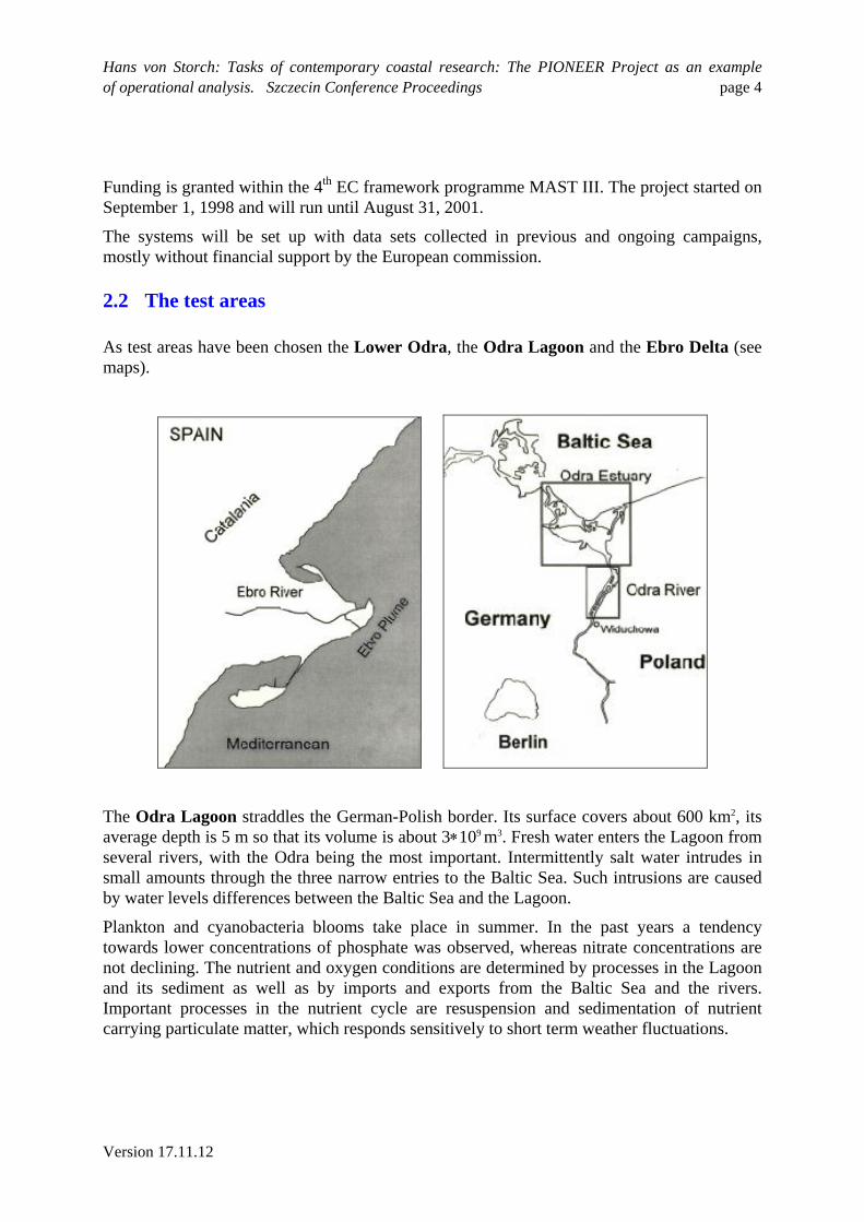
2.2 The test areas
As test areas have been chosen the Lower Odra, the Odra Lagoon and the Ebro Delta (see maps).
1.
The Odra Lagoon straddles the German-Polish border. Its surface covers about 600 km2, its average depth is 5 m so that its volume is about 3109 m3. Fresh water enters the Lagoon from several rivers, with the Odra being the most important. Intermittently salt water intrudes in small amounts through the three narrow entries to the Baltic Sea. Such intrusions are caused by water levels differences between the Baltic Sea and the Lagoon.
Plankton and cyanobacteria blooms take place in summer. In the past years a tendency towards lower concentrations of phosphate was observed, whereas nitrate concentrations are not declining. The nutrient and oxygen conditions are determined by processes in the Lagoon and its sediment as well as by imports and exports from the Baltic Sea and the rivers. Important processes in the nutrient cycle are resuspension and sedimentation of nutrient carrying particulate matter, which responds sensitively to short term weather fluctuations.
Hans von Storch: Tasks of contemporary coastal research: The PIONEER Project as an example of operational analysis. Szczecin Conference Proceedings page 5
Version 17.11.12
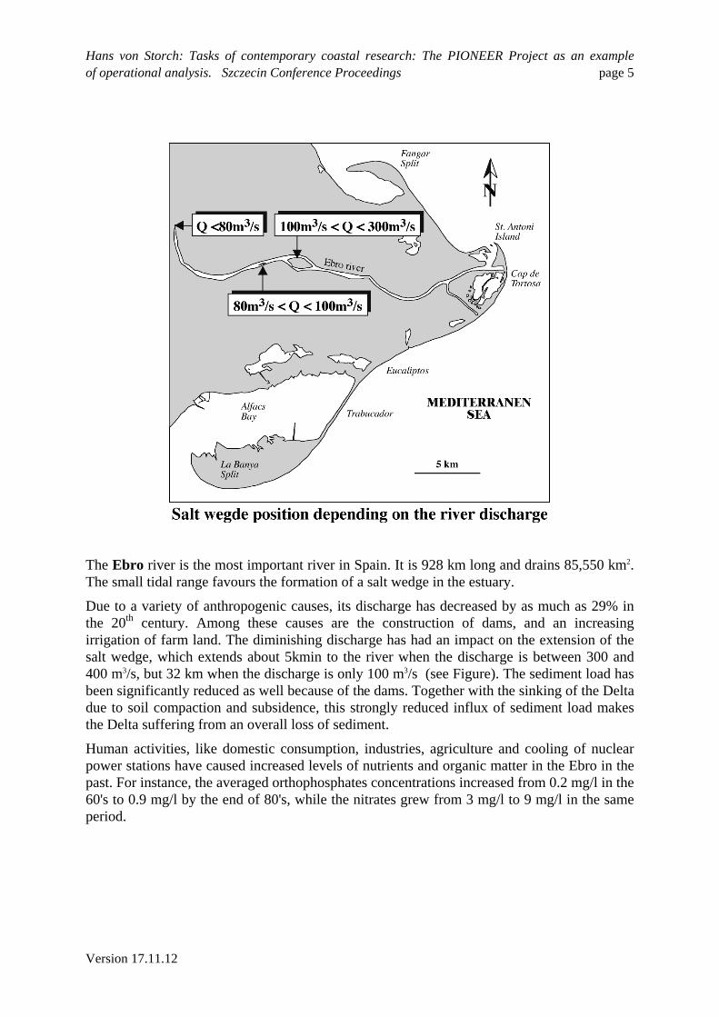
The Ebro river is the most important river in Spain. It is 928 km long and drains 85,550 km2. The small tidal range favours the formation of a salt wedge in the estuary.
Due to a variety of anthropogenic causes, its discharge has decreased by as much as 29% in the 20th century. Among these causes are the construction of dams, and an increasing irrigation of farm land. The diminishing discharge has had an impact on the extension of the salt wedge, which extends about 5kmin to the river when the discharge is between 300 and 400 m3/s, but 32 km when the discharge is only 100 m3/s (see Figure). The sediment load has been significantly reduced as well because of the dams. Together with the sinking of the Delta due to soil compaction and subsidence, this strongly reduced influx of sediment load makes the Delta suffering from an overall loss of sediment.
Human activities, like domestic consumption, industries, agriculture and cooling of nuclear power stations have caused increased levels of nutrients and organic matter in the Ebro in the past. For instance, the averaged orthophosphates concentrations increased from 0.2 mg/l in the 60's to 0.9 mg/l by the end of 80's, while the nitrates grew from 3 mg/l to 9 mg/l in the same period.
Hans von Storch: Tasks of contemporary coastal research: The PIONEER Project as an example of operational analysis. Szczecin Conference Proceedings page 6
Version 17.11.12
2.3 Tasks
The PIONEER project is organised in a series of tasks. In the first phase the tools and data to run the operational simulations will be set up. In the second phase these tools will be applied, tested and assessed by users.
1. Setup of analysis tools
Existing models of the hydrodynamics, of suspended sediment transport and of nutrient are integrated into coupled models which are calibrated to the Odra and Ebro estuarine regions. Geostatistical data analysis [11] and data assimilation techniques [3] [8] for a consistent inter- and extrapolation of limited observational evidence are devised.
1. Setup of data base
To combine meteorological, hydrographical, and water quality parameters for operational forecasting a data base will be set up and made available for all partners via WWW. The data base comprises historical field data and field data measured during the project period. Model data will be stored in the same data base.
2. Preparation of models and data sets for operational simulations
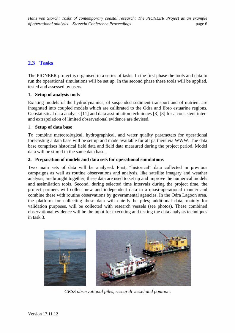
Two main sets of data will be analysed. First, “historical” data collected in previous campaigns as well as routine observations and analysis, like satellite imagery and weather analysis, are brought together; these data are used to set up and improve the numerical models and assimilation tools. Second, during selected time intervals during the project time, the project partners will collect new and independent data in a quasi-operational manner and combine these with routine observations by governmental agencies. In the Odra Lagoon area, the platform for collecting these data will chiefly be piles; additional data, mainly for validation purposes, will be collected with research vessels (see photos). These combined observational evidence will be the input for executing and testing the data analysis techniques in task 3.
1.
GKSS observational piles, research vessel and pontoon.
Hans von Storch: Tasks of contemporary coastal research: The PIONEER Project as an example of operational analysis. Szczecin Conference Proceedings page 7
Version 17.11.12
3. Operational simulations
The developed analysis and data management tools will be integrated and applied to assess scenarios of possible future developments of changing nutrient loads in the considered rivers.
4. Assessment and validation of methods and results
The dependencies of the model forecast on data quality and the skill of the assimilation schemes are validated and assessed.
5. Dissemination and exploitation
Three symposia combined with the annual project meetings at the three different demonstration sites will be held in order to involve the potential end users in the developing phase of the pre-operational forecasting tool. The first of these symposia was the 5th International Scientific Conference: Hydrodynamic and Ecological Aspects of Nutrient Forecasting for Odra and Ebro Estuaries which took place in May 1999 in Szczecin, Poland. The present volume contains the proceedings of the symposium. In May 2000, the next symposium will be held near the Ebro Delta; the last symposium will be organised close to the Odra Lagoon.
2.4 Data analysis
The basic idea of advanced data analysis scheme is to consider two equations; the state space equation describes the temporal evolution of the unobservable, spatially distributed state variable; the other equation is the observation equation, which relates the low-dimensional vector of observables to the continuous state space variable. In general, both equations feature noise terms, mimicking the uncertainty related to observations errors, errors in transfer functions and the neglect of specified processes.
In the PIONEER application the state variable is a (vector of) nutrient concentration(s); these concentrations may be determined locally with automated devices (MERMAID, [6]), but the determination of the spatial distribution at a given time (“synoptic”) can not be done instrumentally. Additionally other variables such as the discharge of the rivers , satellite imagery, or the wind responsible for the rate of resuspension may be observed at least locally. These observed variables form the vector of observables.
Formally, the state space equation may be written as
[1] t+1 = D(t) + t
with the state variable t, the dynamics D and a stochastic term t representing a variety of neglected processes. The observation equation is given as
[2] t = O(t) + t
Hans von Storch: Tasks of contemporary coastal research: The PIONEER Project as an example of operational analysis. Szczecin Conference Proceedings page 8
Version 17.11.12
with the observational uncertainty t and a mapping O of the state variable t on the (vector of) observable(s) t. In general, the mapping O is not invertible, as a continuum of state variables t will often be consistent with a specific observation t. Note that both equations [1],[2] are stochastic equations.
The state variable t is never completely known as it is unobservable. Only estimates are available and some knowledge about the range of uncertainty. Therefore, the determination of a future state t+1 by integrating the state space equation [1] forward in time may return estimates which are in conflict with the actual observational evidence t. Therefore the problem of specifying t is to solve the systems of equations [1]-[2] consecutively. At any given time, it is assumed that an estimate of t as well as a vector of observations t is available. An estimate of the state variable t+1 at time t+1 is obtained by optimally exploiting the dynamical knowledge encoded in the state space equation and in the empirical knowledge available through the observation equation. Formally:
[3] t+1 = D(t) + (1-)K( t)
with an operator K which in general accounts for the observation process O, the previous state t and the range of uncertainties t and t. The most general formalism for implementing [3] is that of the Kalman filter ([4][5]).
In PIONEER a number of different approaches with different levels of sophistication to solve [1]-[3] are pursued.
The simplest approach is based on straight forward spatial interpolation. In that case the observables t are point observations of the continuous state variable t. No forward integration, i.e. prediction, is attempted. Thus no equation [1] is utilized, and only the observation equation [2] is inverted.
A more sophisticated version operates with the observable t = local wind recorded at a pile (as shown on the photo) and a table relating the local wind to a spatial wind distribution calculated with the regional atmospheric model GESIMA. This wind distribution is part of the state variable t, an other part is the spatial distribution of wave statistics. The dynamics D is a wave model [9], simulating the response of the wave field to the wind forcing.
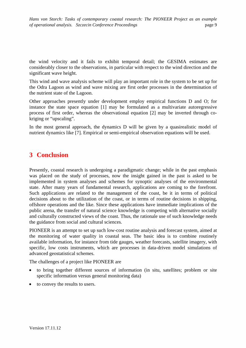
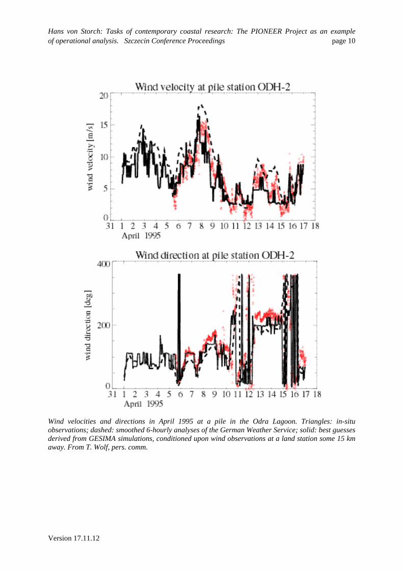
The success of this exercise is displayed in the following diagram (from Wolf et al., in prep.). It shows as triangles the observations of wind speed and wind direction as recorded for about two weeks by one of the piles shown above. Additionally, significant wave height is available from a wave rider buoy in the Lagoon. In case of the wind direction and velocity, the dashed line is the 6-hourly operational analysis provided by the German Weather Service, whereas the solid line is the one-hourly best guess taken from a GESIMA simulation selected according to the observed wind at some 15 km away. The dashed and solid lines in the diagram with the significant wave height represent the response of the wave model to the two types of wind fields, the 6-hourly German Weather Service analyses and the 1-hourly GESIMA estimates. Seemingly, the German Weather Service analyses tend to overestimate
Hans von Storch: Tasks of contemporary coastal research: The PIONEER Project as an example of operational analysis. Szczecin Conference Proceedings page 9
Version 17.11.12
the wind velocity and it fails to exhibit temporal detail; the GESIMA estimates are considerably closer to the observations, in particular with respect to the wind direction and the significant wave height.
This wind and wave analysis scheme will play an important role in the system to be set up for the Odra Lagoon as wind and wave mixing are first order processes in the determination of the nutrient state of the Lagoon.
Other approaches presently under development employ empirical functions D and O; for instance the state space equation [1] may be formulated as a multivariate autoregressive process of first order, whereas the observational equation [2] may be inverted through co-kriging or “upscaling”.
In the most general approach, the dynamics D will be given by a quasirealistic model of nutrient dynamics like [7]. Empirical or semi-empirical observation equations will be used.
3 Conclusion
Presently, coastal research is undergoing a paradigmatic change; while in the past emphasis was placed on the study of processes, now the insight gained in the past is asked to be implemented in system analyses and schemes for synoptic analyses of the environmental state. After many years of fundamental research, applications are coming to the forefront. Such applications are related to the management of the coast, be it in terms of political decisions about to the utilization of the coast, or in terms of routine decisions in shipping, offshore operations and the like. Since these applications have immediate implications of the public arena, the transfer of natural science knowledge is competing with alternative socially and culturally constructed views of the coast. Thus, the rationale use of such knowledge needs the guidance from social and cultural sciences.
PIONEER is an attempt to set up such low-cost routine analysis and forecast system, aimed at the monitoring of water quality in coastal seas. The basic idea is to combine routinely available information, for instance from tide gauges, weather forecasts, satellite imagery, with specific, low costs instruments, which are processes in data-driven model simulations of advanced geostatistical schemes.
The challenges of a project like PIONEER are
to bring together different sources of information (in situ, satellites; problem or site specific information versus general monitoring data)
to convey the results to users.
Hans von Storch: Tasks of contemporary coastal research: The PIONEER Project as an example of operational analysis. Szczecin Conference Proceedings page 10
Version 17.11.12
Wind velocities and directions in April 1995 at a pile in the Odra Lagoon. Triangles: in-situ observations; dashed: smoothed 6-hourly analyses of the German Weather Service; solid: best guesses derived from GESIMA simulations, conditioned upon wind observations at a land station some 15 km away. From T. Wolf, pers. comm.
Hans von Storch: Tasks of contemporary coastal research: The PIONEER Project as an example of operational analysis. Szczecin Conference Proceedings page 11
Version 17.11.12
Significant wave height in April 1995 recorded by a wave rider buoy in the Odra Lagoon. Triangles: in-situ observations; dashed: wave model results forced with the smoothed 6-hourly analyses of the German Weather Service; solid: the same, but with the use of the best guesses derived from GESIMA simulations, conditioned upon wind observations. From T.-Wolf, pers. comm.
Other aspects, as data driven simulations and advanced geostatistical methods, or automated local instrumental devices, are principally known. However, they are to be adapted to the specific regional hydrographic and user-oriented situation.
Acknowledgements
Mrs. Liesner and Gardeike assisted with the edition of manuscript and diagrams. Feedback by Drs. Wolf, Günther and Sierra improved the manuscript.
References
[1] Bertino, L. and H. Wackernagel, 1999: Geostatistical tools for ecological modeling of estuaries. This volume.
[2] Corbin, A., 1990: Meereslust. Das Abendland und die Entdeckung der Küste. Fischer Taschenbuch Verlag, ISBN 3-596-10989-2, 414 pp.
[3] Evensen, G., 1997: Advanced data assimilation for strongly nonlinear dynamics. Mon. Weather Rev., 125, 1342-1354
[4] Jones, R.H., 1985: Time series analysis - time domain. In: A.H. Murphy and R. W. Katz (Eds.): Probability, Statistics, and Decision Making in the Atmospheric Sciences. Westview Press, Boulder and London, ISBN 0-86531-152-8, 223-260

Hans von Storch: Tasks of contemporary coastal research: The PIONEER Project as an example of operational analysis. Szczecin Conference Proceedings page 12
Version 17.11.12
[5] Honerkamp, J., 1994: Stochastic dynamical systems: concepts, numerical methods, data. VCH Publishers, ISBN 3-527-89563-9, 535 pp
[6] Knauth; H.-D., Schroeder, F., Menzel, R., Gebhart, E., Marx, S., Kohnke, D., Holzkamm, F., Nies, H., Theobald, N., 1997: Marine Pollution Network EUROMAR-MERMAID. Results of the Experimental Operation. Dt. Hydr. Zt., 49, pp.385-407.
[7] Radach, G., M. Regener. F. Carlotti, W. Kühn and A. Moll, 1993: Modelling water column processes in the North Sea. Phil Trans. R. Soc. London A, 343, 509-517
[8] Robinson, A.R., P.F.J. Lermusiaux and N. Q. Sloan III, 1998: Data assimilation. In: K.H. Brink, A.R. Robinson (eds): The Global Coastal Ocean. Processes and Methods. The Sea Vol. 10. John Wiley & Sons Inc, New York, 541-593
[9] Schneggenburger, C., H. Günther and W. Rosenthal, 1997: Shallow water wave modelling with nonlinear dissipation. Dtsche. Hydrogr. Z. 49, 431-444
[10] Settekorn, W. et al., 1999: Bilder der Küste. Tagungsband Sankelmark (in preparation).
[11] Wackernagel, H., 1995: Multivariate Geostatistics, Springer Verlag, 270 pp ISBN 3-540-60127-9
Related Documents