TARA MINES LIMITED _______________________________________________________ Extension of Existing Mining Operation Into Nevinstown and Liscartan ________________________________________________________ April 2003 For inspection purposes only. Consent of copyright owner required for any other use. EPA Export 27-07-2013:00:01:46

Welcome message from author
This document is posted to help you gain knowledge. Please leave a comment to let me know what you think about it! Share it to your friends and learn new things together.
Transcript
TARA MINES LIMITED
_______________________________________________________
Extension of Existing Mining Operation
Into Nevinstown and Liscartan ________________________________________________________
April 2003
For
insp
ectio
n pur
pose
s only
.
Conse
nt of
copy
right
owne
r req
uired
for a
ny ot
her u
se.
EPA Export 27-07-2013:00:01:46

Tara Mines Ltd. EIS – Extension of Mining Operation into Nevinstown and Liscartan ________________________________________________________________________________________________________________
i
TABLE OF CONTENTS
Page No.
1. INTRODUCTION
1.1 Background 1 1.2 Proposed Development 1 1.2.1 The Nevinstown Orebody Development 1 1.3 Environmental Impact Assessment Regulations 3 1.4 Role of Government and Statutory Bodies 3 1.5 Content of the Environmental Impact Statement 4 1.6 The Project Team 4
2. PROJECT DESCRIPTION
2.1 Background 6 2.2 Mining and Processing Operation 6 2.2.1 Access 6 2.2.2 Underground Infrastructure 6 2.2.3 Development 8 2.2.4 Mining Methods 8 2.2.4.1 Nevinstown orebody 8 2.2.4.2 Liscartan orebody 11 2.2.5 Mine production 11 2.2.6 Ventilation 12 2.2.7 Backfilling 12 2.2.8 Mine Dewatering 12
3. SCOPING & CONSULTATION
3.1 Introduction 13 3.2 Guidance 13 3.3 Scoping for Nevinstown and Liscartan Development 13
4. HUMAN BEINGS
4.1 Economic Activity 15 4.1.1 Introduction 15 4.1.2 Scope of Economic Issues Under Consideration 15 4.1.3 Contribution to Local Economy 15 4.1.4 Contribution to National Economy 16 4.1.5 Conclusion 16 4.2 Land-Use 16 4.3 Employment 17 4.4 Health and Safety 17 4.5 Settlement and Social Patterns 17
For
insp
ectio
n pur
pose
s only
.
Conse
nt of
copy
right
owne
r req
uired
for a
ny ot
her u
se.
EPA Export 27-07-2013:00:01:46

Tara Mines Ltd. EIS – Extension of Mining Operation into Nevinstown and Liscartan ________________________________________________________________________________________________________________
ii
Table of contents cont’d.
5. GEOTECHNICAL STUDY
5.1 Nevinstown 19 5.1.1 Introduction 19 5.1.1.1 Scope of work 19 5.1.1.2 Study Methodology and data sources 20 5.1.2 Existing Environment 20 5.1.2.1 Conclusions 20 5.1.2.2 Geological Structure 21 5.1.2.3 Geotechnical Conditions 26 5.1.2.4 Conclusions 28 5.1.3 Potential Impacts 29 5.1.3.1 Surface Settlement 29 5.1.3.2 Surface Crown Pillars 32 5.1.3.3 Underground Mine Stability 34 5.1.4 Mitigation Measures 35 5.1.5 Geotechnical Monitoring 37 5.1.6 Recommendation/ and or Conclusions 39 5.1.7 Post Closure 39 5.1.8 References 40 5.1.9 Glossary of Terms 40 5.2 Liscartan 46
6. GROUNDWATER STUDY
6.1 Nevinstown 47 6.1.1 Introduction 47 6.1.1.1 Scope of work 47 6.1.1.2 Study Methodology and data sources 49 6.1.2 Existing Environment 49 6.1.2.1 Hydrogeological units 49 6.1.2.2 Hydrochemistry 55 6.1.2.3 Current Mine Hydrology and Dewatering 55 6.1.2.4 Water Levels and Flows in Nevinstown 57 6.1.2.5 Nevinstown Dewatering 58 6.1.2.6 Soil Moisture 60 6.1.2.6.1 Soil & Bedrocks at Tara Mines 60 6.1.2.6.2 Soil Moisture & Groundwater Balance in Soils &
Bedrocks 61
6.1.2.6.3 Experimental Measurements of Soil Moisture Before & After Pumping
61
6.1.3 Potential Impacts 62 6.1.4 Mitigating Measures 64 6.1.5 Monitoring 67 6.1.6 Recommendation and Conclusions 70
For
insp
ectio
n pur
pose
s only
.
Conse
nt of
copy
right
owne
r req
uired
for a
ny ot
her u
se.
EPA Export 27-07-2013:00:01:46
Tara Mines Ltd. EIS – Extension of Mining Operation into Nevinstown and Liscartan ________________________________________________________________________________________________________________
iii
Table of contents cont’d.
6.1.7 Post Closure 71 6.1.8 References 72 6.2 Liscartan 72
7. VIBRATION & AIR-OVERPRESSURE NOISE
7.1 Introduction 74 7.2 The Nevinstown Proposal 74 7.3 The Existing Blasting Vibration (Air-overpressure Noise) Environment 74 7.3.1 Ground vibration 74 7.3.1.1 Ground Vibration Control 75 7.3.1.2 Blasting &Vibration Control at Tara 75 7.3.2 Air Overpressure (Air Blast) Noise 78 7.4 Nevinstown Blasting Vibration Impacts 78 7.5 Liscartan Blasting Vibration Impacts 79 7.6 Ameliorative Measures for Blasting Vibration Control 79 7.7 Conclusion 80 7.8 References 80 7.9 Glossary of terms 80
8. SURFACE WATER
8.1 Introduction 82 8.2 Existing Environment 82 8.2.1 Water Management System 82 8.2.1.1 Water Source 82 8.2.1.2 Effluent Processing 82 8.2.1.3 Water Quality Monitoring 91 8.2.2 Biological Assessment of the River Blackwater 93 8.2.2.1 Introduction 93 8.2.2.2 Materials and Methods 93 8.2.2.3 Results 93 8.2.2.4 Concluding Comments 95 8.3 Water Management System 97 8.4 Water quality during operation 97 8.5 Water quality after closure 97 Annex I 98
For
insp
ectio
n pur
pose
s only
.
Conse
nt of
copy
right
owne
r req
uired
for a
ny ot
her u
se.
EPA Export 27-07-2013:00:01:46

Tara Mines Ltd. EIS – Extension of Mining Operation into Nevinstown and Liscartan ________________________________________________________________________________________________________________
iv
Table of contents cont’d.
9. FLORA & FAUNA
9.1 Nevinstown 106 9.1.1 Introduction 106 9.1.2 Method 106 9.1.2.1 Survey limitations 107 9.1.3 Baseline Environment 107 9.1.3.1 Habitats, Vegetation and Flora 107 9.1.3.2 Fauna 109 9.1.3.2.1 Mammals, Amphibians and Reptiles 109 9.1.3.2.1 Birds 109 9.1.3.2.3 Fish 110 9.1.3.3 Assessment of scientific importance of survey area 110 9.1.4 Assessment of potential impacts by proposed development 110 9.1.5 References 110 Plates 1 –6 Views of survey site 112 9.2 Liscartan 115 9.2.1 Assessment of potential impacts of proposed development 115
10. LANDSCAPE AND VISUAL IMPACT
10.1 Visual Impacts on the Existing Landscape
116
11. AIR
11.1 Impacts of Proposed Development on Air Quality 117
12. MATERIAL ASSETS 12.1 Cultural & Heritage - Archeology 118 12.1.1 Introduction 118 12.1.2 Methodology 118 12.1.3 Archaeological and Historical Background 119 12.1.4 Recorded Archaeological Sites 121 12.1.4.1 Recorded Archaeological Sites in Nevinstown Townland 122 12.1.4.2 Recorded Archaeological Sites in Adjoining Townlands 123 12.1.5 Field Survey 124 12.1.6 Characteristics of the Proposed Development 127 12.1.7 Potential Impact of the Proposed Development 127 12.1.9 Remedial and Mitigative Measures 127 12.1.9 Bibliography 127 12.2 Agriculture 128 12.2.1 Introduction 128 12.2.2 Existing Environment 129 12.3 Property 129 12.3.1 Impact on property 129
For
insp
ectio
n pur
pose
s only
.
Conse
nt of
copy
right
owne
r req
uired
for a
ny ot
her u
se.
EPA Export 27-07-2013:00:01:46

Tara Mines Ltd. EIS – Extension of Mining Operation into Nevinstown and Liscartan ________________________________________________________________________________________________________________
v
Table of contents cont’d. 13. ROADS AND TRAFFIC
13.1 Access to the new Development 130
14. CLIMATE
14.1 Introduction 131 14.2 Description of the existing Environment 131 14.2.1 General 131 14.2.2 Wind 133 14.3.3 Rainfall 133 14.3 Impacts of Nevinstown and Liscartan extension on Climate
LIST OF FIGURES
Figure 1-1 Location of Nevinstown and Liscartan with respect to the existing mine. 2 Figure 2-1 Overview of the mining and processing operation. 7 Figure 2-2 Schematic Sections of Stoping – Blacks N3 and N5. 9 Figure 2-3 Schematic Long section for Black N4 – 1-5 Lens East. 10 Figure 4-1 Major residential developments North and North-east of Nevinstown. 18 Figure 5-1 Navan Deposit Stratigraphic Table. 23 Figure 5-2 Simplified Tara Mine Geology Plan. 24 Figure 5-3 Nevinstown Geological Dip Section. 25 Figure 5-4 Final Stage of Stoping – predicted Surface Settlement. 31 Figure 5-5 Schematic Crown Pillar Geometry – Cross Section Looking North. 33 Figure 5-6 Nevinstown Precise Level Survey. 38 Figure 6-1 Nevinstown Geology and Groundwater. 51 Figure 6-2 Tara Mine Geological Dip Section. 52 Figure 6-3 Hydrogeological section along north bank of River Blackwater. 59 Figure 6-4 Proposed Groundwater Monitoring Network. 69 Figure 7-1 Locations of Zones 1,2 and 3. 76 Figure 7-2 Faulting projections East and Northeast of the Nevinstown Orebody. 77 Figure 8-1 Components of Water Management System. 86 Figure 14-1 Average Wind Speed and percentage classification of wind speed direction for
period 1st March 1992 to 28th February 1993. 132
Figure 14-2 Average Wind Speed and percentage classification of wind speed direction for period 1st March 1993 to 28th February 1994.
132
Figure 14-3 Average Wind Speed and percentage classification of wind speed direction for period 1st March 1994 to 28th February 1995.
133
Figure 14-4 Long-term Average monthly rainfall (1971 – 2002). 133
For
insp
ectio
n pur
pose
s only
.
Conse
nt of
copy
right
owne
r req
uired
for a
ny ot
her u
se.
EPA Export 27-07-2013:00:01:46

Tara Mines Ltd. EIS – Extension of Mining Operation into Nevinstown and Liscartan ________________________________________________________________________________________________________________
vi
Table of contents cont’d.
LIST OF TABLES
Table 5-1 Summary Geotechnical Characteristics of Key Lithologies. 27 Table 5-2 Nevinstown Implementation Plan (Geotechnical). 36 Table 6-1 Summary Overburden Permeabilites. 50 Table 6-2 Packer Test permeability Data in UDL. 53 Table 6-3 Packer Test permeability Data in Pale Beds. 54 Table 6-4 Nevinstown Implementation Plan (Hydrology). 65 Table 8-1 Emission Limits for Tara Mines Surface Water Discharge. 84 Table 8-2 Water quality data for discharge to Boyne. 85 Table 8-3 Water quality for data for receiving water. 85 Table 8-4 Percentage occurrence of macroinvertebrate groups in determining Q-ratings. 90 Table 8-5 Summary of percentage occurrence in main indicator groups. 91
For
insp
ectio
n pur
pose
s only
.
Conse
nt of
copy
right
owne
r req
uired
for a
ny ot
her u
se.
EPA Export 27-07-2013:00:01:46

Tara Mines Limited EIS - Development of Mining Operation into Nevinstown and Liscartan
Non-Technical Summary I
_____________________________________________________________________
NON-TECHNICAL SUMMARY
_____________________________________________________________________
Introduction
In accordance with their obligations under the procedures for an Environmental Impact Assessment, Tara Mines Limited have prepared an Environmental Impact Statement (EIS) for an extension of mining operations into Nevinstown and Liscartan at Navan, Co. Meath. The EIS will accompany a Planning Application to Meath County Council. Tara Mines Limited, the largest operating lead-zinc mine in Europe, is located at Knockumber, 2 km west of Navan in County Meath. Originally sited in a rural area, expansion of Navan has resulted in the development of residential areas nearer to the mine although much of its surroundings remain flat agricultural land drained by prolific fishing rivers. The Nevinstown orebody is in essence an extension northwards of the existing ‘main orebody’ while Liscartan forms the north west extension of the existing orebody. Ongoing and future exploration will determine the quantity and extent of mineable reserves in the Liscartan area. The Nevinstown development involves establishing access to the orebody by underground mining methods via the existing underground mine. The surface characteristics and features of the Nevinstown townland will not be altered by mining activity and there will be no infrastructural facilities in the area. All other necessary infrastructure for its operation is in place, including administration, mining and processing facilities, tailings storage capacity, ventilation, effluent discharge facilities and road/rail links to Dublin Port. The estimated current known mineral resources including the expansion of the mine northwards into the Nevinstown orebody, along with the continuation of the southwest development (SWEX development) are 20.2 million tonnes grading 7.2% zinc and 2.2% lead. The current estimated ore reserves are 18.3 million tonnes grading 9.4% zinc and 2.1% lead. Development of the Nevinstown extension would improve the cost efficiency of the mine and assure Tara’s status as the fourth largest zinc mine in the world. It is anticipated that the ‘Nevinstown Mine’ will be exploited over a period of approximately 10 years. Project Description The Nevinstown orebody is an extension northwards of the existing orebody and is present (outcrops) at the surface level and dips steeply below the River Blackwater into the existing mining area. A recent study review and analyses carried out by Geotechnical consultants concluded that the characteristics of the rock types and structures which occur in Nevinstown are essentially identical to those that occur in the Tara mines ‘main orebody’ immediately to the south of the river. Access to the Nevinstown orebody will be from the existing Tara Mines site (south of the River Blackwater). A new inclined portal access from within the site is planned to
For
insp
ectio
n pur
pose
s only
.
Conse
nt of
copy
right
owne
r req
uired
for a
ny ot
her u
se.
EPA Export 27-07-2013:00:01:46

Tara Mines Limited EIS - Development of Mining Operation into Nevinstown and Liscartan
Non-Technical Summary II
provide access for a vehicle route and underground drifts from existing mine workings at varying locations and depths will provide access for mining purposes. Mine development is planned and development drifts driven to prepare sections of the orebody for large-scale ore production. All ore and waste rock produced will be moved by scoop and/or truck underground back into the existing mine for crushing and hoisting. A crown pillar of ore approximately 30m below the overburden will remain as a major support of the surface overlying the orebody whilst production mining will extract ore below the crown pillar. Mining follows a cyclic pattern resulting in the removal of ore underground followed by the filling of the voids using waste sand material that remains after the ore treatment process. Cement is added to much of this waste, for additional strength. Mined-out areas (stopes) will be backfilled with sand-fraction mill tailings and cement through an underground pipeline network connected to the existing mine backfilling facilities. All underground water encountered during development and mining will be piped back into the existing mine. This water will then join the existing mine drainage system for later treatment and pumping to surface Scoping and Consultation The scope for the proposed Nevinstown Development was entered into in the early stages of the EIA and emerged both formally and informally from discourse between Tara Mines’ staff, the Competent Authority (Meath County Council), Specialist Agencies / Consultants and the Public. All of these sources provided invaluable information while identifying and clarifying the nature and detail of key issues to be contained in an EIS. Role of Government and Statutory Bodies Responsibility for the protection of the environment and the regulation of planning issues lies primarily with the Department of the Environment and Local Government. Other Government departments, statutory bodies and special interest groups also exercise important control functions. The responsibility for further regulation in the natural resource sector, including mining, is currently administered by the Department of Communications, Marine and Natural Resources who also, though not directly, have responsibility for environmental control through the Central and Regional Fisheries Boards. Within the Department of the Environment and Local Government, the Heritage Service, Dúchas, plays a major role in relation to the protection, conservation and management of the natural and built as well as the historic environment.
Of the Statutory Bodies, the local authorities have a major role in relation to the enforcement of planning legislation especially at county and local level. The major environmental management responsibility for improving and protecting the environment lies with the Environmental Protection Agency. Another Statutory Body with immense regulatory power is the Planning Appeals Board, An Bord Pleanala,
For
insp
ectio
n pur
pose
s only
.
Conse
nt of
copy
right
owne
r req
uired
for a
ny ot
her u
se.
EPA Export 27-07-2013:00:01:46

Tara Mines Limited EIS - Development of Mining Operation into Nevinstown and Liscartan
Non-Technical Summary III
which determines first and third party appeals inter alia against planning decisions. Other bodies with responsibilities in relation to mining development are the Health Boards and the National Authority for Occupational Safety and Health, however, the extent of their involvement varies with the circumstances of individual proposed development. Of the Special Interest Groups the most important is An Taisce, the National Trust for Ireland. It has prescribed body status under the planning acts and has the right of examination of planning applications. A lesser participatory role in planning decisions has been played by Bord Failte Eireann, the National Tourist Board. Human Beings The economic consequences of the proposed Nevinstown and Liscartan Development were considered. Although Navan has been recognised as a primary growth center with respect to employment, retailing and service bases and has assumed the role of a Dormitory town for Dublin City, local industry remains the primary source of employment with Tara being one of the most significant employers in the Navan area since 1973. The principal economic consequence of the proposed development will result from its effect on the future lifespan of the mine. These consequences are estimated in terms of employment and contributions to both the local and national economy. There is no doubt that the economic stability of the mine depends greatly on proposed development and will be a project of major economic significance at local, regional and national levels. While it is not envisaged that the proposed development will result in an expansion to current personnel numbers but will underpin the future operation of the mine thereby protecting pre existing employment over the optimum life of the mine. The effect of wages and salaries generated by Tara being spent in the local and greater Navan areas are considerable and will be an important component in continuing economic growth. A loss of such a large payroll would have a severe and detrimental effect on the local economy. The national economy also benefits from a fully operating mine in the form of payments to state enterprises (Electricity Supply Board and Iarnrod Eireann) and to the Revenue Commissioners in the form of PAYE, PRSI, Corporation and other taxes. A major contribution to the country’s balance of payments arises from the sales of zinc and lead concentrates. The entire Nevinstown property is zoned as Mining and will remain so throughout any development period of the orebody. It has been operated as a rough grassland farm unit since 1972 and will remain as farm land used by grazing tenants. Liscartan is zoned as Agriculture. Agricultural productivity and trafficability of the free-draining soils may be improved by the groundwater draw-down effects of mining. There will be no loss of rights of way of existing amenities, conflicts or other changes likely to alter the character and use of the surroundings and the traditional right of anglers to pass along the river bank will not be restricted.
For
insp
ectio
n pur
pose
s only
.
Conse
nt of
copy
right
owne
r req
uired
for a
ny ot
her u
se.
EPA Export 27-07-2013:00:01:46
Tara Mines Limited EIS - Development of Mining Operation into Nevinstown and Liscartan
Non-Technical Summary IV
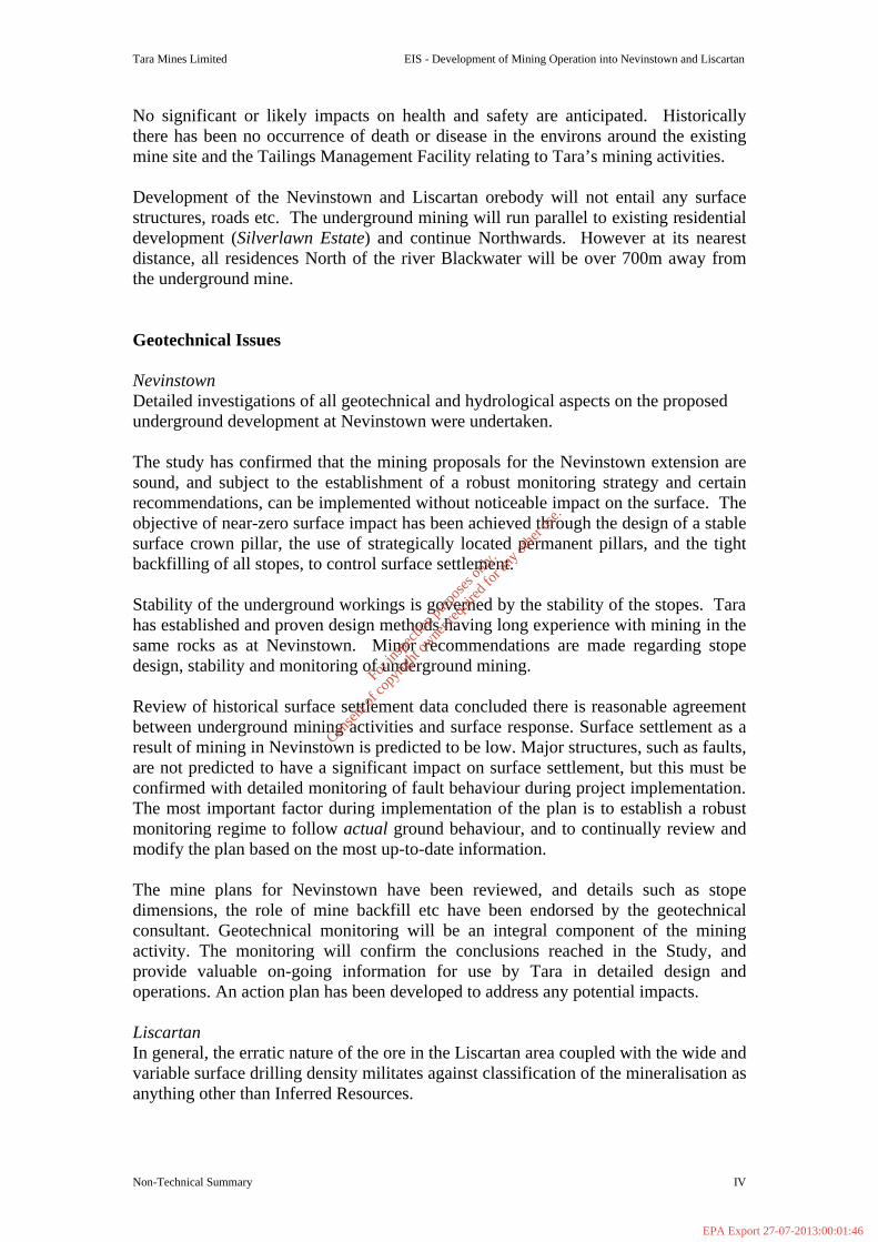
No significant or likely impacts on health and safety are anticipated. Historically there has been no occurrence of death or disease in the environs around the existing mine site and the Tailings Management Facility relating to Tara’s mining activities. Development of the Nevinstown and Liscartan orebody will not entail any surface structures, roads etc. The underground mining will run parallel to existing residential development (Silverlawn Estate) and continue Northwards. However at its nearest distance, all residences North of the river Blackwater will be over 700m away from the underground mine. Geotechnical Issues Nevinstown Detailed investigations of all geotechnical and hydrological aspects on the proposed underground development at Nevinstown were undertaken. The study has confirmed that the mining proposals for the Nevinstown extension are sound, and subject to the establishment of a robust monitoring strategy and certain recommendations, can be implemented without noticeable impact on the surface. The objective of near-zero surface impact has been achieved through the design of a stable surface crown pillar, the use of strategically located permanent pillars, and the tight backfilling of all stopes, to control surface settlement. Stability of the underground workings is governed by the stability of the stopes. Tara has established and proven design methods having long experience with mining in the same rocks as at Nevinstown. Minor recommendations are made regarding stope design, stability and monitoring of underground mining. Review of historical surface settlement data concluded there is reasonable agreement between underground mining activities and surface response. Surface settlement as a result of mining in Nevinstown is predicted to be low. Major structures, such as faults, are not predicted to have a significant impact on surface settlement, but this must be confirmed with detailed monitoring of fault behaviour during project implementation. The most important factor during implementation of the plan is to establish a robust monitoring regime to follow actual ground behaviour, and to continually review and modify the plan based on the most up-to-date information. The mine plans for Nevinstown have been reviewed, and details such as stope dimensions, the role of mine backfill etc have been endorsed by the geotechnical consultant. Geotechnical monitoring will be an integral component of the mining activity. The monitoring will confirm the conclusions reached in the Study, and provide valuable on-going information for use by Tara in detailed design and operations. An action plan has been developed to address any potential impacts. Liscartan In general, the erratic nature of the ore in the Liscartan area coupled with the wide and variable surface drilling density militates against classification of the mineralisation as anything other than Inferred Resources.
For
insp
ectio
n pur
pose
s only
.
Conse
nt of
copy
right
owne
r req
uired
for a
ny ot
her u
se.
EPA Export 27-07-2013:00:01:46

Tara Mines Limited EIS - Development of Mining Operation into Nevinstown and Liscartan
Non-Technical Summary V
Indications from the initial drilling show that the orebody footwall lies in excess of 210m below the surface. It is premature to outline any mining schedule, but, subject to the confirmation of mineable ore reserves, it is intended to mine the area by underground means. The selected mining method will, in all probability, be longhole open stoping with backfill. Cemented backfill will be used for the initial (primary) stoping, and a mixture of cemented and uncemented backfill for later (secondary/pillar) stoping. The proposed mining methods and stope dimensions will be determined by the ground conditions, taking account of specific structural weaknesses, as per current practice. The potential for any large scale collapse of a stope is therefore considered to be very low, and even assuming conservative swell factors for the hangingwall rocks, unplanned collapse cannot extend far vertically into the hangingwall above a stope. Furthermore, the use of tight backfill in each stope limits the extent of hangingwall relaxation that can occur during and after mining. Tight-filling of all stopes remains a policy for the stoping operations. Regarding subsidence potential, a tensile zone will develop immediately above the planned stoping, but this will only extend a limited distance vertically upwards. The orientation of the far-field maximum principal stress will ensure that a compressive arch develops above this tensile zone, creating a zone of increased interlocking and clamping of structures within the rockmass, thus limiting the upward extent of any relaxation occurring in the rock immediately above the stoping. In respect of regional stability, monitoring instrumentation will be installed on a selective basis, from underground hangingwall access development when completed, to monitor rock behaviour associated with the extraction of individual stopes. Precise levelling survey stations will also be located on surface, to confirm that subsidence is negligible, and of no consequence to surface infrastructure, or the ground water regime. Geotechnical monitoring will form an integral component of future mining activities. Groundwater Nevinstown The hydrogeological units and mechanisms of groundwater flow at Nevinstown are directly comparable to the main mine, south of the River Blackwater. The hydrological data available has confirmed that the bedrock at Nevinstown has been substantially dewatered by flow to the main Tara Mine. This includes the bedrock beneath the River Blackwater. Any leakage from the River is controlled by the permeability of the alluvium, till and shallow bedrock. Any additional dewatering in the mine is not expected to change this leakage rate. Operations at the Tara Mine over the last thirty years have shown that it is feasible to mine under the River Blackwater without any negative impacts on the flow of the river The A-Fault (which lies on the eastern boundary of the ore) does not form a pathway for water inflow into the mine and has been observed to have very low permeability in numerous underground exposures. The mining methods to be adopted will minimise
For
insp
ectio
n pur
pose
s only
.
Conse
nt of
copy
right
owne
r req
uired
for a
ny ot
her u
se.
EPA Export 27-07-2013:00:01:46

Tara Mines Limited EIS - Development of Mining Operation into Nevinstown and Liscartan
Non-Technical Summary VI
any differential settlement across the structure, and renders it very unlikely that mining will result in any change to the permeability of the fault. Sink hole development in the area around Tara is mainly confined to the Pale Beds, and in the Nevinstown area most of the known near-surface sink holes occur in the subcrop area of the Pale Beds. Since groundwater levels have already fallen and much of the expected future drawdown within the Pale Beds has already occurred, the concern for future sink hole development is reduced. Sink hole development is most likely to occur during prolonged periods of dry weather when the near-surface water table in the overburden deposits becomes reduced. Mining methods towards an area in the north with known cavities will take account of their presence. Much of the Nevinstown extension being substantially dewatered, mining is not likely to create a significant expansion of dewatering influence. The Randalstown Tailings Management Facility is 2km from the northern limit of mining at Nevinstown and, therefore, there is considered to be no potential for drawdown to extend towards the dam. Theory and experimental measurements show that soil moisture is influenced by rainfall, evapotranspiration and recharge to the groundwater table. Therefore, grass and crop growth are not influenced by changes in the deep water table caused by dewatering of the mine. This has been the case at Navan Mines since mining began and will continue to be the case as mining is extended to the Nevinstown orebody. A hydrological and groundwater monitoring programme has been recommended to confirm the hydrological predictions. An action plan has been developed to address any potential impacts. Liscartan All underground water encountered during development and mining will be collected at a central underground pumping station and piped back into the existing mine. This water will then join the existing mine drainage system for later treatment and pumping to surface. The total pumping capacity in the mine is 21,600 m3/d. There is no planned additional water pumping related connections to surface. At present, it is not possible to estimate the quantity of groundwater as the extent of mineable ore has not yet been established. It is however anticipated that there will be sufficient flexibility and storage in the water management system to accommodate the additional flow. Any additional groundwater flow from the Liscartan extension is not expected to alter the overall chemistry of the discharge. The new orebody is geologically and geochemically identical to the orebody in the main Tara Mine and, therefore, there will be no significant difference in the water chemistry. A groundwater monitoring programme will be established to check the impact of dewatering in the Liscartan area. Theory and experimental measurements show that soil moisture is influenced by rainfall, evapotranspiration and recharge to the groundwater table. Since soil moisture content is not influenced by the height of the watertable, grass and crop growth and production likewise are not influenced when the watertable is deep. This has been the
For
insp
ectio
n pur
pose
s only
.
Conse
nt of
copy
right
owne
r req
uired
for a
ny ot
her u
se.
EPA Export 27-07-2013:00:01:47
Tara Mines Limited EIS - Development of Mining Operation into Nevinstown and Liscartan
Non-Technical Summary VII
case at Navan Mines since development began in 1973 and will continue to be the case as mining is extended outwards from the existing boundaries.
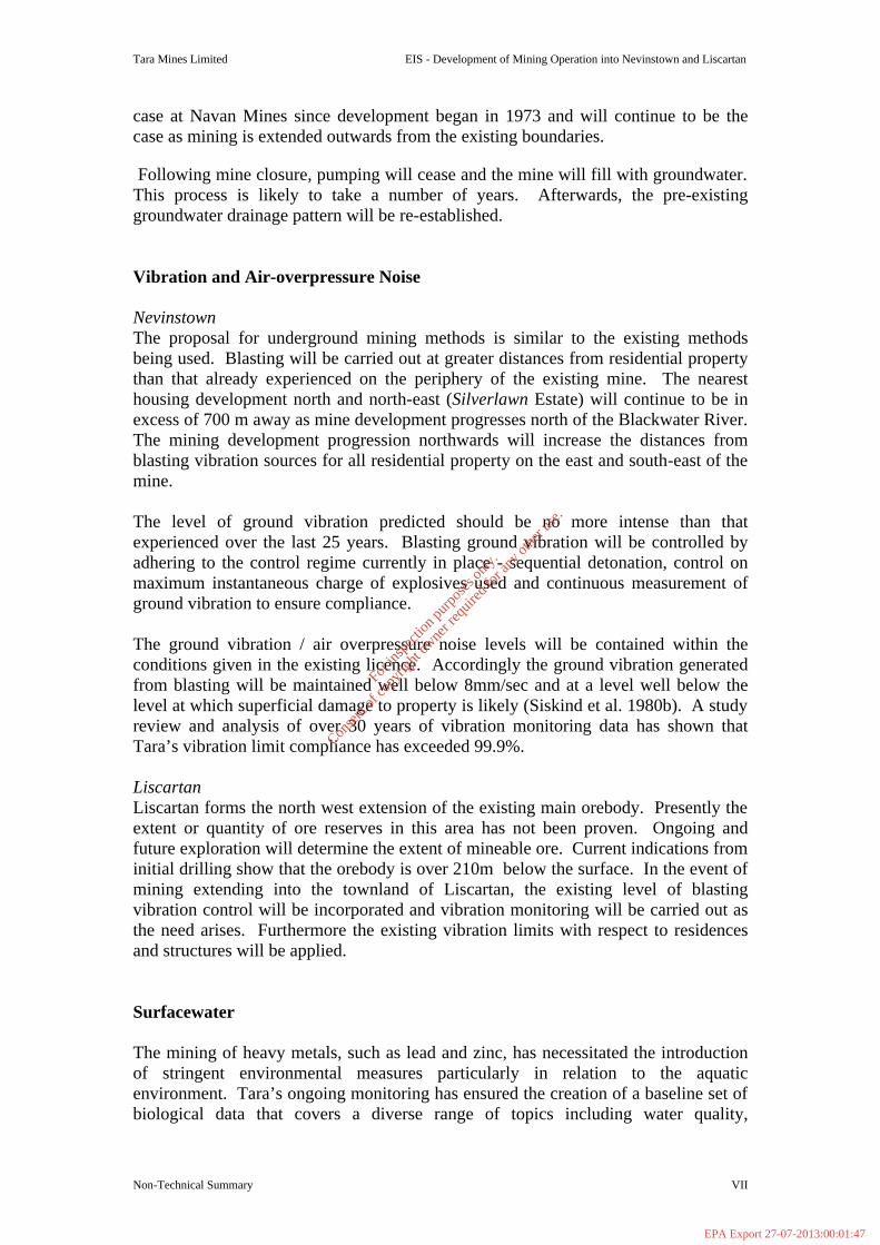
Following mine closure, pumping will cease and the mine will fill with groundwater. This process is likely to take a number of years. Afterwards, the pre-existing groundwater drainage pattern will be re-established. Vibration and Air-overpressure Noise Nevinstown The proposal for underground mining methods is similar to the existing methods being used. Blasting will be carried out at greater distances from residential property than that already experienced on the periphery of the existing mine. The nearest housing development north and north-east (Silverlawn Estate) will continue to be in excess of 700 m away as mine development progresses north of the Blackwater River. The mining development progression northwards will increase the distances from blasting vibration sources for all residential property on the east and south-east of the mine. The level of ground vibration predicted should be no more intense than that experienced over the last 25 years. Blasting ground vibration will be controlled by adhering to the control regime currently in place - sequential detonation, control on maximum instantaneous charge of explosives used and continuous measurement of ground vibration to ensure compliance. The ground vibration / air overpressure noise levels will be contained within the conditions given in the existing licence. Accordingly the ground vibration generated from blasting will be maintained well below 8mm/sec and at a level well below the level at which superficial damage to property is likely (Siskind et al. 1980b). A study review and analysis of over 30 years of vibration monitoring data has shown that Tara’s vibration limit compliance has exceeded 99.9%. Liscartan Liscartan forms the north west extension of the existing main orebody. Presently the extent or quantity of ore reserves in this area has not been proven. Ongoing and future exploration will determine the extent of mineable ore. Current indications from initial drilling show that the orebody is over 210m below the surface. In the event of mining extending into the townland of Liscartan, the existing level of blasting vibration control will be incorporated and vibration monitoring will be carried out as the need arises. Furthermore the existing vibration limits with respect to residences and structures will be applied. Surfacewater The mining of heavy metals, such as lead and zinc, has necessitated the introduction of stringent environmental measures particularly in relation to the aquatic environment. Tara’s ongoing monitoring has ensured the creation of a baseline set of biological data that covers a diverse range of topics including water quality,
For
insp
ectio
n pur
pose
s only
.
Conse
nt of
copy
right
owne
r req
uired
for a
ny ot
her u
se.
EPA Export 27-07-2013:00:01:47
Tara Mines Limited EIS - Development of Mining Operation into Nevinstown and Liscartan
Non-Technical Summary VIII
community structure of the aquatic flora and fauna, fish stocks and the possible accumulation of heavy metals in fish tissues. A Biological Assessment of the River Blackwater was carried out in 2001 to establish if mining activity have had any adverse effects on the aquatic environment. The study concluded that aquatic macroinvertebrate fauna have remained remarkably stable at four particular sites on the River Blackwater over the last 25-30 years. The only apparent damage is from agricultural practices involving the increased production of phosphorus and nitrate. There was ample evidence of algal growth present. The overall conclusion is that the Nevinstown and Liscartan development will not cause any major impacts to the existing aquatic environment. The proposed mining operations will be approximately 30m below the overburden (and not less than 40m below the surface at Nevinstown and 210m at Liscartan) and there are no plans to install effluent pipes or conduits. Past experience will ensure that best practices are maintained and no environmental damage is caused to the tributaries and streams flowing through Nevinstown and Liscartan and entering the Blackwater. Tara Mines have always ensured continuous monitoring in the region and will continue this practice in accordance with their IPC Licence. The groundwater inflows to the Nevinstown and Liscartan extension (including all groundwater inflow / backfill water / service water) will be collected at a central underground pumping station. In addition to the existing sump there may be additional higher-level sumps constructed in the new workings. All dewatering flows will continue to pass through a large settling sump at this pumping station, where suspended solids settle out, prior to being pumped via the production shaft to the second stage of settlement/clarification in the Minewater/Reclaim Water Ponds. There will be no additional water management facilities on surface. The additional dewatering flow from the Nevinstown orebody is estimated to be approximately 1000m3/d. This amounts to an additional 13% of the inflow to the mine and 5% of the maximum pumping capacity. There is sufficient flexibility and storage in the water management system to accommodate all additional water collected and pumped from underground. Flora and Fauna A baseline habitat, flora and fauna survey of the Nevinstown property which is located to the north-west of Navan town (study site grid reference N 855 690) was carried out in June 2002. The survey methodology consisted of systematically walking the site area and recording on a large scale map habitats and vegetation types present. Habitat classification is according to the system recommended by The Heritage Council (Fossit 2000). Notes were made on bird species present within and around the site. For mammals, the main emphasis was on search for signs of activity or dwellings. During the survey, particular attention was given to the possible presence of habitats and/or species that are legally protected under Irish or European
For
insp
ectio
n pur
pose
s only
.
Conse
nt of
copy
right
owne
r req
uired
for a
ny ot
her u
se.
EPA Export 27-07-2013:00:01:47

Tara Mines Limited EIS - Development of Mining Operation into Nevinstown and Liscartan
Non-Technical Summary IX
legislation (e.g. the Flora Protection Order 1999; Wildlife Act 1966; EU Habitats Directive; EU Birds Directive). The majority of the site is dominated by improved grassland, either pasture or meadow, with hedgerows the main field boundary type. Several patches of scrub occur, and there are stands of planted woodland in the northern sector of the site. Wet ditches or drainage channels are also found. The main ecological feature of the area is the River Blackwater, a substantial watercourse and important fishery that is a tributary of the River Boyne and forms the southern boundary to the site. Marginal wetland vegetation can be found along the riverbank. The site also includes a number of buildings and a section of railway track. The principal habitat at this site, improved grassland, has negligible or very low scientific importance or conservation value. The main ecological interests lie in the hedgerows, woodland and particularly the river and associated marginal vegetation. The hedgerows are mostly well developed and some are notable for the presence of tall trees. Species diversity is fairly typical of the hedgerows in Co. Meath and have ecological value in a local context. The planted woodland stands provide useful habitat for a range of wildlife species, though their scientific value is low. The River Blackwater is a substantial watercourse with important scientific interests and is a notable fishery. In some areas the river still has a recognisable flood-plain zone and this supports typical wetland vegetation. The survey area does not appear to support, nor has been known to in the past, any rare or protected plant species. No animal species of high conservation importance occurs within the main part of the site. As the proposed development would not cause any disturbance to the surface of Nevinstown and the site, and as mining operations will be well below the rooting depth of plants, it is concluded that there would not be any impacts on the ecological interests of the area. Landscape and Visual Impact There are no surface structures / infrastructure required, thus the surface characteristics and features of the Nevinstown and Liscartan townlands will in no way be altered. Air There is no additional surface air intake / output infrastructure required for the Nevinstown and Liscartan development. Therefore, there will be no impact on the air quality of the area resulting from this project.
For
insp
ectio
n pur
pose
s only
.
Conse
nt of
copy
right
owne
r req
uired
for a
ny ot
her u
se.
EPA Export 27-07-2013:00:01:47
Tara Mines Limited EIS - Development of Mining Operation into Nevinstown and Liscartan
Non-Technical Summary X
Material Assets A detailed archaeological study was undertaken comprising of the results of desk-based research and a field survey of the proposed development site. The field inspection was carried out to assess the local topography and current land use. The present condition of archaeological sites previously excavated in the development area was noted as was any further possible features of archaeological or historical interest. The site is located in an area where there is clear evidence of settlement from at least the Neolithic period onwards. Excavations within the boundaries of the development site itself have uncovered archaeological deposits dating to the Early Bronze Age, Early Christian, Medieval and Post-Medieval periods (each period being listed in the study). These excavations took place in advance of a proposed open-cast mining operation which did not proceed. In the vicinity of the Nevinstown evidence of early settlement is present in the form of upstanding monuments as well as archaeological deposits which were discovered during development of the tailings dam at Simonstown and Randalstown. The study lists all the archaeological sites in Nevinstown and adjoining townlands as recorded by Dóchas in the SMR/RMP and the Archaeological Inventory of County Meath.. The proposed development, confined entirely to underground mining operations, will not have any impact on the recorded archaeological sites and monuments at Nevinstown and Liscartan or in the surrounding areas. Roads and Traffic Access to the Nevinstown and Liscartan orebody will be from within the existing main mine plant site. A new inclined portal access (underground roadway) is planned from the surface of the existing plant site adjacent to the existing portal that will provide a vehicle route via the existing mine into the Nevinstown orebody. There will be no access to the Nevinstown orebody from the Nevinstown side of the River Blackwater. Access to Liscartan will also be from existing mine infrastructure. No additional transportation infrastructure is therefore required. Access to the Nevinstown property is from the Rathaldron Road via a private roadway owned by Tara Mine Ltd. The proposed development will not impact on current traffic levels of the area. Climate The Nevinstown and Liscartan orebody development will have no impact on climactic conditions. The role of weather conditions, principally wind speed & direction and precipitation, as potential vectors of pollution will continue to be monitored.
For
insp
ectio
n pur
pose
s only
.
Conse
nt of
copy
right
owne
r req
uired
for a
ny ot
her u
se.
EPA Export 27-07-2013:00:01:47

Tara Mines Limited EIS - Extension of Mining Operation into Nevinstown and Liscartan
Introduction 1
_____________________________________________________________________
SECTION 1 INTRODUCTION
_____________________________________________________________________
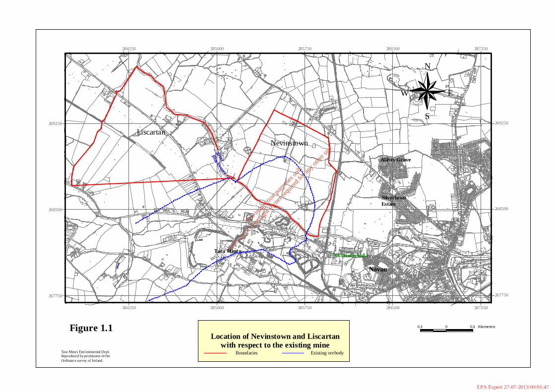
1.1 Background Tara Mines Limited, the largest operating lead-zinc mine in Europe, is located at Knockumber, 2 km west of Navan in County Meath. Originally sited in a rural area, expansion of Navan has resulted in the development of residential areas nearer to the mine although much of its surroundings remain flat agricultural land drained by prolific fishing rivers. The River Blackwater (which flows into the River Boyne) passes over the orebody and forms a surface intersection feature between what is now referred to as the ‘Main orebody’ and the ‘Nevinstown orebody’. Liscartan forms the north west extension of the main orebody. However, mineable ore reserves have not yet been proven in this area. The original ore reserves (calculated 1971) south of the River Blackwater were 60.9 million tonnes at 10.1% zinc and 2.6% lead. In 2001 ore production totalled 2.0 million tonnes at a grade of 8.8 % zinc and 1.6 % lead (the mine being on a care and maintenance basis for the last 2 months of 2001). The 2.0 million tonnes of ore produced 146,000 tonnes of zinc and 26,000 tonnes of lead in concentrates. The estimated current known mineral resources including the expansion of the mine northwards into the Nevinstown orebody, along with the planned southwest extension of the ‘main orebody’ (SWEX development) are 20.2 million tonnes grading 7.2% zinc and 2.2% lead. The current estimated ore reserves are 18.3 million tonnes at 9.4% zinc and 2.1% lead. It is envisaged that annual production of 250,000 tonnes of zinc in concentrates (2.8 million tonnes of ore equivalent) will be achieved by the year 2004. This would improve the cost efficiency of the mine and assure Tara’s status as the fourth largest zinc mine in the world. 1.2 Proposed Development It is proposed to extend the existing mining operation into Nevinstown and Liscartan. The Nevinstown orebody is in essence an extension northwards of the existing ‘main orebody’ while Liscartan forms the north west extension of the same orebody. Ongoing and future exploration will determine the quantity and extent of mineable reserves in the Liscartan area. Figure 1.1 shows the locations of Nevinstown and Liscartan with respect to the existing mine. 1.2.1 The Nevinstown Orebody Development The proposed development involves establishing access to the orebody by underground mining methods via the existing underground mine and therefore no surface development in the Nevinstown area is required. A new inclined portal access from the surface property of Tara Mines is planned that will provide a vehicle route to the existing mine and to the Nevinstown orebody. The necessary infrastructure for its
For
insp
ectio
n pur
pose
s only
.
Conse
nt of
copy
right
owne
r req
uired
for a
ny ot
her u
se.
EPA Export 27-07-2013:00:01:47
Tara Mines
Abbey Grove
SilverlawnEstate
River
Blackwater
Navan
N3 (Kells Rd.)
N
EW
S
0.3 0 0.3 Kilometers
284250
284250
285000
285000
285750
285750
286500
286500
287250
287250
267750 267750
268500 268500
269250 269250
Figure 1.1
Tara Mines Environmental Dept.Reproduced by permission of theOrdinance survey of Ireland.
LiscartanNevinstown
Location of Nevinstown and Liscartanwith respect to the existing mine
Boundaries Existing orebody
For
insp
ectio
n pur
pose
s only
.
Conse
nt of
copy
right
owne
r req
uired
for a
ny ot
her u
se.
EPA Export 27-07-2013:00:01:47

Tara Mines Limited EIS - Extension of Mining Operation into Nevinstown and Liscartan
Introduction 3
operation is already in place; including administration, mining and processing facilities, tailings storage capacity, ventilation, effluent discharge facilities and road/rail links to Dublin Port. The entire Nevinstown property is zoned as Mining and will remain so throughout the development period of the orebody. The property has been operated as a rough grassland farm unit since 1972 and will remain as farmland used by grazing tenants. 1.3 E.I.A. Regulations The European Council Directive 85/377/EEC on the assessment of the effects of certain public and private projects on the environment is provided for in Irish legislation by: § The European Communities (Environmental Impact Assessment) Regulations,
1989 (S.I. No 349 of 1989). Amended in 1994 by S.I. No. 84 of 1994. § The Local Government (planning and development) Regulations, 2001 (S.I.
No. 600 of 2001). Environmental impact assessment is provided for in Part X of the Planning and Development Act 2000 and in the Planning and Development Regulations 2001 for specified classes of development prescribed by regulations made under Section 176 of the Act. The proposed extension of mining operations into Nevinstown and Liscartan constitutes a project as prescribed in Schedule 5 of the 2001 regulations. 1.4 Role of Government and Statutory Bodies Responsibility for the protection of the environment and the regulation of planning issues lies primarily with the Department of the Environment and Local Government. Other Government departments, statutory bodies and special interest groups also exercise important control functions. The responsibility for further regulation in the natural resource sector, including mining, is currently administered by the Department of Communications, Marine and Natural Resources who also, though not directly, have responsibility for environmental control through the Central and Regional Fisheries Boards. Within the Department of the Environment and Local Government, the Heritage Service, Dúchas, plays a major role in relation to the protection, conservation and management of the natural and built as well as the historic environment.
Of the Statutory Bodies, the local authorities have a major role in relation to the enforcement of planning legislation especially at county and local level. The major environmental management responsibility for improving and protecting the environment lies with the Environmental Protection Agency. Another Statutory Body with immense regulatory power is the Planning Appeals Board, An Bord Pleanala, which determines first and third party appeals inter alia against planning decisions. Other bodies with responsibilities in relation to mining development are the Health
For
insp
ectio
n pur
pose
s only
.
Conse
nt of
copy
right
owne
r req
uired
for a
ny ot
her u
se.
EPA Export 27-07-2013:00:01:47
Tara Mines Limited EIS - Extension of Mining Operation into Nevinstown and Liscartan
Introduction 4
Boards and the National Authority for Occupational Safety and Health, however, the extent of their involvement varies with the circumstances of individual proposed developments. Of the Special Interest Groups the most important is An Taisce, the National Trust for Ireland. It has prescribed body status under the planning acts and has the right of examination of planning applications. A lesser participatory role in planning decisions has been played by Bord Failte Eireann, the National Tourist Board. 1.5 Content of the Environmental Impact Statement The Environmental Impact Statement (EIS) is a key component of the impact assessment procedure and its content is specified in Annex III of the EC Directive and is defined in Article 25 of S.I. No. 349 of 1989 as follows:-
“A statement of the effects, if any, which proposed development, if carried out, would have on the environment”
This EIS has been prepared following a “Grouped Format Structure” as described in Draft Guidelines on the Information to be Contained in Environmental Impact Statements, Environmental Protection Agency, 2002 which has been used as a term of reference. This format examines each topic considered as a separate section referring to the existing environment, the proposed development, impacts and mitigation measures. The environmental topics included in this EIS are Human Beings, Geotechnical, Hydrology and Groundwater, Vibration and Noise, Aquatic, Flora and Fauna, Air, Landscape and Visual Impact and Climate. 1.6 The Project Team The Environmental Impact Statement has been prepared by Tara Mines Environmental Department staff with assistance of the following specialists: The main participating specialists include;
§ Geotechnical M.A. Struthers, M.F. Lee, Australian Mining Consultants (UK) Ltd.
§ Groundwater Geoff Beale, Patrick McKelvey, Water Management Consultants Limited, UK
§ Blast Vibration and Air-overpressure Noise Brendan O’Reilly, Tara Mines Environmental Department
§ Aquatic Deirdre Tierney, Roisin Lyons, Mary Kelly-Quinn and J. J. Bracken, Aqueens Limited, Dublin
§ Flora and Fauna Brian Madden, Biosphere Environmental Services, Co. Wicklow
§ Archaeology - Heritage and Cultural Kieran Campbell, Drogheda, Co.Louth
For
insp
ectio
n pur
pose
s only
.
Conse
nt of
copy
right
owne
r req
uired
for a
ny ot
her u
se.
EPA Export 27-07-2013:00:01:47

Tara Mines Limited EIS - Extension of Mining Operation into Nevinstown and Liscartan
Introduction 5
§ Air Tara Mines Environmental Department
§ Human Beings Tara Mines Environmental Department
§ Landscape and Visual Impact Tara Mines Environmental Department
§ Climate Tara Mines Environmental Department
The sub-section on ‘soil moisture’ was carried out by J. Mulqueen, Teagasc Land and Water Management Unit, NUI Galway. The following Environmental Department personnel contributed to the preparation of the EIS: Eric Brady MSc, IAH Oliver Fitzsimons, B. Env.Sc. (Hons) Ailish Mc Cabe, B. Ag.Sc. (Hons) Brendan O’ Reilly, MSc, ISEE, SFA, EAA Significant contributions were made by the various departments within the mine and by W. G. Dallas, Enviro Plan Services.
For
insp
ectio
n pur
pose
s only
.
Conse
nt of
copy
right
owne
r req
uired
for a
ny ot
her u
se.
EPA Export 27-07-2013:00:01:47
Tara Mines Limited EIS - Extension of Mining into Nevinstown and Liscartan _______________________________________________________________________________________________________
Project Description 6
_____________________________________________________________________
SECTION 2 PROJECT DESCRIPTION
____________________________________________________________________
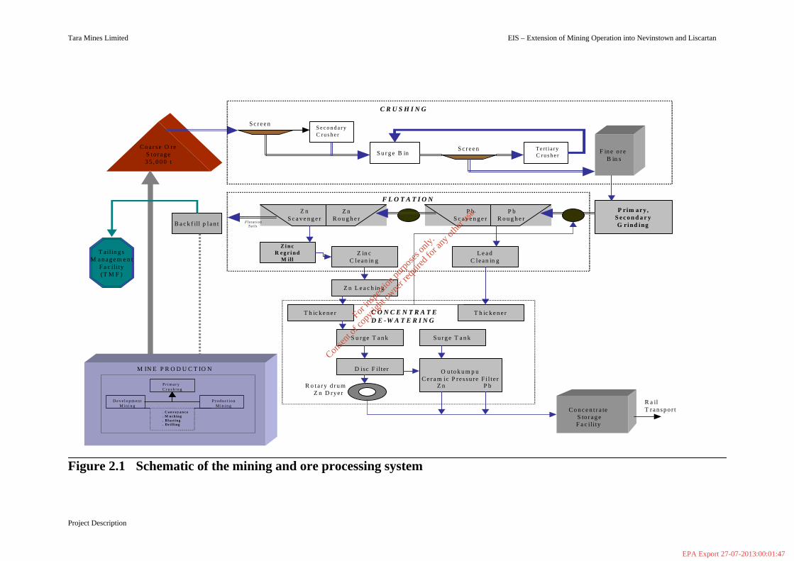
2.1 Introduction The Nevinstown orebody is an uninterrupted northern continuation of the ‘main orebody’ currently being mined by Tara Mines Ltd. The orebody is present at the surface level of the Nevinstown townland and dips steeply below the River Blackwater into the property of Tara Mines Ltd. Liscartan forms the North-west extension of the ‘main orebody’. Presently the extent or quantity of ore reserves in the Liscartan area has not been proven. However indications from initial drilling show that the orebody lies in excess of 210m below the surface. The proposal involves the mining of the proven ore reserves in the Nevinstown orebody and the mining of the Liscartan orebody subject to confirmation of mineable ore reserves. Mining follows a cyclic pattern resulting in the removal of ore underground followed by the filling of the voids using cement and waste sand material that remains after the ore treatment process. The surface characteristics and features of the Nevinstown and Liscarton townlands will not be altered by mining activity and there will be no surface structure / infrastructure facilities in the area. Figure 2.1 displays a schematic of the mining and ore processing system. 2.2 Mining and Processing Operation
2.2.1 Access
Access to the proposed Nevinstown and Liscartan development will be underground via a new portal access (underground road from surface) on the Knockumber Mine site. This will provide a vehicle route via the existing mine into the new orebody. Underground drifts from existing mine workings at varying locations and depths will provide access for mining purposes. There will be no access to the new orebody other than from the existing main site. 2.2.2 Underground Infrastructure A new main decline (portal access) will allow mining vehicles to enter the mine. Other mine services such as compressed air, water, fuel and communications cables will be directed down holes (drilled on Tara owned property), south of River Blackwater. These mine services transverse down along access drifts and on into the Nevinstown orebody. There will be no services taken into the mine from outside of the main Knockumber site. Underground infrastructure may include lunchrooms, fuelling stations and ore passes. Existing facilities in the existing mine will be utilised whenever possible.
For
insp
ectio
n pur
pose
s only
.
Conse
nt of
copy
right
owne
r req
uired
for a
ny ot
her u
se.
EPA Export 27-07-2013:00:01:47
Tara Mines Limited EIS – Extension of Mining Operation into Nevinstown and Liscartan
Project Description
Figure 2.1 Schematic of the mining and ore processing system
C o a r s e O reS t o r a g e3 5 , 0 0 0 t
S e c o n d a r yC r u s h e r
S u r g e B in F in e o r e B in s
Ter t i a ryC r u s h e r
P rim a r y ,S e c o n d a r yG rind ingB a c k f ill p l a n t F l o t a t i o n
T a i l s
Z in cC lean in g
Z i n cR e g r i n d
M ill
Z n L e a c h in g
L e a dC lean in g
T h ic k e n e r T h ic k e n e r
S u rge T a n k S u r g e T a n k
R o t a r y d r u mZ n D ryer
C o n c e n t r a teS to r a g e F a c il i ty
C O N C E N T R A T ED E -W A T E R I N G
S c r e e n
S c r e e n
C R U S H I N G
T ailin g sM a n a g e m e n t
F a c il i ty(T M F )
O u to k u m p uC e r a m ic P res su re F i l t e r
D isc F il ter
P bR o u g h e r
P bS c a v e n g e r
Z nR o u g h e r
Z nS c a v e n g e r
F L O T A T I O N
Z n P b
M IN E P R O D U C T IO N
. C o n v e y a n c e
. M uck ing
. B l a s t i n g
. Dr i l l ing
P r i m a r yC r u s h i n g
D e v e l o p m e n tM i n i n g
P r o d u c t i o nM i n i n g
R a ilT r a n s p o r t
For
insp
ectio
n pur
pose
s only
.
Conse
nt of
copy
right
owne
r req
uired
for a
ny ot
her u
se.
EPA Export 27-07-2013:00:01:47
Tara Mines Limited EIS - Extension of Mining into Nevinstown and Liscartan _______________________________________________________________________________________________________
Project Description 8
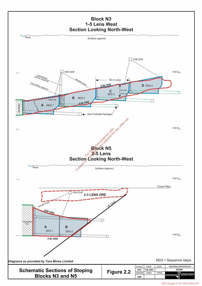
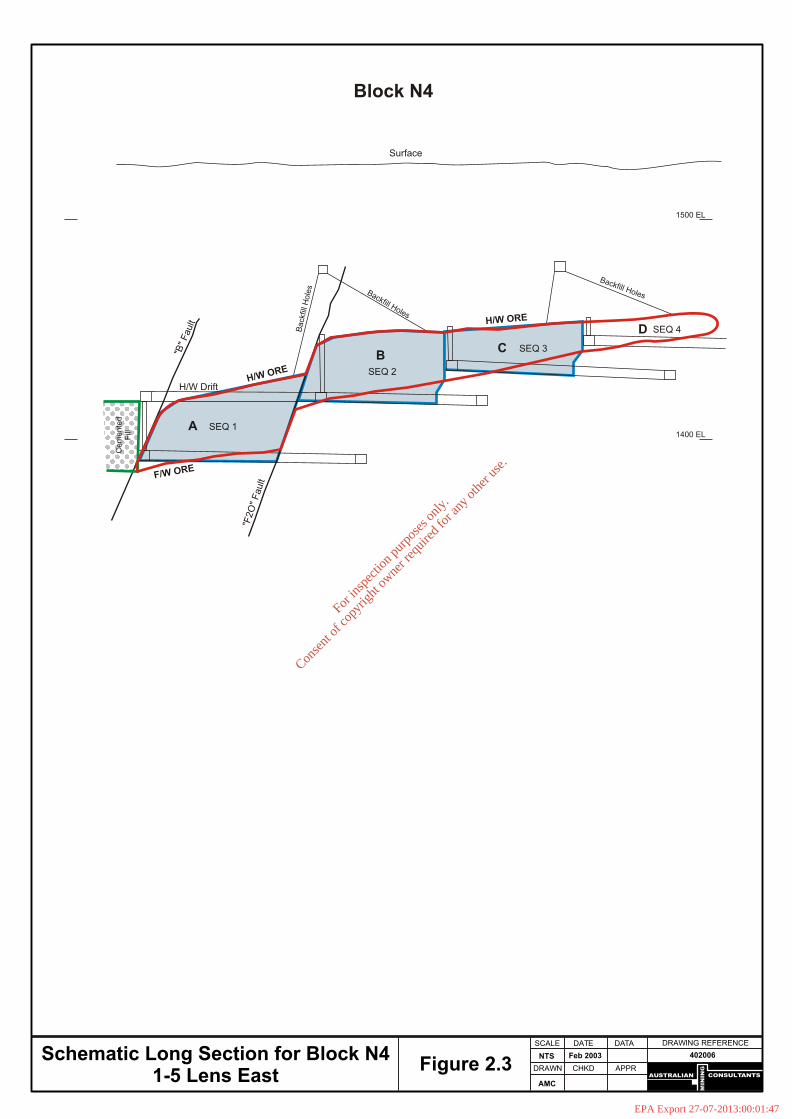
2.2.3 Development Mine development is planned to access the orebody at varying levels and to prepare large sections of the orebody for mining. Development drifts are driven at different dimensions depending on their intended purpose, for example a main haulage drift will have larger dimensions than a drift designed for ventilation purposes. It is necessary to have a significant amount of development in place before large-scale ore production commences. All development work is accessed from the existing mine, all ore and waste rock produced by the development will be trucked back into the existing mine. 2.2.4 Mining Methods 2.2.4.1 Nevinstown Orebody The upper boundary of the orebody passes under the River Blackwater below which mining is currently taking place. The orebody is closest to surface at its eastern end and at the greatest depth at the western end. Geotechnical studies (which are dealt with in Section 5) determine that a crown pillar of approximately 30 meters thick in this location. To the west the ore horizon is some 250 meters below surface. The Nevinstown ore will be mined over a period of approximately 10 years, at an average rate of approximately 700,000 tonnes per annum. The selected mining method is mostly longhole open stoping with backfill, for the thicker areas of ore, and variations on ‘room & pillar’ mining in areas of thinner ore. Cemented backfill will be used for initial (primary) stoping, and a mixture of cemented and uncemented backfill for later (secondary/pillar) stoping. This is as per current practice in the existing mine. An important aspect of the longhole open stoping method is that mining is sequential, ie. stopes are mined in sequence, and each stope is filled before mining of the adjacent stope commences. In ‘room and pillar’ stoping the roof stability is achieved through the design of stable rock pillars, provision of roof support where necessary, and the use of regional (larger) pillars where the mining spans are large. Stoping is planned to commence in the south of Nevinstown, close to the river, and to gradually progress northwards and westwards. The longhole stoping proposals for the two main ore lenses at Nevinstown are quite similar. The 2-5 lens will have independent hangingwall development for ventilation and backfilling of stopes (Figure 2.2). The 1-5 lens will also have independent hangingwall drifts for backfilling and ventilation for most stopes (Figure 2.3). Where this is not possible, ventilation and backfill will be provided via the mucking horizon for the adjacent (to be mined) stope up-dip. The long axis of all stopes is directly North. The stoping proposals for Nevinstown have been reviewed, and the report includes a number of recommendations relating to their design and implementation to ensure that the area remains stable, both during and after ore extraction.
For
insp
ectio
n pur
pose
s only
.
Conse
nt of
copy
right
owne
r req
uired
for a
ny ot
her u
se.
EPA Export 27-07-2013:00:01:47
CONSULTANTS
MIN
ING
AUSTRALIAN
DRAWING REFERENCEDATE
DRAWN
AMC
NTS Feb 2003 402006
SCALE DATA
CHKD APPRFigure 2.2
SEQ 2SEQ 1
B
2-3 LENS ORE
A
CementedFill
H/W Drift
Crown Pillar
"B" F
ault
River Surface (approx)
F/W ORE
H/W ORE
Backfill Holes
1550 EL
1450 EL
60 m Long
SEQ 3
SEQ 2
SEQ 1
SEQ 4
24m highx
20m wideC
B
A
D
Cem Fill
Ba
ckfil
led
H/W Drift
H/W Drift
River Surface (approx)
Sub Footwall Haulages
F/W ORE
H/W ORE
Backfill HolesPost Pillars (approx)
Vent Raises(where required)
Pro
d D
rill Hole
s
1500 EL
1400 EL
Block N52-5 Lens
Section Looking North-West
Block N31-5 Lens West
Section Looking North-West
Schematic Sections of StopingBlocks N3 and N5
SEQ = Sequence stepsDiagrams as provided by Tara Mines Limited
For
insp
ectio
n pur
pose
s only
.
Conse
nt of
copy
right
owne
r req
uired
for a
ny ot
her u
se.
EPA Export 27-07-2013:00:01:47
CONSULTANTS
MIN
ING
AUSTRALIAN
DRAWING REFERENCEDATE
DRAWN
AMC
NTS Feb 2003 402006
SCALE DATA
CHKD APPRFigure 2.3Schematic Long Section for Block N4
1-5 Lens East
Block N4
Ce
me
nte
dF
ill
1500 EL
1400 EL
SEQ 2
H/W Drift
"B"
Fault
"F2O
" F
ault
BSEQ 3C
SEQ 1A
H/W ORE
H/W ORE
F/W ORE
Backfill Holes
Backfill HolesB
ack
fill H
ole
s
SEQ 4D
Surface
For
insp
ectio
n pur
pose
s only
.
Conse
nt of
copy
right
owne
r req
uired
for a
ny ot
her u
se.
EPA Export 27-07-2013:00:01:47
Tara Mines Limited EIS - Extension of Mining into Nevinstown and Liscartan _______________________________________________________________________________________________________
Project Description 11
2.2.4.2 Liscartan Orebody In general the erratic nature of ore in this area coupled with the wide and variable surface drilling density militates against classification of the mineralisation as anything other than ‘Inferred Sources’. The existing mine surface structures and infrastructure will facilitate mining in Liscartan. Access to Liscartan will be from the existing main orebody. All ventilation requirements will be met by the existing mine ventilitation system and existing fan stations will remain unaltered in terms of their air flow volumes and overall performance. There will be no ventilation related connections to the surface in this area. It is premature to outline any mining schedule, but the selected mining method will in all probability be longhole open stoping with backfill. Cemented backfill will be used for the initial (primary) stoping, and a mixture of cemented and uncemented backfill for later (secondary) stoping. This will be as current practice in the existing mine. The proposed mining methods and stope dimensions will be appropriate for the ground conditions taking account of specific structural weaknesses, as per current practice. 2.2.5 Mine Production Mine production involves the generation of large tonnage of ore from stopes and pillars. All ore produced will be transported by scoop and/or truck underground back into the existing mine for crushing and hoisting. The main mine will shortly have 5 crushers. The Nevinstown & Liscartan ore will be crushed at existing crushers (No.1 and No. 2 ) Main mine ore production in 2003 is scheduled at almost 2.1m tonnes plus 0.5m tonnes of development ore. This includes a scheduled 100,000 tonnes of development ore from Nevinstown. Therefore in 2003 Nevinstown development ore will comprise 3.8% of total mine ore. In a typical full production year, 700,000 tonnes of stope & pillar ore and 104,000 tonnes of development ore will be scheduled from Nevinstown. In the coming years the tonnage of ore from the existing main orebody crushed at No.1 and No.2 crushers will be greatly reduced, therefore the existing crushing and conveyance infrastructure will be capable of handling Nevinstown and Liscartan development and production ore. Waste rock generated by continued development will be either: § Placed underground in the main mine § Placed underground in new stopes § Hauled to surface for temporary storage § Re-directed to orepasses to be crushed and hoisted to surface for temporary § storage.
Mining equipment to load and haul waste rock is part of the existing fleet. No additional mobile equipment will be necessary to handle the new ore.
For
insp
ectio
n pur
pose
s only
.
Conse
nt of
copy
right
owne
r req
uired
for a
ny ot
her u
se.
EPA Export 27-07-2013:00:01:47

Tara Mines Limited EIS - Extension of Mining into Nevinstown and Liscartan _______________________________________________________________________________________________________
Project Description 12
2.2.6 Ventilation All ventilation requirements will be met by the existing mine ventilation system. Fresh air will enter the mine through existing fresh air routes and the new portal. Air will flow along the main working levels of the mine before rising to upper dedicated drifts, which will carry the exhaust air back to existing underground and surface fan stations. Existing fan stations will remain unaltered in terms of their airflow volumes and overall performance. There will be no ventilation-related connections to surface other that that already established on the main mine site. The performance of these fan stations is not being altered in any way, so total emissions will continue at current levels. 2.2.7 Backfilling Mined-out areas will be backfilled with sand-fraction mill tailings and cement through an extensive underground pipeline network connected to the existing mine backfilling facilities. Stopes will be backfilled through holes drilled down into the roof of the excavation and backfill poured down over an extended period until the stope is filled. There will be no backfilling-related connections to surface outside the main mine site. 2.2.8 Mine Dewatering All underground water encountered during development and mining will be collected at a central underground pumping station and piped back into the existing mine. This water will then join the existing mine drainage system for later treatment and pumping to surface. The total pumping capacity in the mine is 21,600 m3/d. There will be no additional water pumping related connections to surface The additional dewatering flow from the Nevinstown orebody is estimated to be approximately 1000m3/d. This amounts to an additional 13% of the inflow to the mine and 5% of the maximum pumping capacity. Likewise all groundwater encountered during the development and mining of Liscartan will be collected at a central underground pumping station and pumped back to the existing mine. It is however not possible to estimate the quantity of water as the extent of mineable ore in Liscartan has not yet been established. It is anticipated that there will be is sufficient flexibility and storage in the water management system to accommodate any additional flow.
For
insp
ectio
n pur
pose
s only
.
Conse
nt of
copy
right
owne
r req
uired
for a
ny ot
her u
se.
EPA Export 27-07-2013:00:01:47

Tara Mines Limited EIS - Extension of Mining Operation into Nevinstown and Liscartan
Scoping and Consultation 13
_____________________________________________________________________
SECTION 3 SCOPING AND CONSULTATION
_____________________________________________________________________ 3.1 Introduction Scoping is a process entered into in the early stages of an EIA in order to identify and clarify the key issues that are likely to be important during EIA and eliminates those that are not. The information may be compiled by a formal process, whereby the competent authority is asked to consult with relevant agencies to draw up an opinion about the scope of the coverage required. More informal scoping can also be carried out to ensure that all relevant issues are identified and addressed to an appropriate level of detail. In addition to consultation with the competent authority, scoping routinely involves consultation with Statutory bodies such as Duchas or Regional Fisheries Boards to whom aspects of the proposed development may be referred for comment. It also often involves consultation with Non Governmental Organisations such as the Heritage Council or An Taisce that have interests in specific aspects of the environment likely to be affected by the development. Sensitive receptors such as neighbouring landowners, local communities are usually identified and are actively involved in the scoping process. 3.2 Guidance Neither EC Directive 85/337 nor the Regulations transposing it into Irish law refer specifically to scoping. However, the scoping process has become an established and integral part of an EIA and this is reflected in many recent publications (eg. Advice Notes on current practice in the Preparation of Environmental Impact Statements and Guidelines on the Information to be Contained in Environmental Impact Statements, Environmental Protection Agency, March 2002 ). 3.3 Scoping for Nevinstown and Liscartan Development During the scooping process for the Nevinstown Development particular focus was placed on issues and impacts that which were;
(i) Environmentally based (ii) Likely to occur (iii) Significant or adverse
The scope emerged from dialogue between; § Tara’s Environmental Department who proposed the initial outline based on a
knowledge of the project and the site;
For
insp
ectio
n pur
pose
s only
.
Conse
nt of
copy
right
owne
r req
uired
for a
ny ot
her u
se.
EPA Export 27-07-2013:00:01:47

Tara Mines Limited EIS - Extension of Mining Operation into Nevinstown and Liscartan
Scoping and Consultation 14
§ The Competent Authority (Meath County Council) who have a detailed
knowledge of the procedural and legal requirements as well as an extensive knowledge of both the context and local issues and concerns;
§ Specialist Agencies / Consultants who have a detailed understanding of a
particular aspect of the environment affected (including An Taisce, Central Fisheries Board etc.).
§ The Public and local businesses, who provided views on both thematic and
area-specific concerns. Scoping continued throughout the duration of the EIA and often involved feedback and further consultation with relevant parties. This was achieved by reviewing environmental criteria emerging from an assessment of the specific receiving environment.
For
insp
ectio
n pur
pose
s only
.
Conse
nt of
copy
right
owne
r req
uired
for a
ny ot
her u
se.
EPA Export 27-07-2013:00:01:47

Tara Mines Limited EIS - Extension of Mining Operation into Nevinstown and Liscartan
Human Beings 15
_____________________________________________________________________
SECTION 4 HUMAN BEINGS
_____________________________________________________________________
4.1 Economic Activity 4.1.1 Introduction The 1999 Strategic Planning Guidelines for the greater Dublin area listed Co.Meath as hinterland area and recognised Navan as one of the primary growth centers. In its intended role Navan would develop into a town with strong employment, retailing and service bases. The town has increasingly assumed the role of a Dormitory town for Dublin City and concurrently the population has swelled. Nonetheless, local industry remains the primary source of employment. The Tara Mine, one of the most significant employers in the Navan area, has been in existence since 1972 and in production since 1977. Its economic benefits both locally and nationally have been well established. Estimated current reserves and resources of ore concentrates (including the Nevinstown orebody) are sufficient to extend the mine life to the year 2015. The proposed expansion into the Nevinstown orebody will greatly increase the planned lifespan of the mine and will also contribute significantly to the viability of the Tara operation thereby assuring its status as the fourth largest zinc mine in the world. 4.1.2 Scope of Economic Issues under Consideration The principal economic consequence of the Nevinstown development will result from its effect on the future life of the mine. These consequences are estimated in terms of employment and income to the local region and the country including:
Direct effects, such as the employment and capital investment in the mine over its expected lifetime. Indirect effects, such as employment and income effects in enterprises supplying goods and services to the mine. Induced (knock-on) effects, which are additional to the indirect effects since they arise from the establishment of new enterprises or from increased levels of economic activity supported by the mine.
There is no doubt that the proposed extension to the mine will be a project of major economic significance at local, regional and national levels. 4.1.3 Contribution to Local Economy The effect of wages and salaries generated by Tara being spent in the local and greater Navan areas are considerable. Currently, the annual wage bill is €35.5 million, of
For
insp
ectio
n pur
pose
s only
.
Conse
nt of
copy
right
owne
r req
uired
for a
ny ot
her u
se.
EPA Export 27-07-2013:00:01:47

Tara Mines Limited EIS - Extension of Mining Operation into Nevinstown and Liscartan
Human Beings 16
which approximately €32 million is the gross payroll cost, and €3.5 is the employer costs. In addition an average of €1,340.000 is paid, annually, to the local authority in rates, water rates and planning charges. Local purchases, mainly consisting of cement and explosives, amount to approximately €5 million per year. There is no doubt that the Nevinstown development will be of major economic significance at a local level and will be an important component in the continuing economic growth of County Meath and the Mid East Region. A loss of such a large payroll would have a severe and detrimental effect on the local economy. 4.1.4 Contributions to the National Economy The national economy also benefits, substantially, from a fully operating mine in the form of payments to state enterprises (Electricity Supply Board and Iarnrod Eireann) and to the Revenue Commissioners in the form of PAYE, PRSI, Corporation and other taxes. In addition, approximately €25 million (inclusive of local purchases) is spent annually for the purchases of goods and services within the state. A major contribution to the country’s balance of payments arises from the sales of zinc and lead concentrates. The annual net contribution to the Balance of Payments is in the region of €100 million. 4.1.5 Conclusion The economic stability of the mine depends greatly on the development of this rich natural resource. Ongoing exploration continues to provide encouraging results and if development proceeds as planned the lifespan of the mine could be extended in excess of 10 years, well beyond 2015. 4.2 Land-Use The entire Nevinstown property is zoned as Mining and will remain so throughout any development period of the ore body. It has been operated as a rough grassland farm unit since 1972 and will remain as farmland used by grazing tenants. Theory and experimental measurements show that soil moisture is influenced by rainfall, evapotranspiration and recharge to the groundwater table. Since soil moisture content is not influenced by the height of the watertable, grass and crop growth and production likewise are not influenced when the watertable is deep. This has been the case at Navan Mines since development began in 1973 and will continue to be the case as mining is extended outwards from the existing boundaries. Liscartan is zoned as Agriculture and any future mining in this area will not effect farming productivity or practices. There will be no loss of rights of way of existing amenities, conflicts or other changes likely to alter the character and use of the surroundings and the traditional right of anglers to pass along the river bank will not be restricted.
For
insp
ectio
n pur
pose
s only
.
Conse
nt of
copy
right
owne
r req
uired
for a
ny ot
her u
se.
EPA Export 27-07-2013:00:01:47

Tara Mines Limited EIS - Extension of Mining Operation into Nevinstown and Liscartan
Human Beings 17
4.3 Employment The number of personnel employed by Tara, including Dublin port employees and regularly employed contractors, is in excess of 750. Indirect employment, comprising mainly of on-site contractors currently averages around 100 people. Additional indirect employment is caused by a multiplier effect of Tara generating spending in the locality. Many small businesses are dependant indirectly on the mine. Census figures show that Tara is one of the most significant employers in the area (employees and contactors accounting for 18% of the total local labour force). Approximately 30% of Tara Mines Ltd. employees live in Navan, the remainder commute from nearby rural areas and smaller towns. It is not envisaged that the proposed development will result in an expansion to current personnel numbers but rather will underpin the future operation of the mine thereby enabling Tara to continue to protect pre existing employment over the optimum life of the mine. 4.4 Health and Safety Health and safety are vital components of the Tara Mines operation. During over 30 years, no incidents detrimental to the health of humans or animals residing in the environs of the mine site nor the tailings management facility have been attributed to the mining operation. Environmental protection has been an integral part of the company’s everyday operations and is emphasized at all levels. Tara takes considerable satisfaction for the fact that in 30 years of operation it is prosecution free in relation to environmental compliance. Tara operates an ‘open door’ policy with respect to environmental control. All environmental data is available for inspection at the Environmental Department’s Kells Road office, which is strategically located along the N3 outside the mine site. It is company practice to respond to any complaint within 24 hours and a register of all such complaints and response actions have been maintained since 1972. 4.5 Settlement and Social Patterns The development of the Nevinstown orebody will not entail any surface structures, roads etc. The underground mining will run parallel to existing residential development (Silverlawn Estate) and continue Northwards. However at its nearest distance, all residences North of the river Blackwater will be over 700m away from the underground mine. Figure 4.1 shows the area of the proposed mining activity with respect to inhabited areas North and North-east of Nevinstown. The development of mining operations into Liscartan will not entail any surface structures and the underground mine (if ore reserves are proven mineable) will be at an elevation of 210m and 320m below the surface.
For
insp
ectio
n pur
pose
s only
.
Conse
nt of
copy
right
owne
r req
uired
for a
ny ot
her u
se.
EPA Export 27-07-2013:00:01:47

Tara Mines
Abbey Grove
SilverlawnEstate
River
Blackwater
Navan
N3 (Kells Rd.)
N
EW
S
0.3 0 0.3 Kilometers
284250
284250
285000
285000
285750
285750
286500
286500
287250
287250
267750 267750
268500 268500
269250 269250
Figure 4.1
Tara Mines Environmental Dept.Reproduced by permission of theOrdinance survey of Ireland.
LiscartanNevinstown
Major residential developments N & NE of Nevinstown & Liscartan
Boundaries Existing main orebody
For
insp
ectio
n pur
pose
s only
.
Conse
nt of
copy
right
owne
r req
uired
for a
ny ot
her u
se.
EPA Export 27-07-2013:00:01:47

Tara Mines Limited EIS - Extension of Mining Operation into Nevinstown and Liscartan
_____________________________________________________________________
Geotechnical Study 19
_____________________________________________________________________
SECTION 5 GEOTECHNICAL STUDY
_____________________________________________________________________
5.1 Nevinstown 5.1.1 Introduction Tara Mines Limited commissioned Australian Mining Consultants (UK) Ltd (“AMC”) to carry out an independent geotechnical study of the Nevinstown orebody. The Study, the Nevinstown Geotechnical Study, also encompassed a hydrological investigation of the mining-related aspects. Water Management Consultants Ltd (“WMC”), an independent firm of hydrological consultants based in the UK, were requested to provide hydrological input to the Study as sub-consultants to AMC. The Nevinstown project is an up-dip extension to the Navan orebody being exploited by Tara Mines Limited south of the River Blackwater. The Nevinstown mineralisation extends north beneath the river, and under agricultural land. Meath County Council require an independent view of the mining proposals, particularly in respect of any potential risks of surface impacts. This section summarises the principal findings of the geotechnical component of the integrated geotechnical/hydrological study. Full details of these investigation are provided in Appendix 1 “Nevinstown Geotechnical Study ”. 5.1.1.1 Scope of Work The Scope of Work for the Study was as follows:
§ A detailed investigation of all geotechnical and mine design aspects of the proposed underground mine development at Nevinstown.
§ A detailed investigation of the hydrological aspects of the proposed development, as pertaining to the geotechnical study.
Specifically, the Study addresses the following issues:
§ The potential for surface settlement at Nevinstown, and whether any impacts can occur beyond the Nevinstown lease boundary.
§ The stability of the proposed underground mining at Nevinstown. This includes definition of the upper limit of mining close to surface.
§ The stability of the strata beneath the River Blackwater, and potential for water ingress into the mine workings beneath.
§ Definition of a detailed, long-term monitoring strategy to be implemented by Tara Mines.
For
insp
ectio
n pur
pose
s only
.
Conse
nt of
copy
right
owne
r req
uired
for a
ny ot
her u
se.
EPA Export 27-07-2013:00:01:47

Tara Mines Limited EIS - Extension of Mining Operation into Nevinstown and Liscartan
_____________________________________________________________________
Geotechnical Study 20
5.1.1.2 Study Methodology and data sources
The geotechnical components of the Study were carried out in a number of logical steps, fully integrated with each other:
Step 1: Review of existing data.
Step 2: Collection of additional data.
Step 3: Geotechnical analysis.
Step 4: Geotechnical design.
Step 5: Reporting. A programme of detailed geotechnical investigations has been ongoing at Nevinstown since August 2002. The bulk of this has comprised the drilling of nearly 50 boreholes, both on surface and from underground. The intention of this programme was three-fold: (i) to provide additional data on key aspects of the Nevinstown area, (ii) to validate data gathered from previous core drilling campaigns, and (iii) to provide sites for and geotechnical measurements and monitoring. In summary, the geotechnical investigation has comprised;
§ Geotechnical assessment of new surface drillholes, positioned to test and confirm the ground conditions of key features, including the faults, orebody, and hangingwall rocks.
§ Geotechnical re-assessment of drillcore from the 1970s. This work is on-going.
§ Geotechnical assessment of recent underground drilling from south of the river, in the central and western parts of Nevinstown.
§ Underground inspection and assessment of current development and stoping along the south side of the river.
§ Inspection of underground exposures of key features, such as the major faults, and principal rock types.
§ Compilation of geotechnical and geological data from both the existing Tara Mine and Nevinstown, including rock property testwork, in-situ stress determinations, structural mapping, geotechnical characterisation, and ground behaviour monitoring data.
5.1.2 Existing Environment 5.1.2.1 Deposit Geology The existing Navan Zn-Pb orebody is a Lower Carboniferous, carbonate-hosted deposit currently being mined by underground trackless methods, at rates exceeding 2 million tonnes per annum. The vast majority of the economic mineralisation is contained within shallow-water limestones known as the Pale Beds. The ore occurs as complex strata-bound tabular lenses, often dislocated by faulting, and truncated against an erosional surface. Above this unconformity is often a conglomerate (the Boulder Conglomerate), followed upwards by a thick succession called the Upper Dark Limestones (UDL). Figure 5.1 illustrates a stratigraphic column for the area.
For
insp
ectio
n pur
pose
s only
.
Conse
nt of
copy
right
owne
r req
uired
for a
ny ot
her u
se.
EPA Export 27-07-2013:00:01:47

Tara Mines Limited EIS - Extension of Mining Operation into Nevinstown and Liscartan
_____________________________________________________________________
Geotechnical Study 21
The Nevinstown area is simply an up-dip extension of the same geology and orebodies mined to the south of the River Blackwater (Figures 5.2 and 5.3). The deposit stratigraphy is relatively complex in detail, with numerous marker horizons used to define sub-horizons within the main stratigraphic units (Figure 5.1). The ore occurs in numerous lenses, some as intense high grade massive sulphides, and others as lower grade disseminated sulphide layers between barren limestones. The original Ore Reserves (ca. 1971) south of the River Blackwater were 60.9Mt @ 10.1% Zn, 2.6% Pb. The total mined to the end of 2002 was 55.2Mt @ 8.4% Zn, 2.1%Pb. Updated resource calculations at the end of 2002 defined the Nevinstown Ore Reserve as 6.1Mt @ 9.6% Zn, 1.8% Pb, plus Mineral Resources of 3.0Mt @ 7.6% Zn, 1.5% Pb. Of major interest to this Study are the rocks hosting the mineralisation (the Pale Beds), where the bulk of the mining activity is concentrated, and those lying above the ore (the Boulder Conglomerate and UDL – see Figures 5.1 and 5.3). The Pale Beds comprise strong, medium to coarse grained limestones, partly dolomitised, commonly thickly bedded, but with minor shale / sandstone layers which may contain polished bedding planes. A number of these distinctive layers form marker horizons which are invaluable for detailed structural interpretations of the deposit. The Pale Beds are not generally folded, but do contain pervasive, variably developed NNW-trending carbonate veins/joints. The Pale Beds are truncated by an erosion surface, onto which is deposited the Boulder Conglomerate, varying in thickness from <1m to >50m. The characteristics of the conglomerate vary, with a wide range of clast types and sizes, enclosed in a dark argillaceous matrix. In places the conglomerate is mineralised (referred to as Conglomerate Group Ore - CGO), but there is no significant CGO in Nevinstown. The UDL are a generally thick sequence of variably (often thick) bedded limestones, comprising dark mudstones with well-bedded turbiditic calcarenites and calcirudites. The remaining thickness of the UDL reduces north of the River Blackwater, and it is absent for much of the Nevinstown area. Frequent carbonate-filled extensional veins are usually restricted to the thicker beds. Polishing of bedding planes is common. The UDL may also be folded, especially close to major faults where the folding can be very tight. The lowest unit of the UDL is termed the Thin Bedded Unit, consisting of thinly bedded (<10cm) calcarenites and mudstones, commonly with laminae of fine pyrite and carbonaceous layers, and up to 20m thick, though it is better developed in the southern part of the orebody, and less apparent in Nevinstown. Figure 5.3 also illustrates the change in the dip of 2-5 Lens close to surface, in the Nevinstown area. The increased dip corresponds to an increase in ore grade. 5.1.2.2 Geological Structure At Navan the Lower Carboniferous is draped, with strong unconformity, over Lower Palaeozoic sediments and intrusives. The local structure is dominated by a complex anticline, which plunges gently to the southwest at 20-30o. This is affected by a series
For
insp
ectio
n pur
pose
s only
.
Conse
nt of
copy
right
owne
r req
uired
for a
ny ot
her u
se.
EPA Export 27-07-2013:00:01:47
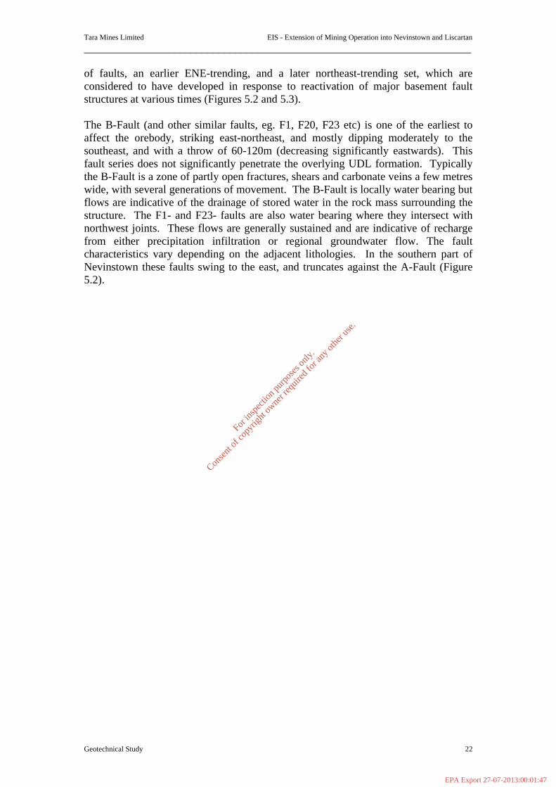
Tara Mines Limited EIS - Extension of Mining Operation into Nevinstown and Liscartan
_____________________________________________________________________
Geotechnical Study 22
of faults, an earlier ENE-trending, and a later northeast-trending set, which are considered to have developed in response to reactivation of major basement fault structures at various times (Figures 5.2 and 5.3). The B-Fault (and other similar faults, eg. F1, F20, F23 etc) is one of the earliest to affect the orebody, striking east-northeast, and mostly dipping moderately to the southeast, and with a throw of 60-120m (decreasing significantly eastwards). This fault series does not significantly penetrate the overlying UDL formation. Typically the B-Fault is a zone of partly open fractures, shears and carbonate veins a few metres wide, with several generations of movement. The B-Fault is locally water bearing but flows are indicative of the drainage of stored water in the rock mass surrounding the structure. The F1- and F23- faults are also water bearing where they intersect with northwest joints. These flows are generally sustained and are indicative of recharge from either precipitation infiltration or regional groundwater flow. The fault characteristics vary depending on the adjacent lithologies. In the southern part of Nevinstown these faults swing to the east, and truncates against the A-Fault (Figure 5.2).
For
insp
ectio
n pur
pose
s only
.
Conse
nt of
copy
right
owne
r req
uired
for a
ny ot
her u
se.
EPA Export 27-07-2013:00:01:47
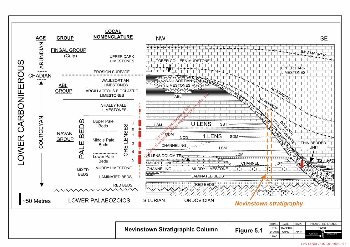
CONSULTANTS
MIN
ING
AUSTRALIAN
PROJECT REFERENCEDATE
DRAWN
AMC
402006NTS Mar 2003
SCALE DATA
CHKD APPRFigure 5.1Nevinstown Stratigraphic Column
LO
WE
RC
AR
BO
NIF
ER
OU
S
CO
UR
CE
YA
NA
RU
ND
IAN
AGE GROUP
LOCALNOMENCLATURE
FINGAL GROUP(Calp)
ABLGROUP
NAVANGROUP
CHADIAN
NW SE
~50 Metres LOWER PALAEOZOICS SILURIAN ORDOVICIAN
ARGILLACEOUS BIOCLASTICLIMESTONES
SHALEY PALE LIMESTONES
PA
LE
BE
DS
MIXED BEDS
MUDDY LIMESTONE
LAMINATED BEDS
RED BEDS
WAULSORTIAN LIMESTONES
EROSION SURFACE
UPPER DARK LIMESTONES
LAMINATED BEDS
RED BEDS
MUDDY LIMESTONE
MICRITE UNIT
5 LENS DOLOMITE
CHANNELING
LDM
LSM
CHANNEL
CHANNELING
SHALEY PALES
USM
THIN BEDDED UNIT
AAMARKER
ACMARKERABL
TOBER COLLEEN MUDSTONE
BMS MARKER
U
0
1
3
4
5
OR
EL
EN
SE
S
BO
ULD
ER
CO
NG
LOM
ERATE
NODUDM
CGO
UPPER DARK LIMESTONES
U LENS
1 LENS
WAULSORTIANLIMESTONES
Upper PaleBeds
Middle PaleBeds
Lower PaleBeds
SDM
SST
Nevinstown stratigraphy
For
insp
ectio
n pur
pose
s only
.
Conse
nt of
copy
right
owne
r req
uired
for a
ny ot
her u
se.
EPA Export 27-07-2013:00:01:47
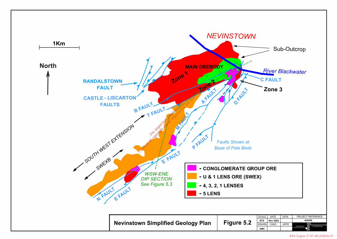
CONSULTANTS
MIN
ING
AUSTRALIAN
PROJECT REFERENCEDATE
DRAWN
AMC
402006NTS Nov 2002
SCALE DATA
CHKD APPRFigure 5.2Nevinstown Simplified Geology Plan
- CONGLOMERATE GROUP ORE
- 4, 3, 2, 1 LENSES
- 5 LENS
RANDALSTOWN
FAULT
CASTLE - LISCARTON
FAULTS
B FAULT
T FAULT
EFAULT
C FAULT
D F
AU
LT
P FAULT
Zone 3
SOUTH WEST E
XTENSION
Faults Shown at
Base of Pale Beds
WSW-ENEDIP SECTIONSee Figure 5.3
1Km
NFAULT
- U & 1 LENS ORE (SWEX)
MAIN OREBODY
Zone 1
A F
AULTZone 2
M F
AU
LT
SWEXB
E FAULT
Sub-Outcrop
NEVINSTOWN
River Blackwater North
For
insp
ectio
n pur
pose
s only
.
Conse
nt of
copy
right
owne
r req
uired
for a
ny ot
her u
se.
EPA Export 27-07-2013:00:01:47

CONSULTANTS
MIN
ING
AUSTRALIAN
PROJECT REFERENCEDATE
DRAWN
AMC
402006NTS Nov 2002
SCALE DATA
CHKD APPRFigure 5.3Nevinstown Geology Dip Section
WSW-ESE dip section from the centre of the South-West Extension to the up-dip orebody limit at Nevinstown
500 Metres
ENEWSW
- Upper Dark Limestones
- Boulder Conglomerate
- Shaley Pales
- Pale Beds
- Muddy Limestone
- Laminated Beds
- Red Beds
- Lower Palaeozoics- Conglomerate Group Ore
- Pale Beds Ore
E Fault Complex
Y Fault
T Fault
A - Fault
Erosion Surface
Major Unconformity- Basalt Dyke
- Fault
ARUNDIAN
CHADIAN
COURCEYAN
SILURIAN/ORDOVICIAN- Marker Horizons in Pale Beds
SWEX Main Orebody
SWEX Project Area SWEX Current Production
~2Km to CurrentLimit of Drilling
Nevinstown
River Blackwater
For
insp
ectio
n pur
pose
s only
.
Conse
nt of
copy
right
owne
r req
uired
for a
ny ot
her u
se.
EPA Export 27-07-2013:00:01:47

Tara Mines Limited EIS - Extension of Mining Operation into Nevinstown and Liscartan
_____________________________________________________________________
Geotechnical Study 26
Later movements resulted in the A-Fault and similar structures (C, D, Castle and Randalstown faults), all of which cut and displace the UDL. Of most relevance to Nevinstown is the A-Fault, which dislocates the ore and UDL, and subcrops at surface in the south-eastern corner of Nevinstown, close to the River Blackwater. The A-Fault zone is several metres wide, and contains several thin, tight, gouge-filled shears. Folding, pressure solution and strong carbonate veining are common within the fault. The zone of deformation is wider to the east of the fault, where UDL rocks are very deformed. North-trending folding within the UDL increases in intensity towards these faults, but not so in the more massive Pale Beds. The A-Fault has never produced any water inflows in the existing operation, even when exposed directly beneath the river. Further Late-Carboniferous activity is thought to have generated the ubiquitous northwest trending jointing and carbonate veining. Occasionally (every few hundred metres) an open, water-bearing joint occurs, the most significant of which occur in the west of Nevinstown, near the F1-Fault. Finally, several transgressive dolerite sills (known locally as basalt sills/dykes) were intruded during Tertiary times. These strike north-northwest, dip variably to the west, and follow older structures for short distances. The sills have a tendency to slake rapidly on exposure to air and moisture. The main Nevinstown Geotechnical Study report (Appendix 1) provides detailed characteristics of the fault structures, along with additional information on the general geology. 5.1.2.3 Geotechnical conditions The Study has necessarily focussed on those aspects of the area geology, geotechnical conditions, that will have an influence, directly or indirectly, on the Study objectives. During the Study, special attention has been given to specific structures which intersect the area of interest, ie. the major faults, and the thin basalt sills. The rock types that form the footwall to the mineralisation have not generally been studied to the same level of detail, since the stability of these will not impact on the regional stability issues being considered. Rather, the stability of these footwall rocks is more an operational issue for the mine, in respect of the location and rock support of mine development. All the information available on these components has been compiled and analysed, to assemble as complete a picture as possible of the Nevinstown project area. This has included rockmass characterisation, structural analysis, rock property data, and in-situ stress measurements. This geotechnical database is presented in detail in the main Study report. The salient geotechnical characteristics of the main geological units of interest are given in Table 5.1. Rockmass characterisation has been completed using the Q-System1. This system is specific to geotechnical engineering (or rock
1 The Q-System is a method of quantifying the quality of the rockmass on a large scale. The general process is known as rockmass classification. The Q-System is one of these methods. It was developed originally by Dr. N. Barton and co-workers at the Norwegian Geotechnical Institute in 1974, for civil engineering tunnelling projects, but today is widely applied (along with other similar systems) in both the civil and mining industries.
For
insp
ectio
n pur
pose
s only
.
Conse
nt of
copy
right
owne
r req
uired
for a
ny ot
her u
se.
EPA Export 27-07-2013:00:01:48
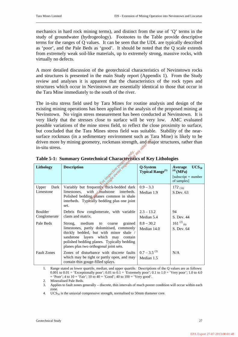
Tara Mines Limited EIS - Extension of Mining Operation into Nevinstown and Liscartan
_____________________________________________________________________
Geotechnical Study 27
mechanics in hard rock mining terms), and distinct from the use of ‘Q’ terms in the study of groundwater (hydrogeology). Footnotes to the Table provide descriptive terms for the ranges of Q values. It can be seen that the UDL are typically described as ‘poor’, and the Pale Beds as ‘good’. It should be noted that the Q scale extends from extremely weak soil-like materials, up to extremely strong, massive rocks, with virtually no defects. A more detailed discussion of the geotechnical characteristics of Nevinstown rocks and structures is presented in the main Study report (Appendix 1). From the Study review and analyses it is apparent that the characteristics of the rock types and structures which occur in Nevinstown are essentially identical to those that occur in the Tara Mine immediately to the south of the river. The in-situ stress field used by Tara Mines for routine analysis and design of the existing mining operations has been applied in the analysis of the proposed mining at Nevinstown. No virgin stress measurement has been conducted at Nevinstown. It is very likely that the stresses close to surface will be very low. AMC evaluated possible variations of the mine stress field, to reflect the close proximity to surface, but concluded that the Tara Mines stress field was suitable. Stability of the near-surface rockmass (in a sedimentary environment such as Tara Mine) is likely to be driven more by mining geometry, rockmass strength, and major structures, rather than in-situ stress. Table 5-1: Summary Geotechnical Characteristics of Key Lithologies
Lithology Description Q-System Typical Range(1)
Average UCS50 (4) (MPa) [subscript = number of samples]
Upper Dark Limestone
Variably but frequently thick-bedded dark limestones, with mudstone interbeds. Polished bedding planes common in shale interbeds. Typically bedding plus one joint set.
0.9 – 3.3 Median 1.9
172 (16)
S.Dev. 63
Boulder Conglomerate
Debris flow conglomerate, with variable clasts and matrix.
2.3 – 13.2 Median 5.4
94
S. Dev. 44
Pale Beds Strong, medium to coarse grained limestones, partly dolomitised, commonly thickly bedded, but with minor shale / sandstone layers which may contain polished bedding planes. Typically bedding planes plus two orthogonal joint sets.
8.8 – 30.2 Median 14.0
161 (2) (6)
S. Dev. 64
Fault Zones Zones of disturbance with discrete faults which may be tight or partly open, and may contain thin gouge-filled splays.
0.7 – 3.5 (3)
Median 1.5 N/A
1. Range stated as lower quartile, median, and upper quartile. Descriptions of the Q values are as follows: 0.001 to 0.01 = ‘Exceptionally poor’; 0.01 to 0.1 = ‘Extremely poor’; 0.1 to 1.0 = ‘Very poor’; 1.0 to 4.0 = ‘Poor’; 4 to 10 = ‘Fair’; 10 to 40 = ‘Good’; 40 to 100 = ‘Very good’.
2. Mineralised Pale Beds. 3. Applies to fault zones generally – discrete, thin intervals of much poorer condition will occur within each
zone. 4. UCS50 is the uniaxial compressive strength, normalised to 50mm diameter core.
For
insp
ectio
n pur
pose
s only
.
Conse
nt of
copy
right
owne
r req
uired
for a
ny ot
her u
se.
EPA Export 27-07-2013:00:01:48
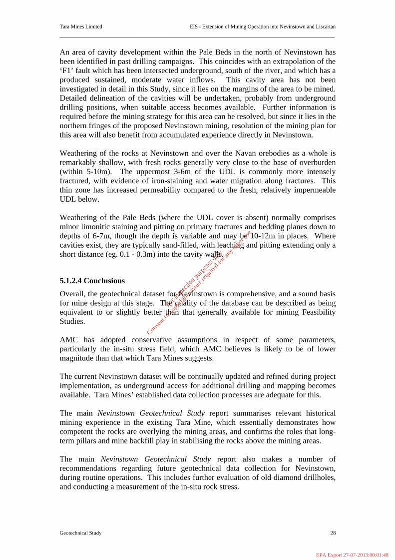
Tara Mines Limited EIS - Extension of Mining Operation into Nevinstown and Liscartan
_____________________________________________________________________
Geotechnical Study 28
An area of cavity development within the Pale Beds in the north of Nevinstown has been identified in past drilling campaigns. This coincides with an extrapolation of the ‘F1’ fault which has been intersected underground, south of the river, and which has a produced sustained, moderate water inflows. This cavity area has not been investigated in detail in this Study, since it lies on the margins of the area to be mined. Detailed delineation of the cavities will be undertaken, probably from underground drilling positions, when suitable access becomes available. Further information is required before the mining strategy for this area can be resolved, but since it lies in the northern fringes of the proposed Nevinstown mining, resolution of the mining plan for this area will also benefit from accumulated experience directly in Nevinstown. Weathering of the rocks at Nevinstown and over the Navan orebodies as a whole is remarkably shallow, with fresh rocks generally very close to the base of overburden (within 5-10m). The uppermost 3-6m of the UDL is commonly more intensely fractured, with evidence of iron-staining and water migration along fractures. This thin zone has increased permeability compared to the fresh, relatively impermeable UDL below. Weathering of the Pale Beds (where the UDL cover is absent) normally comprises minor limonitic staining and pitting on primary fractures and bedding planes down to depths of 6-7m, though the depth is variable and may be 10-12m in places. Where cavities exist, they are typically sand-filled, with leaching and pitting extending only a short distance (eg. 0.1 - 0.3m) into the cavity walls.
5.1.2.4 Conclusions
Overall, the geotechnical dataset for Nevinstown is comprehensive, and a sound basis for mine design at this stage. The quality of the database can be described as being equivalent to or slightly better than that generally available for mining Feasibility Studies. AMC has adopted conservative assumptions in respect of some parameters, particularly the in-situ stress field, which AMC believes is likely to be of lower magnitude than that which Tara Mines suggests. The current Nevinstown dataset will be continually updated and refined during project implementation, as underground access for additional drilling and mapping becomes available. Tara Mines’ established data collection processes are adequate for this. The main Nevinstown Geotechnical Study report summarises relevant historical mining experience in the existing Tara Mine, which essentially demonstrates how competent the rocks are overlying the mining areas, and confirms the roles that long-term pillars and mine backfill play in stabilising the rocks above the mining areas. The main Nevinstown Geotechnical Study report also makes a number of recommendations regarding future geotechnical data collection for Nevinstown, during routine operations. This includes further evaluation of old diamond drillholes, and conducting a measurement of the in-situ rock stress.
For
insp
ectio
n pur
pose
s only
.
Conse
nt of
copy
right
owne
r req
uired
for a
ny ot
her u
se.
EPA Export 27-07-2013:00:01:48

Tara Mines Limited EIS - Extension of Mining Operation into Nevinstown and Liscartan
_____________________________________________________________________
Geotechnical Study 29
5.1.3 Potential Impacts 5.1.3.1 Surface Settlement For background, the main Nevinstown Geotechnical Study report provides an introduction to surface settlement in mining. AMC have reviewed in detail the historical records of settlement over the existing mining operation. Tara Mines have been monitoring surface settlement since mining commenced in the 1970s, with an array of ≈ 270 surface precise leveling stations over the mine area. The 30 years of mining operations have resulted to date in a maximum of only 70mm of surface settlement, centered over the main mining area. This is in part testament to the competence of the rocks overlying the ore, but also reflects the contribution made by long-term rock pillars, and the appropriateness of the longhole-stoping-with-backfill mining method. AMC’s analysis of this historical data provides a basis for calibrating models of future mining, and for estimating the extent of settlement for various mining options. In summary, the analysis demonstrates a generally good agreement between changes in mining activity underground, and consequent changes to the surface settlement. In the past 2-3 years the rate of settlement south of the river has increased, reflecting the extraction of old pillars which commenced in the late 1990s. Further settlement will occur in response to continued pillar extraction south of the river. The extent of this future settlement has been limited by leaving strategic permanent pillars throughout the mining area, and by progressive tight filling of stopes. In a situation as prevails at Tara and Nevinstown, surface settlement is controlled principally by two measures; (i) the leaving of permanent (yielding) pillars in strategic locations, which provide direct support to the hangingwall (roof) rockmass, and (ii) the use of backfill in each mined stope, the backfill being placed as tight as possible against the stope roof. Clearly it is also most important that each stope is designed to be stable. This is standard practice at Tara Mines. This strategy is also appropriate to the Nevinstown development. Settlement potential above future Nevinstown mining has therefore been minimised through the use of permanent yield pillars, and tight backfilling. For the stoping that is proposed close to and beneath the River Blackwater, the same strategy outlined above has been applied, but a greater proportion of permanent pillars will be left in place, and cemented backfill is recommended for all stopes. In addition, attention has been given to securing the A-Fault (the only structure which reaches surface, close to mineralisation and the river), again with pillars, to minimise potential differential settlement across the structure, and any consequent change in the permeability of the structure. Importantly, AMC is not aware of any evidence of disturbance to the fault due to existing mining immediately south of the river. Surface settlement north of the river will be directly influenced by settlement south of the river, which is an arbitrary boundary. The analysis of surface settlement for the Nevinstown development predicts a maximum settlement of just below 200mm, the centre of which remains south of the river (Figure 5.4). However, owing to inherent
For
insp
ectio
n pur
pose
s only
.
Conse
nt of
copy
right
owne
r req
uired
for a
ny ot
her u
se.
EPA Export 27-07-2013:00:01:48

Tara Mines Limited EIS - Extension of Mining Operation into Nevinstown and Liscartan
_____________________________________________________________________
Geotechnical Study 30
simplifications in any model of rockmass behaviour on such a large scale, the surface settlement is predicted to be between 200-250mm. The key to managing surface settlement is to minimise the potential for any differential displacement to occur. This is generally only possible where major structures are present. The analysis suggests that major faults such as the A-Fault will only have a very minor effect on settlement, and that these structures will be stable close to surface. This must be confirmed with detailed monitoring of fault behaviour during implementation. In the area of interest, only the A-Fault extends up through the UDL rocks. A basalt dyke extends to surface to the east of the A-Fault, but is not likely to have a significant influence on settlement behaviour. Consequently, it is the behaviour of the A-Fault which has been the focus of attention regarding surface settlement in the Study. The only surface infrastructure at Nevinstown that may be affected by surface settlement is the uninhabited Nevinstown House, owned by Tara Mines, in the centre of the mining area. The extent of the effect depends largely upon whether any small differential settlement occurs. It would be prudent to prevent casual public access to the actual farm buildings once mining commences, as a precautionary measure. Permission has previously been given by MCC to demolish the house (MCC No. H5/75). Surface settlement is predicted not to extend out to the railway. Also, it is expected that the maximum radial extent of settlement will be smaller than that suggested by the elastic model, further reducing the potential for surface effects that far to the east. In the longer term, surface settlement will continue to occur for a period after mine closure, although at a gradually reducing rate. This is due to the mine backfill gradually providing increased resistance to continued hangingwall relaxation, until a state of equilibrium is reached. The return of groundwater levels to their pre-mining state will also provide further resistance to continued settlement. The period over which this may occur is very difficult to estimate, but it may last for 2-3 years, though at a progressively reducing settlement rate. The main report again makes a number of technical recommendations regarding the management of surface settlement potential for the Nevinstown development.
For
insp
ectio
n pur
pose
s only
.
Conse
nt of
copy
right
owne
r req
uired
for a
ny ot
her u
se.
EPA Export 27-07-2013:00:01:48
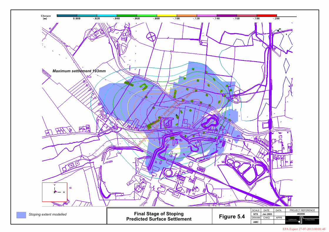
CONSULTANTS
MIN
ING
AUSTRALIAN
PROJECT REFERENCEDATE
DRAWN
AMC
402006NTS Jan 2003
SCALE DATA
CHKD APPRFigure 5.4Final Stage of Stoping
Predicted Surface SettlementStoping extent modelled
Maximum settlement 193mm
For
insp
ectio
n pur
pose
s only
.
Conse
nt of
copy
right
owne
r req
uired
for a
ny ot
her u
se.
EPA Export 27-07-2013:00:01:48
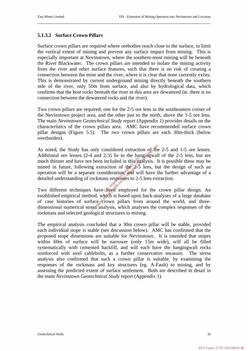
Tara Mines Limited EIS - Extension of Mining Operation into Nevinstown and Liscartan
_____________________________________________________________________
Geotechnical Study 32
5.1.3.2 Surface Crown Pillars
Surface crown pillars are required where orebodies reach close to the surface, to limit the vertical extent of mining and prevent any surface impact from mining. This is especially important at Nevinstown, where the southern-most mining will be beneath the River Blackwater. The crown pillars are intended to isolate the mining activity from the river and other surface features, such that there is no risk of creating a connection between the mine and the river, where it is clear that none currently exists. This is demonstrated by current underground mining directly beneath the southern side of the river, only 50m from surface, and also by hydrological data, which confirms that the host rocks beneath the river in this area are dewatered (ie. there is no connection between the dewatered rocks and the river). Two crown pillars are required; one for the 2-5 ore lens in the southeastern corner of the Nevinstown project area, and the other just to the north, above the 1-5 ore lens. The main Nevinstown Geotechnical Study report (Appendix 1) provides details on the characteristics of the crown pillars area. AMC have recommended surface crown pillar designs (Figure 5.5). The two crown pillars are each 30m-thick (below overburden). As noted, the Study has only considered extraction of the 2-5 and 1-5 ore lenses. Additional ore lenses (2-4 and 2-3) lie to the hangingwall of the 2-5 lens, but are much thinner and have not been included in this analysis. It is possible these may be mined in future, following extraction of the 2-5 lens, but the design of such an operation will be a separate consideration, and will have the further advantage of a detailed understanding of rockmass responses to 2-5 lens extraction. Two different techniques have been employed for the crown pillar design. An established empirical method, which is based upon back-analyses of a large database of case histories of surface crown pillars from around the world, and three-dimensional numerical stress analysis, which analyses the complex responses of the rockmass and selected geological structures to mining. The empirical analysis concluded that a 30m crown pillar will be stable, provided each individual stope is stable (see discussion below). AMC has confirmed that the proposed stope dimensions are suitable for Nevinstown. It is intended that stopes within 60m of surface will be narrower (only 15m wide), will all be filled systematically with cemented backfill, and will each have the hangingwall rocks reinforced with steel cablebolts, as a further conservative measure. The stress analysis also confirmed that such a crown pillar is suitable, by examining the responses of the rockmass and key structures (eg. A-Fault) to mining, and by assessing the predicted extent of surface settlement. Both are described in detail in the main Nevinstown Geotechnical Study report (Appendix 1).
For
insp
ectio
n pur
pose
s only
.
Conse
nt of
copy
right
owne
r req
uired
for a
ny ot
her u
se.
EPA Export 27-07-2013:00:01:48
CONSULTANTS
MIN
ING
AUSTRALIAN
NEVINSTOWN STUDYDATE
DRAWN
AMC
402006NTS Dec 2002
SCALE DATA
CHKD APPRFigure 5.5Schematic Crown Pillar Geometry
Cross-Section Looking North
30 degrees
Surface
Notional crown pillar = 30 m
Break angle
Cave angle
Approx. 100m
15 m
35 m
A-Fault Schematic
Single stope void
For definitions of Break Angle and Cave Angle, refer to the spreadsheet example in the main text, and Appendix A.
Ore loss as pillar against A-Fault
Economic limits to 2-5 ore lens
For
insp
ectio
n pur
pose
s only
.
Conse
nt of
copy
right
owne
r req
uired
for a
ny ot
her u
se.
EPA Export 27-07-2013:00:01:48
Tara Mines Limited EIS - Extension of Mining Operation into Nevinstown and Liscartan
_____________________________________________________________________
Geotechnical Study 34
The proposed crown pillars design is dependant on a number of other measures which are recommended, particularly for stoping above 1500mRL (stope dimensions, type of backfill, use of cable bolting, and stoping sequence). A detailed monitoring programme will also be required for the surface crown pillars area, as well as for the Nevinstown development as a whole. This is detailed in Section 10 below. The competent rocks at Nevinstown, and the use of tight filling of all mined voids, precludes the possibility of long-term deterioration of the crown pillars. 5.1.3.3 Underground Mine Stability Stability of the underground workings is governed by the stability of the stopes. Mine development (tunnels) is small compared to the scale of the mining activity, and though the stability of each opening is crucial from an operations standpoint, development stability does not impact on the large scale stability with which the Study is concerned. Tara Mines have long experience with mining in the same rocks as at Nevinstown. They have established and proven design methods, and a good understanding of the rockmass response to mining. Tara Mines recognise that additional conservatism is warranted when mining close to surface, and beneath the river. Key factors in achieving stable stoping, and this applies especially to the surface crown pillar area, are as follows:
§ The longhole stoping process is sequential, ie. each stope is mined and filled before mining of the immediately adjacent stope commences.
§ Each individual stope is uniquely designed for stability. This is the current practice at Tara Mine. In general, the need for additional rockmass reinforcement is determined on a case-by-case basis, but for those stopes close to surface (stope backs above ≈ 1500mRL) AMC recommends the hangingwall is routinely strengthened with cement grouted cablebolts2, as an additional precautionary measure.
§ As noted above, Tara Mines have reduced stope dimensions close to surface, from 20m wide to 15m wide. The stope length varies according to ore geometry, but it is the minimum stope dimension that has the greatest impact on stope stability. AMC has confirmed the chosen stope dimensions are appropriate.
§ Backfill is placed at tight as possible into each stope after mining. Cemented backfill is recommended for all stopes close to surface. Near-total tight-filling of each stope is achieved by ‘shaping’ of the stopes to promote tight backfilling, and further ‘top-up’ filling which follows the initial placement. This is possible from the hangingwall development access available. Also, any minor separation of the backfill from the hangingwall that occurs in primary stopes is further tight-filled during the filling of secondary stopes.
A number of other minor recommendations are made in the Nevinstown Geotechnical Study (Appendix I) report regarding stope design, stability, and monitoring. The
2 Cablebolts are commonly used in the mining industry. They typically comprise 7-strand steel cable tendons, each with a peak load-bearing capacity of 25 tonnes. One or two cables can be installed in a single borehole, using cement grout.
For
insp
ectio
n pur
pose
s only
.
Conse
nt of
copy
right
owne
r req
uired
for a
ny ot
her u
se.
EPA Export 27-07-2013:00:01:48
Tara Mines Limited EIS - Extension of Mining Operation into Nevinstown and Liscartan
_____________________________________________________________________
Geotechnical Study 35
report also describes the current mine backfill system, and some specific requirements relating to backfill for application at Nevinstown. 5.1.4 Mitigation Measures The proposed mining methods and mine design provide the main mitigation against geotechnical impacts at surface. In addition, a Management Plan is recommended for implementing mining at Nevinstown. The Plan would comprise a Monitoring Programme, and an Implementation Plan. A robust monitoring programme is central to implementation of a project such as the Nevinstown extension. It is through monitoring that the Study findings are confirmed, and in particular the results of monitoring provide the basis for reviewing and adjusting designs according to actual rather than predicted rockmass and hydrological responses. The project Implementation Plan encompasses a series of recommended responses to any conditions that don’t correspond to predictions. The plan comprises a series of recommended technical responses to conditions arising, such as specific investigations of stope behaviour, determining the causes of elevated stresses in pillars, investigations into higher than expected groundwater inflows to the mine, etc The Study implementation plan is detailed in Table 5.2 below. The monitoring plan is outlined in Section 5.5. Table 5.2 details a series of recommendations for responses to conditions which may arise, that do not match predictions. The listing should not be considered as complete. It represents a basis for a plan that should then be reviewed and expanded upon by Tara Mines, as part of the Nevinstown Management Plan, during project implementation. Such a plan should also be subject to annual reviews, both internally within Tara Mines, and also by the company’s consultants.
For
insp
ectio
n pur
pose
s only
.
Conse
nt of
copy
right
owne
r req
uired
for a
ny ot
her u
se.
EPA Export 27-07-2013:00:01:48

Tara Mines Limited EIS - Extension of Mining Operation into Nevinstown and Liscartan
_____________________________________________________________________
Geotechnical Study 36
Table 5-2: Nevinstown Implementation Plan (Geotechnical) Condition Control
1) The rate and magnitude of surface settlement is greater than predictions.
a) Review the past mining activity that may have led to the condition. Where specific causes can be identified, determine the value of installing additional monitoring (eg. surface extensometers).
b) Inspect and report conditions within all available underground access, including the extent of tight filling in stopes. Determine any areas that require additional tight filling, and fill as soon as possible.
c) Review any planned extraction in the affected areas, and determine any changes required to reduce further settlement.
d) Update numerical models of mining, and update settlement predictions.
2) Underground stopes experience some overbreak/instability.
a) Immediately determine the nature and extent of the instability and the risk that it may worsen, and/or impact on larger-scale stability (eg. of the hangingwall, or major structures). Stope surveys will probably be required.
b) If such a potential exists, cease production in that stope and commence backfilling as soon as possible.
c) Determine the causes of the instability, and revise future mine designs to account for such potential. Mitigation measures may include leaving slightly larger pillars against key features, modifying stope shapes, or installing additional rock support.
3) Monitoring identifies shear responses on major structures as a result of mining.
a) Determine the extent of the displacement, the causes, and the potential for further disturbance.
b) Determine the implications of further fault movements on larger-scale stability, and review the mining plan accordingly.
c) Mitigation actions, if required, may include providing additional reinforcement of the structures, installing additional monitoring to better define future responses, or ceasing the mining activity which led to the response.
4) Stress levels in late-stage pillars exceed the rock strength, and stress-induced failures result.
Stress change monitoring in earlier pillars will reduce the likelihood of unexpected stress increases, but where the condition occurs AMC recommends the following: a) Update numerical models of the area, and compare
model predictions with actual pillar behaviour. b) Determine the likely impacts of further pillar
deterioration on local and larger-scale stability. If any undesirable impacts are determined, reduce their potential by installing additional pillar reinforcement, leaving a larger pillar, or ensuring the pillar is confined by backfill in the near future.
c) Determine the value of installing additional monitoring instrumentation.
5) Backfill overbreak occurs from a stope backfill exposure.
a) Proceed as with stope overbreak (item 2 above). b) Examine backfilling records to determine whether
inferior quality backfill placed in error, and determine if any other stopes may be similar affected.
For
insp
ectio
n pur
pose
s only
.
Conse
nt of
copy
right
owne
r req
uired
for a
ny ot
her u
se.
EPA Export 27-07-2013:00:01:48
Tara Mines Limited EIS - Extension of Mining Operation into Nevinstown and Liscartan
_____________________________________________________________________
Geotechnical Study 37
Condition Control
6) Monitoring of stope hangingwalls identifies areas of greater or deeper-seated movement than expected.
a) Proceed as with stope overbreak (item 2 above). b) If cablebolt support installed, review the design
effectiveness, and modify future designs where appropriate. c) Install additional cablebolt support in adjacent stope
hangingwalls to help arrest further hangingwall displacements.
5.1.5 Geotechnical Monitoring The geotechnical monitoring strategy will be directed at confirming the stability of stoping operations, the response (or lack) of major structures to mining, and surface settlement monitoring. To a large degree the details of the monitoring programme will evolve as mining progresses, but AMC anticipates that the minimum requirements will include the following: § Extension of the surface precise-level (settlement) monitoring array established
south of the river, to cover the Nevinstown mining area. Tara Mines geotechnical staff have developed a draft of an initial array of stations for the new area (see Figure 5.6), and this is endorsed. The array would be extended in a phased fashion, as the area of mining expands. The configuration of stations will be similar to that south of the river, but will focus on these key areas;
- the northern margin of the river
- either side of the A-Fault, close to the river
- the surface crown pillar
- traverse lines crossing the centroids of mining activity. Further details of the array, station installation, monitoring frequency etc are contained in the main report.
§ Surface, wire-type extensometers installed in existing surface drillholes. The extensometers will terminate in the UDL or Pale Beds formations, immediately above stoping areas. These will combine with precise-levelling arrays to provide a full picture of any deformation of the hangingwall (roof) rocks. A minimum of 10 such instruments is recommended for the first 1-2 years of mining, with at least 4-6 in the area of the crown pillars.
For
insp
ectio
n pur
pose
s only
.
Conse
nt of
copy
right
owne
r req
uired
for a
ny ot
her u
se.
EPA Export 27-07-2013:00:01:48

132N132N132N132N
104W104W104W104W
112W112W
111W
111W112W
112W
111W
111W
BL11WESTBL11WESTBL11WESTBL11WEST
114W114W114W114W
115W115W115W115W
113W113W113W113W
105W105W105W105W
101W101W101W101W
102W102W102W102W
BL10WESTBL10WEST
103W103W
BL10WESTBL10WEST
103W103W
NO. 2
NORTH
WEST H
AULA
GE P
ILLA
R
NO. 2
NORTH
WEST H
AULA
GE P
ILLA
R
PILLARPILLAR
P7P7
1315 NORTH
WEST
1315 NORTH
WEST
NO. 1
NORTH
WEST H
AULA
GE P
ILLA
R
NO. 1
NORTH
WEST H
AULA
GE P
ILLA
R
157N157N
1315 NORTH
WEST
1315 NORTH
WEST
NO. 1
NORTH
WEST H
AULA
GE P
ILLA
R
NO. 1
NORTH
WEST H
AULA
GE P
ILLA
R
157N157N
NO.15NO.15P3P3
NO.15NO.15P3P3
P6P6P5P5P6P6P5P5
P6P6P6P6
P4P4P4P4
PILLAR
PILLAROREPASS
OREPASS
PILLAR
PILLAROREPASS
OREPASS
AC
CE
SS
PILLA
R
AC
CE
SS
PILLA
R
AC
CE
SS
PILLA
R
AC
CE
SS
PILLA
R
P2P2P2P2
P1P1P1P1
158N158N158N158N
137N137N
138N138N 137N
137N
139N139N139N139N
141N141N141N141N
136N136N
134N134N134N134N
135N135N135N135N
133N133N133N133N
ZONEZONEZONEZONE 1111
155N155N155N155N
168N168N168N168N
167N167N167N167N
166N166N166N166N
BL1NWBL1NWBL1NWBL1NW 156N156N156N156N
160
N
160
N
160
N
160
N
165N165N165N165N
BL1NWBL1NWBL1NWBL1NW
162N162N162N162N
164N164N164N164N
163N163N163N163N
161N161N161N161N
154N154N154N154N
152N152N152N152N
153N153N153N153N
151N151N151N151N
221N
221N
227N
227N22
8N22
8N133S133S
132S132S
236N
236N
243N243N
PIL
LAR
PIL
LAR 22
1N22
1N
227N
227N22
8N22
8N133S133S
132S132S
236N
236N
243N243N
213N213N
214N214N
213N213N
214N214N
238N
238N
238N
238N
243S243S251S251S251S251S
SHAFTSHAFTSHAFTSHAFT
PILLARPILLARPILLARPILLAR
250N250N
251N251N
248S248S248S248S249S249S249S249S250S250S250S250S 247S247S247S247S 244S244S244S244S
245N245N
246N246N246N246N248N
248N
247N247N247N247N
242N
242N
242N
242N
241N
241N
241N
241N
240N
240N
240N
240N
223N
223N
225N
225N
223N
223N
225N
225N
224N
224N
224N
224N
ZONEZONEZONEZONE
237S237S
ZONEZONEZONEZONE
237S237S240S240S240S240S242S242S242S242S 241S241S241S241S 239S239S239S239S
NO.2NO.2NO.2NO.2NO.2NO.2NO.2NO.2
OREPASSOREPASSOREPASSOREPASSPILLARPILLARPILLARPILLAR
HAULAGEHAULAGEHAULAGEHAULAGEHAULAGEHAULAGEHAULAGEHAULAGE
228N
228N
228N
228N
229N
229N
229N
229N
230N
230N
PILLARPILLAR
227N
227N
227N
227N
226N
226N
226N
226N
225N
225N
225N
225N
TRANSVERSE
TRANSVERSE
226N
226N
226N
226N
222N
222N
222N
222N
PILLARPILLARPILLARPILLARPILLARPILLARPILLARPILLAR
21
9N
21
9N
222N
222N
222N
222N
NO.1NO.1
220N
220N
221N
221N
221N
221N
224N
224N
223N
223N
223N
223N
NO.2NO.2NO.2NO.2 216N216N216N216N215N215N215N215N214N214N214N214N
MINING
LIMIT
MINING
LIMIT
MINING
LIMIT
MINING
LIMIT
336N
336N
337N
337N
334N
334N
333N
333N
336N
336N
337N
337N
334N
334N
333N
333N
333S
333S
333S
333S
213N213N213N213N
331N
331N
331N
331N332N
332N
332N
332N
209N209N
208N208N
207N207N
209N209N
208N208N
207N207N
PILLAR
PILLAR
PILLAR
PILLAR
337N
337N
337N
337N
211N211N211N211N212N212N212N212N
TRANSVERSE
TRANSVERSE
SOUTHSOUTH
113S113S
TRANSVERSE
TRANSVERSE
SOUTHSOUTH
113S113S
114N114N
115N115N
116N116N
117N117N
120N120N
114N114N
115N115N
116N116N
117N117N
120N120N
127S127S
HAULAGE
HAULAGE
121N121N
127S127S
HAULAGE
HAULAGE
121N121N
ZONEZONEZONEZONE
130S130S130S130S131S
131S131S131S
129S129S129S129S
128S128S128S128S
NO.1NO.1NO.1NO.1
126N126N126N126N
128N128N128N128N
129N129N129N129N130N
130N130N130N
131N131N131N131N
NORTHNORTHNORTHNORTH
127N127N127N127N
OREPASS
OREPASS
PILLAR
PILLAROREPASS
OREPASS
PILLAR
PILLAR
124N124N124N124N
125N125N125N125N
123N123N123N123N
122N122N122N122N
126S126S126S126S
124S124S124S124S125s
125s125s125s
118S118S118S118S
117S117S117S117S
ZONEZONEZONEZONE
119S119S119S119S
1111
PILLAR
PILLAR
PILLAR
PILLAR
123S123S123S123S
118N118N118N118N
119N119N119N119N
114S114S114S114S
TRANSVERSE
TRANSVERSE22
8N22
8N
TRANSVERSE
TRANSVERSE22
8N22
8N
106S106S106S106S
234N
234N
233N233N
234N
234N
233N233N
235N
235N
235N
235N
PILLARPILLARPILLARPILLAR
229N
229N
229N
229N
105S105S105S105S
229N
229N
229N
229N
107S107S
MINING LIMIT
MINING LIMIT
107S107S
MINING LIMIT
MINING LIMIT111
S111
S111
S111
S
110S110S110S110S
109S109S
108S108S
109S109S
108S108S
112S112S112S112S
222N
222N
222N
222N
224N
224N22
5N22
5N22
4N22
4N225N
225N
PILLAR
PILLAR
PILLAR
PILLAR
223N
223N
223N
223N
227N
22
7N
227N
22
7N
226N
226N
226N
226N
UN
D
UN
D
1.8
3m
FF
NEVINSTOWN
River Blackwater
10kv
9400 N
9500 N
9600 N
9700 N
9800 N
9900 N
10000 N
90
00
E
91
00
E
92
00
E
93
00
E
94
00
E
95
00
E
96
00
E
97
00
E
98
00
E
99
00
E
10
00
0 E
N5
01
A1
N5
01
A1
N5
06
A1
N5
06
A1
N5
07
A1
N5
07
A1
N5
08
B1
N5
08
B1
N5
08
A1
N5
08
A1
N5
09
A1
N5
09
A1
N5
09
1N
50
91
N5
09
C1
N5
09
C1
N5
08
C1
N5
08
C1
N5
07
C1
N5
07
C1
N5
10
C1
N5
10
C1
N5
10
B1
N5
10
B1
N5
10
A1
N5
10
A1
N5
11A
1N
511
A1
N5
11B
1N
511
B1
N5
11C
1N
511
C1
N5
12
C1
N5
12
C1
N5
12
B1
N5
12
B1
N5
12
A1
N5
12
A1
N5
05
A1
N5
05
A1N
50
4A
1N
50
4A
1N5
03
A1
N5
03
A1
N5
02
A1
N5
02
A1
N5
04
B1
N5
04
B1
N5
05
1N
50
51
N5
06
B1
N5
06
B1
N5
07
B1
N5
07
B1
N5
06
C1
N5
06
C1
N401A
1N
401A
1
N401B
1N
401B
1
N401C
1N
401C
1
N401D
1N
401D
1
N401E
1N
401E
1
N401F
1N
401F
1
N402F
1N
402F
1
N402E
1N
402E
1N
402E
1N
402E
1
N402D
1N
402D
1
N402C
1N
402C
1
N402B
1N
402B
1
N402A
1N
402A
1
N403A
1N
403A
1
N403B
1N
403B
1
N403C
1N
403C
1
N403D
1N
403D
1
N403E
1N
403E
1
N403F
1N
403F
1
N404F
1N
404F
1
N404E
1N
404E
1
N404D
1N
404D
1
N404C
1N
404C
1
N404B
1N
404B
1
N404A
1N
404A
1
N405A
1N
405A
1
N405B
1N
405B
1
N405C
1N
405C
1
N405D
1N
405D
1
N405E
1N
405E
1
N405F
1N
405F
1
N406F
1N
406F
1
N406E
1N
406E
1
N406D
1N
406D
1
N406C
1N
406C
1
N406B
1N
406B
1
N406A
1N
406A
1
N407A
1N
407A
1
N407B
1N
407B
1
N407C
1N
407C
1
N407D
1N
407D
1
N407E
1N
407E
1
N407F
1N
407F
1
N408F
1N
408F
1
N408E
1N
408E
1
N408D
1N
408D
1
N408C
1N
408C
1
N408B
1N
408B
1
N408A
1N
408A
1
N409A
1N
409A
1
N409B
1N
409B
1
N409C
1N
409C
1
N409D
1N
409D
1
N409E
1N
409E
1
N409F
1N
409F
1
N410F
1N
410F
1
N410E
1N
410E
1
N410D
1N
410D
1
N410C
1N
410C
1
N410B
1N
410B
1
N410A
1N
410A
1
N411
A1
N411
A1
N411
B1
N411
B1
N411
C1
N411
C1
N411
D1
N411
D1
N411
E1
N411
E1
N411
F1
N411
F1
N412F
1N
412F
1
N412E
1N
412E
1
N412D
1N
412D
1
N412C
1N
412C
1
N412B
1N
412B
1
N412A
1N
412A
1
N413A
1N
413A
1
N413B
1N
413B
1
N413C
1N
413C
1
N413D
1N
413D
1
N413E
1N
413E
1
N413F
1N
413F
1
N414F
1N
414F
1
N414E
1N
414E
1
N414D
1N
414D
1
N414C
1N
414C
1
N414B
1N
414B
1
N414A
1N
414A
1
N415A
1N
415A
1
N415B
1N
415B
1N
415C
1N
415C
1
N415D
1N
415D
1
N415E
1N
415E
1
N415F
1N
415F
1
N416F
1N
416F
1
N416E
1N
416E
1
N416D
1N
416D
1
N416C
1N
416C
1
N416B
1N
416B
1
N416A
1N
416A
1
N301B
1N
301B
1
N301C
1N
301C
1
N301D
1N
301D
1
N301E
1N
301E
1
N302E
1N
302E
1
N302D
1N
302D
1
N302C
1N
302C
1
N302B
1N
302B
1
N302A
1N
302A
1
N303A
1N
303A
1
N303B
1N
303B
1
N303C
1N
303C
1
N303D
1N
303D
1
N303E
1N
303E
1
N304E
1N
304E
1
N304D
1N
304D
1
N304C
1N
304C
1
N304A
1N
304A
1
N305B
1N
305B
1
N305D
1N
305D
1
N305E
1N
305E
1
N305F
1N
305F
1
N306F
1N
306F
1
N306E
1N
306E
1
N306D
1N
306D
1
N306C
1N
306C
1
N306A
1N
306A
1
N307C
1N
307C
1
N307D
1N
307D
1
N307E
1N
307E
1
N307F
1N
307F
1
N308F
1N
308F
1
N308E
1N
308E
1
N308D
1N
308D
1
N308C
1N
308C
1
N308B
1N
308B
1
N308A
1N
308A
1N307A
1N
307A
1
N305A
1N
305A
1
N306B
1N
306B
1
N307B
1N
307B
1
N304B
1N
304B
1
N305C
1N
305C
1
N309A
1N
309A
1
N309B
1N
309B
1
N309C
1N
309C
1
N309D
1N
309D
1
N309E
1N
309E
1N
309F
1N
309F
1
N310F
1N
310F
1
N310E
1N
310E
1
N310D
1N
310D
1
N310C
1N
310C
1
N310B
1N
310B
1
N310A
1N
310A
1
N311
A1
N311
A1
N311
B1
N311
B1
N311
C1
N311
C1
N311
D1
N311
D1
N311
E1
N311
E1
N311
F1
N311
F1
N312F
1N
312F
1
N312E
1N
312E
1
N312D
1N
312D
1
N312C
1N
312C
1
N312B
1N
312B
1
N312A
1N
312A
1
N313A
1N
313A
1
N313B
1N
313B
1
N313C
1N
313C
1
N313D
1N
313D
1
N313E
1N
313E
1
N313F
1N
313F
1
N314F
1N
314F
1
N314E
1N
314E
1
N314D
1N
314D
1
N314C
1N
314C
1
N314B
1N
314B
1
N314A
1N
314A
1
N315A
1N
315A
1
N315B
1N
315B
1
N315C
1N
315C
1
N315D
1N
315D
1
N315E
1N
315E
1
N315F
1N
315F
1
N316F
1N
316F
1
N316E
1N
316E
1
N316D
1N
316D
1
N316C
1N
316C
1
N316B
1N
316B
1
N316A
1N
316A
1
N317A
1N
317A
1
N317B
1N
317B
1
N317C
1N
317C
1
N317D
1N
317D
1
N317E
1N
317E
1
N317F
1N
317F
1
N318F
1N
318F
1
N318E
1N
318E
1
N318D
1N
318D
1
N318B
1N
318B
1
N318A
1N
318A
1
N319A
1N
319A
1
N319B
1N
319B
1
N319D
1N
319D
1
N319E
1N
319E
1
N319F
1N
319F
1
N320F
1N
320F
1
N320E
1N
320E
1
N320D
1N
320D
1
N320A
1N
320A
1
N321A
1N
321A
1
N321B
1N
321B
1
N321C
1N
321C
1
N321D
1N
321D
1
N321E
1N
321E
1
N321F
1N
321F
1
n301a1
n301a1
N320B
1N
320B
1
N320C
1N
320C
1
N319C
1N
319C
1
N318C
1N
318C
1
N2
03
C1
N2
03
C1
N2
06
C1
N2
06
C1
N2
09
C1
N2
09
C1
N2
09
E1
N2
09
E1
N2
04
D1
N2
04
D1
N2
03
D1
N2
03
D1
N2
05
D1
N2
05
D1
N2
06
D1
N2
06
D1
N2
07
D1
N2
07
D1
N2
08
D1
N2
08
D1
N2
09
D1
N2
09
D1
N2
07
C1
N2
07
C1
N2
08
C1
N2
08
C1
N2
05
C1
N2
05
C1
N2
04
C1
N2
04
C1
N2
05
B1
N2
05
B1
N2
04
B1
N2
04
B1
N2
06
B1
N2
06
B1
N2
08
B1
N2
08
B1
N2
07
B1
N2
07
B1
N2
09
B1
N2
09
B1
N2
05
A1
N2
05
A1
N2
06
A1
N2
06
A1
N2
08
A1
N2
08
A1
N2
07
A1
N2
07
A1
N2
09
A1
N2
09
A1
B
B
B
B
B
B
N01640
N01641
N01642
N01643N01644
N01646
N01647
N01648
N01649
N01650
N01651
N01652
N01653
N01654
N01655
N01656
N01657
N01658
N01659
N01661
N01663
N01664
N01674N01675
CONSULTANTS
MIN
ING
AUSTRALIAN
PROJECT REFERENCEDATE
DRAWN
AMC
4020061:3000 Jan 2003
SCALE
CHKDFigure 5.6
Nevinstown Precise Level Survey Network
(Preliminary Phase)
Nevinstown Geotechnical StudyLegend
N01651 = Surface diamond drillhole collar
N01640 = Surface geotechnical drillhole collar
Provisional stoping outlines shown in grey.
Existing Tara Mines stoping outlines shown in grey
Proposed Location of Survey Base Station
B Old Bula Limited borehole utilised
For
insp
ectio
n pur
pose
s only
.
Conse
nt of
copy
right
owne
r req
uired
for a
ny ot
her u
se.
EPA Export 27-07-2013:00:01:48

Tara Mines Limited EIS - Extension of Mining Operation into Nevinstown and Liscartan
_____________________________________________________________________
Geotechnical Study 39
§ Underground wire-type extensometers installed across major structures (eg. A, B, F20 faults), to confirm the expected minor shear responses to mining.
§ Underground extensometers installed into the hangingwalls of selected stopes,
from hangingwall access, to confirm hangingwall stability, and the effectiveness of stope support measures (cables bolts, and tight backfill).
§ Stress change monitoring, in selected permanent pillars. AMC also recommends an absolute measurement of the rock stress at Nevinstown. In conjunction with the above, routine mining operations will continue to involve regular inspections of working areas by Tara Mines geologists and geotechnical and mining engineers. 5.1.6 Recommendations / and or Conclusions The Nevinstown Geotechnical Study (Appendix 1) has confirmed that the mining proposals for the Nevinstown extension under consideration by Tara Mines Limited are sound, and subject to the establishment of a routine monitoring strategy, and certain recommendations contained within the main Nevinstown Geotechnical Study report, can be implemented without noticeable impact on the surface environment. The objective of minimal surface impact has been achieved through the design of a stable surface crown pillar, the use of strategically located permanent pillars, and the tight backfilling of all stopes, to control surface settlement. Various recommendations have been made concerning the stability of underground mining. The geotechnical monitoring programmes will be an integral component of the mining activity. The monitoring will confirm the conclusions reached in the Study, and provide valuable on-going information for use by Tara Mines in detailed design and operations. The main Nevinstown Geotechnical Study report details a range of recommendations pertaining to the proposed Nevinstown mine design and operations. Most important however is the successful implementation of a monitoring programme which addresses the main geotechnical and hydrological issues for the future operation. The Study team recommend a number of additional specific field investigations, which would be implemented following approval to proceed with development of Nevinstown, as and when better underground access becomes available. It is the view of the Study team that Tara Mines would benefit from periodic reviews of mining progress at Nevinstown. This will enable independent comparisons between predicted and actual geotechnical and hydrological responses to mining, and ensure that appropriate adjustments are made to mining plans, if necessary. 5.1.7 Post Closure No additional geotechnical impacts are predicted post closure. Geotechnical monitoring will continue post closure for a specified period to check that the
For
insp
ectio
n pur
pose
s only
.
Conse
nt of
copy
right
owne
r req
uired
for a
ny ot
her u
se.
EPA Export 27-07-2013:00:01:48

Tara Mines Limited EIS - Extension of Mining Operation into Nevinstown and Liscartan
_____________________________________________________________________
Geotechnical Study 40
settlement pattern is as predicted. A closure plan has been prepared for the main Tara mine and this will be adapted to include the Nevinstown extension also. 5.1.8 References
Duncan, N., Bula Limited’s Proposed Nevinstown Mining Complex. Report to Tara
Mines Ltd, Volumes I-III. 1986. Golder Associates, Groundwater Studies - Vol I - Current and Future Conditions.
Report to Tara Mines Limited. October 1974. Golder Associates, 1977 Investigations into the Whistlemount Channel. Report to
Tara Mines Ltd. 1978. Knill, The Whistlemount Channel - its implications for mining at Navan. May 1977. Minerex Limited, Additional monitoring of groundwater quality at Navan Mine, with
reference to surface water infiltration. January 1980. Minerex Limited, Water Studies at Navan Mine. Periodic report No. 83 & selected
previous reports 1-82. August 2002. RTZ Consultants Ltd, Nevinstown Lead/Zinc Deposit Feasibility Study. Report to
Bula Limited. Volume III – Geotechnical Report. July 1975. Smith, J D, Comments on “January 1979 Review of Tara’s Mine Planning and
Structural Design in the Region of the Blackwater River”, by R A Oram; January 1979.
5.1.9 Glossary of Terms In order to assist the reader in the reading of this report, definitions of the some of the technical terms used are provided below: adit: A horizontal opening into a mine, started from a hillside.
alluvium A general term for clay, silt, sand or gravel, or similar unconsolidated material, deposited by a stream or river
altered, alteration: Referring to physical or chemical change in a rock or mineral subsequent to its formation.
anticline, antiformal: A part of a fold system forming an arch ie convex upwards.
aquifer A formation or group of formations that contains sufficient saturated permeable material to yield economic quantities of water
backfill: Material used to fill mined-out stope voids.
base metal: Non precious metal, usually refers to copper, lead, zinc.
bedding: A surface in sedimentary or volcanic rocks that was a depositional surface when the sediments or volcanics were deposited.
bedrock Rock, usually solid, that underlies unconsolidated material
breccia: A rock composed of angular fragments of rock embedded in a matrix.
Cambrian: A geological time period from 530 to 460 million years ago.
carbonaceous mudstone or shale:
A fine grained, dark coloured sedimentary rock containing organic material.
carbonate: Minerals containing calcium and/or magnesium carbonate.
For
insp
ectio
n pur
pose
s only
.
Conse
nt of
copy
right
owne
r req
uired
for a
ny ot
her u
se.
EPA Export 27-07-2013:00:01:48
Tara Mines Limited EIS - Extension of Mining Operation into Nevinstown and Liscartan
_____________________________________________________________________
Geotechnical Study 41
core recovery: The proportion of the drilled rock column recovered as core in core drilling.
core: Cylinder of rock recovered from diamond drilling.
cut-off grade: The grade at or above which material is treated as ore, and below which it is treated as waste.
decline: A tunnel access to an orebody, inclined downward from the surface.
development: Mining carried out to gain access to ore.
dewatering Reduction in water levels caused by abstraction of groundwater
diamond drilling: Method of obtaining a cylindrical core of rock by drilling with a diamond impregnated bit.
dilution: Reduction of ore grade by contamination with waste material.
dip: The angle at which layered rocks, foliation, a fault, or other planar structures, are inclined from the horizontal.
disseminated: Mineralisation distributed throughout a rock.
dolomite: A calcium magnesium carbonate mineral.
downdip flow Groundwater flow which follows the dip of rocks or structures
drawdown The action of lowering the groundwater level below surface, through pumping or other means..
drilling and blasting: The process required in most mines to fragment the material so it can be excavated efficiently.
esker A sinuous feature composed of unconsolidated material deposited in streams beneath glaciers or ice sheets.
evapo-transpiration Loss of water from a land area through transpiration from plants and evaporation from soil and open water
fault: A fracture in rocks along which rocks on one side have been moved relative to the rocks on the other.
feasibility study (bankable): A comprehensive technical and economic study of a project of sufficient accuracy to provide the basis for a decision concerning financing.
fluvio-glacial Unconsolidated material deposited by glacial meltwater streams
footwall: The underlying side of a geological feature or mine opening.
gangue: Waste.
geophysical: Prospecting techniques which measure the physical properties (magnetism, conductivity, density etc) of rocks and define anomalies for further testing.
geotechnical: Referring to the physical behaviour of rock under stress.
glacial till Unconsolidated material deposited by glaciers or ice sheets
grade control: A general term which describes the many measures required to maximise mining recovery of the valuable mineral whilst minimising dilution.
grade: Quantity of metal per unit weight of host rock.
grid: Rectangular pattern marked on ground, usually with wooden pegs, to provide reference points for exploration observations and measurements.
groundwater storage The amount of water stored within a rock in pore spaces, joints and fractures
For
insp
ectio
n pur
pose
s only
.
Conse
nt of
copy
right
owne
r req
uired
for a
ny ot
her u
se.
EPA Export 27-07-2013:00:01:48
Tara Mines Limited EIS - Extension of Mining Operation into Nevinstown and Liscartan
_____________________________________________________________________
Geotechnical Study 42
hangingwall: The wall or rock on the topside of a geological feature or mine opening.
indicated mineral resource: Defined in the 1999 JORC Code as that part of a Mineral Resource
for which tonnage, densities, shape, physical characteristics, grade and mineral content can be estimated with a reasonable level of confidence. It is based on exploration, sampling and testing information gathered through appropriate techniques from locations such as outcrops, trenches, pits, workings and drill holes. The locations are too widely or inappropriately spaced to confirm geological and/or grade continuity but are spaced closely enough for continuity to be assumed.
inferred mineral resource: Defined in the 1999 JORC Code as that part of a Mineral Resource
for which tonnage, grade and mineral content can be estimated with a low level of confidence. It is inferred from geological evidence and assumed but not verified geological and/or grade continuity. It is based on information gathered through appropriate techniques from locations such as outcrops, trenches, pits, workings and drill holes which may be limited or of uncertain quality and reliability.
jumbo: A development drill rig.
karst A landform consisting of interconnected caves and sinkholes, formed by extensive dissolution of limestone rock
level: A main underground roadway or passage.
limestone: A sedimentary rock consisting chiefly of calcium carbonate mainly as calcite.
massive sulphide: Body of mineralisation comprised mainly of sulphide minerals.
measured mineral resource: Defined in the 1999 JORC Code as that part of a Mineral Resource
for which tonnage, densities, shape, physical characteristics, grade and mineral content can be estimated with a high level of confidence. It is based on detailed and reliable exploration, sampling and testing information gathered through appropriate techniques from locations such as outcrops, trenches, pits, workings and drill holes. The locations are spaced closely enough to confirm geological and/or grade continuity.
mineral resource: Defined in the 1999 JORC Code as a concentration or occurrence of material of intrinsic economic interest in or on the Earth’s crust in such form and quantity that there are reasonable prospects for eventual economic extraction. The location, quantity, grade, geological characteristics and continuity of a Mineral Resource are known, estimated or interpreted from specific geological evidence and knowledge. Mineral Resources are sub-divided, in order of increasing geological confidence, into Inferred, Indicated and Measured categories
mineralisation: The process by which minerals are introduced into a rock. More generally a term applied to accumulations of economic or related minerals in quantities ranging from anomalous to economically recoverable.
moraine An accumulation of unsorted glacial material deposited by direct action of glacial ice.
mucking: Removal of ore and/or waste using a front end loader.
mudstone: A fine, more or less sandy, clayey rock.
ore reserve: Defined in the 1999 JORC Code as the economically mineable part of a Measured or Indicated Mineral Resource. It includes diluting materials and allowances for losses which may occur when the
For
insp
ectio
n pur
pose
s only
.
Conse
nt of
copy
right
owne
r req
uired
for a
ny ot
her u
se.
EPA Export 27-07-2013:00:01:48
Tara Mines Limited EIS - Extension of Mining Operation into Nevinstown and Liscartan
_____________________________________________________________________
Geotechnical Study 43
material is mined. Appropriate assessments, which may include feasibility studies, have been carried out, and include consideration of and modification by realistically assumed mining, metallurgical, economic, marketing, legal, environmental, social and governmental factors. These assessments demonstrate at the time of reporting that extraction could reasonably be justified. Ore Reserves are sub-divided in order of increasing confidence into Probable Ore Reserves and Proved Ore Reserves.
ore: Mineral bearing rock which can be mined and treated profitably under current or immediately foreseeable economic conditions.
orebody: A physically discrete body of rock comprising ore.
outcrop: Expression of rock unit at surface.
overburden Unconsolidated material overlying bedrock
oxidation: The process by which minerals are altered by the addition of oxygen in the crystal structures.
Palaeozoic: A geological era from 570 to 225 million years ago.
percussion drilling: Drilling method which utilises a hammering action under rotation to penetrate rock while the cuttings are forced to the surface by compressed air.
permeability The capacity of a rock or material for transmitting a fluid
piezometer An instrument for measuring pressure. In groundwater terms, a pipe installed in a borehole which measures the water level at a particular location in a rock or material.
pillar (crown, rib): Rock left in situ around mine openings for support.
plunge: The angle from the horizontal of a geological feature viewed in a vertical plane parallel to its strike.
pore pressure The pressure of water in a rock or material. Usually measured with a piezometer.
porosity The percentage of a material which is occupied by spaces, either isolated or connected
portal: The entrance to a tunnel or decline.
precious metals: Generally refers to gold and silver.
pre-feasibility study: A relatively comprehensive analysis which is qualified by the availability and accuracy of fundamental criteria and assumptions to the degree that it cannot be the basis for final decisions.
pre-stripping: Removal of waste rock before mining of ore in an open pit.
probable ore reserve: Defined in the 1999 JORC Code as the economically mineable part of an Indicated, and in some circumstances Measured, Mineral Resource. It includes diluting materials and allowances for losses which may occur when the material is mined. Appropriate assessments, which may include feasibility studies, have been carried out, and include consideration of and modification by realistically assumed mining, metallurgical, economic, marketing, legal, environmental, social and governmental factors. These assessments demonstrate at the time of reporting that extraction could reasonably be justified.
proved ore reserve: Defined in the 1999 JORC Code as the economically mineable part of a Measured Mineral Resource. It includes diluting materials and allowances for losses which may occur when the material is mined. Appropriate assessments, which may include feasibility studies, have
For
insp
ectio
n pur
pose
s only
.
Conse
nt of
copy
right
owne
r req
uired
for a
ny ot
her u
se.
EPA Export 27-07-2013:00:01:48
Tara Mines Limited EIS - Extension of Mining Operation into Nevinstown and Liscartan
_____________________________________________________________________
Geotechnical Study 44
been carried out, and include consideration of and modification by realistically assumed mining, metallurgical, economic, marketing, legal, environmental, social and governmental factors. These assessments demonstrate at the time of reporting that extraction could reasonably be justified.
pumping test A test conducted, using a pumping well, to ascertain aquifer characteristics
pyrite: An iron sulphide mineral.
quartz: Mineral species composed of crystalline silica.
quartzite: A metasedimentary rock derived from sandstone.
recharge The addition of water to the zone of saturation
recovery: The percentage of metal in an ore extracted by the metallurgical process.
reserve: An ore estimate based, after application of mining recovery and dilution factors, on an in-situ identified resource. Referred to as an Ore Reserve under JORC.
resource: An in-situ estimate of tonnage and grade of mineralisation, a part of which may be economically mineable. Referred to as an Identified Mineral Resource under JORC.
room and pillar: An underground mining method.
sandstone: A medium grained sedimentary rock with a high content of quartz.
saturated zone That part of a material below the water table, ie where water pressure is equal to or greater than atmospheric pressure. All pore spaces are filled with water
sedimentary: Rocks formed of particles deposited from suspension in water, wind or ice.
shaft: A nearly vertical passage from the surface by which a mine is entered and through which ore is transported.
shale: Mudstone or claystone with very thin fissile bedding.
shear: Zone in which rocks have been deformed by lateral movement along parallel planes.
siltstone: A fine-grained sedimentary rock.
sinkhole A natural cavity beneath the surface, resulting from dissolution of limestone by acidic groundwater, the top of the cavity having collapsed or subsided, creating a depression of opening at the surface.
stope: An underground opening from which ore is extracted.
stratiform: Parallel to sedimentary bedding.
stratigraphy: Refers to the classification of a series of layered rock or strata.
strike: The direction of bearing of a bed or layer of rock in the horizontal plane.
structural: In this report refers to processes of fracturing and folding of rocks.
sulphides: Minerals consisting of a chemical combination of sulphur with metals.
surface crown pillar A pillar of rock above the mine workings, between the mine workings and surface, which remains unmined.
syncline: A fold in rock strata which is concave upwards.
For
insp
ectio
n pur
pose
s only
.
Conse
nt of
copy
right
owne
r req
uired
for a
ny ot
her u
se.
EPA Export 27-07-2013:00:01:48

Tara Mines Limited EIS - Extension of Mining Operation into Nevinstown and Liscartan
_____________________________________________________________________
Geotechnical Study 45
tailings: Material rejected from a treatment plant after the recoverable valuable minerals have been extracted.
thrust: A low angle fault.
true thickness: The thickness of a lens or shoot normal to its plane of maximum elongation as opposed to the thickness indicated by a drill hole intercept which may cut the lens obliquely giving a large apparent thickness.
unconformity: A contact between rock units that represents a time break in rock deposition or formation.
underground methods: Methods used for underground mining as opposed to open pit methods.
unsaturated zone The zone containing water under pressure less than atmospheric pressure. Between the land surface and the water table.
uphole benching; uphole retreating:
A method of mechanised open stope underground mining in which the ore is drilled and blasted from below.
vein: A tabular form mineral filling of a rock fracture.
waste: Rock other than ore excavated during a mining operation.
weathering: Near-surface alteration of minerals and rocks by exposure to the atmosphere and groundwater.
wedge: A section of diamond drill-hole mechanically deviated from the direction of the primary hole.
workings: Refers to pits, shafts and adits made by prospectors in search of minerals.
For
insp
ectio
n pur
pose
s only
.
Conse
nt of
copy
right
owne
r req
uired
for a
ny ot
her u
se.
EPA Export 27-07-2013:00:01:48
Tara Mines Limited EIS - Extension of Mining Operation into Nevinstown and Liscartan
_____________________________________________________________________
Geotechnical Study 46
5.2 Liscartan In general, the erratic nature of the ore in the Liscartan area coupled with the wide and variable surface drilling density militates against classification of the mineralisation as anything other than Inferred Resources. Indications from the initial drilling show that the orebody footwall lies in excess of 210m below the surface. It is premature to outline any mining schedule, but, subject to the confirmation of mineable ore reserves, it is intended to mine the area by underground means. The selected mining method will, in all probability, be longhole open stoping with backfill. Cemented backfill will be used for the initial (primary) stoping, and a mixture of cemented and uncemented backfill for later (secondary/pillar) stoping. The proposed mining methods and stope dimensions will be determined by the ground conditions, taking account of specific structural weaknesses, as per current practice. The potential for any large scale collapse of a stope is therefore considered to be very low, and even assuming conservative swell factors for the hangingwall rocks, unplanned collapse cannot extend far vertically into the hangingwall above a stope. Furthermore the use of tight backfill in each stope limits the extent of hangingwall relaxation that can occur during and after mining. Tight-filling of all stopes remains a policy for the stoping operations. Regarding subsidence potential, a tensile zone will develop immediately above the planned stoping, but this will only extend a limited distance vertically upwards. The orientation of the far-field maximum principal stress will ensure that a compressive arch develops above this tensile zone, creating a zone of increased interlocking and clamping of structures within the rockmass, thus limiting the upward extent of any relaxation occurring in the rock immediately above the stoping. In respect of regional stability, monitoring instrumentation will be installed on a selective basis, from underground hangingwall access development when completed, to monitor rock behaviour associated with the extraction of individual stopes. Precise levelling survey stations will also be located on surface, to confirm that subsidence is negligible, and of no consequence to surface infrastructure, or the ground water regime. Geotechnical monitoring will form an integral component of future mining activities.
For
insp
ectio
n pur
pose
s only
.
Conse
nt of
copy
right
owne
r req
uired
for a
ny ot
her u
se.
EPA Export 27-07-2013:00:01:48

Tara Mines Limited EIS - Extension of Mining Operation into Nevinstown and Liscartan
_____________________________________________________________________
Groundwater Study 47
_____________________________________________________________________
SECTION 6 GROUNDWATER STUDY
_____________________________________________________________________
6.1 Nevinstown 6.1.1 Introduction The Nevinstown Geotechnical Study (see Appendix 1), also encompassed a hydrological investigation of the mining-related aspects. Water Management Consultants Ltd (“WMC”), an independent firm of hydrological consultants based in the UK, were requested to provide hydrological input to the Study as sub-consultants to AMC. This section summarises the principal findings of the hydrological component of the integrated geotechnical/hydrological study. In respect of the hydrological investigation, although aspects of the hydrological study have direct environmental implications, the Study has focussed on those aspects which relate directly to the proposed mining activity. Some components of the hydrological work are also incorporated into Tara Mines’ Environmental Impact Study (EIS), along with being reported here. Specifically, the Study addresses the following issues:
§ The stability of the strata beneath the River Blackwater, and potential for water ingress into the mine workings beneath.
§ The extent of dewatering which can be expected as a result of mining in Nevinstown, and the impacts of this.
§ Definition of a detailed, long-term monitoring strategy to be implemented by Tara Mines.
6.1.1.2 Study methodology and data sources The geotechnical and hydrogeological components of the Study were carried out in a number of logical steps, fully integrated with each other:
Step 1: Review of existing data.
Step 2: Collection of additional data.
Step 3: Hydrogeological analysis.
Step 4: Hydrogeological design.
Step 5: Reporting. A programme of detailed hydrogeological investigations has been ongoing at Nevinstown since August 2002. The bulk of this has comprised the drilling of nearly 50 boreholes, both on surface and from underground. These boreholes are displayed on Figure 6.1. The intention of this programme was three-fold: (i) to provide additional data on key aspects of the Nevinstown area, (ii) to validate data gathered
For
insp
ectio
n pur
pose
s only
.
Conse
nt of
copy
right
owne
r req
uired
for a
ny ot
her u
se.
EPA Export 27-07-2013:00:01:48
Tara Mines Limited EIS - Extension of Mining Operation into Nevinstown and Liscartan
_____________________________________________________________________
Groundwater Study 48
from previous core drilling campaigns, and (iii) to provide sites for hydrological measurements and monitoring. In summary, the hydrogeological investigation has comprised;
§ Single boreholes with piezometers completed in specific structures.
§ Multi-level piezometers in separate hydrogeological units.
§ Sub-horizontal drilling into Nevinstown from the main Tara Mine.
The Study has also been able to draw upon the very extensive volume of geotechnical, mining, and hydrological work on the Nevinstown resource undertaken since the 1970s. These have included: § Feasibility studies conducted by Tara Mines, Bula Limited, and consultants for
both parties (eg. RTZ Consultants, 1975), and reviews of them (eg. Duncan, 1986). These have addressed all aspects of prior proposals, including mining, geotechnical, and hydrological studies. In particular, a number of studies have focussed on the hydrogeology of the River Blackwater and Whistlemount Channel (eg. Golder Associates, 1978).
§ Independent consultants reports commissioned by local and national authorities,
as contributions to previous Planning Applications. This includes the annual Experts Group reviews, and data provided by Tara Mines to the committee, in the form of memoranda, reports etc. Specific reports in response to certain issues were also produced by members of the Experts Group (eg. Smith, 1979).
§ Extensive operations and design experience accumulated by Tara Mines since
the early 1970s. This is especially relevant to the Study, since the rocks hosting the Nevinstown orebody are essentially identical to those south of the River Blackwater. This includes a large volume of geotechnical, mining, and hydrological data, observations and monitoring, together with ongoing operational data and status reports on groundwater inflows and characteristics.
§ The results of previous surface drilling campaigns, which comprise approximately 200 drillholes by Tara Mines, and a further approximately 100 drillholes completed by Bula Limited.
§ The results of recent underground drilling by Tara Mines, from positions south of the river, totalling approximately 300 drillholes.
Full details of the historical reports utilised in the Study are provided in the main Nevinstown Geotechnical Study report. Overall, the coverage of data available for Nevinstown is very good. The combination of previous surface drilling by Tara Mines and Bula Limited has resulted in an average borehole spacing of approximately 30m (or better) for half the area, and 40m spacing for the remainder. The Study team has concluded there are no serious deficiencies or gaps in the data available that will significantly impact on the Study findings. Any gaps that have been identified are readily accommodated into ongoing work programmes by Tara
For
insp
ectio
n pur
pose
s only
.
Conse
nt of
copy
right
owne
r req
uired
for a
ny ot
her u
se.
EPA Export 27-07-2013:00:01:48

Tara Mines Limited EIS - Extension of Mining Operation into Nevinstown and Liscartan
_____________________________________________________________________
Groundwater Study 49
Mines, and particularly in the monitoring programme that will be implemented for Nevinstown. Specific recommendations on the latter are an important component of the present Study (see below). During mining operations at Nevinstown additional data will be generated, as access becomes available. This will include geological mapping of underground development, infill diamond drilling for each stope (to approximately 10m centres) for ore delineation and geotechnical assessments, and additional surface drilling (in progress). 6.1.2 Existing Environment 6.1.2.1 Hydrogeological units The main geological units have been described previously (Section 5). In this section the main units are rationalised into a series of hydrogeological units. These are:
(i) Overburden and alluvium
(ii) The Upper Dark Limestones (UDL)
(iii) The Pale Beds A number of potentially hydrogeologically important structures have also been identified. Principally, these are the A- and B-Faults, the F1 structure (and others close by), the NW-joints, and cavities in the bedrock. The significance of these is described in following sections. Figure 6.1 displays the surface bedrock geology for the Nevinstown area showing the surface outcrop of the main hydrogeological units plotted. The units are also displayed in the section of Figure 6.2. Overburden There are three main overburden units of interest in the study area, these are:
§ The glacial till which covers most of the study area.
§ The alluvium and till deposits in the bed of the River Blackwater.
§ The glacial till in the buried channel to the south of the river, the Whistlemount Channel.
The glacial till at Nevinstown consists mainly of hard dense brown clays and silts with boulders. The material varies in origin from glacial moraine deposits to fluvio-glacial sands and alluvial silts and sands. In some areas there are indications of a basal sand or fine gravel layer. Fluvioglacial deposits are seen as small eskers to the north of the Nevinstown area. Alluvial silts are widespread on the floodplain of the River Blackwater. The till thickness varies between 0 - 27m, with an average of 6 - 7m. In general terms, the till is thicker to the north and west and thins towards the river.
For
insp
ectio
n pur
pose
s only
.
Conse
nt of
copy
right
owne
r req
uired
for a
ny ot
her u
se.
EPA Export 27-07-2013:00:01:48

Tara Mines Limited EIS - Extension of Mining Operation into Nevinstown and Liscartan
_____________________________________________________________________
Groundwater Study 50
Drilling through the river bed was carried out in 1974 to characterise the geology of the river and underlying units. The river bed was found to consist of boulders and silty sand up to 0.5m thick. Underlying this, glacial till is present with a maximum depth of 10.4m, in the east. On the section of the river which crosses the main mine, the till is thin or absent. Where the till is thin, bedrock subcrops beneath the river bed deposits. Over most of the river reach of interest, UDL is the main bedrock unit. However, in places the river flows over Pale Beds. The Whistlemount Channel occurs mainly to the south of the river over the main Tara workings. The centreline of the Channel is plotted on Figure 6.1. It comprises a channel incised into the rock and filled with glacial till and alluvium. It is more developed south of the river, but north of the river can be seen as a 15m-deep broad trough in the overburden running through Rathaldron, west of Nevinstown. In detail it typically comprises up to 20m of compact tills overlying fluvial silty sands, with a basal gravel layer which is continuous to the NW but impersistent towards the east. Where the Channel intersects the current line of the River Blackwater, between 11 to 15m of glacial till is present which effectively seals the river from infiltrating to the basal gravel. Regular water level measurements carried out in the 1970s demonstrate that the Channel south of the River Blackwater has been effectively dewatered by slow leakage to the underlying depressurised bedrock. In December 2002, piezometers were installed in the UDL below the Channel, and in an adjacent borehole drilled to the basal gravels of the Channel. The deeper borehole confirms that the water level in the UDL is up to 10m below the base of the Channel (30 mbgl). The piezometer in the basal gravels shows that the water level in the Channel is at least 20 mbgl. The reduced water level in the UDL is due to the unit draining slowly to the dewatered mine workings in the Pale Beds below. In turn, the water in the overburden is draining to the UDL, but at a lower rate. This gives rise to an unsaturated zone in the UDL below the overburden. Any future flow from the overburden will be governed by the permeability of the overburden/UDL contact and not by dewatering in the mine below. Therefore, additional dewatering of the rocks below the Whistlemount Channel will not give rise to additional infiltration from the Whistlemount Channel through the overburden. A summary of overburden permeability tests from previous studies is shown in Table 6.1. Table 6-1: Summary Overburden Permeabilities
Overburden Unit Permeability (m/s)
Glacial Till 10-8
Silty sand 1x10⁻⁷ - 4x10⁻⁸
Clayey silt 0.4x10⁻⁸
Sand and gravel 10-5
From Finlay, 1977.
For
insp
ectio
n pur
pose
s only
.
Conse
nt of
copy
right
owne
r req
uired
for a
ny ot
her u
se.
EPA Export 27-07-2013:00:01:48
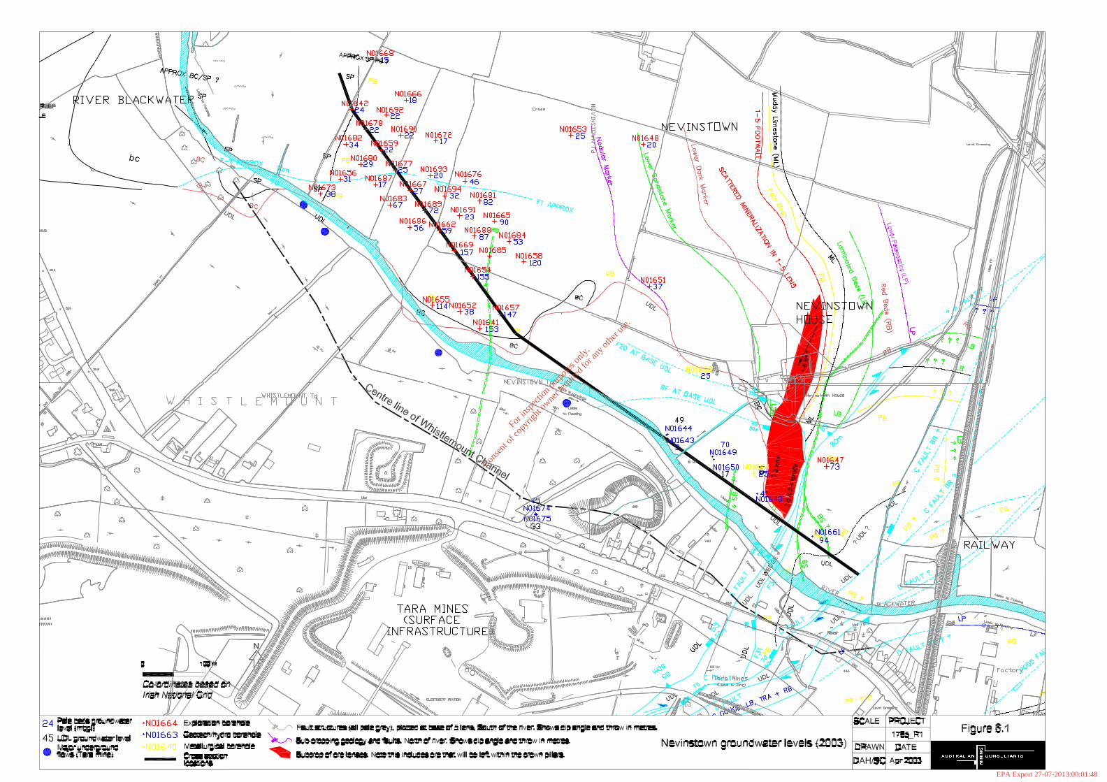
For
insp
ectio
n pur
pose
s only
.
Conse
nt of
copy
right
owne
r req
uired
for a
ny ot
her u
se.
EPA Export 27-07-2013:00:01:48

CONSULTANTS
MIN
ING
AUSTRALIAN
PROJECT REFERENCEDATE
DRAWN
AMC
402006NTS Nov 2002
SCALE DATA
CHKD APPRFigure 5.3Nevinstown Geology Dip Section
WSW-ESE dip section from the centre of the South-West Extension to the up-dip orebody limit at Nevinstown
500 Metres
ENEWSW
- Upper Dark Limestones
- Boulder Conglomerate
- Shaley Pales
- Pale Beds
- Muddy Limestone
- Laminated Beds
- Red Beds
- Lower Palaeozoics- Conglomerate Group Ore
- Pale Beds Ore
E Fault Complex
Y Fault
T Fault
A - Fault
Erosion Surface
Major Unconformity- Basalt Dyke
- Fault
ARUNDIAN
CHADIAN
COURCEYAN
SILURIAN/ORDOVICIAN- Marker Horizons in Pale Beds
SWEX Main Orebody
SWEX Project Area SWEX Current Production
~2Km to CurrentLimit of Drilling
Nevinstown
River Blackwater
Figure 6.2Nevinstown Geology Dip Section
For
insp
ectio
n pur
pose
s only
.
Conse
nt of
copy
right
owne
r req
uired
for a
ny ot
her u
se.
EPA Export 27-07-2013:00:01:48

Tara Mines Limited EIS - Extension of Mining Operation into Nevinstown and Liscartan
_____________________________________________________________________
Groundwater Study 53
Upper Dark Limestone (UDL)
The UDL generally forms a low permeability cover above the Pale Beds. Going up-dip into Nevinstown, it becomes thinner, and is eventually absent in the outcrop area of the Pale Beds. No significant cavity development is observed in the UDL at Nevinstown. The base of the UDL subcrops in Nevinstown. The upper 3-6m of the UDL near surface is fractured and weathered, and forms a locally permeable system. Some cavity development is seen in the UDL immediately below the Whistlemount Channel, but not in other areas. Packer tests carried out during previous studies on the UDL are listed in Table 6.2 (RTZ Consultants, 1975). Table 6-2: Packer Test Permeability Data in UDL
Borehole Depth (m) Permeability (m/s)
Comments
428 3-10 10-20 20-28
2.8x10⁻⁶ 2.3x10⁻⁷ 4.8x10⁻⁷
433 3-14 5.8x10⁻⁷ G1 3-12
12-25 7.5x10⁻⁷ 1.6x10⁻⁸
Intrusion of basalt in UDL
The average permeability of the UDL is approximately 6 x 10⁻⁷ m/s, which is typical of a limestone with a low fracture density. Vertical permeability is likely to be an order of magnitude less, as the vertical flow will be restricted by the flat-dipping bedding. As a comparison, the primary permeability of unfractured limestone is approximately 1x10⁻⁷ m/s (Freeze and Cherry, 1979). Therefore, the UDL can be characterised as a low permeability limestone with an associated low degree of fracturing. In turn, this means that the UDL typically forms a low permeability cover above the underlying mine workings. In general the water level in the UDL is depressed but the low permeability of the unit means that it is not completely dewatered. Occasionally flows are encountered in the UDL where fracture zones are intersected. These flows are not sustained from surface and quickly dry up. Pale Beds
The Pale Beds contain the ore at Nevinstown and therefore comprise the main unit that will require dewatering. The Pale Beds are continuous and interconnected between the existing mine and Nevinstown. They subcrop in Nevinstown as shown on Figure 6.1. The Pale Beds are present under the river just west of the railway bridge, in a location where the glacial till under the river is thin or absent. The highest potential for leakage into the mine workings occurs where the higher permeability Pale Beds subcrop beneath the river. The Pale Beds are generally considered to be the most permeable bedrock unit in the area. Although permeability is higher than the UDL, it is still low in absolute terms. Packer permeability tests were carried out in previous studies and are listed in Table
For
insp
ectio
n pur
pose
s only
.
Conse
nt of
copy
right
owne
r req
uired
for a
ny ot
her u
se.
EPA Export 27-07-2013:00:01:48

Tara Mines Limited EIS - Extension of Mining Operation into Nevinstown and Liscartan
_____________________________________________________________________
Groundwater Study 54
6.3 (RTZ Consultants, 1975). In general, the Pale Beds have permeability values an order of magnitude higher than the UDL. Table 6-3: Packer Test Permeability Data in Pale Beds
Borehole Depth (m) Permeability (m/s) Comments
428 40-55 55-75 75-115
3.6x10⁻⁷ 6.2x10⁻⁶ 1.2x10⁻⁶
B Fault
433 14-37 37-61 61-70
4.5x10⁻⁶
3.4x10⁻⁶ 8.3x10⁻⁶
100% water loss during drilling
G1 46-76 76-94 94-106
2x10⁻⁸ 2.9x10⁻⁶ 4.4x10⁻⁷
Cavities
Cavities have been located in drill core from Nevinstown. The cavities have generally been identified from core losses, or from significant water loss during drilling. It should be noted that core loss does not necessarily mean that a cavity is present. Some cavities are very evident from cores but a number of other factors can lead to core loss, such as weak rock or the use of single tube core barrels. Cavities are generally filled with overburden, although this is not often recovered in core. Cavities would have been formed as pre-glacial dissolution of limestone. During subsequent glaciation, the cavities were infilled with alluvium and glacial till. There is no indication of a connected cave or karst system at Nevinstown, and cavities are not indicated to have any significant impact on groundwater flow direction or magnitude. Near surface at Nevinstown there are numerous cavities in the Pale Beds subcrop (Golder Associates, 1974). North of the river, no significant cavity development is observed in the UDL in Nevinstown. The relative absence of cavities in the UDL is probably due to the relatively lower permeability of this unit, and the consequent restricted circulation of groundwater during the main period of cavity formation. Where the Pale Beds outcropped, there was greater potential for fluids to circulate and form cavities, before the glacial till was deposited. Consequently at Nevinstown, principal cavity development occurs where the Pale Beds subcrop (UDL cover absent). Structures All groundwater movement in the UDL and Pale Beds is structurally controlled. Therefore, the majority of groundwater inflows are associated with structural features. The main structures which are important for groundwater flow are:
§ The A-Fault – this forms a wide zone of deformation which extends to surface through the UDL and subcrops beneath the River Blackwater. There is no indication of permeability development or water movement in the A-Fault, and it is not considered to be a conduit for any groundwater inflows to the main Tara Mine, even close to the River Blackwater.
For
insp
ectio
n pur
pose
s only
.
Conse
nt of
copy
right
owne
r req
uired
for a
ny ot
her u
se.
EPA Export 27-07-2013:00:01:48

Tara Mines Limited EIS - Extension of Mining Operation into Nevinstown and Liscartan
_____________________________________________________________________
Groundwater Study 55
§ The B-Fault – this feature does not extend to surface near the river. In the main Tara Mine, flows from the B-Fault are generally the result of storage removal in the rock surrounding the fault.
§ The F1 structure is a northeast trending normal fault dipping 50-60 degrees to
the southeast. The F1 feature is associated with a long running inflow where an exploration heading intersected F1 at the 1330 level. This major single source of sustained groundwater inflow has 1flowed since 1985. Water makes from the F1 area were initially estimated at 100gpm (654m3/day), but have now decreased to a constant flow of 80gpm (523m3/day), this approximates to 10% of total groundwater inflow to the mine.
6.1.2.2 Hydrochemistry Mine water samples have been divided into four groups (A-D) on the basis of their chemistry. Most of the water samples taken from the Main Mine fall into Groups A and B, and show a calcium-bicarbonate water, with low sodium. The waters appear to be typical of recent recharge. Group A and B waters also have low TDS1 values and low temperatures. In general, the chemistry data and the inflow locations support that >90% of the water pumped from the existing Tara Mine is young water derived from surface infiltration. Hydrochemical studies over the last thirty years have not identified any hydrochemical signatures of river water in underground flow. Studies have been carried out on temperature, major ions, minor ions and isotopes. These studies suggest that there is no rapid infiltration of river water to the workings. Carbonate saturation indices have been calculated for the River Blackwater and other local groundwaters. The results confirm that the river water is over-saturated with respect to carbonate. This reduces the potential for enhanced limestone dissolution through infiltrating surface water, ie. formation of fresh sinkholes beyond those already present is not likely. The mine discharge is regularly sampled and reported and meets all water quality standards at the discharge point. 6.1.2.3 Current Mine Hydrology and Dewatering Currently, the Tara Mine pumps up to 7,500 m3/d to dewater the workings. Inflows from discrete flows and general seepages are routed to a central sump, from where the water is pumped to surface. Inflows are regularly mapped, sampled and measured by the mine and an interpretive report is prepared annually. The following conclusions can be drawn from the dewatering data and operational experience gathered over the last thirty years: § There is no positive correlation between rainfall and estimated groundwater
inflows to the mine. Even though recharge is likely to be strongly seasonal, the
1 Total Dissolved Solids.
For
insp
ectio
n pur
pose
s only
.
Conse
nt of
copy
right
owne
r req
uired
for a
ny ot
her u
se.
EPA Export 27-07-2013:00:01:48
Tara Mines Limited EIS - Extension of Mining Operation into Nevinstown and Liscartan
_____________________________________________________________________
Groundwater Study 56
impact of seasonal variation is attenuated in the flow path through the overburden and bedrock units.
§ Between 1984 and 2002, groundwater inflows have increased from approximately 5,000 m3/d to 7,500 m3/d. As the mine workings have been extended, the area contributing recharge to the mine has also expanded, so increasing the overall flow.
§ The main mechanism for inflows entering the Main Mine has been identified as recharge from rainfall entering the overburden, with the water subsequently entering fractures in the underlying limestone and being transmitted downwards towards the mine.
§ All porosity and permeability in the bedrock occurs in fractures, fissures and joints. Therefore, the amount of water stored in the rock is low. Therefore, storage removal represents only a small proportion of the total inflows to the mine, less than 10% of total flow.
§ The overburden units have higher porosity and storage and act as a “header tank” supplying water to the fractures in the underlying bedrock. Cavities are not likely to contribute significant storage compared to the overall volume of overburden.
§ There are no recorded inflows from the A-Fault.
§ The B-Fault is one of the major contributors of groundwater flow to the mine. However, when intersected it flows for a short time only and then dries up. These B-Fault flows are characteristic of storage removal in the rock surrounding the fault.
§ The major single source of sustained groundwater to the mine since 1985 to date
has been from the F1 fault where it was intersected by the 1330 exploration drift. This flow amounts to approximately 10% of the total groundwater inflow to the mine. Recent sub-horizontal boreholes drilled from underground into Nevinstown only encountered water from intersections with F1 and F23 structures. The source of water to this feature is considered to be flow of water along northwest trending joints, and flow downdip from the Pale Beds outcrop.
§ Most sustained groundwater occurrences in the northern section of the existing Tara Mine occur where NE trending faults intersect NW trending joint sets. These NW trending joint sets are more developed in the Pale Beds than in the UDL. Therefore inflows are probably fed horizontally through the Pale Beds, rather than vertically from the UDL.
§ The Tara Mine has a lower dewatering rate than comparable mines in the Irish Carboniferous. Higher inflows at other mines have been attributed to the development of significant secondary permeability through regional dolomitisation, which has increased the density of jointing (Dodds et al, 1994). At Tara, dolomitisation is only locally developed and, where present, is not porous. Significant secondary permeability has not been developed in the rock mass, apart from discrete structures.
For
insp
ectio
n pur
pose
s only
.
Conse
nt of
copy
right
owne
r req
uired
for a
ny ot
her u
se.
EPA Export 27-07-2013:00:01:48
Tara Mines Limited EIS - Extension of Mining Operation into Nevinstown and Liscartan
_____________________________________________________________________
Groundwater Study 57
6.1.2.4 Water Levels and Flows in Nevinstown Prior to the onset of mining at Tara, water levels in the bedrock at Nevinstown were typically between 1 and 3 mbgl1. As mining began south of the Blackwater in the early 1970s, groundwater levels were drawn down by up to 25m, with the majority of drawdown occurring to the south. During the 1980s significant groundwater lowering took place. At this time, drawdown appeared to be preferentially occurring in a north-westerly alignment. Water levels measured in March 2003 are plotted on Figure 6.1, as depths below ground level. Key features of the map are:
§ In the Whistlemount Channel, groundwater is present at 30m below ground level in the UDL. The Pale Beds are dewatered at this point.
§ In Nevinstown, groundwater in the UDL ranges between 15 and 45 mbgl.
§ To the west and north of Nevinstown, groundwater in the Pale Beds is between 20 and 30 mbgl, ie. depressed when compared to pre-mining levels.
§ Moving southeast along the river, groundwater levels in the Pale Beds are occasionally down to 150 mbgl.
§ On that part of Nevinstown directly across from the main Tara infrastructure, groundwater levels in the Pale Beds are between 40 and 70 mbgl.
§ In the vicinity of the A-Fault, groundwater levels in the Pale Beds are approximately 90 mbgl.
§ Data over the past few months show significant drops in water levels, probably caused by dewatering due to development drilling from the Tara Mine into Nevinstown. Sub-horizontal boreholes are currently actively draining approximately 650 m3/d from the Pale Beds in Nevinstown.
Current water levels are also been plotted on Figure 6.3, which is a cross section along the line of the River Blackwater. The following characteristics are evident:
§ To the west, where the mine workings are deeper, the influence of dewatering at surface is muted. Water levels in the Pale Beds are generally 20 mbgl, some 10m below the base of the overburden. The limit of significant dewatering is approximately 300m west of the edge of the orebody.
§ From the limit of dewatering to the edge of the orebody, there is a steep drop in water levels down to the top of the orebody.
§ In the central section where the UDL is present, the water level in the Pale Beds is generally at the top of the orebody. To the south in the Tara Mine the workings are dewatered and the water level is below the workings. The water level in the UDL above the Pale Beds shows some influence of dewatering, but due to the lower vertical permeability of the UDL there is significantly less drawdown.
§ In the area of the A-Fault and to the east, the Pale Beds are substantially dewatered to the top of the orebody.
1 mbgl = metres below ground level.
For
insp
ectio
n pur
pose
s only
.
Conse
nt of
copy
right
owne
r req
uired
for a
ny ot
her u
se.
EPA Export 27-07-2013:00:01:48

Tara Mines Limited EIS - Extension of Mining Operation into Nevinstown and Liscartan
_____________________________________________________________________
Groundwater Study 58
6.1.2.5 Nevinstown Dewatering
Although Nevinstown has been significantly dewatered already, there will be a requirement to further lower water levels as the workings are extended across the river. Key points of the dewatering and hydrogeological “model” for Nevinstown are as follows: § Porosity and groundwater storage in all bedrock units is low. It is estimated that
approximately 10% of the total mine inflow rate to the existing operation is produced as a result of groundwater storage removal. More than 70% of the current mine inflow is derived from recharge from the overburden. This is likely to remain the case as mining is extended into Nevinstown.
§ Water is fed to the fracture zones from the overburden, rather than from any direct connection to the Blackwater or other surface water features. The overburden acts as a “header tank” to partly attenuate seasonal variations in flow. The Blackwater probably also provides year-round recharge at low rates from sections of the overburden under the river and on the flood plain.
§ As the workings will be closer to surface, mining at Nevinstown may cause a more seasonal pattern in recharge, with higher winter/spring flows and lower summer/autumn flows.
§ There may be potential to pump a significant portion of the water currently flowing to the main mine from shallower levels in Nevinstown, thus decreasing overall pumping costs.
When mining extends into Nevinstown, there will be an additional reduction in groundwater levels. Water levels in the Pale Beds will be drawn down to at least the base of the orebody. It is estimated that additional drawdown due to mining of Nevinstown will amount to a further 50-100m near the river and up to 25m at the northern extent of the orebody.
For
insp
ectio
n pur
pose
s only
.
Conse
nt of
copy
right
owne
r req
uired
for a
ny ot
her u
se.
EPA Export 27-07-2013:00:01:48

For
insp
ectio
n pur
pose
s only
.
Conse
nt of
copy
right
owne
r req
uired
for a
ny ot
her u
se.
EPA Export 27-07-2013:00:01:48
Tara Mines Limited EIS - Extension of Mining Operation into Nevinstown and Liscartan
_____________________________________________________________________
Groundwater Study 60
When this additional drawdown is extrapolated to the north the predicted limit of drawdown is likely to extend up to 100m further north than currently seen. Approximately 0.9 km2 of Nevinstown will be affected by reduced groundwater levels and will drain to the mine pumps, compared to the 0.5 km2 currently draining to the mine. The total additional contribution to mine inflows from Nevinstown is likely to be of the order of 1,000 m3/d (750 m3/d recharge and 250 m3/d storage removal). The planned dewatering system should be based on an expansion of current practices. An effective dewatering operation for the Nevinstown extension is likely to comprise the following key components:
(i) Horizontal drainholes from new headings into the Pale Beds.
(ii) Horizontal boreholes from new headings – sub-horizontal exploration boreholes have been drilled into Nevinstown from the main workings. Some of these holes have intersected transmissive structures and flowed at initial rates of up to 80 m3/d. Total flow from all new horizontal boreholes is approximately 500 m3/d. It is recommended that horizontal boreholes with a flow rate of over 50 m3/d (10 gpm) be kept as advance dewatering boreholes and reticulated to the discharge system. Cover drilling should be carried out at a higher density where cavities are developed in the Pale Beds outcrop.
(iii) Reticulated drainage of passive flows. In the current dewatering operation, all inflows are run to a central sump where they are pumped to surface. For the Nevinstown extension it is proposed that significant flows are reticulated through flexible pipes or constructed drains to a sump. This would minimise the possibility that water could seep into already dewatered workings at a lower level.
(iv) High-level sumps – to reduce pumping head, dewatering flows from Nevinstown could be directed into a sump which is at a higher elevation than the current main sump. Depending on the economics of pumping from the current sump versus the construction of a new pumping station, this could reduce overall pumping costs.
Sealing of abandoned boreholes: In the current drilling programme boreholes will either be sealed or converted to piezometers. However, an extensive number of previous boreholes have been drilled at Nevinstown over the last thirty years. Not all of these holes will have been sealed and they could form a shortcut for water to flow from surface to the workings. Procedures for grouting boreholes are already in place at the main Tara Mine and it is recommended that these procedures be applied to open boreholes at Nevinstown. There is a risk however that many of these old borehole collars can no longer be located. 6.1.2.6 Soil Moisture
6.1.2.6.1 Soil & Bedrocks at Tara Mines
The soil at Tara Mines is clay loam with over 60% silt and clay. As such, it is termed a “heavy” soil with good moisture holding capacity. Beneath the developed agricultural soil is a limestone glacial drift or bolder clay, varying from 3 – 8 meters in thickness and with a few small areas totaling about 5m2 in area of rock outcrop.
For
insp
ectio
n pur
pose
s only
.
Conse
nt of
copy
right
owne
r req
uired
for a
ny ot
her u
se.
EPA Export 27-07-2013:00:01:49

Tara Mines Limited EIS - Extension of Mining Operation into Nevinstown and Liscartan
_____________________________________________________________________
Groundwater Study 61
Underlying this soil overburden is carboniferous limestone bedrock. In general the watertable is deep.
6.1.2.6.2 Soil Moisture & Groundwater Balance in Soils & Bedrocks In areas where the watertable is deep, there are two water balances in soils and bedrocks: § the soil moisture balance in soil above a watertable
§ the groundwater balance below the watertable
The soil moisture balance may be written as:
R – Re - Ev = Change in Soil Moisture [1]
Where: R = Rainfall
Re = drainage ( recharge ) to the groundwater
Ev = evaporation from plants and soil
The groundwater balance may be written as:
Re - Dr = Change ( rise or fall ) of the watertable [2]
Where: Dr = outward drainage to streams, rivers and lakes
Equation [1] states that a change in the moisture content of soil – increase or decrease – is due to the balance between rainfall, recharge or seepage downwards from the soil to the groundwater and evapotranspiration to the atmosphere by plants and soil. Equation [2], states that the rise or fall of the watertable is due to the balance between recharge from the soil and outward drainage from the waterbody to streams, rivers and lakes. While the soil moisture balance influences the height of the watertable (through recharge), the watertable has no influence on the soil moisture. This also holds where there is seepage into or out of an area, when the seepage is accounted for. Therefore, lowering of the watertable (e.g. by pumping ) only influences the deep groundwater, and not the shallow water in the soil horizons.
6.1.2.6.3 Experimental Measurements of Soil Moisture Before & After Pumping
To confirm the observations made above, reference is made to experimental measurement of soil moisture that were made at a site near Thurles, Co. Tipperary over the growing season of 1992 and the results were published2. The underlying geology and soils at the site are comparable to the situation at Nevinstown. Soil moisture was measured regularly throughout the period using a nuclear gauge. The flow of water (upwards to evapotranspiration and downwards to recharge) was determined by measuring pore water pressures at various depths by tensiometers; soil 2 Hosty, M. and Mulqueen,J. (1995). Soil moisture and groundwater drawdown in a dry grassland soil. Irish Journal of Agric. & Food Res.35:17-24
For
insp
ectio
n pur
pose
s only
.
Conse
nt of
copy
right
owne
r req
uired
for a
ny ot
her u
se.
EPA Export 27-07-2013:00:01:49

Tara Mines Limited EIS - Extension of Mining Operation into Nevinstown and Liscartan
_____________________________________________________________________
Groundwater Study 62
moisture flows from a zone of high pressure to one of low pressure and the direction of the flow can be determined by pore water pressure measurements. Watertables were measured in a borehole and rainfall by a rain guage. Evapotranspiration was estimated from Penman’s equation. These measurements and estimates gave quantities of (1) rainfall. (2) recharge, (3) evapotranspiration, (4) change in soil moisture and (5) change in watertable height. Pumping began on the 25th August and continued through 15th September at an average discharge of 155 m3 /hour (34,000 gallons/hour). As a result, the watertable was lowered by 3.5 meters, from 4.0 to 6.5 meters below ground surface. Results showed that lowering the groundwater height by 3.5 meters (11.5 feet) had no effect on the moisture content of the soil. A period of rainfall between 20th and 26th August gave 36.5mm (about 11/2 inches) and both the soil moisture and the pore water pressure increased while the watertable was being lowered. As rainfall continued giving 89.1mm (31/2 inches) up to the 16th September, soil moisture and pore water pressure continued to increase to close to saturation despite the continued lowering of the watertable. 6.1.3 Potential Impacts
Potential impacts on groundwater due to mining at Nevinstown have been identified as follows: 1. Whether settlement and subsidence will cause an increase in groundwater flow
and river leakage.
A review of settlement and hydrogeological data has shown that, given the operational experience to date, and the nature and predicted extent of future ground settlement, significant enhanced permeability development or losses from the river are not anticipated. It is recommended that groundwater conditions within and around the project area are carefully monitored throughout all stages of mining. An action plan is provided for responses outside of predictions. Contingency pumping capacity is recommended for all stages of the operation.
2. Whether dewatering of Nevinstown may cause additional or rapid leakage from
the River Blackwater to the underground workings.
The bedrock beneath the River Blackwater is currently dewatered over the mine workings, and there is an unsaturated zone between the river and the water level in the bedrock. The degree of leakage from the river is constrained by the depth and permeability of this unsaturated zone. Over most of the river length, this unsaturated zone is composed of UDL, which is of low permeability. Further drawdown of the water level below the river will not cause further leakage from the river.
3. The possibility that dewatering of Nevinstown could open up sink holes at the surface.
The risk of sinkhole development at surface relates to the drainage of mud/silt filled cavities and subsequent collapse through dewatering. The majority of the
For
insp
ectio
n pur
pose
s only
.
Conse
nt of
copy
right
owne
r req
uired
for a
ny ot
her u
se.
EPA Export 27-07-2013:00:01:49

Tara Mines Limited EIS - Extension of Mining Operation into Nevinstown and Liscartan
_____________________________________________________________________
Groundwater Study 63
area to be mined at Nevinstown has already been dewatered to a depth of at least 15-20 mbgl3, and there is no current evidence of sinkhole development at surface. Therefore, there will be no additional dewatering of cavities close to surface, and formation of additional sinkholes at surface is, therefore, not likely.
Mining operations at Nevinstown have the potential to intersect cavities in the
Pale Beds, particularly on the north-west fringes of the mining area. Further investigations of the occurrence of cavities are required before detailed mining plans can be finalised in these areas. There will be some dewatering of cavities below the current water level, as mining progresses up dip. There will also be some associated risk of mud and silt inflows to nearby underground working areas. Mitigation measures have been recommended, prior to mining in areas with suspected sinkholes.
4. The possibility that current leakage of water from the superficial deposits into
the underlying limestones could open up more significant flow paths as a result of dissolution of CaCO3.
Calculations of carbonate saturation indices has shown that further rapid carbonate dissolution (ie especially within the mine life) is not possible. As a result, leakage of water from the superficial deposits into the underlying limestones is unlikely to open up more significant flow paths as a result of dissolution of CaCO3.
5. Whether there is a possibility that pore pressures or lubrication will enhance
movement within the main structures in the area of the crown pillar.
Measured permeabilities in the major structures are comparable to the surrounding rockmass. However, as high flows do occur from some structures, local permeabilities are sometimes much higher than the surrounding rockmass. Consequently, structures will drain either faster or at the same rates as the rockmass. There is no indication of significantly lower permeabilities in major structures which might give rise to higher pore pressures in the structures than the surrounding rock. Where monitoring identifies areas of high pore pressure, horizontal drainage boreholes will be used to reduce those pressures.
6. The possibility that dewatering at Nevinstown may increase the regional extent of drawdown.
The Pale Beds in the immediate vicinity of the Tara Mine are classified as a poor to locally important aquifer, according to the criteria developed by the Geological Survey of Ireland. Areas of sands and gravels within the superficial deposits are also water-bearing, and may constitute aquifers of local importance.
The hydrogeological assessment has shown that the Nevinstown extension
could increase the dewatered zone, as follows:
§ To the north the catchment zone is likely to extend up to 500m north of the River Blackwater.
3 mbgl = metres below ground level. Similarly, masl = metres above (mean) sea level.
For
insp
ectio
n pur
pose
s only
.
Conse
nt of
copy
right
owne
r req
uired
for a
ny ot
her u
se.
EPA Export 27-07-2013:00:01:49

Tara Mines Limited EIS - Extension of Mining Operation into Nevinstown and Liscartan
_____________________________________________________________________
Groundwater Study 64
§ To the west the catchment zone just extends to Rathaldron Castle - the well here may be affected by reduced water levels. The catchment zone is not expected to extend to the Randalstown tailings management facility.
§ To the east, dewatering may extend under the railway and the Carpet Factory, although propagation to the east may be limited by the low permeability caused by fault gouge zones. Dewatering at depth will not reduce soil moisture at surface (see below) and, therefore, surface settlement is not expected to occur, and fault structures will be unaffected.
Groundwater monitoring boreholes will be constructed around the Nevinstown extension, to determine the influence of dewatering.
7. The possibility that lowering the water table in the Pale Beds could cause a change in soil moisture conditions at Nevinstown.
Theory and experimental measurements show that soil moisture is influenced by rainfall, evapotranspiration and recharge to the groundwater table. Since soil moisture content is not influenced by the height of the watertable, grass and crop growth and production likewise are not influenced when the watertable is deep. This has been the case at Navan Mines since mining began in 1972 and will continue to be the case as mining is extended outwards from the existing boundaries.
8. Potential changes to the water quality of the mine discharge.
Under the current water management system, water pumped from underground is pumped to the tailings management facility where it is reclaimed for use in the mine and mill. Surplus water is discharged to the River Boyne through a storage pond, where the quality is checked before discharge. The discharge meets all water quality limits.
Any additional groundwater flow from Nevinstown is not expected to alter the overall chemistry of the discharge. The Nevinstown orebody is geologically and geochemically identical to the orebody in the main Tara Mine and, therefore, there will be no significant difference in the water quality.
9. Alterations to groundwater flow upon closure.
Following closure and cessation of pumping, the main mine and Nevinstown workings will fill with groundwater. This process is likely to take a number of years. Afterwards, the pre-existing groundwater drainage pattern will be re-established. There is no significant potential for discharge of contaminated water from the deep mine workings to the shallow groundwater system or to the River Blackwater.
6.1.4 Mitigating Measures A Management Plan is recommended for implementing mining at Nevinstown. The Plan would comprise a Monitoring Programme, and an Implementation Plan. A robust monitoring programme is central to implementation of a project such as the Nevinstown extension. It is through monitoring that the Study findings are
For
insp
ectio
n pur
pose
s only
.
Conse
nt of
copy
right
owne
r req
uired
for a
ny ot
her u
se.
EPA Export 27-07-2013:00:01:49
Tara Mines Limited EIS - Extension of Mining Operation into Nevinstown and Liscartan
_____________________________________________________________________
Groundwater Study 65
confirmed, and in particular the results of monitoring provide the basis for reviewing and adjusting designs according to actual rather than predicted rockmass and hydrological responses. The project Implementation Plan encompasses a series of recommended responses to any conditions that don’t correspond to predictions. The plan comprises a series of recommended technical responses to conditions arising, such as specific investigations of stope behaviour, determining the causes of elevated stresses in pillars, investigations into higher than expected groundwater inflows to the mine, etc The Study implementation plan is detailed in Table 6.4 below. The monitoring plan is outlined in Section 6.5. Table 6.4 details a series of recommendations for responses to conditions which may arise, that do not match predictions. This encompasses both geotechnical and hydrological aspects. The listing should not considered as complete. It represents a basis for a plan that should then be reviewed and expanded upon by Tara Mines, as part of the company’s Nevinstown Management Plan, during project implementation. Such a plan should also be subject to annual reviews, both internally within Tara Mines, and also by the company’s consultants. Table 6-4: Nevinstown Implementation Plan (Hydrology) Condition Control 1. Higher than expected
groundwater inflows to the workings, due to:
§ General leakage from the River Blackwater
§ Development of permeability along the plane of the A-Fault beneath the river.
The likelihood of more leakage than expected from the river entering the mine is low. The Nevinstown orebody and the Pale Beds beneath the river are already substantially dewatered, hence any losses from the river are already occurring. The monitoring plan has been designed so that, in addition to the local area of the orebody, potential losses from the river upstream and downstream of the immediate mine area can be monitored on an on-going basis during mining.
The following actions are recommended:
a) Provide underground pumping capacity of 20,000 m3/day, which is more than twice the expected inflow rate.
b) Carefully track the actual pumping rate with time during mining. If the pumping rate were to be greater than anticipated, additional contingency pumping capacity would be installed.
c) Designate an area underground for contingency storage of water and ensure that water can be routed to this area in the event of a prolonged power outage or other times of emergency.
d) If water levels in one particular area start to rise, and this can be correlated with an increase in underground inflows, a detailed investigation programme would be implemented. Corrective action would be taken, which may include: (i) grouting of any discrete flow paths, or (ii) installation of targeted drains from underground to intercept any discrete flow paths.
For
insp
ectio
n pur
pose
s only
.
Conse
nt of
copy
right
owne
r req
uired
for a
ny ot
her u
se.
EPA Export 27-07-2013:00:01:49
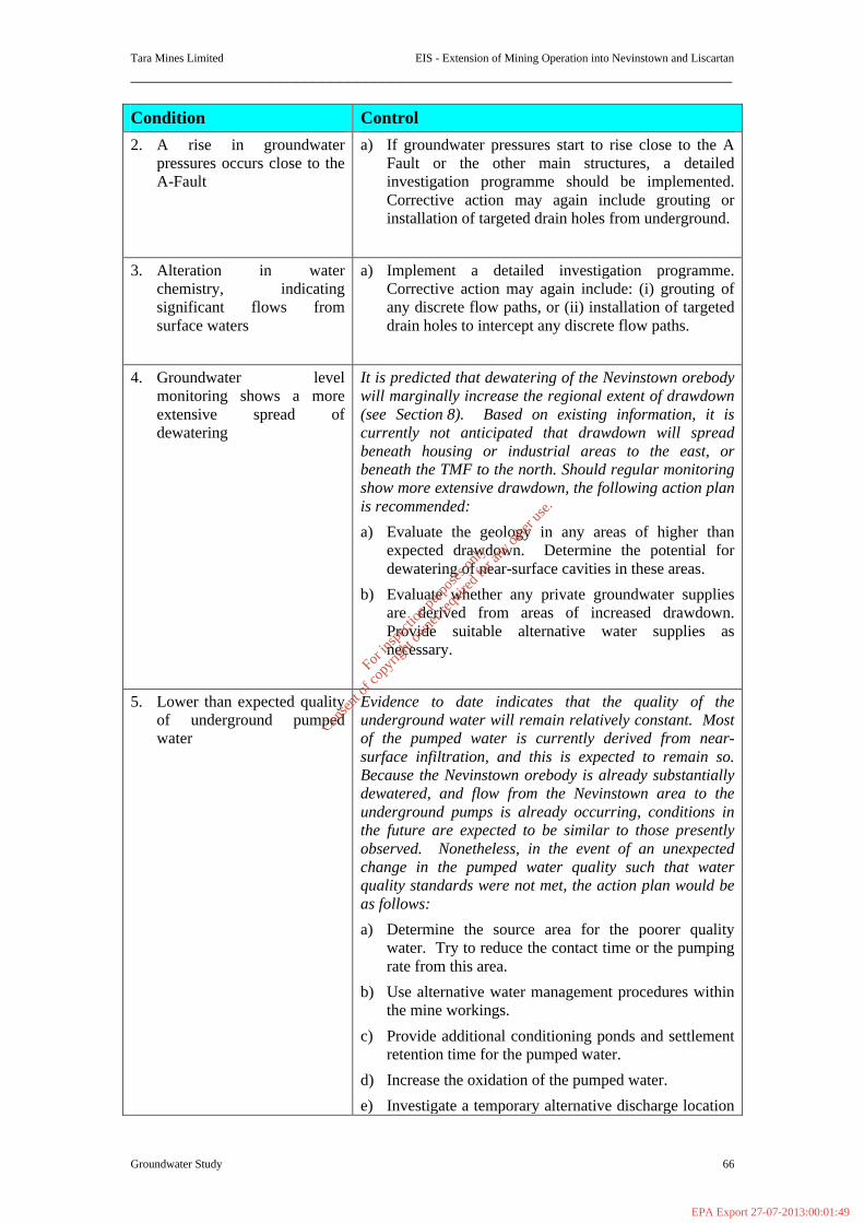
Tara Mines Limited EIS - Extension of Mining Operation into Nevinstown and Liscartan
_____________________________________________________________________
Groundwater Study 66
Condition Control 2. A rise in groundwater
pressures occurs close to the A-Fault
a) If groundwater pressures start to rise close to the A Fault or the other main structures, a detailed investigation programme should be implemented. Corrective action may again include grouting or installation of targeted drain holes from underground.
3. Alteration in water chemistry, indicating significant flows from surface waters
a) Implement a detailed investigation programme. Corrective action may again include: (i) grouting of any discrete flow paths, or (ii) installation of targeted drain holes to intercept any discrete flow paths.
4. Groundwater level monitoring shows a more extensive spread of dewatering
It is predicted that dewatering of the Nevinstown orebody will marginally increase the regional extent of drawdown (see Section 8). Based on existing information, it is currently not anticipated that drawdown will spread beneath housing or industrial areas to the east, or beneath the TMF to the north. Should regular monitoring show more extensive drawdown, the following action plan is recommended:
a) Evaluate the geology in any areas of higher than expected drawdown. Determine the potential for dewatering of near-surface cavities in these areas.
b) Evaluate whether any private groundwater supplies are derived from areas of increased drawdown. Provide suitable alternative water supplies as necessary.
5. Lower than expected quality of underground pumped water
Evidence to date indicates that the quality of the underground water will remain relatively constant. Most of the pumped water is currently derived from near-surface infiltration, and this is expected to remain so. Because the Nevinstown orebody is already substantially dewatered, and flow from the Nevinstown area to the underground pumps is already occurring, conditions in the future are expected to be similar to those presently observed. Nonetheless, in the event of an unexpected change in the pumped water quality such that water quality standards were not met, the action plan would be as follows:
a) Determine the source area for the poorer quality water. Try to reduce the contact time or the pumping rate from this area.
b) Use alternative water management procedures within the mine workings.
c) Provide additional conditioning ponds and settlement retention time for the pumped water.
d) Increase the oxidation of the pumped water.
e) Investigate a temporary alternative discharge location
For
insp
ectio
n pur
pose
s only
.
Conse
nt of
copy
right
owne
r req
uired
for a
ny ot
her u
se.
EPA Export 27-07-2013:00:01:49

Tara Mines Limited EIS - Extension of Mining Operation into Nevinstown and Liscartan
_____________________________________________________________________
Groundwater Study 67
Condition Control for the pumped water
6. Sinkholes are developed at surface
Because the river only flows over the Pale Beds for a distance of about 40m, development of sink holes beneath the river is not anticipated. There are no other significant tributary streams or other surface water features which could be affected by sink hole development in the Pale Beds subcrop area. Development of sink holes within built-up areas would only be anticipated if additional regional dewatering occurs, as described above.
The action plan to mitigate against sink hole developments is as follows:
a) Carry out the gravity geophysical survey over the Nevinstown subcrop area and along the line of the river, as planned. Particular attention will be paid to results in the area of the A-Fault, where the river flows directly over the Pale Beds, or where there is only thin (<10 m) UDL cover.
b) Interpret the data, and other data from air photography and geological mapping to confirm the current understanding of cavity development and distribution.
c) Monitor regional drawdown as described above. Evaluate the geology in any areas of higher than expected drawdown. Determine the potential for dewatering of near-surface cavities in these areas.
d) The potential for mining into cavities underground would be mitigated by: (i) collating data from the planned gravity survey with mapping data, and (ii) cover drilling ahead of new development headings. Mining into minor cavities is a “normal” hazard of underground mining in limestone areas. Operational procedures exist at Tara Mine for mining into small unexpected cavities.
6.1.5 Monitoring
A groundwater monitoring programme will be established to check the impact of dewatering at Nevinstown. Parts of the network have already been constructed and the remainder will be installed as the exploration drilling programme continues. The proposed network is displayed on Figure 6.4 and summarised below:
§ One multi-level piezometer through the Whistlemount Channel.
§ Two piezometers equipped with pressure sensors and dataloggers, beneath the River Blackwater, in the UDL and Pale Beds.
§ At least 3 groups of multi-level piezometers along the north bank of the Blackwater. These are already installed in key structures.
For
insp
ectio
n pur
pose
s only
.
Conse
nt of
copy
right
owne
r req
uired
for a
ny ot
her u
se.
EPA Export 27-07-2013:00:01:49
Tara Mines Limited EIS - Extension of Mining Operation into Nevinstown and Liscartan
_____________________________________________________________________
Groundwater Study 68
§ Single piezometers along the river and to the west, north and east of the mine workings.
§ Measurement of flows and water quality underground.
The results of this programme will be regularly reported and interpreted, in line with the regular reports carried out for the main mine.
For
insp
ectio
n pur
pose
s only
.
Conse
nt of
copy
right
owne
r req
uired
for a
ny ot
her u
se.
EPA Export 27-07-2013:00:01:49
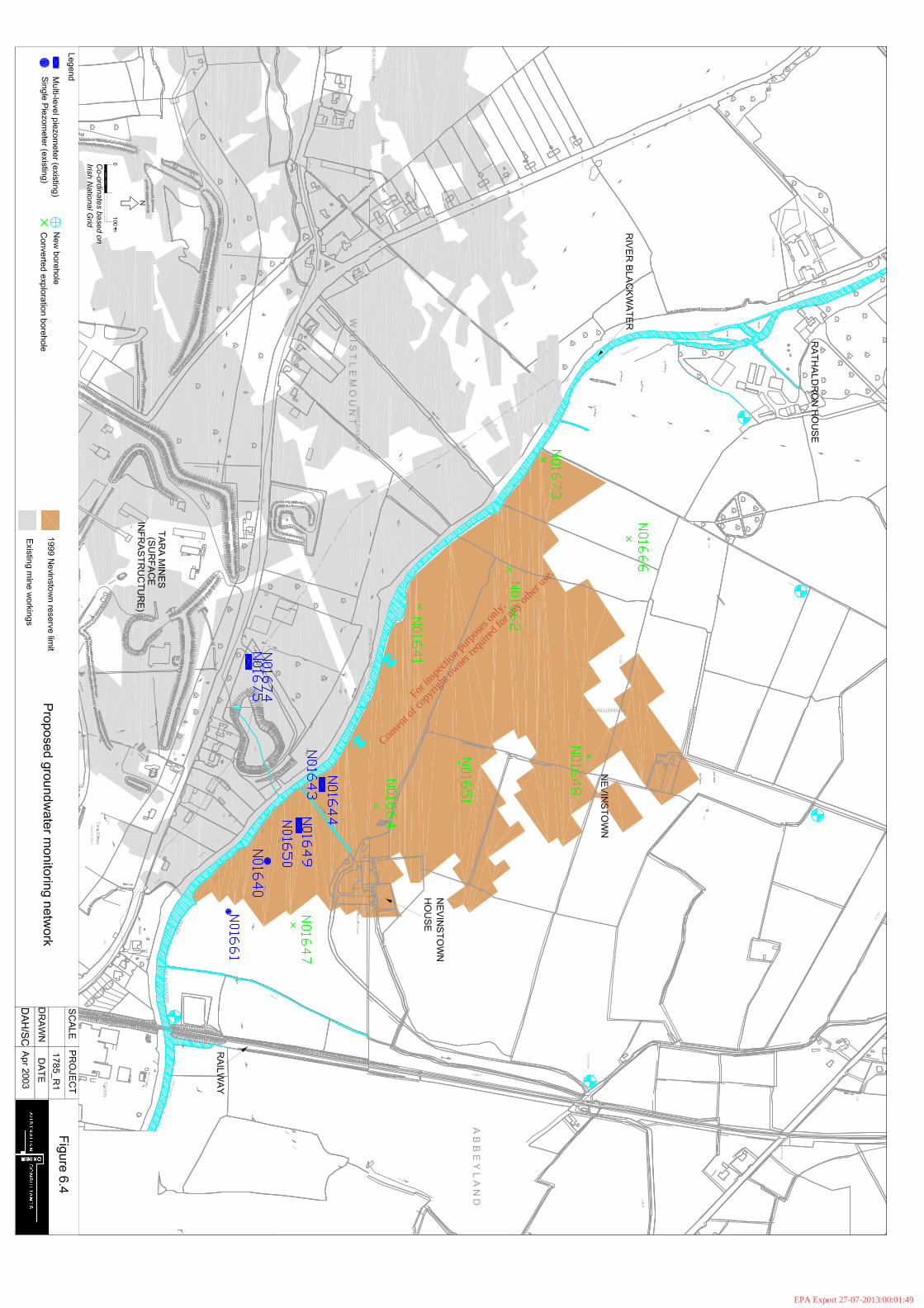
For
insp
ectio
n pur
pose
s only
.
Conse
nt of
copy
right
owne
r req
uired
for a
ny ot
her u
se.
EPA Export 27-07-2013:00:01:49
Tara Mines Limited EIS - Extension of Mining Operation into Nevinstown and Liscartan
_____________________________________________________________________
Groundwater Study 70
6.1.6 Recommendation and Conclusions The Nevinstown Geotechnical Study (Appendix 1) has confirmed that the mining proposals for the Nevinstown extension under consideration by Tara Mines Limited are sound, and subject to the establishment of a routine monitoring strategy, and certain recommendations contained within the main Nevinstown Geotechnical Study report, can be implemented without noticeable impact on the surface. The objective of minimal surface impact has been achieved through the design of a stable surface crown pillar, the use of strategically located permanent pillars, and the tight backfilling of all stopes, to control surface settlement. Various recommendations have been made concerning the stability of underground mining. The hydrological data has confirmed that the bedrock at Nevinstown has been substantially dewatered by downdip flow to the main Tara Mine. This includes the bedrock beneath the River Blackwater. Any leakage from the River is controlled by the permeability of the alluvium, till and shallow bedrock. Any additional dewatering in the mine is not expected to significantly change this leakage rate. Just to the north of the river, Pale Beds groundwater levels have already been drawn down by up to 100m. UDL water levels are depressed to a lesser degree, as would be expected. The A-Fault does not currently form a pathway for water inflow into the mine. It has been observed to have very low permeability in numerous underground exposures. The minimisation of any potential for differential settlement across the structure, through the use of pillars and other measures, and the absence of any such response at surface, renders it very unlikely that mining will result in any change to the faults permeability. Operations at the Tara Mine over the last thirty years have shown that it is feasible to mine under the River Blackwater without any negative impacts on the flow of the river. Further dewatering is not expected to increase the potential for sinkholes to develop at the surface, as any cavities are expected to be already dewatered. Mining methods towards the area in the north with cavities will take account of their presence. Much of the Nevinstown extension being substantially dewatered, mining is not likely to create a significant expansion of dewatering influence. There is only one groundwater user within the vicinity of Nevinstown who may experience lowered groundwater levels, and a monitoring well will be established, in co-operation with the owner. The Nevinstown extension does not bring mining any closer to the Randallstown Tailings Management Facility and, therefore, there is considered to be no potential for significant drawdown to extend towards the dam. Mining operations at Nevinstown have the potential to intersect cavities in the Pale Beds, particularly on the north-west fringes of the mining area. Further investigations of the occurrence of cavities are required before detailed mining plans can be finalised in these areas. The hydrological monitoring programmes will be an integral component of the mining activity. The monitoring will confirm the conclusions reached in the Study, and
For
insp
ectio
n pur
pose
s only
.
Conse
nt of
copy
right
owne
r req
uired
for a
ny ot
her u
se.
EPA Export 27-07-2013:00:01:49

Tara Mines Limited EIS - Extension of Mining Operation into Nevinstown and Liscartan
_____________________________________________________________________
Groundwater Study 71
provide valuable on-going information for use by Tara Mines in detailed design and operations. The main Nevinstown Geotechnical Study report details a range of recommendations pertaining to the proposed Nevinstown mine design and operations. Most important however is the successful implementation of a monitoring programme which addresses the main geotechnical and hydrological issues for the future operation. The hydrological data available is considered entirely adequate, and additional information will be derived from the monitoring programme. Recommendations for an effective dewatering system for Nevinstown have also been made. It is the view of the Study team that Tara Mines would benefit from periodic reviews of mining progress at Nevinstown. This will enable independent comparisons between predicted and actual geotechnical and hydrological responses to mining, and ensure that appropriate adjustments are made to mining plans, if necessary. 6.1.7 Post Closure Following closure and cessation of pumping the main mine and Nevinstown workings will fill with groundwater. This process is likely to take a number of years. Afterwards, the pre-existing groundwater drainage pattern will be re-established. This will comprise the following:
§ Water levels in the overburden at Nevinstown will remain unchanged as they have been virtually unaffected by mining. However, groundwater levels will recover in the Whistlemount Channel.
§ Groundwater levels in the UDL and Pale Beds will return to approximately 1-5 mbgl, over Nevinstown and the main Tara Mine.
§ The shallow groundwater flow system in the overburden and shallow bedrock will be re-established. This will comprise recharge from infiltration of precipitation and subsequent discharge to the River Blackwater.
§ There is unlikely to be groundwater flow from the deep mine workings to the River Blackwater.
§ As there will be no mining in the crown pillars, ie. above 30 mbgl, then there will be no potential for the post-closure shallow groundwater to flow through old mine workings. Therefore, there is no significant potential for contaminants to be flushed from the mine to the River. During the recovery of the water level there will be flow through the workings, but there will not be discharge to the river.
§ Mineral surfaces in the crown pillar will not be exposed to oxidation and, therefore, there is no significant potential for the generation of acid mine drainage and subsequent discharge to the river. The generation of acid rock drainage in the workings below the crown pillar is not considered likely due to the geochemistry of the orebody and host rocks. In addition, there is not predicted to be any discharge of deep groundwater from the mine workings.
For
insp
ectio
n pur
pose
s only
.
Conse
nt of
copy
right
owne
r req
uired
for a
ny ot
her u
se.
EPA Export 27-07-2013:00:01:49

Tara Mines Limited EIS - Extension of Mining Operation into Nevinstown and Liscartan
_____________________________________________________________________
Groundwater Study 72
Targeted monitoring will continue post closure to check that groundwater levels and water quality and flows are in line with predictions. A closure plan has been prepared for the main Tara mine and this will be adapted to include the Nevinstown extension also. 6.1.8 References
Dodds, J.E, Daly, E.P & Cullen, K.T, Relationship between Mining and Ground
Water Within the Dolomites of Ireland. Proceedings of the 5th International Mine Water Congress. 1994.
Duncan, N., Bula Limited’s Proposed Nevinstown Mining Complex. Report to Tara Mines Ltd, Volumes I-III. 1986.
Freeze, R.A & Cherry, J.A., Groundwater. Pub: Prentice-Hall, 1979. Golder Associates, Groundwater Studies - Vol I - Current and Future Conditions.
Report to Tara Mines Limited. October 1974. Golder Associates, 1977 Investigations into the Whistlemount Channel. Report to
Tara Mines Ltd. 1978. Hosty, M. and Mulqueen,J., Soil moisture and groundwater drawdown in a dry
grassland soil. Irish Journal of Agric. & Food Res.35:17-24. 1995. Knill, The Whistlemount Channel - its implications for mining at Navan. May 1977. Minerex Limited, Additional monitoring of groundwater quality at Navan Mine, with
reference to surface water infiltration. January 1980. Minerex Limited, Water Studies at Navan Mine. Periodic report No. 83 & selected
previous reports 1-82. August 2002. RTZ Consultants Ltd, Nevinstown Lead/Zinc Deposit Feasibility Study. Report to
Bula Limited. Volume III – Geotechnical Report. July 1975. Smith, J D, Comments on “January 1979 Review of Tara’s Mine Planning and
Structural Design in the Region of the Blackwater River”, by R A Oram; January 1979.
Tara Mines Limited, Site closure, Decommissioning and Perpetual Aftercare Plan. November 2002.
6.2 Liscartan All underground water encountered during development and mining will be collected at a central underground pumping station and piped back into the existing mine. This water will then join the existing mine drainage system for later treatment and pumping to surface. The total pumping capacity in the mine is 21,600 m3/d. There is no planned additional water pumping related connections to surface. At present, it is not possible to estimate the quantity of groundwater as the extent of mineable ore has not yet been established. It is however anticipated that there will be sufficient flexibility and storage in the water management system to accommodate the additional flow. Any additional groundwater flow from the Liscartan extension is not expected to alter the overall chemistry of the discharge. The new orebody is geologically and geochemically identical to the orebody in the main Tara Mine and, therefore, there will be no significant difference in the water chemistry.
For
insp
ectio
n pur
pose
s only
.
Conse
nt of
copy
right
owne
r req
uired
for a
ny ot
her u
se.
EPA Export 27-07-2013:00:01:49

Tara Mines Limited EIS - Extension of Mining Operation into Nevinstown and Liscartan
_____________________________________________________________________
Groundwater Study 73
A groundwater monitoring programme will be established to check the impact of dewatering in the Liscartan area. Theory and experimental measurements show that soil moisture is influenced by rainfall, evapotranspiration and recharge to the groundwater table. Since soil moisture content is not influenced by the height of the watertable, grass and crop growth and production likewise are not influenced when the watertable is deep. This has been the case at Navan Mines since mining began in 1972 and will continue to be the case as mining is extended outwards from the existing boundaries.
Following mine closure, pumping will cease and the mine will fill with groundwater. This process is likely to take a number of years. Afterwards, the pre-existing groundwater drainage pattern will be re-established.
For
insp
ectio
n pur
pose
s only
.
Conse
nt of
copy
right
owne
r req
uired
for a
ny ot
her u
se.
EPA Export 27-07-2013:00:01:49

Tara Mines Ltd EIS - Extension of Mining Operation into Nevinstown and Liscartan ___________________________________________________________________________________
Blasting Vibration /Air over- pressure Noise 74
SECTION 7 BLASTING VIBRATION AND AIR-OVERPRESSURE NOISE 7.1 Introduction Tara Mines Limited, the largest operating lead-zinc mine in Europe, is located at Knockumber, 2 km west of Navan in County Meath. Originally sited in a rural area, expansion of Navan has resulted in the development of residential areas nearer to the mine although much of its surroundings remain flat agricultural land drained by prolific fishing rivers. The River Blackwater (which flows into the River Boyne) passes over the orebody and forms a surface intersection feature between what is now referred to as the ‘Main orebody’ and the ‘Nevinstown orebody’. The proposal involves the mining of proven ore reserves in the Nevinstown orebody and the mining of the Liscartan orebody subject the confirmation of mineable ore reserves. The Nevinstown orebody is in essence an extension northwards of the existing orebody, while Liscartan forms the northwest extension of this orebody. Ongoing and future exploration will determine the extent of mineable ore in the Liscartan area. 7.2 The Nevinstown Proposal The proposed development involves establishing access to the orebody by underground mining methods via the existing underground mine and therefore no surface development in the Nevinstown area is required. A new inclined portal access from the surface property of Tara Mines is planned that will provide a vehicle route to the existing mine and to the Nevinstown. The necessary infrastructure for its operation is already in place; including administration, mining and processing facilities, tailings storage capacity, ventilation, effluent discharge facilities and road/rail links to Dublin Port 7.3 The Existing Blasting Vibration (Air-overpressure Noise) Environment 7.3.1 Ground Vibration Cause of Blast Vibration Ground vibration is caused by the imperfect utilisation of the explosive energy released during blasting operations. The energy that is unused in the fragmentation of rock propagates as an elastic disturbance away from the shot area as seismic waves. These waves, which radiate in a complex manner, diminish in strength with distance from the source. The theory relative to this motion is based on an idealised (sinusoidal) vibratory motion. When these waves come into contact with a free face, physical motion results as the energy induces oscillation in the ground surface.
For
insp
ectio
n pur
pose
s only
.
Conse
nt of
copy
right
owne
r req
uired
for a
ny ot
her u
se.
EPA Export 27-07-2013:00:01:49
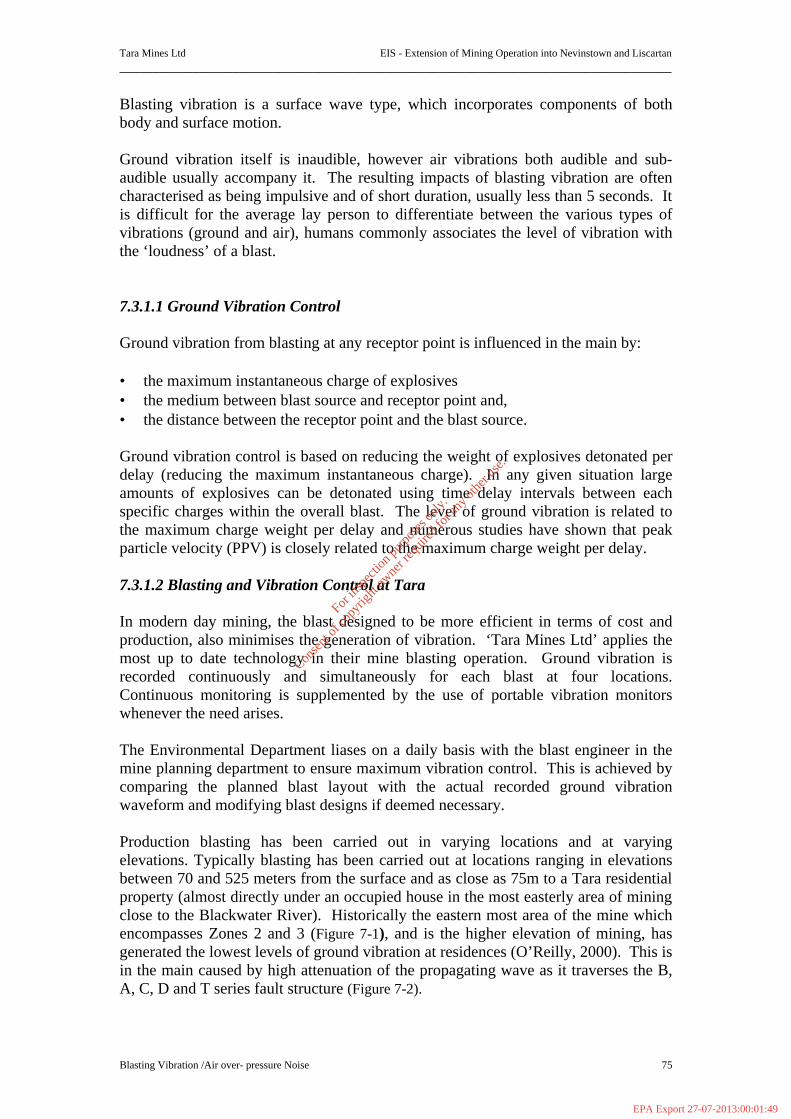
Tara Mines Ltd EIS - Extension of Mining Operation into Nevinstown and Liscartan ___________________________________________________________________________________
Blasting Vibration /Air over- pressure Noise 75
Blasting vibration is a surface wave type, which incorporates components of both body and surface motion. Ground vibration itself is inaudible, however air vibrations both audible and sub-audible usually accompany it. The resulting impacts of blasting vibration are often characterised as being impulsive and of short duration, usually less than 5 seconds. It is difficult for the average lay person to differentiate between the various types of vibrations (ground and air), humans commonly associates the level of vibration with the ‘loudness’ of a blast. 7.3.1.1 Ground Vibration Control Ground vibration from blasting at any receptor point is influenced in the main by: • the maximum instantaneous charge of explosives • the medium between blast source and receptor point and, • the distance between the receptor point and the blast source. Ground vibration control is based on reducing the weight of explosives detonated per delay (reducing the maximum instantaneous charge). In any given situation large amounts of explosives can be detonated using time delay intervals between each specific charges within the overall blast. The level of ground vibration is related to the maximum charge weight per delay and numerous studies have shown that peak particle velocity (PPV) is closely related to the maximum charge weight per delay. 7.3.1.2 Blasting and Vibration Control at Tara In modern day mining, the blast designed to be more efficient in terms of cost and production, also minimises the generation of vibration. ‘Tara Mines Ltd’ applies the most up to date technology in their mine blasting operation. Ground vibration is recorded continuously and simultaneously for each blast at four locations. Continuous monitoring is supplemented by the use of portable vibration monitors whenever the need arises. The Environmental Department liases on a daily basis with the blast engineer in the mine planning department to ensure maximum vibration control. This is achieved by comparing the planned blast layout with the actual recorded ground vibration waveform and modifying blast designs if deemed necessary. Production blasting has been carried out in varying locations and at varying elevations. Typically blasting has been carried out at locations ranging in elevations between 70 and 525 meters from the surface and as close as 75m to a Tara residential property (almost directly under an occupied house in the most easterly area of mining close to the Blackwater River). Historically the eastern most area of the mine which encompasses Zones 2 and 3 (Figure 7-1), and is the higher elevation of mining, has generated the lowest levels of ground vibration at residences (O’Reilly, 2000). This is in the main caused by high attenuation of the propagating wave as it traverses the B, A, C, D and T series fault structure (Figure 7-2).
For
insp
ectio
n pur
pose
s only
.
Conse
nt of
copy
right
owne
r req
uired
for a
ny ot
her u
se.
EPA Export 27-07-2013:00:01:49
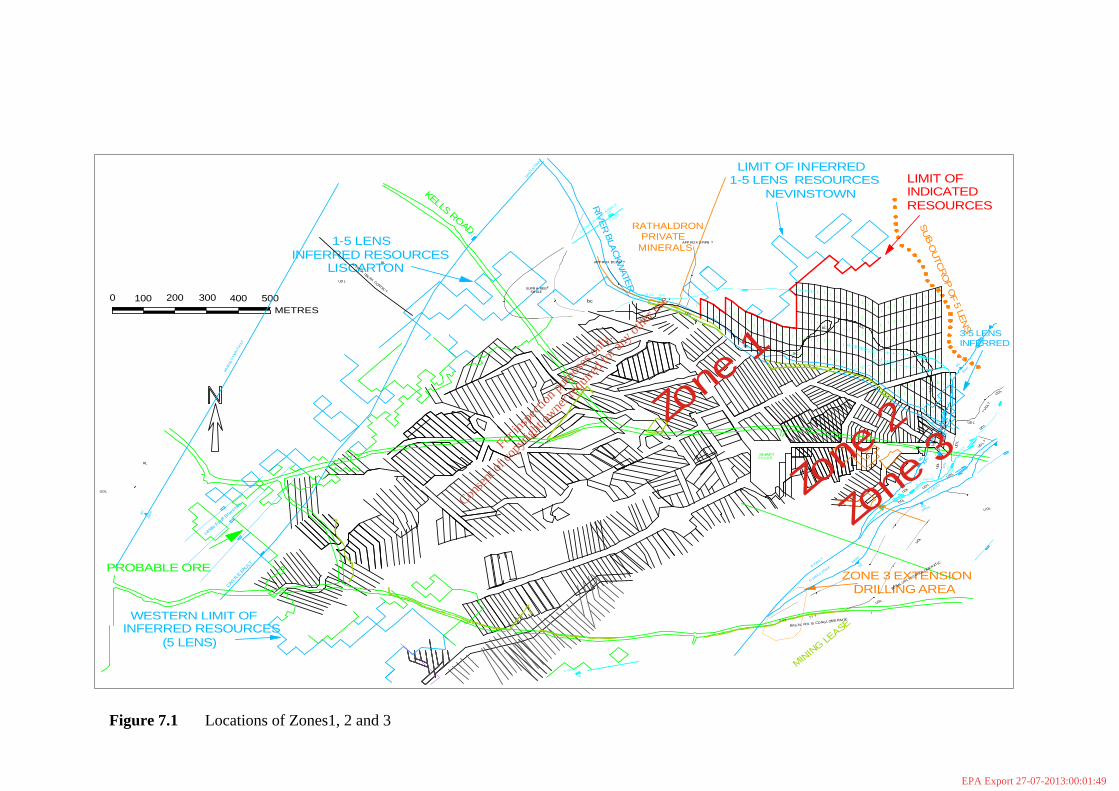
MININ
G LEASE
P ILLA RSHAFT
PROBABLE OREZONE 3 EXTENSION
DRILLING AREA
N210A1N209A1
N208A1
N301A1
N302A1
N303A1
N303B1
N304B1
N304A1
N305A1
N305B1
N306B1
N306A1
N307A1
N307B1
N308B1
N308A1
N309A1
N309B1
N310B1
N310A1
N311A1
N311B1
N312B1
N312A1
N313A1
N313B1
N314E1
N314D1
N314C1
N314B1
N314A1
N315A1
N315B1
N315C1
N315D1
N315E1
N316E1
N316D1
N316C1
N316B1
N316A1
N317A1
N317B1
N317C1
N317D1
N317E1
N318E1
N318D1
N318C1
N318B1
N318A1
N319A1
N319B1
N319C1
N319D1
N319E1
N401A1
N401B1
N401C1
N401D1
N401E1
N402E1
N402D1
N402C1
N402B1
N402A1
N403A1
N403B1
N403C1
N403D1
N403E1
N404E1
N404D1
N404C1
N404B1
N404A1
N405A1
N405B1
N405C1
N405D1
N405E1
N406E1
N406D1
N406C1
N406B1
N406A1
N407A1
N407B1
N407C1
N407D1
N407E1
N408E1
N408D1
N408C1
N408B1
N408A1
N409A1
N409B1
N409C1
N409D1
N409E1
N410E1
N410D1
N410C1
N410B1
N410A1
N411A1
N411B1
N411C1
N411D1
N411E1 N412E1
N412D1
N412C1
N412B1
N412A1
N413A1
N413B1
N413C1
N413D1
N413E1
N414E1
N414D1
N414B1
N414C1
N414A1
N415A1
N415B1
N415C1
N415D1
N415E1
N416E1
N416D1
N416C1
N416B1
N416A1
N417A1
N417B1
N417C1
N417D1
N417E1
N501A1
N502A1
N503A1
N504A1
N505A1
N506A1
N507A1
N508A1
N509A1
N510A1
N511A1
N503B1
N512A1
N504B1
N5051
N506B1
N507B1
N508B1
N5091
N510B1
N511B1
N512B1
N506C1
N507C1
N508C1
N509C1
N509C1
N510C1
N511C1
N512C1
0 100 200 300 400 500METRES
KELLS ROAD
1-5 LENSINFERRED RESOURCES
LISCARTON
RIV
ER
BLA
CKW
ATER
RATHALDRONPRIVATE
MINERALS
WESTERN LIMIT OFINFERRED RESOURCES
(5 LENS)
LIMIT OF INFERRED1-5 LENS RESOURCES
NEVINSTOWNS
UB-O
UTC
RO
P O
F 5 LEN
S
LIMIT OF INDICATEDRESOURCES
3-5 LENSINFERRED
F1 AP PROX
RL
UDL
RA ND
ALS
TOW
N F
AULT
A PPROX UDL/RL CONTAC T
RL
UD L
SUPR A-REEFSH ALE
UDLU DL
castle
Fault B
ranche
s
CASTLE FA
ULT
BC
BC
BC
B F AT BASE UDL
F2 0 AT BASE UDL
UDL
UD
L
UDL
UDL
U DL
UD L
UDL
UDL
UD L
UDL
UDL
? U
DL ?
UDL
UDL
UDL
U DL
? ? ?
LISCART
ON FAULT
APPR
OX
APP ROX S P/PB ?
CASTL
E FA
ULT
UDL
BC
C FA
ULT
C FAU LT
A FAUL
T
D FAULT
BAS AL UDL IS CONGLOME RATIC? ? ?
BASAL U
DL I S CONGL OMERAT IC
D FAULT Z
ONED FAULT
80
65>
100m
>1 00m
200m
8550
m
55
bc
APP ROX BC/SP ?
70
F-1 APPR OX 10m
A FA
ULT
4 55 0 m
5015m
50
P FAU LT
50
200 m
65
6 0m
8 0m
F31
F31
UD L
WED
G E55
70
6 0m
290m
75
200m
m
UDL
4 5
50m55
65
10m
UD L ?
6 5
Zone 1
Zone 2
Zone 3
Figure 7.1 Locations of Zones1, 2 and 3
For
insp
ectio
n pur
pose
s only
.
Conse
nt of
copy
right
owne
r req
uired
for a
ny ot
her u
se.
EPA Export 27-07-2013:00:01:49
Tara Mines
Abbey Grove
SilverlawnEstate
River
BlackwaterN3 (Kells Rd.)
F 20 Fault
A Fault
C F
ault
Bran
ch C Fault
D Fault
#Y
Proposed V5
#YV2
#YV1
T Fault
NevinstownLiscartan
N
EW
S
Reproduced by permission of the ordinance survey of Ireland
Figure 7.2
282750
282750
283500
283500
284250
284250
285000
285000
285750
285750
286500
286500
268500 268500
269250 269250
270000 270000
Scale1 : 20,000
Faulting projections on the East andNortheast of the Nevinstown orebody
Nevinstown & Liscartansite boundaries
Existing, main orebody
Fault Lines
For
insp
ectio
n pur
pose
s only
.
Conse
nt of
copy
right
owne
r req
uired
for a
ny ot
her u
se.
EPA Export 27-07-2013:00:01:49
Tara Mines Ltd EIS - Extension of Mining Operation into Nevinstown and Liscartan ___________________________________________________________________________________
Blasting Vibration /Air over- pressure Noise 78
The ground vibration limit at the nearby relevant monitoring station V2 (Figure 7-2) has not been exceeded since blasting commenced in 1973. Furthermore, the highest level of ground vibration recorded at this station has been less than 5 mm/sec. 7.3.2 Air Overpressure (Air Blast) Noise A surface explosion causes a diverging shock-wave front that quickly reduces to the speed of sound, and an air blast is then propagated through the atmosphere as sound waves. Air blast or air overpressure is the term used to describe the low frequency, high energy air vibrations generated by blasting detonation. Air blasts are characterised by containing a larger proportion of its energy in the sub-audible spectrum, below 20 Hz. Because the waves associated with air blasts are essentially outside the audible spectrum (below 20 Hz), a separate unit of measure, pressure is reported. The pressure is recorded using an air-blast transducer and the linear device must measure accurately in the structurally critical range, 2 to 20 Hz. Air blast (sound waves) can be reported in two distinct units of measurements, pressure (psi) or decibels (dB) Sound waves in the form of the sub-audible sound waves (air overpressure/air blast waves), and noise (the audible waves) are sometimes linked inextricable. It is difficult sometimes for humans to differentiate between the characteristics of air blasts and noise. In surface blasting (which Tara does not propose to carry out) the significant pulse of energy that gives rise to an air blast, travels from the source on surface directly through the air. The much smaller pulse of energy that is derived from ground transmission/movement at the receiver is generally insignificant. In underground blasting the air blast that is generated from the movement of the ground at the receiver is insignificant and generally at such a low level that it becomes difficult to measure accurately. Air overpressure (air blasts) are difficult to record accurately below 110 dB and this is due to existing similar levels derived from typical wind velocities.
7.4 Nevinstown Blasting Vibration Impacts The Nevinstown orebody is simply the up-dip section of the main orebody on the north east side of a surface feature - the River Blackwater. A recent study review and analysis carried out by geotechnical consultants concluded that it is apparent that the characteristics of the rock types and structures which occur in Nevinstown are essentially identical to those that occur in the Tara ‘main orebody’ immediately to the south of the river. The proposal for underground mining methods is similar to the existing methods being used. Blasting will be carried out at greater distances from residential property than that already experienced on the periphery of the existing mine. The nearest housing developments north and north-east (Silverlawn Estate) will continue to be in excess of 700m away as mine development progresses north of the Blackwater River. The mining development progression northwards will increase the distances from
For
insp
ectio
n pur
pose
s only
.
Conse
nt of
copy
right
owne
r req
uired
for a
ny ot
her u
se.
EPA Export 27-07-2013:00:01:49

Tara Mines Ltd EIS - Extension of Mining Operation into Nevinstown and Liscartan ___________________________________________________________________________________
Blasting Vibration /Air over- pressure Noise 79
blasting vibration sources for all residential property on the east and south-east of the mine. The level of ground vibration predicted should be no more intense than that experienced over the last 25 years. Blasting ground vibration will be controlled by adhering to control regime currently in place - sequential detonation, control on maximum instantaneous charge of explosives used and continuous measurement of ground vibration to ensure compliance. For ‘future Tara development / production blasting’, the vibration / noise limits will be similar to those existing and given in the EPA IPC Licence No 516 Condition 8. Noise: ‘No blast, or combination of simultaneous blasts shall give rise to a vibration level at any noise sensitive location which exceeds the following limits: • Daytime 8 mm/sec • Night-time 4 mm/sec ‘No blast, or combination of simultaneous blasts shall give rise to an air-overpressure level at any noise sensitive location which exceeds the following limits: • Daytime 125 dB (Lin). max. peak • Night-time 105 dB (Lin). max. peak It is anticipated that the ‘Nevinstown mine’ will be mined out over a period of approximately 10 years 7.5 Liscartan Blasting Vibration Impacts Liscartan forms the north west extension of the existing main orebody. Presently the extent or quantity of ore reserves in this area has not been proven. Ongoing and future exploration will determine the extent of mineable ore. Current indications from initial drilling show that the orebody is over 210m below the surface. In the event of mining extending into the townland of Liscartan, the existing level of blasting vibration control will be incorporated and vibration monitoring will be carried out as the need arises. Furthermore the existing vibration limits with respect to residences and structures will be applied. 7.6 Ameliorative Measures for Blasting Vibration Control The following controls will be put in place so that ground vibration, air overpressure / noise is minimised. • Ensure that the optimum blast ratio is maintained and ensure that the maximum
amount of explosive on any one delay, the maximum instantaneous charge is optimised so that the ground vibration levels are kept below those specified in the IPC Licence No. 516.
For
insp
ectio
n pur
pose
s only
.
Conse
nt of
copy
right
owne
r req
uired
for a
ny ot
her u
se.
EPA Export 27-07-2013:00:01:49

Tara Mines Ltd EIS - Extension of Mining Operation into Nevinstown and Liscartan ___________________________________________________________________________________
Blasting Vibration /Air over- pressure Noise 80
• The adequate confinement of all charges by means of accurate face survey and the subsequent judicious placement of explosives.
• Blasting will be carried out at regular times and production blasting will be
avoided during night-time. • All blasts will be measured using our existing continuously monitoring systems
and by the installation of a new monitoring station,V5 as shown in Figure 7-2. Furthermore this monitoring will be complimented by additional portable ground vibration monitoring as the need arises.
NB The measures which control ground vibration generated from underground blasting will also control air overpressure noise. 7.7 Conclusion The ground vibration / air overpressure noise levels will be contained within the conditions given in our existing licence. Accordingly the ground vibration generated from blasting will be maintained well below 8mm/sec and at a level well below the level at which superficial damage to property is likely (Siskind et al. 1980b). A study review and analysis of over 30 years of vibration monitoring data has shown that Tara’s vibration limit compliance has exceeded 99.9%. 7.8 References O’Reilly, B., (2000), Noise and Vibration Around an Active Base Metal Mine, M.Phil. thesis, University of Liverpool. Struthers. M.A., Lee. M. F., Australian Mining Consultants (UK) Ltd (2003), Nevinstown Geotechnical Study – Executive Summary Siskind, D. E., Stagg, M. S., Kopp, J.W., and Dowding, C.H. (1980B), Structural Response and Damage Produced by Ground Vibrations from Surface Blasting, Report of Investigations 8507, U. S Bureau of Mines, Washington, DC. 7.9 Glossary of Terms Peak Particle Velocity (PPV) – the maximum rate of change of particle displacement, measured in millimetres per second (mm/sec). Frequency (Hz) – the number of cycles per second of vibration usually expressed in Hertz (Hz) dB – Decibel, a unit of measure on a logarithmic scale used to quantify pressure fluctuations such as those associated with air overpressure
For
insp
ectio
n pur
pose
s only
.
Conse
nt of
copy
right
owne
r req
uired
for a
ny ot
her u
se.
EPA Export 27-07-2013:00:01:49
Tara Mines Ltd EIS - Extension of Mining Operation into Nevinstown and Liscartan ___________________________________________________________________________________
Blasting Vibration /Air over- pressure Noise 81
dB(A) – Decibel measured within an A weighted frequency curve that differentiates between sounds of different frequency in a similar way to the human ear Maximum Instantaneous Charge Weight – The maximum amount of explosives detonated at any one precise time Blast Ratio – The amount of work per unit of explosive measured in tonnes of rock per kilogram of explosives detonated Delay Interval – The time between successive detonations of detonators Sequential Detonation – The method of control of time intervals between explosions of individual charges
For
insp
ectio
n pur
pose
s only
.
Conse
nt of
copy
right
owne
r req
uired
for a
ny ot
her u
se.
EPA Export 27-07-2013:00:01:49
Tara Mines Limited EIS - Extension of Mining Operation into Nevinstown and Liscartan
Surface water 82
_____________________________________________________________________
SECTION 8 SURFACE WATER _____________________________________________________________________ 8.1 Introduction Mining activity in the Navan area has been ongoing since the early seventies. The mine owners have continuously complied with the environmental demands made on them by the EPA and other state and semi-state bodies. The mining of heavy metals, such as lead and zinc, has necessitated the introduction of stringent environmental measures in a variety of areas particularly where water and soils were involved. Ongoing monitoring in the field has ensured the creation of a baseline set of biological data. These datasets cover such diverse topics as;- water quality, community structure of the aquatic flora and fauna, fish stocks, the possible accumulation of heavy metals in fish tissues and the appropriate remedial action necessary. The same approach has been agreed and adopted for the new development in Nevinstown. The monitoring regime will be in place for the duration of mining. From the outset the same rigorous sampling programme will be adhered to as is successfully employed in the existing mine. The underground operation will never be closer to the surface of the ground than 40 metres. Assurances have also been given that there will be no new surface structures, pipelines or effluent pipes constructed in the new operation. This should act as an environmental buffer under normal circumstances. The overall conclusion is that the proposals will not cause any major upsets to the environment. Past experience will ensure that best practices are maintained on the new site. 8.2 Existing Environment 8.2.1 Water Management System 8.2.1.1 Water Sources All the water used in plant operations comes from three sources, namely:
(i) water pumped from the River Boyne, (ii) mine de-watering (iii) precipitation
The maximum quantity of water abstracted from the River Boyne, is 13,000m³/day . The remaining water requirement is obtained by internal water reclamation and reticulation. 8.2.1.2 Effluent Processing There are three sources of water requiring clarification before discharge to the River Boyne, namely (i) water from the mine, (ii) surface runoff and (iii) water from the
For
insp
ectio
n pur
pose
s only
.
Conse
nt of
copy
right
owne
r req
uired
for a
ny ot
her u
se.
EPA Export 27-07-2013:00:01:49
Tara Mines Limited EIS - Extension of Mining Operation into Nevinstown and Liscartan
Surface water 83
process plant. Water from these sources must pass through three stages of clarification in sedimentation-aeration ponds before discharge to the River Boyne. All minewater (groundwater inflow / backfill water / service water) is collected at a central underground pumping station. It passes through a large settling sump at this pumping station, where suspended solids settle out, prior to being pumped via the production shaft to the second stage of settlement/clarification in the Minewater/Reclaim Water Pond. Surface runoff is collected by a system of drainage ditches which feed into the Main Site Drainage Water Pond, where suspended solids settle out prior to the water being pumped to the Reclaim Water Pond. The storage capacity of the Kells Road Drainage Water Pond when full is approximately 15 acre feet (4.1 million gallons). The waste water from the process plant is pumped to the Tailings storage facility (TSF). The TSF is designed to operate as a large sedimentation/aeration pond where solids settle to the bottom and clear water at the surface is drawn off for recirculation to the Reclaim Water Pond. The limestone in the tailings maintains the water at an alkaline pH, which precipitates all but traces of the metals remaining in solution from the milling process. The large surface area of the facility provides adequate aeration for aerobic degradation of the organic reagents, so as to assure a low B.O.D. level in the water. It is anticipated that the annual accumulation of tailings will be equivalent to approximately: - 1,000-acre feet per year with backfill recovery plant not in operation. 600 acre feet per year with the backfill plant in operation. The second and third stages of water processing (the Reclaim Water Pond and the Clear Water Pond, respectively) are common to all three water sources. The Reclaim Water Pond is approximately four acres in area with gross storage capacity of approximately 9.5 million gallons. The pond has been divided into two sections to facilitate cleanout as required. Water is pumped from the Reclaim Water Pond to the process plant for reuse in the process. The water to be discharged to the River Boyne overflows from the Reclaim Water Pond into a Clear Water Pond. This pond has a surface area of approximately 1.25 acres and a storage capacity of approximately three million gallons. A weir structure at the pond outlet measures and controls the discharge to the River Boyne. The discharge point to the River Boyne is displayed in Figure 8-1. An automatic gauging station has been installed on the River Boyne. This gauging station provides a continuous record of the water level and therefore the flow in the River Boyne. The discharge to the River Boyne is measured at a measuring weir at the discharge of the Clear Water Pond. This flow measurement is recorded and used to control the inflow into the Clear Water Pond, which is regulated by a control valve in the discharge pipe between the Reclaim and Clear Water Ponds in accordance with licensed/permitted dilution factors/ratios.
For
insp
ectio
n pur
pose
s only
.
Conse
nt of
copy
right
owne
r req
uired
for a
ny ot
her u
se.
EPA Export 27-07-2013:00:01:49

Tara Mines Limited EIS - Extension of Mining Operation into Nevinstown and Liscartan
Surface water 84
The water level in the Clear Water Pond is controlled automatically to within ± 0.1 feet of the pre-set level. The flow rate can be altered by changing the dilution ratio setting on the recorder-controller instrument (licensed dilution limit 100:1). The tailings area is also used for water storage and designed such that there is always an excess storage volume of approximately 1,000 acre feet available, over and above that required for the storage of plant tailings, which can be used for the retention of water during low flow periods in the River Boyne. The excess water accumulates in the tailings area during summer months when the flows in the River Boyne are low and released to discharge into the River Boyne by way of the Reclaim Water and Clear Water Ponds in the winter months when the river flow is high. Effluent Discharge Effluent is discharged by gravity to the River Boyne in compliance with the IPCL (No.516, granted 29th May 2001). Emission standards are presented in Table 8-1.
Table 8-1 Emission Limits for Tara Mines Surface Water Discharge
Parameter Emission Limit Value
Temperature 25°C (max.)
pH 6-9
Toxicity 5 TU
BOD
COD
Suspended Solids
Zinc
Lead
Copper
Filtered Iron
Cadmium
Arsenic
Antimony
Cyanide
Chromium
Mercury
Mineral Oils
Total Nitrogen (as N)
Total Phosphorus (as P)
mg/l
20
1500
30
2
0.5
0.5
1
0.2
0.5
1
0.2
1
0.05
1
15
2
For
insp
ectio
n pur
pose
s only
.
Conse
nt of
copy
right
owne
r req
uired
for a
ny ot
her u
se.
EPA Export 27-07-2013:00:01:49
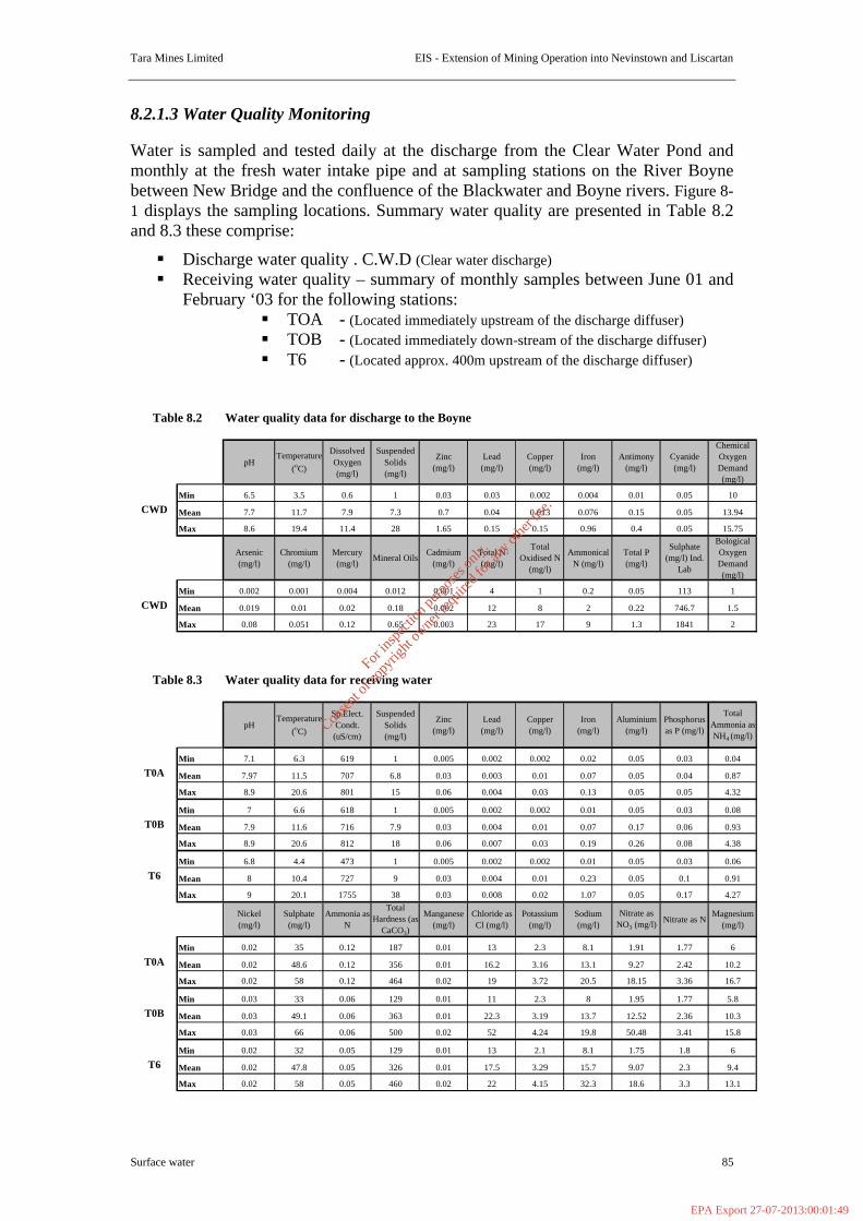
Tara Mines Limited EIS - Extension of Mining Operation into Nevinstown and Liscartan
Surface water 85
8.2.1.3 Water Quality Monitoring Water is sampled and tested daily at the discharge from the Clear Water Pond and monthly at the fresh water intake pipe and at sampling stations on the River Boyne between New Bridge and the confluence of the Blackwater and Boyne rivers. Figure 8-1 displays the sampling locations. Summary water quality are presented in Table 8.2 and 8.3 these comprise:
§ Discharge water quality . C.W.D (Clear water discharge) § Receiving water quality – summary of monthly samples between June 01 and
February ‘03 for the following stations: § TOA - (Located immediately upstream of the discharge diffuser) § TOB - (Located immediately down-stream of the discharge diffuser) § T6 - (Located approx. 400m upstream of the discharge diffuser)
Water quality data for discharge to the Boyne
pHTemperature
(oC)
Dissolved Oxygen (mg/l)
Suspended Solids (mg/l)
Zinc (mg/l)
Lead (mg/l)
Copper (mg/l)
Iron (mg/l)
Antimony (mg/l)
Cyanide (mg/l)
Chemical Oxygen Demand (mg/l)
Min 6.5 3.5 0.6 1 0.03 0.03 0.002 0.004 0.01 0.05 10
Mean 7.7 11.7 7.9 7.3 0.7 0.04 0.013 0.076 0.15 0.05 13.94
Max 8.6 19.4 11.4 28 1.65 0.15 0.15 0.96 0.4 0.05 15.75
Arsenic (mg/l)
Chromium (mg/l)
Mercury (mg/l)
Mineral Oils Cadmium
(mg/l)Total N (mg/l)
Total Oxidised N
(mg/l)
Ammonical N (mg/l)
Total P (mg/l)
Sulphate (mg/l) Ind.
Lab
Bological Oxygen Demand (mg/l)
Min 0.002 0.001 0.004 0.012 0.001 4 1 0.2 0.05 113 1
Mean 0.019 0.01 0.02 0.18 0.002 12 8 2 0.22 746.7 1.5
Max 0.08 0.051 0.12 0.65 0.003 23 17 9 1.3 1841 2
Water quality data for receiving water
pHTemperature
(oC)
Sp.Elect. Condt.
(uS/cm)
Suspended Solids (mg/l)
Zinc (mg/l)
Lead (mg/l)
Copper (mg/l)
Iron (mg/l)
Aluminium (mg/l)
Phosphorus as P (mg/l)
Total Ammonia as NH4 (mg/l)
Min 7.1 6.3 619 1 0.005 0.002 0.002 0.02 0.05 0.03 0.04
Mean 7.97 11.5 707 6.8 0.03 0.003 0.01 0.07 0.05 0.04 0.87
Max 8.9 20.6 801 15 0.06 0.004 0.03 0.13 0.05 0.05 4.32
Min 7 6.6 618 1 0.005 0.002 0.002 0.01 0.05 0.03 0.08
Mean 7.9 11.6 716 7.9 0.03 0.004 0.01 0.07 0.17 0.06 0.93
Max 8.9 20.6 812 18 0.06 0.007 0.03 0.19 0.26 0.08 4.38
Min 6.8 4.4 473 1 0.005 0.002 0.002 0.01 0.05 0.03 0.06
Mean 8 10.4 727 9 0.03 0.004 0.01 0.23 0.05 0.1 0.91
Max 9 20.1 1755 38 0.03 0.008 0.02 1.07 0.05 0.17 4.27
Nickel (mg/l)
Sulphate (mg/l)
Ammonia as N
Total Hardness (as
CaCO3)
Manganese (mg/l)
Chloride as Cl (mg/l)
Potassium (mg/l)
Sodium (mg/l)
Nitrate as NO3 (mg/l) Nitrate as N
Magnesium (mg/l)
Min 0.02 35 0.12 187 0.01 13 2.3 8.1 1.91 1.77 6
Mean 0.02 48.6 0.12 356 0.01 16.2 3.16 13.1 9.27 2.42 10.2
Max 0.02 58 0.12 464 0.02 19 3.72 20.5 18.15 3.36 16.7
Min 0.03 33 0.06 129 0.01 11 2.3 8 1.95 1.77 5.8
Mean 0.03 49.1 0.06 363 0.01 22.3 3.19 13.7 12.52 2.36 10.3
Max 0.03 66 0.06 500 0.02 52 4.24 19.8 50.48 3.41 15.8
Min 0.02 32 0.05 129 0.01 13 2.1 8.1 1.75 1.8 6
Mean 0.02 47.8 0.05 326 0.01 17.5 3.29 15.7 9.07 2.3 9.4
Max 0.02 58 0.05 460 0.02 22 4.15 32.3 18.6 3.3 13.1
T0B
T6
T0A
T0B
T6
T0A
CWD
CWD
Table 8.2
Table 8.3
For
insp
ectio
n pur
pose
s only
.
Conse
nt of
copy
right
owne
r req
uired
for a
ny ot
her u
se.
EPA Export 27-07-2013:00:01:49

N
EW
S
284000
284000
285000
285000
286000
286000
287000
287000
288000
288000
268000 268000
269000 269000
270000 270000
271000 271000
272000 272000
273000 273000
#YDischarge point T0B
T0A
Reclaim & Clearwater ponds
Tailings storagefacility
Figure 8.1
Reproduce by permission of the Ordinance survey of Ireland.
Scale 1 : 28,000
Site Drainagepond
Railway line
Components of WaterManagement System
For
insp
ectio
n pur
pose
s only
.
Conse
nt of
copy
right
owne
r req
uired
for a
ny ot
her u
se.
EPA Export 27-07-2013:00:01:49
Tara Mines Limited EIS - Extension of Mining Operation into Nevinstown and Liscartan
Surface water 87
8.2.2 Biological Assessment of the River Blackwater 8.2.2.1 Introduction In September 2001 and May 2002 Aquens Ltd. commenced initial investigations on the possible environmental effects that the proposed new underground mining facility might have on the waterways in the Nevinstown area. This section of the orebody, originally owned by Bula Ltd., passes under the River Blackwater and lies north of the river. Assurances have been received that mining operations will never reach closer than 40 metres below the surface of the ground. Further, there would be no new surface structures, pipelines or effluent pipes constructed in the mining region. From an environmental viewpoint this is positive news. Over the foreseeable future Tara Mines intend to continue water quality monitoring in the new sector. Any aquatic contamination would thus be detected early and allow the swift introduction of remedial environmental action. Tara Mines have always been alert to the possible dangers of contamination to the aquatic environment by ‘heavy metals’ and have always tried to ensure that such pollution does not occur. Environmental monitoring has also been ongoing in the River Boyne for many years, investigating water chemistry, fish population densities and aquatic communities. The present report is the culmination of two aquatic surveys carried out at the behest of Tara Mines, in September 2001 and in May 2002. Both surveys re-visit the original four sites on the Blackwater and assess the present status of the aquatic faunal community. The results are important in forming a data base before mining operations commence in the Nevinstown area. Aquens Ltd,. a campus company associated with the Zoology Department, University College Dublin, has been involved with water quality studies in the Blackwater since 1975. The background data recently collected have been compared with the data from the earlier period to give an overview of the water quality which currently exists within the system. Under normal conditions Aquens Ltd. are confident that damage to the aquatic environment will be negligible provided that the assurances given are adhered to in the coming years. 8.2.2.2 Materials and Methods Seasonal monitoring will be undertaken in the Blackwater at the usual four sites. In each case there will be three 20-second, replicate kick-samples collected. The fauna will be placed in plastic bags, preserved in 70% alcohol and returned to the laboratory for analysis. Smaller streams and tributaries flowing in the vicinity of the new sector will also be sampled and occasionally electro-fished. 8.2.2.3 Results The River Blackwater was sampled on two occasions; September 2001 and May 2002. Results of the faunal surveys are presented in Annex I. A brief outline of the data is presented here. Percentage occurrence of key macroinvertebrate groups used in determining Q - ratings are presented in Table 8.4 for the September 2001 and May 2002 faunal surveys with summaries for the main indicator groups in Table 8.5.
For
insp
ectio
n pur
pose
s only
.
Conse
nt of
copy
right
owne
r req
uired
for a
ny ot
her u
se.
EPA Export 27-07-2013:00:01:49
Tara Mines Limited EIS - Extension of Mining Operation into Nevinstown and Liscartan
Surface water 88
Community composition was similar between all sites on both sampling occasions. Group A fauna (sensitive to pollution) accounted for 0.1% to 6% of the total fauna. The Mayflies; Heptageniidae and Ephemeridae (Ephemera danica) were the only Group A fauna encountered. Ephemera danica was present at all sites in small numbers (<5%). Heptageniidae were not encountered at Sites 1 and 4 in September 2001 but were recorded at the remaining sites on both occasions. Heptageniidae were considered to be scarce (<1%). Group B fauna (less sensitive to pollution) accounted for 3.1% to 15.4% of the total fauna. Three taxa were encountered. Apheilocheirus aestivalis (water bug) and cased trichopterans (caddis flies) were recorded at all sites on both occasions. These occurred in small numbers to common (1% to 20% of the total fauna). Apheilocheirus aestivalis was usually the dominant taxon. Baetids other than Baetis rhodani were the third taxon. These were scarce (<1%) and recorded at Sites 1, 2 and 4. Group C fauna (tolerant of pollution) were dominant at all sites on both occasions and accounted for over 75% of the total fauna. Twelve Group C taxa were recorded. Uncased trichopterans (Caddis flies), Coleoptera (beetles), Gammarus sp. (freshwater shrimp), Chironomids (midges), and Gastropoda (snails) were recorded at all sites on both sampling occasions. The three most prevalent taxa were normally from this group. Six of the remaining taxa were encountered at all sites on at least one sampling occasion. Six Group D (very tolerant of pollution) taxa were recorded. Group D accounted for 3.1% to 15.4% of the total fauna. Sphaeriidae (freshwater mussels) and Hirudinea (leeches) were present at all sites on both occasions. Lymnea peregra were recorded at all sites in the September sampling. Remaining taxa were scarce (<1%). The River Blackwater has been previously surveyed in 1975/76 at comparable sites. Examination of the faunal lists revealed more similarities than differences with the current survey. The more important similarities being the absence of Plecoptera (Stoneflies) and the presence of the same ephemeropteran or mayfly species. Hydropsychids were the dominant trichopterans and Elmidae were the dominant coleopterans. Similar species lists were generated for the molluscans. Gammarus sp. was recorded in both surveys. However, the relative abundance of species was not necessarily reflective of the current surveys. The saucer bug Apheilocheirus aestivalis was absent from the 1975/76 survey. However, the presence of the same Group A taxa with the dominance of Group C fauna (fauna relatively tolerant of pollution) in conjunction with Group D (fauna tolerant of pollution) in the 1975/76 survey suggests that overall there has been little or no change in water quality in the intervening years. Q-ratings Biotic indices and their typical associated community structure and abundance levels are presented in Table 1 in Annex I, Part 3. All sites were assigned a Q-rating of 3-4. This is indicative of slight organic pollution.
For
insp
ectio
n pur
pose
s only
.
Conse
nt of
copy
right
owne
r req
uired
for a
ny ot
her u
se.
EPA Export 27-07-2013:00:01:49
Tara Mines Limited EIS - Extension of Mining Operation into Nevinstown and Liscartan
Surface water 89
8.2.2.4 Concluding Comments The aquatic macroinvertebrate fauna has remained remarkably stable for the four sites of the River Blackwater over the last 25-30 years. The only apparent damage is from agricultural practices involving the increased production of phosphorus and nitrate. Both of these nutrients have been responsible for an increase in eutrophication in Irish lakes and rivers. The river Blackwater is no exception. There is ample evidence of algal growth such as Cladophora spp. present. From the assurances received from the mining operatives we are satisfied that there will be no environmental damage caused to the tributaries and streams flowing through Nevinstown & Liscartan and entering the Blackwater. The underground mining operations are well below the surface (at least 40m) and there are no plans to install effluent pipes or conduits of any kind. This would appear to ensure the safety of the surface waters. Tara Mines have always ensured continuous monitoring in the region. In view of the new mining development it is their intention to continue this practice.
For
insp
ectio
n pur
pose
s only
.
Conse
nt of
copy
right
owne
r req
uired
for a
ny ot
her u
se.
EPA Export 27-07-2013:00:01:49

Tara Mines Limited EIS - Extension of Mining Operation into Nevinstown and Liscartan
Surface water 90
Table 8.4: Percentage occurrence of key macroinvertebrate groups used in determining Q - ratings are presented for the September 2001 and May 2002 faunal surveys.
September 2001 Survey May 2002 Survey
Key Macroinvertebrates Site 1 Site 2 Site 3 Site 4 Site 1 Site 2 Site 3 Site 4 Group A Plecoptera (excluding Leuctra sp.), Heptageniidae 0.03 0.25 1.00 0.34 0.12 0.54 Siphlonuridae Ephemera danica 2.22 0.07 4.57 0.18 5.43 0.68 3.23 0.27 Margaritifera margaritifera Group B Leuctra sp. Baetidae (excluding Baetis rhodani) 0.47 0.09 0.08 Leptophlebiidae Cased trichoptera 0.03 4.16 0.51 14.37 0.90 1.44 2.42 7.03 Odonata Aphelocheirus aestivalis 5.85 4.16 10.41 0.53 5.34 1.61 4.27 2.03 Group C Baetis rhodani 0.48 0.40 1.52 2.40 1.44 1.08 Caenidae 0.30 2.03 1.99 3.53 0.34 4.50 4.32 Ephemerellidae 0.09 0.46 0.29 0.27 0.34 1.04 0.54 Uncased trichoptera 31.34 11.81 5.58 7.80 6.79 1.95 1.96 13.51 Hemiptera (excl. A. aestivalis) 0.03 Coleoptera 23.40 27.15 28.43 21.41 13.67 14.70 18.13 12.16 Chironomidae (Excl. Chironomus sp.) 0.87 3.46 6.85 7.16 7.69 7.39 4.27 28.38 Simulidae 0.03 2.90 31.61 0.12 0.14 Tipulidae 0.23 0.09 0.08 0.12 0.41 Hydracarina 0.49 3.30 1.06 0.27 0.42 2.31 1.35 Gammarus sp 20.16 44.70 26.90 32.38 37.56 36.87 49.88 23.92 Astacidae- Austropotambius pallipes Gastropoda (excl. Lymnaea peregra & Physa sp.) 7.20 1.06 3.30 3.23 8.24 0.17 5.20 2.70
Anodonta spp. Piscicola sp. Platyhelminthes Group D Sialidae 1.78 Asellus sp. 0.25 0.08 0.46 Crangonyx spp. Lymnaea peregra 0.15 1.85 0.25 4.40 Physa sp 1.00 Sphaeriidae 7.68 0.10 2.79 1.11 5.70 0.34 0.92 1.35 Hirudinae (excl. Piscicola sp.) 0.21 0.07 1.27 0.54 0.08 1.04 0.27 Group E Chironomus sp. Eristalis sp. Tubificidae
For
insp
ectio
n pur
pose
s only
.
Conse
nt of
copy
right
owne
r req
uired
for a
ny ot
her u
se.
EPA Export 27-07-2013:00:01:49
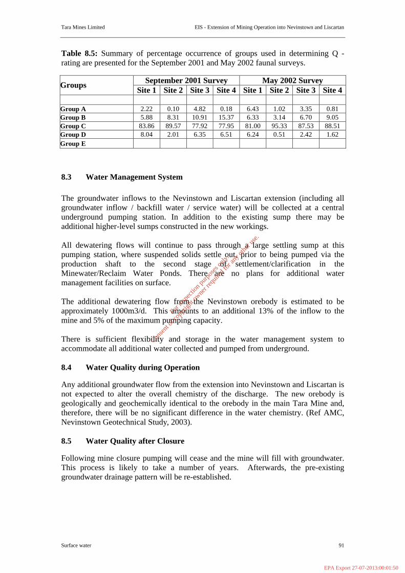
Tara Mines Limited EIS - Extension of Mining Operation into Nevinstown and Liscartan
Surface water 91
Table 8.5: Summary of percentage occurrence of groups used in determining Q - rating are presented for the September 2001 and May 2002 faunal surveys.
September 2001 Survey May 2002 Survey Groups Site 1 Site 2 Site 3 Site 4 Site 1 Site 2 Site 3 Site 4
Group A 2.22 0.10 4.82 0.18 6.43 1.02 3.35 0.81 Group B 5.88 8.31 10.91 15.37 6.33 3.14 6.70 9.05 Group C 83.86 89.57 77.92 77.95 81.00 95.33 87.53 88.51 Group D 8.04 2.01 6.35 6.51 6.24 0.51 2.42 1.62 Group E 8.3 Water Management System The groundwater inflows to the Nevinstown and Liscartan extension (including all groundwater inflow / backfill water / service water) will be collected at a central underground pumping station. In addition to the existing sump there may be additional higher-level sumps constructed in the new workings. All dewatering flows will continue to pass through a large settling sump at this pumping station, where suspended solids settle out, prior to being pumped via the production shaft to the second stage of settlement/clarification in the Minewater/Reclaim Water Ponds. There are no plans for additional water management facilities on surface. The additional dewatering flow from the Nevinstown orebody is estimated to be approximately 1000m3/d. This amounts to an additional 13% of the inflow to the mine and 5% of the maximum pumping capacity. There is sufficient flexibility and storage in the water management system to accommodate all additional water collected and pumped from underground. 8.4 Water Quality during Operation Any additional groundwater flow from the extension into Nevinstown and Liscartan is not expected to alter the overall chemistry of the discharge. The new orebody is geologically and geochemically identical to the orebody in the main Tara Mine and, therefore, there will be no significant difference in the water chemistry. (Ref AMC, Nevinstown Geotechnical Study, 2003). 8.5 Water Quality after Closure Following mine closure pumping will cease and the mine will fill with groundwater. This process is likely to take a number of years. Afterwards, the pre-existing groundwater drainage pattern will be re-established.
For
insp
ectio
n pur
pose
s only
.
Conse
nt of
copy
right
owne
r req
uired
for a
ny ot
her u
se.
EPA Export 27-07-2013:00:01:50

Tara Mines Limited EIS - Extension of Mining Operation into Nevinstown and Liscartan
Surface water 92
ANNEX I
For
insp
ectio
n pur
pose
s only
.
Conse
nt of
copy
right
owne
r req
uired
for a
ny ot
her u
se.
EPA Export 27-07-2013:00:01:50

Tara Mines Limited EIS - Extension of Mining Operation into Nevinstown and Liscartan
Surface water 93
Annex I Part 1 Results of September 2001 Faunal Survey of the River Blackwater. Community Composition based on Key Macroinvertebrate Groups used in determining Q-ratings. The average abundance of key macroinvertebrate groups used in determining Q – rating are presented in Table 1 and summarised in Table 2. Percentage occurrence of key macroinvertebrate groups used in determining Q – rating is presented in Table 3 and summarised in Table 4. Site 1- Donaghpatrick Bridge national Grid Reference N 819 723 Site 1 was dominated by Group C taxa (83.9% of the total fauna) which are relatively tolerant of pollution. Uncased trichoptera (predominantly Hydropsychidae) accounted for 31.3% of the total fauna followed by Coleoptera (mainly Elmidae) at 23.4% and Gammarus sp. at 20.2%. Groups A, B and D accounted for 2.2%, 5.9% and 8% of the fauna respectively. Ephemera danica was the only Group A taxon present. The saucer bug, Apheilocheirus sp. was the dominant taxon in Group B (5.9%). Sphaeriidae were the dominant Group D fauna and accounted for 7.7% of the total fauna. Site 2-Liscarton National Grid Reference N 843 696 Site 2 was also dominated by Group C taxa (89.8% of the total fauna). Gammarus sp. at 44.7% was the dominant taxon both within this group and overall. Coleoptera and uncased trichoptera (predominantly Hydropsychidae) accounted for 27.2% and 11.8% of the fauna respectively. One Heptageniidae specimen and two specimens of Ephemera danica, both Group A fauna, were collected from this site. Group B accounted for 8.3% of the total fauna. The saucer bug, Apheilocheirus sp. and cased trichoptera were present in equal proportions (4.2%). Group D fauna accounted for 2% of the total fauna. Site 3-In Ore Body at Nevinstown National Grid Reference N 852 686 Site 3 was dominated by Group C taxa (77.9% of the total fauna). Coleoptera was the dominant taxon at 28.4%. Gammarus sp. accounted for 26.9% of the fauna. Groups A, B and D accounted for 4.8%, 10.9% and 6.4% of the fauna respectively. With the exception of a single Heptageniid, Ephemera danica was the sole component of Group A. Apheilocheirus aestivalis was the dominant taxon in Group B (10.4%). Sphaeriidae and Sialidae accounted for 2.8% and 1.8% of the total fauna in Group D. Site 4 Close to new Motorway Bridge at Navan National Grid Reference N 866 683 Site 4 was dominated by Group C taxa (78% of the total fauna). Groups A, B and D accounted for 0.2%, 15.4% and 6.5% of the fauna respectively. Gammarus sp. at 32.4% was the dominant fauna both within this group and overall. Coleoptera and Hydroptilidae accounted for 21.4% and 13.4% of the fauna respectively. Three specimens of E. danica (Group A) were recorded. Cased trichopterans (Sericostomatidae) were the dominant fauna within Group B (14.4%). Lymnaea peregra was the dominant taxon in Group D and accounted for 4.4% of the total fauna.
For
insp
ectio
n pur
pose
s only
.
Conse
nt of
copy
right
owne
r req
uired
for a
ny ot
her u
se.
EPA Export 27-07-2013:00:01:50

Tara Mines Limited EIS - Extension of Mining Operation into Nevinstown and Liscartan
Surface water 94
Overall community compositions were similar between sites although the percentage compositions did vary. Ephemera danica and Heptageniidae were the only Group A taxa recorded. Ephemera danica were recorded in small numbers (<5%) at all sites. Three specimens of Heptageniidae were encountered at Sites 2 and 3. Only three Group B taxa were recorded. Cased trichoptera and A. aestivalis were present at all sites. They were scarce (<1%) to common (10-20%) in abundance. The third taxon was only recorded at Site 4 and it was scarce (<1%). Six of the twelve Group C taxa recorded were present at all sites. A further three taxa were present at three sites. Their percentage occurrence did not exceed 5% at any site. The remaining taxa were present at one site. Their percentage occurrence did not exceed 1%. Coleoptera (Elmidae) and Gammarus sp. were the predominant Group C taxa. They were recorded at all sites and were usually numerous (>20%). Baetis rhodani was recorded in small numbers (<5%) at all sites. Of the six Group D taxa recorded, only the Sphaeriidae and Lymneae pergra were present at all sites. Average abundances were significantly lower at sites 3 and 4 which had an average of 131.33 and 568.33 individuals respectively compared to average abundance values of 1111.33 and 1010.33 for Sites 1 and 2 (Table 1). Q-ratings Biotic indices and their typical associated community structure and abundance levels are presented in Table 1 in Annex 1, Part 3. All sites were assigned a Q-rating of 3-4 based on the following: To be assigned a rating of Q3-4 requires at least one Group A taxa to be present. Ephemera danica was present at all sites. A single Heptageniidae specimen was encountered at Sites 2 and 3. The two taxa combined were scarce (<1%) in abundance at Sites 2 and 4 and occurred in small numbers (<5%) at Site 1 and 3. (2) Group B accounted from 5% to 15% of the fauna. A quality of Q3-4 is assigned if this group is absent or accounts for up to 50% of the total fauna. (3) Group C accounted for over 75% of the total fauna, in particular Gammarus sp. and Coleoptera (Elmidae) accounted for over 20% of the fauna at all sites. Group C is usually numerous (20%) to excessive (>75%) in abundance at Q3-4 sites. The saucer bug Apheilocheirus aestivalis was present at all sites. This species requires clean well-oxygenated water. It lives in gravels or clings to stones in fast flowing water.
For
insp
ectio
n pur
pose
s only
.
Conse
nt of
copy
right
owne
r req
uired
for a
ny ot
her u
se.
EPA Export 27-07-2013:00:01:50
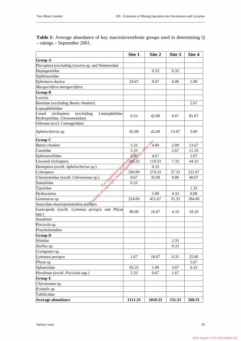
Tara Mines Limited EIS - Extension of Mining Operation into Nevinstown and Liscartan
Surface water 95
Table 1: Average abundance of key macroinvertebrate groups used in determining Q – ratings – September 2001. Site 1 Site 2 Site 3 Site 4 Group A Plecoptera (excluding Leuctra sp. and Nemouridae Heptageniidae 0.33 0.33 Siphlonuridae Ephemera danica 24.67 0.67 6.00 1.00 Margaritifera martgaritifera Group B Leuctra Baetidae (excluding Baetis rhodani) 2.67 Leptophlebiidae Cased trichoptera (excluding Limnephilidae, Hydroptilidae, Glossomatidae) 0.33 42.00 0.67 81.67
Odonata (excl. Coenagriidae)
Aphelocheirus sp. 65.00 42.00 13.67 3.00
Group C Baetis rhodani 5.33 4.00 2.00 13.67 Caenidae 3.33 2.67 11.33 Ephemerellidae 1.00 4.67 1.67 Uncased trichoptera 348.33 119.33 7.33 44.33 Hemiptera (excld. Aphelocheirus sp.) 0.33 Coleoptera 260.00 274.33 37.33 121.67 Chironomidae (excld. Chironomus sp.) 9.67 35.00 9.00 40.67 Simuliidae 0.33 Tipulidae 1.33 Hydracarina 5.00 4.33 6.00 Gammarus sp 224.00 451.67 35.33 184.00 Astacidae-Austropotamobius pallipes Gastropoda (excld. Lymnaea peregra and Physaspp.) 80.00 10.67 4.33 18.33
Anodonta Piscicola sp. Platyhelminthes Group D Silaidae 2.33 Asellus sp. 0.33 Crangonyx sp. Lymnaea peregra 1.67 18.67 0.33 25.00 Physa sp. 5.67 Sphaeriidae 85.33 1.00 3.67 6.33 Hirudinae (excld. Piscicola spp.) 2.33 0.67 1.67 Group E Chironomus sp. Eristalis sp. Tubificidae Average abundance 1111.33 1010.33 131.33 568.33
For
insp
ectio
n pur
pose
s only
.
Conse
nt of
copy
right
owne
r req
uired
for a
ny ot
her u
se.
EPA Export 27-07-2013:00:01:50

Tara Mines Limited EIS - Extension of Mining Operation into Nevinstown and Liscartan
Surface water 96
Table 2 Summary of average abundance of groups used in determining Q- ratings –September 2001. Site 1 Site 2 Site 3 Site 4 Group A 24.67 1.00 6.33 1.00 Group B 65.33 84.00 14.33 87.33 Group C 932.00 905.00 102.33 443.00 Group D 89.33 20.33 8.33 37.00 Group E Table 3 Percentage occurrence of key macroinvertebrate groups used in determining Q – ratings in September 2001 Site 1 Site 2 Site 3 Site 4
Group A
Plecoptera (excluding Leuctra sp. and Nemouridae), Heptageniidae 0.33 0.25 Siphlonuridae Ephemera danica 2.22 0.07 4.57 0.18 Margaritifera martgaritifera Group B
Leuctra Baetidae (excluding Baetis rhodani) 0.47 Leptophlebiidae Cased trichoptera (excluding Limnephilidae, Hydroptilidae, Glossomatidae) 0.03 4.16 0.51 14.37
Odonata (excl. Coenagriidae)
Aphelocheirus sp. 5.85 4.16 10.41 0.53
Group C
Baetis rhodani 0.48 0.40 1.52 2.40 Caenidae 0.30 2.03 1.99 Ephemerellidae 0.09 0.46 0.29 Uncased trichoptera 31.34 11.81 5.58 7.80 Hemiptera (excld. Aphelocheirus sp.) 0.03 Coleoptera 23.40 27.15 28.43 21.41 Chironomidae (excld. Chironomus sp.) 0.87 3.46 6.85 7.16 Simuliidae 0.03 Tipulidae 0.23 Hydracarina 0.49 3.30 1.06 Gammarus sp 20.16 44.70 26.90 32.38 Astacidae-Austropotamobius pallipes Gastropoda (excld. Lymnaea peregra and Physaspp.) 7.20 1.06 3.30 3.23
Anodonta Piscicola sp. Platyhelminthes Group D
For
insp
ectio
n pur
pose
s only
.
Conse
nt of
copy
right
owne
r req
uired
for a
ny ot
her u
se.
EPA Export 27-07-2013:00:01:50
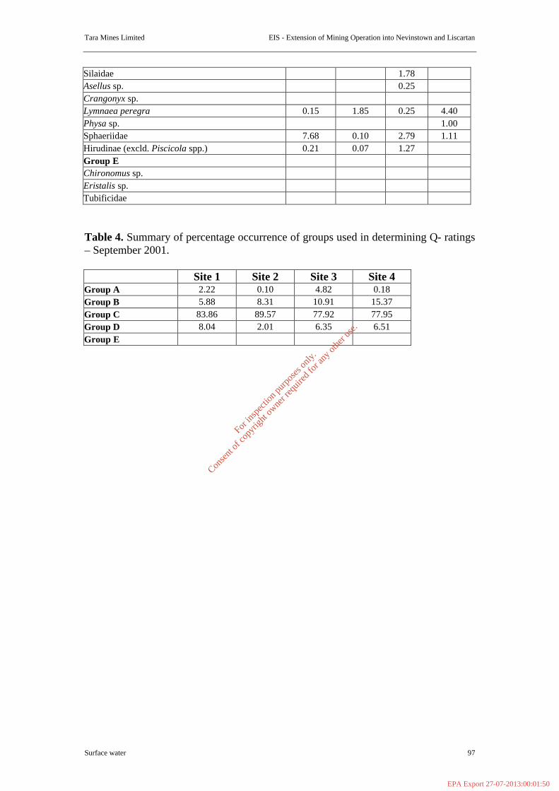
Tara Mines Limited EIS - Extension of Mining Operation into Nevinstown and Liscartan
Surface water 97
Silaidae 1.78 Asellus sp. 0.25 Crangonyx sp. Lymnaea peregra 0.15 1.85 0.25 4.40 Physa sp. 1.00 Sphaeriidae 7.68 0.10 2.79 1.11 Hirudinae (excld. Piscicola spp.) 0.21 0.07 1.27 Group E Chironomus sp. Eristalis sp. Tubificidae Table 4. Summary of percentage occurrence of groups used in determining Q- ratings – September 2001. Site 1 Site 2 Site 3 Site 4 Group A 2.22 0.10 4.82 0.18 Group B 5.88 8.31 10.91 15.37 Group C 83.86 89.57 77.92 77.95 Group D 8.04 2.01 6.35 6.51 Group E
For
insp
ectio
n pur
pose
s only
.
Conse
nt of
copy
right
owne
r req
uired
for a
ny ot
her u
se.
EPA Export 27-07-2013:00:01:50
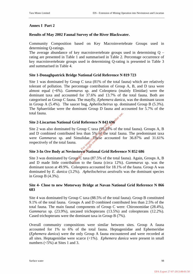
Tara Mines Limited EIS - Extension of Mining Operation into Nevinstown and Liscartan
Surface water 98
Annex I Part 2 Results of May 2002 Faunal Survey of the River Blackwater. Community Composition based on Key Macroinvertebrate Groups used in determining Q-ratings. The average abundance of key macroinvertebrate groups used in determining Q – rating are presented in Table 1 and summarised in Table 2. Percentage occurrence of key macroinvertebrate groups used in determining Q-rating is presented in Table 3 and summarised in Table 4. Site 1-Donaghpatrick Bridge National Grid Reference N 819 723
Site 1 was dominated by Group C taxa (81% of the total fauna) which are relatively tolerant of pollution. The percentage contribution of Group A, B, and D taxa were almost equal (~6%). Gammarus sp. and Coleoptera (mainly Elmidae) were the dominant taxa and accounted for 37.6% and 13.7% of the total fauna. Both are categorised as Group C fauna. The mayfly, Ephemera danica, was the dominant taxon in Group A (5.4%). The saucer bug, Apheilocheirus sp. dominated Group B (5.3%). The Sphaeriidae were the dominant Group D fauna and accounted for 5.7% of the total fauna. Site 2-Liscarton National Grid Reference N 843 696
Site 2 was also dominated by Group C taxa (95.33% of the total fauna). Groups A, B and D combined contributed less than 5% of the total fauna. The predominant taxa were Gammarus sp. and Simulidae. These accounted for 36.87% and 31.61% respectively of the total fauna. Site 3-In Ore Body at Nevinstown National Grid Reference N 852 686
Site 3 was dominated by Group C taxa (87.5% of the total fauna). Again, Groups A, B and D made little contribution to the fauna (circa 12%). Gammarus sp. was the dominant taxon at 49.9%. Coleoptera accounted for 18.1% of the fauna. Group A was dominated by E. danica (3.2%). Apheilocheirus aestivalis was the dominant species in Group B (4.3%). Site 4- Close to new Motorway Bridge at Navan National Grid Reference N 866 683 Site 4 was dominated by Group C taxa (88.5% of the total fauna). Group B constituted 9.1% of the total fauna. Groups A and D combined contributed less than 2.5% of the total fauna. The main faunal components of Group C were: Chironomidae (28.4%), Gammarus sp. (23.9%), uncased trichopterans (13.5%) and coleopterans (12.2%). Cased trichopterans were the dominant taxa in Group B (7%). Overall community compositions were similar between sites. Group A fauna accounted for 1% to 6% of the total fauna. Heptageniidae and Ephemeridae (Ephemera danica) were the only Group A fauna encountered and were recorded at all sites. Heptageniidae were scarce (<1%). Ephemera danica were present in small numbers (<5%) at Sites 1 and 3.
For
insp
ectio
n pur
pose
s only
.
Conse
nt of
copy
right
owne
r req
uired
for a
ny ot
her u
se.
EPA Export 27-07-2013:00:01:50

Tara Mines Limited EIS - Extension of Mining Operation into Nevinstown and Liscartan
Surface water 99
Group B fauna accounted for 3 to 9% of the total fauna. Apheilocheirus aestivalis and cased trichopterans were recorded at all sites. These occurred in small to fair numbers (1% to 5% of the total fauna). Specimens of baetids that were not Baetis rhodani were only recorded at Sites 1 and 2. These were single individuals. Group C fauna was dominant and accounted for over 80% of the total fauna at all sites. With the exception of B. rhodani, the remaining recorded taxa were present at all sites. Gammarus sp. were common to numerous (23–50%) within this group and the overall dominant taxon at Sites 1 to 3. Coleoptera were the second most common taxon (10-20%) at these sites. Chironomids (28.4%) were dominant at Site 4 followed by Gammarus sp. (23.9%). The percentage compositions of Groups did vary between sites but the overall sequence of dominance followed the same pattern. Average abundance was lower at sites 3 and 4, 288.67 and 246.67 individuals respectively compared to average abundance values of 368.33 and 392 for sites 1 and 2 (Table 1). The same pattern was observed in the September 2001 samples. However, overall there has been a marked decline in abundance across sites 1, 2 and 4. This can be attributed to reduced numbers of Apheilocheirus aestivalis, Gammarus sp. uncased trichopterans (Hydrosychidae), Coleoptera (Elmidae) and Molluscs (Hydrobiidae and Valvatidae). The decline in numbers is more pronounced at sites 1 and 2. The high flow at the time of sampling caused the reduction in faunal numbers. Comparison of the September 2001 samples with the current samples showed the pattern in percentage composition to be relatively similar for Groups A to E across sites 1 to 4. Consequently, their Q-ratings remained the same despite the reduced numbers. Q-ratings
Biotic indices and their typical associated community structure and abundance levels are presented in Table 1 in Appendix III. All sites were assigned a Q-rating of 3-4. However, Sites 2 and 4 did not strictly fulfil the first precept for assigning a Q-rating of 3-4 (see below). But given that all sites are on the same stretch of river and the fauna present was broadly speaking the same, it was felt that the Q-rating was justified. Q-rating were based on the following: (1) To be assigned a rating of Q3-4 requires at least one Group A taxa to be present. Two Group A taxa, Ephemera danica and specimens of Heptageniidae, were present at all sites. The two taxa combined were fair (5-10%) in abundance at site 1, scarce (<1%) in abundance at sites 2 and 4 and occurred in small numbers (<5%) at Site 3. (2) For Q3-4, Group B can be absent to common (50%) in abundance. To be assigned a rating of Q3, Group B can be absent to fair (10%) in abundance. Group B was no greater than 10% or fair in abundance at all sites. (3) Group C is usually numerous (20%) to excessive (>75%) in abundance at Q3-4 sites. Group C fauna accounted for greater than 80% of the fauna at all sites i.e. it was excessive. (4) Group D fauna are usually scarce to common (10-20%) in abundance at both Q3 and Q3-4 sites. Group D accounted for less than 10% of the fauna at all sites.
For
insp
ectio
n pur
pose
s only
.
Conse
nt of
copy
right
owne
r req
uired
for a
ny ot
her u
se.
EPA Export 27-07-2013:00:01:50
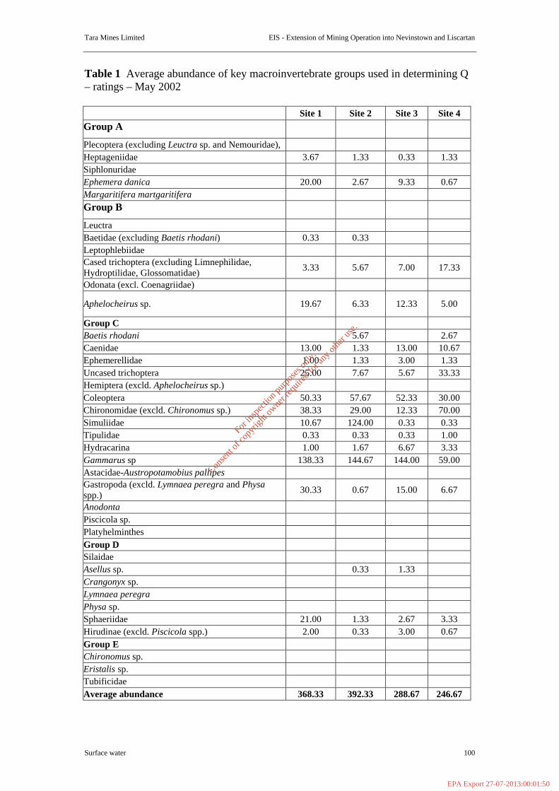
Tara Mines Limited EIS - Extension of Mining Operation into Nevinstown and Liscartan
Surface water 100
Table 1 Average abundance of key macroinvertebrate groups used in determining Q – ratings – May 2002 Site 1 Site 2 Site 3 Site 4 Group A
Plecoptera (excluding Leuctra sp. and Nemouridae), Heptageniidae 3.67 1.33 0.33 1.33 Siphlonuridae Ephemera danica 20.00 2.67 9.33 0.67 Margaritifera martgaritifera Group B
Leuctra Baetidae (excluding Baetis rhodani) 0.33 0.33 Leptophlebiidae Cased trichoptera (excluding Limnephilidae, Hydroptilidae, Glossomatidae) 3.33 5.67 7.00 17.33
Odonata (excl. Coenagriidae)
Aphelocheirus sp. 19.67 6.33 12.33 5.00
Group C Baetis rhodani 5.67 2.67 Caenidae 13.00 1.33 13.00 10.67 Ephemerellidae 1.00 1.33 3.00 1.33 Uncased trichoptera 25.00 7.67 5.67 33.33 Hemiptera (excld. Aphelocheirus sp.) Coleoptera 50.33 57.67 52.33 30.00 Chironomidae (excld. Chironomus sp.) 38.33 29.00 12.33 70.00 Simuliidae 10.67 124.00 0.33 0.33 Tipulidae 0.33 0.33 0.33 1.00 Hydracarina 1.00 1.67 6.67 3.33 Gammarus sp 138.33 144.67 144.00 59.00 Astacidae-Austropotamobius pallipes Gastropoda (excld. Lymnaea peregra and Physa spp.) 30.33 0.67 15.00 6.67
Anodonta Piscicola sp. Platyhelminthes Group D Silaidae Asellus sp. 0.33 1.33 Crangonyx sp. Lymnaea peregra Physa sp. Sphaeriidae 21.00 1.33 2.67 3.33 Hirudinae (excld. Piscicola spp.) 2.00 0.33 3.00 0.67 Group E Chironomus sp. Eristalis sp. Tubificidae Average abundance 368.33 392.33 288.67 246.67
For
insp
ectio
n pur
pose
s only
.
Conse
nt of
copy
right
owne
r req
uired
for a
ny ot
her u
se.
EPA Export 27-07-2013:00:01:50

Tara Mines Limited EIS - Extension of Mining Operation into Nevinstown and Liscartan
Surface water 101
Table 2. Summary of average abundance of groups used in determining Q- ratings –May 2002. Site 1 Site 2 Site 3 Site 4 Group A 23.67 4.00 9.67 2.00 Group B 23.33 12.33 19.33 22.33 Group C 298.33 374.00 252.67 218.33 Group D 23.00 2.00 7.00 4.00 Group E Table 3 Percentage occurrence of key macroinvertebrate groups used in determining Q – ratings – May 2002. Site 1 Site 2 Site 3 Site 4 Group A
Plecoptera (excluding Leuctra sp. and Nemouridae), Heptageniidae 1.00 0.34 0.12 0.54 Siphlonuridae Ephemera danica 5.43 0.68 3.23 0.27 Margaritifera martgaritifera Group B
Leuctra Baetidae (excluding Baetis rhodani) 0.09 0.08 Leptophlebiidae Cased trichoptera (excluding Limnephilidae, Hydroptilidae, Glossomatidae) 0.90 1.44 2.42 7.03
Odonata (excl. Coenagriidae)
Aphelocheirus sp. 5.34 1.61 4.27 2.03
Group C
Baetis rhodani 1.44 1.08 Caenidae 3.53 0.34 4.50 4.32 Ephemerellidae 0.27 0.34 1.04 0.54 Uncased trichoptera 6.79 1.95 1.96 13.51 Hemiptera (excld. Aphelocheirus sp.) Coleoptera 13.67 14.70 18.13 12.16 Chironomidae (excld. Chironomus sp.) 7.69 7.39 4.27 28.38 Simuliidae 2.90 13.61 0.12 0.14 Tipulidae 0.09 0.08 0.12 0.41 Hydracarina 0.27 0.42 2.31 1.35 Gammarus sp 37.56 36.87 49.88 23.92 Astacidae-Austropotamobius pallipes Gastropoda (excld. Lymnaea peregra and Physa spp.) 8.24 0.17 5.20 2.70
Anodonta Piscicola sp. Platyhelminthes
For
insp
ectio
n pur
pose
s only
.
Conse
nt of
copy
right
owne
r req
uired
for a
ny ot
her u
se.
EPA Export 27-07-2013:00:01:50
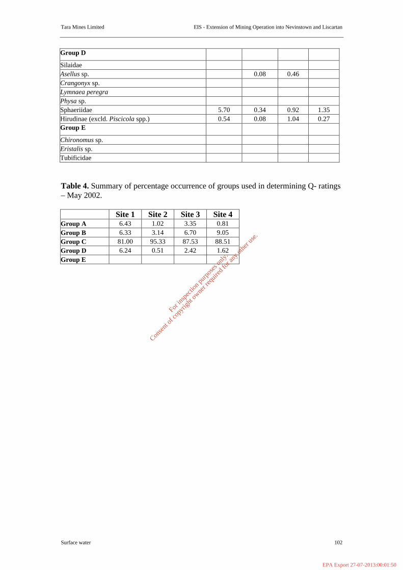
Tara Mines Limited EIS - Extension of Mining Operation into Nevinstown and Liscartan
Surface water 102
Group D
Silaidae Asellus sp. 0.08 0.46 Crangonyx sp. Lymnaea peregra Physa sp. Sphaeriidae 5.70 0.34 0.92 1.35 Hirudinae (excld. Piscicola spp.) 0.54 0.08 1.04 0.27 Group E
Chironomus sp. Eristalis sp. Tubificidae Table 4. Summary of percentage occurrence of groups used in determining Q- ratings – May 2002. Site 1 Site 2 Site 3 Site 4 Group A 6.43 1.02 3.35 0.81 Group B 6.33 3.14 6.70 9.05 Group C 81.00 95.33 87.53 88.51 Group D 6.24 0.51 2.42 1.62 Group E
For
insp
ectio
n pur
pose
s only
.
Conse
nt of
copy
right
owne
r req
uired
for a
ny ot
her u
se.
EPA Export 27-07-2013:00:01:50
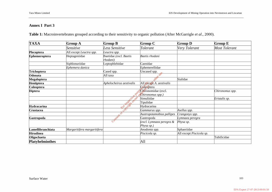
Tara Mines Limited EIS Development of Mining Operation into Nevinstown and Liscartan
Surface Water 103
Annex I Part 3 Table 1: Macroinvertebrates grouped according to their sensitivity to organic pollution (After McGarrigle et al., 2000). TAXA Group A Group B Group C Group D Group E Sensitive Less Sensitive Tolerant Very Tolerant Most Tolerant Plecoptera All except Leuctra spp. Leuctra spp. Ephemeroptera Heptageniidae Baetidae (excl. Baetis
rhodani) Baetis rhodani
Siphlonuriidae Leptophlebidae Caenidae Ephemera danica Ephemerellidae Trichoptera Cased spp. Uncased spp. Odonata All taxa Megaloptera Sialidae Heniiptera Aphelocheirus aestivalis All except A. aestivalis Coleoptera Coleoptera Diptera Chironomidae (excl.
Chironomus spp.) Chironomus spp.
Simuliidae Eristalis sp. Tipulidae Hydracarina Hydracarina Crustacea Gammarus spp. Asellus spp. Austropotamobius pallipes Crangonyx spp. Gastropoda Gastropoda Lymnaea peregra (excl. Lymnaea peregra &
Physa sp.) Physa sp.
Lamellibranchiata Margaritifera margaritifera Anodonta spp. Sphaeriidae Hirudinea Piscicola sp. All except Piscicola sp. Oligochaeta Tubificidae Platyhelminthes All
For
insp
ectio
n pur
pose
s only
.
Conse
nt of
copy
right
owne
r req
uired
for a
ny ot
her u
se.
EPA Export 27-07-2013:00:01:50
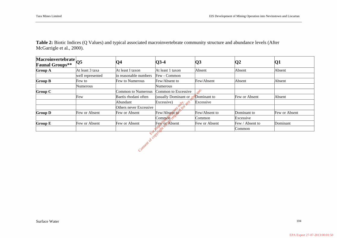
Tara Mines Limited EIS Development of Mining Operation into Nevinstown and Liscartan
Surface Water 104
Table 2: Biotic Indices (Q Values) and typical associated macroinvertebrate community structure and abundance levels (After McGarrigle et al., 2000). Macroinvertebrate Faunal Groups** Q5 Q4 Q3-4 Q3 Q2 Q1
Group A At least 3 taxa At least I taxon At least 1 taxon Absent Absent Absent well represented in reasonable numbers Few - Common Group B Few to Few to Numerous Few/Absent to Few/Absent Absent Absent Numerous Numerous Group C Common to Numerous Common to Excessive Few Baetis rhodani often (usually Dominant or Dominant to Few or Absent Absent Abundant Excessive) Excessive Others never Excessive Group D Few or Absent Few or Absent Few/Absent to Few/Absent to Dominant to Few or Absent Common Common Excessive Group E Few or Absent Few or Absent Few or Absent Few or Absent Few / Absent to Dominant Common
For
insp
ectio
n pur
pose
s only
.
Conse
nt of
copy
right
owne
r req
uired
for a
ny ot
her u
se.
EPA Export 27-07-2013:00:01:50
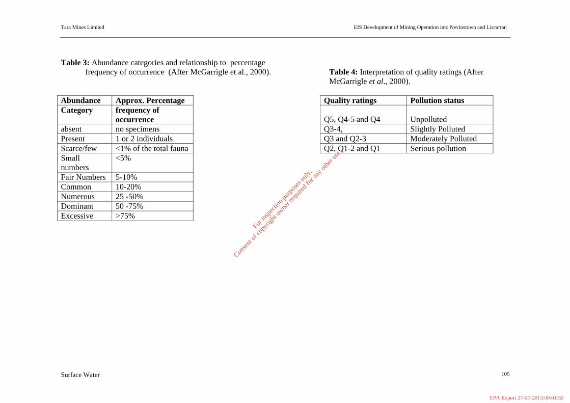
Tara Mines Limited EIS Development of Mining Operation into Nevinstown and Liscartan
Surface Water 105
Table 3: Abundance categories and relationship to percentage
frequency of occurrence (After McGarrigle et al., 2000). Table 4: Interpretation of quality ratings (After McGarrigle et al., 2000).
Abundance Approx. Percentage Quality ratings Pollution status Category frequency of
occurrence
Q5, Q4-5 and Q4 Unpolluted absent no specimens Q3-4, Slightly Polluted Present 1 or 2 individuals Q3 and Q2-3 Moderately Polluted Scarce/few <1% of the total fauna Q2, Q1-2 and Q1 Serious pollution Small numbers
<5%
Fair Numbers 5-10% Common 10-20% Numerous 25 -50% Dominant 50 -75% Excessive >75%
For
insp
ectio
n pur
pose
s only
.
Conse
nt of
copy
right
owne
r req
uired
for a
ny ot
her u
se.
EPA Export 27-07-2013:00:01:50
Tara Mines Limited EIS - Extension of Mining Operation into Nevinstown and Liscartan _______________________________________________________________________________________________________
Flora & Fauna 106
_____________________________________________________________________
SECTION 9 FLORA AND FAUNA
_____________________________________________________________________ 9.1 Nevinstown 9.1.1 Introduction Biosphere Environmental Services was commissioned by Tara Mines Ltd. to carry out a baseline habitat, flora and fauna survey of a property at Nevinstown where there is a proposal to extract ore. The survey site is located to the north-west of Navan town (study site grid reference N 955 690). The River Blackwater, which drains the site, marks the southern boundary of the site. The western boundary is marked by hedgerows and the northern boundary by the Navan to Donaghpatrick road. The eastern boundary mostly follows a drainage ditch but is close to the Kingscourt railway line, with the northeastern sector extending east of the line. Almost the entire site comprises agricultural land, though this has not been intensively managed in recent times. Some planted woodland (former nursery) occurs in the north-east of the site. There are two derelict complexes of buildings on the site. The main ecological feature of the area is the River Blackwater, a substantial watercourse and important fishery that is a tributary of the River Boyne. Presently, no part of the site is covered by a conservation designation. The nearest designated sites are Jamestown Bog proposed Natural Heritage Area (code 01324), located approximately 5 km to the west, and the Boyne Woods proposed Natural Heritage Area (code 015), located along the Boyne approximately 5 km to the north-east. Information supplied by National Parks & Wildlife of Dúchas the Heritage Service (Dr M. Wyse Jackson pers. comm.) indicates that in the near future the main channels of the Rivers Boyne and Blackwater will be proposed as a Special Area of Conservation (SAC) (under EU Habitats Directive) on the basis of fish interests, especially the Atlantic Salmon (Salmo salar). 9.1.2 Method The survey was carried out in June 2002. The survey methodology consisted of systematically walking the site area and recording on a large scale map habitats and vegetation types present. Habitat classification is according to the system recommended by The Heritage Council (Fossit 2000). Notes were made on bird species present within and around the site. For mammals, the main emphasis was on search for signs of activity or dwellings. During the survey, particular attention was given to the possible presence of habitats and/or species that are legally protected under Irish or European legislation (e.g. the Flora Protection Order 1999; Wildlife Act 1966; EU Habitats Directive; EU Birds Directive).
For
insp
ectio
n pur
pose
s only
.
Conse
nt of
copy
right
owne
r req
uired
for a
ny ot
her u
se.
EPA Export 27-07-2013:00:01:50
Tara Mines Limited EIS - Extension of Mining Operation into Nevinstown and Liscartan _______________________________________________________________________________________________________
Flora & Fauna 107
The standard literature was checked for reference to the site and locality, as were the listings and maps of sites of conservation importance in Co. Meath held by Dúchas the Heritage Service. 9.1.2.1 Survey Limitation No constraints are associated with the botanical survey as it was carried out in the summer period. The time of survey was also optimum for most fauna species. However, owing to high vegetation cover at the time of survey, full search could not be made for mammal species, especially badger. While no survey was carried out for wintering birds, this is not considered a significant constraint as the likelihood of a species of conservation importance occurring can be made from an assessment of habitats present. 9.1.3 Baseline Environment 9.1.3.1 Habitats, Vegetation and Flora The majority of the site is dominated by improved grassland, either pasture or meadow, with hedgerows the main field boundary type. Several patches of scrub occur, and there are stands of planted woodland in the northern sector of the site. Wet ditches or drainage channels are also found. The main channel of the River Blackwater forms the southern boundary to the site, and there is some marginal wetland vegetation along the river bank. The site also includes a number of buildings and a section of railway track. The vegetation types or habitats which were identified are described below with reference to the accompanying map (Fig. 1). Both English and scientific names are given for plant species. Nomenclature follows Webb, Parnell and Doogue (1996). Improved grassland Pasture grassland, grazed by cattle and sheep, is the most frequent habitat within the site (see Plate 1). It has not been intensively managed in recent times, with the sward often up to 20-30 cm high. It is dominated by common agricultural grass species, mainly rye grass (Lolium perenne), meadow grasses (Poa spp.) and cock’s-foot (Dactylis glomerata). Herb species are common, with such species as meadow buttercup (Ranunculus acris), creeping buttercup (Ranunculus repens), the plantains (Plantago lanceolata, P. major), white clover (Trifolium repens) and speedwell (Veronica serpyllifolia). Patches of nettles (Urtica dioica) and thistles (Cirsium spp.) are widespread, and in a few areas brambles (Rubus fruticosus) are encroaching into the fields. Tall ‘meadow’ grassland occurs in some of the fields where grazing or cutting has not occurred (see Plate 2). Sward height was at least 60 cm and often up to 100 cm. Species diversity is similar to the pasture grassland, though a few additional species were recorded including knapweed (Centaurea scabiosa) and mouse-ear chickweed (Cerastium fontanum).
For
insp
ectio
n pur
pose
s only
.
Conse
nt of
copy
right
owne
r req
uired
for a
ny ot
her u
se.
EPA Export 27-07-2013:00:01:50
Tara Mines Limited EIS - Extension of Mining Operation into Nevinstown and Liscartan _______________________________________________________________________________________________________
Flora & Fauna 108
Hedgerows Hedgerows are the principal type of field boundary within the site (see Plate 1 & 2). These are largely intact though some in the north-west sector of the site have been partly or completely removed. There appears to have been little management in recent times and most of the hedges are well-grown with good structures. Average height is estimated at 6-6 m, though taller trees are frequent (some 20+ m high) and in a few cases the boundary is more aptly described as a treeline. Ash (Fraxinus excelsior) is by far the main tall tree species, and is accompanied mostly by hawthorn (Crataegus monogyna), blackthorn (Prunus spinosa) and elder (Sambucus nigra). Other tree or shrub species which have an occasional presence are holly (Ilex aquilinum), willow (Salix spp.), sycamore (Acer pseudoplatanus), elm (Ulmus spp.), alder (Alnus glutinosa), cherry (Prunus spp.) and crab-apple (Malus sylvestris). The understorey of the hedgerows is dominated by brambles (Rubus fruticosus), nettles (Urtica dioica) and hogweed (Heraceum sphondylium). Ivy (Hedera helix) is frequent and honeysuckle (Lonicera periclynemum) and wild roses (Rosa spp.) occasional. Some typical shade-loving species were noted in the bases of the hedges, including hart’s-tongue fern (Phyllitis scolopendrium), black spleenwort (Asplenium adiantum-nigrum) and lords and ladies (Arum maculatum). Woodland, scrub and trees A block of woodland occurs in the north-east sector of the site. This is planted woodland associated with the former Bula Windtown Nurseries. The trees are planted in single species stands, comprising such species as oak (Quercus spp.), ash, sycamore, poplar and birch (Betula spp.). The trees are now of medium height. Since the abandonment of the nurseries, some of the areas between the stands of trees have become overgrown with scrub and brambles. Some scrub has developed on slopes within the fields adjacent to the river. This comprises gorse (Ulex europaeus), hawthorn and elder. Tall trees occur around the derelict Nevinstown House. These include beech (Fagus sylvatica), sycamore and cypress (Cupressus spp.). River bank/flood plain vegetation The Blackwater is a typical, relatively slow-moving, lowland river (see Plate 3). Within the main channel, stands of common club-rush (Schoenoplectus lacustris) are present. The bankside vegetation along the river is variable. At the eastern end of the site, it is well developed with a typical floodplain appearance (see Plate 4). A wetland zone extends approximately 60 m into the field to where the ground starts to rise. The dominant species is yellow flag (Iris pseudacorus), with clumps of rushes (Juncus spp.) and other plants of wet ground such as cow parsley (Anthriscus sylvestris), water plantain (Alisma plantago-aquatica), marsh arrowgrass (Triglochin palustris), brooklime (Veronica beccabunga) and water mint (Mentha aquatica). At the margin of the river reed canary grass (Phalaris arundinacea) occurs with the yellow flag.
For
insp
ectio
n pur
pose
s only
.
Conse
nt of
copy
right
owne
r req
uired
for a
ny ot
her u
se.
EPA Export 27-07-2013:00:01:50
Tara Mines Limited EIS - Extension of Mining Operation into Nevinstown and Liscartan _______________________________________________________________________________________________________
Flora & Fauna 109
Several tall poplar trees (Populus spp.) occur at one location along the bank. Elsewhere along the river bank the pasture grassland comes close to the waters edge and there is little or no natural riverbank vegetation (see Plate 5). A line of alder trees occur along the river bank in the westernmost field. Wet grassland/freshwater marsh A small area of wet grassland or freshwater marsh occurs in the north-west sector of the site, immediately north of a derelict complex of buildings (see Plate 6). This is associated with flooded ground and may indicate a spring. Rushes (Juncus spp.) were frequent, and occurred alongside yellow flag (Iris pseudacorus), marsh marigold (Caltha palustris) and pondweeds (Potamogeton spp.). 9.1.3.2 Fauna 9.1.3.2.1 Mammals, Amphibians and Reptiles A typical diversity of mammal species associated with agricultural land was recorded, or is considered likely to occur, within the site. Rabbits (Oryctolagus cuniculus) were frequent, with burrows in most of the embankments associated with the hedgerows. A fox (Vulpes vulpes) was sighted along the eastern boundary and several signs of fox (i.e. scats) were noted elsewhere within the site. Brown rats (Rattus norvegicus) are common in the area. The high vegetation cover precluded full search for badger (Meles meles) in many parts of the site but it is considered that this species would probably occur in the vicinity. Other ubiquitous Irish mammals which occur in agricultural habitats and are likely at the site would be hedgehog (Erinaceous europaeus), pygmy shrew (Sorex minutus) and long-tailed field mouse (Apodemus sylvaticus). The Irish hare (Lepus timidus hibernicus) may occur in the grassland fields as it is known from the area. The River Boyne supports otters (Lutra lutra) and it is likely that they occur on the Blackwater. No survey was carried out for bat presence but the various derelict buildings and the mature trees would support roosting bats. The river would provide excellent foraging habitat for bats. The common frog (Rana temporaria) was recorded on wet ground in the north-west sector of the site and probably occurs in some of the wet ditches elsewhere. There is no suitable habitat on the site for the common lizard (Lacerta vivipara). 9.1.3.2.2 Birds A typical range of bird species associated with improved grassland and hedgerows occur within the site. Crows were plentiful, with rook (Corvus frugilegus), jackdaw (Corvus monedula), hooded crow (Corvus corone) and magpie (Pica pica) all present. Jackdaws nest in the derelict buildings. Starlings (Sturnus vulgaris), meadow pipits (Anthus pratensis) and woodpigeons (Columba palumbus) were also recorded in the pasture fields. Small bird species recorded in the hedgerows included robin (Erithacus rubecula), wren (Troglodytes troglodytes), blackbird (Turdus merula), song thrush (Turdus philomelos), blue tit (Parus caeruleus), coal tit (Parus ater), goldcrest (Regulus regulus), chiffchaff (Phylloscopus collybita), chaffinch (Fringilla coelebs) and bullfinch (Pyrrhula pyrrhula). Most of these species would probably nest.
For
insp
ectio
n pur
pose
s only
.
Conse
nt of
copy
right
owne
r req
uired
for a
ny ot
her u
se.
EPA Export 27-07-2013:00:01:50
Tara Mines Limited EIS - Extension of Mining Operation into Nevinstown and Liscartan _______________________________________________________________________________________________________
Flora & Fauna 110
The section of the River Blackwater in the vicinity of the site supports a range of wetland bird species, with mallard (Anas platyrhynchos), moorhen (Gallinula chloropus), grey heron (Ardea cinerea), grey wagtail (Motacilla cinerea) and little grebe (Tachybaptus ruficollis) observed on the day of survey. The river also appears suitable for kingfisher (Alcedo atthis). 9.1.3.2.3 Fish O’Reilly (1991) describes the fishery interests of the Kells Blackwater as follows: “The Kells Blackwater drains Lough Ramor near Virginia in Co. Cavan and flows south east for 19 miles before joining the Boyne at Navan. It is a medium sized limestone river and is now recovering from the effects of the arterial drainage scheme. It was noted for its spring-salmon fishing and enormous stocks of fat trout. The salmon fishing is poor at present except on the Mollies Fishery at Navan, where some fish are still taken. The trout fishing varies from good to very good, with fair numbers of trout up to 2 lb and better”. 9.1.3.3 Assessment of scientific importance of survey area The principal habitat at this site, improved grassland, has negligible or very low scientific importance or conservation value. The main ecological interests lie in the hedgerows, woodland and particularly the river and associated marginal vegetation. The hedgerows are mostly well developed and some are notable for the presence of tall trees. Species diversity is fairly typical of the hedgerows in Co. Meath and all have ecological value in a local context. The planted woodland stands provide useful habitat for a range of wildlife species, though their scientific value is low. The River Blackwater is a substantial watercourse with important scientific interests and is a notable fishery. In some areas the river still has a recognisable flood-plain zone and this supports typical wetland vegetation. The survey area does not appear to support, nor has been known to in the past, any rare or protected plant species. No animal species of high conservation importance occurs within the main part of the site. However, the likely presence of otter on the Blackwater is of note as otter is of particular conservation importance as it is listed on Annex II of the EU Habitats Directive. Also, the presence or likely presence of species such as the Irish hare, badger and common frog within the survey area is of some note, as these species are protected under the Wildlife Act (1966) (though all are still widespread in distribution). The areas surrounding the site are predominantly agricultural lands. There are no features of known ecological interest in areas immediately surrounding the site. At present, no part of the site is governed by a scientific or conservation designation, with the nearest site of conservation importance being approximately 5 km away. However, the River Blackwater is due to be proposed as a Special Area of Conservation in the near future.
For
insp
ectio
n pur
pose
s only
.
Conse
nt of
copy
right
owne
r req
uired
for a
ny ot
her u
se.
EPA Export 27-07-2013:00:01:50

Tara Mines Limited EIS - Extension of Mining Operation into Nevinstown and Liscartan _______________________________________________________________________________________________________
Flora & Fauna 111
9.1.4 Assessment of potential impacts by proposed development The proposed ore extraction development will be belowground, at a depth of several tens of metres. It is not proposed that there will be any surface structures, such as air ventilation units, within the Nevinstown site area. As the proposed development would not cause any disturbance to the surface of the site, and as mining operations will be well below the rooting depth of plants, it is concluded that there would not be any impacts on the ecological interests of the area. 9.1.5 References Anonymous (1999) Proposed Natural Heritage Areas and Special Areas of Conservation in County Meath - listings and maps. Dúchas, the Heritage Service, Dublin. Fossit, J.A. (2000) A Guide to Habitats in Ireland. The Heritage Council, Kilkenny. O’Reilly, P. (1991) Trout and Salmon Rivers of Ireland: An Anglers Guide. Merlin
Unwin Books, London. Webb, D.A., Parnell, J. & Doogue, D. (1996) An Irish Flora. Dundalgan Press, Dundalk. Whilde, A. (1993) Irish Red Data Book 2: Vertebrates. HMSO : Belfast. Plate 1. Improved pasture grassland is the principal habitat within the site. The fields are bounded mainly by hedgerows. Plate 2. Tall ‘meadow’ grassland occurs in the fields where grazing or cutting has not occurred. Plate 3. The River Blackwater is a typical, relatively slow-moving, lowland river. View is looking eastwards. Plate 4. The river still retains a flood-plain zone in places, such as at the eastern end of the site as shown in the photograph. Yellow flag is a dominant species. Plate 5. Along much of the river bank, however, the pasture grassland comes close to the waters edge and there is little or no natural riverbank vegetation. Plate 6. A small area of wet grassland or freshwater marsh occurs in the north-west sector of the site, immediately north of a derelict complex of buildings.
For
insp
ectio
n pur
pose
s only
.
Conse
nt of
copy
right
owne
r req
uired
for a
ny ot
her u
se.
EPA Export 27-07-2013:00:01:50

Tara Mines Limited EIS - Extension of Mining Operation into Nevinstown and Liscartan _______________________________________________________________________________________________________
Flora & Fauna 112
Plate 1.Improved grassland is the principal habitat within the site. The fields are bounded mainly by hedgerows. Plate 2. Tall ‘meadow’ grassland occurs in the fields where grazing or cutting has not occurred.
For
insp
ectio
n pur
pose
s only
.
Conse
nt of
copy
right
owne
r req
uired
for a
ny ot
her u
se.
EPA Export 27-07-2013:00:01:50

Tara Mines Limited EIS - Extension of Mining Operation into Nevinstown and Liscartan _______________________________________________________________________________________________________
Flora & Fauna 113
Plate 3. The River Blackwater is a typical, relatively slow-moving, lowland river. View is looking eastwards. Plate 4. The river still retains a flood-plain zone in places, such as at the eastern end of the site as shown in the photograph. Yellow flag is a dominant species.
For
insp
ectio
n pur
pose
s only
.
Conse
nt of
copy
right
owne
r req
uired
for a
ny ot
her u
se.
EPA Export 27-07-2013:00:01:50
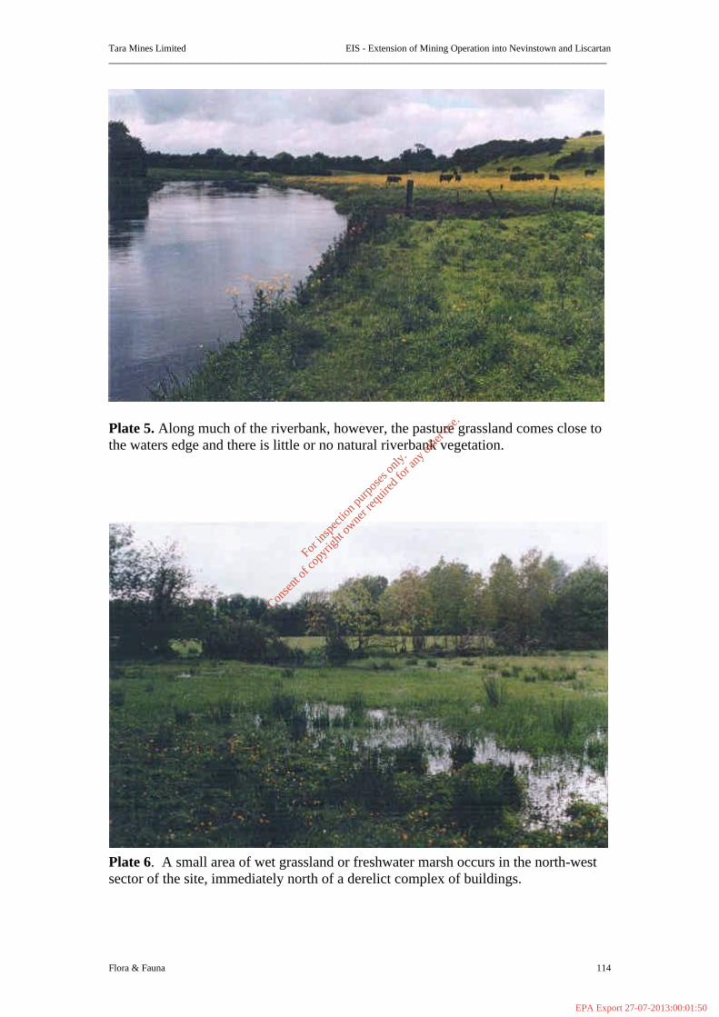
Tara Mines Limited EIS - Extension of Mining Operation into Nevinstown and Liscartan _______________________________________________________________________________________________________
Flora & Fauna 114
Plate 5. Along much of the riverbank, however, the pasture grassland comes close to the waters edge and there is little or no natural riverbank vegetation. Plate 6. A small area of wet grassland or freshwater marsh occurs in the north-west sector of the site, immediately north of a derelict complex of buildings.
For
insp
ectio
n pur
pose
s only
.
Conse
nt of
copy
right
owne
r req
uired
for a
ny ot
her u
se.
EPA Export 27-07-2013:00:01:50
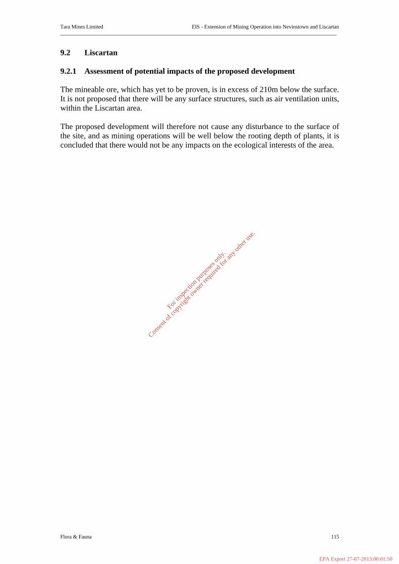
Tara Mines Limited EIS - Extension of Mining Operation into Nevinstown and Liscartan _______________________________________________________________________________________________________
Flora & Fauna 115
9.2 Liscartan 9.2.1 Assessment of potential impacts of the proposed development The mineable ore, which has yet to be proven, is in excess of 210m below the surface. It is not proposed that there will be any surface structures, such as air ventilation units, within the Liscartan area. The proposed development will therefore not cause any disturbance to the surface of the site, and as mining operations will be well below the rooting depth of plants, it is concluded that there would not be any impacts on the ecological interests of the area.
For
insp
ectio
n pur
pose
s only
.
Conse
nt of
copy
right
owne
r req
uired
for a
ny ot
her u
se.
EPA Export 27-07-2013:00:01:50

Tara Mines Limited EIS - Extension of Mining Operation into Nevinstown and Liscartan
Landscape & Visual Impact 116
_____________________________________________________________________
SECTION 10 LANDSCAPE AND VISUAL IMPACT
_____________________________________________________________________ 10.1 Visual Impacts on the Existing Landscape Since there is no surface structures / infrastructure required for the extension into Nevinstown and Liscartan it is therefore proposed that there will be no further descriptions on visual impacts on the existing landscape in the EIS.
For
insp
ectio
n pur
pose
s only
.
Conse
nt of
copy
right
owne
r req
uired
for a
ny ot
her u
se.
EPA Export 27-07-2013:00:01:50
Tara Mines Limited EIS - Extension of Mining Operation into Nevinstown and Liscartan
Air 117
_____________________________________________________________________
SECTION 11 AIR
_____________________________________________________________________ 11.1 Impacts of proposed development on Air Quality There will be no surface structures, or air emission sources North of the Blackwater River. All air intake / output required for the extension of mining works will be from existing facilities. All access to the proposed development will be underground via the Knockumber Mine site. Accordingly, no likely impacts on air quality are anticipated. Furthermore, no odour sources are anticipated. Ambient air quality and dust deposition have been monitored extensively in the environs of the existing mine site, since development commenced in 1973. The monitoring protocol in place as part of our IPC Licence will continue. Since there is no surface development proposed for the extension of mining into Nevinstown and Liscartan it is therefore proposed that there will be no further descriptions of impacts on air quality.
For
insp
ectio
n pur
pose
s only
.
Conse
nt of
copy
right
owne
r req
uired
for a
ny ot
her u
se.
EPA Export 27-07-2013:00:01:50
Tara Mines Limited EIS - Extension of Mining Operation into Nevinstown and Liscartan _______________________________________________________________________________________________________
Material Assets 118
_____________________________________________________________________
SECTION 12 MATERIAL ASSETS
_____________________________________________________________________
12.1 Cultural and Heritage - Archaeology 12.1.1 Introduction This archaeological report was undertaken at the request of Tara Mines Ltd., Knockumber, Navan, Co. Meath, as part of the Environmental Impact Statement on the impact of the proposed Nevinstown orebody development. The Nevinstown orebody is almost wholly contained within the boundaries of the townland of Nevinstown, situated 1km north west of Navan town between the River Blackwater and the Navan-Donaghpatrick road. The townland overall comprises 240 acres of undeveloped farmland which is currently in pasture. There are no inhabited buildings in the townland, the four houses present being now ruinous or derelict. The Nevinstown orebody is located to the north of the existing Tara Mines development and extends in an arc for a maximum distance of c 0.75km north of the River Blackwater. The development site is located in an area which is rich in known archaeological monuments ranging in date from the Neolithic to the Post-Medieval periods. In 1966 the National Museum of Ireland carried out a programme of archaeological excavation on a number of sites located on the land overlying the orebody. In addition, there is a strong likelihood of the presence of further archaeological sites of which there are no surface indications. Liscartan forms the north west extension of the existing main orebody. Presently the extent or quantity of ore reserves in this area has not been proven. Ongoing and future exploration will determine the extent of mineable ore. However, since development of the Nevinstown orebody will take place underground, as an extension of the existing mine south of the River Blackwater with no associated surface developments whatsoever, the development should have no impact on the archaeological heritage in Nevinstown. Likewise since the development into Liscartan (if mineable reserves are proven) will take place underground, as an extension of the existing mine with no associated surface developments whatsoever, the development should have no impact on the archaeological heritage in Liscartan. 12.1.2 Methodology This archaeological study comprises the results of desk-based research and a field survey of the proposed development site.
For
insp
ectio
n pur
pose
s only
.
Conse
nt of
copy
right
owne
r req
uired
for a
ny ot
her u
se.
EPA Export 27-07-2013:00:01:51
Tara Mines Limited EIS - Extension of Mining Operation into Nevinstown and Liscartan _______________________________________________________________________________________________________
Material Assets 119
The principal documentary sources consulted for the study were as follows: • The archives of the Archaeological Survey of Ireland. The Archaeological Survey
forms part of the National Monuments and Historic Properties Division of Dóchas, The Heritage Service, Department of Arts, Heritage, Gaeltacht and the Islands. The purpose of the Survey is to identify, on a county by county basis, all monuments and places of archaeological importance. In 1985 the Archaeological Survey issued the Sites and Monuments Record: County Meath (SMR), consisting of site lists and a corresponding set of annotated O.S. six-inch maps. This was followed in 1986 by the Archaeological Inventory of County Meath, published in book format, based on an examination of numerous sources including 18th and 19th century estate maps, various editions of O.S. maps, records of the National Museum of Ireland and collections of aerial photographs (Air Corps, G.S.I., Cambridge University, Tara Mines Ltd.). In 1996 the National Monuments and Historic Properties Division issued the Record of Monuments and Places: County Meath (RMP) in accordance with Section 12 of the National Monuments (Amendment) Act 1994. All archaeological sites listed in the 1996 Record, essentially an updating of the 1985 Sites and Monuments Record, are given statutory protection under the 1994 Act. An extract from the 1996 Record of Monuments and Places: County Meath for the relevant area is attached as Figure 1 below.
• The first edition of the O.S. six-inch (1:10560) map, Meath Sheet 25 (1836). • Relevant historical and archaeological books and journals (see Bibliography) A field inspection was carried out to assess the local topography and current land use. The purpose was also to note the present condition of the archaeological sites previously excavated in the development area and to note any further possible features of archaeological or historical interest. 12.1.3 Archaeological and Historical Background The development site is located in an area where there is clear evidence of settlement from at least the Neolithic period onwards. Indeed, excavations within the boundaries of the development site itself have uncovered archaeological deposits dating to the Early Bronze Age, Early Christian, Medieval and Post-Medieval periods. These excavations took place in 1966 under the direction of Mary Cahill of the National Museum of Ireland, in advance of a proposed open-cast mining operation which did not proceed. In the vicinity of the Nevinstown evidence of early settlement is present not only in the form of upstanding monuments but also as archaeological deposits which were discovered during development of the Tara Mines Ltd. tailings dam at Simonstown and Randalstown. Prehistoric period At Simonstown in 1965 E.P. Kelly recorded pits and hearths of Neolithic date (c. 4500-2200 BC) under the banks of an Early Christian period ringfort. More recently, in 1998, Coilin � Drisceoil partially excavated the remains of a large rectangular
For
insp
ectio
n pur
pose
s only
.
Conse
nt of
copy
right
owne
r req
uired
for a
ny ot
her u
se.
EPA Export 27-07-2013:00:01:51

Tara Mines Limited EIS - Extension of Mining Operation into Nevinstown and Liscartan _______________________________________________________________________________________________________
Material Assets 120
structure (his Area 2) which may have been burnt. A Neolithic date, first indicated by the finding of a leaf-shaped arrowhead on the site, was later confirmed by radiocarbon dating (pers comm C. � Drisceoil). Material of Bronze Age date (c. 2200-500 BC) was found at Nevinstown Site 1, by Mary Cahill, where cremated human bone was contained in an Encrusted Urn and a Food Vessel Vase buried in a pit. Burnt mounds or fulachta fiadh, presumed communal cooking places typically Bronze Age in date, have been excavated in the borrow areas for the tailings dam at Simonstown (� Drisceoil’s Area 6) and at Randalstown, where four such sites were excavated by D. Murphy in 1999. At Simonstown, � Drisceoil also uncovered 61 circular pits containing burnt stone, charcoal and occasionally cremated bone, suggestive of a Bronze Age date. In Liscartan townland, on the opposite side of the Blackwater c. 0.5km upstream and west of Nevinstown, a tumulus or earthen mound is likely to be of prehistoric date, but without excavation is impossible to assign to a particular period. Early Christian period Large-scale excavations of settlement sites of the Early Christian period took place at Nevinstown itself (Cahill’s Site 1) and also at Simonstown and Randalstown. Kelly excavated a large ringfort (65m diameter) at Simonstown in 1965 and an enclosure with a cemetery at St. Anne’s Chapel, Randalstown, in 1965-6 and 1981-2. On this latter site Iron Age settlement was indicated by the finding of a 1st century AD Roman brooch. There is a further ringfort surviving at Clomagaddan, to the north east of Nevinstown. Souterrains, associated with unenclosed settlements, have been excavated at Nevinstown (Cahill’s Site III) and on two sites at Randalstown. There is a record of a souterrain with two beehive chambers at Ardbraccan. There is annalistic and archaeological evidence for Early Christian churches at Ardbraccan, Liscartan and Randalstown but no fabric survives of the actual buildings. Bradley considers that documentary evidence for the foundation of a house for Augustinian Canons at Navan, before the coming of the Anglo-Normans, supports the tradition of an Early Christian monastery on the site of the town. Medieval period The town of Navan is an Anglo-Norman foundation of the late 12th century although the earliest documentary reference to the town as a borough is 1462, when Edward IV confirmed the right of the town to collect tolls, and its earliest charter dates to 1494. Hugh de Lacy granted Navan and Ardbraccan to Jocelin de Angulo (later Nangle) before 1286 and the town most likely owes its foundation to him or his son William. The motte built by de Angulo at Moathill, marked “Navan Moat” on the O.S. map, is probably the earliest surviving vestige of the medieval town. It is situated to the west of the town on a ridge on the south bank of the Blackwater a little over 0.5km south east of Nevinstown. The town was walled from the 15th century and a portion of the wall with a tower survives at Barrack Lane on the north side of the town. The Augustinian Priory of St. Mary lay between the north wall and the River Blackwater.
For
insp
ectio
n pur
pose
s only
.
Conse
nt of
copy
right
owne
r req
uired
for a
ny ot
her u
se.
EPA Export 27-07-2013:00:01:51
Tara Mines Limited EIS - Extension of Mining Operation into Nevinstown and Liscartan _______________________________________________________________________________________________________
Material Assets 121
Adjacent on the west side of Nevinstown, the core of Rathaldron House is a four-storey late medieval tower house, possibly built by the Cusacks in the 14th century. Another medieval tower house stands at Liscartan, “Liscartan Castle (in ruins)” on Figure 1, in company with the ruins of a gatehouse and a later stone house, of 16th or 16th century date. West of the castle are the ruins of the medieval church, still in use into the 18th century. The late medieval cross at Nevinstown, marked “Old Cross” on the 1836 O.S. map, was erected by Michael de Cusack in 1588 and is believed to have functioned as a wayside cross on an old road from Navan to Rathaldron Castle. The cross was moved to the County Library in Navan in recent times. The site of the cross was the subject of archaeological excavation in 1966 (Cahill’s Site IV), when the remains of 6-8 infants were uncovered around the plinth. In addition to recognised medieval monuments in the area, material of medieval date has also occurred in the excavation of several Early Christian settlement sites, representing the later phases of use of the sites. Pottery and other domestic artifacts were found in Phase III at Nevinstown Site I. A medieval phase was also recognised on the ringfort excavated by Kelly at Randalstown. Post-Medieval period The Civil Survey of County Meath, compiled in 1654-6, lists ‘Patrick Cusacke of Rahaldron’ as the proprietor of ‘Symonstowne and Neivenstowne’, with a combined 250 acres. A wing was added to the Cusack castle at Rathaldron in the 16th century, the whole edifice being gothicised c. 1800 with further alteration by new owners in 1843. The prevailing field pattern of large rectangular fields probably dates to the 18th century. The architectural style of Nevinstown House suggests it also dates to this time, although possibly built on the site of an earlier house. In 1836 the house was the only building in the townland; three other small dwellings not appearing until the early 20th century. A limekiln, of 18th-early 19th century date, stands in the field between Nevinstown House and the River Blackwater. One of the more significant changes to the landscape of the immediate area must have been the construction in 1862 of the Navan-Kingscourt branch railway line on the western side of the townland. 12.1.4 Recorded Archaeological Sites The relevant SMR and RMP sheet for the proposed development site is Sheet No. 25 for Co. Meath (Figure 1). Listed below are the archaeological sites in Nevinstown and adjoining townlands as recorded by Dóchas in the SMR/RMP and the Archaeological Inventory of County Meath. The Nevinstown sites were excavated by the N.M.I. in 1966 and appear as Sites I, III and IV on Figure 2. The details of each site are arranged in the order as follows: Inventory No. SMR No. Townland NGR
For
insp
ectio
n pur
pose
s only
.
Conse
nt of
copy
right
owne
r req
uired
for a
ny ot
her u
se.
EPA Export 27-07-2013:00:01:51

Tara Mines Limited EIS - Extension of Mining Operation into Nevinstown and Liscartan _______________________________________________________________________________________________________
Material Assets 122
Site type Description 12.1.4.1 Recorded Archaeological Sites in Nevinstown Townland 286 025:043.2 Nevinstown 28504 26865 Pit burial An Encrusted Urn and a Vase Food Vessel were excavated at Site I by Mary Cahill in 1966. The urn and food vessel were contained in a pit dug into the natural ridge and contained the cremated bones of at least two adults and one child. 392 025:043.1 Nevinstown 28504 26865 Early Christian Occupation Site Excavated as Site I by Mary Cahill in 1966 this was a flat-topped mound at the end of a gravel ridge and was enclosed by three concentric ditches. Excavation produced evidence for three phases of activity dating mainly to the Early Christian period but with finds also from the medieval and post-medieval preiods. 441 025:004 Nevinstown 28520 26883 Souterrain This site, Cahill’s Site II excavated in 1966, consisted of a 12m length of destroyed souterrain passage leading to a beehive chamber. This monument type is datable to the Early Christian period. No evidence was found for an enclosure around the souterrain. 1546 025:013.1 Nevinstown 28518 26900 Cross A wayside cross was erected here in 1588 by Michael de Cusack and his wife Marguerita Dexter. The cross has been moved to the County Library in Navan. Excavations by Mary Cahill in 1966, her Site IV, uncovered the remains of the plinth which had been constructed of cut-limestone blocks. A cillÍn, a burial ground for unbaptised children, was found at the base of the cross.
For
insp
ectio
n pur
pose
s only
.
Conse
nt of
copy
right
owne
r req
uired
for a
ny ot
her u
se.
EPA Export 27-07-2013:00:01:51

Tara Mines Limited EIS - Extension of Mining Operation into Nevinstown and Liscartan _______________________________________________________________________________________________________
Material Assets 123
1600 025:013.2 Nevinstown 28518 26900 CillÍn Excavated as Site IV by Mary Cahill in 1966, this burial ground contained the remains of 6 or 8 infants and young children at the base of the late medieval wayside cross (1546 above). 12.1.4.2 Recorded Archaeological Sites in Adjoining Townlands 189 025:12 Liscartan 28442 26910 Tumulus A circular mound, planted with trees, measures 23m in diameter and 2.5m high. The mound has been damaged by quarrying. 1646 025:023 Moathill 28598 26665 Motte and Bailey Flat-topped earthen mound surrounded by the remains of a fosse, with a small lunate bailey defined by a scarp. Motte measures 36m diameter and 6.8m high. 1443 025:008 Liscartan 28396 26945 Church A medieval church consisting of an undivided nave and chancel with original double-light windows in the east and west walls. Repaired in the 18th century when large round-headed windows were inserted into the south and north walls. 1323 025:024 Abbeylands South 28690 26814 Abbey (site) No visible remains survive of the medieval Augustinian St. Mary’s Abbey on the north side of Navan town. Some medieval mouldings were recovered during
For
insp
ectio
n pur
pose
s only
.
Conse
nt of
copy
right
owne
r req
uired
for a
ny ot
her u
se.
EPA Export 27-07-2013:00:01:51

Tara Mines Limited EIS - Extension of Mining Operation into Nevinstown and Liscartan _______________________________________________________________________________________________________
Material Assets 124
construction of the Inner Ring Road. Cut stone from the abbey is kept at St. Patrick’s Classical School and in the Church of St. Oliver Plunkett in Navan. 1648 025:009 Liscartan 28403 26951 Tower House A three-storey rectangular medieval tower house with large corner towers on three angles. An entrance in the east tower leads to a barrel-vaulted ground floor. An enclosing courtyard contains a stone house (1806). 1649 025:010 28412 26945 Liscartan Gatehouse A barrel-vaulted gateway, with murder hole over the entrance, is situated 100m from the tower house at Liscartan (1648) 1662 025:012 Rathaldron 28458 26932 Tower House A four-storey medieval tower house, still inhabited. The castle has been extensively remodelled but retains some original features. 1816 025:025 Abbeylands South/Townparks 28600 26660 Town Defences The medieval defences of Navan town enclosed an area of c. 13 acres. The town walls probably date from the early 15th century. Portion of the town wall and a tower survive near Barrack Lane. 12.1.5 Field Survey Field walking was carried out on the 31st May 2002, in bright sunny conditions. The survey was limited to those fields which directly overlay the proposed mining operation. These fields are numbered 1-10 on Figure 2. The topography of Nevinstown townland from the Rathaldron road to the River Blackwater is of undulating farmland set out in large rectangular pasture fields. The field boundaries consist of traditional banks and ditches with tall hedges and many mature trees.
For
insp
ectio
n pur
pose
s only
.
Conse
nt of
copy
right
owne
r req
uired
for a
ny ot
her u
se.
EPA Export 27-07-2013:00:01:51

Tara Mines Limited EIS - Extension of Mining Operation into Nevinstown and Liscartan _______________________________________________________________________________________________________
Material Assets 125
Comparison of the present-day field layout with that shown on the 1836 first edition of the O.S. six-inch map (1:10560), surveyed in 1836, shows that changes are limited to some subdivision of fields. The straight lane running north-south through the townland from the Rathaldron road is also a post-1836 addition. The land is currently grazed by cattle and sheep or is in silage. Field 1 This is a large rectangular pasture field running north from the River Blackwater at the western boundary of Nevinstown townland. The field is on two levels separated by a sharp slope c 50-60m from the river’s edge. Nothing of archaeological interest was observed. Field 2 This is a large elongated pasture field of similar configuration to Field 1, with a drop in level to a flat area by the river’s edge. Nothing of archaeological interest was observed. Fields 1 and 2 appear as one large field on the 1836 map. Field 3 Large pasture field aligned east-west for c 600m along the north bank of the River Blackwater. The field is level by the river’s edge with a slope up towards its northern boundary. Over the western half of the field this slope takes the form of a furze-covered scarp above which is a flat area up to c 100m wide (N-S). An archaeological site, Site I of the 1966 excavations programme, is located on the top of the scarp at the western end of the field (Figure 2). The essential elements of the site, enclosing ditches and flat-topped central area, survive in good condition. The grid squares of the archaeological excavation, now grassed over, remain clearly visible. The scarp is shown wooded on the 1836 O.S. map, as is the slope at the north-western edge of the field. The map also shows a stand of trees at the river’s edge midway along the length of the field. Field 4 This large approximately square pasture field is generally level, with a marked ridge running east-west across the southern half of the field. There is a slight fall towards the western margin and there are natural hollows against the eastern edge which continue into the adjoining fields. There is an small overgrown quarry in the south-east corner of the field which is shown as “Gravel Pit” on the 1836 O.S. map. Three of the archaeological sites excavated in 1966, Sites II, III and IV, were located in this field (Figure 2). • Site II, a standing stone, which stood on the east-west ridge across the field, was
discounted as an antiquity by the excavator and this site was not included in the Sites and Monuments Record or the Record of Monuments and Places issued by Dóchas for County Meath. It is omitted from Figure 2.
• Site III, a souterrain, now appears as an area of disturbed ground at the centre of the field. This site is shown in the wrong position, i.e. at the eastern edge of the field, on Sheet 25 of the Record of Monuments and Places: County Meath, issued by Dóchas. The approximate location is indicated in Figure 2.
For
insp
ectio
n pur
pose
s only
.
Conse
nt of
copy
right
owne
r req
uired
for a
ny ot
her u
se.
EPA Export 27-07-2013:00:01:51
Tara Mines Limited EIS - Extension of Mining Operation into Nevinstown and Liscartan _______________________________________________________________________________________________________
Material Assets 126
• Site IV, the site of a 16th century wayside cross and associated cillÍn, at the northern boundary of the field and outside the limit of the development, is now marked by a shallow excavation and a scatter of loose stones.
Field 5 This is a large rectangular pasture higher at the southern side, flattening off to the north and north-east. At the south-east corner of the field there is a depression, 20m across and c1.5m deep, now grassed-over and containing nettles. This is most likely to be a backfilled quarry or gravel pit, perhaps used as a rubbish dump for Nevinstown House. No features of archaeological interest were observed. Field 6 This large rectangular field with an overall south-facing aspect was in silage at the time of survey. There is a wet hollow at the western boundary of the field. Nothing of archaeological interest was observed. Field 6 This is a large pasture field of irregular shape, which is level to the south-west with a gentle slope to the east and south-east. Nothing of archaeological interest was observed. Field 8 This is now a small L-shaped paddock with an undulating surface. The 1836 O.S. map shows this field laid out as a formal garden. Also shown within the area of the present field was an additional range of buildings, aligned east-west to the north of the farmyard, which has now disappeared. Field 9 A pasture field of irregular shape, bordering the old avenue to Nevinstown House. There is a gradual slope to the east. Nothing of archaeological interest was observed. Field 10 This is a large irregular pasture field on the north bank of the River Blackwater at the eastern boundary of Nevinstown townland. The field is level to gently undulating over the north-eastern half, with a slope south-west to the river. The field is dotted with occasional bushes and young trees. There are a number of small-scale recent excavations resembling test pits/trenches. A broad gully towards the western end of the field, due south of Nevinstown House, is depicted as “Quarry” on the 1836 O.S. map. It is noted on the 1955 revision of the O.S. six-inch map that the lower part of the field is ‘Liable to Floods’. A lime kiln, depicted by a symbol on the 1836 map, survives intact towards the eastern edge of the field, built into the slope c 50m from the river. The lime kiln possesses a fine elliptical stone arch and is in a reasonable state of preservation, although heavily overgrown with bushes around the top. Nevinstown House In plan Nevinstown House and outbuildings survive much as they are shown on the 1836 O.S. six-inch map, with few alterations to the layout. As noted above, a range of outbuildings and the formal garden north of the house no longer exist. The house, which is of two storeys and five bays, and the farmyard buildings to the rear, are still
For
insp
ectio
n pur
pose
s only
.
Conse
nt of
copy
right
owne
r req
uired
for a
ny ot
her u
se.
EPA Export 27-07-2013:00:01:51
Tara Mines Limited EIS - Extension of Mining Operation into Nevinstown and Liscartan _______________________________________________________________________________________________________
Material Assets 127
roofed but are in a semi-derelict condition. The house in its present form is likely to date to the later 18th or early 19th century. 12.1.6 Characteristics of the Proposed Development It is proposed to develop the Nevinstown orebody, north of the River Blackwater, by means of an underground mining operation extending from the existing mined-out area south of the river. No surface developments, e.g return air raises / ventilation facilities, or other ground works are currently proposed. Likewise the development into Liscartan (if mineable ore is proven) will be by underground mining operation extending from the existing mined-out area. No surface developments, e.g return air raises / ventilation facilities, or other ground works are currently proposed 12.1.7 Potential Impact of the Proposed Development The proposed development, confined entirely to underground mining operations, will not have any impact on the recorded archaeological sites and monuments at Nevinstown or Liscartan, or in the surrounding areas. 12.1.8 Remedial and Mitigative Measures The development as proposed does not impact on any known archaeological sites. However, should any above-ground work take place at any future stage of the development, which would involve disturbance of the present ground surface, it is recommended that all topsoil removal be monitored by a qualified archaeologist licenced by Dóchas. In the case of large-scale ground disturbance a programme of pre-development test trenching would be advisable. If archaeological material should be discovered in the course of monitoring or testing full archaeological excavation may be necessary. In this event, provision should be made for adequate time and funding for any such archaeological work, including post-excavation work, the preparation of reports and the conservation and analysis of artifacts. It should be noted that under the National Monuments (Amendment) Act 1994 the owner of a monument or place which is listed in the Record of Monuments and Places is required to give two months notice to the National Monuments and Historic Properties Service, Dóchas, of any work proposed at such monuments or places. 12.1.9 Bibliography Bradley, J. 1988-9 ‘The Medieval Towns of County Meath’. RÍocht na Midhe, 8, 2, 30-49. Bradley, J. and King, H. 1986 Urban Archaeology Survey: County Meath. Office of Public Works, Dublin.
For
insp
ectio
n pur
pose
s only
.
Conse
nt of
copy
right
owne
r req
uired
for a
ny ot
her u
se.
EPA Export 27-07-2013:00:01:51

Tara Mines Limited EIS - Extension of Mining Operation into Nevinstown and Liscartan _______________________________________________________________________________________________________
Material Assets 128
Cahill, M. 1986-8 ‘Nevinstown’ in C. Manning and D. Hurl (eds) ‘Excavations Bulletin 1980-84: Summary Account of Archaeological Excavations in Ireland’, 66. Journal of Irish Archaeology IV, 65-69. Campbell, K. 1986 ‘Randalstown’ in C. Cotter (ed) Excavations 1985: Summary accounts of archaeological excavations in Ireland, 32. Dublin. Campbell, K. 1986 ‘Randalstown’ in C. Cotter (ed) Excavations 1986: Summary accounts of archaeological excavations in Ireland, 31-2. Dublin. Casey, C. and Rowan, A. 1993 The Buildings of Ireland: North Leinster. London. Ellison, C. 1983 The Waters of the Boyne and Blackwater. Dublin. Gwynn, A. and Hadcock, R.N. 1988 Medieval Religious Houses: Ireland. Dublin. Kelly, E.P. 1966 ‘Randalstown’ and ‘Simonstown’ in T.G. Delaney (ed) Excavations 1965-66: Summary accounts of Archaeological work in Ireland, 16-8, 36. Belfast. Kelly, E.P. 2002 ‘Antiquities from Irish Holy Wells and their wider context’. Archaeology Ireland 16, 2, 24-8. King, H. 1984 ‘Late Medieval Crosses in County Meath c. 1460-1635’. Proceedings of the Royal Irish Academy, 84C, 2, 69-125. Moore, M.J. 1986 Archaeological Inventory of County Meath. Stationery Office, Dublin. Murphy, D. 2000 ‘Randalstown’ in I. Bennett (ed) Excavations 1999: Summary accounts of archaeological excavations in Ireland, 243-4. Bray. � Drisceoil, C. 2000 ‘Simonstown’ in I. Bennett (ed) Excavations 1998: Summary accounts of archaeological excavations in Ireland, 166-6. Bray. Simmington, R.C. 1940 The Civil Survey AD 1654-1656 County of Meath. Dublin. 12.2 AGRICULTURE 12.2.1 Introduction Agricultural land forms an intrinsic part of the landscape of Co. Meath. Accordingly, any potential impact of the proposed Nevinstown or Liscartan Developments on material assets with respect to agriculture and agricultural enterprises would have to be considered.
For
insp
ectio
n pur
pose
s only
.
Conse
nt of
copy
right
owne
r req
uired
for a
ny ot
her u
se.
EPA Export 27-07-2013:00:01:51

Tara Mines Limited EIS - Extension of Mining Operation into Nevinstown and Liscartan _______________________________________________________________________________________________________
Material Assets 129
12.2.2 Existing Environment Nevinstown Almost the entire Nevinstown property comprises agricultural land and although not intensively managed has been operated as a rough grassland farm unit since 1972. The site is dominated by improved grassland, either pasture or meadow, with hedgerows the main field boundary type. Several patches of scrub and wet ditches or drainage channels occur. Some planted woodland (former nursery) occurs in the northern sector of the site. The main channel of the River Blackwater forms the southern boundary to the site, and there is some marginal wetland vegetation along the riverbank. The site also includes a number of buildings and a section of railway track. The entire Nevinstown property is zoned as Mining and will remain so throughout the development period of the orebody. It is proposed that this property remain as farmland used by grazing tenants. No land will be lost to the development. The proposed development of the Nevinstown orebody should have no significant impact with respect to agriculture. Liscartan Liscartan is primarily agricultural land and any future mining will have no impact with respect to agriculture. 12.3 PROPERTY 12.3.1 Impacts on Property Visual Impacts The proposed Nevinstown or Liscartan Development is by underground methods and does not require any surface structures / infrastructure. Accordingly there should be no visual impacts with respect to the landscape / residences. Blasting Vibration The only potential impact is that associated with ground vibration from blasting. High levels of ground vibration could cause structural damage to buildings. However, blast vibration levels will be contained within current ground vibration limits (8mm/sec) as set by our IPC Licence No. 516. Furthermore these vibration limits are well below the level at which even superficial damage to structures is likely. The impacts of blasting vibration should have a negligible impact on property. Surface Settlement The only surface infrastructure at Nevinstown that may be affected by surface settlement is the uninhabited Nevinstown House, owned by Tara Mines, in the centre of the mining area. The extent of the effect depends largely upon whether any small differential settlement occurs. It would be prudent to prevent casual public access to the actual farm buildings once mining commences, as a precautionary measure. Permission has previously been given by MCC to demolish the house (MCC No. H5/75).
For
insp
ectio
n pur
pose
s only
.
Conse
nt of
copy
right
owne
r req
uired
for a
ny ot
her u
se.
EPA Export 27-07-2013:00:01:51
Tara Mines Limited EIS - Extension of Mining Operation into Nevinstown and Liscartan
Roads and Traffic 130
_____________________________________________________________________
SECTION 13 ROADS AND TRAFFIC
_____________________________________________________________________ 13.1 Access to the new development Access to the Nevinstown and Liscartan orebody will be from within the existing main mine plant site. A new inclined portal access (underground roadway) is planned from the surface of the existing plant site adjacent to the existing portal that will provide a vehicle route via the existing mine. There will be no other access point from surface to the new development. No additional transportation infrastructure is therefore required. The new development will not lead to any additional surface traffic and current site access routes to the Nevinstown and Liscartan will be capable of dealing with all future traffic.
For
insp
ectio
n pur
pose
s only
.
Conse
nt of
copy
right
owne
r req
uired
for a
ny ot
her u
se.
EPA Export 27-07-2013:00:01:51
Tara Mines Limited EIS - Extension of Mining Operation into Nevinstown and Liscartan
Climate 131
_____________________________________________________________________
SECTION 14 CLIMATE
_____________________________________________________________________
14.1 Introduction Climate can refer to both the long-term weather patterns in an area and also to the localised atmospheric conditions or microclimate. Climate can have distinct implications for the type of flora and fauna supported in an area and also in the overall land use practices, therefore alteration to climatic conditions arising from a proposed development are a necessary consideration. This section of the report deals with the existing climate in the area and how the proposed scheme will affect that climate. 14.2 Description of the existing environment 14.2.1 General The climate of County Meath is characterised by the passage of Atlantic low-pressure weather systems and associated frontal rain belts from the west during much of the winter period. Over the summer months the influence of anticyclonic weather conditions will result in drier continental air over this part of Ireland, in particular when winds are from the east, interspersed by the Atlantic frontal systems. Occasionally, the establishment of a high-pressure area over Ireland and Britain will result in calm conditions and during the winter months these are characterised by clear skies and the formation of low-level temperature inversions with slack wind conditions at nighttime. If anticyclonic conditions become established for a few days or more during the summer months then high daytime temperatures may be recorded, especially at inland locations in the region. Prolonged dry weather conditions are relatively infrequent but should continental air masses dominate over Ireland a period of drought conditions may occur which could last up to 2 or 3 weeks. 14.2.2 Wind The wind characteristics; speed and direction, of the location are important climatological elements in examining the potential transport of air pollutants. Data from the Tara Mines Met Eireann Meteorological Station indicates that the main wind direction is from S-W direction with an annual incidence of around 55 %. The mean wind speed is about 2.5 m/s. Figures 14.1, 14.2 & 14.3 show the average wind speed and direction for three twelve-month periods beginning on the 1st March 1992. These show that the wind direction over the mine site is predominantly from the southwest.
For
insp
ectio
n pur
pose
s only
.
Conse
nt of
copy
right
owne
r req
uired
for a
ny ot
her u
se.
EPA Export 27-07-2013:00:01:51

Tara Mines Limited EIS - Extension of Mining Operation into Nevinstown and Liscartan
Climate 132
Figure 14.1. The average wind speed and percentage classification of wind speeds in each wind direction for the 12 months 1st March 1992 to 28th February 1993.
Figure 14.2. The average wind speed and percentage classification of wind speeds in each wind direction for the 12 months 1st March 1993 to 28th February 1994.
For
insp
ectio
n pur
pose
s only
.
Conse
nt of
copy
right
owne
r req
uired
for a
ny ot
her u
se.
EPA Export 27-07-2013:00:01:51

Tara Mines Limited EIS - Extension of Mining Operation into Nevinstown and Liscartan
Climate 133
Figure 14.3. The average wind speed and percentage classification of wind speeds in each wind direction for the 12 months 1st March 1993 to 28th February 1994. 14.2.3 Rainfall Precipitation data for the Tara Mines Meteorological Station indicates an average annual rainfall of 834mm in the locality of the proposed scheme. Slightly higher levels are recorded during the winter period compared to the summer period. Historically highest rainfall occurs in December with an average of 85mm and the lowest in May with an average of 56mm. The precipitation occurring in the winter period tends to be associated with more pro-longed Atlantic frontal weather depressions passing over the region compared to the summer when rainfall is more likely to be associated with showery conditions. Figure 14.4 shows the long-term average monthly rainfall.
Figure 14.4. Long-term Average monthly rainfall (1971 – 2002) 14.3 Impacts of Nevinstown and Liscartan extension on Climate The new development will have no impact on climactic conditions. However, the role of weather conditions, principally wind speed & direction and precipitation, as potential vectors of pollution will continue to be monitored.
20
40
60
80
100
120
Jan Feb Mar Apr May June July Aug Sep Oct Nov Dec
Month
Rai
nfal
l in
mm
For
insp
ectio
n pur
pose
s only
.
Conse
nt of
copy
right
owne
r req
uired
for a
ny ot
her u
se.
EPA Export 27-07-2013:00:01:51
Related Documents