TABLE OF CONTENTS SECTION -- ZULU SHAREHOLDER INFORMATION 1 CORRESPONDENCE WITH MR. A.J. GARRAWAY 2 ZULU CORPORATE DATA 3 MENZIES 1968 INSIDER REPORT 4 Y

Welcome message from author
This document is posted to help you gain knowledge. Please leave a comment to let me know what you think about it! Share it to your friends and learn new things together.
Transcript

TABLE OF CONTENTS
SECTION --
ZULU SHAREHOLDER INFORMATION 1
CORRESPONDENCE WITH MR. A.J. GARRAWAY 2
ZULU CORPORATE DATA 3
MENZIES 1968 INSIDER REPORT 4
Y

‘A I

ZULU EXPLORATIONS LTD. (N.P.L.)
PARTIAL SHAREHOLDERS LIST
NAME & ADDRESS SHARE # AMOUNT
A.J. Garraway 1 _.
;6 27
J.D. Garrawag 2101 McDonald Prince George EC
Harvey Strang 5180 Wallace Dr. Delta BC
W.D. Wainea 2216 W. 15th Vancouver, B.C.
R.S. McDonald 5209 Lynn Place Delta BC
W. Wiedmann 4664 Willow Cr. West Vancouver, BC
Kenneth 0. Eotte 2415 Millstream Rd. Victoria BC
hag Bradley #311, 925 Eaquimalt Rd. Victoria BC
T.C. Allam 127-l - 102 Ave. North Surrey EC
Joyce Lillian Price 2775 Vantelberg Crea. Victoria BC
M.J. McNamara 849 Old Eaquimalt Rd. Victoria BC
Ray Legate 2670 Capital Heights Victoria BC
Mrs. Elaa K. Johnston 4624 William Head Rd. Victoria BC
28 15,000
29 30
::
35 7,500 36 2,500
00073
30063 14,030
00128 24,000 00129 50,250
00121 28,900
192,530 102,500
. 95,000 35,000
425,000
45,000 ‘35,000
15,900 5,000
7,500 2,500
45,000
16,000
23,000
20,000

-2-
George A. Gray 220 Bay Street Victoria, B.C.
Donald Deveau 2060 Sooke Rd. Victoria BC
CA. Price 2775 Vsntilberg Cr. Victoria BC
John Grzyb 108 Carlboo Tr. Park Prince George BC
Frank Losgchuk c/o Grzyb 108 Cariboo Tr. Park i+ince George BC
oooa6
00043 44
00055 00056 0004 0003
130,000 30,000 90,000
100,000
0027 60,000
24,000
45,000
30,om 20,300

ZULU EXPLORATIONS LTD. (N.P.L.)
SHAREHOLDERS' DATA
Information Circular
May 5, 1976
Shares outstanding 2,059,Y75
Shares held by Garrawag 130,000
Shares held by John Grzyb 13cl,ooo
INFORMATION FROM NATIONAL TRUST
November 1976
A.J. Garraway $c' - 192,503 - lC2.500
$$ - - 35,003 95,000 -- 425,000 425,COC
J.D. Garraway 15,000 15 000 )
John Grzyb #0005 5 - 100,000
#ggf - - 30,000 90,aoo #0003 - 103,003
320,000 320,000
760,000
It would appear that J.D. Garrawag and family members owned at least 760,COO shares in Zulu Explorations Ltd. as of November 1976.


Zulu Explorations Ltd. (N.P.L.) 725 Suffolk Street Victoria, British Columbia Phone 382-8666 January 5th, 1977
Mr. Morris M. Menzies, President Norco Resources Ltd. 711 - 850 West Hastings Street Vancouver, B.C. V6C lE2
Dear Mr. Menzies:
Re: Bowron River Coalfield Coal and Minerals
Our letter of December 6, 1976, invited proposals of Norco, by which Zulu could acquire Norco's three coal licences and the division of title to the Bowron Coalfield could be avoided.
Doubtless you are aware that Zulu has applied for coal licences on the Bowron Coalfield - we emphasise this to make sure of your understanding. Also we stress that Zulu places little or only minor economic value, or other advantages on the coal reserves of Norco's licences, they are not necessary or even contributory to Zulu's enterprises, except in regard to the matter of bringing the total mineral resources of the Bowron Coalfield under a form of unified or co-operative development .
We interpret your reply of December 8th, 1976, "there will be no compromise on the Bowron Coal potential" as rejecting any co-operative agreement to develop the Bowron prospects. It would appear to be your decision to end the matter here. However, we will leave the door open for you to initiate any proposals which could lead to a fair and workable agreement between Norco and Zulu on the Bowron coal and mineral prospects.

.
/
Mr. Norris M. Menzies, President Norco Resources Ltd. January 5th, 1977 Page 2
Zulu has no plans to drill the radioactive shales under Norco's three coal licences at the present time or in the near future, for technical reasons. In addition, there is Norco's refusal to open negotiations on the Bowron prospects. Zulu intends to conduct its affairs accordingly.
If you wish to reconsider Norco's pos,ition, we would be interested in holding discussions with you.
On behalf of Zulu Explorations Ltd. (N.P.L.)
&y..~
,_H ____. ~~..~.--- c
A. . GARRAWAY PRESIDENT
AJG:jk C.C. The Honourable James Chabot
Minister of Mines
Dr. James T. Fyles Deputy Minister of Mines

r\'ORCO RESOURCES LTD.
711 - 850 West Hastings Street
Vancouver, B. C., v6c 1E.2
December 8, 1976
COPY
Mr. A. J. Garraway Zulu Explorations Ltd. 725 Suffolk Street Victoria, B. C.
Dear Mr. Garraway:
Re: Bowron Mineral Properties Your letter dated Dec. 6/76
As you know full well, 971 shareholders of Northern Coal Mines Ltd. supported you loyally over several years at
' great personal cost. Many of these people were then retired or approaching retirement and a regrettable number of them are now deceased.
The Norco management has a deep and unshakeable commitment to their shareholders, particularly the very old and the infirm. After many years of fading hope, and very real suffering for some, their reward is now within sight. I am pledged to see that they will not grow older or more infirm without a just return on an investment made in good faith so long ago.
You have misread me and my intent. There will be no com- promise on the Bowron Coal potential but I stand ready, at a very small cost to the Zulu shareholders, to systematically drill off the radioactive shales which lie below the coal measures. All core recovered below the coal measures would be delivered to you or your representative at the drill site at only an incremental cost and not on a pro-rated basis. Thus Zulu's radioactive shales could be explored systematically at depth on a grid basis at a cost of less than 15 percent of any program undertaken directly by them.
Mr. Wilson is available at short notice to negotiate with you on the above basis but any agreement must be ratified by Norco's Board of Directors,

Page 2 W. A. J. Garraway December 8, 1976
W I wish you personally and all the shareholders of Zulu Explorations Ltd. (N.P.L.) a Kerry Christmas and a happy and successful New Year.
Yours very truly,
I*. I%::. ivienzies President
C.C. The Honourable James Chabot Minister of I\:ines & Petroleum Resources
Dr. James T. Fyles Deputy Kinister of Kines & Petroleum Resources
W
C.C. All Norco Directors
All Shareholders of Zulu Explorations Ltd.

Zulu Explorations Ltd. (N.P.L.) 725 Suffolk Street Victoria, British Columbia Phone 382-8666 December 6, 1976
Mr. Morris M. Menzies, President Norco Resources Ltd. 711 - 850 West Hastings Street Vancouver, B.C.
Dear Mrs. Menzies: - Re: Bowron River Coalfield
Coal and Minerals
Thank you for your letter of November 29, 1976, and your agreement to discuss the Bowron coal and mineral pr-operties.
We will proceed on the understanding that Mr. John Wilson, Director and Secretary of Norco Resources Ltd., will represent Norco with the authority accredited by statement of your letter.
As you are aware from our former meeting of November 22nd, 1973, it is Zulu's intention to develop a producing mine on the Bowron property. This development may, or may not, depend on any agreement between Zulu and Norco.
The management and directors of Zulu are prepared to consider any reasonable and equitable proposal from Norco, whereby it would be possible for Zulu to acquire the three coal licences held by Norco, and whereby division of the coal titles to the Bowron Coalfield could be eliminated.
If Norco are willing to indicate their intent, or otherwise their views on the subject of discussions here proposed by Zulu, we can save much time.

.
-2-
We will be glad to have Norco's initial response to the basis of the proposed discussions. We would appreciate your reply by letter. If suitable we can then proceed directly to comprehensive discussions.
For meetings, we can suggest schedules from December 9th, which can be arranged by telephone.
Yours truly,
On behalf of Zulu Explorations Ltd. (N.P.L.1 :w
President
c-c. Mr. John Wilson Director and Secretary Norco Resources Ltd.
C.C. The Honourable James Chabot Minister of Mines
C.C. Dr. James T. Fyles Deputy Minister of Mines

tsar Mr. Garrnueyr

, * I
Kulu Explorations Ltd (NPL) 725 Suffolk Street, Victoria, British Columbia
Phone 382 - 8666
November 23rd 1976
Mr. Morris M. Menzies, President, Norco Resources Ltd., 711 - 850 West Hastings Street, Vancouver, B.C.
Dear Mr. Menzies,
Bowron River Coalfield: Coal and Minerals
I write to follow up my letter to you of November 2nd, in which
I had proposed discussions on behalf of Zulu and Norco to exchange
views to possible agreements on developing coal and minerals in the
Bowron coalfield.
We have not received any reply or form of acknowledgement to
Date.
The reasons for Zulu's approach are obvious, in view of the
ground shared by Norco's three coal licences and Zulu's mineral claims,
and in view of Zulu's standing and current application for coal
licences on the Bowron coalfield.
I would regard it as a kind consideration and condescension
if ,you are interested to reply to our proposals of November 2nd, and
would look forward to opening discussions with Norco as soon as
possible.
Yours Truly,
On behlf of Zulu Explorations Ltd. (NPL)
President
C.C. The Honourable James Chabot Minister of Mines
Dr. James T. Fyles Deputy Minister of Mines


, ZULU EXPLORATIONS LTD (NPL)
DIRECTORS REPORT TO SHAREHOLDERS
v May 5th, 1976
Although this Report is expected to cover the period from the last Annual Meeting held on May 2nd, 1975, to the forthcoming Meeting to be held on May 28th, 1976, "a must consider all developments since July 31st, 1974.
At that time we were attempting to organise, and have the Securities Commission approve, a Rights Offering to the shareholders, in order to obtain funds to complete the drilling and work recommended by Zulu's consulting engineers, Dr. J.E. Hughes, Consulting Geologist, and H.S. Haslam, P.Eng., Consulting Coal Mining Engineer.
We were fortunate that certain of the Directors and shareholders advanced funds.by way of loans to Zulu, so that the Company's properties could be maintained in good stan&ing by continued drilling. A Resolution is being proposed at the Annual Meeting approving the issuance of shares to these Directors and shareholders, thereby discharging the Company's obligation to them. The Resolution also proposes approving the issuing of shares to Mr. Cy Keyes of Air Power Ltd., in partial reduction of the Company's debt to Air Power Ltd., for drilling services.
The Balance Sheet of the enclosed Financial Statement to November 30th, 1975, shows that advances from Directors and shareholders amounted to $58,375.00. Since then there have been further advances bringing the total to this date at $70,525.00.
Without these advances, Zulu would have been unable to record assessment work and
w pay rental on the mineral claims, and would have been in danger of losing this important property.
At July 31st, 1974, the 25 and 26 drill holes had been completed, and assessment work recorded and rental paid by August 14th, 1974, on the U.G. Group of 30 claims for two years. Also, the 27 drill hole had been completed and assessment work recorded and rental paid by November 14th, 1974, on the LAD SIX Group of 40 claims, for two years.
WORK IN 1974
On July 31st, 1974, the 210 drill hole "as at a depth of 525 feet. This drill hole was completed to a depth of 818 feet, and assessment work work recorded and renta paid by August 21st, 1974, on the LAD FIVE GROUP of 40 claims, for one year.
In the Fall of 1974, the 28 drill hole was put down 117 feet, the Z9 (1) 232 feet, and the Z9 drill hole completed to a depth of 815 feet, and assessment work recorded and rental paid on April 24th, 1975, on the LAD ONE GROUP of 40 claims for two years.
WORK IN 1975
In 1975, when drilling was resumed, the P(a) drill holes (see June Report) was drilled near the site of the ZlO drill hole. The P(a) drill hole "as put down 615 feet, and assessment work recorded and rental paid by August 21st, 1975, on the LAD FIVE GROUP of 40 claims, for two years. This drill hole was extended down to a depth of 850 feet by November 1975.
. . . . 2
I
Page Two
w Without the advances from Directors and shareholders, it would have been impossible to carry out any'drilling, and Zulu would have been obliged to pay $200.00 per claim in lieu of work, and $10.00 rental, on each claim, for each year.
Also, without the co-operation, understanding and trust, of Mr. Cy Keyes of Air Power Ltd., the owner of the diamond drill, it would have been impossible to carry out the drilling and maintain the property in good standing.
Zulu Explorations Ltd (NPL) hold 150 mineral claims in good standing to various dates from August 14th, 1976 to August Zlst, 1977, as follows:
U.G. GROUP ANNIVERSARY DATE
U.G. 1 - 6 U.G. 7 - 12 U.G. 13 - 18 U.G. 19 - 30 30 CLAIMS
August 14th, 1976
September 17th, 1976 October 24th, 1976 November Eth, 1976
LAD ONE GROW LADl- 22 LAD 27 - 44
w 40 CLAIMS April 24th, 1977
LAD FIVE GROUP LAD 89 - 110 LAD 137 - 154
LAD SIX GROUP LAD 177 - 198 LAD 199 - 216
40 CLAIMS August 21st, 1977
40 CLAIMS August 14th, 1976
On March 16th, 1976, Zulu renewed the applications for 10 coal licences of November 14th, 1974, and we were informed that the applications will be retained on file for future consideration.
WORK REQUIRED IN 1976
The foregoing table shows that assessment work must be recorded on the U.G. Group of 30 claims by August 14th, 1976, and on the LAD SIX Group of 40 claims by November 14th, 1976.
In their Reports, Dr. Hughes and Mr. Haslam recommend that a drill hole should be put down on each of these Groups of claims. We propose drilling these holes in the U.G. 24, and the LAD 181 mineral claims.
w
. . * . 3

Page Three
W
At present the diamond drill is located on the P(a) drill hole on the LAD FIVE GROUP. The drill should not be moved until this drill hole, at a depth of 850 feet, is completed to 1,400 or 1,500 feet, as recommended by Dr. Hughes in his Report of June 1975.
The P(a) drill hole is located on the LAD 90 mineral claim, and is farther out into the valley plain to the northeast, and down dip, than any of the holes drilled by Zulu to date. The drill core at a depth of between 700 and 850 feet indicates that the strata has flattened to less than 10 degrees in this area.
This P(a) drill hole appears to confirm the findings of the other drill holes that the attitude of the seams under the valley plain, on the east side of the river, are comparatively flat.
Not only would the completion of these three drill holes provide valuable information on the Uranium ! Germanium bearing shales, and the coal sea* for our consulting engineers, but when recorded as assessment work would maintain 110 mineral claims in good standing for an additional two years. This means that two Groups of 70 claims would be protected until August and November 1978, and one Group of 40 claims until August 1979.
Failing to drill these three holes would result in Zulu having to pay $23,100.00 in lieu of work in order to maintain the 110 mineral claims in good standing for one year. In our opinion, the payment of such a large sum of money in lieu of work is foolish and wasteful, provides no information, and does not increase the value of the property.
In order that these three drill holes are completed on time, it is vitally important that drilling is resumed as soon as possible.
Reports prepared by Dr. J.E. Hughes and H.S. Halsm dated January and April 1975, respectively, were distributed to all of the shareholders of the Company. Enclosed is the Report by Dr. J.E. Hughes of June 1975.
The Directors and shareholders of Zulu are all well aware of the somewhat unique position of the Company with respect to its 150 mineral claims insofar as it has been necessary to first drill through coal seams in order to explore the underlying minerals in the shale seams. Although Zulu is the registered owner of all of its mineral claims, it does not hold any coal licences, and to date has not been able to obtain such licences. The Company is continuing its efforts to obtain coal licences covering that portion of its mineral claims which it feels are also prospective for coal, and the Company is optimistic that it will be able to obtain coal licences in that if production of coal and metals is attainable it would appear that any mining to exclude one or other as a consequence of the division of coal and mineral titles would lead to considerable difficulties in mining practice, increased costs and other factors which would not make separate production feasible.
Only Development Drilling and Underground Exploration can determine the feasibility of developing a mine into production.
. . . . 4

.
Page Four
To finance the Development Drilling, followed by underground exploration, would require the participation of a major company.
In the meantime, the Directors with the support of all the shareholders must make every effort to complete the drilling recommended for 1976, and maintain the property in good standing.
Your Directors intend to keep in close contact with the Government in the hope that with the new coal policy, Zulu will-be granted the necessary coal licences which will enable your Company to proceed with the development of your property without delay.
On Behalf of the Directors,
&J$+--y A
A. J. GARRAWAY, President

ZULU EXPLORATIONS LTD (NPLl
NOTICE OF ANNUAL GENERAL MEETING
TO THE SHAREHOLDERS:
Notice is herby given that the Annual General Meeting of ZULU EXPLORATIONS LTD (NPL) will be held in the Goldstream Masonic Temple, 679 Goldstream Avenue, Victoria, B.C., on Friday, May 28th, 1976 at 8:30 p.m., Victoria time, for the following purposes:
1. To receive and approve the Annual Report of the Directors to the shareholders and the audited financial statements of the Company for the period from date of incorporation December 12th, 1972, to November 30th, 1975, together with the report of the Auditors theron.
2. To appoint Auditors and to authorize the Directors to fix the remuneration to be paid to the Auditors.
3. To receive the report of Dr. J.E. Hughes of June 1975.
4. To elect Directors.
5. To consider proposed Resolution.
6. To transact such other business as may properly come before the meeting.
Accompanying this Rotice of Meeting is an Information Circular and Instrument of Proxy. If you are unable to attend the meeting in person, kindly read the Notes accompanying the Instrument of Proxy enclosed and complete and return the Proxy within the time and to the location set out in the said notes.
DATED at VictoZia, B.C., this 5th day of May, 1976.
BY ORDER OF THE BOARD
&&ppe-J
'A.J. GARRAWAY" President

ZULU EXPLORATIONS LTD (NPL)
INFORWTION CIRCLEAR AS AT MAY 5, 1976
REVOCABILITY OF PROXY
A member giving a proxy has the power to revoke it in any manner permitted by law.
PERSONS MAKING THE SOLICITATION
This Information Circular is furnished in connection with the solicitation by management of the Company of the proxies to be used at the Annual General Meeting of the Shareholders of Zulu Explorations Ltd (NPL) to be held in the Goldstream Masonic Temple, 679 Goldstream Avenu&, Victoria, B.C., on the day, year and time as set out in the Notice attached, and the cost of the solicitation will be borne by the Company.
VOTING SHARES AND PRINCIPAL HOLDERS THEROF
The Company is authorized to issue 3,000,OOO shares with a par value of 50~ each, of which 2,059,875 shares are issued and outstanding.
The holders of these shares are entitled to one vote for each such share registered in their name.
To the knowledge of the Directors and Senior Officers of the Company, there are no persons or companies who or which beneficially own, directly or indirectly equFty shares carrying more than 10% of the voting rights attached to all the share of the Company.
ELECTION OF DIRECTORS
The Directors of the Company are elected annually and hold office until the next Annual General Meeting of the Shareholders or until their successors in office are duly elected. The management of the Company proposes to nominate the persons listed below for election as Directors of the Company to serve until their successors areelected or appointed. In the absence of instructions to the contrary,Proxies given pursuant to the solicitation by management of the Company will be voted for the nominees listed in the circular.
The following table sets out the names of the persons proposed to be nominees for election as Directors, the positions and offices which they hold with the Company, their respective principal occupations or employments, the period duringwhich each has served as a Director of the Company, and the number of shares of the Company and its subsidiaries which each beneficially owns directly or indirectly.

Page Two
PRINCIPAL DIRECTOR SHARES OWNED NAME OCCUPATION SINCE BENEFICIALLY
w ALFRED J. GARRAWAY Mining Executive December 12th, 1972 130,000
Cyril A. Price Businessman December 12th, 1972 77,500
John Grzyb Mine Foreman June 1973 130,000
Bernard Lake Retired R.C.N. May 1975 22,500
Ross simlns Teacher May 1975 30,000
APPOINTMENT OF AUDITORS
The person named in the enclosed form of proxy intends to vote for the appointment of Messrs. Peat, Mar-wick, Mitchell & Company, Chartered Accountants, as the Auditors of the Company.
OTHER MATTERS ~0 BE ACTED UPON AND INTEREST OF MANAGEMENT THERIN
The Shareholders arebeing asked to consent to a Resolution approving the issuance of shares for monies advanced by Directors and shareholders of the Company, and for drilling services provided by Mr. Cy Keyes of Air Power Ltd.
The Directors and certain shareholders of Zulu advanced the Company funds v in the amount of $70.525.00. The Resolution proposes to cancel these advances by
the issuing of 282,100 shares at $0.25 per share. The Resolution also proposes to issue 60,000 shares at $0.25 per share to Mr. Cy Keyes of Air Power Ltd., and thereby reduce Zulu's debt to Air Power Ltd by the sum of $15,000.00.
This Resolution is subject to the approval of the Securities Commission of British Columbia.
REMDNEP.ATION OF MANAGEMENT
1. The only remuneration received by any present Director or Officer during the last fiscal year has been for services rendered by John Grzyb and Fred Garraway as driller and project manager respectively and not for services as Directors or Officers.
2. No pension or retirement benefit plans have been instituted by the Company and none is proposed at this time.
3. No remuneration has been paid to any senior officers of the Company or Directors of the Company pursuant to any plan or otherwise.
GENERAL
The management knows of no ohher matters other than those set forth in the Notice of Annual General Meeting which will come before the Shareholders of such Annual General Meeting but if any such matters should arise before the day of holding such meeting the shareholders will be informed.

ZULU EXPLORATIONS LTD. (N.P.L.)
Auditors' Report
Financial Statements - November 30, 1975

PEAT, MAHWICK. MITCHELL & Co. CHARTERED ACCOUNTANTS
Fifth Floor, Scotia Bank Building 1488 Founh Avellue
Prince George. British Columbia
AUDITORS’ REPORT
The Shareholders Zulu Explorations Ltd. (N.P.L.)
We have examined the balance sheet of Zulu Explorations Ltd. (N.P.L.) as at November 30, 1975 and the statements of deferred exploration and development costs and changes in financial position for the year then ended. Our examination included a general review of the accounting procedures and such tests of accounting records and other supporting evidence as we considered necessary in the circumstances except as referred to in the following paragraph.
‘6
we were unable to satisfy ourselves as to the carrying value if any of the mining claims and deferred exploration and development costs included in the accompanying balance sheet in the amount of $419,693. In addition, the carrying value is dependent upon the company’s ability to obtain funds in order to carry out sufficient work to keep the claims in good standing as set out in Note 2 to the financial statements.
Because of the possible effect of any adjustments which might have been . required had we been able to satisfy ourselves as to the carrying value of the
mining claims and deferred exploration and development costs, we are unable to express an opinion on the financial position of the Company as at November 30, 1975 or the changes in financial position for the period then ended. In our opinion, however, cash, equipment. accounts payable and accrued expenses, advances from directors and shareholders and capital stock of the Company as at November 30, 1975 are presented fairly in the balance sheet in accordance with generally accepted accounting principles. In addition, the statement of deferred exploration and development costs presents fairly the costs which were incurred during the year ended November 30, 1975.
Prince George, British Columbia February 3, 1976
&fld.dU~. Chartered Accountants

ZULU EXPLORATIONS LTD. (N.P.L.)
Balance Sheet
November 30, 1975
(With comparative figures for 1974)
Assets
Current assets: Cash Refundable licence application fees
$ 521 60 6,400
Total current assets 521 6,460
Equipment, at cost Less accumulated depreciation
1,585 143
Mining claims and deferred exploration and development costs, at cost (Notes 1 and 2):
Expenditures and value of work prior to incorporation
Costs since incorporation, per accompanying statement
Liabilities and Shareholders' Equity
Current liabilities: Bank loan Accounts payable and accrued expenses (Note 3) Advances from directors and shareholders
Total current liabilities
Shareholders' equity: Capital stock (Note 3):
Common shares of par value of $.50 per share. Authorized 3,000,OOO shares; issued 1,200,OOO shares
Shares subscribed for, allotted and unissued
See accompanying notes to financial statements.
1975
1,442
122,750 122,750
296,943 202,717
419,693 325,467
$ 421,656 331,927
1974
On behalf of the Board:
J4y.h Director 4 - .
cz&hLa Director
$ - 2,000 112,365 61,836
58,375 17,175
170,740 81,011
127,500 127,500 123.416 123,416
250,916 250,916
$ 421,656 331,927

ZULU EXPIBRATIONS LTD. (N.P.L.)
Statement of Changes in Financial Position
Year ended November 30, 1975
December 12 December 12 Year ended 1972 to 1972 to
November 30, 1975 November 30. 1974 November 30, 1975
w
. Source of funds:
Consideration received for shares (Note 3):
Shares issued $ - Shares subscribed for,
allotted and unissued
Application of funds: Mining claims and deferred
exploration and development costs (Notes 1 and 2)
Less depreciation
Purchase of equipment 419,550
1.585
w
. Increase in working capital deficiency
Working capital deficiency, beginning of period
94,226 325,467 143
94,083 325,467 1,585
95,668 325,467
95,668 74,551
74,551
421,135
170,219
Working capital deficiency, end of period $ 170,219 74,551 170,219
127,500 127,500
123,416 123,416
250,916 250,916
419,693 143
See accompanying notes to financial statements.
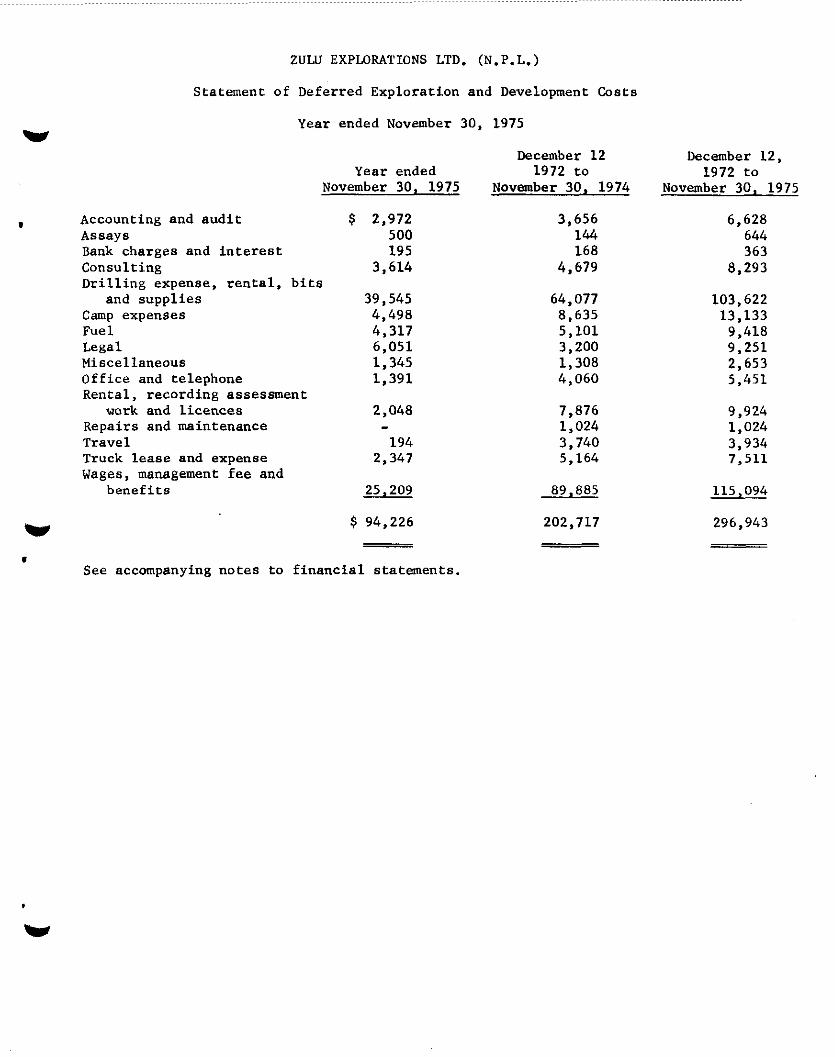
ZULU EXPLORATIONS LTD. (N.P.L.)
Statement of Deferred Exploration and Development Costs
W Year ended November 30, 1975
Year ended November 30, 1975
1 Accounting and audit $ 2,972 Assays 500 Bank charges and interest 195 Consulting 3,614 Drilling expense. rental, bits
and supplies 39,545 camp expenses 4.498 Fuel 4,317 Legal 6,051 Miscellaneous 1,345 Office and telephone 1,391 Rental, recording assessment
work and licences 2,048 Repairs and maintenance Travel 194 Truck lease and expense 2,347 Wages, management fee and
benefits 25,209
W $ 94,226
. See accompanying notes to financial statements.
December 12 December 12, 1972 to 1972 to
November 30, 1974 November 30, 1975
3,656 6,628 144 644 168 363
4,679 a,293
64,077 103,622 8,635 13.133 5,101 9,418 3,200 9,251 1,308 2,653 4,060 5,451
7,876 9,924 1,024 1,024 3,740 3,934 5,164 7,511
89,885 115,094
202,717 296,943
W

ZULU EXPLORATIONS LTD. (N.P.L.)
Notes to Financial Statements
WH November 30, 1975
1. Significant accounting policies:
It is the company's policy to consider all expenses, including administration, as deferred exploration and development costs until a decision is made as
I to whether a mining operation is viable. When such a decision is made, these costs will be smortieed against future revenues of such property. If, on the other hand, the costs did not develop a viable mining property they would be written off to deficit.
2. Mining claims and deferred exploration and development costs:
The deferred exploration and development costs relate to two groups of mineral claims recorded as the U.G. group of 30 claims and the lad group of 120 claims. The company is required to carry out assesamant work in the amount of or pay fees of $200 per claim each year in order to keep the claims in good standing. As of November 30, 1975, assessment work and rentals on these claims were in good standing to various dates from August 14, 1976 to August 21, 1977.
The expenditures and value of work done by the vendors (certain shareholders of the company who were the original owners of mining claims) prior to incorporation totalling $122,750, represents monies spent by them in the amount of $38,700, the value attributed to exploration and development work
w done by them in the amount of $46,550 and the value attributed to shares issued for transfer of the mining properties in the amount of $37,500.
1 3. Share capital:
From incorporation 2,059,875 shares have been subscribed for and allotted as follows:
Shares Par Value Discount Consideration
750,000 vendor shares for transfer of certain mining properties, the value assigned to the property and the shares is $.05 par share
454,500 shares in consideration of cash of $49,400 and value of development work carried out of $46,550
750.000 $3 375,000 337,500 37,500
454,500 227,250 131,300 95,950

ZULU EWZDRATIONS LTD. (N.P.L.)
v Notes to Financial Statements
November 30, 1975 .
3. Share capital (continued):
I Shares Par Value Discount Consideration
855,375 shares for cash consideration 055,375 '427.607 310.221 117,466
2,059,875 1,029,937 779,021 250,916
Less 750,000 vendor shares and 450,000 treasury shares issued 1,200,000 600,000 472.500 127.500
Shares subscribed for, allotted'and unissued 859,875 $ 429,937 306,521 123,416
The 1,200,OOO issued shares are subject to an escrow agreement which restricts the sale of the shares.
Mr. C.C. Keyes, President of Air Power Limited, the largest creditor of the v company, has agreed to purchase 60,000 shares at twenty-five ($.25) cents
per share, for a total of $15,000 to be applied to reduce the company's . account. To date no shares have been allotted to Mr. Keyes.
4. Statutory information:
Remuneration paid or payable to the five highest paid employees of the company, including directors and senior officers, smounted to $25,000 for the year ended November 30, 1975.

w
I
w .
ZULU EXPLORATIONS LTD. (N.P.L.)
Victoria, B.C.
INFORMATION ON APPLICATION TO THE
BRITISH COLUMBIA SECURITIES COMMISSION
June 1975
J.E. Hughes, P. Eng.

TELEPHONE ,604) 477.4228
J. E. HUGHES CONSULTING GEOLOGIST
4155 LONG VIEW DRIVE VICTORIA, BRITISH COLUMBIA
PROPOSAL TO ADOITIONAL EXPLORATION, 1975
.
u
Zulu Explorations propose an addition to their 1975
exploration programme (- as set out in the Report: Information to
the British Columbia Securities Commission for a Rights Offering:
J.E. Hughes, and H.S. Haslam; January 1975). The proposal is for
drilling a third location, P (a), illustrated in Figure 1.
This addition follows earlier recomnendations made by the
consultants, H.S. Haslam, and J.E. Hughes, in their planning,
of the 1975 exploration, December 1974 (see Figure 3).
The proposal for drilling, location P (a) can be described,
as follows:
SPECIFICATIONS
(1) Location, - Lad 90 Claim, or adjacent in the Lad Five
Group of Claims - as shown in Figure 1.
(2) Drilling to be carried into the base of the Tertiary beds
underlying the coal measures, - estimated depth of 420 to 460
metres (1,400 to 1,500 feet).
(3) Beds of economic interest, including the radioactive shale
zone to be cored: cores to be assayed, as appropriate.
COSTS
The estimated cost of drilling location P (a), and related
work (assays, logging, etc.) is $25,000.

REMARKS --__
(1) The drill location P (a), is planned to determine structure,
stratigraphy, and the distribution and grade of uranium and
germanium: and to test the projected flexure and change of
bedding to lower dips in subsurface to the northeast of the
Bowron River.
(2) The proposed drilling, location P (a) will replace drillhole
ZlO which was abandoned at 260 metres (850 feet), at entry into the
coal measures, due to compounding difficulties brought on by
caving in loose shales under the casing.
(3) The proposed drilling, location P (a) is considered adviseable
in order to meet requirements of assessment work, and thereby
achieve economy and useful work instead of payment to rentals:
the record for assessment work on the 40 Claims of Lad Five Group
is due, August 21/75.
(4) In view of the required assessment work, it will be necessary
for Zulu to adjust schedules, and the sequence of its drilling
in the 1975 exploration programme, for the proposed additional
drill hole, location P (a), to be drilled first. and to be completed
by August 21/75.
PLANS
Figure 1. Proposed Drill Hole Addition to Exploration Programme 1975
Figure 2. Drilling 1973 and 1974
Figure 3. Proposed Drill Locations, December 1974
J.E. Hughes, Ph,D., P.Eng.
Consulting Geologist Victoria, B.C.
June 30th 1975

Zulu Explorations Ltd. (NPL)
BOWRON PROPERTY
ADDITION TO EXPLORATION 1975
July 1975
0 P(a) : Proposed drill location
-- .
Scale: 1 cm/500m. .-
: one mile = 1.25 inches approximately

rlgure z \9 < .&&$A
I Zulu Explorations Ltd. (NPL)
&xei
BOWRON PROPERTY
~~f~~~,"~~ :ii: and 1974
-L i p-,
. Zl- 10 Drill holes completed to
depth, by Zulu Explorations
one mile = 1.25 inches, approximately

Figure 3
BOWRON PROPERTY
L--- L Proposed Drill Locations: ;
A, B, - north sector
C, D, - south sector
R F 1 : 50,000 1 mile q 1.25 inch
approximately.
J. E. Hughes, P.Eng.
H. S. Haslam, P.Eng.

Y

- .
/ - Fan>: IS
1. ~ ~~~~‘~;~,“,;,
SECURITIES ACT, 1967 I., .I~ .. ,;*%.a : L-s. .
Report of Ins&r on Changes in Ownership of Capita! Securities
1. hkw of cwporation of which the undcrsigncd is insider .” ___.___.. - ._.__._ -_.-__-- _... -.__- _.__._ -_._-__ ._..._ - .._.__... - _____i_ _ . . . . __-_ . .._ _ ___._ __ I______________________
2. Full name of the _____-____ :.
3. Business addrw of the undcrsi~ncd..~~~~~~~~~~~~~~~~~~~.~~~~~
‘~ 4. Indicate in what capacity or capacities the undersigned qualifies as an insider (see instruction 3)-;.----
&aE.-.~~~~:~~A~Ez --_.. .: .._. - . .._. .-.;....-i _._..._ -___-_-_.____-.__ ’ .‘~. _-_-.-.-- -_.-_ - _.___. -_.-_.-._- ___.. -._-- .______ __ ___.._ _____^__ ..___. ____ /‘..’
5. 1nforma:ion g&n for cakdar x&k of.... __._ ,&&Y&?&~--L%&? ______ :-.- _____ _.._ ___________ _ ‘:~
6. Changs dorinz mo;ith in the undersign& direct or indirect beneficial ownership of capital securities of ., corpora.:ion:-
. . : : Dui&-doa 0: Dcve Of eurc:>xc oi ;“y?;f;cyoy;;;r: *moun: or xxdx~ *es PCI Share or “nit : S~C”iiW SllC nmracrian so,* or Oihervirs JC Which sold o< Pur- Nsture Ol Owncirhip
(se inr;ruccioa 5.) (SIC inrrmclion 6.1, v’ae AWi&d Dispored OI Ch3IEd or Olhciwire (see inlu”ctioll 7.) G.rinrLvsiion 8.) (S<C i”rclYctio” 7.) AcSuirsGlor Diipordo:
..,: : -- .._. -_ _.... - ._.._..__ -__-----.-__-_- __-_ -- _____. _ . .._
z. A__. -----
: .. ~~.------r--..----.-.-..- _.._. -.- .___ -_---_-__-_‘- ___.___ --__-_-_-~L---_-_
-- -.-_-... -_--, _-_- __ _-.. -..--.- ..-- -.- .----- .--,_ --_-- -._.- -__-----. _.--_-.-._---- . ..__ --_..--. -_-- --.--- _~
_--._ ___- .___ -_--._--_.. ..- _..__ -.----. -._-_-__.-___- -.l. ._._ -- __._ --_.. -.---_-_-.. --_---- ._.._......_.__ -.--- _... .--_- _.__ ---..-. - .._.... ----- . .._.. ---~-~~--r..~------ I .~,
7. Ca$al securkks of corporation benefxially owned directly or indirectly by the undersigned at end of .: ~- mor.th:-
DniEn.tiOn olsccurity AmOunt or xum!xr tsrr inl’a4c,io” 5.) (S<ei”s~r”ciian 7.1 ygp$$f$y$
----. - ____ ijjz:~I~~ _____ ..-:I
_- ____ -.- .____..__ -_.--.--_-._-_-..___ _~ _---- _.__. - ____ __ ---__------.-__.__ __ _-_-__- _.. ‘- _---- - :
_--._. --- -_.-- .-.- --_- ---- : -- --- -.--- -.---.- -.----- -
------- ---.--_ -...- ---_---__---.-- I__- __--__--__ ----. ___._- --_- --__---_-_-- _..___ -..z.. ---_---_ _c_________ _____ -_- -_____ -_ -_-._~--.-_~_--__ ----
7% undcrsigncd hcrcby ccrtiGcs that the information given in this report is true and complete in every respect.
It is an o~ccr,ccur.dcr the SccurXes Act. 1967. to tilt a false or mislc~di~~ report. * ,. SCc rzvcrsc r;idc of this form for inst,ruc:iox.
.,,

S U M M A R Y REPORT
- OF A -
DEVELOPMENT DRILLIiilG PROGRAMME (1977)
- ON THE -
BOWRON RIVER COAL DEPOSIT
- FOR -
NORCO RESOURCES LTD.,
#2050 - 200 GRANVILLE STREET,
VANCOUVER, B. C,
KERR, DAWSON & ASSOCIATES LTD. 1 - 219 Victoria Street
Kamloops. B.C.
JOHN Ra KERR, P, ENG,, JANUARY 5TH.N 1978,

JOHN R. KtiFiR. P.ENQ. q EOLOOICAL ENBINEER
January Sth., 1978.
The Board of Directors, Norco Resources Ltd., ft2OSO - 200 Grnnville Street, VANCOUVER, 8. c.
GENTLEMEN :
I am pleased to submit five copies of my final report regarding the 1977 Field Progrnmme on the Rowron River Coal I’ropcrty.
The report is submitted in three volumes:
VOLUME I
VOLUME II
VOLUME III
Only one copy of unnecessary reproduction. all reports.
- Written Text of report, with small maps and appendices.
- l:l,OOO scale sections, with ore reserve calculations.
- Appendix C - Geological Logs
Volume III is submitted to alleviate This volume does not need to accompany
The report incorporates conversion to the metric system. As the programme was completed using American Standards of measurements, reference is made to feet, inches, etc.; however, where confusion may exist, both measurement standards are referred to.
1 must apologize for any ambiguity that may arise in retain- ing the use of American weight standards (BTU/lb; pounds), when reference is made to the value of coal and resin, while converting
GEOLOGICAL BRANCH ASSBSSM.ENT REPORT
00 015 KERfl. DAWSDN AND ASSOCIATES LTD.
CONSULTlNG GEOLOGISTS AND ENGINEERS
.

- 2 -
to the metric tonne in ore calculations. The reason for this is that the marketing of these products are done under American weight standards in the North American continent.
I wish to express my appreciation to the Board of Directors of Norm for entrusting this project and compilation to the staff of Kerr, Dawson and Associates Ltd.
Yours very truly,
KERR, DAWSON & ASSOCIATES LTD.,
GEOLOGIST JRK:rd
Encl.

SUMMARY REPORT
- OF A - RECEIVED end RECORDED
DEVELOPMENT DRILLING PROGRAMME (1977)
- ON THE -
BOWRON RIVER COAL DEPOSIT
NORCO RESOURCES LTD,,
#2050 - 200 GRANVI LLE STREET,
VANCOUVER, B, C.
PREPARED BY:
KERR, DAWSON & ASSOCIATES LTD,, #1 - 219 VICTORIA STREET,
I(AMLOOPS, B, Cm JOHN R, KERR, P, ENG,r JANUARY ~TH,, 1978,

INDEX
SUMMARY ......................
INTRODUCTION ...................
General Statement ..............
Location and Access .............
Topography and Vegetation ..........
Property ...................
History of Development ............
GEOLOGY ......................
1977 FIELD PROGRAMME ...............
COAL RESERVES ...................
COAL QUALITY ...................
RESIN .......................
ECONOMIC POTENTIAL ................
RECOMMENDATIONS ..................
TABLE 1 - SUMMARY OF DRILL HOLES - 1977
TABLE 2 - SUMMARY OF ORE RESERVES
CHART 1 - ORE RESERVE CALCULATIONS
Page No. 1
11
14
20
24
27
29
32
CIIART 2 - RELATIONSHIP OF CALORIFIC VALIJE TO ASH CONTENI

LIST OF APPENDICES:
APPENDIX A
APPENDIX B
APPENDIX C
APPENDIX D
APPENDIX E
APPENDIX F
APPENDIX G
LIST OF MAPS:
Figure 152-I
Figure 152-Z
Figure 153-3
- Cost Estimates
- 1977 Field Expenditures
- Writer's Certificate
- References
- Lab Reports
- Geological Strips
- Geological Logs (Volume III)
- Location Map
- Property Map
- Location of Diamond Drill Holes
GEOLOGICAL SECTIONS:
Figure 152-4 - Section 24 + OON
Figure 152-5 - Section 25 + SON
Figure 152-6 - Section 27 + OON
Figure 152-7 - Section 28 + 50N
Figure 152-8 - Section 30 + OON
Figure 152-9 - Section 31 + 50N
Figure 152-10 - Section 33 + DON
Figure 152-11 - Section 34 + SON
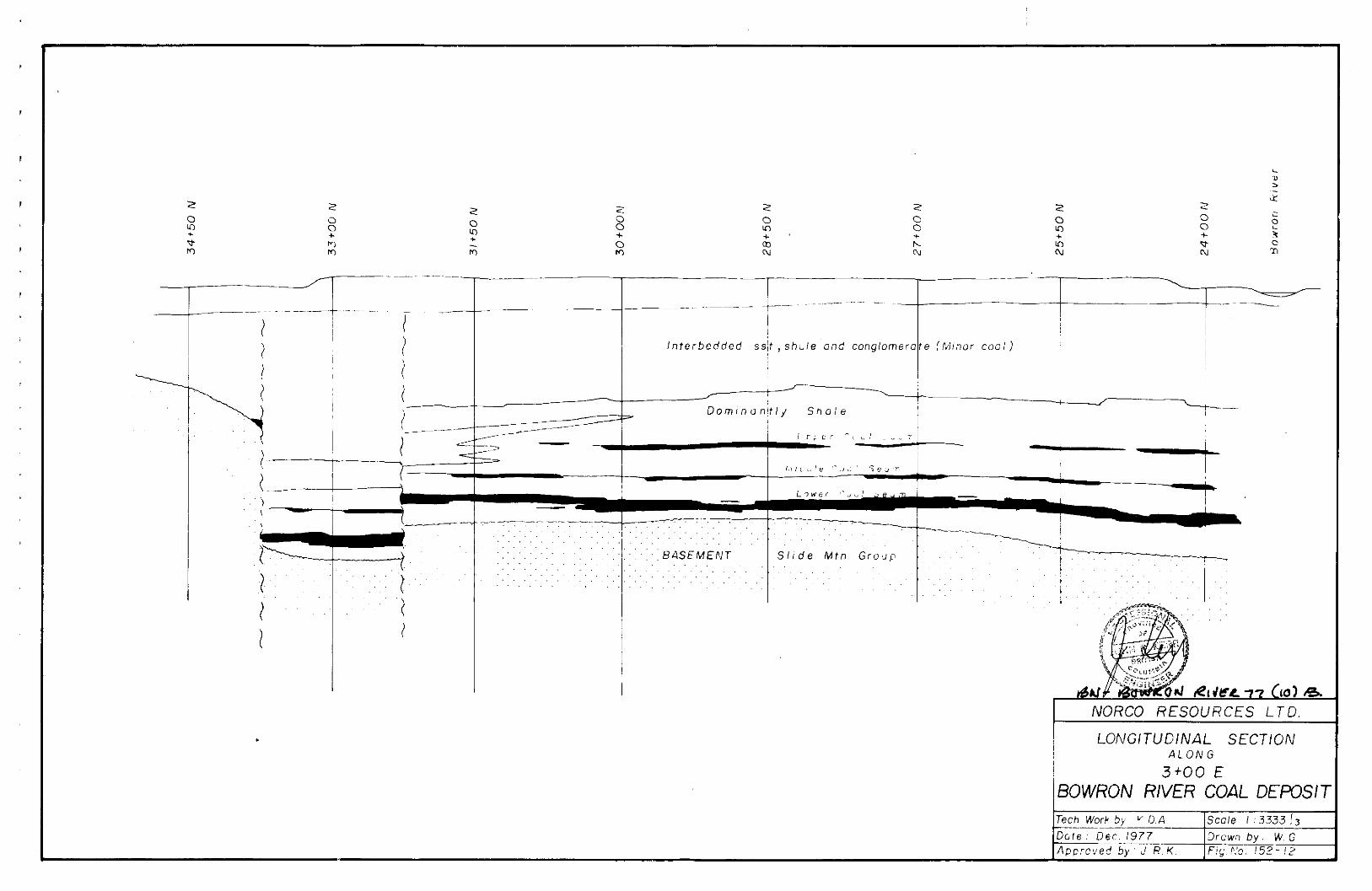
Figure 152-12 - Longitudinal Section

ORE RESERVE SECTIONS (VOLUME II):
Figure 152-13 - Section 24 + OON
Figure 152-14 - Section 25 + SON
Figure 152-15 - Section 27 + OON
Figure 152-16 - Section 28 + SON
Figure 152-17 - Section 30 + OON
Figure 152-18 - Section 31 + SON
Figure 152-19 - Section 33 + OON
Figure 152-20 - Section 34 + SON
Figure 152-21 - SURVEY MAP

1.
SUMMARY
During 1977, Norco Resources Ltd. completed
a development drilling programme on three coal licences
in the Bowron River valley, 40 miles east of Prince George.
The objective of the programme was to establish reserves
in a small portion of the Bowron River coal basin.
The reserves in the basin are summarized as follows:
PROVEN (Probable) RESERVES - 5,940,OOO Tonnes
Kerr (1977) - 90% Proven
DRILL INDICATED RESERVES - 55,000,OOO Tonnes
Trenholme (19751, Revised
Kerr (1977)
UNEXPLORED POTENTIAL
Dolmage, Campbell,
and Associates (1975)
- lOO-250,000,OOO Tonnes
The three Norco licences contain all the proven
reserves, 70% of the drill indicated reserves, and only
10% of the unexplored portion of the basin. Additional
licences have been applied for, to cover the full extent
of the basin.

2.
The coal is indicated to be a good quality
thermal coal, ranked as High Volatile B Bituminous.
Tests performed on clean coal (9% ash) substantiate a
12,360 BTU/lb. product. Run-of-mine coal contains an
averape ash content of 37%, with an average thermal rating
of 8,090 BTU/lb. Sulphur content is indicated to be
1.30%, however is contained partly in sulphide minerals.
Natural resins occur in coal and interbedded shale.
The “Amber” resin is megascopic, occuring as blebs up to
1.5 cm in diameter. Visual estimates indicate an average
content of 1.05%. The “Refined” resin is microscopic,
occuring as part of the hydrocarbon of coal. Earlier
research has indicated contents of 5 - 8%.
Wright Engineers Ltd. have completed a prelim-
inary feasibility study of a proposed 900 Tonne/day mining
operation. Conclusions indicate that the cost of producing
an 11,000 BTU/lb. coal product would be $33/Tonne. ($301
short ton). The optimum market for a 900 Tonne/day coal
product would be sales to local Prince George pulp mills,
val~ued at $lS.gO/Tonne ($14.30/Tori). The economics of a
900 Tonne per day operation would depend entirely upon the
content, quality, recoverability and marketability of the
contained resins.

3.
The value of the resin has not yet been
determined. “Amber” resins are reported to be sold in
North America with values ranging from $0.40-l.SO/lb.
It is obvious that if a 900 Tonne/day operation is
economic, much more research is required regarding the
true value of the resin in the Bowron River coal.
Better markets do exist for the coal. Ontario
Hydro pays $1.85/million BTU for Alberta coal. This
represents $44/Tonne for an 11,000 BTU/lb. coal product.
Japanese, Korean, and European markets have not yet been
exploited. Transportation is the key determining factor
in studying the economics of distant markets.
For the following reasons, a 500 - 1,000 Tonne/
day operation is not the optimum production rate for
Bowron River coal:
(1). The cheapest form of ground transportation are unit
trains, demanding a minimum production rate of
3,000 Tonnes/day.
(2:). A larger mining operation would reduce the unit costs
of production.

4.
(3). B. C. Hydro would consider installing a
generating station on site with a minimum
capacity of 600 Megawatts. This represents
a minimum production rate of 5,500 Tonnes/day.
It is therefore recommended that further work
on the property be oriented at developing a 3,000 - 6,000
Tonne/day operation. Further work includes continued
development drilling, large diameter drilling for bulk
samples and continued laboratory, market and feasibility
research of the coal and by-products. The cost of the
recommended programme is $625,000.
m
m
a
m
m
I
__,-.., _I_......,._._.... .,, .,.. .,,._.-
NORCO RESOURCES LTD.
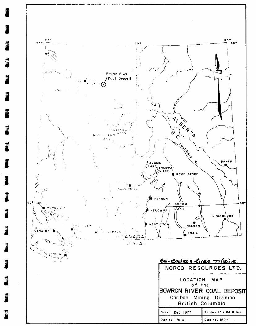
LOCATION MAP of the
BOWRON RIVER COAL DEf=OSl Caribao Mining Division
British Columbia

5.
INTRODUCTION
GENERAL STATEMENT:
Norco Resources Ltd. have completed an initial
phase programme to develop coal reserves in a small
portion of the Bowron River coal fields. During the
period April 22nd. - October 25th., 1977, 25 holes
totalling 5701.3 m. (18,706 ft.) were completed. This
report summarizes all work completed during the 1977
field season.
Kerr - Dawson and Associates Ltd. were engaged
by Norco Resources Ltd. to supervise all aspects of the
field programme. The terms of engagement are summarized
as follows:
(1).
(2).
(3).
(4).
(5).
Supervise the drill programme and on-site field
activities.
Provide detailed geological logs of each drill hole.
Prepare suitable samples of coal intersections for
laboratory analysis.
Prepare sections of the drill holes, indicating
geological coal reserves.
Compile all data in report form.

6.
The writer managed all aspects of the
development programme, and was present on the property
during the periods April 22 - May 6, May 12 and 13, May
25, August
11 - 14,
. Mr. T. D.
Lewis, resident geologist under the empl
Dawson and Associates Ltd. was responsib
activities and logging of the drill core
17 - 20, June 1 - 3, July 5 - 7, July 19 -
3 - 5, August 29 - September 2, September
October 6 and 7, and October 18 - 20, 1977
OY
le
of Kerr -
for all field
The writer acknowledges the immense amount of
back-up services and data supplied for this compilation.
L. s. Trenholme, P. Eng. contributed essential information
of previous programmes completed on the property. Nick
Krpan, P. Eng. of Wright Engineers Ltd., provided technical
information regarding feasibility of mining, processing
and marketing the coal and byproducts. 3, Sharpe,B.C.L.S.
and T. Connelly, B.C.L.S. of Underhill and Underhill,
provided data from previous surveys and completed a com-
prehensive ground and airborne photogrammetric survey of
the property. Mr. K. Douglass, P. Eng., has investigated
various environmental aspects of developing and mining coal
from this area of British Columbia. Messrs. M. M. Menzies
and H. J. Wilson, directors of Norco, have provided utmost
cooperation in authorizing essential back-up services for
the overall success of the project.

7.
LOCATION AND ACCESS:
The property is located in the Bowron River
Valley, approximately 56 kilometers east of Prince George,
B. C. Geographic coordinates are 52”ZO’N and 122”W (NTS
Reference 93H/13W l/2).
Access to the mine camp on the west side of the
Bowron River is possible along a gravel logging road,
59 km. east of Highway #97 at Buckhorn. Buckhorn is a
small community, 16 km. south of Prince George. Access
to the licences on the east side of the Bowron River is
possible along a gravel logging road, 8 km. south of
Highway #16 at Purden Lake. Purden Lake is 64 km. east of
Prince George. There is no bridge across the Bowron River
at the mine site.
TOPOGRAPHY AND VEGETATION:
The property is located in the broad, flat -
bottomed valley of the Bowron River. Relief is in the
order of 490 m. ranging from 730 m. (~a.s.1.) in the Bowron
River to over 1,220 m. (a.s.1.) in the surrounding hills.

8.
a
a
m
a
a
a
a
I
1
a
a
I
a
a
a
I
I
a
PROPERTY:
The Norco property consists of three contiguous
coal licences, numbered 148, 162, and 163, identified as
Lots #9591, #9692, and #9593 on Provincial Land Maps.
The licences are registered to Norco Resources Ltd. under
the Coal Act of British Columbia. Additional contiguous
licences have been applied for; however, have not been
granted at this time.
Work completed on the property during 1977 is
sufficient to hold the licences for several years. All
documents for licence extension were properly filed prior to
the date of licence expiry - November llth., 1977.
The three licences contain 70% of the drill
indicated and inferred reserves, as discussed in this
report.
HISTORY OF DEVELOPMENT:
Coal was discovered in the Bowron River Valley
in 1870 by G. M. Dawson of the Geological Survey of Canada.
Prior to 1960, several small companies and operators explored
and developed the near surface coal measures. It is reported
that some coal was hand sorted, shipped and sold locally
in the City of Prince George.

m Proven Reserves 5,940,OOO Tonnes
p. I] Dr111 lndrcored Reserve Area I _______ -L--__----d 55,000,OOO Tonnes
El Unexplored Bowron River Sedlrntnts Potentiol Reserves

9.
Northern Coal Mines Ltd. acquired coal licences
covering the entire basin during the 1960’s. During the
period 1964 - 1966, approximately 3’2 drill holes, 50 - 150m.
deep, were completed near the surface project of the coal
seams. Results of this programme are very poorly documented _~,~ .-_ .~~
and the core has been destroyed; therefore, data cannot
be used for coal reserve calculations.
During 1967, under the supervision of Dr. J. M.
Black, 10 BQ diamond drillholes, 200 - 400111. deep, were
completed. Information from these holes is well documented
and most of the core is in tact at the mine site. Some of
this core is being relogged and resampled, and can be used
for coal reserve calculations.
(a)
(b)
During 1966 and 1967, two entries were driven:
The north “entry” slope was driven at -12 degrees to
expose coal from the upper and middle coal seams. The
entry is within the southern portion of current
drilling area.
The south “entry” slope, 1,000 m. to the southeast,
explored the upper seams of coal and is outside the
current drilling area.
Northern Coal Mines Ltd. optioned the property
to Bethlehem Copper Mines Ltd. during 1971. Under the

10.
supervision of Dr. R. E. Kucera, Bethlehem completed
five NQ diamond drill holes to establish the nature and
structure of the coal measures at depth and at the eastern
limits of the coal basin. Dr. Kucera compiled a
comprehensive report including detailed stratigraphic
and structural interpretation based on drill core studies,
surface mapping and photogeological studies.
During the period 1971 - 1976, there was no
exploration or development work on the property. Due to
their inability to maintain commit:ments, the company
dropped all but three of the key coal licences. The
company was reorganised and renamed Norco Resources Ltd.
During the fall of 1976, under the supervision
of H. S. Haslam, P. Eng., the north “entry” was dewatered
so that a 12 tonne sample could be mined from the upper
seam. Eleven tonnes of this sample were shipped to the
Department of Energy, Mines and Resources and Cyclone
Engineering Sales Ltd. in Edmonton for coal analysis.

11.
GEOLOGY
The Bowron River coal deposits occur in the
basal unit of Tertiary sediments, consisting of shale,
sandstone and conglomerate. The sediments were
deposited in a graben-formed basin, unconformably
overlying tuffs and volcanic rocks of the Mississippian
Slide Mountain Group. The depositional environment of
the basal unit was a quiet, shallow, inland lake, contained
over the full extent of the basin. Three continuous seams
of coal have been interpreted from drill results completed
to date, suggesting that extensive swamp conditions
prevailed over most portions of the basin in at least
three periods of time.
Lower Seam - 1.5 - 9 m. thickness of coal is located 18 - 36 m. above the basement unconformity.
Middle Seam - 3 - 3 m. thickness of coal is located 24 - 30 m. above the lower seam.
Upper Seam - A discontinuous seam of coal up to 24 m. thick is located’18 m. above the middle seam.
Immediately overlying the lower coal seam, a
one foot thick fragmental (angular) rock occurs. This
rock is quite unique to the sedimentary sequence, and
may have had a volcanic (pyroclastic) origin.

12.
There are local conglomerate beds in the
basal unit, ’ marking discharge points of feeder creeks
in the basin. The basal unit of the sedimentary sequence
is estimated to be 90 m. thick.
Subsidence in the basin, probably more rapid
than deposition, created deep water with only local
swamp conditions. Deposition in the lake included mud,
silt, sand and gravel, giving rise to the upper unit
(600 m. thick) of irregularly interbedded sandstone,
shale, and conglomerate.
During deposition, there is evidence of more
rapid subsidence of the basin to the east. After deposition
further subsidence to the east and/or uplift to the west
gives rise to the current structural trend of the beds -
strike 150 degress; dip 20 - 35 degrees NE.
At least three post-depositional faults are
interpreted in the area of intense drilling. All faults
have a steep-vertical dip. The western fault appears
to mark the western limit of exposed Tertiary sediments.
This fault is definitely post-depositional, and cannot

13.
he interpreted as the main graben structure forming
the western limits of the basin. The fault caused
uplift of at least 100 meters.
Very little information is known of the
northern fault lying between L33+00N and L34+50N.
DDH #77-20 intersected 100 meters of sediments before
entering the basement, None of the three major coal
seams were intersected. It is apparent from logs of
the drill hole that the sediment/basement contact was
not a fualt. The fact that no coal occurs in the lower
50 - 100 meters of the sediments, leads one to the con-
clusion that the basement was high before deposition.
Therefore, the interpreted fault is possibly pre-deposition.
Further drilling in this area is required to substantiate ,/”
this interpretation. The economic significance of this
structure is important, as this may terminate extensions
of the coal seams to the north.
Geological logs, rock descriptions and a geolog-
ical section of each hole is presented in Appendices F & G of
this report.


n
l
1
I
I
I
I
n
I
I
I
1
I
1
I
l
I
I
I
14.
1977 FIELD PROGRAMME
The 1977 field programme was primarily a
development drill programme to establish proven reserves
in a small portion of the Bowron River coal fields. The
objective of the programme was to establish 2,700,OOO -
4,500,OOO tonnes (3,000,OOO - S,OOO,OOO tons) of clean
Coal, sufficient to initiate a 500 - 1,000 tonne per day
mining operation. This is being accomplished by drilling
an area 1,050 meters long by 750 meters wide at 150
meter centers. Although 150 meter centers will not
fully delineate the lenticular nature of the coal seams,
it is hoped to provide sufficient data to compile a
statistical estimate of proven reserves. Figure; #152-3
indicates the selected area, and the location of diamond
drill holes.
The selection of the area was based on the
following parameters:
(1). An area where previous drilling had indicated the
best quality coal over the thickest and most
continuous seam.
(2). An area where the coal seams are relatively close
to the surface and provide a tolerable dip for
mining purposes.

(3). The area most likely to contain all required
15.
Coal.
(4). An area where previous drilling had indicated
consistent resin content throughout the coal
seam.
The initial concerns of developing reserves
directly beneath the Bowron River are unfounded. Studies
of mining methods to be used, indicate that sufficient
support will remain to cause no subsidence at the surface.
Four drill contractors submitted tender to
complete a minimum of 4,500 ft. (1,370 m.) of drilling.
C:onnors Drilling Ltd. of Vancouver was awarded the
contract on the basis that their bid was the lowest.
Twenty-five holes totalling 5,701..3 m. (18,706 ft.) were
completed. The table on the following pages summarises
all drill holes.
In summary, the programme was completed in
six months, average rate of 950 m/ma. (3,000 ft./ma.),
using a Royles 45A drill. Size of core is NQ, and core
recovery is considered excellent. In several holes,
difficulty was encountered while drilling through 20-50
meters of very gravelly overburden. Average cost of
drilling was $ll.O6/ft. (36.28/m.)
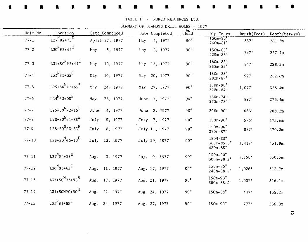
TABLE I - NORCO RESOURCES LTD. SUMMARY OF DIAMOND DRILL HOLES - 1977
Hole No. Location Date Commenced Date Completed Hzd Dip Tests 1s0m-83°
Depth(Feet) Depth(Meters) “?... 77-l 261.3m
77-2 L30N@2+44E 2bOm-81"
150m-85° 225111-83”
O>,'
747’ 227.7m
77-3 L31+50N@2+44E 160111-85~ 25&n-83’ 847’ 258.2111
77-4
77-5 L25+50N@3+b5E
77-b L24'@3+0SE
77- 7. L25+50N@2+1SE
77- 8 L28+50N@1+8SE
77-9 L28+50N@3+3SE
April 27, 1977
May 5, 1977
May 10, 1977
May 16, 1977
May 24, 1977
May 28, 1977
June 4, 1977
July 5, 1977
July 8, 1977
July 13, 1977
Aug. 3, 1977
Aug. 11, 1977
Aug. 17, 1977
Aug. 22, 1977
Aug. 24, 1977
May 4, 1977
May 8, 1977
May 13, 1977
May 20, 1977
May 27, 1977
June 3, 1977
June 8, 1977
July 7, 1977
July 11, 1977
July 29, 1977
Aug. 9, 1977
Aug. 17, 1977
Aug. 21, 1977
Aug. 24, 1977
Aug. 27, 1977
9o”
90”
90”
9o”
90”
9o”
9o”
9o”
90”
9o”
9o”
90”
9o”
9o”
9o”
150m-88" 282111-87~ 927’
lSOm-90" 328~ 84“ 1,07~7'
282.61~
328.4m
150m-74° 273~11-78” 897’ 273.4111
208w9o”
lSOm-90"
683’
57b'
208.2111
150m-90" 2 JOm- 87” 887’
17S.6m
270.3m
77-10 L28+50N@6+10E 150M-88' 300m-85.5° 1,417' 430~85’
431.9m
77-11 L27N@4+25E 15om-9o” 300~88.5” 1,150' 350.5m
77- 12 L30N@3+bSE 150~86' 240m-88.5' 1,026' 312.7m
77-13 31b.lm
77-14 L31+50N@0+90E
150m-90" 300~88.5” 1,037’
150m-88" 447’
150m-90° 777’
136.2111
77-15 236. &II

TABLE I - (continued)
SUMMARY OF DIAMOND DRILL HOLES - 1977
d Depth Depth Hole No. Location Date Commenced Date Completed Head Dip Tests (Feet) (Meters)
77-16 L30N@0+60E Aug. 28, 1977 Aug. 29, 1977
L28+50N@4+70E Aug. 29, 1977 Sept. 15, 1977
90' 207' 63.lm
77-17 90"
77-18 L30N@5+95E Sept. 15, 1977 Sep,t. 24, 1977 90”
77-19 L31+50N@5+90E Sept. 26, 1977 Oct. 1, 1977 90'
77-20 Oct. 4, 1977 Oct. 6, 1977
Oct. 11, 1977 Oct. 13, 1977
Oct. 13, 1977 Oct. 15, 1977
Oct. 15, 1977 Oct. 16, 1977
Oct. 17, 1977 Oct. 22, 1977
Oct. 23, 1977 Oct. 25, 1977
90" 347' 105.8m
77-21
77-22
77-23
77-24
77-25
90" 117' 35.6111
90" 116' 35.3m
90" 147' 44.8m
9o" 437' 133.2m
90' 377' 114.8m
150m-90" 3001~80" 37011-82" 150~90" 300m-85.5" 381m-85" 150m-88' 30&n-86"
1,217' 370.8m
1,252' 381.6m
1,137' 346.4~1
Totals 18,706' 5,701.3m
Type of Drill - Boyles Brothers 45A
Size of Core - NQ
Core Recovery - - Q8%
Average Drill Cost - $ll.O6/ft. (36.28/m.) u

18.
All core was collected at the drill site in
5 ft. (1.52111) core boxes, and transported to the main
camp, where it was logged in detail (See Appendix G).
Geological strips were prepared for each hole (Appendix
F) Coal intersections from the main seam, for all holes
were sampled. Samples consist of split core over a
continuous length of the coal intersection. Samples from
holes #77-l through ~477-7 were shipped to Cyclone
Engineering Sales Ltd. in Edmonton, Alberta, and samples
from holes #77-8 through #77-19 were shipped to
Commercial Testing and Engineering Co. in Vancouver, B. C.
Analysis included ash content, fixed carbon, volatile material,
moisture content, sulphur content and BTU/lb. Samples
were analyzed on an as-received and dry basis. The labs
were asked for a visual estimate of amber resin content,
Lab results are included as Appendix E.
During the period October 17 - November 20,
1977, a permanent core storage facility was built at the
main campsite. All core is stored in this building.
During the period September 8 - 23, 1977,
Underhill and Underhill completed a topographic survey of
the project area. This survey included:

19.
(1).
(2).
(3).
(4).
Locating old Iron Pins from 1967 survey.
Surveying in all 1977 drill holes.
Establishing survey points and targets
for, air photographs.
Low - level air photography for detailed
ground mapping on a scale of 1:2,500 ft. The
mapping has not been completed.
All survey pins and drill holes have been tied
i.nto the UTM coordinate system, with coordinates expressed
i.n meters. Underhill has provided a 1:50,000 scale map
of all drill hole locations, included as Figure #152-21 of
t.his report.
Wright Engineers Ltd. prepared a preliminary
feasibility study of a 900 Tonne/day operation at
Rowron River during the period July 20 - November 10,
1,977. Nick II. Krpan, P. Eng., L. S. Gormely, P. Eng.,
and G. B. Henson, P. Eng., of Wright contributed data regard-
ing methods and costs of the operation, and potential markets
for the coal and resins. K. Douglass, P. Eng., an independ-
ent consultant, contributed data pertinent to some of the
environmental impacts of such an operation. The writer
contributed data pertaining to the geology and 1977
development programme.

20.
COAL RESERVES
Ore reserves in the Bowron River basin have been
classified into the following three categories:
I. PROVEN (Probable) RESERVES: Based on the results
of the 1977 field programme, 5,940,OOO Tonnes of
“run-of-mine” coal were established in the
selected area of intense drilling. By the methods
and parameters used (Chart l), 90% of these reserves
are classified as proven reserves, the remaining
10% classified as probable reserves.
The average ash content of the proven coal
reserves is calculated at 37%. All of the ash can be
c,onsidered shale, occuring as small lenses and seams within
the coal. Therefore 3,683,OOO Tonnes of clean coal exist
within the proven reserves.
Proven geological coal reserves contain lenses of
barren shale, which may be sorted during a mining process.
1,798,OOO Tonnes of barren shale (waste) are included
within seams of proven reserves. These lenses of barren
shale do contain minor coal content ( < 50% by volume),
therefore further analysis of drill core is reuiqred to
study the dilution effect of the barren shale during a min-
ing process.

COAL RESERVE CALCULATION
Assume :
S,G cool = I,45 S,G~ shale = 2 5 D~st~ncc? befwec;, sectmns z 152 4 m
VT - Totul Vu!‘ime vcc ^ Vofume cleuri cucl VsS - Volum? bnverr snoie V,C - Vol,.~nt2 shc;e in xol
VS % - % shufe 1~;~ volonre ws % % shale t y w=igt,t
= ash 3mtent
. . V SC = I VT - VBS ) x I. 45 ws of_-,- m3 2.5- 1.05 Ws%
. . To r1 ii ‘ s Clean Coul = VCC x 1.45
Jonn~s Shale in Coul = WC X 2.5
50 n n e s Barren Shale = Ves x 2.5
mL Chart No. I

21.
Table 2, on the following page, summarizes
the section by section coal reserves. Figures 8152-13
through #152-20, indicates the individual reserve blocks
as calculated.
II. DRILL INDICATED (Possible) RESERVES:
L. S. Trenholme, in 1975, estimated the drill
indicated reserve potential of the Bowron River
Basin as 74,000,OOO Tonnes (81,000,000 short tons).
These reserves were based on wide spaced drill
holes (avg. 7 600111)., with some of the data very
poorly documented. Included in the estimates were
seams of coal, less than the minimum thickness of Y
mining. The writer has reviewed the 1975 Trenholme
calculation process, and with the knowledge of the
1977 reserve calculations, feels that Trenholme’s
estimate was 10 - 15% too high. Therefore, the
drill indicated reserves of the Bowron River basin
have been revised to 55,000,OOO Tonnes.

NORCO RESOURCES LTD. ORE RESERVES - TONNES CONTENTS
Shale Run-of-Mine % Barren Atier Cal.Value
24+00N
Seam
Lower Other
Clean Cm1 in Coal Coal Proven Shale Resin Sulphur BTU/lb.
223,580 102,400 325,980 79% 12,820 136,570 127,560 264,130 91% 1.0% ~.84% 8,030 ___
25+50N Lower 405,850 189,660 595,510 78% 186,070 1.6% 1.31% 9,280
27+00N Lower 601,900 351,500 953,400 77% 273,630 Other 189,360 86,780 276,140 65% 148,760 1.2% 1.62% 8,278
28+50N Lower 454,210 206,250 660,460 100% 276,140 Other 116,900 125,350 242,250 100% 61,680 1.0% 1.74% 9,184
30+OON Lowe* 415,940 280,520 696,460 96% 280,350 Other 67,X50 38,990 106,840 100% 46,790 .9% 1.19% 7,000
31+50N LCWer 557,340 410,110 967,450. 95% 258,220 .8% 1.17% 7,525
33+00N Lower 513,490 337,840 851,330 100% 253,750 1.0% 1.08% 7,706
34+50N _- __ __ -- __ _- _-
TOTALS 3,682,990 2,256,960 5,939,950 90% 1,798,210 Avg. 1.05% 1.30% 8,090
Ore Reserve Calculations Based on SG Coal - 1.45 SG Shale- 2.5
Amber Resin Content - Visual Estimate
Average Ash Content - Shale in Coal Run-of-Mine Coal x 100 = 37%

23.
III. UNEXPLORED POTENTIAL: With the knowledge that
coal seams exist in the basal 100 meters of the
Bowron River sediments, it is not unreasonable to
project potential reserves into areas of the basin
that have not been explored by drilling; however,
which are known to contain outcrop of the Bowron
River sediments. Dolmage, Campbell and Associates
in a report to B. C. Hydro (1975) estimated the
ultimate potential of the Bowron River basin to
contain an additional 100,000,000 - 250,000,OOO
Tonnes.
The following summarizes the total geological
potential reserves at Bowron River.
PROVEN RESERVES - 6,000,OOO Tonnes
oRILL INDICATED RESERVES -55,000,OOO Tonnes
UNEXPLORED POTENTIAL RESERVES -100 - 250,000,OOO Tonnes
TOTAL RESERVE POTENTIAL -161 - 311,000,000 Tonnes
Figure #152-Z indicates the areas of the three
classifications of reserves.

24.
COAL QUALITY
Bowron River coal is indicated to be a good quality
thermal coal, ranked as High Volatile B Bituminous. Tests
pcrformcd on ~J,ean coal (9% ash) from a 11 Tonne bulk
sample substantiate a 12,360 BTU/lb. coal product. It is
possible that some of the coal may be used as a blend Ear
metallurgical purposes.
Tests completed on drill core submitted for
analysis indicate an average of 8,090 BTU/lb. for the coal
product with included ash content (37%). The clean coal
(ash content removed) would provide a greater energy product,
approaching 13,000 BTU/lb. The graph on the following
page (chart 2) substantiates this estimate.
Chart 2 illustrates several interesting features
of the quality of the coal.
(1). The relationship of the ash content to the calorific
value (BTU/lb.) is a straight line progression..
(2). The true quality of a clean coal product in the tested
area of the basin apparently is quite uniform (’ 200 BTU/lb.)
(31. The slight deviation of the samples may reflect a
laboratory error. It is interesting to note that the Cyclone
analyses are higher with respect to the line, than the

t
I I I I I ‘\,
0 it, x .? ‘d 4c1 fO
AsI? content % ( by weight )
BOWRON RI’dfR C3AL DEPOSIT
RELATIONSHIF OF CALOGlFlC VALUE TO ASH CONTENT

25.
Commercial analyses
(41. Given the ash content, it is possible to estimate
the calorific value to + 200 BTU/lb. -
(5:I. Indication from analysis of only one 1967 core
sample is that the thermal quality of coal does not
significantly deteriorate when exposed for great periods
of time (10 years).
Total sulphur content of drill core averages
1.30%. Sulphide minerals, pyrite and marcasite, have been
recognized on fracture faces, and are believed to contribute
significantly to the sulphur content. Coal washi’ng and
beneficiation tests are required to determine the extent
to which sulphide cont’ent can be reduced.
Preliminary investigations by Wright Engineers
Ltd. have indicated several potential markets for thermal
coal.
(1:I. B. C. Hydro: -
Value to supplement coal at the Hat Creek generating station
- $0.50/million BTU

26.
(2). Prince George Pulp Mills:
Currently pay for llog Fuel
- $0.66/million BTU
(31. Ontario Hydro:
Value at Ontario generating stations
- $1.85/million BTU
(41. Alberta Utilities:
Has sufficient supply of coal - very unlikely to import.
Other potential markets for the coal are
Japanese, Korean, U. S. and European utility companies.
The value of coal to these countries have yet to be
exploited. With the projected energy demands for the mid
nineteen eighties, the value of thermal coal, especially
in foreign markets, is expected to dramatically rise.

27.
RESIN
Two types of natural resins occur within the
coal measures at Bowron River.
(1:). “Amber” resin occurs as blebs (up to 1.5 cm.
diameter), generally elongated along the bedding
plane axis, within the coal and interbedded shale.
Visual estimates of the drill core indicate an average
“Amber” resin content of 1.05% (Table 2). Satisfact-
ory laboratory methods for determining the “Amber”
resin content have not yet been established.
Cyclone Engineering attempted “sink float” and “hand
sorting” methods of analyzing the resin conent. The writer
feels these estimates are inadequate. The best estimate of
the “Amber” resin has been visual estimates in drill core.
Experimentation has been done to improve the visual estimates
by tracing the resin blebs on paper to identify and compare
with known “percentage content”charts.
(21. “Refined”resin is microscopic and is believed to be
part of the hydrocarbon of the coal. Previous research
by Batelle Memorial Institute indicates that the
“Refined” resin is totally soluable in pyridine and
content estimated to be 5 - 8%.
28.
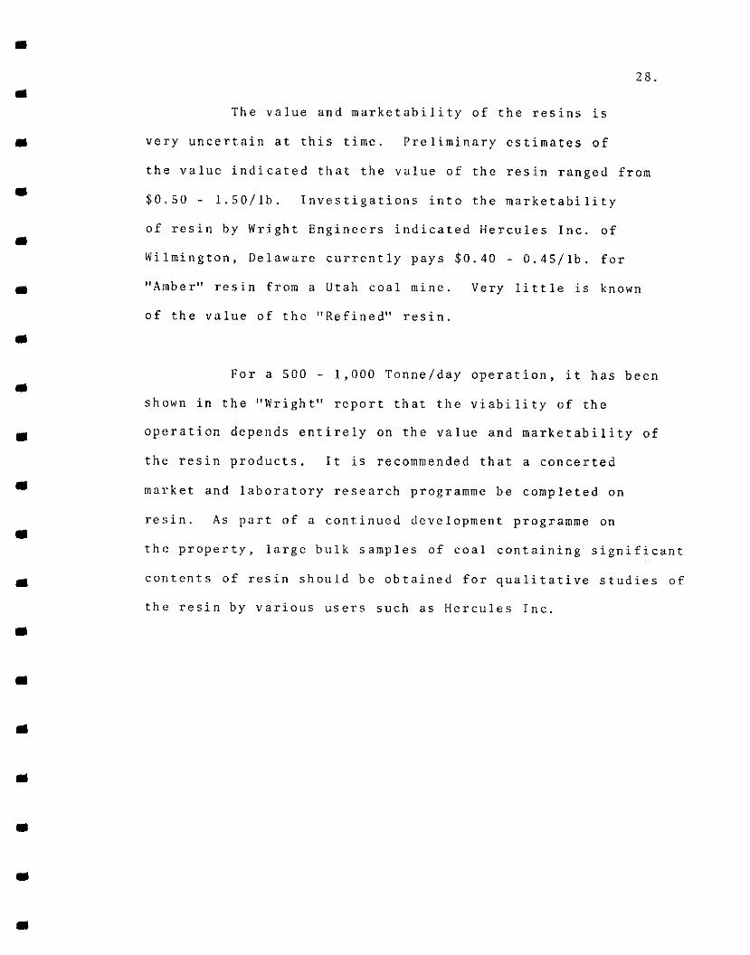
The value and marketability of the resins is
very uncertain at this ti.mc. Preliminary estimates of
the value indicated that the value of the resin ranged from
$0.50 - l.SO/lb. Investigations into the marketability
of resin by Wright Engineers indicated Hercules Inc. of
Wilmington, Delaware currently pays $0.40 - 0.45/lb. for
“Amber” resin from a Utah coal mine. Very little is known
of the value of the “Refined” resin.
For a 500 - 1,000 Tonne/day operation, it has been
shown in the “Wright” report that the viability of the
operation depends entirely on the value and marketability of
the resin products. It is recommended that a concerted
market and laboratory research programme be completed on
resin. As part of a continued development programme on
the property, large bulk samples of coal containing significant
contents of resin should be obtained for qualitative studies of
the resin by various users such as Hercules Inc.

29.
ECONOMIC POTENTIAL
In the Interim Conceptual Study of the Bowron
River Coal Deposit by Wright Engineers Ltd., the operating
cost to produce an 11,000 BTU/lb. coal product for a
900 Tonne/day operation, has been estimated at $1.39/million
BTU or $33/Tonne.
Considering the excessive freight rates to
distant sales outlets, the Prince George pulp mills appear
to be the optimum market for a 900 tonne/day operation.
The value of the coal sold at Prince George is $0.66/million BTU,
or $lS.gO/Tonne less transportation costs. Therefore, the
economics of the deposit would depend on a minimum value
of $17.00/tonne of the contained resin.
The visual estimate of 1.05% “Amber” resin
(2:3 lbs. /Tonne), with values of $0.40 - l.SO/lb. indicates
a potential value of $9 - 34/Tonne. With better estimates
of the content and market value of resin, the economics
of a 900 Tonne/day operation could be more fully evaluated.
The value of the “Refined” resin has yet to be established.

30.
It is felt that the objective of a 500 - 1,000
Tonne/day operation may not be the most optimum for the
Bowron River Coal deposit.
(1). The best markets available for coal are outside
the Province of British Columbia. Transportation
rates are greatly reduced by employing unit trains
- a minimum of l,OOO,OOO Tonnes/year (3,000 Tonnes/day).
(21. The unit operating costs of a larger mining operation
would be somewhat lower than a 900 Tonne/day operation.
(3). B. C. Hydro has stated that the minimum sized generat-
ing station they would consider on site would be 600
Megawatts, with a minimum coal reserve for 35 years.
This, in the writer’s opinion, would provide the
best ultimate market for the coal. Such an operation
would demand production of 5,500 ‘Tonnes/day of an
11,000 BTU/lb. coal product. Ultimate reserves would
have to be established at a minimum of 70,000,OOO
Tonnes.

It is felt that at a larger scale of mining,
say 3,000 to 6,000 Tonnes/day, the Bowron River coal
reserves may be economic on marketing the coal alone.
Further feasibility and market studies are required to
substantiate this statement.
31.

32.
RECOMMENDATIONS
Continued development work is recommended, which
is oriented at proving substantial reserves for a 3,000
- 6,000 Tonne/day operation.
(1).
(2).
(3).
10,000 meters of NQ diamond drilling, in an area
to the south and east of the 1977 area. Drill hole
spacing should be 300 meters, with 150 meter spacing
in areas of faults and geological contacts.
1,000 meters of large diameter diamond drill holes
(. lo-. 15 meters) to obtain a sufficient bulk sample
of coal ( l/2 - 1 tonne) for quality studies of the
coal and resin. 7 - 8 holes are required, each 120 -
150 meters deep. The location of the holes should
be in areas known from the 1977 programme to contain
substantial thicknesses of coal (> 6 meters), and
high resin content.
Continued laboratory testing of coal properties
and research regarding resin quality and content.
33.
I
I
(4). Continued mine feasibility studies, environmental
studies and market research of the coal and by-
products.
Costs for the above programme are estimated
at $625,000.00 and are shown in Appendix A.
Respectfully Submitted By:
KERR, DAlYSON & ASSOCIATES LTD.,
Kerr, P. Eng.,
Kamloops, 8. C.,
January Sth., 1978.

APPENDIX A
COST ESTIMATES

COST ESTIMATES
Diamond Drilling
NQ - 10,000 meters @ $40.00/meter . . . . $400,000
Lnge Diameter 1,000 meters @ $lOO.OO/meter . . . . . . . 100,000
LabTestingand Research . . . . . . . . . . . 10,000
Continued Mine Feasibility '. . . . . . . . . 30,000
Supervision, includes compilation of data and report. . , . . . . . . . . . . 45,000
Room and Board . . . . . . . . . . . . . 6,000
Supplies, Travel, Equipment rental, etc. . . . 34,000
TOTAL . . . . . . . $625,000

APPENDIX B
EXPENDITURES - 1977

EXPENDITURES - 1977
Consulting . . . . . . . . . . . . $29,897
Diamond Drilling (18,706 ft.) . . . . . . . 206,837
Equipment Rental . . . . . . . . . . . . 9,551
Assays................... 920
Travel . . . . . . . . . . . . . . . . 3,586
Misc. Supplies and Services . . . . . . . 13,493
Feasibility and Environmental Study . . . . 32,000
Core Storage Facility . . . . . . . . 13,500
Survey Control ............... 12,000
TOTAL ........ $321,784
I HEREBY CERTIFY that the expenditures to the best of my
knowledge, represent a true and actual cost of work per-
formed on the Bowron Rivaf~'&ai.*+posit during 1977.

APPENDIX C
WRITER’S CERTIFICATE

JOHN R. KERR, P.ENO. BEOLOGICAL ENGINEER
I, JOIIN R. KERR, 01’ Tllli CITY 01: KAMl.OOl’S, DO IIERliRY CliRTIl’Y TIIAT:
(1). I urn a member of the Association of Professi~onal I:nginccrs in the Province of British Columbia, and a, Fellow of the Geologica, Association of Canada.
(2). 1 am employed by Kerr, Dawson, and Associates Ltd., with my office at ii1 - 219 Victori~a Street, Kamloops, R. C:
(3). I have practised continuously as a geologist since graduation from the IJniversi.ty of I3ritish Columbia in 1964 with a B. A. SC. in Ccological Engineering.
(4). I have not direct.ly or i~ndi,rectly recei.ved nor do I expect to rcccivc any i.ntercst in the properties or securities of Norco Resources Ltd., or any bencfj~cial interest in ?ny of the securi,ties of Norco Resources Ltd.
(5). This report is based on an exhaust,iive study of all available data, published and unpublished reports and my periodic attendance on the property during the initial phase of drilling April 22nd. to October 25th.) 1977.
(6). Permission is hereby granted to Norco Resources Ltd. to use this report to satisfy requirements of Securities Commission, Stock lixchangcs, and the British of Mi~ncs.
Kam loops, B. c., .January 5th.. 1978.
KERR. DAWSON AND ASSOCIATES LTD. CONSULTINQ GEOLOOISTS AND ENOINEERS

APPENDIX C
REFERENCES

Trenholme, L. S.
Donaldson, J. R.
REFERENCES
- Report on the Bowron River Coal Deposit, January 27th., 1977.
- Report on the Bowron River Coal Deposit, March lOth., 1976.
- NIX-CO Resources Ltd., Summary Report, August 25th., 1975.
- Petrography of the Coal from the Garroway Mine in the Bowron River Coal Area, British Columbia, G. S. C. Report No. 93 - H - 13 W - 1, 1972.
Dolmage, Campbell and Associates Ltd. - Bowron River Coal Deposit, 1975.
Excerpt from "Coal Resources of British Columbia" prepared for B. C. Hydro and Power Authority.
Black. J. M.
Haslam, H. S.
Kerr. J. R.
Wright Engineers Ltd.
Krpan, N. R. Gormely, L. S. Henson, G. P. Douglass, K. Kerr, J. R.
- Report on Northern Coal Mines Ltd., September Sth., 1967.
- Bowron River Coal Mine Dewatering and Bulk Sampling, September, 1976.
- Report on the Bowron River Coal Deposit, March lOth., 1977.
- Interim Conceptual Evaluation, Bowron River Coal Project, November, 1977.
- Numerous other published and unpublished documents, letters, maps, and laboratory and research reports.

APPENDIX E
LAB REPORTS

NORCO RESOURCES LTD.
PROJECT: Bowron River
HOLE #: 77-l
Footage: 632.0 - 637.5
Ash %
R.M. %
'I.M. %
F.C. %
s. %
BTU/lb.
Air-dry Basis Dry Basis
19.13 19.95
4.07 --
32.42 33.79
44.38 46.26
1.24 1.29
10,720 11,170
Estimated knber Resin Content: 0.4%
CYCLONE ENGINEERING SALES LTD.

NORCO RESOURCES LTD.
PROJECT: Bowron River
HOLE #: 77-l
Footage: 639.0 - 647.5
Ash %
R.M. %
V.M. %
F.C. 4:
s. %
BTU/lb.
Air-dry Basis Dry Basis
27.74 28.83
3.77 --
29.39 30.54
39.10 40.63
2.11 2.19
9,370 9,740
Estimated Amber Resin Content: 0.3%
CYCLONE ENGINEERING SALES LTD.

I
I
I
m
m
m
a
m
I
a
m
m
m
m
1
m
I
m
NORCO RESOURCES LTD.
PROJECT: Bowron River
HOLE #: 77-1
Footage: 651.5 - 659.0
Ash %
Air-dry Basis Dry Basis
34.02 35.23
R.M. % 3.43 _..
V.M. % 28.11 29.11
F.C. % 34.44 35.66
s. % 2.87 2.97
BTU/lb. 8,690 9,000
Estimated Amber Resin Content: 0.6%
CYCLONE ENGINEERING SALES LTD.

NORCO RESOUKCBS LTD.
PROJECT: Bowron River
HOLE: DDU 77-2
Footage: 623' - 628'
Ash %
R.M. %
V.M. %
F.C~. %
s. %
B.T.U./lb.
Air-dry basis -.- Drybasis --
30.57 31.83
3.95
29.94
35.54
1.37
9,140
--
31.17
37.00
1.43
9,520
Estinatcd Amber Resin Content: 0.8%
CYCLONE ENGINEERING SALES LTD.

I
I
I
m
m
I
NORCO RESOURCES LTD.
PROJECT: Bowron River
HOLE: DDH 77-3
Footage: 765' - 773'
Ash %
R.M. %
V.M. %
F.C. %
s. %
B.T.U./lb.
Air-dry basis
50.98
2.97
22.89
23.16
0.79
6,310
Estimated Amber Resin Content: 0.1%
Dry basis
52.54
--
23.59
23.87
0.81
6,500
CYCLONE ENGINEERING SALES LTD.

NORCO RESOURCES LTD.
PROJECT: Bowron River
HOLE: 77-4
Footage: 756' - 765'
Air-dry basis Dry basis
Ash % 34.88 35.97
R.M. % 3.03' --
V.M. % 27.85 28.72
F.C. % 34.24 35.31
s % 1.32 1.36
BTU/lb. 8,120 8,370
Estimated Amber Resin Content: 0.1%
CYCLOtiE ENGINEERING SALES LTD.

NORCO RESOURCES LTD.
PROJECT: Bowron River
HOLE: 77-4
Footage: 765' - 773'
Air-dry basis Dry basis
Ash % 42.26
R.M. % 2.42
v.re. % 25.79 26.43
F.C. % 29.53 30.26
s % 0.76 0.78
BTU/lb. 7,090 7,270
Estimated Amber Resin Content:
43.31
0.09%
CYCLONE ENGINEERING SALES LTD.
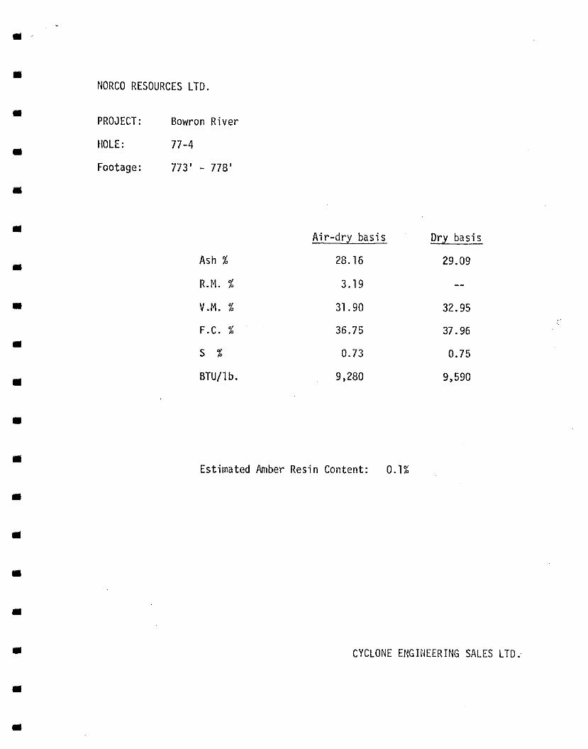
NORCO RESOURCES LTD.
PROJECT: Bowron River
HOLE: 77-4
Footage: 773’ - 77%’
Air-dry basis Dry basis
Ash % 23.16 29.09
R.M. % 3.19 --
V.M. % 31.90 32.95
F.C. % 36.75 37.96
s % 0.73 0.75
BTU/lb. 9,280 9,590
Estimated Amber Resin Content: 0.1%
CYCLONE ENGINEERING SALES LTD..

NORCO RESOURCES LTD.
PROJECT: Bowron River
HOLEH 77-5
Footage: 893' - 909'
Ash X
R.M. %
V.M. %
F.C. %
s. %
BTU/lb.
Air-dry basis Dry basis
33.36 34.37
2.95 --
31.20 32.15
32.49 33.48
1.11 1.14
8,350 8,600
Estimated Ambczr Resin Content: 0.09%
CYCLONE ENGINEERING SALES LTD.
i”

NORCO RESOURCES LTD.
PROJECT: Bowron River
HOLE: #JJ-6
Footage: 695.5' - 709.5
dash %
R.M.%
V-M.%,
F.C. 4:
s. %
BTU/lb.
Air-dry basis
36.08
2.62
33.04
28.26
0.82
7,820
Dry basis
37.05
--
33.93
29.02
0.84
8,030
Estimated knber Resin Content: 0.16%
CYCLONE ENGINEERING SALES LTD.

I NORCO RESOURCES LTD.
PROJECT: Bowron River
HOLE: 77-5
Footage: 912' - 919'
a
I
I
I
Ash %
R.M. %
V.M. %
F.C. %
S.
BTU/lb.
Air-dry basis Dry basis
33.25 34.27
2.98 --
30.37 31.30
33.40 34.43
2.01 2.01
8,600 8,860
m Estimated Amber Resin Content: 0.23%
CYCLONE ENGINEERING SALES LTD.

NORCO RESOURCES LTD.
PROJECT: Bowron River
HOLE: 77-7
Footage: 528.5' - 538'
Ash %
R. M. %
V. M. %
F. C.'%
s. %
BTU/lb.
Air-dry basis -- .& basis
23.65 24.62
3.93 --
36.08 37.56
36.34 37.83
1.13 1.18
9,940 10,350
Estimated Amber Resin Content: 0.26 %
CYCLONE ENGINEERING SALES LTD.

m
I
m
I
m
l
m
m
m
m
m
m
m
m
m
m
(I
I
Please address all correspondence to: 147 RiversIde Dr., North “ancouver, B.C. “7~ ITS Office: Tel. (604) 929.2228
September 15, 1977 WRIGHT ENGINEERS LTD. Ste. #lOO - 1444 Alberni St. VANCOUVER, BC V6G 224 Report No. 64-16093 - 101
Sample Identification: 77-a 471-478' 77-11 988-997' 77-a 478-485' 77-11 1038-1045' 77-9 835-839.5' 77-12 919-927.5' 77-10 1262.5-1271' 77-13 958.5-962.5'
77-15 697.5-707'
PROXIMATE ANALYSES
Sample No. As Received Dry Basis 77-8 % Moisture 4.77 xxxxx 471-478' % Ash 24.52 25.75
% Volatile % Fixed Carbon
29.33 41.38
100.00
Btu 9481 9956 % Sulphur 1.73 1.82
77-8 % Moisture 5.07 xxxxx 478-485' % Ash 25.69 27.06
% Volatile % Fixed Carbon
29.30 30.86 39.94 42.08
100.00 100.00
Btu 9297 9794 % Sulphur 1.46 1.54
77-9 % Moisture 4.32 xxxxx 835-839.5' % Ash 21.84 22.83
% Volatile 30.33 31.70 8 Fixed Carbon 43.51
100.00 45.47
100.00 Btu 9976 10426
% Sulphur 2.71 2.83
Continued Page 2/ . . .

Wright Engineers Ltd. Continued Page 2
September 15, 1977
Sample No. As Received Dry Basis
77-10 % Moisture 3.29 xxxxx 1262.5-1271' % Ash 41.23 42.63
% Volatile 22.57 23.34 % Fixed Carbon 32.91 34.03
100.00 100.00
Btu 7267 7514 % Sulphur 1.17 1.21
77-11 % Moisture 3.22 xxxxx 988-997' % Ash 42.13 43.53
% Volatile 22.94 23.70 % Fixed Carbon 31.71 32.77
100.00 100.00 Btu 7134 7371
% Sulphur 1.65 1.70
77-11 % Moisture 4.36 xxxxx 1038-1045' % Ash 29.81 31.17
% Volatile 26.38 27.58 % Fixed Carbon 39.45
100.00 Btu 8763 9163
% Sulphur 1.22 1.28
77-12 % Moisture 3.36 xxxxx 919-927.5' % Ash 46.94 48.57
% Volatile 19.93 20.62 % Fixed Carbon 29.77 30.81
100.00 100.00
Btu 6307 6526 % Sulphur 0.83 0.86
77-13 % Moisture 4.64 xxxxx 958.5-962.5' % Ash 20.89 21.91
% Volatile 32.12 33.68 % Fixed Carbon 42.35 44.41
100.00 100.00 BtU 10012 10499
% Sulphur 0.96 1.01
Continued Page 3/ . . .
COMMERCIAL TESTING & ENGINEERINQ CO. *

m
m
n
I
m
m
m
m
1
m
m
I
I
I
I
I
I
m
Wright Engineers Ltd. Continued Page 3
September 15, 1977
Sample No. As Received Dry Basis
77-15 % Moisture 4.33 xxxxx 697.5-707' % Ash 34.37 35.93
% Volatile 26.35 27.54 % Fixed Carbon 34.95 36.53
100.00 100.00
Btu 8125 8493
% Sulphur 1.34 1.40
Respectfully submitted, COMMERCIAL TESTING & ENGINEERING CO.
Manager
js
COMMERCIAL TESTING 8, ENGINEERING CO.
1
Aii . , . r . , . “ .

Please address a,, correspondence to: 147 RIversIde Dr., North “ancou~er, B.C. V7H IT6 Office: Tel. (604) 929.2228
September 21, 1977 WRIGHT ENGINEERS LTD. Ste. #lOO - 1444 Alberni St. VANCOUVER, BC Report No. 64-16148 - 50 V6G 224
Attention: Dr. ---_- L.S. Gormely,Mr. N. R. Krpan
Sample Identification: DDH WL-3 846-859' DDH 77-17 1109-1114.5' DDH 77-17 1048.5-1057'
Sample NO.
WL-3 846-859'
PROXIMATE ANALYSES
As Received Dry Basis
% Moisture % Ash % Volatile % Fixed Carbon
BTU
% Sulphur
4.49 xxxxx 41.37 43.32 24.72 25.88 29.42 30.80
100.00 100.00 6646 6958
0.96 1.00
77-17 1109- 1114.5'
% Moisture % Ash % Volatile % Fixed Carbon
BTU % Sulphur
3.68 xxxxx 35.07 36.41 25.99 26.98 35.26 36.61
100.00 100.00
8095 8404 1.09 1.13
77-17 1048.5- 1057'
% Moisture % Ash % Volatile % Fixed Carbon
BTU
% Sulphur
2.92 xxxxx 55.83 57.51 19.90 20.50 21.35 21.99
100.00 100.00 5103 5256
0.50 0.51
Continued Pace 2/'...

147 Rlverslde Dr.. North Vancouver, B.C. “7H 176 Aii
"""'&tober 12, 1977 Office: Tel. (604) 929.2228
WRIGHT ENGINEERS Ste. #lOO - 1444 VANCOUVER, BC V6G 224
LTD. Alberni Street
Report No. 64-16162-64
Attention: Dr. L. S. Gormely Mr. N. R. Krpan
Sample Identification: DDH 77-18 1145 - 1158.5' 1161 - 1167.5' 1169 - 1175'
SAMPLE NO.
DDH 77-18 1145-1158.5'
PROXIMATE ANALYSIS AS RECEIVED DRY BASIS
% Moisture % Ash % Volatile % Fixed Carbon
3.42 XxXxX 47.86 49.56 22.66 23.46 26.06 26.98
100.00 100.00
BTU 6194 6413 % Sulphur 1.06 1.10
DDH 77-18 1161-1167.5'
DDH 77-18 1169-1175'
% Moisture 3.03 XxXxX % Ash 47.90 49.40 % Volatile 23.85 24.60 % Fixed Carbon 26.00
100.00
BTU 6132 6324 % Sulphur 1.23 1.27
% Moisture 3.93 XxXxX % Ash 36.30 37.79 % Volatile 27.48 28.60 % Fixed Carbon 33.61
100.00
BTU 7883 8205 % Sulphur 1.58 1.64
DENSITY: DDH 77-18 1161 - 1167.5' = 98.3 lbs/cu ft.
jp
Respectfully submitted, COMMERCIAL TESTING & ENGINEERING CO
L -;. (;I& *&
C. D. Saville Manager

COMMERCIAL TESTING & ENGINEERING CO.
Office: Tel. (604) 929.2228
October 12, 1977 WRIGHT ENGINEERS LTD. Ste. #lOO - 1444 Alberni Street VANCOUVER, BC V6G 224 Report No. 64-16211-13 Attention: Dr. L. S. Gormely
Mr. N. R. Krpan
Sample Identification: DDH 77-19 1015.5 - 1027' 1027 - 1040' 1040 - 1047'
SAMPLE NO.
DDH 77-19 1015.5-1027'
PROXIMATE ANALYSIS
AS RECEIVED DRY BASIS
% Moisture % Ash % Volatile % Fixed Carbon
3.53 XxXxX 40.69 42.18 19.22 19.92 36.56 37.90
100.00 100.00
BTU 7278 % Sulphur 1.34
7544 1.39
DDH 77-19 1027-1040'
% Moisture 3.04 XxXxX % Ash 49.84 51.40 % Volatile 19.42 20.03 % Fixed Carbon 27.70 28.57
100.00 100.00 BTU 5828 6011
% Sulphur 1.42 1.46
DDH 77-19 1040-1047'
% Moisture 4.21 XxXxX % Ash 34.73 36.26 % Volatile 19.16 20.00 % Fixed Carbon 41.90 43.74
BTU 8104 8460 % Sulphur 1.28 1.34
jp
Respectfully submitted, COMMERCIAL TESTING & ENGINEERING
& 4-,
2-g
r -~ C. D. Saville Manager


APPENDIX F
GEOLOGICAL STRIPS
# ,...,,..,,,,_._.,_._.,......,............... -

ROCK CLASSIFICATION d DESCRIPTIONS
) o/b- 1
50 WRON RIVER SEDIMENTS Tertiary (Eocene ?I
Overb!vrden
aa b a c n
a c c n n ‘.‘.‘.’ ”
: / :. :::: ‘,‘.‘,‘. ‘.‘.‘, ;. :. ‘.‘.‘,‘,’ ‘:::: 1.1. ‘,‘,‘.
ry i::::::;::::::l
SilDE MTN. GROUP Mississippian.


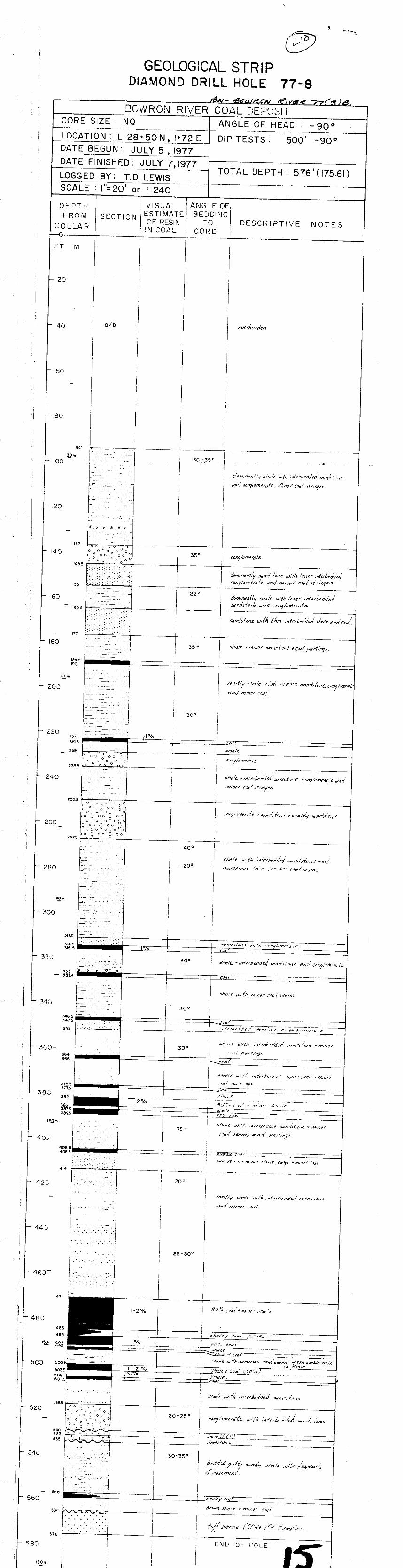


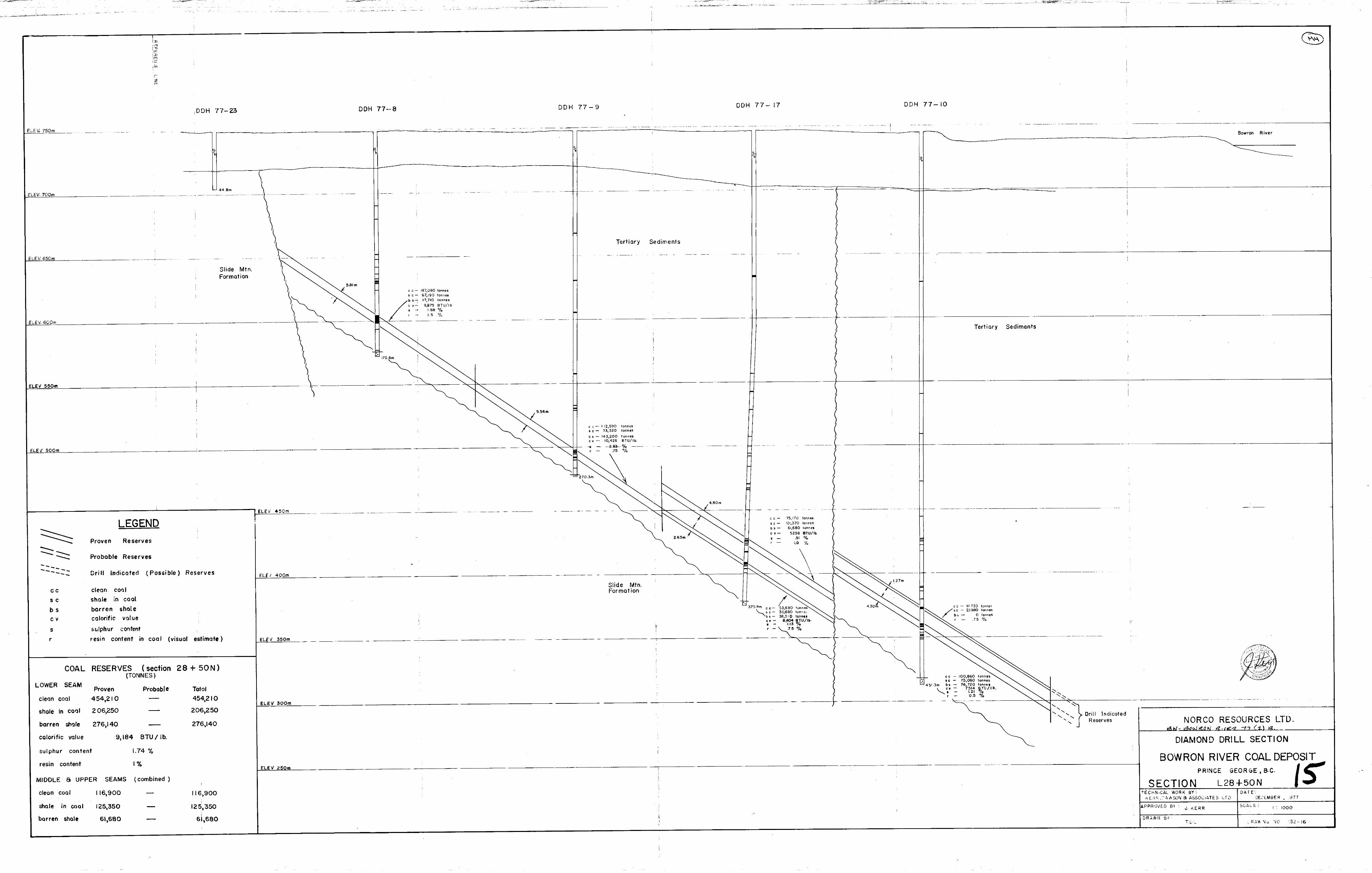


Related Documents