RMUCR_2~~~~E~D~M~IN~IN~G~S~C::::::.;H~E~M:..:!;_E ~1f(1 "'IIC;a ~~!I t-:~ . .....IooY--+-t+-t ~~e'F ~ffi (j'~,rS"J!tJ.. ,52 (3)(i) OF RMMCR 2017 FOR EXTRACTION OR ~:' ~l~~~~~PSUM FROM AGRICULTURE LAND FOR .. ~a tl>m~il tel "I f\N1l,Mt{~MPROVEMENT OF LAND) ~~~ For GYPSUM APPLICATION REF. NO. 201730589 Area-4.75 heet. NEAR VILLAGE -JAGGASAR TEHSIL -KOLA YAT DISTRICT -BIKANER r ~T:3"'~':' ;'C! :l 1 ~ ..... I". ' ' , ..... ~~" 1 ft p n~::: OVF flJ APPLICANT- SARDARU KHAN SIO GULAM RASUL 20 S M D MIRANWALA, ~ DISTRICT -BIKANER ",,-ida; ~ .• !~q~"", ~ l.. -1- t r-;r:" ""'l-rnT ...~t-,r;h CONSULTANT- GEOMIN SOLUTION PVT LTD OPP. PUGAL HOUSE, OLD GINNANI, BIKANER(RAJ) MOB. 09314185551, TEL. - 0151-2203255

Welcome message from author
This document is posted to help you gain knowledge. Please leave a comment to let me know what you think about it! Share it to your friends and learn new things together.
Transcript

RMUCR_2~~~~E~D~M~IN~IN~G~S~C::::::.;H~E~M:..:!;_E~~1f(1 "'IIC;a ~~!It-: ~ ......IooY--+-t+-t
~~e'F ~ffi (j'~,rS"J!tJ.. ,52 (3)(i) OF RMMCR 2017 FOR EXTRACTION OR
~:' ~l~~~~~PSUM FROM AGRICULTURE LAND FOR.. ~a tl>m~il tel "I
f\N1l,Mt{~MPROVEMENT OF LAND)~~~ For
GYPSUM
APPLICATION REF. NO. 201730589
Area-4.75 heet.
NEAR VILLAGE -JAGGASAR
TEHSIL -KOLA YAT
DISTRICT -BIKANERr ~T:3"'~':' ;'C! :l 1~ ..... I". ' ',.....~~"
1 ft pn~:::OVF flJAPPLICANT-
SARDARU KHAN SIO GULAM RASUL
20 S M D MIRANWALA,
~ DISTRICT -BIKANER",,-ida; ~ .•!~q~"",~ l.. -1- t r-;r:" ""'l-rnT
...~t-,r;h
CONSULTANT
GEOMIN SOLUTION PVT LTD
OPP. PUGAL HOUSE, OLD GINNANI,
BIKANER(RAJ) MOB. 09314185551, TEL. - 0151-2203255

Email id:[email protected]
Index f. I'""' ~I ~ () V En J_"S.No DESCRIPTION PAGE NO.01 Detail of applicant 402 Detail of applied area 403 Copy of khasra map of Applied Area 404 Basic infrastructure available nearby applied area 405 Distance of habitation from applied area 506 Detail of earlier removed Gypsum /if any 507 Details of existing plantation in applied area 508 Scheme of collection and use of top soil 509 Detail of nalas, river, and water source nearby
applied area5
10 Plan for rain water diversion fif required 611 Plan for extraction or removal of gypsum and
required machineries6
12 Details of production and dispatch of gypsum 6
14 Measure taken for air pollution, noise pollution and 8
treatment of dust suppression
13 Detail of production of gypsum f per month 7
159Programme of afforestation
3=G-·rr;:'c',<~~.
APDR0\/EU;'
LIST OF PLATESS.no. Particulars Plate no.
1. Applied area map I2. Key plan 23. Surface plan 34. Surface geological plan & section 45. Year wise removal and extraction plan & 5
section
6. Environment plan 67. Conceptual plan 7
List of Annexure
1. Copy ofLOI.
2. Copy ofkhasra map
3. Copy of Jamabandi.
4. Copy of Joint Inspection Report.
----------- -- -- - - - ---- ----------

1. DETAIL OF APPLICANTa. Name of licensee Sardaru Khanb. Address of licensee 20 s m d Miranwala
c. Aadharno.
d. Application Ref. No. 201730589
e. Phone No. 7568724776f. Status of the licensee Individualg. Details of the Area Jaggasarh. District and State Bikaner & Rajsthan1. Tehsil KolayatJ. Village Jaggasar2. Detail of applied area :a. Khasara lMurabba No. 181/6b. Area of KhasaraiMurabba: See annexure 3c. LOI area 4.75 hect.d. Revenue Village Jaggasare. Patwar Circle Jaggsarf. Tehsil Kolayat
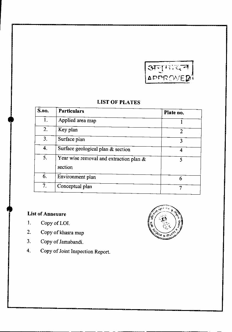
5. Distance of Habitation from applied area:
s. no Village name Population Distance and direction
from applied area01 Mlranwala 162 1.5 km, NE•~ 02 Nasooma 3.0 km, ESE141
03 Karnisar 606 6.0 km, NE
g. District Bikaner
3. Khasara map showing applied area -
4. Basic infrastructure available near applied areaRoad
Electricity
Telephone
Water supply
Dispensary
Post Office
School
Nearest Railway Station
Connecting road MDR 103
Available at Jaggasar
Not Available at applied area
Canal water of IGNP and Pvt. Tanker Supply
131~Tfr~~I
Primary School at Jaggasar 1(\ r P R0\.'~-~JKolayat
6. Detail of earlier removed gypsum lif any _
No, Applied area is in agriculture land and gypsum has not removed inthis area By applicant.
7. Detail of existing plantation in applied area-

Applied area is in Desert region hence it is!~ation and there
no significant number of trees or plants.
8. Scheme of collection and use of top soil -
Over burden is dune sand in this area and it will be collected and stack
separately at appropriate place after the mining of gypsum it will be used
for reclamation. r ~ =4 ,}l:..;=..;' ~ l,.........
fl ~~f:' )VEr~,Detail of nalas, river, water stream, and other source _ JArea fall in project of Indira Gandhi canal project main source of water
in this area only is canal water. The area situated in desertic zone of
Rajasthan and there is not natural water stream/nala present here.10. Plan for rain water diversion/if required _
9.
The applied area situated in thar desert of western rajsthan it is arid
climate average annual rainfall is about 200 mm. rain water scarcity is
too much so there is no requirement of rain water diversion.
11. Plan for Extraction or removal of gypsum and required machineryProposed Mining Method:-
The mineral Gypsum is overlain by Dune Sand Dune so for the
exploitation of mineral there is requirement of removal of the over
burden and stack soil cover separately at the appropriate location. Since
the deposit occurs at a depth of 0.50-1.20 mt and the average thickness
0.54 mt and sufficient to mineable. Semi mechanized open cast mining is
the suitable method for mining. The mining will be carried out as per
requirement. The overburden and mineral will be excavated with the help
of JeB. overburden will be removed and transportation of Gypsum from

mining pit to tractors and Trucks .. The overburden is unconsolidated and
alluvium sand. The mineralized bed is massive and homogeneous easily
extractable with help of JeB. In view the above drilling and blasting of
rock would not be required. Machineries for mining will arranged on hirebasis by applicant.
12. Details of production and dispatch of gypsum:-
It is not huge practice and mining will be done only upto 02mt deep from
surface. Gypsum is surface deposit and mining will be done as per demand.
As per demand mineral will be mined out and dispatched directly to user-industries.
13. Detail of production of gypsum / per month:
Detail of production of Gypsum is listed below-
Total deposit of Gypsum
Area(Sq. mt.) Thickness(mt) Volume(Sq. mt.) Density Tonnage
2.347500 0.54 25650
Year wise production of GypsumYear Production in Tons1st Year 196652nd year 196653rd year 19665
Average 3 Month ProductionMonthsyear Production in tons
1styear 1st 3 months 4916.25

2nd 3 months 4916.253rd 3 months 4916.254th3 months 4916.25
2nd year 1st3 months 4916.252nd 3 months 4916.253rd 3 months 4916.254th3 mon ths 4916.25
3rd year 1st3 months 4916.252nd 3 months 4916.253rd 3 months 4916.254th3 months 4916.25
14. Measure taken for air pollution, noise pollution and treatment of dustsuppression:-
(i) Air:- The quality of air is free from any pollution at this time, as there is no
major source of pollution the air with in the area or nearby the area. There is
no source of air-deterioration in this region and therefore ambient air quality
in the area as well as in the region of 5 Ian radius is natural and pure.
Air pollution caused by deployment of JCB for removal of overburden and
moving of truck/tractors, which generates dust. The air pollution in the
mining area causes respiratory diseases and eye ailment.
Controlling dust, water will be sprinkled daily on temporary unpaved roads
in the applied area and dust mask shall be provi
workers.s
(ii) Ambient Noise& Vibration Levels
The proposed mining is semi mechanized opencast method but some amount
of noise will be there due to JCB which will be deployed on hire basis for
removal of overburden and movement of truck/tractor, which shall be within
limits of safety. Earplugs shall be provided to operator and mineworker.

(iii) Dust Suppression: The proposed mining is semi mechanized open cast
method and mineral is overlain by thin layer of dune sand so dust will be
generated from mining and transportation of mineral by vehicles. For control
of dust applicant will be done water sprinkling on road and mining area. And
applicant will be done plantation on boundary of applied area.
15. Programme of Afforestation
The mining of Gypsum is carried out for improvement of agriculture land,
after removal of the mineral land will be used for agriculture purpose.
Boundary and rest area of the agriculture area will be used for plantation of
tree of local species like babool, neem, khejri.
Signature,

~ fF<Cf)lx
¢Illlclll ~ ~ (Sll'i ~ ~ FcJ~I'i~ iflij)I~~~:"&3l/00/RitLf1Jf4"1f?Jc/2017 1 S3?Cf ~: 2-lI . 6- )'9-
Saradaru Khan S/O: Gulam Rasul20 s m d, Miranwala, Bikaner, Rajasthan,334305COIH~ctno. - [email protected]
~: ~smiGI~ ~ -q ~ wm- ~ ~ -qw ~ ~ 3TNCPT 3l)'i(i11~'i ~ tBi crrm~ ~ ~ ~ ~ ID1f Jagasar d6~(i1 Kolayat ~ 4)Cbloi"1 I
>Ri<T:- ~ tBi ~ 09.01.17 ~4>~'i1 ~ 201730589
134-<1Cft1 fcl~~H:pfd 1¢"1i1;:fi em ~ wm- ~ ~ ctt -qw ~ ~ ~ ~ ~-gg \iil~ Wffi qft ~ ~ 28.10.2016 ~ ~ ~ R414('1 P!4Jflq(.>ft 2017 ~~ 52(3)(i) ~ "d"im 7ffm:r ~ Cfft ~ ~ 29-05-17 em ~ §<fi I ~ &m ~~18GI"1 ct qaT -q 4.75 ~cre4'< ~ tWre ~ s1!t1l4?1 1 "1"<ftCliRl ~ ~ ~ ~ fcp<)~ CR, ~ qaT -q ~ ~ vrRt ~ qft lfw ~ 3RT: 3Jlq Plkj~~d 31'4iIlRCbdl.q -q?f
mP{r ct U: llffi 1f cf>l~fC'1~ T.j mw=r ~, mfcp ~ tTa1 1f ~ tRflic tcftCliRl \ifRt qft \j'fT
~I:-
1. 3lj+i~~d fflcqc4'l4>I~;S JfI~~JI ~
2. ~ Xlfu ~ 40,000/- (~/q'iqfl4))"GIT ~ ~ ~Cbloi"1 ~ qaT -q ~-gT
3. lRl'-ic ~ ~ 10001- (~~*)
~ * ~ 3R1TCIT ~ ~ ~ c;;:r qft G"1" ~ tWre q,'ffi ~ ~ qmf X1lm 3TWT ~ \1I11T'\
Cf) ,~Cj14) 511ft I
4. q~f(Nol CfC'ft4~"""tl
~'l~--("G)o"tfio~)~~
~ ~ ~ fcMR fct+rllr4)Cf)loi"1

(!l'6~. -;fo . 1trorr. . 11'_
~ ..~: ..
• I.<D:2,,1130s!!!~T"K~~'" .\"111..: . ~6~~I"~
. ftf.m.
-j,.:o- _ :_ ,', ___;,- _ .,
<lURq ~ ",. ~.(~~ ~ iml. "RR 'I'T: ~'t!l"''''1 ~ ~ .@T1IT f%. ~ ¢i ~; <j;<jf ~ .~ ~ ....-:,.•~..~'-Il1!.lfr4jlffl .tol'~~i4.Ji" .:'~1.t1cm.ro ~- ~ ~~~{.oJ; ~:~ .~ ..~;~.-:: ,;.:~:·":-~~-ci};~X'ft4r.-~.-::;~'.;r~rw.~~~-_< •• _
~.tff.>lI.v#W ~ ~ I ~. o\?!;q ilffiIij\'~.~·.'.- iff'..'ilif~ :,m ~ 1M iilt<t~ a~If~~oPTrit ~:-' " .. ' -.. ' .'. :;;.~:;._.,; ..... _.c:;o.;c,_ -C,:' ". ,; _.... " .
.,_, -:
.... i-'
c
-- ~.
.----~==---:-~::==::-::::- ---:-:-:-:::-:---:-~---- ---_._..--_ .. -'". '---:';'7=- --::... _
~:....- _.,-- - ._

-..---.._.-..--~-"'-'~~:'_-::_-;---~-"..;i-\~,_ ---~'-J .' ---- .___ ... _.~ •__ :_ ~ .... : ..... _
i .. ' . ·ci~cr't\;fI;\~"tmr· ~ 1P,c~ (~!) :. ; .... '-. " ..'. ~.-~'"='~-~-~.!"'":"~-~7~~'::'~_~-:--~_. "
It. '. '. ':"-c'·:····~4- .. - '-~~""'~-"--.~. .,., "" ..• ,..~-., ~-';
->
: \ ..
. - __ :.;.,. ... _. ··--_._'.OT .. .
!l),,,,,'t !"d"f,jl'(l!~~l'li§!t~ _~. . ..'... ,::.:." •..-,. -"---'-"'..:~..~ --·.d .Of i. , "'",_'•• ' .".. ". •
~(!If) X ~'~('lt.i~,~ 'f.i'141ri' .'~7.m~ "'111 . i.t, ·,
.' .
. .
... i
-..\ ..
.'..~D: ;;:.'
....~} .... e '
•
w .. ~:;~" ;~'.~\:..tkv\ J ',=.:': .'! .I"'~ ," ,~:,,·V1:" ~'~~V'\; ,'I'
'.../ ' ,
. ' .
. '.. ..'
. .
. 'I.:, ..
: ., "
<;. I -,
II.....,,_' '. ,
tI,.. i..
'. ";1. ,...
. ~.•• 10 #. .. ''... . "
!,
I!
'j'.. . ',
:.,:,;~:~;_!~"~~'Uf'". . . . . . ',' ..,
'; .' t- ~ :':. - "j. ': v: .
• • • J': ..:' . :'
. .. ;""
,~. ,.'
"':." • # ",
. '. ,
. .".. -: ~~... " . . "
~- -s!.,~.~.. .. ..\; . ..' ; .::.
" .
. '.... ", '.1 •• , '
. ;.I; ... : " . '.: .
. . : " .•'. ~.. "
, .!, .
-, ---

(tf.t f~".16t'11U I i'l irT~T fittdfur ~1. QT ~ ~ 1St ~ t1 ,mitft '~"a'.m ~i.tit .~. "'" ~ ,"it ~1'
~I. WI'"" ....•••~~.D. - '1",;111".•..~~:H'lf'a'.d<p.:r~ Iinn········ ~I~. "~"'. ..,~, '(.",.ti') '''RlI! ..~2.~i----r---.---------__~------~---------------.~-------r--------~--~I~':~-----·.--~~--~.-,.----.-~--~--------~~~~~~
3f,;j~r;n,_;,Jit--
..";
",ril<:I1:.ih .ril~n. ~1"B ..111,,"1(\ ~ '111f,m'~ '"""'If" 111'1'1: fomv ~"'" "'"
'1-1Il't'l.ll11lR".h q..1
OIfIiRr~.r•.,"("I'''m tfWlt~",r,",~!hflllfq.,~ 11){.~,----
b~~I '1'<'"
1N'(T.
~.~1l'h
r...,. "'on .
kt":l~~'?F ·~alj'lf!!.".c:r··'- - ..
~l" l<fT. >-I}~r;;J'8fr~:i«i1)4)Z.'
1----..·-------·· ....--.R
tiif l"i--'~c\iC-0.,-' _. - - ~i/S - _.c. .• -
1; ':l..o \"'1""2.&) '\.~~~:t. ~I
., ~~ ~".....,),. ~
. ~ 0..," ~~.CI.,o\!'~'0 '0.,<\'i ~q,l\ ~9a·...,
. '9:a- ''''1.~~ ""'4 a..,.~ J~c:rc. cy.ct",,' .c::y!U .':I.I).~~.~ ..~y'. .-.,.•~"
,..,
......................
fq.,f~'"
I!
. I
I;l1
tt., '~~,;r~~~:-c·~

Gypsum for ,..tum Qf ~grlclJltUreland
on noof me or my family and there is no dues of any kind against me or my family of Mines i
!
I-I
I1
~l
.\ ..1
l'1I¥Ii-!ftIi-!it

a.nS_MD....................
.~........ -:.'" ......
KEY PLANN
-$'•RF 1:500005'i!j i 5ij! 30r
..'
,JIt
PART OF GT SHEET NO - 44 DI7
.........
.._- ,a.18"HM(AJow 1#KHM(IIJ .' ow 'IIKHM(AJ .
. • • It .••
.,~
.ft,
:'TJ
..
"""'-Ch#JIt2JM.
. ...
TEH:- KOLAYAT
REF.NO.:- 201730589
NN:· JAGGASAR
mST:- BlKANER
AREA:-4.75 HECT
MINERAL:- GYPSUM

,L."1/'
.,. t /''''V''
, 1 ; .."1/.
.. -," t /'''V'
.-,: t j''\j/'
.,.I ;,''''J./ .
, .f ~.W. .
,.1; ."1/
-,: t j''\.1/' . ~/ .
.•.•.•.. •••.•..•..•..•••...•••.•. •.•• • 2SN.. ,' ... '" ..... " ..... " ....... . .:<: :.... <. : :. <. <jr-~, ..... .>:< :« <:< :.:: <.<.«.<:- :j
.,. I· :-'''V'
. ~.l /',\J/ .
, .l "w.
... v I· ;' .'''V'
·~L· .',,¥ .
., .1./w:
~.l "..'\1/.'
,.·1 ..""1/ .
·,·1·;, .''J./ .
·,·1·;, .'''V'
" ·I·_,..'\1/.
.'W . \\ lOOW/7~ ~ nsw 200W 11SW ISOW 12SW IOOWlSW ~ 2S~.: lSON
• •• I2SN
.. . ::
, 1 ...."1/. , I·....·."1/ .
.\j/.
" ·I·_,.w:
,.J.~'\l/. .
.,. I· / ... '''1/
ENVIRONMENT PLANN
2±\E"S+7.RF 1:5000r -0 r wr
SYMBOL
REF.NO.:- 201730589
NIV:- JAGGASAR
TEH:-KOLAYAT
SR. ~ARDARUKHANmST:- BIKANER
AREA:- 4.75 MEeT
MINERAL:- GYPSUM

PLAN SHOWING APPLIED STP AREA FOR MINERAL GYPSUM NEAR VILLAGE JAGGASARTEHSIL KOLAYAT DIST. BIKANERAPPLIED BY- SADARU KHANREF NO- 201730589
SCALE:- lCM = 40 MT.
r---------------------~B
r=D----'C
F E
TOTAL APPLIED AREA - 4.75 HEeT. SIGNATURE OF APPLICANT

300W 275W 250W 225W 200W 175W 150W 125W lOOW 75W 50W 25W
SURFACE PLANN
~
B W E150N
sw II!
RF 1:2000125N 1° 0 jD yolOON
75N
50N
25N
OONC
INDEX
\ .
\.
\ .....\
...
\ .....\-:
F E
PLATE NO.03REF.NO.:- 201730589
SH.
NIV:- JAGGASAR
TEH:- KOLAYAT
DIST:- BlKANER
AREA:- 4.75 HECT
MINERAL:- GYPSUM
SCALE:- 1 20 MT

300W 275W 250W 225W 200W l75W l50W l25W lOOW 75W 50W 25W
. . . . . . . . .
.......... . . . . . . . . . . . . . . . . . . . . . . .
. . . . . . . . . . . . . . . . . . . .. . . . . . . . . . . . . . . . . . . . . . . . . . . . . . . . . . .
. . . . . . . .
...............
...... , . .. . . . . . . . . . . . . . . . .
............................. . . . . . . . . . . . . . . . . . . . . . . . . . . . . . . . . . . . . .
...............
............................................................................ lOON
B· l50N
· 125N
. . . . . . . . . . . . . . . . . . . . . . . . .. . . . . . . 75N
. . . . . . . . . . . . . . . . . , .....
..........
. . . . . . . . . . . . . . . . .
. . . . . . . . . . . . . .. . ....
....... , .....
F
..................................... . . . . . . . .
.............................................. ' .
...............E
. X'· SON
·25N
- _-----
SURFACE GEOLOGICAL PLANN
Wzi:\EE~
iO 0 2~F 1:200020d
SCALEVERTICAL1CM=01MT IN SECTION
INDEX
S.N. DESCRIPTION SYMBOL1. PERMITBOUNDARY o2. LLUVIUMSAND3. GYPSUM4. SECTIONLINE
PLATENO.04REF.NO.:- 201730589
NIV:- JAGGASAR
TEH:- KOLAYAT
DIST:- BIKANER
AREA:- 4.75 HECT
MINERAL:- GYPSUM
SCALE:- 1CM 20 MT
if'¥;~1:::;f;i";N{ik';&/X,.'/..
SR. SARDARUihAN

300W 275W 250W 225W 20~W 175W 150W 125W lOOW 75W 50W 25W B(X¢<~ 150N¢<~~~ >6~ ~ 125N
(X ~
75N
¢< ~Il'I.XMr'>("""""'><,N<,;(>QQC<~~>?S..,., x(x
lOON
xSON
F E
98mt
YEAR WISE WORKING PLANN
W~EE
S?p.RF 1:2000
20o- _----.;;;20
SCALEVERTICAL1CM=01MT IN SECTION
REF.NO.:- 201730589
NIV:- JAGGASAR
TEH:- KOLAYAT
DIST:- BIKANER
AREA:- 4.75 HECT
MINERAL:- GYPSUM
20MT
PLATE NO.OS

300W 275W 250W 225W 200W l75W l50W l25W lOOW 75W 50W 25W BAI.'W'· .. '.'~.' \Ii" .. '.'W".' ~. "V -:V' ' .1/ l50N
'W.
50N
.....................
... ~ . ": . . . . ...., . I'."'. .. '"
. . ~. . . . .....1/ . . . . 'W' . . . .~. . . . ~ . . . . '11/' . . . . ~. . .
lOON
. '."' ..... -w l25N
'~'." ... ~ . ... '\It ... .~ .
. .. fV ... 75N
. . -..v. w..... w. ~ .... w.
\.. .
\ ..~ ..... ' .~.
. ..1
J/
EF
o RF 1:200020
CONCEPTUAL PLANN
wzi5E
~
--_- 1jO
INDEX
S.N. SYMBOL
3.
PERMIT BOUNDARYALLUVIUM SAND
DESCRIPTION1.2. o
AGRICULTURE LAND
REF.NO.:- 201730589
NIV:- JAGGASAR
TEH:- KOLA YAT
DIST:- BIKANER SR.AREA:- 4.75 HECT
MINERAL:- GYPSUM
SCALE:- 1 CM= 20 MT
. . . . .. . . . . .PLATE NO.07
.'\Ii' '-V '-1/' .'\Ii'~.
~. .~ '<.J .W' '-.v 25N
.1 .1 .• 1
Related Documents