Syracuse Metropolitan Area (Onondaga County) Intelligent Transportation Systems Concept Plan Prepared for New York State Department of Transportation Syracuse Metropolitan Transportation Council Prepared by PB Farradyne In association with Clough, Harbour & Associates, LLP Howard/Stein-Hudson Associates, Inc. July 2003

Welcome message from author
This document is posted to help you gain knowledge. Please leave a comment to let me know what you think about it! Share it to your friends and learn new things together.
Transcript

Syracuse Metropolitan Area (Onondaga County)
Intelligent Transportation Systems
Concept Plan
Prepared for
New York State Department of Transportation
Syracuse Metropolitan Transportation Council
Prepared by
PB Farradyne In association with
Clough, Harbour & Associates, LLP
Howard/Stein-Hudson Associates, Inc.
July 2003

TABLE OF CONTENTS
1. INTRODUCTION ...................................................................................................... 1 1.1 GENERAL BACKGROUND .............................................................................. 1 1.2 IMPROVING TRANSPORTATION THROUGH TECHNOLOGY: AN OVERVIEW OF
INTELLIGENT TRANSPORTATION SYSTEMS (ITS) ........................................... 2 1.3 ITS ARCHITECTURE .................................................................................... 3 1.4 PURPOSE OF THE ITS STRATEGIC PLAN ...................................................... 6 1.5 ORGANIZATION OF CHAPTERS:..................................................................... 6
2. STAKEHOLDER INVOLVEMENT............................................................................. 7 2.1 OUTREACH PLAN ........................................................................................ 7 2.2 DOCUMENTATION OF INTERVIEWS ................................................................ 10 2.3 INITIAL EVALUATION OF INSTITUTIONAL ISSUES............................................. 11 2.4 RESPONSIBILITY FOR FACILITY OPERATIONS ................................................ 13 2.5 INTER-AGENCY COMMUNICATION/COORDINATION......................................... 14
3. ITS VISION ............................................................................................................... 16 3.1 VISION STATEMENT....................................................................................... 16 3.2 GOALS AND OBJECTIVES............................................................................... 17
4. EXISTING CONDITIONS / PROBLEMS / ITS ELEMENTS...................................... 19 4.1 INTRODUCTION ............................................................................................ 19
4.1.1 Methodology and Criteria for Selection of Priority Locations........... 19 4.1.2 Study Area....................................................................................... 20
4.2 ROADWAY SYSTEMS.................................................................................... 22 4.2.1 Roadway Network ........................................................................... 22 4.2.2 General Roadway Congestion......................................................... 23 4.2.3 Recurring Congestion...................................................................... 24 4.2.3.1 Congested Road Segments........................................................... 24 4.2.3.2 Congested Intersections ................................................................ 29 4.2.4 Special Event Access Roadways .................................................... 29 4.2.4.1 New York State Fairgrounds .......................................................... 29 4.2.4.2 Carrier Dome.................................................................................. 32 4.2.4.3 Clinton Square ............................................................................... 32 4.2.5 Regional Traffic Generators ............................................................ 33 4.2.6 High Accident Locations .................................................................. 33 4.2.6.1 State Highway System................................................................... 33 4.2.6.2 Local Roadway System.................................................................. 39 4.2.7 Critical Ramp Locations................................................................... 41 4.2.8 Overhead Bridges with Low Clearances ......................................... 41 Table 8 - Low Clearance Bridges .............................................................. 43 4.2.9 Highway-Rail Grade Crossings ....................................................... 45 4.2.10 Major Truck Routes ........................................................................ 47 Town of Camillus ....................................................................................... 47 Town of Dewitt ........................................................................................... 48 Town of Salina ........................................................................................... 49 Village of Liverpool .................................................................................... 49 Permitted Routes ....................................................................................... 49 Restricted Routes ...................................................................................... 50
Syracuse Metropolitan Area ITS Concept Plan

Minor Town and Village Route Restrictions............................................... 50 Table 13 - Minor Town and Village Route Restrictions.............................. 50 4.2.11 Weather Related Transportation Issues ......................................... 50
4.3 TRANSIT AND AIR SYSTEM ........................................................................... 55 4.3.1 Rail Network .................................................................................... 55 4.3.2 Bus Service ..................................................................................... 58 4.3.3 Air Service ....................................................................................... 60
4.4 EXISTING AND PLANNED ITS INVENTORY ..................................................... 62 4.4.1 City of Syracuse .............................................................................. 62 4.4.1.1.Existing ITS Elements.................................................................... 62 4.4.1.2 Proposed ITS Elements ................................................................. 64 4.4.2 Onondaga County ........................................................................... 64 4.4.2.1 Onondaga County Department of Transportation Proposed ITS
Elements ........................................................................................ 64 4.4.2.2 Onondaga County Dept. of Emergency Communications
Proposed ITS Elements ................................................................. 64 4.4.3 New York State Department of Transportation (NYSDOT) ............. 67 4.4.3.1 Existing ITS Elements .................................................................... 67 4.4.3.2 Proposed ITS Elements ................................................................. 72 4.4.4 Central New York Regional Transportation Authority (CNYRTA).... 73 4.4.4.1 Existing ITS Elements .................................................................... 73 4.4.4.2 Proposed ITS Elements ................................................................. 73 4.4.5 Existing Traffic Management Centers ............................................ 74 4.4.6 Existing Communication System ................................................. 76
5. MARKET PACKAGES .............................................................................................. 81 5.1 NATIONAL ITS ARCHITECTURE MARKET PACKAGES ....................................... 81 5.2 SYRACUSE METROPOLITAN AREA ITS STRATEGIC PLAN MARKET PACKAGE
DEFINITIONS................................................................................................ 85 5.2.1 Archived Data ................................................................................... 87 5.2.2 Advanced Public Transportation Systems ........................................ 87 5.2.3 Advanced Traveler Information Systems.......................................... 90 5.2.4 Advanced Traffic Management Systems .......................................... 92 5.2.5 Advanced Vehicle Safety Systems ................................................... 99 5.2.6 Commercial Vehicle Operations ...................................................... 101 5.2.7 Emergency Management ................................................................ 103
5.3 POTENTIAL BENEFITS OF MARKET PACKAGES .............................................. 104 5.4 AGENCY MARKET PACKAGE PLANS .............................................................. 112
5.4.1 Potential Applications of Market Packages ..................................... 112 5.4.2 Priority Rating Definitions ................................................................ 113
5.5 MARKET PACKAGE PLAN DEVELOPMENT ...................................................... 128 5.6 PROCESS OF MARKET PACKAGE PRIORITIZATION ......................................... 129 5.7 SUMMARY OF THE MARKET PACKAGES RATINGS .......................................... 135 5.8 NEXT STEPS................................................................................................ 136
6. PERFORMANCE CRITERIA .................................................................................... 137 6.1.1 Recommended Performance Criteria .............................................. 137 6.1.2 Recommended Roadway Performance Criteria .............................. 139 6.1.3 Recommended Transit Performance Criteria .................................. 144 On-Time Performance ............................................................................... 144 6.1.4 Recommended Performance Criteria & ITS Market Packages ....... 148 6.1.5 Recommended Performance Criteria and Data Needs ................... 149
Syracuse Metropolitan Area ITS Concept Plan

7 FUNDING................................................................................................................... 152 7.1 CAPITAL FUNDING FOR ITS .......................................................................... 153 7.2 OPERATIONS AND MAINTENANCE FUNDING FOR ITS ..................................... 153 7.3 PRIVATE SECTOR FUNDING.......................................................................... 154
Syracuse Metropolitan Area ITS Concept Plan
1. Introduction
1.1 General Background
The New York State Department of Transportation (NYSDOT) has retained PB Farradyne to
develop a strategic plan for deployment of Intelligent Transportation Systems (ITS) for the
Syracuse Metropolitan Area (Onondaga County). PB Farradyne, in its efforts to develop the
plan, is being assisted by Clough, Harbour & Associates, LLP and Howard/Stein-Hudson
Associates, Inc. This technical memorandum is one of a series of reports being prepared for
the strategic plan which will document the established goals, assess operational deficiencies,
analyze the existing conditions of transportation facilities, prioritize those facilities for potential
ITS deployment, and prioritize the ITS Market Packages needs of each involved agency and the
region. This effort considers the near, mid and long term needs of the area.
Onondaga County, with an area of approximately 800 square miles, contains the fourth largest
upstate city (Syracuse) in New York. Onondaga County and the City of Syracuse occupy a
central position within the local, regional, and national transportation system. The region’s
roadways, public transportation, rail, and airport provide outstanding access to services and
employment. In Onondaga County, two major interstates (Interstate 81, which provides
connections to the north and south and the New York State Thruway - Interstate 90, which
provides access to the east and west) meet in Onondaga County and provide access to all of
the Northeast and Canada. In addition, the I-690 runs through the City connecting east to the
west. There are approximately 3,100 miles of roadway and almost 500 bridges in Onondaga
County. However, in some cases, connections among these facilities, and between these
facilities and the local road network, is limited. There are some gaps in the transportation
system, and some facilities have reached capacity. Implementation or expansion of Intelligent
Transportation System (ITS) strategies/elements can improve the overall safety and mobility of
Onondaga County as well as of the region.
Syracuse Metropolitan Area ITS Concept Plan 1

1.2 Improving Transportation Through Technology: An Overview of
Intelligent Transportation Systems (ITS)
The current Long-Range Transportation Plan forecasts that travel times will increase extensively
in the next several years. Therefore, the demand for more traffic capacity will continue to
increase. In addition, more traffic volume translates into an increase in accidents. Accidents not
only cause personal injuries and property damage, but also result in long traffic delays.
Traffic delays and other related problems are not new to the Syracuse Metropolitan area. Like
other metropolitan areas have learned in the past few decades, transportation officials realized
that they could not simply build their way out of congestion. New approaches were needed. In
addition to traditional roadway improvements, the NYSDOT responded to the need to improve
regional transportation services by providing funds to develop a Regional ITS Strategic Plan to
set the stage for regional implementation of ITS, coordination among agencies and sharing of
information.
The concepts of ITS incorporate a broad range of technologies that, when integrated, can help
solve many of our transportation problems. ITS technology elements include information
processing, communications, control systems, and electronic field equipment. Applying these
technologies to our transportation system will save lives, save time, and save money. ITS
technology and the application of management and operations strategies allow transportation
system managers to not only respond to capacity issues, but to improve the overall delivery of
transportation services. Some of the types of service improvements ITS enables include:
• Minimizing response time to incidents and accidents through the use of incident
management programs.
• Providing real time traffic information to help motorists avoid congestion.
• Reducing weather related traffic incidents by using Road-Weather Information Systems
(RWIS) to sense and respond to snow and icing more quickly.
• Improving emergency management communications and providing real-time traffic
information to improve emergency vehicle routing.
• Improving on-time performance and security for transit users through the use of automatic
vehicle location systems.
Syracuse Metropolitan Area ITS Concept Plan 2

In addition, ITS can promote inter-agency communication, cooperation and data distribution.
Through ITS, agencies in different jurisdictions can work together to manage the regional
transportation network as a seamless whole. An integrated transportation system, managed and
operated more efficiently through the use of ITS, enhances quality of life through improvements
to motorist safety, promotion of a strong and growing economy and enhancement and
protection of environmental quality. Last, ITS can address the public’s expectations and
demands for service from their government agencies. Technology is now in the hands of the
public, and their expectations for technology to improve all aspects of their daily lives, including
travel, has increased.
1.3 ITS Architecture
A planning-level architecture (as is provided in this report) describes the planned connections
between diverse computerized systems. The connections are defined by the data that flows
between the systems. In addition, standards required to ensure that each computerized system
can understand and communicate data in a uniform fashion are also included in the ITS
architecture.
ITS architectures are important when ITS elements/systems are implemented in an incremental
fashion by multiple agencies. Computer systems are very difficult to modify once they have
been implemented. Extraction of data from a system that is not designed for that purpose can
be very costly. It is often less costly to replace an entire system than it is to reconfigure it for
specific data extraction. With architecture, systems can be designed up front to accommodate
future connections to other computer systems.
The Syracuse ITS Strategic Plan is simply a plan that describes how local agencies will
connect, communicate and coordinate with each other, and also describes how to enhance the
efficiency of various types of transportation systems, and to determine what types of data will
flow across those connections. Where applicable, communications standards for the data are
identified. In addition, the Syracuse ITS architecture contained within the Strategic Plan
describes how the regional partners will use the transmitted data to improve the delivery of
services. Development of this Strategic Plan and ITS Architecture meets Federal requirements
for ITS project funding.
Syracuse Metropolitan Area ITS Concept Plan 3

On January 8, 2001, the Federal Highway Administration (FWHA) rule and Federal Transit
Authority (FTA) policy on ITS Architecture and Standards were published to implement section
5206(e) of the Transportation Equity Act for the 21st Century (TEA-21). The FTA and FHWA
have different processes and procedures for project development. Therefore, the FHWA has
issued a Regulation, and FTA has issued a Policy. The policy language in each document is
consistent and will be carried out in a coordinated fashion, as applicable under FTA and FHWA
project management and oversight procedures. This final rule/policy requires that ITS projects
funded by the Highway Trust Fund and the Mass Transit Account conform to the National ITS
Architecture, as well as to the United State Department of Transportation’s (USDOT) adopted
ITS Standards.
The final rule/policy requires that:
Regions currently implementing ITS projects must have a regional ITS architecture in
place in four years from the effective date or before April 8, 2005. Regions not currently
implementing ITS projects must develop a regional ITS architecture within four years from
the date their first ITS project advances to final design.
ITS projects funded by the Highway Trust Fund and the Mass Transit Account must
conform to a regional ITS architecture.
Major ITS projects should move forward based on a project level architecture that clearly
reflects consistency with the National ITS Architecture. A major ITS project is any ITS
project that impacts regional integration or national interoperability. In other words they are
those ITS projects in a region which are critical to future integration and therefore must be
developed within the framework of an architecture.
Projects must use USDOT adopted ITS standards as appropriate. To date, the USDOT
has not adopted any ITS standards, and a formal rulemaking process will precede any
USDOT ITS standard adoption. The proposed rule does not require replacement of
existing systems or equipment. Applicable ITS standards would be used as new features
and system upgrades are planned with the use of the National ITS Architecture.
Standards are mandated only when they become officially adopted by the USDOT; at this
point the USDOT has not adopted any ITS standards. The USDOT encourages the use of
applicable ITS standards prior to their official adoption, however, as appropriate.
Compliance with the regional ITS architecture will be in accordance with USDOT oversight
and Federal-aid procedures, similar to non-ITS projects.
Syracuse Metropolitan Area ITS Concept Plan 4

The rule includes requirements for both the ITS planning stage, and the project implementation
stage. This report focuses on the planning stage. Per the rule, the regional ITS plan and
architecture shall include, at a minimum, the following:
1. A description of the region;
2. Identification of participating agencies and other stakeholders;
3. An operational concept that identifies the roles and responsibilities of participating
agencies and stakeholders in the operation and implementation of the systems included
in the regional ITS architecture;
4. Any agreements (existing or new) required for operations, including at a minimum those
affecting ITS project interoperability, utilization of ITS related standards, and the
operation of the projects identified in the regional ITS architecture;
5. System functional requirements;
6. Interface requirements and information exchanges with planned and existing systems
and subsystems (for example, subsystems and architecture flows as defined in the
National ITS Architecture);
7. Identification of ITS standards supporting regional and national interoperability;
8. The sequence of projects required for implementation; and,
9. The agencies and other stakeholders participating in the development of the regional
ITS architecture shall develop and implement procedures and responsibilities for
maintaining it, as needs evolve within the region.
This plan is consistent with the requirements of the ITS Architecture rule.
Due to the importance of Regional ITS Architectures, the USDOT invested a significant amount
of money to develop a National ITS Architecture. The National ITS Architecture includes a broad
array of potential ITS applications and data flows. It can be thought of as the “full menu” of ITS.
Each region can start to create an architecture using the National ITS Architecture, by selecting
or modifying the applications and data flows appropriate to their region. In addition, applications
and data flows not on the National menu can be added.
Syracuse Metropolitan Area ITS Concept Plan 5

1.4 Purpose of The ITS Strategic Plan
Incorporating the ITS plans developed in the past and the ITS infrastructure now implemented in
the region, this plan updates past efforts, establishes an integrated/coordinated/multi-agency
Regional Architecture and agency-based ITS implementation plan and responds to two key
factors:
1. Technology changes- Technology is changing at a rapid pace, and will continue to do so
in the foreseeable future. These changes present certain opportunities to the region for
improving the delivery of transportation services. Long-term changes in technology
cannot be predicted. However, short-term innovations, particularly those tested and
proven elsewhere in the U.S., can be specifically incorporated as they meet local needs.
ITS plans must be frequently updated to reflect changes in technology, including
changes that affect cost.
2. Integration- It has always been the intent of the agencies in the region to develop an
integrated ITS infrastructure. That is, each agency should be able to share data with
other agencies that need it, and operations should be accomplished without regard to
jurisdictional boundaries. This plan addresses how systems can be connected to one
another.
1.5 Organization of Chapters:
Chapter 2 details the stakeholder involvement in the project until the development of this report
and also provides an insight of the institutional issues that were identified. Chapter 3 enlists the
vision and goals of this project while Chapter 4 provides the inventory of existing conditions in
the study area. In Chapter 5, the market packages from the National ITS Architecture were
explained in detail along with the process adopted by the Steering Committee (SC) to utilize
them in developing the ITS Architecture. Discussions in Chapter 6 are focused on identifying the
performance criteria for various ITS elements and Chapter 7 exclusively covers the funding
issues and opportunities that are present.
Syracuse Metropolitan Area ITS Concept Plan 6
2. Stakeholder Involvement
2.1 Outreach Plan
The elements of the Outreach Plan are designed to promote a dialog among the various
stakeholders to ensure reaching a consensus for the implementation of ITS projects in the
Syracuse Metropolitan area. The Plan includes:
• Steering Committee
• Stakeholders Database
• Stakeholders Interviews
• Workshops
• Fact Sheets
Steering Committee: The Steering Committee (SC) is comprised of representatives of all key
agencies that are responsible for the implementation of ITS in the Syracuse Metropolitan area.
The responsibilities of the SC include reviewing and commenting on deliverables, establishing
policy guidance for implementing ITS region wide, and maintaining liaison with other
stakeholders.
The core group of the SC, which meets monthly for the duration of the project, includes
representatives from the New York State Department of Transportation, the New York State
Thruway Authority, the Syracuse Metropolitan Transportation Council, the City of Syracuse,
Onondaga County, the New York State Police, the City of Syracuse Police, the Onondaga
County Sheriff’s Office, the County Fire Department, Onondaga County Emergency 911. The
current listing of the Steering Committee members is provided below:
Syracuse Metropolitan Area ITS Concept Plan 7

Table 1 - Outreach Participants Name Agency Phone Fax E-mail Mary Rowlands SMTC – Syracuse 315-422-5716 315-422-7753 [email protected] Jim Lawler NYSDOT - Syracuse 315-428-4312 315-428-4311 [email protected] Bruce Trexler Onondaga – DOT 315-435-3205 315-428-5744 [email protected] Eugenia Urman NYSDOT – Albany 518-457-0089 518-457-5933 [email protected] Frank DeGennaro NYS Police 315-455-2850 315-455-2944 [email protected] Mike Hartman NYSDOT – Albany 518-457-2384 518-457-1960 [email protected] Shannon Trice Syracuse Police 315-442-5130 315-422-5147 [email protected]
Andrew Sapoznikov Syracuse Fire
Department 315-473-
5525x602 [email protected]
Barry Stevens NYSDOT - Syracuse 315-428-4381 315-428-4311 [email protected] Tony DiGregorio OCHO EMS 315-435-6964 [email protected] Stephen Wisely Emergency Comm. 315-435-7911 315-435-8620 [email protected] Richard Landerkin CNYRTA 315-442-3381 315-442-3337 [email protected]
John Foland NYSTHA 315-437-2741 315-461-0765 [email protected].
us William Nurk City of Syracuse-PD 315-442-5203 315-442-5249 [email protected] Robin Palmer NYS Police 315-455-2850 315-455-2944 [email protected] Pete O’Conner Syracuse DPW 315-448-8576 315-448-8531 [email protected] Jerry Zell FHWA 518-431-4124 518-431-4121 [email protected] Frank Kobliski CNYRTA 315-442-3344 315-442-3337 [email protected]
Warren Darby Onondaga County
Sheriff’s Office 315-435-3044 315-435-3043 [email protected]
Peter Alberti Onondaga County Office
of Emergency
Management 315-435-2525 315-435-3309 [email protected]
John Harvey City of Syracuse-DPW 315-448-8518 315-448-8531 [email protected]
The consultant performs the following activities:
• prepares and distributes meeting notifications,
• prepares materials and handouts,
• facilitates the meetings, and
• records meeting activities and distribute summaries.
Stakeholders Database: The Syracuse Metropolitan Transportation Council’s ITS list serves as
the core for the project mailing list. The database also includes other public, private and
Syracuse Metropolitan Area ITS Concept Plan 8
institutional entities. The mailing list will be revised and expanded as other interested and
affected individuals and organizations are identified. The consultant maintains the database.
Stakeholders Interviews: A series of interviews were held with key stakeholders in the
Syracuse Metropolitan area to get everyone on board for the study and to gather information on
the existing and future transportation system conditions, safety related issues, current and
planned ITS projects, information sharing, funding, stakeholder needs, institutional barriers,
policy issues, jurisdictional issues, expectations of the study, etc.
The consultant drafted a discussion guide for review by the SC. Once the discussion guide was
finalized it was distributed prior to the interviews to facilitate the discussion. The consultant
facilitated the interviews, summarized the results and distributed to appropriate team members
for review and approval.
Workshops: Four workshops were scheduled during the course of the study to involve the
stakeholders on specific ITS issues. The workshops are:
Workshop #1: This workshop was held early in the study in conjunction with the Regional ITS
Strategic Plan. The full day workshop covered an overview of ITS, the benefits and process.
During the workshop a vision statement and goals and objectives was presented and
discussed.
Workshop #2: The second workshop was held approximately 2 months after the first workshop.
This workshop was executed in two separate days and focused on the Market Packages Needs
of the region. The first day focused on the definition of all market packages. Once all agencies
determined and rated their market packages needs, there was another workshop to review the
ratings.
Workshop #3: The first half of third workshop was held to discuss the initial concept of the
Regional Architecture and to review some possible alternatives. The second half focused on
the initial results of Turbo-Architecture and an agency interconnects and data flow needs.
Workshop #4: The final workshop will be held at the end of the study to discuss the executive
summary of the Final Strategic Plan and address any outstanding issues. This is a one-day
workshop.
The consultant is responsible for; preparation and distribution of all invitations, preparation of
the presentation materials and, documentation of all workshop activities.
Syracuse Metropolitan Area ITS Concept Plan 9

Fact Sheets: Two fact sheets are scheduled for this study. The first fact sheet discussed
general ITS concepts, introduced the project and detailed the projects goals and objectives.
The second fact sheet will be produced in conjunction with the Draft ITS Strategic Plan and will
discuss the recommendations of the study.
The fact sheets are produced as a tri-fold for easy reference. They are printed on high quality
paper in four-color format.
2.2 Documentation of Interviews
The Consultants met with the stakeholders in the region to perform an initial assessment of their
operational needs, to assess future developments, and to identify the issues that are of concern
to them with regard to regional transportation enhancement. Prior to the meeting, stakeholders
were provided with a “discussion guide” that was aimed at introducing the stakeholders to the
various issues associated with the implementation of an ITS network in the Syracuse area and
to serve as a guide for the interview process. The discussion guide and a cover letter
accompanying that were mailed to the stakeholder agencies before the interviews were
conducted. The agencies interviewed include:
• New York State Department of Transportation (Region 3 and Albany)
• Syracuse Metropolitan Transportation Council
• Onondaga County Department of Transportation
• City of Syracuse, Department of Public Works, Transportation
• Onondaga County Sheriff’s Office
• City of Syracuse Police Department
• New York State Thruway Authority
• New York State Police
• Onondaga County, Division of Emergency Management
• Onondaga County Department of Emergency Communications
• Central New York Regional Transportation Authority
Syracuse Metropolitan Area ITS Concept Plan 10

All of the interviews were conducted one-on-one. Draft minutes of the interviews were sent to
the interviewees to allow them the opportunity to add comments. The actual notes from the
interviews, as well as the list of interviewees can be found at the end of the report, Appendix A.
2.3 Initial Evaluation of Institutional Issues
One of the early tasks in developing the institutional issues for the “Intelligent Transportation
Systems (ITS) Strategic Plan for the Syracuse Metropolitan Area” study involves an inventory of
current regional ITS activities. As part of this effort, a series of interviews were held with
relevant current or potential ITS users in the region. Through the interviews, an understanding
was gained of the various agencies’ perspectives, roles and priorities related to the
implementation of ITS in the study area. This section summarizes the interviews and highlights
some of the issues that will need to be addressed during this study. Interview content focused
on the region’s institutional structure (relationship between agencies, government and other
stakeholders), as well as what the area’s agencies and potential users of a regional system see
the ITS providing.
• Everyone interviewed agreed that the Syracuse Metropolitan area does not yet have
extensive congestion problems, but they want to have the ability to avoid traffic congestion,
especially during special events.
• Almost all those interviewed were in agreement on most of the issues related to ITS. There
were a few differences of opinion, such as the need for a centralized or co-located Traffic
Operations Center and who should “champion” ITS in the region. Everyone agreed that a
“champion” is important.
• There is need for improved communications between various agencies and to the public.
This communication should be in the form of real-time traffic and incident information with
special emphasis given to incident management and construction detours. Motorists need
to be able to make choices at points in both time and location to allow them to make
intelligent decisions. The expansion and sharing of regional communication systems in both
the public and private sector is important.
• Currently, there are several different communications systems in use in the Syracuse area
including cellular phones, landline, radio, Nextel and fiber optics. Every agency appears to
be going in its own direction with their communications systems.
Syracuse Metropolitan Area ITS Concept Plan 11

• The same protocols should be used by all agencies for notification of emergencies to ensure
rapid and proper response and to avoid duplication of services.
• Everyone is interested in sharing information. While there currently is some sharing of
information, not all agencies are involved. Information needs vary by agency. All the
interviewees want information on; weather conditions, roadways and lane closures, traffic
data, construction schedules, incidents, and special events.
• The amount of data that is necessary to do the job correctly and its cost effectiveness need
to be determined.
• All the agencies interviewed are using some form of ITS. ITS elements in use include
Highway Advisory Radio (HAR), Variable Message Signs (VMS), various types of
communication systems, signal systems, Roadway Weather Information System (RWIS),
Automatic Vehicle Location (AVL-in progress), signal pre-emption (Syracuse Fire
Department only), loop detectors, and E-ZPass.
• There exist different levels of fiber optics coverage. Some agencies are well covered, while
others have limited access to fiber optics or none at all.
• The ITS needs vary greatly by agency. All interviewees want better communications. The
Central New York Regional Transportation Authority is in the process of implementing an
AVL system. The Onondaga County Department of Transportation is investigating how it
can use the AVL system. The importance of video cameras is recognized by most of the
agencies although requirements vary. RWIS is considered important by all agencies.
• Coordination is a major issue. While there is little coordination among agencies within the
Syracuse area, there is some coordination on services such as snow plowing and between
the various police departments.
• Everyone uses separate base maps, depending on their needs. This makes the sharing of
GIS data very difficult.
• Potential barriers to the implementation of ITS in the Syracuse area include lack of a
“champion”, funding, privacy issues and different agency requirements.
Syracuse Metropolitan Area ITS Concept Plan 12

2.4 Responsibility for Facility Operations
The City and County have different regulatory norms regarding the operational responsibility of
roads and highways. These responsibilities are important to understand, as they play a part in
the design of the regionally integrated intelligent transportation system. The system must
respond to the institutional framework created by these laws.
The New York State DOT and Thruway are responsible for the all freeway operations in the
study area. The freeways operated by these two agencies serve interstate passenger and
freight traffic. The State owns and operates the traffic control devices on its arterials and
freeways and the New York State Police are responsible for law enforcement. Commercial
Vehicle enforcement is a major role on the freeways undertaken by the State Police and they
operate a separate division that maintains commercial vehicle enforcement.
The City of Syracuse is responsible for the operation of the City arterial network that handles the
majority of the region’s traffic. Several extremely large traffic generators are located in the City
limits, such as Syracuse University, that contribute significantly to the region’s everyday traffic
throughput. The City Department of Public Works is responsible for the operation and control of
all the traffic signals, and several traffic control and monitoring devices such as cameras, on the
city arterials. In addition to traffic management responsibilities, the DPW controls some of the
parking areas within the city limits. Enforcement in the city limits is carried out by the Syracuse
City Police. Outside of the city limits, Onondaga County owns, maintains and operates the
county road networks. The County Sheriff’s Office is responsible for the Law Enforcement in the
County region.
All emergency operations within the City and County limits are carried out from the E-911
Center that is responsible for all law enforcement and emergency response. The E-911 center
receives most emergency telephone calls (including landline and cell phone calls) that are then
directed to appropriate agency personnel, who in turn will contact appropriate internal staff to
take a report on the incident. Some emergency calls from cell phones are occasionally received
by the NY State Police are also diverted back to the E-911 center for dispatch.
This decentralization of operations responsibility requires a flexible approach to regional ITS
design that can accommodate varying local needs. Plus, the design must overcome the barrier
of jurisdictional boundaries, and enable the system to be operated as a seamless whole, if the
local jurisdictions agree to operate in that fashion.
Syracuse Metropolitan Area ITS Concept Plan 13

For example, there are several principal arterials in the County and City and each agency is
responsible for owning and operating traffic signals located in their jurisdiction. Each jurisdiction
may have installed equipment that is incompatible with their neighboring jurisdiction’s
equipment, and may have a different operational philosophy that results in signal timing patterns
that could create discontinuities in the flow on the principal arterial. To implement changes on
such an arterial, not only must a system design enable operations that disregard jurisdictional
boundaries, but also the affected jurisdictions must coordinate and agree on an operational
philosophy that balances the local jurisdiction’s goals with the regional needs. The technology
can only enable improved operations – people must agree to implement new operations plans.
2.5 Inter-Agency Communication/Coordination
The regional multimodal transportation system is not managed as an integrated whole, because
multiple agencies are responsible for managing only portions of the system. Increased
jurisdictional coordination and communication could be enabled using ITS – but only if the
various agencies’ systems can be electronically connected.
In the past, the only systems that were available for traffic signal control, for automated vehicle
location, and even for freeway management were proprietary products that did not allow for
open data exchange with other systems. Today, we are coming into an era of national open
data and communications standards for all ITS. However, we are early in the standards
development stage. Agencies that have been on the “bleeding” edge of standards
implementation have found it costly, and have found that there are several problems with the
new standards that can only be worked out given more installations and time. As standards
mature, more and more manufacturers will adopt them, and they will become more and more
reliable.
New systems should enable open data exchange on a system-to-system basis. These
standards are early in the development and adoption stages. However, all new projects being
considered for regional integration (e.g. computer aided dispatch, automated vehicle location,
centralized signal systems) should be implemented using the latest version of the national data
and communications standards for transfer of data between systems (the National
Transportation Communications for ITS Protocol (NTCIP) center-to-center standard).
Syracuse Metropolitan Area ITS Concept Plan 14

Where needed, on-street (field) equipment should meet the same data and communications
protocol standard. Some integration will occur in the field, rather than between centralized
computer control systems. For example, coordinated signal operations can readily be
implemented in the field by connecting compatible signal controllers. At locations where
coordination should occur in the field, the affected agencies should evaluate whether it is
appropriate to replace existing equipment with NTCIP compliant equipment.
New regional systems, and changes to the existing systems, should be developed recognizing
the “home rule” environment that exists in the region. That is, they should enable integration for
willing jurisdictions, but not require it or “lock out” potential partners.
Syracuse Metropolitan Area ITS Concept Plan 15
3. ITS Vision
The vision for the Syracuse Metropolitan Area ITS Strategic Plan depicts the future regional
transportation system in a 20-year horizon. The project goals have been developed in view of
the deficiencies identified in the region’s existing transportation system as well as the long-term
vision of the future regional transportation system.
3.1 Vision Statement
Intelligent Transportation Systems (ITS) will create an efficient, effective, safe, and seamless
transportation network for the movement of people and goods in the Syracuse Metropolitan
Area. ITS will promote public and private partnerships by increasing private sector participation
in ITS projects. ITS will enhance interagency coordination and cooperation and provide a
flexible transportation system that can accommodate shifts between facilities. These
streamlined partnerships will greatly enhance emergency and transportation planning efforts.
Table 2 shows the visioning process established for the Syracuse Metropolitan area.
Syracuse Metropolitan Area ITS Concept Plan 16
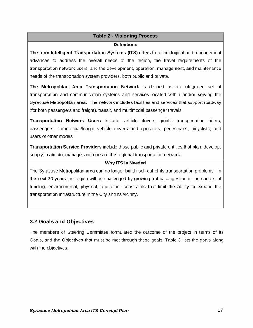
Table 2 - Visioning Process Definitions
The term Intelligent Transportation Systems (ITS) refers to technological and management
advances to address the overall needs of the region, the travel requirements of the
transportation network users, and the development, operation, management, and maintenance
needs of the transportation system providers, both public and private.
The Metropolitan Area Transportation Network is defined as an integrated set of
transportation and communication systems and services located within and/or serving the
Syracuse Metropolitan area. The network includes facilities and services that support roadway
(for both passengers and freight), transit, and multimodal passenger travels.
Transportation Network Users include vehicle drivers, public transportation riders,
passengers, commercial/freight vehicle drivers and operators, pedestrians, bicyclists, and
users of other modes.
Transportation Service Providers include those public and private entities that plan, develop,
supply, maintain, manage, and operate the regional transportation network.
Why ITS Is Needed The Syracuse Metropolitan area can no longer build itself out of its transportation problems. In
the next 20 years the region will be challenged by growing traffic congestion in the context of
funding, environmental, physical, and other constraints that limit the ability to expand the
transportation infrastructure in the City and its vicinity.
3.2 Goals and Objectives
The members of Steering Committee formulated the outcome of the project in terms of its
Goals, and the Objectives that must be met through these goals. Table 3 lists the goals along
with the objectives.
Syracuse Metropolitan Area ITS Concept Plan 17

Table 3 - Goals and Objectives Goal #1 - Improve Safety
Reduce the frequency of incidents
Reduce the severity of incidents
Reduce emergency response time
Goal #2 - Increase Operational Efficiency and Mobility
Increase throughput of the transportation services
Reduce delay due to incidents
Improve travel time and service level reliability
Improve intermodal facilities and operations
Goal #3 - Increase Productivity
Increase cost savings
Reduce acquisition, maintenance and life cycle costs
Goal #4 - Reduce Environmental and Energy Impacts
Reduce harmful emissions
Reduce energy consumption
Goal #5 - Enhance Customer Satisfaction
Increase traveler benefits of the transportation services
Increase provider benefits of the transportation services
Goal #6 - Improve Traveler Information
Increase dissemination of real-time information
Provide alternate route information during emergencies
Enhance Roadway/Weather Information System (RWIS) and use to provide information to key users and the general public
Syracuse Metropolitan Area ITS Concept Plan 18

4. Existing Conditions / Problems / ITS Elements
4.1 Introduction
The objective of this report is to document the established goals, assess operational
deficiencies, analyze the existing conditions of transportation facilities, and prioritize those
facilities for potential ITS deployment. Available data were gathered and summarized in order
to identify the current status of the city and county’s transportation system.
Section 4.2 presents the roadway system while Section 4.3 provides an overview of the transit
and air system in Onondaga County. Priority locations and issues relating to each mode of
transportation are identified if applicable. An inventory of existing and proposed ITS elements
within the study area is presented in Section 4.4.
4.1.1 Methodology and Criteria for Selection of Priority Locations
ArcView GIS, a Geographic Information System, was used to array and analyze available data.
The GIS provides significant capabilities for base mapping, analyzing and displaying project
data and for producing high quality output in the form of maps and tables.
For highway corridors, the priority locations are identified based on recurring congestion.
Recurring congestion occurs during peak commuting times whenever the volume of traffic trying
to use a roadway segment approaches or exceeds its traffic carrying capacity. Information
provided by the Syracuse Metropolitan Transportation Council’s (SMTC) Congestion
Management System 2000-2001 Final Report provided the basis for the locations of recurring
congestion. Congested locations were defined as having a volume to capacity (V/C) ratio of
0.90 or greater.
Additional priority locations were identified through consultation with the ITS Strategic Plan
Steering Committee and through the analysis of a variety of data including the following:
• Traffic patterns and congestion during special events;
• State and local highway system accidents;
Syracuse Metropolitan Area ITS Concept Plan 19

• Low clearance bridges;
• Highway-rail grade crossings;
• Critical ramp locations;
• Truck routes;
• Locations that experience weather related transportation issues; and
• Transit and air travel availability and accessibility.
4.1.2 Study Area
The study area is comprised of Onondaga County, which includes the City of Syracuse (see
Figure 4.1). Based on the 2000 U.S. Census, Onondaga County has a population of 458,336.
Residents within the City limits account for 147,306 of the total County population.
Centrally located within Onondaga County, the City of Syracuse serves as the focus for
commercial and business activity. Land uses within the City include commercial, governmental
(federal, state, county, and city), institutional (education, medical, cultural, and religious), retail,
residential, and industrial.
Onondaga County offers a variety of high-quality educational, cultural, and recreational
opportunities. Major colleges and universities include Syracuse University, the State University
of New York College of Environmental Science and Forestry, Lemoyne College, the State
University of New York’s Upstate Medical University, and Onondaga Community College.
In addition to the colleges and universities, the County has a variety of cultural assets. These
include the Onondaga County Public Library System, the Everson Museum, Syracuse Stage,
the Syracuse Symphony Orchestra, the Museum of Science and Technology (MOST), the New
York State Fair, the Erie Canal, the Landmark Theater, the Onondaga County Convention
Center and the Carrier Dome.
Recreational facilities within the County include P&C Stadium, home of the Syracuse SkyChiefs
Triple-A baseball team, the Onondaga County War Memorial, home of the Syracuse Crunch
minor league hockey team, the Carrier Dome which hosts a variety of Syracuse University
sports teams and the Onondaga County Parks system.
Syracuse Metropolitan Area ITS Concept Plan 20

Syracuse Metropolitan Area ITS Concept Plan 21
Base Year and Data Sources
The year 2001 was selected as the base year for the analysis. The Syracuse Metropolitan
Transportation Council (SMTC) was the primary source of traffic data and ArcView GIS files.
The base year for traffic data contained in the SMTC database for its Congestion Management
System (the source of congested locations identified in this report) ranges between 1998 and
2000. Additional data was obtained from the Onondaga County and New York State
Departments of Transportation, the City of Syracuse, and the Central New York Regional
Transportation Authority (CNYRTA).
Accident data for the local highway system was obtained from the SMTC, the original source of
which was the NYSDOT. The accident data covers the years 1997 through 1999, which was
the most recent data available. State highway accident data was obtained directly from the
NYSDOT and covers the two-year period from September 1997 through August 1999.
Additional information was provided by the ITS Strategic Plan Steering Committee and from
interviews held with regional ITS stakeholders.
4.2 Roadway Systems
4.2.1 Roadway Network The highway network within the county and city, including functional classification, are shown in
Figure 4.2 and 4.2a, respectively. Onondaga County is primarily laid out in a radial pattern with
most of the major roadways and arterials leading to and from the City of Syracuse. The
highway network consists of interstate highways (I-81, I-90 (New York State Thruway), I-481, I-
690), freeways (Route 481, Route 690, Route 695), state highways (Route 5, Route 31, Route
80, Route 92, Route 173, Route 175, Route 257, Route 290, Route 298, and Route 370), US
highways (US 11, US 20), and other major arterials.
The north-south traffic in Onondaga County is primarily served by Interstate 81 and to a lesser
degree, Interstate 481 and US 11. In addition, major arterials such as Route 57, Morgan Road,
John Glenn Boulevard, Henry Clay Boulevard, Buckley Road, Thompson Road, and Northern
Boulevard also serve north-south traffic in the northern portion of the county.
Syracuse Metropolitan Area ITS Concept Plan 22

East-west traffic within Onondaga County is primarily served by Interstate 690 and State Routes
5 and 92. Other major east-west corridors in Onondaga County include Route 370, Onondaga
Lake Parkway, Route 31, Taft Road, Route 173, Route 175 and Route 290. Interstate 90 (New
York State Thruway) is a limited access toll highway that typically serves traffic passing through
or traffic from outside Onondaga County. There is very little use of Interstate 90 for trips within
Onondaga County.
As shown in Figure 4.2a, the City of Syracuse is primarily laid out in a grid street pattern and
consists of a variety of functional classifications. The roadway network consists of two
interstate highways (I-81 and I-690), state routes (Route 5, Route 80, Route 92, Route 173,
Route 175, and Route 290), one US highway (US 11), and major arterials (Erie Boulevard,
Genesee Street, Salina Street and Almond Street). In addition, there are numerous local streets
that are critical to the circulation patterns within the City of Syracuse.
The north-south traffic into and out of the Syracuse Central Business District (CBD) is primarily
served by Interstate 81 and the following four major arterials: Salina, Clinton, West, and Almond
Streets. Other significant north-south roadways in the City include Franklin, Geddes, and State
Streets and Teall Avenue.
East-west traffic within the CBD is primarily served by Genesee Street, Erie Boulevard and
Adams Street. Other major east-west corridors in the City include Washington Street, Fayette
Street, Harrison Street, and Jefferson Street.
4.2.2 General Roadway Congestion
Traffic in Onondaga County is typically concentrated during rush hours. The peak periods
typically last from 7:00 AM to 9:00 AM in the morning, and from 4:00 PM to 6:00 PM in the
evening. Outside of these times, traffic flow is generally good. Workers commuting in to the city
from the surrounding suburbs are the main cause of congestion. City of Syracuse residents and
businesses contribute relatively little to these volumes.
With the exception of the streets that flow directly into the CBD, the University Hill area and
streets that intersect with an interstate system ramp, traffic flow during peak hours within the city
is better than average.
Syracuse Metropolitan Area ITS Concept Plan 23

4.2.3 Recurring Congestion
4.2.3.1 Congested Road Segments
Information provided by the Syracuse Metropolitan Transportation Council’s (SMTC) Congestion
Management System 2000-2001 Final Report provided the basis for the locations of recurring
congestion. Congested locations were defined as having a volume to capacity (V/C) ratio of
0.90 or greater. Twenty-five locations were identified that had a v/c ratio > 0.90 for the PM peak
hour. The PM peak hour was used since a majority of the locations had higher volumes during
this time. Table 4 lists the twenty-five locations and Figure 4.3 displays the locations of these
road segments.
Syracuse Metropolitan Area ITS Concept Plan 24

Syracuse Metropolitan Area ITS Concept Plan 25

Syracuse Metropolitan Area ITS Concept Plan 26

Table 4 - Congested Road Segment Locations REFERENCE
NUMBER
ROAD FROM/TO SEGMENT
LENGTH
PM PEAK
V/C RATIO
1 I481 Acc Rts 5 92/Acc Rt 690I 1.26 0.92
2 I690 Jct Rt 695/Syracuse W City Ln 1.99 1.27
3 I690 Acc Geddes St Half Int/Acc West St 0.64 1.19
4 I690 Acc Midler Av/Syracuse E C L Rt 635 1.06 1.50
5 I690 Acc 81I NB/Acc McBride St EB 0.22 1.66
6 I81 Jct Taft Rd/Jct Rt 481 1.30 1.00
7 I81 Jct Rt 90I/Jct Rt 11 1.79 1.04
8 I81 Jct Colvin St/Jct E Adams St 0.97 1.04
9 I81 Jct E Adams St/Acc 690I 0.66 2.21
10 I81 Jct Rt 298 Bear St/Rt370 0.30 1.81
11 SR173 Genesee St Fairmount/Split Rock 1.82 0.95
12 SR290 Bridge St/Fremont Rd 1.87 1.44
13 SR31 End Rt 370 OLP/CR 91 Old Rt 57 3.62 1.31
14 SR370 River Rd Cold Springs/John Glenn
Blvd
0.77 1.17
15 SR370 Rt 931 G Old Rt 57/Syracuse N City
Ln
2.22 1.05
16 I481 Acc Kirkville Rd/Acc Rt 90I 1.13 0.99
17 SR5 Acc 481I/End Rt 92 OLP Lyndon 0.77 1.71
18 SR5 Rt 290 Mycenae/Madison County Line 0.85 0.91
19 SR695 Rt 5/690I End 695 2.30 0.92
20 SR92 End Rt 5 OLP/Woodchuck Hill Rd 1.73 1.57
21 SR92 End Rt 173 OLP/Pompey Ctr Rd 0.98 1.19
22 SR173 City of Syracuse/Rt 80 Valley Dr 0.43 1.15
23 W Fayette
St
Geddes St/West St 0.64 1.12
24 Teall Ave James St/Grant Blvd 0.48 0.92
25 CR 57 I90/Tulip St 0.75 1.17
Source: SMTC Congestion Management System 2000-2001 Final Report
Syracuse Metropolitan Area ITS Concept Plan 27

Syracuse Metropolitan Area ITS Concept Plan 28

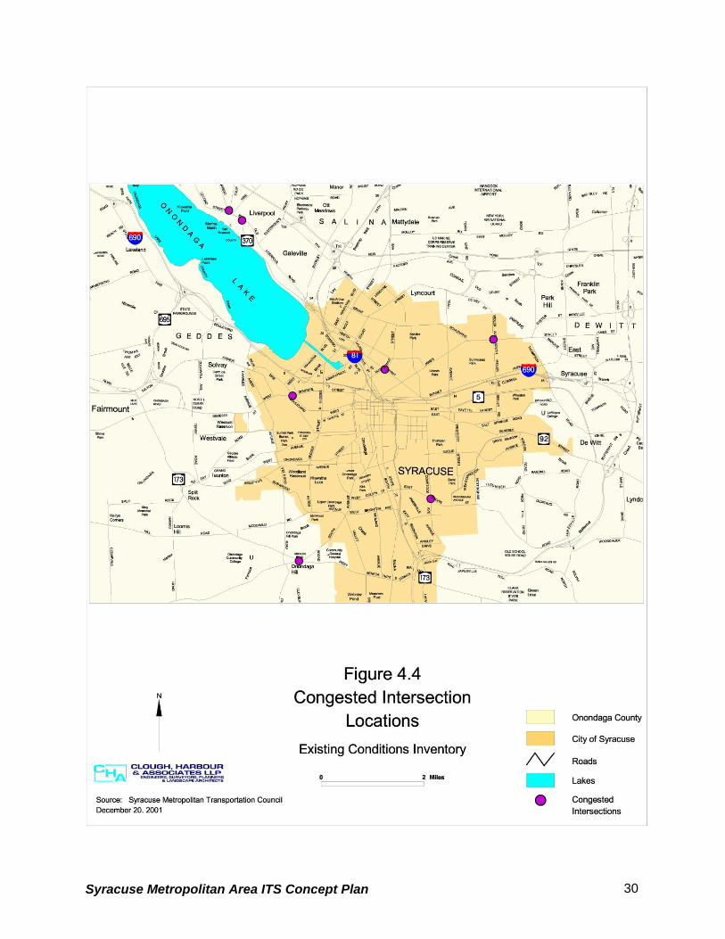
4.2.3.2 Congested Intersections
In addition to the twenty-five road segments identified in the SMTC Congestion Management
System 2000-2001 Final Report, seven congested intersections were identified where at least
one approach had a v/c ratio that was greater than 1.0. The intersections are listed below and
the locations are shown in Figure 4.4.
• SR 370/CR 57/Old Liverpool Rd
• CR 57 at Tulip St
• Midler Ave at James St
• Butternut at Lodi St
• Genesee St at Erie Blvd West
• SR 173 (East) at SR 175
• Colvin St at Comstock
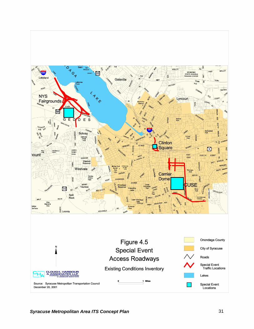
4.2.4 Special Event Access Roadways
Based on input from the ITS Strategic Plan Steering Committee there are a number of locations
that experience significant traffic increases due to special events. The special event traffic
generators and access roadways are discussed below and are shown in Figure 4.5.
4.2.4.1 New York State Fairgrounds
The New York State Fairgrounds is a 375 acre site located adjacent to Interstate 690 west of
the City of Syracuse. The site accommodates parking and shuttle service for 23,000 vehicles
and hosts over two million visitors annually. The following locations experience significant traffic
increases during special events at the New York State Fairgrounds:
• Interstate 690
• State Route 695
• State Fair Boulevard
• State Route 297 – Bridge Street
Syracuse Metropolitan Area ITS Concept Plan 29
Syracuse Metropolitan Area ITS Concept Plan 30
Syracuse Metropolitan Area ITS Concept Plan 31

4.2.4.2 Carrier Dome
The Carrier Dome is a 50,000 seat multi-purpose facility and is the only major domed stadium
on a college campus. Both sporting and entertainment events are held here year-round. The
facility is located on the campus of Syracuse University, adjacent to Interstate 81, but is only
served by city streets. The following locations experience significant traffic increases during
special events at the Dome:
• Interstate 81 northbound and southbound – mainline
• Interstate 81northbound off ramp at Adams Street
• Interstate 81 southbound off ramp at Harrison Street
• Adams Street
• Harrison Street
• Almond Street
• Irving Avenue
• Colvin Street
• Comstock Avenue
4.2.4.3 Clinton Square Clinton Square, located in the CBD of the City of Syracuse, is a civic plaza designed for year-
round use. The recently renovated space will host festivals, the farmers market, concerts and
lunchtime activities. The square is home to an ice skating rink during the winter months. The
following locations experience significant traffic increases during special events in Clinton
Square:
• Interstate 81 southbound off ramps at Salina/Clinton Streets
• West Genesee Street
• Salina Street
Syracuse Metropolitan Area ITS Concept Plan 32

4.2.5 Regional Traffic Generators Over the next three years, it is anticipated that the existing Carousel Center Mall, which is
located north of the City of Syracuse CBD adjacent to Interstate 81, will be transformed into a
multi-million dollar tourism center called DestiNY USA. It is projected that DestiNY USA will
include a five million square foot facility on 800 acres of land (an area seven times larger than
Magic Kingdom). The plans indicate that the facility will house 400 retailers, 30 restaurants and
cafes, and 4,000 hotel rooms. With 75 million people within a one-day drive, it is anticipated that
the development will have a significant impact on the local and regional transportation network.
Figure 4.6 shows the location of the Carousel Center Mall and identifies major access routes.
4.2.6 High Accident Locations
Data regarding high accident locations on both the state highway and local highway systems
has been included in this report. The information for the state highway system was provided by
the NYSDOT based on their Priority Investigation Location System (PILS) and for the local
highway system based on their Safety Information Management System (SIMS).
4.2.6.1 State Highway System
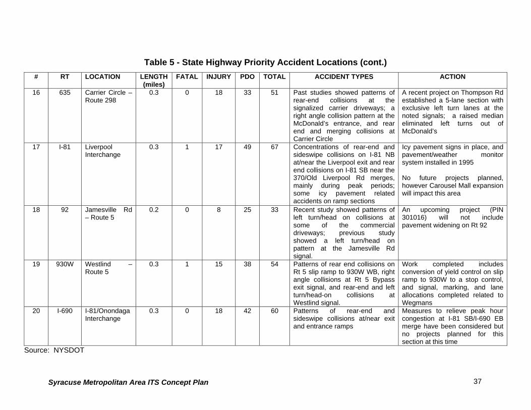
Table 5 lists the top twenty high accident locations on the state highway system and provides a
summary of accident types and action taken or proposed. The locations were selected based
on accident rates and severity by the NYSDOT for the two-year period September 1997 through
August 1999. The locations are numbered for referencing purposes only and are not intended to
indicate ranking (see Figure 4.7).
Syracuse Metropolitan Area ITS Concept Plan 33

Syracuse Metropolitan Area ITS Concept Plan 34

Syracuse Metropolitan Area ITS Concept Plan 35
Table 5 - State Highway Priority Accident Locations # RT LOCATION LENGTH
(miles) FATAL INJURY PDO TOTAL ACCIDENT TYPES ACTION
1 11 Bailey Rd 0.1 0 23 40 63 Pattern of left turn/head on collisions at signal
Traffic signal adjustments; no projects planned
2 31 Crabtree-Pardee Rd
0.2 0 24 55 79 Patterns of left turn/head on collisions at signalized I-81 ramp intersections and at gas station convenience stores west of Crabtree and east of Pardee Rd
Project to restore skid resistance scheduled for 2002
3 11 E. Circle Drive-Hogan
0.3 0 39 65 104 Pattern of left turn/head on collisions at E. Circle Drive signal
Adjusted traffic signal to protected only phase; considering reducing skew angle of slip ramp from E. Circle Drive to address rear end collisions
4 298 Carrier Circle 0.5 0 44 118 162 Patterns of rear end, merging collisions on all approaches, heaviest recently on 298 EB approach
Project (PIN 310413) scheduled to reduce skew angle and to channelize EB approach
5 11 Elbow Rd 0.1 0 11 17 28 Patterns of rear end collisions at signal
Project completed that reallocated Rt 11 to two lanes with left lanes at intersection; associated sign work included
6 11 Malden-SouthBay Rd
0.6 0 67 131 198 Most accidents in Mattydale Circle; right angles at I-81NB/Rt 11 SB, I-81 NB/Rt 11 NB; rear end collisions at Rt 11 SB/N Concourse and S. Bay Rd
Project completed that included lane additions /reallocations and associated sign work
7 I-81 Salina St-Spencer
0.3 0 31 71 102 Congestion related accidents at/near downtown ramps (mostly rear end and sideswipe collisions)
Ramp metering being considered for NB
8 31 Walmart-SouleRd
0.5 0 32 62 94 Patterns of congestion related rear end collisions
Recent project created 5-lane section from Belgium to Walmart area; right lane constructed on Rt 31 EB at Soule Rd; upcoming Target and Home Depot development will require additional pavement widening to mitigate generated traffic

Syracuse Metropolitan Area ITS Concept Plan 36
Table 5 - State Highway Priority Accident Locations (cont.) # RT LOCATION LENGTH
(miles) FATAL INJURY PDO TOTAL ACCIDENT TYPES ACTION
9 290 Bridge-BJ’s 0.2 0 11 33 44 Patterns of rear end collisions on slip ramps
Project under consideration to reduce skew angles
10 I-81 Adams-I-690 0.6 0 37 98 135 Patterns of sideswipe, rear end collisions at/near ramps and merge areas (I-81 NB to I-690 EB near Almond St on ramp); barrier hits.
No projects anticipated
11 298 GM Circle – Ridings Rd
0.3 0 13 22 35 Sideswipe accidents on GM Circle while exiting to 298 WB and left turn/head on collisions at the signalized Ridings Rd intersection
Project scheduled to realign left turn lanes at Ridings Rd; GM Circle to be resurfaced with upgrades to signs and markings
12 I-81 Court St – Bear Rd
0.3 0 26 56 82 Congestion related accidents near ramps
No projects planned for this area, however Carousel Mall expansion will impact operations along this section
13 930C(Adams St Art)
Clinton St – Almond St/ I-81
0.5 0 21 81 102 Patterns of left turn/head-on collisions at S. Salina St; left turn related sideswipes at S. State St; right angle, left turn related sideswipes and left turn/head-on collisions at Townsend St; and right angle, right turn, related rear end and sideswipe accidents at Almond St/I-81.
Recent improvements include brighter signal indications; a double left turn with protected only phasing for SB Townsend St; resurfacing and new pavement markings along the entire section
14 I-81 I-690 – Salina St
0.3 0 20 41 61 Patterns of rear end and sideswipe collisions at/near ramp junctures and several rail/barrier collisions
Recent project to clean scuppers, downspouts, and underground drainage system to minimize ponding related accidents
15 I-690 Thompson Rd – Bridge St
0.9 0 50 136 186 Recent study shows accidents on the collector/distributor roads, particularly at ramp junctures (mostly rear end and merging collisions); pattern of fixed object accidents on the WB exit to Thompson Rd NB
Countermeasures currently being considered for ramp accidents
Syracuse Metropolitan Area ITS Concept Plan 37
Table 5 - State Highway Priority Accident Locations (cont.)
# RT LOCATION LENGTH(miles)
FATAL INJURY PDO TOTAL ACCIDENT TYPES ACTION
16 635 Carrier Circle –Route 298
0.3 0 18 33 51 Past studies showed patterns of rear-end collisions at the signalized carrier driveways; a right angle collision pattern at the McDonald’s entrance, and rear end and merging collisions at Carrier Circle
A recent project on Thompson Rd established a 5-lane section with exclusive left turn lanes at the noted signals; a raised median eliminated left turns out of McDonald’s
17 I-81 LiverpoolInterchange
0.3 1 17 49 67 Concentrations of rear-end and sideswipe collisions on I-81 NB at/near the Liverpool exit and rear end collisions on I-81 SB near the 370/Old Liverpool Rd merges, mainly during peak periods; some icy pavement related accidents on ramp sections
Icy pavement signs in place, and pavement/weather monitor system installed in 1995 No future projects planned, however Carousel Mall expansion will impact this area
18 92 Jamesville Rd– Route 5
0.2 0 8 25 33 Recent study showed patterns of left turn/head on collisions at some of the commercial driveways; previous study showed a left turn/head on pattern at the Jamesville Rd signal.
An upcoming project (PIN 301016) will not include pavement widening on Rt 92
19 930W Westlind – Route 5
0.3 1 15 38 54 Patterns of rear end collisions on Rt 5 slip ramp to 930W WB, right angle collisions at Rt 5 Bypass exit signal, and rear-end and left turn/head-on collisions atWestlind signal.
Work completed includes conversion of yield control on slip ramp to 930W to a stop control, and signal, marking, and lane allocations completed related to Wegmans
20 I-690 I-81/OnondagaInterchange
0.3 0 18 42 60 Patterns of rear-end and sideswipe collisions at/near exit and entrance ramps
Measures to relieve peak hour congestion at I-81 SB/I-690 EB merge have been considered but no projects planned for this section at this time
Source: NYSDOT

Syracuse Metropolitan Area ITS Concept Plan 38

4.2.6.2 Local Roadway System Table 6 lists and Figure 4.8 displays those locations on the local roadway system that had more
than 40 accidents during the years 1997 through 1999. The locations are sorted by the total
number of accidents and do not take in to consideration accident rate or severity. The locations
are numbered for referencing purposes only and are not intended to indicate ranking.
Table 6 - Local Roadway Priority Accident Locations REFERENCE # LOCATION INJURY PDO TOTAL
1 East Adams St/I-81 Underpass 22 55 77 2 Harrison St/I-81 Underpass 19 51 70 3 W Fayette St/West Street Arterial 18 49 67 4 Grant Blvd/Teall Ave 29 37 66 5 N & S Geddes St/Erie Blvd W 24 41 65 6 N Salina St/E & W Genesee St 22 43 65 7 Burnet Ave/Teall Ave 17 48 65 8 N Townsend St/NY 5 19 43 62 9 S Salina St/E & W Seneca Tnpk 18 44 62 10 W Taft Rd/Buckley Rd 17 42 59 11 S Geddes St/W Fayette St 19 37 56 12 E Adams St/Comstock Ave 14 41 55 13 N Geddes St/W Genesee St 19 36 55 14 James St/N State St/E Genesee St 16 35 51 15 Lodi St/James St 23 27 50 16 N McBride St/Erie Blvd E 18 32 50 17 Midland Ave/W Brighton Ave 18 30 48 18 S Salina St/Brighton Ave E & W 18 29 47 19 Butternut St/Lodi St 19 27 46 20 W Hiawatha Blvd/Solar St 17 28 45 21 W Hiawatha Blvd/State Fair Blvd 13 31 44 22 Seymour St/S Geddes St 16 28 44 23 N Geddes St/W Belden Ave 20 23 43 24 Burnet Ave/S Midler Ave 8 34 42 25 James St/Teall Ave 16 26 42 26 E Colvin St/S State St 14 27 41
Source: SMTC, NYSDOT
Syracuse Metropolitan Area ITS Concept Plan 39

Syracuse Metropolitan Area ITS Concept Plan 40

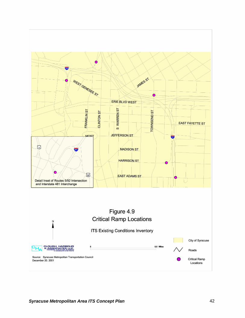
4.2.7 Critical Ramp Locations
Based on input from regional stakeholders there are six off-ramps from interstate highways that
have a significant traffic impact on the local streets. The locations are listed in Table 7 and are
shown in Figure 4.9.
Table 7 - Critical Ramp Locations
Interstate Ramp
I-690 Eastbound off ramp at W. Genesee Street
I-81 Southbound off ramp at Clinton Street/Salina Street
I-690 Westbound off ramp at Townsend Street
I-81 Southbound off ramp at Harrison Street
I-81 Northbound off ramp at Adams Street
I-481 Southbound off ramp at exit 3E (Routes 5 and 92)
The off ramps at Clinton Street, Harrison Street, and Adams Street were also identified as
experiencing significant traffic increases during special events at the Carrier Dome and Clinton
Square.
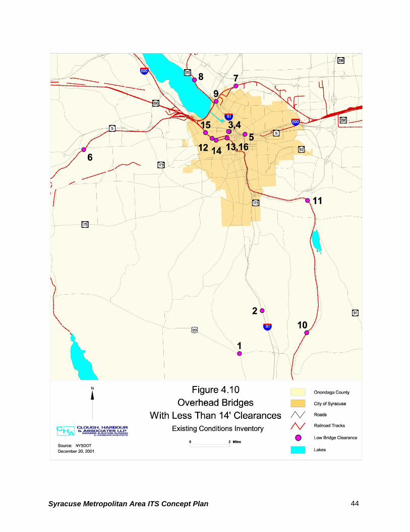
4.2.8 Overhead Bridges with Low Clearances
The NYSDOT considers overhead bridges with a vertical clearance of less than 14 feet to be
substandard. Table 8 identifies sixteen bridges in Onondaga County that are posted for
substandard vertical clearance. The locations are shown in Figure 4.10.
The Route 20 bridge over Route 11A, referenced as number 1, is currently being reconstructed
and will not have substandard vertical clearance when completed.
Based on local knowledge, the CSX railroad bridge over Route 370 and the NYS&W railroad
bridge over W. Genesee Street, referenced as numbers 8 and 15, respectively, are hit most
frequently.
Syracuse Metropolitan Area ITS Concept Plan 41
Syracuse Metropolitan Area ITS Concept Plan 42

Table 8 - Low Clearance Bridges
REFERENCE
NUMBER
FEATURE CARRIED FEATURE CROSSED ACTUAL CLEARANCE
1 Route 20 Route 11A 13’ 6”
2 Interstate 81 Webb Road 13’ 6”
3 SB West Street Arterial West Genesee 13’ 9”
4 NB West Street Arterial West Genesee 13’ 9”
5 Ramp to Route 690 EB Catherine Street 13’ 9”
6 Finger Lakes Railway Genesee Street 12’ 8”
7 CSX Transport/Amtrak Route 11 13’ 9”
8 CSX Transport Route 370 12’ 03”
9 CSX Transport Route 370/Park
Street
11’ 09”
10 NYS&W Eager Road CR 232 12’ 02”
11 Allied Chemical County Road
6/North Street
12’ 00”
12 NYS&W Route 5 12’ 02”
13 NYS&W W Fayette Street 13’ 04”
14 NYS&W S Geddes Street 13’ 08”
15 NYS&W W Genesee Street 13’ 03”
16 NYS&W Siding W Fayette Street 13’ 08”
Source: NYSDOT
Syracuse Metropolitan Area ITS Concept Plan 43
Syracuse Metropolitan Area ITS Concept Plan 44

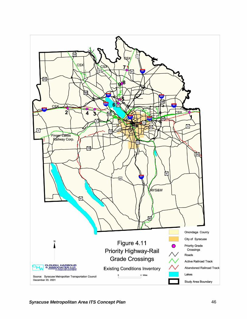
4.2.9 Highway-Rail Grade Crossings Table 9 lists and Figure 4.11 displays nine priority highway-rail grade crossing locations. The
first four locations listed are on the Chicago Main Line and were selected due to the frequency
and speed of trains at the crossings. All four locations have a frequency of 70 trains per day
with a maximum train speed of 79-Miles per Hour (MPH). If the state implements high-speed
rail as proposed, these sites will require an additional track for that purpose.
The remaining five sites each have Average Annual Daily Traffic (AADT) volumes greater than
5,000, have a frequency of between five and eight trains per day and a maximum train speed of
40 MPH.
All nine locations are equipped with gates and flashers. The only accident recorded at any of
the sites during the past ten years was a fatality in June of 2000 at the Herman/DeVoe grade
crossing. Motorists driving around lowered gates have been identified as an issue at some of
these locations.
Table 9 - Priority Highway-Rail Grade Crossings REFERENCE
NUMBER
STREET NAME AADT TRAIN
FREQUENCY/
DAY
MAX. TRAIN
SPEED
(MPH)
ACCIDENTS
1 Kirkville Road 2,807 70 79
2 Bennetts Corners Road 889 70 79
3 Pottery Road 762 70 79
4 Herman Road/DeVoe
Road
700 70 79 Fatality,
6/11/00
5 Vine Street 13,955 8 40
6 Old Liverpool Road 13,566 8 40
7 State Route 31 10,607 5 40
8 Henry Clay Boulevard 8,038 5 40
9 Wetzel Road 6,358 5 40
Source: SMTC
Syracuse Metropolitan Area ITS Concept Plan 45
Syracuse Metropolitan Area ITS Concept Plan 46

4.2.10 Major Truck Routes
The City of Syracuse Truck Route Study completed by the SMTC in May 2000 documented
existing truck routes within the City of Syracuse and made recommendations for creating one
new route while eliminating others. Figure 4.12 shows the existing truck routes within the City
and displays the changes recommended in the City of Syracuse Truck Route Study. All
highways in Onondaga County owned by the NYSDOT are open to all legal vehicles.
The Onondaga County Department of Transportation cannot legally post truck routes. The
County can post “No Truck” signs; however, since the towns have the authority to post truck
routes, it is the County’s policy to defer to the towns in the placement of “No Truck” signs.
The SMTC requested information from towns in Onondaga County regarding truck routes and
posted weight-restricted routes. The information that was received is summarized below.
Town of Camillus
Restricted Routes
Table 10 lists streets within the Town of Camillus that have weight limit restrictions:
Table 10 - Town of Camillus Weight Limit Restrictions Name of Street Weight Limit (tons)
Vanida Drive (between West Genesee Street and Sanderson Drive) 4 Sunnybrook Drive, Garland Road, Wilmont Road, Myron Road, Sherry Drive, Gifford Drive, Cotton Street, Sawyer Street, Jones Street and James Avenue
4
Cotton Street 5 Germania Avenue 5 Jones Street 5 Knowell Road 5 Male Avenue 5 Mackay Avenue 5 Myron Road 5 Myrtis Road 5 Sawyer Street 5 Sidney Street 5 Sunnybrook Drive 5 Semloh Drive 5 Lyons Road Extension 5 Gifford Drive 5 Hinsdale Road (between West Genesee Street and Milton Avenue) 5 DeVoe Road 5 VanAlstine Road 5 Thompson Road 5 Whedon Road 5/per axle Oakridge Drive 5/per axle
Source: Town of Camillus
Syracuse Metropolitan Area ITS Concept Plan 47

Town of Dewitt
Permitted Routes
The following roads are designated truck routes:
• Cedar Bay between Kinnie Road and Towpath Road
• Kinnie Road west from Agway Drive to Erie Boulevard
• Lapage Place from Walter Drive to Leo Avenue to James Street
Restricted Routes
Table 11 lists streets within the Town of Dewitt that have weight limit restrictions:
Table 11 - Town of Dewitt Weight Limit Restrictions
Name of Street Weight Limit (tons)
Ambergate Road 4 Bradford Drive 5 Bradford Heights Road 5 Butternut Drive (from East Genesee Street to Kinne Road) 4 Canterbury Road 4 Collamer Drive 4 Cross Road 5 DeWittshire Road 4 Franklin Park Drive 4 Grover Street 4 Hobson Avenue 8 Kinne Road (from Mapleview Road to Butternut Drive) 5 Kittel Road 8 Loucks Road 5 Lyndon Road (from East Genesee Street to Kinne Road 4 Orville-Jamesville Road No. 7 (from East Genesee to County Jamesville-Dewitt Interstate Route 281 4
Orvilton Drive (from Thompson Road to East Genesee Street 5 Peck Hill Road (from Nottingham Road to Tecumseh Road 5 Radcliffe Avenue (from Thompson Road to Syracuse City line) 4 Randall Road (from Kimber Road to Jamesville Road 5 Roby Avenue (from James Street to Grover Street) 4 Russell Lane 5 Schuyler Road 5 Scott Avenue 5 Syracuse-Dewitt County Road No. 6 (from Ogle Road to Rams Gulch Road) 5 Tecumseh Road (from Nottingham Road to Kimber Road) 5 Temple Drive 5 Thompson Road (from Kinne Road to Orvilton Drive 5 Warwick Road 4 Wellington Road (from 198 feet south of East Genesee Street south to its terminus) 4 Winchester Road (from Kinne Street to Franklin Park Drive 4 Woodchuck Hill Road (from Marmot Circle east to the Town of Manlius line) 5
Source: Town of Dewitt
Syracuse Metropolitan Area ITS Concept Plan 48

Town of Salina
Permitted Routes
Trucks in excess of five tons may travel on Factory Avenue East from US Route 11 (Brewerton)
to Town Line Road.
Restricted Routes
Many of the local streets within the Town of Salina have a weight limit restriction of 3 or 5 tons.
The following table lists six of the more significant streets and their associated weight limit
restrictions.
Table 12 - Town of Salina Weight Limit Restrictions
Name of Street Weight
Limit (tons) Bailey Road 5 Buckley Road (from 7th North Street to north boundary of the Town of Salina) 5 East Molloy Road (from US Route 11 to Town Line Road) 5 Hopkins Road (from Electronics Parkway to Buckley Road) 5 Malden Road (from US Route 11 to Town Line Road) 5 West Molloy Road (from Biltmore Street and McAlpine Street) 3
Source: Town of Salina
Village of Liverpool
Permitted Routes Trucks weighing greater than three tons are permitted to travel on the following roadways within
the Village of Liverpool:
• First Street between Tulip Street and Oswego Street
• Fourth Street between Vine Street and Cypress Street; Cypress Street from Fourth Street to
its intersection with Cleveland Street; Cleveland Street from Cypress Street to its end.
• North Willow Street
• Old Liverpool Road
• Onondaga Lake Parkway
• Oswego Street
• Pearl Street
• Route 370 – Second Street
• Salina Street
Syracuse Metropolitan Area ITS Concept Plan 49

• Tulip Street
• Vine Street
Restricted Routes Trucks weighing greater than three tons are excluded from all other village streets and all trucks
are excluded from Brow Street between Sycamore Street and Tulip Street.
Minor Town and Village Route Restrictions
Table 13 presents the remaining information that was received from towns and villages
regarding route restrictions.
Table 13 - Minor Town and Village Route Restrictions
Town/Village Name of Roadway Weight Limit
Village of Fayetteville Sheffield Lane 7,000 pounds
Village of Manlius All non-state highways and roads 5 tons Village of Marcellus South Street 5 tons
Village of Tully Railroad Street; Lincoln Street No through truck traffic
Town of Cicero East West Road (between Route 11 and East Circle Road); Lombardi Manor development tract 8,000 pounds
Town of Clay Soule Road 4 tons Town of Spafford All town roads No restrictions
Source: Towns and Villages identified in table
4.2.11 Weather Related Transportation Issues Due to Onondaga County’s geographic location, it is impacted by severe weather conditions
during the winter months including Lake Effect snow. The ITS Strategic Plan Steering
Committee identified the entire county as being subject to weather related transportation issues.
The following four sites were identified by the NYSDOT as locations where the weather has a
significant impact on transportation (see Figure 4.13):
1. Interstate 690 westbound ramp to Auburn
2. Route 695 over the railroad near the New York State Fairgrounds
3. Interstate 81 over Park Street
4. Interstate 81 over Route 80 in Tully
Syracuse Metropolitan Area ITS Concept Plan 50

The NYSDOT has installed Road Weather Information Systems (RWIS) at these locations. A
RWIS is a system developed from a combination of technologies that uses historic and current
climatological data to develop road and weather information to aid in roadway-related decision
making.
Syracuse Metropolitan Area ITS Concept Plan 51
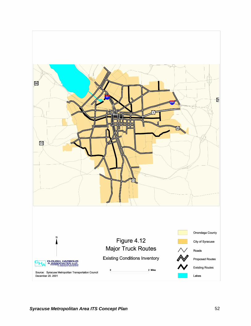
Syracuse Metropolitan Area ITS Concept Plan 52

Syracuse Metropolitan Area ITS Concept Plan 53

There are three components to a RWIS including an environmental sensor system to collect
data, a model or processing system to develop forecasts and provide the information in an
understandable format, and a dissemination platform to display the information.
Syracuse Metropolitan Area ITS Concept Plan 54

4.3 TRANSIT AND AIR SYSTEM
Public transportation services in Onondaga County are primarily provided by the following:
• Centro- a subsidiary of the Central New York Regional Transportation Authority (CNYRTA)
providing fixed route local, express and regional bus service
• OnTrack - local passenger rail service
In addition to the local service, Greyhound and Amtrak provide intercity bus and rail services.
The transportation hub for the intercity services is located at the William F. Walsh Regional
Transportation Center (RTC) shown on Figure 4.14.
4.3.1 Rail Network
The study area passenger rail network consists of the Chicago Main Line owned by CSX
Transportation and the New York Susquehanna & Western Railway (NYS&W) of which OnTrack
is a subsidiary. The overall rail network for the county and the boarding platform locations for
OnTrack are shown in Figure 4.14.
OnTrack provides passenger rail service between Carousel Center Mall and the University area
with additional boarding platforms located at Armory Square and East Colvin Street. There are
also boarding platforms located south of the City in the Town of Jamesville and Jamesville
Beach. These sites are used seasonally for special events such as fall foliage trips.
An additional boarding platform is located at P&C Stadium just beyond the RTC, but service to
this location has been delayed due to the need for a new rail bridge over Park Street. It is
anticipated that this situation will be remedied within the next few years which will allow OnTrack
to provide service to the RTC and P&C Stadium.
OnTrack service is divided into three categories that consist of City Express, Orange Express,
and Special Events with a total annual ridership of 25,000. City Express is the regularly
scheduled service that runs between Carousel Center Mall and the University area and
accounts for approximately 50 percent of annual ridership. The Orange Express provides
service between Carousel Mall and the University for special events at the Carrier Dome. The
Syracuse Metropolitan Area ITS Concept Plan 55
Orange Express combined with other Special Event service accounts for the remaining 50
percent of ridership.
The City Express service operates Wednesday through Sunday from September through May.
The service provides eight daily round trips between 11:00 AM and 7:00 PM. During the
summer months when the Universities are not in session, the City Express only operates Friday
through Sunday. The fair for the City Express is $1.50 per boarding. The Orange Express
service that runs for special events at the Carrier Dome cost $3.00 round trip from Armory
Square and $4.00 round trip from Carousel Center Mall.
Syracuse Metropolitan Area ITS Concept Plan 56

Syracuse Metropolitan Area ITS Concept Plan 57

4.3.2 Bus Service The Central New York Regional Transportation Authority (CNYRTA) serves Onondaga, Cayuga,
and Oswego Counties. The CNYRTA has a fleet size of 207 vehicles and serves an area with a
population of 657,715. Approximately 4,000 daily trips are generated with a daily ridership of
41,000 people. Annual passengers total 13,316,428.
The CNYRTA provides for a number of transportation services including:
• Local, handicap accessible service
• Shopper shuttles
• Paratransit services
• Inter-city services between the cities of Auburn, Oswego, Fulton, and Syracuse
• Parking
• Carpool program
• Carrier Dome special events services
• Syracuse and SUNY Oswego shuttle services
A subsidiary of the CNYRTA commonly known as Centro, operates 12 numbered route groups
providing local and express bus service in Onondaga County. With the exception of route group
12, which provides service within the Syracuse University vicinity, all routes converge at
Common Center in downtown Syracuse where transfers can be made conveniently.
As a result of ReMAP (Regional Mobility Action Plan), a recently completed comprehensive
strategic plan for restructuring its public transportation services in Onondaga County, Centro
recently implemented two new routes, the Suburban East Loop and the Suburban West Loop.
The goal is to serve employment, shopping and activity centers while providing convenient
transfers to bus lines serving downtown Syracuse and other locations. Figure 4.15 shows the
areas served by current Centro routes.
Syracuse Metropolitan Area ITS Concept Plan 58

Syracuse Metropolitan Area ITS Concept Plan 59

4.3.3 Air Service
Syracuse Hancock International Airport, owned and operated by the City of Syracuse, is the
only major airport within the study area. In 1997, Hancock International Airport handled 152,000
flights and serviced 2.1 million people. Six major airlines and seven commuter airlines provide
air passenger service. In addition, six major air cargo carriers serve the County.
Syracuse Hancock International Airport is within a fifteen-minute drive of the City of Syracuse
Central Business District (CBD) and within five minutes of the crossroads of Interstates 81 and
90. Access to the airport, shown in Figure 4.16, is obtained via Interstate 81 and South Bay
Road. Access for commercial operations is also displayed.
Syracuse Metropolitan Area ITS Concept Plan 60

Syracuse Metropolitan Area ITS Concept Plan 61

4.4 EXISTING AND PLANNED ITS INVENTORY
This chapter provides an inventory of existing and planned ITS devices/systems based on
information available from various reports as well as information provided by the regional
stakeholders.
4.4.1 City of Syracuse
4.4.1.1. Existing ITS Elements
The City of Syracuse has implemented the following ITS projects (see Figure 4.17):
• Closed Loop Traffic Signal Systems 1. East Genesee Street from Columbus Avenue to Salt Springs Road
2. James Street from Shotwell Avenue to the City line
3. Seventh North Street from Court Street to Crouse Hinds parking lot (just past Hiawatha
Boulevard
4. Burnet Avenue from Catherine Street to Beech Street
5. West Genesee Street from Leavenworth to Avery Avenue
6. Geddes Street from Belden to Delaware Street
• Computer Controlled Traffic Signal Interconnect System: 143 intersections within the
City of Syracuse are currently under computer control. These signals are operated by the
City of Syracuse and connected to the Traffic Control Center (TCC) at the Department of
Public Works using multi-mode fiber optic cable. Figure 4.17 displays the locations of
intersections that are part of the traffic signal interconnect system.
• CCTV (Closed Circuit Television): The City currently has CCTV cameras installed at the
five intersections listed below. The CCTVs allow the City to visually monitor traffic conditions
at these locations from the TCC.
Syracuse Metropolitan Area ITS Concept Plan 62

Syracuse Metropolitan Area ITS Concept Plan 63

1. I-690 westbound off ramp / Townsend Street
2. Harrison Street / Irving Avenue
3. Harrison Street / Almond Street
4. Harrison Street / Montgomery Street
5. Adam Street / McBride Street
4.4.1.2 Proposed ITS Elements
The City of Syracuse has scheduled the following ITS improvements:
• Computer Controlled Traffic Signal Interconnect Project: Expansion of the traffic signal
interconnect system to include the Geddes Street - West Genesee Street loop which
includes 23 intersections is scheduled to begin design in 2004/2005. In addition, the design
for the inclusion of 15 additional intersections in the vicinity of N. Salina Street and Lodi
Street is scheduled for 2004/2005. The locations of the traffic signal interconnect system
expansion are shown in Figure 4.17. The City plans to have all of the traffic signals in the
City included in the interconnect system within the next ten years.
4.4.2 Onondaga County
4.4.2.1 Onondaga County Department of Transportation Proposed ITS Elements
The Onondaga County Department of Transportation currently does not own or operate any ITS
devices. However, the County does have plans to implement the following ITS system in 2002
(see Figure 4.18):
• A closed loop traffic signal system on Route 57 between the Interstate 90 (Thruway)
interchange and Gaskin Road (south of Route 31).
4.4.2.2 Onondaga County Dept. of Emergency Communications Proposed ITS Elements
Syracuse Metropolitan Area ITS Concept Plan 64

The Onondaga County Department of Emergency Communications (911 Center) recently
contracted to upgrade their equipment in order to accept Phase 1 and 2 wireless
communications service (enhanced wireless 911 system). The equipment upgrade is
scheduled for completion in the spring of 2002. Phase 1 wireless service would present 911
workers with digital and graphic information regarding the distressed callers wireless phone
numbers, what tower the signal is coming from and from which direction the signal hit the tower.
Phase 2 wireless service would provide the longitude and latitude of the calling party and
display the information graphically. Currently, there is no anticipated time frame in which phase
2 wireless service will be available.
In addition, the 911 Center has recently agreed to participate in trials for Automatic Crash
Notification (ACN) which uses wireless communication to send emergency information directly
to emergency centers.
Syracuse Metropolitan Area ITS Concept Plan 65

Syracuse Metropolitan Area ITS Concept Plan 66

4.4.3 New York State Department of Transportation (NYSDOT)
4.4.3.1 Existing ITS Elements The NYSDOT currently owns and operates the ITS devices listed below (see Figure 4.19):
• Permanent Variable Message Signs (VMS) 1. I-81 NB north and south of Route 31
2. I-81 SB north of Court Street
• Portable Variable Message Signs (VMS)
• The Onondaga East and West Maintenance Residencies have a total of ten portable
Variable Message Signs (VMS).
• Video Traffic Detection 1. Intersection of Routes 635 & 290 (Thompson Road/James Street)
• Closed Loop Signal Systems 1. Routes 5/92 – Lyndon Corners – Three signals
2. Route 11 – North Syracuse – Four signals
3. Route 31/Route 57 – Moyers Corners – Two Signals
4. Route 31 – Great Northern Mall – Eight Signals
5. Bridge Street – East Syracuse – Six Signals
6. Thompson Road – Dewitt – Eight Signals
7. Fairmount – Four Signals
8. Liverpool – Six Signals*
9. Manlius – Six Signals*
10. Route 5 at Fay Road – 1 Signal
11. Route 31 – Cicero – Six Signals*
*Spread Spectrum Radio Installations
Syracuse Metropolitan Area ITS Concept Plan 67

Syracuse Metropolitan Area ITS Concept Plan 68

• Road Weather Information System (RWIS) 1. I-690 WB Ramp to Auburn
2. Route 695 over railroad near State Fairgrounds
3. Interstate 81 over Park Street
4. Interstate 81 over Route 80 – Tully
• Induction Loop Sites: The NYSDOT has a number of induction loop sites that are used to
obtain traffic volume counts on a three year cycle for their Traffic Volume Report (TVR). The
sites are listed in Table 14. The induction loops are primarily installed at high volume
locations and eliminate the need to manually place tubes across the roadway to obtain
traffic volumes.
Five of the sites (noted in Table 14) are continuous count (CC) locations that provide traffic
volume counts 24 hours a day 365 days a year. In addition to these five locations, the Rt.
370 site has been equipped to be, and is used as, a seasonal CC location. A seasonal
restriction to travel speed has been imposed for safety reasons and therefore the NYSDOT
monitors traffic speed at this location during the winter months.
Syracuse Metropolitan Area ITS Concept Plan 69
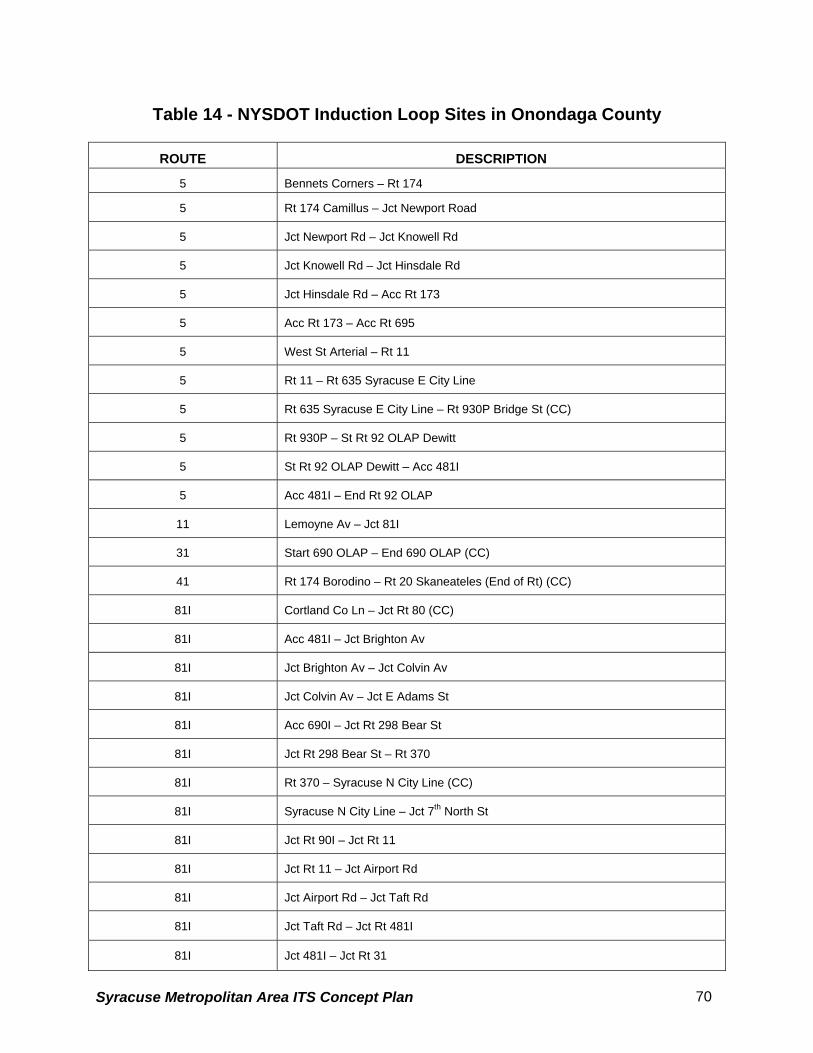
Table 14 - NYSDOT Induction Loop Sites in Onondaga County
ROUTE DESCRIPTION
5 Bennets Corners – Rt 174
5 Rt 174 Camillus – Jct Newport Road
5 Jct Newport Rd – Jct Knowell Rd
5 Jct Knowell Rd – Jct Hinsdale Rd
5 Jct Hinsdale Rd – Acc Rt 173
5 Acc Rt 173 – Acc Rt 695
5 West St Arterial – Rt 11
5 Rt 11 – Rt 635 Syracuse E City Line
5 Rt 635 Syracuse E City Line – Rt 930P Bridge St (CC)
5 Rt 930P – St Rt 92 OLAP Dewitt
5 St Rt 92 OLAP Dewitt – Acc 481I
5 Acc 481I – End Rt 92 OLAP
11 Lemoyne Av – Jct 81I
31 Start 690 OLAP – End 690 OLAP (CC)
41 Rt 174 Borodino – Rt 20 Skaneateles (End of Rt) (CC)
81I Cortland Co Ln – Jct Rt 80 (CC)
81I Acc 481I – Jct Brighton Av
81I Jct Brighton Av – Jct Colvin Av
81I Jct Colvin Av – Jct E Adams St
81I Acc 690I – Jct Rt 298 Bear St
81I Jct Rt 298 Bear St – Rt 370
81I Rt 370 – Syracuse N City Line (CC)
81I Syracuse N City Line – Jct 7th North St
81I Jct Rt 90I – Jct Rt 11
81I Jct Rt 11 – Jct Airport Rd
81I Jct Airport Rd – Jct Taft Rd
81I Jct Taft Rd – Jct Rt 481I
81I Jct 481I – Jct Rt 31
Syracuse Metropolitan Area ITS Concept Plan 70

81I Jct Rt 31 – Jct Bartell Rd
81I Jct Bartell Rd – Oswego County Line
298 Midler Av Ext – Rt 635 Acc 90I
370 Rt 931G Old Rt 57 – Syracuse N City Line (seasonal CC)
481 Rt 81I Onon Co – Rt 11 Conn
481I Acc Rts 5 & 92 - Acc Rt 690I
481I Acc Kirkville Rd – Acc Rt 90I
635 Rt 5 Erie Blvd – Acc 690I
690I Int 39 90I Rt 690 – Rt 90I Under
690I Rt 90I Under – Jct State Fair Blvd
690I Jct State Fair Blvd – Jct Rt 695
690I Syracuse W Cty Ln – Acc Hiawatha Blvd
690I Acc Hiawatha Blvd – Acc Rt 298
690I Acc Rt 298 – Acc Geddes St Half Int
690I Acc Geddes St Half Int – Acc West St
690I Acc West St – Acc 81I SB
690I Acc 81I SB – Acc McBride St EB
690I Acc McBride St – Acc 81I EB
690I Acc 81I EB – Acc Teall Av
690I Acc Teall Av – Acc Midler Av
690I Acc Midler Av – Acc Rt 635
690I Acc Rt 635 – Acc Rt 290 Bridge St
690I Acc Rt 290 – Acc 481I End 690I
695 Rt 5 – Acc Rt 690I End 695
930B Acc Rt – Acc 690I Ramps
930C Adams St
930P Rt 5 – End 930P at Rt 290
Source: New York State Department of Transportation
• Long-Term Pavement Performance (LTPP) Study Site: The Federal Highway
Administration (FHWA) has a LTPP site on I-481 between the interchanges at Route 298
Syracuse Metropolitan Area ITS Concept Plan 71

and Northern Boulevard. This test site is under the Strategic Highway Research Program
(SHRP). Some of the features of the research site include the following:
Weigh-in-motion scales
Temperature sensors for pavement research
Induction loops to measure speeds and volume
Piezo strips for axle detection to classify vehicles
The station currently functions as a TVR station to be counted on a three-year cycle. The
bending plates that allow the weigh in motion scales to function will be removed. The new
piezo strips have the ability to weigh vehicles in motion, and can identify vehicle
classification.
4.4.3.2 Proposed ITS Elements
The NYSDOT plans on implementing the ITS devices listed below (see Figure 4.19):
• Five or six fixed VMS are proposed to be added within the Interstate 690 and Route 695
interchange near the New York State Fairgrounds to address icy pavement conditions
during the winter months, and assist the State Police in managing traffic during the State
Fair. Sensors will be installed in targeted locations, and may tie into the existing RWIS
located nearby.
In addition to the VMS, there is a proposed statewide contract for a statewide RWIS that would
tie the existing RWIS together. This project may result in an additional five RWIS in NYSDOT
Region 3 within the next five years. The NYSDOT also anticipates that five new closed loop
traffic signal systems will be added per year within Region 3.
Region 3 is also working with the Onondaga County Department of Emergency
Communications (911 center) to implement the enhanced wireless 911 system.
Syracuse Metropolitan Area ITS Concept Plan 72
4.4.4 Central New York Regional Transportation Authority (CNYRTA)
4.4.4.1 Existing ITS Elements
The CNYRTA currently has Automated Fare Collection (AFC) boxes on their buses.
4.4.4.2 Proposed ITS Elements
The CNYRTA is in the process of implementing a Mobile Data Acquisition System. The
purpose of implementing the system is to improve transit service control and to improve service
reliability. The CNYRTA expects the system to become an integral part of its evolving
management information system.
Currently, the CNYRTA operates three dispatch centers including the Syracuse facility and two
remote locations in Cayuga and Oswego Counties. A primary goal of the system is to have the
ability to dispatch to all three counties out of the Syracuse facility.
The intended system will provide CNYRTA management with on-line real time management
control of the fleet and a management reporting/information system. One component of the
system is an Automatic Vehicle Location (AVL) system that will provide the CNYRTA with better
knowledge of where their buses are at any given time. In addition to allowing for better fleet
management and greater customer satisfaction, it will also provide data on the location of
recurring problem areas.
Eventually, 30 buses will be equipped with Automatic Passenger Counters (APC) to allow for
the collection of ridership information.
The CNYRTA is aware of two additional issues that may be improved by the implementation of
ITS devices and are currently considering options. Bus and bus stop security could be
Syracuse Metropolitan Area ITS Concept Plan 73

enhanced by the use of cameras and information kiosks located at transit hubs could provide
real time information regarding route changes and bus availability.
4.4.5 Existing Traffic Management Centers
Figure 4.20 identifies the locations of the main public safety facilities (including answering points
and dispatch centers) and the City of Syracuse Traffic Control Center. The numbering system
below coincides with the numbering system shown on Figure 4.20.
1) New York State Police Headquarters
2) City of Syracuse Traffic Control Center, Department of Public Works
3) Onondaga County Sheriff’s Headquarters Building
4) City of Syracuse Police Department Headquarters
5) Onondaga County Department of Emergency Communications (911 Center)
Syracuse Metropolitan Area ITS Concept Plan 74

Syracuse Metropolitan Area ITS Concept Plan 75
4.4.6 Existing Communication System This inventory focuses on the existing communication infrastructure, and services, used by the
agencies in the Syracuse Metropolitan Area. It is based solely on the information provided by
each agency.
To create the inventory, a communications inventory questionnaire was developed and
distributed to all agencies. The results are summarized, by agency, below:
Onondaga County Department of Transportation
This department does not own any communications infrastructure and does not yet have an ITS
communication network in operation. The closed-loop signal system on Old Route 57 from just
South of New York State Route 31 to the New York State Thruway interchange is the only ITS
project under construction in the department. The closed-loop system will use the local
communications system to interconnect intersections. .
New York State Police Department
The Police Department has a T1 Frame Relay leased data network for data sharing between its
buildings. The Frame Relay service is working at a sub rate of 384 KB/S.
New York State Thruway Authority
The Authority, in exchange for use of its right of way, has received a duct system with inner-duct
conduit and a fiber optic network across its entire length. The fiber optic network, equipped with
a SONET OC-3 system, is for the sole use of the Authority.
The Authority has a plan to upgrade this network for more capacity. As part of an agreement
with the private sector, the use of this network is limited to the Authority application. It is
anticipated that all field ITS elements will use this network to connect to the Thruway Traffic
Operation Center.
In addition, there are T1 leased services, which are used for video transmission. ISDN and low
speed dial-up connections are also used by the Authority for exchanging data with the buildings
that are not connected to the fiber optic network.
The Authority does not utilize CDPD or other wireless data systems for accessing ITS elements.
Syracuse Metropolitan Area ITS Concept Plan 76
New York State Department of Transportation
NYSDOT does not own any communications infrastructure in the region. There are a large
number of fiber optic and cable duct systems in the area, which the department does not have
agreements or rights to use.
The State has an ISB WAN expansion project that will connect more than 85 locations
statewide. As part of this project, eight State office buildings in the Syracuse area will be
connected to that network. Communication links in this network are leased Frame Relay
service. A Video Tele-Conferencing Project is another data network under development that
includes 11 locations statewide. This network uses ISDN leased services from Verizon.
NYSDOT has closed-loop traffic signal control systems and Variable Message Signs in the
region. The closed-loop systems use dial-up links for connection between slave and master
controllers. Also, dial-up links are used for connection between VMSs and the NYSDOT
computer.
City of Syracuse Department of Public Works
The Syracuse Downtown Interconnect Project includes a centralized signal system, a CCTV
surveillance system and a fiber optic communication network.
The duct system for this communication network is combination of NMPC Conduit, the city duct,
the state-owned conduit, streetscape conduit and some overhead cable. .Figure 4.21 shows the
existing City fiber optic cable plan.
The Syracuse Downtown Interconnect fiber optic communications network uses multi mode
fiber optic cable for intersection interconnection data channels.
Each intersection is equipped with a “drop and insert” fiber optic modem assigned to a specific
channel. The several channels have a common multiplexing point. A multiplexing point is a
location where data channels are connected to a T1 multiplexer and transmitted to the city
Traffic Operations Center. There are three multiplexing points in the network. The
communications link between multiplexing points and TOC are fiber optic single mode cables.
The video surveillance system is an analog based system. The video and PTZ signals are
transmitted to the Operations Center, point-to-point, over one fiber optic strand.
Syracuse Metropolitan Area ITS Concept Plan 77

The single mode cables have 24 fiber optic strands. The current load on the communications
network utilizes about half of the available capacity, and the remaining capacity can be used for
future expansion.
The city has multiple analog radio systems in the Public Works Department. These systems
operate at 453.15, 458.15, 453.225 and 458.225 MHz frequencies. The city has licenses for
these frequencies.
Central New York Regional Transportation Authority (CNYRTA)
CNYRTA is currently in the process of deploying a Mobile Data Acquisition System (MDAS).
The MDAS is a wireless data communications network that has the capability of Automatic
Vehicle Identification (AVI) and two-way data and voice transmission. The MDAS system works
on 450 MHz frequency, for which the Authority has a license. The network coverage is provided
via three base stations. Two of the base stations located at Rose Hill and Pompey are
connected to the CNYRTA operation center via Microwave links. The third site at Oswego
provides auxiliary coverage for the area and it is connected to the Operation Center via T1
leased service.
Presently more than 200 of the Authority’s buses are equipped with Mobile Data Units (MDU).
This communications infrastructure has potential for the following expansion and other uses.
a) Provision of services to other agencies.
b) Integration of other ITS elements with this network as a communication media.
c) Utilization of the radio tower structures for installation of other radio systems.
Onondaga County 911, Emergency Communications Center
This Center is responsible for dispatching emergency services in the County. It operates and
maintains the County-wide radio system, utilizing a number of VHF LoBand (12 channels in
range of 39.46 to 47.58 MHz), VHF HiBand (14 channels in range of 153.370 to 159.060), UHF
Band (18 channels from 453.100 to 466.775) and 800 MHz (28 channels) simplex and duplex
radio channels. The Center also operates 15 microwave links in the County.
The County recently produced a Radio Communications Analysis and Development Master
Plan. As part of that study, a 9 site and 15 channels in 800 MHz trunked digital simulcast
(APCO 25 compliant) were recommended.
Syracuse Metropolitan Area ITS Concept Plan 78
Metro Net Network Project
This project is designed based on the Verizon and Telergy network. The goal of this project
was to create a communications network among; City of Syracuse, Syracuse University,
Onondaga County, County Library, Curse/ Community Hospital, SUNY HSC, Workforce
Development, BOCES, Oswego Schools, Syracuse Schools and Saint Joseph’s Hospital.
Telergy Company has recently filed for Bankruptcy protection. Therefore, the future of the
Syracuse Metro Net project is not clear. Verizon communications may take over the entire
project; however, this is not confirmed.
Syracuse Metropolitan Area ITS Concept Plan 79

Figure 4.21: City of Syracuse Fiber Optic Cable Plan
Syracuse Metropolitan Area ITS Concept Plan 80

5. Market Packages
Market Packages are comprised of specific ITS services. A market package is defined as a
collection of equipment capabilities that satisfy a market need (or an objective) and are likely to
be deployed as a group. Market Packages are physical entities that, later in the process, will
become a framework for projects that are actually implemented.
Market Packages are tailored to fit real-world transportation problems and needs. They are
technology-independent, can accommodate current and future technologies, and are flexible
enough to allow an implementer to develop a system by using existing resources and enhancing
it with maturing ITS capabilities.
This section provides a brief introduction to the National ITS Architecture Market Packages,
followed by a description of the prioritization process used to distinguish the various Market
Packages, along with a list of prioritized Market Packages by stakeholder agencies.
5.1 NATIONAL ITS ARCHITECTURE MARKET PACKAGES
To illuminate the deployment options that must be considered by the ITS implementer, the
developers of the National ITS Architecture have defined a set of Market Packages. To promote
ease of implementation, the Market Packages were defined to support specific benefits
analysis, and with clear ties to transportation problems. There are currently sixty-three Market
Packages identified in the National ITS Architecture Implementation Strategy
(www.iteris.com/itsarch as of 3/13/01). They are broadly classified under the following
transportation application scenarios:
• Archived Data (AD)
• Advanced Public Transportation Systems (APTS)
• Advanced Traveler Information Systems (ATIS)
• Advanced Traffic Management Systems (ATMS)
• Advanced Vehicle Safety Systems (AVSS)
• Commercial Vehicle Operations (CVO)
• Emergency Management (EM)
Syracuse Metropolitan Area ITS Concept Plan 81
Several different Market Packages are defined in each of these application areas. The
complete set of Market Packages is identified in Table 15. Each market package is given an
abbreviation indicating the general class of stakeholder and an index (e.g., atms01 - Network
Surveillance is a market package that primarily relates to Advanced Traffic Management
Systems and is of interest to transportation managers).
Syracuse Metropolitan Area ITS Concept Plan 82
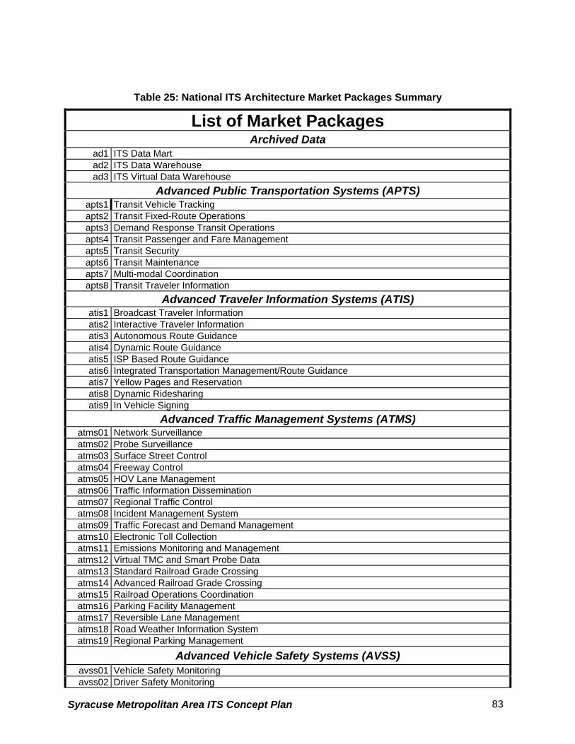
Table 25: National ITS Architecture Market Packages Summary
List of Market Packages Archived Data
ad1 ITS Data Mart ad2 ITS Data Warehouse ad3 ITS Virtual Data Warehouse
Advanced Public Transportation Systems (APTS) apts1 Transit Vehicle Tracking apts2 Transit Fixed-Route Operations apts3 Demand Response Transit Operations apts4 Transit Passenger and Fare Management apts5 Transit Security apts6 Transit Maintenance apts7 Multi-modal Coordination apts8 Transit Traveler Information
Advanced Traveler Information Systems (ATIS) atis1 Broadcast Traveler Information atis2 Interactive Traveler Information atis3 Autonomous Route Guidance atis4 Dynamic Route Guidance atis5 ISP Based Route Guidance atis6 Integrated Transportation Management/Route Guidance atis7 Yellow Pages and Reservation atis8 Dynamic Ridesharing atis9 In Vehicle Signing
Advanced Traffic Management Systems (ATMS) atms01 Network Surveillance atms02 Probe Surveillance atms03 Surface Street Control atms04 Freeway Control atms05 HOV Lane Management atms06 Traffic Information Dissemination atms07 Regional Traffic Control atms08 Incident Management System atms09 Traffic Forecast and Demand Management atms10 Electronic Toll Collection atms11 Emissions Monitoring and Management atms12 Virtual TMC and Smart Probe Data atms13 Standard Railroad Grade Crossing atms14 Advanced Railroad Grade Crossing atms15 Railroad Operations Coordination atms16 Parking Facility Management atms17 Reversible Lane Management atms18 Road Weather Information System atms19 Regional Parking Management
Advanced Vehicle Safety Systems (AVSS) avss01 Vehicle Safety Monitoring avss02 Driver Safety Monitoring
Syracuse Metropolitan Area ITS Concept Plan 83

avss03 Longitudinal Safety Warning avss04 Lateral Safety Warning avss05 Intersection Safety Warning avss06 Pre-Crash Restraint Deployment avss07 Driver Visibility Improvement avss08 Advanced Vehicle Longitudinal Control avss09 Advanced Vehicle Lateral Control avss10 Intersection Collision Avoidance avss11 Automated Highway System
Commercial Vehicle Operations (CVO) cvo01 Fleet Administration cvo02 Freight Administration cvo03 Electronic Clearance cvo04 CV Administrative Processes cvo05 International Border Electronic Clearance cvo06 Weigh-In-Motion cvo07 Roadside CVO Safety cvo08 On-board CVO Safety cvo09 CVO Fleet Maintenance cvo10 HAZMAT Management
Emergency Management (EM) em1 Emergency Response em2 Emergency Routing em3 Mayday Support
Source: The National ITS Architecture Implementation Strategy, Appendix A
(The shaded text indicates the Market Packages that are identified as not applicable/beneficial
to the development of regional architecture and these market packages will be excluded from
consideration. CVO issues were perceived more as a statewide issue than as a regional issue,
especially for the Syracuse Metropolitan area due to low volume of freight movement across the
study area. AVSS applications, on the other hand are primarily aimed at the automobile
manufactures that build vehicle control systems with limited or absolutely no control from a
regional standpoint. These packages will be discussed in detail in the following pages though
they will not take part in the development of regional Architecture. For more information about
these market packages please refer to www.iteris.com/itsarch)
The developers of the National ITS Architecture stress that the Market Packages are illustrative
rather than prescriptive. The actual implementation variations that are possible across the
country are myriad and cannot be enumerated through a finite set of packages. The Market
Packages are tools that allow discussion of an incremental deployment of ITS services in a
manner consistent with the underlying architecture definition. Detailed descriptions of each of
Syracuse Metropolitan Area ITS Concept Plan 84

these national architecture Market Packages can be found in Appendix A of the National ITS
Architecture Implementation Strategy (Federal Highway Administration, 1998).
5.2 Syracuse Metropolitan Area ITS Strategic Plan Market Package Definitions
While the Market Packages identified in the national ITS architecture provides a general
framework for developing ITS solutions to transportation problems, their application in a regional
architecture is influenced by the nature of local transportation needs and supporting
infrastructure. Therefore, in adopting the packages in response to the multi-jurisdictional
transportation needs of the Syracuse Metropolitan Area, some revisions to the definition and
service options of some of the national architecture packages were deemed necessary. The
National ITS Architecture is periodically updated with new Market Packages and architecture
flows. This often mandates that agencies revise their regional architectures to keep abreast with
the change in the contents and other core changes mandated by the USDOT. The Architecture
helps ensure that regional ITS deployments are in harmony with national standards.
The pedestrian issues in the Syracuse Metropolitan area were initially suggested for placement
in a new, user-defined market package exclusively to address this issue. After discussions with
the National ITS Architecture experts, it was understood that there is no need to develop an
exclusive market package since there exists an architecture flow in the Physical Architecture to
address the pedestrian needs. The pedestrians are also included as a “terminator”, a
component of the physical architecture in the National ITS Architecture. All of the 63 Market
Packages from the National ITS Architecture were initially considered for the development of the
Syracuse Metropolitan Area ITS Strategic Plan.
Certain Market Packages were found to have no relevance to the regional needs, and hence
were dropped from the finalized list of Market Packages. Except for the following, the core
Market Packages specified by the National ITS Architecture were used to develop this strategic
plan. The revisions are classified as follows:
• Not Used – The Advanced Vehicle Safety Systems (AVSS) Market Packages are
not being considered within this ITS Strategic Plan context because they are not
applicable to the study area’s transportation network goals and they do not fall within
Syracuse Metropolitan Area ITS Concept Plan 85

the realm of the public agencies. These Market Packages are shown shaded in the
above listed table (Table 5.1).
• Fundamental - the market package is recognized as a fundamental building block
for implementation of ITS in the study area. The services offered by the package are
prerequisites to successful and effective operations of many other packages. All
affected agencies shall strive to make funding available for implementation of this
package.
Three Market Packages were identified to belong to this category: the Network
Surveillance (atms01) and the Probe Surveillance (atms02) for traffic management;
and the Transit Vehicle Tracking (apts01) for transit management. • Modified - the market package cvo01, Fleet Administration, is modified to address the
tracking of maintenance and supervisory vehicles of stakeholder agencies. This market
package is actually devised to track the movement of commercial vehicle fleet. But due
to the inadequacies of the current version of the National ITS Architecture in addressing
this issue, some user-defined flows are created exclusively for this market package to
define tracking of vehicles (snow plows) during emergencies, especially relating to
weather. A new market package called Maintenance and Construction Operations
(MCO) is already recommended for inclusion into the National ITS Architecture and will
find a place in the future updates/revisions of this architecture.
As stated in the National ITS architecture document, the deployment oriented Market Packages
can be traced to the interface-oriented architecture definition. Once a particular market
package is selected for implementation, the required subsystems, equipment packages, and
interface requirements are readily identified due to this traceability. This approach allows the
implementer (and this Implementation Strategy) to first consider service needs and later
concentrate on those pieces of the architecture necessary to provide the selected service.
The following list presents the ITS Strategic Plan deployment Market Packages as they have
been defined to reflect the characteristics of the Syracuse Metropolitan Area.
Syracuse Metropolitan Area ITS Concept Plan 86

5.2.1 Archived Data
1. ITS Data Mart (ad1) This market package provides a focused archive that houses data collected and owned by a
single agency, district, private sector provider, research institution, or other organization. This
focused archive typically includes data covering a single transportation mode and one
jurisdiction that is collected from an operational data store and archived for future use. It
provides the basic data quality, data privacy, and meta-data management common to all ITS
archives and provides general query and report access to archive data users. 2. ITS Data Warehouse (ad2) This market package includes all of the data collection and management capabilities provided
by the ITS Data Mart, and adds the functionality and interface definitions that allow collection of
data from multiple agencies and data sources spanning across modal and jurisdictional
boundaries. It performs the additional transformations and provides the additional metadata
management features that are necessary so that all this data can be managed in a single
repository with consistent formats. The potential for large volumes of varied data suggests
additional on-line analysis and data mining features that are also included in this market
package in addition to the basic query and reporting user access features offered by the ITS
Data Mart.
3. ITS Virtual Data Warehouse (ad3) This market package provides the same broad access to multimodal, multidimensional data
from varied data sources as in the ITS Data Warehouse Market Package, but provides this
access using enhanced interoperability between physically distributed ITS archives that are
each locally managed. Requests for data that are satisfied by access to a single repository in
the ITS Data Warehouse Market Package are parsed by the local archive and dynamically
translated to requests to remote archives which relay the data necessary to satisfy the request.
5.2.2 Advanced Public Transportation Systems 4. Transit Vehicle Tracking (apts1)
This market package provides for an Automated Vehicle Location System to track the transit
vehicle’s real time schedule adherence and updates the transit system’s schedule in real-time.
Vehicle position may be determined either by the vehicle (e.g., through GPS) and relayed to the
Syracuse Metropolitan Area ITS Concept Plan 87

infrastructure or may be determined directly by the communications infrastructure. A two-way
wireless communication link with the Transit Management Subsystem is used for relaying
vehicle position and control measures. Fixed route transit systems may also employ beacons
along the route to enable position determination and facilitate communications with each vehicle
at fixed intervals. The Transit Management Subsystem processes this information, updates the
transit schedule and makes real-time schedule information available to the Information Service
Provider Subsystem via a wire line link. 5. Transit Fixed-Route Operations (apts2)
This market package performs automatic driver assignment and monitoring, as well as vehicle
routing and scheduling for fixed-route services. This service uses the existing AVL database as
a source for current schedule performance data, and is implemented through data processing
and information display at the transit management subsystem. This data is exchanged using the
existing wire line link to the information service provider where it is integrated with that from
other transportation modes (e.g. rail, ferry, air) to provide the public with integrated and
personalized dynamic schedules. 6. Demand Response Transit Operations (apts3)
This market package performs automatic driver assignment and monitoring as well as vehicle
routing and scheduling for demand response transit services. This package uses the existing
AVL database to monitor current status of the transit fleet and supports allocation of these fleet
resources to service incoming requests for transit service while also considering traffic
conditions. The Transit Management Subsystem provides the necessary data processing and
information display to assist the transit operator in making optimal use of the transit fleet. The
Information Service Provider Subsystem may be either be operated by transit management
center or be independently owned and operated by a separate service provider. In the first
scenario, the traveler makes a direct request to a specific para-transit service. In the second
scenario, a third party service provider determines the para-transit service is a viable means of
satisfying a traveler request and uses wire line communications to make a reservation for the
traveler. 7. Transit Passenger and Fare Management (apts4)
This market package allows for the management of passenger loading and fare payments on-
board vehicles using electronic means. The payment instrument may be either a stored value or
credit card. This package is implemented with sensors mounted on the vehicle to permit the
driver and central operations to determine vehicle loads, and readers located either in the
Syracuse Metropolitan Area ITS Concept Plan 88

infrastructure or on-board the transit vehicle to allow fare payment. Data is processed, stored,
and displayed on the transit vehicle and communicated as needed to the Transit Management
Subsystem using existing wireless infrastructure. 8. Transit Security (apts5)
This market package provides for the physical security of transit passengers. An on-board
security system is deployed to perform surveillance and warn of potentially hazardous
situations. Public areas (e.g. stops, park and ride lots, stations) are also monitored. Information
is communicated to the Transit Management Subsystem using the existing or emerging wireless
(vehicle to center) or wire line (area to center) infrastructure. Security related information is also
transmitted to the Emergency Management Subsystem when an emergency is identified that
requires an external response. Incident information is communicated to the Information Service
Provider. 9. Transit Maintenance (apts6)
This market package supports automatic maintenance scheduling and monitoring. On-board
condition sensors monitor critical system status and transmit critical status information to the
Transit Management Subsystem. Hardware and software in the Transit Management
Subsystem processes this data and schedules maintenance activities. 10. Multi-modal Coordination (apts7)
This market package establishes two-way communications between multiple transit and traffic
agencies to improve service coordination. Intermodal coordination between transit agencies can
increase traveler convenience at transfer points and also improve operating efficiency.
Coordination between traffic and transit management is intended to improve on-time
performance of the transit system to the extent that this can be accommodated without
degrading overall performance of the traffic network. More limited local coordination between
the transit vehicle and the individual intersection for signal priority is also supported by this
package.
11. Transit Traveler Information (apts8)
This market package provides transit users at transit stops and on-board transit vehicles with
ready access to transit information. The information services include transit stop annunciation,
imminent arrival signs, and real-time transit schedule displays that are of general interest to
transit users. Systems that provide custom transit trip itineraries and other tailored transit
information services are also represented by this market package.
Syracuse Metropolitan Area ITS Concept Plan 89
5.2.3 Advanced Traveler Information Systems
12. Broadcast Traveler Information (atis1)
This market package provides the user with a basic set of ATIS services; its objective is early
acceptance. It involves the collection of traffic conditions, advisories, general public
transportation, toll and parking information, incident information, air quality and weather
information, and the near real time dissemination of this information over a wide area through
existing infrastructures and low cost user equipment (e.g., FM subcarrier, cellular data
broadcast). Different from the market package ATMS6--Traffic Information Dissemination--which
provides the more basic HAR and DMS information capabilities, ATIS1 provides the more
sophisticated digital broadcast service. Successful deployment of this market package relies on
availability of real-time traveler information from roadway instrumentation, probe vehicles or
other sources.
13. Interactive Traveler Information (atis2)
This market package provides tailored information in response to a traveler request. Both real-
time interactive request/response systems and information systems that "push" a tailored
stream of information to the traveler based on a submitted profile are supported. The traveler
can obtain current information regarding traffic conditions, transit services, ride share/ride
match, parking management, and pricing information. A range of two-way wide-area wireless
and wireline communications systems may be used to support the required digital
communications between traveler and the information service provider. A variety of interactive
devices may be used by the traveler to access information prior to a trip or en-route to include
phone, kiosk, Personal Digital Assistant, personal computer, and a variety of in-vehicle devices.
Successful deployment of this market package relies on availability of real-time transportation
data from roadway instrumentation, probe vehicles or other means.
14. Autonomous Route Guidance (atis3)
This market package relies on in-vehicle sensory, location determination, computational, map
database, and interactive driver interface equipment to enable route planning and detailed route
guidance based on static, stored information. No communication with the infrastructure is
assumed or required. Identical capabilities are available to the traveler outside the vehicle by
integrating a similar suite of equipment into portable devices.
15. Dynamic Route Guidance (atis4)
Syracuse Metropolitan Area ITS Concept Plan 90

This market package offers the user advanced route planning and guidance which is responsive
to current conditions. The package combines the autonomous route guidance user equipment
with a digital receiver capable of receiving real-time traffic, transit, and road condition
information which is considered by the user equipment in provision of route guidance.
16. ISP Based Route Guidance (atis5)
This market package offers the user advanced route planning and guidance which is responsive
to current conditions. Different than the Dynamic Route Guidance Market Package, this market
package moves the route planning function from the user device to the information service
provider. This approach simplifies the user equipment requirements and can provide the
infrastructure better information on which to predict future traffic and appropriate control
strategies to support basic route planning with minimal user equipment. The package includes
both turn-by-turn route guidance as might be used in a vehicle, as well as pre-trip routes. The
package includes two-way data communications and optionally also equips the vehicle with the
databases, location determination capability, and display technology to support turn-by-turn
route guidance.
17. Integrated Transportation Management/Route Guidance (atis6)
This market package allows a traffic management center to continuously optimize the traffic
control strategy based on near-real time information on intended routes for a proportion of the
vehicles within their network while offering the user advanced route planning and guidance
which is responsive to current conditions. It would utilize the individual and ISP route planning
information to optimize signal timing while at the same time providing updated signal timing
information to allow optimized route plans. The use of predictive link times for this market
package is possible through utilizing the market package ATMS9--Traffic forecast and Demand
Management--at the traffic management center.
18. Yellow Pages and Reservation (atis7)
This market package enhances the Interactive Traveler Information package by making
infrastructure provided yellow pages and reservation services available to the user. The same
basic user equipment is included. This market package provides multiple ways for accessing
information either while en-route in a vehicle using wide-area wireless communications or pre-
trip via wireline connections.
19. Dynamic Ridesharing (atis8)
Syracuse Metropolitan Area ITS Concept Plan 91

This market package enhances the Interactive Traveler Information package by adding an
infrastructure provided dynamic ridesharing/ride matching capability. In terms of equipment
requirements, ATIS8 is similar to ATIS7.
20. In Vehicle Signing (atis9)
This market package supports distribution of traffic and travel advisory information to drivers
through in-vehicle devices. It includes short-range communications between roadside
equipment and the vehicle and wire line connections to the Traffic Management Subsystem for
coordination and control. This market package also informs the driver of both highway-highway
and highway-rail intersection status.
5.2.4 Advanced Traffic Management Systems
21. Network Surveillance (atms01)
This market package includes traffic detectors, other surveillance equipment, the supporting
field equipment, and wire line communications to transmit the collected data back to the Traffic
Management Subsystem. The derived data can be used locally such as when traffic detectors
are connected directly to a signal control system or remotely (e.g., when a CCTV system sends
data back to the Traffic Management Subsystem). The data generated by this market package
enables traffic managers to monitor traffic and road conditions, identify and verify incidents,
detect faults in indicator operations, and collect census data for traffic strategy development and
long range planning. The collected data can also be analyzed and made available to users and
the Information Service Provider Subsystem.
22. Probe Surveillance (atms02)
This market package provides an alternative approach for surveillance of the roadway network.
Two general implementation paths are supported by this market package: 1) wide-area wireless
communications between the vehicle and Information Service Provider is used to communicate
current vehicle location and status, and 2) dedicated short range communications between the
vehicle and roadside is used to provide equivalent information back to the Traffic Management
Subsystem. The first approach leverages wide area communications equipment that may
already be in the vehicle to support personal safety and advanced traveler information services.
The second approach utilizes vehicle equipment that supports toll collection, in-vehicle signing,
Syracuse Metropolitan Area ITS Concept Plan 92

and other short range communications applications identified within the architecture. The
market package enables traffic managers to monitor road conditions, identify incidents, analyze
and reduce the collected data, and make it available to users and private information providers.
It requires one of the communications options identified above, roadside beacons and wire line
communications for the short range communications option, data reduction software, and
utilizes wire line links between the Traffic Management Subsystem and Information Service
Provider Subsystem to share the collected information. Both “Opt out” and “Opt in” strategies
are available to ensure the user has the ability to turn off the probe functions to ensure
individual privacy. Due to the large volume of data collected by probes, data reduction
techniques are required in this market package which includes the ability to identify and filter
out-of-bounds or extreme data reports.
23. Surface Street Control (atms03)
This market package provides the central control and monitoring equipment, communication
links, and the signal control equipment that support local surface street control and/or arterial
traffic management. A range of traffic signal control systems are represented by this market
package ranging from static pre-timed control systems to fully traffic responsive systems that
dynamically adjust control plans and strategies based on current traffic conditions and priority
requests. Additionally, general advisory and traffic control information can be provided to the
driver while en-route. This market package is generally an intra-jurisdictional package that does
not rely on real-time communications between separate control systems to achieve area-wide
traffic signal coordination. Systems that achieve coordination across jurisdictions by using a
common time base or other strategies that do not require real time coordination would be
represented by this package. This market package is consistent with typical urban traffic signal
control systems.
24. Freeway Control (atms04)
This market package provides the communications and roadside equipment to support ramp
control, lane controls, and interchange control for freeways. Coordination and integration of
ramp meters are included as part of this market package. This package is consistent with typical
urban traffic freeway control systems. This package incorporates the instrumentation included in
the Network Surveillance Market Package to support freeway monitoring and adaptive
strategies as an option. This market package also includes the capability to utilize surveillance
information for detection of incidents. Typically, the processing would be performed at a traffic
management center; however, developments might allow for point detection with roadway
Syracuse Metropolitan Area ITS Concept Plan 93

equipment. For example, a CCTV might include the capability to detect an incident based upon
image changes. Additionally, this market package allows general advisory and traffic control
information to be provided to the driver while en-route.
25. HOV Lane Management (atms05
This market package manages HOV lanes by coordinating freeway ramp meters and connector
signals with HOV lane usage signals. Preferential treatment is given to HOV lanes using special
bypasses, reserved lanes, and exclusive rights-of-way that may vary by time of day. Vehicle
occupancy detectors may be installed to verify HOV compliance and to notify enforcement
agencies of violations.
26. Traffic Information Dissemination (atms06)
This market package allows traffic information to be disseminated to drivers and vehicles using
roadway equipment such as dynamic message signs or highway advisory radio. This package
provides a tool that can be used to notify drivers of incidents; careful placement of the roadway
equipment provides the information at points in the network where the drivers have recourse
and can tailor their routes to account for the new information. This package also covers the
equipment and interfaces that provide traffic information from a traffic management center to the
media (for instance via a direct tie-in between a traffic management center and radio or
television station computer systems), transit management center, emergency management
center, and information service provider.
27. Regional Traffic Control (atms07)
This market package advances the Surface Street Control and Freeway Control Market
Packages by adding the communications links and integrated control strategies that enable
integrated Inter-jurisdictional traffic control. This market package provides for the sharing of
traffic information and control among traffic management centers to support a regional control
strategy. The nature of optimization and extent of information and control sharing is determined
through working arrangements between jurisdictions. This package relies principally on
roadside instrumentation supported by the Surface Street Control and Freeway Control Market
Packages and adds hardware, software, and wireline communications capabilities to implement
traffic management strategies which are coordinated between allied traffic management
centers. Several levels of coordination are supported from sharing of information through
sharing of control between traffic management centers.
Syracuse Metropolitan Area ITS Concept Plan 94

28. Incident Management System (atms08)
This market package manages both predicted and unexpected incidents so that the impact to
the transportation network and traveler safety is minimized. Requisite incident detection
capabilities are included in the freeway control market package and through the regional
coordination with other traffic management and emergency management centers, weather
service entities, and event promoters supported by this market package. Information from these
diverse sources are collected and correlated by this market package to detect and verify
incidents and implement an appropriate response. This market package provides Traffic
Management Subsystem equipment that supports traffic operations personnel in developing an
appropriate response in coordination with emergency management and other incident response
personnel to confirmed incidents. The response may include traffic control strategy
modifications and presentation of information to affected travelers using the Traffic Information
Dissemination market package. The same equipment assists the operator by monitoring
incident status as the response unfolds. The coordination with emergency management might
be through a CAD system or through other communication with emergency field personnel. The
coordination can also extend to tow trucks and other field service personnel.
29. Traffic Forecast and Demand Management (atms09)
This market package includes advanced algorithms, processing, and mass storage capabilities
that support historical evaluation, real-time assessment, and forecast of the roadway network
performance. This includes the prediction of travel demand patterns to support better link travel
time forecasts. The source data would come from the Traffic Management Subsystem itself as
well as other traffic management centers and forecasted traffic loads derived from route plans
supplied by the Information Service Provider Subsystem. In addition to short-term forecasts, this
market package provides longer-range forecasts that can be used in transportation planning.
This market package provides data that supports the implementation of TDM programs, and
policies managing both traffic and the environment. Information on vehicle pollution levels,
parking availability, usage levels, and vehicle occupancy are collected by monitoring sensors to
support these functions. Demand management requests can also be made to Toll
Administration, Transit Management, and Parking Management Subsystems.
30. Electronic Toll Collection (atms10)
This market package provides toll operators with the ability to collect tolls electronically and
detect and process violators. Variations in the fees that are collected enable implementation of
demand management strategies. Dedicated short-range communication between the roadway
Syracuse Metropolitan Area ITS Concept Plan 95

equipment and the vehicle is required as well as wire line interfaces between the toll collection
equipment and transportation authorities and the financial infrastructure that supports fee
collection. Vehicle tags of toll violators are read and electronically posted to vehicle owners.
Standards, inter-agency coordination, and financial clearinghouse capabilities enable regional
and ultimately national interoperability for these services. The population of toll tags and
roadside readers that these systems utilize can also be used to collect road use statistics for
highway authorities. This data can be collected as a natural by-product of the toll collection
process or collected by separate readers that are dedicated to probe data collection.
31. Emissions Monitoring and Management (atms11)
This market package monitors individual vehicle emissions and provides general air quality
monitoring using distributed sensors to collect the data. The collected information is transmitted
to the emissions management subsystem for processing. Both individual detection and
identification of vehicles that exceed emissions standards and general area-wide monitoring of
air quality are supported by this market package. For area wide monitoring, this market package
measures air quality, identifies sectors that are non-compliant with air quality standards, and
collects, stores and reports supporting statistical data. For point emissions monitoring, this
market package measures tail pipe emissions and identifies vehicles that exceed emissions
standards. The gathered information can be used to implement environmentally sensitive TDM
programs, policies, and regulations.
32. Virtual TMC and Smart Probe Data (atms12)
This market package provides for special requirements of rural road systems. Instead of a
central TMC, the traffic management is distributed over a very wide area (e.g., a whole state or
collection of states). Each locality has the capability of accessing available information for
assessment of road conditions. The package uses vehicles as smart probes that are capable of
measuring road conditions and providing this information to the roadway for relay to the Traffic
Management Subsystem and potentially direct relay to following vehicles (i.e., the automated
road signing equipment is capable of autonomous operation). In-vehicle signing is used to
inform drivers of detected road conditions.
33. Standard Railroad Grade Crossing (atms13)
This market package manages highway traffic at highway-rail intersections (HRIs) where
operational requirements do not dictate more advanced features (e.g., where rail operational
speeds are less than 80 miles per hour). Both passive (e.g., the crossbuck sign) and active
Syracuse Metropolitan Area ITS Concept Plan 96

warning systems (e.g., flashing lights and gates) are supported. (Note that passive systems
exercise only the single interface between the roadway subsystem and the driver in the
architecture definition.) These traditional HRI warning systems may also be augmented with
other standard traffic management devices. The warning systems are activated on notification
by interfaced wayside equipment of an approaching train. The equipment at the HRI may also
be interconnected with adjacent signalized intersections so that local control can be adapted to
highway-rail intersection activities. Health monitoring of the HRI equipment and interfaces is
performed; detected abnormalities are reported to both highway and railroad officials through
wayside interfaces and interfaces to the traffic management subsystem. Similar interfaces and
services are provided for other types of multimodal crossings (e.g., draw bridges).
34. Advanced Railroad Grade Crossing (atms14)
This market package manages highway traffic at highway-rail intersections (HRIs) where
operational requirements demand advanced features (e.g., where rail operational speeds are
greater than 80 miles per hour). This market package includes all capabilities from the Standard
Railroad Grade Crossing Market Package and augments these with additional safety features to
mitigate the risks associated with higher rail speeds. The active warning systems supported by
this market package include positive barrier systems which preclude entrance into the
intersection when the barriers are activated. Like the Standard Package, the HRI equipment is
activated on notification by wayside interface equipment which detects, or communicates with
the approaching train. In this market package, additional information about the arriving train is
also provided by the wayside interface equipment so that the train's direction of travel, its
estimated time of arrival, and the estimated duration of closure may be derived. This enhanced
information may be conveyed to the driver prior to, or in context with, warning system activation.
This market package also includes additional detection capabilities which enable it to detect an
entrapped or otherwise immobilized vehicle within the HRI and provide an immediate notification
to highway and railroad officials.
35. Railroad Operations Coordination (atms15)
This market package provides an additional level of strategic coordination between rail
operations and traffic management centers. Rail operations provide train schedules,
maintenance schedules, and any other forecast events which will result in highway-rail
intersection (HRI) closures. This information is used to develop forecast HRI closure times and
Syracuse Metropolitan Area ITS Concept Plan 97

durations which may be used in advanced traffic control strategies or to enhance the quality of
traveler information.
36. Parking Facility Management (atms16)
This market package provides enhanced monitoring and management of parking facilities. The
included equipment assists in the management of parking operations, coordinates with
transportation authorities, and supports electronic collection of parking fees. This is performed
by sensing and collecting current parking facilities status, sharing the data with information
service providers and traffic operations, and automatic fee collection using short-range
communications with the same in-vehicle equipment utilized for electronic toll collection.
37. Reversible Lane Management (atms17)
This market package provides for the management of reversible lane facilities. In addition to
standard surveillance capabilities, this market package includes sensory functions that detect
wrong-way vehicles and other special surveillance capabilities that mitigate safety hazards
associated with reversible lanes. The package includes the field equipment, physical lane
access controls, and associated control electronics that manage and control these special
lanes. This market package also includes the equipment used to electronically reconfigure
intersections and manage right-of-way to address dynamic demand changes and special
events.
38. Road Weather Information System (atms18)
This market package monitors current and forecast road and weather conditions using a
combination of weather service information and data collected from environmental sensors
deployed on and about the roadway. The collected road weather information is monitored and
analyzed to detect and forecast environmental hazards such as icy road conditions, dense fog,
and approaching severe weather fronts. This information can be used to more effectively deploy
road maintenance resources, issue general traveler advisories, and support location specific
warnings to drivers using the Traffic Information Dissemination Market Package.
39. Regional Parking Management (atms19)
This market package supports coordination between parking facilities to enable regional parking
management strategies.
Syracuse Metropolitan Area ITS Concept Plan 98

5.2.5 Advanced Vehicle Safety Systems
40. Vehicle Safety Monitoring (avss01)
This market package will diagnose critical components of the vehicle and warn the driver of
potential dangers. On-board sensors will determine the vehicle’s condition and performance,
determine on-board safety data, and display information.
41. Driver Safety Monitoring (avss02)
This market package will determine the driver’s condition, and warn the driver of potential
dangers. On-board sensors will determine the driver’s condition and performance, determine
on-board safety data, and display information.
42. Longitudinal Safety Monitoring (avss03)
This market package allows for longitudinal warning. It utilizes safety sensors and collision
sensors. It requires on-board sensors to monitor the areas in front of and behind the vehicle and
present warnings to the driver about potential hazards.
43. Lateral Safety Monitoring (avss04)
This market package allows for lateral warning. It utilizes safety sensors and collision sensors. It
requires on-board sensors to monitor the areas to the sides of the vehicle and present warnings
to the driver about potential hazards.
44. Intersection Safety Monitoring (avss05)
This market package will determine the probability of a collision in an equipped intersection
(either highway-highway or highway-rail) and provide timely warnings to drivers in response to
hazardous conditions. Monitors in the roadway infrastructure assess vehicle locations and
speeds near an intersection. Using this information, a warning is determined and communicated
to the approaching vehicle using a short-range communications system. Information can be
provided to the driver through the market package ATIS9--In-Vehicle Signing.
45. Pre-Crash Restraint Deployment (avss06)
This market package provides in-vehicle sensors to monitor the vehicle's local environment
determine collision probability and deploy a pre-crash safety system. It will include on-board
sensors to measure lateral and longitudinal gaps and together with weather and roadway
Syracuse Metropolitan Area ITS Concept Plan 99
conditions will determine lateral and longitudinal collision probability. It will have the mechanism
to deploy a pre-crash safety system.
46. Driver Visibility Improvement (avss07)
This market package will enhance driver visibility using an enhanced vision system. On-board
display hardware is needed.
47. Advanced Vehicle Longitudinal Control (avss08)
This market package automates the speed and headway control functions on board the vehicle.
It utilizes safety sensors and collision sensors combined with vehicle dynamics processing to
control the throttle and brakes. It requires on-board sensors to measure longitudinal gaps and a
processor for controlling the vehicle speed.
48. Advanced Vehicle Lateral Control (avss09)
This market package automates the steering control on board the vehicle. It utilizes safety
sensors and collision sensors combined with vehicle dynamics processing to control the
steering. It requires on-board sensors to measure lane position and lateral deviations and a
processor for controlling the vehicle steering.
49. Intersection Collision Avoidance (avss10)
This market package will determine the probability of an intersection collision and provide timely
warnings to approaching vehicles so that avoidance actions can be taken. This market package
builds on the Intersection Collision Warning infrastructure and in-vehicle equipment and adds
equipment in the vehicle that can take control of the vehicle in emergency situations. The same
monitors in the roadway infrastructure are needed to assess vehicle locations and speeds near
an intersection. This information is determined and communicated to the approaching vehicle
using a short-range communications system. The vehicle uses this information to develop
control actions which alter the vehicle’s speed and steering control and potentially activate its
pre-crash safety system.
50. Automated Highway System (avss11)
This market package enables “hands-off” operation of the vehicle on the automated portion of
the highway system. Implementation requires lateral lane holding, vehicle speed and steering
control, and Automated Highway System check-in and checkout. This market package currently
Syracuse Metropolitan Area ITS Concept Plan 100

supports a balance in intelligence allocation between infrastructure and the vehicle pending
selection of a single operational concept by the AHS consortium.
5.2.6 Commercial Vehicle Operations
51. Fleet Administration (cvo01)
This market package keeps track of vehicle location, itineraries, and fuel usage at the Fleet and
Freight Management Subsystem using a cell based or satellite data link and the pre-existing
wireless infrastructure. The vehicle has a processor to interface to its sensor (e.g., fuel gauge)
and to the cellular data link. The Fleet and Freight Management Subsystem can provide the
vehicle with dispatch instructions, and can process and respond to requests for assistance and
general information from the vehicle via the cellular data link. The market package also provides
the Fleet Manager with connectivity to intermodal transportation providers using the existing
wireline infrastructure.
52. Freight Administration (cvo02)
This market package tracks cargo and the cargo condition. This information is communicated
with the Fleet and Freight Management Subsystem via the existing wireless infrastructure.
Interconnections are provided to intermodal shippers and intermodal freight depots for tracking
the cargo from source to destination.
53. Electronic Clearance (cvo03)
This market package provides for automated clearance at roadside check facilities. The
roadside check facility communicates with the Commercial Vehicle Administration subsystem
over wireline to retrieve infrastructure snapshots of critical carrier, vehicle, and driver data to be
used to sort passing vehicles. This package allows a good driver/vehicle/carrier to pass
roadside facilities at highway speeds using transponders and dedicated short-range
communications to the roadside. The roadside check facility may be equipped with AVI,
weighing sensors, transponder read/write devices, and computer workstation processing
hardware, software, and databases.
54. CV Administrative Processes (cvo04)
This market package provides for electronic application, processing, fee collection, issuance,
and distribution of CVO credential and tax filing. Through this process, carriers, drivers, and
vehicles may be enrolled in the electronic clearance program provided by a separate market
Syracuse Metropolitan Area ITS Concept Plan 101
package which allows commercial vehicles to be screened at mainline speeds at commercial
vehicle check points. Through this enrollment process, current profile databases are maintained
in the Commercial Vehicle Administration Subsystem and snapshots of this database are made
available to the commercial vehicle check facilities at the roadside to support the electronic
clearance process.
55. International Border Electronic Clearance (cvo05)
This market package provides for automated clearance specific to international border
crossings. This package augments the electronic clearance package by allowing interface with
customs related functions and permitting NAFTA required entry and exit from the US to Canada
and Mexico.
56. Weigh-In-Motion (cvo06)
This market package provides for high speed weigh-in-motion with or without AVI attachment.
Primarily this market package provides the roadside with additional equipment, either fixed or
removable. If the equipment is fixed, then it is thought to be an addition to the electronic
clearance and would work in conjunction with the AVI and AVC equipment in place.
57. Roadside CVO Safety (cvo07)
This market package provides for automated roadside safety monitoring and reporting. It
automates commercial vehicle safety inspections at the Commercial Vehicle Check roadside
element. The capabilities for performing the safety inspection are shared between this market
package and the On-Board CVO Safety Market Package which enables a variety of
implementation options. The basic option, directly supported by this market package, facilitates
safety inspection of vehicles that have been pulled in, perhaps as a result of the automated
screening process provided by the Electronic Clearance Market Package. In this scenario, only
basic identification data and status information is read from the electronic tag on the commercial
vehicle. The identification data from the tag enables access to additional safety data maintained
in the infrastructure which is used to support the safety inspection, and may also inform the pull-
in decision if system timing requirements can be met. More advanced implementations,
supported by the On-Board CVO Safety market package, utilize additional vehicle safety
monitoring and reporting capabilities in the commercial vehicle to augment the roadside safety
check.
58. On-board CVO Safety (cvo08)
Syracuse Metropolitan Area ITS Concept Plan 102

This market package provides for on-board commercial vehicle safety monitoring and reporting.
It is an enhancement of the Roadside CVO Safety Market Package and includes roadside
support for reading on-board safety data via tags. This market package uses the same
communication links as the Roadside CVO Safety Market Package, and provides the
commercial vehicle with a wireless link (data and possibly voice) to the Fleet and Freight
Management and the Emergency Management Subsystems. Safety warnings are provided to
the driver as a priority with secondary requirements to notify the Fleet and Freight Management
and Commercial Vehicle Check roadside elements.
59. CVO Fleet Maintenance (cvo09)
This market package supports maintenance of CVO fleet vehicles through close interface with
on-board monitoring equipment and AVLS capabilities with in the Fleet and Freight
Management Subsystem. Records of vehicle mileage, repairs, and safety violations are
maintained to assure safe vehicles on the highway.
60. HAZMAT Management (cvo10)
This market package integrates incident management capabilities with commercial vehicle
tracking to assure effective treatment of HAZMAT material and incidents. HAZMAT tracking is
performed by the Fleet and Freight Management Subsystem. The Emergency Management
subsystem is notified by the Commercial Vehicle if an incident occurs and coordinates the
response. The response is tailored based on information that is provided as part of the original
incident notification or derived from supplemental information provided by the Fleet and Freight
Management Subsystem. The latter information can be provided prior to the beginning of the
trip or gathered following the incident depending on the selected policy and implementation.
5.2.7 Emergency Management
61. Emergency Response (em1) This market package provides the computer-aided dispatch systems, emergency vehicle
equipment, and wireless communications that enable safe and rapid deployment of appropriate
resources to an emergency. Coordination between Emergency Management Subsystems
supports emergency notification and coordinated response between agencies. Existing wide
area wireless communications would be utilized between the Emergency Management
Subsystem and an Emergency Vehicle to enable an incident command system to be
established and supported at the emergency location. The Emergency Management Subsystem
Syracuse Metropolitan Area ITS Concept Plan 103

would include hardware and software for tracking the emergency vehicles. Public safety, traffic
management, and many other allied agencies may each participate in the coordinated response
managed by this package.
62. Emergency Routing (em2) This market package supports dynamic routing of emergency vehicles and coordination with the
Traffic Management Subsystem for special priority on the selected route(s). The Information
Service Provider Subsystem supports routing for the emergency fleet based on real-time traffic
conditions and the emergency routes assigned to other responding vehicles. In this market
package, the Information Service Provider Subsystem would typically be integrated with the
Emergency Management Subsystem in a public safety communications center. The Emergency
Vehicle would also optionally be equipped with dedicated short-range communications for local
signal preemption.
63. Mayday Support (em3)
This package allows the user (driver or non-driver) to initiate a request for emergency
assistance and enables the Emergency Management Subsystem to locate the user and
determine the appropriate response. The Emergency Management Subsystem may be
operated by the public sector or by a private sector provider. The request from the traveler
needing assistance may be manually initiated or automated and linked to vehicle sensors. The
data is sent to the Emergency Management subsystem using wide area wireless
communications with voice as an option. Providing user location implies either a location
technology within the user device or location determination within the communications
infrastructure.
5.3 Potential Benefits of Market Packages
Benefits of these Market Packages have been recorded by the USDOT over the years, and
were listed in National ITS Architecture Market Package Analysis document (1999). The
following table 16 identifies the benefits of the different Market Packages grouped under their
area of applicability such as transit management, traffic management, etc. With the exception
of Vehicle Safety Market Packages, all others are designed predominantly to involve/aid the
public agencies in executing their roles in the regional transportation operations. In contrast,
the vehicle safety Market Packages are predominantly aimed at the private sector entities such
Syracuse Metropolitan Area ITS Concept Plan 104

as automobile manufacturers who contribute to the development and refinement of new
technologies that aid in the safety of vehicles on road.
Table 16 – Potential Benefits of ITS Market Packages
Market Packages Likely Benefits Context Where Benefits May Occur
Traveler Information Market Packages
Broadcast Traveler Information
• Possible benefits as high as other interactive ATIS services (see below), depending on capability of in-vehicle devices
• Primary value for incident-related (accidents, weather, special events, etc.) traffic delays, across all geographic areas
• Higher benefits to travelers with long trips, multiple mode and route alternatives
Interactive Traveler Information
• Reduction in travel time for equipped travelers
• Increases in speeds, decrease in number of stops for equipped travelers
• Some benefits for non-equipped travelers
• Higher benefits for pre-trip versus on route information
• Decreasing benefits with higher market penetrations
• Primary value for incident-related (accidents, weather, special events, etc.) traffic delays, across all geographic areas
• Higher benefits to travelers with long trips, multiple mode and route alternatives
• Decreasing benefits with higher network loadings (i.e. higher congestion)
Autonomous Route Guidance Dynamic Route Guidance ISP Based Route Guidance Integrated Transportation Management/Route Guidance
• Reduction in travel time for equipped travelers
• Increases in speeds, decrease in number of stops for equipped travelers
• Some benefits for non-equipped travelers
• Higher benefits for pre-trip versus en-route information
• Decreasing benefits with higher market penetrations
• Primary value for incident-related (accidents, weather, special events, etc.) traffic delays, across all geographic areas
• Higher benefits to travelers with long trips, multiple mode and route alternatives
• Higher benefits for visitor's and other unfamiliar travelers
Yellow Pages and Reservation
• Potential reduction of VMT spent searching for trip destinations
• Benefits highest for visitors and other unfamiliar travelers
• Familiar travelers benefit from parking reservation
Dynamic Ridesharing • Increased vehicle occupancy and
use of HOV modes • Improved individual mobility
• Significant density of related trips is necessary to ensure ride matching
In Vehicle Signing • Reduction in search time and
excess VMT • Reduction in accidents
• Anticipated benefits in congested areas, night driving, rural areas
• Aid to visually challenged drivers
Syracuse Metropolitan Area ITS Concept Plan 105
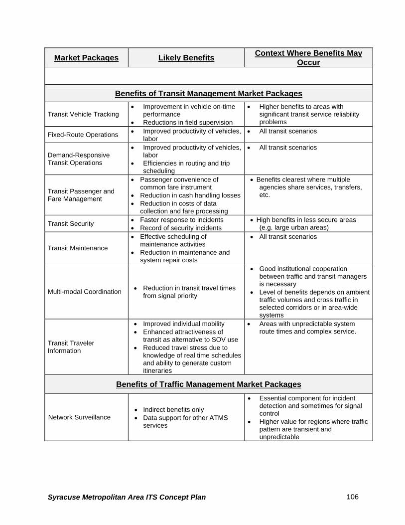
Market Packages Likely Benefits Context Where Benefits May Occur
Benefits of Transit Management Market Packages
Transit Vehicle Tracking • Improvement in vehicle on-time
performance • Reductions in field supervision
• Higher benefits to areas with significant transit service reliability problems
Fixed-Route Operations • Improved productivity of vehicles, labor
• All transit scenarios
Demand-Responsive Transit Operations
• Improved productivity of vehicles, labor
• Efficiencies in routing and trip scheduling
• All transit scenarios
Transit Passenger and Fare Management
• Passenger convenience of common fare instrument
• Reduction in cash handling losses • Reduction in costs of data
collection and fare processing
• Benefits clearest where multiple agencies share services, transfers, etc.
Transit Security • Faster response to incidents • Record of security incidents
• High benefits in less secure areas (e.g. large urban areas)
Transit Maintenance
• Effective scheduling of maintenance activities
• Reduction in maintenance and system repair costs
• All transit scenarios
Multi-modal Coordination • Reduction in transit travel times from signal priority
• Good institutional cooperation between traffic and transit managers is necessary
• Level of benefits depends on ambient traffic volumes and cross traffic in selected corridors or in area-wide systems
Transit Traveler Information
• Improved individual mobility • Enhanced attractiveness of
transit as alternative to SOV use • Reduced travel stress due to
knowledge of real time schedules and ability to generate custom itineraries
• Areas with unpredictable system route times and complex service.
Benefits of Traffic Management Market Packages
Network Surveillance • Indirect benefits only • Data support for other ATMS
services
• Essential component for incident detection and sometimes for signal control
• Higher value for regions where traffic pattern are transient and unpredictable
Syracuse Metropolitan Area ITS Concept Plan 106

Market Packages Likely Benefits Context Where Benefits May Occur
Probe Surveillance • Indirect benefits only • Data support for other ATMS
services
• Essential component for incident detection and sometimes for signal control
• Higher value for regions where traffic pattern are transient and unpredictable
Surface Street Control
• Reduction in travel time • Reduction in queue time • Increase in speeds • Reduction in stops • Reduction in fuel consumption • Reductions in VMT • Reductions in HC and CO
emissions • Reduction in intersection-related
accident rates, with higher reductions possible for left-turn accidents
• Significant benefit-to-cost ratio
• Most surface street systems will benefit from this Market Package
• Cities with major traffic generators such as theme park or stadium will benefit more
• It is expected that signal coordination tailored to specific local traffic patterns can have significantly higher benefits.
Freeway Control
• Increase in freeway speed (before-after) during congested peak hours, depending on level of congestion
• Increase in freeway throughput • Reduction in travel time • Reduction in queue time • Reduction in fuel consumption • Reduction in emissions
• Most freeway systems will benefit from this market package
• Essential component for HOV Lane Management and Reversible Lane Management Market Packages
• Capacities of freeway on and off ramps may be diminished by ramp metering
HOV Lane Management
• Reduction in travel time • Increase in lane carrying
capacity • Increase in use of transit and
HOV modes • Reduction in number of
stops (HOV priority at ramp meters)
• Benefits will be greatest in areas with high levels of congestion, concentrated residential and employment land uses, and limited route options.
• Improved service on HOV lanes could induce more HOV travelers and improve flow on non-HOV facilities.
Traffic Information Dissemination
• Positive value but quantitative estimates have yet to be determined
• Regions where travelers respond to traffic information by changing departure time, route choice, etc.
• Regions that have alternate routes, mode choices, etc.
Regional Traffic Control • Uncertain level of benefits, but
can be significant in many instances
• High benefits in regions with many cities or jurisdictions
Incident Management System
• Reduction in incident response times for large urban areas
• FSP programs report significant reductions in incident-related vehicle hours of delay
• Significant benefit to cost ratio
• Regions with high frequency of incidents
• Regions where incident delays constitute a substantial part of delays
Syracuse Metropolitan Area ITS Concept Plan 107

Market Packages Likely Benefits Context Where Benefits May Occur
Traffic Forecast and Demand Management
• Reductions in data collection cost
• Benefits depend heavily on current surveillance and analysis activities
• Regions that have TDM programs • Regions that have traffic
management plans responding to performance evaluation
Electronic Toll Collection
• Reduce peak hour congestion • Reduction in toll plaza operating
costs • Reduced incidents and
emissions
• Regions that have TDM programs or existing manual toll collection systems
• Toll collection infrastructure can be leveraged to provide traffic surveillance capabilities
Emissions monitoring and management • Improve air quality • High value in geographic areas in air
quality non-attainment
Virtual TMC and Smart Probe
• Reduction in incident notification time
• Reduction in infrastructure operating costs
• Support traffic management and traveler information services
• Assumed value in rural and inter-urban areas with low capital
Standard Railroad Grade Crossing Advanced Railroad Grade Crossing
• Some grade crossing accidents may be avoided
• Condition of rail roadside equipment can be monitored
• Requires institutional cooperation between rail operators and traffic managers
Railroad Operations Coordination
• Further contribution to benefits identified under Surface Street Control. Level of benefits unknown
• Larger traffic networks with significant highway-rail intersection closures.
Parking Facilities Management
• Reduction in administrative costs• Reduction in queues at parking
entrances and exits • Can support use of HOV and
transit modes
• Can leverage electronic toll collection equipment
• Most effective when coupled with other urban traveler information services
Reversible Lane Management
• Reduction in travel time • Increase in lane carrying
capacity • Mitigate safety risks with existing
reversible lanes
• Viable in corridors with clear directional patterns or to respond to dynamic demand changes and special events
Road Weather Information System
• Improved safety via valuable pre-trip and en-route information
• Enhanced facility maintenance efficiency
• Especially relevant in rural areas with diverse terrain and variable weather patterns.
Regional Parking Management
• Improved facility utilization • Reduced travel time, fuel use,
and emissions associated with traveler parking services
• Regional (i.e., Mutli-jursidictional / multi-agency) parking environments
Benefits of Commercial Vehicle Market Packages
Fleet Administration • Improvements in vehicle and
driver productivity • Increase in loaded miles
• Local and long-haul systems
Syracuse Metropolitan Area ITS Concept Plan 108

Market Packages Likely Benefits Context Where Benefits May Occur
Freight Administration • Largely unknown level of benefits
• Hazardous materials and other sensitive cargo
Electronic Clearance
• Reduction or elimination of border clearance times
• Reductions in commercial and public administrative costs
• Improvements in vehicle and driver productivity
• Highest benefits for long-haul carriers
Commercial Vehicle Administrative Processes
• Significant cost savings for commercial vehicle operators and regulatory agencies
• Reduced HAZMat incidents • Reduced tax evasion
• Most effective when implemented across jurisdictions.
International Border Electronic Clearance
• Reduction or elimination of border clearance times
• Reductions in commercial and public administrative costs
• Improvements in vehicle and driver productivity
• Highest benefits for long-haul carriers
Weigh-In-Motion
• Reduction in vehicle weighing times
• Reductions in commercial and public administrative costs
• Improvements in vehicle and driver productivity
• Highest benefits for long-haul carriers
Roadside CVO Safety
• Reduction in safety inspection times
• Reduction in commercial vehicle accidents
• The capabilities for performing the safety inspection are shared between this market package and the On-Board CVO Safety Market Package which enables a variety of implementation options
On-board CVO Safety
• Reduction in commercial vehicle accidents
• The capabilities for performing the safety inspection are shared between this market package and the Roadside CVO Safety Market Package which enables a variety of implementation options
CVO Fleet Maintenance
• Improvement in vehicle productivity
• Reduction in commercial vehicle accidents
• All CVO scenarios
HAZMAT Management
• Faster and more appropriate response to HAZMAT incidents
• Reduction in number of accidents
• Requires coordination between fleet administration, traffic management, and emergency management officials.
Benefits of Archived Data Market Package
Syracuse Metropolitan Area ITS Concept Plan 109

Market Packages Likely Benefits Context Where Benefits May Occur
ITS Data Mart
• Largely unknown level of benefits; rarely measured in quantitative terms, however the Archived Data Market Packages improved system planning by reducing sampling biases and providing more detailed data
• Potential reduction in effort required for data collection and analysis for system planning
• Agencies and analysts engaged in detailed modeling / simulation
• Agencies with significant data reporting responsibilities
ITS Data Warehouse
• Largely unknown level of benefits; rarely measured in quantitative terms, however the Archived Data Market Packages improved system planning by reducing sampling biases and providing more detailed data
• Potential reduction in effort required for data collection and analysis for system planning
• Support data integration and multi- variable analyses
• Data standards efforts will have a significant impact on ease of data sharing and integration
• Agencies and analysts engaged in detailed modeling / simulation
• Agencies with significant data reporting responsibilities
ITS Virtual Data Warehouse
• Largely unknown level of benefits; rarely measured in quantitative terms, however the Archived Data Market Packages improved system planning by reducing sampling biases and providing more detailed data
• Potential reduction in effort required for data collection and analysis for system planning
• Support data integration and multi-variable analyses
• Institutional relationships at a regional level must be sufficient to facilitate cooperation between different agencies and jurisdictions
Benefits of Emergency Management Market Packages
Emergency Response • Assumed reduction in response
times through system-coordinated response
• Higher level of benefit realized in areas with multiple jurisdictions and independent response agencies
Emergency Vehicle Routing
• Unknown level of benefits • Effectiveness can be enhanced with local signal preemption capabilities
Mayday Support
• Anticipated faster routing of calls, shorter response times
• Higher level of benefit realized in areas with multiple jurisdictions and independent response agencies
• High benefits in rural areas Benefits of Vehicle Safety Market Packages
The following Market Packages are primarily aimed towards the private sector (especially automobile manufacturers) and are considered of relatively low applicability to the public sector agencies.
Vehicle Safety Monitoring • Lower vehicle maintenance costs• Lower accident and vehicle
breakdown rates
Syracuse Metropolitan Area ITS Concept Plan 110
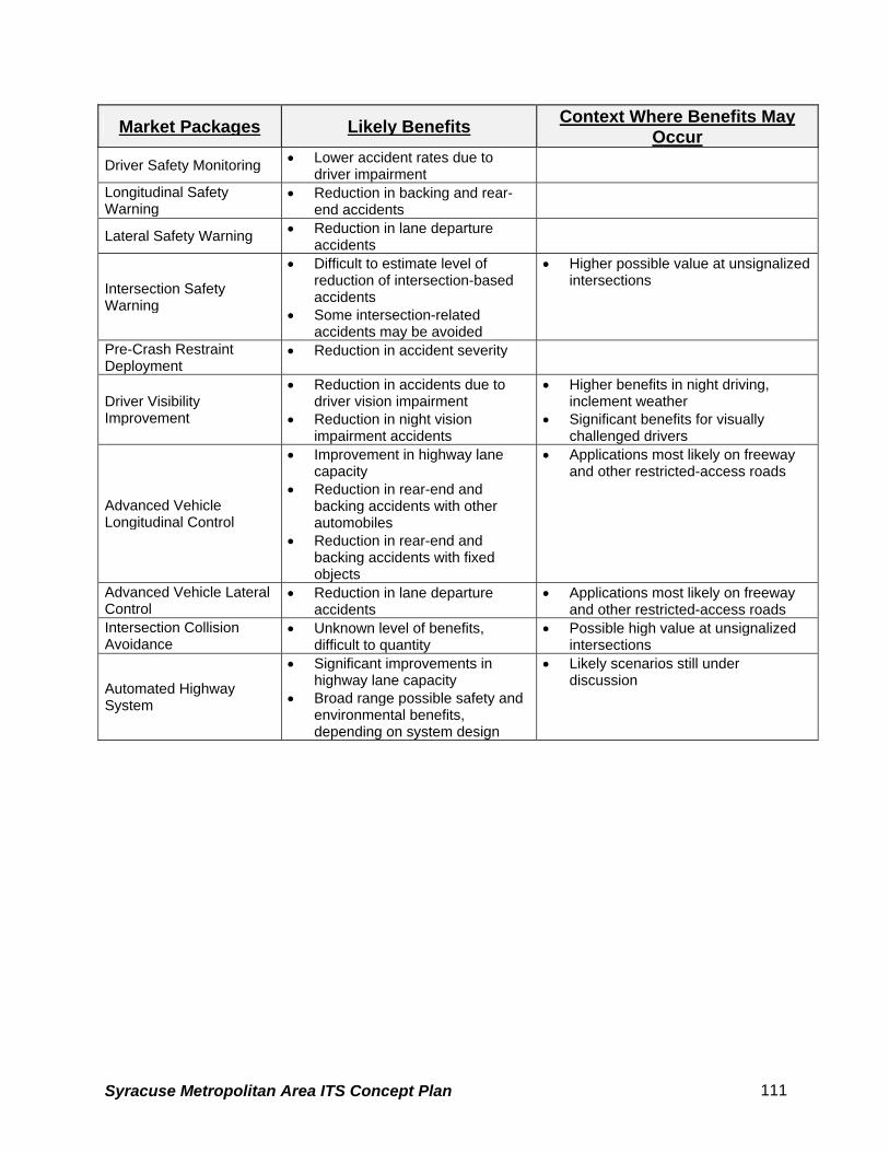
Market Packages Likely Benefits Context Where Benefits May Occur
Driver Safety Monitoring • Lower accident rates due to driver impairment
Longitudinal Safety Warning
• Reduction in backing and rear-end accidents
Lateral Safety Warning • Reduction in lane departure accidents
Intersection Safety Warning
• Difficult to estimate level of reduction of intersection-based accidents
• Some intersection-related accidents may be avoided
• Higher possible value at unsignalized intersections
Pre-Crash Restraint Deployment
• Reduction in accident severity
Driver Visibility Improvement
• Reduction in accidents due to driver vision impairment
• Reduction in night vision impairment accidents
• Higher benefits in night driving, inclement weather
• Significant benefits for visually challenged drivers
Advanced Vehicle Longitudinal Control
• Improvement in highway lane capacity
• Reduction in rear-end and backing accidents with other automobiles
• Reduction in rear-end and backing accidents with fixed objects
• Applications most likely on freeway and other restricted-access roads
Advanced Vehicle Lateral Control
• Reduction in lane departure accidents
• Applications most likely on freeway and other restricted-access roads
Intersection Collision Avoidance
• Unknown level of benefits, difficult to quantity
• Possible high value at unsignalized intersections
Automated Highway System
• Significant improvements in highway lane capacity
• Broad range possible safety and environmental benefits, depending on system design
• Likely scenarios still under discussion
Syracuse Metropolitan Area ITS Concept Plan 111

5.4 Agency Market Package Plans
The Market Package plan for an agency consists of a set of prioritized ITS services carefully
selected with a view to alleviating the existing problems and to achieving overall long-term
objectives of the agency. The importance of the agency-specific market package plan is
stressed by the fact that while the desired functional capabilities of the plan satisfy the agency’s
needs, the plan’s technological interface establishes the framework for the subsequent task of
developing the ITS system architecture for the agency. It allows the agency to concentrate on
those pieces of the architecture necessary to provide the required services. This section
develops market package plans for the transportation related agencies in the study area. These
agencies include:
• New York State Dept. of Transportation (NYSDOT Region 3)
• New York State Thruway Authority (NYSTA)
• New York State Police
• Syracuse Metropolitan Transportation Council (SMTC)
• Central New York Regional Transportation Authority (CNYRTA)
• City of Syracuse Department of Public Works (DPW)
• City of Syracuse Police Department
• City of Syracuse Fire Department
• City of Syracuse Emergency Management Services
• Onondaga County Department of Transportation
• Onondaga County Sheriff’s Office
• Onondaga County 9-1-1
5.4.1 Potential Applications of Market Packages
In subsection 3, a generic description was provided for each market package; however no real-
world applications were discussed. This sub-section simplifies the understanding of each
market package by providing examples of potential applications in terms of deployable projects.
As shown in Table 17, the Network Surveillance (atmsS01) market package will include
deployment of electronic devices such as Close Circuit Television (CCTV), Video Image
Syracuse Metropolitan Area ITS Concept Plan 112
Detectors (VID), and other detectors/sensors on the roadway network for measuring various
performance measures (e.g. speed, volume, vehicle classification, etc.). Similarly the other
Market Packages have potential applications that may relate to transit, commercial vehicles
operations, pedestrian, emergency management and so on. Sometimes two or more Market
Packages are required to achieve a desired function. Table 17 will be used in the subsequent
analyses to identify the priority Market Packages for each agency in the City of Syracuse region.
5.4.2 Priority Rating Definitions The market package plans for the agencies were developed by assigning a priority rating to
each package. With the exception of fundamental/mandatory Market Packages mentioned
earlier, the following priority ratings were used for other Market Packages:
High - the market package offers services that are fundamental to agency’s existing as
well as perceived future operations; a high priority candidate for funding. The agency
will actively pursue financing and implementation of the market package.
Medium - the market package offers services that are only complementary to agency’s
existing as well as perceived future operations; a medium priority candidate for agency
funding. The agency will consider financing it to the extent required to complement the
services of a high priority package.
Low - the market package offers services that are only remotely related to agency’s
existing as well as perceived future operations; a low priority candidate for agency
funding.
Not Rated - the market package offers services that are not related to the agency
operations. It is not a candidate for agency financing.
Syracuse Metropolitan Area ITS Concept Plan 113

This page is intentionally left blank
Syracuse Metropolitan Area ITS Concept Plan 114
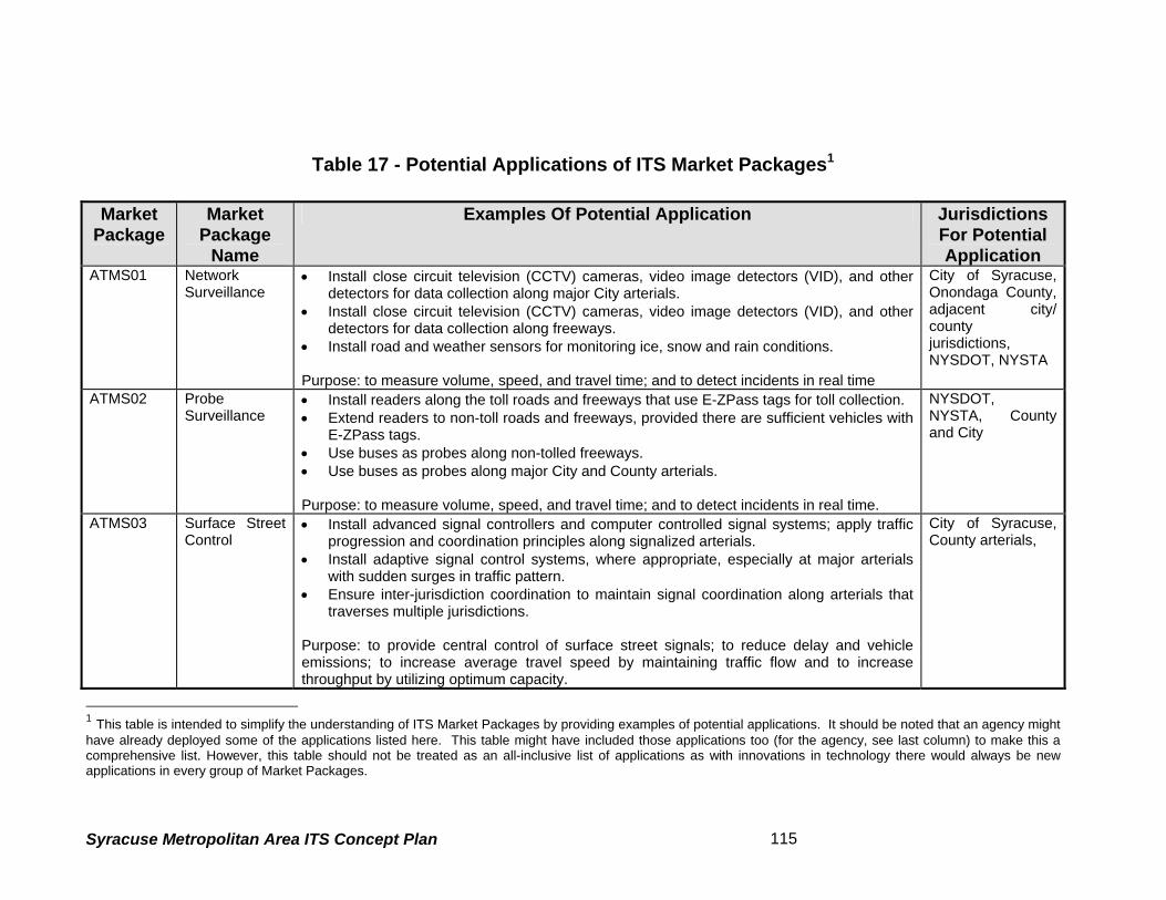
Table 17 - Potential Applications of ITS Market Packages1
Market
Package Market
Package Name
Examples Of Potential Application Jurisdictions For Potential Application
ATMS01 NetworkSurveillance
• Install close circuit television (CCTV) cameras, video image detectors (VID), and other detectors for data collection along major City arterials.
• Install close circuit television (CCTV) cameras, video image detectors (VID), and other detectors for data collection along freeways.
• Install road and weather sensors for monitoring ice, snow and rain conditions. Purpose: to measure volume, speed, and travel time; and to detect incidents in real time
City of Syracuse, Onondaga County, adjacent city/ county jurisdictions, NYSDOT, NYSTA
ATMS02 ProbeSurveillance
• Install readers along the toll roads and freeways that use E-ZPass tags for toll collection. • Extend readers to non-toll roads and freeways, provided there are sufficient vehicles with
E-ZPass tags. • Use buses as probes along non-tolled freeways. • Use buses as probes along major City and County arterials. Purpose: to measure volume, speed, and travel time; and to detect incidents in real time.
NYSDOT, NYSTA, County and City
ATMS03 Surface StreetControl
• Install advanced signal controllers and computer controlled signal systems; apply traffic progression and coordination principles along signalized arterials.
• Install adaptive signal control systems, where appropriate, especially at major arterials with sudden surges in traffic pattern.
• Ensure inter-jurisdiction coordination to maintain signal coordination along arterials that traverses multiple jurisdictions.
Purpose: to provide central control of surface street signals; to reduce delay and vehicle emissions; to increase average travel speed by maintaining traffic flow and to increase throughput by utilizing optimum capacity.
City of Syracuse, County arterials,
1 This table is intended to simplify the understanding of ITS Market Packages by providing examples of potential applications. It should be noted that an agency might have already deployed some of the applications listed here. This table might have included those applications too (for the agency, see last column) to make this a comprehensive list. However, this table should not be treated as an all-inclusive list of applications as with innovations in technology there would always be new applications in every group of Market Packages.
Syracuse Metropolitan Area ITS Concept Plan 115

Market Package
Market Package
Name
Examples Of Potential Application Jurisdictions For Potential Application
ATMS04 FreewayControl –Ramp Control
• Install ramp metering at freeway ramps and interchanges, and coordinate ramp control
signals with local street signals Purpose: to maintain optimum traffic flow on freeway and ensure safe merging of on-ramp vehicles.
NYSDOT, NTSYTA
ATMS05/ ATMS17
HOV andReversible Lane Management
• Install cameras/detectors to monitor and enforce bus-HOV lanes on freeways • Install vehicle occupancy detectors along HOV lanes • Install cameras/detectors to monitor and enforce bus lanes on the arterials • Install cameras/detectors on reversible lane facilities and provide provisions for the Traffic
Management Center (TMC) to dynamically mange these facilities, especially during special events or other events that cause traffic surges.
• Install variable speed limit signs along HOV and reversible lanes, as appropriate. Purpose: to increase throughput by effectively managing buses, HOVs, and reversible lanes, especially during peak hours of travel and special events. Ensure safe merging of on-ramp vehicles.
NYSTA- Reversible lanes only at Toll Collection Facilities. No HOV Lanes in the study area.
ATMS06 TravelerInformation Dissemination
• Install variable message signs (VMS) at critical decision points in the freeway and arterial network.
• Install highway advisory radios (HAR) along freeway/arterial networks and at major destinations (e.g. airports)
Purpose: to provide basic traveler information so that the travelers can make an intelligent choice for their travel route and avoid locations of incidents.
NYSDOT, NYSTA, City of Syracuse, Onondaga County.
ATMS07 RegionalTransportation Control
• Install communication links and coordination between traffic control centers of multiple jurisdictions so that: a) Integrated signal control can be established for the arterials that traverse multiple
jurisdictions. b) A single traffic control center can manage the facilities of multiple jurisdictions during
off-peak hours, or during other hours of need.
Purpose: to manage transportation more efficiently through sharing/transferring some of the traffic control functions among two or more jurisdictions.
NYSDOT, NYSTA, City of Syracuse, Onondaga County, Emergency Service Providers
ATMS08 IncidentManagement System
• Install surveillance and data collection systems (see packages ATMS1, ATMS2, ATMS3) to detect and verify incidents
• Install effective communication channels among traffic, police, fire, and emergency
NYSDOT NYSTA, City of Syracuse &
Syracuse Metropolitan Area ITS Concept Plan 116
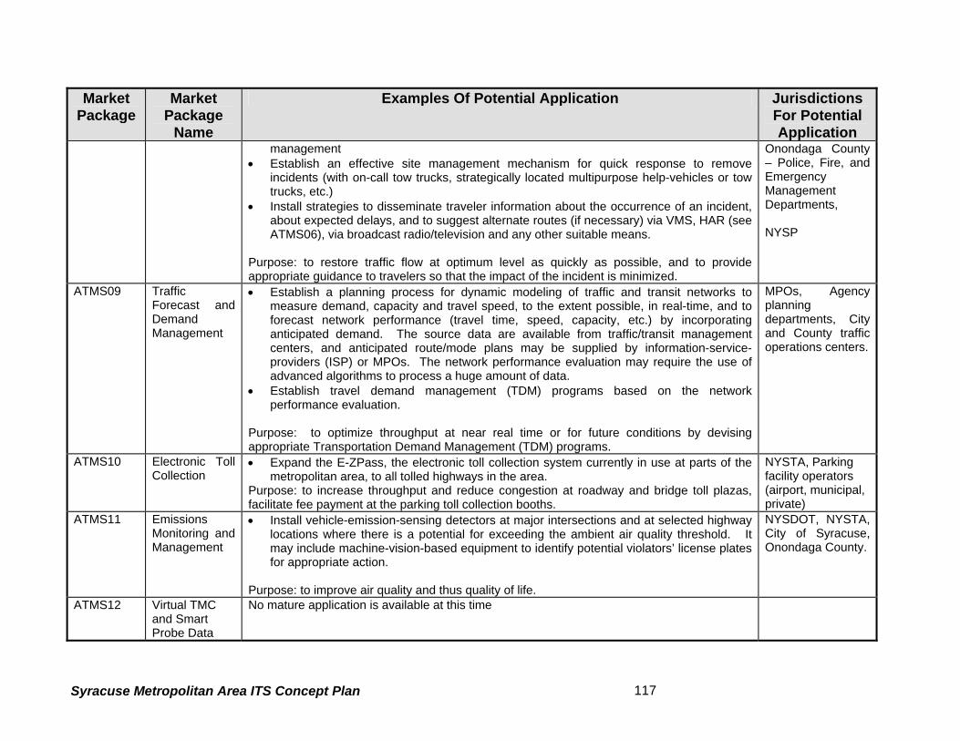
Market Package
Market Package
Name
Examples Of Potential Application Jurisdictions For Potential Application
management • Establish an effective site management mechanism for quick response to remove
incidents (with on-call tow trucks, strategically located multipurpose help-vehicles or tow trucks, etc.)
• Install strategies to disseminate traveler information about the occurrence of an incident, about expected delays, and to suggest alternate routes (if necessary) via VMS, HAR (see ATMS06), via broadcast radio/television and any other suitable means.
Purpose: to restore traffic flow at optimum level as quickly as possible, and to provide appropriate guidance to travelers so that the impact of the incident is minimized.
Onondaga County – Police, Fire, and Emergency Management Departments, NYSP
ATMS09 TrafficForecast and Demand Management
• Establish a planning process for dynamic modeling of traffic and transit networks to measure demand, capacity and travel speed, to the extent possible, in real-time, and to forecast network performance (travel time, speed, capacity, etc.) by incorporating anticipated demand. The source data are available from traffic/transit management centers, and anticipated route/mode plans may be supplied by information-service-providers (ISP) or MPOs. The network performance evaluation may require the use of advanced algorithms to process a huge amount of data.
• Establish travel demand management (TDM) programs based on the network performance evaluation.
Purpose: to optimize throughput at near real time or for future conditions by devising appropriate Transportation Demand Management (TDM) programs.
MPOs, Agency planning departments, City and County traffic operations centers.
ATMS10 Electronic TollCollection
• Expand the E-ZPass, the electronic toll collection system currently in use at parts of the metropolitan area, to all tolled highways in the area.
Purpose: to increase throughput and reduce congestion at roadway and bridge toll plazas, facilitate fee payment at the parking toll collection booths.
NYSTA, Parking facility operators (airport, municipal, private)
ATMS11 EmissionsMonitoring and Management
• Install vehicle-emission-sensing detectors at major intersections and at selected highway locations where there is a potential for exceeding the ambient air quality threshold. It may include machine-vision-based equipment to identify potential violators’ license plates for appropriate action.
Purpose: to improve air quality and thus quality of life.
NYSDOT, NYSTA, City of Syracuse, Onondaga County.
ATMS12 Virtual TMCand Smart Probe Data
No mature application is available at this time
Syracuse Metropolitan Area ITS Concept Plan 117

Market Package
Market Package
Name
Examples Of Potential Application Jurisdictions For Potential Application
ATMS13/ ATMS14
Standard/Advanced railroad grade crossing
• Installation of track and road surface sensors and wayside control equipment to detect presence of vehicles on grade crossing.
• Coordinated control between Highway and Railroad operations to avoid any accidents.
City, County and Railroad companies.
ATMS16 Parking FacilityManagement
• Install equipment to assist the management of parking operations, coordinates with transportation authorities, and supports electronic collection of parking fees.
• Provide availability information to travelers through guide signs and coordinated traveler information through ISPs message boards.
Purpose: to facilitate parking availability information and faster electronic toll collection.
City owned and private parking lots.
ATMS18 Road WeatherInformation
• Install sensors to monitor the road surface conditions • Installation of de-icing equipment at bridge and accident prone areas • Install weather sensors that monitor atmospheric weather conditions such as wind speed,
wind chill, direction, etc and can forecast hazardous weather patterns. Purpose: to provide real-time weather information to traffic control centers to manage hazardous weather conditions and propel appropriate response by planning and controlling the inventory of manual labor and materials.
City of Syracuse, Onondaga County, NYSDOT and NYSTA.
ATMS19 RegionalParking Management
• Install electronic toll/fare collection system at park-n-ride lots, airport parking lots/garages, and major parking lots/garages in urban areas.
• Install directional signs and post parking availability information (in real-time) at major intersections and/or decision points in the city, near park-n-ride lots, and in the vicinity of major destinations.
Purpose: to facilitate parking fee payment at the pay-booth, and to reduce congestion by eliminating vehicles wandering in search of a parking place.
City of Syracuse, Hancock Int’l. Airport.
APTS01 Transit VehicleTracking
• Install advanced train tracking systems to identify train locations in real-time. The technology may involve Global Positioning Systems (GPS), Communications Based Track Circuits (CBTC), and/or others.
• Install automatic vehicle location (AVL) systems for buses. GPS based systems are the preferred system at the present time.
Purpose: These applications are fundamental to any transit ITS. Real-time tracking of transit vehicles will enable the transit agency to manage the system more effectively and to provide traveler information about arrival/departure time, delays, service disruptions, and incidents in real-time.
CNYRTA
APTS02 Transit Fixed- • Establish a dynamic system for automatic driver assignment, monitoring, routing, and CNYRTA
Syracuse Metropolitan Area ITS Concept Plan 118

Market Package
Market Package
Name
Examples Of Potential Application Jurisdictions For Potential Application
Route Operations
scheduling for fixed-route transit operations using the real-time transit tracking information (see APTS1) and traffic information data. The Information Service Providers (ISP) may integrate the fixed-route transit operations data with the data from connecting modes (e.g. ferry, train, air) to provide the public with integrated and personalized information.
Purpose: to achieve optimal use of the fixed-route transit fleet
APTS03 DemandResponse Transit Operations
• Establish a dynamic system for automatic driver assignment, monitoring, routing, and scheduling for demand-responsive transit services using the real-time bus tracking information (see APTS1). The information service providers (ISP) may integrate the flexible-route transit operation data with the data from connecting modes (e.g. ferry, train, and air) for providing the public with integrated and personalized information.
• Enable the flexible-route-transit and para-transit services to entertain travelers’ requests for pick-up/drop-off through real-time monitoring and flexible routing of the transit vehicles.
Purpose: to achieve optimal use of the demand-responsive transit fleet
CNYRTA
APTS04 TransitPassenger and Fare Management
• Install fare collection devices at rail stations to enable the passengers to pay fares electronically (i.e. by a quick-contact or contact-less means, as the available technology permits) via a debit or smart card.
• Provide ticket vending machines at stations and bus terminals for buying tickets and electronic fare cards (e.g. a debit or smart card).
• Install devices on-board buses for electronic payment of fares via a debit or smart card. • Install automatic passenger counters (APC) for counting passengers on-board transit
vehicles, especially buses, to improve passenger management by initiating appropriate actions (e.g. dispatching an additional bus to avoid crowding at a peak-load point on the route) by the Transit Management Center. APCs are useful in increasing operating efficiency by planning better services and by providing real-time passenger data needed by Traffic/Transit Management Center to initiate bus priority at traffic signals. As an example: provide priority to a bus only when the bus is not only delayed bust also carries the number of passengers on board that exceeds a certain minimum threshold.
Purpose: Efficient fare and passenger management.
CNYRTA
APTS05 TransitSecurity
• Install CCTV at rail/bus stations for surveillance and security and to warn of potentially dangerous situations.
CNYRTA
Syracuse Metropolitan Area ITS Concept Plan 119

Market Package
Market Package
Name
Examples Of Potential Application Jurisdictions For Potential Application
• Install cameras on buses/rail cars to monitor/record dangerous conditions, and a silent-alarm system to initiate a help-request by the driver.
Purpose: to provide physical security to passengers at stations and on board.
APTS06 TransitMaintenance
• Install devices on buses and rail cars to enable the Transit Management Center to automatically monitor the vehicle component conditions of vehicles (such as high engine temperature, low oil pressure, etc.) and the schedule for maintenance.
Purpose: Efficient transit fleet maintenance.
CNYRTA
APTS07 Multi-modalCoordination
• Install a workstation that depicts real-time train schedule at the bus control center so that arrival/departure of trains and buses are coordinated at rail stations. A bus may be allowed to wait at an en-route rail station to pickup passengers from a delayed train without substantially degrading the bus schedule.
• Provide provisions for bus priority at traffic signals along selected routes. Purpose: Coordinate services/operations among multiple modes (e.g., bus, train, and auto-traffic) to optimize passenger throughput (as in bus priority at signals), to optimize travel time (as in bus-train coordination).
CNYRTA
APTS08 En-RouteTransit Customer Information Dissemination
• Install display monitors, variable message signs at rail/bus stations/terminals, and on-board vehicles.
• Install public address systems on-board vehicles and at stations/terminals Purpose: to disseminate up-to-date and real-time (to the extent possible) basic traveler information to transit passengers on-board vehicles and at stations/terminals.
CNYRTA
APTS09 IntegratedFee/Fare Payment
• Establish inter-agency coordination and devise a means for paying fee/fare at multiple modes/facilities (e.g. rail, bus, tolled highways, bridges and parking facilities) via a single interoperable electronic device (e.g. smart card). Establish an integrated financial clearinghouse (back-office operations) for fee/fare processing and distribution among operating agencies.
Purpose: Easy, efficient, and integrated way of fee/fare payment and management irrespective of mode and facility-ownership.
NYSDOT, NYSTA, CNYRTA, City of Syracuse, Private Operators of Parking facilities.
ATIS01 BroadcastTraveler Information
• Provide multi-modal traveler information via local broadcast radio/TV stations, cable TV or via dedicated channel for traffic/transit information. The source of information can be Traffic and Transit Management Centers, individual initiatives by TV stations (chopper in
Private sector, and ISP-based.
Syracuse Metropolitan Area ITS Concept Plan 120
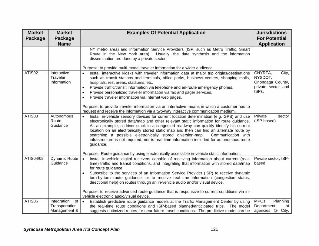
Market Package
Market Package
Name
Examples Of Potential Application Jurisdictions For Potential Application
NY metro area) and Information Service Providers (ISP, such as Metro Traffic, Smart Route in the New York area). Usually, the data synthesis and the information dissemination are done by a private sector.
Purpose: to provide multi-modal traveler information for a wider audience.
ATIS02 InteractiveTraveler Information
• Install interactive kiosks with traveler information data at major trip origins/destinations such as transit stations and terminals, office parks, business centers, shopping malls, hospitals, rest areas, stadiums, etc.
• Provide traffic/transit information via telephone and en-route emergency phones. • Provide personalized traveler information via fax and pager services. • Provide traveler information via Internet web pages. Purpose: to provide traveler information via an interactive means in which a customer has to request and receive the information via a two-way interactive communication medium.
CNYRTA, City, NYSDOT, Onondaga County, private sector and ISPs,
ATIS03 AutonomousRoute Guidance
• Install in-vehicle sensory devices for current location determination (e.g. GPS) and use electronically stored data/map and other relevant static information for route guidance. As an example, a driver stuck in a congested roadway can quickly identify his current location on an electronically stored static map and then can find an alternate route by searching a possible electronically stored diversion-map. Communication with infrastructure is not required, nor is real-time information included for autonomous route guidance.
Purpose: Route guidance by using electronically accessible in-vehicle static information.
Private sector (ISP-based).
ATIS04/05 Dynamic RouteGuidance
• Install in-vehicle digital receivers capable of receiving information about current (real-time) traffic and transit conditions, and integrating that information with stored data/map for route guidance.
• Subscribe to the services of an Information Service Provider (ISP) to receive dynamic turn-by-turn route guidance, or to receive real-time information (congestion status, directional help) on routes through an in-vehicle audio and/or visual device.
Purpose: to receive advanced route guidance that is responsive to current conditions via in-vehicle electronic audio/visual device.
Private sector, ISP-based
ATIS06 Integration ofTransportation Management &
• Establish predictive route guidance models at the Traffic Management Center by using the real-time route conditions and ISP-based planned/anticipated trips. The model suggests optimized routes for near-future travel conditions. The predictive model can be
MPOs, Planning Department at agencies @ City,
Syracuse Metropolitan Area ITS Concept Plan 121

Market Package
Market Package
Name
Examples Of Potential Application Jurisdictions For Potential Application
Route Guidance
used by the Traffic Management Center to change the progression of traffic signals along certain route based on near-future anticipated conditions. A Transit Management Center can plan for diverting an express bus along a less congested route based on the predictive model. The dynamic route guidance based on the predictive model can be disseminated by an ISP in coordination the Traffic Management Center
Purpose: to manage traffic control systems, as well as, provide dynamic route guidance based on predictive models that use real time route conditions and planned/anticipated travel in near-future.
County, NYSDOT, NYSTA, City and ISPs.
ATIS07 Yellow Pagesand Reservation
• Advance the use of the interactive traveler information devices (e.g. telephone, kiosk, Internet, etc. See ATIS2) by adding electronically accessible yellow-page information and enabling the travelers to make reservations (for a hotel, ticket, restaurant, etc.) at interactive Kiosks and on Internet.
Purpose: to provide yellow-page information and reservation services as well as interactive traveler information at the same time.
ISP-based.
ATIS08 DynamicRidesharing
• Advance the use of the interactive traveler information devices (e.g. telephone, kiosk, Internet, etc. See ATIS2) by adding ridesharing information in near real-time. An ISP may be involved in providing the information on ridesharing opportunities and the customer requests for ridesharing in near real-time.
Purpose: to integrate real-time ridesharing opportunities/requests as part interactive traveler information.
Private sector lead, in association with traveler information department of public agencies
ATIS09 In VehicleSigning
• Provide information to drivers, via in-vehicle electronic device/display, about the static signs along the route or about the messages displayed on en-route variable message signs, or about intersection safety warning. It requires dedicated short-range communications between roadside signs and the vehicle, as well as, wire-line communication between roadside signs and Traffic Management Center. The service may be offered by the Traffic Management Center, or by an Information Service Provider (ISP) in cooperation with Traffic Management Center.
Purpose: to provide the driver with in-vehicle information on the regulatory/advisory signs along the route.
Private sector lead, in association with public agencies (NYSDOT, NYSTA, City and County)
AVSS01 Vehicle SafetyMonitoring
No mature application is available at this time. Auto industry lead
AVSS02 Driver Safety No mature application is available at this time. Auto industry lead
Syracuse Metropolitan Area ITS Concept Plan 122

Market Package
Market Package
Name
Examples Of Potential Application Jurisdictions For Potential Application
Monitoring AVSS03 Longitudinal
Safety Warning No mature application is available at this time. Auto industry lead
AVSS04 Lateral SafetyWarning
No mature application is available at this time. Auto industry lead
AVSS05 IntersectionSafety Warning
• Install sensors, detectors at or near intersection/grade-crossing to measure speed, and identify vehicle locations, pedestrian/bicycle presence, and then assess the potential for any impending collision or dangerous condition. Use the information to warn the drivers by triggering an in-vehicle alarm and the pedestrians/bicyclists by an onsite safety warning. The mechanism may require sophisticated data/video processing at the Traffic Management Center.
Purpose: to increase safety at intersections and grade crossings.
City of Syracuse, CNYRTA, County, other local jurisdictions and private automobiles.
AVSS06 Pre-CrashRestraint Deployment
No mature application is available at this time. Auto industry lead
AVSS07 Driver VisibilityImprovement
No mature application is available at this time. Auto industry lead
AVSS08 AdvancedVehicle Longitudinal Control
No mature application is available at this time. Auto industry lead
AVSS09 AdvancedVehicle Lateral Control
No mature application is available at this time. Auto industry lead
AVSS10 IntersectionCollision Avoidance
No mature application is available at this time. Auto industry lead
AVSS11 AutomatedHighway System (AHS)
• Equip the highway and vehicle with advanced detectors/sensors so that it allows a driver “hands-off” operation of his vehicle.
Purpose: to increase capacity/throughput by enabling shorter headway between vehicles, increase safety, reduce monotony of driving, plus scores of other associated benefits. Caveat – the concept may not be fully realistic, though it has potential for innovations in traffic safety by increasing the intelligence of vehicle. Since August 1997, the USDOT has abandoned the research support for AHS program and directed its focus on passenger safety
Lead by public-private partnerships with USDOT support. A futuristic concept.
Syracuse Metropolitan Area ITS Concept Plan 123

Market Package
Market Package
Name
Examples Of Potential Application Jurisdictions For Potential Application
and Safer vehicles starting a new program named as Intelligent Vehicle Initiative (IVI). CVO01 Fleet
Administration • Install a vehicle location identification system using a cell based (or satellite) data link and
the existing wireless infrastructure. • Establish a system for central monitoring of itineraries using the cellular-data-link based
vehicle location information • Establish a system for central monitoring of fuel usage of vehicles via an in-vehicle
processor with an interface to its fuel gauze and the cellular data link. • Establish a system that allows the Management Center to process dispatch instructions
and to respond to requests for assistance/information via cellular data link Purpose: to facilitate administration and increase efficiency of CVO fleet
Private sector based
CVO02 FreightAdministration
• Install electronic identification tags on cargo (national standards are not yet available). • Install an electronic cargo monitoring system at the cargo Administration Center through
wireless communication between the cargo tags and the Administration center. Purpose: to facilitate remote tracking of cargo in real-time.
Private operators, Public cargo carriers – Hancock Intl’ Airport
CVO03 ElectronicClearance
• Install transponders on the commercial vehicle • Install electronic credential-checking system at the roadside checkpoints so that
checkpoint staff can retrieve the snapshot of critical data of the carrier, vehicle and driver. The roadside checking can b e equipped with automatic vehicle identification system, transponder read/write devices and other data processing equipment.
Purpose: Allow a good driver/carrier/vehicle to pass checkpoints at highway speed. It allows time saving for truckers and cost savings for regulators.
Regulators such as NYSDOT/DMV, NYSTA
CVO04 CVAdministrative Processes
• Establish a system of electronic application/processing/fee collection and issuance/distribution of CVO credential. Store the credential data to be available at roadside checking facility. This package is a pre-requisite for the Electronic Clearance (CVO3) or both packages should be simultaneously deployed.
Purpose: Efficiency in commercial vehicle credential checking and cost savings for both regulator and operators.
Regulators such as NYSDOT/DMV, NYSTA
CVO05 InternationalBorder Electronic Clearance
• Establish International credential checking system. For these agreements on International Credential is required.
• Establish electronic processing of customs fees. International Customs agreements are required.
Regulators such as NYSDOT/DMV, NYSTA
Syracuse Metropolitan Area ITS Concept Plan 124

Market Package
Market Package
Name
Examples Of Potential Application Jurisdictions For Potential Application
• Establish international standards for electronic clearance and CVO administrative process.
Purpose: Time saving for truckers and cost savings for regulators.
CVO06 Weigh-In-Motion
• Install roadside fixed or removable roadside equipment for high speed weigh-in-motion. This package will work in conjunction with electronic clearance / CVO administrative process for identifying violators and recording the data.
Purpose: Time saving for truckers and cost savings for regulators.
Regulators such as NYSDOT/DMV, NYSTA
CVO07/08 CVO Safety • This package will be supported by Electronic Clearance and CVO Administrative Process for the critical vehicle safety data stored in the infrastructure so that a pulled-in decision can be made for safety check. The required systems are being researched.
• Install on-board safety checking mechanism that will indicate the critical safety parameters, and that data can be accessed by the Management Center for alerting the driver. The required systems are being researched
Purpose: to increase safety
Regulators such as NYSDOT/DMV, NYSTA
CVO09 FleetMaintenance
• Establish a system for storing vehicle records such as mileage, repair history, safety violations. Install on-board monitoring equipment for checking safety parameters with close interface with management center via automatic vehicle location system. The driver can be warned of possible safety violations and the vehicle can be programmed for timely maintenance.
Purpose: to increase reliability and reduced costs due to timely maintenance
Private sector
CVO10 HAZMATManagement
• Establish a system for tracking of HAZMAT and other sensitive cargo as it travels through the region. The electronic clearance package facilitates the procedure of tracking. If an incident occurs, the Incident Management System (ATMS08) and Emergency Response (EM1) packages support the clearance/removal/clean-up of HAZMAT
Purpose: Rapid and safer cleanup of hazardous spills.
NYSDOT, NYSTA, City, County, EMS and City and County Police.
CVO11 CommercialVehicle Traveler Information Dissemination
• Establish a system to tailor the data collected as part of ATMS (Traffic Management) and ATI S (Traveler Information) so that specific needs for commercial vehicle operators can be met.
Purpose: To provide truckers with the needed information on various travel conditions
Private Sector, NYSDOT and NYSTA.
Syracuse Metropolitan Area ITS Concept Plan 125

Market Package
Market Package
Name
Examples Of Potential Application Jurisdictions For Potential Application
(congestion/weather/pavement etc.) EM1 Emergency
Response • Establish a system for automatic notification of emergency vehicles after an incident has
been checked and verified. • Establish a system for tracking emergency vehicles so that the nearest emergency
vehicle can respond to an emergency. • Establish a system for effective coordination (by better algorithms) between, police, fire
and emergency response team as each of these agencies develop their tracking systems.
Purpose: to provide quicker response to accident victims.
State, City, County police, fire and emergency management departments;
EM2 EmergencyRouting
• Establish a signal priority for emergency vehicles. • Establish a system for dynamic routing of emergency vehicles based on real-time traffic
conditions in coordination with Traffic Management Center. Purpose: Reduced delay and easier access to emergency vehicles
State, City, County emergency management departments and traffic departments.
EM3 MaydaySupport
• Equip the infrastructure and the vehicle so that the location of vehicle requesting Mayday support can be automatically determined.
• Install in-vehicle devices and sensors so that requests from the traveler can be manually initiated or the request can be automatically transmitted via sensors with wireless communication.
Purpose: To provide faster attention to medical emergencies and hazards to vehicle and people.
Current regulations prohibit automatic May Day request to 911. Initially private sector will take lead
AD1 ITS Data Mart • Archiving own agency data for future developmental/planning needs. • Can be shared with individual agencies upon request.
City, County, EMS, Emergency Agencies, NYSDOT, NYSTA, MPO
AD2 ITS Data Warehouse
• Similar to ITS Data Mart with an enhanced feature of being a regional warehouse to collect and disseminate the required, archived information.
• Can be automated when several agencies are involved and the transfer can be made upon request or without one.
NYSDOT, MPO, NYSTA.
AD3 ITS Virtual • Establish better planning methods using real-time data, which will be available from City and County
Syracuse Metropolitan Area ITS Concept Plan 126

Market Package
Market Package
Name
Examples Of Potential Application Jurisdictions For Potential Application
Data Warehouse
implementation of various, previously described packages. Purpose: Better estimation of effect and cost of future transportation improvements.
and State Planning Departments.
Syracuse Metropolitan Area ITS Concept Plan 127

5.5 Market Package Plan Development
The identification of Market Packages for developing the ITS Architecture began with an
introductory workshop held with participation of all agencies/stakeholders in the region. It
involved a series of phases, as detailed below.
Phase1: The stakeholders in the region were invited to attend a workshop on Market Packages
and were educated on the various Market Packages that are prescribed by the USDOT’s
National ITS Architecture. Depending on the operational characteristics of the stakeholder
agency, these Market Packages were classified under different categories/aspects of
Transportation Operation such as Traffic Management, Transit Management, Emergency
Management, etc. To aid the presentation, handouts were given to the attendees. During the
workshop, participating agencies were asked to choose the set of Market Packages, based on
their agencies current and future needs that would be in the best interest of the region’s
transportation system. The participants were asked to rate the selected Market Packages as
High, Medium and Low. Those Market Packages that didn’t reflect the functional vision of any
agency were rated as Not Applicable (N/A).
Phase2: These selected Market Packages were tabulated to identify any discrepancy in the
selection process between different members of the same agency. The results were then
validated with other agencies in the region that have similar operational characteristics. This
process helped identify the differences in the needs of various agencies in the region, which
may have the same mission, but with a different level of priority. For example, NYSDOT wishes
to share traffic camera Images with the NYSTA, which already has a few traffic cameras located
within the NYSTA study area. This was rated as a high priority. But for the NYSTA, this might
not be a top priority, as they might prefer to direct Immediate/short-term investments to Traveler
Information, since they have a large volume of commuter traffic on their road network.
Further, it was found that in a few instances, the Market Packages selected and rated by
representatives of the same agency varied. To avoid this, the Market Packages survey was sent
to the stakeholder agencies for further verification, and they were asked to come to consensus
among themselves and provide a unified selection. The completed surveys were sent in by mail
to the agency representatives who were asked to consult with their decision makers, to validate
and verify the information provided initially.
Syracuse Metropolitan Area ITS Concept Plan 128

Phase3: The re-evaluated Market Packages surveys were tabulated yet again and compared
against other agencies with similar operational characteristics. Meeting with the agencies face-
to-face further validated the results and helped fine–tune the selected Market Packages so that
that they will be mutually beneficial to each other while benefiting the region as a whole. The
meetings held were dedicated to agencies that perform different categories of transportation
operation such as freeway management (NYSDOT and NYSTA), Arterial Street Control (City
and County), and Emergency Management (City Police, County Sheriff, Fire, County
Emergency Communication Center, EMS personnel and New York State Police).
Thus, an agency or a group of similar agencies identified a set of prioritized ITS Services. The
goal of this exercises was to alleviate the existing problems and to achieve overall long-term
goals of the agency/group and the region.
The Market Packages selection process was interactive and in-depth in nature. The consultant
team’s experts on ITS explained the potential application of each market package (Table 4.1).
The agency representatives evaluated each market package (and the associated technologies)
based upon their understanding of how the packages help satisfy the current needs and
achieve future goals.
5.6 Process of Market Package Prioritization
While a quantitative (goal weighting) process is considered as unique and probably a more
accurate reflection of an agency’s ITS needs and direction, the approach preferred for this study
is “qualitative” evaluation. It is a quick and easy to understand process wherein the stakeholder
agencies in the Market Package workshop developed their market package plan based solely
on their qualitative judgment and their agency goals. Each agency/group applied its qualitative
judgment directly by understanding how each market package application (see Table 15)
satisfies its needs and helps achieve its future goals. Accordingly, the agency applied the
ratings of Fundamental/ Mandatory, high (H), medium (M), low (L), not applicable (N/A) and
not rated (NR) for each market package. The summarized results of the market packages
survey are presented in Table 18.
Syracuse Metropolitan Area ITS Concept Plan 129

Market Packages
City
of S
yrac
use
Cou
nty
DO
T
NYS
TA
NYS
DO
T
911
Ono
ndag
a C
ount
y
NYS
P
Syra
cuse
Fire
Dep
t.
City
Pol
ice
City
Pol
ice
SUN
Y U
psta
te M
edic
al
Uni
vers
ity
Cou
nty
Sher
iff
CN
YRTA
SMTC
Network Surveillance ATMS01 mandatory H H H H H H H H M H H H H
Probe Surveillance ATMS02 mandatory H M H M M L L H M H L H H
Surface Street Control ATMS03 L H L M H H H H L M H H H
Freeway Control - Ramp Control ATMS04 H M L M H L H M L L L L L
HOV Lane Management ATMS05 L NR L NR L NR N/A N/A NR NR N/A NR NR
Traffic Information Dissemination ATMS06 H H H H M H M H L H H L L
Regional Traffic Control ATMS07 M H H H H L M M L H H/M H H
Incident Management System ATMS08 H H H H H H H H M H H M L
Traffic Forecast and Demand Management ATMS09 M L M L H- N/A H H H L M M L L
Electronic Toll Collection ATMS10 H NR L L H L L H L L L L NR
Emissions Monitoring and Management ATMS11 L L L L H H M L L M L L L
Syracuse Metropolitan Area ITS Concept Plan 130

Market Packages
City
of S
yrac
use
Cou
nty
DO
T
NYS
TA
NYS
DO
T
911
Ono
ndag
a C
ount
y
NYS
P
Syra
cuse
Fire
Dep
t.
City
Pol
ice
City
Pol
ice
SUN
Y U
psta
te M
edic
al
Uni
vers
ity
Cou
nty
Sher
iff
CN
YRTA
SMTC
Virtual TMC and Probe Data ATMS12 Not Applicable L NR L NR M L N/A M L NR L L L
Standard Railroad Grade Crossing ATMS13 L L L H M L M H L L M L M
Advanced Railroad Grade Crossing ATMS14 L NR M M M L M M L L M L L
Railroad Operations Coordination ATMS15 L NR M L M L L M L L L L L
Parking Facility Management ATMS16 L NR L L L H M/L L L H M L NR
Reversible Lane Management ATMS17 H NR L L N/A H L L NR L L L NR
Road Weather Information System ATMS18 H H H H M H M H M H L L M
Regional Parking Management ATMS19 L NR L L L H M L L H M M/L NR
Transit Vehicle Tracking APTS1 mandatory L NR M H L L H L H H
Transit Fixed-Route Operations APTS2 L NR L L H L L L L H L L NR
Demand Response Transit Operations APTS3 L NR L L H L M L L H L L NR
Transit Passenger and Fare Management APTS4 NR NR L L M L L L L H H L NR
Syracuse Metropolitan Area ITS Concept Plan 131

Market Packages
City
of S
yrac
use
Cou
nty
DO
T
NYS
TA
NYS
DO
T
911
Ono
ndag
a C
ount
y
NYS
P
Syra
cuse
Fire
Dep
t.
City
Pol
ice
City
Pol
ice
SUN
Y U
psta
te M
edic
al
Uni
vers
ity
Cou
nty
Sher
iff
CN
YRTA
SMTC
Transit Security APTS5 NR NR M M M H H M L H L L L
Transit Maintenance APTS6 L NR L L H L L M L M L L NR
Multi-modal Coordination APTS7 NR NR H L H M L H L H L L L
Transit Traveler Information APTS8 L NR M L M L L H L H L L NR
Broadcast Traveler Information ATIS01 H L H H M H L H L M L M L
Interactive Traveler Information ATIS02 H L H L M M L H L H L M M
Autonomous Route Guidance ATIS03 L NR L L H L L L L L L L L
Dynamic/ISP Based Route Guidance ATIS04/05 L NR M L M L L M L L L L L
Integrated Transportation Management/Route Guidance ATIS06 L NR M L M L L M L L L L L
Yellow Pages and Reservation ATIS07 L L L L L H L L L L L L L
Dynamic Ridesharing ATIS08 NR NR L L L L L L L M L L L
Syracuse Metropolitan Area ITS Concept Plan 132
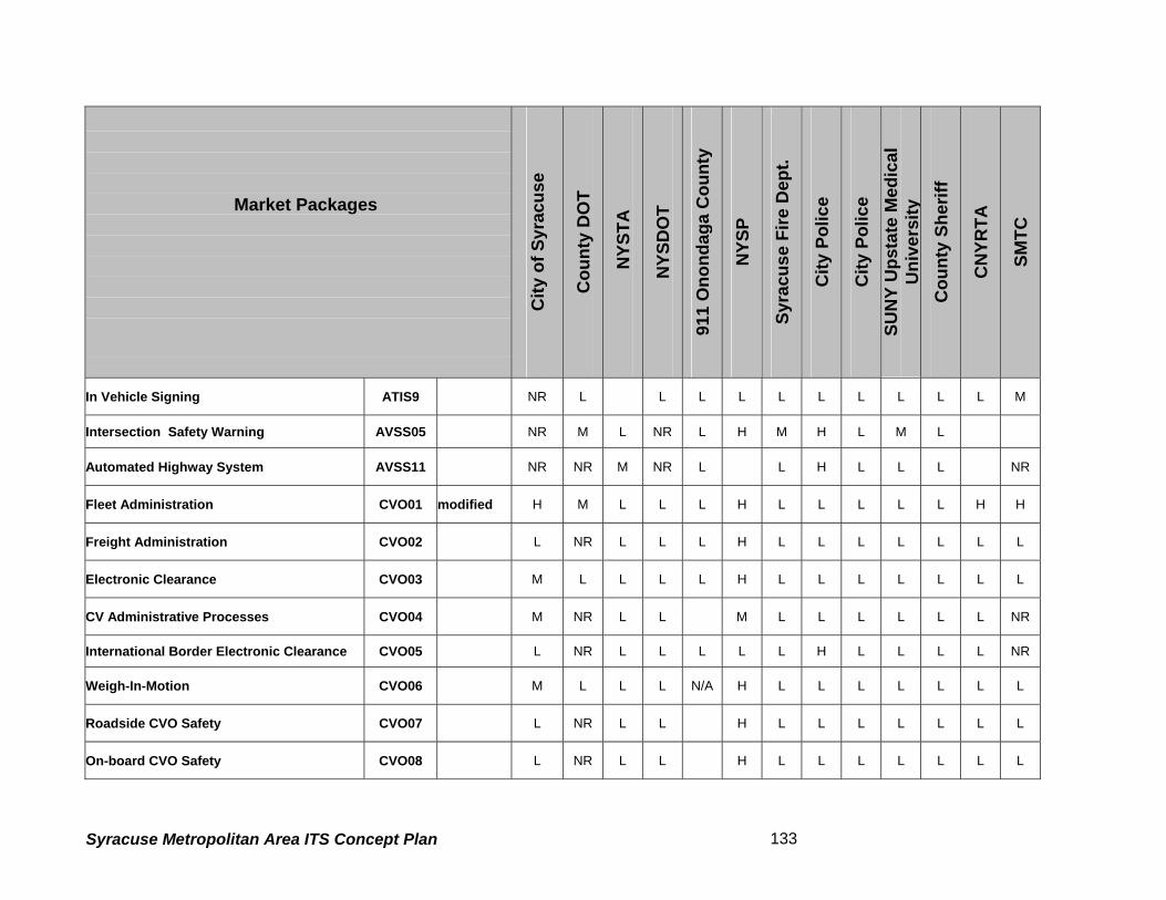
Market Packages
City
of S
yrac
use
Cou
nty
DO
T
NYS
TA
NYS
DO
T
911
Ono
ndag
a C
ount
y
NYS
P
Syra
cuse
Fire
Dep
t.
City
Pol
ice
City
Pol
ice
SUN
Y U
psta
te M
edic
al
Uni
vers
ity
Cou
nty
Sher
iff
CN
YRTA
SMTC
In Vehicle Signing ATIS9 NR L L L L L L L L L L M
Intersection Safety Warning AVSS05 NR M L NR L H M H L M L
Automated Highway System AVSS11
NR NR M NR L L H L L L NR
Fleet Administration CVO01 modified H M L L L H L L L L L H H
Freight Administration CVO02 L NR L L L H L L L L L L L
Electronic Clearance CVO03 M L L L L H L L L L L L L
CV Administrative Processes CVO04 M NR L L M L L L L L L NR
International Border Electronic Clearance CVO05 L NR L L L L L H L L L L NR
Weigh-In-Motion CVO06 M L L L N/A H L L L L L L L
Roadside CVO Safety CVO07 L NR L L H L L L L L L L
On-board CVO Safety CVO08 L NR L L H L L L L L L L
Syracuse Metropolitan Area ITS Concept Plan 133

Market Packages
City
of S
yrac
use
Cou
nty
DO
T
NYS
TA
NYS
DO
T
911
Ono
ndag
a C
ount
y
NYS
P
Syra
cuse
Fire
Dep
t.
City
Pol
ice
City
Pol
ice
SUN
Y U
psta
te M
edic
al
Uni
vers
ity
Cou
nty
Sher
iff
CN
YRTA
SMTC
CVO Fleet Maintenance CVO09 L L L L L L L L L L L L
HAZMAT Management CVO10 L L H M H H L H M L L L L
Emergency Response EM1 H L H H H H M H H H L L L
Emergency Routing EM2 H M H M H H M H H H L M L
Mayday Support EM3 L L H L H L M H M H L L L
ITS Data Mart AD1 M M M L H L H M M H H H
ITS Data Warehouse AD2 M M M M H L H M H H M M
ITS Virtual Data Warehouse AD3 M L M H H L M L H H L L
Syracuse Metropolitan Area ITS Concept Plan 134
5.7 Summary of the Market Packages Ratings
The compilation of results from several meetings provided a clear insight into what the regional
needs are. Overall results emphasized the need for better inter-agency coordination among the
regional stakeholders in order to perform their roles at a broader level as well to improve their
own operating efficiencies. This effort demonstrated that agencies recognized the need for the
increased use of technology to effectively manage the transportation system, and to provide
high-quality service to transportation system “customers.”
Workshops and interviews indicated a lack of coordination among the major role players of this
architecture effort. Issues brought forward by the agencies were often prioritized by own needs
and seldom were found to contribute to the region as a whole. Policy roadblocks, along with a
lack of a regional vision, were often the obstacles in achieving transportation goals, even though
in many cases required infrastructure to meet these goals is already in place. Agencies
participating in this architecture effort must make cooperation a priority. Adoption of policies
that favor the regional integration and coordination will support the framework of future
transportation operations in the region.
Freeway Management agencies in the region such as the NYSDOT and the NYSTA,
emphasized their need for traffic management systems on their road network. The
discrepancies found in the earlier versions of the survey were solved when the agencies met to
discuss their needs. Advanced Traveler Information and Emergency Management were two
areas of common need. Sharing of real time/ near real time traffic images between the City of
Syracuse and the NYSDOT was identified as a top priority. Integration of all nearby regional
freeway traffic management centers was also seen as important. Market Packages
The CNYRTA has opted for most of the APTS packages. Among the selections made, Transit
Vehicle Tracking (apts1) was already identified as a mandatory market package since the
agency has realized the benefits of vehicle tracking for its operational enhancements. Also
traffic signal prioritization was important, given the significance increasing transit ridership as a
means to combat traffic congestion in the study area.
Syracuse Metropolitan Area ITS Concept Plan 135

As expected, Emergency Management Agencies in the region, including New York State Police,
Syracuse City Police, Onondaga County Sheriff, City and County Fire Departments along with
the E-911 Center officials rated all of the Emergency Market Packages, except for Mayday
Support as High, reiterating the need for enhancement of existing operations and coordination
of effort. Most of these agencies stressed the need for exchange of traffic images from the City
of Syracuse and the NYSDOT to help improve the response times. The E-911 Center is
stepping up its operations and is moving in directions that favor the involvement of advanced
technologies such as Mayday Support for drivers through partnerships with private industry
(General Motors OnStar).
The City and County’s choices were very similar. Once again, the exchange of traffic images
was of importance for both agencies, especially during special events. The University, located
in the heart of the study area, generates a large volume of traffic during special events such as
sporting events and concerts. Exchange of information, including current traffic conditions,
parking situations, etc. during such events becomes mission-critical coordination and is
essential to manage the high influx in traffic volumes. Also favored is the tracking of
maintenance vehicles, which will be addressed through a separate market package during the
second phase of this study (development of ITS Architecture). Currently this issue is addressed
through the Fleet Administration Market package categorized under Commercial Vehicle
Operations (cvo01).
SMTC has emphasized their need for data archiving.
5.8 Next Steps
Task 5.5 of this chapter has identified the agency priorities based on the Market Packages. In
the subsequent tasks of the project, the Syracuse Metropolitan Area ITS architecture will be
developed so that, as a minimum, the architecture supports at least the fundamental, high and
medium priority Market Packages. The final ITS Implementation Plan, to be developed in a
later stage of the project, will identify the deployable ITS projects to meet the agencies’ needs in
order to achieve the vision and goals defined in this technical memorandum.
Syracuse Metropolitan Area ITS Concept Plan 136

6. PERFORMANCE CRITERIA
Performance criteria are meant to measure the effectiveness of the intelligent transportation
systems to be deployed. This section presents the recommended performance criteria, and the
applicability of these performance criteria to the project goals and ITS Market Packages. Three
potential benefits can be realized through the use of performance criteria to evaluate ITS
strategies: the results can be used in making better decisions concerning the selection and
prioritization of ITS strategies yet to be implemented; the data can be used to improve the
accuracy and responsiveness of models and analytical techniques that are used to conduct ITS
planning, and; the results can be used to refine and improve current operations.
The performance criteria are generally quantitative, and useful in gauging the “before” and
“after” effects of alternative proposals. Data measured by performance criteria are expected to
be easy to collect and store, and the results are relevant to the goals of the project. The
performance criteria identified in this report are meant for use in the future to evaluate the
results that are achieved by implementing ITS Market Packages and relevant ITS projects in the
Syracuse Metropolitan Area.
Subtask 1 of this step identifies and describes the performance criteria recommended for this
project. Since the performance criteria discussed in this report measure the ability of project
actions to satisfy the goals of the study, these performance criteria are discussed with respect
to their relevance to each of the project goals. Subtask 1 also presents the recommended
performance criteria for both traffic and transit. Subtask 2 describes the applicability of the
selected performance criteria to the ITS Market Packages, and subtask 3 reviews the
relationship of the recommended performance criteria and the related data needs. The
conclusion is presented in subtask 4.
6.1.1 Recommended Performance Criteria
The recommended performance criteria are quantitative in nature, so that they can be
calculated based on numeric data. This reduces the need for subjective reasoning. Qualitative
investigations could be used when appropriate. A further reason for selecting these criteria is
their ability to measure the effectiveness of ITS Market Packages in meeting project goals. As
with all transportation improvements, it is important to account for other improvements that have
Syracuse Metropolitan Area ITS Concept Plan 137

been made. This is especially important when evaluating ITS. Therefore, care should be taken
to account for benefits received from ITS and non-ITS improvements.
The recommended performance criteria are divided into two sections: those that are most
relevant to roadways and those that are most relevant to transit.
The roadway criteria are:
• Average travel speed
• Travel time reliability
• Throughput
• Vehicle occupancy
• Delay
• Congestion
• Accident rate
• Incident related delay
The transit criteria are:
• Throughput (frequency/capacity)
• On-time performance
• Transit/ridership
• Fare operating ratio
• Average travel time
• Number of crime incidents
• Incident related delay
• Public perception
• Bus route/services
Two performance criteria are applicable to both roadways and transit:
• Effective use of traveler information
• Operations and maintenance costs
Syracuse Metropolitan Area ITS Concept Plan 138
6.1.2 Recommended Roadway Performance Criteria
This subchapter summarizes characteristics of the final recommended performance criteria for
roadways, including the measurement of the performance criteria, the means to obtain
data/information for measuring the criteria and the data/information requirements. Table 19
summarizes the information presented.
Average travel speed Average travel speed is measured in miles per hour and is obtainable by field observation. It
can be measured using floating car runs, by license plate matching, or by computing travel time
using traffic volumes and roadway capacities. Average travel speed at a fixed point on a
roadway can be measured by the network surveillance market package. The travel speed of
tagged vehicles along a roadway link can be measured by the probe surveillance market
package.
Average travel speed also indicates congestion, with congestion and delay occurring when
average travel speeds fall below satisfactory levels. Average travel speed also indicates ease
of movement for roadway users. Chapter 11 of the Highway Capacity Manual defines arterial
level of service based upon average travel speed.
Travel time reliability Travel time reliability is expressed as the percentage of times that a trip is made within the
standard travel time for that trip. Travel times can be measured using field measurements or
traffic/transportation planning models. ITS can measure travel time reliability through network
surveillance or probe surveillance.
This performance criterion measures the reliability of travel time for people and goods to move
from one location to another. It assumes that measurement of the percentage of instances
when travel time from point to point in the designated network of facilities is within some datum
or standard. A low percentage, which indicates that travel times are often higher than the
standard, indicates congestion and delay. This provides a good measure of ease of movement
for roadway users. Improvements to roadway traveling conditions should be clearly reflected by
improved travel time reliability.
Syracuse Metropolitan Area ITS Concept Plan 139

Table 19 - Characteristics of Recommended Roadway Performance Criteria Performance
Criteria
Units of
Measurement Data Requirements
Potential Data
Sources
Average
travel speed
Miles per hour
(mph)
Previous, current, and future
measurements of average travel
speed
Field
measurement; ITS
network and probe
surveillance
Travel time
reliability
Travel time,
measured in hours
and minutes;
reliability measured
in the percentage of
times that a trip is
made within the
standard travel time
for that trip
Manually, use floating car runs
over specified facilities, or other
techniques; with models, extract
travel times from data for
specified origin-destination
pairs; standard travel time can
be estimated from averaging
manual data or from model
Can be measured
manually or with
models; ITS
network and probe
surveillance
Throughput Vehicle flow per
hour
Previous, current, and future
measurements of throughput by
vehicles per hour
Measured with
models; ITS
network and probe
surveillance
Average
vehicle
occupancy
Average number of
occupants per
private vehicle
Manually obtained
measurement, using roadside
observations, of previous,
current, and future average
vehicle occupancy
Field
measurement
Delay
Minutes or hours of
delay; delay can
also be measured
by queue length at
entrance/exit ramps;
ton hours (freight)
Direct measurement of previous,
current, and future delay;
alternatively, delay can be
estimated from traffic counts
combined with travel time
measurements
Field
measurement for
delay (by time
period) and queue
length (by number
of vehicles); ITS
network and probe
surveillance
Syracuse Metropolitan Area ITS Concept Plan 140
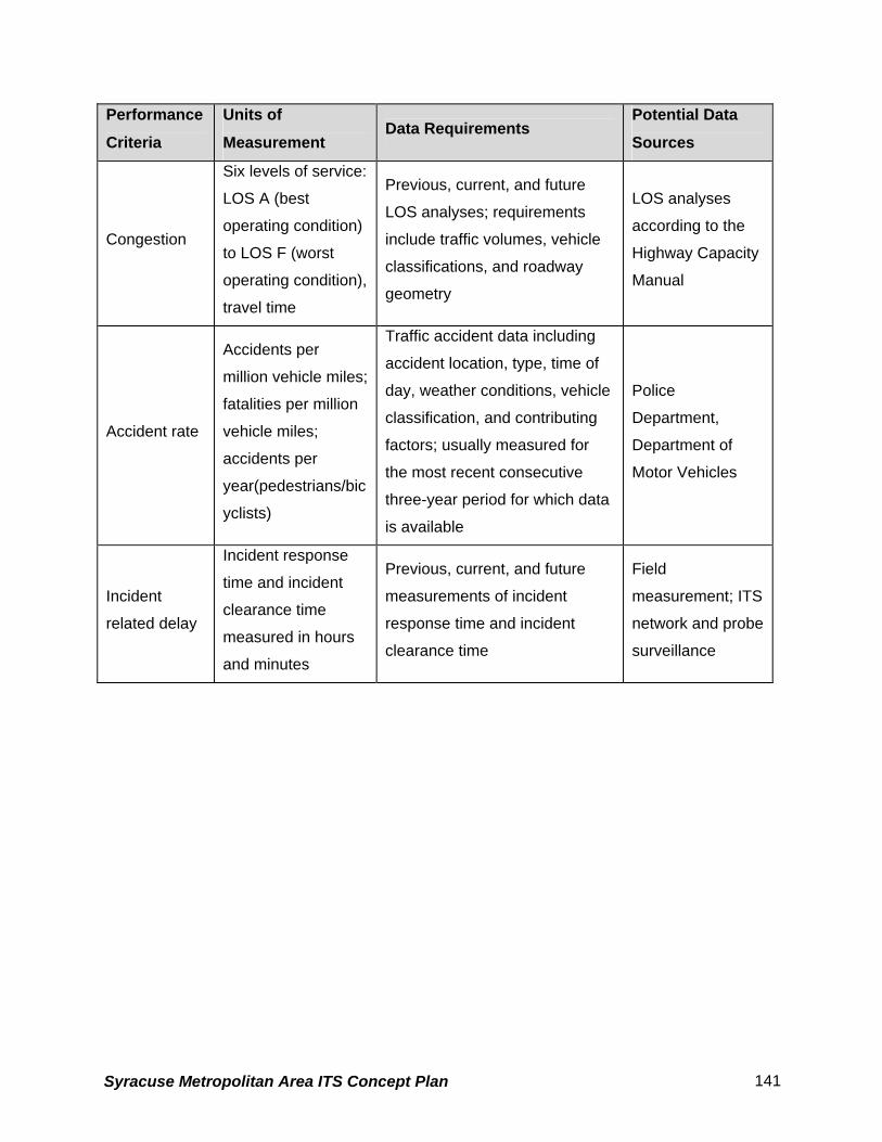
Performance
Criteria
Units of
Measurement Data Requirements
Potential Data
Sources
Congestion
Six levels of service:
LOS A (best
operating condition)
to LOS F (worst
operating condition),
travel time
Previous, current, and future
LOS analyses; requirements
include traffic volumes, vehicle
classifications, and roadway
geometry
LOS analyses
according to the
Highway Capacity
Manual
Accident rate
Accidents per
million vehicle miles;
fatalities per million
vehicle miles;
accidents per
year(pedestrians/bic
yclists)
Traffic accident data including
accident location, type, time of
day, weather conditions, vehicle
classification, and contributing
factors; usually measured for
the most recent consecutive
three-year period for which data
is available
Police
Department,
Department of
Motor Vehicles
Incident
related delay
Incident response
time and incident
clearance time
measured in hours
and minutes
Previous, current, and future
measurements of incident
response time and incident
clearance time
Field
measurement; ITS
network and probe
surveillance
Syracuse Metropolitan Area ITS Concept Plan 141

Throughput Throughput is expressed as the flow of traffic per hour. This performance criterion can be
measured manually or with models. ITS data can be collected to measure throughput using
network surveillance.
Throughput measures the efficiency of travel by showing how effective a transportation facility is
in moving vehicles. It is also possible to determine person throughput by using data gathered
for vehicle throughput and vehicle occupancy. By multiplying throughput by occupancy, the
number of persons per hour traveling on a facility is obtained.
Throughput is one possible measure of congestion, since it reflects how many vehicles the
system is moving per unit of time. It also reflects regional mobility. If a roadway facility is well
managed, throughput is high.
Average vehicle occupancy Average vehicle occupancy - a count of all persons in automobiles including the driver and
passenger - indicates the number of travelers per vehicle in non-transit modes. It is usually
measured by roadside observation.
Average vehicle occupancy is a useful performance criterion for environmental assessments
because it influences air quality and can, therefore, are used to demonstrate efficiency. Lower
average vehicle occupancies generally equate to more traffic.
Delay Delay is stated in terms of minutes or hours of delay. It can be measured using manually
obtained data or it can be computed from traffic counts combined with travel time
measurements. Floating car runs or license plate matching can be used to determine travel
times, which can be combined with traffic counts to estimate delay. Alternatively, delay can be
measured by queue length at entrance/exit ramps. ITS data can be collected to measure delay
using network or probe surveillance.
Delay is a vehicle-oriented measurement of roadway performance that reflects time
losses/savings to people due to recurring congestion. It is measured in minutes or hours of
delay (ton hours of delay for freight) experienced by system users. It provides a sound measure
Syracuse Metropolitan Area ITS Concept Plan 142

of congestion on roadway links or systems, although it does not give any insight as to the
cause. Delay measurements also provide information about restricted flow and travel at sub-
optimal speeds. The delays at signalized intersections are based on average stopped delay per
vehicle and can be estimated by various transportation software tools.
Congestion Level Of Service (LOS) is a qualitative measure describing traffic conditions in terms of factors
such as speed, travel time, maneuverability, and safety. Density, expressed in unit of
passenger car per mile per lane (pc/mi/ln), is the parameter used to define levels of service of
basic freeway sections. For example, Chapter 3 of the Highway Capacity Manual defines six
expressway levels of service from LOS A to LOS F where LOS A represents the best operating
condition and LOS F the worst operating condition.
LOS designations indicate the amount of congestion and delay that a driver experiences along
roadways. Delay occurs when traffic volumes exceed the roadway capacity. AASHTO (the
American Association of State Highway Transportation Officials) suggests roadways should be
designed to at least LOS C, but LOS D is acceptable in urban areas. Roadway sections or
ramps where the LOS falls into E or F ranges operate at unacceptable conditions.
Accident Rate Accident analyses are used to identify and evaluate high accident locations, assess contributing
factors, and suggest mitigation measures. The process can include the determination of
accident frequency, accident rate, and accident cost.
Average accident rates, expressed in terms of accidents or fatalities per million vehicle miles
traveled, are developed from this data and compared to statewide averages for similar facilities.
High average accident rates may reflect the influence of nonstandard roadway features, a high
degree of use, and frequent roadway congestion. Accidents and fatalities involving pedestrians
and bicyclists will be considered in addition to accidents and fatalities involving only vehicles.
Incident related delay Incident delay is measured in terms of incident response time and incident clearance time
expressed in hours and minutes. ITS data can be collected to measure incident delay using
roadside network surveillance, probe surveillance, or incident management Market Packages.
Syracuse Metropolitan Area ITS Concept Plan 143
Toll plaza throughput Delay at toll plazas is measured by length of queue in minutes from field observations. ITS data
can be collected to measure congestion and delay using network or probe surveillance.
Roadway capacity decreases sharply at toll plazas, resulting in congestion and delay. Queues
often form where traffic flow is unstable.
Operations/maintenance costs This performance criterion is expressed in terms of the operation and maintenance costs (in
dollars) per passenger mile of travel. The costs incurred are available from transportation
agencies. This performance criterion provides a measure of the efficiency of an agency in
providing basic services.
6.1.3 Recommended Transit Performance Criteria
This subchapter summarizes the characteristics of the final recommended performance criteria
for transit, including the measurement of the performance criteria, the means to obtain
data/information for measuring the criteria, and the data/information requirements. Table 19
summarizes the information presented.
Throughput (frequency/capacity) Throughput measures the efficiency of travel by showing how effectively transportation facility
capacity is moving people and freight. It is measured in number of transit passengers per hour
and number of transit vehicles per hour. The data required could be collected using manual
counts. Alternatively, ITS data can be collected to measure throughput using transit vehicle
tracking and transit passenger and fare management Market Packages and freight tracking.
ITS technology can be utilized to increase throughput.
This performance criterion reveals traveler options and the degree to which transit modes are
used. Throughput also gives a direct measurement of travelers using alternatives to
automobiles.
On-Time Performance On-time performance is measured by the percentage of transit that meets scheduled departure
and arrival times. ITS data can be collected to measure on-time performance using transit
Syracuse Metropolitan Area ITS Concept Plan 144

vehicle tracking information. Weather conditions, incidents, accidents, congestion, operator
error, mechanical failure, and/or combinations of these factors can delay transit operations. On-
time performance gives an indication of overall transit system efficiency.
Ridership Passenger ridership is measured in the number of riders per year. Alternatively, passenger
ridership can be measured as a percentage of all travelers using transit modes. ITS data can
be collected to measure ridership using transit passenger and fare management. Ridership
presents a quantifiable performance criterion that indicates the ability of transit to attract riders.
Improvements to transit system operation may be reflected in increased ridership over time.
Revenue Transit agency revenue is measured by an increase in fare operating ratio (i.e., the ratio of fare
collected to operating costs). Increased revenue can be the result of changes in subsidy levels,
as well as improved system efficiency, which can be accomplished by incorporating new
technology.
Effective use of traveler information Improvements in real-time information dissemination can be measured by the percentage of
passengers who use real-time information. This performance criterion can also be measured by
a count of the number of times passengers access real-time information. It can also quantify
how the public used the data to determine changes in route, time and mode. This performance
criterion can also quantify the availability of information to transit service providers for possible
use in day-to-day operations adjustments. This information gives an indication of the extent to
which infrastructure is in place for real-time information and the extent to which passengers are
able to use it. This performance criterion is an accurate way to gauge the impact of real-time
traveler information dissemination because passengers will not bother to access the information
if they do not believe that it is up to date or useful. They must also be aware that the
information exists.
Syracuse Metropolitan Area ITS Concept Plan 145

Table 20 - Characteristics of Recommended Transit Performance Criteria Performance
Criteria Units of Measurement Data Requirements
Potential Data
Sources
Throughput
Transit passengers per
hour
transit vehicles per hour
Previous, current, and
future measures of
transit vehicles
throughput
Field observations or
surveys; ITS network
surveillance and
passenger loading
On-time
performance
Percentage of transit that
meets scheduled
departure and arrival
times
Previous, current, and
future scheduled and
actual transit arrival and
departure times
Field observations;
ITS transit vehicle
tracking
Transit/ferry
ridership
Passenger ridership
measured in number of
riders per year, or
percentage of all
travelers using transit
modes
Previous, current, and
future passenger
ridership figures
Field observations,
surveys, models, toll
counts; ITS
passenger loading
Fare operating
ratio
Transit system fare
operating ratio
Previous, current, and
future fare operating
figures
Operator accounting
figures
Effective use of
traveler
information
Percentage of transit
passengers that use real-
time information
Previous, current, and
future numbers of
passengers
using/accessing real-
time information
Operators; user
surveys
Average travel
time
Travel time measured in
hours and minutes
Previous, current, and
future measures of
multi-modal passenger
travel times
Field observation or
regional
transportation
models; ITS transit
vehicle tracking
Operations/
maintenance
costs
Cost of operations and
maintenance per
passenger mile
Previous, current, and
future operations and
maintenance costs
Operators; ITS
transit maintenance
Syracuse Metropolitan Area ITS Concept Plan 146
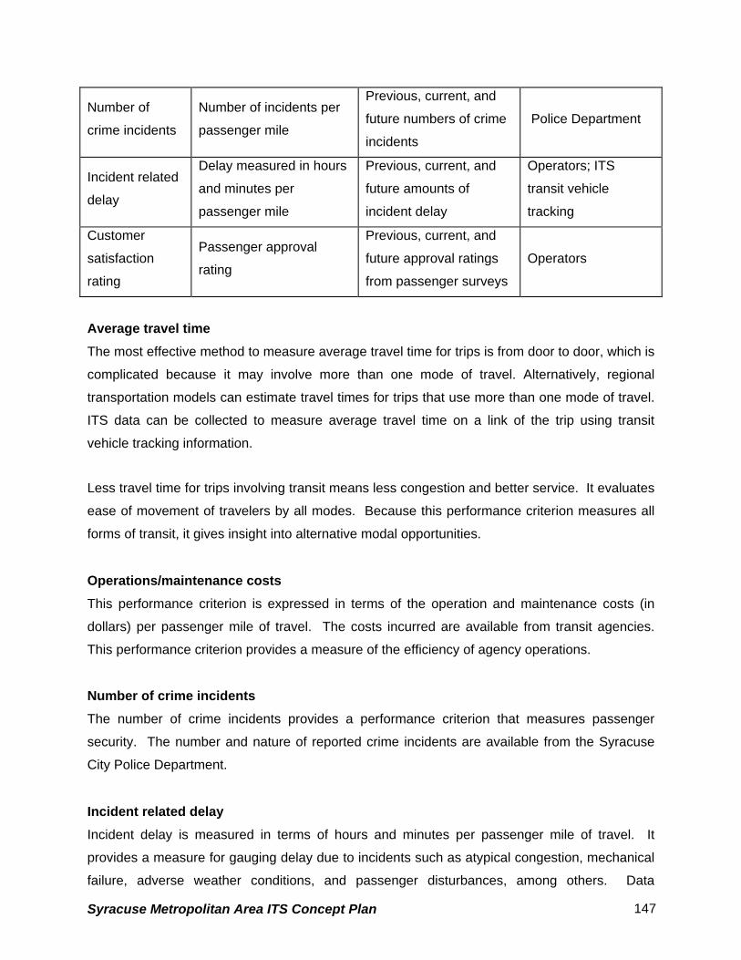
Number of
crime incidents
Number of incidents per
passenger mile
Previous, current, and
future numbers of crime
incidents
Police Department
Incident related
delay
Delay measured in hours
and minutes per
passenger mile
Previous, current, and
future amounts of
incident delay
Operators; ITS
transit vehicle
tracking
Customer
satisfaction
rating
Passenger approval
rating
Previous, current, and
future approval ratings
from passenger surveys
Operators
Average travel time The most effective method to measure average travel time for trips is from door to door, which is
complicated because it may involve more than one mode of travel. Alternatively, regional
transportation models can estimate travel times for trips that use more than one mode of travel.
ITS data can be collected to measure average travel time on a link of the trip using transit
vehicle tracking information.
Less travel time for trips involving transit means less congestion and better service. It evaluates
ease of movement of travelers by all modes. Because this performance criterion measures all
forms of transit, it gives insight into alternative modal opportunities.
Operations/maintenance costs This performance criterion is expressed in terms of the operation and maintenance costs (in
dollars) per passenger mile of travel. The costs incurred are available from transit agencies.
This performance criterion provides a measure of the efficiency of agency operations.
Number of crime incidents The number of crime incidents provides a performance criterion that measures passenger
security. The number and nature of reported crime incidents are available from the Syracuse
City Police Department.
Incident related delay Incident delay is measured in terms of hours and minutes per passenger mile of travel. It
provides a measure for gauging delay due to incidents such as atypical congestion, mechanical
failure, adverse weather conditions, and passenger disturbances, among others. Data
Syracuse Metropolitan Area ITS Concept Plan 147

concerning delay is available from the agencies themselves. Alternatively, delay measurements
can be obtained manually by transit system observation. ITS data can be collected to measure
incident delay using transit vehicle tracking information.
Customer satisfaction rating Approval ratings give an indication of passenger satisfaction with transit systems. They are
available from passenger surveys conducted by the operators themselves.
6.1.4 Recommended Performance Criteria & ITS Market Packages
Recommended performance criteria are intended to evaluate future ITS projects. By
associating performance criteria with Market Packages the most effective performance criteria
for evaluating a specific ITS project can be identified.
In this section, the recommended performance criteria are discussed with respect to the ITS
Market Packages discussed in the previous chapter. The Market Packages are arranged
according to groups:
• ATMS: Advanced Transportation Management Systems,
• APTS: Advanced Public Transportation Systems,
• ATIS: Advanced Traveler Information Systems,
• AVSS: Automated Vehicle Safety Systems,
• CVO: Commercial Vehicle Operations, and
• EM: Emergency Management.
• AD: Archived Data Management
Table 18 summarizes the recommended roadway and transit performance criteria as sources
for evaluating ITS Market Packages. The transit performance criteria detail how each of the
Market Packages can be measured for bus operations. The Market Packages are listed in the
rows, and the columns list the recommended performance criteria. A recommended
performance criterion that can be used to evaluate that particular market package can be
developed to address specific issues. In some cases, more than one performance criterion may
be useful to evaluate a market package.
Syracuse Metropolitan Area ITS Concept Plan 148

The following three Market Packages are not rated, as these elements are required prior to
other Market Packages being deployed:
• ATMS01: Network Surveillance
• ATMS02: Probe Surveillance (Applicable only to NYSTA)
• APTS01: Transit Vehicle Tracking
In addition, a few Market Packages are not appropriate for evaluation performance criteria.
Transportation Forecast and Demand Management (ATMS09) is an evaluation element and ITS
Data Mart (ad01), ITS Data Warehouse (ad02) and ITS Virtual Data Warehouse (ad03) are the
packages solely aimed at data gathering, analysis and dissemination for planning purposes of
any individual agency or between several agencies.
6.1.5 Recommended Performance Criteria and Data Needs
This section discusses the recommended performance criteria in terms of current and projected
data collection needs. Table 21 is intended to be used as an aid to the data collection efforts by
various agencies involved in deploying ITS in the City of Syracuse.
Syracuse Metropolitan Area ITS Concept Plan 149

Table 21 - Recommended Performance Criteria Data Requirements
Mode Performance Criteria Data Requirements
Average travel speed Average travel speed
Travel time reliability Floating car runs; origin-destination pairs;
standard travel time from manual data or from
model; probe data
Throughput Throughput by vehicles per hour
Average vehicle occupancy Average vehicle occupancy
Delay Delay
Congestion LOS analyses, which require traffic volumes,
vehicle classifications, and roadway geometry
Accident rate Traffic accident data including accident location,
type, time of day, weather conditions, vehicle
classification, and contributing factors
Incident related delay Incident response time and incident clearance
time
Toll plaza throughput Delay at toll plazas
Effective use of traveler
information
Number of drivers using/accessing real-time
information; public’s use of information
Roadways
Operations/maintenance costs Operations and maintenance costs
Throughput (frequency/capacity) Persons throughput,
On-time performance Scheduled and actual bus arrival and departure
times
Transit ridership Bus ridership
Fare operating ratio Revenue
Effective use of traveler
information
Number of transit passengers using/accessing
real-time information; publics' use of information.
Average travel time Average bus passenger travel times
Operations/ maintenance costs Bus operations and maintenance costs
Number of crime incidents Number of crime incidents on buses and at bus
stations and bus stops
Transit –
Bus
Incident related delay Bus incident delay
Syracuse Metropolitan Area ITS Concept Plan 150

Performance criteria discussed in this technical memorandum are meant to evaluate the
benefits of ITS projects quantitatively after they are deployed. This section focused on the
project goals to select performance criteria. The characteristics, including data requirements,
have been reviewed for each of the recommended performance criteria. The memorandum has
presented a relationship of the selected performance criteria to the ITS Market Packages so
that an evaluation of ITS projects can be made in compliance with the National ITS Architecture
guidelines
Syracuse Metropolitan Area ITS Concept Plan 151

7 Funding
The institutional framework and division of responsibilities within each state also affect funding
for management and operations. For example, in each state the agency responsible for
interstate highway management and operations also has budget authority to fund those
activities. The activities and the funding source are integrated. . In many states, however, the
responsibility for incident management activities and the funding sources for those activities are
not integrated. While a state agency may be broadly responsible for incident management on
its interstates, entities such as private towing companies, law enforcement, fire departments
and emergency medical services providers are all critical to effective incident management, and,
all have their own sources of funding.
This does not mean that a state will not fund ongoing operations, and improvements to those
operations, related to incident response. Indeed, one of the key functions of the Syracuse
Metropolitan Area ITS Architecture is incident management. However, the blurring of
boundaries as described above can make funding decisions related to incident management
more difficult.
One example of an unclear boundary is funding for sharing data and video images between
public safety and traffic management agencies. Emergency response to incidents can be
improved using data and video available from traffic management agencies. Traditionally,
highway funds have not been used to fund improvements to emergency response. However,
because improved data provided to emergency response agencies translates to improved
incident management, a region may find it appropriate to apply highway funds to this type of
project.
The Syracuse Metropolitan Area ITS Architecture does not specifically identify funding sources
to support proposed ITS deployments. However, one of the objectives of the plan is to begin a
dialogue on new approaches to funding that may not have been considered in the past. For
example, the New York State Thruway Authority and state agencies such as the NYSDOT might
form partnerships to share wireless and wireline resources.
Syracuse Metropolitan Area ITS Concept Plan 152

7.1 Capital Funding for ITS
Given the diffuse nature of transportation operations and decision making, where does the
burden for financing ITS projects fall? Across the country, regionally-integrated ITS is largely
being funded by Federal Highway program funds including Surface Transportation Program
(STP) funds, special Federal Operational Tests and Model Deployment Initiatives, and the
Congestion Mitigation and Air Quality (CMAQ) program.. State DOT and MPO projects are also
eligible to compete for the use of these funds. In the Syracuse metropolitan area, the CMAQ
program can be tapped to fund the congestion mitigation projects that also benefit the region
through reducing emissions. FTA funds transit ITS projects through their standard grant
programs. One example of a state making maximum use of Federal sources is Kentucky, which
will use only Federal grant money in 2002 to fund ITS.
The Federal Highway Administration is currently funded via the Transportation Equity Act for the
21st Century (TEA –21). Under TEA-21, a separate “line item” for ITS, was created, in addition
to STP and CMAQ monies. Within TEA-21’s ITS line item, specific projects are “earmarked” for
Federal support. Money is also made available to the states for projects of their choosing.
A portion of the ITS budget was set aside to fund projects that focus on integrating multi-modal
ITS components in a variety of settings, including large regional areas or metropolitan areas.
These funds are allocated, or earmarked, in congressional transportation budget committees.
An additional Federal funding source for ITS projects that integrate emergency responders and
transportation agencies is available through the Department of Justice (DOJ). The DOJ has
indicated that they are prepared to be a funding partner in projects that integrate emergency
responders with ITS. No specific funding amounts or limits have been identified by DOJ for
these projects.
In New York State, a mix of Federal, state, and local funds have been used for ITS programs
such as TRANSCOM, centralized traffic signal systems, AVL and weather information systems.
7.2 Operations and Maintenance Funding for ITS
Federal highway and transit funds may also be used for operations and operational
improvements of ITS, subject to certain restrictions. USDOT policy stipulates that long-term, on-
Syracuse Metropolitan Area ITS Concept Plan 153

going operations and operational improvements of ITS shall not be federally funded. However,
this situation may change in the near future as the importance of operations continues to be
highlighted at the Federal level. However, nearly all ITS operations and operational
improvements are funded by the State and local agencies using State and local dollars.
7.3 Private Sector Funding
Across the US, including New York State, the private sector and public sector have partnered to
deliver ITS. Two key areas have been of interest to the private sector: traveler information and
communications infrastructure provision. However, changes in technology, costs, and other
market factors have recently stimulated private sector interest in other ITS opportunities,
including providing traveler security services. The key for the public sector is to remain open to
private sector partnership opportunities as they arise in the future.
Both capital and operations/maintenance funds for ITS must compete with other needs for
scarce funding. The best way to acquire and retain project funding is to clearly demonstrate
benefits deriving from the investment. Key steps to accomplish this include:
• Ensure that performance is continuously monitored to ensure that benefits are derived.
• Develop means to reduce capital costs to all ITS projects
• Develop means to keep operations costs low.
In summary, a variety of funding sources are available for planning, deployment, and on-going
operations of ITS. The Federal sector is a strong source of funds for project deployment and
startup. However, the private sector, in partnership with state agencies, is increasingly playing
a role in funding projects and this presents unique opportunities for the ITS owner/operator.
Creative thinking in securing funding sources, and careful documentation of benefits to retain
funding, are keys to successful financial management of ITS
Syracuse Metropolitan Area ITS Concept Plan 154
Related Documents