1 Syn-eruptive morphometric variability of monogenetic scoria cones Gábor Kereszturi 1,2,3 , Gyozo Jordan 2 , Károly Németh 1,4 and Javier F. Dóniz-Páez 5 1 Volcanic Risk Solutions, CS-INR, Massey University, Private Bag 11 222, Palmerston North, New Zealand; email: [email protected] 2 Geological Institute of Hungary, Stefánia út 14, H-1143, Budapest, Hungary 3 Department of Geology and Mineral Deposits, University of Miskolc, Hungary 4 Geological Hazards Research Unit, King Abdulaziz University, Jeddah, Kingdom of Saudi Arabia 5 Department of Geography, University of La Laguna, Tenerife, Spain The final publication is available at www.springerlink.com Pre-print version of the following paper: Kereszturi, G., Jordan G, Németh K, Dóniz-Páez JF (2012) Syn-eruptive morphometric variability of monogenetic scoria cones. – Bulletin of Volcanology, 74(9), pp. 2171-2185. DOI:10.1007/s00445-012-0658-1 Introduction Morphometric studies of volcanoes commonly aim to characterize a wide range of eruptive and erosion- related processes (Inbar et al., 2011; Grosse et al., 2012). Scoria (or cinder) cones are one of the most frequent targets of such studies (Favalli et al., 2009; Bemis et al., 2011; Rodriguez-Gonzalez et al., 2012) due to their abundance on the Earth, occurring in monogenetic volcanic fields in almost all known geological settings (Wood, 1980a; Connor et al., 2000; Rapprich et al., 2007; Valentine and Gregg, 2008). The primary aim of morphometric studies on volcanoes (mostly on scoria cones) is to establish slope angle values, which are important parameters for assessing the relative age of volcanic cone within a monogenetic volcanic field (e.g. Wood, 1980a). A fresh scoria cone has been said to have initial slope angle values between 30–33° (Wood, 1980b; Riedel et al., 2003), with these values decreasing systematically during the course of degradation (Wood, 1980a; Dohrenwend et al., 1986; Hooper, 1995). During cone formation and subsequent degradation, various processes can shape the morphology of volcanic edifices (Wood, 1980a; Rodriguez-Gonzalez et al., 2011; Büchner and Tietz, 2012; Kereszturi and Németh, 2012). The syn- eruptive controlling parameters determine the initial geometry and properties of pyroclastic deposits. These processes include, for example, changing magma fragmentation style, migration or changing dimensions of a feeder-dyke beneath the edifice, effusive activity or cone collapses and/or breaching due to intermittent explosions (Corazzato and Tibaldi, 2006; Martin and Németh, 2006; Kereszturi et al., 2011; Martí et al., 2011; Németh et al., 2011; Starkova et al., 2011), all of which can lead to the formation of complex volcanic landforms in terms of inner architecture, pyroclastic deposits types and morphometry. Such diversity of morphology and architecture is a source of pitfalls for morphometric parameterization and morphometry-based dating. On the other hand, the post-eruptive, erosional processes such as linear dissection of the flanks, landslides or sediment creep, also play vital roles in shaping of volcanic landforms after the cessation of volcanic activity (Hooper and Sheridan, 1998). A number of both syn- and post-eruptive controlling processes make the interpretation of morphometry of scoria cones more complicated than it has been assumed by previous studies (Wood, 1980a; Hooper and Sheridan, 1998). In early studies, the initial geometrics of volcanic edifices were assumed to be similar, providing a basis for comparative morphometric studies (Settle, 1979; Wood, 1980a). In other words, previous studies interpreted the present morphometric characteristics entirely as the result of erosional processes governed by climatic conditions, assuming homogenous inner architecture and similar initial geometry (Porter, 1972; Wood, 1980a; Hooper, 1995; Hooper and Sheridan, 1998; Pelletier and Cline, 2007). In order to test the variability of slope angle values in relation to syn- and post-eruptive controlling factors, nine young (≤Pleistocene) scoria cones in Tenerife, Canary Islands are parameterized morphometrically. Scoria cones on volcanic islands such as Tenerife (Fig. 1) are located along volcanic rift zones in extensional stress fields (Carracedo et al., 2007; Geyer and Martí, 2010). The nine studied scoria cones were selected on the basis of their known young (≤Pleistocene) ages (Carracedo et al., 2007) and their diverse pre-eruptive surface inclinations. As a consequence of the young age, the morphology of the studied cones has not significantly been modified by erosional processes as confirmed by the lack of vegetation or gullies (see for example Figs 5–7). Thus, the slope angles measured on the outer flanks of a scoria cone can be parameterized by using high-resolution Digital Elevation Models (DEMs), allowing quantification of morphometric variability among monogenetic edifices. These young cones with limited erosional modification provide good opportunity to test the uniformity of initial geometry, one of the assumptions of morphometry-based dating and comparative studies on scoria cones (Porter, 1972; Wood, 1980a; Hooper and Sheridan, 1998).

Welcome message from author
This document is posted to help you gain knowledge. Please leave a comment to let me know what you think about it! Share it to your friends and learn new things together.
Transcript
1
Syn-eruptive morphometric variability of monogenetic scoria cones
Gábor Kereszturi1,2,3
, Gyozo Jordan2, Károly Németh
1,4 and Javier F. Dóniz-Páez
5
1 Volcanic Risk Solutions, CS-INR, Massey University, Private Bag 11 222, Palmerston North, New Zealand; email:
[email protected] 2 Geological Institute of Hungary, Stefánia út 14, H-1143, Budapest, Hungary
3 Department of Geology and Mineral Deposits, University of Miskolc, Hungary
4 Geological Hazards Research Unit, King Abdulaziz University, Jeddah, Kingdom of Saudi Arabia
5 Department of Geography, University of La Laguna, Tenerife, Spain
The final publication is available at www.springerlink.com
Pre-print version of the following paper:
Kereszturi, G., Jordan G, Németh K, Dóniz-Páez JF (2012) Syn-eruptive morphometric
variability of monogenetic scoria cones. – Bulletin of Volcanology, 74(9), pp. 2171-2185.
DOI:10.1007/s00445-012-0658-1
Introduction
Morphometric studies of volcanoes commonly aim to characterize a wide range of eruptive and erosion-
related processes (Inbar et al., 2011; Grosse et al., 2012). Scoria (or cinder) cones are one of the most frequent targets
of such studies (Favalli et al., 2009; Bemis et al., 2011; Rodriguez-Gonzalez et al., 2012) due to their abundance on
the Earth, occurring in monogenetic volcanic fields in almost all known geological settings (Wood, 1980a; Connor et
al., 2000; Rapprich et al., 2007; Valentine and Gregg, 2008). The primary aim of morphometric studies on volcanoes
(mostly on scoria cones) is to establish slope angle values, which are important parameters for assessing the relative
age of volcanic cone within a monogenetic volcanic field (e.g. Wood, 1980a). A fresh scoria cone has been said to
have initial slope angle values between 30–33° (Wood, 1980b; Riedel et al., 2003), with these values decreasing
systematically during the course of degradation (Wood, 1980a; Dohrenwend et al., 1986; Hooper, 1995). During
cone formation and subsequent degradation, various processes can shape the morphology of volcanic edifices
(Wood, 1980a; Rodriguez-Gonzalez et al., 2011; Büchner and Tietz, 2012; Kereszturi and Németh, 2012). The syn-
eruptive controlling parameters determine the initial geometry and properties of pyroclastic deposits. These processes
include, for example, changing magma fragmentation style, migration or changing dimensions of a feeder-dyke
beneath the edifice, effusive activity or cone collapses and/or breaching due to intermittent explosions (Corazzato
and Tibaldi, 2006; Martin and Németh, 2006; Kereszturi et al., 2011; Martí et al., 2011; Németh et al., 2011;
Starkova et al., 2011), all of which can lead to the formation of complex volcanic landforms in terms of inner
architecture, pyroclastic deposits types and morphometry. Such diversity of morphology and architecture is a source
of pitfalls for morphometric parameterization and morphometry-based dating. On the other hand, the post-eruptive,
erosional processes such as linear dissection of the flanks, landslides or sediment creep, also play vital roles in
shaping of volcanic landforms after the cessation of volcanic activity (Hooper and Sheridan, 1998). A number of
both syn- and post-eruptive controlling processes make the interpretation of morphometry of scoria cones more
complicated than it has been assumed by previous studies (Wood, 1980a; Hooper and Sheridan, 1998). In early
studies, the initial geometrics of volcanic edifices were assumed to be similar, providing a basis for comparative
morphometric studies (Settle, 1979; Wood, 1980a). In other words, previous studies interpreted the present
morphometric characteristics entirely as the result of erosional processes governed by climatic conditions, assuming
homogenous inner architecture and similar initial geometry (Porter, 1972; Wood, 1980a; Hooper, 1995; Hooper and
Sheridan, 1998; Pelletier and Cline, 2007).
In order to test the variability of slope angle values in relation to syn- and post-eruptive controlling factors,
nine young (≤Pleistocene) scoria cones in Tenerife, Canary Islands are parameterized morphometrically. Scoria
cones on volcanic islands such as Tenerife (Fig. 1) are located along volcanic rift zones in extensional stress fields
(Carracedo et al., 2007; Geyer and Martí, 2010). The nine studied scoria cones were selected on the basis of their
known young (≤Pleistocene) ages (Carracedo et al., 2007) and their diverse pre-eruptive surface inclinations. As a
consequence of the young age, the morphology of the studied cones has not significantly been modified by erosional
processes as confirmed by the lack of vegetation or gullies (see for example Figs 5–7). Thus, the slope angles
measured on the outer flanks of a scoria cone can be parameterized by using high-resolution Digital Elevation
Models (DEMs), allowing quantification of morphometric variability among monogenetic edifices. These young
cones with limited erosional modification provide good opportunity to test the uniformity of initial geometry, one of
the assumptions of morphometry-based dating and comparative studies on scoria cones (Porter, 1972; Wood, 1980a;
Hooper and Sheridan, 1998).
2
Geological settings
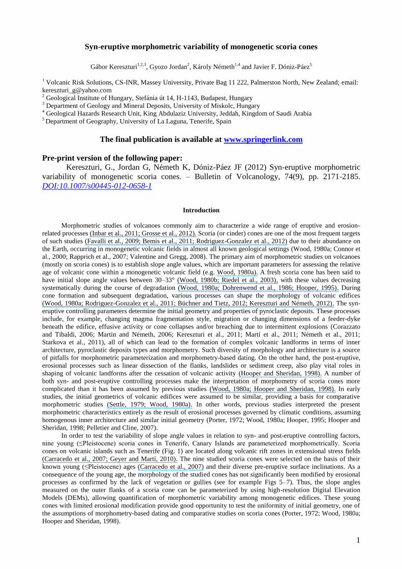
The Canary Archipelago is located a few hundred of kilometres from the NW coast of Africa. Of the seven
volcanic islands forming the Canarian Archipelago, Tenerife is the largest (2,034 km2) and highest (3,718 m asl). The
first shield stage eruptive products of Tenerife (Fig. 1) are exposed as old volcanic massifs, e.g. Teno, Anaga or the
Roque del Conde formed between 12 Ma and 3.5 Ma (Ancochea et al., 1990; Thirlwall et al., 2000). The new phase
of volcanism built up a large volcanic complex sitting on top of older remnants (Fig. 1), which was merged and
partially covered by the eruption products of the Las Cañadas volcano (Ancochea et al., 1990; Carracedo, 1994;
Carracedo et al., 2007). The Las Cañadas volcano has been truncated by (1) lateral gravitational collapses (Carracedo
et al., 2011) or by (2) multiple, vertical collapses following emptying of the shallow magma chamber (Marti and
Gudmundsson, 2000). Other important volcanic structures are the central edifice (Teide–Pico Viejo volcano) and its
associated rift zones (Fig. 1) originating either from (1) swelling of the surface due to mantle ascent (Carracedo,
1994; Carracedo et al., 2007) or from (2) spreading of the upper volcanic structure (Walter, 2003). Recent volcanic
activity and possible hazard are most likely linked to these rift systems, which host the majority of the subaerial
monogenetic volcanoes studied in this paper (Carracedo et al., 2007; Doniz et al., 2008; Geyer and Martí, 2010).
Fig. 1: Simplified geological map of the island of Tenerife including the major shield edifices in the three corners of
the present island, the deposits of Las Cañadas volcano and the location of the most recent products of Pico-Viejo
stratocone and its rift zones based on Ancochea et al. (1990), IGME (2003) and Carracedo et al. (2007). Note: STR –
Santiago del Teide rift, DR – Dorsal Rift, SVZ – Southern Volcanic Zone.
Materials and methods
Digital elevation models (DEMs) were created from the 5 m interval contour lines of the 1:5,000 Tenerife
topographic map sheets (GRAFCAN, 2009). A linear interpolation method specifically designed for contours was
implemented with the ILWIS raster GIS software (Gorte and Koolhoven, 1990). Linear interpolation is an exact
interpolation method because it fits to the input data, i.e. contour lines (Gorte and Koolhoven, 1990). This method
rasterizes the digitized vector contour lines first with the contour elevation values, then the unknown elevation values
are interpolated. The interpolation is performed between the two nearest contour lines by using the shortest distances
measured both forwards and backwards directions on the rasterized maps (Borgefors, 1984; Gorte and Koolhoven,
1990). Selection of proper cell size is, however, crucial because large cells containing two or more contour lines
cannot resolve the original detailed topographic information. This loss of resolution and thus morphologic
3
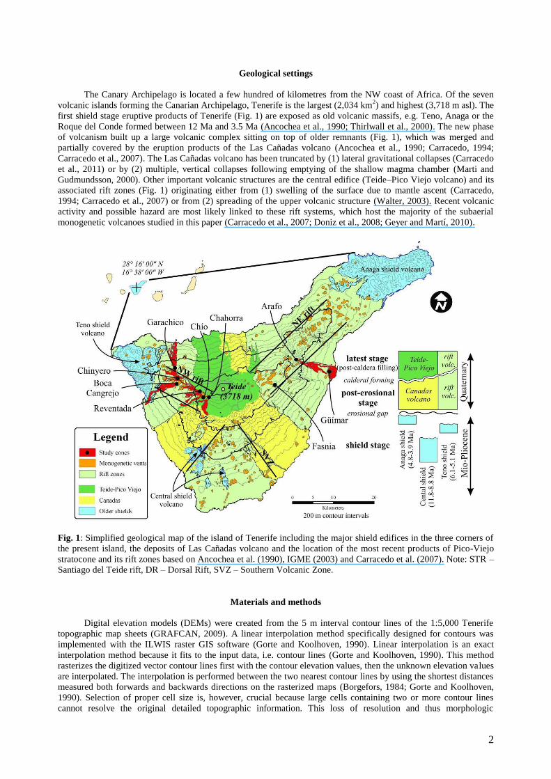
information is particularly likely on steep slopes with close contour line spacing. In order to retain the maximum
morphological information carried by the contour lines the appropriate grid cell size resolving all individual contours
was determined by a trial-and-error approach of rasterizing the contours to 0.5 m, 1 m and 2 m cell sizes. The cell
size was regarded fine enough if the rasterized contour lines were separated by at least one undefined cell width. This
was numerically tested by applying a simple neighbourhood operation in a 3 3 moving window. If none of the
contour line raster cells in the map have neighbour cells with a different elevation value, then the tested grid cell size
was defined as the right resolution for DEM interpolation. In this case, the 0.5 0.5 m grid cell size was found to
properly resolve and represent the original contour line information, so the final DEM was interpolated from the
contours to the 0.5 m grid cell size. In order to improve slope gradient calculation, the DEMs were smoothed with
5 5 (2.5 2.5 m) moving average window (see Electronic Supplementary Material 1). A limitation of linear
interpolation is that it creates flat areas within closed contour lines at hill tops and natural depressions, with cells of
constant elevation value. This systematic error can affect morphometric calculations such as slope statistics. In order
to improve statistical analyses topographic peaks within closed contour lines were not considered in further
morphometric calculations, including slope angle statistics. These minor peaks are located around the crater rim,
which anyway tends to be degraded early (Pelletier and Cline, 2007; Valentine et al., 2007).
Fig. 2: (A) Change of slope angles (Smean, Smedian and Smode) as a function of grid cell size examined on the outer
flanks of Fasnia scoria cone from Tenerife. (B) The slope angle histogram for the same cone showing the unimodal
distribution of slope values for grid cell size of 0.5 m, which is essential for accurate univariate analysis.
The DEM‘s accuracy was characterized by the root mean square error (RMSE) (Fisher and Tate, 2006)
comparing the interpolated DEM elevation to independent spot heights digitalized from the topographic maps:
RMSE = n
ZZ refDEM
2)( (1)
where ZDEM is grid cell elevation, Zref is the reference spot height elevation and n is the number of reference
points. In the case of the studied DEM, the RMSE was calculated separately for each studied volcanic cone and it
ranged from ±0.5 m to ±3.8 m (see Electronic Supplementary Material 1). This is well within the original 5 m
contour interval, confirming the appropriateness of the interpolation method.
The gradient vector of a digital surface is characterized by it length, i.e. the slope (S) and a direction, i.e.
aspect (A). These properties were calculated as
S = arctan 22 fyfx
(2)
A = 180° – arctan(fy/fx) + 90°(fx/|fx|) (3)
4
where A is the modified directional component of the gradient vector pointing in the down flow direction and
measured clockwise from north. The partial derivatives (fx, fy) were estimated using the unweighted eight-point
Prewitt operators: fx = (Z3+Z6+Z9-Z1-Z4-Z7)/6ΔX and fy = (Z1+Z2+Z3-Z7-Z8-Z9)/6ΔY in a 3 3 moving window
(Jordan, 2007). Besides its smoothing effect, this method has the advantage of being identical to a least-squares plane
fit to the 9 window elevations (Sharpnack and Akin, 1969), thus the linear Prewitt operators are particularly suitable
for linearly interpolated surfaces. The slope and aspect values of a DEM are highly dependent on the resolution used
(Zhou and Liu, 2004; Deng et al., 2007; Dragut et al., 2011). In order to visualize changes of slope angle as a
function of grid cell size, a series of DEMs were generated from the same contour lines in different resolutions from
0.2 m to 20 m (Fig. 2A). The slope angles were calculated for only the outer flanks of Fasnia edifice where central
tendency of slope angles is expected (Fig. 2B). The Smean and Smedian values showed a sharp decrease in their values
around 5 m resolution (Fig. 2), while the Smode showed no trend due to the multimodal slope angle histogram.
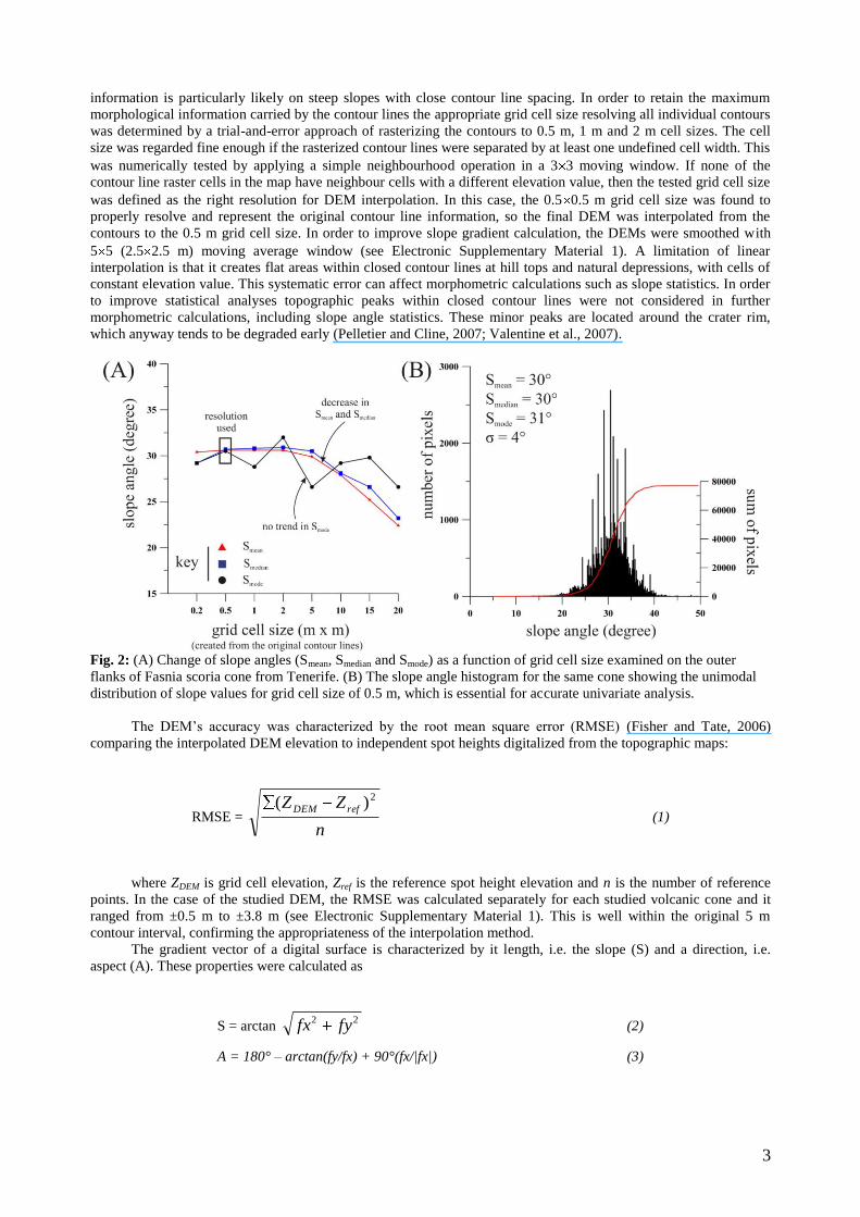
Fig. 3: Establishing the basal inclination by a first-order trend surface interpolated using the least-squares method
and spot height data. Example is the Arafo scoria cone. (A) View of the volcanic edifice and its surrounding on an
5
orthophotograph draped on the DEM. (B and C) Fitted first-order trend surface through the spot heights (red points)
with the location of the outer flanks. The interpolated trend surface displays the general slope and aspect of the pre-
eruptive surface.
The pre-eruptive surface or basement slope (Sbasal) and aspect (Abasal) were also calculated (Fig. 3). This pre-
eruptive surface of the studied cones was modelled by a first-order trend surface, i.e. plane, fitted by the least-squares
method to the digitalized spot heights (de Smith et al., 2009). To obtain the pre-eruptive surface, only those spot
heights were used which were not located within the area of (1) the tephra blanket around the cone, (2) the cones‘
slope, (3) the associated lava flow fields, and (4) the large valleys located near the analysed cones. Orthophotos,
geological maps and field observations were used to delineate these areas.
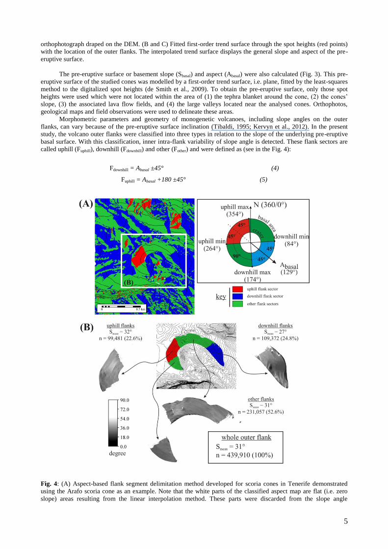
Morphometric parameters and geometry of monogenetic volcanoes, including slope angles on the outer
flanks, can vary because of the pre-eruptive surface inclination (Tibaldi, 1995; Kervyn et al., 2012). In the present
study, the volcano outer flanks were classified into three types in relation to the slope of the underlying pre-eruptive
basal surface. With this classification, inner intra-flank variability of slope angle is detected. These flank sectors are
called uphill (Fuphill), downhill (Fdownhill) and other (Fother) and were defined as (see in the Fig. 4):
Fdownhill = Abasal ±45° (4)
Fuphill = Abasal +180 ±45° (5)
Fig. 4: (A) Aspect-based flank segment delimitation method developed for scoria cones in Tenerife demonstrated
using the Arafo scoria cone as an example. Note that the white parts of the classified aspect map are flat (i.e. zero
slope) areas resulting from the linear interpolation method. These parts were discarded from the slope angle
6
calculations. Inset diagram shows the graphical definition of flank sectors. (B) Local slope angle statistics for the
Arafo scoria cone.
Thus, the Fuphill and Fdownhill slope facets are perpendicular (±45°), while the Fother are orthogonal (±45°) to the
dominant pre-eruptive surface inclination. Scoria cones are mostly built up from loose, scoriaceous lapilli fragments
(Riedel et al., 2003). If the fragment-size is in a narrow range for a pristine scoria cone (Wood, 1980b) only
unimodal distribution of slope angles are expected. Thus central tendency statistic of average (Smean), median (Smedian)
and mode (Smode) were used for the flank segments of each studied edifice. To identify inappropriate statistical slope
angle descriptors, slope angle histograms were calculated and presented for each studied scoria cone. The calculated
slope angle values were also visualized as a function of slope aspect in the polar plots in order to detect geographical
location of variance in slope angles on the outer flanks. The outer flanks were defined as the surface between slope-
break at the foot of the cone and the crater rim. In the delimitation of the outer flanks, 1:30,000 aerial photographs
(with 40–50 cm resolutions), 1:25,000 geological maps (IGME, 2003) and field observations were used.
Results
Out of nine examined young scoria cones from Tenerife only three examples are described in this section in
terms of location, volcanology, morphology and slope angle characteristics for demonstration purposes. These three
examples represent a wide spectrum of pre-eruptive inclinations from 4° to 11°. The rest of the studied scoria cones
with detailed description and additional figures can be found in the Electronic Supplementary Material 2.
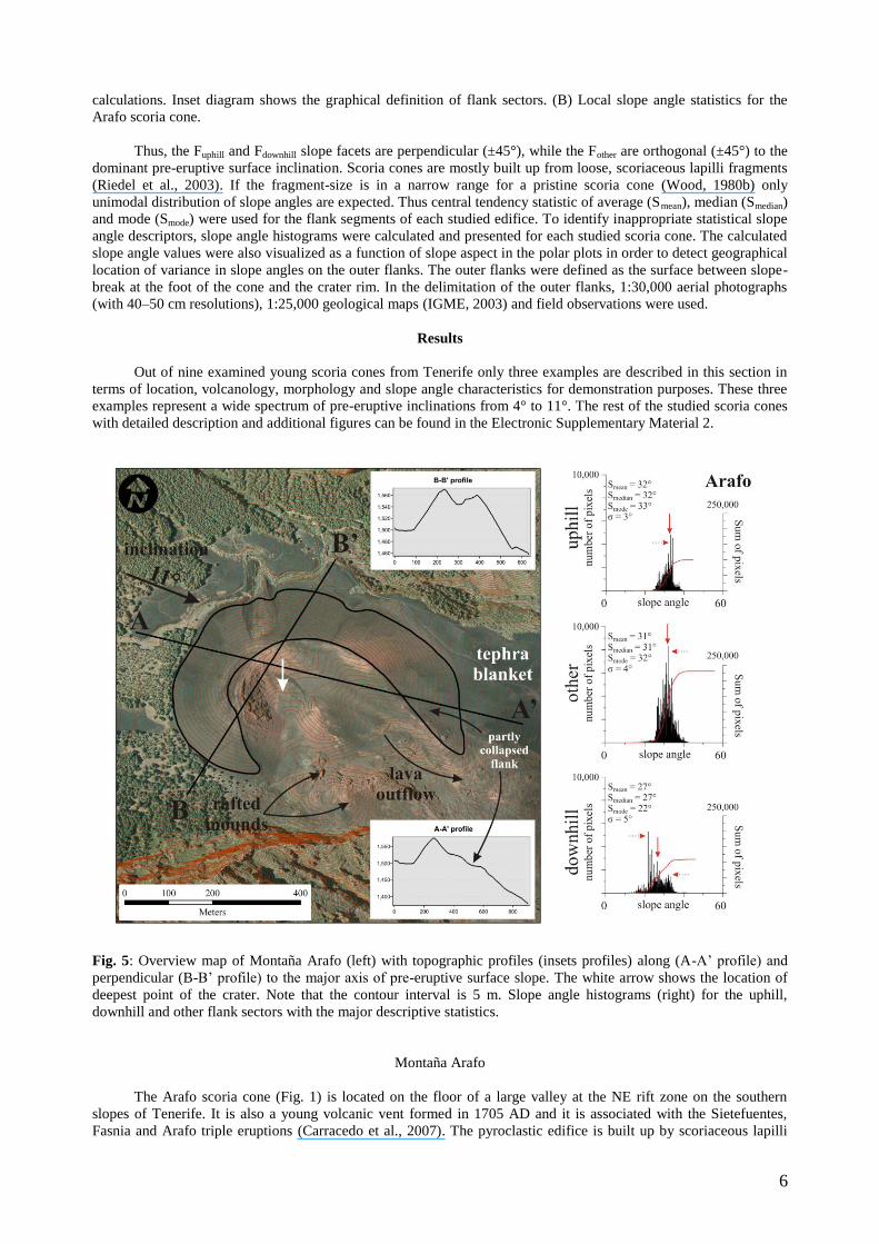
Fig. 5: Overview map of Montaña Arafo (left) with topographic profiles (insets profiles) along (A-A‘ profile) and
perpendicular (B-B‘ profile) to the major axis of pre-eruptive surface slope. The white arrow shows the location of
deepest point of the crater. Note that the contour interval is 5 m. Slope angle histograms (right) for the uphill,
downhill and other flank sectors with the major descriptive statistics.
Montaña Arafo
The Arafo scoria cone (Fig. 1) is located on the floor of a large valley at the NE rift zone on the southern
slopes of Tenerife. It is also a young volcanic vent formed in 1705 AD and it is associated with the Sietefuentes,
Fasnia and Arafo triple eruptions (Carracedo et al., 2007). The pyroclastic edifice is built up by scoriaceous lapilli
7
and ash beds reflecting more explosive than effusive behaviour. The scoria cone is horseshoe-shaped due to crater
breaching (Fig. 5). The scoria cone of Arafo is in a special location in a valley, where the valley floor (pre-eruptive
surface) has an 11° slope angle. The direction of this interpolated surface is facing toward SE (129°; Table 1). The
slope angles are generally the steepest among the cones of Tenerife according to our DEM-based calculations. The
uphill (Smean = 32°, Smedian = 32°, Smode = 33°) and other (Smean = 31°, Smedian = 31°, Smode = 32°) flank sectors are
steeper than downhill sector (Smean = 27°, Smedian = 27°, Smode = 22°, Table 1). The slope standard deviations are
relatively low, between 3° and 5° and have the lowest values in the Fuphill, increasing towards Fdownhill (Table 1). The
slope angle histograms show skewed and bimodal distribution, except the Fother, making accurate capture of
descriptive statistics harder (Fig. 5).
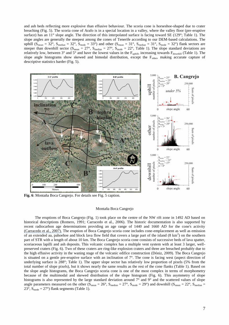
Fig. 6: Montaña Boca Cangrejo. For details see Fig. 5 caption.
Montaña Boca Cangrejo
The eruptions of Boca Cangrejo (Fig. 1) took place on the centre of the NW rift zone in 1492 AD based on
historical descriptions (Romero, 1991; Carracedo et al., 2006). The historic documentation is also supported by
recent radiocarbon age determinations providing an age range of 1440 and 1660 AD for the cone's activity
(Carracedo et al., 2007). The eruption of Boca Cangrejo scoria cone includes cone-emplacement as well as emission
of an extended aa, pahoehoe and block lava flow field that covers a large part of the island (8 km2) on the southern
part of STR with a length of about 10 km. The Boca Cangrejo scoria cone consists of successive beds of lava spatter,
scoriaceous lapilli and ash deposits. This volcanic complex has a multiple vent system with at least 3 larger, well-
preserved craters (Fig. 6). Two of these craters are ring-like explosion craters and three are breached probably due to
the high effusive activity in the waning stage of the volcanic edifice construction (Dóniz, 2009). The Boca Cangrejo
is situated on a gentle pre-eruptive surface with an inclination of 7°. The cone is facing west (aspect direction of
underlying surface is 288°; Table 1). The upper slope sector has relatively low proportion of pixels (5% from the
total number of slope pixels), but it shows nearly the same results as the rest of the cone flanks (Table 1). Based on
the slope angle histograms, the Boca Cangrejo scoria cone is one of the most complex in terms of morphometry
because of the multimodal and skewed distribution of the slope histogram (Fig. 6). This asymmetry of slope
histograms is also represented by the large standard deviation around 7° and 9° and the scattered values of slope
angle parameters measured on the other (Smean = 26°, Smedian = 27°, Smode = 29°) and downhill (Smean = 22°, Smedian =
23°, Smode = 27°) flank segments (Table 1).
8
Montaña Fasnia
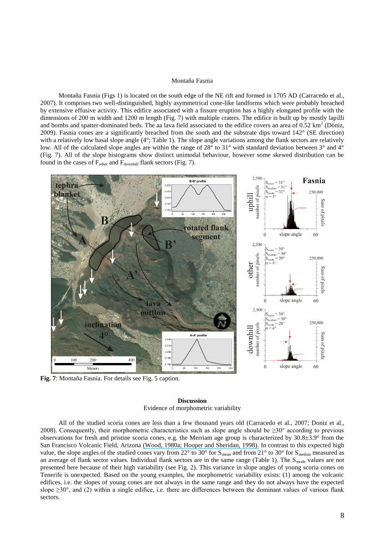
Montaña Fasnia (Figs 1) is located on the south edge of the NE rift and formed in 1705 AD (Carracedo et al.,
2007). It comprises two well-distinguished, highly asymmetrical cone-like landforms which were probably breached
by extensive effusive activity. This edifice associated with a fissure eruption has a highly elongated profile with the
dimensions of 200 m width and 1200 m length (Fig. 7) with multiple craters. The edifice is built up by mostly lapilli
and bombs and spatter-dominated beds. The aa lava field associated to the edifice covers an area of 0.52 km2 (Dóniz,
2009). Fasnia cones are a significantly breached from the south and the substrate dips toward 142° (SE direction)
with a relatively low basal slope angle (4°; Table 1). The slope angle variations among the flank sectors are relatively
low. All of the calculated slope angles are within the range of 28° to 31° with standard deviation between 3° and 4°
(Fig. 7). All of the slope histograms show distinct unimodal behaviour, however some skewed distribution can be
found in the cases of Fother and Fdownhill flank sectors (Fig. 7).
Fig. 7: Montaña Fasnia. For details see Fig. 5 caption.
Discussion
Evidence of morphometric variability
All of the studied scoria cones are less than a few thousand years old (Carracedo et al., 2007; Doniz et al.,
2008). Consequently, their morphometric characteristics such as slope angle should be ≥30° according to previous
observations for fresh and pristine scoria cones, e.g. the Merriam age group is characterized by 30.8±3.9° from the
San Francisco Volcanic Field, Arizona (Wood, 1980a; Hooper and Sheridan, 1998). In contrast to this expected high
value, the slope angles of the studied cones vary from 22° to 30° for Smean and from 21° to 30° for Smedian measured as
an average of flank sector values. Individual flank sectors are in the same range (Table 1). The Smode values are not
presented here because of their high variability (see Fig. 2). This variance in slope angles of young scoria cones on
Tenerife is unexpected. Based on the young examples, the morphometric variability exists: (1) among the volcanic
edifices, i.e. the slopes of young cones are not always in the same range and they do not always have the expected
slope ≥30°, and (2) within a single edifice, i.e. there are differences between the dominant values of various flank
sectors.
9
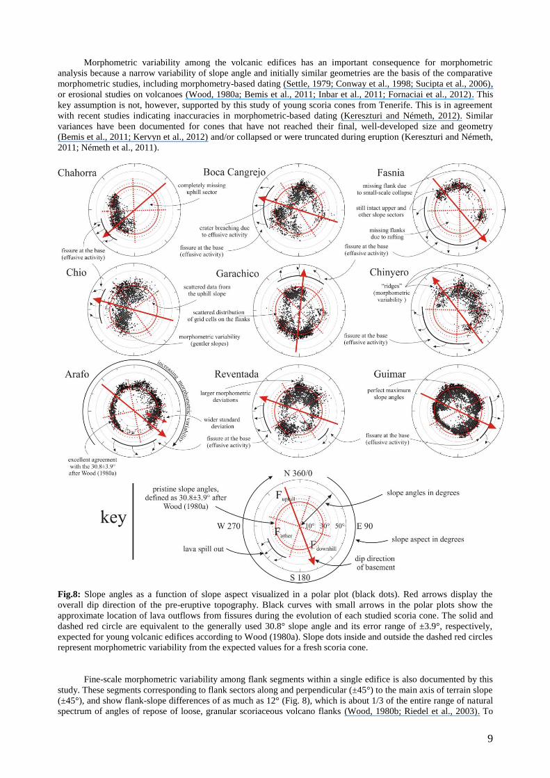
Morphometric variability among the volcanic edifices has an important consequence for morphometric
analysis because a narrow variability of slope angle and initially similar geometries are the basis of the comparative
morphometric studies, including morphometry-based dating (Settle, 1979; Conway et al., 1998; Sucipta et al., 2006),
or erosional studies on volcanoes (Wood, 1980a; Bemis et al., 2011; Inbar et al., 2011; Fornaciai et al., 2012). This
key assumption is not, however, supported by this study of young scoria cones from Tenerife. This is in agreement
with recent studies indicating inaccuracies in morphometric-based dating (Kereszturi and Németh, 2012). Similar
variances have been documented for cones that have not reached their final, well-developed size and geometry
(Bemis et al., 2011; Kervyn et al., 2012) and/or collapsed or were truncated during eruption (Kereszturi and Németh,
2011; Németh et al., 2011).
Fig.8: Slope angles as a function of slope aspect visualized in a polar plot (black dots). Red arrows display the
overall dip direction of the pre-eruptive topography. Black curves with small arrows in the polar plots show the
approximate location of lava outflows from fissures during the evolution of each studied scoria cone. The solid and
dashed red circle are equivalent to the generally used 30.8° slope angle and its error range of ±3.9°, respectively,
expected for young volcanic edifices according to Wood (1980a). Slope dots inside and outside the dashed red circles
represent morphometric variability from the expected values for a fresh scoria cone.
Fine-scale morphometric variability among flank segments within a single edifice is also documented by this
study. These segments corresponding to flank sectors along and perpendicular (±45°) to the main axis of terrain slope
(±45°), and show flank-slope differences of as much as 12° (Fig. 8), which is about 1/3 of the entire range of natural
spectrum of angles of repose of loose, granular scoriaceous volcano flanks (Wood, 1980b; Riedel et al., 2003). To
10
detect and visualize such changes as a function of position within individual edifices, polar plots were made (Fig. 8),
with emphasis on the location of the expected ‗average‘ values, i.e. 30.8±3.9° (Wood, 1980a). The expected average
slope angle is fulfilled by the Fuphill segment of the Arafo scoria cone (Figs 5 and 8). This flank segment has a low
standard deviation (3°) and is in the expected ≥30° range. The overall geomorphic state of Arafo scoria cone is
interesting because there is an increase in the standard deviation towards the Fdownhill sector, from 3° to 5° (Fig. 8).
The observed increasing slope segment variability results from the combination of inclined basement and the
effusive activity and/or flank collapse (Figs 5 and 8).
Origin of morphometric variability
The morphology of scoria cones can change rapidly (years to decades) after eruption (Inbar et al., 1994;
Fornaciai et al., 2010; Inbar et al., 2011). Nevertheless, these secondary modifications including deflation by wind,
small gravitational landslides or rain splash erosion (Wood, 1980a; Hooper, 1999) on the flank of a young volcanic
edifice (≤ka) do not extremely alter the original morphology (Pelletier and Cline, 2007; Fornaciai et al., 2010). The
morphometric variability detected among these young cones through slope angle values resulted from syn-eruptive
rather than post-eruptive processes. Such morphometric variability may be related to either non-volcanic and/or
volcanic processes including (1) pre-eruptive surface inclination, (2) vent migration and associated crater breaching,
(3) effusive activity and associated crater breaching and flank collapses as well as (4) variation of the properties of
the pyroclastic successions, e.g. grain size, degree of welding and agglutination. From these controlling factors on
initial cone morphology, the effects of pre-eruptive surface inclination and of effusive activity are hardly
distinguishable from each other because most of the lava flows left the cones at the base of their downhill flank (Fig.
8). These lava outflows and associated processes such as flank collapses (Holm, 1987; Németh et al., 2011) may
have affected the final morphometry of the studied volcanic edifices by partially removing, rotating and gradually
distorting the flank segment(s), as on the Arafo scoria cone (Figs 5 and 8). Flank collapses and subsequent rebuilding
of cones represent a more complex eruption history than may be typical for pure symmetric cones (Holm, 1987). The
pre-eruptive surface inclination helps to develop such collapse and breaching, as indicated here by the preferred
extrusion of lavas from the cones' downhill flanks (Fig. 8). A larger degree of morphometric variability can be
expected with pre-eruption topographic slopes exceeding 5° (Table 1) which is in agreement with the field-based
observation at the Los Morados scoria cone in Argentina (Németh et al., 2011) and with the LiDAR-based
characterization of parasitic cones from the flank of Mt. Etna (Favalli et al., 2009).
Importance of morphometric variability
The abovementioned syn-eruptive processes lead to morphometric variability both among individual volcanic
edifices and between individual flank segments within the same edifice. Such initial morphometric variability has
important implications for interpretation of morphometric characteristics of volcanic edifices, cluster of cones or
even volcanic fields. Because there is morphometric even among young, uneroded scoria cones, edifice ages and
their general implications for eruption histories of individual edifices or groups cannot be inferred. Comparison
should be restricted to edifices with strict age-control, knowledge on eruption history and pyroclastic composition as
well as information on the initial geometry of the edifice.
The studied cones were sorted in decreasing order of slope angles of the three flank sectors with the Fasnia or Arafo
cones having the highest slopes. These steep cone flanks would be traditionally interpreted as a sign of young age,
but they are not the youngest edifices (Table 1). More interesting is that the pre-Holocene cone of Güímar has higher
flank slopes (26–28°) than the 600 and 300 years old edifices including Boca Cangrejo (22–25°) or Garachico (22–
28°) (Table 1). Similarly, the morphometric signature of Güímar and Chinyero scoria cones are in the same range
between 29° and 26° in spite of their age difference of over 10,000 years (Table 1). These observations show that the
same morphological state of an edifice can be reached either during eruption or as a consequence of post-eruptive
processes. In this case, the 29° and 26° slopes for Güímar reflect a slight modification by erosional processes (e.g.
weathering and soil-formation), while the fresh (100 years old) Chinyero is formed by syn-eruptive processes, and
shows no evidence of weathering or soil-formation.
A key inference from our work is that comparative morphometric investigation of monogenetic volcanoes
without knowledge of the initial geometry cannot be used to infer relative ages of well-preserved cones. These
distorting effects of the initial geometry fade away by the final stages of the erosion, when more compact and
erosion-resistant layers become exposed on the flanks of a scoria cone (Kereszturi and Németh, 2012), but this
usually requires million years (Wood, 1980a; Kereszturi and Németh, 2012), or in some cases, as long as 40 My
(Rapprich et al., 2007; Büchner and Tietz, 2012).
Relation of morphometric variability with basement inclination
An increasing difference can be identified among the three overall slope descriptors (Smean, Smedian and Smode;
Fig. 9), which is related to the occurrence of multimodal and skewed slope angle histograms (see Figs 5–7 and
Electronic Supplementary Material 2). These differences coincide with the overall inclination of the pre-eruptive
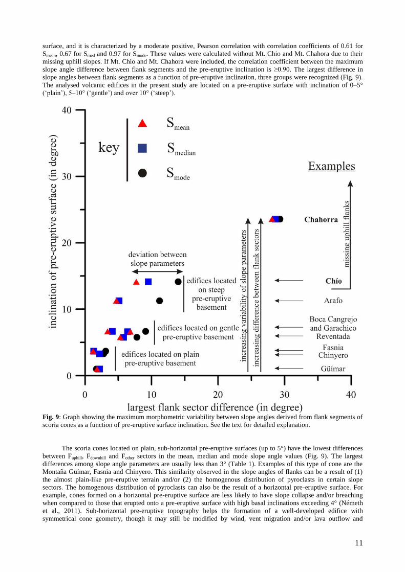
11
surface, and it is characterized by a moderate positive, Pearson correlation with correlation coefficients of 0.61 for
Smean, 0.67 for Smed and 0.97 for Smode. These values were calculated without Mt. Chio and Mt. Chahora due to their
missing uphill slopes. If Mt. Chio and Mt. Chahora were included, the correlation coefficient between the maximum
slope angle difference between flank segments and the pre-eruptive inclination is ≥0.90. The largest difference in
slope angles between flank segments as a function of pre-eruptive inclination, three groups were recognized (Fig. 9).
The analysed volcanic edifices in the present study are located on a pre-eruptive surface with inclination of 0–5°
(‗plain‘), 5–10° (‗gentle‘) and over 10° (‗steep‘).
Fig. 9: Graph showing the maximum morphometric variability between slope angles derived from flank segments of
scoria cones as a function of pre-eruptive surface inclination. See the text for detailed explanation.
The scoria cones located on plain, sub-horizontal pre-eruptive surfaces (up to 5°) have the lowest differences
between Fuphill, Fdownhill and Fother sectors in the mean, median and mode slope angle values (Fig. 9). The largest
differences among slope angle parameters are usually less than 3° (Table 1). Examples of this type of cone are the
Montaña Güímar, Fasnia and Chinyero. This similarity observed in the slope angles of flanks can be a result of (1)
the almost plain-like pre-eruptive terrain and/or (2) the homogenous distribution of pyroclasts in certain slope
sectors. The homogenous distribution of pyroclasts can also be the result of a horizontal pre-eruptive surface. For
example, cones formed on a horizontal pre-eruptive surface are less likely to have slope collapse and/or breaching
when compared to those that erupted onto a pre-eruptive surface with high basal inclinations exceeding 4° (Németh
et al., 2011). Sub-horizontal pre-eruptive topography helps the formation of a well-developed edifice with
symmetrical cone geometry, though it may still be modified by wind, vent migration and/or lava outflow and
12
associated breaching. This finding is in agreement with experimental modelling results (Tibaldi, 1995; Kervyn et al.,
2012).
The scoria cones built on gently sloping pre-eruptive surfaces with inclinations of 5°–10° are characterized by
greater variation of slope angle differences between flank segments, from 3°–9° (Fig. 9 and Table 1). Three studied
cones are of this type, the Garachico, Reventada and Boca Cangrejo scoria cones. These differences are high enough
(e.g. exceeds the overall accuracy of the input topographic data) to cause problems for morphometry-based dating,
and comparative studies of scoria cone degradation.
The scoria cones situated on pre-eruptive surfaces with inclinations of ≥10° are represented by Chahorra, Chío
and Arafo scoria cones. These examples formed on 24°, 14° and 11° pre-eruptive surfaces, respectively (Fig. 9). In
this group, two of the studied edifices have no uphill facing flanks. All of these examples have breached crater
morphology, where the direction of breaching is in accordance with the direction of inclination. The difference
between slope sectors is the largest for the Chahorra cones, and ranges up to 28° due to the missing uphill flanks
(Table 1). In addition to the missing uphill facing slopes, the extremely elongated morphology of Chío scoria cone
may also be related to (1) the high degree of pre-eruptive surface inclination, (2) formation of fissure rather than a
‗point-like‘, well-localized vent, and/or (3) late-stage effusive activity.
Conclusions
The nine studied young cones in Tenerife are characterized by wide ranges of slope angles for individual
edifices and for individual flank sectors making morphometric parameters unique for every cone studied. Such
variation in slope angle values could be as high as 12°, which is significantly higher than indicated early studies
(Porter, 1972; Wood, 1980a). Due to the known young geological age (mostly Holocene), the observed
morphometric variability can be interpreted as the result of mostly syn-eruptive processes such as (1) pre-eruptive
surface inclination, (2) vent migration, (3) lava outflows and associated crater breaching and (4) differences in the
properties of pyroclastic rocks preserved in the flanks of the volcano.
The studied young cones are seen to have variations in slope angles of certain flank segments when the pre-
eruptive inclination gets steeper. The observed morphometric variability may become significant on cones on basal
slopes ≥5°, as suggested by recent studies (e.g. Németh et al., 2011; Kervyn et al., 2012). This shows that the
basement inclination is an important factor in triggering flank collapses and subsequent re-construction processes,
leading to complex eruption histories and often complex geomorphology of the resultant volcanic edifice. This
diverse nature of edifice growth possibly make the internal architecture of a scoria cone complicated, which plays
important the role in the subsequent degradation.
The observed wide range of morphometric variability caused by syn-eruptive processes raises the question
about the interpretation of morphometric parameters. Previous studies interpreted morphometric parameters of
monogenetic volcanic edifices in two ways: (1) primary, geometric modifications triggered by volcanological
processes (Tibaldi, 1995; Corazzato and Tibaldi, 2006; Doniz et al., 2008; Bemis et al., 2011; Fornaciai et al., 2012;
Kervyn et al., 2012), and (2) secondary, post-eruptive surface modifications caused by erosional-processes during the
degradation (Wood, 1980a; Hasenaka and Carmichael, 1985; Dohrenwend et al., 1986; Hooper, 1995; Hooper and
Sheridan, 1998; Inbar and Risso, 2001; Sucipta et al., 2006; Favalli et al., 2009; Fornaciai et al., 2010; Negrete-
Aranda et al., 2010; Rodríguez et al., 2010; Inbar et al., 2011; Rodriguez-Gonzalez et al., 2011; Kereszturi and
Németh, 2012). However, morphometric characteristics as documented here are too complex to interpret in a single
way because they could bear both primary (i.e. results of syn-eruptive processes) and secondary (i.e. results of
erosion-related processes) information. Theoretically, the likelihood of syn-eruptive process shaped morphometric
values is higher in the first stage of the degradation history than after a few ka or even Ma after the eruptions ceased.
Further studies should target the understanding of the meaning of morphometric parameters at certain stages of
erosion. It seems that using large number of scoria cones of varying age is inappropriate for detailed geomorphic
studies. Without strict age control, simple calculations of slope angles can merge the effect of various
geological/volcanological and erosion processes which in turn can lead morphometric misinterpretation. Thus, the
simple global interpretation of morphometric characteristics based on large number of scoria cones should be
avoided.
The presented methods are suitable to detect morphometric irregularities found on the flanks of monogenetic
scoria cones. In addition to the flank sector analysis, slope angle histograms proved to be useful for controlling the
accuracy of statistical estimates. Also, polar plots efficiently describe the morphometric variability of small-volume,
monogenetic volcano flanks. In this study, flank sectors located parallel to the main direction of the pre-eruptive
basal surface have multi-modal and asymmetric slope distributions suggesting a control of basal tilt. The
combination of such techniques allows a more detailed investigation of the late-stage, syn-eruptive morphometric
evolution of young scoria cones.
Acknowledgements
Gabor Kereszturi would like to thank the PhD Research Fellowship offered by Volcanic Risk Solutions, Institute of
Natural Resources at the Massey University (New Zealand). This research was also partly supported by Department
13
of Geology and Mineral Deposits, University of Miskolc, Hungary. Authors are grateful for the topographic maps
and orthophotos to the Gobierno de Canarias (GRAFCAN). The comments and discussion with Mike Tuohy and
Matthew Irwin (Massey University) and the comments by the Editors, Benjamin van wyk de Vries and James White,
as well as the two anonymous Journal Reviewers improved the quality of the manuscript.
References
Ancochea E, Fuster JM, Ibarrola E, Cendrero A, Coello J, Hernan F, Cantagrel JM, Jamond C (1990) Volcanic
evolution of the island of Tenerife (Canary Islands) in the light of new K-Ar data. J Volcanol Geotherm Res 44(3-
4):231-249
Bemis K, Walker J, Borgia A, Turrin B, Neri M, Swisher III C (2011) The growth and erosion of cinder cones in
Guatemala and El Salvador: models and statistics J Volcanol Geotherm Res 201(1-4):39-52
Borgefors G (1984) Distance transformations in arbitrary dimensions. Computer Vision, Graphic, and Image
Processing 27(3):321-345
Büchner J, Tietz O (2012) Reconstruction of the Landeskrone Scoria Cone in the Lusatian Volcanic Field, Eastern
Germany — Long-term degradation of volcanic edifices and implications for landscape evolution. Geomorphology
151-152:175-187
Carracedo JC (1994) The Canary Island: an example of structural control on the growth of large oceanic-island
volcanoes. J Volcanol Geotherm Res 60:225-241
Carracedo JC, Guillou H, Nomade S, Rodríguez-Badiola E, Pérez-Torrado FJ, Rodríguez-González A, Paris R, Troll
VR, Wiesmaier S, Delcamp A, Fernández-Turiel JL (2011) Evolution of ocean-island rifts: The northeast rift zone of
Tenerife, Canary Islands. Geol Soc Am Bull 123(3-4):562-584
Carracedo JC, Rodríguez Badiola E, Guillou H, Paterne M, Scaillet S, Pérez Torrado FJ, Paris R, Fra-Paleo U,
Hansen A (2007) Eruptive and structural history of Teide Volcano and rift zones of Tenerife, Canary Islands. Geol
Soc Am Bull 119(9):1027–1051
Carracedo JC, Rodríguez Badiola E, Pérez Torrado FJ, Hansen A, Rodríguez González A, Scaillet S, Guillou H,
Paterne M, Fra Paleo U, Paris R (2006) La erupción que Cristobal Colón vio en La Isla de Tenerife (Islas Canarias).
Geogaceta 41:39-42
Connor CB, Stamatakos JA, Ferrill DA, Hill BE, Ofoegbu G, Conway FM, Sagar B, Trapp J (2000) Geologic factors
controlling patterns of small-volume basaltic volcanism: Application to a volcanic hazards assessment at Yucca
Mountain, Nevada. J Geophys Res 105(1):417-432
Conway FM, Connor CB, Hill BE, Condit CD, Mullaney K, Hall CM (1998) Recurrence rates of basaltic volcanism
in SP cluster, San Francisco volcanic field, Arizona. Geology 26(7):655-658
Corazzato C, Tibaldi A (2006) Fracture control on type, morphology and distribution of parasitic volcanic cones: an
example from Mt. Etna, Italy. J Volcanol Geotherm Res 158(1-2):177-194
de Smith MJ, Goodchild MF, Longley PA (2009) Geospatial Analysis - A Comprehensive Guide to Principles,
Techniques and Software Tools. Winchelsea Press, Leicester, UK
Deng Y, Wilson JP, Bauer BO (2007) DEM resolution dependencies of terrain attributes across a landscape.
International Journal of Geographical Information Science 21(2):187-213
Dohrenwend JC, Wells SG, Turrin BD (1986) Degradation of Quaternary cinder cones in the Cima volcanic field,
Mojave Desert, California. Geol Soc Am Bull 97(4):421-427
Dóniz J (2009) Morphometric analysis of cinder cones on Tenerife (Canary Islands, Spain): results and applications.
In: Romero Díaz A, Belmonte F, Alonso F, López-Bermídez F (eds) Advances in studies on desertification. Editum,
University of Murcia, Murcia, pp 235-238
Doniz J, Romero C, Coello E, Guillen C, Sanchez N, Garcia-Cacho L, Garcia A (2008) Morphological and statistical
characterisation of recent mafic volcanism on Tenerife (Canary Islands, Spain). J Volcanol Geotherm Res 173(3-
4):185-195
Dragut L, Eisank C, Strasser T (2011) Local variance for multi-scale analysis in geomorphometry. Geomorphology
130:162-172
Favalli M, Karátson D, Mazzarini F, Pareschi MT, Boschi E (2009) Morphometry of scoria cones located on a
volcano flank: A case study from Mt. Etna (Italy), based on high-resolution LiDAR data. J Volcanol Geotherm Res
186(3-4):320-330
14
Fisher PF, Tate NJ (2006) Causes and consequences of error in digital elevation models. Prog Phys Geog 30(4):467-
489
Fornaciai A, Behncke B, Favalli M, Neri M, Tarquini S, Boschi E (2011) Detecting short-term evolution of Etnean
scoria cones: a LIDAR-based approach. Bull Volcanol 72(10):1209-1222
Fornaciai A, Behncke B, Favalli M, Neri M, Tarquini S, Boschi E (2012) Morphometry of scoria cones, and their
relation to geodynamic setting: A DEM-based analysis. J Volcanol Geotherm Res
Geyer A, Martí J (2010) The distribution of basaltic volcanism on Tenerife, Canary Islands: Implications on the
origin and dynamics of the rift systems. Tectonophysics 483(3-4):310-326
Gorte BGH, Koolhoven W (1990) Interpolation between isolines based on the Borgefors distance transform. ITC
Journals 1990-3:245-247
GRAFCAN (2009) Mapa Topográfico de las Islas Canarias (1:5.000). Cartográfica de Canarias
Grosse P, van Wyk de Vries B, Euillades PA, Kervyn M, Petrinovic I (2012) Systematic morphometric
characterization of volcanic edifices using digital elevation models. Geomorphology 136:114-131
Hasenaka T, Carmichael ISE (1985) A compilation of location, size, and geomophological parameters of volcanoes
of the Michoacan-Guanajuato volcanic field, central Mexico. Geofisica Internacional 24(4):577-607
Holm RF (1987) Significance of agglutinate mounds on lava flows associated with monogenetic cones: An example
at Sunset Crater, northern Arizona. Geol Soc Am Bull 99(3):319-324
Hooper DM (1995) Computer-simulation models of scoria cone degradation in the Colima and Michoacán-
Guanajuato volcanic fields, Mexico. Geofisica Internacional 34(3):321-340
Hooper DM (1999) Cinder movement experiments on scoria cone slopes: Rates and direction of transport. Landform
Analysis 2:5-18
Hooper DM, Sheridan MF (1998) Computer-simulation models of scoria cone degradation. J Volcanol Geotherm
Res 83(3-4):241-267
IGME (2003) Mapa Geológico de Canarias (1:25.000). Instituto Geológico y Minero de España
Inbar M, Gilichinsky M, Melekestsev I, Melnikov D, Zaretskaya N (2011) Morphometric and morphological
development of Holocene cinder cones: A field and remote sensing study in the Tolbachik volcanic field, Kamchatka
J Volcanol Geotherm Res 201(1-4):301-311
Inbar M, Hubp JL, Ruiz LV (1994) The geomorphological evolution of the Paricutin cone and lava flows, Mexico,
1943–1990. Geomorphology 9:57-76
Inbar M, Risso C (2001) A morphological and morphometric analysis of a high density cinder cone volcanic field. -
Payun Matru, south-central Andes, Argentina. Z Geomorphol 45(3):321-343
Kereszturi G, Németh K (2011) Shallow-seated controls on the evolution of the Upper Pliocene Kopasz-hegy nested
monogenetic volcanic chain in the Western Pannonian Basin, Hungary. Geol. Carpath. 62(6):535-546
Kereszturi G, Németh K (2012) Structural and morphometric irregularities of eroded Pliocene scoria cones at the
Bakony–Balaton Highland Volcanic Field, Hungary. Geomorphology 136(1):45-58
Kereszturi G, Németh K, Csillag G, Balogh K, Kovács J (2011) The role of external environmental factors in
changing eruption styles of monogenetic volcanoes in a Mio/Pleistocene continental volcanic field in western
Hungary. J Volcanol Geotherm Res 201(1-4):227-240
Kervyn M, Ernst GGJ, Carracedo J-C, Jacobs P (2012) Geomorphometric variability of ―monogenetic‖ volcanic
cones: Evidence from Mauna Kea, Lanzarote and experimental cones. Geomorphology 136(1):59-75
Marti J, Gudmundsson A (2000) The Las Cañadas caldera (Tenerife, Canary Islands): an overlapping collapse
caldera generated by magma-chamber migration J Volcanol Geotherm Res 103(1-4):161-173
Martí J, Planagumà L, Geyer A, Canal E, Pedrazzi D (2011) Complex interaction between Strombolian and
phreatomagmatic eruptions in the Quaternary monogenetic volcanism of the Catalan Volcanic Zone (NE of Spain) J
Volcanol Geotherm Res 201(1-4):178-193
Martin U, Németh K (2006) How Strombolian is a "Strombolian" scoria cone? Some irregularities in scoria cone
architecture from the Transmexican Volcanic Belt, near Volcán Ceboruco (Mexico), and Al Haruj (Libya). J
Volcanol Geotherm Res 155(1-2):104-118
Negrete-Aranda R, Cañón-Tapia E, Brandle JL, Ortega-Rivera MA, Lee JKW, Spelz RM, Hinojosa-Corona A (2010)
Regional orientation of tectonic stress and the stress expressed by post-subduction high-magnesium volcanism in
15
northern Baja California, Mexico: Tectonics and volcanism of San Borja volcanic field. J Volcanol Geotherm Res
192:97-115
Németh K, Risso C, Nullo F, Kereszturi G (2011) The role of collapsing and rafting of scoria cones on eruption style
changes and final cone morphology: Los Morados scoria cone, Mendoza, Argentina. Central European Journal of
Geosciences 3(2):102-118
Pelletier JD, Cline ML (2007) Nonlinear slope-dependent sediment transport in cinder cone evolution. Geology
35(12):1067-1070
Porter SC (1972) Distribution, Morphology, and Size Frequency of Cinder Cones on Mauna Kea Volcano, Hawaii.
Geol Soc Am Bull 83(12):3607-3612
Rapprich V, Cajz V, Kostak M, Pécskay Z, Ridkosil T, Raska P, Radon M (2007) Reconstruction of eroded
monogenetic Strombolian cones of Miocene age: A case study on character of volcanic activity of the Jicin Volcanic
Field (NE Bohemia) and subsequent erosional rates estimation. Journal of Geoscience 52(3-4):169-180
Riedel C, Ernst GGJ, Riley M (2003) Controls on the growth and geometry of pyroclastic constructs. J Volcanol
Geotherm Res 127(1-2):121-152
Rodriguez-Gonzalez A, Fernandez-Turiel JL, Perez-Torrado FJ, Aulinas M, Carracedo JC, Gimeno D, Guillou H,
Paris R (2011) GIS methods applied to the degradation of monogenetic volcanic fields: A case study of the Holocene
volcanism of Gran Canaria (Canary Islands, Spain). Geomorphology 134(3-4):249-259
Rodriguez-Gonzalez A, Fernandez-Turiel JL, Perez-Torrado FJ, Paris R, Gimeno D, Carracedo JC, Aulinas M
(2012) Factors controlling the morphology of monogenetic basaltic volcanoes: The Holocene volcanism of Gran
Canaria (Canary Islands, Spain). Geomorphology 136(1):31-44
Rodríguez SR, Morales-Barrera W, Layer P, González-Mercado E (2010) A quaternary monogenetic volcanic field
in the Xalapa region, eastern Trans-Mexican volcanic belt: Geology, distribution and morphology of the volcanic
vents. J Volcanol Geotherm Res 197(1-4):149-166
Romero C (1991) Las manifestaciones volcánicas históricas del Archipiélago Canario. Consejería de Política
Territorial. Gobierno Autónomo de Canarias, Santa Cruz de Tenerife, Spain
Settle M (1979) The structure and emplacement of cinder cone fields. Am J Sci 279(10):1089-1107
Sharpnack DA, Akin G (1969) An algorithm for computing slope and aspect from elevation. Photogrammetric
Survey 35:247-248
Starkova M, Rapprich V, Breitkreuz C (2011) Variable eruptive styles in an ancient monogenetic volcanic field:
examples from the Permian Levín Volcanic Field (Krkonoše Piedmont Basin, Bohemian Massif). J Geosci 56:163-
180
Sucipta IGBE, Takashima I, Muraoka H (2006) Morphometric age and petrological characteristic of volcanic rocks
from the Bajawa cinder cone complex, Flores, Indonesia. J Mineral Petrol Sci 101(2):48-68
Thirlwall MF, Singer BS, Marriner GF (2000) 39Ar–40Ar ages and geochemistry of the basaltic shield stage of
Tenerife, Canary Islands, Spain. J Volcanol Geotherm Res 103(1-4):247-297
Tibaldi A (1995) Morphology of pyroclastic cones and tectonics. J Geophys Res 100(B12):24521-24535
Valentine GA, Gregg TKP (2008) Continental basaltic volcanoes - Processes and problems. J Volcanol Geotherm
Res 177(4):857-873
Valentine GA, Krier DJ, Perry FV, Heiken G (2007) Eruptive and geomorphic processes at the Lathrop Wells scoria
cone volcano. J Volcanol Geotherm Res 161(1-2):57-80
Walter TR (2003) Buttressing and fractional spreading of Tenerife, an experimental approach on the formation of rift
zones. Geophys Res Lett 30(6):1296
Wood CA (1980) Morphometric analysis of cinder cone degradation. J Volcanol Geotherm Res 8(2-4):137-160
Wood CA (1980) Morphometric evolution of cinder cones. J Volcanol Geotherm Res 7(3-4):387-413
Zhou Q, Liu X (2004) Analysis of errors of derived slope and aspect related to DEM data properties Comput Geosci
30(4):369-378
16
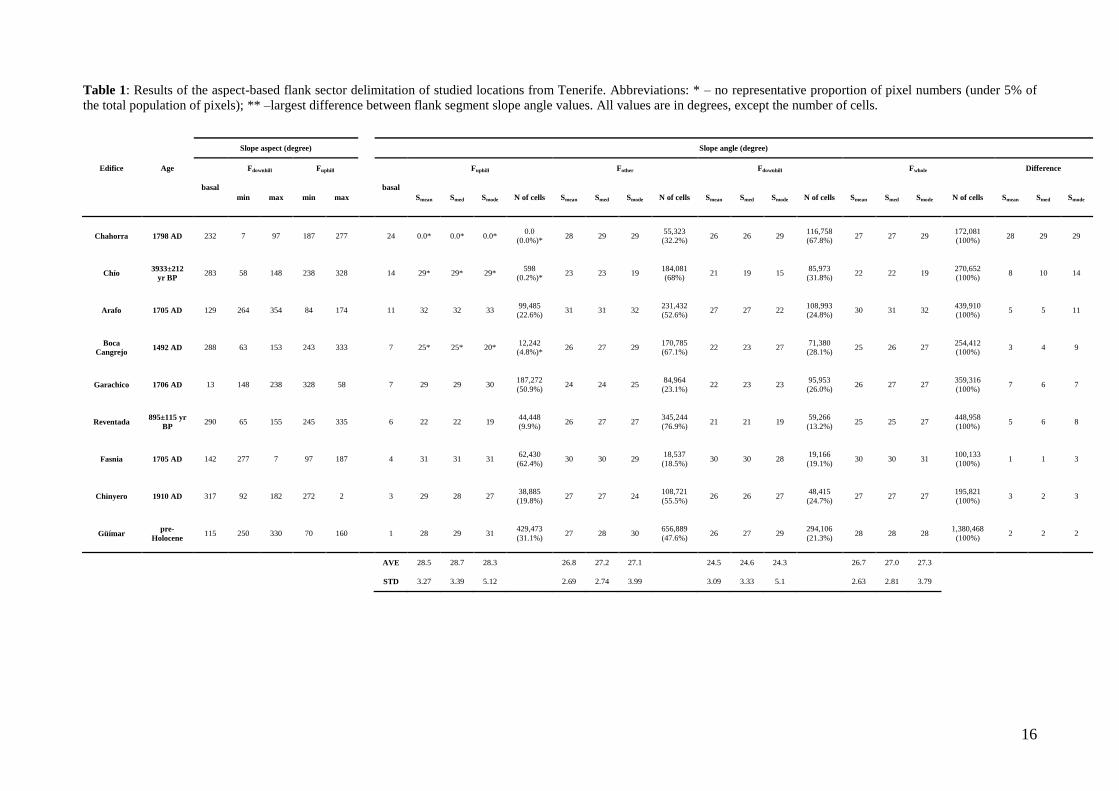
Table 1: Results of the aspect-based flank sector delimitation of studied locations from Tenerife. Abbreviations: * – no representative proportion of pixel numbers (under 5% of
the total population of pixels); ** –largest difference between flank segment slope angle values. All values are in degrees, except the number of cells.
Slope aspect (degree)
Slope angle (degree)
Edifice Age
basal
Fdownhill Fuphill
basal
Fuphill Fother Fdownhill Fwhole Difference
min max min max Smean Smed Smode N of cells Smean Smed Smode N of cells Smean Smed Smode N of cells Smean Smed Smode N of cells Smean Smed Smode
Chahorra 1798 AD 232 7 97 187 277
24 0.0* 0.0* 0.0* 0.0
(0.0%)* 28 29 29
55,323
(32.2%) 26 26 29
116,758
(67.8%) 27 27 29
172,081
(100%) 28 29 29
Chío 3933±212
yr BP 283 58 148 238 328
14 29* 29* 29*
598
(0.2%)* 23 23 19
184,081
(68%) 21 19 15
85,973
(31.8%) 22 22 19
270,652
(100%) 8 10 14
Arafo 1705 AD 129 264 354 84 174
11 32 32 33 99,485
(22.6%) 31 31 32
231,432
(52.6%) 27 27 22
108,993
(24.8%) 30 31 32
439,910
(100%) 5 5 11
Boca
Cangrejo 1492 AD 288 63 153 243 333
7 25* 25* 20*
12,242
(4.8%)* 26 27 29
170,785
(67.1%) 22 23 27
71,380
(28.1%) 25 26 27
254,412
(100%) 3 4 9
Garachico 1706 AD 13 148 238 328 58
7 29 29 30 187,272
(50.9%) 24 24 25
84,964
(23.1%) 22 23 23
95,953
(26.0%) 26 27 27
359,316
(100%) 7 6 7
Reventada 895±115 yr
BP 290 65 155 245 335
6 22 22 19
44,448
(9.9%) 26 27 27
345,244
(76.9%) 21 21 19
59,266
(13.2%) 25 25 27
448,958
(100%) 5 6 8
Fasnia 1705 AD 142 277 7 97 187
4 31 31 31 62,430
(62.4%) 30 30 29
18,537
(18.5%) 30 30 28
19,166
(19.1%) 30 30 31
100,133
(100%) 1 1 3
Chinyero 1910 AD 317 92 182 272 2
3 29 28 27 38,885
(19.8%) 27 27 24
108,721
(55.5%) 26 26 27
48,415
(24.7%) 27 27 27
195,821
(100%) 3 2 3
Güímar pre-
Holocene 115 250 330 70 160 1 28 29 31
429,473
(31.1%) 27 28 30
656,889
(47.6%) 26 27 29
294,106
(21.3%) 28 28 28
1,380,468
(100%) 2 2 2
AVE 28.5 28.7 28.3 26.8 27.2 27.1 24.5 24.6 24.3 26.7 27.0 27.3
STD 3.27 3.39 5.12 2.69 2.74 3.99 3.09 3.33 5.1 2.63 2.81 3.79

17
Electronic Supplementary Material 1: Table showing the properties and accuracy of the DEMs for the nine studies scoria cones in Tenerife. Note that the n is the number of
pixels.
Scoria
cone
Touching pixels Flat pixel analysis Error
descriptors
total map area outer flanks total map area outer flanks RMSE
1 m 0.5 m 2
m 1m
0.5
m
real flat inflow outflow n %
n % n % n % n % n % n ±m
Chahorra 588 0.0330 440 0.0062 0 0 0 6,338 0.09 1,308 0.02 412 0.006 0 0 69 3.64
Chío 216 0.0270 89 0.0029 2 0 0 1,698 0.05 931 0.03 1,285 0.040 1+2
(out/inflow) 0.0014 68 3.74
Arafo 54,120 1.8500 47,031 0.4020 0 0 0 9,666 0.08 3,430 0.03 4,551 0.040 0 0 151 3.77
Boca
Cangrejo 147 0.0070 107 0.0005 2 0 0 47,255 0.61 3,374 0.04 6,642 0.090 3 (outflow) 0.0011 251 1.75
Garachico 96 0.0020 4 0.0000 0 0 0 54,597 0.42 5,293 0.04 7,900 0.060 0 0 243 3.80
Reventada 509 0.0170 134 0.0012 0 0 0 30,288 0.27 3,214 0.03 7,111 0.060 0 0 226 2.64
Fasnia 256 0.0130 40 0.0005 0 0 0 31,252 0.42 1,455 0.02 3,828 0.050 0 0 100 3.02
Chinyero 109 0.0040 2 0.0000 44 2 0 17,363 0.19 4,027 0.04 8,210 0.090 0 0 167 2.74
Güímar 915 0.0240 998 0.0068 0 0 0 223,675 1.52 6,496 0.04 4,757 0.030 3 (outflow) 0.0002 257 0.56
18
Electronic Supplementary Material 2
Montaña Chahorra
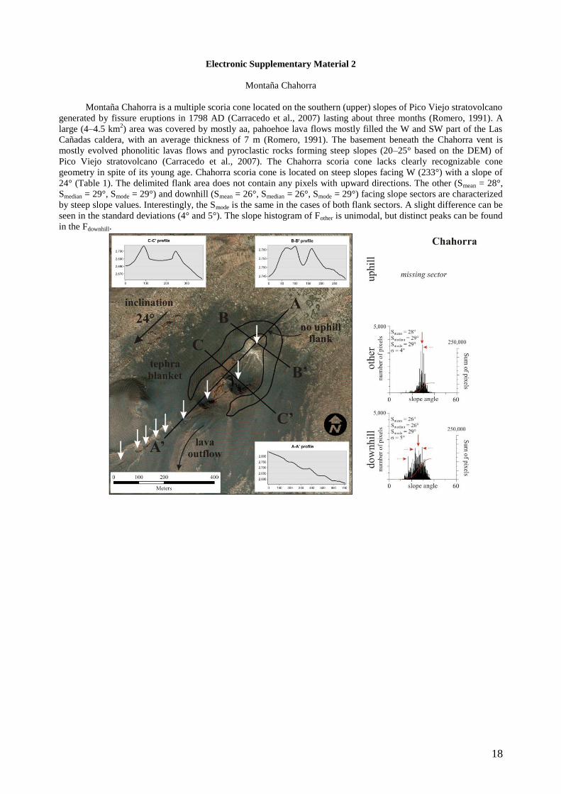
Montaña Chahorra is a multiple scoria cone located on the southern (upper) slopes of Pico Viejo stratovolcano
generated by fissure eruptions in 1798 AD (Carracedo et al., 2007) lasting about three months (Romero, 1991). A
large (4–4.5 km2) area was covered by mostly aa, pahoehoe lava flows mostly filled the W and SW part of the Las
Cañadas caldera, with an average thickness of 7 m (Romero, 1991). The basement beneath the Chahorra vent is
mostly evolved phonolitic lavas flows and pyroclastic rocks forming steep slopes (20–25° based on the DEM) of
Pico Viejo stratovolcano (Carracedo et al., 2007). The Chahorra scoria cone lacks clearly recognizable cone
geometry in spite of its young age. Chahorra scoria cone is located on steep slopes facing W (233°) with a slope of
24° (Table 1). The delimited flank area does not contain any pixels with upward directions. The other (Smean = 28°,
Smedian = 29°, Smode = 29°) and downhill (Smean = 26°, Smedian = 26°, Smode = 29°) facing slope sectors are characterized
by steep slope values. Interestingly, the Smode is the same in the cases of both flank sectors. A slight difference can be
seen in the standard deviations (4° and 5°). The slope histogram of Fother is unimodal, but distinct peaks can be found
in the Fdownhill.
19
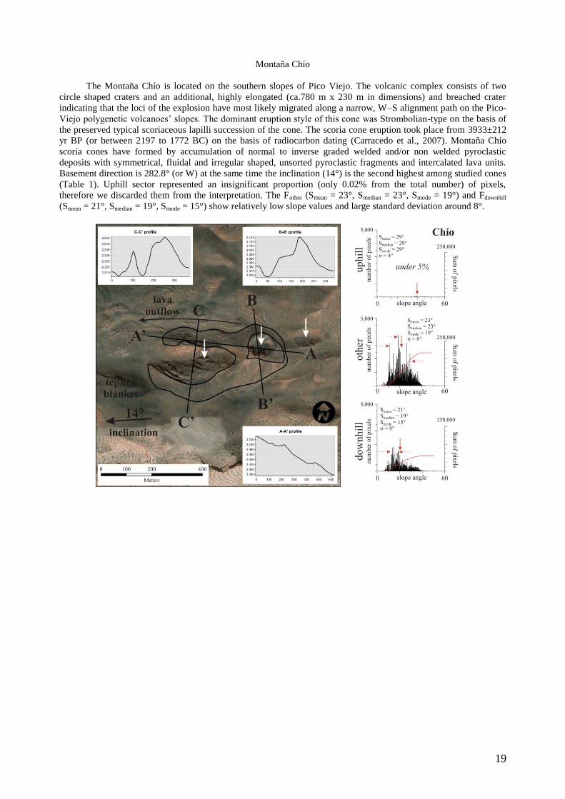
Montaña Chío
The Montaña Chío is located on the southern slopes of Pico Viejo. The volcanic complex consists of two
circle shaped craters and an additional, highly elongated (ca.780 m x 230 m in dimensions) and breached crater
indicating that the loci of the explosion have most likely migrated along a narrow, W–S alignment path on the Pico-
Viejo polygenetic volcanoes‘ slopes. The dominant eruption style of this cone was Strombolian-type on the basis of
the preserved typical scoriaceous lapilli succession of the cone. The scoria cone eruption took place from 3933±212
yr BP (or between 2197 to 1772 BC) on the basis of radiocarbon dating (Carracedo et al., 2007). Montaña Chío
scoria cones have formed by accumulation of normal to inverse graded welded and/or non welded pyroclastic
deposits with symmetrical, fluidal and irregular shaped, unsorted pyroclastic fragments and intercalated lava units.
Basement direction is 282.8° (or W) at the same time the inclination (14°) is the second highest among studied cones
(Table 1). Uphill sector represented an insignificant proportion (only 0.02% from the total number) of pixels,
therefore we discarded them from the interpretation. The Fother (Smean = 23°, Smedian = 23°, Smode = 19°) and Fdownhill
(Smean = 21°, Smedian = 19°, Smode = 15°) show relatively low slope values and large standard deviation around 8°.
20
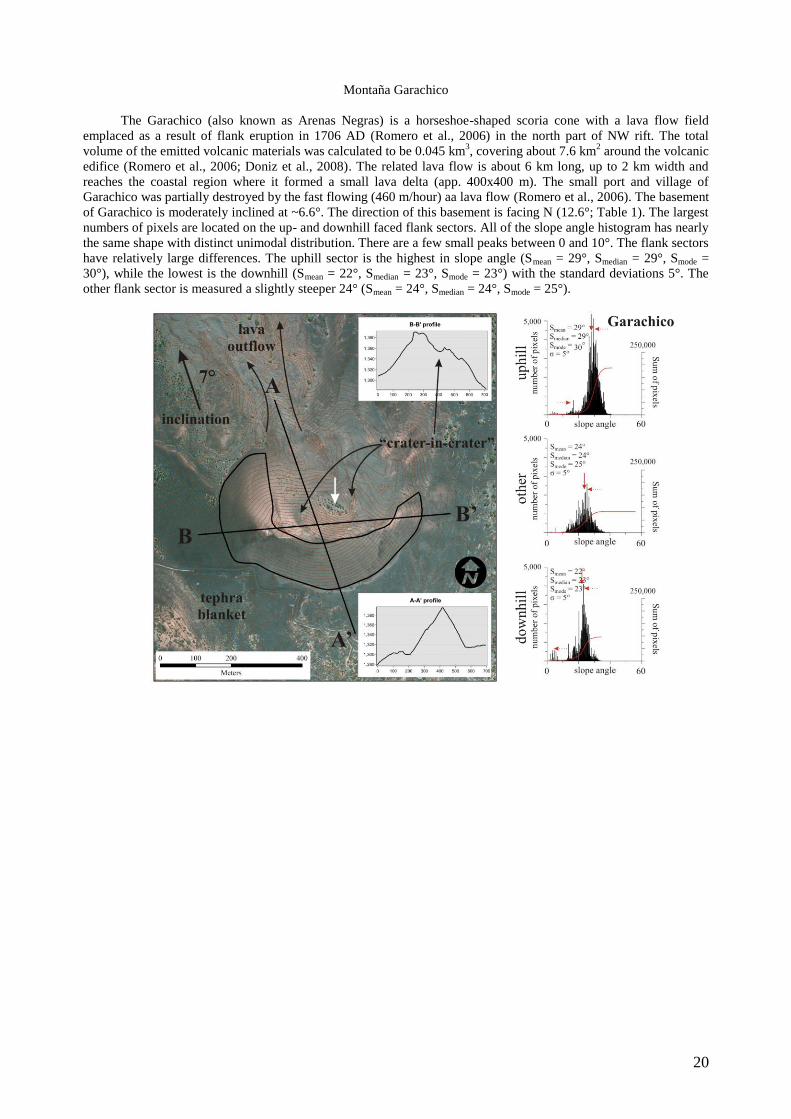
Montaña Garachico
The Garachico (also known as Arenas Negras) is a horseshoe-shaped scoria cone with a lava flow field
emplaced as a result of flank eruption in 1706 AD (Romero et al., 2006) in the north part of NW rift. The total
volume of the emitted volcanic materials was calculated to be 0.045 km3, covering about 7.6 km
2 around the volcanic
edifice (Romero et al., 2006; Doniz et al., 2008). The related lava flow is about 6 km long, up to 2 km width and
reaches the coastal region where it formed a small lava delta (app. 400x400 m). The small port and village of
Garachico was partially destroyed by the fast flowing (460 m/hour) aa lava flow (Romero et al., 2006). The basement
of Garachico is moderately inclined at ~6.6°. The direction of this basement is facing N (12.6°; Table 1). The largest
numbers of pixels are located on the up- and downhill faced flank sectors. All of the slope angle histogram has nearly
the same shape with distinct unimodal distribution. There are a few small peaks between 0 and 10°. The flank sectors
have relatively large differences. The uphill sector is the highest in slope angle (Smean = 29°, Smedian = 29°, Smode =
30°), while the lowest is the downhill (Smean = 22°, Smedian = 23°, Smode = 23°) with the standard deviations 5°. The
other flank sector is measured a slightly steeper 24° (Smean = 24°, Smedian = 24°, Smode = 25°).
21
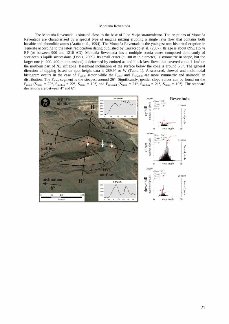
Montaña Reventada
The Montaña Reventada is situated close to the base of Pico Viejo stratovolcano. The eruptions of Montaña
Reventada are characterized by a special type of magma mixing erupting a single lava flow that contains both
basaltic and phonolitic zones (Araña et al., 1994). The Montaña Reventada is the youngest non-historical eruption in
Tenerife according to the latest radiocarbon dating published by Carracedo et al. (2007). Its age is about 895±115 yr
BP (or between 900 and 1210 AD). Montaña Reventada has a multiple scoria cones composed dominantly of
scoriaceous lapilli successions (Dóniz, 2009). Its small crater (~ 100 m in diameter) is symmetric in shape, but the
larger one (~ 200 400 m dimensions) is deformed by emitted aa and block lava flows that covered about 1 km2 on
the northern part of NE rift zone. Basement inclination of the surface below the cone is around 5.8°. The general
direction of dipping based on spot height data is 289.9° or W (Table 1). A scattered, skewed and multimodal
histogram occurs in the case of Fuphill sector while the Fother and Fdownhill are more symmetric and unimodal in
distribution. The Fother segment is the steepest around 26°. Significantly, gentler slope values can be found on the
Fuphill (Smean = 22°, Smedian = 22°, Smode = 19°) and Fdownhill (Smean = 21°, Smedian = 21°, Smode = 19°). The standard
deviations are between 4° and 6°.
22
Montaña Chinyero
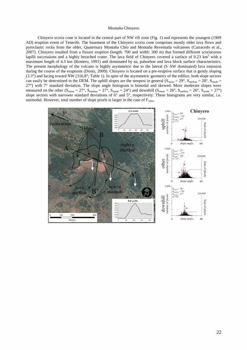
Chinyero scoria cone is located in the central part of NW rift zone (Fig. 1) and represents the youngest (1909
AD) eruption event of Tenerife. The basement of the Chinyero scoria cone comprises mostly older lava flows and
pyroclastic rocks from the older, Quaternary Montaña Chío and Montaña Reventada volcanoes (Carracedo et al.,
2007). Chinyero resulted from a fissure eruption (length: 700 and width: 300 m) that formed different scoriaceous
lapilli successions and a highly breached crater. The lava field of Chinyero covered a surface of 0.23 km2 with a
maximum length of 4.5 km (Romero, 1991) and dominated by aa, pahoehoe and lava block surface characteristics.
The present morphology of the volcano is highly asymmetric due to the lateral (S–SW dominated) lava emission
during the course of the eruptions (Dóniz, 2009). Chinyero is located on a pre-eruptive surface that is gently sloping
(3.3°) and facing toward NW (316.8°; Table 1). In spite of the asymmetric geometry of the edifice, both slope sectors
can easily be determined in the DEM. The uphill slopes are the steepest in general (Smean = 29°, Smedian = 28°, Smode =
27°) with 7° standard deviation. The slope angle histogram is bimodal and skewed. More moderate slopes were
measured on the other (Smean = 27°, Smedian = 27°, Smode = 24°) and downhill (Smean = 26°, Smedian = 26°, Smode = 27°)
slope sectors with narrower standard deviations of 6° and 5°, respectively. These histograms are very similar, i.e.
unimodal. However, total number of slope pixels is larger in the case of Fother.
23
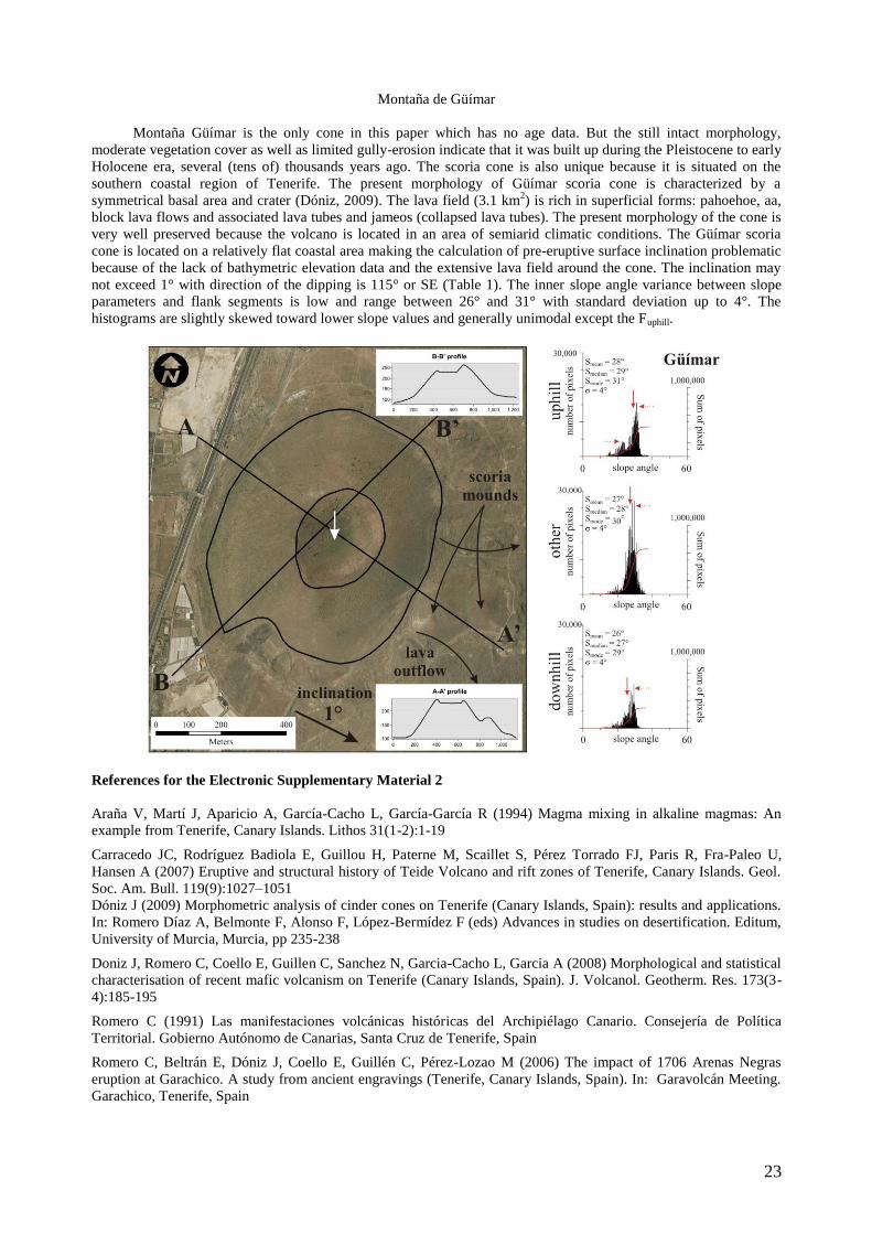
Montaña de Güímar
Montaña Güímar is the only cone in this paper which has no age data. But the still intact morphology,
moderate vegetation cover as well as limited gully-erosion indicate that it was built up during the Pleistocene to early
Holocene era, several (tens of) thousands years ago. The scoria cone is also unique because it is situated on the
southern coastal region of Tenerife. The present morphology of Güímar scoria cone is characterized by a
symmetrical basal area and crater (Dóniz, 2009). The lava field (3.1 km2) is rich in superficial forms: pahoehoe, aa,
block lava flows and associated lava tubes and jameos (collapsed lava tubes). The present morphology of the cone is
very well preserved because the volcano is located in an area of semiarid climatic conditions. The Güímar scoria
cone is located on a relatively flat coastal area making the calculation of pre-eruptive surface inclination problematic
because of the lack of bathymetric elevation data and the extensive lava field around the cone. The inclination may
not exceed 1° with direction of the dipping is 115° or SE (Table 1). The inner slope angle variance between slope
parameters and flank segments is low and range between 26° and 31° with standard deviation up to 4°. The
histograms are slightly skewed toward lower slope values and generally unimodal except the Fuphill.
References for the Electronic Supplementary Material 2
Araña V, Martí J, Aparicio A, García-Cacho L, García-García R (1994) Magma mixing in alkaline magmas: An
example from Tenerife, Canary Islands. Lithos 31(1-2):1-19
Carracedo JC, Rodríguez Badiola E, Guillou H, Paterne M, Scaillet S, Pérez Torrado FJ, Paris R, Fra-Paleo U,
Hansen A (2007) Eruptive and structural history of Teide Volcano and rift zones of Tenerife, Canary Islands. Geol.
Soc. Am. Bull. 119(9):1027–1051
Dóniz J (2009) Morphometric analysis of cinder cones on Tenerife (Canary Islands, Spain): results and applications.
In: Romero Díaz A, Belmonte F, Alonso F, López-Bermídez F (eds) Advances in studies on desertification. Editum,
University of Murcia, Murcia, pp 235-238
Doniz J, Romero C, Coello E, Guillen C, Sanchez N, Garcia-Cacho L, Garcia A (2008) Morphological and statistical
characterisation of recent mafic volcanism on Tenerife (Canary Islands, Spain). J. Volcanol. Geotherm. Res. 173(3-
4):185-195
Romero C (1991) Las manifestaciones volcánicas históricas del Archipiélago Canario. Consejería de Política
Territorial. Gobierno Autónomo de Canarias, Santa Cruz de Tenerife, Spain
Romero C, Beltrán E, Dóniz J, Coello E, Guillén C, Pérez-Lozao M (2006) The impact of 1706 Arenas Negras
eruption at Garachico. A study from ancient engravings (Tenerife, Canary Islands, Spain). In: Garavolcán Meeting.
Garachico, Tenerife, Spain
Related Documents