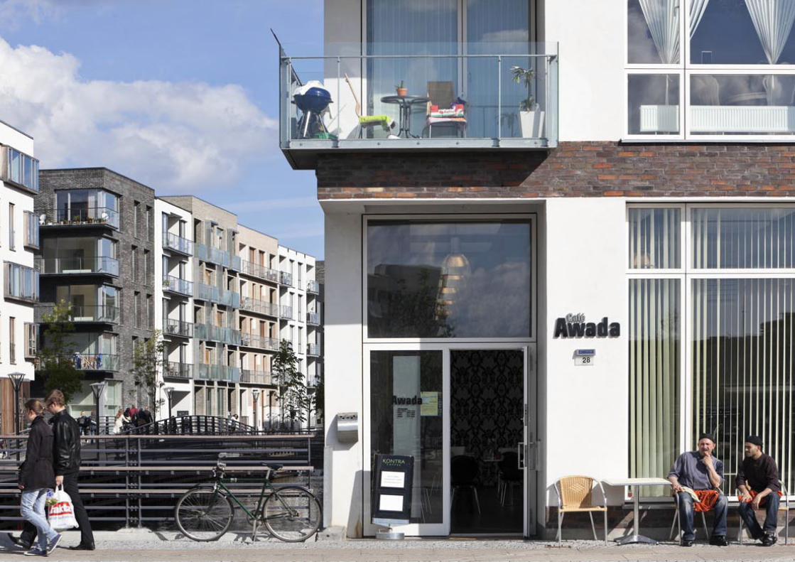
- 1 - SYDHAVNEN/SLUSEHOLMEN COPENHAGEN Harbour renovation project 2000-2009 Sydhavnen is the southern harbour district of Copenhagen, located south of the historic city. With Java Island in Amsterdam as an example, Sjoerd Soeters was asked by the Municipality of Copenhagen to make a plan for the transformation of Sydhavnen into a residential area. This plan consists entirely of city blocks, situated so as to be oriented toward the water on all sides. In order to achieve this, kilometres of canal were added to the area. The size of the blocks in Sydhavnen are based on the dimensions of the large city blocks in the centre of Copenhagen. The twists and curves of the canals create constantly changing spatial effects and sight lines. Sluseholmen is the first application of the Sydhavnen plan. The island is characterised by a panoramic view of the surrounding wa- ter and a more intimate inner side. The inner area is formed by a curved main canal and several short lateral canals. Each city block is a single structure that contains a variety of dwelling types. The facades, however, were worked out by different Danish architects, supearvised by Sjoerd Soeters. Architectural guidelines were set for materials, colours, spatial effects and building height, to ensure that each city block remained coherent and fitted in with the greater ensemble.

Welcome message from author
This document is posted to help you gain knowledge. Please leave a comment to let me know what you think about it! Share it to your friends and learn new things together.
Transcript

- 1 -
SYDHAVNEN/SLUSEHOLMEN COPENHAGENHarbour renovation project2000-2009
Sydhavnen is the southern harbour district of Copenhagen, located south of the historic city. With Java Island in Amsterdam as an example, Sjoerd Soeters was asked by the Municipality of Copenhagen to make a plan for the transformation of Sydhavnen into a residential area. This plan consists entirely of city blocks, situated so as to be oriented toward the water on all sides. In order to achieve this, kilometres of canal were added to the area. The size of the blocks in Sydhavnen are based on the dimensions of the large city blocks in the centre of Copenhagen. The twists and curves of the canals create constantly changing spatial effects and sight lines.Sluseholmen is the first application of the Sydhavnen plan. The island is characterised by a panoramic view of the surrounding wa-ter and a more intimate inner side. The inner area is formed by a curved main canal and several short lateral canals. Each city block is a single structure that contains a variety of dwelling types. The facades, however, were worked out by different Danish architects, supearvised by Sjoerd Soeters. Architectural guidelines were set for materials, colours, spatial effects and building height, to ensure that each city block remained coherent and fitted in with the greater ensemble.

- 2 -
Phase 1: Sluseholmen 2003-2009
Masterplan, supervision and architectural guidelinesSjoerd Soeters
DeveloperJM Danmark - Karre A & B Sjælsøgruppen - Karre C, D, F & H Nordicom - Karre E & G
Block architects - design, construction & coordinationArkitema - Karre A, B, C, D, F & HGröning Arkitekter - Karre E & G
LandscapeArkitema
Facade architectsArkitemaC.F. MøllerC. Stenberg + C. HolgaardCuboDissing+WeitlingForce 4Format ArkitekterGröning ArkitekterHvidt & MølgårdJuul & Frost ArkitekterKasper Danielsen ArkitekterKHR Arkitekter
A
F
B
D
GH
C
E
Phase 2: Teglholmen 2005
MasterplanSjoerd Soeters and ArkitemaMasterplan only. Further development of the plan is not supervised by Sjoerd Soeters.
MasterplanSluseholmen
[[
MasterplanTeglholmen
Masterplan Sydhavnen 2000
Masterplan Sydhavnen 2000
Client masterplanByggemodningsselskabet Sluseholmen PS (Københavns Havn & Københavns Kommune)
MasterplanSjoerd Soeters
Kim Utzon ArkitekterLadegård ArkitekterMarie KaarøeONVOscar Breyen GroningPerlt & Black arkitekterSchmidt, Hammer & LassenSoeters Van Eldonk architectenTage LyneborgThora ArkitekterVandkunstenVilhelm Lauritzen Arkitekter

- 3 -

- 4 -

- 5 -

- 6 -
- 7 -

- 8 -

- 9 -

- 10 -

- 11 -

- 12 -

- 13 -

- 14 -

- 15 -
History
One night in June 1999, a tiny fraction of the Copenhagen Council, the only one that had not left the meeting to celebrate the beginning of summer holidays, forced the lord mayor in the last voting session at 00:30 AM to have a comprehensive plan made in the coming year for both the north and south harbour areas of Copenha-gen. The next morning the lord mayor was the first to realise that this duty forced upon him was almost completely impossi-ble to fulfil, as the city of Copenhagen was not even the owner of the two areas.After the summer a committee of profes-sionals was put together containing rep-resentatives of the ministries of finance, environment and planning, the real estate
agency of state property, the director of the Copenhagen departments of planning and finance and the director of the Inde-pendent Harbour Authority. This steering committee organised a secretariat whose three members made a tour to visit new city planning projects in London, Ham-burg, Berlin, Barcelona, Paris, Rotterdam and Amsterdam. Back in Copenhagen they reported to the steering committee that Borneo Sporenburg by Adriaan Geuze and Java Island by Sjoerd Soeters were the best fitting examples for the development of plans for respectively the north and the south harbour. It was winter in Amsterdam when the tel-ephone in the office rang and one of the secretaries, a senior planning specialist, invited us to Copenhagen. As we were
very busy at the time, we weren’t able to schedule a meeting within short notice. In the end a compact appointment was made to meet one evening late in the SAS hotel lobby at the airport of Copenhagen and to take the first flight back to Amsterdam next morning.Our contact, a man of a certain age, kept his rain coat on, collar up, like a charac-ter by John Le Carré, and explained the absolute secrecy of the assignment. He proposed an almost impossible short plan-ning process. The plan was to be ready for presentation to the steering committee before June 21 2000 when a city council decision was needed. On midsummer night June 23 a big presentation in the city hall was foreseen.As the project plan had to be developed
1. Copenhagen 1659 2. Copenhagen 1898 3. Copenhagen 1906

- 16 -
without involving the local planners, the dialogue and debate about the proposed solutions would take place from time to time with the steering committee in which especially the Harbour Authority delegate was not at all in favour of the propositions done by complete strangers on his terri-tory.The Danish planning and architectural pro-fession was at the same time highly skep-tical about the invitation given to these foreigners, because the commissions given were considered the most prestigious plan-ning jobs at that time in all of Denmark.
The site
The south harbour of Copenhagen, Sydhavnen, is situated south of the city centre. The south harbour area is a set of peninsulas along the main water streaming through Copenhagen in south-south-west direction, each of the peninsulas sepa-rated by a side canal with minor branches or a bigger surface of water, a knot with three different sized docks. As the harbour activities have been moved out further north to a new and bigger port, the south harbour became redun-dant. While left-over structures, silos, bonded warehouses and cranes stood idly, junkyards for car parts and raw material deposits took over the quay areas. An old fashioned energy plant, rooted in highly polluted soil, producing a cloud of con-taminated air and posing various explosion risks around the intake nozzle for oil on the dock side, is a continuing limitation for the development of housing in the area. A modern office building for a ship-engine industry occupies an important waterfront corner of one of the peninsula. The inevitable noise near the try-out shed from the engines that are tested is also limiting the possibilities for housing in the immediate area.Just like in the eastern docklands in Am-sterdam, the water is ever present at 2 meters below quay level. The water though in this case is flowing, cristal clear
4. Copenhagen in 2000, the marked area is Sydhavnen 5. Sydhavnen 2000

- 17 -
and salt. Making canals is equally differ-ent here: the sandy soil makes it possible to just dig them out cheap and fast behind piled metal sheets.
After the Second World War, Copenhagen expanded according to the municipal ‘fin-ger plan’: the urban expansions should be stretching out into the surrounding land-
scape like fingers of one hand. At the same time, between those fingers, the land-scape should be able touch the old city centre. This strategy resulted in the subur-banization of a far bigger area around the city and ever bigger traffic problems of growing numbers of commuters.With the prospect of the opening of the Øresund Bridge from Copenhagen to Swe-
6. Sydhavnen 2000
7. Sydhavnen 2000
8. Sydhavnen 2000 9. ‘Finger plan’ of Copenhagen

- 18 -
den in 2000, modern big high tech compa-nies set up their head offices in the har-bour areas and on the waterfront of the city of Copenhagen thus attracting young, highly educated professionals. However, the housing possibilities in the old city, mainly small two room apartments in so-cial housing projects, didn’t answer the demands of these young urban profession-als. There was an urgent need for the kind of housing that would satisfy them and that would keep them from seeking set-tlement in the suburban districts further away.By transforming the southern harbour with its long waterline into a residential area, the city could offer an alternative. A primitive illustration therefore was drawn up, showing that the plan was aiming at a house on the waterside with a small jetty and a boat (havne bolig), instead of the traditional house surrounded by a hedged garden (have bolig), blue instead of green.
Genius loci
Looking for the genius loci of Copenha-gen, we found a medieval looking inner city where vertically developed individual houses address lively narrow streets and intimate squares. Neo classicist influence is found in the parts of the city that were rebuilt after the fire of 1795.The introduction of Dutch designers for commissions both in the north and south harbour aroused public debate, stirred by the professional community. However, it stands in a proud tradition of invit-ing foreign city planners when they had proved their ideas to be the best of their time. In the 17th century, the Dutch have been invited to design Christianshavn at the east side as a canal-area. The French, highly successful and fashionable in the 18th century, drew up the northern exten-sion of the city in a plan for Frederiksstad. Nyhavn, today a crowded strip of cafes,
10. From havne bolig to have bolig 11. Copenhagen, neo classicist influence
12. Copenhagen, individual houses in narrow streets
13. Copenhagen, neo classicist influence

- 19 -
15. Copenhagen, Nyhavn
14. Copenhagen, city block in Frederiksstad with courtyard
restaurants and bars, is as Dutch as a quay front can be, built in typical Danish archi-tectural style and colour. Frederiksstad is built up out of big city blocks of city palaces, the royal palace surrounding the octagonal square at its centre, with enor-
Christainshavn 1617
Frederiksstaden 1750
Sydhavnen2000
16. Comparison of the different quarters
mous courtyards behind the houses, in which first, second and third back houses find ample place. The scale of the south harbour site is comparable to these his-toric commissions.

- 20 -
The masterplan Sydhavnen
A concise plan for the four elements of the south harbour was designed in a few months. The importance of the water was enhanced by the addition of an enormous length of new canals in an attempt to give all housing water orientation. Following the ideas of the French, big perimeter blocks dominated the plan, reserving space for first, second and third backhous-es, and creating interior courtyards with the size of small parks. The second penin-sula, Teglholmen, posed specific problems of how to deal with the office building and
17. Masterplan Sydhavnen 2000
test shed of the ship engine factory, and how to weave in the green crossing area for bicycles and pedestrians, that the local planners had foreseen, within a pattern of canals and waterfronts.On the first of July 2000, the day the bridge to Sweden was officially put into use, an exposition of the harbour plans was opened in Christianshavn. The south harbour plan was shown in a 1:500 model in which Sluseholmen and Teglholmen had blocks that had coloured and parcelled elevations, the rest of the total plan being shown as white volumes.
18. Model of Sydhavnen 2000
- 21 -
Polder model
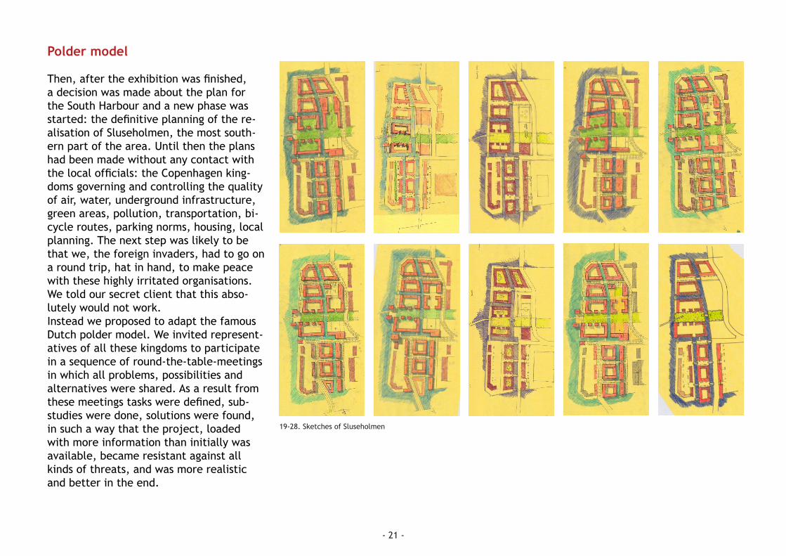
Then, after the exhibition was finished, a decision was made about the plan for the South Harbour and a new phase was started: the definitive planning of the re-alisation of Sluseholmen, the most south-ern part of the area. Until then the plans had been made without any contact with the local officials: the Copenhagen king-doms governing and controlling the quality of air, water, underground infrastructure, green areas, pollution, transportation, bi-cycle routes, parking norms, housing, local planning. The next step was likely to be that we, the foreign invaders, had to go on a round trip, hat in hand, to make peace with these highly irritated organisations. We told our secret client that this abso-lutely would not work.Instead we proposed to adapt the famous Dutch polder model. We invited represent-atives of all these kingdoms to participate in a sequence of round-the-table-meetings in which all problems, possibilities and alternatives were shared. As a result from these meetings tasks were defined, sub-studies were done, solutions were found, in such a way that the project, loaded with more information than initially was available, became resistant against all kinds of threats, and was more realistic and better in the end.
19-28. Sketches of Sluseholmen

- 22 -
Parma versus St. Dié
The problem of most newly planned city extensions is that, although they may be beautifully designed, they are completely dead. The pure beauty of design, unity in colour and in volumetric composition may play a very big part in this feeling of dead-liness, but this is not the whole story. Big blocks generate big in-between spaces, that are mostly occupied by cars, driving by or parked on the spot. Even when most of the cars are stored in underground ga-rages or under buildings, the open spaces feel uncomfortable. People see each other at great distance, the frequency of meet-ing one another is very limited, the new city feels as anonymous. Part of this is caused by the extensive unbuilt surface in modern city planning, the other cause
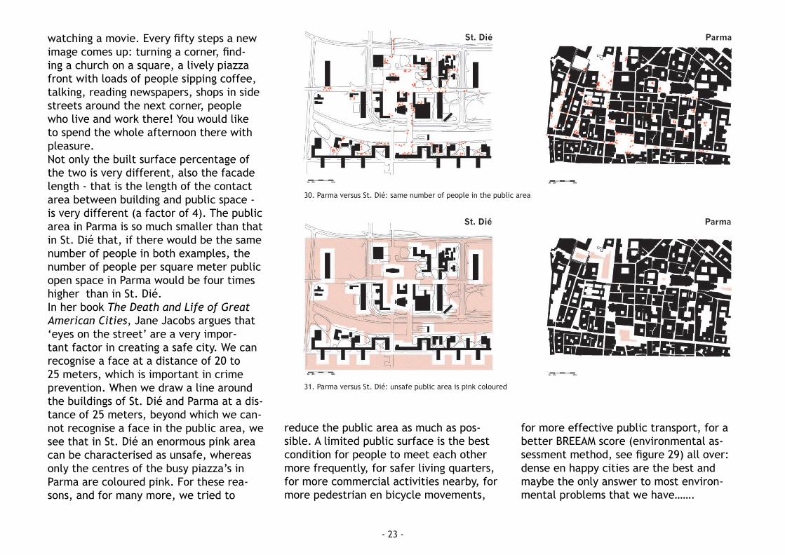
is the low population density. Even in tra-ditional cities, their built volume kept as they are, the number of people per hectare has decreased with a factor of at least 10. In nineteenth century Amsterdam it was common for a family with 8 children to live in a two room flat, whereas today a four room apartment is likely to be used by two people. So, when the streets of the old city quarters used to be full of human interaction, nowadays they are far less crowded.In modern city lay out schemes this has become even worse. Colin Rowe explains in his book Collage City why this is, by comparing the post war plan for the re-building of St. Dié by Le Corbusier with the city plan of Parma in the north of Italy. Both city plans are in the same scale and black stands for built, white for unbuilt.
In St. Dié this unbuilt area can be char-acterised as ‘space’, whereas in Parma it resembles more what we call ‘room’. Buildings in St. Dié are sculptures standing in free floating space; in Parma buildings line up along street lines and they, stand-ing shoulder to shoulder, shape the public rooms of the city. A walk through both plans takes less than a quarter of an hour. In St. Dié though, walking along the straight roads, designed for cars, makes you want to hitchhike. You can see the buildings further up the street already from afar and it feels like you only slowly come nearer. They have so little detail that your walk is not at all reward-ed by new images when going along the straight road. In St. Dié you would rather not walk at all.However, walking through Parma is like
29. Parma versus St. Dié
ParmaSt. Dié
TOTAL AREA 405.000 m2OPEN SPACE 356.800 m2BUILDING AREA 48.200 m2% BUILT 12%FACADE LENGTH 7.650 m2
Environmental Assessment Method: BREEAM-NL Area Development
UNCLASSIFIED <25PASS >25GOOD >40VERY GOOD >55EXCELLENT >70OUTSTANDING >85
TOTAL AREA 405.000 m2OPEN SPACE 201.100 m2BUILDING AREA 203.900 m2% BUILT 50%FACADE LENGTH 27.220 m2
Environmental Assessment Method: BREEAM-NL Area Development
UNCLASSIFIED <25PASS >25GOOD >40VERY GOOD >55EXCELLENT >70OUTSTANDING >85
- 23 -
watching a movie. Every fifty steps a new image comes up: turning a corner, find-ing a church on a square, a lively piazza front with loads of people sipping coffee, talking, reading newspapers, shops in side streets around the next corner, people who live and work there! You would like to spend the whole afternoon there with pleasure.Not only the built surface percentage of the two is very different, also the facade length - that is the length of the contact area between building and public space - is very different (a factor of 4). The public area in Parma is so much smaller than that in St. Dié that, if there would be the same number of people in both examples, the number of people per square meter public open space in Parma would be four times higher than in St. Dié.In her book The Death and Life of Great American Cities, Jane Jacobs argues that ‘eyes on the street’ are a very impor-tant factor in creating a safe city. We can recognise a face at a distance of 20 to 25 meters, which is important in crime prevention. When we draw a line around the buildings of St. Dié and Parma at a dis-tance of 25 meters, beyond which we can-not recognise a face in the public area, we see that in St. Dié an enormous pink area can be characterised as unsafe, whereas only the centres of the busy piazza’s in Parma are coloured pink. For these rea-sons, and for many more, we tried to
reduce the public area as much as pos-sible. A limited public surface is the best condition for people to meet each other more frequently, for safer living quarters, for more commercial activities nearby, for more pedestrian en bicycle movements,
for more effective public transport, for a better BREEAM score (environmental as-sessment method, see figure 29) all over: dense en happy cities are the best and maybe the only answer to most environ-mental problems that we have…….
30. Parma versus St. Dié: same number of people in the public area
31. Parma versus St. Dié: unsafe public area is pink coloured
ParmaSt. Dié
ParmaSt. Dié

- 24 -
Sluseholmen
So, attempting in the next phase of preci-sion to maximally shrink the public area, we decided to eliminate most streets in the Sluseholmen plan. We made our pe-rimeter blocks rise up out of the water as much as possible. The main canal we laid out in a slow curve, so that at the begin-ning of your promenade on the quay the end of it is not visible yet. This principle of ‘serial vision’ (see Gordon Cullen in Townscape) is applied here to create an area in which visitors and users can wan-der and be constantly surprised.
The hollow stretch of buildings facing south is the longest in view, while the convex row of buildings facing north is not dominating the atmosphere, as it is short-ened in perspective. Because the summer season is short, Scandinavians love it when the sun is shining. That is why the prom-enade quay is only stretched out as com-pacted public area at the north side of the main canal section. Due to the reduction of public area surface, most of the housing in the perimeter blocks has to be entered by way of the interior courtyards. Because of this, these courtyards become commu-nal urban spaces, shared gardens where people who live around it can meet one another, have their children play safely, have barbecue parties and so on.Java Island consists of long peripheral
rows of 27 meter wide ‘houses’, with per-pendicular to them rows of canal houses and palazzo’s of uniform dimensions as well. In Sluseholmen, most blocks are not rectangular and they form an intricate fabric of apartments, stairways, eleva-tors, galleries for access, etcetera. It therefor seemed impossible to commission separately designed ‘houses’ of standard
dimensions as we did on Java Island. For Sluseholmen, so-called ‘block architects’ were commissioned to sort out the best way to organise an entire block with its public access to the courtyard and, from there, its varied entryways to different apartments and maisonettes, to the park-ing under the courtyard, to storages, bicy-cle parking, and so on. These block plans
32. Masterplan Sluseholmen

- 25 -
were discussed with city officials, develop-ers, and the supervising architect Sjoerd Soeters.A very primitive set of architectural guide-lines was drawn up in a cartoon fashion (see appendix 1).Then some thirty highly modern and mostly famous Danish architects were in-vited to design the facades of the pseudo-parcels in which the blocks were divided. The architects were not amused, not to say that they felt flatly insulted. But they nevertheless took up work, and came to-
34. Aerial view of Sluseholmen 2006
gether to discuss the paper and carton board models that showed the progress of designs of every block. Danish archi-tects are well educated but at the same time touchy. Criticism of the supervising architect sometimes almost resulted in an uproar; only my Danish speaking assistant architect could warn me in time to pre-vent it..... The sometimes strong debates nevertheless resulted in blocks that were very satisfactory to the whole team of city representatives, developers and the super-visor.
A picture of May 2006 shows building ac-tivities in Sluseholmen. Danes build their housing in a kind of cold montage, most concrete parts being precast. Therefore the parking is best constructed under the courtyards and not under the housing structures.
Completed in 2009, Sluseholmen has re-ceived various architecture and planning awards since then. Inhabitants send fan-mail. It seems to have become a place that people are proud of and love to live in.
33. Model of part of Sluseholmen

- 26 -

Appendix 1: Architectural guidelines Sluseholmen
Architectural guidelines Sluseholmen 18.02.2003 Second version Soeters
1. Main structure
“To live in houses” “Variation of the facade” “The buildingmodulus is fixed”
The main structure of the buildings blocks (islandblocks) is surrounded by canals and harbour bassins. The houses on the individual island must appear homogeneous in size and rhytme in order to maintain a continuity. Every house in the block has its own plan, organisation and own architectual expression. The houses along the cross canals are smaller and so have a smaller individual (vertical) expression. .
2. Height:
“Variation of height between the indiviual houses”
North,East,West quay : A variation of 5-7- floors with an average of 6½ South quay : A variation of 4-5- floors with an average of 4 ½. Canal buildings: A variation of 3-4½ floors with an average of 3 ½ Note: The difference in height from house to house can incidential be one floor.
2. Elevations
“The vertical arrangement in the facade is important for the proportion of the facade.”
North, East,West quay apartmentblocks: ”The facades are individual faces of the houses to the public space.” The balconies are a part of the architectual facade, no projecting balconies to the public space. The annexes and balconies project out from the facade by a maximum of 30-40 cm. South quay: apartmentblocks ”The facades are individual faces of the houses to the public space.” The balconies are a part of the architectual facade, no projecting balconies to the public space. The annexes and balconies project out from the facade by a maximum of 30-40 cm. Courtyard elevations: ”The facades are individual faces of the houses to the public space.” Smalll extentions and annexes are possible.This to create different

outside rooms in the courtyard. The balconies are a part of the architectual facade. The balconies project out from the facade by a maximum of 100 cm. Cross Canal buildings: ”The facades are individual faces of the houses to the public space.” The balconies are a part of the architectual facade, no projecting balconies to the public space. The annexes and balconies project out from the facade by a maximum of 30-40 cm. No piling of balconies in order to avoid large holes in the facade. The gates in the block have to be a part of the building.The facade should end with a designed trim – a finished “corniche”, in a modern way. This subtle element can also be used to articulate the height differences. The windows in each facade are setback with a specific depth per house. The variation of windows from house to house are made to avoid continuous horizontal lines in the facade.
4. Materialisation and colors
The materialisation of the facades of the buildings should avoid deteriorating, but instead should age in a nice manner by using materials such as brick, copper, zinc, and wood. Glass only in openings, not as a main mass. Materials used in the Danish tradition, and seen in Copenhagen. A colorpalet has to be worked out. This palet maintains the harmony of area, each area will have a specific colorpalet.
5. Roof landscape:
The roof can be penthouses and-/or roofgardens. The installations on the roof are preferably not higher than the height of the designed trim. Individual pipes are grouped and hidden in chimney cages.
6. Corner buildings
The corners of the different urban blocks are going to be designed according to the situation. – ”different solution for different situations- with the possiblity to place public functions. Therefore the fronts of the buildings is more open. The transition of the corner building at the cross canals, where the lower meets the higher building, should be designed individually. The solutions should be related to the scale of the smaller crosscanalbuildings.
7. Public space
A proposal is going to be worked out for the hierarchy of the different places in the public space. Proposals of functions, activities etc. which can be at the different places. Sections quay north side: the existing height level of the quay Sections quay south side: ± 0.5m lower than the north quay Section Sluseholmen: Sluseholmen is the entrance to the whole area. The road will be a long slope starting at the level of the Metrobuilding. The level will end up in the brigde over Teglværksløbet. The buildings are following the upgoing level of the road.
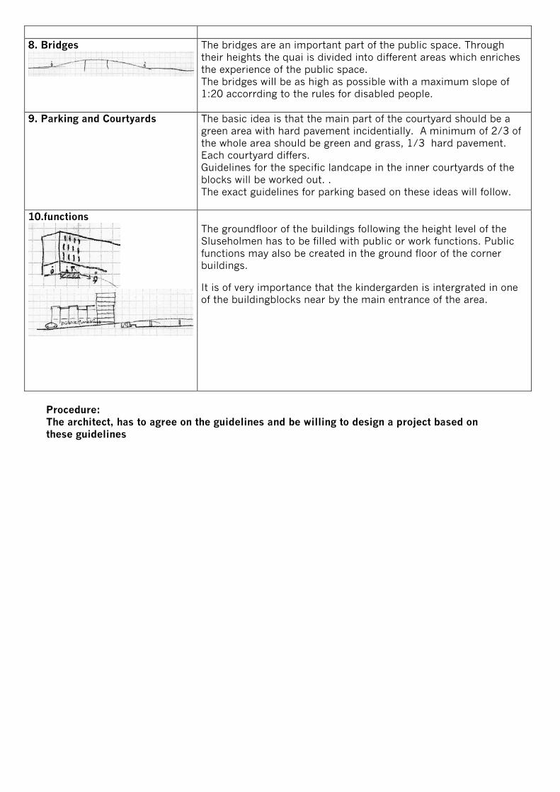
8. Bridges
The bridges are an important part of the public space. Through their heights the quai is divided into different areas which enriches the experience of the public space. The bridges will be as high as possible with a maximum slope of 1:20 accorrding to the rules for disabled people.
9. Parking and Courtyards
The basic idea is that the main part of the courtyard should be a green area with hard pavement incidentially. A minimum of 2/3 of the whole area should be green and grass, 1/3 hard pavement. Each courtyard differs. Guidelines for the specific landcape in the inner courtyards of the blocks will be worked out. . The exact guidelines for parking based on these ideas will follow.
10.functions
The groundfloor of the buildings following the height level of the Sluseholmen has to be filled with public or work functions. Public functions may also be created in the ground floor of the corner buildings. It is of very importance that the kindergarden is intergrated in one of the buildingblocks near by the main entrance of the area.
Procedure: The architect, has to agree on the guidelines and be willing to design a project based on these guidelines
Related Documents