SwissEx WIKI

SwissEx WIKI. Motivation for WIKI re-use of measurements –collaborative effort –semantics organization of measurements –temporal and spatial reference.
Dec 20, 2015
Welcome message from author
This document is posted to help you gain knowledge. Please leave a comment to let me know what you think about it! Share it to your friends and learn new things together.
Transcript

SwissEx WIKI

Motivation for WIKI
• re-use of measurements – collaborative effort– semantics
• organization of measurements– temporal and spatial reference systems

Overview Experiments
• Ontology
• experiment– set-up– maintenance– data access, processing & visualization– overall coordination

Meta Data Management
• very different requirements per project• master schema will not work
– does not even work in a single organization (SLF)• m eta data usage
– important for data re-use and provenance– less important for searching
• approach– capturing meta data in WIKI pages using a controlled
vocabulary– make relevant parts accessible for search using
semantic annotation using a controlled vocabulary

Ontology• sensorML http://vast.nsstc.uah.edu/SensorML/ • Ontology for Geographic Information - Metadata ( ISO 19115:2003 )
http://loki.cae.drexel.edu/%7Ewbs/ontology/iso-19115.htm• Open Geospatial Consortium, “GML – A Markup Language for Geography,”
http://opengis.net/gml/• Ontology for Geography Markup Language (GML3.0) of Open GIS
Consortium (OGC) http://loki.cae.drexel.edu/~wbs/ontology/2004/09/ogc-gml.owl
• sensor standard harmonization (ANSI N42.42, CAP, DoD CBRN Data Model, EDXL-DE, IEEE 1451.0, IEEE 1512.3-2002, OGC SAS 1.0, OGC SensorML, OGC SWE, OGC WFS 1.1) http://vkwiki.visualknowledge.com/wiki/sensors, http://colab.cim3.net/cgi-bin/wiki.pl?NetReadySensorsWorkshop_2006_08_0203
• sensor ontology of the NASA project http://sweet.jpl.nasa.gov/ontology/sensor.owl
• Suggested Upper Merged Ontology (SUMO) http://www.ontologyportal.org/• AmeriFlux ontology of measurment values
http://public.ornl.gov/ameriflux/standards-core.shtml• American Meterological Society Glossary
http://amsglossary.allenpress.com/glossary/browse

Ontology• DIN 4049 Part 1-3 (hydrologic terms quantitative, qualitative, ground water)• DIN 19711 Hydrogeologische Characters• ISO 19100 series of geographic information standards
– supported by the World Meteorological Organization– main goal
• define the basic semantics and structure of geographic information for data management and data interchange purposes, and
• define geographic information service components and their behaviour for data processing purposes.
– ISO/TC 211 DIS 19115 OpenGIS(tm) Metadata • around 400 elements where around 20 are mandatory
– 19115-2 - Metadata - Part 2: Extensions for imagery and gridded data• World Meteorological Organization (WMO) No 182 "International
meteorological vocabulary"– http://www.wmo.ch/pages/catalogue/New%20HTML/frame/engfil/182.html– http://doi.wiley.com/10.1002/qj.49709339524
• ISO/IEC 10746:1995 RM_ODP (Reference model for Open Distributed Processing).

Ontology
• standards are community specific– SensorMap & SwissEx: interdisciplinary
• ontology has to be discussed and decided by environmental scientists
• scientists are not used to share data on a larger scale without personal interaction
• scientist see the need for a controlled vocabulary in their work, but are busy right now with site selection and instrumentation
• scientists are used to report a minimal set of meta data (geographical position, time, author, etc...)

Ontology
• approach– definition of a glossary– have to provide information about
• instruments being used• measurements done in an experiment using an instrument • position, situation, • maintenance and manual observations of stations
– use this vocabulary to steer the ontology discussion – use formatting templates to structure meta data
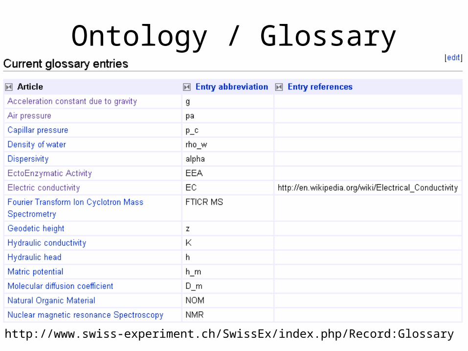
Ontology / Glossary
http://www.swiss-experiment.ch/SwissEx/index.php/Record:Glossary

Experiment set-up
• assigning a name to a sensor station– when does a name change?
• recording of meta data– using controlled vocabulary
• persistence of data
• publishing of data– e.g. SensorMap

Experiment maintenance
• change over time of senor positions, names
• maintenance and exchange of instruments
• re-calibration or configuration of instruments

Data access, processing and visualization
• find relevant sensors– e.g. based on spatial constraints
• select relevant data– more information by environmental engineers
• process or visualize derived data– existing code is based on applications (ArcGIS,
MatLab)– document processing instructions and results
• integrated UI– data provenance?

Overall coordination
• tagging– personalized organization of content
• calendar– temporal organization
• map– spatial organization
for knowledge management and project coordination
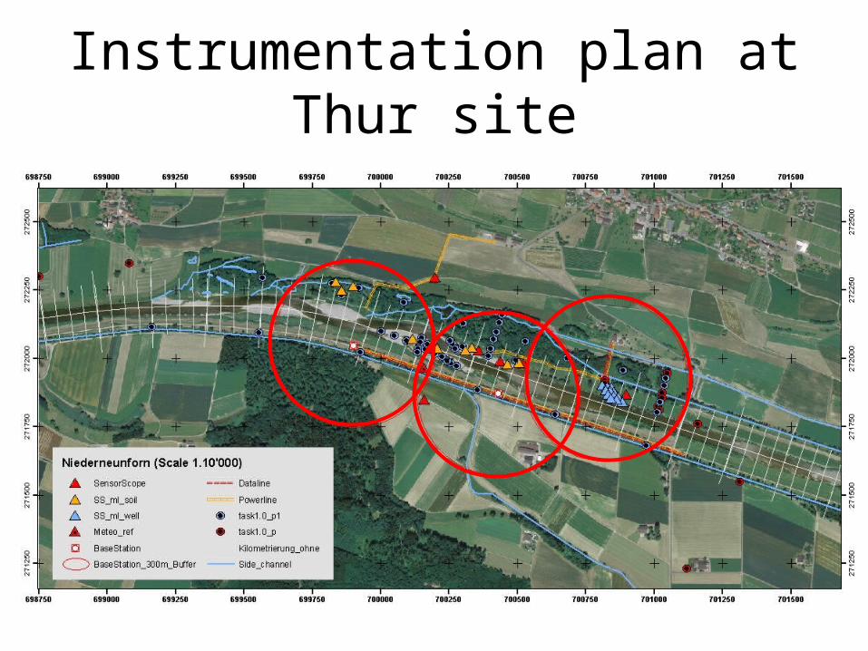
Instrumentation plan at Thur site
Related Documents


