[email protected] SUSTAINABLE DEVELOPMENT AND DISASTER RISK REDUCTION: AN INSIGHT INTO GEOSPATIAL ROLES IN MALAYSIA Khamarrul Azahari Razak 1,2 , PhD 1 UTM Razak Faculty of Technology and Informatics 2 Disaster Preparedness and Prevention Center Malaysia-Japan International Institute of Technology Universiti Teknologi Malaysia (UTM) Kuala Lumpur [email protected] I 019 3649495 National Geospatial Information Symposium (NGIS) 2018 Geospatial in Environmental Sustainability I 10-11 July 2018 @ Putrajaya

SUSTAINABLE DEVELOPMENT AND DISASTER RISK REDUCTION…ngis.mygeoportal.gov.my/sites/default/files/ngis8/... · [email protected] SUSTAINABLE DEVELOPMENT AND DISASTER RISK REDUCTION:
Jun 28, 2020
Welcome message from author
This document is posted to help you gain knowledge. Please leave a comment to let me know what you think about it! Share it to your friends and learn new things together.
Transcript

SUSTAINABLE DEVELOPMENT AND DISASTER RISK REDUCTION:AN INSIGHT INTO GEOSPATIAL ROLES IN MALAYSIA
Khamarrul Azahari Razak1,2, PhD
1 UTM Razak Faculty of Technology and Informatics 2 Disaster Preparedness and Prevention Center Malaysia-Japan International Institute of TechnologyUniversiti Teknologi Malaysia (UTM) Kuala Lumpur
[email protected] I 019 3649495
National Geospatial Information Symposium (NGIS) 2018Geospatial in Environmental Sustainability I 10-11 July 2018 @ Putrajaya

BEFORE
AFTER
20
15
Sab
ah E
arth
qu
ake
1. SDG vs DRR
2. Roles of Geospatial
3. Multi-Hazard and Risk Assessment
4. Mainstreaming DRR into Development Planning in Malaysia
5. Concluding remarks
CONTENTS

Khamarrul Azahari Razak, PhD 1,2
1 Senior Lecturer, Research Manager, UTM RAZAK School of Engineering and Advanced Technology2 Research Member, Disaster Preparedness and Prevention CenterMalaysia-Japan International Institute of TechnologyUniversiti Teknologi Malaysia (UTM) Kuala Lumpur
Ph.D (Geosciences, Landslides, Remote Sensing)Faculty of Geosciences, Utrecht University, Utrechtwith cooperation of ITC-University of Twente, United Nation University UNU-DRM Center for Spatial and Risk Management, The Netherlands
National Involvement: Technical expert in the National Project (Slope Hazard and Risk Mapping) (2014-2015) appointed by Minerals and Geoscience Department Malaysia, Ministry of Natural Resources and Environment Malaysia; Consultants in Revision of National Slope Master Plan 2009-2023 Public Work Department; National Guidelines for Disaster Resilient Cities by PLANMalaysia; Resilience of Critical Infrastructure by CREAM CIDB
Membership: European Geosciences Union; Asia Oceania Geoscience Society; IEEE Geoscience and Remote Sensing Society; Asia-Pacific Network on Climate Science and Technology; Asia-Pacific Network for Global Change Research; Royal Institution of Surveyors Malaysia, Institution of Geospatial and Remote Sensing Malaysia, Malaysia Nature Society; Member of the Academy of Sciences Malaysia Disaster Risk Reduction Alliance Committee (DRR Alliance); Society for Engineering Geology and Rock Mechanics Malaysia (SEGRM)
Awards: Top 11 Young World Geomorphologists, awarded by the International Association of Geomorphology in Paris 2013 & Merdeka Awards Receipient Grant (Petronas, Shell, Exxon) 2016; Global Young Academy (GYA)
2016-2020Multi-hazard & Disaster Risk (Kyoto University, Japan); Earthquake and Cascading Geohazard (Taiwan), Co-seismic landslides (National Center of Excellence in Geology, Pakistan); Disaster Informatics (National Information Society Agency, Korea); Geospatial Business Continuity Planning (JICA); Risk Cities Initiative (RiskCities-i) TU Berlin, HFT Stuggart, UFZ Helmholtz Germany; Disaster Resilient (IRIDeS, Tohoku University, Japan)

MULTI GEO-HAZARD RESEARCH THEME
2015 - 2020
International Research Grants@ UTM-MJIIT & Japanese University Consortium
High Impact Joint Publications @ ISI publications & Policy Papers
Contract Research & Consultation@ Research application- & Problem solving-oriented
Professional Training & Workshop@ Integrated Disaster Risk Management
Post-Graduate Teaching & Supervision@ Master of Disaster Risk Management @ MJIIT I ASEAN & JAPAN
Advancing disaster risk reduction in a changing environment
Multi-Geohazard and Disaster Risk Laboratory (Geohazard Lab) @ Universiti Teknologi Malaysia (UTM) Kuala Lumpur

https://globalyoungacademy.net
The Global Young Academy (GYA) aims tobecome the voice of young scientists aroundthe world. To realise our vision, we develop,connect, and mobilise new talent from sixcontinents. We empower young researchersto lead international, interdisciplinary, andinter-generational dialogue with the goal tomake global decision making evidence-basedand inclusive.
GYA counts 171 alumni in addition to its 200members; together representing 77 countries.
Acknowledgement & Contribution !!!
National Geospatial Information Symposium (NGIS) 2018Geospatial in Environmental Sustainability I 10-11 July 2018 @ Putrajaya

National Geospatial Information Symposium (NGIS) 2018Geospatial in Environmental Sustainability I 10-11 July 2018 @ Putrajaya
As core development strategies, 10 of the 17 SDGs with 25 targets are identified relatedto disaster risk reduction (DRR). Given extreme climate and rapid urbanization, it iscrucial for us to better cope the disaster capacity, assessing our increased exposure tonatural hazards and advancing our understanding disaster by science and technology.

National Geospatial Information Symposium (NGIS) 2018Geospatial in Environmental Sustainability I 10-11 July 2018 @ Putrajaya
https://www.preventionweb.net/drr-framework/sendai-framework-monitor/common-indicators
Integrated monitoring of the global targets of the Sendai Framework and the Sustainable Development Goals

National Geospatial Information Symposium (NGIS) 2018Geospatial in Environmental Sustainability I 10-11 July 2018 @ Putrajaya

htt
ps:
//u
nst
ats.
un
.org
/sd
gs/f
iles/
rep
ort
/201
7/T
heS
ust
ain
able
Dev
elo
pm
entG
oal
sRe
po
rt2
017
.pd
f
A set of significantdevelopment challenges can be mapped, analyzed, and modelled within a geographic context.
The 2030 Agenda specificallydemands the need for highquality, timely, reliable and disaggregated data, including earth observation, geospatial information and Big Earth Data analytics.
National Geospatial Information Symposium (NGIS) 2018Geospatial in Environmental Sustainability I 10-11 July 2018 @ Putrajaya

htt
ps:
//w
ww
.ear
tho
bse
rvat
ion
s.o
rg/d
ocu
men
ts/p
ub
licat
ion
s/2
01
70
4_g
eo_u
ngg
im_
4p
ager
.pd
f
National Geospatial Information Symposium (NGIS) 2018Geospatial in Environmental Sustainability I 10-11 July 2018 @ Putrajaya
The global indicator framework wasdeveloped by the Inter-Agency andexpert Group on SDG Indicators (IAEG-SDGs) and adopted by the UnitedNations Statistical Commission inMarch 2017 and by the United NationsGeneral Assembly in July 2017. Thisset of indicators is intended for thereview of progress at the global level.

htt
ps:
//w
ww
.ear
tho
bse
rvat
ion
s.o
rg/d
ocu
men
ts/p
ub
licat
ion
s/2
01
70
4_g
eo_u
ngg
im_4
pag
er.p
df
Geospatial data & information has been mapped to target, goals, and indicators of SDGs
National Geospatial Information Symposium (NGIS) 2018Geospatial in Environmental Sustainability I 10-11 July 2018 @ Putrajaya

GEO
do
cum
ent
use
dfo
ra
sid
e-ev
en
tat
the
47
thSe
ssio
no
fth
eU
nit
edN
atio
ns
Stat
isti
cal
Co
mm
issi
on
Stat
isti
cal-
Geo
spat
ial
Inte
grat
ion
Foru
m-
Geo
spat
ial
Info
rmat
ion
and
Eart
hO
bse
rvat
ion
s:Su
pp
ort
ing
Off
icia
lSt
atis
tics
inM
on
ito
rin
gth
eSD
Gs
(Mar
ch,2
01
6).
Cre
dit
:GEO
https://www.earthobservations.org/documents/publications/201703_geo_eo_for_2030_agenda.pdf
National Geospatial Information Symposium (NGIS) 2018Geospatial in Environmental Sustainability I 10-11 July 2018 @ Putrajaya

National Geospatial Information Symposium (NGIS) 2018Geospatial in Environmental Sustainability I 10-11 July 2018 @ Putrajaya
A modern and advanced geospatial technology has great potential to help in providing accurate up-to-date topographic data, land-use-land-cover changes, anthropogenic activities, and elements-at-risk.
Advancement of satellite data (positioning, earth observation, and communication) coupling with GIS-oriented modelling and Big Data analytics-based sophisticated algorithms on machine and deep-learning techniques made the processing, analysis, and assessment
performed in real-time with high accuracy and efficiency.

National Geospatial Information Symposium (NGIS) 2018Geospatial in Environmental Sustainability I 10-11 July 2018 @ Putrajaya

National Geospatial Information Symposium (NGIS) 2018Geospatial in Environmental Sustainability I 10-11 July 2018 @ Putrajaya

National Geospatial Information Symposium (NGIS) 2018Geospatial in Environmental Sustainability I 10-11 July 2018 @ Putrajaya

https://www.unisdr.org/we/inform/disaster-statistics
“Access to information is critical to successful disaster risk management. You cannot MANAGE what you cannot MEASURE”
National Geospatial Information Symposium (NGIS) 2018Geospatial in Environmental Sustainability I 10-11 July 2018 @ Putrajaya

Assessing environmental and
socioeconomic impact, as a result of
development in an objective and
quantitative way is very challenging,
even with spatial and temporal
characterization remained elusive in
changing environment
The urbanization rate in Malaysia is predicted up to 85% in 2040 with a
population reaching about 46 million. There is an urgent need to monitor our
current and future development to be more sustainable and resilient.
National Geospatial Information Symposium (NGIS) 2018Geospatial in Environmental Sustainability I 10-11 July 2018 @ Putrajaya

“The more governments, UN agencies, organizations, business and civil society understand
risk and vulnerability, the better equipped they will be to mitigate disasters when they strike and
save more lives” – Ban Ki-moon, ex-United Nations Secretary-General
National Geospatial Information Symposium (NGIS) 2018Geospatial in Environmental Sustainability I 10-11 July 2018 @ Putrajaya
“Development drivers are stronger driver of the increase of risk than hazards themselves. In
order to limit economic losses in the future, we need to improve urban planning and make
economic growth resilient” – Jerry Velasquez, ex-UNISDR’s Chief of Advocacy and Outreach

In which
P(T│HS) = the temporal probability of a certain hazard scenario (HS);
P(S│HS) = the spatial probability that a particular pixel in the susceptible
areas is affected given a certain hazard scenario;
A(ER│HS) = the quantification of the amount of exposed elements at risk,
given a certain hazard scenario (e.g. expressed as the number or
economic values); and
V(ER│HS) = the vulnerability of elements at risk given the hazard intensity
under the specific hazard scenario
QUANTITATIVE HAZARD RISK ASSESSMENT
National Geospatial Information Symposium (NGIS) 2018Geospatial in Environmental Sustainability I 10-11 July 2018 @ Putrajaya

Van
Wes
ten
(20
15
)
STA
KEH
OLD
ER
INV
OLV
EMEN
T
National Geospatial Information Symposium (NGIS) 2018Geospatial in Environmental Sustainability I 10-11 July 2018 @ Putrajaya

A: Input dataB: Susceptibility assessmentC: Hazard assessmentD: Exposure analysisE: Vulnerability assessmentF: Risk assessmentG: Quantitative risk
•Economic risk•Direct•Indirect
•Population risk•Societal risk•Individual risk
H: Qualitative riskI: Risk reduction measures
Co
rom
inas
et a
l. (2
01
3)

1
2
43
5 6
7
8
10
9
1. Airborne LIDAR; 2. Terrestrial LIDAR, 3. GPS Survey, 4. Mobile GIS Field Mapping, 5. Data Processing, 6. LIDAR-Landslide Processing,
7. Landslide Inventory Mapping, 8. Landslide susceptibility Analysis, 9. Landslide Hazard Assessment, 10. Landslide Risk Assessment
National Initiative - Landslide Hazard and Risk Mapping Project - 2014-2016
Raz
aket
al.
(20
15
)
National Geospatial Information Symposium (NGIS) 2018Geospatial in Environmental Sustainability I 10-11 July 2018 @ Putrajaya

SEM
INA
R G
AR
IS P
AN
DU
AN
PER
AN
CA
NG
AN
P
EMB
AN
GU
NA
N D
I KA
WA
SAN
BU
KIT
& T
AN
AH
TIN
GG
I K
AW
ASA
N S
ENSI
TIF
ALA
M S
EKIT
AR
NEG
ERI S
ELA
NG
OR
12
-05
-20
15
I Sh
ah A
lam
, Sel
ango
r
http://www.alliedmarketresearch.com/lidar-market
Global LiDAR Market (2013 – 2020)
htt
p:/
/ww
w.a
llied
mar
ketr
esea
rch
.co
m

STUDY AREA @ KUNDASANG, SABAH
7 April 2015
20 July 2015
National Geospatial Information Symposium (NGIS) 2018Geospatial in Environmental Sustainability I 10-11 July 2018 @ Putrajaya

New capability of modern
LiDAR system for recording
full-waveform spatial data
Hö
fle
& R
utz
inge
r(2
01
1)
Razak et al (2014)
High density airborne LIDAR is a powerful tool for
mapping, monitoring & modelling of the disaster
prone area
Topographic Laser Scanning System (LiDAR) is the most advanced geospatial technology in the last millennium
Courtesy of BUMITOUCHplmc
National Geospatial Information Symposium (NGIS) 2018Geospatial in Environmental Sustainability I 10-11 July 2018 @ Putrajaya
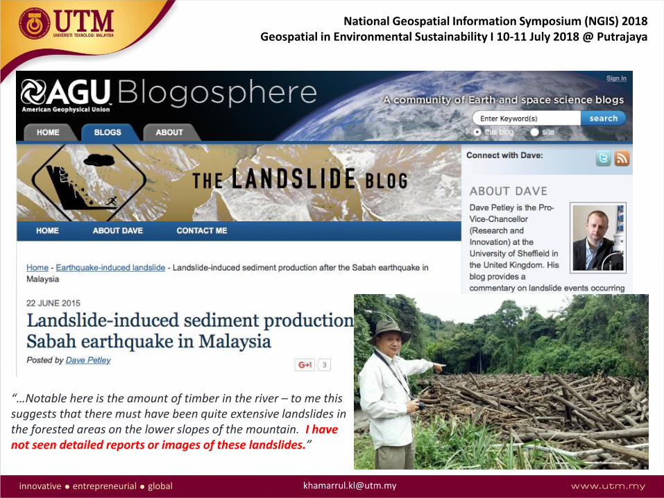
“…Notable here is the amount of timber in the river – to me this suggests that there must have been quite extensive landslides in the forested areas on the lower slopes of the mountain. I have not seen detailed reports or images of these landslides.”
National Geospatial Information Symposium (NGIS) 2018Geospatial in Environmental Sustainability I 10-11 July 2018 @ Putrajaya

Vu
lnera
ble
Cit
ies in
Pen
insu
lar
Mala
ysia
Sou
rce:
Nat
ion
al P
hys
ical
Pla
n 3
Fed
eral
Dep
artm
ent
of
Tow
n a
nd
Co
un
ty P
lan
nin
g Pe
nin
sula
r M
alay
sia
Mainstreaming Disaster Risk Reduction (DRR) into Development Plan/ControlNational Physical Plan (National), State Structural Plan (State), District
Development Plan (District), Special Development Plan (Specific Areas)
National Geospatial Information Symposium (NGIS) 2018Geospatial in Environmental Sustainability I 10-11 July 2018 @ Putrajaya

UTM RAZAK School of Engineering and Advanced Technology
Disaster Preparedness and Prevention Center, MJIIT
Universiti Teknologi Malaysia (UTM) Kuala Lumpur
R = f (D,A,T)
An Integrated Research Framework“Disaster Resilience Model”
Where R: Resilience; D: Damage = f (H,E,V); A: Human Activities; T: Time
where D = f (H,E,V)
R = f (H,E,V,A,T)Prevention Recovery

Mapping potential debris flow torrents
Analyzing regional susceptibility zones for debris flow
Inventory of possible affected zones/community & Elements-at-risk
Assessing debris flow hazard & risk
Disaster Info. (database development
Updating & dissemination)
Warning
Evacuation
Disaster analysis
Rainfall based model
Early warningsystem
Rainfall >Threshold
When?
(Monitoring & Prediction)
Engineering Landuse restriction
Residential Relocation Evacuation**
Where (spatial)?
Where (temporal) & What (risk level)?
What & How (vulnerability)?
Framework for Sediment Disaster Management
National Geospatial Information Symposium (NGIS) 2018Geospatial in Environmental Sustainability I 10-11 July 2018 @ Putrajaya

ISL 2004
Elements
at risk
data
collectio
n.
Summary
ELEMENTS AT RISK
FOR MULTI-HAZARD
AND DISASTER
RISK
Van
Wes
ten
et a
l. (2
01
5)

Sustainable and Resilience for Critical Infrastructure Construction in Malaysia
National Disaster Management Agency
National Geospatial Information Symposium (NGIS) 2018Geospatial in Environmental Sustainability I 10-11 July 2018 @ Putrajaya

2016 EBC-K Project to Facilitate ICT Application in the Asia-Pacific
ICT & Disaster Resilient @ Malaysia 2017-2018EBCK - Extra Budgetary Contribution from the Republic of Korea
Project to Facilitate ICT Applications in the Asia Pacific
Community-based Disaster Informatics for Building Resilient Cities
http://kl.utm.my/ebck-ict-disaster

The Selangor Government’s
mission statement is to become a smart state
by 2025.
The blueprint outlines twelve key dimensions
of what Selangor considers as a priority
to turn itself into a smart state with the key aim of improving
citizen’s quality of life.
34
12 Key Dimensions Of Selangor Smart State
An Integrated research ICT-Disaster Resilient (EBC-Korea) Project significantly supports the Selangor Smart 2025 initiative
National Geospatial Information Symposium (NGIS) 2018Geospatial in Environmental Sustainability I 10-11 July 2018 @ Putrajaya

ICT & Disaster Resilient @ Malaysia 2017-2018EBCK - Extra Budgetary Contribution from the Republic of Korea
Project to Facilitate ICT Applications in the Asia Pacific
http://kl.utm.my/ebck-ict-disaster/
Met
amo
de
lsys
tem
-A
rch
ite
ctu
re
METAMODEL-BASED GEOSPATIAL MULTI DISASTER PROTOTYPE SYSTEM (MGeoMR)
http://kl.utm.my/ebck-ict-disaster

Disaster Simulation Day 2018Full-scale I Command Post Exercise (CPX-Idaman)
27 February 2018 @ Serendah, Selangor
Jointly organized by:-
UTM RAZAK School of Engineering and Advanced Technology
Universiti Teknologi Malaysia (UTM) Kuala Lumpur
Disaster Management Unit, State Secretary Office of Selangor
Selangor State Disaster Management Committee
Hulu Selangor District Disaster Management Committee
htt
p:/
/kl.
utm
.my/
eb
ck-i
ct-d
isas
ter/
@ k
ham
arru
l.kl
@u
tm.m
y
ICT & Disaster Resilient I EBCK Project I UTM Kuala Lumpur - Asia Pacific Telecommunity (APT) & National Information Society Agency (NIA), Republic of Korea I 2017-2018

ICT & Disaster Resilient @ Malaysia 2017-2018EBCK - Extra Budgetary Contribution from the Republic of Korea
Project to Facilitate ICT Applications in the Asia Pacific
http://kl.utm.my/ebck-ict-disaster/
Landslide Disaster Simulation Drill @ Serendah, Selangor
http://kl.utm.my/ebck-ict-disaster/cpx-idaman/

PUBLIC
HELP
MUTUAL
HELP
SELF
HELP
National Geospatial Information Symposium (NGIS) 2018Geospatial in Environmental Sustainability I 10-11 July 2018 @ Putrajaya

National Geospatial Information Symposium (NGIS) 2018Geospatial in Environmental Sustainability I 10-11 July 2018 @ Putrajaya

National Geospatial Information Symposium (NGIS) 2018Geospatial in Environmental Sustainability I 10-11 July 2018 @ Putrajaya
Submitted to Federal Ministry of Education and Research (BMBF) Germany “Sustainable Development of Urban Regions”

41
National Geospatial Information Symposium (NGIS) 2018Geospatial in Environmental Sustainability I 10-11 July 2018 @ Putrajaya
Submitted to Federal Ministry of Education and Research (BMBF) Germany “Sustainable Development of Urban Regions”

Three main components:
1) Technical assessment (hazard and risk)
2) Decision making (use cases)
3) Data management
New Approach : Multi-Hazard & Disaster Risk Management
Van
Wes
ten
et a
l. (2
01
5)
National Geospatial Information Symposium (NGIS) 2018Geospatial in Environmental Sustainability I 10-11 July 2018 @ Putrajaya

RiskChanges: Spatial Decision Support System for the analysis of
changing multi-hazard risk, based on possible future scenarios and
risk reduction alternatives
to analyse the effect of risk
reduction planning alternatives on reducing the risk now and in the future, and support decision
makers in selecting the best alternatives.
Users:
Civil protection organizations.
Organizations with the mandate to design structural risk
reduction measures
Planning organizations

Complexity of disaster – multisectoral & disciplinary group - special need & interest Action oriented program – scientific-based decision support – transdisciplinary approach
Sendai Framework for Disaster Risk Reduction 2015-2030: Progress & Challenges
National Geospatial Information Symposium (NGIS) 2018Geospatial in Environmental Sustainability I 10-11 July 2018 @ Putrajaya

National Geospatial Information Symposium (NGIS) 2018Geospatial in Environmental Sustainability I 10-11 July 2018 @ Putrajaya
Geospatial communities have been significantly contributing to the sustainabledevelopment. A paradigm shift into transdisciplinary approach for addressing complexityof future disaster and climate risk. An insight into roles and contribution of geospatialtowards making our cities more resilient and developing sustainable society in the future.
Global policy instruments, e.g. SDGs and SFDRR interlinkages made DRR as a cross-cutting issue in the SDGs. DRR, as an integral part of social and economic development,is a critical factor if development is to be sustainable for the near future.
It is imperative to establish persistent policy, institutional and methodologicalframework with the support of geospatial intelligence data for a comprehensivedisaster risk analysis, assessment and reduction.
CONCLUSION

Khamarrul Azahari Razak, PhDUTM RAZAK School of Engineering and Advanced Technology
Universiti Teknologi Malaysia
54100 Jalan Sultan Yahya Petra
Kuala Lumpur
Tel: +6019-3649495
Email: [email protected]; [email protected]
Web: http://www.razakschool.utm.my/khamarrul
Visiting address:-
Room no. 32, Level 6,
Malaysia-Japan International Institute of Technology (MJIIT)
Universiti Teknologi Malaysia
Jalan Sultan Yahya Petra, Kuala Lumpur
THANK YOU FOR YOUR ATTENTION
Disaster Preparedness and Prevention CenterMalaysia-Japan International Institute of TechnologyUniversiti Teknologi Malaysia (UTM) Kuala Lumpur
Geospatial Intelligence Research InitiativeCascading GeoHazards Research Initiative
UTM RAZAK School of Engineering and Advanced TechnologyUniversiti Teknologi Malaysia (UTM) Kuala Lumpur
54100 Jalan Sultan Yahya Petra, Kuala Lumpur
Related Documents