SUSTAINABLE CITY PARK VISION FOR CARIAPPA PARK, BANGALORE, INDIA by SREELATHA NAIR M.Sc. (Ag), KERALA AGRICULTURAL UNIVERSITY, INDIA, 1989 B.Sc. (Ag), KERALA AGRICULTURAL UNIVERSITY, INDIA, 1982 A THESIS SUBMITTED IN PARTIAL FULFILLMENT OF THE REQUIREMENTS FOR THE DEGREE OF MASTER OF LANDSCAPE ARCHITECTURE in THE FACULTY OF GRADUATE STUDIES (LANDSCAPE ARCHITECTURE) THE UNIVERSITY OF BRITISH COLUMBIA AUGUST 2006 © SREELATHA NAIR, 2006

Welcome message from author
This document is posted to help you gain knowledge. Please leave a comment to let me know what you think about it! Share it to your friends and learn new things together.
Transcript

SUSTAINABLE CITY PARK VISION FOR CARIAPPA PARK, BANGALORE, INDIA
by
SREELATHA NAIR
M.Sc. (Ag), KERALA AGRICULTURAL UNIVERSITY, INDIA, 1989 B.Sc. (Ag), KERALA AGRICULTURAL UNIVERSITY, INDIA, 1982
A THESIS SUBMITTED IN PARTIAL FULFILLMENT OF THE REQUIREMENTS FOR THE DEGREE OF
MASTER OF LANDSCAPE ARCHITECTURE
in
THE FACULTY OF GRADUATE STUDIES (LANDSCAPE ARCHITECTURE)
THE UNIVERSITY OF BRITISH COLUMBIA
A U G U S T 2006 © SREELATHA NAIR, 2006

A B S T A C T
The concept of sustainable development emerged as a consequence to a growing
awareness of the global environmental crisis. People all over the world are working
towards sustainable development. In addition to environmental criteria, quality of life is
an important indicator of the health of a city. Urban parks fulfill many social functions
and address the psychological needs of citizens, making them a very valuable resource
and a key ingredient for a sustainable city. Despite many challenges, countries like India
are slowly adopting measures to increase sustainability within their cities. Located in the
South Indian city of Bangalore, Cariappa Park is a small urban park. In its present state,
it fails to live up to its role as a provider of social, ecological and economic services to its
users. In this study, an attempt is made to look into the factors that have led to the failure
of this park. The study further proposes an alternative design for the park. The aim of the
proposed design is to inspire environmental consciousness and sustainable design
construction through example. The new design will fulfill many social, economic and
environmental functions, rendering Cariappa Park into a valuable municipal resource that
contributes to the well-being of its citizens and to the sustainability of the city of
Bangalore.
ii

T A B L E O F C O N T E N T S
Abstract ii Table of contents Hi List of Tables v List of Figures vi
Chapter 1 : Introduction 1 1.1 Statement of intent 2 1.2 The project goal 3 1.3 Project objectives 3 1.4 Methodology 4
Chapter 2: Literature review 5 2.1 Core sustainability issues 5 2.2 Sustainable landscapes 13 2.3Sustainable parks 13
Chapter 3: The Site 16 3.1 Project Location 16 3.2 Site context 16 3.3 Site inventory 20 3.3.1 People flow and access analysis 21 3.3.2 circulation and view analysis 22 3.3.3 degree of use analysis 23 3.3.4 Vegetation and slope analysis 23 3.3.5 users and preferred activities 25
Chapter 4: Precedent Studies 26 4.1 Nek Chand Rock Garden, Chandigarh, India 26 4.2 Osho Teerth Park, Pune, India 28 4.3 Dil l i Haat, New Delhi, India 30 4.4 Cariappa officers' colony, Bangalore 33
Chapter 5: Creating Sustainability together-The approach 36 5.1. Research Methodology 36 5.2 Sustainability Matrix for site Plan of Cariappa Park 37 5.3 Setting priorities for the site 38 5.4 Principles and Goals for site plan Of Cariappa Park 40 5.4.1 Social and community health 41 5.4.2 Water quality and quantity 43 5.4.3 Economic Prosperity 45
ii i

Chapter 6: Creating sustainability together-The Design 46
6.1Proposed program 46 6.2Program relationships 47 6.3Master plan 49 6.4Detailed design 65
Chapter 7: Design Evaluation and Conclusion 71 7.1 Design Evaluation 71 7.1.1 Design response to economic prosperity 71 7.1.2 Design response to social and community health 72 7.1.3 Design response to water quantity and quality 74 7.2 Design response to sustainability-Comparison 75 7.3 Conclusion 76
Bibliography 79
iv

LIST O F T A B L E S
Table 1 37
Table 2 76
Table 3 77

LIST OF F I G U R E S
Figure 1.1 Park Location 2 Figure 1.2 Park Then and Now 3 Figure 3.1 Project Location 16 Figure 3.2 Site Context 17 Figure 3.3 Site inventory 20 Figure 3.4 People flow and access analysis 21 Figure 3.5 Circulation and view analysis 22 Figure 3.6 Vegetation and Slope analysis 24 Figure 4.1 Artist Nekchand receiving solid wastes 26 Figure 4.2 Garden from solid waste 26 Figure 4.3 Group sculpture-women collecting water 27 Figure 4.4 monkeys watching traffic 27 Figure 4.5 Osho Teerth Park 28 Figure 4.6 Stream after treatment 29 Figure 4.7 Dil l i Haat 30 Figure 4.8 Di l l i Haat Stalls 31 Figure 4.9 Artists at work 32 Figure 4.10 Handicrafts for sale 33 Figure 4.11 F M Cariappa Officer Colony, Bangalore 34 Figure 6.1 Program relationship 47 Figure 6.2 Master Plan 49 Figure 6.3 Section A - A and section B-B 50 Figure 6.4Section K - K 51 Figure 6.5Sculpture Avenue 51 Figure 6.6 Experience Play area 53 Figure 6.7 Cariappa Haat 55 Figure 6.8 Section through Haat Pavement 56 Figure 6.9 Pavement section 56 Figure 6.10 Section C-C Butterfly roof-Performance area 57 Figure 6.11 Community garden 58 Figure 6.12 Rain chain 60 Figure 6.13 Plant Nursery 61 Figure 6.14 Existing Memorial 61 Figure 6.15 The Gates 63 Figure 6.16 Enhanced Promenade 64 Figure 6.17 Residential area detailed plan 66 Figure 6.18Residential area- Section 67 Figure 6.19 Sheltered recreation area 67 Figure 6.20 Sheltered seating area 68 Figure 6.21 Swale section 68 Figure 6.22 Vegetated infiltration basin 70 Figure 7.1 Surface water systems 74
vi

Chapterl: Introduction
1.1 Statement of intent
Sustainable development has become one of today's most topical phrases since the Publication
of our Common Future-the Brundtland Report to the World Commission on Environment and
Development (Brundtland and WCED) in 1987. This Concept emerged as a consequence of
gradual awareness to global environmental crisis. Now this has become a much researched and
sought after topic all over the World.
Though sustainable development is a global concept, its elements, practices and activities,
need to be addressed at the local level. Some cities have been developing their own sustainability
indicators to try and measure quality of life issues in a meaningful way. Besides environmental
criteria, quality of life issues are considered pivotal to all the various definitions of a sustainable city
(Chiesura, 2004). Urban parks and open green spaces are of strategic importance for quality of life
of our increasingly urbanized society They play an important role as providers of social services
essential to the quality of human life, which in turn is a key component of sustainable development.
(Ibid).
Despite many problems like population explosion, extreme poverty, resource
insufficiency and of late, terrorism, developing countries like India, are also adopting sustainability
in their national policies and advancing towards a sustainable future. Neverthless, they do encounter
some limitations due to lack of awareness and education regarding the concept of sustainablity
1

The inspiration for this project arose during my study program in Canada where I was
exposed to sustainable landscape designs. Most of the literature I encountered discussed the
situation in, and examples from Western countries where conditions are very different from those in
India. This project takes on the challenge of attempting to put this knowledge into and Indian
context, to inspire environmental consciousness and sustainable design by practically illustrating
them through an urban park. Cariappa Memorial Park in Bangalore, India was chosen as the study
site.
Cariappa Memorial Park, opened in 1996, is one of the latest additions to Bangalore's
public spaces (Figure 1-1). Spread over 22 acres, this park is situated in the heart of the city,
surrounded by M.G. Road, St. Marks Road, and Cubbon Road on its three sides, and the Army
parade ground on the eastern side. After its inauguration it attracted many of the residents because
of its strategic location in the heart of the city. However, in a very short time the Park failed to serve
its purpose, except that it remained an important green space in a built-up environment. Since it was
developed, it has become a neglected space, attracting vandalism and crime, and thus has a negative
impact on the society (
Figure 1.1 Park loction Source:Bangalore City road map
2

1.2 The project goal
The goal o f this project is to revitalize
Cariappa Park using sustainable measures, and
thus contributing to the sustainability of the city of
Bangalore. The focus is not only on the Park, but
also on how the Park connects to the surrounding
neighborhood and public space, making the area a
more safe and vibrant place filled with people, not
just park elements.
1.3 Project objectives
The intention of this study is to:
> To Explore an approach to integrate the
design with sustainable principles
> Develop a set of new design Goals and
Objectives based on sustainability
principles for Cariappa Park;
> To offer an alternative design for Cariappa
3. Mini waterfall
4. Main waterfall
5. Band stand
6. Memorial area
8. Children's play area
10. Lake site
Park, which w i l l make the area more safe and YJ^l^l The Park then and now
vibrant place filled with people not just park
elements.
3

1.4 Methodology
The following set of steps outline the methodology followed in the project:
> Literature review of the concept of sustainable development
> Use of Mark Holland's framework for sustainability to connect the concept of sustainable
development to the development of design principles and guidelines for Cariappa Park.
> Thesis committee review
> Revision to design guidelines
> Development of site inventory and photo documentation to analyze existing site conditions
> Guided by the guidelines, use precedent studies to explore design strategies and propose a
new master plan for the Park.
4

Chapter 2: Literature Review
2.1 Core Sustainability Issues
The 20 t h century has seen a marked increase in environmental degradation and an
awareness that the levels at which we are using the natural resources of our planet are
unsustainable (WCED, 1987). In recognition of the consequences that were becoming
increasingly evident, the United Nations (UN) sponsored the World Commission on
Environment and Development in 1987 to author the book, Our Common Future. As a
result of this pivotal study the term "sustainable development" was first coined. In this
book, sustainable development was defined as "development that meets the needs of the
present without compromising the ability of future generations to meet their own needs"
(WCED, 1987, p.43). This statement addresses the concern over the extent to which
ecosystems can continue to survive with the level of demand that is being placed on them
by human desire for our present conception of development. In other words,
sustainability refers to the "need to improve the human condition, while caring for, and
protecting the natural environment at the same time" (Sheltair Group, 1998, p20).
By the turn of the century, nearly half of the world's population was living in
urban areas (WCED, 1987). The manner in which we will choose to develop these urban
areas will largely determine our success or failure in overcoming environmental
challenges, and achieving sustainable development.
Cities provide enormous, untapped opportunities to solve environmental challenges, and local governments must and can pioneer new approaches to sustainable development and urban management. They must also assume the responsibility and marshal the resources to address the environmental problems facing their communities (Roseland, 1992, p20).
5

In urban areas, the development of any community that purports to be sustainable
must use "an evolving set of principles and practices to make decisions that minimize
negative environmental impacts while ensuring positive social and economic benefits."
(NIPC, 2004, p.l)
The previously discussed 1987 World Commission on Environment and
Development (WCED) has offered the following points of concern as core issues. These
core sustainability issues provide a foundation for developing fundamental sustainable
principles for sustainable urban development.
Economic prosperity
Sustainability recognizes the need for the maintenance of economic prosperity
and resilience in order to maintain the health of a community (WCED, 1987). It can be
achieved by developing a strong local economy, which stabilizes and revitalizes
communities, by providing revenues needed to make improvements in education,
government services, infrastructure, and community amenities. A skilled community
workforce provides incentives for business investment. This creates jobs for local
workers, lowers employee recruitment costs, and increases overall productivity by
reducing labor shortages and turnover. When more workers stay within the community to
work, overall commute distances are decreased and local transit use is promoted.
Supporting small and independent businesses helps keep profits in the community,
supports local, family-owned businesses, and provides a stable economic foundation
(Ekins, et a l , 1992).
6

Social and community health
Inequity and lack of understanding among citizens are often the major obstacles in
promoting the concept of sustainable development. The "satisfaction of human needs and
aspirations is the major objective of development" (WCED, 1987, p. 43).
Social sustainability refers to "the ongoing ability of a community to
function as a safe, healthy and viable setting for human interaction, education,
employment, recreation and cultural development (Sheltair Group, 1998, p.23). Social,
cultural and community cohesion can be promoted in many ways. For example,
connecting public spaces to surrounding neighborhoods and adjacent open spaces may
facilitate interaction between people from a variety of neighborhoods. This type of local
planning can have the effect of nurturing a sense of belonging to a particular place
(Paterson and Connery, 1997). The use of green streets and linear parks may further
enhance these connections by maximizing contact between people and natural processes.
Pedestrian movement along green streets, through neighborhoods, past schools, playing
fields, libraries, shops and public plazas allows people of diverse ages to experience the
multitude of activities that occur on a daily basis (Ibid). This type of interaction is very
valuable, especially for children, as it encourages them to safely explore the adult world
where, through observation, they can learn invaluable lessons on how to behave and
interact in their society.
7

Food security
The world is experiencing growing concerns over the security of the global food
supply due to international political instability and depleted energy reserves that are
relied upon to transport food. Consumers are separated from the sources of their food.
Spatial distancing refers to the physical separation of producers and consumers; vast
quantities of energy are required to process, refrigerate and transport food to the
consumer (Fairholm, 1998) In order to adequately address this problem, we must begin
by rethinking and redesigning our food system. Local food security ultimately depends
upon local food sources. A community that produces a proportion of its own food can
contribute to its own security and thus reduce its dependence on expensive imported
food. Community gardens can play a crucial role here. In addition to growing food
locally, they also bring citizens together to forge new relationships based on common
goals and values. These are connections that mark a collectivist society - one based on
affiliations of people - rather than on individualism through individual achievement
(Kaplan, 1993). It is not surprising that affinitive societies have been shown to cope
better with stress and adversity (Ibid) and are therefore healthier societies that express a
sustaining hope for the future.
Sustainability in terms of food security therefore, would place a strong focus on
maintaining a healthy and local food economy, where the local citizens would be aware
of, and active participants (to the extent possible) in the production and processing of
their food. The presence of community or personal gardens using healthy and organic
methods of farming (particularly in an urban setting), for example, help to connect people
and foster their interest, investment and understanding about their food supply.
8
Air quality
Air quality is one of the most critical issues facing any growing metropolitan area
in the world. Air pollutions can result in increased acid rain, which deteriorates buildings
and disrupts the chemistry of lakes and soil, impairing their ability to support life. The
emission of greenhouse gases can increase the risk of climate change. Ground-level
ozone, as one type of air pollution can interfere with the ability of plants to produce and
store food (NIPC, 2004).
Strategies to protect air quality often include: practicing compact, mixed-use,
transit-oriented, and pedestrian-oriented development to reduce the need to travel by
automobile; planting trees and other native vegetation that help cleanse the air, produce
oxygen, and require less maintenance (mowing, fertilizers, and pesticides); and
maintaining open space networks that provide ample area for trees and other plants that
produce oxygen and filter the air.
Energy supply
The combustion of fossil fuels (such as natural gas, coal, gasoline, diesel, and
propane), is presently a major resource for energy supply worldwide. The global trend of
heavy use of fossil fuels is leading to the depletion of non-renewable resources. It has
been estimated that at the 1989 rates of production and consumption, oil will only last
until the year 2032, gas until 2053, and coal until 2380 (Sheltair, 1998).
Transportation, lighting and the thermal comfort requirement for buildings are
major consumers of non-renewable energy resources. Promoting pedestrian-oriented
9

development to reduce the need to travel by automobile, using natural site features (such
as landform, vegetation, sun angles), building orientation, and landscaping to provide
shade during summer and maximizing solar heating during the winter while taking
advantage of natural day lighting are some of the measures available to reduce the
negative impacts of heavy fossil fuel consumption.
Shifting away from reliance on non-renewable sources in favor of more
renewable sources is also a crucial factor in alleviating the energy supply crisis. Such a
switch would help to reduce emissions, increase energy security and insulate the
economy from energy price shocks associated with real or perceived energy constraints.
Water Quantity and Quality
Water forms the backbone of natural ecosystems, and enables life to exist. Water
naturally flows in cycles, and human intervention can easily interrupt these cycles.
Conventional development patterns, with their prevalence of impermeable parking lots,
buildings and roads, serve only to increase the volume of storm water runoff from
development sites (Marsh, 1998). This increased volume contributes to downstream
flooding as the storm water is quickly removed from the site via storm sewer pipes to the
nearest water body. Along with flooding, the added volume of water causes stream
erosion and sedimentation; water pollution by toxic compounds washed off the road
surface, habitat degradation, and reduced ground water levels (Ibid).
Sustainable urban development endeavors to reduce surface runoff of storm water
to levels below that of pre-development. (Ibid). A crucial step in reducing downstream
flooding and improving the quality of aquatic environments is to bring old stream courses
10

back to the surface from the underground drainage pipes to which they were banished.
This process is also salient in making the water cycle visible and a part of every day life
(Paterson and Connery, 1997). When people can see a stream, they are more likely to
understand how it becomes balanced and to take responsibility for its health (Kaplan,
1993)
Holding water on a site for as long as possible after rainfall, and allowing it to
infiltrate into the ground, where feasible, are proven methods of reducing surface runoff
and channel loading (Marsh, 1998; Paterson and Connery, 1997). Holding storm water on
site also provides the opportunity to clean it of industrial, automotive, and domestic
pollutants before it is returned to surface or ground water. Retention basins in the form
of constructed wetlands and bio-filtration ponds make use of the natural functions of
aquatic plants to filter pollutants from water (Lyle, 1994; Marsh, 1998). Wetland plants
such as bulrushes (Scirpus spp.), cat tails (Typha spp.), reeds (Phragmites spp.), rushes
(Juncus spp.), and sedges (Carex spp.) are variously effective at reducing biological
oxygen demand, nitrogen, suspended solids, metals, trace organic compounds, and
pathogens (Lyle, 1994). Constructed wetlands and bio-filtration ponds are therefore
desirable elements for enhancing biological productivity and diversity.
Ecosystem Integrity
A l l life forms on the planet are connected in a web-like relationship. While the
connections may vary in strength, the impact of change occurring in one part of an
11

ecosystem inevitably has ripple effects on other parts of the ecosystem. Ecosystems,
which are high in biodiversity, tend to be more stable and resilient to stress and change
(Holland, 1996).
In order to maintain the integrity of ecosystems, it is important that all
developments carefully address the issues of ecosystem planning and biodiversity (Ibid).
This can be achieved through the protection of ecologically sensitive areas/species, and
through the development of areas in ways that minimize negative impacts. Through
planning and designing natural plant and animal habitat areas into our local
developments, we can ensure that they will be more sustainable over the long term.
Resource Efficiency
Sustainability means that the depletion rates of renewable resources should not
exceed the regenerative capacity of the natural system that produces them. According to
the World Watch Institute, 40 percent of materials entering the world's economy are used
in the construction and operation of buildings (Roodman, 2005). This quantity is well
above the carrying capacity of the resource base and cannot be sustained (Sheltair Group,
1998).
Sustainability objectives in terms of resource efficiency highlight the need to
increase economic efficiency and performance by reducing the consumption of scarce,
non-renewable resources in favor of renewable resources, and by essentially eliminating
the concept of waste, in favor of principles of efficiency, re-use and recycling. (Holland,
2003)
12

2.2 Sustainable landscapes
Robert L. Thayer has defined a sustainable landscape as "a physical place where
human communities, resource uses and the carrying capacities of surrounding ecosystems
can all be perpetually maintained" (Thayer, 1994, p.235). Sustainable landscapes
contribute to the well-being of mankind, do not deplete or destroy other ecosystems,
conserve invaluable natural resources like water, soil nutrients, energy, and are
considered to function in harmony with the natural environment (CELA, 1988).
Sustainable landscapes therefore are an essential grounding element in the transition to a
new philosophical framework. They serve as an antidote to the increasingly common
world of consumption and technology whose end result is the destruction of nature and
the development of human environments which are devoid of soul, alienating and
resemble concrete jungles (Thayer, 1994).
2.3 Sustainable Parks
Sustainable parks are the new wave in park development. Dr. Galen Cranz and
Michael Boland of the University of California at Berkeley have studied the history of
parks and have looked for ways to integrate human and ecological systems in public open
spaces. Through their research, Cranz and Boland have come up with a new model for
urban parks called Sustainable Parks (Cranz and Boland, 2004). They have identified the
following characteristics of sustainable parks.
13

Sustainable parks:
• Attempt to become self-sufficient with regard to material resources • Can play a role in solving larger urban problems outside their boundaries when
they are integrated with the surrounding urban fabric. New aesthetic forms emerge for parks and other urban landscapes
• Use green building techniques such as solar power, rain water reuse, grey water for irrigation, etc. to minimize ecological costs of construction and ongoing use
• Employ the best management practices to ensure healthy ecosystems, e.g. river buffers, using native, non-invasive, environmentally appropriate plant choices, etc.
• Encourage partnerships with other entities to foster community support • Have a strong sense of place and identity • Recycle waste products as much as possible • Do not waste limited resources • Enhance the environment, and do not degrade it • Build community, relationships, trust and goodwill • Educate the public about the value of natural resource stewardship • Enhance wildlife habitats • Create a low impact on the environment • Do not pollute • Involve the public in many ways (as. partners, customers, volunteers, participants,
stakeholders, etc.) • Respect both nature and people • Promote alternative forms of transportation (e.g. greenways)
Public parks can profoundly influence the quality of life in urban communities.
This influence can be beneficial i f the open spaces are planned thoughtfully and it can be
deleterious i f they are not. Planning public parks with the needs of both people and nature
in mind requires intricate and varied connections to be made. The objective in the
planning is ultimately to conserve the natural environment while "reshaping" the built
environment (Roseland, 1992). These connections can be physical connections - such as
linear parks connecting neighborhoods - or conceptual connections - such as those that
arise when a child first realizes where the rainwater that falls on his/her roof goes.
14

Planning sustainable parks that w i l l satisfy the needs of both people and nature
requires careful forethought, creativity and attention to the actual and potential
relationships that w i l l make such a park, and thus community and the natural
environment flourish. The nature of the daily interactions between neighbors and
strangers, people and nature, and between the various elements of natural systems must
all be given careful consideration. The sustained health of both the natural and social
environments relies upon the nature of these complex interactions. Through well thought-
out and careful planning, new and dynamic relationships can be formed, facilitating
creative, healthy and dynamic environments with a renewed social, cultural and
recreational life, as well as opportunities for relaxation, education, and appreciation of the
natural environment etc. Such an environment w i l l inevitably foster a coming together of
diverse people, along with natural elements, which would otherwise not have the
opportunity to interact. The needs of nature also become satisfied, creating more healthy
and satisfying environment for all .
15

Chapter 3 The Site
3.1 Project location
The project site is located in the city of Bangalore
(Figure 3.1), in South India. Figure. Bangalore first earned the
title of "Garden City" in the mid-19th century, after two of its
famous garden landmarks; Lalbagh (1856) and Cubbon Park
(1870) were established. Plentifully planted flowering trees, both
exotic and indigenous, ensured that the name became a well-
deserved one. Figure 3.1
As a result of fast growth in software sector, Bangalore is
considered as "Techno polis" of India. Because of its cosmopolitan nature, it attracts people from all
over India and abroad. With a population that is presently 7.2 million, Bangalore is spread over an
area of 500 sq. kms, 3000 ft. above sea level. The warmest months are March through to May.
Bangalore benefits from both the Southwest and Northeast monsoons. The average annual rainfall is
900mm. Monsoon season is from October to November and dry months are from December to
March. Maximum temperature is 33 degree C and Minimum temperature is 14 degree C
Founded by Kempegowda in 1537,city is also famous for its silks, ivory products, and
sandalwood and granite stones.
3.2 Site context
Cariappa Park in Bangalore is located between 12 degrees 8'N latitude and 77 degrees37' E
longitude. It is bounded by Mahatma Gandhi Road (MG. Road) on the South, Cubbon Road on the
North, St. Marks Road on the West and Kamaraj Road on the East (Figure 3.2). The site has a good
16

sense of enclosure. The buildings on M G Road, Cubbon Road, Kamaraj Road and St. Marks Road
(Chinna Swami stadium) help to provide this sense of enclosure. A void emerges from a dense
urban fabric, making this an ideal lung space in the heart of the city. (Fig 3.2)
Site context
History of the site
The present Cariappa Park is a part of a parade ground or Parade maidan, now known as
Field Marshal Manekshaw Parade Ground. It stretches over 1.5 km from East to West, and is
surrounded by a ride, or mall called 'Rotten Row'. This area is more or less the hub of Bangalore
Cantonment. Cariappa Park consists of an open field of leveled dirt, which is used as a ceremonial
space, as well as a parade ground by the defense services (Deccan Herald, Jan 22, 2005) According
to Anuradha Mathur and Dilip da Cunha (2006), the parade ground was a segment of a mile long
esplanade. The site was a tank that was filled by the British army to the level of the bund that ran
along its Southern edge. (The raised walk or promenade adjacent to the Cariappa Park on North side
South parade (MG Road today.). During the colonial times South Parade was a place where much
business was conducted in Bangalore. During these times also, the Parade Ground was an important
ceremonial space with a bandstand, where military bands played, and parades were held. The bridle
17

path, also known as the "Rotten Row" was a popular promenade where people came to see others,
and to be seen. In June 1996, a part of the parade ground was converted into Cariappa Memorial
Park. Today, the Parade Ground continues to be used mostly for military ceremonies, and
occasionally for concerts, and also as a temporary parking space.
The Indian army owns the Field Marshall Cariappa Park grounds. Since it is in the heart of
Bangalore city, where commercial development is extremely high, the importance of keeping this
area as a 'lung-space' cannot be over looked. While the army is trying to keep this as an open-
space, the civil administration is lobbying the army hierarchy for allowing it to be used for
developmental purposes (Deccan Herald, June 23, 2005). The army, in keeping with its principles
of environment protection, and in an effort to not allow the civilian plans for the area to take hold,
tried to develop it into a park in 1994. The public lobbied to have this done, and a landscape
architect came up with a plan. Due to various reasons, the L A ' s plan was not implemented. Instead,
a separate plan, which included a twenty-seven foot waterfall, was created. The overuse of water
energy and the lack of proper management were cited as some of the reasons for the plan's ultimate
failure.
Increased terrorist activity in Bangalore, such as the recent incident at the Indian Institute of
Science in Bangalore has become a continued threat to Cariappa Park since this park is located in a
VIP-frequented area. Sales of food products, and dog walking were not permitted in the park. The
absence of drinking water facilities and park amenities like benches and washrooms also kept
people away from the park. The park failed as a social gathering space. The army named the park
as an "Army Environmental and Ecological Training Area" without incorporating any sustainability
principles, as the name would suggest. Although, the Army failed in its main objective of creating
an environmental education area, it did succeed in retaining its land ownership by converting it in to
a green space. Today, the park is a weed-infested area that is totally neglected by the public. This
18

study is undertaken in order to come up with a plan to revitalize Cariappa Park using sustainable
technologies, and to further make it into a model of a Sustainable Park.
Street character
The streets surrounding the parade ground each have a distinct character, which is strongly
influenced by the surrounding land use. M G Road is a very busy commercial street with heavy
vehicular and pedestrian movement. Cubbon Road has a distinctly military atmosphere, with its
parade ground and Cariappa Park on one side, and military buildings on other. Compared to M G
road, Cubbon Road has lesser vehicular movement.. St. Marks Road and Kamraj Roads are
comparatively calmer with regard to traffic.
Land use around the Cariappa Park and parade ground
Cubbon road is the northern boundary of Cariappa Park. The area on its Northern edge of
has a mix of military and commercial land use. The head quarters of K K & G sub area, responsible
for the park management is also located in this complex. The 200-year-old St Andrews church, is an
historic landmark, which dominates the area with its tall spire. The land on western edge of
Cariappa Park is classified as open space and is used as police parade ground.
The area on the southern edge of Cariappa Park and parade ground is M G road, which consists
of offices, shops, restarurants, pubs, and a movie theatre. It is the busiest part of M G road
supporting heavy pedestrian traffic. Pedestrians like to linger in this area and. The adjacent
promenade which is physically part of Parade ground and is visually a part of M G road. People like
sitting on the benches along the promenade and observing street life.
19

Sidewalk along the eastern edge of parade ground is a major pedestrian axis extending from
brigade road in the south to Commercial Street on the North (Both are two busiest roads in
Bangalore). The western edge of Cariappa Park is St marks road is used as police parade ground.
3.3 Site inventory and analysis
3.3.1 Site inventory (Figure 3.5)
1. Pedestrian entry and service vehicle access
2. Office building 3. Mini waterfall 4. Main waterfall
5. Band stand
6. Cariappa memorial area
7. Main gate and entry plum 8. Children's play area
9. Golden palm
10. Lake site
11. Rock garden
12. Parade ground
Legend:
J3 _ Cubbon road
St. Marks road
MG road
Kamraj road
Boundary walls
Primary pedestrian routs
, . . Secondary pedestrian routs
Figure 3.5
The Cariappa Park is a part of the Army Parade ground extending in an area of 22 acres. A
surrounding boundary wall protects the park with main public entrance at St. Marks Rd. and a
private entrance for military management at the Cubbon Rd. The major attraction to the park is the
27 feet waterfall at the northwest corner of the park and a mini waterfall with a lily pond in the
20

center (both are derelict now). This park was made to honor F M Cariappa for his contribution to the
Indian army. There is a memorial area for field Marshall Cariappa with an eight-foot tall granite
statue. This area is well maintained by the army and is used on ceremonial occasions. There is a
bandstand set in a lawn in the center of the park. The bandstand is surrounded by grassy mounds
meant for people to sit and watch the military band performances. There is a manmade lake at the
south end of the park that has been filled due to silting and poor management. Another attraction to
the park is the adventure play area for children. This area was previously well used before but is not
now.
3.3.1 People flow and access analysis
Figure 3.4
The only public entry into Cariappa Park is from St. Marks Road, and there is no public
parking available on this Road. The M G Road consists of offices, shops, restaurants, pubs, and
movie theatres and supports heavy pedestrian traffic as well as vehicular traffic. The primary people
flow to the park is from M G Road. When people are driving through this busy road, they fail to
21

notice the park, as no entry exists from this side. Even if they find roadside parking along M G
Road, they have to circle the park on foot to reach the park entrance at St Mark's Road. The
sidewalk along the Kamraj Road is a major pedestrian axis, extended from the busy Brigade Road
in the south to Commercial Street in the north. Based on the analysis, there is a need for more
entrances to the park, which would meet the requirements of people, vehicle flow and parking
availability (Figure 3.4).
3.3.2 Circulation and View Analysis
22

The circulation analysis (Figure 3.5) shows us that, there are two paths of circulation in the
existing park. The jogger's path forms an outer ring, and few secondary pathways reach the other
areas in the park. There is no vehicular entry or parking, except for a service road at the northern
end that goes to the main waterfall. Walking through the park, people get only one impression —
that of scattered trees and open spaces, with no benches on which to sit. There are very few
significant viewpoints, as once again the main features are now dysfunctional and overgrown. More
programs have to be developed in the Park so that more people will be attracted to visiting and
using it. Furthermore, comfortable seating and diverse viewpoints need to be created. The lack of
parking and the single entry makes the park less accessible and people-friendly.
3.3.3 Degree of use Analysis
According to the site analysis, the most intensely used area is the jogger's path, which
addresses the fitness needs of Army officers, some senior citizens and a few teenagers from the
surrounding area. The Memorial area is maintained by the Army, and attracts few visitors during a
military ceremony or a parade. A l l other areas of the Park, which at one point attracted many
residents are seldom used or visited. (Deccan Herald, Jan 22, 2005) This state of neglect needs to
be addressed.
3.3.4 Vegetation and slope analysis (Fig 3.6)
When Army authorities, turned the parade ground into a park, some trees such as gulmohr,
trumpet trees or Tabebuia, Peltophorums, Spathodia, Cassias, Jacarandas, a few fruit trees like
mango and guava, pride of India and a good bamboo grove were already established at the Park.)
These trees help to make the jogger's path an attractive spot. In fact, the Park enjoys a year-round
sequential blossoming of these trees throughout the year. There is a patch of exotic ornamentals,
23

which were introduced into the Park. These need to be removed. Army authorities have already
removed several Eucalyptuses shown around the present lake area, as they have been found to bring
down the water table in the already drought-prone area. ((Deccan Herald, July 22,2004) some more
are recommended to be removed and planted with indigenous fruit or ornamental trees.
Figure 3.6
Examining the slope of the Park, we see that the Park is almost flat, as Army authorities
previously leveled it. The current lake area is the lowest point in the Park. Because of its consistent
slope, the site drains naturally from the Northeast and Northwest corners of the park to the lowest
point, into the present lake location. The water input into the man-made lake was from surface
runoff from the surrounding parade ground area, direct rainfall over the surface and minimal ground
water flow from the surrounding soil body. Now, due to silting, these areas are covered up and
overgrown with vegetation. This condition has to be changed in the redesign.
24

3 . 3 . 5 Users and preferred activities
The main users of the Park are Army officers and their families, including senior citizens
residing just one block from the Park in the Cariappa officer's colony. They use it mainly for their
jogs and morning / evening walks. An exciting opportunity exists to further involve the officers,
their families, and the senior citizens in more sports activities and active recreation. The second
main group of Park users includes children from the nearby Army school, as well as the children of
the colony. Potential exists to engage them with the landscape and provide them with places to play.
The next important category of users includes young professionals who work in the surrounding
office buildings. Potential exists for providing them with lunchtime relaxation and passive
recreation. The last group of users includes shoppers and families coming for an evening outing to
M G Road and Brigade Road. One could potentially attract them through various programs such as a
village market, which would provide local food, entertainment and handicrafts at a low cost.
25

Chapter 4: Precedent Studies
Comedian Jaspal Shatli presenting Rock Garden creator Nek Char*! with a beautifully decorated basket of scrap in Chandigarh on Sunday. His logic was. Nek Chand Is an artist who has risen from scrap to International fame Without his contribution. Chandigarh's tourism scene would nave been a scrap' Si j.. .. .J* w%- - I. J . + . _ a -
4.1 Rock garden, Chandigarh, India
The Rock garden, built by artist Nek Chand, is a
monument of international importance, which
expresses the conflict between productive industry
and a healthy, sustainable environment through
originality and imagination. Nekchand, a road
inspector believed in waste recycling and this
motivated him to work secretly for 12 years Figure 4.1 Citizens donate solid wastes to the artist Nek Chand to make artworks
sculpting figures from urban and industrial waste. Source: TheTribune, march 1,2001
Discovered by the government in 1972,rock garden
was officially opened in 1976.Spread in 25 acres, this garden is funded by city and
maintained by Nekchand foundation. This park
attracts over 500 visitors each day
A case of resource efficiency
Rock Garden highlights the value of
recycling waste (Figure 4.1). Discarded tube lights,
rusting oil drums, broken tiles, shattered china and
sanitary ware, glass bangles, unused building
material, street lights, burnt bricks, electrical fittings
and wires, caps from soda bottles, bicycle handle
bars, and even human hair harvested from barbers'
Figure 4-2 Garden from urban waste
26

shops were transformed as art. Streams and waterfalls weave around these paths and
buildings. A l l are constructed of various combinations of porcelain, concrete, and stone
(Figure 4.2).
A case of Social and community
health
This garden uses sculptures to
educate the public about the need for
conservation of the earth's natural resources
and the importance of balancing industrial Figure 4.3 the group sculpture of Indian
development and sound environmental women collecting water
practices.
For example, the group sculpture of Indian
women collecting water is especially relevant in a forum,
which addresses the need to protect the environment and
to conserve water (Figure 4.3). The dearth of viable wells
and quality water in some areas forces women in village
India to devote an estimated 30 percent of their day to the
collection of water. Another typical example is the Figure 4.4 Monkeys watching
monkey watching traffic (Figure 4.4). It reveals an traffic
appreciation and concern for the diverse wildlife found on the Indian subcontinent.
27

Implication for the project ilnvite the artist Nek Chand or local artists to make
sculptures in the proposed project to emphasize issues of water, wildlife, and efficient use
of resources;
• Use discarded materials for making benches, lampposts, walls, and other
structures in the proposed project;
4.2 Osho Teerth Park, Pune, India
Osho Teerth Park is in a prime
locality in Pune, India and this area was an
oil-slicked, foul-smelling stream. Swarms of
mosquitoes formed a floating population,
thus completing a picture of the decrepit
face of urban India. This area is now Figure 4.5 Osho Teerth Park
converted from an open sewage to a verdant, undulating landscape, complete with a
gurgling stream and myriad shades and textures of green (Figure 4.5). This is an example
unique community effort of Osho commune, a community consisting of people from all
over the world and founded by Bhagvan Rajneesh, a religious guru in Pune, India. Swami
Vedant Bharati, a Japanese landscape architect of Shunyo foundation, designed this 850m
by 75m wide park More than 5000 visitors visit this park every day.
28

Design methodology for
improving water quantity and quality
First the stream was routed through
a steel gate and the gate was provided with
a mesh to separate the floating garbage.
Then it was guided through a series of four
ponds, created on natural bedrock, which
Figure 4.6 Stream after treatment
alternates between functions as settling
tanks for slugging and bio filtration by means of plants such as water hyacinth, bulrushes
and alocasias. The ponds cascade into each other by maintaining a level difference of 300
mm, thereby encouraging natural aeration and oxygenation of the flowing water, as it is
designed to course in a winding stream bed created for maximum aeration surface (Figure
2-6). Fish called gambusia have been specially incorporated in this system to further clear
the water of mosquito larvae.
Finally, wetland zones were created to catch the extra gallons of water inevitable
during heavy showers, thereby helping the bio filtration ponds retain their unique eco-
culture, and to function as cleansing agents. After continuously passing through the
natural filter courses, now the water is 80 percent purified.
The bio diversity of the park is also increased, kingfishers, herons, sunbirds and
lapwings have made the Park their permanent home. The Park remains a lesson that with
nurturing care and respect for nature, we can once again green the barren stretches of
earth ravaged by mankind.

Implications for the project
• Direct storm water and waste water generated from the proposed housing to the
existing lake area through grassed swales to make natural processes visible to
people
• Design the existing lake area as bio filtration ponds to treat storm water and
wastewater.
• Use plants such as water hyacinth, bulrushes and alocasias for retention/detention
ponds to function as bio-filtration ponds in the proposed project;
• Use design to reveal the natural world
4.3 Dilli Haat, New Delhi, India
The Dil l i Haat Food & Craft Bazaar is a joint
project of Delhi Tourism & Transportation
Development Corporation (DTTDC) and New
Delhi Municipal Committee. The project has Figure 4.7
received technical and financial support from the Ministry of Textiles
through the offices of Development Commissioner (Handicrafts) and Development
Commissioner (Handlooms).
Designed as a traditional market (Fig.4.7) with imaginative architecture, stone and
brickwork paved paths; Dil l i Haat attempts to provide leisure and recreational facility for
the tourists and the citizens of Delhi and has been success ever since it opened in the
30

spring of 1994. The 6 acres of land on which this sprawling complex is situated was
salvaged as part of a reclamation project and transformed into a magnificent dream plaza.
Extensive foundation work, small thatched roof cottages and kiosks with a village
atmosphere have made the place into an attractive multiple centers The area has been
developed as a park where the constructed area has been limited to around 10% of the
total plot area Dil l i Haat has gained a considerable popularity and around 5000 visitors
visit Dil l i Haat every day and during festivals and particularly weekends the number of
visitors goes up to 10,000 to 15,000 every day.
The shop/stalls have been set up on platforms, which act as a link in the Bazaar
Figure 4.8 The Stalls
Source: The Tribune, October 30.2003 design. The country-yards in between these shops have been paved in stone and spaced
with grass to retain visual softness and provide a conducive environment for recreation
and leisure. The crafts section of the Bazaar has a total number of 62 stalls. These stalls
are allotted to national level craftsmen and other artisans from all over the country, for a
maximum period of 15 days. The food section of the Bazaar consists of 16 big and nine
31

small foods stalls making available ethnic food from different parts of India at one place.
There is an open air cultural complex where programs are organized displaying the
cultural aspects of different States of India. The Dil l i Haat offers a delightful amalgam of
craft, food and cultural activities.
A case of social and community health
The word Haat refers to a weekly
market in rural India. Situated in the heart of
Delhi, the unique Dil l i Haat is an upgraded
version of the traditional weekly market,
and cultural activities. However, while the F i g u r e 4.9 Artists at work
village Haat is a mobile, flexible arrangement,
at Dill i Haat, it is the craftsmen who are mobile and ever - changing thereby offering a
kaleidoscopic view of the richness and diversity of Indian handicrafts and artifacts. The
ever changing and colorful cultural activities attract people both nationally and
internationally (Figure 4.8). It facilitates to bring awareness among the consumers about
how these commodities are grown and processed to develop into a finished product
(Figure 4.9). It would also serve as a platform to educate the public on how it contribute
to the employment, livelihood, biodiversity and creating an eco-friendly environment.
32

A case of economic prosperity
The objective of the project is to
provide marketing facilities to rural artisans
and craft persons in the Capital city, without
the intervention of middlemen (Figure 4.10).
To establish the contribution that craft people
and biodiversity-based economy are making to Figure 4.10 Handicrafts for sale
the national economy.
Implications for the project
• Create a market in Haat style in the park to encourage high level of social activity
across the site as well as to generate income for the park maintenance.
• The Park will be funded and maintained by the K K & G sub area of the Army
4.4 Field Marshall Cariappa officer's colony, M G road, Bangalore
Located at the eastern end of Cubbon Road is the F M Cariappa officer's colony,
which is a housing complex fully owned by the Government of India, ministry of
Defense meant for housing for the Army officers and their families (Figure 4-11). Placed
right in the heart of the city, with M G road in south and Cubbon road in north and
Dickenson road in the east, this prestigious housing colony caters for housing 90 officer
families (9 buildings with 2 units in 5 floors). There are two bedroom and 3 bedroom
units. Each unit comes with servant quarters, which houses the house keepers/Nanny/ or
33

others meant for domestic help. It may be noted that more than 12 per cent of the total
land area in Bangalore City belongs to the Army and this is a piece of land that was
earmarked to meet the demand for housing for army personnel's as many of the army
establishments are located in this central hub of the city. So this serves as an ideal Live
and work area for army officials.
Figure 4.11 Field Marshall Cariappa officer's colony, MG road, Bangalore
Source: (ioogle Larth, 2U06
The Military engineering corps is in charge of all construction and
maintenance of these units. There is a children's park placed ideally in the centre with
many play structures. Parking is on the ground floor. Some of the units are provided with
garages as well. There is a play ground/cricket ground on the western end, which caters
to the main sports activities of both adults and children in the housing colony. This
34

housing colony is also located close to the Army school and many public schools. The
famous tourist destinations like Ulsoor Lake, Russell market (famous for its flowers,
fruits and vegetables, shoppers paradise like Commercial Street, Brigade road and
recreation centers like Army officers mess and gymkhana club (The Gymkhana conducts
various sports like Polo, Paper chase, Racing, and Trap-Shooting besides Cricket,
Hockey and Tennis) all are at walking distance from this colony.
Implications for the project
Since there is acute shortage of housing for army personals, (Deccan Herald, June22,
2005) and as the project site is located in close proximity to various army institutions, a
part of the site can be allocated for housing to maximize revenue .As the housing units
will be sited overlooking the park, safety of the park will be ensured
35

Chapter 5:Creating Sustainability together-The Approach
5.1 Research methodology
For the purpose of achieving the sustainability objectives for the re-design of Cariappa
Park, Mark Holland's sustainability matrix is used as the main framework or tool in this project.
The sustainability matrix is based on 2 axes. The x-axis contains all core sustainability goals
discussed in detail in the previous chapter, and the y-axis contains the core issues or challenges
faced by the Park. The axis of sustainability matrix, which typically contains the sustainability
goals, contains a minimum of the following (Holland, 2003)
1 .Climate Change / Air quality
2. Energy supply
3. Resource efficiency
4. Water quality and quantity
5. Ecosystem integrity
6. Food security
7. Economic prosperity
8.Social and community health
a framework is developed as illustrated in Table 1
Sustainable development goals (X Axis)
Based on the sustainability matrix,
36

5.2 Sustainability Matrix for Site plan of Cariappa Park
Table 1 (Developed using Mark Holland's Sustainability Matrix ©)
Goal: Design F M Cariappa Park contributing to the sustainability of the city
Challenge On site issues Design Principles Design goals
Energy Supply
No electricity and high cost Protect local and global environment using less Energy
> Provide for lighting with energy efficient bulbs > Use lights only when required > Design structures which requires less electricity
or no electricity > Use energy saving buildings with natural
ventilation > Provide a percentage use of efficient irrigation
system.
Water Quantity and Quality
No water in the park. Drinking water of the city is used for park functioning.
Increase water retention, water efficiency, and reduce storm water run off
> Manage and celebrate storm water on the site > Purify waste water on site > Maximize water infiltration
Eco System Integrity
More plantings with exotic plants, low bio- productivity
Enhance the soil and biological productivity, bio-diversity and ecological connectivity in the site
> Provide for high soil organic matter level > Maximize the use of native and low maintenanc<
Vegetation throughout the site that attracts Wildlife and insects
> Provide for vegetative vertical stratification
Resource Efficiency
The Park generates waste which has become a source for urban garbage
Design the park using urban waste as resources Design the park to produce less waste
> Use recycled or reclaimed material wherever Possible
> Decompose leaf litter onsite > Provide for waste management on site > Use long lasting building materials
Economic Prosperity
High cost for maintenance resulted in failure of the park
Meet needs at the lowest cost
> Maximize revenue from the site > Maximize recycling of resources and waste > Materials
Food Security
No effort made to contribute to food security
Use site to produce food that can be consumed locally
> Use the site to produce food that can be consum > Create edible landscapes > Create a fruit and flower market facility that
Encourages the consumption of locally producec
Air Quality
Access to the Park is a concern for people
Promote air quality of the surrounding environment > Increase multiple entry points to promote
Pedestrian visitors, thus calming down vehicular Traffic and reducing air pollution
Social and Community Health
Park does not attract people: Lack of seating, Lack of functional spaces for traditional social activities, Lack of shelter from rain, Lack of engagement with the landscape
Promote Quality of life and encourage high level of social activity across the site
> Optimize socializing while remaining flexible For larger social functions
> Provide opportunity for education > Maximize connection between the site and
Surroundings
37

5.3 setting priorities for the Site
In the context of this study, from amongst the eight core issues discussed in the matrix,
the Cariappa park project will focus on three core issues of sustainability:
• Social and community health
• Water quantity and quality
• Economic prosperity
Social and community health
As explained earlier, the urgency for a re-design of Cariappa Park came to the fore when the prime
land of the Park became a site of interest for development to both government agencies and real
estate developers. When the state government of the time had considered developing a parking lot
on the site, the Army, fearing a take-over, decided to convert the area into a park. This plan was
strongly endorsed by environmentalists of all hues. However, less than a year after its inauguration,
Cariappa Park became a deserted and overgrown place. Having consulted residents, military
authorities, and other users, regarding why they believed the Park to have been a failure, one of the
major reasons quoted was that the Park didn't play a role in enhancing any social activity. The
design provided no opportunity for any kind of social interaction. When a designer takes a
community development approach to recreation planning, strong communities are built, and strong
communities develop into healthy communities (Sparrow, 1998). Besides environmental services
such as air and water purification, wind and noise filtering, urban parks also provide social and
psychological services, which are of crucial significance to livability of a city. (Chiesura, 2004).
Urban parks can be designed as a domain of active experience providing a sense of challenge,
privacy and intimacy.(Ibid).Unfortunately, these aspects were not given adequate thought in the
original design of the Park. Hence, social and community health will be given the first priority in
the re-design.
38

Water quantity and quality
The second reason quoted for Park failure involved concerns and problems related to water
supply. In a city like Bangalore, which has no perennial river sources, and where the population is
estimated to have reached 6.5 million, there is acute shortage of water. In Bangalore, only 35% of
the city gets water on daily basis, the rest on alternative days. (Nagesh et al, 2005) In Peenya
industrial area, it is common for street fights over water to erupt among the women. Social conflict
and tension is high due this water crisis. (Deccan Herald, June 2004). There are around 4 hundred
thousand-bore wells in the Bangalore urban district and 750 million liters of water is extracted ever
day. (Nagesh et al, 2005) Apart from domestic use, private suppliers through tanker lorries are
selling ground water commercially. Over exploitation by mineral water companies has resulted in
severe stress on the aquifers, hence ground water levels are coming down to a large extent. (Ibid).
In Cariappa Park, the main waterfall, as well as the mini waterfall and the irrigation of
exotic ornamentals required large amounts of water. Considering the situation overall shortage in
the city, the existence of this design can be considered unconscionable. As a result, the Park
management got a very high water and electricity bill, which they could not pay. The consequence
was that the city cut off all water from the Park. No thought was given, or action taken regarding the
efficient use of rainwater, and no efforts were made to manage the storm water. In the past, park
planning tended to revolve merely around providing green spaces for recreation. (Reid, 1989).
Today, in contrast, ecological problems may be counted among our most pressing social problems.
(Cranz and Boland, 2004). The possibility then exists to enhance the ecological functioning of the
urban fabric, while visually enriching the urban experience with the use of storm water management
39

Economic prosperity
Another reason identified for the Park failure was economic. Economic aspects of park
maintenance were not kept in mind while the design was being made. No effort was taken to make
the park self-sustaining. There are various ways to generate income in a park. Sustainable parks
employ a diverse array of strategies to reduce the need for resources, and to increase self-
sufficiency. These strategies are woven into every aspect of park design, construction and
management. (Cranz and Boland, 2004). The strategies identified include increasing resource self-
sufficiency through sustainable design, construction and maintenance practices, plant choices,
composting, water harvesting, public/private partnerships and community stewardship. Hence, in
the redesign, emphasis will be given to maximizing the revenues to the Park. This will not only
make the Park economically sustainable, but also will attract more people into the Park
5.4 Developing Principles, Goals and Objectives for Site plan of Cariappa Park
5.4.1 Social and Community Health
Issues on the site
• The Entire park is enclosed by a wall and there is only one entry at St.mark's road, into
the park
• There is no provision for Parking space
• Lack of legibility
• Lack of protection from adverse weather conditions
• Lack of Connection to the surrounding area.
• No opportunity for educational programming
• No programs provided to enhance social activity
40

Opportunities
• Large volume of people flow, hence great potential for social activities
• Existing promenade invites People
Urban Core area, full of diverse city functions and replete with historic and cultural
heritage
Principle: Promote quality of life and encourage high level of social activity across the site
Goal 1- Optimize socialization while retaining flexibility for larger social functions
Objectives:
• Design an on-site traditional art, craft and food market, or Haat, to be strategically placed
between the Park and parade ground to attract more people into the Park and cater for
diverse activities and different sized events. Handicrafts from local artists will be sold here
• Provide for a sports area with tennis and basketball facilities for active recreation. Basketball
courts should have removable basketball hoops that would allow the area to be turned into a
dance floor, a common requirement in most Army parties.
• Providing a sculpture avenue through the centre of the park will create interstitial spaces that
will encourage social interaction, encourage people to stop and talk and will bring in a close
knit sense of community.
• Provide a community centre for community interaction. The centre should have many
indoor sports facilities, as well as facilities for various art classes, classes for organic
farming, plant propagation and nursery training etc.
• Provide for an outdoor gym to cater to the needs of main user groups i.e. officers and senior
citizens.
41

• Provide a community garden, which will foster a sense of community, belonging and
purpose.
• Include a sheltered performance area / bandstand as a venue for band music, plays, summer
movies, festival performances of various Indian states, music concerts etc. The shelter will
also serve as a venue for outdoor community gatherings, community talent shows and a
variety of other social events.
• Enhance existing promenade by providing seating, water fountain, garbage receptacles, and
lampposts. Local artists would be included in the design of these street furniture
Goal 2 — Provide opportunities for education
Objectives:
• Showcase solar aquatic facility as an educational tool
• Vegetated infiltration basins
• Children's experiential play
• Sculptures in Sculpture Avenue will serve to educate citizens about the need to conserve
natural resources and draw people's attention to water issues and efficient use of resources.
• Butterfly roof structure for rainwater harvesting along Sculpture Avenue and similar roof for
performance area serving to draw public awareness to the fact that rain water is a valuable
asset and should be conserved.
• Community garden
• Direct storm water from village market, officers housing and sports area through a system of
swales to the detention pond in order to reveal the ecological process.
Goal 3 - Connect Park to the surrounding area
42

Objectives:
• Add a new residential road with side parking between the park and local housing to
increase accessibility to the Park
• Position the village market in such a way as to connect M G Road and Cubbon Road, the
two busy roads from which there will be a maximum people flow to the Park
• Create more entrances that are legible. Adding additional entrance gates at St Mark's road
and M G road that are strong and legible, will make, Cariappa Park gain a sense of identity.
• Make the Site more accessible by adding many wall punctures, and more cross roads and
step ways. This will also help to calm traffic and will invite more pedestrian visitors to the
Park
5.4.2: Water quality and quantity
Issues:
1) Drinking water was used to run a massive waterfall of 27ft height.
2) No effort made to harvest rainwater
3) A l l run off is directed to storm water sewers.
4) No efforts taken to recycle water
5) No effort taken to treat wastewater
6) No design component to reveal and celebrate water
Opportunities
• Existing lake area is the lowest point in the site which is ideal for storing water on site
• Park area is ideal for designing a system of swales to direct storm water runoff
Design Principle: Increase water retention, water efficiency and reduce storm water runoff
43

Goal 1: Manage and celebrate storm water on site
Objectives:
• Restore the existing lake area at the lowest point in the Park, and convert it into a
detention pond. Daily flow of treated water from solar aquatic facility will ensure to
keep the detention pond topped up during dry season.
• Through a system of swales, storm water will be re-infiltrated to the site, and the swale
will meander its way though the site before reaching a large detention basin located at
the south end of the site.
• Provide for green roofs and rainwater harvesting systems in the housing and community
building
• . It is proposed to have butterfly roof structure for the performance area and a similar
structure all along the sculpture avenue that will act as a showcase for rainwater
harvesting.
Goal 2:Treat waste water on site
Objective:
• Provide for solar aquatic facility to treat wastewater from the officer's housing. This will
make an impressive visual presence in the park and will invite more visitors; as such a bold
move to treat wastewater will be one of the first attempts in the city of Bangalore.
• Provide bio filtration ponds to clean water using plants.
Goal 3: Maximize Infiltration and creative approaches to storm water management across the site
Objectives:
• Provide permeable parking lots
• Provide for vegetated infiltration basins in the open spaces in the housing region
• Pavement in sculpture avenue and all other hard surfaces to be made of permeable materials
44

5.4.3: Economic Prosperity
Issues
High cost of maintenance
Opportunities
• High real estate value of land, hence has good potential for generating income
• Close to civil and Army offices, main shopping plazas of the city, hence good
potential exists for buying and selling
• This is the main area for tourist flow. So good potential to promote the site as a
tourist destination.
Principle: Meet needs at the lowest costs
Goal 1: Maximize revenue from the Park
Objectives:
• Provide for housing in the Northwestern corner of site thereby adding to the revenue of the
park and to pay its maintenance cost
• Provide a village market, or Haat thereby adding to the revenue of the park. This will make
cariappa Park one of the most favored destinations for local citizens and the many tourists,
which in turn will bring in revenue as well.
• Provide a plant nursery thereby adding to the revenue of the park at the same time attract lot
of plant lovers to the park.
• Remove all exotic plants and replace with native plants that require low maintenance
Goal 2: Maximize recycling of resources and waste materials
Objectives:
• Use recycled materials for public art sculptures, park benches, etc.
• Recycle all waste produced in the Park by providing composting facility.
45

Chapter 6:Creating Sustainability together-The Design
6.1 Proposed program
Based on the research on sustainable principles, goals and objectives of the project, precedent studies, and detailed site analysis the following programs have been identified (Figure 6.1).
Social and community health
• Social activities Haat (village market) Entrance plaza Parking Outdoor gym Plant nursery Community garden Sports area Community centre Memorial area Children's experiential play area Sculpture promenade Bandstand / Performance area Picnic area Walking trail
• Education Washrooms (composting toilet) Experiential play area Community garden / Compost unit Sculpture promenade Rainwater harvesting from rooftops Grassed swales Bio filtration ponds Edible landscape Signage highlighting sustainability awareness, Functional works of art Sculptures
• Economic prosperity Housing Haat (village market) Community garden / Compost unit Solar aquatic
46

Plant nursery
• Water quantity and quality Storm water detention pond Grassed swales Solar aquatic Rainwater harvesting from rooftops Biofiltration pond
Figure 6.1
6..2 Program relationships
1. Entrance a) Parking; b) Washroom; c) Community centre; d) Walking trail; c)
Sculpture promenade
2. Parking a) Entrance plaza; b) Haat; c) Community centre; d) Walking trail; e)
Sculpture promenade
47

3. Washrooms a) Entrances; b) Community centre; c) Haat; d) Sports area; e) Performance area; f) Walking trail
4. Community centre a) Washroom; b) Parking; c) Entrances; d) Walking trail; e) Sports area
5. Sports area a) Community centre; d) Washroom; e) Walking trail
6. Experiential play area a) Storm water detention pond; b) Solar aquatic; c) Plant nursery; d) Walking trail; e) Grassed swale
7. Storm water detention pond a) Experiential play area; b) Grassed swale; c) Solar aquatic; d) Plant
nursery; e) Walking trail
8. Grassed swale a) Storm water detention pond; b) Solar aquatic; c) Experience play area; d) Children's play area
9. Memorial area a) Parking; b) Community centre; c) Walking trail
10. Housing a) Solar aquatic; b) Community garden; c) Outdoor gym; d) Children's play; e) Rain water harvesting
11. Children's play area a) Housing; b) Community garden; c) Walking trail; d) Washrooms
12. Community garden a) Housing; b) Children's play area; c) Solar aquatic; d) Walking trail
Solar aquatic
Grassed swale; b) Walking trail; c) Plant nursery; d) Experience play area
14. Sculpture promenade a) Entrances; b) Walking trail; c) Haat d) Housing; e) Parking
15. Walking trail a) Entrance; b) Community centre; c) Memorial area; d) Bandstand/performance area; e) Children's play area; f) Community
48

garden; g) Solar aquatic; h) Washrooms; i) Sports area; j) Sculpture promenade; k) Experiential play area
16. Haat a) Entrance; b) Washrooms; c) Sculpture Avenue; d) Performance area; e) Parking; f) Community centre; g) Walking trail
17. Bandstand / Performance area a) Haat; b) Washrooms; d) Community centre; e) Walking trail
18. Rainwater harvesting from rooftops a) Housing; b) Community centre; c) Swales; d) Storm water detention pond
19. Plant nursery a) Storm water detention pond; b) Solar aquatic; c) Haat; d) Grassed swale
6.3 The Master Plan (Figure 6.2, 6.3)
49

Section B-B
The Golden Palm Officer's Colony.
One of the major reasons for the park to fail was the lack of financial support for
the park maintenance. In order to bring in more revenue, The Northwest corner of the
park adjacent to Cubbon road and St Marks road has been chosen for the layout of the
officers' housing, and would be named Golden Palm Officer's Colony, after the gold
palm insignia of the Army sub area which manages the Park. The 4 storied units, some of
them facing the park, would contribute to public safety by adding more "eyes on the
park". A one-way residential road entering from St Marks road, and opening to Cubbon
road, would be equipped with parking spots, thus bringing people into the park and
allowing for much-needed parking for park visitors. A courtyard would be created within
the centre of the housing units. This courtyard would houses an outdoor gym, a children's
play area (with adequate shelter and benches for supervision), a garden for passive
recreation and a community gathering space for the residents of the colony. The ground
floor of the housing units would be allotted for parking, utility and for recreational
activities that could be used as shelter during times of inclement weather. There would be
50
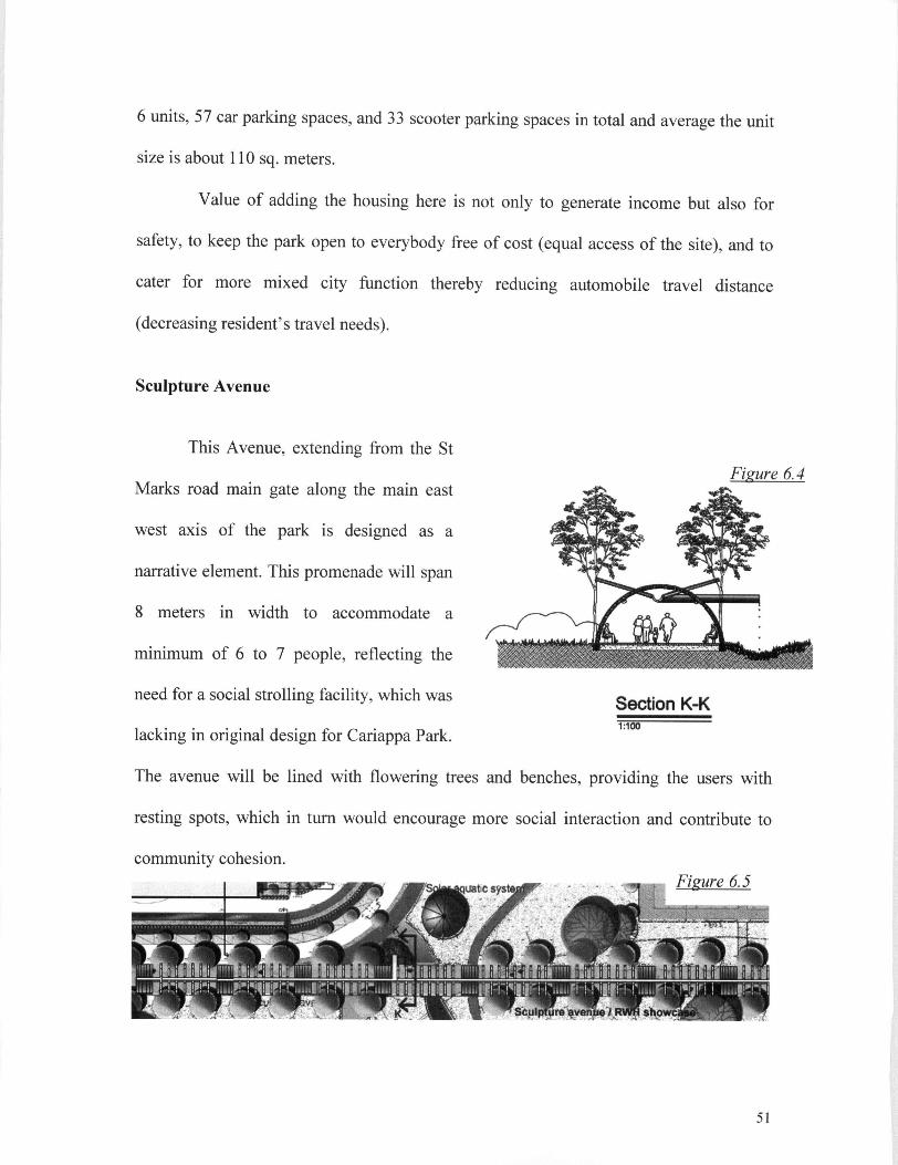
6 units, 57 car parking spaces, and 33 scooter parking spaces in total and average the unit
size is about 110 sq. meters.
Value of adding the housing here is not only to generate income but also for
safety, to keep the park open to everybody free of cost (equal access of the site), and to
cater for more mixed city function thereby reducing automobile travel distance
(decreasing resident's travel needs).
Sculpture Avenue
Figure 6.4
This Avenue, extending from the St
Marks road main gate along the main east
west axis of the park is designed as a
narrative element. This promenade will span
8 meters in width to accommodate a
minimum of 6 to 7 people, reflecting the
need for a social strolling facility, which was
lacking in original design for Cariappa Park.
The avenue will be lined with flowering trees and benches, providing the users with
resting spots, which in turn would encourage more social interaction and contribute to
Section K-K 1:100
community cohesion. li'llV'T Figure 6.5
51

Sculptures are placed all along the avenue. A l l the sculptures would be made from
recycled urban waste, which highlight the fragility of the environment, and the need for
conservation of the earth's natural resources. Another attraction to the avenue will be a
rainwater harvesting structure leading the park visitors along the walkway to the
performance area and haat. Designed with a butterfly roof this structure will echo the
structural and functional commonality with the roof of the performance area both
designed as rainwater harvesting structures (Figure 6.4). As the avenue is adjacent to the
solar aquatic and sculptures it will also serve as a showcase for sewage treatment,
rainwater harvesting and urban waste recycling (Fig 6.5).
Experiential play area for children
This area, set in the lower southwest corner of the Park is intended to promote
creative play for children. Considering the proximity of both the Army school and the
Stracey Memorial School, this area would be well used by school children. It is intended
for use as both as an outdoor classroom for interacting with landscape and for creative
play.
The play area would include grassy mounds, ideal for encouraging games such as
"King of the Castle" or "Capture the Flag". It would also serve to foster developmental
skills such as rolling or walking on an incline. Provision will be given for encouraging
unstructured play by providing wooden platforms of 5' x 5' in size that would be spread
across the swale and tucked into nooks. These platforms could be used by children for
impromptu drama shows or story telling (Fig 6.6.) Stepping-stones, buried in the grass,
52

would provide for optional informal play activities such as hopping or jumping games.
Trees would be chosen for their unique looking features that would be memorable and
intriguing for both the young and the old, and would be considered for such qualities as
the suitability of their branches for climbing, interesting looking seed pods or edible
berries. Benches, intended for those supervising the children, would be provided along
the periphery of the play area.
Figure 6.6
Keeping with the Army's accent on fitness, children would be provided with a
number of fun and physically demanding opportunities for activity including obstacles
courses, tunnels, tree stump rings for climbing, tree houses, Tarzan swings, balance
53

beams for walking along and crawling under, or any number of activities imagined by a
child.
The goal is to demonstrate that play environments can be created at low cost, and
yet also provide health and educational values that far exceed the relative costs of
traditional play equipment and learning ground designs. The grassy swale would pass
through this plays cape. As the water level in this swale naturally rises and falls, children
would be made aware of the role that the site plays in rein filtrating storm water back into
the natural system. A native plant wildlife habitat would be incorporated in this area for
nature study. Plants would be carefully chosen to be conducive for nectar and larval
butterfly habitats, with the inclusion of different plants that highlight smells, tastes, and
leaf /flower shapes. Edible landscape plants/trees would be added into this space through
a kiwi tunnel, raspberry arbour and through the inclusion of fruit orchard of guava,
mango, custard apple, gooseberry etc. Children from the above mentioned schools could
participate in the yearly harvest and in planting and propagation activities. This area
would become a great outdoor classroom of the neighbouring schools.
Solar aquatic system
A state of art solar aquatic facility would be located near the main entrance of the
site. This would involve a bold move in treating wastewater from the 98 units of the
Golden Palm Officers Colony. Additionally, it would also be the first step taken towards
creating a sustainable urban model for wastewater treatment in Bangalore. A specially-
designed green house named 'The Manekshaw Pyramid' would clean the wastewater.
The green house would have a pyramidal Shape, which would provide a simple volume
54

with reduced surface area for energy conservation,
and take into consideration solar exposure, shading,
and views from the surrounding area. A l l wastewater
from the residential block would be collected and pre-
treated in a small underground mechanical-biological
sewage treatment plant. It would then be pumped to
the Pyramid, and processed through a series of
biological tanks. Each tank would represent a
different level of biological breakdown (from algae to
plankton to fishes and mussels). After leaving the last
tank, the water would be pumped to the swale leading
to the detention pond. The Manekshaw Pyramid
would be an impressive visual presence showcasing
an intensive ecological system, that treats waste
water and supports aquaculture and horticulture. This
would also serve as a great educational tool and
would attract a number of visitors, including tourists,
to the Park.
Cariappa Haat -Village market (Figure 6.7)
A traditional art, craft and food market, which
would be named Cariappa Haat would be designed Figure 6.7
55

to cater to diverse activities and events of different sizes. Spread over an area of 2500
sq meters, The Haat would be located between the Park and parade ground at the
eastern edge of the site. Two entry plazas, one at M G road, and one at Cubbon road
would invite visitors into the Haat. The Haat would offer visitors the opportunity to
see and buy arts and crafts from different parts of Karnataka, as well as to taste
cuisines and witness performances from different parts of the country.
Figure 6.8 CobD'e stone mtn open surface filled
«f>!p sand
1%
Granite stono 07X0 Am
3E3C Sand setting layer Open graded base'
Filter fabric • Subgiaoe. min compact
7 : 1
The arts and crafts area
would be set up on platforms located
at the northern end of the Haat, with
14 permanent stalls and 20
temporary stalls of 4 m 2 in size. The
food plaza would be oriented
towards the south end of the Haat, Section I-I Haat pavement
with 8 permanent stalls 4 m and 15 temporary stalls. The placement of the food plaza at
the south end would facilitate the separation of the food area from the craft area, and
would also allow people to walk down into the picnic area around the detention pond
(Fig6.7)
Cobbte paver Granite stone Concrete base Granite paver
I 3
1 i i c T
3 3C
0.4X0 7m
3m Figure 6.9
56

A pathway paved with pervious cobblestones sloping towards a central line of
granite stones (Fig 6.8) would drain all the water from the Haat and community center
rain chains into a water collecting point at the south end of the Haat (Fig 6.9). A swale
would then empty excess water into the detention pond. Focus would be placed on
promoting organic foods and produce grown and sold at the market by local farmers.
The primary aim would be to support local farmers and to conserve traditional crops and
plants that are being pushed towards extinction. Selling them at the Haat would secure
their continued existence and make them available to the urban public of Bangalore. The
Haat (or village market) would also be used as a venue for regional food festivals. It
would simultaneously help to generate revenue, add to a colourful urban life, and
support the local economy by promoting local business and craftspeople.
The performance area/band Stand (Figure6.10)
Section C-C Figure 6.10 1:100
57

Located at the western end of the Haat, in an area 900m2, this space would offer
a venue for cultural performances from different parts of India. The performance area
will have a roof, sheltering the performers in case of bad weather. The structure would
be designed as a butterfly roof to harvest rainwater (Fig 6.10). There would be a 'green
room' for the performing artists to get ready, and a space to store chairs to accommodate
the audience. Seating would be provided through a seating wall and removable chairs.
The stage could additionally be used for ceremonial Army Band performances. Such
performances were traditionally hallmark events in all parks in Bangalore and have
strong historical roots in this city from as far back as Colonial times. The performance
area would be designed as a flexible space for a great variety of activities. The
performance area could, for example, be used as a venue for outdoor community
meetings, summer movie nights, and annual Army events like the May Queen Ball,
community talent shows or other social gatherings.
Community Garden
!Mfli «- { OJ*'.
Figure 6.11
The community garden would
be located in an area of 1160m2 at the
southwest end of the Park (Figure
6.11). It would be located close to the
housing units and the main entrance,
and would be well connected to the
Park. Three by two meter plots would
be allotted to community members
58

and residents of the officer's colony. A gazebo of 3 m 2 is located in the centre and
would provide space for social interaction and resting. There would be a tool shed for
storing tools, and a compost pit for decomposing the leaf litter and other Park wastes.
An herb and medicinal plant garden would also be provided in the community garden.
Espaliered fruit trees would be planted along the edges of the fencing. The community
garden, along with all these elements would aspire to bring in more social activity, and
serve as an educational tool.for children as well as all members of the community. It
will also help to build in a sense of community, local spirit and pride.
Sports Area
Taking into consideration the need for active recreation space for the army
officers and youth, a sports field would be provided in the central area of the
park. This region was chosen because it is very flat and almost devoid of any
vegetation. The field would be equipped with two badminton courts and a basketball
court. Trees would be planted on both the west and east sides of the sports field to
provide shade. The area would be paved with permeable paving and benches would be
provided in a north-south orientation.
59

Community centre
Located close to the entrance plaza at Cubbon road and the parking area, the old
Park Office would be converted into a community centre, which would house the main
offices for Park management, as well as serving as a centre from which to coordinate
the many community-based activities and programs for both adults and children like
painting and dance lessons, Martial art sessions,
yoga camps etc.
A n effort would be made to celebrate the
aesthetic and sensory qualities of rain through rain
chains, a series of connected copper funnels that
would hang from the gutters on the roof of
community center, and would direct runoff from
the roof into the Park (Figure 6.12). As rain would
fall, it would make a pleasant tinkling sound
against the funnels. The rain chains would drape
over the sides and corners of the building, enhancing the aesthetic and sound qualities
of cascading water on rainy days. They would hang down to ground level with a
weight buried in the pebbles, keeping the chain taut in the wind. Thus, the rain chains
would function in helping to break the fall of the water, guiding it visibly downward
onto a drain covered in pebbles.
60

Plant nursery
Bangalore is known for its
gardens and garden lovers. It is
therefore proposed to have a nursery
located near the detention pond
(Figure 6.13). This nursery will house
two green houses and will be used to
produce seedlings of various
ornamental plants. Espaliered apples will be adding to the beauty of the fences. The
plants produced in the nursery will be sold through the stalls located in the Haat area
closer to the Parking. This nursery can also serve as a learning ground for plant
propagation techniques.
Figure 6.13
The Memorial
It is proposed to preserve the original
memorial area (Figure 6.14). The memorial
house with the eight-foot granite statue made
by the shilpis (craftsmen) from
Figure 6.14 shivarapatnam, Bangalore would be
61

maintained with a formal garden around. The pathways leading to the memorial will
have bricks engraved with the names of those soldiers who have made significant
contributions to the Bangalore cantonment.
The swale and Detention pond
The swale system will act as a natural drainage system of the park. The main
drainage swale is designed to collect and rein filtrate storm water and treated
wastewater from the Golden palm officer's colony from the western end of the Park
and meander its way through the children's experiential play area before reaching the
large detention basin at the southern end of the Park. While running down this swale
system, storm water will slowly seep back into ground water system. Water from the
north end of the Haat area will be drained to the south end through the pavers and
taken through another swale to the detention pond. The area around detention pond
will serve as a good setting for picnics and for other passive recreational activities. The
swale system makes the ecological process visible and would remind the public that
the city is a part of natural environment. During dry months the daily discharge from
Solar aquatic facility will help to keep the pond with adequate water for irrigation
requirements of plant nursery. During heavy monsoon, the overflow valve in the
detention pond will help direct water away to the storm sewer pipes.
62

The Gates {Figure 6.15)
Four separate gateways would lead onto the site, and all four would be
accessible to the public. Two of them would be directed towards the Park, and the
other two, to the Haat The main entrance to the park would be on St. Marks road, and
would be known as Kanteevara Gateway, echoing the name of Kanteevara Stadium, a
stadium that is located close by (Fig 6.15). The second entrance would be at the corner
63

of St Mark's road and M G road, and would be named Kempe gowda Gateway to
commemorate the great ruler of Karnataka. The entrances to the Haat would be
respectively on M G road and Cubbon road. The entrance of the Haat at M G road
would be named the South Parade Gateway in memory of the South Parade, the name
by which M G road was known in colonial days. The gate of the Haat at Cubbon Road
would be named Lt. Blakiston Gateway, after Lt. John Blakiston, a British Army
officer, who first levelled the parade ground from a tank to its present condition. This
gateway, unlike the other three pedestrian entries, would incorporate a vehicular
entryway. In addition, smaller gateways would be added at 50-meter intervals by
creating wall punctures to the existing wall at M G road and cubbon road and St mark's
road. A hierarchy would be maintained in the gate structures in order to easily
differentiate between the different gates. A l l the gateways would be designed using
traditional architectural forms and as such would help to increase the legibility of the
site. Together with their names, they would connect the Park to the rich cultural past
of the city.
64

The promenade alongside M G road was known as South Parade Boulevard in
colonial times. It was one of the most famous and celebrated roadways of the Civil &
Military Station, Bangalore. A cool and comfortable place for shoppers and families to
spend time, this project proposes to enhance the promenade by adding additional
benches, drinking fountains, streetlights with hanging flower baskets, garbage
receptacles and. bicycle stands (Figure 6.16). M G road is a busy road with heavy
traffic. A 1.5 m wide sidewalk and 7 new cross walks would be added to allow for safe
pedestrian access to the park and enhance connectivity of the Park to surrounding area.
The paving material would consist of pervious concrete to allow for maximum
filtration of storm water. Local artists would design all the street furniture.
6.4 Detail Design
The area chosen for detail design is the Golden Palm Officers Colony, which
would be the Park's newly added residential area (Figure 6.17). A 4 m wide one-way
residential road between St Mark's road and Cubbon road would be designed and built.
Side parking, which would provide much needed parking for the Park would be located
along this area.
This road would also serve to separate the housing units from the Park. The
entrance to the residential area would be from St Mark's road through the new
gateway, which would be named Golden Palm Gateway. This residential area would
include 4building blocks, of four floors each, with a courtyard in the centre. A half
65

portion of the ground floor of the buildings (except for one buildings in the western
corner) would be designated for car/scooter parking. Fifty-seven stalls would be
allocated for car parking, and 33 for scooter parking. The other half of the ground floor
would be allotted for utility and recreational activities. A half wall with planters would
separate the parking space from the sheltered recreational space (Figure 6.17, 6.18).
1.2m

Cubbon Rd. Children's play area Community activity area Outdoor gym (rock climbing)
Residential road (One way)
Figure 6.18) would be designed with a curvilinear bench with a seating wall
(Figure 6.19). This wall would have several planters with shade loving plants such as
Coleus, Chlorophytum, Pothos, Dieffenbachia, and Hosta. .The other half- portion
would be assigned as a tiny tot play area, with benches provided for supervision. A l l
the entryways to the building would be clearly demarcated using colored granite
sneiterea Kecreation Figure 6.19
67

Figure 6.20
Sheltered seating
The recreation area under Block C would be designed as seating steps. (Fig 6.20)
This would allow for people to sit and watch community activities or stage
performances taking place in the community activity area of the courtyard. This block
would also accommodate 3 ping-pong tables. The recreation area under Block D would
be designed with a curvilinear seating bench and a few multifunctional tables. These
tables would be designated as
utility areas for officers'
orderlies and would serve as
places for the ironing of
uniforms, polishing of shoes,
and the decorating of uniforms
etc. The other half, would
function as the security guard
lunch or coffee break room and
utility area for electrical Jm
fittings. The central courtyard
12x120 wooden planks @ 15cm Interval̂
Concrete beam
Grass mix lyp.
Jranite flower bed
4:1 max. side slope
Minimum 12" depth flfowinp medium
Permeable filler fabric optional
10cm Asphail
Figure6.21 Swale Section
68

would be designed with a swale running through the centre of it to direct storm water
to the main swale of the Park (Figure 6.21).
Additionally, there would be an outdoor gym at the south end of courtyard with
a long jump pit, monkey bars, balancing beams and a rock climbing structure. Placing
the outdoor gym in this courtyard would allow easy access and privacy to the main
users - the officers and seniors living in the residences. A community activity area
would be placed diagonally opposite the outdoor gym across the swale. This area
would provide possibilities for an endless variety of activities such as during Bada
Khana(grand buffets and barbeques), community talent shows, movie nights and for
performances during festival times such as during the Spring Festival, Vasantha
Habba. . A 1.5 m wide east-west pathway lined with Ashoka trees would run along the
swale, and would function to divide the community activity area from the children's
park at the northern corner of the courtyard. The children's park would be outfitted,
with play equipment and playhouses. Benches would be provided for supervision, and
hedge plantings would further add to enclose the area. A 2 x 2 m wooden gazebo
would be erected, again facilitating sheltered play activities.
The western corner of the courtyard would be designed as a passive recreation
area. Tables and chairs would be provided for playing card games, board games, chess
or reading. A central, semi-circular wooden arbour would function as a focal point
with fragrant climbing plants such as Jasmine, Petria etc.
A 4 wide driveway, paved with gravel pavers would run from Golden Palm
Gateway to the exit at Cubbon road. To demonstrate storm water management, 2
69

vegetated infiltration basins or rain gardens would be featured at the southern end of the
residential area. A vegetated infiltration basin is a landscaped depression that accepts
storm water runoff from impervious surfaces, and is similar aesthetically to a planter box
(Figure 6.22). These basins allow pollutants to settle and filter out, and also provide the
opportunity for infiltration. The two trenches, lined with recycled P V C , and filled with
gravel would be designed as a subsurface biological marsh, planted with reeds, sedges
and irises. Storm water run-off would be purified by natural processes and would be
released gradually into subsurface. During overflow, an underground pipeline would
carry the water into the Park's main swale.
Figure 6.22 Vegetated infiltration basin
The Master plan is produced based on the guidelines developed using the sustainability
Matrix. This relationship and Implementation of guidelines is discussed in next chapter
70

Chapter 7: Design Evaluation and Conclusion
7.1 Design Evaluation
The failure of existing park resulted from totally ignoring the natural
processes of landscape, lack of the careful consideration to the cultural and economic
condition of the site and not considering the financial viability of the project. . Hence,
attempts are made to re-evaluating these dimensions of the park and improving them
according to current precedents. Major focus was given for improving sustainability and
the environmental and cultural 'vibrancy' of the park.
To connect the concept of sustainability to the project, sustainability matrix
(Holland, 2003) was used as a planning tool to develop framework and an evaluative
context. This helped to come up with specific criteria that combined increased
sustainability with both functional and aesthetic goals for the Park. While coming up with
a re-development plan that emphasized increased sustainability, attention was given to
incorporate changes to the aesthetic complexion of the park, keeping with contemporary
standards and with its' immediate culture.
7.1.1 Design response to Economic prosperity
• Goal 1 Maximise revenue from the site
Adding housing adjacent to the K K & G sub-area helps to reduce officer's
commuting needs that indirectly contribute to the degradation of the environment. This
proposed new park program not only brings more people into the Park, but also
contributes economically to its operation. In addition, these elements are designed to
71

have minimal ecological impact on the site, thus also promoting ecological success to
the Park. Additionally, the residential area adds "eyes-on-the- park", adding to safety
and also generating money to so that the Park can be open to the public. The Proposed
village market together with plant nursery would also simultaneously help to generate
revenue, add to a colorful urban life, and support the local economy by promoting local
business and craftspeople.
• Goal 2 Maximize Recycling of Resources and waste
A l l the sculptures in the sculpture avenue would be made from recycled urban waste,
which highlight the fragility of the environment, and the need for conservation of the
earth's natural resources. Local artists would design all the street furniture. Using
recycled waste products
7.1.2 Design response to Social and community Health
• Goal 1 Connect Park to the surrounding area
The Proposed sidewalk new cross walks crosswalks across M G road
will allow for safe pedestrian access to the park and enhance connectivity of the Park to
surrounding area. The enhanced Promenade with inviting benches and street furniture
like drinking water fountain, trash bins, Bicycle stands, Street lights will all contribute to
make the park inviting. Addition of a one-way residential road with side parking also will
make park accessible to more people and provide for the much-needed parking for the
park. The four new gateways and the wall entryways again make the park more easily
accessible Park. A l l the gateways designed using traditional architectural forms will help

to increase the legibility of the site. Together with their names, they would connect the
Park to the rich cultural past of the city.
• Optimize socialization while retaining flexibility for larger social functions
The performance area is designed as a flexible space for a great
variety of activities as a venue for outdoor community meetings, summer movie nights,
and annual Army events and other social gatherings. The sculpture avenue lined with
flowering trees and benches will provide the users with resting spots, which in turn
would encourage more social interaction and contribute to community cohesion. The
community garden, along with all these elements would aspire to bring in more social
activity and to build in a sense of community, local spirit and pride. The sports activity
area and out door gym in housing area also provide for active recreation space for the
army officers and youth. The community center will serve as a centre from which to
coordinate the many community-based activities and programs for both adults and
children
The proposed culturally rooted elements such as the village market, army band
local folk art performance and a plant nursery, will turn cariappa park into a domain of
active/passive experience providing social and psychological services which are of
crucial significance for the livability of modern cities.
• Goal 2 Provide Opportunity for Education
Butterfly roof structure of Sculpture Avenue share a structural and functional
commonality with the roof of the performance area both designed as rainwater
73

harvesting structures, which will serve as an educational element. As the sculpture
avenue is adjacent to the solar aquatic, it will also serve as a showcase for sewage
treatment, rainwater harvesting and urban waste recycling. Children's experiential
play area would become a great outdoor classroom of the neighboring schools. The
swale system makes the ecological process visible and would remind the public that
the city is a part of natural environment. A l l these elements together serve to educate
and inspire the park visitors.
7.1.3 Design response to water Quantity and quality
Haas (Martel) (jround drainage slope 1.5%
Stormwater inflow grassed swale i via grassed swale
Irrigation to Ihe nursery
Vegetated swale and Infiltration Basins
Surface water system
Figure 7.1
• Goal 1 Purify wastewater on site
Solar aquatic facility and the vegetated infiltration basins will serve to purify
water on site. The proposed solar aquatic system will also serve to attract the public,
inviting them to observe and learn from the display and will promote it as a tourist
destination.
74

• Goal 2 Manage and celebrate storm water on site
In India, where there is enough rain for collection, and conventional water
resources are at risk of being over-used, rainwater harvesting can provide lifeline water
for human consumption and irrigation. Through the rain chains that will be
incorporated into the community center roof system in the proposed design, one will
actually be able to see the water as it clings to the chains as it makes its way down to
the ground. The Butterfly roof structure of the performance area and Sculpture
Avenue, designed to collect rainwater will provide a visual appeal as people walk
along. Surface water management using a system of swales will also provide a visual
cue as to the hydrology of the site. A l l these elements will bring in awareness among
citizens that rainwater is an in invaluable asset that must be celebrated and cherished,
and not allowed to be wasted as runoff.
• Goal 3 Maximize water infiltration
Vegetated infiltration basins and swale system, pervious pavements on all hard
surfaces and parking will help to maximize water infiltration in the site.
As opportunities for reducing consumptive water use are embraced and
integrated into the site design of Cariappa Park (Figure 7.1), the design community can
in turn transfer this knowledge to the public, so that sustainability becomes nothing
more and nothing less than common sense
75

7.2 Design response to sustainability-Comparison
The new design has thus attempted to employ a number of different ways to
reduce the need for resources and to increase self-sufficiency. The following table
compares sustainability criteria in the existing and proposed designs
Existing Cariappa Park Design
Existing program Social Economical Ecological
Entrance plaza o X X
Main waterfall X X X
Mini waterfall X X X
Memorial area o X X
Bandstand X X X
Rock garden X X X
Parking X X X
Park office X X X
Lake X X X
Pathway X X X
• directly supports o indirectly supports x no support
76

Proposed Cariappa Park Design
• Directly supports o indirectly supports x no support
Table 3
Proposed Program Social Economical Ecological
Housing * • o
Village market (Haat) * • o
Parking * O o
Sculpture avenue • o • Community center • o o
Performance area • • o
Community garden • • o
Experience play area * o • Plant nursery * • o
Detention pond • • Solar aquatic • • •
Enhanced promenade o o
Gates * X X
Memorial area X X
Pathway • o •
77

From the comparison above, it is apparent that the proposed design surpasses
its existing condition. Urban Parks fulfills many social functions and psychological
needs of citizens, which make such parks a valuable municipal resource, and a key
ingredient for city sustainability. (Chiesura, 2004) The new proposed design intends to
bring in sustainability principles that are socially and culturally feasible and also
keeping the synergy between sustainable landscape design and reduced park
maintenance.
7.3 Conclusion
Cariappa park redesign is thus intended to rejuvenate the Park space and
inspire its population of visitors to create a healthier and more beautiful world that is
both sustainable and ecologically sound. The new design will help Cariappa park to
provide many social, ecologic and economic services to its user and will serve as a
valuable municipal resource and key component in city sustainability. The Park, which
for the last few years has been a dead space, will surely make a specifically strong
impact on those who will have witnessed its evolution. It is hoped that through
exhibiting the possible options for sustainable and ecological design, visitors will be
inspired to promote or incorporate these types of elements into existing or future
projects within the spheres of their lives. In this way, Cariappa Park will serve as a
model sustainable Park helping local planners to envision more such projects
contributing to the well being of the citizens and for the sustainability of the city they
live in.
78

Bibliography
Brundtland, Gro Harlem and WCED (World Commission on Environment and
Development). 1987. Our common future. Oxford: World Commission on
Environment and Development.
Cranz, G. and Boland, M . 2004. Defining the sustainable park: A fifth model for urban
parks. Landscape Journal 23(2): 102-120.
Chiesura, A . 2004. The Role of urban parks for the sustainable city. Landscape and
Urban Planning 68 (1): 129-138
Daly, H. and Cobb, J. 989. For the Common Good: Redirecting the economy toward
community, the environment and a sustainable future. Boston: Beacon Press.
Ekins, T. and Hutchinson, R. 1992. Wealth beyond measure: A n atlas of new economics.
London: Gaia Books.
Holland, M . 2003 "A Planning Framework for Sustainable Development." Lecture
series, Department Of Landscape Architecture. University of British Columbia.
Holland, M . 1996. A planning framework for an ecologically sustainable development: a
discussion paper on policies and precedents City of Vancouver, Central area planning
division.
79

Fairholm, J. 1998. Urban Agriculture and Food Security Initiatives in Canada: A Survey
of Canadian Non-Governmental Organizations. Cities Feeding People, Lifecycles: 79.
Forman, R. 1990. Ecologically sustainable landscapes: The role of spatial configuration
in changing landscapes: an ecological perspective. I. S. Zonneveld and R.T.T Forman
(eds.), New York: Springer-Verlag.
Kaplan, R. 1993. Environmental appraisal, human needs, and a sustainable future In T.
Garling and R. G. Golledge (eds.), Behaviour and environment: psychological and
geographical approaches. Amsterdam: Elsevier Science Publishers.
Marsh, W. 1998. Landscape planning: environmental applications, 3 r d Ed. New York:
John Wiley & Sons.
Mathur, A . and Da Cunha, D. 2006. Deccan Traverses - Making of Bangalore's Terrain.
Delhi: Rupa Publishers.
Mooney, P. 2003. Landscape Architecture 541: Landscape planning and management,
lecture notes. Department of Landscape architecture University of British Columbia
Nagesh, L.et al.2005. Wastewater reuse in Mega cities- Emerging trends in Bangalore
city -Paper presented at IWMI-TATA partners Meet. Anand, Gujarat, India
80

NIPC (Northeastern Illinois Planning Commission). (2004). Building sustainable
community
http://www.nipc.org/environment/sustainable/development/communities/index.htm
Paterson, D and Connery, K. 1997 "Reconfiguring the edge city: the use of ecological
design parameters in defining the form of community." Landscape and Urban Planning.
36: 327-346.
Reid, G. 1989. Changing patterns of work and leisure and the healthy community. Plan
Canada, 29(4): 45-50
Roodman, D and Lenssen, N . 2005. A Building Revolution: How Ecology and Health
Concerns Are Transforming Construction. Ed. Jane Peterson. Washington, DC: World
watch Institute.
Roseland, M . 1992. Towards sustainable communities: a resource book for municipal and
local governments'. National Roundtable on the Environment and the Economy.
Orillia, Ontario.
Sheltair Group, Inc. 1998. Visions, tools and targets: environmentally sustainable
development guidelines for Southeast False Creek. Vancouver: City of Vancouver, April
18, 1998.
81

Sparrow, K.1998. Leisure seizure: Community cultural development. Plan Canada:
38(1): 8-13
Thayer, R. 1994. Gray world, green heart: technology,' nature and the sustainable
landscape. New York: John Wiley & Sons, INC. New York, Chichester, Brisbane,
Toronto, Singapore.
Toronto Declaration on World Cities and their Environment (Toronto: World Cities and
Their Environment Congress of Municipal Leaders, August 28, 1991).
http://www.cela.ca/faq/cltn_detail.shtml =1508#1734
http://wvm.city.vancouver.bc.ca/commsvcs/currentplanning/sefc/SEFCpolicy.htm
http://www.deccanherald.com/deccanherald/ian22 2005/cl.asp
http://wvvw.deccanherald.corn/deccanherald/iune23 2005/cl.asp
http://www.deccanherald.com/deccanherald/august25 2005/cl .asp
http://www.delhi-india.net/travel/delhihaat.htmKIMP)
http://www.landscape.co.uk/resources/nov2003%20pdf.pdf
http://www.nekchand.com/
http://www.rawvision.com/nekchand/theway.html
http://www.southindia-tours.com/tamil-nadu/meenakshi-india.htm
http://www.spaenvis.nic.in/pub_march2_decent.htm
http://www.tribuneindia.com/2003/20031031/nation.htm
82
Related Documents