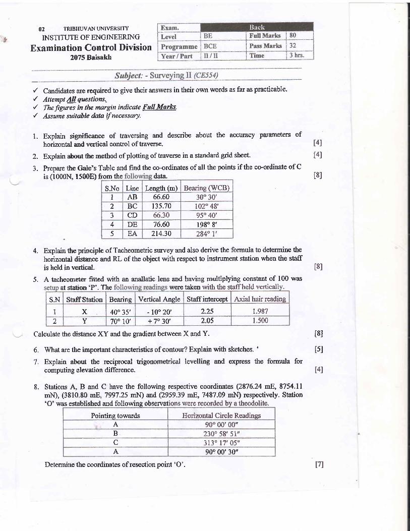
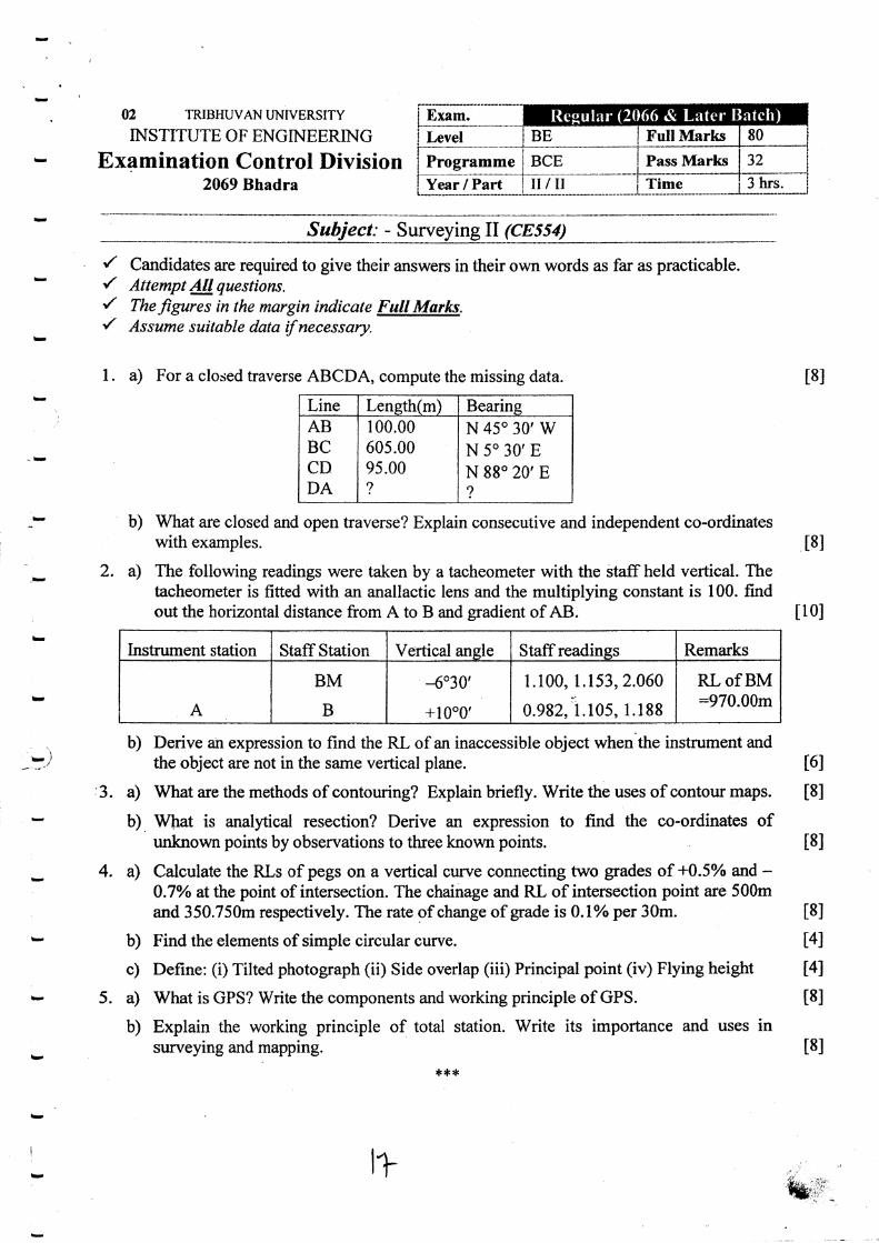
ip, 02 TRIBHUVAI{ I.JNIVERSTTY INSTITUTE OF ENGINEERING Examination Control Division 2075 Baisakh ,/ / ,/ { 1. Candidates are required to give their answers in their own words as far as practicable. Attempt All questians.- The ligures in the margin indicate FuU Mafles. Assume suitohle data if necessary. Explain significance of haversing and describe about the accuracy parameters of horizontal and vertical control of traverse. Explain about ttrc method of plotting of traverse in a standard grid sheet. Prepare the Gale's Table and find the co-ordinates of all the points if the co-ordinate of C is (1000N, 1500E) tqlq the data. S.No Line Leneth (m) Bearing (WCB) I AB 66.60 30" 30' 2 BC '35.74 102" 48', 3 CD 66.30 95" 40' 4 DE 76.60 lg8" 8' 5 EA 2t4.30 284" l', Explain the principle of Tacheometric suney and also derive the formula to determine the horizontal distance and RL of the object with respect to instrument station when the staff is held in vertical. A tacheometer fitted with an anallatic lens and having multiplying constant of 100 was with the staffheld verticall at station'P'. The were taken S.N StaffStation Bearine Vertical Anele Staffintercept Axial hair reading I X 40" 35' - 100 20' 2.25 1.987 2 Y 70" 10' + 7" 30' 2.05 1.500 Calculate the distance XY and the gradient between X and Y. 6. What are the important characteristics of contour? Explain with sketches. ' 7. Explain about the reciprocal higonomefrical levelling and express the fomrula for computing elevation difference. 8. Stations A, B and C have the following respective coordinates (2876.24 mE, 8754.11 mtr{), (3310.80 nF', 7997.25 rnN) and (2959.39 mE, 7487.09 mI.I) respectively. Station 'O'was established and following obseryal ons were recorded bv a theodolite. Pointing towards Horizontal Circle Readings A 90" 00'00" B 230" 58', 51" C 313" 17'05', A 90" 00'30" 2. 3. t4l t41 t8l 4. 5. l8l t8l tsl t4l t7l Determine the coordinates of resection point 'O'.

Welcome message from author
This document is posted to help you gain knowledge. Please leave a comment to let me know what you think about it! Share it to your friends and learn new things together.
Transcript
ip,
02 TRIBHUVAI{ I.JNIVERSTTY
INSTITUTE OF ENGINEERING
Examination Control Division2075 Baisakh
,//,/{
1.
Candidates are required to give their answers in their own words as far as practicable.
Attempt All questians.-
The ligures in the margin indicate FuU Mafles.
Assume suitohle data if necessary.
Explain significance of haversing and describe about the accuracy parameters ofhorizontal and vertical control of traverse.
Explain about ttrc method of plotting of traverse in a standard grid sheet.
Prepare the Gale's Table and find the co-ordinates of all the points if the co-ordinate of Cis (1000N, 1500E) tqlq the data.
S.No Line Leneth (m) Bearing (WCB)I AB 66.60 30" 30'2 BC
'35.74102" 48',
3 CD 66.30 95" 40'
4 DE 76.60 lg8" 8'5 EA 2t4.30 284" l',
Explain the principle of Tacheometric suney and also derive the formula to determine the
horizontal distance and RL of the object with respect to instrument station when the staffis held in vertical.
A tacheometer fitted with an anallatic lens and having multiplying constant of 100 waswith the staffheld verticallat station'P'. The were taken
S.N StaffStation Bearine Vertical Anele Staffintercept Axial hair reading
I X 40" 35' - 100 20' 2.25 1.987
2 Y 70" 10' + 7" 30' 2.05 1.500
Calculate the distance XY and the gradient between X and Y.
6. What are the important characteristics of contour? Explain with sketches. '
7. Explain about the reciprocal higonomefrical levelling and express the fomrula forcomputing elevation difference.
8. Stations A, B and C have the following respective coordinates (2876.24 mE, 8754.11
mtr{), (3310.80 nF', 7997.25 rnN) and (2959.39 mE, 7487.09 mI.I) respectively. Station'O'was established and following obseryal ons were recorded bv a theodolite.
Pointing towards Horizontal Circle Readings
A 90" 00'00"B 230" 58', 51"C 313" 17'05',A 90" 00'30"
2.
3.
t4l
t41
t8l
4.
5.
l8l
t8l
tsl
t4l
t7lDetermine the coordinates of resection point 'O'.
t9' It is required to join two straights-having atotaldeflection angle lgo 36, by acentralcircular curve of radius 450 rn-with two-rra, cubic spiral transition
"u*r.-ih" designvelocity is70 kmph and rate of change orluJiur "..d.rutitrJ,
go "Jrr"i. ciuioage ofrP :2524'20 m' Take Peg interval foicircular and transition
"u*. :20m for both. ts]
l0' of + 0.5yo. The two ends of these portonschainage and RL of inte ection point ur
e of change of grad, i, f#i#ffi:ts on the curve' rukt ptg
t8lI l. Write short notes on: (Any Four)
a) Importance of Gps and GIS laxalb) Scale of ve^{icaf photograpl.and uses of photo grammetryc) Feahres of total station *d it, *r,d) Types of remote sensing and its applicatione) setting out of circular curve uy ni*in";s method
***
TRIBHUVAN LJNIVERSITY
INSTITUTE OF ENGINEER.ING
Examination Control Division2074 Bhadra
{
,/
Subject: - $gry_"y-i"g_Il--(c_!_s_!+)
Candidates are requirgd to give their answers in their own words as far as practicable.Attempt AII questtonsThe figures in the margin indicate Full Marks;Assume suitable data if necessary.
a) How a linked traverse is balanced? How total misclosure is balanced by Transit Rule?b) Calculate the omitted quantities in the closed traverse ABCDE given below.
Line Length BearingAB 282.20 6 I "30'BC ? 151"24,CD 324.70 201"02,DE 381.60 290"14,EA 359.60 ?
l.t6l
u0l
2. a) Compute RL of a hill station ,p' from tu,odifferent level with same line of sight toinformations.
rnstrument stations Athat of target from
andthe
B at veryfollowing
t5l
b) What is stadia interval factor and additive constant? How these constanrs aredetermined?
c) Following observations were made in a Tacheonnetric survey a station A of RL1086.550, the height of insrrument being 1.3g5 m.
The instrument is fitted with an anallactic lens and the multiplying constants is 100.Determine the R.L of B and C and the gradient of line BC, and- bearilg of BC.3' a) How do you define contour interval, contour gradient and index contour? Explain the
maJn characteristics of contours with neat sketch,
b) What is the different between Intersection and Resection? Explain three pointResection Method to determine the unknown co-ordinate of,a point.
t3l
t8l
t6l
Zenith ansleDistance & Target ht and RL
344%6' Distance between A and B: t20J0 mRL of B = 1280.00 m
Target ht at B : 1.50 rn257"16,
lnst. Station Staff Station Zenithal Ansle7.295, 1.920, 2.3451.010, 1.790,2.570
t4l
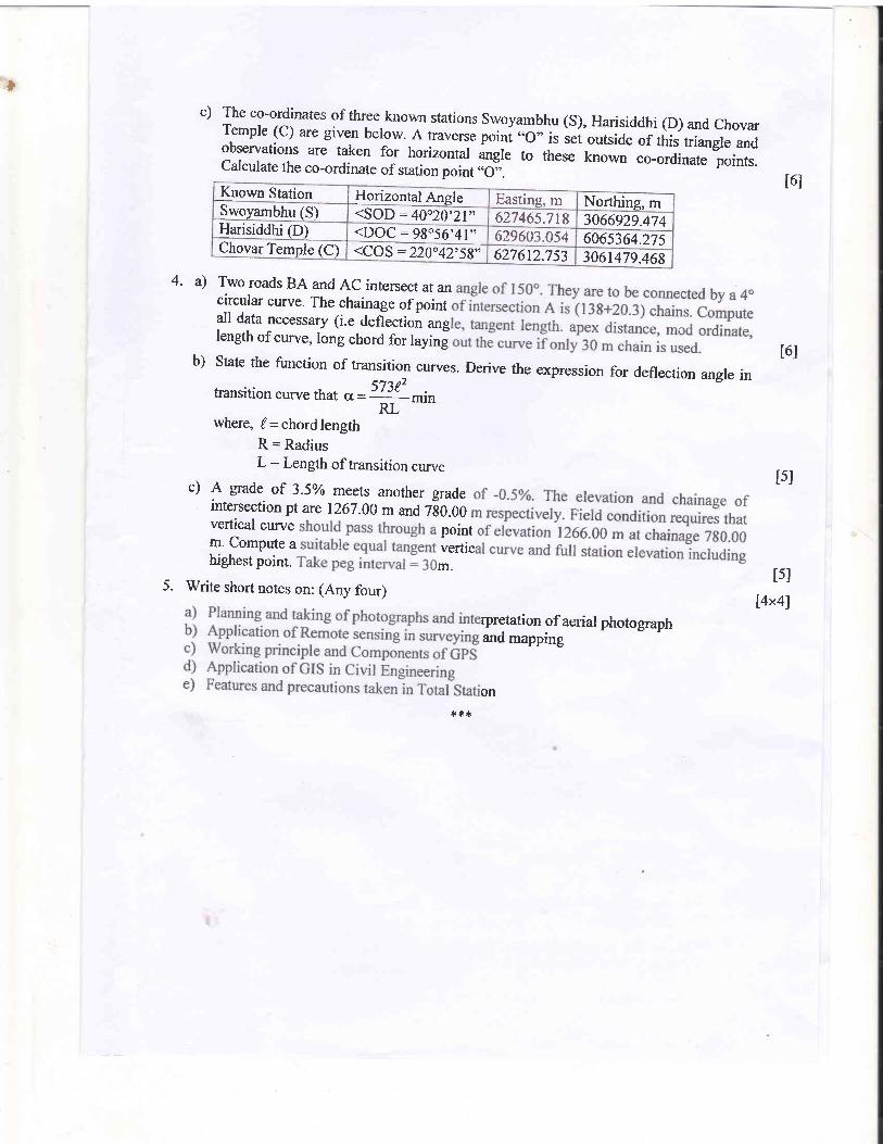
Ic) The co-ordinates of three known stations swoyambhu (S), Harisiddhi (D) and chovarTemple (c) are given below..A traversepoini "o" is sei outside of this triangle andobservations are taken for horizontal ungr. to these known co-ordinate points.Calculate the co-ordinate of station point ..O,,.
Known Station Horizontal Angle Easting, m Nonhing, mSwoyambhu (S) <SOD :40o20'21,, 627465.718 3066929.474Harisiddhi (D) <DOC:98o56'41" 6296n7 0\4 6065364.27sChovar Ternple (C) <COS : 220"42'58,' 6276t2.753 3061479.468
l6l
4. a) Two roads BA and AC intersect at ancircular curve. The chainage of pointall data necessary (i.e defl*ection anglength of curve, long chord for layin!
b) State the function of transition curves. Derive the expression for deflection angle intransition curve that cr -!3t5-mm
t6l
where, /=chordlengthR = RadiusL: Length of transition curve
tslc) A grade of 3.59'o meets another gradeintersection pt are 1267.00 m and ZSO.OOverticai curve pointm. Compute a vertichighest point. m.
I5l5. Write short notes on: (Any four) [ax4)
rpretation of aerial photographand mapping
on
* +{.
tTRIBHWAN I.'NIVERS I'TY
INSTITUTE OF ENGINEERING
Examination Control Division2073 Magh
il
i Prosramme i;---*-=-- -----..--.*. i -
i Year lPart i
Subiect' - Surveying II (CEl54)
,/ Candidates are required to give their answers in their own words as far as practicable.
{ Attempt AII questions-
'/ The figures in the margin indicate 4ull Marks-./ Assume suitable data if necessary.
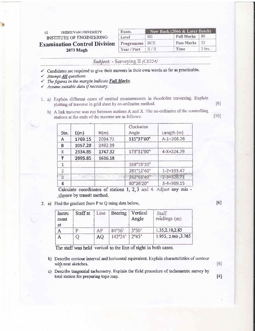
l. a) Explain different cases of omitted measurements in theodolite traversing. Explain' ptotting of traverse in grid sheet by co-ordinates method. t6]
b) A link traverse was run between stations A and X. The co'ordinates of the controlling
stations at the ends of the traverse are as follows: [10]
Stn. E(m) N(m)ClockwiseAngle Leneth (m)
A 1769,15 2094.72 115"37'00" A-t=2Q8.26
B LO57.28 2492.39
X 2334.85 L747.32 173"31'00" 4-X=224.79
Y 2995.85 1616.18
1 158"19'1.0u
2 281:12'40" t-2=L93.47
4 90"26'20" 3-4=309.15
Calculate coordinates of stations 7, 2,3,,.qlg".qure by transit method.
2. a) Find the gradient from P to Q using data below,
and 4. Adjust any mN-
t6l
t6lb)
c)
Instrumentat
Staffat Line Bearing VerticalAngle
Staffreldings (m)
A P AP 84"36i 3030' 1.35,2.10,2.85 '
A a AQ tr4224' 2045' 1.955, 2.860,3.765
The staff was held 'vbrtical
to the line of sight in both cases.
Describe contour interval and horizontal equivalent. Explain characteristics of contourwith neat sketches.
Describe tangential tachometry. Explain the field procedure of tachometric survey bytotal station for preparing topo map. l4l
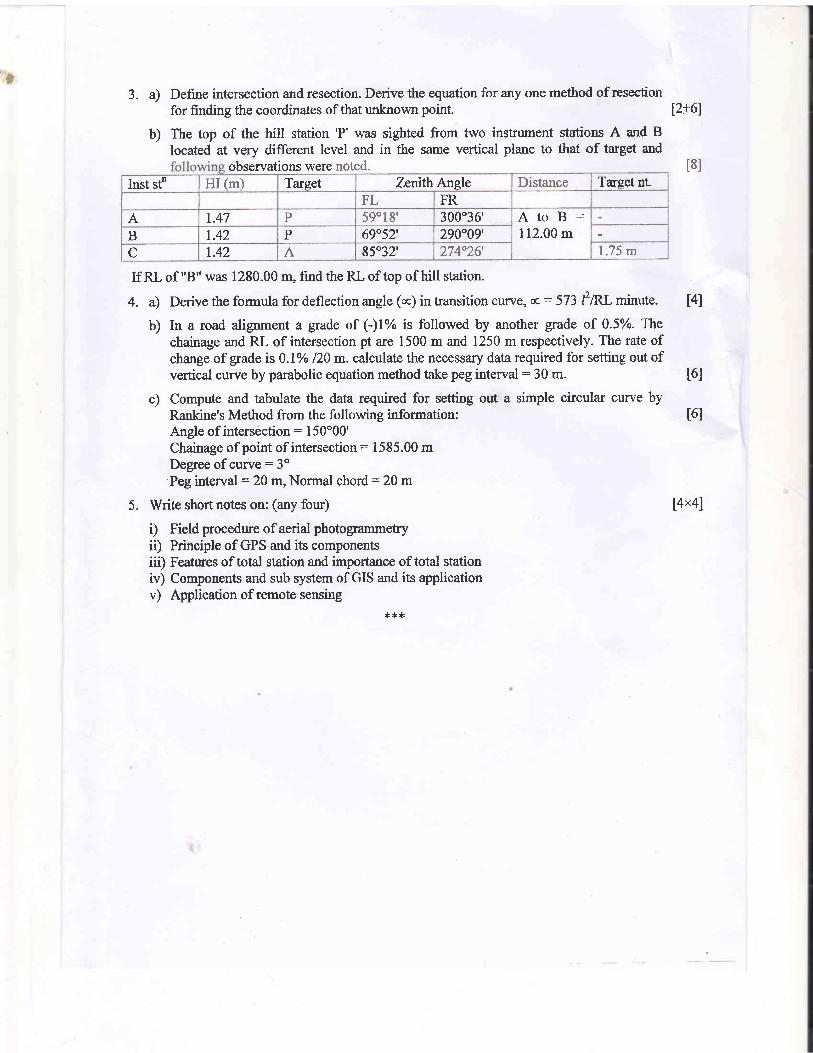
l3. a) Define intersection and resection. Derive the equation for any one method of resection
for finding the coordinates of that unknown point. 12+61
b) The top of the hill station 'P' was sighted from two instrument stations A and B
located at very different level and in the same vertical plane to that of target and
noted.observations wereInst stn HI (m) Target ZqnrthAngle Distance Target nt.
FL FR
A t.47 P 5901 8' 300"36' AtoB:112.00 mB t.42 P 69"52', 290"49'.
C r.42 A 85"32'. 274"26'. 1.75 m
If RL of "B" was 1280.00 m, find the RL of top of hill station.
4. a) Derive the formula for deflection angle (cc) in transition curve, q,:573 Pntminute. t4l
b) In a road alignment a grade of (-)1% is followed by another gade of 0.5%. Thechainage and RL of intersection pt are 1500 m and 1250 m respectively. The rate ofchange of grade is 0.1% 120 m. calculate the necessary data required for setting out ofvertical curve by parabolic equation method take peg interval: 30 m. t6]
c) Compute and tabulate the data required for setting out a simple circular curve byRankine's Method from the following infonnation: t6lAngle of intersection: 150o00'
Chainage of point of intersection = 1585.00 mDegree of curye: 3"Peg intenral: 20 m, Normal chord : 20 m
5. Write short notes on: (any four) [4x4]
i) Field procedure of aerial photogrammetyiD Principle of GPS and its componentsiii) Features of total station and importance of total stationrv) Components and sub system of GIS and its applicationv) Application of remote sensing
***
t8l
tTRIBHUI'AN LINIVERSI'|Y
iN STITUTE OF EhIGI}{L]ERIN G
Examination Control Division2073 Bhadra
i.
Candidates are required to give their answers in their own words as far as practicable.
Attempt 4lquesttons.The -figures in the margin indicate Fuil Marks'
Assurne suilable data if nece'tsory.
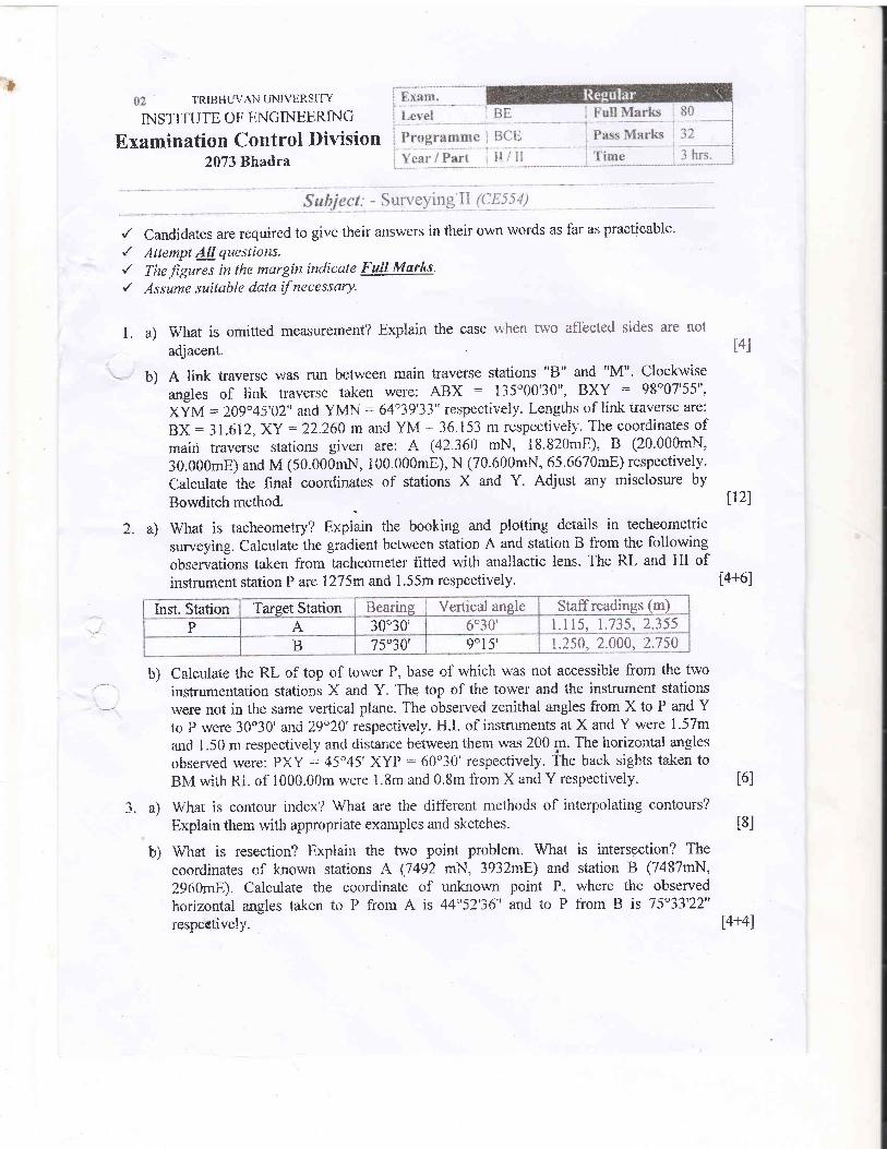
a) What is omitted measurement? Explain the case
adjacent.
rvhen two affected sides are not
l4l
2.
b) A link traverse was run between main traverse stations "8" and "M". Clockwise
angles of link traverse taken were: ABX : 135o00'30", BXY : 98o07'55",
XyM : 209"45'02" and YMN- : 64o39'33" respectively. Lengths of link traverse are:
BX : 31.61 2,XY = 22.260 rn and YM : 36.153 m respectively. T'he coordinates ofmain traverse stations gi'ren are A (42.360 rnN, 18.820mE), B (20.000mN,
30.000mE) and M (50.000mN, i00.000mE), N (70.600mN, 65.657AmE) respectively.
Calculate the final coordinates of stations X and Y. Adjust any misclosure by
u21Bowditch method.
a) What is tacheometry? Explain the booking and plotting details in techecmetric
surveying. Calculate the gradient betr,veen station A and station B from the following
observations taken from tacheometer fitted with anallactic lens. The RL and HI ofinstument station P are 1275rn and 1.55m respectively. [4+6]
Inst. Station Target Station Bearing Vertical angle Staff readings (m)
P A 30"30' 6030' f .i15, 1.735,2.355B 75"30' 9015' 1.250, 2.000, 2.750
Calculate the RL of top of tower P, base of which was not accessible from the two
instrumentation stations X and Y. 'Ihe top of the tower and the instrument stations
were not in the same vertical plane. The observed zenithal angles from X to P and Yto P rvere 30"30' and 29"20' respectively" H.I. of instruments at X and Y were 1.57m-and 1.50 nr respectively and distanc,e befween them was 200 p. Th. horizoirtal angles
observed were: PXY : 45"45'XYP : 60"30' respectively. The back sights taken to
BIr4withRLofl000.00mwere l.Smand0.SmfromXandYrespectively. t6l
What is contour index? What are the different methods of interpolating contours?
Explain them with appropriate examples and sketches. t8]
What is resection? Explain the two point problem. What is intersection? The
coorclinates of known stations A (7492 mN, 3932mE) and station B (7487mN,
2960mE). Calculate the coordinate of unknown point P, where the observed
horizontal angles taken tc. P from A is 4452'36" attd to P from B is 75"33'22"respectively. [4+4J
b)
3. a)
b)
h 4. a) Explain the setting out of simple circular curve by offsets from long chord' t4]
b)
is 45o and chainage of intersection point
circular curve are 20 m and 30 m iespectively. Take chainage at multiple of peg
interval. - '. t6]
c) A grade of -3.5Vo rneets another grade of1267.$0m and 780 m respectively' Fiel
should pass through a point of elevation I
equal tangent vertical curve ancl futl stations elevations whennormal chord - 30 m. t6l
5. Explain the following: (any four)
i) Principle of stereoscoPy, inrportance of aerial mapping
ii) Application of rernote sensing
iii) Wortcing principle and components of GPS
iv) GIS and its components and subsystem
v) Features of total station and its importance'
[axa]
!J
.-i -- --;-.-,;- -
J-l.:
iri
i
.102 TRIBHWAN I,JNIVERSITY-INSTITUTE OF ENGINEERING
Examination Contlgl Division2A72 AsIiYvjP
:
'. : ..i : ,
_ Sq$ject: -Svnteytagfi (CE55t)'#-+
J. the
are
Exem. Ittgu lar'
I-evel
PrugraumeBE FuIlMarb 80
BCE Prss lt{erkb 32
YearlPart II/II Time 3 hrs.
i1 .
r' C,andidates are required to.givettreir answen! in their own words as far as practicable.r' Attempt&llqueEtions.{ Ttefigures in the margin indiede Fult Ma*s./ Asni* suitable dotaftfnecessay.
I. a) Explain the procedure of computation of omitted measurement, when two affectedsides oftraverse are rlot adjacent.
The are made in a taversb ABCDA.
Bearing of CDr: 314"58'04" Coordinate of'C (500 m N, 500 mE)Complete the Gale's Table with final adjusted length and bearing of each line.
2. a) Describe about the working principle of subtense bar tacheometry and dcrive subtense
bar formula for computing horizontal and vertical distances v&en line of sight'isinclined upward. [2+41
b) It is required to determine the height (clear) of a Flood light tower in an arena byustng a trartsit theodolite and for this zenith angles observationtake,n at 5 m and 2 m.height on a target vane held on the plinth level of tower were 87"45' and 88o30'rcspectively. From the same instrume,nt, renith angle observed at top of the tower was
. fonnd'as 67"45'.If the RL of the insfiument a:ris was 1200.00 nr" Calculate the clearheigbt tower.
16I
ll0I
' :i'
,i
l
I
:l
ll0l
t8l
t8lP
If observed horizontal APB =45'andBPC=52"
Determine (i) I-eneth and Beariings of AP, BP and CP (ii) C-o-ordinates of P.
4. a) Derive the expression that in a parabolic shaped vertical curye, RL of any curve point
?'isequalto yo =$'+S+nr, of BVC200L 100
\f,/here, Br and g2 arc iercer-rtage of grade of two targelf& L is the toht length ofcurve and x is tlie chord distance taken tom BVC. Also find the formula to dete,rnoinelowest and highest point ofthe curve.
I
Traverse Leg Horizontal Distance (m) Trfiverse Station Horizontal Aneleo I fi
78 4lAB 7t;5 A 25
BC 42.0 B. l0l 18 3870.0 c 89 59 4tCD
DA 56.0 D 90 00 2t
t6I
Jo
b) A road 8 m wide is300 m, the
out:
to deflect through an angle of 60" with the center line radius ofof intersection point betng (3{-605) Km: A transition curve is to
a lengttr that theof design veliicle
rate ofchange ofis 70Jhp1r, find
ll0l
[ax4J
Length
ii)iii)
iv)
elevation
pointspointsof tangeffChainage
flIrves and circular curve.
cunre:20 m.circularand
points
ml0two
curve
first
transition
forangles
for
Deflection
intervalPeg
any
Take
Attempt
a) Feature of total station and its importanceb) Working prinbiple an-d co_mpgBentsof,GPS -'
9) ti"ld pnocedurdof aerial photogralniuetryd) Application of remote sensing in engineering and mappinge) Components ofCtS and its application
tt
1l
:
L
fr,I[;
'a-l"
.ii'
a:11
| ..; l'
i'
t
.{
i
t
ii,;
-lf--
;j 02 TSIBHWANI'NIVERSITY
INSTITUTE OF ENGINEERING
Examination Control Division2072Mraigh
Exam. Ncu llecli (2066 .t L:rtcl'llatch)Lerrel BE Full llfierks 80
Programme BCE Pass Marks 32
Year / Part II/II Time 3 hrs.
Subject: - Surveying ll (CEs
/ Candidates are required to give their answers in their owh words as far as practicable.r' Attempt Allquestions.{ The figures in the margin indicate Full Marks.y' Assume suitable data if necessary.
l. a) Describe consecutive and independent coordinates. Explain the plotting method oftraverse by grrd coordinates.
b) In a four sided closed traverse ABCDA the informations are
i) Compute all missing figures.ii) Compute the coordinates of other points with respect to C.
2. a) Develop expressi,on for H, V, and R.L for the tangential system of tachometry whenthe both sightings are angles ofdepression
b) Deterrrine gradient and bearing of PQ. The staffwas held vertical. K.:.I$;C:0.Inst. St. Staff
St.Bearing Zenithal
AneleStaff Readinss (m)
T M B
RP s600E 79"28', 2.36 t.8l t.25o s30'w 95"06', 2.94 2.t2 1.30
c) The top (Q) of a tower was sighted from two stations at very different level and insame vertical plane with Q. Find R.L of the top of tower from the following observeddata:
Inst. St. H.I R.L Target Zenithal{ 1 o?ctP 1.87 m o
R 1.64 m 112.78 m a {tt"42'
The distance between instrument stations P "-id i( is 120 m.The angle of eleyation from R to 2 nii. above the root of the staff held at P ras I 5" I I'
3. a) Explain the faclars that affect the contour interval.
b) In e irigonometical levellings a hill station "P" was sighted from two irrstumentstation A and B which were at very different level but with same line of sight to thatof target'and following intbrmation were noted.
Inst. st' HI (m) Target ZEfith Anele DistanceFL ER
A 1.42 P 65018', 304"36', 120.00m(stn A to Stn B)B 1.47 P 6952', 290"00'
A 1.42 B 102"52', 257016',
Determine the RL of P, if RL of ground point B was I280.00 m and vane height whilesighting from A to B was 2.50 m above the foot of the vane.
IL
[3+3]
t10l
14l
[-6fu.,
t6I
t4I
t6l
Lensth (m)Side Deflection anele Bearine CoordinatesAB 280.00 ? s50'w ?
BC 360.00 ? ?85"00'LeftCD 320.00 135'00'Left ? C=2500mE,2500mNDA "l ?
,l ?
. L.--...--.---,... -
,|:
r.,t ,:
i': . ..
:i
ii'
li'
iiil/::i
-. ,,.
t: I'i..:-
.:f.
l" rii;. .
i. r 11.l:,.,':
tQ-
c) ht two point resection problem, if tno known points A and B having coordinates(6928.474 mN,7464.418 mE) aurd,(5363.775 rnN,96A2.054 mE) are given. Fromtwopoints C and D localed south and west of AB, angles observations are:
I ACB = 70"35'48", Z DCA : 52"25'35", Z ADB : 65"27'35" andIBDC = 32"16'42u. Determine the coordinates of resection point nC^
4. a) Derive the formula for deflection angle (a) in transition curve, s.= 573 P/RI minute.
b) Calculate the R.L.s of pegs on a vertical curve connecting two grades of -0.5% and+0-,7yo at the intersection point which has chainage =.1000 m and R.L = 500 m. Therate of change of grade is 0.1% per 30 m. Take peg ittirval = 20.
c) Compute the data for setting out a simple circular curve by Rankines deflection anglemethod from the following informations:
Angle of intersection = 145o0'Chainage of point of intersection = 1580 mDegee of curve = 5o
Least count of the theodolite = 10"Peg interval = 30 m
5. Write short note on: (any four)
a) 'Field procedure of aerial photogrammetricb) Application ofremote sensing in engineering and mappingc) Working principle and components of GPSd) Components of GIS and its application' e) Features of totd stration and its
!t*+.',*'
,i
ir
-i lr{'iil:
t6I
141
t6I
16I
[4x4]
.{
IL
'i'" ..:i'-
..:i:*r ,
:':, ?
U2 TRIBHWA}.IIJMVERSITY
ENGINEERING
2071
ll (cE5s4)
{
I{r
I
Candidates are required to give their aoswers in their
Thefigrres in the mwgin indicate ffii Marks. : :
et iie suitab le data lJ ne c e s s ary.-.-.'...:.]:-l , . ,, : .
.
a) Define closed loop and close{ Iink traverse.balancing process in liuked traveise.
own words as
AIso explain
b) A traverse ABCDA was conducted and the following datarequired to connect thd midpoint E of CD to the midpoint Fand bearing of EF.
Line Leneth BearinsAB 610.00 N 80"10'EBC 5r0.00 N 13"00',ECD 1130,00 s 80010'wDA 450.00 s 15030'E
2. a) State the principle of stadia tacheomeffy and describe thetacheometry survey for preparing topographic map.
b) A tachometric suvey was done.to find the gradient between X and Y. Tacheometerconsist of an anallatic lens was used and following observalions wer€ made fromsectionRonvertical staff. ;
Inst. Stn. Staffpoint Stadia hair readines Vertical anele Bearine
R x 0.915; 1.750, 2.585 +15" 3450
Y 0.760.2.24A.3.t15 +10" 75"
3. a)' How can you measure the horizontal distance and elevation of an inaiccessible objectwhen the instnrment positions are at very different levels; instrument stations and the
b) Ihe co-ordinates of three known stations Swayambhu, Dharara and Chovar temple is,,1
given below.
Known station Horizontal angle Eastins NorthinsSwayambhu (S) ZSxD=41020'21" 627464.718 3A66928.474
Dharara (D) Iti"x C:9?a56'41" 62960L0s4 306s363.275ChovarTemple (C) ZC x S:22A"42'58" 627611.753 34il479.468
A theodolite is set up over an unknown point X. Calculate the co-ordinates of stationX using the Tiensta mettficd.
!
Exam. Itl.'tr,slrr l
Level BE ', , ,'l'*fiffi[ffii8ffi,,1,i E0',:,,.r,:,
PrggrammeYear/Part II/il lffiti]$',n 3'hi$,
4. a)
b)
deflection angles for circular curve. Take peg interval = 10rh for2}mfor circular curve.
5. Write short notes on: (any four)
a) Working principle and components of GPSb) Relief displacement and its expressionc) Application of remote sensing in civil engineeringd) F"eatures of total station and its importancee) Comporient of GIS and its application
**:F
a.
:
l
I
i
I
I
I
Ii
i
.l
I
tol ftOI TRIBHUVAN
,
IINSTITUTE OF ENG
Examination Control2071 Magh
II/ Candidates are required to their answers in their own words as far as practicable.{ Attempt All questtons.r' Thefigures in the margin Full Marks.{ Assume suitable data if1. a) When would you
Explain with neata theodolite traversing by the method of deflection angles?
b) The following dataDE and EA.
to a traverse ABCDE. Determine the bearings of the sides
2. a) The co-ordinates of S and A are (1309.12 rr E, 1170.50 m N) and(1525.43 m E and 87 m N) respectively. Calculate the co-ordinates of point Bwhich has been by intersection from stations S and A observing the followingangles. ZBSA:85"3 and ZSAB = 55o50'33".
b) Calculate the difference and gradient between stations A and B from thegrven data which are by a tacheometer from station R. Staff was verticallyheld at A and subtense at B. The subtended angle between the instrument and 2mlong subtense bar was 15"
3. a) Explain the direct method of contouring and write the uses of contour map.
b) In a road alignment a falling grade of l% is followed by rising grade of 0.5%. Thechainage and RL of the intersection point are 500 and 350 m respectively. The rate ofchange of grade is 0.1% per 20 m. Calculate the necessary data required for settingout the vertical curve, take peg interval of 30 m.
4. a) Explain degree of curve with neat sketch. Derive the formula of Tangential angle,
90'ccr,=t and deflectionangle An = 6r +62 * 63 .|....... * 6n.nR
b) The top of temple was sighted from two stations A and B at very different level. The
observed vertical angle from A and B to top of temple 'P' were 30o36' and 20o12'respectively. The vertical angle B to A to a vane at 1.5 m above the foot of the vanewas 4o15'. The height of instrument at A and B were I .47 m and 1.42 m. The distancebetween two instument station was 1 12 m. RL of B was 1280.00 m. Find the RL ofthe top of the temple. Also apply the correction for refraction and curveturate.
5. Write short notes on: (any four)
a) Working principle and components of GPSb) Importance and uses of photogrammetryc) Application of remote sensing in Civil Engineeringd) Features, importance and uses of Total Statione) Component and subsystem of GIS and its application
d. {€ i.
t6l
ll0I
t8I
t8I
t6l
t10I
t8I
fax4l
t8l
Exam. Neu ll:rcli (2066 ct l.atu'llatch)Level BE Full Marks 80
Programme BCE Pass Marks 32
Year / Part il/II Time 3 hrs.
Line AI t BC CD DE EALensth (m) 230.50 250.20 210.80 240.30 265.40Bearing N 360, .s',E s 92049'E s 10"15'E ? ,l
InstrumentStation
Sightedto
BearingZenithangle
Sta.ffreadings(m)
Subtensebar heieht
R A 345000' 96"30', 0.650, 1.250,1.850 xR B 225"00', 85000' x 1.180 (m)
a' W TRJBHWANI.INIVERSITY
INSTITUTE OF ENGINEERING
Examination Control Division2070 Bhadra
Exam. I{cgul:r rLeveI BE FulI llflarks 80
Piugramme BCE Pass Marl6 32
Year / Part u/II Time 3 hrs.
Subject: - Surveying II (CEs54)
r' Candidates are required to give their answers in their ovrn words as far as practicable.{ Attempt Allquestions.{ Thefigures inthe margin tndicate Full Matk./ Assume suitable data if necessory,
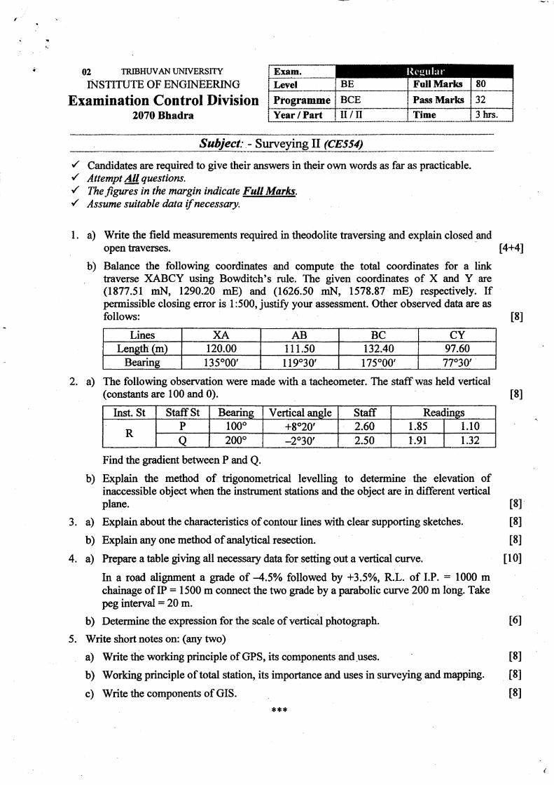
1. a) Write the field measurements required in theodolite traversing and explain closed andopentraverses. [4+41
b) Balance the following coordinates and compute the total coordinates for a linktraverse XABCY using Bowditch's rule. The given coordinates of X and Y are(1877.51 rnN, 1290.20 mE) and (1626.50 mN, 1578.87 mE) respectively. Ifpermissible closing error is 1:500, justify your assessment. Other observed data are asfollows: t8l
Lines XA AB BC CYLenelh (m) 120.00 I 11.s0 132.40 97.60
Bearing 135000' I 19"30', 175"00', 77"30',
2. a) The following obsenration were made with a tacheometer.. The staffwas held vertical(constants are 100 and 0).
Inst. St StaffSt Bearine Vertical angle Staff Readines
RP 1000 +8020, 2.60 1.85 1.10
o 2000 -2030' 2.50 1.91 1.32
Find the gradient between P and Q.
b) Explain the method of trigonometical levelling to determine the elevation ofinaccessible object when the instrument stations and the object are in different verticalplane.
3. a) Explain about the characteristics of contour lines with clear supporting sketches.
b) Explain any one method of analytical resection.
4. a) Prepare atable gving all necessary data for setting out a verticalcurve.
In a road alignment a grade of 4.5o/o followed by +3.5Yo, R.L. of I.P. : 1000 mchainage of IP = 1500 m connect the two grade by a parabolic curve 200 m long. Takepeg interval :20 m.
b) Determine the expression for the scale of venical photograph.
5. Write short notes on: (any two)
a) Write the working principle of GPS, its components and.uses.
b) Working principle of total station, its importance and uses in surveying and mapping.
c) Write the components of GIS. ***
t8l
t8l
t8l
t8l
t10I
t6I
t8I
t8l
t8I
t
02 TRJBHUVAN I.JNIVERSITY
INSTITUTE OF EN,GINEERING
Examinetion Control Division' 2070 Magh
Exam.t
I
\ctt llucli (206(r .,t L:rtcr ll:rtclr )
Level BE Full Marks 80
Programme BCE Pasg Marks 32
Year / Part II/II Time 3 hrs.
Subject: - Surveying 1l (CEs57)
{ Candidates are required to give'their answers irttheir own words as far as practicable./ Attempt All questtons.r' The Jigures in the margin indicate Full Marles.{ Assume suitable data if necessary.
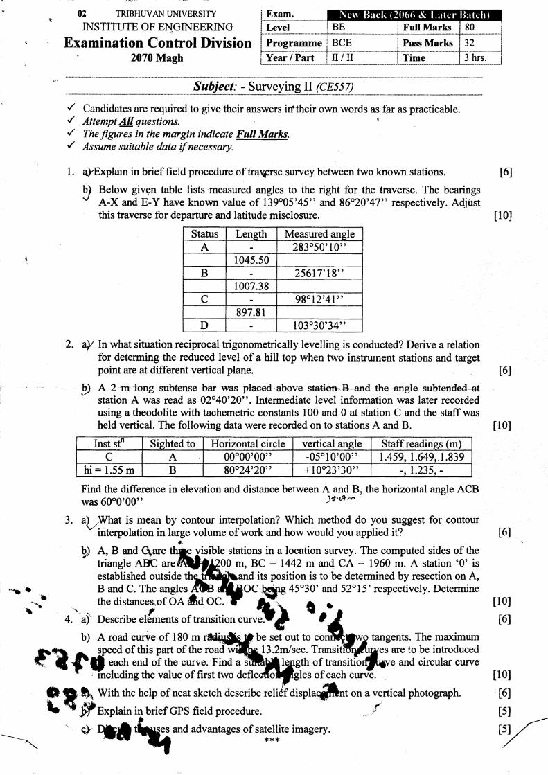
l. alExplain in brief field procedure of traprse survey between two known stations.
b) Below givgn table lists measwed angles to the right for the traverse. The bearingsv A-X and E-Y have known value of 139o05'45" and 8620'47" respectively. Adjustthis traverse for departure and latitude misclosure.
Status Leneth Measured angleA 283050'10"
1045.50B 25617',18"
1007.38C 98"12',41"
897.81D 103030'34"
2. aY lnwhat situation reciprocal trigonometrically levelling is conducted? Derive a relationfor determing the reduced level of a hill top when two instrurnent stations and targetpoint are at different vertical plane.
I A 2 m{ong subtense bm was placed-above station--B-an4t}re angle subtended-+tstation A was read as 02"40'20". Intermediate level information was later recordedusing a theodolite with tachemetric constants 100 and 0 at station C and the staffwasheld vertical. The flollowing data were recorded on to stations A and B.
Inst stn Sishted to Horizontal circle vertical angle Staff readines (m)
C A 00"00'00' ) -05010'00" t .459. 1 .649.. I .839hi = 1.55 m B 80"24',20" +10023'30" -.1.235. -
Find the difference in elevation and distance between A and B, the horizontal angle ACBwas 60o0,00', )i'th,t,
al )Ntatis mean by contour interpolation? Which method do you suggest for contour" interpolation in large volume of work and how would you applied it?
b) A, B and Qare stations in a location survey. The computed sides of theriangle Affi m, BC = 1442 m and CA : 1960 m. A station '0' isestablished outside its position is to be determined by resection on A,
45o30' and 52"1 5' respectively. Determine
t6I
t
tl0I
tl0I
ll0lt6l
t6If':
3
t6l
*L 't'l
'.\L o CI
4.")'
D
11 Wittr the help of neat sketch describe
ffexphin in brief GPS field procedure.
tangents. The maximumare to be introduced
and circular curve
on a vertical photograph.fa'
b) A road curve of 180 m be set out toof this part of the 13.2mlsec.
each end of the curve. Find a ofthe value of first two ofeach
and advantages of satellite imagery.!F**
ll0lt6l
tsI
tsIa>
02 TRIBHUVAN I.'NIVERSITY
INSTITUTE OF ENGINEERING
Examination Control Division2069 Bhadra
Exam. Regul:tr (Z(l(t(t & Luter Batclt)LeVel BE f,'ull Marks 80
Programme BCE Pass Marks 32
Year / Part il/il Time 3 hrs.
II
'/ Candidates are required to give their answers in their own words as far as practicable.r' Attempt 4ll questions../ The/igures in the margin indicate Full Marks.y' Assume suitable data if necessary.
l. a) For a closed traverse ABCDA, compute the missing data.
Line Lensth(m) BearingABBCCDDA
100.0060s.0095.00?
N 450 30', WN 50 30',EN 880 20',E?
b) What are closed and open traverse? Explain consecutive and independent co-ordinateswith examples.
2. a) The following readings were taken by a tacheometer with the itaffheld vertical. Thetacheometer is fitted with an anallactic lens and the multiplying constant is 100. findout the horizontal distance from A to B and gradient of AB.
Instrument station StaffStation Vertical ansle Staffreadines Remarks
A
BM
B
4"30',
+1000'
1.100, 1.153,2.060l:
0.992,1.105, 1.188
RL ofBM=970.00m
Derive an expression to find the RL of an inaccessible object when the instrument andthe object are not in the same vertical plane.
What are the methods of contouring? Explain briefly. Write the uses of contour maps.
What is analytical resection? Derive an expression to find the co-ordinates ofunknown points by observations to three known points.
Calculate the RLs of pegs on a vertical curve connecting two grades of +0.5yo and -0.7% at the point of intersection. The chainage and RL of intersection point are 500mand 350.750m respectively. The rate of change of grade is 0.1% per 30m.
Find the elements of simple circular curve.
Define: (i) Tilted photograph (ii) Side overlap (iii) Principal point (iv) Flying height
What is GPS? Write the components and working principle of GPS.
Explain the working principle of total station. Write its importance and uses insurveying and mapping.
rl.rt *
t8t
tl0l
t6I
t8l
E
t8I
t
r)b)
3. a)
b)
4- a)
b)
c)
5. a)
b)
t8l
t8l
t8I
t4l
L4l
t8I
Ittfrd+,i
-
t;
02 TRIBHW-ANI4\IVE\S]TY
iNSTITUTE OF ENGINEERING
Examination Control Division2068 Bhadra
Exam. RegularLevel BE Full IVIarks . 80
Programme BCE Pass Plarks 32
Year / Part II/II Time 3 hrs.
II./ Candidates are required to give their answers in their own words as far as piacticable./ Attemot All auestions. . .
/' Thefigures tn th,e margin indicate Full Marks./ Assume suitable data if necessary.
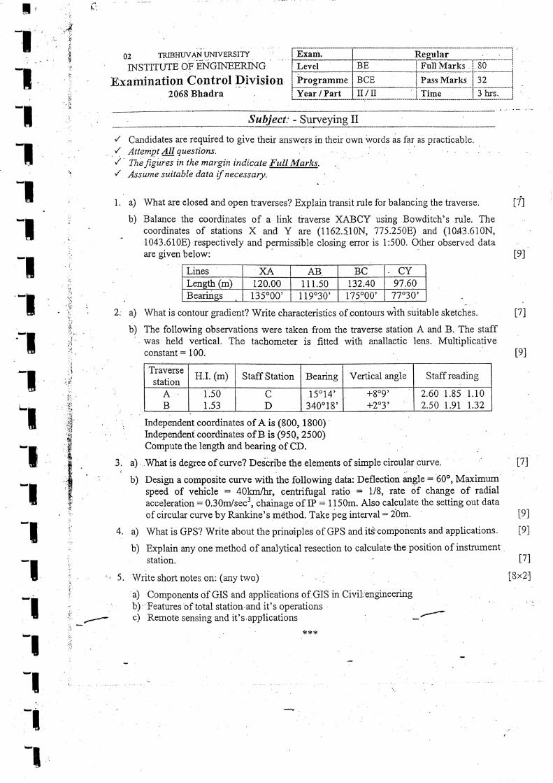
1, a) What are closed and open kaverses? Explain transit rule for balancing the traverse.
b) Balance the coordinates of a link tiaverse XABCY using Bowditch's rule. Thecoordinates of stations X and Y are (1162.5-10N,775.250F) and (10-43.610N,' 1043.610E) respectively and permissible closing error is 1:500. bther observed dataare given below:
Lines XA AB. BC CYLeneth (m) 120.00 111.50 t32.40 97.6ABearings 135000' 1 19030' 175000' 77"30',
U]
tel
U1
tel
f-
l:.
':
' l'i::t
,+
n',.:
1t
rl. :ii,:.*
ii!'1J
irl'
',;i*;,e,.,s's
,.#
.'$.E*.,:.ii;'{:
:
i
i
;i^r:.
':1.:r,
:
i_.
2: a) What is contour gradient? Write characteristics of contours wiA suitaUte sketches.
b) The following observations were taken from the traverse station A and B. The staffwas held vertical. The tachometer is frtted with anallactic lens. Multiplicativeconstant: 100.
Traversestation
H.I. (m) Staff Station Bearing Vertical angle Staffreading
AB
1.501.53
CD
15" i 4',
34001 8',
+809',
+2"3',2.60 r.85 Lio2.50 1.91 1.32
Independent coordinates ofA is (800, 1800)
Compute the length and bearing of CD.
3. ' a). -What is degree of curve? Dedcribe the elements of simple circularcurve.i
b) Design a composite curve with the following data: Deflection angle: 60", Ma,rimumspeed of vehicle : 40hnr/tr, centrifugal ratio = 1/8, rate of change of radialacceleration = 0.30m/sec3, chainage of IP: 1150m. Also calculate the settingout dataof circular curve by Rankine's method. Take peg interval : 20m.
4 a) What is GPS? Write about the principles of GPS and its\'components and applications.
b) Explain any one method of analytical resection to calculate'the position of instntmentstation.
a) Componants of GIS and applications oiGIS in Civil,engineering
UI
lel
tel
t7l
[8x2,]
b)c)
'Features of total station,and it's operationsRemote sensing and it's,apprt.uttorr
***
05 TRIBHWAN L,'NIVERSiTY
b{STITUTE OF ENGINEERbIG
Examination Control Division2065 Magh
E-xam. ReEularIBackLevel BE Full Nlarks 80
Prograrnrae BCE Pass ivlarks )L
Year i Part u/Ii Time 3 hrs
Sub II./ Candidates are required to grve their answers in their os.n words as far as practicable.t' Attempt any -Five questions.'/ The jieures in the margin indicate FutI Marks.-/ ,qssutne sutraoLe daru tf ruecessarl/.
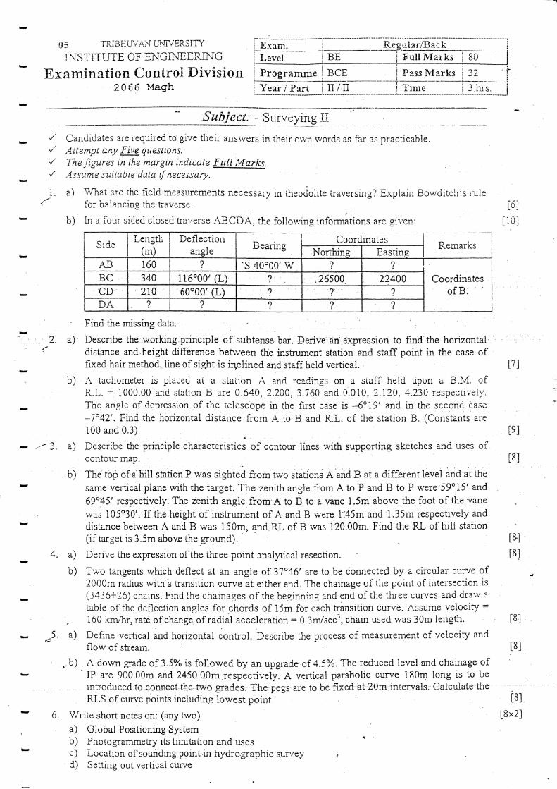
a) V,'hat are the fieiri rneasurements necessary in theodolite traversing? Explain Bowciitch's;uletbr baiancing the traverse.
b) Lq a iour si,led cioseci tra./erse ABCDA, the follov,.ing informations are siven:
SideLength
(m)Det-lection
angle BearingCoordinates
RemarksNor*thins Easting
AB 160,)
s 40"00'w ,)
BC 340 116"00',(L) ,) 26s00 ?2400CD .210 ' 60"00'(L) ,)
?,)
DA ? ? ? ? ?
Finri the missing data. ,
Describe the.working,principle of subtense bar. DErive':an:dxpression to find the horizontaldistance and height difference betrveen the inskument station and staff point in the case offixed hair method, line of sight is iqclined and staff held vertica{.
A tachometer is placed at a station A and readings on a stafi held dpon a B.M. ofR.L.: i000.00 and statio;r B are 0.640, 2.200,3.760 and 0.010, 2.120.4.230 respecdvely.The angl6 of depression of the telescope in the firsr case is -6"19' and in the second case
-1o42'. Find the horizontai distance from A to B and R.L. of the station B. (Constants'are100 and 0.3)
Describe the principle characteristics of contour lines with supporting sketches and uses oicontotn rnap.
54
r6l
[10]
2. a) .:
i7l
tel
l8l
b)
tiill station'P was sighted from two stations A and B a! a different levei and at the.b) Thetopofaisame vertical plane with the target. The zenith angle from A to P and B to P were'59o15' and
69o45'respectively. The zenith angle from A to B to a vane 1.5m above the foot of tLe vane
rvas 105'30'. If the height of instrument of A and B were 1.45m and 1.35m respectively anddistance between A and B was 150m, and RL of B was I20.00m. Find the RL of hill station
i&l(if target is 3.5m above the ground).
4. a) Derive the expression of the three point analyical resection- t8]
b) Two tangents which deflect at an angle of 37"46' are to be connected by a circular curve of2000m radius rvith''a transition curv'e at either end. The chainage of the point of intersection is(3,136+26) chains. Find the chainages of the beginning and end of the thret curves and drari'atable of the deflection angles for chords of 15m for each transition curve. Assume velocity =
- 160 km/hr, rate of change of radiai acceleration : 0.3m/secr, chain used was 30m length.
a) Define vertical au'd horizontal control. Describe the process of measurement of velocity andflow oi stream.
.-b) A down grade of 3.5% is followed by an upgrade of 4.5o/o. The reduced level and chainage of' IP are 900.00m and 2450,00m respectively. A vertical parabolic curve 180m long is to be
introduced to connectthe tws grades. The pegs are to-be-fixed-ats20m:intervais. Calculate theRLS of curve points including lowest point
V"rite short notes on: (any two)a) Giobal Positioning Systemb) Photogrammetry its limitation and usesc) Location of sounding pcint in hydro.graphic sunre;; ,
d) Setting out verlical curye
v -'' 3. a)
t8l
t8l
=,
6
t8l
l8x2l
I
INS'l'Ii U Ib, Uf E,NUTN.E,.tr}(-l..I\\J
Examination Control Division2065 Kartik
Level
Programme BCE
il/tr
.illlll iY!.Srris
Pass Marks
6U
32
IJT.
3 hrs.Year I Part Time
II
their ansrvers in their own words as far as practicable.'/ Anempt any Five c|uestions./ Thefigures tilte margin indicate Full Marks.,/ Assume suitable data if necessary.
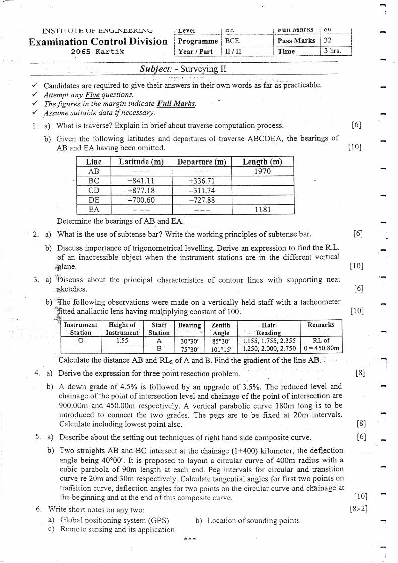
1. a) What is traverse? Explain in brief about traverse computation process.
b) Given the following latin-rdes and departures of traverse ABCDEA, the bearings ofAB and EA having been omitted.
Line Latitude (m) Departure (m) Lensth (m)AB 1970BC +841-11 +336.7tCD +877.18 -311.74DE -700.60 127.88EA 1181
Determine the bearings of AB.and EA.
2. a) What is the use of subtense bar? Write the working principles of subtense bar.
b) Discuss importance of trigonometrical levelling. Derive an expression to find the R.L.of an inaccessible object when the instrument stations are in the different vertical.ry.lane.
3. a) ':Discuss about the principal characteristics of contour iines with supporting neat
,Bketches.
b) follow-ing observations were made on a verticatly held staff with a tacheometerffed anallactic lens having mu\tiplyrng constant of 100.
ealculate the distance AB and RLs of A'and B.'Find the:gradient of the line AB.
b) A down grade of 4.5o/o is followed by an upgrade of 3.5Yo. The reduced level andchainage of the poirit of intersection level and chainage of the point of intersection are
900.00rn and 450.0Om respectiveiy. A vertical parabolic curve 18Om long is to beintroduced to connect the two ,erades. The pegs are to be fixed at 20m intervals.Calculate inclu<iing lowest point also.
5. 4 Describe about the setting out techniques of right hand side composite curve.
b) Two straights AB anri BC intersect at the chainage (1+400) kilometer, the defl.ectionangle being 40"00'. It is proposed to layout a circular curve of 40Om radius with acubic parabola of 90m leag1h at each end. Peg intervals for circuiar and ransitioncurve re 20m and 30m respectively. Calculate tangential angles for first two points ontrarisition cun'e, deflection angles for turo points on the circuiar curv-e anC ch?inage aithe begrnning and at the end of this composite curye.
6. \Vrite short notes on any two:a) Global positioning system (GPS) b) Location of sounding pointsc) Remote sensing and its application
'/ Candidates are required to give
t6l
[10]
l6l
li0l
t6l
[10]
t8l
I8l
l6l
Ii0]i8x2l
i
-1
I Ileight ofI Instrument
fnstrument' Station'
StaffStation
Bearing Zenith1l\nsle
Hair. 'Readine
Remartr<s
o A,B
30e30'
75030',
8503o',
1010 15',
1,155, 1-755,2.355'1.250, 2.000,2.750
RL of0:450.80m
***
.-ii-:+,i.;i-*::":l:.{,;;{";..:i:::j.j;a*iiai1,:;cl!e}a.a}*:$a- 'ir ":-r . :'-'- -" . -.' --.-:.;:..-.-. '*-&.,
E]
05 TRtsHWA}.I I.JNIVERSITY
INSTITUTE OF ENGINEERING
Examination Control Division2065 Chaitra
/ Candidates are required to give their answers in'/ Attempt any ru.questions.{ Thefigures in the margin indtcate Full Marks.,/ Assume suitable data if necessary.
as practicable.
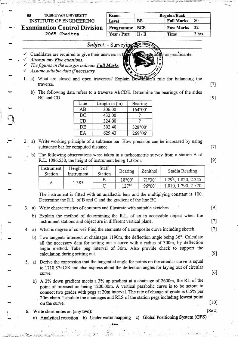
i. a) What are closed and open traverses? Explaintraverse.
rule for balancing the
b) The following data refers to a traverse ABCDE. Determine the bearings of the sidesBC and CD.
Line Length in (m) BearingAB 306.00 164000'BC 432.00 ?
CD 324.00 ?
DE 302.40 328"00',
EA 629.43 269"06',
Write working principle of a subtense bar. IIow precisidn can be increased by usingsubstence bar for computed distance.
The followiirg observations were taken in a tacheometric survey from a station A ofR.L. 1086.550, the height of instnrment being 1.385m.
U)
tel
,1
! {"}F'r'
2.-a)
_b)17)
iel
17l
17)
tel
t6l
II
tel
3. a)
b)
The instrument is fitted with an anallactic lens and the multiplying constant is 100.
Determine the R.L. of B and C and the gradient of the line BC.
Write characteristics of contoursand illustrate with suitable sketches,
Explain the method of determining the R.L. of an in accessible object when the
instrument stations and object are in different vertical plane.
What is degree of curve? Find the elements of a composite curve including sketch.
Two tangents intersect at chainages 1190m, the deflection angle being 36o. Calculateall the necessary data for setting out a currye with a radius of 300m, by deflectionangle method. Take peg interval of 30m. Also provide check to support thecalculation during setting out.
Derive the expression that the tangential angle for points on the circular curye is equal
to 1718.87xClR and also express about the deflection angles for laying out of circularcurye.
4. a)
5. a)
b)
b) A 2% down gradient meets a 3Y, tp gradient at a chainage of 2600m, the RL of the
point of intersection being 1200.00m. A vertical parabolic curve is to be setout to
connect two grades with pegs at 20m interval. The rate of change of grade is 0.5% per
20m chain. Tabulate the chainages and RLS of the station pep inctuding lowest point
onthe curye. [10]
6. Write short notes on (any two): [8x2]a) Analytical resection' b) Under water mapping c) Global Positioning System (GPSI '"'''
' - .._- .,,;,, r: ;:;k.-.;1.,51.5;,1;ii,,[,,i,i'i r",,:r
Exam. ResularlBackLevel BE E'uIlMarla 80
Programme BCE Pass Marks 32
Year / Part tr/tr Time 3 hrs.
lnstrumentStation
Height oflnstr,ument
StaffStation
Bearing Zenithol Stadia Reading
A 1.385B 1 8000' 71o30' 1 1.820,2.345C 1270', 96000' 1.010, 1.790,2.570
Related Documents