wq-s5-04 • 12/11/12 www.pca.state.mn.us • Available in alternative formats 651-296-6300 • 800-657-3864 • TTY 651-282-5332 or 800-657-3864 Page 1 of 19 Wild Rice and Sulfate Data Assessments Sulfate Data Submittal Template Instructions How to fill out this spreadsheet Click on cells to select from drop down menus. Sulfate Data Submittal worksheet: 1. Do not include sulfate data that has been stored in the database under other projects. 2. Enter lab metadata in Columns S, U, and/or W, Rows 1-5. Lab name is required. Location Establishment worksheet: wq-s6-41c 4/1/2013 View all comments by scrolling mouse over the header row cells. Visit the Minnesota Wild Rice and Sulfate Map to view all established surface water location IDs and those locati 3. Enter sulfate data in Column S, U, and/or W (and) remark codes in Columns T, V, and/or X, one column per lab. Enter data from additional labs after Column X. been determined. 2. Enter required information in column headers with bold red font and additional information if available. Contact Lynda Nelson at [email protected] or (651)757-2601 for assistance. Please submit completed template to [email protected]

Welcome message from author
This document is posted to help you gain knowledge. Please leave a comment to let me know what you think about it! Share it to your friends and learn new things together.
Transcript

wq-s5-04 • 12/11/12 www.pca.state.mn.us • Available in alternative formats651-296-6300 • 800-657-3864 • TTY 651-282-5332 or 800-657-3864 Page 1 of 15
Wild Rice and Sulfate Data AssessmentsSulfate Data Submittal Template Instructions
How to fill out this spreadsheet
Click on cells to select from drop down menus.
Sulfate Data Submittal worksheet:1. Do not include sulfate data that has been stored in the database under other projects.2. Enter lab metadata in Columns S, U, and/or W, Rows 1-5. Lab name is required.
Location Establishment worksheet:1. Enter location information for sampling locations not yet established (and) when establishment has not yet been determined.
wq-s6-41c 4/1/2013
View all comments by scrolling mouse over the header row cells.
Visit the Minnesota Wild Rice and Sulfate Map to view all established surface water location IDs and those locations with stored sulfate data.
3. Enter sulfate data in Column S, U, and/or W (and) remark codes in Columns T, V, and/or X, one column per lab. Enter data from additional labs after Column X.
2. Enter required information in column headers with bold red font and additional information if available.
Contact Lynda Nelson at [email protected] or (651)757-2601 for assistance.Please submit completed template to [email protected]

Project Name: Wild Rice and Sulfate Data AssessmentsSulfate Data Submittal Template
Note: Do not include data that has been previously stored in the database under other projects.
Meters MetersProject ID Field ID EQuIS Location ID Start Date Start Time Military Sample Depth Sample Depth UpperPRJ07911PRJ07911PRJ07911PRJ07911PRJ07911PRJ07911PRJ07911PRJ07911PRJ07911PRJ07911PRJ07911PRJ07911PRJ07911PRJ07911PRJ07911PRJ07911PRJ07911PRJ07911PRJ07911PRJ07911PRJ07911PRJ07911PRJ07911PRJ07911PRJ07911PRJ07911PRJ07911PRJ07911PRJ07911PRJ07911
Please submit completed template to [email protected]
A8
Wild Rice and Sulfate Data Assessment Project ID.
B8
ID assigned to site by sample collectors or local project manager.
C8
EQuIS sampling location name. For lakes, use the DNR code plus MPCA Site ID (01-0126-03-201), for streams use the S-code (S003-894). Leave blank for new locations and enter information in the Sulfate Location Establishment worksheet.
D8
Month/day/four-digit year (ie. 1/18/2013)
E8
Based on 24 hour clock. Insert colon (hh:mm) and record actual local time (CDT, CST).
F8
Depth of your discrete sample in meters.
G8
Lakes only: upper depth of your integrated sample in meters.

PRJ07911PRJ07911PRJ07911PRJ07911PRJ07911PRJ07911PRJ07911PRJ07911PRJ07911PRJ07911PRJ07911PRJ07911PRJ07911PRJ07911PRJ07911PRJ07911
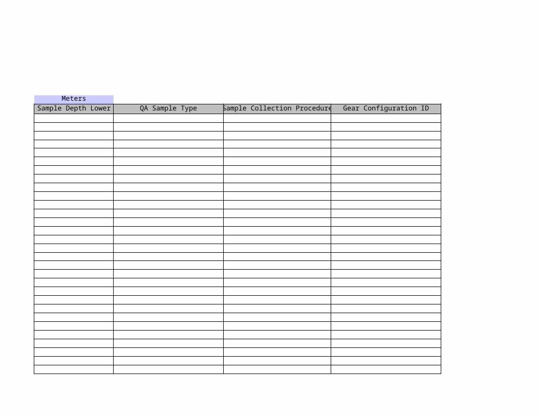
MetersSample Depth Lower QA Sample Type Sample Collection Procedure Gear Configuration ID Sampler Name / Group
H8
Lakes only: lower depth of your integrated sample in meters.
I8
Please specify if this row represents a field or lab duplicate, a blank (please describe), etc. Select via drop down menus in each cell.
J8
Examples: D-T = Discrete sample G = Grab sample LKDEPTH = Lake depth point sampling LKSURF2M = Lake 0-2m integrated sampling LKSURFOTH = Lake integrated sample other than 0-2m or spell out your method. Select via drop down menus in each cell.
K8
Examples: AS = Automatic sampler ROD = Telescoping rod with bottle SIM = Simple open plastic bucket WB = Weighted bucket WSKM = Kemmerer WSVD = Van Dorn WSWB = Water bottle 2MPVCPIPE = Lake 0-2m sampler or spell out your gear. Select via drop down menus in each cell.
L8
Name of sample collector and group they are affiliated with.


Required >Include if available>Include if available>Include if available>Include if available>
Deg CGeneral Comments Lab Comments Lab Temp Sample Holding Time Exceeded (Y) Lab Sample ID
M8
Comments relating to your sampling activity.
N8
Analysis comments from lab.
O8
Water temperature of samples when delivered to the lab in deg C.
P8
Indicate if sample analyzed exceeded maximum holding time allowed. Select via drop down menu in each cell.
Q8
Sample ID assigned by lab.


Lab Name =Lab Certified Y/N (see drop down menu) =
Analytical Method (see drop down menu) =Analytical Method Detection Limit (MDL) =
Analytical Method Reporting Limit (RL) =Fraction = Dissolved Fixed
Units = mg/L mg/LAnalyte = RemarkSulfate as SO4 Sulfate as SO4
S8
Enter dissolved sulfate data in mg/L.
T8
D = below detection limit, E = below reporting limit, J = approximately equal to a value, K = less than a value, Select via drop down menus in each cell.
U8
Enter fixed sulfate data in mg/L.


Totalmg/L
Remark RemarkSulfate as SO4
V8
D = below detection limit, E = below reporting limit, J = approximately equal to a value, K = less than a value, Select via drop down menus in each cell.
W8
Enter total sulfate data in mg/L.
X8
D = below detection limit, E = below reporting limit, J = approximately equal to a value, K = less than a value, Select via drop down menus in each cell.
Y8
Each labs data requires a separate entry column. Enter additional labs data here and add more columns as needed.
Z8
D = below detection limit, E = below reporting limit, J = approximately equal to a value, K = less than a value, Select via drop down menus in each cell.


Monitoring year: _________________
Bold red font = Required entry
Project ID Location Description Field ID State County
PRJ07911PRJ07911PRJ07911PRJ07911PRJ07911PRJ07911PRJ07911PRJ07911PRJ07911PRJ07911PRJ07911PRJ07911PRJ07911PRJ07911PRJ07911PRJ07911PRJ07911PRJ07911PRJ07911PRJ07911PRJ07911PRJ07911PRJ07911PRJ07911
Project Name: Wild Rice and Sulfate Data AssessmentsLocation Establishment Template (Add sampling locations to MPCA's water quality database)
Please submit completed template to '[email protected]'Visit the Minnesota Wild Rice and Sulfate Map to view established locations.
Waterbody Type
Latitude (DecDeg or UTM)
A11
Wild Rice and Sulfate Data Assessment Project ID.
B11
See waterbody descriptions below for more information. Select via drop down menus in each cell.
C11
Describe sampling location including directions and distance from nearest city.
D11
ID assigned to site by sample collectors or local project manager.

PRJ07911Add rows for additional locations.
Waterbody Type and Description List Lake
River/Stream
Wetland
Lakes are bodies of relatively still fresh or salt water of considerable size, localized in a basin that is surrounded by land. Lakes are inland and not part of the ocean, and are larger and deeper than ponds. Identify lakes with Minnesota Department of Natural Resources (DNR) lake identification (ID). Identify lake sampling sites by adding bay and site id after lake id. (nn-nnnn-nn-nnn = ID + bay + sampling site).Rivers and streams start a high point such as a mountain, hill or other elevated area from some source like a spring, snow melt or a lake. The water flows down to lower points, generally picking up more water as it decends, creating larger rivers and streams. Streams are identified by MPCA staff assigned id (Snnn-nnn = S indicating river / stream, number assigned by MPCA staff).Undifferentiated wetlands. Wetlands are areas of land whose soil is saturated with moisture either permanently or seasonally. Identify wetlands with DNR lake ID. Identify wetland sampling sites by adding bay and site id after lake id (nn-nnnn-nn-nnn = ID + bay + sampling site).

UTM Zone Map Scale HUC Code
Location Establishment Template (Add sampling locations to MPCA's water quality database)
Latitude (DecDeg or UTM)
Longitude (DecDeg or UTM)
Geopositioning Method
Geopositioning Datum
GPS Carrier Brand/Model
G11
Enter decimal degrees (45.3210) or UTM (654321.987) coordinates. UTMs require entry in 'UTM zone' column.
I11
Enter decimal degrees (45.3210) or UTM (654321.987) coordinates. UTMs require entry in 'UTM zone' column.
K11
Required if 'Latitude' and 'Longitude' are UTM coordinates.
L11
Method used to collect 'Latitude' 'Longitude' coordinates. 'GPS - Unspecified' requires entries in 'Geopositioning Datum' and 'GPS Carrier Brand/Model' column. 'Interpolation - Map' requires entry in 'Map Scale' column. Select via drop down menus in each cell.
M11
Required if 'Geopositioning Method' is 'GPS - Unspecified.' Select via drop down menus in each cell.
N11
Required if 'Geopositioning Method' is 'GPS - Unspecified.'
O11
Required if 'Geopositioning Method' is 'Interpolation - Map.' Select via drop down menus in each cell.

Waterbody Type and Description List Lakes are bodies of relatively still fresh or salt water of considerable size, localized in a basin that is surrounded by land. Lakes are inland and not part of the ocean, and are larger and deeper than ponds. Identify lakes with Minnesota Department of Natural Resources (DNR) lake identification (ID). Identify lake sampling sites by adding bay and site id after lake id. (nn-nnnn-nn-nnn = ID + bay + sampling site).Rivers and streams start a high point such as a mountain, hill or other elevated area from some source like a spring, snow melt or a lake. The water flows down to lower points, generally picking up more water as it decends, creating larger rivers and streams. Streams
Undifferentiated wetlands. Wetlands are areas of land whose soil is saturated with moisture either permanently or seasonally. Identify wetlands with DNR lake ID. Identify wetland sampling sites by adding bay and site id after lake id (nn-nnnn-nn-nnn = ID + bay +
Related Documents