1 This Proposed Plan is not to be considered a technical document but has been prepared to provide an abridged summary to the public. You are Invited to Comment on this Proposed Plan for the Petroleum Products Corporation Site This Proposed Plan presents the U.S. Environmental Protection Agency’s (EPA) Preferred Alternative to address contaminated soil, non-aqueous phase liquids (NAPL) and contaminated groundwater associated with the Petroleum Products Corporation Superfund site (Site) in Pembroke Park, Florida (Figure 1). The Petroleum Products Corporation was a processor and broker of waste oil and other petroleum products. The reprocessing of waste oil generated sludge containing petroleum hydrocarbons and metals. The Petroleum Products Corporation also received other types of hydrocarbon waste containing polychlorinated biphenyls (PCBs) and chlorinated solvents. A glossary defining key terms is provided at the end of this document; the key terms appear in bold the first time they are used. After evaluating the proposed cleanup alternatives, EPA’s Preferred Alternative to address contaminated sludge, NAPL, soil and groundwater at the Site consists of the following: • Common Alternative #1 – Excavation of contaminated soil in the Bamboo Trailer Park area; • Common Alternative #2 – Relocation of businesses, tenants and residents, followed by building demolition in the Main Source Area; • Common Alternative #3A – Shallow soil excavation under buildings – retain existing buildings; • Unsaturated Zone (UZ) Alternative #4 – In situ stabilization/solidification (S/S), with limited soil excavation, and off-facility disposal; • Main Source Area (MSA) Alternative #3 – In situ S/S with large diameter augers (LDA); including the demolition of the buildings within the MSA footprint; • Extended Plume (EP) Alternative #2 – Groundwater recovery and treatment (GR&T); and • Institutional controls (ICs) to prevent the consumption of groundwater until the Biscayne aquifer is restored to its beneficial use as a sole-source of drinking water. This Proposed Plan includes a summary of all cleanup alternatives evaluated for the Site. This document is issued by the EPA, the lead agency for the Site. EPA, in consultation with the Florida Department of Environmental Protection (FDEP), the support agency, will select a final remedy for soil and an interim remedy for groundwater after reviewing and considering all information submitted during the public comment period. The EPA, in consultation with FDEP, may modify this Preferred Alternative or select another alternative presented in this Proposed Plan based on new information or public comments. Therefore, the public is encouraged to review and comment on all the alternatives presented in this Proposed Plan. As part of the excavation and demolition components of the common alternatives, certain residents, tenants and businesses currently located within the boundaries of the affected areas will need to be temporarily or permanently relocated to off-facility locations. Relocation of businesses, tenants and residents will be performed pursuant to the Uniform Relocation Act, 42 U.S. Code §§ 4601 et seq., and regulations promulgated pursuant thereto at 49 C.F.R. Part 24. The EPA is issuing this Proposed Plan as part of its public participation requirements under Section 117 (a) of the Comprehensive Environmental Response, Compensation, and Liability Act of 1980 (CERCLA), as amended, 42 INTRODUCTION SUPERFUND PROGRAM PROPOSED PLAN PETROLEUM PRODUCTS CORPORATION SITE PEMBROKE PARK, BROWARD COUNTY, FLORIDA JANUARY 2021

Welcome message from author
This document is posted to help you gain knowledge. Please leave a comment to let me know what you think about it! Share it to your friends and learn new things together.
Transcript

1
This Proposed Plan is not to be considered a technical document but has been prepared to provide an abridged summary to the public.
You are Invited to Comment on this Proposed Plan for the Petroleum Products Corporation Site
This Proposed Plan presents the U.S. Environmental Protection Agency’s (EPA) Preferred Alternative to address contaminated soil, non-aqueous phase liquids (NAPL) and contaminated groundwater associated with the Petroleum Products Corporation Superfund site (Site) in Pembroke Park, Florida (Figure 1). The Petroleum Products Corporation was a processor and broker of waste oil and other petroleum products. The reprocessing of waste oil generated sludge containing petroleum hydrocarbons and metals. The Petroleum Products Corporation also received other types of hydrocarbon waste containing polychlorinated biphenyls (PCBs) and chlorinated solvents. A glossary defining key terms is provided at the end of this document; the key terms appear in bold the first time they are used. After evaluating the proposed cleanup alternatives, EPA’s Preferred Alternative to address contaminated sludge, NAPL, soil and groundwater at the Site consists of the following:
• Common Alternative #1 – Excavation of contaminated soil in the Bamboo Trailer Park area; • Common Alternative #2 – Relocation of businesses, tenants and residents, followed by building demolition in the
Main Source Area; • Common Alternative #3A – Shallow soil excavation under buildings – retain existing buildings; • Unsaturated Zone (UZ) Alternative #4 – In situ stabilization/solidification (S/S), with limited soil excavation, and
off-facility disposal; • Main Source Area (MSA) Alternative #3 – In situ S/S with large diameter augers (LDA); including the demolition
of the buildings within the MSA footprint; • Extended Plume (EP) Alternative #2 – Groundwater recovery and treatment (GR&T); and • Institutional controls (ICs) to prevent the consumption of groundwater until the Biscayne aquifer is restored to
its beneficial use as a sole-source of drinking water. This Proposed Plan includes a summary of all cleanup alternatives evaluated for the Site. This document is issued by the EPA, the lead agency for the Site. EPA, in consultation with the Florida Department of Environmental Protection (FDEP), the support agency, will select a final remedy for soil and an interim remedy for groundwater after reviewing and considering all information submitted during the public comment period. The EPA, in consultation with FDEP, may modify this Preferred Alternative or select another alternative presented in this Proposed Plan based on new information or public comments. Therefore, the public is encouraged to review and comment on all the alternatives presented in this Proposed Plan. As part of the excavation and demolition components of the common alternatives, certain residents, tenants and businesses currently located within the boundaries of the affected areas will need to be temporarily or permanently relocated to off-facility locations. Relocation of businesses, tenants and residents will be performed pursuant to the Uniform Relocation Act, 42 U.S. Code §§ 4601 et seq., and regulations promulgated pursuant thereto at 49 C.F.R. Part 24. The EPA is issuing this Proposed Plan as part of its public participation requirements under Section 117 (a) of the Comprehensive Environmental Response, Compensation, and Liability Act of 1980 (CERCLA), as amended, 42
INTRODUCTION
SUPERFUND PROGRAM PROPOSED PLAN PETROLEUM PRODUCTS CORPORATION SITE
PEMBROKE PARK, BROWARD COUNTY, FLORIDA JANUARY 2021
2
United States Code Section 9617, commonly known as Superfund, and the National Oil and Hazardous Substances Pollution Contingency Plan (NCP), as set forth in 40 Code of Federal Regulations Section 300.430 (f)(2). This Proposed Plan summarizes and identifies key information that can be found in greater detail in the Remedial Investigation (RI) and Feasibility Study (FS) reports, as well as other documents contained in the Administrative Record file for this Site. The EPA encourages the public to review these documents to gain a more comprehensive understanding of the Site. The Administrative Record is contained in the Information Repository located at the Broward County Library at 100 S. Andrews Avenue, Fort Lauderdale, Florida. In addition, information can be obrtained from the EPA webpage.
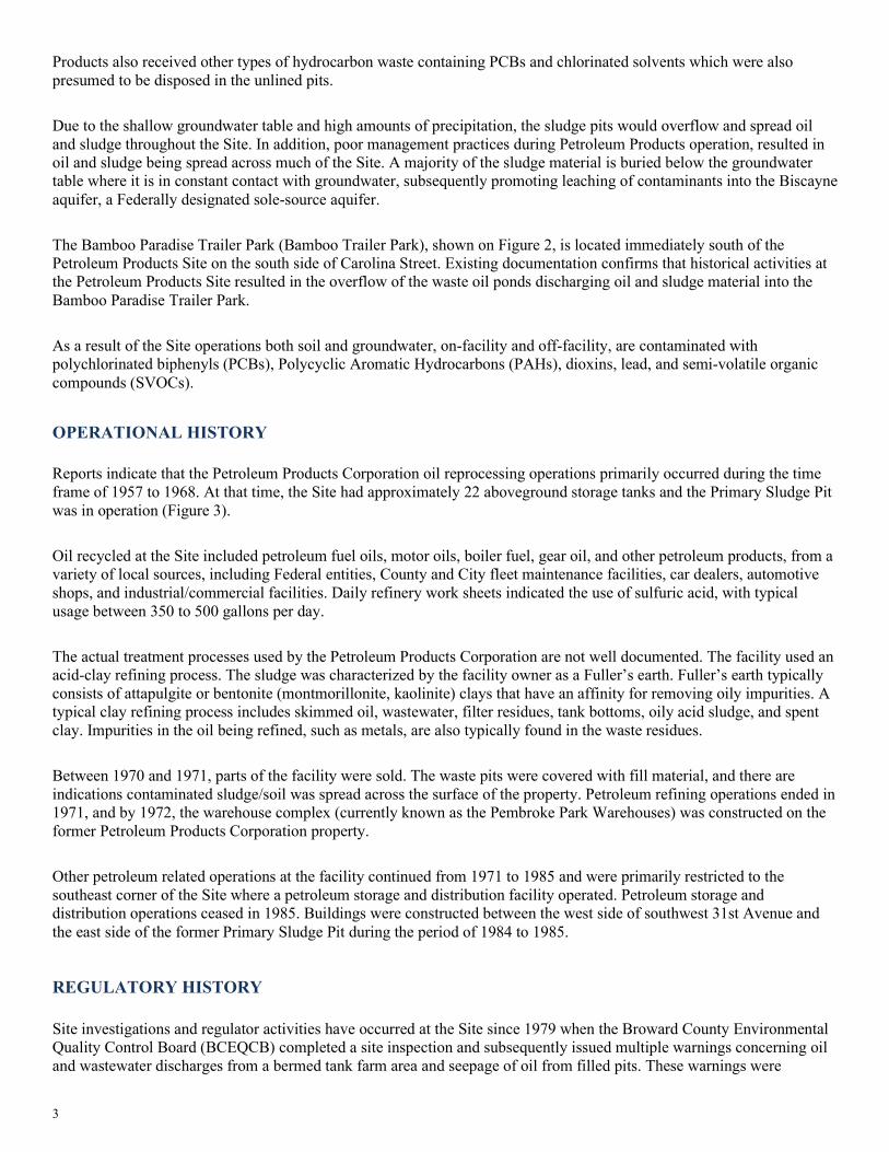
Community Involvement Coordination
Public Comment Period: January 11, 2021 through February 12,
2021 EPA will accept written comments on this Proposed Plan during the public comment period. You may submit written comments three (3) ways: BY MAIL Michael Taylor U.S. EPA - Region 4 61 Forsyth Street, SW Atlanta, Georgia 30303-8960 BY EMAIL [email protected] BY FACSIMILE (404) 562-8174 Addressed to Michael Taylor
Attend the Public Meeting
You are invited to attend a virtual public meeting sponsored by EPA to hear about this Proposed Plan. At the meeting you will be able to voice your opinions and ask questions about the cleanup. If you would like to request an in-person meeting, please e-mail [email protected].
The meeting will be held: January 19, 2021/Time is 5pm to 6:30pm Location: This will be a virtual public meeting . Please register at the following link: https://www.eventbrite.com/e/us-epa-petroleum-products-corp-site-proposed-plan-community-zoom-meeting-tickets-132275877711 or e-mail [email protected]
Location of Administrative Record and Information Repository
Broward County Public Library
100 S. Andrews Avenue, Level 5 Fort Lauderdale, Florida 33301
Phone: (954) 357-7444 Hours: Mon - Wed 9 a.m.-8 p.m.
Thu - Sat 10 a.m.-6 p.m.
EPA webpage:
www.epa.gov/superfund/petroleum-products-corporation
The approximately 7-acre Petroleum Products Site is located in Broward County Florida, 3150 W. Pembroke Road, Pembroke Park, Florida at the Pembroke Park Self-Storage (Figure 2). The facility also operated under the names International Petroleum Corporation and the National Oil Service of Florida, Inc. The Petroleum Products facility operated from approximately 1957 to 1971 as a processor and broker of waste oil and other petroleum products, including the reprocessing of used oil using a sulfuric acid-clay refining process. This process generated sulfuric acid sludge and spent clay containing petroleum hydrocarbons and metals contamination. The sludge waste and spent clay was presumably disposed on site in excavated unlined pits approximately two acres in size. The operators of Petroleum
SITE BACKGROUND
3
Products also received other types of hydrocarbon waste containing PCBs and chlorinated solvents which were also presumed to be disposed in the unlined pits. Due to the shallow groundwater table and high amounts of precipitation, the sludge pits would overflow and spread oil and sludge throughout the Site. In addition, poor management practices during Petroleum Products operation, resulted in oil and sludge being spread across much of the Site. A majority of the sludge material is buried below the groundwater table where it is in constant contact with groundwater, subsequently promoting leaching of contaminants into the Biscayne aquifer, a Federally designated sole-source aquifer. The Bamboo Paradise Trailer Park (Bamboo Trailer Park), shown on Figure 2, is located immediately south of the Petroleum Products Site on the south side of Carolina Street. Existing documentation confirms that historical activities at the Petroleum Products Site resulted in the overflow of the waste oil ponds discharging oil and sludge material into the Bamboo Paradise Trailer Park. As a result of the Site operations both soil and groundwater, on-facility and off-facility, are contaminated with polychlorinated biphenyls (PCBs), Polycyclic Aromatic Hydrocarbons (PAHs), dioxins, lead, and semi-volatile organic compounds (SVOCs).
Reports indicate that the Petroleum Products Corporation oil reprocessing operations primarily occurred during the time frame of 1957 to 1968. At that time, the Site had approximately 22 aboveground storage tanks and the Primary Sludge Pit was in operation (Figure 3). Oil recycled at the Site included petroleum fuel oils, motor oils, boiler fuel, gear oil, and other petroleum products, from a variety of local sources, including Federal entities, County and City fleet maintenance facilities, car dealers, automotive shops, and industrial/commercial facilities. Daily refinery work sheets indicated the use of sulfuric acid, with typical usage between 350 to 500 gallons per day. The actual treatment processes used by the Petroleum Products Corporation are not well documented. The facility used an acid-clay refining process. The sludge was characterized by the facility owner as a Fuller’s earth. Fuller’s earth typically consists of attapulgite or bentonite (montmorillonite, kaolinite) clays that have an affinity for removing oily impurities. A typical clay refining process includes skimmed oil, wastewater, filter residues, tank bottoms, oily acid sludge, and spent clay. Impurities in the oil being refined, such as metals, are also typically found in the waste residues. Between 1970 and 1971, parts of the facility were sold. The waste pits were covered with fill material, and there are indications contaminated sludge/soil was spread across the surface of the property. Petroleum refining operations ended in 1971, and by 1972, the warehouse complex (currently known as the Pembroke Park Warehouses) was constructed on the former Petroleum Products Corporation property. Other petroleum related operations at the facility continued from 1971 to 1985 and were primarily restricted to the southeast corner of the Site where a petroleum storage and distribution facility operated. Petroleum storage and distribution operations ceased in 1985. Buildings were constructed between the west side of southwest 31st Avenue and the east side of the former Primary Sludge Pit during the period of 1984 to 1985.
Site investigations and regulator activities have occurred at the Site since 1979 when the Broward County Environmental Quality Control Board (BCEQCB) completed a site inspection and subsequently issued multiple warnings concerning oil and wastewater discharges from a bermed tank farm area and seepage of oil from filled pits. These warnings were
OPERATIONAL HISTORY
REGULATORY HISTORY
4
followed by letters concerning complaints of oil seeping through warehouse foundations and asphalt throughout the Site. In 1983, environmental regulators issued a notice of violation requiring Petroleum Products to remove waste oil tanks from the Site in preparation of additional investigation activities to determine the extent of contamination beneath the Site. In 1984, an initial investigation by Petroleum Products Corporation confirmed the presence of groundwater contamination and NAPL. The BCEQCB requested funds from the State of Florida Water Quality Assurance Trust Fund (WQATF), in the early 1980s, to investigate the extent of soil and groundwater contamination at the Petroleum Products Site and to assure protection of the nearby municipal well fields. The Hollywood municipal well field is located 1.5 miles north of the Site and the Hallandale municipal well field is located approximately 0.5 mile to the east (Figure 8). In June 1984, the State of Florida initiated a lawsuit against Petroleum Products Corporation for violations of State statutes concerning the handling and disposal of hazardous materials. This lawsuit included a cost-recovery contingency claim to cover any allocated Water Quality Assurance Trust Fund monies. In October 1984, the State of Florida retained Environmental Science and Engineering, Inc. to investigate and determine the extent of NAPL on the Site. NAPL was found to cover an area of approximately 40,000 square feet (ft2 [0.92 acres]) with a maximum measured thickness in the wells of approximately 30 inches. The investigation also concluded that the NAPL was slowly migrating to the east-southeast. Analytical results indicate that oil and grease were the major contaminants, although significant levels of heavy metals and other organic contaminants were present. In 1985, the EPA collected samples from the eight storage tanks remaining in the tank farm and soil samples from areas away from the tanks. All of these samples exhibited significant levels of hazardous compounds including chlorinated solvents and heavy metals. As a result, the EPA issued an Administrative Order on Consent (AOC) under CERCLA for an emergency removal action at the Site. The order required that all tanks be emptied, cleaned, and rendered inoperable; all oil, water, and sludge were to be chemically tested prior to disposal; oil was to be properly disposed of or recycled, and the asbestos in the boiler house was to be removed or encapsulated. Petroleum Products Corporation accepted the AOC in April 1985. Under the direction of the EPA, Petroleum Products Corporation hired a contractor who removed, analyzed, and properly disposed of or recycled oil, water, and sludge in 262 waste drums. The facility tanks were emptied, cleaned, and rendered inoperable, and asbestos in the boiler house was removed or encapsulated. Petroleum Products dismantled and completely removed all structures and tanks that were stored on site. The top 6 inches of contaminated soil was removed from the tank area and the excavation was backfilled with clean fill from an off-site source. The Site was placed on the National Priorities List in July 1987. In 1988, FDEP completed a remedial investigation/ feasibility study (RI/FS) of the Site. This investigation confirmed elevated concentrations of lead and chromium in soils. These contaminants were identified as two primary inorganic “indicator” contaminants and focused on the nature and extent of these metals. Composite soil samples from 0-10.5 ft below land surface (bls) had lead concentrations as high as 22,400 milligrams per kilogram (mg/kg) and total chromium concentrations as high as 38.5 mg/kg. The secondary sludge pit had not been identified at the time of this investigation. Soil analytical results in the central area of the facility indicated that the depth of contamination had not been determined. Elevated concentrations of lead and chromium in groundwater were confirmed and data indicated that the chromium plume extended off facility to the southeast. The remedial investigation continued from August 1990 through June 1991 to further define the nature and extent of groundwater contamination, and to collect data on the light non-aqueous phase liquid (LNAPL) plume. The investigation concluded that areas of oil and oily-sludge contamination extended through the southeast primary sludge pit and west-central secondary sludge pit. The RI report also concluded that some heavy metals had become sorbed to the relatively immobile sludge matrix, whereas others were migrating downgradient via advection, desorption/resorption, and diffusion. The EPA issued an interim action ROD for OU1 in 1990. EPA issued an Explanation of Significant Differences (ESD) in March 1991 and 1998. The first ESD deferred the closeout of the surface drainage system until the remedy for OU-2 is implemented. The second ESD documented the significant differences between recovery technologies in the original

5
remedial design and the modified bioslurper system. A bioslurping system (vacuum enhanced recovery of waste oil) was installed at the Site in 1998 replacing the pump and treat system installed in 1994. The bioslurper system was expanded in 2001 to collect oil from most of the areas around the Site. The bioslurper operated through October 2012, when the system was suspended. At that time, an estimated 30,695 gallons of free product and 3,715 gallons of emulsified oil were reported to have been recovered by the bioslurper system. A shallow excavation of 330 cubic yards of contaminated petroleum impacted soil in the Bamboo Trailer Park, south of the former facility, occurred in February 2011. This excavation took place in the vicinity of Carolina Street and included excavation, offsite disposal, backfilling, and surface restoration work. The depth of the excavation was approximately 4-4.5 feet to the top of the groundwater table and the area of the excavation covered 2,538 square feet. The excavated soils were disposed off-site. The excavated area was backfilled with clean fill material. The surface areas were restored by placement of sod and shrubs. The EPA completed an updated RI in 2016 to address data gaps and confirm the extent of soil contamination. Several site activities, conducted at the Site from 1970 through 2019, include:
• 1970: Disposal pits were covered with fill; • 1985: Potentially Responsible Party removed 262 drums of sludge; • 1985: Installation of a 30-inch diameter, 23-foot deep free product recovery well with an oil skimming unit
installed along with a pump (approximately 7,000 gallons of oil was removed); • 1995: Installation of Operable Unit One (1) NAPL Removal System completed; • 1999: Bioslurper system modification to OU1 remedy; • 2003: 256 tons of soil excavated and transported off facility to allow for installation of storm water main; • 2009: 400 gallons of NAPL removed from Warehouse Bay 261; • 2011: A partial removal of soil to the water table (to a 4.5 foot depth) on two of the trailer properties, extending
east into SW 31st Avenue; • 2016: Completion of the RI and Supplemental Human Health Risk Assessment; • 2019: Completion of the Feasibility Study.
This Proposed Plan is the third Proposed Plan for the Site. Public meetings were held following release of each of the prior Proposed Plan documents. The RI/FS Report and this current Proposed Plan for the Site will be made available to the public at the information repository maintained at the EPA Docket Room in Region 4 and at the Broward County Public Library. Throughout the project life the lead agency’s goal is to keep the community and others well-informed of site activities via meetings, information bulletins, and by regularly updating the Administrative Record file.
The Site is located in Broward County approximately three miles west of the Atlantic Ocean. Broward County is characterized by warm humid summers and mild winters typical of a tropical climate. Approximately 65% of rainfall occurs from June through October. Annual rainfall averages approximately 64 inches, with June receiving the highest average rain fall and February receiving the lowest. Retirees from colder climates move to the temperate climates of the region during October through April, which can increase the population during these months by as much as 20 to 30 percent. Land elevations at the Site are generally flat with approximately 6 to 8 feet above mean sea level (amsl). Ground surfaces in the area of the Petroleum Products Site are mostly covered by asphalt, concrete, and commercial structures. The Site, shown on Figure 2, is zoned mixed use, which includes mobile home/trailer parks, light industrial, office and private recreation facilities. The Site includes several commercial properties containing mini-warehouses that
SITE CHARACTERISTICS

6
are used for commercial and private storage and small businesses (e.g., shooting range, restaurant, paint and repair shops, cabinet makers, woodworking, manufacturing, etc.). The adjacent properties include a public golf course to the north, mobile home/trailer parks to the south and west, and light industrial/ commercial businesses to the east and west. Several large man-made lakes are located to the north, south, and west of the Site. These ponds effectively function as stormwater retention ponds. The Hollywood, Florida municipal wellfield is located 1.5 miles north of the Site and the Hallandale, Florida municipal wellfield is located approximately 0.5-mile to the east. Contamination within the former facility boundary includes two waste oil sludge pits (primary and secondary sludge pits) that partially underlie some commercial warehouses and asphalt-covered access roads. The contaminated NAPL impacted soils extend beneath additional adjacent commercial warehouses, off facility. Figure 4 is a simplified, general conceptual site model developed for the Site. The model depicts important site features, the subsurface lithology, known sources of contamination, and aspects of contaminant degradation and migration. Figure 4 is intended to represent important relationships in the subsurface to the extent they are presently understood. The general conceptual model shows that several routes of potential contamination migration from the Site are present. The primary source of contaminants and NAPL is the sludge which extends across the Site as a mostly continuous layer with two distinct deep areas representing the former primary and secondary disposal pits. The sludge consistency varies across the Site; however, many areas are NAPL saturated. Due to the nature and low permeability of the sludge, NAPL is slowly released above and below the sludge layer, serving as a constant source of oil for Operable Unit One (1). The sludge acts as a barrier to the horizontal and vertical movement of groundwater due to its oily nature and very low permeability. As groundwater interacts with the edges of the sludge, organic and inorganic constituents in the sludge slowly dissolve and are transported along with the groundwater. The shallow aquifer is characterized by very high hydraulic conductivity albeit low groundwater flow velocities which prevent extensive movement of contaminated groundwater. The sludge material (Operable Unit 2) will continue to serve as a source for NAPL in Operable Unit 1 and dissolved contaminants in the groundwater (Operable Unit 3), until a final remedy is implemented.
The Site has been covered by a significant amount of fill material to bring the area to a useable grade. The surface and subsurface material contains contaminated fill and limited naturally occurring earth materials. Beneath the fill and graded material is the highly productive Biscayne aquifer. The Biscayne aquifer is a Federally designated sole-source aquifer which supplies drinking water to the South Florida population. The aquifer consists of a highly permeable sequence of carbonate and siliciclastic sediment that is approximately 200 feet thick in southeast Broward County. The Biscayne aquifer is underlain by a 500- to 600-foot-thick section of Miocene age marls and clay which separates it from the Floridan aquifer. The Biscayne aquifer exists under water table conditions (unconfined) and is recharged by the direct infiltration of rainfall. Water levels are generally within 5 feet of land surface. Water table isopleth maps developed by the United States Geological Survey ([USGS] 2004) for the Biscayne aquifer in southeast Broward County indicate a regional hydraulic gradient to the east and northeast, with distinct cones of depression associated with the Hollywood and Hallandale well fields. Prior gradients in the early 1990s indicate a southeasterly flow direction. The City of Hallandale, Florida indicates that their well field is located approximately 1,800 feet from the Site, and the wells are screened at approximately 160 feet below ground surface, near the base of the Biscayne aquifer. In addition, the surficial area underlying the Site has been significantly disturbed by operations at the former oil reprocessing facility, including excavation of sludge disposal pits, and disposal of oil contaminated soil across the Site footprint. No areas of native surface soil are essentially present within the Site. What is presumed to be native material, consisting mostly of sandy limestone (organic peat in the shallow subsurface of the west part of the Site), is encountered at depths up to approximately 20 feet. The boundary between disturbed/contaminated material and native soil is easily discernible in drilled soil core sections. Portions of the north warehouse area were found to contain significant amounts of construction-related fill material such as concrete rubble and broken brick in the shallow subsurface. This material appeared to be mixed with hydrocarbon stained dark soil. Some limited areas of fill and small debris were also encountered in the south portion of the Site.
GEOLOGY/HYDROLOGY

7
Site-specific lithology (exclusive of sludge and oil) recorded from these borings generally consist of layers of fine sand, silty sand, and peat (up to 7-feet thick) overlying greyish white limestone with sand. Isolated layers of white silty clay, and gravelly sand were also noted above the limestone. Surficial fill with or without sludge may include isolated concrete fragments and debris, gravel, wood debris, glass debris, and rubber tire material.
As the primary source contaminant, the physical characteristics and volumetric extent of the sludge pits are an integral factor for the distribution and transport of chemicals of concern (COCs). The sludge is principally within the assumed perimeter of the primary sludge pit and the secondary sludge pit but is also present at shallower depths across a large portion of the Site (Figure 2). The sludge is bound within a predominantly sand and silt mixture. The sludge material consists of a black oily material that includes both used oil sludge, residual waste from the acid-clay re-refining process used at the Petroleum Products Corporation facility, and a mixture of native soils and fill. The Unsaturated Zone and Main Source Area include the sludge found within the primary sludge pit and the secondary sludge pit; the main differentiator between the two zones is depth. The texture of the sludge material is heterogeneous throughout the primary sludge pit. At some locations the sludge material exhibits a hard, dry, tacky, rubbery texture with a strong petroleum odor. At other locations the sludge has a much softer muddy texture and is saturated with NAPL. The nature of the sludge consistency varies across the Site from a solid and viscous liquid to areas that are saturated with NAPL. NAPL is present above and below the sludge layer. The sludge acts as a barrier to the horizontal and vertical movement of groundwater due to its oily nature and very low hydraulic conductivity. The extent of sludge was evaluated through a large array of soil borings. Near the surface, at intervals of 2 to 6-ft bls, the sludge is more widespread than the original pit locations. As depth increases the sludge is more concentrated in the areas of the primary and secondary sludge pits. Below a depth of 17 feet the occurrence of sludge is significantly smaller than the foot print of the primary and secondary sludge pits. After facility closure in the 1970s, the Site was covered by fill material which may have been partially mixed with residual oily sludge and spread across portions of the Petroleum Products Corporation property. In addition, due to the shallow groundwater table and frequent rain events, the sludge pits would overflow and spread thin layers of sludge materials outside of the pits where it accumulated in shallow depressions across the Site. A summary of the area and volume of sludge and NAPL material for the combined primary sludge pit and secondary sludge pit is shown below. Areas and volumes down to 6-ft bls are combined as they cannot be distinguished by the sludge pit source.
Sludge Volumetric Summary Depth (ft bls)
Thickness (ft)
Impacted Soil Area (ft3)
Impacted Soil Volume (cy)
Interval Delineation Confidence
Contaminated Media Zone 1 – Unsaturated Zone (0 to 5 feet below land surface) 0 – 1 1 N/A very good 1 – 2 1 136,357 5,050 very good 2 – 4 2 223,959 16,590 very good 4 – 5 1 ND -
Contaminated Media Zone 2 – Main Source Area (5 to 24 feet below land surface) 5 – 6 1 336,537 12,464 very good 6 – 7 1 ND - 7 – 8 1 240,045 8,891 good 8 – 9 1 ND -
9 – 10 1 176,885 6,551 good 10 – 11 1 ND -
NATURE AND EXTENT OF SLUDGE CONTAMINATION

8
Sludge Volumetric Summary Depth (ft bls)
Thickness (ft)
Impacted Soil Area (ft3)
Impacted Soil Volume (cy)
Interval Delineation Confidence
11 – 12 1 111,220 4,119 good 12 – 13 1 ND ND - 13 – 14 1 92,195 3,415 good 14 – 16 2 ND ND - 16 – 17 1 45,080 1,670 fair 17 – 18 1 ND ND - 18 – 19 1 18,242 676 fair 19 – 20 1 ND ND - 20 – 21 1 10,093 374 fair 21 – 23 2 16,950 628 Fair
Notes: Areas are interpolated and represent an approximation. The areas and volumes represent the extent of sludge and NAPL impacted soil, not the estimated area/volume of sludge itself. Areas denoted as ND were not contoured and hence a specific area and volume is not identified. These areas are expected to be approximately equivalent to the average extent of the immediately overlying and underlying areas. ND = not determined; N/A = not applicable
A subjective determination of the delineation data confidence for the interval is indicated. With increasing depth, some data confidence is lost as not all borings reached the same depths. It should be noted that there is a (relative) lack of sludge data in the central/northern interior of the primary sludge pit as depth increases. There is no indication of sludge material being present within the limestone layers at any depth. NAPL oil associated with the sludge has been noted within limestone at several borings. Sample analysis of the sludge indicates that a variety of contaminants are present in the sludge pits. SVOCs and PAHS are the most prevalent compounds, as would be expected. Results from the SB019 sample indicate that up to 3.0% of the sludge matrix is comprised of SVOCs. Lead is a significant contaminant with concentrations as high as 19,000 mg/kg in the unsaturated zone. Other metals (e.g., aluminum, chromium, zinc) are present, but at much lower concentrations. PCB is present at appreciable levels (1.4-21 mg/kg). Dichlorobenzenes, acetone, 1,1,2-Trichloro-1,2,2-Trifluoroethane (Freon 113), 1,2-Dibromo-3-Chloropropane (DBCP), 1,2-Dibromoethane (EDB), ethyl benzene, toluene, xylenes, and other volatile organic compounds (VOC) compounds were detected. The 2016 RI and 2019 FS identify these contaminant levels. Low concentrations of Perfluorooctanoic acid (PFOA) and Perfluorooctanesulfonic acid (PFOS) (less than 27 micrograms per kilogram [μg/kg]) and dioxins (less than 240 nanograms per kilogram (ng/kg) as toxicity equivalent) were also detected. The analytes detected are found in both the unsaturated and saturated zones. However, the concentrations are more elevated in the unsaturated zone. Concentrations of the detected analytes in many cases are greater than the risk-based levels calculated in the Human Health Risk Assessment. Due to elevated levels of Resource Conservation and Recovery Act (RCRA) hazardous constituents, including lead, some of the sludge and NAPL may be considered a RCRA characteristic waste due to toxicity [40 C.F.R. § 261.24]. Any extracted multiphase NAPL fluids could also be considered a characteristic hazardous waste. The toxicity characteristic is meant to identify those hazardous wastes which, if disposed in the environment, have the potential of leaching specific hazardous constituents in levels at or above regulatory thresholds. These constituents include eight heavy metals, four insecticides, two herbicides, and twenty-five other organic compounds. The laboratory test for evaluating wastes under the toxicity characteristic is the toxicity characteristic leaching procedure (TCLP). The maximum concentration of contaminants for the toxicity characteristic are provided in Table 1 of 40 C.F.R. § 261.24. For example, the maximum concentration for lead (D008 waste code) is 5 mg/L TCLP. TCLP analysis of ten subsurface Primary Sludge Pit samples ranged from <1 mg/L to 20 mg/L TCLP (SB020) indicating some of the waste to be removed from the Site may exceed the maximum concentration of contaminants for the toxicity characteristic and be classified as RCRA characteristic waste.

9
RCRA hazardous waste must meet all applicable treatment standards for applicable wastes before land disposal. Characteristic waste that is treated may be “decharacterized” and disposed in a nonhazardous, solid waste Subtitle D landfill. When a characteristic waste is “decharacterized” it no longer exhibits a hazardous waste characteristic. For land disposal, Site soils identified as characteristic waste will be treated to meet alternative land disposal restriction (LDR) treatment standards for contaminated soil provided in 40 C.F.R. § 268.49.
NAPL is present as a pore space adherent to the sludge matrix and as a mobile and residual phase product within the native sand matrices outside the primary sludge pit and secondary sludge pit. The NAPL is colored dark brown to black, similar to the sludge. NAPL is present within, above and below the sludge layers. Oil was noted in the unsaturated zone in several borings. Oil and or NAPL noted in the unsaturated zone is considered source material for the Unsaturated Zone. As a primary source contaminant, the transport characteristics of this NAPL, within the high permeability lithology for the Site, are an integral factor for the distribution of COCs. As NAPL, the product will tend to move laterally in coarser, more permeable portions of heterogeneous media, avoiding the finer-grained zones which provide greater capillary resistance to entry. As a result, mobile NAPL is present as globules connected along fractures, macropores, and the larger pore openings. Water occupies the smaller pores and tends to be retained as a film between the nonwetting NAPL globules and media solids. At residual saturation, NAPL occurs as disconnected singlet and multi-pore globules within the larger pore spaces. NAPL can also be present below the water table due to its origin (i.e., buried oily sludge) or due to water table fluctuations that trap NAPL residually in pores. NAPL below the water table is considered source material for the Main Source Area. The relatively high viscosity of the NAPL, ongoing sludge/source leaching of oil, and persistence of the NAPL in the subsurface has allowed a long period of time for NAPL movement in the subsurface following the sludge placement in the primary sludge pit and secondary sludge pit or past disposal practices of oil spills and surface disposal. Many of the compounds within the oil mixture are typically hydrophobic; they tend to sorb strongly to the subsurface soils and are retained as residual NAPL. Residual saturation conditions reflect a stable equilibrium (no new hydrostatic forces), with complete drainage of mobile NAPL along preferential pathways. Any applied forces, such as a hydrostatic change induced by hurricane flooding, could cause movement of NAPL. Ultimately, the NAPL in the soil matrix will undergo dissolution into groundwater and represents an ongoing, long-term source of dissolved phase contamination. Five waste oil samples were collected for analysis from wells and seeps on the Site. The waste oil samples were analyzed for VOCs, SVOCs, metals, and PCBs. Analytical results identified several compounds present. One analyte (PCBs) exceeded the Florida Soil commercial/Industrial Clean-up Target Levels for direct exposure. The compounds with high concentrations include 1,2,4-trimethylbenzene, 1,3,5-trimethylbenzene, trichloroethene, 1,1-biphenyl, 2-methylnaphthalene, benzo(a)anthracene, bis(2-ethylhexyl) phthalate, chrysene, naphthalene, phenol, PCB-1242, PCB-1260 and lead. Significant contaminants detected in the five NAPL samples are summarized below: NAPL Testing Analytical – Select Results
Chemical Unit Minimum Value
Maximum Value
Average Value
FDEP Commercial/ Industrial Soil CTL2
1,2-Dichlorobenzene mg/kg 1.0 60 20.98 5,000 1,2,4‐Trimethylbenzene mg/kg 0.240 190 77.0 95 1,3,5‐Trimethylbenzene mg/kg 1.4 100 38.85 80 Trichloroethene mg/kg 1.4 14 6.87 9.3 Xylenes, Total mg/kg 0.180 89 32.26 700 Total VOCs mg/kg - - 206.4 - 1,1'-Biphenyl mg/kg 9.5 19 13.17 34,000
NATURE AND EXTENT OF NAPL CONTAMINATION

10
NAPL Testing Analytical – Select Results
Chemical Unit Minimum Value
Maximum Value
Average Value
FDEP Commercial/ Industrial Soil CTL2
1-Methylnaphthalene mg/kg 30 100 65 1,800 2-Methylnaphthalene mg/kg 8.0 100 54 2,100 3 & 4 Methylphenol mg/kg 29 29 29 3,400 Benzo[a]anthracene mg/kg 2.0 2.0 2.0 Bis(2-ethylhexyl) phthalate mg/kg 39 39 39 390 Chrysene mg/kg 2.5 11 5.95 Fluoranthene mg/kg 3.4 5.1 4.25 59,000 Naphthalene mg/kg 4.0 72 40.75 300 Phenanthrene mg/kg 3.5 38 20.12 36,000 Pyrene mg/kg 2.7 8.4 4.82 45,000 Phenol mg/kg 110 110 110 220,000 Total SVOCs mg/kg - - 184.0 - 1,2‐Dibromoethane (EDB) mg/kg 1.4 1.4 1.4 200 PCB (Arochlor 1242) mg/kg 16 72 41
2.6 PCB (Arochlor 1260) mg/kg 3.9 17 10.28 Chromium (total) mg/kg 1 44 12 470 Lead mg/kg 110 440 258 1,400 Titanium mg/kg 6 80 24 - Zinc mg/kg 8 71 35 630,000 Notes: 1Based on the EPA Regional Screening Level (RSL) Summary Table (TR=1E-6, HQ=0.1) for Resident Soil, May 2018; 2Based on the FDEP Soil CTLs for Commercial/Industrial Direct Exposure, February 2005. Abbreviations: mg/kg = milligrams per kilogram; µg/kg = micrograms per kilogram
Near the surface, at intervals of 2- to 6-ft bls, the NAPL is more widespread than the original pit locations. As depth increases the NAPL is more concentrated in the areas of the primary and secondary sludge pits. Below a depth of 17 feet the occurrence of NAPL is significantly smaller than the foot print of the primary and secondary sludge pits. The covering of the pits in the early 1970s assumes the relocation and transport of oily sludge and NAPL across portions of the Petroleum Products Corporation property. NAPL has most likely spread through pond overflows from high water tables and storm events, stormwater flows and past surface seeps. The deepest observed NAPL impact in limestone is 22 feet bls. Several borings between 23 and 26.5 feet bls ( such as PSP-1, PSP-4) indicated a slight petroleum odor, although no residual or mobile NAPL or significant staining was noted.
Soil analyses were performed from most borings, including intervals above or below isolated occurrences of NAPL and/or sludge. The industrial soil cleanup target levels are applicable for the majority of the Site, as the current land use is industrial/commercial. The residential soil cleanup target levels are applicable for the Bamboo Trailer Park property. In February 2011, approximately 330 cubic yards of contaminated petroleum impacted soil in the Bamboo Trailer Park was excavated. The accessible petroleum impacted soils were removed. A small inaccessible area remained after the 2011 excavation. This area, located underneath a residential mobile home, is identified to be addressed during the remedial action.
NATURE AND EXTENT OF SOIL CONTAMINATION

11
Surface Soil - Contaminated Media Zone 1 (Unsaturated Zone) Previous analytical results confirmed the presence of elevated COC concentrations in the Site surface soil between 0-2 feet bls. Analytical results identified several compounds exceeding the Industrial Regional Screening Levels and FDEP soil cleanup target levels for direct contact and leachability, including SVOCs, VOCs, PCBs, dioxins, lead and arsenic. Samples SB018 (1-2 ft bls) and SPP-11 (1-3 ft bls) had the highest COC concentrations. SB018 and SSP-11 are located in the primary and secondary sludge pits, respectively. The predominant surface soil contaminant is lead, with sample SSS-7 (22,000 mg/kg; 0-0.5 feet bls), exceeding the Florida direct contact soil cleanup target levels of 1,400 mg/kg. SSS-7 is located with the footprint of the former tank farm. Soil sample SSS-3 (20 mg/kg), exceeded the direct contact soil cleanup target level for arsenic of 12 mg/kg. Sample, SSS-3 is located within the footprint of the former tank farm. Dioxin toxicity equivalent and benzo(a)pyrene toxicity equivalent exceedances were also present in multiple samples. SB019 exceeded the 30 nanograms per kilogram (ng/kg) dioxin toxicity equivalent direct contact soil cleanup target level with the highest detection of 240 ng/kg, collected from 4-5 feet bls. SB019 is located within the boundary of the primary sludge pit. SSP-11, exceeded the benzo(a)pyrene toxicity equivalent Florida leachability soil cleanup target level of 8,000 µg/kg, with the highest detection of 20,530 µg/kg, collected from 1-3 feet bls. SSP-11 is located along the western boundary of the secondary sludge pit. Subsurface Soil - Contaminated Media Zone 2 (Main Source Area) Subsurface soil contamination extends over a broad range contiguous with the extent of both sludge and NAPL, extending beyond the extent of the OU3 (groundwater) dissolved plume. The soil analytical results were compared to the Industrial RSLs and FDEP soil cleanup target levels for ingestion/contact and leachability. Analytical results identified several compounds exceeding these limits, including VOCs, SVOCs (inclusive of PAHs), PCBs, dioxins, lead and arsenic. The distribution of lead in subsurface soils is extensive. The average lead concentration for samples exceeding the industrial FDEP leachability soil cleanup target level is 8,350 mg/kg. Several samples were elevated for lead concentrations: SSP-9 (22,000 mg/kg; 15-17 feet bls); and SSP-20 (23,000 mg/kg; 10-12 feet bls). Samples SSP-9 and SSP-20 are both located within the boundary of the secondary sludge pit. Three samples exceed the chromium FDEP leachability goal of 38 mg/kg. Two subsurface soil results, COEMW-1 and SBB-22, exceeded the 12 mg/kg arsenic industrial FDEP leachability soil cleanup target level. One sample has a chromium detection of 100 mg/kg, SSP-13. This sample was collected at the water table interface from 4 to 6 feet bls. Sample SSP-13 is located just to the north of the secondary sludge pit boundary. Among the VOCs detected are benzene, toluene, ethylbenzene, and xylene (BTEX). VOC exceedances include chlorinated ethenes, chlorinated ethanes, BTEX, 1,4-dioxane, chlorobenzenes, and others. Elevated total VOC values were recorded at PSP-9 and SB019 (within and adjacent to the Primary Sludge Pit area). Several soil samples exceeded the FDEP leachability soil cleanup target levels for VOCs, SVOCs, PCBs, dioxin, and metals. Dioxin toxicity equivalent and benzo(a)pyrene toxicity equivalent exceedances were present in multiple samples. The sample with the highest dioxin detection, SSP-31 (610 ng/kg) from the 19-20 feet bls interval, exceeded the 30 ng/kg dioxin toxicity equivalent FDEP leachability soil cleanup target level. Boring COEMW-1 recorded the highest benzo(a)pyrene toxicity equivalent detection of 9,434 µg/kg, exceeding the FDEP leachability soil cleanup target level of 8,000 µg/kg.
12
Sludge and NAPL are in contact with the groundwater. The groundwater data allows an evaluation of the interaction with various media at the Site. Contaminated Media Zones 2 (Main Source Area) and 3 (Extended Plume) include the groundwater contamination. The main difference between the two zones being the concentrations of COCs detected. The contaminants detected in groundwater are very similar to the contaminants in the source materials (RI Report USACE, 2016a). Some observations of highly variable groundwater concentration results, such as lead, may be a result of small droplets of NAPL or microparticles of sludge or sludge-sediment composites in the sample. Initial Site investigations indicate groundwater contamination has been identified to extend near the vicinity of Park Road. The 2013 and 2018 groundwater data confirms this extent. The highest concentration of lead detected during the 2018 sampling event was recorded at COEMW-14A, 47 micrograms per liter (µg/L), three times the Maximum Contaminant Level (MCL) of 15 µg/L. During the 2013 sampling event lead was recorded at a concentration of 190 µg/L at COEMW-14A. COEMW-14A is located within the boundary of the former tank farm and is screened from 4.5 to 19.5 feet bls. Samples collected in 2013 and 2018 at the deeper paired wells, COEMW-14B and COEMW-14C, were below the MCL. The highest lead detection during the 2013 sampling event was for well COEMW-15A, 8,400 µg/L. COEMW-15A is located within the boundary of the secondary sludge pit. Arsenic exceeds the MCL (10 µg/L) at monitoring well PMW19A, near Park Road at the western boundary of the Site. COEMW-14A contained the highest detection of arsenic in the 2013 sampling event, 65 µg/L. COEMW-14A is located within the boundary of the former tank farm and is screened from 4.5-19.5 feet bls. The 2018 groundwater results indicate that both benzo(b)fluoranthene and indeno(1,2,3-cd) pyrene exceed or are equal to the Florida groundwater cleanup target level (GCTL (0.05 µg/L)) at monitoring well IMW-B located near Pembroke Road, at the northern boundary of the Site (Contmaminated Media Zone 3 (CMZ)). Monitoring well IMW-B is 51.5 feet in depth. The 2013 groundwater data defines the southern boundary of the dissolved plume within the Bamboo Paradise Trailer Park, located south of the facility. Arsenic and lead were both detected in monitoring well MW-A, both at levels above the MCL values of 10 µg/L and 15 µg/L, respectively. Monitoring well MW-A is 10.9 feet in depth. Monitoring well PMW-03A, located south of MW-A, exceeded the Florida GCTL (3.2 µg/L) for 1,4-dioxane. Monitoring well PMW-03A is 18.9 feet in depth. Both MW-A and PMW-03A are located south of the facility within the Bamboo Trailer Park (CMZ3). The contaminant plumes are centered across the Site and extend out to the northwest and southeast with the highest contamination located in the areas of the primary and secondary sludge pits. High concentrations often correlate to the primary and secondary sludge pits. The dissolved plume extends from the top of the water table to a depth of 75 ft. COEMW-12C exceeded the target levels for both manganese and 1,4-Dioxane. This well is located within the boundary of the secondary sludge pit. A shallow well, BBLPMW-1A, was sampled in 2018 with a total depth of 6.7 feet bls. BBLPMW-1A is located in the northwest corner of the Site. BBLPMW-1A recorded several detections with exceedance levels for SVOC analytes: benzo(a)anthracene, benzo(a)pyrene, benzo(b)fluoranthene, dibenz(a,h)anthracene, and indeno (1,2,3-cd) pyrene. Each of these analytes exceed their respective Florida GCTL. The Hollywood well field, located to the North of the Site, and the Hallandale Beach well field, located to the east of the Site, appear to have an effect on the contaminant migration. Groundwater removal from the well fields is the primary factor controlling deeper flow (below 40 ft), creating potentially offsetting hydraulic stresses on the groundwater, further limiting groundwater flow.
NATURE AND EXTENT OF GROUNDWATER CONTAMINATION

13
The NCP establishes an expectation that the EPA will address the principal threats posed by a site through treatment to the maximum extent practicable (CERCLA §121(b)(l), NCP §300.430(a)(l)(iii)(A)). Principal threat waste (PTW) is defined on a site-specific basis for source material with toxicity and mobility characteristics that combine to pose a potential risk several orders of magnitude greater than the risk level that is acceptable for the current or reasonably anticipated future land use given realistic exposure scenarios. In general, the priority for treatment of PTW is placed on source materials considered to be liquid, highly toxic or highly mobile, which generally cannot be contained in a reliable manner or would present a significant risk to human health or the environment should exposure occur. If the selected remedy does not comply with this preference, the EPA must publish an explanation as to why a treatment remedy was not selected. EPA acknowledges that there may be situations where wastes identified as constituting PTW may be effectively and reliably contained on-site and off-site rather than treated due to inherent difficulties in treating the wastes. The soil containing visual evidence of NAPL would be considered PTW at the Site. Currently, the sludge and NAPL is a long-term source of leaching of contaminants for surrounding groundwater. The former sludge pits (primary and secondary pits) represent the largest extent of sludge and NAPL on-facility and the extent also includes significant areas impacted from overflow of the ponds or sludge/NAPL redistribution from Site fill and grading activities. An estimated 165,570 bank cubic yards (bcy) of sludge and NAPL impacted soil exist within the source area.
The Site is divided into three operable units (OUs):
1. OU1 includes soil and groundwater impacted by non-aqueous phase liquids (NAPL) or free product. 2. OU2 includes soil and groundwater impacted by oil/sludge. 3. OU3 includes impacted groundwater and adsorbed phase contamination external to OU1 and OU2.
These OUs have been further divided into contaminated media zones:
1. Unsaturated Zone (OU1/OU2) 2. Main Source Area (OU1/OU2) 3. Extended Plume (OU3)
The first action, an Interim Action Record of Decision (IAROD) for OU1, was issued in 1990, followed by an Explanation of Significant Difference in 1991 and 1998. This second action will be a final action for the soil and NAPL (OU1 and OU2) and an Interim Action for groundwater (OU3). The proposed remedial action will eliminate direct contact with source material (soil, sludge and NAPL) and reduce the leaching of contaminants from the source material to the Biscayne aquifer. The source materials identified constitute PTW at the Site. The third and final action for the Site will be addressed in a future decision document and will restore the Biscayne aquifer to its beneficial use as a Federally designated sole-source drinking water aquifer. All groundwater classified by the FDEP as Class I or Class II would have to meet FDEP drinking water standards or groundwater cleanup target levels where remedial action objective includes restoration of groundwater to its beneficial use. The EPA has deferred selection of a final groundwater remedy for the Site pending further evaluation of the effectiveness of the proposed source control actions in reducing contamination in the groundwater zone and to monitor the effects of that remediation on contamination within groundwater. The proposed interim action includes ICs and monitoring for groundwater and ICs, maintenance and monitoring for source areas. The general remedial strategy is driven by the need to protect current and future warehouse tenants and neighboring residences from direct exposure to contaminated sludge and soil. The remedial strategy for the Site can be described as follows:
1. Aggressive removal, isolation, or treatment of source contamination in the Unsaturated Zone and Main Source Area (e.g., sludge, NAPL, and highly impacted soil);
PRINCIPAL THREAT WASTE
SCOPE AND ROLE

14
2. Aggressive removal, isolation, or treatment of source contamination in the oil impacted sands of the Main Source Area (e.g., NAPL, and highly impacted soil); and
3. Implementation of an Interim Remedial Action (IRA) for groundwater contaminant reduction (treatment) and/or containment of the adsorbed and dissolved phase COCs outside the source areas.
This phased remediation of the peripheral soil and groundwater contamination is a commonly applied approach to sites with a significant mass of contamination in a source area. Remediation will be optimized by targeting the highest levels of mass. Full restoration of the extended plume (EP) zone will be deferred until the flux reduction of COCs from source treatment/isolation can be further evaluated and the EP will be more clearly delineated.
The NCP requires a site-specific baseline risk assessment to be conducted, as appropriate, as part of the remedial investigation (Section 300.430(d)(1)). Specifically, the NCP states that the baseline risk assessment should "characterize the current and potential threats to human health and the environment that may be posed by contaminants migrating to ground water or surface water, releasing to air, leaching through soil, remaining in the soil, and bioaccumulating in the food chain" (Section 300.430(d)(4)). The primary purpose of the baseline risk assessment is to provide risk managers with an understanding of the actual and potential risks to human health and the environment posed by the site and any uncertainties associated with the assessment. This information may be useful in determining whether a current or potential threat to human health or the environment exists that warrants remedial action. The baseline risk assessment is divided into two sections, human health risk and ecological risk, summarized below: Human Health Risk The human health risk assessment (HHRA) evaluates the potential risks to human health from exposure to Site-related contaminants, considering current and reasonably anticipated future land use. The current and reasonably anticipated future land use for the Site is for industrial/commercial use. A portion of the Site, the Bamboo Trailer Park, is zoned for residential use. The HHRA uses a four-step process to assess site-related cancer risks and noncancer health hazards (see adjoining box “What is Risk and How is it Calculated”). The four-step process is comprised of: hazard identification, exposure assessment, toxicity assessment, and risk characterization.
SUMMARY OF SITE RISKS

15
Hazard Identification Chemicals of potential concern (COPCs) in potentially-affected environmental media (e.g., soil and groundwater) are identified through comparisons of maximum detected concentrations to conservative, risk-based screening levels and, where relevant, to site-specific background levels. Exceedances of screening levels do not in themselves indicate an unacceptable risk. Rather, exceedance of a screening level indicates need for further evaluation in the HHRA. The complete list of COPCs is identified in the 2016 Supplemental Human Health Risk Assessment. Analytes identified as COPCs in the HHRA were evaluated to identify individual COCs in distinct media above which remediation or control measures would be required. This evaluation included a comparison of measured concentrations of HHRA COPCs to risk-based clean up levels calculated in the HHRA and applicable chemical-specific Applicable or Relevant and Appropriate Requirements (ARARs). Groundwater data was separated into two different data sets; one including the sludge pits and one excluding the sludge pits. The environmental samples were analyzed for VOCs, SVOCs, metals, PCBs, and dioxins. Exposure Assessment The exposure assessment estimates the intensity, frequency and duration of human exposure to a chemical in the environment and consists of the following three basic steps:
WHAT IS RISK AND HOW IS IT CALCULATED?
A Superfund human health risk assessment estimates the "baseline risk." This is an estimate of the likelihood of health problems occurring if no cleanup action were taken at a site. To estimate the baseline risk at a Superfund site, EPA undertakes a four-step process:
Step 1: Analyze Contamination
Step 2: Estimate Exposure
Step 3: Assess Potential Health Dangers
Step 4: Characterize Site Risk
In Step 1, The EPA looks at the concentrations of contaminants found at a site as well as past scientific studies on the effects these contaminants have had on people (or animals, when human studies are unavailable). Comparisons between site-specific concentrations and concentrations reported in past studies helps EPA to determine which contaminants are most likely to pose the greatest threat to human health.
In Step 2, The EPA considers the different ways that people might be exposed to the contaminants identified in Step 1, the concentrations that people might be exposed to, and the potential frequency and duration of exposure. Using this information, EPA calculates a "reasonable maximum exposure" (RME) scenario, which portrays the highest level of human exposure that could reasonably be expected to occur.
In Step 3, The EPA uses the information from Step 2 combined with information on the toxicity of each chemical to assess potential health risks. EPA considers two types of risk: cancer risk and non-cancer risk. The likelihood of any kind of cancer resulting from a Superfund site is generally expressed as an upper bound probability; for example, a "1 in 10,000 chances." In other words, for every 10,000 people that could be exposed, one extra cancer may occur as a result of exposure to site contaminants. An extra cancer case means that one more person could get cancer than would normally be expected to from all other causes. For non-cancer health effects, EPA calculates a "hazard index." The key concept here is that a "threshold level" (measured usually as a hazard index of less than 1) exists below which non-cancer health effects are no longer predicted.
In Step 4, The EPA determines whether site risks are great enough to cause health problems for people at or near the Superfund site. The results of the three previous steps are combined, evaluated and summarized. The EPA adds up the potential risks from the individual.
16
• characterization of the exposure setting (physical environment and potential receptors); • identification of exposure pathways (constituent sources, exposure points and exposure routes); and • quantification of pathway-specific exposures (exposure point concentrations, or EPCs, calculation of receptor
intakes and exposure assumptions). A Human Health conceptual site model was developed to identify exposure pathways from contaminated media to current and potential future human receptors, see Figure 5. The use scenarios were based on the current and reasonably anticipated future use of the property and adjacent Bamboo Trailer Park and included the following current and future receptors exposed to environmental Site-media:
• Incidental ingestion, dermal contact with surface soil (tenants, residents, indoor/outdoor workers, construction workers);
• Incidental ingestion and dermal contact with subsurface soil (residents, outdoor workers, construction workers); • Incidental ingestion of groundwater, dermal contact with groundwater (tenant, residents, indoor/outdoor workers,
construction workers); and • Incidental ingestion of sludge/seepage (older child tenant).
Toxicity Assessment The toxicity assessment describes the relationship between an estimated dose of a chemical and potential likelihood of an adverse health effect. The purpose of the toxicity assessment is to quantitatively estimate inherent toxicity of COPCs for use in risk characterization. Potential effects of chemicals are separated into two categories: carcinogenic (cancer) and non-carcinogenic (non-cancer) effects. The toxicity assessment identifies the toxicity values (i.e., slope factors and reference doses) for COPCs and applies the toxicity values to the estimated doses calculated in the exposure assessment to calculate carcinogenic risk and noncarcinogenic hazard. Risk Characterization The objective of the risk characterization step is to integrate the information developed in the exposure assessment and the toxicity assessment into an evaluation of the potential current and future unacceptable health risks associated with the COPCs at the Site. Data collected during the previous air study were screened for risk. There were no unacceptable risks from this pathway. Therefore, there is no need for further evaluation including vapor intrusion. Carcinogenic risk is based on an incremental lifetime cancer risk (ILCR) to an individual or population exposed to contaminants at a Site. ILCR values greater than 1 x 10⁻⁴ (i.e. 1 excess cancer in every 10,000 individuals) are above the cancer risk range and indicate unacceptable carcinogenic risk. ILCR values within the cancer risk range of 1.0 x 10⁻⁴ to 1.0 x 10⁻⁶ are considered acceptable, and ILCR values below 1.0 x 10⁻⁶ represent minimal carcinogenic risk. Noncarcinogenic hazard is determined by summing the hazard quotients (HQs) values across different chemicals and across different exposure pathways to account for the additive effect of being exposed to more than one chemical by more than one exposure route. The sum of the HQs is termed the hazard index (HI). A Target Organ HI to a receptor above 1 indicates unacceptable noncarcinogenic risk, while a HI less than or equal to 1 is considered acceptable. COPCs that contribute significantly (risk of 1 x 10⁻⁶ or greater, or HQ of 0.1 or greater) to an unacceptable receptor cancer risk or receptor Target Organ HI, are defined as COCs for the Site. For carcinogens, total ILCRs were calculated for the tenant, indoor worker, outdoor worker, resident, and construction worker and are shown in the table below. All unacceptable risks are highlighted in bold.

17
Summary of the Reasonable Maximum Exposure Carcinogenic Risks for All Receptors:
NA- Not Applicable The total ILCR exceeds the target risk range of 1 x 10⁻⁶ to 1 x 10⁻⁴ for the current and future young child tenant; the future older child and future adult tenant, and future indoor and outdoor workers; and for the future resident and future construction worker scenarios. The calculated cancer risks for other receptors are in the acceptable risk range. For noncarcinogens, if the HQ across all chemicals associated with an exposure pathway exceeded 1, the primary target organ or organ system was identified noting that the noncarcinogenic hazard effects of chemicals affecting the same organ or organ system are additive. The noncancer hazards as well as the target organ analysis is summarized in the table below. All unacceptable HI values are highlighted in bold. Summary of the Reasonable Maximum Exposure Noncancer Hazard for All Receptors:
Receptor Total
Noncancer HI
Highest Target Organ
Noncancer HI Notes
Tenant
Young Child
Current 10 5 Incidental ingestion of surface soil; respiratory
Future 640 447 Incidental ingestion of groundwater; renal, hepatic, neurological
Older Child
Current 1 NA NA
Future 345 244 Incidental ingestion of groundwater; renal, hepatic, neurological
Adult Current 1 NA NA
Future 240 168 Incidental ingestion of groundwater; hepatic, neurological
Occupational Indoor Worker Current 0.5 NA
Occupational
Indoor Worker Future 114 81 Incidental ingestion of groundwater;
renal, hepatic, neurological
Outdoor Worker Current 2 < 1 NA: Total HI > 1, but all target organ HIs
< 1
Receptor Current Future
Tenant Young Child 3 x 10⁻⁴ 1 x 10⁻² Older Child 9 x 10⁻⁵ 2 x 10⁻² Adult 1 x 10⁻⁴ 3 x 10⁻²
Occupational Indoor Worker 7 x 10⁻⁵ 1 x 10⁻² Outdoor Worker 1 x 10⁻⁴ 1 x 10⁻²
Resident Child and Adult (Age-Adjusted) NA 7 x 10⁻²
Commercial/ Industrial Construction Worker NA 5 x 10⁻⁴

18
Summary of the Reasonable Maximum Exposure Noncancer Hazard for All Receptors:
Receptor Total
Noncancer HI
Highest Target Organ
Noncancer HI Notes
Future 105 73 Incidental ingestion of groundwater; hepatic, neurological
Resident Child and
Adult (Age-Adjusted)
Future 491 326 Incidental ingestion of groundwater; hepatic, neurological
Commercial/ Industrial
Construction Worker Future 92 65 Incidental ingestion of groundwater;
renal, hepatic Notes: NA- Not Applicable. For each receptor, the current exposure scenario includes exposure to surface soil, and the future exposure scenario includes exposure to surface soil as well as exposure to groundwater (assuming that site groundwater is used as the source of drinking water).
The cumulative HI exceeds 1 for the current and future young child tenant and future outdoor worker; the future older child and future adult tenant, and future indoor worker; and the future resident and future construction worker scenarios. However, no unacceptable noncancer hazards were identified for the other receptor scenarios. In the Site’s Feasibility Study (FS), the list of COCs identified in the 2016 Supplemental HHRA in all media (surface soil, subsurface soil and groundwater) were refined to include a selected list of “risk drivers” that had high frequency of detections above the media-specific remedial goals. The refined list of for each media are shown below: Chemicals of Concern by Media
Surficial Soil1 Subsurface Soil Groundwater2 SVOCs VOCs VOCs Metals
Benz(a)anthracene 1,2-Dibromoethane/ ethylene dibromide (EDB) Benzene Antimony
Benzo(a)pyrene SVOCs cis-1,2-Dichloroethene Arsenic Benzo(b)fluoranthene Benz(a)anthracene Trichloroethene (TCE) Lead
Dibenz(a,h)Anthracene Other Vinyl Chloride Vanadium Indeno(1,2,3-cd)pyrene PCB (Arochlor 1016) SVOCs
Other PCB (Arochlor 1248) Naphthalene Polychlorinated biphenyls (PCB;
Arochlor 1016) PCB (Arochlor 1260) 1,4-Dioxane
PCB (Arochlor 1248) PCB (Arochlor 1254) Other PCB (Arochlor 1260) Dioxin TEQ PCB (Arochlor 1242)
Dioxin toxicity equivalent (TEQ) Metals PCB (Arochlor 1260) Metals Arsenic Dioxin TEQ Arsenic Lead
Lead Notes: 1Surficial soils considered 1 to 2-ft bls; 2COCs from all groundwater sources i.e. groundwater with sludge and groundwater without sludge.
At the time the supplemental HHRA was finalized, EPA was using a blood-lead target of 10 ug/dL, and our assessment of a surface soil Lead exposure point concentration of 7621 mg/kg resulted in unacceptable health risk (greater than 5% probability of exceeding the blood-lead target) to both an onsite worker, as well as a hypothetical future resident. Since that time, EPA has considered lowering the blood-lead target when assessing lead contamination at our sites. Using any lower blood-lead target, together with the recommended updates to the Integrated Exposure Uptake Biokinetic (IEUBK)

19
model, we still reach the same conclusion that the health risks are unacceptable to both an onsite worker and a hypothetical future resident. Ecological Risk As stated in Section 6.0, the 1992 Baseline Risk Assessment determined that the contamination at the Site did not pose any unacceptable adverse ecological impacts. This is because the Site is located in a highly developed commercial/industrial area where there is a lack of vegetation with very little habitat to support wildlife. Most of the Site is paved or covered with warehouse buildings. The surrounding area includes residential and commercial/industrial areas. Ecological exposures within the Site boundary were considered infrequent, and the potential for adverse ecological impacts are considered unlikely. The 1992 Baseline Risk Assessment concluded that the average lead concentrations in unpaved surface soil samples were below levels associated with sublethal effects in earthworms. However, the average lead concentration in an unpaved surface soil samples from onsite exceeded a level associated with sublethal effects in plants. It is possible that vegetation onsite could be adversely impacted by lead in surface soil, given the presence of grasses and weeds onsite, it is apparent that the chemical concentrations in soil are below toxic levels for at least some plant species. The Site and surrounding areas provide marginal habitat for a small number of urban adapted species. With the limited areal extent of exposed surface soil, exposures of wildlife to chemicals in surface soil are likely to be minimal, and adverse impacts are unlikely. Birds and small mammals foraging for food in these areas could ingest contaminated soil but given the limited availability of food resources at the Site, and the availability of numerous other foraging areas scattered throughout the urban area, exposures are likely to be infrequent and insignificant. Likewise, animals foraging at the Site could ingest food that has accumulated chemicals. However, given the limited food resources at the Site, exposures are likely to be infrequent and insignificant. The Site ecological evaluation process concluded no adverse ecological risk.
It is the lead agency’s judgment that the Preferred Alternative identified in this Proposed Plan, or one of the other active measures considered in this Proposed Plan, is necessary to protect human health or the environment from actual or threatened releases of hazardous substances into the environment. In particular, the sludge and NAPL pose an unacceptable risk to human health from direct exposure and are a continuing source of contaminants into groundwater.
Remedial action objectives (RAOs) provide a general description of what the cleanup will accomplish. RAOs are specific goals to protect human health and are based on available information and standards, such as applicable or relevant and appropriate requirements (ARARS), to-be-considered (TBC) guidance, and site-specific, risk-based levels. Site-specific RAOs developed for the Site are listed as follows: Source Material (NAPL and Sludge/ CMZ 1 and 2)
• Prevent leaching from COC source material from the subsurface to groundwater above levels that are protective for beneficial use (i.e., drinking water use).
• Prevent human exposure to COCs in site soils through direct contact above risk-based levels. Groundwater (CMZ 3)
• Prevent human exposure to COCs in groundwater through ingestion, dermal contact and inhalation above levels that are protective for beneficial use (i.e., drinking water use).
• Prevent migration of groundwater contaminated above levels that are protective for beneficial use (i.e., drinking water use).
BASIS FOR ACTION
REMEDIAL ACTION OBJECTIVES
20
Soil (CMZ 1 and 2)
• Former Facility Property o Prevent leaching of COCs from soil to groundwater above levels that are protective for beneficial use (i.e.,
drinking water use). o Prevent human exposure to COCs in surface and subsurface soil through ingestion and dermal contact above
risk-based levels on the former process area • Bamboo Trailer Park
o Prevent human exposure to COCs in subsurface soil through ingestion and dermal contact above risk-based levels in Bamboo Trailer Park.
Preliminary remediation goals (PRGs) are developed during the RI/FS and are based on ARARs (such as Safe Drinking Water Act MCLs for groundwater that is considered an actual/potential drinking water source), where available, and other readily available To Be Considered (TBC) guidance. In the absence of such ARARs or TBCs the NCP requires development of risk based PRGs such as concentrations and using a target risk level of a 1 x 10⁻⁶ cancer risk (point of departure) or a hazard quotient equal to one for non-carcinogens calculated from EPA toxicity information. Initial PRGs may also be modified based on exposure, uncertainty, and technical feasibility factors. As data are gathered during the RI/FS, PRGs are refined into final contaminant-specific remediation goals. Based on consideration of factors during the nine criteria analysis and using PRGs as a point of departure, the final remediation goal may reflect a risk level within the acceptable risk range (10-4 to 10-6 for carcinogens) but different from the original identified PRG. The subsurface soil which may have included some material that was evaluated as one media. The surficial soils (samples from 2.0 ft bgs and above) are treated as a separate media. Surficial Soil PRGs The surface soil PRGs for direct exposure were based upon FDEP default Soil Cleanup Target Levels (SCTLs) for Residential and Commercial/Industrial land use that are included in Table II of F.A.C 62-777 Contaminant Cleanup Target Levels. FDEP applies the direct exposure soil cleanup target levels to the entire column of soil above the water table (approximately 5 ft bls for the PPC Site). However, the soil cleanup target level is only applicable to the top 2 ft of exposed soils if ICs are used to prohibit intrusive activities below 2-ft. EPA established a final non-cancer dioxin reassessment in 2012, publishing a non-cancer toxicity value, or reference dose (RfD), for dioxin TEQ of 0.7 picograms per kilogram-day (pg/kg-day). The PRG calculated using this reference dose and EPA's non-adjusted exposure factors is 50 ng/kg for dioxin TEQ for residential soil and 230 ng/kg dioxin TEQ for commercial/industrial soil. Subsurface Soil PRGs Florida direct exposure SCTLs for industrial/commercial use have been selected for PRGs in comparison to background, where applicable. The industrial SCTLs are applicable for the majority of the Site, as the current and future land use are expected to remain industrial. The residential SCTLs are applicable for the Bamboo Park residential area. The PRGs are listed below:
PRELIMINARY REMEDIATION GOALS

21
PRGs for Chemicals of Concern – Surficial and Subsurface Soil
Chemical of Concern Unit Soil Depth Surface/
Subsurface
Direct Exposure Background ARARs
HHRA Risk Based Level)1
(10-5 Risk or HQ =1)
FDEP SCTL2 Residential
FDEP SCTL2
Industrial
Site Background
Values3
Florida SCTL - Leachability
Based on Groundwater4
Benzo(a)anthracene mg/kg Surface 7.50E+00 1.0E+00 7.00E+00 2.20E-01 NA Subsurface 8.0E-01
Benzo(a)pyrene mg/kg Surface 7.86E-01 1.0E-01 7.00E-01 2.20E-01 NA Benzo(b)fluoranthene mg/kg Surface 8.67E+00 1.0E+00 7.00E+00 1.72E-01 NA
Dibenz(a,h)Anthracene mg/kg Surface 7.14E-01 1.0E-01 7.00E-01 ND NA Indeno(1,2,3-cd)pyrene mg/kg Surface 6.79E+00 1.0E+00 7.00E+00 ND NA
PCB-1016 mg/kg Surface 1.37E+01 5.0E-01 2.6E+00 ND NA Subsurface 1.7E+01
PCB-1248 mg/kg Surface 2.87E+00 5.0E-01 2.6E+00 ND NA Subsurface 1.7E+01
PCB-1254 mg/kg Subsurface 2.57E+00 5.0E-01 2.6E+00 ND 1.7E+01
PCB-1260 mg/kg Surface 2.54E+00 5.0E-01 2.6E+00 ND NA Subsurface 1.7E+01
1,2-Dibromoethane (EDB) mg/kg Subsurface 3.67E+00 1.0E-01 2.0E-01 ND NA 1.0E-04
Dioxin TEQ mg/kg Surface 4.69E-05 7.0E-06 3.0E-05 7.4E-06 NA Subsurface 3.0E-03
Arsenic mg/kg Surface 5.18E+00 2.1E+00 1.2E+01 1.26E+01 NA Subsurface
Lead mg/kg Surface NA 4.0E+02 1.4E+03 3.00E+02 NA Subsurface Abbreviations: ARARs = Applicable or Relevant and Appropriate Requirements; NA = not available; ND = non detect; FDEP = Florida Department of Environmental Protection; HHRA = Human Health Risk Assessment; mg/kg = milligrams per kilogram Notes: 1Based on the more conservative carcinogenic or noncarcinogenic HHRA Risk-based Level (at cancer TR=1E-05, noncancer HQ=1); Black & Veatch, 2018. 2Based on the FDEP direct exposure Soil Cleanup Target Levels (SCTLs) for Residential/Commercial use, April 2005. 3Background value based on two times the background level from the background soil data collected in November 2012. 4ARARs – leachability based on groundwater (FDEP SCTLS).
Groundwater PRGs Groundwater PRGs were calculated in 2018 by using the 2016 Supplemental Human Health Risk Assessment (see Table 5 of the 2016 HHRA) data for risk range 10-6 and 10-4 for all current and future receptors. The State of Florida GCTL cleanup standards provided in F.A.C. Chapter 62-777, Contaminant Cleanup Target Levels, Table I (FDEP, 2005) were applied as PRGs. EPA’s MCL were selected as the appropriate PRG; where an MCL is not available, the FDEP GCTL was applied. The PRGs are shown below:
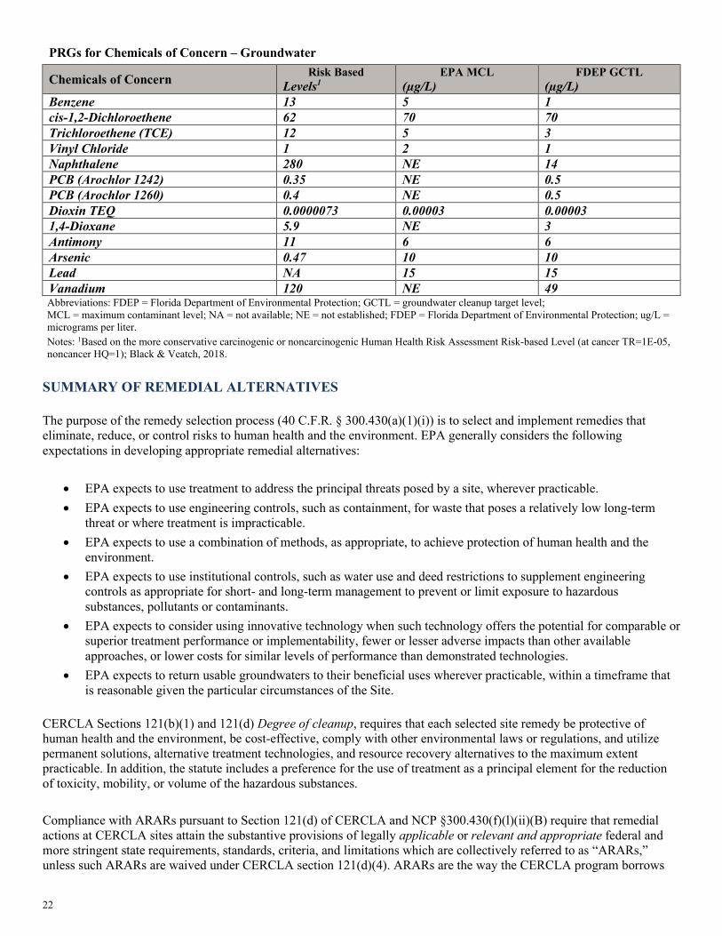
22
PRGs for Chemicals of Concern – Groundwater
Chemicals of Concern Risk Based Levels1
EPA MCL (µg/L)
FDEP GCTL (µg/L)
Benzene 13 5 1 cis-1,2-Dichloroethene 62 70 70 Trichloroethene (TCE) 12 5 3 Vinyl Chloride 1 2 1 Naphthalene 280 NE 14 PCB (Arochlor 1242) 0.35 NE 0.5 PCB (Arochlor 1260) 0.4 NE 0.5 Dioxin TEQ 0.0000073 0.00003 0.00003 1,4-Dioxane 5.9 NE 3 Antimony 11 6 6 Arsenic 0.47 10 10 Lead NA 15 15 Vanadium 120 NE 49 Abbreviations: FDEP = Florida Department of Environmental Protection; GCTL = groundwater cleanup target level; MCL = maximum contaminant level; NA = not available; NE = not established; FDEP = Florida Department of Environmental Protection; ug/L = micrograms per liter. Notes: 1Based on the more conservative carcinogenic or noncarcinogenic Human Health Risk Assessment Risk-based Level (at cancer TR=1E-05, noncancer HQ=1); Black & Veatch, 2018.
The purpose of the remedy selection process (40 C.F.R. § 300.430(a)(1)(i)) is to select and implement remedies that eliminate, reduce, or control risks to human health and the environment. EPA generally considers the following expectations in developing appropriate remedial alternatives:
• EPA expects to use treatment to address the principal threats posed by a site, wherever practicable. • EPA expects to use engineering controls, such as containment, for waste that poses a relatively low long-term
threat or where treatment is impracticable. • EPA expects to use a combination of methods, as appropriate, to achieve protection of human health and the
environment. • EPA expects to use institutional controls, such as water use and deed restrictions to supplement engineering
controls as appropriate for short- and long-term management to prevent or limit exposure to hazardous substances, pollutants or contaminants.
• EPA expects to consider using innovative technology when such technology offers the potential for comparable or superior treatment performance or implementability, fewer or lesser adverse impacts than other available approaches, or lower costs for similar levels of performance than demonstrated technologies.
• EPA expects to return usable groundwaters to their beneficial uses wherever practicable, within a timeframe that is reasonable given the particular circumstances of the Site.
CERCLA Sections 121(b)(1) and 121(d) Degree of cleanup, requires that each selected site remedy be protective of human health and the environment, be cost-effective, comply with other environmental laws or regulations, and utilize permanent solutions, alternative treatment technologies, and resource recovery alternatives to the maximum extent practicable. In addition, the statute includes a preference for the use of treatment as a principal element for the reduction of toxicity, mobility, or volume of the hazardous substances. Compliance with ARARs pursuant to Section 121(d) of CERCLA and NCP §300.430(f)(l)(ii)(B) require that remedial actions at CERCLA sites attain the substantive provisions of legally applicable or relevant and appropriate federal and more stringent state requirements, standards, criteria, and limitations which are collectively referred to as “ARARs,” unless such ARARs are waived under CERCLA section 121(d)(4). ARARs are the way the CERCLA program borrows
SUMMARY OF REMEDIAL ALTERNATIVES

23
requirements and technology considerations from other federal and state statutes and guidelines to help design and develop cleanup response actions and determine contaminant remediation goals. The EPA has created three categories of ARARs: Chemical-, Location- and Action-specific. Under 40 C.F.R. § 300.400(g)(5), the lead and support agencies shall identify their specific ARARs for a particular site. Chemical-specific ARARs are usually health or risk-based numerical values limiting the amount or concentration of a chemical that may be found in, or discharged to, the environment. Location-Specific ARARs establish restrictions on permissible concentrations of hazardous substances or establish requirements for how activities will be conducted because they are in special locations (e.g., wetlands, streams, floodplains or critical habitats). Action-specific ARARs are usually technology-based or activity-based requirements or limitations that control actions taken at hazardous waste sites. Action-specific requirements often include performance, design and controls, or restrictions on particular kinds of activities related to management of hazardous substances and are triggered by the types of remedial activities and types of wastes that are generated, stored, treated, disposed, emitted, discharged, or otherwise managed. Remedial alternatives for each contaminated media zone: Unsaturated Zone, Main Source Area, and Extended Plume (EP) are summarized below. The alternatives are numbered to correspond with the numbers in the FS report. More detailed descriptions of the remedial alternatives can be found in the FS report. Capital costs are those expenditures that are required to construct a remedial alternative. Operation and Maintenance (O&M) costs are those post-construction costs necessary to ensure or verify the continued effectiveness of a remedial alternative and are estimated on an annual basis. Present value is the amount of money which, if invested in the current year, would be sufficient to cover all the costs over time associated with a project, calculated using a discount rate of seven percent and a 30-year time interval. Construction time is the time required to construct and implement the alternative and does not include the time required to design the remedy, negotiate performance of the remedy with the responsible parties, or procure contracts for design and construction.
Soil and groundwater contamination at the Site are classified into three contaminated media zones (CMZs) that are the basis for remedial alternative screening and remedy selection. A contaminated media zone represents a portion of the Site contamination which has a particular characteristic that defines the optimal remediation approach. Defining characteristics can include one or more parameters such as lithology, COCs, depth, areal extent, and/or presence of sludge or NAPL. Segregation of the Site into CMZs allowed remedial alternatives to be tailored to these conditions, thereby resulting in a more economical and focused remedy. CMZ-1 – Unsaturated Soil Zone (UZ) The UZ encompasses the significantly contaminated soil in the unsaturated zone from 0 to 5- feet bls . This zone includes the former primary sludge pit and the secondary sludge locations, and several areas believed to be impacted by overflows from the pits and relocation of sludge and NAPL as fill on Site. This contaminated media zone was configured to represent the largest mass of significantly contaminated soil containing both potentially mobile and residual NAPL and sludge that could be easily excavated due to unsaturated conditions. Remediation of this zone is principally focused on protection of human receptors from direct contact with seeps and soil, treatment of PTW, and preventing leaching of COCs into groundwater. CMZ-2 – Main Source Area (MSA) The Main Source Area encompasses the significantly contaminated soil in the saturated zone from 5 to approximately 21-feet bls (with a maximum extent of 24 feet bls). This zone includes the former primary sludge pit and the secondary sludge pit locations, and areas believed to be impacted by overflows from the pits and relocation of sludge and NAPL as fill on Site. This contaminated media zone was configured to represent the bulk of sludge/NAPL mass that lies deeper within the saturated zone. Remediation of this zone is principally focused on treatment of PTW to protect groundwater from soil leachate.
CONTAMINATED MEDIA ZONES

24
CMZ-3 – Extended Plume (EP) The EP encompasses all dissolved and adsorbed phase contamination outside of the Main Source Area and extends as deep as 40 feet bls over a wide area. A broad range of COCs is present in this zone, notably several VOCs, some SVOCs, and lead. This contaminated media zone represents the very large volumetric extent of contamination that does not contain NAPL or sludge. Remediation of this zone is principally focused on protection of groundwater and containment of the dissolved plume. This zone is being evaluated as an Interim Remedial Action. Common Elements All alternatives except the No Action alternative have the same common elements. Due to hazardous substances remaining at levels that do not allow for unlimited use and unrestricted exposure, five-year reviews will be required for each alternative, as required by CERCLA 121(c) and the NCP [40 C.F.R. § 300.430(f)(4)(ii)]. Each CMZ-specific remedial alternative can be supplemented with selected institutional controls. Institutional controls will provide notice of remaining contamination and/or restrict future activities that could result in exposure to residual contamination. These long-term controls are required due to the extended timeframe leaving contamination in place and the timeframe required for Site groundwater restoration. Two remedial activities are included in the overall analysis for the Unsaturated Zone. These activities are considered common, as each alternative will include these activities presumptively. An evaluation of the common alternatives was not completed, because these alternatives were deemed to be the most beneficial with no practical alternatives. As part of excavation and demolition components of the common remedies, tenants, residents, and businesses currently located within the boundaries of the affected areas (defined as the extent of CMZ-1 and CMZ-2) will need to be temporarily or permanently relocated to off-site locations. Relocation of businesses, tenants and residents will be performed pursuant to or consistent with the Uniform Relocation Act, 42 U.S. Code §§ 4601 et seq., and regulations promulgated pursuant thereto at 49 C.F.R. Part 24, depending on whether EPA or the PRPs take the lead on the relocation activities. Common Alternatives Alternative Description of Remediation Alternatives
1 Bamboo Trailer Park Excavation
• Temporarily relocate the trailer and tenants. • Excavation of contaminated soil for one residential area at the Bamboo Trailer
Park. • The depth of excavation will be approximately 4.5 to 5-ft to the top of the
groundwater table covering 2,285 square feet. • Backfill.
2 Building Demolition Overlying the Main Source Area
• Demolish warehouses (five buildings, Figure 6) in the center of the Site that overlie the former primary and secondary sludge pits where extensive sludge and NAPL contamination extends up to 24 feet deep.
• A Fair Market Value (FMV) appraisal of the five buildings was completed in mid- 2019 and determined the value of the buildings to be estimated at $9.5M.
• Debris from the warehouses and the underlying concrete slabs along with adjacent asphalt overlying the Main Source Area will be characterized, cleaned as needed and sent to the local RCRA Subtitle D landfill as construction debris. If the debris is designated as a RCRA hazardous debris, it will be sent to an off-site RCRA Subtitle C landfill.

25
Common Alternatives Alternative Description of Remediation Alternatives
3A/3B
Shallow Soil Excavation Under Buildings – Retain Existing Buildings (3A) or Demolish Existing Buildings(3B)
• Shallow sludge/NAPL contamination exists under six additional buildings on Site between 0 to 5-ft bls as shown on Figure 6. (The six buildings identified for Common Alternative 3 are in addition to the five buildings identified for Common Alternative 2).
• A total of 7,200 bank cubic yards (bcy) of COC-laden soil is estimated beneath the buildings. An investigation will need to be completed during the RD to determine the full extent of contamination under the buildings. (If contamination under the buildings is extensive or it is found to be unfeasible to perform shallow excavation, any or all of the 6 buildings may be demolished.)
• Should the buildings require demolition, the disposal of the debris will be required as in Alternative 2.
• The excavation can proceed initially around the perimeter, with temporary shoring (e.g., I-beams, timber, jacks, pneumatic pillows) used to support the footer during excavation. With shoring in place, the soil beneath the edges of the building can be pneumatically excavated.
• After excavation, a flowable concrete fill can be used to replace the contaminated soil. If the buildings are demolished, clean fill can be used to backfill the excavation.
• Soil will be characterized in batches using the TCLP method to determine if considered RCRA hazardous waste due to exhibiting the characteristic of toxicity.
• If necessary, excavated soils that are characteristic waste will be treated to meet alternative land disposal restriction (LDR) treatment standards for contaminated soil before disposing of in an off-site RCRA Subtitle D landfill.
Estimated Costs for Common Alternatives
Activity COM Alternative #1
COM Alternative #2
COM Alternative #3A
COM Alternative #3B
Estimated Capital Cost $141,500 $1,690,900 $4,572,400 $5,635,100
Estimated O&M Costs $0 $0 $0 $0
Net Present Value $141,500 $1,690,900 $4,572,400 $5,635,100
Estimated Time to Achieve RAOs
< 1 year < 1 year < 1 year < 1 year
Estimated Construction Time
< 1 month 1 month 6 months 2 months
Contaminated Media Zone 1 (CMZ 1) – Unsaturated Soil Zone. Unsaturated sludge/NAPL source material in the unsaturated zone is a PTW. Currently, the shallow sludge and NAPL are a long-term source of leachate for underlying groundwater. The unsaturated zone represents the largest areal extent of sludge and NAPL on-facility and includes the former shallow extent of the sludge pits and significant areas impacted from overflow of the ponds or sludge/NAPL redistribution from site fill/grading activities. The entire surface of the unsaturated zone is overlain by the warehouse buildings with active tenants, asphalt, utilities, and vehicles. The five remedial alternatives developed for the unsaturated zone are listed below:

26
CMZ-1: Unsaturated Soil Zone (UZ) Remedial Alternatives Alternative Description of Remediation Alternatives
1 No Action
• The NCP requires that the EPA consider a “no-action” alternative against which other remedial alternatives can be compared. Under this alternative, there would be no action to address contaminated soil and groundwater and PTW.
• Periodic monitoring of existing wells and reporting will be completed every five years to confirm Site conditions.
2 Excavation and Off-Facility Disposal in Landfill
• Excavation of contaminated soil within the unsaturated zone, along with necessary sidewall slope volumes to permit excavation.
• A shallow sheet pile wall would be installed to 10 ft bls around the area of the five demolished buildings (Common Alternative #2) to protect buildings on the periphery of the unsaturated zone excavation and will minimize the side slope soil removal.
• Approximately 49,300 bcy of soil would be excavated to a depth of 5 ft bls to remove contaminated soil.
• Soil will be characterized in batches using the TCLP method to determine if considered RCRA hazardous waste due to exhibiting the characteristic of toxicity.
• If necessary, excavated soils that are characteristic waste will be treated to meet alternative LDR treatment standards for contaminated soil before being disposed of in an off-site RCRA Subtitle D landfill.
3
Excavation, Ex Situ Stabilization/ Solidification (S/S), and Disposal
• Excavation of contaminated soil within the unsaturated zone, along with necessary sidewall slope volumes to permit excavation.
• A sheet pile wall would be installed to 10 ft bls around the area of the five demolished buildings (Common Alternative #2) to provide protection of the buildings on the periphery of the unsaturated zone excavation and will minimize the side slope soil removal.
• Approximately 49,300 bcy of soil would be excavated to a depth of approximately 5 ft bls to remove COC-contaminated soil. PTW is represented by the sludge and NAPL and is expected to be encountered during this action.
• Soil will be characterized in batches using TCLP to determine whether it exceeds the maximum concentration of contaminants for the toxicity characteristic, indicating it is a RCRA hazardous waste.
• Excavated soil would be sampled; and then stabilized/solidified (S/S) above grade to meet alternative LDR treatment standards for contaminated soil.
• Following ex situ S/S treatment, the soil will be placed into an on-site engineered disposal unit that complies with identified RCRA ARARs.
• The treated soil disposed of in the engineered unit will be covered with a multi-layered cap that complies with identified RCRA ARARs.
• To keep land surface as close as possible to existing grade, any excess soil (S/S often causes an increase in volume) will be characterized using TCLP to determine if considered RCRA hazardous waste due to exhibiting the characteristic of toxicity. If necessary excavated soils that are characteristic waste will be treated to meet alternative LDR treatment standards for contaminated soil before disposing of in an off-site RCRA Subtitle D landfill.

27
CMZ-1: Unsaturated Soil Zone (UZ) Remedial Alternatives Alternative Description of Remediation Alternatives
4
In Situ Stabilization/ Solidification (S/S) with Limited Soil Excavation, and Off-Facility Disposal
• In situ S/S to isolate and stabilize the sludge and NAPL (considered PTW) and contiguous soil contamination within the unsaturated zone down to 5 ft bls.
• Use large diameter augers/vertical rotary mixing systems to stabilize soil in place by mixing a cement-based grout and ground blast furnace slag mixture into impacted soils.
• Alternately, the in situ mixing could be accomplished with or in conjunction with excavators or shallow soil mixing tools such as a Lang or Allu tool.
• The estimated target volume for in situ S/S with large diameter augers is approximately 21,800 bcy over an area of 4.5 acres.
• Approximately 18,440 bcy of stabilized and non-stabilized soil from 0 to 2 ft bls will be excavated and characterized in batches using TCLP to determine whether it exceeds the maximum concentration of contaminants for the toxicity characteristic, indicating it is a RCRA hazardous waste. If necessary excavated soils that are characteristic waste will be treated to meet alternative LDR treatment standards for contaminated soil before disposing of in an off-site RCRA Subtitle D landfill. This alternative would not require a surrounding sheet pile to protect the buildings as only shallow soil excavation is required.
• The in situ treated soils would be covered with a 2-ft thick clean fill soil cover.
5
Excavation, Ex Situ Thermal Treatment and Stabilization/ Solidification (S/S) with Disposal
• Excavation of contaminated soil within the unsaturated zone along with necessary sidewall slope volumes to permit excavation.
• A shallow sheet pile wall would be installed to 10-ft bls around the area of the five demolished buildings (Common Alternative #2) to provide protection of the buildings on the periphery of the unsaturated zone excavation and will minimize the side slope soil removal.
• The excavation portion of the scope closely mirrors the scope for Alternative UZ #2 and UZ #3.
• Soil will be processed ex situ in a STARx batch smoldering process. • Soils from 0 to 2-ft bls will be excavated and characterized in batches using TCLP to
determine if considered RCRA hazardous waste due to exhibiting the characteristic of toxicity. If necessary excavated soils that are characteristic waste will be treated to meet alternative LDR treatment standards for contaminated soil before disposing of in an off-site RCRA Subtitle D landfill.
• The in situ treated soils would be covered with a 2-ft thick clean fill soil cover. • Excavated soil would be sampled and then stabilized/solidified (S/S) above grade to
meet alternative LDR treatment standards for contaminated soil. • Soil from 2 to 5 ft bls will be processed ex situ in a STARx batch smoldering process
enclosed within a new fabricated steel building. The STARx process would leave only a residue of metals contamination (lead in particular).
• To treat the residue of metals contamination, following the STARx process, the treated soil will be mixed with a S/S admixture aboveground. Mixing will be conducted either via an excavator for mixing within a roll off container or with specialized soil blending equipment (e.g., pugmill).
• Excavated soil would be sampled prior to and after treatment to demonstrate compliance with alternative LDR treatment standards for contaminated soil.
• Treated soil will be placed into an on-site engineered disposal unit that complies with identified RCRA ARARs. The treated soil disposed of in the unit will be covered with a multi-layered cap that complies with identified RCRA ARARs.

28
Estimated Costs for Remedial Alternatives in Contaminated Media Zone-1
Activity UZ Alternative #1
UZ Alternative #2
UZ Alternative #3
UZ Alternative #4
UZ Alternative #5
Estimated Capital Cost $0 $14,372,100 $12,785,000 $12,339,800 $15,610,100
Estimated O&M Costs $86,100 $0 $0 $0 $0
Net Present Value $86,100 $14,372,100 $12,785,000 $12,339,800 $15,610,100 Estimated Time to Achieve RAOs
greater than 30 years < 1 year < 1 year < 1 year < 1 year
Estimated Construction Time Not Applicable 6 months 6 months 5 months 6 months Contaminated Media Zone 2 (CMZ 2) – Main Source Area (MSA) Unsaturated sludge/NAPL source in the main source area is deemed an extensive area of PTW within the aquifer. Currently, the deeper sludge and NAPL are a significant long-term source of leachate for contiguous groundwater. The main source area represents the largest volume of sludge and NAPL on-facility and includes the full depth of the former sludge pits, and sludge/NAPL redistribution from Site fill/grading activities. In addition to sludge and mobile NAPL, the main source area includes soil impacted with residual NAPL levels and adsorbed phase contamination of a variety of COCs. The entire surface of the main source area is overlain by the warehouse buildings with active tenants, asphalt, utilities, and vehicles. After further evaluation by EPA, MSA #4 (Excavation, Ex Situ Thermal Treatment and Stabilization with On-Site Disposal) developed in the FS was later determined by EPA as either too costly as result of regulatory requirements or impractical from an engineering perspective and in consideration of the intended land use at the Site. As a result, the Proposed Plan only presents the remedial alternatives that are considered for remedy selection including the Preferred Alternative. Accordingly, the Alternatives retain the original number in the FS and are not necessarily in numerical sequence. The four remedial alternatives developed for the main source area are listed below. CMZ-2: Main Source Area (MSA) Remedial Alternatives Alternative Description of Remediation Alternatives
1 No Action
• The NCP, requires that the EPA consider a “no-action” alternative against which other remedial alternatives can be compared. Under this alternative, there would be no action to address contaminated soil and groundwater and PTW.
• Periodic monitoring of existing wells and reporting will be completed every five years to confirm Site conditions.
2 Excavation and Off-Facility Disposal in Landfill
• Excavation of contaminated soil within the MSA along with necessary sidewall slope volumes to permit excavation. PTW is represented by the sludge and NAPL and is expected to be encountered during this action. (A sheet pile wall installation to protect adjacent buildings would be untenable due to the presence of limestone.) Approximately 116,270 bcy of soil would be excavated to a depth of approximately 21 ft bls (varying as deep as 24 ft bls) to the MSA limits to remove COC contaminated soil.
• Excavation would be accomplished using an engineered system such as a slide rail shoring box system or interlocking, steel sheet pile and hydraulic walers to isolate segments of soil and to minimize dewatering
• Excavated soil would be sampled and characterized in batches using TCLP to determine whether it exceeds the threshold for toxicity characteristic, indicating it is a RCRA hazardous waste. If necessary excavated soils that are hazardous due to exhibiting the characteristic of toxicity will be treated to meet alternative LDR treatment standards for contaminated soil and disposed of in an off-site RCRA Subtitle D landfill.
• Clean fill will be used to backfill the excavation.

29
CMZ-2: Main Source Area (MSA) Remedial Alternatives Alternative Description of Remediation Alternatives
3 In Situ S/S with Large Diameter Augers (LDA)
• In situ S/S to isolate and stabilize the sludge and NAPL (PTW) and contiguous soil contamination within the main source area down to approximately 21 ft bls (as deep as 24 feet below land surface). This remedy is equivalent to the in situ S/S remedy alternative UZ #4.
• The estimated target volume for in situ S/S with large diameter auger is approximately 116,270 bcy over an area of 4.5 acres. This alternative would not require a surrounding sheet pile to protect the buildings as no soil excavation is required.
• Tooling on large diameter augers can cut through limestone rock and can remediate NAPL at specific locations that is bound in the limestone.
• To keep land surface as close as possible to existing grade, any excess soil (S/S often causes an increase in volume) will be characterized using TCLP to determine if considered RCRA hazardous waste due to exhibiting the characteristic of toxicity. If necessary excavated soils that are characteristic waste will be treated to meet alternative LDR treatment standards for contaminated soil before disposing of in an off-site RCRA Subtitle D landfill.
4
Excavation, Ex Situ Thermal Treatment and Stabilization with Disposal
This alternative as developed in the Feasibility Study is not considered for remedy selection.
5
In Situ Thermal Treatment (Conductive Heating) with Chemical Reduction
• In situ thermal conductive heating of the sludge and NAPL impacted soils followed by the injection (via multiphase extraction wells) of either reducing or sequestering amendments to fix the lead to the soil and prevent leaching. Alternative MSA #5 is an in situ remediation and does not involve excavation.
• Thermal conductive heating is capable of remediating over 95% to 99% of organic VOCs and lighter carbon SVOCs, rendering the soil essentially free of petroleum leachate.
• Following thermal treatment, in situ reduction or stabilization using injected amendments would be needed to stabilize lead and other metals on the soil matrix.
• A sheet pile wall would be installed around the MSA to prevent groundwater flow from quenching heat within treatment areas and minimize excursions of contaminated groundwater and vapors.
• The impacted existing warehouses in the main source area could remain in place although implementation would be enhanced if they were demolished. This alternative assumes that the buildings would remain in place; however, tenants would need to be relocated for up to a year due to the hazards for volatilization of COCs created by in situ heating below the buildings.

30
Estimated Costs for Remedial Alternatives in Contaminated Media Zone-2
Contaminated Media Zone 3 (CMZ 3) – Extended Plume (EP) The extended plume (EP) consists of groundwater and contiguous soils on the periphery of the source areas that are impacted above PRGs with generally low concentrations of VOCs, select SVOCs, 1, 4-dioxane, lead, chromium, and other COCs. The diverse mixture of COCs limit the options for remediation as different physicochemical processes are needed for the unique COCs. No principal threat waste is included in the EP. Remediation of this zone is focused on preventing the further vertical and horizontal migration of contaminated groundwater. Remedial alternatives for the extended plume are interim as EPA expects to return usable groundwaters to their beneficial uses whenever practicable, within a timeframe that is reasonable given the circumstances of the Site. When restoration of groundwater to beneficial use is not practicable, EPA expects to prevent further migration of the plume, prevent exposure to the contaminated groundwater and evaluate further risk reduction (40 C.F.R. § 300.430 (a)(1)(III)(F). The extended plume alternatives are predicated on the assumption that some form of remediation is undertaken for the unsaturated zone and main source area contaminated media zones. EP #4 (Monitored Natural Attenuation) developed in the FS, is only a viable alternative when implemented in conjunction with treatment of source areas. Natural biotic or abiotic processes may be a realistic phased alternative. Monitored natural attenuation is the use of natural biotic degradation or natural abiotic degradation (e.g., due to reduced iron species, soil attenuation, advection, dispersion, dilution, etc.) for contaminant reduction. Both processes are thought to be active for the PPC Site for several COCs as evidenced by the downgradient edge of the dissolved plume essentially being in equilibrium between these natural reduction forces and the ongoing level of COCs being introduced via leachate from sludge/soil and NAPL. The geochemistry of the surficial groundwater is partially representative of an aerobic aquifer. It is plausible that aerobic degradation of several VOCs and SVOCs is occurring biologically. Abiotic degradation (inclusive of indigenous chemical reduction) is also a potential ongoing degradation mechanism that could be applied to all the COCs. Following implementation of the proposed source remedies, groundwater should be monitored for site COCs along with select monitored natural attenuation parameters. A monitored natural attenuation study should be conducted following the completion of the source remedy to determine if this remedial option is a viable remedy. For purposes of this Proposed Plan, the remedy is presented below, but is not carried through the evaluation of alternatives. The evaluation can be completed once a monitored natural attenuation study can be conducted. The four remedial alternatives developed for the extended plume are summarized below:
CMZ-3: Extended Plume (EP) Remedial Alternatives
Alternative Description of Remediation Alternatives
1 No Action
• The NCP requires that the EPA consider a “no-action” alternative against which other remedial alternatives can be compared. Under this alternative, there would be no action to address contaminated soil and groundwater and PTW.
• Periodic monitoring of existing wells and reporting will be completed every five years to confirm Site conditions.
Activity MSA Alternative #1
MSA Alternative #2
MSA Alternative #3
MSA Alternative #4
MSA Alternative #5
Estimated Capital Cost $0 $28,437,700 $11,611,000
This alternative as developed in the
Feasibility Study is not considered for remedy selection.
$19,841,000
Estimated O&M Costs $86,100 $0 $0 $3,828,400
Net Present Value $86,100 $28,437,700 $11,611,000 $23,669,100
Estimated Time to Achieve RAOs
greater than 30 years < 1 year < 1 year 10 years
Estimated Construction Time Not Applicable 7 months 8 months 24 months

31
CMZ-3: Extended Plume (EP) Remedial Alternatives Alternative Description of Remediation Alternatives
2
Groundwater Recovery & Treatment (GR&T)
• Hydraulic containment using groundwater recovery wells to provide mass removal and prevent the lateral solute transport of COCs.
• Six groundwater recovery wells oriented across the breadth of the dissolved plume and perpendicular to groundwater flow would be installed to create the hydraulic containment.
• The water is then treated with a complex treatment train consisting of oil/water separation, air stripping, metal sequestration/adsorption, filtration, pH adjustment, ex situ oxidation treatment, and carbon filtration.
• A treatment plant would be constructed inside a steel building to house the groundwater treatment equipment.
• Treated effluent would be discharged preferentially to infiltration galleries constructed west of the facility. Conversely a series of injection wells and/or discharge to the surface water lake west of the Site could be used for effluent disposal. Surface discharge would satisfy the substantive requirements of a National Pollution Discharge Elimination System (NPDES) permit.
3
In Situ Carbon Injection and In Situ Reduction Permeable Barriers
• Two injection treatment barriers would be used to apply in situ carbon adsorption and metal/fixation amendments for passive treatment zones.
• The injection array locations are placed near the downgradient edge of the dissolved plume along the eastern and northern edge of the extended plume.
• The injection wells would be injected initially with an injectable colloidal carbon composed of microscale particles of activated carbon suspended in water through the use of organic polymer chemistry. The injected carbon should also function as a colloidal biomatrix binding to the aquifer matrix, providing both direct carbon adsorption and biodegradation of dissolved COCs.
• The same injection wells will be used to inject a reducing agent or sequestering agent such as calcium polysulfide (CaSx) or a soluble phosphate-based fixation/sequestering agent such as Monopotassium phosphate (KH2PO4 or MKP). The injection flows and pressures would be devised to achieve approximately a 15-foot distribution of these suspensions.
4
Monitored Natural Attenuation (MNA)
• MNA is the use of natural biotic degradation or natural abiotic degradation (for example, due to reduced iron species, soil attenuation, advection, dispersion, dilution, etc.) for contaminant reduction. The diverse array of dissolved COCs will limit the effectiveness of MNA as an interim remedy as the different COCs require different conditions for either biotic or abiotic decay.
• This remedy uses analysis of COCs and natural attenuation parameters from monitoring wells to gauge the effectiveness of natural biotic and abiotic degradation mechanisms.
• This remedy is closely linked to source area reduction efforts.
Estimated Costs for Remedial Alternatives in CMZ-3
Activity EP Alternative #1
EP Alternative #2
EP Alternative #3
EP Alternative #4
Estimated Capital Cost $0 $919,250 $2,855,400 $0
Estimated O&M Costs $86,100 $3,171,654 $3,017,987 $329,802
Net Present Value $86,100 $4,090,900 $5,873,400 $329,800
Estimated Time to Achieve RAOs
greater than 30 years
15 years 15 years 30 years
Estimated Construction Time Not Applicable 3 months 4 months Not Applicable
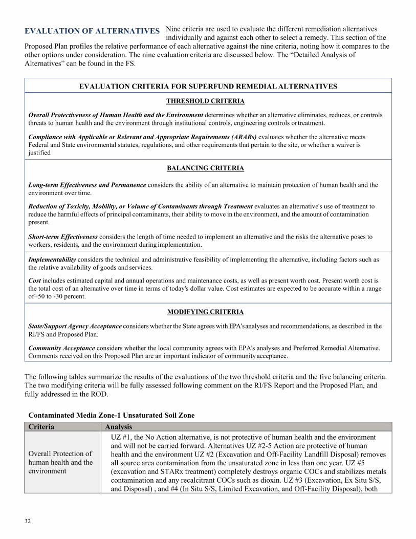
32
Nine criteria are used to evaluate the different remediation alternatives individually and against each other to select a remedy. This section of the
Proposed Plan profiles the relative performance of each alternative against the nine criteria, noting how it compares to the other options under consideration. The nine evaluation criteria are discussed below. The “Detailed Analysis of Alternatives” can be found in the FS.
EVALUATION CRITERIA FOR SUPERFUND REMEDIAL ALTERNATIVES
THRESHOLD CRITERIA
Overall Protectiveness of Human Health and the Environment determines whether an alternative eliminates, reduces, or controls threats to human health and the environment through institutional controls, engineering controls or treatment.
Compliance with Applicable or Relevant and Appropriate Requirements (ARARs) evaluates whether the alternative meets Federal and State environmental statutes, regulations, and other requirements that pertain to the site, or whether a waiver is justified
BALANCING CRITERIA Long-term Effectiveness and Permanence considers the ability of an alternative to maintain protection of human health and the environment over time.
Reduction of Toxicity, Mobility, or Volume of Contaminants through Treatment evaluates an alternative's use of treatment to reduce the harmful effects of principal contaminants, their ability to move in the environment, and the amount of contamination present. Short-term Effectiveness considers the length of time needed to implement an alternative and the risks the alternative poses to workers, residents, and the environment during implementation.
Implementability considers the technical and administrative feasibility of implementing the alternative, including factors such as the relative availability of goods and services.
Cost includes estimated capital and annual operations and maintenance costs, as well as present worth cost. Present worth cost is the total cost of an alternative over time in terms of today's dollar value. Cost estimates are expected to be accurate within a range of+50 to -30 percent.
MODIFYING CRITERIA
State/Support Agency Acceptance considers whether the State agrees with EPA’s analyses and recommendations, as described in the RI/FS and Proposed Plan.
Community Acceptance considers whether the local community agrees with EPA's analyses and Preferred Remedial Alternative. Comments received on this Proposed Plan are an important indicator of community acceptance.
The following tables summarize the results of the evaluations of the two threshold criteria and the five balancing criteria. The two modifying criteria will be fully assessed following comment on the RI/FS Report and the Proposed Plan, and fully addressed in the ROD.
Contaminated Media Zone-1 Unsaturated Soil Zone Criteria Analysis
Overall Protection of human health and the environment
UZ #1, the No Action alternative, is not protective of human health and the environment and will not be carried forward. Alternatives UZ #2-5 Action are protective of human health and the environment UZ #2 (Excavation and Off-Facility Landfill Disposal) removes all source area contamination from the unsaturated zone in less than one year. UZ #5 (excavation and STARx treatment) completely destroys organic COCs and stabilizes metals contamination and any recalcitrant COCs such as dioxin. UZ #3 (Excavation, Ex Situ S/S, and Disposal) , and #4 (In Situ S/S, Limited Excavation, and Off-Facility Disposal), both
EVALUATION OF ALTERNATIVES
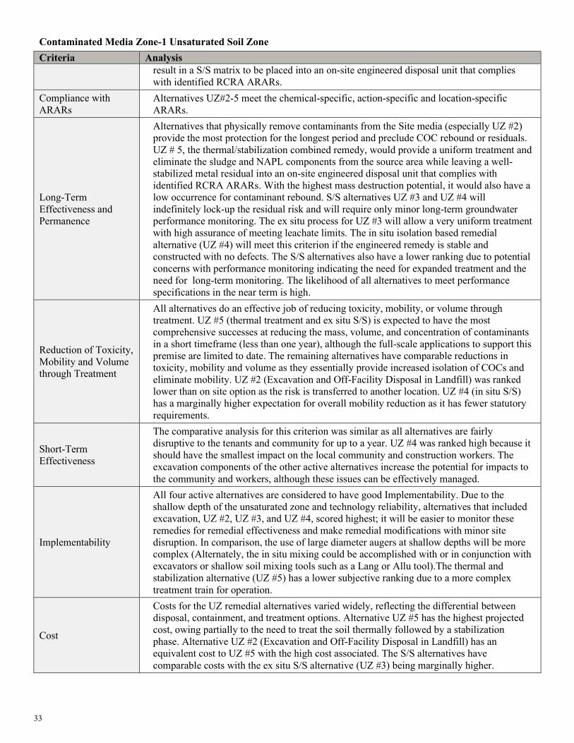
33
Contaminated Media Zone-1 Unsaturated Soil Zone Criteria Analysis
result in a S/S matrix to be placed into an on-site engineered disposal unit that complies with identified RCRA ARARs.
Compliance with ARARs
Alternatives UZ#2-5 meet the chemical-specific, action-specific and location-specific ARARs.
Long-Term Effectiveness and Permanence
Alternatives that physically remove contaminants from the Site media (especially UZ #2) provide the most protection for the longest period and preclude COC rebound or residuals. UZ # 5, the thermal/stabilization combined remedy, would provide a uniform treatment and eliminate the sludge and NAPL components from the source area while leaving a well-stabilized metal residual into an on-site engineered disposal unit that complies with identified RCRA ARARs. With the highest mass destruction potential, it would also have a low occurrence for contaminant rebound. S/S alternatives UZ #3 and UZ #4 will indefinitely lock-up the residual risk and will require only minor long-term groundwater performance monitoring. The ex situ process for UZ #3 will allow a very uniform treatment with high assurance of meeting leachate limits. The in situ isolation based remedial alternative (UZ #4) will meet this criterion if the engineered remedy is stable and constructed with no defects. The S/S alternatives also have a lower ranking due to potential concerns with performance monitoring indicating the need for expanded treatment and the need for long-term monitoring. The likelihood of all alternatives to meet performance specifications in the near term is high.
Reduction of Toxicity, Mobility and Volume through Treatment
All alternatives do an effective job of reducing toxicity, mobility, or volume through treatment. UZ #5 (thermal treatment and ex situ S/S) is expected to have the most comprehensive successes at reducing the mass, volume, and concentration of contaminants in a short timeframe (less than one year), although the full-scale applications to support this premise are limited to date. The remaining alternatives have comparable reductions in toxicity, mobility and volume as they essentially provide increased isolation of COCs and eliminate mobility. UZ #2 (Excavation and Off-Facility Disposal in Landfill) was ranked lower than on site option as the risk is transferred to another location. UZ #4 (in situ S/S) has a marginally higher expectation for overall mobility reduction as it has fewer statutory requirements.
Short-Term Effectiveness
The comparative analysis for this criterion was similar as all alternatives are fairly disruptive to the tenants and community for up to a year. UZ #4 was ranked high because it should have the smallest impact on the local community and construction workers. The excavation components of the other active alternatives increase the potential for impacts to the community and workers, although these issues can be effectively managed.
Implementability
All four active alternatives are considered to have good Implementability. Due to the shallow depth of the unsaturated zone and technology reliability, alternatives that included excavation, UZ #2, UZ #3, and UZ #4, scored highest; it will be easier to monitor these remedies for remedial effectiveness and make remedial modifications with minor site disruption. In comparison, the use of large diameter augers at shallow depths will be more complex (Alternately, the in situ mixing could be accomplished with or in conjunction with excavators or shallow soil mixing tools such as a Lang or Allu tool).The thermal and stabilization alternative (UZ #5) has a lower subjective ranking due to a more complex treatment train for operation.
Cost
Costs for the UZ remedial alternatives varied widely, reflecting the differential between disposal, containment, and treatment options. Alternative UZ #5 has the highest projected cost, owing partially to the need to treat the soil thermally followed by a stabilization phase. Alternative UZ #2 (Excavation and Off-Facility Disposal in Landfill) has an equivalent cost to UZ #5 with the high cost associated. The S/S alternatives have comparable costs with the ex situ S/S alternative (UZ #3) being marginally higher.

34
Contaminated Media Zone-1 Unsaturated Soil Zone Criteria Analysis
State Acceptance State acceptance of the preferred alternative will be addressed in the ROD following review of comments received on the Proposed Plan. The State has indicated acceptance and support for the preferred alternative.
Community Acceptance
Community acceptance of the preferred alternative will be addressed in the ROD following review of comments received on the Proposed Plan.
Contaminated Media Zone-2 Main Source Area (MSA) Criteria Analysis
Overall Protection of human health and the environment
MSA #1, the No Action alternative is not protective of human health and the environment and will not be carried forward. MSA #2 through #5 will be protective of human health and the environment. Each alternative would reduce the threat of sludge and NAPL mobility either though stabilization/isolation, partial treatment, or direct removal. MSA #2 (Excavation and Off-Facility Landfill Disposal) removes all source area contamination from the Main Source Area in approximately 7 months. MSA #3 does not provide a treatment reduction in concentration as the other active remedies can provide. MSA #5 (In Situ Thermal Treatment with Chemical Reduction) has the highest risk and uncertainty; it lacks adequate treatability testing and is highly contingent on sub surface heterogeneity and conditions. As noted above, MSA #4 as developed in the Feasibility Study is not considered for remedy selection.
Compliance with ARARs
Alternatives MSA#2-5 meet the chemical-specific, action-specific and location-specific ARARs.
Long-Term Effectiveness and Permanence
MSA #2 (Excavation and Off-Facility Disposal in Subtitle D Landfill) is expected to offer the best long-term effectiveness as all Site contamination is removed. In situ stabilization will combine a proven soil mixing approach along with a bench scale proven S/S mixture; long-term expectations for this remedy are also high. MSA #3 was considered less effective than MSA #2 only because it does not provide reduction in toxicity or volume through treatment. Alternative MSA #5 (In Situ Thermal Treatment with Chemical Reduction) was ranked lower as the in situ thermal and injected stabilization approach has a higher chance of inefficiencies and may leave residual areas that were not thoroughly treated with either thermal conductive heating or stabilization. Alternatives MSA #3and #5 all require long-term stabilization of COCs; however, all S/S approaches should be irreversible.
Reduction of Toxicity, Mobility and Volume through Treatment
MSA #2 provides complete removal but does represent a transference of waste to another location without treatment for toxicity. MSA #3 is expected to provide strong assurance of mobility reduction to prevent leachate that would exceed groundwater PRGs. Alternative MSA #3requires long-term onsite stabilization of COCs; however, all S/S approaches should be irreversible. Statutory preference for MSA #5 may be lower due to the estimated 10 years to reach RAOs for remediation and potential for residuals.
Short-Term Effectiveness
All MSA alternatives have similar expectations for short term effectiveness. The in situ options, MSA #5 and MSA #3 have less potential for site and neighborhood disruption as they do not involve excavation or trucking. The large diameter auger soil mixing alternative, MSA #3, should have minimal dust and odor issues as vapors can be collected in a shroud. MSA #5 has a longer time period before RAOs are completed and requires air phase treatment controls. While most of the MSA alternatives require less than 1 year to reach RAOs, MSA #5 is estimated to take up to 10 years to reach RAOs. MSA #2 will provide a substantial disruption to the Site and local traffic due to the number of trucks necessary to haul off the contaminated soil to a landfill.
Implementability Three of the alternatives evaluated for the Main Source Area are implementable with only minor issues and there is little differentiation. MSA #3 (LDA S/S) should be a straightforward application in shallow soils with the buildings removed. The excavation and dewatering scenarios can be executed but are expected to be arduous, due to the
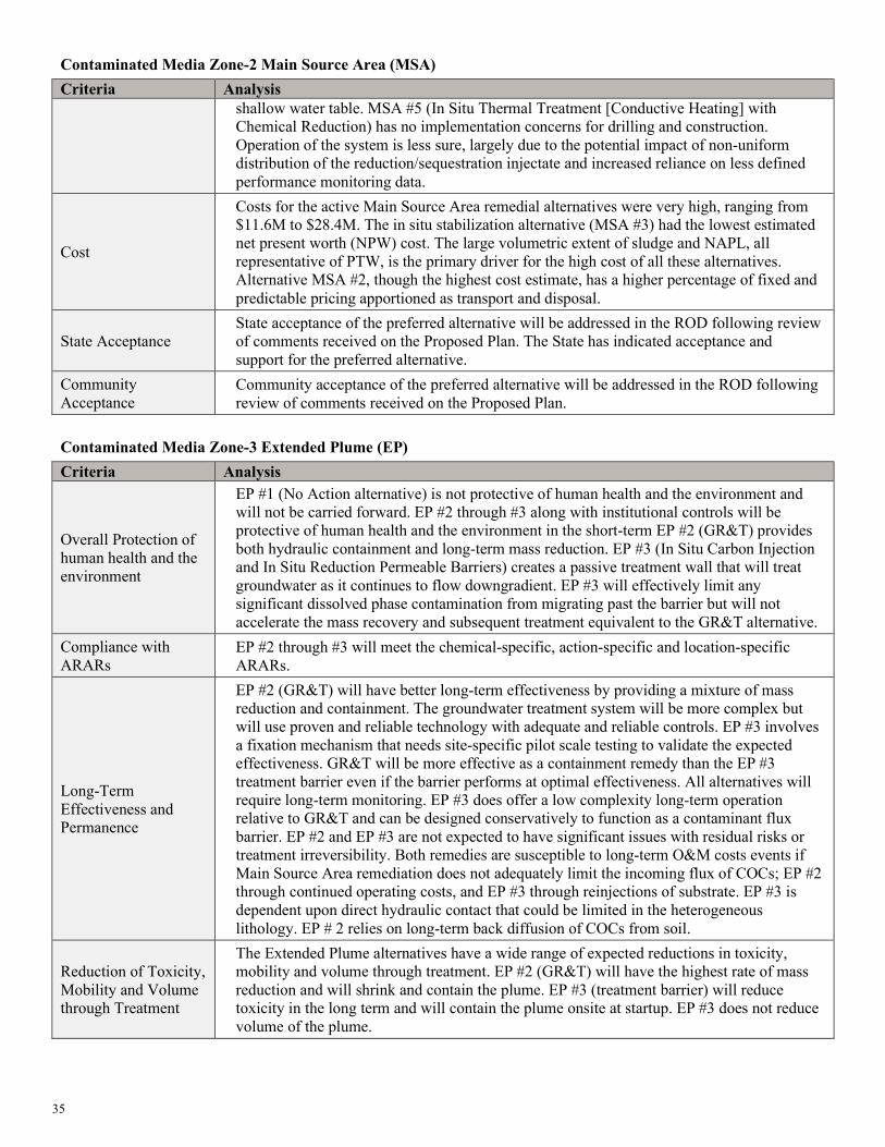
35
Contaminated Media Zone-2 Main Source Area (MSA) Criteria Analysis
shallow water table. MSA #5 (In Situ Thermal Treatment [Conductive Heating] with Chemical Reduction) has no implementation concerns for drilling and construction. Operation of the system is less sure, largely due to the potential impact of non-uniform distribution of the reduction/sequestration injectate and increased reliance on less defined performance monitoring data.
Cost
Costs for the active Main Source Area remedial alternatives were very high, ranging from $11.6M to $28.4M. The in situ stabilization alternative (MSA #3) had the lowest estimated net present worth (NPW) cost. The large volumetric extent of sludge and NAPL, all representative of PTW, is the primary driver for the high cost of all these alternatives. Alternative MSA #2, though the highest cost estimate, has a higher percentage of fixed and predictable pricing apportioned as transport and disposal.
State Acceptance State acceptance of the preferred alternative will be addressed in the ROD following review of comments received on the Proposed Plan. The State has indicated acceptance and support for the preferred alternative.
Community Acceptance
Community acceptance of the preferred alternative will be addressed in the ROD following review of comments received on the Proposed Plan.
Contaminated Media Zone-3 Extended Plume (EP) Criteria Analysis
Overall Protection of human health and the environment
EP #1 (No Action alternative) is not protective of human health and the environment and will not be carried forward. EP #2 through #3 along with institutional controls will be protective of human health and the environment in the short-term EP #2 (GR&T) provides both hydraulic containment and long-term mass reduction. EP #3 (In Situ Carbon Injection and In Situ Reduction Permeable Barriers) creates a passive treatment wall that will treat groundwater as it continues to flow downgradient. EP #3 will effectively limit any significant dissolved phase contamination from migrating past the barrier but will not accelerate the mass recovery and subsequent treatment equivalent to the GR&T alternative.
Compliance with ARARs
EP #2 through #3 will meet the chemical-specific, action-specific and location-specific ARARs.
Long-Term Effectiveness and Permanence
EP #2 (GR&T) will have better long-term effectiveness by providing a mixture of mass reduction and containment. The groundwater treatment system will be more complex but will use proven and reliable technology with adequate and reliable controls. EP #3 involves a fixation mechanism that needs site-specific pilot scale testing to validate the expected effectiveness. GR&T will be more effective as a containment remedy than the EP #3 treatment barrier even if the barrier performs at optimal effectiveness. All alternatives will require long-term monitoring. EP #3 does offer a low complexity long-term operation relative to GR&T and can be designed conservatively to function as a contaminant flux barrier. EP #2 and EP #3 are not expected to have significant issues with residual risks or treatment irreversibility. Both remedies are susceptible to long-term O&M costs events if Main Source Area remediation does not adequately limit the incoming flux of COCs; EP #2 through continued operating costs, and EP #3 through reinjections of substrate. EP #3 is dependent upon direct hydraulic contact that could be limited in the heterogeneous lithology. EP # 2 relies on long-term back diffusion of COCs from soil.
Reduction of Toxicity, Mobility and Volume through Treatment
The Extended Plume alternatives have a wide range of expected reductions in toxicity, mobility and volume through treatment. EP #2 (GR&T) will have the highest rate of mass reduction and will shrink and contain the plume. EP #3 (treatment barrier) will reduce toxicity in the long term and will contain the plume onsite at startup. EP #3 does not reduce volume of the plume.

36
Contaminated Media Zone-3 Extended Plume (EP) Criteria Analysis
Short-Term Effectiveness
None of the active remedies will have a distinguishable difference in community impacts or worker protection. All options are generally protective of the local community. The two active alternatives (EP #2 and EP #3) provide good short-term effectiveness and are protective of workers and the community during remedial action. EP #2 (GR&T) should be more effective at meeting RAOs in a shorter timeframe.
Implementability
All of the alternatives evaluated for the Extended Plume are implementable with only minor issues. EP #2 (GR&T) offers more complexity due to the reliance on establishing and maintaining reduced conditions and achieving a uniform distribution of soluble carbon. EP#2 (GR&T) is an easily implemented approach, although the long piping runs will provide some Site disruption. The operation of the GR&T system is expected to be labor intensive and require extensive remote monitoring. All remedies offer reliable and proven technology that is easy to implement, though the GR&T system is more easily modified.
Cost
Costs for the EP zone active remedial alternatives ranged between $4.1M and $5.9M. Projected Costs for EP #2 (GR&T) are high due to high capital and operation and maintenance costs and EP #3 (treatment barrier) is high due to the drilling and chemical costs and potential re-injection of amendments.
State Acceptance State acceptance of the preferred alternative will be addressed in the ROD following review of comments received on the Proposed Plan. The State has indicated acceptance and support for the preferred alternative.
Community Acceptance
Community acceptance of the preferred alternative will be addressed in the ROD following review of comments received on the Proposed Plan.
The Lead Agency’s Preferred Alternative for OU1, OU2, and IRA for OU3 of the Petroleum Products Corporation Site is a combination of the following alternatives:
• Common Alternative #1 – Bamboo Trailer Park Excavation; • Common Alternative #2 – Relocation of businesses, tenants and residents prior to building demolition in the Main
Source Area; • Common Alternative #3A – Shallow Excavation Under Buildings; • Unsaturated Zone Alternative #4 - In Situ Stabilization/Solidification (S/S), with Limited Soil Excavation, and Off-
Facility Disposal; • Main Source Area Alternative #3 – In Situ Stabilization/Solidification (S/S) with Large Diameter Augers (LDA); • Extended Plume Alternative #2 – Groundwater Recovery and Treatment (GR&T); and • Site-wide activities including long-term groundwater monitoring, five-year reviews, implementation of ICs on the
Site to provide increased public awareness of the Site’s potential hazards. Figure 7 of this Proposed Plan summarizes the Preferred Alternatives. The estimated cost of this Preferred Alternative (including all three treatment zones), is $57,100,000. This alternative consists of aggressive remediation or isolation of groundwater source areas, along with an interim treatment of the dissolved contaminants in the aquifer (OU3). The effectiveness of the NAPL source treatment in reducing the groundwater plume will be evaluated with regular monitoring. Should groundwater monitoring not show a reduction in concentrations, a remedy screening and evaluation of other remedies will be completed at that time so a final remedy can be selected and documented in a final ROD for OU3.
PREFERRED ALTERNATIVE
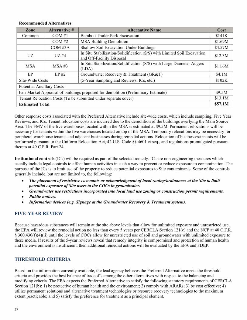
37
Other response costs associated with the Preferred Alternative include site-wide costs, which include sampling, Five Year Reviews, and ICs. Tenant relocation costs are incurred due to the demolition of the buildings overlying the Main Source Area. The FMV of the five warehouses located within the MSA is estimated at $9.5M. Permanent relocations will be necessary for tenants within the five warehouses located on top of the MSA. Temporary relocations may be necessary for peripheral warehouse tenants and adjacent businesses during remedial actions. Relocation of businesses/tenants will be performed pursuant to the Uniform Relocation Act, 42 U.S. Code §§ 4601 et seq., and regulations promulgated pursuant thereto at 49 C.F.R. Part 24. Institutional controls (ICs) will be required as part of the selected remedy. ICs are non-engineering measures which usually include legal controls to affect human activities in such a way to prevent or reduce exposure to contamination. The purpose of the ICs is to limit use of the property to reduce potential exposures to Site contaminants. Some of the controls generally include, but are not limited to, the following:
• The placement of restrictive covenants or acknowledgment of local zoning/ordinances at the Site to limit potential exposure of Site users to the COCs in groundwater.
• Groundwater use restrictions incorporated into local land use zoning or construction permit requirements. • Public notices. • Information devices (e.g. Signage at the Groundwater Recovery & Treatment system).
Because hazardous substances will remain at the site above levels that allow for unlimited exposure and unrestricted use, the EPA will review the remedial action no less than every 5 years per CERCLA Section 121(c) and the NCP at 40 C.F.R. § 300.430(f)(4)(ii) until the levels of COCs allow for unrestricted use of soil and groundwater with unlimited exposure to these media. If results of the 5-year reviews reveal that remedy integrity is compromised and protection of human health and the environment is insufficient, then additional remedial actions will be evaluated by the EPA and FDEP.
Based on the information currently available, the lead agency believes the Preferred Alternative meets the threshold criteria and provides the best balance of tradeoffs among the other alternatives with respect to the balancing and modifying criteria. The EPA expects the Preferred Alternative to satisfy the following statutory requirements of CERCLA Section 121(b): 1) be protective of human health and the environment; 2) comply with ARARs; 3) be cost effective; 4) utilize permanent solutions and alternative treatment technologies or resource recovery technologies to the maximum extent practicable; and 5) satisfy the preference for treatment as a principal element.
Recommended Alternatives Zone Alternative # Alternative Name Cost
Common COM #1 Bamboo Trailer Park Excavation $141K COM #2 MSA Building Demolition $1.69M COM #3A Shallow Soil Excavation Under Buildings $4.57M
UZ UZ #4 In Situ Stabilization/Solidification (S/S) with Limited Soil Excavation, and Off-Facility Disposal $12.3M
MSA MSA #3 In Situ Stabilization/Solidification (S/S) with Large Diameter Augers (LDA) $11.6M
EP EP #2 Groundwater Recovery & Treatment (GR&T) $4.1M Site-Wide Costs (5-Year Sampling and Reviews, ICs, etc.) $102K Potential Ancillary Costs Fair Market Appraisal of buildings proposed for demolition (Preliminary Estimate) $9.5M Tenant Relocation Costs (To be submitted under separate cover) $13.1M Estimated Total $57.1M
FIVE-YEAR REVIEW
THRESHOLD CRITERIA

38
This Proposed Plan is being issued to inform the public of EPA’s Preferred Alternative for the Petroleum Products Corporation Site and to solicit public comments pertaining to all remedial alternatives evaluated, including the Preferred Alternative. Changes to the Preferred Alternative, or a change to another alternative, may be made if public comments or additional data indicate that such a change would result in a more appropriate remedial action. The final decision regarding the selected remedy will be made after the EPA has taken into consideration all public comments. The EPA may, based upon community input, select a remedy other than the proposed Preferred Alternative. This Proposed Plan has been made available to the public for a public comment period that concludes on February 12, 2021. A virtual public meeting will be held during the public comment period to present the conclusions of the RI/FS, to elaborate further on the reasons for proposing the Preferred Alternative for the Site, and to receive public comments. If there is a request for an in-person meeting, please e-mail [email protected]. The public meeting will include a presentation of the Preferred Alternative. Information concerning the public meeting and for submitting written comments can be found in the “Community Involvement Coordination” text box on Page 2. Comments received at the public meeting, as well as written comments received during the public comment period, will be documented in the Responsiveness Summary section of the ROD. The ROD is the document that explains which remedial alternative has been selected and the basis for the selection of the remedy. For further information on the Site, please contact: Michael Taylor, Remedial Project Manager (404) 562-8762 or (800) 435-9233 E-mail: [email protected] LaTonya Spencer, Community Involvement Coordinator (404) 562-8463 E-mail: [email protected] US EPA Region 4 SEMD/RSB/RCS 61 Forsyth Street, SW Atlanta, Georgia 30303-8960
The Administrative Record contains all the information used by the Agency to select a Remedial Action. Copies of the Administrative Record are retained at:
Broward County Public Library 100 S. Andrews Avenue, Level 5 Fort Lauderdale, Florida 33301 Phone: (954) 357-7444 (Currently not open to the public due to the pandemic) U.S. Environmental Protection Agency Region IV - Records Center 61 Forsyth Street, SW Atlanta, Georgia 30303-3104 Phone: ( 404)562-8816 Hours: Mon - Fri 8 a.m. - 5 p.m. EPA Website: www.epa.gov/superfund/petroleum-products-corporation
COMMUNITY PARTICIPATION
DOCUMENT INFORMATION

39
GLOSSARY Administrative Record: Materials, information and documents that provide the basis and support EPA's selection of a remedial action at Superfund sites usually placed in the information repository near the Site. Applicable or Relevant and Appropriate Requirements (ARARs): Refers to Federal and more stringent State environmental requirements a selected remedy must attain which vary from site to site. Reference 40 C.F.R. § 300.5 Definitions of “Applicable requirements” and “relevant and appropriate requirements.” Baseline Risk Assessment (BRA): A qualitative and quantitative evaluation performed to define the risk posed to human health and the environment by the presence or potential presence and use of specific pollutants. Characteristic Waste: a waste exhibiting one of the following characteristics, as defined in 40 C.F.R. § 261: ignitability, corrosivity, reactivity, or extraction procedure toxicity. Chemical of Concern (COCs): Chemical constituents associated with a Superfund Site that have been released into the environment and pose an unacceptable risk to human health. Cleanup: Actions taken to deal with a release or threat of release of a hazardous substance that could affect humans and/or the environment. The term "cleanup" is sometimes used interchangeably with the terms remedial action, removal action, response action, or corrective action. Comprehensive Environmental Response, Compensation and Liability Act (CERCLA): Also known as Superfund, is a federal law passed in 1980 and modified in 1986 by the Superfund Amendment and Reauthorization Act (SARA). The act created a trust fund, to investigate and clean up abandoned or uncontrolled hazardous waste sites. Ecological Risk Assessment (ERA): A qualitative and quantitative evaluation performed in an effort to define the risk posed to ecological receptors by the presence or potential presence of specific contaminants. Feasibility Study (FS): Study conducted after the Remedial Investigation to determine what cleanup alternatives or technologies could be applicable to the site-specific COCs. Groundwater: Water located beneath the ground surface in soil pore spaces and in the fractures of lithologic formations. Human Health Risk Assessment (HHRA).The process used to estimate the nature and probability of adverse health effects in humans who may be exposed to hazards in contaminated environmental media, now or in the future. Information Repository: A library or other location where documents and data related to a Superfund project are placed to allow public access to the material. Institutional Controls: Administrative, non-engineering, controls that inform and prevent exposures to human receptors. Monitoring: The periodic or continuous surveillance or testing to determine the level of pollutants in various media. NAPL: Non-aqueous phase liquid. Non-aqueous phase liquids or NAPLs are liquid solution contaminants that do not dissolve in or easily mix with water ( hydrophobic ), like oil, gasoline and petroleum products. National Oil and Hazardous Substances Pollution Contingency Plan (NCP): The federal regulation that guides the Superfund program. Proposed Plan: Document that summarizes the RI/FS, the alternatives developed and the proposed Preferred Remedial Alternative and the rationale for its proposal. Public Comment Period: The time allowed for the public to express their views and concerns on the information provided in the Proposed Plan and EPA’s proposed Preferred Remedial Alternative. Resource Conservation and Recovery Act (RCRA): Federal environmental law passed by Congress in 1976 and later amended in 1984 that governs the generation, storage, treatment and disposal of solid and hazardous wastes. Some CERCLA sites are contaminated with RCRA wastes or activities. A CERCLA response action may include management of RCRA wastes. Record of Decision (ROD): A decision document that selects and describes the remedy that will be implemented at a Site. The ROD is based on information and technical analysis generated during the remedial investigation/feasibility study and consideration of public comments. Remedial Action (RA): The actual construction or implementation phase of a Superfund site cleanup that follows remedial design.

40
Remedial Action Objectives (RAOs): Provide a general description of what the cleanup will accomplish (e.g., restoration of groundwater to drinking water levels). These goals typically serve as the basis for developing remedial alternatives. Remedial Design (RD): The development of engineering drawings and specifications for the implementation and construction of a remedial action. Remedial Investigation (RI): An investigation conducted to fully characterize the nature and extent of contamination of a release, or threat of release, of hazardous substances, pollutants, or contaminants. In addition, the RI also evaluates risks posed to human health and the environment. The RI gathers the necessary data to support the corresponding FS. Response Action: A CERCLA-authorized action involving either a short-term removal action or a long-term removal response. This may include but is not limited to: removing hazardous materials from a site to an EPA-approved hazardous waste facility for treatment, containment or treating the waste on-site, identifying and removing the sources of groundwater contamination and halting further migration of contaminants. Subtitle C landfill: management of hazardous wastes, in a manner that protects human health and the environment. Subtitle D landfill: management of nonhazardous solid waste, such as household garbage and nonhazardous industrial solid waste Superfund: The common name used for the Comprehensive Environmental Response, Compensation and Liability Act of 1980 (CERCLA), as amended in 1986. Toxicity characteristic leaching procedure (TCLP): a soil sample extraction method for chemical analysis employed as an analytical method to simulate leaching through a landfill.

FIGURES

Florida 0 Ortando
Pembroke Park, FL
Nassau 0
THE BAHAMAS
1rnson St
van Buten St . . > . ~
~ ~ ~
"' 1: "' "' Jellerson SI
1ms St
Straits of Forda
Havana 0
. ~ ~ : .,
,. .rc,,c\eoi
.,. ~ "• \. . Cl.
~ ;;
0
" ~ van Buren St~
"'
.. ..< ('.\_... "-,.,
#(' c, •~, .. o, -t.,
:; Adams St "oo.._o,. "'
W.uhinQton St ~ ~ '; Hillcrest Ln
,:. ~
Ben Tobin Or
100
q,." ~
0.,.
"
"'"' ~~ .... ,,? ...
" . C w
200
State St Flottda St
w d
. ~ SW 18th St
i SW 19th SI
~ SW 20th St ... ,., SW21StSt . ·-p ...
23rd St
Carver
. ~ & . !;
anches sw 2~th st 5th Ct
. ~ ~ " ~ C
j ~ 3: 3: "' .,
SW 261h St
SW 27th SI
SW 28th St 3:
NH2~:n.~~--a .. ctLBl>1 C ===::{!:•,a@ Lake For.,,ost ~ broke P:trk :!.
L • tie ,;~ 3111S1~
SW 32ndSI~ .. ,,. .J,3,as, . . .. .,,
~ ~ .r.,,.. .r"' .J,., £ £ .J .J~ Or-
.J,. "a
N 0 0.25 0.5
PembrolCe Rd
SW 22nd St . >
"
SW 30th St
~C.' ~~· -;'II
~ '3~\h~ "' --;' Cl
. ~ " ~ 3: "'
"
" "' . . r-.,1:.~ ] ... "" u P•"
Do ..
Coral/ pr nl s @)
Pompano Beach T.1mar.1c
laml
@ID
Fort Lauderdale
Petroleum Products Corporation
Miami Beach
0
Jackson St Jackson St
5 I
Miles
Monroe St . Monroe St
,i Madison St
~
~ Adams St
., . Wnhmgton St ~
5 oewey St ~ .,
Funston St
Rodman St
Plunkett St
Wiley St ~ Wiley Ctt.i
~ hiayoSt ~ ~ Fletcher Cl ~ "'
~
! "'
~
! Mad11on St . > ., ~<
Adams St ·-:i:!! oN ,.., o .,
Dewey St
Funston SI Rodman St:
" Plutkett St! ~ N
" u .,
Wiley St~
~ "' M.,yoSt .,
10
u . ~ ~ 0
~ N
"' "'
Fletcher St w 82-4} W Pembroke Rd
Fletcher St W Pembroke Rd If~' E Pembrok
Fo~,.,. i le } -.i
"""' .,£. lte1 .c,_ ~ ~ ~ ''St ....- ..a .s= i ~ tt i
,,.
i NW7thSI
NW 6th St
NW 5th Ct NW 5th $1 . ~ = ;;
i NW 2nd St
NWHI Ct
NW 1st St
• SW 1st St ~ SW 1st Pl £ SW 2nd St 0 • ~ > ! ~ SW 2nd Cl
SW3rdSI i t 0 SW 4th St
~ Daily Or SW 4th Ct
~ SW 5th Cl
~ SW 6th St
Site Location Map
. NW 10th St > .. " NW 9th St ~ :,: .. . ~ NW 8th St • z NW 7th Ct c~ . NW 7th St z~
Fo•I > ~
" NW 6th St i ., Ila ~ . NW 5th St
i N z . m
~ N
NW 3rd-St , .. . . g ! ~ ~ ~ "' NW 2nd SI ... " z g ~ C a N ;; " ! i ~
C N w z
SW 1st St . . . . > ~ ~ "
>
" " ~ .
" " ·;; C .... C o N SW 2nd St 3:
N 3: '" Cl) ~ "' .,
"' "' s SW 3rd St . Hallandale SW 4th St ~
~
•sw 5th s1 3:
I ~ "'
SE 4th
A Miles
NAO 83 State Plane Flonda East, Feet
Petroleum Products Corp. Superfund Site Pembroke Park, Broward County, Florida

--~ --~..:..-...----=-...,_____..,..:--;:-:;;:;:.~~'.
' PeJ11brpke Rd •
Legend
x - x Fence
Former Tank Farm
D Surface Extent of PSP
c::J Presumed Location of SSP
~ Former Lake/Pond (1969)
[p]Approximate Site Boundary
D Ba mboo Paradise Trailer Park
\
.... _ J..N ___ o ___ 90--1-ao _ _, '-----------S-i-te-La_y_o_u_t_M_a_p _________ __, I Fig2u,e I ~ Feet Petroleum Products Corp. Superfund Site
NA083StatePlaneFtondaEast, Feet Pembroke Park, Broward County, Florida

Legend
D Sludge Disposal Pit Notes:
D Former Lake/Pond (1969) Facility demolished in 1970. Warehouses constructed 1970 to 1973.
Q Approximate Site Boundary
Historic Site Layout - November 1969 Petroleum Products Corp. Superfund Site Pembroke Park, Broward County, Florida
I Figt• I N 0 40 80 160
A' I I
Feet NAD83 State Plane Florida East. Feet

Figure 4: General Conceptual Site Model Petroleum Products Corporation Superfund Site
Sand Dominated Units
Limestone Dominated Units
Main Potential Exposure Routes
(D Dermal contact - soils, future groundwater(?)
Q) Inhalation
® Ingestion - soils, product, future groundwater(?)
Pembroke Park Warehouses -
(l
2 c-,)
PPC Fenced Are• Former Tank Fa
I I
D Diffused/Dispersed Contamination in Groundwater
Cracks In foundation allow vapors to enter building

Figure 5: Conceptual Site Model Petroleum Products Corporation Superfund Site
Source Release Transport Exposure Potential Mechanism Pathway Route Receptors
Tresp8$ser Tena-nt Indoor Worker OutctoorWorker Re$ident ConsuuctionWQtker-
Current Fu<ure Cooent Futute Current future Currenl Future Cun-ell! Future Curreot Fvture
Incidental Ingestion C> C> - - - - - - C) - C) -Surface Soil Dermal Contact C) C) - - - - - - C) - C) -FugitfveOusa
Runoff ,.. Inhalation of Particulates-Outdoors C) C) C) C) C> C) C) C) 0 C) C) C)
NI j rnhalation of Vapors . OutdoorS C) C) C) C) C) C) C> C> C) C> C) C>
Volatilization
lncidente-1 lngeslion ~ ~ u u u u - - ~ - u -Dermal Contact ~ ~ u u u u - - ~ - u -Vo1utilit .Jtion
Sou.roe Area, /vi j rnhalation of Vapors - Indoors C) C) C) C) C) C) C) 0 C) C) C) C)
Surrounding Area
Volatilization
Ingestion C) C) C) - C) - C) - C) - 0 -Dermal Contact ~ c::> u - u - u - ~ - u -Voltllilit ~
NI I Inhalation ofVapors • Outdoors u c::> ~ C) u u ~ C) u c::> u C)
Lead'aig NI I Inhalation of Vapors • Outdoors C) C) C) C) C) C) C) C) C) C) C) C)
VolatillzabOn
lncadental lngesc,on C> C> - - C) C> C> C> C) C> C) C> SludgeJSeepage
Dermal Contact C> C> C> C> C> C> C> C> C) C> C) C>
Food lnges.tiOno(Flsh C> C> C> C) C) C) C) C) C) C> C) C)
Surface Water or 1-tal Ingestion C> C> C> C> C) C> C> C> C) C) C) C)
StanchngWater Dermal Contact C> C> C> C> C) C> C> C> C) C) C) C>
Volatilization
,.. Inhalation ofVapors . Outdoors C) C> C> C) C> C> C> C> C) C> C) C>
Volatilization
Incidental Ingestion C) C) C) C) C) C) C) C) C) C) C) C) Sediment
Oerma1Cont.$d <::) <.:::> <.:::> <::) <.:::> <::) c::> c:> u <.:::> u <.:::> Noles: - Complete Pathw-ay; quantitatively assessed in the supplemental HHRA.
C) C~ete Pathway. qi;aJltatlvely assessed In the supplemental HHRA..
0 Incomplete Pathway; not assessed in the supplemental HHRA.

Legend
Extent or SludgeiNAPL in ; • ' , CMZ-1 • Unsaturated Zone . .. (UZ)Oto5-ft~s
Extent or Sludge~APL in ~: ~ CMZ-2. Maui Source Zone
(MSA) at 5-fl ~s; salurated
■ Demolition or Buiding to Extents Shown
Buidings Overlying Shallow Soil Contam~ation
D Excavation Sheet Pile
x - Feoce
Former Tank Farm
0 Surface Extent or PSP
0 Presumed Location of SSP
QjApproximate Site Boundary
D Bamboo Paradise Trailer Pall(
/J:i Assigned Building ID
Figure 6 Building Demolition for Common Alternatives
Petroleum Products Corp. Superfund Site Pembroke Pall(, Broward County, Florida
N o 50 100 200
! Feet
" NAD83 Slate Plane flooda East.feet
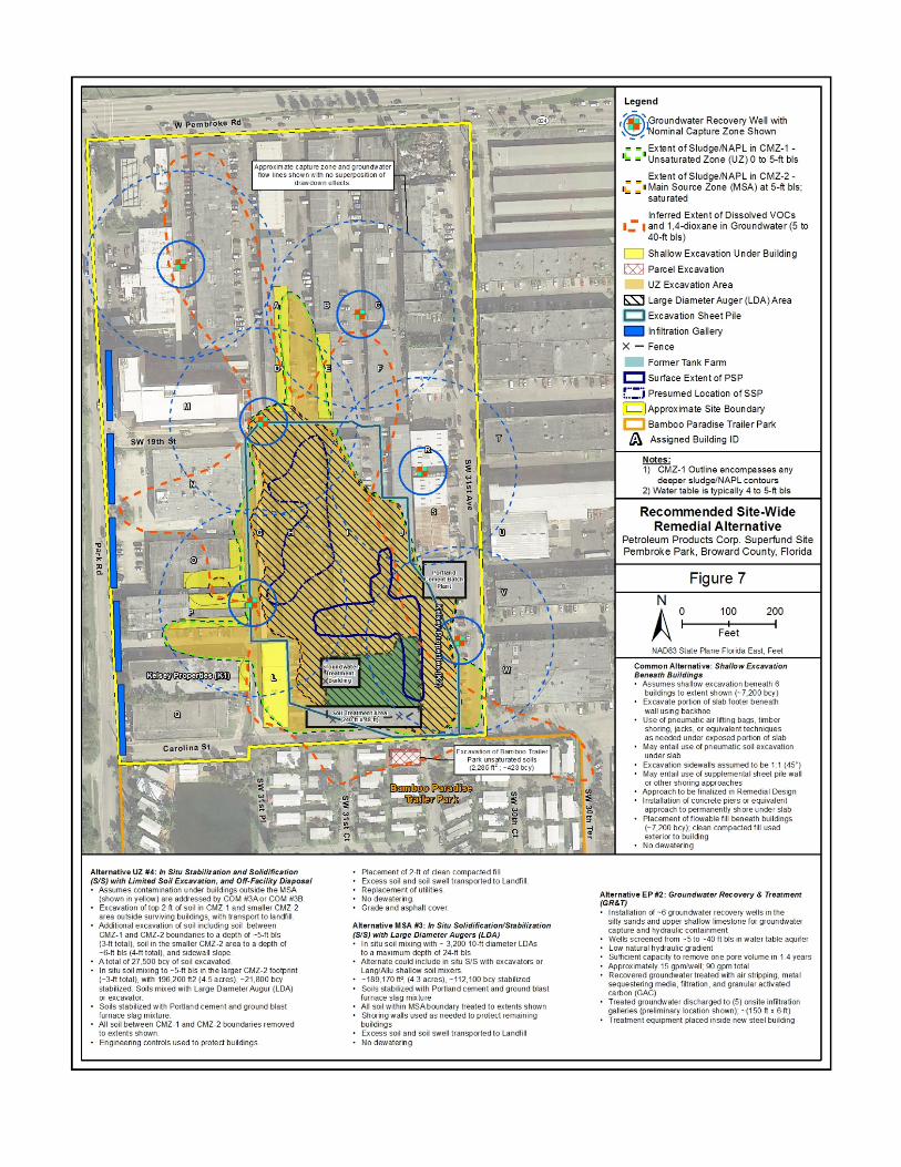
-
\\ f, ,:1 ,,, ~.· ,,, \ '
►
I I
t ', ', (1
\\ I
I I
I
I .,,· , ~ I :.- , ~ I
I
{ I
I
I
I
I
1 I I
I
I
I
I I
~
Alternative UZ #4: In Slru Srablllzarlon and Solldlncarlon (SIS) with Umhed Soil Excavation, and Off-Facilhy Disposal
Assumes contamination under buildings outside the MSA (shown in yellow) are addressed by COM #3Aor COM #3B Excavation of top 2-ft ot soil in CMZ-1 and smaller CMZ-2 area outside surviving bu~dings, with transport to landf1I. Additional excavation ot soil including soil between CMZ-1 and CMZ-2 boundaries to a depth of -5-ft bis (3-ft total), soil m the smaller CMZ-2 area 10 a depth of - 6-ft bis (4-ft tota l), and sidewan slope. A total of 27,500 bey of soil excavated. In sit u soil mixing to -5-ft bls in the larger CMZ-2 footprint (-3-ft total), wl h 196,200 ft2 (4.5 acres), -21,800 bey stabilized. Soils mixed with Large Diameter Augur (LOA) or excavator. So~s stab~1zed with Portland cement and ground blast furnace slag mixtu re. All sod between CMZ-1 and CMZ-2 boundaries removed to extents shown.
• Engineering controls used to protect buildings.
Legend
,~ t,roundwater Recovery Well w ith
!115;=-----=====1 ~ -Nominal Capture Zone Shown
• • • Extent of Sludge/NAPL in CMZ-1 • '!a " Unsaturated Zone (UZ) 0 to 5-ft bis
Placement of 2 -ft ot clean compacted fill. Excess soil and soil swell transported to LandfiU. Replacement of utilities. No dewatenng Grade and asphalt cover.
Alternative M SA #3: In Situ Solidification/Stabilization (SIS) with Large Diameter Augers (LDA)
In situ SOIi mixing with - 3,200 10-fl diameter LDAs to a maximum depth of 24-ft bis Alternate couk:I inck.lde in Situ SIS wi h excavators or Lang!Allu shallow soil mixers. -189, 170 ft2, (4.3 acres), -112, 100 bey stabilized SO~s stabihzed with Portland cement and ground blast furnace slag mixture All SOIi within MSAboundary treated 10 extents shown Shoring walls used as needed to protect remaining buddings Excess soil and soil swell transported to Landfill No dewatering
~ ~ Extent of Sludge/NAPL in CMZ-2 -I!. .. • Main Source Zone (MSA) at 5-ft bis;
saturated
Inferred Extent of Dissolved v oes •= I and 1,4-dioxane in Groundwater (5 to 40-ft bis)
- Shallow Excavation Under Building
@ Parcel Excavation
UZ Excavation Area
&s:] Large DiameterAuger (LDA) Area
D Excavation Sheet Pile
- Infiltration Gallery
X - Fence
Former Tank Farm
c:J Surface Extent of PSP
r::i Presumed Location of SSP
li=}Approx imate Site Boundary
c:J Bamboo Paradise Trailer Park
/J!! Assigned Building ID
Notes: 1) CMZ-1 Outl ine encompasses any
deeper sludge/NAPL contours 2) Water table is typically 4 to 5-ft bis
Recommended Site-Wide Remedial Alternative
Petroleum Products Corp. Superfund S rte Pembroke Park, Broward County, Florida
Figure 7 N ~ 01----1-+00 ___ 2-loo
~ Feet
NAD83 State Plane Florida East, Feet
Common Alternati ve: Shallow Excavation Beneath Buildings
Assumes shalow excavahon beneath 6 bu ildings to extent shown (-7,200 bey) Excavate portion of slab footer beneath wall using backhoe Use of pneumatic air lifting bags, tmber shoring, jacks, or equivalent techniques as needed under exposed portion of slab May entail use of pneumatic soil excavation under slab ExcavatMln sidewalls assumed to be 1:1 (45• ) May entail use of supplemental sheet pile wal or other shonng approaches
Approach to be f inalized in Remedial Design Installation ot concrete piers or equivalent approach to permanently shore under slab Placement ot flowable fin beneath buildings (-7,200 bey); clean compacted fill used exterior to bui lding
No dewatering
Alternative EP #2: Groundwater Recovery & Treatment (GR&T)
Installation of - 6 groundwater recovery wells in the silty sands and upper shallow linlestone for groundwater capture and hydrauhc containment Wells screen ed from -5 to - 40 tt bis in water table aquifer Low natural hydraulic gradient Sufficient capacity to remove one pore volume in 1 4 years Approximately 15 gpm/weU; 90 gpm total Recovered groundwater treated with air stripping, metal sequestering media, rnralion, and granular activated carbon (GAC) Treated groundwater discharged to (5) onsite infiltration galleries (preliminary location shown); - {150-ft x 6-ft) Treatment equipment placed inside new steel bu~ding

LEGEND - 270 Day Travel Time - - 2-foot drawdown contour Approx. Scale 1" =1,500' t
~ __________ H_a_ll-an_d_a_le_,_F_L_W_e_llf-ie-ld_,_2_7_0_D_a_y_T_r_a_v_e_l --------~ I Fig8u,e I Petroleum Products Corp . Superfund Site Pembroke Park, Broward County, Florida
Related Documents


