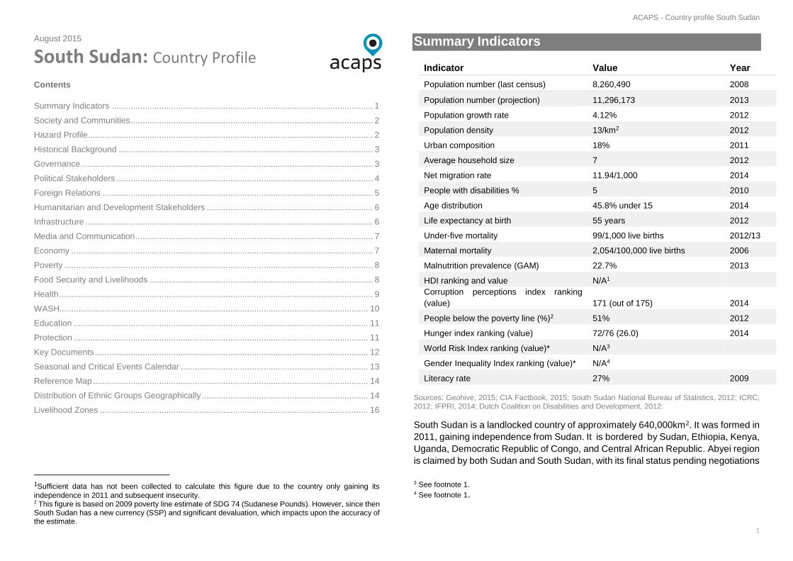
ACAPS - Country profile South Sudan 1 August 2015 South Sudan: Country Profile Contents Summary Indicators .............................................................................................................. 1 Society and Communities ...................................................................................................... 2 Hazard Profile........................................................................................................................ 2 Historical Background ........................................................................................................... 3 Governance ........................................................................................................................... 3 Political Stakeholders ............................................................................................................ 4 Foreign Relations .................................................................................................................. 5 Humanitarian and Development Stakeholders ...................................................................... 6 Infrastructure ......................................................................................................................... 6 Media and Communication .................................................................................................... 7 Economy ............................................................................................................................... 7 Poverty .................................................................................................................................. 8 Food Security and Livelihoods .............................................................................................. 8 Health .................................................................................................................................... 9 WASH.................................................................................................................................. 10 Education ............................................................................................................................ 11 Protection ............................................................................................................................ 11 Key Documents ................................................................................................................... 12 Seasonal and Critical Events Calendar ............................................................................... 13 Reference Map .................................................................................................................... 14 Distribution of Ethnic Groups Geographically ...................................................................... 14 Livelihood Zones ................................................................................................................. 16 1 Sufficient data has not been collected to calculate this figure due to the country only gaining its independence in 2011 and subsequent insecurity. 2 This figure is based on 2009 poverty line estimate of SDG 74 (Sudanese Pounds). However, since then South Sudan has a new currency (SSP) and significant devaluation, which impacts upon the accuracy of the estimate. Summary Indicators Indicator Value Year Population number (last census) 8,260,490 2008 Population number (projection) 11,296,173 2013 Population growth rate 4.12% 2012 Population density 13/km 2 2012 Urban composition 18% 2011 Average household size 7 2012 Net migration rate 11.94/1,000 2014 People with disabilities % 5 2010 Age distribution 45.8% under 15 2014 Life expectancy at birth 55 years 2012 Under-five mortality 99/1,000 live births 2012/13 Maternal mortality 2,054/100,000 live births 2006 Malnutrition prevalence (GAM) 22.7% 2013 HDI ranking and value N/A 1 Corruption perceptions index ranking (value) 171 (out of 175) 2014 People below the poverty line (%) 2 51% 2012 Hunger index ranking (value) 72/76 (26.0) 2014 World Risk Index ranking (value)* N/A 3 Gender Inequality Index ranking (value)* N/A 4 Literacy rate 27% 2009 Sources: Geohive, 2015; CIA Factbook, 2015; South Sudan National Bureau of Statistics, 2012; ICRC, 2012; IFPRI, 2014; Dutch Coalition on Disabilities and Development, 2012: South Sudan is a landlocked country of approximately 640,000km 2 . It was formed in 2011, gaining independence from Sudan. It is bordered by Sudan, Ethiopia, Kenya, Uganda, Democratic Republic of Congo, and Central African Republic. Abyei region is claimed by both Sudan and South Sudan, with its final status pending negotiations 3 See footnote 1. 4 See footnote 1.

Welcome message from author
This document is posted to help you gain knowledge. Please leave a comment to let me know what you think about it! Share it to your friends and learn new things together.
Transcript
ACAPS - Country profile South Sudan
1
August 2015
South Sudan: Country Profile
Contents
Summary Indicators .............................................................................................................. 1
Society and Communities ...................................................................................................... 2
Hazard Profile ........................................................................................................................ 2
Historical Background ........................................................................................................... 3
Governance ........................................................................................................................... 3
Political Stakeholders ............................................................................................................ 4
Foreign Relations .................................................................................................................. 5
Humanitarian and Development Stakeholders ...................................................................... 6
Infrastructure ......................................................................................................................... 6
Media and Communication .................................................................................................... 7
Economy ............................................................................................................................... 7
Poverty .................................................................................................................................. 8
Food Security and Livelihoods .............................................................................................. 8
Health .................................................................................................................................... 9
WASH.................................................................................................................................. 10
Education ............................................................................................................................ 11
Protection ............................................................................................................................ 11
Key Documents ................................................................................................................... 12
Seasonal and Critical Events Calendar ............................................................................... 13
Reference Map .................................................................................................................... 14
Distribution of Ethnic Groups Geographically ...................................................................... 14
Livelihood Zones ................................................................................................................. 16
1Sufficient data has not been collected to calculate this figure due to the country only gaining its
independence in 2011 and subsequent insecurity. 2 This figure is based on 2009 poverty line estimate of SDG 74 (Sudanese Pounds). However, since then South Sudan has a new currency (SSP) and significant devaluation, which impacts upon the accuracy of the estimate.
Summary Indicators
Indicator Value Year
Population number (last census) 8,260,490 2008
Population number (projection) 11,296,173 2013
Population growth rate 4.12% 2012
Population density 13/km2 2012
Urban composition 18% 2011
Average household size 7 2012
Net migration rate 11.94/1,000 2014
People with disabilities % 5 2010
Age distribution 45.8% under 15 2014
Life expectancy at birth 55 years 2012
Under-five mortality 99/1,000 live births 2012/13
Maternal mortality 2,054/100,000 live births 2006
Malnutrition prevalence (GAM) 22.7% 2013
HDI ranking and value N/A1
Corruption perceptions index ranking
(value) 171 (out of 175) 2014
People below the poverty line (%)2 51% 2012
Hunger index ranking (value) 72/76 (26.0) 2014
World Risk Index ranking (value)* N/A3
Gender Inequality Index ranking (value)* N/A4
Literacy rate 27% 2009
Sources: Geohive, 2015; CIA Factbook, 2015; South Sudan National Bureau of Statistics, 2012; ICRC, 2012; IFPRI, 2014; Dutch Coalition on Disabilities and Development, 2012:
South Sudan is a landlocked country of approximately 640,000km2. It was formed in
2011, gaining independence from Sudan. It is bordered by Sudan, Ethiopia, Kenya,
Uganda, Democratic Republic of Congo, and Central African Republic. Abyei region
is claimed by both Sudan and South Sudan, with its final status pending negotiations
3 See footnote 1. 4 See footnote 1.

ACAPS - Country profile South Sudan
2
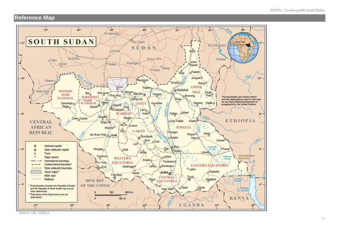
between the two countries (CIA Factbook, 2015). The country is divided into 10 states,
with the capital being Juba.
The country’s terrain rises from plains in the north and central areas to southern
highlands along the border (CIA Factbook, 2015). The country’s landscape is made up
of hills and mountains in the north; rainforests in the south and southeast; and
extensive flood plains and the Sudd wetlands in the centre, north and northeast of
the country (ACTED, 09/2013). A large section of the White Nile river flows through
South Sudan, and these wetlands are a vast swamp area formed by the White Nile,
a main tributary of the Nile River, and make up more than 15% of the country’s total
area (WB, 2014).
Society and Communities
Key population figures: The average family size in a private household is seven.
71% of households are female-headed. Polygamy is widely practised: approximately
41% of women are in polygamous unions, therefore a large number of households
are satellites of larger male-headed families. The population is largely rural, with
83% of the population residing in rural areas. Five cities had an estimated population
exceeding 100,000 prior December 2013 and the most recent escalation of violence;
Aweil, Malakal, Wau, Yei and the capital Juba. Juba is the biggest city with a
population estimated to be nearly 400,000. 72% of the population is under the age
of 30: 51% of these are under 18, 32% under 10, and 16% under five. (South Sudan
Bureau of Statistics, 2012; WFP, 2010)
Ethnic or tribal groups: The Dinka are the largest ethnic group in the country
(35.8% of the total population). The Dinka are broken down into roughly 10 sections
based around a separate geographical territory. Each one is considered an
individual political entity. They inhabit the vast arc of land running north, west, and
south of the central Nile basin, covering the greater Bahr el Ghazal in the northwest
and Upper Nile areas in the northeast. Many live as pastoralists (CMI, 2012; Gurtong,
2014).
The Nuer are the second-largest group, and constitute 15.6% of the population. The
Nuer groups traditionally occupy Unity state, extending eastwards along the Sobat
and Baro Rivers through the northern areas of Jonglei, and southern Upper Nile.
Groups of Nuer are also found in southwestern Ethiopia (CMI, 2012).
Other prominent groups include Shilluk, Azande, Bari, Kakwa, Kuku, Murle,
Mandari, Didinga, Ndogo, Bviri, Lndi, Anuak, Bongo, Lango, Dungotona, Acholi. (CIA
Factbook, 2015). Within these groups are various subtribes, usually based around
specific geographical regions (Gurtong, 2014).
(See Map of Distribution of Ethnic Groups Geographically)
Languages: English is the official language, although there are few fluent speakers;
Arabic (includes Juba and Sudanese variants), and 64 tribal languages. Dinka,
Nuer, Bari, Zande, and Shilluk are the most widely spoken (CIA Factbook, 2015; BBC,
2011; The Niles, 2013).
Religion: Most of the population is Christian or animist; a very small percentage are
Muslim (CIA Factbook, 2015; South Sudan Embassy in Washington DC, 2011).
Protracted displacement: Since independence, displacement has occurred at
different stages and for different reasons. People have been displaced by floods and
droughts, fighting between Sudan Armed Forces (SAF) and Sudanese People's
Liberation Army (SPLA) in Abyei, fighting between SPLA and armed opposition
groups, inter-tribal conflicts in Jonglei, Warrap, Lakes and Unity states, and LRA
activity in Western Bahr el-Ghazal and Western Equatoria states (LRA, 06/2012).
In 2012, an estimated 183,000 people were reported as newly displaced (IDMC,
28/12/2012). There were a further 189,000 people displaced in 2013 prior to the
violence that erupted in December. These numbers only reflect people who were
accessed and assisted, which indicates actual figures might be higher. Due to
repeated displacements, total figure of those who remain displaced, compared to
the newly or repeatedly displaced have limited validity (IDMC, 2014).
Returnees: Two million people of South Sudanese origin have returned from Sudan
primarily through voluntary returns, particularly in the years preceding
independence. Returnees were offered free rural land as part of a government policy
to encourage returns, but in many cases in areas that were either flood-prone or
unfamiliar to the returnees. Only a few returns took place in 2014: it is suggested
that returnees are going back to Sudan (IDMC, 09/07/2014).
Hazard Profile
Floods: Seasonal floods are common in South Sudan, and typically occur between
August and October each year, especially affecting low-lying areas in Warrap,
Lakes, Unity, and Jonglei states. By January, floods recede ( FEWSNET, 24/09/2014).
Drought: South Sudan periodically experiences drought, dramatically affecting crop
production and subsequently food security, particularly for South Sudan’s large
ACAPS - Country profile South Sudan
3
number of subsistence farmers. The most severe and recent droughts were in 2011
and 2013, with north and northeastern states being worst affected. In 2011, drought
directly contributed to 3.7 million people being in need of food assistance (The Niles,
07/2014; GIEWS, 03/2014).
Historical Background
Colonisation: Egypt attempted to colonise the area covered by South Sudan by
establishing the province of Equatoria in the 1870s. An Islamic Mahdist revolutionary
force recruited from Sudanese tribes in opposition to Egyptian rule overran the
region in 1885, but a British force overthrew the Mahdist regime in 1898. An Anglo-
Egyptian Sudan was established the following year: Equatoria was the
southernmost of its eight provinces. Sudan gained independence in 1956 (CIA
Factbook, 2015).
Civil wars (1955–2005): The root causes of both civil wars can be generalised as a
conflict of religious identity between the Muslim North and largely Christian south,
political autonomy for the South from Khartoum, and control of resources, especially
oil following its discovery in the 1970s. The first civil war (1955–72) was between
the Government in Khartoum and a separatist movement in the south. After 1963,
most of the fighting was conducted by the military wing of the resistance called the
Anya-Nya. The second (1983–2005) was between the Government and the
Sudanese People's Liberation Army/Movement (SPLA/M), led by John Garang, and
allies. The conflict intensified when oil was discovered in the South and oil
exploration increased in the 1980s (ODI, 07/2012). In 1991, an SPLA commander Riek
Machar split from the John Garang to form SPLM/A-Nasir faction (Sudan Tribune; ODI,
07/2012; The Midddle East Quarterly, 2001).
Comprehensive Peace Agreement, semi-autonomy and independence (2005–
2011): The Comprehensive Peace Agreement (CPA) was signed on 9 January
2005, and among its provisions was a referendum on independence six years after
the CPA. John Garang died in a helicopter crash in July 2005 (Sudan Tribune). On 9
January 2011 an overwhelming majority voted for independence, leading to a new
country, the Republic of South Sudan, on 9 July (UCDP, 2014).
December 2013 conflict–present: Violent clashes erupted in Juba on 15
December 2013, between SPLA soldiers from rival political and ethnic groups.
Consequently, President Salva Kiir accused Riek Machar, the former Vice-President
(who was removed from office in July 2013), of inciting the violence in an attempted
coup. Machar has repeatedly denied this accusation. The violence quickly spread to
other locations in late December 2013, with heavy fighting between Government
and opposition forces in Central Equatoria, Jonglei, Unity and Upper Nile states. The
fighting also adopted characteristics of an inter-ethnic conflict between Dinka, allied
with President Kiir, and the Nuer, loosely allied with Machar.
Governance
South Sudan’s constitutional model is presidential. The President is elected directly
and forms the head of the executive.
Legal system: The South Sudanese legal system is built on a combination of
statutory and customary law. South Sudan has enacted dozens of laws since 2005,
but their use in legal disputes and courts is limited. Poor dissemination, little
experience with new provisions, the difficulty of many legal staff in understanding
English, and lack of access to statutory courts limit the relevance of new laws.
The Supreme Court is the highest organ of the judiciary. It consists of seven judges,
one of whom is the Chief Justice of the Supreme Court and one the Deputy
President. The Court can form three different panels: the Constitutional Panel, the
Criminal Panel and the Civil Panel. Decisions are majoritarian. Most of the time the
Supreme Court decides cases on the record but it can call litigants for oral argument
if needed (NYU, 12/2012).
Local government: The relationship between the central Government in Juba and
the state governments is unclear. The structure appears federal: each states has its
own constitution, elected governor, and legislative assembly (NYU, 12/2012).
Chiefdom governance: Hierarchy and chiefdom governance varies among
different ethnic groups. In general, the Dinka, Nuer, and other ethnicities view their
chiefs as possessing supernatural powers associated with truth-telling, justice,
wealth, knowledge, and prophetic vision. Within each group, there can be an
elaborate system of administrative elected chiefs: head chiefs, court presidents,
and, at least in the case of the Nuer, sub-chiefs (Gurtong, 2014).
Security forces: The SPLA became South Sudan’s armed forces. As of 2013, its
strength stood at 212,000 troops. The President is the commander-in-chief (Global
Security, 2014).
Communities have formed their own defence units. With an utter lack of security
forces and police in certain areas, these groups represent an important source of
physical protection. They vary in composition and nature, but are usually formed of
mainly, and sometimes exclusively, young males (PI, 02/07/2015; Enough, 03/2010).
ACAPS - Country profile South Sudan
4
Police: Most of the South Sudan National Police Service is run by former SPLA
combatants. There is little to no decentralisation to state or local areas. Though the
standards of policing service have reportedly been improving, corruption, extortion,
and illiteracy in English (the national language) are very common. Some have been
reported as being involved in robberies, and there are many cases where ethnic and
cultural prejudices are exhibited by individual officers. Rather than cooperating with
other security forces, the police operate a parallel system (The Sudd Institute, 09/2013).
Corruption: In the 2014 Corruption Perception Index, South Sudan ranked 171/174,
with a score of 15/100 (Transparency International, 2014).
Political Stakeholders
SPLM-in-Opposition (SPLM-IO) is the term used to describe the opposition to the
Government of Salva Kiir. The SPLM-IO formed in the December 2013 conflict and
is led by former Vice President Riek Machar. It is made up of a number of inter-
connected groups including the political SPLM-IO under the leadership of Riek
Machar, the wider Nuer political class in exile, and armed supporters in the Nuer
heartlands of the Greater Upper Nile (Jonglei, Upper Nile, and Unity). The armed
wing is almost entirely Nuer (Small Arms Survey, 02/05/2015).
The South Sudan Democratic Movement (SSDM)/South Sudan Defence Army
(SSDA) insurgent militia group was created by SPLA General George Athor after
losing the Jonglei governor election in 2010. Athor died in December 2012, but
SSDM has attracted other dissenting commanders who formed their own factions.
In 2012, they had an estimated core force of 500–1,000 men, although some
estimates say the SSDA can raise a total of 3,000–6,000 youths. In the current
conflict, its official position has been in opposition to the state government in Jonglei,
but declaring loyalty to the national Government in Juba. However, in 2015, the
SSDM/A has been involved in clashes with government forces outside Jonglei state (Small Arms Survey, 6/11/2013; ICG, 04/2014; Nyamilepedia, 04/2015).
SSDM/A-Cobra Faction: the SSDM/A ‘Cobra faction’, led by David Yau, emerged
in 2013 and has increasingly acted independently from the wider South Sudan
Democratic Movement/Army (SSDM/A), and has presented itself as more neutral
(Small Arms Survey, 6/11/2013). Yau, who ran but was not elected to the Jonglei
legislature in 2010, is from the Murle ethnic group, who inhabit Pibor county, Jonglei.
The group’s main area of operation is Pibor and at times Jonglei. Yau Yau claimed
his main motivation was the underdevelopment and marginalisation of Pibor county.
On 30 January 2014, the SSDM/A-Cobra signed a cessation of hostilities agreement
with the Government (Small Arms Survey, 02/05/2014). The peace agreement also gave
Yau Yau’s base county of Pibor country a higher level of autonomy (VOA, 07/2014).
with the government led to a split within the Cobra faction between elements aligned
with the Government and those wishing to remain independent (African Arguments,
01/2015). Yau Yau has since reportedly met with Machar, and refused requests from
the government to conduct operations against the SPLM-IO (Sudan Tribune, 04/2015).
South Sudan Liberation Movement/Army: The South Sudan Liberation
Movement/Army (SSLM/A) was founded by Peter Gadet, of the Bul Nuer ethnic
group from Mayom county in Unity state. Gadet defected from the SPLA in March
2011, with the aim of attacking the Government. From mid-April until August 2011,
the SSLM/A and SPLA clashed in Abiemnom and Mayom counties in Unity before
spilling over into Lakes and Warrap. In August 2011, Gadet signed a peace
agreement with the Government and was integrated into the SPLA. In late 2013, he
defected again to the opposition with troops loyal to him and attacked Government
facilities in Bor. In July 2015, Machar dismissed Peter Gadget from the SPLA-IO.
His replacement and current allegiance in unclear (Small Arms Survey, 6/11/2013; BBC,
11/07/2014; African Spotlight, 22/07/2015).
The Lord’s Resistance Army (LRA): The earliest sightings of the LRA in Eastern
Equatoria date from 1991 but it was not until 1994 that the group located a base
there and made its presence felt (Small Arms Survey, 09/2007). LRA operated in Magwi
county in Eastern Equatoria (along the South Sudan–Uganda border) over 2002–
2005. During the 2006–2008 Juba peace talks between the Government of Uganda
and the LRA, the LRA’s area of operation moved west, towards Central Equatoria,
and later moved further west, to Western Equatoria, closer to the border with
Democratic Republic of Congo and Central African Republic (Small Arms Survey,
02/2010). The LRA was then reported to be operating in parts of Western Bahr el
Ghazal and Darfur, Sudan (OCHA LRA Update, 23/01/2012). After a two-year lull in
fighting, three suspected LRA attacks were reported in Ezo and Tambura counties
of Western Equatoria in late 2013 (OCHA LRA Update, 22/01/2014). No incidents have
been reported since (OCHA LRA Update, 11/04/2014).
Inter-communal conflict: Conflicts between different ethnic groups have occurred
since independence. Underlying causes include persistent lack of services,
increased competition over natural resources, and the erosion of traditional
leadership structures as well as the unspoken rules of cattle raiding.
Within Jonglei, inter-tribal violence involving the Lou Nuer (a subtribe of the Nuer),
Murle, and to lesser extent Dinka ethnic groups, escalated in 2009 and has become
increasingly violent (Small Arms Survey, 10/2012). Between December 2011 and January
2012, clashes between Lou Nuer and Murle groups killed more than 1,400 people
in remote areas of Pibor county (UCDP, 2014; HRW, 19/07/2013). Attacks by armed ethnic
ACAPS - Country profile South Sudan
5
militia have also been frequently reported in Warrap, Lakes, Eastern and Western
Equatoria, and Upper Nile states (ACLED Database, 2015).
Foreign Relations
UN: The United Nations Mission in South Sudan (UNMISS) was established on 8
July 2011 (UN, 2011). Its original mandate was to support the Government in conflict
prevention and peace consolidation, long-term state building and economic
development. Its initial strength was up to 7,000 military personnel, including military
liaison officers and staff officers, and up to 900 civilian police personnel (UN).
After December 2013, the UN Security Council authorised a temporary increase in
numbers, to 12,500 military and 1,323 police. The mission’s focus also temporarily
shifted from mainly peacebuilding activities to protecting civilians, facilitating
humanitarian assistance, monitoring and reporting on human rights, preventing
further inter-communal violence, and supporting the IGAD led mediation efforts as
and when requested. The protection priority would be displaced people. This shift in
focus is expected to remain until the Government and SPLM-IO find a political
agreement (UN). The current authorisation is until 30 May 2015 (UNMISS).
Intergovernmental Authority on Development (IGAD): The IGAD comprises
seven member states: Djibouti, Eritrea, Ethiopia, Kenya, Somalia, Sudan and
Uganda. The IGAD Monitoring and Verification Mechanism for South Sudan,
headquartered in Juba, was set up shortly after the Government and SPLM-IO
signed the Cessation of Hostilities Agreement on 23 January 2014. Its mission is to
support the mediation process by monitoring, investigating and reporting the two
parties’ compliance with the Agreement. (IGAD).
IGAD has led mediation efforts (Enough Project). Peace talks collapsed on 5 March
2015 in Addis Ababa, as the parties failed to meet a deadline for an agreement on
power sharing and security issues. (Reuters, 06/03/2015).
United States, United Kingdom, and Norway: Also known as the ‘Troika’, the
three states are supporting IGAD’s mediation efforts between the parties. The
United States also helped create the 2005 Comprehensive Peace Agreement. The
US Government is the leading international donor to South Sudan (US Department of
State, 04/03/2014).
Sudan: The border with Sudan has neither been delimited nor demarcated since
South Sudan’s independence. Abyei and other areas remain contested. The border
region contains crucial grazing areas for pastoralist and transhumance groups,
which traditionally agreed grazing arrangements between themselves. Oil regions
along the border region are a source of conflict. In March and April 2012, the SPLA
took Heglig from the Sudan Armed Forces (SAF), to widespread international
condemnation. The SPLA said the assault was prompted by a series of SAF attacks
on South Sudanese positions along the border. Fighting continued throughout 2012
(Small Arms Survey).
In 2005, the Government of Sudan and the Sudan People’s Liberation Movement
signed the Abyei Protocol of the Comprehensive Peace Agreement (CPA), which
committed both sides to implementing a referendum to determine whether Abyei
would rejoin the states that now constitute South Sudan. However, both Sudan and
South Sudan have shown little interest in resolving Abyei’s political future (Small Arms
Survey, 17/04/2015).
Oil has been the major contribution to South Sudan’s budget and a major root cause
of conflict with the North. South Sudan has approximately 75% of the former Sudan’s
oil reserves, but relies on the infrastructure of the North to extract and sell it. In
January 2012, when talks around sharing the oil revenue broke down between the
two countries, tensions and conflict erupted. It also resulted in the halt of oil
production. Production only resumed in 2013 when a demilitarised zone was created (BBC, 20/05/2015).
Significant clashes over disputed territory occurred in 2011 and 2012. The borders
remain officially closed, but unofficial cross border travel and trade is known to take
place. Tensions along the borders of oil-rich areas, such as Upper Nile state and the
disputed Abyei region, remain high. Both nations have military forces positioned
along it (PI, 20/07/2015; Global Witness, 2015).
Kenya has played a central role in hosting negotiations between Sudan and South
Sudan, including the signing of the Comprehensive Peace Agreement. Kenya has
also focused on boosting economic relations, especially with many Kenyans working
to develop of South Sudan’s private sector such as banking, infrastructure,
construction, and private-goods sector (Al Jazeera Centre for Studies, 29/03/2012).
Uganda supported the SPLA during the Sudan civil war, and continues to support
it, purchasing and delivers military resources on behalf of the SPLA (The Insider,
01/2015). Uganda also sent troops and aircraft to support the SPLA against the SPLM-
IO. Uganda is also an important trading partner for South Sudan, and many
Ugandans have taken up residence in South Sudan, attracted by the opportunities
of the post-war economy (IRIN, 19/03/2014).

ACAPS - Country profile South Sudan
6
Humanitarian and Development Stakeholders
International aid community: 23 UN Agencies and more than 150 INGOs are in
South Sudan (UN) (South Sudan NGO Forum). The cluster system was activated in 2010,
including cluster-level NGO coordinators and state-level focal points (UNICEF,
27/08/2012).
The South Sudan NGO Forum and Secretariat is an independent body coordinating
national and international NGOs, also including the Government of South Sudan,
the UN, donors, and other external stakeholders (South Sudan NGO Forum, 2014).
National response capacity: OCHA works closely with the Government of South
Sudan’s Relief and Rehabilitation Commission to boost humanitarian coordination
and policy capacity at state and central level (OCHA, 2015; GoSS, 2015). There are 140
national NGOs, as of 2014 (South Sudan NGO Forum)
Perceptions: In 2012, South Sudan was third (after Afghanistan and Somalia) in
the ranking of countries with most violent attacks against humanitarian aid workers.
Aid agencies have struggled with the Government’s lack of capacity and lack of
observance of responsibilities regarding the security of aid operations. Aid agencies
are hesitant to approach government officials for security advice or support, and
most agencies try to avoid association with the central government. Security forces
commandeer agency vehicles and other communications assets and detain aid
agency staff with no legal basis, along with other harassments and threats. At the
local level, relations tend to be better, and most agencies heed officials’ advice
(Humanitarian Outcomes, 2012).
Infrastructure
Airports: There are more than 50 airstrips, serviceable by fixed wing aircraft and by
helicopters. Juba, Wau and Malakal are the only airports with asphalted runways
capable of handling large aircraft. The rest are gravel and only accessible by light
aircraft. Juba is the only international airport receiving flights from international
commercial airline carriers (Logistics Cluster, 21/02/2014).
Roadway: South Sudan has one of the world’s most underdeveloped road
networks. The total estimated track length in South Sudan is approximately
90,200km, which includes approximately 14,000km of primary and secondary roads,
and 6000km of tertiary tracks. Only 300 km of roads are sealed, and this includes
the only international road (192 km) between Juba and Nimule on the Ugandan
border, and most of the rest are within Juba (African Development Bank, 10/2012). Most
roads are not passable for extended periods during the rainy season, cutting off
large areas of the country (Logistics Cluster, 21/02/2014). The rugged terrain, insecurity
along some transport routes, and the large amount of capital investment required all
limit the expansion of the road network.
Ports and waterways: During the rainy season, the White Nile is the only reliable
transport link between the southern, central, and northern areas of the country. The
country has access to approximately 1,400km of navigational waterways from Juba
in the south, Bentiu (Unity state), to Akobo on the Ethiopian border to the east, and
Kosti in Sudan. The river is accessible throughout the year. Many of the river’s
tributaries are navigable during the rainy reason (Logistics Cluster, 21/01/2014).
Melut, Malakal, and Renk in Upper Nile, Mangalla in Central Equatoria, and Bor in
Jonglei are major ports. Other ports are mostly an easily accessible riverbank.
Loading and offloading facilities remain problematic. Passenger transport along the
river has not been fully developed, and is mostly powerboats and allocated space
on cargo barges (Logistics Cluster, 20/03/2015).
Railway: South Sudan’s current rail infrastructure was constructed in 1959–1962.
The single narrow-gauge railway links Wau and Aweil to Babanusa in Sudan, which
forms part of a rail transport corridor that extends up to Port Sudan. During the
Second Civil War (1983–2005) military trains went as far as Aweil, frequently with
train cars carrying large numbers of troops and militia. This caused great levels of
disruption to civilians and humanitarian aid organisations along the railway line
(Institute of Developing Economies, 2015; HRW, 1999). However, the railway is in a serious
state of disrepair and rail operations have been suspended due to border closures,
unserviceable equipment and lack of capacity (Logistics Cluster, 21/01/2014).
Electricity and energy sources: South Sudan has the lowest per capita electricity
consumption in Africa, according to the African Development Bank. Only 1% of
South Sudan's population is connected to the electricity grid. More than 96% uses
firewood and charcoal for household heating and cooking. Even those connected to
the power network still experience infrequent service because of ageing equipment
and limited maintenance. Load shedding, or forced blackouts, are a regular part of
South Sudan's power system (African Development Bank, 10/2012).
Storage: There is a lack of permanent storage capacity in South Sudan, with a
majority of storage solutions provided through temporary and mobile storage units.
The humanitarian sector uses most of the warehouse space. Cold chain remains
problematic (Logistics Cluster, 21/01/2014).

ACAPS - Country profile South Sudan
7
Media and Communication
Radio is the most widely owned device for accessing information. In a 2013
Internews survey, 37% of respondents stated they had a functioning radio in their
household (Internews, 09/2013). Around three-quarters of the population listen to the
radio each day (BBC Media Action, 08/2012). As of 2012, more than 30 radio stations were
on air across the country. Radio stations are funded or supported by foreign donors,
such as Eye Radio (funded by USAID) and Radio Miraya (operated by UNMISS).
The Catholic Church also supports local radio stations (infoasaid, 02/2012).
Newsprint: Readership and distribution of newspapers is extremely limited outside
Juba (18.8% of people receive the paper regularly). The Juba Post has a circulation
of approximately 2,000 and The Citizen reports a circulation of approximately 4,400.
The low literacy rates and distribution challenges are responsible for the low rates
of readership (BBC Media Action, 08/2012).
TV: The country’s government-run television station, South Sudan TV, has a
relatively low and restricted audience, particularly outside Juba, where television
ownership is low (BBC Media Action, 08/2012). A privately owned, independent news
station called Citizen TV went off air due to lack of staff and security threats in April
2014 (local media, 05/04/2014).
Internet: Only one in ten South Sudanese regularly uses the internet (BBC Media
Action, 08/2012).
Mobile network: As of 2013, 25% of the population had a mobile phone subscription
(ITU, 2013).
Economy
South Sudan’s nominal gross domestic product (GDP) in terms of purchasing power
parity (PPP) in 2013 was estimated at USD 14.71 billion (CIA Factbook, 2015). Oil
accounts for 98% of government revenue and 70% of the country’s GDP. The
decision to suspend oil production in January 2012, following tensions with Sudan
on production and pipeline transit fees, caused large deficits in the budget and the
balance of payments, with a 47% contraction of GDP in 2012. Oil production
resumed in April/May 2013 (WFP, 2014).
Budget: For the fiscal year 2013, government revenues were an estimated USD
437 million; while expenditures were USD 2.3 billion (CIA Factbook, 2015). Following a
60% drop in oil production since 2013, the country is experiencing a major budget
shortfall (AP, 22/03/2015).
Currency: The South Sudanese Pound (SSP) was introduced following
independence and operates under a managed float, i.e. its exchange rate depending
on the price of oil and the value of other regional currencies. Initially, the currency
was intended to have parity with the Sudanese pound (SDG), trading at 2.67 SSP
to the US Dollar (Bloomberg, 11/07/2011). However, a parallel exchange rate has
emerged, varying from 4.6 SSP in early 2012 to 8 SSP in 2015. The Government
has attempted to unify the two exchange rates by devaluing the South Sudanese
pound in November 2013 and again in September 2014, following a drop in financial
reserves (Bloomberg, 15/09/2014) (WFP, 2014).
Inflation: Annual inflation in January 2015 was 5.5% in Juba, and 2.2% in Wau,
compared with -1.3% for the country (NBS, 2015). Following the shutdown in oil
production, inflation in 2012 was 79%, but country-wide average inflation stabilised
to 1.7% in 2013 as production resumed (NBS, 2015).
Key industries: Oil is exported through two pipelines that run to refineries and
shipping facilities at Port Sudan on the Red Sea.
Trade flows: Since the closure of the border with Sudan in 2011, the flow of
commodities to northern regions of South Sudan has dwindled to a virtual standstill,
with only a few informal routes still open to cross-border trade (e.g. near Aweil, for
goods from Darfur and near Renk for mechanised farming). As a result, markets in
these regions have become heavily dependent on food commodities and other
goods from Uganda. In southern areas, supplies from Uganda were always
important, but more so after the border closure. In eastern areas (Jonglei, Eastern
Equatoria, and Upper Nile) supplies from Ethiopia and Kenya may be relevant, but
much less important than those from Uganda (FAO/WFP, 20/02/2014).
Main export products: Crude petroleum makes up 99.8% of exports (OEC, 2015)
Main partners (exports): China 77%, Japan 22%, Pakistan, Sudan 0.0039%, and
Uganda all less than 1% (OEC, 2015)
Main partners (imports): China 30%, Pakistan 23%, Uganda 15%, United States
14%, and Japan 9.8% (OEC, 2015)
Banking: In addition to the central bank, there are also commercial and foreign
banks (Encyclopaedia Britannica, 2015). Penetration of the banking sector is negligible,
and the urban population enjoys the most banking services (UCW, 31/01/2013). Two

ACAPS - Country profile South Sudan
8
Kenyan banks, Equity bank and the Kenya Commercial Bank, lead the banking
sector (IFC, 2015).
Remittances: Data on remittances is currently not available
Resources: Hydropower, fertile agricultural land, gold, diamonds, petroleum,
hardwoods, limestone, iron ore, copper, chromium ore, zinc, tungsten, mica, silver
(CIA Factbook). South Sudan’s forest resources are also abundant (AFDB, 10/2012)
Markets: The main retail markets in the country are in the state capitals, namely
Juba, Aweil, Malakal, Wau, Torit, Kuajok, Bentiu, Bor, Rumbek, and Yambio. The
most important wholesale market is Renk, in Upper Nile state (FEWSNET, 04/2015).
Agriculture: Agricultural production is mainly rain-fed; as such, rainfall variability is
a major factor that determines crop performance. Crops are mostly produced on
small, hand-cultivated plots farmed by women-headed households belonging to
larger family aggregations, reflecting the polygamous nature of most communities.
After many years of conflict and high levels of insecurity, farmers have become
accustomed to cultivating only land close to their home or in group-farmed blocks of
individual plots of land, according to location. Cereal area per household is
estimated this year at 0.9 ha (WFP, 2014).
Mechanised agriculture: Large-scale rain-fed mechanised cereal production is
practiced in the Upper Nile counties of Renk, Manyo, Baliet, Fashoda, and Malakal.
Farmers commonly use their own seed saved from the previous year’s harvest. The
use of commercial pesticides, fertilisers and herbicides is uncommon except for
large-scale mechanised farms in Upper Nile state (WFP, 2014).
Livestock are very important assets for households throughout the country, mainly
cattle, goats, and sheep. The cattle population is estimated at 11.7million, with an
estimated 12 million each of sheep and goats. Sale of livestock, especially small
ruminants, offers significant income opportunities for both pastoralists and sedentary
livestock rearers. While the domestic cattle market is growing, cattle sales, unless
forced by circumstances, are considered taboo (WFP, 2014; WB, 01/2013).
Labour force per occupation: 62% of the working-age population is employed in
the agricultural sector, 12.1% in services, and 15% is involved in household
production that includes undifferentiated goods- and services-producing activities of
private households (UCW, 31/01/2013).
Services: The service sector mainly consists of government employees, NGO
employees, and small businesses such as shops and restaurants (Encyclopaedia
Britannica, 2015).
Poverty
GDP per capita: USD 1,081 (World Bank, 2013).
Poverty line: In 2009, 51% of the population was below the poverty line, which was
measured at 72.9 SDG (12.2 USD) per month (World Bank, 2013). Female-headed
households are more likely to be poor (57%) compared to male-headed households
(48%). The incidence of poverty is also higher in rural areas (55%) and urban areas
(24%) (AFDB, 08/2012). In 2010, Northern Bahr El Ghazal had the highest rate of
poverty, at 76%, and Upper Nile the lowest, at 26% (NBS, 08/02/2011). Poverty rates
also correlate closely with education levels: they are highest for those living in
households whose head has no education or only some primary education; they are
much lower for households where the head has more education (UCW, 31/01/2013).
Food Security and Livelihoods
Food security: High food prices, insecurity, and floods are the main drivers of food
insecurity. Food insecurity levels are highest in June at the peak of the lean season
(May to August). Food insecurity is highest in households engaged in sale of natural
resources (WFP, 2014).
Livelihood zones: South Sudan has seven major land systems and livelihood
zones: the Western Flood Plains, the Eastern Flood Plains, the Nile and Sobat
Rivers, the Ironstone Plateau, the Greenbelt, the Hills and Mountains, and the
Arid/Pastoral Zone (WB, 2014).
(See Map of Livelihood Zones)
Main crops: Sorghum (of several varieties ranging from short-season to very long-
season) is the main cultivated crop, comprising 70% of the cereal area sown. Maize
is planted in 27% of the area. Other cereals such as bulrush, finger millet and rice
comprise the remaining 3%. In Western Bahr el Ghazal and Warrap, yams and
sweet potatoes are also cultivated. Groundnut is grown on sandy soils in northern
regions, and serves as the main cash crop in the Bahr el Ghazal region. Okra,
cowpea, green-gram (black-eyed pea), pumpkin, Bambara groundnut, and tobacco
are grown around homesteads in all areas. Vegetables such as tomatoes and onions

ACAPS - Country profile South Sudan
9
are not commonly grown in rural areas, but are cultivated in areas near the cities to
supply urban markets.
Main inputs in traditional smallholder agriculture are manual labour and local
planting material (seeds and cuttings). Traditional tools are a significant limiting
factor for agricultural activities, and for most households farm size is limited to the
area of land the farming families can clear, cultivate and weed.
Livestock: The main livestock product is milk, which constitutes the main diet of
pastoralists (WB, 01/2013). Endemic diseases (like haemorrhagic septicaemia,
contagious bovine pleuropneumonia, anthrax, and peste des petits ruminants) are
undermining livestock production. An estimated one in five cattle die from disease
(FAO, 2014).
Fisheries: Fish is an important seasonal source of food in many parts of the country,
and year-round in the Nile-Sobat corridor and other areas with permanent water
bodies. All states have natural fishing grounds, which are easily accessed during
the year. It is estimated that some 15–25% of the population depend on fishery
products as part of their nutritional needs (WFP, 03/2013). Fishing is commonly
artisanal, using very simple equipment including hooks, throw nets, and fishing
spears. Large nets are seldom used and are not available in Yirol, the main fishing
area. Some fresh fish is sold at the Rumbek and Yirol markets, but the sale of sun-
dried fish is far more common (WB, 01/2013).
Coping mechanisms and hunger season: The most frequently adopted coping
strategies involve changes in food intake such as eating less preferred foods, eating
fewer meals, limiting portion size. The least favoured (and last resort) are the sale
or consumption of resources such as animals and seed stocks. There is a very
pronounced seasonal pattern in the intensity of coping mechanisms used. Unlike in
many other food insecure countries, the selling of livestock in South Sudan is seen
as a last resort due to cattle’s link with social status (Oxfam 03/2013).
Prior to December 2013, the highest levels of coping were observed in Northern
Bahr el Ghazal, Warrap, Unity, Upper Nile and Jonglei, as a result of high poverty
and high commodity prices. Households that depend on sale of livestock and, to a
lesser degree, sale of other natural resources and alcohol, tend to be worst affected (WFP, 03/2013).
Due to the frequency of conflict, many communities are reported to preposition
supplies, so that, when displaced, they have access to some resources. It has also
been observed that when individual communities are displaced, they frequently
move towards other communities with ethnic or tribal afflictions who can share
resources (PI, 02/07/2015). f
Health
Health system: As of 2012, there were 1,487 health facilities in the countries. Only
1,147 were functional, including three teaching hospitals, seven state hospitals, 27
county hospitals, 284 primary health care centres, 792 primary health care units, 10
private facilities, 14 specialised hospitals/clinics, and 10 police and military health
facilities. Only 26% of all health facilities had infrastructure in good condition, while
33% needed complete replacement. Furthermore, the facilities lacked medical
equipment, transport, communication, water and power supplies (MOHSS, 2012).
NGOs, both international and faith-based, comprise the majority of healthcare
employers (WHO, 2015).
Health expenditures: In 2012, total expenditure on health was 2.6% of GDP (WHO,
2015).
Maternal health: There is currently only one qualified midwife for 39,088 people
(WHO, 15/01/2014). 81% of women deliver at home; only 11.5% deliver in any type of
health facility (South Sudan Household Health Survey, 2010). In 2011, only 19% of births were
attended by skilled health personnel (WHO, 2013). Maternal mortality is among the
highest in the world, with 2,054 deaths per 100,000 live births, as of 2006. This is
the equivalent to a 1 in 7 chance of a woman dying of pregnancy-related causes in
her lifetime (GoSS Ministry of Health, 01/2012). Many deaths are not reported as 90% of
women give birth away from formal medical facilities (IRIN, 2012/07/20).
Infant and child health: In 2012, the under-five mortality rate is 99 deaths per 1,000
live births, compared to 253 in 1990. Acute respiratory infections, prematurity, birth
asphyxia, and diarrhoea are the main causes of death for children under five years
(WHO).
Vaccination: No conclusive evidence can be produced but based on WHO
estimates in 2014, DTP3 (diphtheria, tetanus, pertussis) coverage was 40% (WHO,
07/07/2015).
Nutrition: Prior to the December 2013 crisis, GAM was 22.7% (SHHS, 2010). GAM
prevalence was above WHO emergency threshold of 15% in all states except
Western Equatoria (ALNA 2012). Chronic malnutrition was just under 40% in 2012
(WHO). Unity, Jonglei, and Northern Bahr el Ghazal had the highest burden of acute
malnutrition (ALNA 2012). Acute malnutrition peaks every year during the pre-harvest
lean season (April–June) and gradually declines to its lowest in October before rising
again in February (WFP, 06/2013) Malnutrition rates spike following conflict and
displacement (MSF 14/07/2014).

ACAPS - Country profile South Sudan
10
Cholera: In 2014, a cholera epidemic claimed 6,421 cases including 167 deaths
(case fatality rate 2.60%) in five states and 16 counties (WHO/GoSS, 14/12/2014).
Cholera outbreaks occurred in the southern part of Sudan from 2006 to 2009, with
the case fatality rate peaking at 3.64% in 2007 (WHO, 15/01/2014).
Guinea worm: South Sudan remains host to 98% of the world’s remaining Guinea
worm cases, despite a reduction in caseload from more than 20,500 in 2006 to below
1,000 in 2011 (UNICEF, 2012).
Hepatitis E: Several outbreaks of hepatitis E were reported in refugee camps across
the country in 2013 (WHO, 15/01/2014).
HIV: An estimated 150,000 people were living with HIV/AIDS in South Sudan in
2013; 12,600 people died of the disease. In 2013, only 16% of women living with
HIV received antiretrovirals for preventing mother-to-child transmission, and around
6% of patients with HIV in total receive some form of antiretroviral treatment (WHO,
2013; UNAIDS, 2013; VOA, 2013).
Malaria: In 2012, there were 54 deaths due to malaria per 100,000 head of
population, and 4.6% of all deaths (WHO, 2013). There is a high malaria risk due
predominantly to P. falciparum, in the whole country including the capital Juba. The
risk exists throughout the year and is especially high during the rainy season. (WHO,
15/01/2014).
Measles: The risk of measles is high because of low vaccination coverage,
population movement, and overcrowding in IDP settings (WHO, 15/01/2014). The last
measles outbreak started in September 2013 and lasted until end of July 2014, with
a total of 2,054 suspected cases (WHO, 08/08/2014).
Meningococcal disease: South Sudan is located in the meningitis belt, and
epidemics of meningitis strain A typically occur during the dry season (December to
May). In 2013, during outbreak of meningitis 259 cases were reported (WHO, 2013).
Tuberculosis (TB) was the cause of 2.5% of all deaths in South Sudan in 2012
(WHO, 2013). The TB burden is high among the poor, the elderly, and the male
population (WHO, 15/01/2014). Identifying multi-drug resistant tuberculosis (MDR-TB)
remains a challenge (USAID).
Visceral leishmaniasis (kala azar): Epidemics were reported in 1997 and 2014. In
2014, there were 2,627 new cases, including 102 deaths, the highest death rate
since 2011. Most cases are in Jonglei and Upper Nile. Studies estimated that more
than 100,000 people died from 1984 to 1994, more than half of the population of
some affected villages in western parts of Upper Nile state (WHO, 2013).
Yellow fever is endemic in South Sudan, but no cases have been reported in the
last decade. Risk of transmission still exists, with reduced immunisation coverage
and disruption of mosquito control programmes (WHO, 15/01/2014).
River blindness: The MoH estimates that around 4.1 million people are at risk of
contracting river blindness, as communities often group near fast-flowing rivers
where the carrier of the disease, the blackfly, breeds (Al Jazeera, 04/03/2014). In 2009,
12% of the inhabitants of some villages were blind, mainly due to river blindness (South Sudan Medical Journal, 2009),
Sleeping sickness: The number of new cases fell from over 3,000 in 2002 to
between 100 and 200 in 2013, largely due to the introduction of nifurtimox-
eflornithine combination therapy by MSF in 2009 (MSF, 2014). The recent conflict has
prevented the distribution of drugs and obstructed control measures. There are
concerns that an increase in new cases is likely (WHO, 2015).
WASH
Access to water: Officially, 68% of the population in South Sudan has access to
improved sources of drinking water. However, 30–50% of water facilities are non-
functional at any given time, so the actual level of access in rural areas is figured to
be closer to 34% (USAID, 2013). Among the urban population, 73% at most have
access to improved sources of drinking water. Only 2.1% of households have water
on their premises. Nearly 86% of people who collect water are women aged 15 and
older. 8.8% of female children under the age of 15 collect water (SHHS, 2010; USAID,
2013). Women and girls collecting water are at risk of attacks in insecure places.
Water supply: The average availability of water resources is ample, but it varies
enormously according to the season, with frequent extremes of both flood and
drought (WB, 01/2013). Drainage networks are poorly developed. Many significant
rivers and small streams flow mainly in the rainy season (WB, 01/2013). Substantial
groundwater resources are available in large areas of the country. However, these
range from very shallow groundwater to moderately productive aquifers that can be
developed with 90–180m boreholes, which are impractical for the majority of the
population. Moreover, little knowledge of these aquifers is available in terms of their
location, hydrogeology, depth, extent, and yield (WB, 01/2013).
Sanitation facilities: Only 13% of the population has access to adequate sanitation
facilities (UNICEF, 2013). 64.1% practices open defecation (SHHS, 2010). In some states,
collapsing formations and/or rocky ground hamper the construction of pit latrines
ACAPS - Country profile South Sudan
11
(MWRI, 08/2011). Only 17% primary schools have access to adequate latrines for both
boys and girls (UNICEF, 2013).
Waste management: In Juba, solid waste is frequently blocked in sewage
channels, creating pools of stagnant water and increasing the risk of waterborne
diseases. 70% of South Sudanese disposed of their household waste randomly. In
Juba, the most populous area in South Sudan, this number rises to 75% (Journal of
Applied Sciences, 2014).
Hygiene practices: The general level of hygiene awareness and of vectors of
disease is very low. The incidence of waterborne diseases is widespread (MWRI,
08/2011).
Water pollution: Increasing urbanisation along the While Nile presents a major
threat for water pollution for the river (local media, 22/04/2013; international media, 19/11/2009).
Oil exploration activities have been linked to water contamination of the White Nile
River, especially in northern parts of Unity state (international NGO, 26/02/2015).
Education
Literacy rate: The literacy rate of the total population aged 15 and over is 27%.
Literacy among men is 40%; among women it is 16% (WB, 04/2013).
Access to education: The majority of adults and children have not attended school
due to decades of civil war. 70% of children have never attended any school. In
2012, the net enrolment rate (NER) – the proportion of children of school age who
are enrolled in school – was 42%: 47.3% for boys and 36.3% for girls (GOSS, 2012).
The completion rate in primary schools is less than 10%, with girls half as likely to
complete as boys (UNESCO, 06/2011). Early marriage is the greatest barrier to girls’
education, while cattle herding is the main barrier to boys completing their education
(OCHA, 13/11/2014).
Education system: Basic education is in principle free and compulsory (FHI, 04/2014).
The formal education system consists of eight years of primary education, four years
of secondary education, and four years of higher education (GOSS, 2012). The official
age of entry is six years. In practice, however, many schools follow the curricula of
neighbouring countries, and the number of years for primary and secondary
education may vary (FHI, 04/2014). The use of foreign curricula is partly due to the lack
of a South Sudanese syllabus and teaching resources following independence and
the reliance of displaced South Sudanese on foreign schools and higher education
during the decades of conflict before independence (IRIN, 18/12/2008; PI, 07/2015).
After the civil wars, the Ministry of Education constructed a parallel alternative
education system, of six different programmes, offering flexible entry and exit points
for children, youth, and adults (GOSS, 2012).
Infrastructure and facilities: 73.5% of primary schools continue to be government
operated; the remaining schools are supported by NGOs or managed by private
entities. The number of primary schools increased in 2012 (3,639) compared to 2011
(3,447) and 2010 (3,349). The number of primary schools fell only in Unity state. In
2012 there were 18,461 primary classrooms, of which 6,363 were permanent, 4,000
semi-permanent, 5,888 open-air and 2,210 ‘other’ (including roof-only, tent, etc.).
60.3% of the secondary schools are government-owned; the remaining 39.7% are
NGO-supported or privately owned, a slight change from 2010 (66.7, 33.3%
respectively). The number of secondary schools also increased in 2012 (242)
compared to 2011 (196) and 2010 (168) in all states. In 2012, there were 1,299
secondary school classrooms, 987 of which were permanent, 256 semi-permanent,
6 open-air and 50 ‘other’.
Pupil:Classroom ratio in secondary schools was 45.7, up from 43.1 in 2010 due to
the increase in student numbers. The pupil:classroom ratio: for primary schools was
in 2012 was 131.8, down from 143.2 in 2010 (GOSS, 2012).
There are nine universities: seven are in Central Equatoria (four in Juba and three
in Yei River), and one each in Jonglei and Western Equatoria.
Teacher qualifications: In 2012, 47% of the total 28,029 primary school teachers
were trained, 32% were untrained and 21% had unknown qualifications (GOSS, 2012).
At the secondary level, 57% of teachers were trained, compared to 16% untrained
and 27% with unknown qualifications. 10% of secondary school teachers were
women (GOSS, 2012).
Protection
Children: Children face a multitude of risks, such as abduction, early marriage,
recruitment into armed groups, violence, and separation from families (UNICEF,
10/02/2012). 35% of all children aged 10–14 years are in work exclusively, while
almost 11% of the same age group attend school and work at the same time. Only
26% of 10–14 year olds attend school and do not work. A very large residual group
(28% of 10–14 year-olds) is neither in school nor in employment. It is likely that most
of this group are involved in work activities such as unpaid household chores within

ACAPS - Country profile South Sudan
12
their own homes (UCW, 12/2011). 72% of working children are in non-remunerated
family employment and over 60% are in the agriculture sector. Only a very small
share of children (less than 6%) are in formal sector work that typically falls within
the domain of labour inspection regimes (UCW, 12/2011).
In 2014, an estimated 12,000 children, mostly boys, were recruited and used as
soldiers by armed forces and armed opposition groups (UNICEF, 27/04/2015).
The legal minimum age for marriage is 18 years, though girls, particularly in rural
areas, often get married much earlier. Such marriages are usually arranged. Almost
half (48.1%) of girls aged 15 to 19 years are currently married, out of which 17%
were married before age 15 (HRW, 2013).The men are typically in their early twenties
for their first marriages, although marriage of boys in their teens is not uncommon,
particularly in rural areas (Small Arms Survey, 01/2012).
Gender-based violence: In attacks in 2011–12 in Pibor county, Jonglei state,
Human Rights Watch quoted observers saying that women had been raped (Small
Arms Survey, 04/2012). Until then, sexual violence had not been noted as an issue during
conflict in south Sudan.
Landmines and explosive remnants of war: All ten states are contaminated to
varying degrees with mines and explosive remnants of war (ERW). Central
Equatoria, Eastern Equatoria, Jonglei, and Upper Nile are most affected. Armed
conflict has since led to new contamination (The Landmine and Cluster Munition Monitor,
25/11/2013)..
Key Documents
BBC (2015) South Sudan profile - Timeline FEWSNET (2014) Seasonal Monitor South Sudan Government of South Sudan (2012) Education Statistics Logistics Cluster (2015) Logistics Cluster Concept of Operations Small Arms Survey (2015) Human Security Baseline Assessment for Sudan and South Sudan UNICEF (2013) Water, Sanitation and Hygiene WHO (2013) Public Health Risk Assessment and Interventions World Bank (2013) South Sudan Dashboard OCHA (2014) South Sudan Consolidated Appeal 2014 - 2016 UNICEF (2012) Country Programme Document 2012-2013

ACAPS - Country profile South Sudan
13
Seasonal and Critical Events Calendar
Key seasonal data Jan Feb March April May June July Aug Sept Oct Nov Dec
Average rainfall precipitation 1990-2009 (mm)
0 2.1 7.3 23.3 38.3 54.6 91.1 104.8 62 38.2 7.9 2.1
Average temperature 1990–2009 (Celsius)
22.7 24.3 27.1 30 31 30.7 29.6 29.3 29.2 28.8 25.9 23.4
School year
Rainy season in Central Plateau and Sudd Wetlands5
Main rainy season
Rainy season in Greenbelt & Hills and Mountains6
1st rainy season 2nd rainy season
Lean Season
Elections (presidential &parliamentary)
2010 (Subnational)
Floods Seasonal Flooding
Measles* 2013
Meningitis* 2013
Cholera* 2007 2006 2015/ 2014
Hepatitis E* 2013
*Epidemics: month of the start of the outbreak
5 This includes Northern Bahrel Ghazal, Western Bahr el Ghazal, Unity, Warrap, Jonglei, Lakes and Upper Nile state. 6 This includes north and north west in Central, Eastern and Western Equatoria.
ACAPS - Country profile South Sudan
14
Reference Map
Source: UN, 10/2011

ACAPS - Country profile South Sudan
15
Distribution of Ethnic Groups Geographically
Source: OCHA, 12/2009

ACAPS - Country profile South Sudan
16
Livelihood Zones
Source: FEWSNET 08/2013
Related Documents