WELCOME

Welcome message from author
This document is posted to help you gain knowledge. Please leave a comment to let me know what you think about it! Share it to your friends and learn new things together.
Transcript

WELCOME

INSTITUTE OF TECHNOLOGY & MANAGEMENT
PRESENTATION ON
GPS
PREPARED BY : KUNAL PRAKASH MISHRA
ECE 4’th YR.

Introduction Working Different segments of GPS Primary function of GPS GPS position location principle PSEUDO RANDOM NOISE code Equations involved Sources of signal interference GPS receiver DGPS Applications of GPS
CONTENTS

INTRODUCTION
It is global positioning system used for position location & navigation.
It is a network of 24 NAVSTAR satellites orbiting around earth at an altitude of approx. 20200 kms.
In this system satellites are placed in MEO
It consists of satellites ,receivers & ground control systems.
It is operated on L –band frequency(1-2GHz).
A GPS works in any weather condition

contd… It provides a direct readout of the present
position of a GPS receiver with a typical accuracy of 30 m.
The orbital period of a satellite is approx. one-half a sidereal day (11hr 58 min)
LORAN is also used for position location
There are three segments of a GPS & they are:
1.Control segment
2.Space segment
3.User segment

CONTROL SEGMENT
A control segment is composed of :
1.A master control station
2.Four dedicated ground stations
3.Six dedicated monitor stations

Control Segment
Space Segment
User Segment
Three Segments of the GPSThree Segments of the GPS
Monitor Stations
GroundAntennas
Master Station

Kwajalein Atoll
US Space Command
Control SegmentControl Segment
Hawaii
Ascension Is.
Diego Garcia
Cape Canaveral
Ground AntennaMaster Control Station Monitor Station

Space Segment

Military. Search and rescue. Disaster relief. Surveying. Marine, aeronautical and terrestrial navigation. Remote controlled vehicle and robot guidance. Satellite positioning and tracking. Shipping. Geographic Information Systems (GIS). Recreation.
User Segment

Position and coordinates.
The distance and direction between any two waypoints, or a position and a waypoint.
Travel progress reports.
Accurate time measurement.
Four Primary Functions of GPS

Position is Based on TimePosition is Based on Time
T + 3
Then distance between satellite and receiver = “3 times the speed of light”
T
Radio waves travel at the speed of light. If GPS signal leaves satellite at time “T”…
…and is picked up by the receiver at time “T + 3.”
Pseudo Random Noise CodePseudo Random Noise Code
Receiver PRN
Satellite PRN
Time Difference
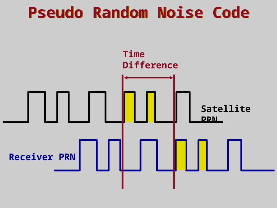
GPS RECEIVER

Signal From One SatelliteSignal From One Satellite
The receiver is somewhere on this sphere.

Signals From Two SatellitesSignals From Two Satellites

Three Satellites (2D Positioning)Three Satellites (2D Positioning)

Triangulating Correct Position Triangulating Correct Position

Three Dimensional (3D) PositioningThree Dimensional (3D) Positioning
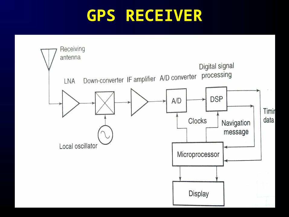
Sources of GPS ErrorStandard Positioning Service (SPS ): Civilian Users
Source Amount of Error Satellite clocks: 1.5 to 3.6 meters Orbital errors: < 1 meter Ionosphere: 5.0 to 7.0 meters Troposphere: 0.5 to 0.7 meters Receiver noise: 0.3 to 1.5 meters Multipath: 0.6 to 1.2 meters User error: Up to a kilometer or more
Errors are cumulative

Sources of Signal InterferenceSources of Signal Interference
Earth’s Atmosphere
Solid Structures
Metal Electro-magnetic Fields
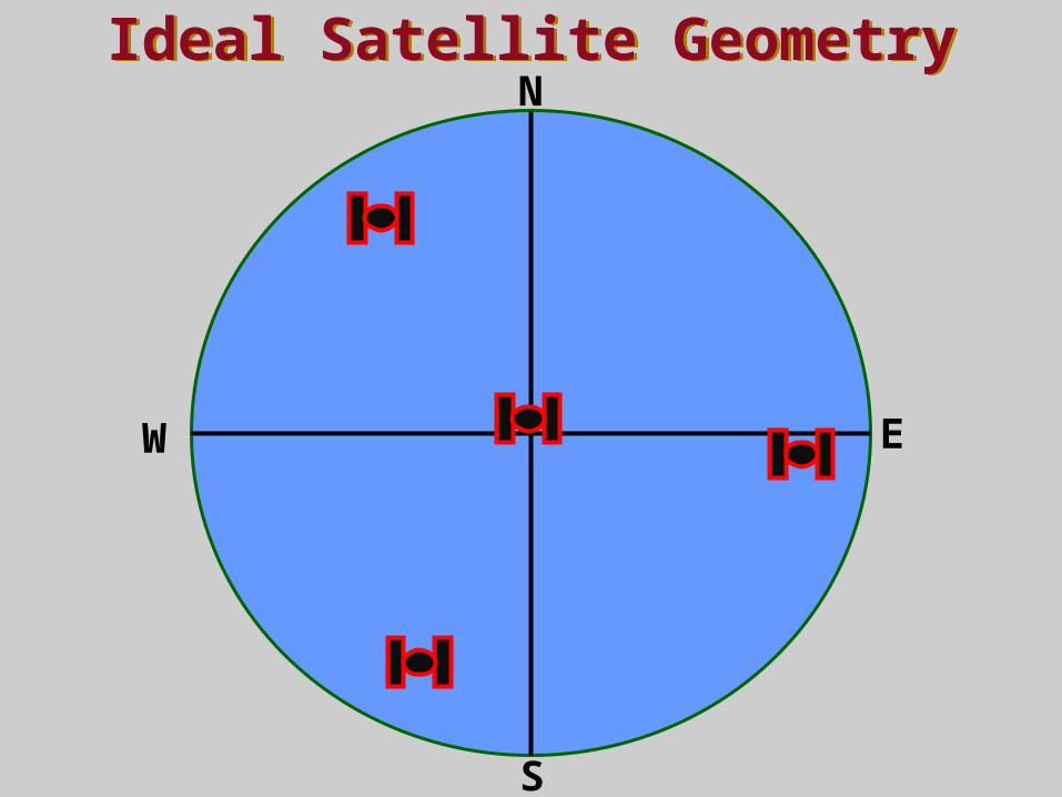
Ideal Satellite GeometryIdeal Satellite GeometryN
S
W E

Good Satellite GeometryGood Satellite Geometry

Poor Satellite GeometryPoor Satellite GeometryN
S
W E

Poor Satellite GeometryPoor Satellite Geometry

DGPS Site
x+30, y+60
x+5, y-3
True coordinates = x+0, y+0
Correction = x-5, y+3
DGPS correction = x+(30-5) and y+(60+3)
True coordinates = x+25, y+63
x-5, y+3
Real Time Differential GPSReal Time Differential GPS
DGPS ReceiverReceiver

A visual example of the GPS constellation in motion with the Earth rotating. Notice how the number of satellites in view from a given point on the Earth's
surface, in this example at 45°N, changes with time.

APPLICATIONGPS has become a widely used & useful tool for commerce, scientific uses , tracking & surveillance.
1.Surveying
2.map-making
3.Navigation
4.Cellular telephony
5.Tectonics( fault motion measurement in earthquakes)
6.Geofencing (vehicle ,person tracking systems)
7. Military

Any query ???
Related Documents