District Department of Transportation 55 M Street, SE, Suite 400 Washington, DC 20003 W8 - 82 Speed Limit and Safety Nexus Studies for Automated Enforcement Locations in the District of Columbia Suitland Parkway at Firth Sterling Road SE Study Area and Location District PSA Ward ANC Phase Description 7 703 8 8C Planned Suitland Parkway Eastbound at Firth Sterling Road Southeast The planned speed camera is located in Ward 8 at the intersection of Suitland Parkway and Firth Sterling Road Southeast in the eastbound direction. Suitland Parkway runs between Pennsylvania Avenue to the east and Anacostia Freeway to the west. The posted speed limit is 45 MPH. KEY: Planned Camera Proposed Camera Bus Stop Metro Station Hiker/Biker Trail School Other Pedestrian Generator Webster University Site 117

Welcome message from author
This document is posted to help you gain knowledge. Please leave a comment to let me know what you think about it! Share it to your friends and learn new things together.
Transcript

District Department of Transportation 55 M Street, SE, Suite 400 Washington, DC 20003
W8 - 82
Speed Limit and Safety Nexus Studies for AutomatedEnforcement Locations in the District of Columbia
Suitland Parkway at Firth Sterling Road SE
Study Area and LocationDistrict PSA Ward ANC Phase Description
7 703 8 8C Planned Suitland Parkway Eastbound at Firth SterlingRoad Southeast
The planned speed camera is located in Ward 8 at the intersection of Suitland Parkway and Firth Sterling RoadSoutheast in the eastbound direction. Suitland Parkway runs between Pennsylvania Avenue to the east andAnacostia Freeway to the west. The posted speed limit is 45 MPH.
KEY:Planned CameraProposed CameraBus StopMetro StationHiker/Biker TrailSchoolOther Pedestrian Generator
WebsterUniversity Site 117
Suitland Parkway at Firth Sterling Road SE
W8 - 83
District Department of Transportation 55 M Street, SE, Suite 400 Washington, DC 20003
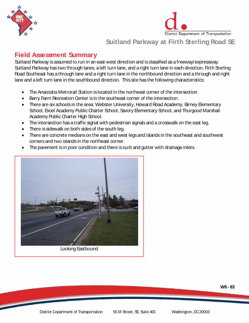
Field Assessment SummarySuitland Parkway is assumed to run in an east-west direction and is classified as a freeway/expressway.Suitland Parkway has two through lanes, a left turn lane, and a right turn lane in each direction. Firth SterlingRoad Southeast has a through lane and a right turn lane in the northbound direction and a through and rightlane and a left turn lane in the southbound direction. This site has the following characteristics:
The Anacostia Metrorail Station is located in the northeast corner of the intersection.Barry Farm Recreation Center is in the southeast corner of the intersection.There are six schools in the area: Webster University, Howard Road Academy, Birney ElementarySchool, Excel Academy Public Charter School, Savory Elementary School, and Thurgood MarshallAcademy Public Charter High School.The intersection has a traffic signal with pedestrian signals and a crosswalk on the east leg.There is sidewalk on both sides of the south leg.There are concrete medians on the east and west legs and islands in the southeast and southwestcorners and two islands in the northeast corner.The pavement is in poor condition and there is curb and gutter with drainage inlets.
Looking Eastbound
Suitland Parkway at Firth Sterling Road SE
W8 - 84
District Department of Transportation 55 M Street, SE, Suite 400 Washington, DC 20003
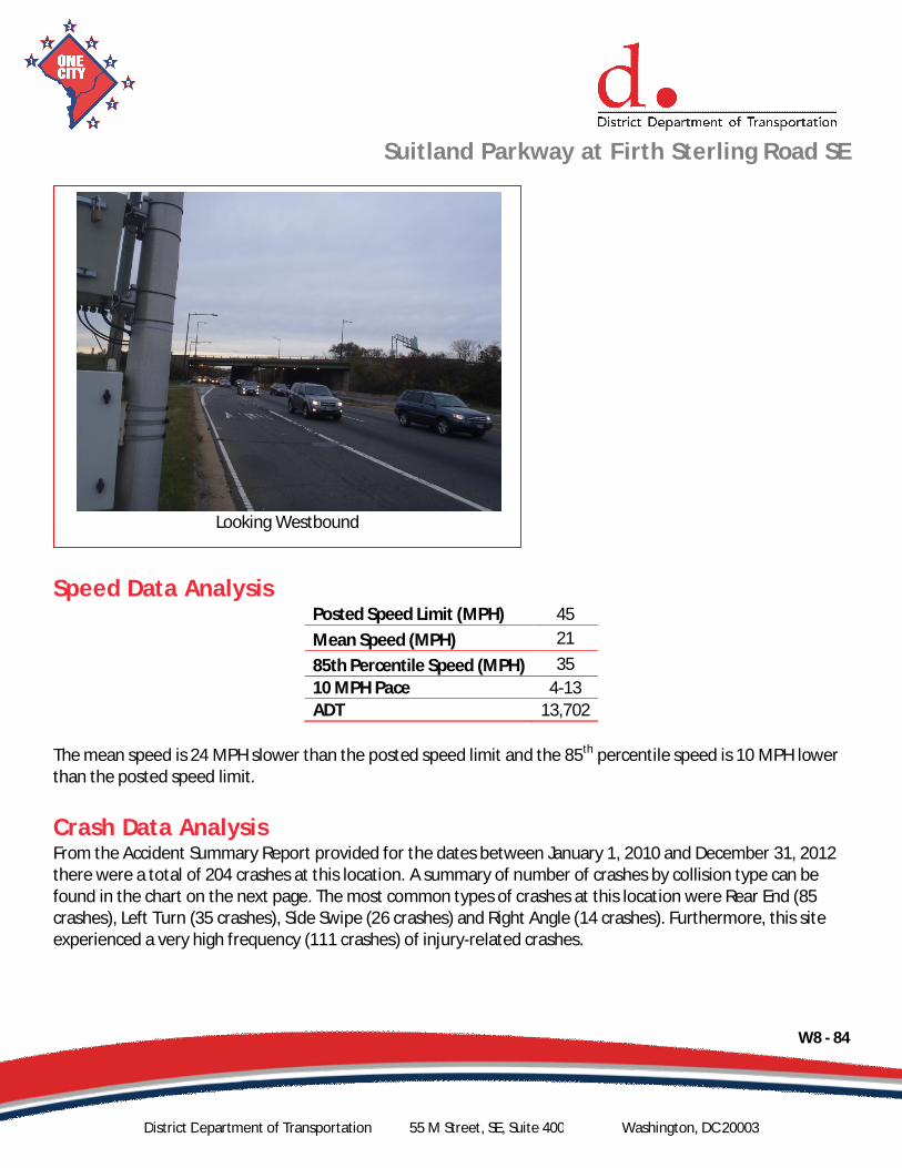
Speed Data AnalysisPosted Speed Limit (MPH) 45Mean Speed (MPH) 2185th Percentile Speed (MPH) 3510 MPH Pace 4-13ADT 13,702
The mean speed is 24 MPH slower than the posted speed limit and the 85th percentile speed is 10 MPH lowerthan the posted speed limit.
Crash Data AnalysisFrom the Accident Summary Report provided for the dates between January 1, 2010 and December 31, 2012there were a total of 204 crashes at this location. A summary of number of crashes by collision type can befound in the chart on the next page. The most common types of crashes at this location were Rear End (85crashes), Left Turn (35 crashes), Side Swipe (26 crashes) and Right Angle (14 crashes). Furthermore, this siteexperienced a very high frequency (111 crashes) of injury-related crashes.
Looking Westbound

Suitland Parkway at Firth Sterling Road SE
W8 - 85
District Department of Transportation 55 M Street, SE, Suite 400 Washington, DC 20003
There were an elevated number of speed-related crashes at this location, including Rear End crashes. TheHighway Safety Manual lists “assuming the lead driver will go through a green or yellow light, but the leaddriver stops” and “changing lanes to avoid a slowing or stopped vehicle” as two errors leading to Rear Endcrashes.1 Both of these errors can be reduced with a decrease in travel speed.
The Suitland Parkway at Firth Sterling Road Southeast intersection is listed as one of the Top 20 hazardousintersections from 2009 to 2011, according to the Traffic Safety Statistics Report for the District of Columbia(2009-2011).2 This site is listed in the Top 5 percent high accident locations in the District from 2010 to 2012.3
1 AASHTO, Highway Safety Manual, 1st Edition, 2010; Volume 1, pages 2-13.2 DDOT, Traffic Safety Statistics Report for the District of Columbia (2009-2011), page 70.3 DDOT, Top 5 Percent High Accident Locations, 2010-2012.
Total 204Fatal 1 0.5% Clear 171 83.8% Dry 165 80.9% Day 111 54.4%Injury 111 54.4% Rain 22 10.8% Wet 25 12.3% Night 79 38.7%Truck 27 13.2% Snow 3 1.5% Snow/Ice 4 2.0%
Police/EMS 8 3.9%
Severity Weather Surface condition Light Condition
Righ
tAng
le
Left
Turn
Righ
tTur
n
Rear
End
Side
Swip
e
Head
On
Fixe
dO
bjec
t
Ran
Off
Road
Pede
stria
n
Back
ing
Unde
r/O
verR
ide
Unsp
ecifi
ed
0
10
20
30
40
50
60
70
80
90
Num
bero
fCra
shes
Collision Type
Number of Crashes by Collision Type
Suitland Parkway at Firth Sterling Road SE
W8 - 86
District Department of Transportation 55 M Street, SE, Suite 400 Washington, DC 20003
Safety NexusThis site presents the following safety considerations which may establish a nexus between traffic safety andthe speed camera:
1. Speed Data – The speed data analysis shows travel speeds being lower than the posted speed limit.2. Crash Data – There were an elevated number of speed-related crashes at this location, including Rear
End crashes, as well as a very high frequency (111 crashes) of injury-related crashes. This intersectionis listed as one of the Top 20 hazardous intersections from 2009 to 2011 and is listed in the Top 5percent high accident locations in the District from 2010 to 2012.
3. Field Assessment – The following site characteristics suggest a need for a safer travel environment:a. There are six schools in the area: Webster University, Howard Road Academy, Birney
Elementary School, Excel Academy Public Charter School, Savory Elementary School, andThurgood Marshall Academy Public Charter High School.
b. There are several bus stops and one bus station and Metro station which generate pedestrianactivity.
c. The Berry Farm Recreation Center is in the area which generates pedestrian and bicycle activity.
Although the speed data analysis showed the mean and 85th percentile speeds to be lower than the postedspeed limit, due to the elevated number of speed-related crashes and injury-related crashes, the designationas a high accident location, the specific site characteristics, the proximity of schools to the site, and otherpedestrian generators, there is a nexus between traffic safety and the speed camera at this location.

SAMMAT ENGINEERING SERVICES, LLC1515 RISING RIDGE ROAD
MOUNT AIRY, MD 21771
www.sammateng.com
Suitland Pkwy EB at Firth Sterling SE Speed
EBStart 1 16 21 26 31 36 41 46 51 56 61 66 71 76 Time 15 20 25 30 35 40 45 50 55 60 65 70 75 999 Total
11/24/13 * * * * * * * * * * * * * * *01:00 * * * * * * * * * * * * * * *02:00 * * * * * * * * * * * * * * *03:00 * * * * * * * * * * * * * * *04:00 * * * * * * * * * * * * * * *05:00 * * * * * * * * * * * * * * *06:00 * * * * * * * * * * * * * * *07:00 * * * * * * * * * * * * * * *08:00 * * * * * * * * * * * * * * *09:00 * * * * * * * * * * * * * * *10:00 * * * * * * * * * * * * * * *11:00 * * * * * * * * * * * * * * *
12 PM * * * * * * * * * * * * * * *13:00 * * * * * * * * * * * * * * *14:00 * * * * * * * * * * * * * * *15:00 * * * * * * * * * * * * * * *16:00 * * * * * * * * * * * * * * *17:00 * * * * * * * * * * * * * * *18:00 * * * * * * * * * * * * * * *19:00 * * * * * * * * * * * * * * *20:00 * * * * * * * * * * * * * * *21:00 * * * * * * * * * * * * * * *22:00 77 0 3 27 149 124 15 3 0 0 0 0 0 0 39823:00 89 0 1 39 156 138 21 1 0 0 0 0 0 0 445Total 166 0 4 66 305 262 36 4 0 0 0 0 0 0 843
W8-87

SAMMAT ENGINEERING SERVICES, LLC1515 RISING RIDGE ROAD
MOUNT AIRY, MD 21771
www.sammateng.com
Suitland Pkwy EB at Firth Sterling SE Speed
EBStart 1 16 21 26 31 36 41 46 51 56 61 66 71 76 Time 15 20 25 30 35 40 45 50 55 60 65 70 75 999 Total
11/25/13 58 0 2 16 72 126 19 2 0 0 0 0 0 0 29501:00 26 0 2 11 31 49 10 1 0 0 0 0 0 0 13002:00 14 0 2 8 32 25 6 0 0 0 0 0 0 0 8703:00 11 0 0 5 25 16 8 0 0 0 0 0 0 0 6504:00 30 0 0 2 30 40 10 3 1 0 0 0 0 0 11605:00 63 0 0 17 109 97 13 1 0 0 0 0 0 0 30006:00 119 0 1 32 200 172 26 0 0 0 0 0 0 0 55007:00 142 1 5 70 322 187 23 2 0 0 0 0 0 0 75208:00 140 1 9 68 264 227 34 3 0 0 0 0 0 0 74609:00 153 0 4 39 274 185 22 1 0 0 0 0 0 0 67810:00 186 1 1 45 282 198 19 1 0 0 0 0 0 0 73311:00 205 0 7 89 323 192 31 1 0 0 0 0 0 0 848
12 PM 254 0 5 83 406 218 16 2 0 0 0 0 0 0 98413:00 240 10 31 163 405 183 14 1 0 0 0 0 0 0 104714:00 404 90 87 58 57 16 1 0 0 0 0 0 0 0 71315:00 372 93 170 163 113 35 2 0 0 0 0 0 0 0 94816:00 424 60 24 5 0 0 0 0 0 0 0 0 0 0 51317:00 390 121 43 11 4 0 0 0 0 0 0 0 0 0 56918:00 432 68 11 2 0 0 0 0 0 0 0 0 0 0 51319:00 343 85 73 78 143 43 2 0 0 0 0 0 0 0 76720:00 193 2 16 128 339 139 9 0 0 0 0 0 0 0 82621:00 168 0 5 58 260 170 16 2 0 0 0 0 0 0 67922:00 * * * * * * * * * * * * * * *23:00 * * * * * * * * * * * * * * *Total 4367 532 498 1151 3691 2318 281 20 1 0 0 0 0 0 12859
Grand
Total4533 532 502 1217 3996 2580 317 24 1 0 0 0 0 0 13702
15th Percentile : 6 MPH50th Percentile : 18 MPH85th Percentile : 35 MPH95th Percentile : 39 MPH
Stats Mean Speed(Average) : 21 MPH
10 MPH Pace Speed : 4-13 MPHNumber in Pace : 5243Percent in Pace : 38.3%
Number of Vehicles > 45 MPH : 47Percent of Vehicles > 45 MPH : 0.3%
W8-88

SAMMAT ENGINEERING SERVICES, LLC1515 RISING RIDGE ROAD
MOUNT AIRY, MD 21771
www.sammateng.com
Suitland Pkwy EB at Firth Sterling SE Volume
Start Sun 24-Nov-13 Mon 25-Nov-13 Tue 26-Nov-13 Daily AverageTime A.M. P.M. A.M. P.M. A.M. P.M. A.M. P.M.
12:00 * * 106 236 * * 106 23612:15 * * 69 241 * * 69 24112:30 * * 58 246 * * 58 24612:45 * * 62 261 * * 62 26101:00 * * 45 302 * * 45 30201:15 * * 33 234 * * 33 23401:30 * * 29 240 * * 29 24001:45 * * 23 271 * * 23 27102:00 * * 20 168 * * 20 16802:15 * * 18 127 * * 18 12702:30 * * 29 180 * * 29 18002:45 * * 20 238 * * 20 23803:00 * * 23 175 * * 23 17503:15 * * 21 218 * * 21 21803:30 * * 2 339 * * 2 33903:45 * * 19 216 * * 19 21604:00 * * 25 116 * * 25 11604:15 * * 29 119 * * 29 11904:30 * * 30 161 * * 30 16104:45 * * 32 117 * * 32 11705:00 * * 54 121 * * 54 12105:15 * * 69 195 * * 69 19505:30 * * 85 115 * * 85 11505:45 * * 92 138 * * 92 13806:00 * * 114 100 * * 114 10006:15 * * 147 142 * * 147 14206:30 * * 130 137 * * 130 13706:45 * * 159 134 * * 159 13407:00 * * 186 121 * * 186 12107:15 * * 175 156 * * 175 15607:30 * * 205 236 * * 205 23607:45 * * 186 254 * * 186 25408:00 * * 210 198 * * 210 19808:15 * * 177 234 * * 177 23408:30 * * 190 203 * * 190 20308:45 * * 169 191 * * 169 19109:00 * * 168 175 * * 168 17509:15 * * 187 178 * * 187 17809:30 * * 153 160 * * 153 16009:45 * * 170 166 * * 170 16610:00 * 114 173 * * * 173 11410:15 * 100 181 * * * 181 10010:30 * 97 209 * * * 209 9710:45 * 87 170 * * * 170 8711:00 * 122 196 * * * 196 12211:15 * 127 217 * * * 217 12711:30 * 107 217 * * * 217 10711:45 * 89 218 * * * 218 89Total 0 843 5300 7559 0 0 5300 8402
CombinedTotal 843 12859 0 13702
Peak 11:00 11:00 00:15 11:00 00:15Vol. 445 848 1050 848 1050
P.H.F. 0.876 0.972 0.869 0.972 0.869ADT ADT 13,702 AADT 13,702
W8-89
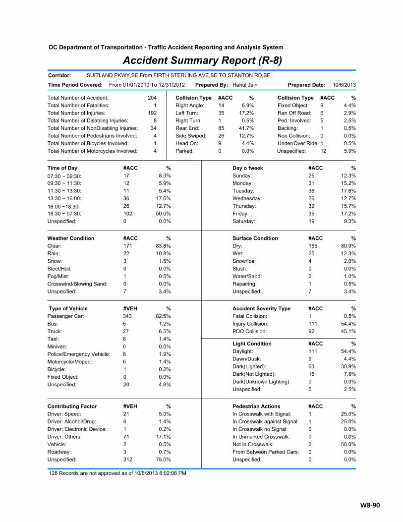
Pedestrian Actions #ACC %In Crosswalk with Signal: 25.0%1In Crosswalk against Signal: 25.0%1In Crosswalk no Signal: 0.0%0In Unmarked Crosswalk: 0.0%0Not in Crosswalk: 50.0%2From Between Parked Cars: 0.0%0Unspecified: 0.0%0
Contributing Factor #VEH %Driver: Speed: 5.0%21Driver: Alcohol/Drug: 1.4%6Driver: Electronic Device: 0.2%1Driver: Others: 17.1%71Vehicle: 0.5%2Roadway: 0.7%3Unspecified: 75.0%312
Light Condition #ACC %Daylight: 54.4%111Dawn/Dusk: 4.4%9Dark(Lighted): 30.9%63Dark(Not Lighted): 7.8%16Dark(Unknown Lighting): 0.0%0Unspecified: 2.5%5
Accident Severity Type #ACC %Fatal Collision: 0.5%1Injury Collision: 54.4%111PDO Collision: 45.1%92
Type of Vehicle #VEH %Passenger Car: 82.5%343Bus: 1.2%5Truck: 6.5%27Taxi: 1.4%6Minivan: 0.0%0Police/Emergency Vehicle: 1.9%8Motorcycle/Moped: 1.4%6Bicycle: 0.2%1Fixed Object: 0.0%0Unspecified: 4.8%20
Surface Condition #ACC %Dry: 80.9%165Wet: 12.3%25Snow/Ice: 2.0%4Slush: 0.0%0Water/Sand: 1.0%2Repairing: 0.5%1Unspecified: 3.4%7
Weather Condition #ACC %Clear: 83.8%171Rain: 10.8%22Snow: 1.5%3Sleet/Hail: 0.0%0Fog/Mist: 0.5%1Crosswind/Blowing Sand: 0.0%0Unspecified: 3.4%7
Day o fweek #ACC %Sunday: 12.3%25Monday: 15.2%31Tuesday: 17.6%36Wednesday: 12.7%26Thursday: 15.7%32Friday: 17.2%35Saturday: 9.3%19
Time of Day #ACC %07:30 ~ 09:30: 8.3%1709:30 ~ 11:30: 5.9%1211:30 ~ 13:30: 5.4%1113:30 ~ 16:00: 17.6%3616:00 ~18:30: 12.7%2618:30 ~ 07:30: 50.0%102Unspecified: 0.0%0
DC Department of Transportation - Traffic Accident Reporting and Analysis System
Accident Summary Report (R-8)
Total Number of Accident:
Total Number of Injuries:Total Number of Disabling Injuries:Total Number of NonDisabling Injuries:Total Number of Pedestrians Involved:Total Number of Bicycles Involved:Total Number of Motorcycles Involved:
Total Number of Fatalities:204
1192
834
414
Time Period Covered:
Corridor:
Collision Type #ACC % Collision Type #ACC %Right Angle: 14 6.9% Fixed Object: 9 4.4%Left Turn: 35 17.2% Ran Off Road: 6 2.9%Right Turn: 1 0.5% Ped. Involved: 5 2.5%Rear End: 85 41.7% Backing: 1 0.5%Side Swiped: 26 12.7% Non Collision: 0 0.0%Head On: 9 4.4% Under/Over Ride: 1 0.5%Parked: 0 0.0% Unspecified: 12 5.9%
Rahul Jain 10/6/2013
SUITLAND PKWY,SE From FIRTH STERLING AVE,SE TO STANTON RD,SE
From 01/01/2010 To 12/31/2012 Prepared Date:Prepared By:
128 Records are not approved as of 10/6/2013 8:02:08 PM
W8-90
Related Documents