OCTOBER 2008 Subsidence Reversal in a Re-established Wetland in the Sacramento-San Joaquin Delta, California, USA Robin L. Miller, U.S. Geological Survey* Miranda S. Fram, U.S. Geological Survey Roger Fujii, U.S. Geological Survey Gail Wheeler, U.S. Geological Survey *Corresponding author: [email protected] ABSTRACT The stability of levees in the Sacramento–San Joaquin Delta is threatened by continued subsidence of Delta peat islands. Up to 6 meters of land-surface elevation has been lost in the 150 years since Delta marshes were leveed and drained, primarily from oxi- dation of peat soils. Flooding subsided peat islands halts peat oxidation by creating anoxic soils, but net accumulation of new material in restored wetlands is required to recover land-surface elevations. We investigated the subsidence reversal potential of two, 3-hectare, permanently flooded, impounded wetlands re-established on a deeply subsided field on Twitchell Island. The shallower wetland (design water depth 25 cm) was almost completely colonized by dense emergent marsh vegetation within two years; where- as, the deeper wetland (design water depth 55 cm) which developed spatially variable depths as a result of heterogeneous colonization by emergent vegeta- tion, still had some areas remaining as open water after nine years. Changes in land-surface elevation were quantified using repeated sedimentation-erosion table measurements. New material accumulating in the wetlands was sampled by coring. Land-surface elevations increased by an average of 4 cm/yr in both wetlands from 1997 to 2006; however, the rates at different sites in the wetlands ranged from –0.5 to +9.2 cm/yr. Open water areas of the deeper wetland without emergent vegetation had the lowest rates of land-surface elevation gain. The greatest rates occurred in areas of the deeper wetland most isolated from the river water inlets, with dense stands of emergent marsh vegetation (tules and cat- tails). Vegetated areas of the deeper wetland in the transition zones between open water and mature emergent stands had intermediate rates of land-sur- face gain, as did the entire shallower wetland. These results suggest that the dominant component contrib- uting to land-surface elevation gain in these wetlands was accumulation of organic matter, rather than mineral sediment, and that accumulation of organic matter in emergent marshes is strongly affected by hydrologic factors. Re-established, non-tidal wet- lands with managed hydrology can produce signifi- cant increases in land-surface elevations, which can help to improve levee stability and protect subsided islands from future flooding.

Welcome message from author
This document is posted to help you gain knowledge. Please leave a comment to let me know what you think about it! Share it to your friends and learn new things together.
Transcript

october 2008
Subsidence Reversal in a Re-established Wetland in the Sacramento-San Joaquin Delta, California, USARobin L. Miller, U.S. Geological Survey*Miranda S. Fram, U.S. Geological SurveyRoger Fujii, U.S. Geological SurveyGail Wheeler, U.S. Geological Survey
*Corresponding author: [email protected]
AbStRACt
The stability of levees in the Sacramento–San Joaquin Delta is threatened by continued subsidence of Delta peat islands. Up to 6 meters of land-surface elevation has been lost in the 150 years since Delta marshes were leveed and drained, primarily from oxi-dation of peat soils. Flooding subsided peat islands halts peat oxidation by creating anoxic soils, but net accumulation of new material in restored wetlands is required to recover land-surface elevations. We investigated the subsidence reversal potential of two, 3-hectare, permanently flooded, impounded wetlands re-established on a deeply subsided field on Twitchell Island. The shallower wetland (design water depth 25 cm) was almost completely colonized by dense emergent marsh vegetation within two years; where-as, the deeper wetland (design water depth 55 cm) which developed spatially variable depths as a result of heterogeneous colonization by emergent vegeta-tion, still had some areas remaining as open water after nine years. Changes in land-surface elevation were quantified using repeated sedimentation-erosion table measurements. New material accumulating in the wetlands was sampled by coring.
Land-surface elevations increased by an average of 4 cm/yr in both wetlands from 1997 to 2006; however, the rates at different sites in the wetlands ranged from –0.5 to +9.2 cm/yr. Open water areas of the deeper wetland without emergent vegetation had the lowest rates of land-surface elevation gain. The greatest rates occurred in areas of the deeper wetland most isolated from the river water inlets, with dense stands of emergent marsh vegetation (tules and cat-tails). Vegetated areas of the deeper wetland in the transition zones between open water and mature emergent stands had intermediate rates of land-sur-face gain, as did the entire shallower wetland. These results suggest that the dominant component contrib-uting to land-surface elevation gain in these wetlands was accumulation of organic matter, rather than mineral sediment, and that accumulation of organic matter in emergent marshes is strongly affected by hydrologic factors. Re-established, non-tidal wet-lands with managed hydrology can produce signifi-cant increases in land-surface elevations, which can help to improve levee stability and protect subsided islands from future flooding.

san francisco estuary & watershed science
2
keyWoRDS
Subsidence reversal, carbon sequestration, carbon storage, wetland restoration, peat, organic matter accumulation, organic soils, Sacramento-San Joaquin Delta, Twitchell Island
SUGGeSteD CitAtion
Miller RL, Fram MS, Fujii R, Wheeler G. 2008. Subsidence reversal in a re-established wetland in the Sacramento-San Joaquin Delta, California, USA. San Francisco Estuary and Watershed Science 6(3): article 1. Available from: http://repositories.cdlib.org/jmie/sfews/vol6/iss3/art1
intRoDUCtion
the Sacramento–San Joaquin Delta
The Sacramento–San Joaquin (SSJ) Delta was once a vast freshwater marsh, east of the San Francisco Bay, at the confluence of the Sacramento and San Joaquin rivers. Peat deposits up to 18 meters thick formed in the SSJ Delta as accretion in the marshes kept pace with sea level rise during the last 6,000 years (Atwater and Belknap 1980; Shlemon and Begg 1975). Beginning in the mid–1800s, tracts of marsh-land were leveed, drained, and cleared for agricul-tural development. The SSJ Delta currently consists of 57 islands and tracts protected from inundation by approximately 1700 kilometers of levees (Figure 1; DWR 1995). The islands have extensive networks of drainage ditches and pumps to remove water from the soils and return it to SSJ Delta channels in order to maintain crop-rootzone soils dry enough for agri-cultural use. Drainage of soils has resulted in land-surface subsidence of up to 7 meters below sea level (Figure 1).
The drained peat subsides by three distinct mecha-nisms: compaction of peat still below the water table due to reduction in buoyancy as fluid pore pressures drop, shrinkage of peat soils above the water table due to desiccation, and loss of peat soils at and above the water table by microbial oxidation of the organic matter to carbon dioxide under aerobic conditions
(Ewing and Vepraskas 2006; Wosten and others 1997; Price and Schlotzhauer 1999; Stephens and others 1984). In addition, agricultural practices may result in variable amounts of soil compaction by heavy machinery, loss of surface soil by wind erosion, and accelerated soils oxidation by periodic burning of fields (Weir 1950). Microbial oxidation accounts for approximately 75% of the current subsidence on SSJ Delta peat islands (Deverel and Rojstaczer 1996).
Current, ongoing rates of subsidence range from 0.6 to 4.0 cm/yr as the peat soils continue to oxi-dize and compact under current land-use practices (Rojstaczer and Deverel 1995). This subsidence will continue under current land-use practices until the peat layer is exhausted. The peat layer has already been completely removed in southern and eastern portions of the SSJ Delta, but is still present in cen-tral, western, and northern portions, with thicknesses greater than 12 meters in areas of the western Delta (DWR 1995).
Land surface subsidence threatens the stability of the levee system that maintains the current configura-tion of the SSJ Delta (Ingebritsen and Ikehara 1999). The elevation difference between the river water and the water levels in the drainage ditches drives seep-age through and under the levees; and compaction of peat foundations beneath levees causes cracking and slumping, necessitating continuous, expensive levee maintenance operations. Despite these efforts, levee failures are not uncommon: 15 major islands flooded at least once between 1967 and 1992 (DWR 1995). Hydrostatic stress on a levee is approximately proportional to the square of the hydraulic head dif-ference between the two sides of the levee, implying that the precariousness of the system will increase geometrically as subsidence continues (Mount and Twiss 2005).
Failure of this increasingly vulnerable levee system could result in catastrophic disruption of California’s state-wide water distribution system. The current configuration of SSJ Delta channels and islands impedes ingress of saline water from San Francisco Bay with the tides, and loss of these island barriers, particularly in the western Delta, would likely result in greatly increased salinities at the intakes for the

october 2008
3
Figure 1. Map of the Sacramento-San Joaquin Delta showing land surface below sea level (DWR 1995) and location of Twitchell Island

san francisco estuary & watershed science
4
State Water Project, Central Valley Project, Contra Costa Water District, and others (Ingebritsen and Ikehara 1999). Over two-thirds of Californians obtain at least a portion of their drinking water from the SSJ Delta; and, vast agricultural acreage in the San Joaquin valley, as well as approximately half a mil-lion acres in the Delta, depend on SSJ Delta water for irrigation.
The threat posed by land-surface subsidence is com-pounded by sea level rise. Sea level rose 15 to 20 cm during the twentieth century (Miller and Douglas 2004), and the rate of sea level rise is expected to increase during the twenty-first century as global warming continues. Models considering only thermal expansion of seawater predict 14 to 32 cm of sea level rise between 2000 and 2100 (Meehl and oth-ers 2005). Modeling of the response of Arctic and Antarctic ice to current global warming trends sug-gests sea level rise of 100 cm between 2000 and 2100 is probable (Overpeck and others 2006). Thus, even in the absence of continued land subsidence, the eleva-tion difference between SSJ Delta waters and island land-surfaces is likely to increase by 0.2 to 1.0 cm/yr between 2000 and 2100, increasing the stress on the levees.
Maintaining reliability of California’s water distri-bution system in its current configuration requires mitigation of the effects of land-surface subsidence and sea level rise on the SSJ Delta islands. Permanent shallow flooding will slow further subsidence of the SSJ Delta islands by reducing oxidation and com-paction of the peat. However, the current sediment supply to the Delta from the Sacramento and San Joaquin river system is insufficient to fill the subsid-ed lands once they are opened to tidal action (Wright and Schoellhamer 2004 and 2005; Mount and Twiss 2005; Orr and others 2003). Because the peat layer in the SSJ Delta originally developed in wetlands, re-establishing wetlands to re-create anaerobic condi-tions may be a management tool for mitigating sub-sidence by accreting new “peat,” and thereby increas-ing land-surface elevations.
Land-Surface elevation Gain in Wetland Systems
The rate of land-surface elevation gain in wetlands depends on the interplay among hydrologic factors,
subsidence, compaction, sedimentation, erosion, plant biomass production, and organic matter decomposi-tion (e.g., Callaway and others 1996; Middelburg and others 1997; Gosselink and Turner 1978; Mitsch and Gosselink 2000). Material accumulating in wetlands ranges from largely mineral sediments transported into the wetland to largely organic matter produced by primary productivity in the wetland, depend-ing on sediment supply and wetland hydrology. Mineral sediment deposition generally dominates in high-energy systems with high sediment supply. Conversely, accumulation of organic matter generally dominates in low-energy, “back-water” environments with low sediment supply. Wetlands with emergent marsh vegetation are among the terrestrial ecosys-tems with the highest rates of net primary productiv-ity (e.g., Whittaker and Likens 1975), and in settings where environmental conditions act to minimize organic matter decomposition and export, organic matter accumulates. In environments of organic accumulation an influx of mineral sediment disrupts the peat formation process (Kosters and others 1987), and can compact the accumulating organic material with a substantial increase in the bulk density of the substrate (Bloom 1964; Marachi and others 1983; Cahoon and others 1995: Ford and others 1999).
In the past, wetland restoration in the SSJ Delta was generally thought of in terms of tidal wetlands produced by breaching levees on subsided islands. However, for the deeply subsided Delta islands, sim-ply breaching levees produces environments with water too deep to permit growth of emergent marsh vegetation, such as Franks Tract and Mildred Island (Orr and others 2003). Therefore restoring tidal wet-lands on deeply subsided islands will require raising land surfaces to tidal ranges. This can be addressed by implementing non-tidal wetlands with managed hydrology to maximize accretion of biomass over long time frames.
Because agriculture is the predominant land use on most SSJ Delta islands, an initial series of pilot studies was conducted to compare the potential of different water management practices to stop ongo-ing subsidence and increase land-surface through biomass accretion. Permanent shallow flooding, per-manent deep flooding, seasonal (winter) flooding, and

october 2008
5
non-seasonal flooding of 10 by 10 meter mesocosms on Twitchell Island were evaluated for net carbon sequestration between 1995–1998. By comparing biomass production, organic matter decomposition, and gaseous carbon flux, Miller and others (2000) showed permanent shallow flooding resulted in an anaerobic site covered with emergent vegetation that had the highest net positive balance between inputs and losses of carbon, and therefore the greatest sub-sidence reversal potential through biomass accretion and carbon sequestration. These results indicated two important things. First, it appears unlikely that agri-cultural activities requiring even periodic land drain-age would result in significant land-surface elevation gains, and second, that site hydrology drives dif-ferences in biological and biogeochemical processes responsible for biomass accretion and carbon seques-tration.
Based on the findings from the pilot study (Miller and others 2000), we designed a long-term, field-scale demonstration project for examining carbon inputs and losses, and the subsequent rates of carbon storage and subsidence reversal potential of wetlands under permanent shallow flooding conditions. The objective of the study described here is to assess the subsidence reversal potential of restored wetlands by analyzing periodic measurements of land-surface elevation changes relative to local benchmarks and cores of new and old soil material taken between 1997 and 2006. Previously published studies from the Twitchell wetlands project include Gamble and others (2003), describing wetland hydrology; Bossio and others (2006), examining the soil microbial com-munity composition change with flooding; and Fleck and others (2007) on the dissolved organic carbon (DOC) loads from the wetland after flooding.
MethoDS
Site Description
The project was carried out on Twitchell Island, bor-dered on the south by the San Joaquin River, in the western SSJ Delta (Figure 1). Twitchell Island was drained and fully surrounded by levees by 1869. Since then, the levees have been reinforced several
times, most recently in 2006. The island is principally used for agricultural purposes, primarily irrigated row crops and pasture. Currently, land-surface elevation on the island is as much as 6 meters below sea level, and there is potential for further subsidence because 3 to 9 meters of peat still remains on the island (Gamble and others 2003; DWR 1995).
In 1997, two, 3 Ha wetland sites were established in the central part of the island (Figure 2). The sites were constructed on a former agricultural field by excavating surface soil and using that soil to build berms around the excavated area to contain the wet-lands. The east and west wetland sites were perma-nently flooded to depths of 55 cm and 25 cm, respec-tively, to support emergent marsh vegetation. The specific conductance of water from the San Joaquin River supplying the wetlands ranged from 0.1 to 1.1 μS/cm, varying seasonally, with highs occurring in late fall after the dry season, and lows in spring, following winter rains and mountain snow melt. Periodic measurements of daytime inlet river water taken during this study showed that pH ranged from 7 to 8.5, with an average of 7.5, and had dissolved oxygen concentrations greater than 50 percent as it entered the wetlands (YSI 556 MPS).
A gravity siphon pipe supplied water from the San Joaquin River to the wetlands. Each wetland had an inflow pipe located near its southeast and southwest corners, and two outflows located near the center of its north side (Figure 2). Adjustable weirs installed in the outflows controlled water depths in the wetlands. Maintaining the target water depths of approximately 55 cm in the east wetland and 25 cm in the west wetland required periodic addition of boards to the tops of the weirs as material accumulated and land-surface elevations increased. Mean inflow rates to both wetlands were 900 ± 200 L/min (Gamble and others 2003). Based on these inflow rates, the cal-culated mean water residence times were 6 days in the west wetland and 13 days in the east wetland. The impounded, non-tidal design resulted in efficient trapping of the small amount of suspended solids carried in the inflow water (Fleck and others 2007), and eliminated losses from erosion or export.

san francisco estuary & watershed science
6
Plant communities evolved at different rates in the west and east wetlands after flooding, despite plant-ing tules (Schoenoplectus acutus) over about three percent of the western end of each wetland prior to flooding. In the first growing season, algae were abundant, and Myriophyllum aquaticum (water mil-
foil) colonized areas of both wetlands. By the end of the first growing season (1998), cattails (Typha spp.) had colonized mid and southern portions of the east wetland, and most of the west wetland. Cattails probably colonized the southern and central parts of the wetland first because strong prevailing northwest winds drove seeds and veg-etative propagules to the south; and emergent marsh vegetation first established in more quiescent zones of water, where there was some shelter from wind and wave activity. As emergent vegetation spread, shelter-ing the water from wind, Lemna sp. (duckweed) and Azolla (mosquito fern) replaced algae as the domi-nant species on the water surface. Submergent veg-etation grew in areas of the east wetland that were not colonized by cattails and tules (Figure 2), with Egeria densa (Brazilian water-weed) and Potomogetan sp. (pondweed) first replac-ing Myriophyllum, and finally Ceratophyllum demersum (hornwort or coontail) replacing Egeria (Miller and Fujii submitted).
Thus, the deeper east wetland developed a spatially heterogeneous mixture of different plant commu-nities, and continued to have areas of open water with submergent vegetation eight years after being flooded. Conversely, the shallower west wetland rap-idly became a relatively homogenous community of mature emergent marsh vegetation.
Figure 2. Map of Twitchell Island showing locations of the west and east wetlands, and map of wetlands showing locations of sampling sites (solid dots labeled with capital letters), board-walks (diagonal lines), piers (straight lines between sampling sites and sides of wetland), inflows (short straight lines in south corners of both wetlands), and outflows (open circles near center of north side of both wetlands). Blue indicates extent of open-water areas without emer-gent marsh vegetation in October 2002.

october 2008
7
Land Surface elevation Measurements
Changes in land-surface elevation were determined using a surface elevation table, which is a modified sedimentation-erosion table (SET) (Boumans and Day 1993; Cahoon and others 2002). The SET measures small changes in elevation relative to a fixed local reference plane. The instrument consists of a flat plate at the end of a horizontal arm connected to a vertical arm that fits into aluminum base support pipes cemented to the top of the benchmark pipes at the sampling sites. The vertical distance between the flat plate and the benchmark is fixed, thus the plate is a fixed reference plane.
Prior to flooding, fixed reference benchmarks for SET measurements, and 50 cm by 50 cm feldspar marker horizons to serve as reference surfaces for measur-ing accretion of new material in the wetlands were installed. At eight permanent sampling sites spatially distributed across each wetland and accessed by boardwalks and piers (Figure 2), a benchmark was installed 2 to 3 m beyond the end of the pier using steel pipe driven to refusal through the peat layer and into the underlying sands.
SET measurements were made in December 1997, June 1998, May 1999, May 2000, May 2001, January 2003, and April 2005, using a temporary bridge from the pier to access each benchmark. The measurement pins of the SET were carefully lowered through nine holes in the plate until the 5-cm diameter feet on the bottoms of the pins made contact with wetland sedi-ment. The distance between the plate and the land-surface was determined from the length of each pin above the plate. Each sampling site yielded 36 mea-surements (except when the presence of vegetation prevented lowering of some of the pins) because the vertical arm fit in the base support in four directions, at ninety degree angles to one another.
While emergent vegetation colonized all SET sites in the west wetland by the second growing season, SET sites in the east wetland reflected its greater spatial variability in vegetation. Specifically, in the east wetland cattails colonized four SET sites in the first growing season, two of which, Sites J and K, were engulfed by dense emergent marsh vegetation the
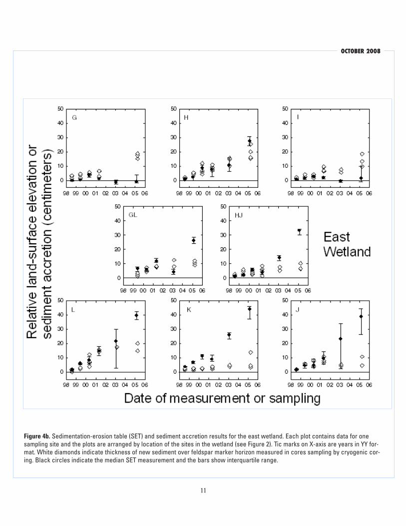
following growing season, while the other two, Sites GL and HJ, in the central portion of the wetland, remained near the edge of the marsh throughout this study (Figure 2). Emergent marsh vegetation colo-nized Sites L and H in 2000; and Site L was subse-quently surrounded by dense marsh vegetation, but Site H, like Sites GL and HJ, remained on the marsh edge. Because emergent vegetation colonized the northern corners of the wetland last, Sites G and I both remained on the outside edge of the encroach-ing marsh vegetation throughout the period of this study (Figure 2).
Accumulation of new Material
Vertical accretion of new material was measured using cryogenic coring over the feldspar marker hori-zons (Cahoon and others 1995; 1996). At each SET site, four 50 cm by 50 cm feldspar marker horizons were laid down on the soil surface surrounding each benchmark. Cryogenic cores (cryocores) were col-lected at the same time that SET measurements were made (except no cores were collected in December 1997). During the first few sampling events, cryocore locations within the feldspar marker horizons were selected randomly on a grid. Each node on a 1 cm grid suspended over the marker horizon was assigned a number and a random number generator was used to determine at which grid node the core should be taken. The cryogenic cores were obtained using a straight copper tube with a sharp, closed tip pushed into the sediment far enough to extend through the feldspar marker horizon, and then filled with liq-uid nitrogen to freeze the sediment adjacent to the tube. The frozen cores were then pulled out and the distance from the sediment surface to the feldspar marker was measured in at least five places around the circumference of the core. The sediment surface in the cryocores was defined as the highest level of brown ice that did not have white ice below it. Plant detritus and roots above this level were not consid-ered part of the accreted sediment.
As emergent vegetation matured, the transition between the water column and the accumulated material on the bottom of the wetlands was much more complex, and the cryocore method became

san francisco estuary & watershed science
8
more difficult. Some of the marker horizons were sufficiently broken apart by the growth of vegeta-tion that they were not recovered, and it became increasingly difficult to push the copper tube through the roots and rhizomes. Even when this succeeded, vegetation frozen into cores did not easily break off, bringing attached roots and sometimes whole plants with them. Furthermore, vertical displacement of the feldspar by plant growth made later samplings less reliable even when feldspar from a marker horizon was recovered. This led to the abandonment of many sampling locations and loss of cryocores, resulting in a significant bias in the sampling locations such that plant biomass, particularly roots and rhizomes of the emergent vegetation, was considerably underrepre-sented in recovered cryocores.
In November 2006 and January 2007, we collected additional cores using a 10 cm diameter, 55 cm long, steel, modified Hargis corer (Hargis and Twilley 1994). The end of the core barrel was filed to form a sharp edge capable of cutting through the roots and rhizomes of the emergent vegetation, making it pos-sible to collect cores in areas with dense emergent vegetation. Core sample locations were selected ran-domly at equidistant locations along the boardwalks in both wetlands. After cores were removed from the wetlands, they were sectioned with a hacksaw, and dried at 70°C for 72 hours. The sectioned cores were then weighed, and representative subsamples of the cores were ground with a Tecater mill (1093), ashed at 550° C for 4 h to determine organic matter content, and analyzed for carbon (C) and nitrogen (N) content with a CHNS/O analyzer (Perkin/Elmer series II 2400). Additionally, bulk density, water con-tent, organic matter content, and carbon and nitro-gen concentrations were measured in samples of the underlying sediment before and after flooding. Replicate measurements were made on all samples and samples were re-analyzed if the replicates did not agree to within 5%.
Statistical Analyses
Statistical analyses were conducted on the SET and cryocore data to compare results for the two wetlands and to evaluate the significance of temporal trends.
Because the data were often not normally distrib-uted or the sets of results being compared did not have equal variance, the Mann-Whitney Rank Sum Test was used to evaluate the significance of differ-ences. A p-value of 0.05 was used as the threshold for significance, and p-values for statistical tests are reported in the text. Data generally were summarized using median values with inter-quartile range (IQR) as the measure of variance (Helsel and Hirsch 1995). In some cases, it was appropriate to summarize data using mean values with standard deviation as the measure of variance. Regression analyses to deter-mine rates were done with linear regression when data were normally distributed, and with the non-parametric Kendall–Thiel slope when they were not (Helsel and Hirsch 1995). The Kendall–Thiel slope is the median of all possible pairwise slopes between the data points.
ReSULtS
Land-surface elevation
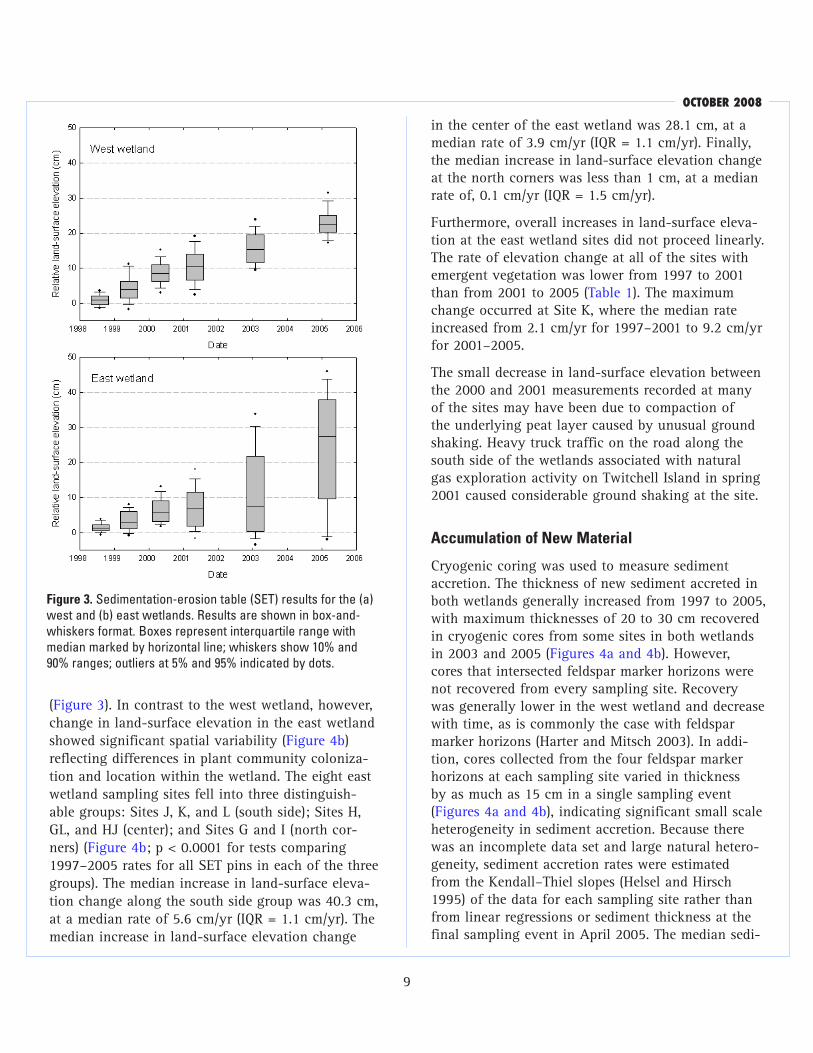
Between December 1997 and March 2005, land-surface elevation as measured by the SET in the west wetland increased by a median of 22.6 cm (inter-quartile range, IQR = 4.9 cm), which corresponds to a median rate of change of 3.1 cm/yr (IQR = 2.8 to 3.5 cm/yr) (Figure 3). The increase in land-surface elevation was linear at all eight sites (Figure 4a; R2 for linear regressions >0.90). Within the west wet-land, there was some significant variability in land-surface elevation gain, despite the fact that plant communities in the wetland are relatively homog-enous and matured at approximately the same rate. Sites C and CE had significantly greater increases in land-surface elevation than the other six sites (p < 0.0001) (Figure 4a) with a median rate of eleva-tion increase of 4.1 cm/yr (IQR = 0.6 cm) compared to 3.0 cm/yr (IQR = 0.5 cm) for the other six sites.
Between December 1997 and March 2005, land-surface elevation as measured by the SET in the east wetland increased by a median of 27.4 cm (IQR = 28.0 cm), which corresponds to an average rate of change of 3.8 cm/yr (IQR range = 1.4 to 5.2 cm/yr)
october 2008
9
(Figure 3). In contrast to the west wetland, however, change in land-surface elevation in the east wetland showed significant spatial variability (Figure 4b) reflecting differences in plant community coloniza-tion and location within the wetland. The eight east wetland sampling sites fell into three distinguish-able groups: Sites J, K, and L (south side); Sites H, GL, and HJ (center); and Sites G and I (north cor-ners) (Figure 4b; p < 0.0001 for tests comparing 1997–2005 rates for all SET pins in each of the three groups). The median increase in land-surface eleva-tion change along the south side group was 40.3 cm, at a median rate of 5.6 cm/yr (IQR = 1.1 cm/yr). The median increase in land-surface elevation change
Figure 3. Sedimentation-erosion table (SET) results for the (a) west and (b) east wetlands. Results are shown in box-and-whiskers format. Boxes represent interquartile range with median marked by horizontal line; whiskers show 10% and 90% ranges; outliers at 5% and 95% indicated by dots.
in the center of the east wetland was 28.1 cm, at a median rate of 3.9 cm/yr (IQR = 1.1 cm/yr). Finally, the median increase in land-surface elevation change at the north corners was less than 1 cm, at a median rate of, 0.1 cm/yr (IQR = 1.5 cm/yr).
Furthermore, overall increases in land-surface eleva-tion at the east wetland sites did not proceed linearly. The rate of elevation change at all of the sites with emergent vegetation was lower from 1997 to 2001 than from 2001 to 2005 (Table 1). The maximum change occurred at Site K, where the median rate increased from 2.1 cm/yr for 1997–2001 to 9.2 cm/yr for 2001–2005.
The small decrease in land-surface elevation between the 2000 and 2001 measurements recorded at many of the sites may have been due to compaction of the underlying peat layer caused by unusual ground shaking. Heavy truck traffic on the road along the south side of the wetlands associated with natural gas exploration activity on Twitchell Island in spring 2001 caused considerable ground shaking at the site.
Accumulation of new Material
Cryogenic coring was used to measure sediment accretion. The thickness of new sediment accreted in both wetlands generally increased from 1997 to 2005, with maximum thicknesses of 20 to 30 cm recovered in cryogenic cores from some sites in both wetlands in 2003 and 2005 (Figures 4a and 4b). However, cores that intersected feldspar marker horizons were not recovered from every sampling site. Recovery was generally lower in the west wetland and decrease with time, as is commonly the case with feldspar marker horizons (Harter and Mitsch 2003). In addi-tion, cores collected from the four feldspar marker horizons at each sampling site varied in thickness by as much as 15 cm in a single sampling event (Figures 4a and 4b), indicating significant small scale heterogeneity in sediment accretion. Because there was an incomplete data set and large natural hetero-geneity, sediment accretion rates were estimated from the Kendall–Thiel slopes (Helsel and Hirsch 1995) of the data for each sampling site rather than from linear regressions or sediment thickness at the final sampling event in April 2005. The median sedi-

san francisco estuary & watershed science
10
Figure 4a. Sedimentation-erosion table (SET) and sediment accretion results for the west wetland. Each plot contains data for one sampling site and the plots are arranged by location of the sites in the wetland (see Figure 2). Tic marks on X-axis are years in YY format. White diamonds indicate thickness of new sediment over feldspar marker horizon measured in cores sampling by cryogenic coring. Black circles indicate the median SET measurement and the bars show interquartile range.
october 2008
11
Figure 4b. Sedimentation-erosion table (SET) and sediment accretion results for the east wetland. Each plot contains data for one sampling site and the plots are arranged by location of the sites in the wetland (see Figure 2). Tic marks on X-axis are years in YY for-mat. White diamonds indicate thickness of new sediment over feldspar marker horizon measured in cores sampling by cryogenic cor-ing. Black circles indicate the median SET measurement and the bars show interquartile range.

san francisco estuary & watershed science
12
ment accretion rate for the eight sites in the east wetland was 1.8 cm/yr (range: 0.5 to 3.5 cm/yr) and 2.0 cm/yr in the west wetland (range: 1.1 to 3.9 cm/yr). The difference between the two wetlands was not statistically significant (p = 0.67), and there were no systematic differences in accretion rates with location in the wetlands, plant community com-position, or marsh maturity, although this may be a reflection of the limited data set.
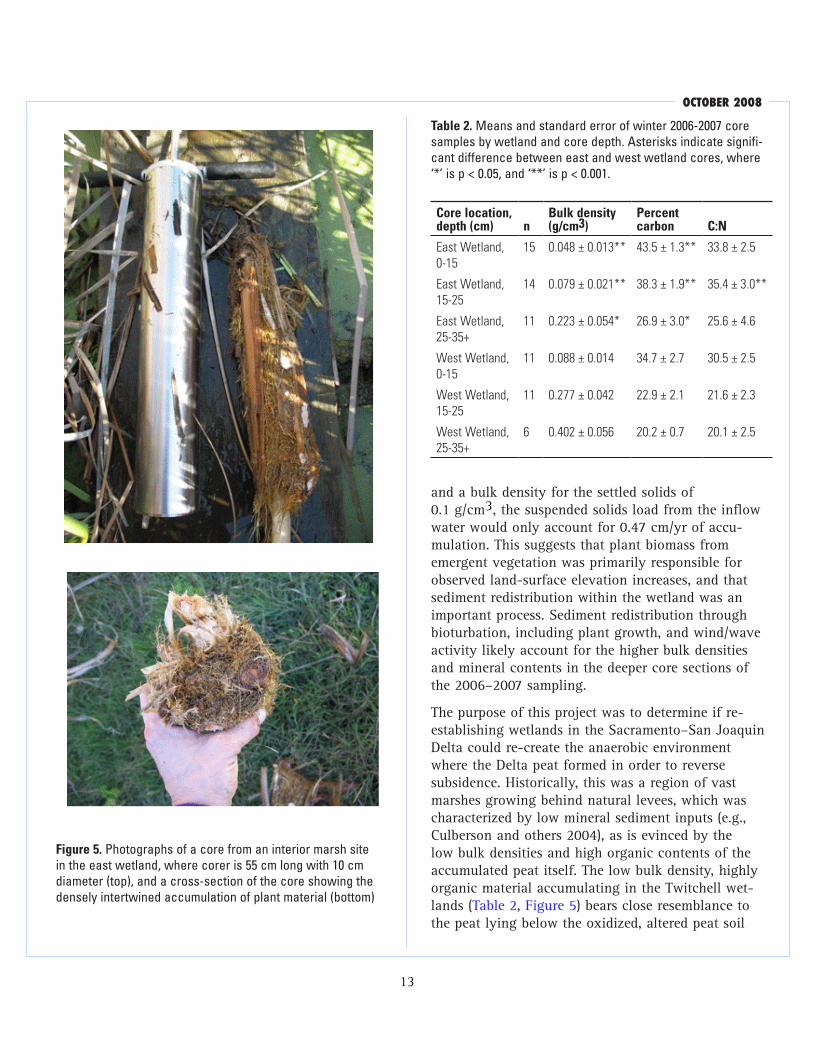
The cores collected in winter 2006–2007 using a Hargis corer were more representative of the mate-rial accumulating in the wetlands than the cryocores
because they sampled areas with dense emergent vegetation dominating the wetlands. Cores ranged from 15 to 48 cm deep, with an average core depth of 34 cm. The Hargis cores consisted primarily of root and rhizome biomass with lesser amounts of stem and leaf material (Figure 5). The newly accreted material had very low bulk densities which increased with depth, while C:N decreased (Table 2). Samples of the oxidized peat soil had a mean bulk density of 0.61 ± 0.01 g/cm3 prior to flooding, and 0.49 ± 0.02 g/cm3 in the west wetland and 0.41 ± 0.02 g/cm3 in the east wetland after flooding. Only the deepest core sections (25 to 35+ cm) from the west wetland had bulk densities approaching the density of the underlying oxidized peat substrate (Table 2). These deep core sections also had C contents and C:N val-ues similar to the original substrate’s 18% C and C:N value of 18, indicating that the deepest core sections from the west wetland were mostly composed of the original substrate. Cores from the east wetland were significantly less dense, and tended to have higher C:N values, than their west wetland counterparts (Table 2).
DiSCUSSion
Accumulation of Plant biomass and Sediment Accretion
Rates of accretion represent the positive balance of inputs and losses to the environment. Inputs can be imported or produced locally; losses occur through export, herbivory, and decomposition. Land-surface elevation increased in all areas of both wetlands that were colonized by emergent marsh vegetation (Figures 2 and 4; Table 1), while areas in the east wetland that were not colonized by cattails and tules, represented by Sites G and I, experienced almost zero change in land-surface elevation (Figure 4b; Table 1). Mineral sediment deposition, as evidenced by cryo-core data, did not show spatial variability by vegeta-tion or water depth. Also, the suspended sediment load in the inflow water was far to small to provide sufficient sediment to account for the measured sedi-ment accumulation: assuming an average suspended solids content of 30 mg/L (Fleck and others 2007)
table 1. Summary of rates of land-surface elevation change and sediment accretion measured in the west and east wet-lands, 1997-2005. Rates of sediment accretion calculated from the Kendall-Thiel slope of the sediment thicknesses over feld-spar marker horizons measured in cryogenic cores collected 1998-2005 (Figures 4a, 4b). Sedimentation-erosion table (SET) rates for the periods 1997-2001 and 2001-2005 calculated from linear regression of the measured data, and rates for 1997-2005 calculated using the final SET measurement in 2005 only.
Site
Cryocore 1997-2005 (cm/yr)
Set1997-2005 (cm/yr)
Set1997-2001 (cm/yr)
Set2001-2005 (cm/yr)
West wetland (25 cm target depth for water level)
A 2.64 2.87 3.08 2.70
B 1.97 3.22 3.27 3.50
C 3.94 4.18 5.40 3.26
D 2.27 3.01 1.76 4.41
E 1.19 3.26 3.28 3.75
F 2.05 3.01 2.84 3.67
CE 1.63 4.29 4.69 3.83
BF 1.08 2.83 3.09 2.80
East wetland (55 cm target depth for water level)
G 2.23 -0.11 0.69 -0.46
H 2.75 3.80 2.67 5.24
I 1.81 0.23 0.68 -0.03
J 1.70 5.40 2.65 7.65
K 0.53 6.10 2.90 9.15
L 3.48 5.50 4.34 6.55
GL 1.88 3.62 3.15 3.98
HJ 0.97 4.59 1.39 7.70
october 2008
13
Figure 5. Photographs of a core from an interior marsh site in the east wetland, where corer is 55 cm long with 10 cm diameter (top), and a cross-section of the core showing the densely intertwined accumulation of plant material (bottom)
table 2. Means and standard error of winter 2006-2007 core samples by wetland and core depth. Asterisks indicate signifi-cant difference between east and west wetland cores, where ‘*’ is p < 0.05, and ‘**’ is p < 0.001.
Core location, depth (cm) n
bulk density (g/cm3)
Percent carbon C:n
East Wetland, 0-15
15 0.048 ± 0.013** 43.5 ± 1.3** 33.8 ± 2.5
East Wetland, 15-25
14 0.079 ± 0.021** 38.3 ± 1.9** 35.4 ± 3.0**
East Wetland, 25-35+
11 0.223 ± 0.054* 26.9 ± 3.0* 25.6 ± 4.6
West Wetland, 0-15
11 0.088 ± 0.014 34.7 ± 2.7 30.5 ± 2.5
West Wetland, 15-25
11 0.277 ± 0.042 22.9 ± 2.1 21.6 ± 2.3
West Wetland, 25-35+
6 0.402 ± 0.056 20.2 ± 0.7 20.1 ± 2.5
and a bulk density for the settled solids of 0.1 g/cm3, the suspended solids load from the inflow water would only account for 0.47 cm/yr of accu-mulation. This suggests that plant biomass from emergent vegetation was primarily responsible for observed land-surface elevation increases, and that sediment redistribution within the wetland was an important process. Sediment redistribution through bioturbation, including plant growth, and wind/wave activity likely account for the higher bulk densities and mineral contents in the deeper core sections of the 2006–2007 sampling.
The purpose of this project was to determine if re-establishing wetlands in the Sacramento–San Joaquin Delta could re-create the anaerobic environment where the Delta peat formed in order to reverse subsidence. Historically, this was a region of vast marshes growing behind natural levees, which was characterized by low mineral sediment inputs (e.g., Culberson and others 2004), as is evinced by the low bulk densities and high organic contents of the accumulated peat itself. The low bulk density, highly organic material accumulating in the Twitchell wet-lands (Table 2, Figure 5) bears close resemblance to the peat lying below the oxidized, altered peat soil

san francisco estuary & watershed science
14
layer on SSJ Delta Islands which is composed domi-nantly of roots, rhizomes, and stems of tules and reeds (Phragmites australis) (Atwater and Belknap 1980; Goman and Wells 2000).
The accreted material recovered in the 2006–2007 cores (Figure 5) was primarily plant roots and shoots, thick enough and with sufficient structural integrity to account for the increase in land-surface eleva-tion. Below-ground root biomass was interpreted to account for a significant amount of the land surface elevation gain in cattail/tule marshes on Brown’s Island in the Sacramento–San Joaquin Delta (Reed 2002). Studies of tidal salt marshes with relatively low inputs of inorganic sediment have shown that although mineral sediment may contribute signifi-cantly to the dry mass of marsh sediment, nearly all the volume of the sediment is produced by the organic matter (Redfield 1972; Craft and others 1993; Bricker–Urso and others 1989). Below-ground root structures compose much of the organic matter pre-served in marsh sediments because they decompose more slowly than above-ground biomass (Redfield 1972; Hackney and de la Cruz 1980; Craft 2001).
Rates of Land-Surface elevation Change
The rates of land-surface elevation gain measured using SET methods in the Twitchell wetlands were significantly greater than rates observed in many natural and restored tidal and non-tidal marshes and greater than accumulation rates estimated for his-toric peat in the SSJ Delta. Radiometric dates of plant remains in cores through SSJ Delta peat sections and estimates of the rate of sea level rise in San Francisco Bay indicate long-term accumulation rates of 0.05 to 0.41 cm/yr for historic SSJ Delta peat (Goman and Wells 2000; Atwater and Belknap 1980). Accretion rates in coastal and estuarine salt marshes mea-sured over time-scales of 1 to 50 years are mostly less than 1.5 cm/yr (Reed 2002; Cahoon and Turner 1989; DeLaune and others 1983; Bricker–Urso and others 1989; Callaway and others 1997; Craft and others 1993; Patrick and DeLaune 1990; Callaway and others 1996), although higher rates have been measured in some systems, including freshwater marshes (Patrick and DeLaune 1990; Bakker and oth-
ers 1997; Sanchez–Carillo and others 2001; Neubauer and others 2002). Examination of areas of the SSJ Delta flooded by historic levee breaches indicates that emergent marsh vegetation can colonize regions within approximately 60 cm below mean lower low water level, but rates of land-surface eleva- tion increase in these marshes are less than 1 cm/yr (Simenstad and others 2000; Reed 2002). In contrast, mean rates of land-surface elevation gain in the study wetlands were approximately 4 cm/yr, and maximum rates were 7 to 9 cm/yr.
The high rates of land-surface elevation gain found in this study probably reflect a few contribut-ing factors. First, these are measurements of short term rates, which tend to be higher than long-term measurements. Also, since accretion was measured from the start of wetland re-establishment, some of the elevation gains represent root biomass growth concomitant with marsh colonization. Additionally, freshwater marshes, such as this one, preserve greater amounts of organic matter than more saline marshes (Kosters and others 1987). Finally, the man-aged hydrology of the Twitchell wetlands affected the inputs and losses of material accumulating in the wetlands.
The spatial and temporal variations in rates of land-surface elevation change in the wetlands suggest that hydrologic factors may be responsible for the observed differences in accretion within the experi-mental wetlands as they affect the components of accretion: inputs and losses. The first factor is an optimum water depth for colonization of emergent vegetation. The accretion data indicate that signifi-cant changes in land surface elevation only occurred in areas that were colonized by emergent marsh veg-etation. Thus, optimizing marsh colonization is vital. While the shallower west wetland was almost com-pletely colonized within two growing seasons, the deeper, east wetland had areas still free of emergent marsh vegetation after eight years. However, the dif-ference in accretion rates between emergent marsh areas in the east and west wetlands, and within emergent marsh areas of the east wetland itself, can-not be attributed to differences in biomass produc-tion, which were uniformly high at both water depths (Miller and Fujii, submitted). Rather, the differences

october 2008
15
in accretion rates between the wetlands and within emergent marsh areas of the east wetland appeared to reflect differences in rates of decomposition of marsh plant biomass inputs (unpublished data). This was also reflected in the accreted material in the 2006/2007 cores, where the higher bulk density and lower C:N values in the cores from the west wetland indicated a greater degree of decomposition than in the east wetland. Also, since the wetland design excluded exports from tidal flushing, high flows, or other such erosion forces, and only a small propor-tion of plant productivity is lost to herbivory in marshes (Mitsch and Gosselink 2000), sources of loss apart from decomposition were limited. This suggests the effect of the hydrologic environment on decom-position dynamics was also important to achieving high rates of accretion.
Decomposition of organic matter is controlled in part by wetland hydrology (Craft 2001; Gosselink and Turner 1978; Wetzel 2001) and is slowest under permanent flooding where anaerobic conditions are maintained. In tidal systems where soils are regularly exposed to aerobic conditions, the fraction of the net primary production of plant biomass eventu-ally preserved in the soil ranges from less than 1% in mineral sediment dominated settings to less than 10% in organic matter dominated settings (Callaway and others 1996; Middelburg and others 1997; Craft and others 1993). In contrast, in more continuously flooded systems, preservation rates can be greater than 50% (Craft 2001; Collins and Kuehl 2001). Atwater and Belknap (1980) estimated that the his-toric SSJ Delta peat deposits represent preservation of at least 20% of the net primary production of plant biomass.
Managing the wetlands to maintain relatively con-stant water depths in the marsh to keep pace with colonization of emergent plants and accretion of biomass contributed to the comparatively high accre-tion rates. Elevation gain in tidal wetlands is limited to the rate of sea level rise (Culberson and others 2004). In systems that are allowed to evolve natural-ly, when the marsh plain becomes high enough that the roots are no longer submerged, even seasonally or periodically, aerobic conditions are re-established in the soil, resulting in faster rates of organic mat-
ter decomposition (Bricker–Urso and others 1989; Neubauer and others 2002; Craft and others 1993; Callaway and others 1996). Accumulation of organic matter in the Twitchell wetlands was not limited because as material accumulated, the heights of the outflow weirs were raised to maintain water depths and anaerobic conditions for continued accumulation under permanently shallowly flooded conditions.
In this study, greatest rates of accretion were mea-sured in the vegetated areas of the east wetland. Because inflow rates to each wetland were similar, water residence times in the deeper, east wetland were about double those of the shallower, west wet-land. It has been shown that wetlands with a mix-ture of dense emergent vegetation and open water areas develop patterns of preferential water flow paths through the more open water areas (Harter and Mitsch 2003; Fennessy and others 1994). Within the east wetland, the vegetated sites with the high-est accretion rates (sites J, K, and L) were the inte-rior marsh sites, which were probably most isolated from river water flow and exchange, or “backwater” areas with the longest water residence time. This link between “backwater” environments with long resi-dence times and high accumulation rates presents an intriguing opportunity that should be studied to develop management approaches to maximize accre-tion rates.
Potential for Subsidence Reversal
In order for wetland restoration to be an effective means of subsidence reversal in the SSJ Delta, the high short-term rates of land-surface elevation gain measured in these wetlands must be sustainable over a long time period. Our results show that with perma-nently flooded conditions and managed water depths, short-term accretion rates as high as 7 to 9 cm/yr can be obtained. However, the accumulated material may still be subject to compaction as the accumu-lated thickness reaches many meters. This compaction needs to be considered when estimating the long-term subsidence reversal potential of re-established marshes.

san francisco estuary & watershed science
16
Long-term compaction rates depend on the nature of the material accumulating. When plant biomass is the primary material accumulating in wetlands—suggest-ing peat development is taking place—then long-term compaction is related to the extent of decomposi-tion of the organic material. SSJ Delta peat has dry bulk densities of 0.1 to 0.3 g/cm3, and no trends in bulk density with depth in cores have been observed (Atwater and Belknap 1980; Marachi and others 1983). Marachi and others (1983) estimated that the peat layer would not compact under its own weight unless it was several hundred feet thick. However, increasing mineral sediment inputs increases the bulk density and consequent compaction rates of accreting material (Ford and others 1999).
Bulk densities of the newly accreted material in the 2006 cores were less than 0.1 g/cm3 pt, similar to bulk densities measured in other plant biomass domi-nated systems. Material accumulating in many tidal marshes with low inputs of mineral sediment has bulk densities between 0.09 and 0.3 g/cm3 (Craft and others 1993; Bricker–Urso and others 1989; DeLaune and others 1983; Callaway and others 1997). In all these cases, the organic matter provides structure to the accumulating material and most of the water content is associated with the organic matter. The similarity in bulk density between the historic peat and the biomass accumulating in the wetlands sug-gests that as plant biomass continues to accumu-late in the wetlands, reaching thicknesses of several meters, it will not necessarily undergo any signifi-cant compaction because its low bulk density makes it extremely buoyant. Thus, the short-term rates of land-surface elevation gain measured in this study may very well be sustainable under continuously flooded conditions.
These results reflect the establishment of specific hydrologic conditions that are important contribu-tors to the high accretion rates measured in this study that are not true of all freshwater wetland systems. In particular, permanent shallow flooding that favors emergent marsh establishment and main-tains anaerobic sediments is important for supplying large amounts of plant biomass inputs while slowing decomposition losses. Water depth management as
organic matter accumulates helps maintain substrate buoyancy, and limits desiccation and compaction. Also, low water flows are important to establish long water residence times, and minimize flushing or exchange that can increase rates of loss from the wetlands. Wetland restoration represents a significant change from current land-use practices on the sub-sided SSJ Delta peat islands. To maintain the gains in land-surface elevation produced by wetland restora-tion, the areas will need to be permanently kept as wetlands. The material accumulating in the wetlands would eventually have properties similar to the his-toric peat, and be similarly vulnerable to subsidence if it were drained and cultivated in the future.
Accumulation of organic matter in wetlands is an important global sink for carbon (Chmura and oth-ers 2003; Mitra and others 2005). Even very low bulk density material can contain a substantial amount of carbon on an aerial basis. For instance, 3 to 5 cm of newly accreted material in these wetlands can repre-sent storage of more than 1 kg of carbon per square meter. Furthermore, restoration of permanently flood-ed wetlands on drained organic soils stops the loss of the old peat substrate to oxidation processes, a cur-rent source of carbon dioxide to the atmosphere.
Along with turning a carbon source back into a carbon sink, mitigating and reversing subsidence through wetland re-establishment can reduce the risk of levee failure by reducing the amount of seepage under and through levees as the hydrostatic pressure is decreased; and, at the same time, it can reduce the amount of accommodation space for flooding and salt water intrusion following catastrophic levee failures (Mount and Twiss 2005). Furthermore, resto-ration of marshes on SSJ Delta islands could reduce the force of flood water moving across an island fol-lowing levee failure, as the friction created by the marsh vegetation slows water movement, thereby reducing the likelihood of additional levee failures, and decreasing the potential for extensive contami-nation of an important source of drinking water for California. Finally, re-establishing marshes in the SSJ Delta would restore wetland habitat in an impor-tant region of the Pacific Coast flyway, a primary bird migration route, and return important wetland

october 2008
17
functioning processes to the area, such as filtering and nutrient removal (Johnston 1991; Arheimer and Wittgren 2002; Verhoeven and others 2006).
Our results show that restored non-tidal, impounded wetlands with managed hydrology can produce large short-term rates of land-surface elevation gain. Maximum rates of 7 to 9 cm/yr were measured, and average rates were close to 4 cm/yr. These rates are higher than observed in many other wetlands. In these wetlands, water management affected inputs and losses, resulting in a hydrologic environment that produced and preserved large amounts of organ-ic matter. Accumulating plant biomass appears to account for the majority of the land-surface eleva-tion gain, suggesting that the material accumulating in the wetlands resembles peat in composition, and may not be subject to significant long-term com-paction if kept saturated. Under current land-use practices, the SSJ Delta peat islands may continue to subside at rates of 0.6 to 4.0 cm/yr (Rojstaczer and Deverel 1995). Re-establishing wetlands can result in land surface elevation gain associated with organic matter accretion and in cessation of loss in land-surface elevation associated with current land-use practices, thus the net benefit of wetland restoration on subsiding SSJ Delta peat islands may be 5 to 13 cm/yr of land-surface elevation change.
ACknoWLeDGeMentS
Funding for this project was provided by California Department of Water Resources and U.S. Geological Survey Cooperative Water Program. The authors thank Joe Fonseco, Rob Hilditch, Kris Jones, Holly Fortier, Teresa Templin, Frank Moseanko, Melissa Carlozzi, Lucien Baker, Sue Bird, Wendi Wilkinson, and Judy Drexler for assisting in the field and labo-ratory, Lauren Hastings for directing the early stages of the project, and Larry Smith (USGS), Jeffrey Mount (UC Davis), and Eliska Rejmonkova (UC Davis) for reviewing this manuscript.
ReFeRenCeS
Armheimer B, Wittgren HB. 2002. Modelling nitrogen removal in potential wetlands at the cachment scale. Ecological Engineering 19:63–80.
Atwater BF, Belknap DF. 1980. Tidal-wetland deposits of the Sacramento–San Joaquin Delta, California. In: Field ME, Bouma AH, Colburn IP, Douglas RG, Ingle JC, editors. Quaternary Depositional Environments of the Pacific Coast: Pacific Coast Paleogeography Symposium 4. Los Angeles: The Pacific Section of the Society of Economic Paleontologists and Mineralogists. p. 89–103.
Bakker SA, Jasperse C, Verhoeven JTA. 1997. Accumulation rates of organic matter associated with different successional stages from open water to carr forest in former turbaries. Plant Ecology 129:13–120.
Bloom AL. 1964. Peat accumulation and compac-tion in a Connecticut coastal marsh. Journal of Sedimentary Petrology. 34(3):599–603.
Bossio DA, Fleck JA, Scow KM, Fujii R. 2006. Linking organic matter decomposition to water quality in restored wetlands: a microbial community approach. Soil Biology and Biochemistry 38(6):1223–1233.
Boumans RMJ, and Day JWJ. 1993. High preci-sion measurements of sediment elevation in shallow coastal areas using a sedimentation-erosion table. Estuaries 16(2):375–380.
Bricker–Urso S, Nixon SW, Cochran JK, Hirschbery DJ, Hunt C. 1989. Accretion rates and sediment accumulation in Rhode Island salt marshes. Estuaries 12(4):300–317.
Cahoon DR, Lynch JC, Hensel P, Boumans R, Perez BC, Segura B, Day JW Jr. 2002. High-precision mea-surements of wetland sediment elevation: I. Recent improvements to the sedimentation-erosion table. Journal of Sedimentary Research 72(5):730–733.
Cahoon DR, Lynch JC, Knaus RM. 1996. Improved cryogenic coring device for sampling wetland soils. Journal of Sedimentary Research 66(5):1025–1027.

san francisco estuary & watershed science
18
Cahoon DR, Reed DJ, Day JWJ. 1995. Estimating shallow subsidence in microtidal salt marshes of the southeastern United States: Kaye and Barghoorn revisited. Marine Geology 128:1–9.
Cahoon DR, Turner RE. 1989. Accretion and canal impacts in a rapidly subsiding wetland II: Feldspar marker horizon technique. Estuaries 12(4):260–268.
Callaway C, Nyman JA, DeLaune RD. 1996. Sediment accretion in coastal wetlands: A review and a simula-tion model of processes. Current Topics in Wetland Biogeochemistry 2:2–23.
Callaway JC, DeLaune RD, Patrick WHJ. 1997. Sediment accretion rates from four coastal wet-lands along the Gulf of Mexico. Journal of Coastal Research 13(1):81–191.
Chmura GL, Anisfeld SC, Cahoon DR, Lynch JC. 2003. Global carbon sequestration in tidal, saline wetland soils. Global Biogeochemical Cycles 17(4):1111.
Collins ME, Kuehl RJ. 2001. Organic matter accu-mulation and organic soils. In: Richardson JL, and Vepraskas MJ, editors. Wetland Soils: Genesis, Hydrology, Landscapes, and Classification. Boca Raton: Lewis Publishers. p. 137–162.
Craft CB. 2001. Biology of wetlands soils. In: Richardson JL, and Vepraskas MJ, editors. Wetland Soils: Genesis, Hydrology, Landscapes, and Classification. Boca Raton: Lewis Publishers. p. 107–135.
Craft CB, Seneca ED, Broome SW. 1993. Vertical accretion in microtidally regularly and irregularly flooded estuarine marshes. Estuarine, Coastal and Shelf Science 37:371–386.
Culberson SD, Foin TC, Collins JN. 2004. The role of sedimentation in estuarine marsh development within the San Francisco estuary, California, USA. Journal of Coastal Research 20:970–979.
DeLaune RD, Baumann RH, Gosselink JG. 1983. Relationships among vertical accretion, coastal sub-mergence, and erosion in a Louisiana Gulf Coast marsh. Journal of Sedimentary Petrology 53(1):147–157.
Deverel SJ, and Rojstaczer S. 1996. Subsidence of agricultural lands in the Sacramento–San Joaquin Delta, California: Role of aqueous and gaseous car-bon. Water Resources Research 32(8):2359–2367.
[DWR] California Department of Water Resources. 1995. Sacramento–San Joaquin Delta Atlas. Sacramento: California Department of Water Resources. 121 pp.
Ewing JM, Vepraskas MJ. 2006. Estimating primary and secondary subsidence in an organic soil 15, 20, and 30 years after drainage. Wetlands 26(1):119–130.
Fennessy MS, Brueske CC, Mitsch WJ. 1994. Sediment deposition patterns in restored freshwater wetlands using sediment traps. Ecological Engineering 3:409–428.
Fleck JA, Fram MS, Fujii R. 2007. Organic carbon and disinfection byproduct precursor loads from a con-structed, non-tidal wetland in the Sacramento–San Joaquin Delta: San Francisco Estuary and Watershed Science 5(2): article 1. Available from: http://reposi-tories.cdlib.org/jmie/sfews/vol5/iss2/art1
Ford MA, Cahoon DR, Lynch JC. 1999. Restoring marsh elevation in a rapidly subsiding salt marsh by thin-layer deposition of dredged material. Ecological Engineering 12:189–205.
Gamble JM, Burow KR, Wheeler GA, Hilditch R, Drexler JZ. 2003. Hydrogeologic data from a shal-low flooding demonstration project, Twitchell Island, California, 1997–2001. U.S. Geological Survey Open-File Report 03-378.
Goman M, Wells L. 2000. Trends in river flow affect-ing the northeastern reach of the San Francisco Bay Estuary over the past 7000 years. Quaternary Research 54:206–217.
Gosselink JG, Turner RE.1978. The role of hydrol-ogy in freshwater wetland ecosystems. In Good RE, Whigham DF, and Simpsom RL, editors. Freshwater Wetlands: Ecological Processes and Management Potential. New York: Academic Press. p. 63–78.
Hackney CT, de la Cruz AA. 1980. In situ decomposi-tion of roots and rhizomes of two tidal marsh plants. Ecology 61(2):226–231.

october 2008
19
Hargis TG, Twilley RR. 1994. Improved coring device for measuring soil bulk density in a Louisiana deltaic marsh. Journal of Sedimentary Research A64:681–683.
Harter SK, Mitsch WJ. 2003. Patterns of short-term sedimentation in a freshwater created marsh. Journal of Environmental Quality 32(1):325–334.
Helsel DR, Hirsch RM. 1995. Statistical methods in water resources: Studies in Environmental Science 49. Amsterdam: Elsevier. 529 p.
Ingebritsen SE, Ikehara ME. 1999. Sacramento–San Joaquin Delta: The sinking heart of the state. In Galloway DL, Jones DR, and Ingebritsen SE, editors. Land Subsidence in the United States: U.S. Geolgocal Survey Circular 1182. p. 83–94.
Johnston CA. 1991. Sediment and nutrient reten-tion by freshwater wetlands: effects on surface water quality. Critical Reviews in Environmental Control 21:491–565.
Kosters EC, Chmura GL, Bailey A. 1987. Sedimentary and botanical factors influencing peat accumulation in the Mississippi Delta. Journal of the Geological Society, London 144:423–434.
Meehl GA, Washington WM, Collins WD, Arblaster JM, Hu A, Buja LE, Strand WG, Teng H. 2005. How much more global warming and sea level rise? Science 307:1769–1772.
Marachi ND, Dayton DJ, Dare CT. 1983. Geotechnical properties of peat in San Joaquin delta. In: Jarrett PM, editor. Testing of Peats and Organic Soils, ASTM STP 820. Philadelphia: American Society of Testing and Materials. p. 207–217.
Middelburg JJ, Nieuwenhuize J, Lubberts RK, van de Plassche O. 1997. Organic carbon isotope systemat-ics of coastal marshes. Estuarine, Coastal and Shelf Science 45:681–687.
Miller L, Douglas BC. 2004. Mass and volume con-tributions to twentieth-century global sea level rise. Nature 428:406–409.
Miller RL, Hastings L, Fujii R. 2000. Hydrologic treatments affect gaseous carbon fluxes from organic soils, Twitchell Island, California, October 1995–December 1997. U.S. Geological Survey Water-Resources Investigations Report 00-4042.
Miller RL, Fujii R. submitted. Plant community, pri-mary productivity, and environmental conditions fol-lowing wetland re-establishment in the Sacramento–San Joaquin River Delta, California.
Mitra S, Wassmann R, Vlek PLG. 2005. An appraisal of global wetland area and its organic carbon stock. Current Science 88(1):25–35.
Mitsch WJ, Gosselink JG. 2000. Wetlands. Third edi-tion. New York: John Wiley & Sons, Inc.
Mount J, Twiss R. 2005. Subsidence, sea level rise, and seismicity in the Sacramento–San Joaquin Delta. San Francisco Estuary and Watershed Science 3(1): article 5. Available from: http://repositories.cdlib.org/jmie/sfews/vol3/iss1/art5
Neubauer SC, Anderson IC, Constantine JA, Kuehl SA. 2002. Sediment deposition and accretion in a Mid-Atlantic (USA) tidal freshwater marsh. Estuarine, Coastal and Shelf Science 54:713–727.
Orr M, Crooks S, Williams PB. 2003. Will restored tidal marshes be sustainable? San Francisco Estuary and Watershed Science 1(1): article 5. Available from: http://repositories.cdlib.org/jmie/sfews/vol1/iss1/art5
Overpeck JT, Otto–Bliesner BL, Miller GH, Muhs DR, Alley RB, Kiehl JT. 2006. Paleoclimatic evidence for future ice-sheet instability and rapid sea-level rise. Science 311:1747–1750.
Patrick WHJ, DeLaune RD. 1990. Subsidence, accre-tion, and sea level rise in south San Francisco Bay marshes. Limnology and Oceanography 35(6):389–1395.
Price JS, Schlotzhauer SM. 1999. Importance of shrinkage and compression in determining water storage changes in peat: The case of a mined peat-land. Hydrological Processes 13:2591–2601.

san francisco estuary & watershed science
20
Redfield AC. 1972. Development of a New England salt marsh. Ecological Monographs 42:201–237.
Reed DJ. 2002. Understanding tidal marsh sedimenta-tion in the Sacramento–San Joaquin Delta, California. Journal of Coastal Research Special Issue 36:605–611.
Rojstaczer S, Deverel SJ. 1995. Land subsidence in drained histosols and highly organic mineral soils of California. Soil Science Society of America Journal 59:1162–1167.
Sanchez–Carillo S, Alvarez–Cobelas M, Angeler DG. 2001. Sedimentation in the semi-arid freshwa-ter wetland Las Tablas de Daimiel (Spain). Wetlands 21(1):112–124.
Shlemon MJ, Begg EL. 1975. Late Quaternary evolu-tion of the Sacramento–San Joaquin Delta, California. In: Suggate RP, Cresswell MM, editors. Quaternary Studies. Wellington: Royal Society of New Zealand. p. 259–266.
Simenstad C, Toft J, Higgins H, Cordell J, Orr M, Williams PB, Grimaldo L, Hymanson Z, Reed DJ. 2000. Sacramento–San Joaquin Delta breached levee wetland study (BREACH), Preliminary report: University of Washington.
Stephens JC, Allen LH, Chen E. 1984. Organic soil subsidence. In: Holzer TL, editor. Man-Induced Land Subsidence: Reviews in Engineering Geology. Boulder, Colorado: The Geological Society of America. p. 107–122.
Verhoeven JTA, Armheimer B, Yin C, Hefting MM. 2006. Regional and global concerns over wetlands and water quality. Trends in Ecology and Evolution 121:96–103.
Weir WW. 1950. Subsidence of peat lands of the Sacramento–San Joaquin Delta, California. Hilgardia 20:37–56.
Wetzel RG. 2001. Limnology: Lake and River Ecosystems. Third edition. San Diego: Academic Press.
Whittaker RH, and Likens GE. 1975. The biosphere and man. In: Lieth H, Whittaker RH, editors. Primary productivity of the biosphere. New York: Springer. p. 305–328.
Wosten JHM, Ismail AB, van Wijk ALM. 1997. Peat subsidence and its practical implications: A case study in Malaysia. Geoderma 78:25–36.
Wright SA, Schoellhamer DH. 2004. Trends in the Sediment Yield of the Sacramento River, California, 1957–2001. San Francisco Estuary and Watershed Science. 2(2): article 2. Available from: http://reposi-tories.cdlib.org/jmie/sfews/vol2/iss2/art2
Wright SA, Schoellhamer DH. 2005. Estimating sedi-ment budgets at the interface between rivers and estuaries with application to the Sacramento–San Joaquin River Delta. Water Resources Research 41 W09428, doi:10.1029/2004WR003753.
Related Documents