1 Submission to the Newcastle Port Environs Concept Proposal Max Maddock 26 June 2003 Introduction The author of this submission is a well qualified biologist with a long-term interest in, and significant knowledge of, the ecology of the Lower Hunter Wetlands, their waterbirds and the impacts of development on them. He has been carrying out continuous field observations since 1974 in the region and since 1981 has been undertaking and publishing extensive ornithological research. He has participated in processes associated with development of Federal and State Government policy on wetlands. He served a 5-year term as a Trustee on the Hunter Catchment Management Trust. He has been actively involved in issues related to the Ramsar Convention on Wetlands of International Importance, including as a delegate to two Conferences of Contracting Parties. This analysis concentrates on the principles of Ecologically Sustainable Development with an emphasis mainly on ornithological issues. Others will deal with equally serious ecological concerns about other species. Grounds for objections made to proposals in the Newcastle Port Environs Concept Proposal (KBR 2003) are provided in some detail to ensure that they are on record. The Proposal document (KBR 2003) states that: in order to ensure protection of valuable assets of regional, national and international significance in conservation and industrial development potential lands, and to achieve a sustainable balance between industrial development and conservation, the proposal begins a process of consultation and planning to secure the long term future of the area; it is the “starting point for a consultation process on which future strategies for conservation and development will be based”; although land uses such as industrial development and conservation traditionally compete for land, these uses can co-exist to establish a sustainable land use pattern. It also states that: The overarching goal is to balance the protection and enhancement of ecological significant lands with the growth of port-related employment lands within the Newcastle Port Environs. Unfortunately, the proposal has four major deficiencies: it has come far too late in the history of the Hunter Estuary to atone for past mistakes; it implies that what is left of the valuable ecological assets of the Estuary can be protected, while at the same time “port-related employment lands” can be created by those same mistakes; the most likely outcome is that those assets will be irrevocably destroyed; it is really based on a heavy industry paradigm that went out of date when BHP ceased to operate in Newcastle. If the remains of the valuable Natural Heritage of the Estuary are to be protected and enhanced in balance with the “growth of port-related employment lands”, in a way that will achieve the fundamental goal of Ecologically Sustainable Development, a radically different way of thinking is needed. An Alternative Paradigm The fundamental paradigm underlying the Concept Proposal document, as presented by KBR (2003), is based on an assumption that heavy industry in the Estuary is desirable for Newcastle ’s economic future and that “on-port" land to accommodate such industry is in demand. It should be noted that most of the Kooragang Industrial Estate, formed by destructive reclamation of valuable wetlands, stood vacant for most of the 23 years since the completion of the reclamation.

Welcome message from author
This document is posted to help you gain knowledge. Please leave a comment to let me know what you think about it! Share it to your friends and learn new things together.
Transcript

1
Submission to the Newcastle Port Environs Concept Proposal
Max Maddock
26 June 2003
Introduction The author of this submission is a well qualified biologist with a long-term interest in, and significant knowledge of, the ecology of the Lower Hunter Wetlands, their waterbirds and the impacts of development on them. He has been carrying out continuous field observations since 1974 in the region and since 1981 has been undertaking and publishing extensive ornithological research. He has participated in processes associated with development of Federal and State Government policy on wetlands. He served a 5-year term as a Trustee on the Hunter Catchment Management Trust. He has been actively involved in issues related to the Ramsar Convention on Wetlands of International Importance, including as a delegate to two Conferences of Contracting Parties. This analysis concentrates on the principles of Ecologically Sustainable Development with an emphasis mainly on ornithological issues. Others will deal with equally serious ecological concerns about other species. Grounds for objections made to proposals in the Newcastle Port Environs Concept Proposal (KBR 2003) are provided in some detail to ensure that they are on record. The Proposal document (KBR 2003) states that:
in order to ensure protection of valuable assets of regional, national and international significance in conservation and industrial development potential lands, and to achieve a sustainable balance between industrial development and conservation, the proposal begins a process of consultation and planning to secure the long term future of the area;
it is the “starting point for a consultation process on which future strategies for conservation and development will be based”;
although land uses such as industrial development and conservation traditionally compete for land, these uses can co-exist to establish a sustainable land use pattern.
It also states that:
The overarching goal is to balance the protection and enhancement of ecological significant lands with the growth of port-related employment lands within the Newcastle Port Environs.
Unfortunately, the proposal has four major deficiencies:
it has come far too late in the history of the Hunter Estuary to atone for past mistakes;
it implies that what is left of the valuable ecological assets of the Estuary can be protected, while at the same time “port-related employment lands” can be created by those same mistakes;
the most likely outcome is that those assets will be irrevocably destroyed;
it is really based on a heavy industry paradigm that went out of date when BHP ceased to operate in Newcastle.
If the remains of the valuable Natural Heritage of the Estuary are to be protected and enhanced in balance with the “growth of port-related employment lands”, in a way that will achieve the fundamental goal of Ecologically Sustainable Development, a radically different way of thinking is needed.
An Alternative Paradigm The fundamental paradigm underlying the Concept Proposal document, as presented by KBR (2003), is based on an assumption that heavy industry in the Estuary is desirable for Newcastle’s economic future and that “on-port" land to accommodate such industry is in demand. It should be noted that most of the Kooragang Industrial Estate, formed by destructive reclamation of valuable wetlands, stood vacant for most of the 23 years since the completion of the reclamation.
2
Heavy industry is basically a short-term moneymaker and is incompatible with the ecological system of the Estuary. Demand for “on-port” land for heavy industry is not sufficient reason for alienating new “greenfields” while leaving previously degraded “brownfields” vacant. An alternative paradigm is built on the belief that the health of the estuary is integral to a healthy economy. To be ecologically sustainable, developments must also be, at the same time, ecologically sustainable, in keeping with the State Government’s own strongly stated policies and the visions promoted by Premier Carr (Carr 2000a, 2000b), noted later in this submission. Conservation must be based on an understanding of key ecosystems, not just on trading off ecological components against alienating more highly valuable “greenfields” for heavy industry, in order to achieve a pseudo balance. Nobody disputes that job creation is an important goal for government. However much more attention needs to be given to finding enterprises which are compatible with the ecological characteristics of the estuary, as well as finding those which can make use of the existing vacant ‘brownfields”. Remedial work on such sites as the old BHP dump on Kooragang should be a high priority, so that they can be “recycled” to house appropriate, job-creating industries. The ecological character of the Estuary and its internationally significant migratory wader population, the Lower Hunter’s extensive network of high conservation wetlands in close proximity to urban areas, and a growing pool of local conservation expertise, provide a unique opportunity for a shift away from excessive emphasis on heavy industry. The new emphasis would facilitate development of an internationally recognised model for long term ecologically compatible and sustainable development. Ecotourism is just one example which could make a major contribution to the economy of the region. The submission by the Wetlands Centre to the Concept Plan (Prietto 2003a) contains a recommendation that the UNESCO Biosphere Reserve Framework be investigated to assess its value as a planning tool to achieve the sustainable development and conservation objectives of the Concept Proposal. The submission is commended as providing a viable alternative paradigm to the heavy industry paradigm. As indicated by the newly appointed Director General of the Ramsar Bureau, Dr Peter Bridgewater, in his address at the Regional Museum in April 2003, a Biosphere Reserve includes a core of strictly protected areas, surrounded by lands being managed for conservation and sustainable development. Buffer zones between the protected lands and other areas are allowed only limited, small-scale development. The Reserve performs the role of a regional centre for monitoring, research, education and training for ecosystem management. The establishment a Hunter Wetlands Conservation Park, as suggested in the Wetlands Centre’s submission to the Government in February 2003 (Prietto 2003) would be a key beginning to implementing such a strategy. A COMMITMENT TO SERIOUSLY CONSIDER PARADIGMS OTHER THAN THE ONE PROMOTED IN KBR (2003) IS URGENTLY NEEDED. THE WETLANDS CENTRE AUSTRALIA PROPOSAL FOR INVESTIGATING THE ESTABLISHMENT OF A BIOSPHERE RESERVE SHOULD BE USED AS A MODEL FOR CREATING AN ALTERNATIVE PARADIGM TO THE TRADITIONAL HEAVY INDUSTRY – EXPANDED PORT CONCEPT. ESTABLISHING A HUNTER WETLANDS CONSERVATION PARK AS SUGGESTED BY THE CENTRE WOULD BE A KEY FIRST STEP IN INITIATING A PARADIGM BASED ON THE BIOSPHERE RESERVE CONCEPT.
Estuary Studies 30 Years On
Expert studies on the Hunter Estuary since the 1970s, the recommendations of which have been continuously ignored, have been pointing out the imbalance between the pressures of reclamation for industrial development and conservation needs, resulting in a parlous state of the health of the estuary (e.g. Coffey (1973), Clark and van Gessel (1983), Smith (1991), Kingsford and Ferster Levy (1997), Williams et al. (2000), Healthy Rivers Commission (2001). The Coffey Report (Coffey 1973, p.72) stated:
The present development of Kooragang Island reflects not only the absence of a comprehensive regional plan, but also a total plan for the island itself. Basically, the Island has developed as a land reclamation project at a rate and fashion dictated by demands for

3
industrial land made from time to time by organisations desirous of establishing there. This was the way it was conceived after the Newcastle Harbour Improvement Act was passed in 1953 and so it has proceeded. The time is now ripe to take a new look at the whole exercise so that future actions will conform to a plan which takes into account the pertinent social, economic and environmental aspects and ensures the best use of the land in the public interest. That very little had been achieved in the interim 28 years is clearly reflected in the Healthy Rivers Commission (2001) report:
while inter-relationships within natural systems are increasingly well-understood, this improved knowledge base is not matched by a better integrated, more holistic approach to their management; Ecological Sustainable Development remains an ideal rather than a reality of the Hunter River and its Catchment;
government and community goals for ecological sustainability are not being met.
Criticism of management for development in coastal wetlands has also come from the Hunter Environment Institute (Whitehead et al. 2000,p.79):
These wetlands have suffered decline as individual councils, often with strong community support, permitted and sometimes encouraged destruction of wetlands to provide a variety of wetland development opportunities. This is a classic example of the “tyranny of small decisions” with councils proceeding independently of each other and giving scant consideration to the broader picture of wetlands and their values.
The “ecological capital” of the Hunter Estuary has been progressively destroyed by incompatible industrial development and mismanagement over nearly 200 years, and has significantly reduced capacity to achieve any genuine balance. The current proposals for industrial projects and the land usage in the Concept Proposal represent a continuation and expansion of that process of degradation. Destruction of more “green field” land for industry will inevitably lead to “insolvency trading” in a financial capital context. Protecting a few remnant pieces of “ecological components” without complying with the fundamental principles underlying “ecological functions of key ecosystems” can never be described as genuine balance.
Framework for the Concept Plan
Although the goal of a “comprehensive regional plan” (Coffey 1973) has not been addressed during the last 30 years by State Governments of either persuasion, both the Federal and State Governments have set up a framework of Policies, Acts and Regulations to govern the decision-making process concerning the siting and type of developments. The proposed Austeel and associated infrastructure developments and the port-related industrial land and proposed infrastructure land proposed in KBR (2003) all fail requirements clearly set out in these Policies, Acts and Regulations. Detailed analyses of the specific features can be found in Maddock (2003a, 2003b, 2003c). The controlling conditions are set out in:
the Federal Environmental Protection and Biodiversity Conservation (EPBC) Act 1999;
the Federal EPBC Regulations (2000);
the NSW Protection of the Environment Administration Act 1991;
NSW Environmental Planning and Assessment Act 1979;
NSW Threatened Species Conservation Act 1995;
NSW Wetlands Management Policy (1998). The underlying fundamental principle for consideration of development proposals enshrined by both the Federal and State Governments in their Policies, Acts and Regulations, is that of Ecologically Sustainable Development. A further restraining factor in the case of development in, and associated with, the wetlands
of the Hunter Estuary is that the Estuary is a Ramsar site listed because of its importance to migratory waders. Australia is a signatory to the Ramsar Convention on Protection of Wetlands of International Importance, the Bonn Convention on migratory species and Treaties between the Governments of China and Japan and the Australian Government for protection of migratory waders (CAMBA and JAMBA). In

4
addition to complying with the requirements of the State Acts and the State Wetlands Management Policy, which specifically accept these restraints, there must also be compliance with the provisions of the Federal EPBC Act 1999 and the EPBC Regulations (2000).
In Appendix 4 (Planning Framework), KBR (2003) acknowledges the existing EPBC 1999 Act, the Ramsar Convention, CAMBA, JAMBA, the NSW Environmental Planning and Assessment Act 1979, but fails to mention the EPBC Regulations (2000), the Bonn Convention, or the NSW Threatened Species Conservation Act 1995. No information is provided on what constraints they impose on decisions on what can be included in the Concept Plan. In fact the land usages shown in the Proposal contravene various requirements of these frameworks. This omission places serious doubts about the validity of community input to the plan. People who are unaware of ecological factors and the specific requirements of the Acts and Regulations have no way of making reasoned judgements on the issues.
Australia’s growing reputation in the international community for not fulfilling its obligations under international treaties will be further entrenched. The Proposal ignores the implications of the resolution passed unanimously at the 1996 Conference of Contracting Parties to the Ramsar Convention in Brisbane (Ramsar Convention 1996, Resolution 6.17.4), in which Australian authorities were requested to:
consider prudent and feasible alternatives to proposed developments within a number of Australian Ramsar sites and their catchments, where those developments would have significant impacts on the Ramsar sites concerned.
The current industrial development proposals for the Hunter Estuary, compounded by the cumulative effect of the proposals in the Concept Plan document, will violate Australia’s obligations under the Convention by causing major negative impacts on the Ramsar site. It will particularly impact on its population of migratory shorebirds, which has been in continuous decline since the 1970s, also in contravention of the migratory species requirements of the EPBC Act 1999. In a public address in Newcastle on 3 April 2003, the newly appointed Director General of the Ramsar Bureau, Dr Peter Bridgewater clearly stated that if a Ramsar site is surrounded by development right up to its boundaries, it is no longer a Ramsar site. He also stressed the importance of providing buffer zones around the site and that inappropriate planned infrastructure corridors should be moved to alternative routes. The present State Government has publicly made much of its record on Ecologically Sustainable Development and protection of sensitive conservation land, as typified by the following statement made by Premier Carr in a presentation to the Brisbane Institute in April 2000 (Carr 2000a):
Zonings that protect coastal wetlands are very important. Yes, they do impose a restraint on what a private landowner can do. A farmer can argue that it is unfair to fill a wetland on his property. But the point is, if these wetlands are destroyed, so is the fishing industry in the area because wetlands are the nurseries for most of the fish we catch. We have got to protect coastal wetlands and the policy was hugely controversial when I introduced it as Minister for Planning and Environment in the 80s, but which is now accepted and it is part of any zoning. Zoning is the next instrument of coastal protection. Councils should be forced to take account of coastal forests, of wetland zonings, when they put together their shire-wide plan. It should be forced on them and you need powerful state departments of planning to see that they cannot bowl up zoning proposals that contravene the goals of coastal protection. So national park declaration, littoral rainforest protection, a total ban on canal estates, protection of coastal wetlands, even on private property and strong State involvement in zoning policy, these are the tools of coastal protection.
In 1999 and 2000, replies originating from the Premier’s Department and two different NSW Ministers to letters from members of the Hunter community, expressing concern about the proposed airport on Kooragang Island, all confirmed that the government opposed Kooragang as an airport site because of concern about the protection of the Ramsar wetlands (see Maddock 2003c). The dates of the Premier’s speech to the Brisbane Institute and the replies to the letters coincided with the period when the Government must have been deeply involved in negotiations for the steel projects. They had ordered withdrawal of the EIS on re-introduction of tidal regime for restoring salt marsh on the Tomago Buffer Land (see Maddock 2003c). They must also have been generating the idea of the proposed future use of land in the Estuary. The serious negative ecological impacts which are certain to result from the alienation by heavy industry of “greenfields” sites at Tomago, Ash Island and Hexham Swamp, immediately

5
surrounding the Ramsar site, are far from consistent with the philosophies expressed in the State Government’s rhetoric. For the Austeel Project to go ahead and for the Tomago land to become a Port-Related Industrial site, in keeping with the Concept Proposal, will require rezoning from Rural 1a to Industrial 4b. If it can be forced on councils to ensure that they “cannot bowl up zoning proposals which contravene the goals of coastal protection” (Carr 2000a), it is logical and morally consistent to force the State Government to set the example.
Ecological Integrity The Healthy Rivers Commission (2001) report made a special issue of the need for maintaining ecological integrity (inherent functional stability):
continuous loss of ecological integrity is a serious threat to long term ecological sustainability;
if ecological sustainability is to be a realistic goal, current management must address ecological integrity directly, based on an understanding of functions of key ecosystems;
to address ecological integrity requires management and performance monitoring based on an understanding of key ecosystems, not just protection of ecological components;
further impacts on ecological features and functions must fall within the capacity of the ecosystems to tolerate such changes.
The Concept Proposal ignores these principles and also the fact that there is ample evidence of the continuous decline in the ecological integrity of the whole Lower Hunter Estuary and its wetland system for nearly 200 years. The Proposal, in fact, is based on an “ecological component” approach. Ecological systems are highly complex and not directly related only to site-specific conditions within a man-made arbitrary boundary. The operations of such systems are not linear (as is really implied from the Concept Proposal). The conservation value of any specific site is a product of a network of complex interdependent processes, some of which are in action far outside the boundaries of a particular local site. The ecology of the study area providing the scope of the Concept Proposal can be considered as a set of subsystems within the total Lower Hunter estuarine ecosystem. The output of one subsystem is the input of another (in the sense of McDonald 1978). Observations throughout the Lower Hunter by the author since 1974, with particularly intensive monitoring of waterbird species in the wetlands since 1999, show that there is significant movement of waterbirds between wetland components within the whole of the floodplain, which are therefore essential for the viability of the bird populations. Some movements are daily, such as the extensive network of movements between night roost sites and distant feeding grounds by species such as ibis and the Cattle Egret and night movements between day roosts and feeding grounds by the Nankeen Night-Heron. The birds move to all points of the compass. At dusk and after dark, duck and swan leave the wetlands, where they have spent the day, to move to night grounds. For example, rate of duck movements from the Wetlands Centre towards Ash Island and Kooragang after dark can be as high as 1860 birds per hour. Some movements are opportunistic in response to local climatic conditions. There are rhythmically seasonal movements between the Hunter and elsewhere, such as the movement of ibis from inland breeding colonies to the Hunter in autumn and return in summer. Some Cattle Egrets migrate north to northern NSW and Queensland in autumn, but the majority move south to destinations in southern NSW, Victoria, South Australia, Tasmania and New Zealand. They return in early summer to nest in the Hunter. The other egret species are similarly seasonal but move to all points of the compass. There are significant inward movements of waterbirds in response to drought conditions inland and a return movement when the drought ends. The Hunter wetlands represent a significant drought refuge for such species, as acknowledged in NSW NPWS (2002). The ecological health of the estuary is interdependent with the ecological conditions along the fly way of the migratory waders between the Hunter Estuary and their northern hemisphere breeding locations. It is dependent on local and regional daily and seasonal hydrological conditions. These include water quality factors driven by tidal flow and the mixing of salt water from the sea and fresh water descending from the catchment through the numerous small and large tributaries. The health of tributary flow is dependent on the
6
quality of ground water in the catchment and the filtering effect of vegetation on the slopes and banks surrounding the tributaries and the floodplain wetlands. Apart from evidence of decline in the ecology of the estuary itself (e.g. in Smith (1991), Kingsford and Ferster Levy (1997), Williams et al. (2000), the Healthy Rivers Commission (2001) and Maddock (2003b)), significant decline in the ecological character of several of the key wetlands in the Lower Hunter system floodplain has become evident since the 1970s. For example, Seaham Swamp, Irrawang Swamp, Bedminster Rehabilitation Swamp, Richardsons Swamp, the Wetlands Centre and Newcastle Wetlands Reserve have lost virtually all of the Water Ribbon (Triglochin procera) coverage, with a consequent decline in the diversity and size of waterbird populations (M. Maddock pers. obs.). Water Ribbon vegetation is an important habitat for a wide range of species, including the Magpie Goose, a Vulnerable species under the NSW Threatened Species Conservation Act 1995, Freckled Duck (Vulnerable), Black-necked Stork (Endangered), Comb-crested Jacana (Vulnerable), Painted Snipe (Vulnerable) and Latham’s Snipe (a Near Threatened) migratory wader (Maddock 2003b). The decline can
be partly attributed to removal of catchment vegetation for urban development, the consequential change in hydrological processes and increased nutrient loadings in the wetlands. The Concept Plan takes no account of the impact of past residential developments nor of impending and proposed future developments within the greater catchment. The cumulative negative effects of these on the ecology of the total system will be felt within the estuary itself. A robust and diverse system can withstand some losses and still survive, but the Hunter has declined well below that stage. As the Healthy Rivers Commission (2001, p.64) puts it:
As human impacts directly or indirectly simplify ecosystems (for example by reducing habitat diversity or eliminating species), the systems adapt and become less flexible in their response to external disturbances and, therefore, more susceptible to impairment. Thus, not only fauna and flora may be lost, but also benefits or services to the wider environment and human activity).
Loss of sub-system representation within an ecosystem leads to chain-reaction effects (McDonald 1978). A stage is eventually reached where the system falls below what could be called “critical ecological mass”. When this point is reached, the system will inevitably crash. The limited knowledge possessed by humans, even by expert ecologists, does not allow a precise prediction of when this stage has been reached. However, evidence from events throughout history is clear that it does happen and the consequences are disastrous if the threat is ignored. This is well recognised by the Ramsar Convention, the Federal and State Acts which require the application of the Precautionary Principle in environmental decision making. The Ramsar Convention manual of guidelines states:
While comprehensive understanding of the ecological constraints of a wetland system should be sought, activities affecting wetlands need to be governed by the “precautionary principle” when such knowledge is not available. In other words when the impact of specific actions is not clearly understood, actions should be prohibited even if there is insufficient evidence to prove direct link between the activities and the resulting wetland degradation. (Davis 1994, Appendix 10, p. 168).
There is a significant body of published information in the literature on the “ecological constraints” of the Hunter Estuary. KBR (2003, p. xii) recognised the importance of the ecology of the area:
The key ecological characteristic of the study area is the presence of wetlands, containing some of the most significant migratory wader habitat in NSW. These wetlands and ecological habitats are protected to varying degrees by a range of mechanisms, including the Ramsar convention, zoning and ownership by government agencies.
However, there is no indication in the report that the Precautionary Principle requirement has even been recognised as a key constraint to the proposals.

7
Planning and Project Assessment Processes The lodging of the steel mill projects and release of the Concept Proposal have revealed a number of serious deficiencies in planning processes. Although their existence has been acknowledged, there has been inadequate attention to the requirements of the Federal and State Acts, which contain particularly stringent requirements in situations where internationally important wetlands, as in the case of the Hunter Estuary, are concerned. Developments on a proposed land use zoning must be of a kind that can pass the requirements of the State and Federal environment protection acts and regulations. Zonings and the developments they allow in wetland environments:
must be consistent with the ecological character of the sites;
must clearly comply with the Ramsar Convention's Wise Use Principle and Australia’s obligations under the Convention.
The processes have revealed a weakness concerning conflict of interest in the application of the Bilateral Agreement provisions of the EPBC Act 1999 to assessment of development proposals and planning. The Act allows the Federal Minister for the Environment to provide accreditation of state processes and systems. This means:
The reliance by the Commonwealth on State assessment processes and, in appropriate cases, State approval decisions. In effect, bilateral agreements allow the Commonwealth to delegate conducting environmental assessments under the Act, and in more limited circumstances the responsibility for granting environmental approvements under the Act. (Environment Australia 1999a, p.7).
If the Concept Proposal for Tomago Buffer Lands and Ash Island is accepted, then EISs for the developments proposed for the land should be capable of passing the assessment tests and be completely free of any suggestion of conflict of interest. Under the provisions of the EPBC Act 1999, the Federal Minister delegated the environmental assessment process for the Austeel mill and the associated infrastructure projects to the NSW Government. In the cases of Referrals 2001/231 (Environment Australia 2001a) for the Austeel mill and 2001/419 (Environment Australia 2001d) for the infrastructure corridor, the delegated accredited process is an Environmental Impact Statement under the NSW Environmental Planning and Assessment Act 1979. In the case of the Referrals for the Austeel mill and the infrastructure corridor and ports it is quite clear that the NSW Government is involved with the project as both a sponsor and proponent. This raises an important and very serious question concerning conflict of interest. As well as it being the sponsor and proponent, it is carrying out the environment assessment projects for the port and infrastructure and, presumably, will be making the decision on the outcomes, at least to the level of a recommendation to the Federal Minister. The notices of delegation for the Referrals make no mention of where the final decision for approval rests, although the provisions of the Act would seem to rest with the Commonwealth. The EPBC Act 1999 requirement concerning delegation of responsibility to the states and management of Ramsar wetlands are quite clear:
Bilateral agreements must, to the extent they accredit State processes applying to actions affecting a Ramsar wetland, promote the management of the property in accordance with the Australian Ramsar management principles (section 34C) (Environment Australia 1999b).
The existing development proposals and the concepts expressed in KBR (2003) are clearly related and will have negative impacts on the adjacent Ramsar sites and migratory species. There is major concern about the planning process and the Concept Proposal, as evident from KBR (2003). There are strong historical indications that the concept of industrial development on the Tomago Buffer Land and on Ash Island date back to at least 1999 and that the proposed usage for these two sites is a fait accompli (Maddock 2003c). The Federal Environmental Protection and Biodiversity Conservation Regulations (2000) clearly require for proposed developments affecting Ramsar wetland sites:
public consultation on decisions and actions that may have a significant impact on a wetland;
special provision for involvement of people holding particular interest in, and may be affected by, the wetland management;

8
continuing community and technical input;
an action inconsistent with maintaining the ecological character or not providing for conservation and sustainable use be not approved.
The processes leading up to the release of KBR (2003) have been far from transparent. There has been no community consultation or involvement of community stakeholders during the period since 1999 concerning the Austeel and associated projects and none in the decision to propose the Tomago Buffer Lands as Port-related Industrial Land or Ash Island for an Infrastructure Corridor in the Concept Proposal. The actions proposed are not consistent with maintaining the ecological character and do not provide for the conservation and sustainable use of the sites.
Proposed Port-Related Industrial Land
Tomago Figure S1 of KBR (2003) shows a pink area north of the Hunter (North Channel) as Port-Related Industrial Land. Under the Port Stephens LEP 2000 zoning (Figure S3) this land is partly zoned Industrial 4a (western part) and partly Rural 1a (eastern half), continuous with the same zoning for the BHP Buffer Lands and the periphery of Fullerton Cove in the Kooragang Nature Reserve Ramsar site. The land on the western boundary of the Nature Reserve is known as the Tomago Buffer Land and includes the proposed site for the Austeel mill. Use of the Tomago Buffer Lands as a site for heavy industry represents a continuation of the policy of serious alienation of “greenfield” sites in the estuary, adding to the long history of degradation. It is totally unsuitable for industrial land.
The Tomago site is immediately adjacent to the Ramsar site. No space is available for any buffer zone, as specified by Dr Bridgewater in his public address on 3 April, let alone the required 4 km zone specified by the Ramsar Bureau assessment team after its evaluation of the Saldanha Steel Mill project in South Africa, to be sited in a very similar situation. The buffer zone was accepted by the South African Government and very strict conditions on the operations were applied. All associated development had to be sited on the other side of the mill from the Langenbaan Ramsar site (Heydorn 1996).
To be used as an industrial site, Tomago has to be filled to raise it above flood level (see Referral 2001/231 for the Austeel mill under the EPBC Act 1999 (Environment Australia 2001a, 3.2.).
It was classified as declared flood plain under the Hunter Flood Mitigation Act 1956, a status retained under the replacement NSW Water Management Act 2000. Patterson Britton and Partners (2001) recommended no filling or levees more than 500 m south of Tomago-CabbageTree Road.
Development of this type of land requires assessment to prove that the land can be developed without causing adverse effects on surrounding properties or the overall environment (KBR 2003, A-4).
Patterson Britton and Partners (1997) rejected filling Tomago as an option and noted community opposition due to increased risks it caused elsewhere.
No flood studies or community consultation based on the specifications of the NSW Flood-prone Lands Policy or the NSW Floodplain Management Manual (NSW Government 2001) have been undertaken. No consideration of the potential effects of sea level rise resulting form global warming has been given, as required by the manual.
Referral 2001/231 (3.2) claimed that potential changes to drainage and sedimentation patterns, both during and after construction of the Austeel Mill, can be managed so as not to adversely affect the Ramsar wetlands. It failed to address the problem that filling of the flood-prone site would introduce an obstructive plug to the flood regime and drastically alter natural flow, a declared NSW Scientific Committee Threatening Process under the NSW Threatened Species Conservation Act 1995. This would impact negatively on threatened and near-threatened species and must have a direct negative effect on the adjacent Ramsar site.

9
The Referral 2001/231 stated that there are no threatened communities as listed under the EPBC Act 1999 likely to occur on the steel mill site. It failed to acknowledge that threatened species under the NSW Threatened Species Conservation Act 1995 and one migratory wader species protected by the migratory species provision of the EPBC Act 1999 have been recorded on the site. Other threatened species have been recorded near the site and their use of Tomago Buffer Lands cannot be discounted.
The Australasian Bittern is listed as Vulnerable under the NSW Threatened Species Conservation Act 1995, Endangered by IUCN and Critically Endangered by the Wetlands International Heron Specialist Group (Kushlan and Hafner 2000). See Maddock (2003b) for a detailed description of the species. The Osprey (Vulnerable in NSW), an uncommon species in the Hunter, has been recorded on the Tomago site and at nearby Stockton Sandspit, Ash Island and Kooragang Island. The Black-necked Stork (Endangered in NSW and Globally) has recently been recorded in the
Tomago area close to the Buffer Lands and at nearby Ash Island and could not be discounted as a species likely to use the site. Habitat suitable for the Australasian Bittern (Vulnerable in NSW) occurs on the Tomago site. The
species has been recently recorded on nearby Ash and Kooragang Islands and the likelihood of it using Tomago cannot be discounted. Latham’s Snipe, a migratory wader, spends the Australian summer in Lower Hunter Wetlands, including the Tomago site. It is classified in Maddock (2003) as Near Threatened, and is protected by the Ramsar and Bonn Conventions, and the CAMBA and JAMBA Treaties. It breeds in Japan (especially in the Ramsar wetlands at Kushiro), The species is one of significant importance to the Sister Wetlands Affiliation Agreement signed in 1994 between Kushiro City and Newcastle and Port Stephens Councils, KWRP, the Wetlands Centre and local High Schools.
Filling and using the Tomago Buffer Lands as an industrial site will destroy any opportunity for rehabilitation on the site to help arrest the ecological decline in the estuary. The Buffer Lands have been under the management of the Kooragang Wetlands Rehabilitation Project (KWRP) since the project was established.
In 1994, KWRP identified the Buffer Lands as a site to rehabilitate habitat, destroyed in the 1970s, by reintroduction of tidal regime in an attempt to restore saltmarsh. This was listed as a major activity in the KWRP Management Plan adopted in 1998 and a MOU to implement the strategy was signed by Tomago Aluminium, KWRP, Department of Land and Water Conservation and Port Stephens Council. The Kooragang Nature Reserve Plan of Management (NSW NPWS 1998) included the rehabilitation project in its strategy for maintaining the viability of the Ramsar site. An EIS assessing the rehabilitation project (Patterson Britton and Partners 1998) found that by not proceeding with the project “realization of objectives and management guidelines for wetlands set out in the Kooragang Nature Reserve Plan of Management, as well as international treaties cannot be fulfilled”. A supporting letter from the Manager (Central) of NSW Fisheries (Appendix G) stated “NSW Fisheries considers that this proposed action is one of the most important efforts for fish habitat in coastal NSW”. It should be noted that in 1999, the Premier’s Department instructed KWRP to withdraw the EIS and not to proceed with re-establishment of a tidal regime on the Buffer Lands. It was also announced in 2003 (Price 2003) that the State Government had finalised purchase of the land for industrial purposes.
THE TOMAGO BUFFER LANDS MUST NOT BE FILLED AND USED FOR AN INDUSTRIAL SITE. THE SITE MUST BE ZONED AS ENVIRONMENTAL PROTECTION WETLANDS LAND. THE ORIGINAL KWRP PROPOSED REHABILITATION PROJECT MUST BE REINSTATED AND PROCEEDED WITH. THE SITE SHOULD EVENTUALLY BE INCORPORATED INTO THE HUNTER ESTUARY RAMSAR SITE.
10
Kooragang Industrial Site KBR (2003, Figure S.1) shows land between the railway line and the Hunter River (South Channel) as well as the adjacent land on the shore of the North Channel, south of Stockton Bridge, as Port-related Industrial Land. Zoning of the land in the Newcastle Draft LEP (Figure 3.9) is shown as 4a Industrial. This land was reclaimed 1951-1977 for industrial purposes and became known as the Kooragang Island Industrial Estate. In the process, 616 ha of wetland habitat was removed. This resulted in the disappearance of cryptic birds such as bitterns, which had nested exclusively in the wetlands (Kingsford and Ferster Levy 1997). It should be noted that the Australasian Bittern, referred to above in the section on Tomago, now classified internationally as Globally Critically Endangered was one of the species affected.
Greenleaf Fertilisers in 1965 and Incitec in 1969 were early occupiers (McDonald 1978) but in general, most of the estate remained unused after reclamation was finished in 1977. During the long period of disuse, because of a water regime developed by chance, a section of the estate, now known as the “Big Pond”, became a prime site for migratory waders and other waterbirds. The Hunter Bird Observers Club has made numerous submissions to the NSW Government on the importance of Big Pond to migratory shorebirds and has been told that compensatory habitat would be provided should the Pond be needed for industrial purposes (A. Lindsey pers. comm.). Because of the zoning and the completeness of the degradation of the original wetland habitat, apart from the importance of the Big Pond section, the estate as a whole has little conservation value. However, use of the site raises important wider conservation issues. The Estate is adjacent to the Ramsar-listed Kooragang Nature Reserve, with no adequate Buffer Zone available, an accident of the timing of historical events. This means that any industry approved for the site must be compatible with such a close location to the Ramsar site. There is an excellent opportunity for the Government to incorporate the Big Pond as a landscape feature within the industrial site and determine whether it really is possible to retain “ecological components” which can retain ecological function as part of an industrial landscape. This would entail removing vegetation and reinstating an appropriate water regime, which had changed during the long drought period. Establishment of a research and monitoring program to find out how such a project works would be an essential component. Because of the long history of destruction of wetlands within the estuary and its catchment, there is no scope elsewhere in the estuary for compensatory habitat projects for loss of the Big Pond. As pointed out in Maddock (2003a) and Maddock (2003b), such projects have been demonstrated as notoriously unreliable, most fail, and even those that successfully support a population of birds after establishment do not replicate the ecological functions of the lost site. Such a project would have to be set up and proved to be successful before the original site is dismantled. This may take as long as 20 years. In the EIS (GDH 2001) on the Protech Steel project, already approved for the Kooragang industrial site (500m from the Ramsar-listed Nature Reserve), it was acknowledged that it was unlikely that the Australasian Bittern was adequately protected in the region and that it would be significantly impacted by the proposed Protech development. It recommended creation of compensatory habitat in the local area. However, it is highly unlikely that such a compensatory project would have any impact on the survival of the species in the region. It would have to be started before construction activities commenced on the site, be given time (several years) for the habitat to become established and thoroughly monitored to ensure it was functioning in a manner suitable for the specialised needs of the species. As for the waders, the long history of destruction of their habitat means that any suitable location for establishing a large enough area of functioning habitat would be impossible to find in the Lower Hunter. The question as to what action would be taken if the project failed would still have to be addressed. FOR ANY INDUSTRIES APPROVED FOR THE KOORAGANG INDUSTRIAL ESTATE, CONSTRUCTION WORK AND OPERATIONS ON THE SITE SO CLOSE TO THE NATURE RESERVE MUST BE COMPATIBLE WITH REQUIREMENTS OF THE RAMSAR CONVENTION. THE BIG POND SHOULD BE RESTORED, INCLUDED IN THE ESTATE AS A SPECIAL LANDSCAPE FEATURE AND MONITORED TO DETERMINE HOW AN ECOLOGICALLY IMPORTANT SITE CAN BE RETAINED WITHIN AN INDUSTRIAL AREA.

11
BECAUSE OF THE LONG HISTORY OF HABITAT DESTRUCTION IN THE REGION AND THE NOTORIOUS UNRELIABILITY AND LACK OF SUCCESS OF SUCH PROJECTS, HABITAT CREATION PROJECTS TO COMPENSATE FOR LOSS OF HABITAT ON THE ESTATE ARE HIGHLY UNLIKELY TO BE OF ANY USE.
Stockton Bridge Site KBR (2003) Figure S1 shows a site, coloured purple (Port-related Industrial Land), north of Stockton Bridge. The inclusion of this site in the Concept is outrageous. It reveals that either the Government and NSW Planning do not really understand the obligations under the Ramsar Convention, or are deliberately prepared to flout them. No attempt is made in the document to provide information about the serious implications of including this land so that people and organisations can prepare reasoned submissions (See Maddock (2003a) for detailed analyses of Ramsar Convention criteria and requirements).
The site is part of Kooragang Nature Reserve, listed as a Wetland of International Importance under the Ramsar Covention.
Resolution 6.17.4 passed at the 1996 Ramsar Convention Conference of Contracting Parties in Brisbane requested Australia to consider alternatives to major developments within a number of Ramsar sites because a number of the projects threatened their ecological character. Resolution 6.17.9 also requested that Australia consider inclusion of sites in the Montreux Record, where this would substantially assist in monitoring, maintaining or restoring the ecological character of Ramsar sites under serious threats (Ramsar Convention 1996).
The section to be used as Port-related Industrial Land would have to be removed from the Ramsar site.
For this to be done it would have to be declared essential because of “the urgent national interest” (Davis 1994).
There is no way that the necessity of removing this piece of land can be considered as being in the “urgent national interest”. It would clearly be against the national interest and would cause further deterioration in the growing perception overseas that Australia is a country which fails to uphold its obligations under international treaties. It would have a detrimental effect on current international negotiations in progress on protection of wader habitat in the Yellow Sea on the East Asia – Australasian Fly Way.
The ecological importance of the site has been thoroughly documented in Straw (1999, 2000) and NSW NPWS (2002), all used as references by KBR (2003).
As removing the site would alter the ecological characteristics of the Ramsar site, Kooragang Nature Reserve would have to be listed on the Montreux Record of the Ramsar Convention. An expert panel from the Ramsar Bureau would have to visit the Estuary to assess the change in ecological character (Davis 1994, Maddock 2003a), as was done in the case of the proposed industrial development project at St Lucia in South Africa (Heydorn 1996, Maddock 2003a).
Even if it could be removed, because the boundary of the land is the boundary of what would be the remaining Nature Reserve, no buffer area is available.
The boundary would be precariously close (a distance of only a few metres) to the absolutely critical Kooragang Dykes migratory wader roost (the most important site in the Hunter Estuary (Geering and Winning 1994)) and only the width of the river to another critical roost at Stockton Sandspit. The proposed site includes important intertidal feeding habitat behind the dykes, which would be destroyed if the site is used for industry (A. Lindsey pers. comm.). Using the site for industry will create serious negative impacts on the already declining migratory wader population, protected under the EPBC Act 1999, the Bonn Convention, CAMBA and JAMBA Treaties. The action would also be contrary to provisions in the NSW Environmental Planning and Assessment Act 1979, the NSW Threatened Species Conservation Act 1995 and the Kooragang Nature Reserve Plan of Management (NSW NPWS 1998).
The Conference of Contraction Parties Resolution in Spain in 1999 concerning deletion of and restricting boundaries of Ramsar sites (Ramsar Bureau 1999, Resolution VII.23) stressed:

12
that if a Contracting Party moves “in its urgent national interest” to restrict a Ramsar site boundary, it should in particular create additional reserves for waterfowl and for protection, in the same area or elsewhere, of an adequate portion of original habitat;
the Conference of Contracting Parties does not wish to encourage the deletion or restriction of boundaries of Listed sites, preferring to see all feasible alternatives examined through rigorous and transparent assessment, in consultation with stakeholders, before contracting parties exercise their right to take such action.
Adequate compensation for loss of the Stockton Bridge site from the Ramsar site could never be achieved by creation of equivalent habitat, as required by the Ramsar Convention, with any credible degree of certainty, either locally or elsewhere. The processes for creating compensatory habitat have been clearly discredited (National Research Council 2001, Atkinson et al. 2001, Maddock 2003a, 2003c). The processes pursued since 1999 by the NSW Government and Planning NSW concerning the estuary development and the Ramsar site have not been rigorous, nor have they consulted stakeholders.
This is a classic example of the Government trying to “bowl up zoning proposals that contravene the goals of coastal protection” (Carr 2000a).
THE CONCEPT PROPOSAL FOR EXCISING THE PART OF THE KOORAGANG NATURE RESERVE NEAR STOCKTON BRIDGE FROM THE RAMSAR SITE TO BECOME PORT-RELATED INDUSTRIAL LAND MUST BE DELETED. THE USE OF THE SITE FOR INDUSTRIAL PURPOSES CAN IN NO WAY BE CONSTRUED AS BEING IN THE URGENT NATIONAL INTEREST. IT IS IN FACT DIRECTLY CONTRARY TO THE NATIONAL INTEREST AND WILL SERIOUSLY ADD FURTHER DAMAGE TO AUSTRALIA’S INTERNATIONAL REPUTATION.
Beresfield Site The Beresfield site is identified in KBR (2003) as being subject to hydrological constraints due to flooding issues and the need for investigations into the significance of regenerated bushland in the area was indicated. Land with natural or regenerating bushland on the margin of Hexham Swamp has important buffer zone filtering functions related to natural flow. There has already been significant recent residential development around the NW margins of the swamp (Maryland, Fletcher, Ebenezer Park) and further development is proposed at the Tank Paddock. Development at the Tank Paddock and at Beresfield will impose a further cumulative negative effect on the marginal hydrology of the swamp. It will also further reduce available habitat for bushland species of birds, including Threatened Species such as the Swift Parrot, Regent Honeyeater and Grey-crowned Babbler, and migratory species such as the Yellow-faced Honeyeater, Sacred Kingfisher and cuckoos, let alone mammals such as threatened bat species and the Brush-tailed Phascogale.
Airport-Related Development Potential In the context of the Government’s committal to the policy of Ecologically Sustainable Development, there are also serious questions, similar to those raised above for Beresfield, concerning removing more bushland for development in the land coloured blue as Airport-Related Development (KBR 2003, Figure S1) and the consequent cumulative impacts. The land in question has a significant area of bushland. This is closely related to habitat within the Ramsar-listed Nature Reserve around the shores of Fullerton Cove and to land labelled Forestry and Tomago Sandbeds in Figure S2 (KBR 2003). As in the case of the Estuary there has been a long history of alienating bushland, as well as what used to be agricultural land, for housing and industrial estates and sandmining. Decisions have been made in site-specific contexts by Newcastle, Port Stephens, Maitland and Cessnock Councils. For example, Port Stephens developments include bushland estates at Brandy Hill, Seaham, Glen Oak, and Clarence Town, and other catchment developments at Eskdale and Seaham. Decisions are pending on proposals for a motor sport drag-strip at Italia Road and a resort and residential complex in bushland along the crest of a ridge at Duns Creek. A township development of about 2000 houses is on the drawing board for land along the Pacific Highway between Raymond Terrace and Six Mile Road. The same criticism of “the tyranny of small decisions”, as applied to wetlands in Whitehead et al. (2000), is applicable in this context. The ecological considerations must be reviewed on a much broader

13
geographical scale than just the estuary-related area dealt with in KBR (2003). Decisions about removing more bushland must “address ecological integrity directly”, with an understanding of “the functions of key ecological systems”. “Further impacts on ecological features and functions must fall within the capacity of the ecosystems to tolerate such changes” (Healthy Rivers Commission 2001). Negative impacts in bushland in the catchment can have a significant impact on the health of the Estuary. The “Ecological Capital” of this type of land in the catchment has been heavily drawn down over history and may well be at the stage of crashing because of having reached the “critical ecological mass” phase. To use the land as proposed could well be a case of “insolvency trading”, with no capacity for “balance” left. A MAJOR ECOLOGICAL AUDIT OF THE CAPACITY OF THE WIDER REGIONAL ECOSYSTEM TO WITHSTAND FURTHER LOSS OF LAND TO HOUSING AND INDUSTRIAL ESTATES, INVOLVING AT LEAST NEWCASTLE, MAITLAND, PORT STEPHENS AND CESSNOCK LOCAL GOVERNMENT AREAS, MUST BE UNDERTAKEN BEFORE ANY DECISION ON ANNEXING OF THE BERESFIELD AND WILLIAMTOWN LAND IS TAKEN.
Infrastructure Corridor Potential
Two of the proposed Infrastructure Corridors marked on KBR (2003) Figure S1 are of considerable concern:
Corridor A dividing Ash Island in two;
Corridor B along the route of the old coal railway line across Hexham Swamp.
Ash Island Corridor (Corridor A) The Island should have been included as part of the original 1984 Kooragang Nature Reserve Ramsar site, as Moss (1983) recommended the best way of addressing the environmental issues in the Estuary was to treat the Kooragang complex and Hexham Swamp as a single ecological unit. Ash Island ecology is continuous with that of the Nature Reserve and it was included by the Hunter Ramsar Committee in 2000 for nomination in the original proposal for the Hunter Estuary Ramsar site. The Committee was advised in 2001 that there are significant issues relating to future developments on adjoining land and that the Premier’s Department and NSW NPWS would not endorse the inclusion at that stage (Hunter Ramsar Committee 2001). In the Newcastle City Council Draft LEP 2003 zoning (KBR 2003, Figure 3.9) it is shown as Environmental Protection 7b, a legitimate zoning, totally compatible with the NSW Government’s “goals for coastal protection “ (Carr 2000a). It is the Government which is the proponent for a totally inappropriate and incompatible industrial development cutting the environmental protection zone in two.
Information in KBR (2003) on the potential size and nature of the corridor across Ash Island indicates that it “could carry all the infrastructure that would need to cross the island to service the north and south arms of the proposed development” and suggests rail, haul road, public road, conveyor, transport and a range of services, a totally disastrous concept. It represents a major enlargement of the corridor proposed in the Austeel submissions. It is clear that it does not comply with the Federal and State Governments’ fundamental principle of Ecologically Sustainable Development. “The corridor would run along the western boundary of the Kooragang Nature Reserve” (KBR 2003). The Reserve is the listed Ramsar site and being on the boundary, could not be separated from it by a buffer zone. The size and nature of the corridor would result in a substantial area of critical habitat being destroyed. It would isolate interconnecting, proximate areas of habitat used by Threatened and Near Threatened species on both sides of the boundary. These actions violate the requirements of Section 5A of the NSW Threatened Species Conservation Act 1995. The author first became aware of the concept of the Ash Island corridor and that the NSW Government was to be directly involved, when following up the news released in the Newcastle Herald in early 2002. Referrals lodged with Environment Australia under the EPBC Act 1999 on the Austeel and associated infrastructure projects were located:
Referral 2001/231 lodged on 3 April 2001 (Environment Australia 2001a) stated that the raw material for the mill complex will be shipped to a Kooragang Island port and unloaded directly onto a conveyor and
14
transported to the steel mill site. It also stated that that the NSW government is to be the proponent for the development of all port works and infrastructure to transfer raw material from the incoming port to the Steel Mill complex and from the complex to the outgoing port.
Referral 2001/242, lodged 11 April (Environment Australia 2001b) revealed that the materials handling corridor would 50-100m wide, would involve clearing, possible cut and fill, provision of power and telecommunications, and a bridge across the North Arm. The conveyor, rail and road may need to be elevated with suitably sized culverts and other drainage structures to prevent adverse flood and other hydrological impacts.
These proposed actions will certainly cause significant alteration of the natural flow, a key threatening process with potential major negative impacts on Threatened Species under the NSW Threatened Species Conservation Act 1995 and Near Threatened Species (Maddock 2003b).
Referral 2001/419 lodged 29 August by the NSW Government (Environment Australia 2001c) provided no documentation but is interpreted to be the taking over of the port and corridor projects by the Government as indicated in the Austeel Referrals.
Referral 2001/231 mentioned that the Tomago site would have to be filled. Referral 2001/242 gave no indication that transport of dredge material by the Ash Island corridor was part of its function, but the question remains as to how the fill for the site is to be obtained and delivered. Two further Referrals need to be examined in order to attempt to interpret what may be in store for the Ash Island corridor, in the absence of openness and transparency of the process being pursued:
Referral 2001/249 on 18 April on dredging of the South Arm by the Newcastle Port Corporation (Environment Australia 2001c) was vague on the disposal of dredge material but stated that sand can be reused as landfill.
Referral 2003/950 (Environment Australia 2003) was a new Referral by the Port Authority on dredging of the South Arm but did not include any documentation. Consequently it is not known whether the activities involved differ from those specified in 2001/249. However the title did specify remediation of contaminated sediments on land and associated activities. If dredging materials from the South Arm are to be used to fill Tomago, it would be expected that they could be transported by pipeline through the Ash Island corridor, requiring a pipe of substantial diameter. This would entail a much wider corridor than specified in Referral 2001/242 or that required for the infrastructure suggested in KBR (2003), and would result in very serious impacts on the environment.
Ash Island is a major component of the Ecological System of the Estuary and its Ramsar site; there is interdependence of ecological processes and continuous exchanges of bird numbers and bird species. It is particularly important as a night roost, used daily by the same migratory waders in conjunction with the day roosts at the Dykes, Stockton Sandspit and at Fullerton Cove (see Stuart 2002, Maddock 2003b). The ecological system in the KWRP section of the Island is continuous with that of the adjacent Nature Reserve and represents part of the Kooragang-Hexham continuous ecological unit stressed by Moss (1983). Any negative impact on the habitat of the Island will be felt throughout the whole system. The fauna of Ash Island is already well known and documented. It is clear that the corridor proposal is not based on any deep understanding of the key ecological system and processes involved. Planting zones between services, underpasses, overpasses and nature strips would be completely incompatible with the ecology of the Island and ineffective in achieving the standards required by the EPBC Act 1999, the NSW Environmental Planning and Assessment Act 1979 and the NSW Threatened Species Conservation Act 1995.
Maddock (2003b) and Stuart (2002) provide detailed analyses of the use of the Island by bird species, which clearly demonstrate its ecological importance. Migratory shorebirds, protected by the Bonn Convention, CAMBA and JAMBA Treaties and the Migratory Species provisions of the EPBC Act 1999 and other waterbird species, including Threatened species, protected by the NSW Threatened Species Conservation Act 1995 and Near Threatened species (Maddock 2003b) are found. They make use of the whole complex of deep, shallow and ephemeral water bodies which constitute the Island’s habitat. These species will not benefit from plantings, nature strips, underpasses or overpasses. Construction and operation of the Infrastructure Corridor would fail the tests under the provisions of the NSW Environmental Protection and Assessment Act 1979 and the EPBC Act 1999, if properly applied.
15
The list of Threatened and Near Threatened bird species recorded on Ash Island is given in Table 1. One Endangered, 10 Vulnerable and 19 Near Threatened species have been recorded, 14 of which are also protected by either two or three of the relevant International Treaties. No consideration of the implications of the Hunter flood regime was included in the proposal for the corridor. The Patterson Britton and Partners (1996) study classified Kooragang as having “all hazard categories”. It stated that during moderate to major floods, the whole of Kooragang Island is completely inundated. It is a major overland path during large floods, carrying up to 40% of the flow, at depths of 1.5 – 2 m in a 1% AEP flood. The corridor structure would seriously disrupt the hydrological functioning of the system, to the detriment of Threatened and Near Threatened species, in violation of the Natural Flow provisions in the Threatened Species Conservation Act 1995, and would create adverse impacts on the neighbouring Nature Reserve Ramsar site. The bridge across the North Arm would cause alteration to natural flow in the Ramsar site section of the Arm.
ENVIRONMENT PROTECTION ZONING FOR ASH ISLAND MUST BE RETAINED. THE PROPOSAL FOR CONSTRUCTION OF AN INFRASTRUCTURE CORRIDOR MUST BE REMOVED FROM CONSIDERATION. KWRP MUST BE ALLOWED TO CONTINUE THE REHABILITATION WORK ON THE ISLAND HABITAT. THE ISLAND MUST BE INCLUDED IN THE HUNTER ESTUARY RAMSAR SITE.
Hexham to Fassifern Corridor (Corridor B) Hexham Swamp, like the rest of the estuary wetland complex, has suffered negative impacts from a series of developments during the history of the region. Earthworks related to these developments effectively increased the freshwater component of the system. The construction of the floodgates on Ironbark Creek in 1971 created another major change to the system (NSW NPWS 1998); mangrove dieback became evident. As in the rest of the Estuary, the swamp’s ecosystem has been so subjected to adverse changes over time that it has become “less flexible in response to external disturbances and more susceptible to significant impairment” (Healthy Rivers Commission 2001). It is illogical that at the same time that a major project by the Hunter Catchment Management Trust is aiming at rehabilitation of the swamp to atone for past injuries, a major corridor, with inevitable negative impacts, should be proposed by the Government, even as a concept. It would divide land zoned for environmental protection. KBR (2003) fails to discuss the implications of the proposed corridor for the flood regime of the Swamp. Patterson Britton and Partners (1996) classified Hexham Swamp as “High to Very High Hazard”. The peak flood level in a 1% AEP flood is 3.6m AHD and the swamp is given a high hazard rating because of the depth of floodwaters. The creation of a much larger and more robust causeway, not susceptible to major flooding, needed to carry coal and more general transport and servicing, will cause escalation of the disruption to the natural flow and general ecology of the swamp complex that is already caused by the current rail embankment. This would be further compounded by the cumulative effect of the Tank Paddock Development and the development of the Beresfield land as an industrial estate. Hexham Swamp has Environmental Protection zonings under the Newcastle Draft LEP (KBR 2003, Figure 3.9) and the placing of the infrastructure corridor through such zoning would again represent the Government sponsoring incompatible and unsuitable development which “contravenes the coastal protection goals” (Carr 2000a). The arguments against the Hexham corridor, which would also impact on Pambalong Nature Reserve, are basically similar to those against corridor A. The areas are of very high conservation value and their ecology is part of a continuous Hunter Estuary ecological system. There is continuous exchange of bird species with other wetlands throughout the region. Two Endangered, 8 Vulnerable and one Near Threatened species,
including 3 additionally protected by either two or three of the International Treaties, have been recorded in the Hexham Swamp - Pambalong NR complex (see Table 1). Thousands of migratory shorebirds and ducks used Hexham Swamp during 2002.

16
INFRASTRUCTURE CORRIDOR B ACROSS HEXHAM SWAMP MUST BE REMOVED FROM CONSIDERATION. HEXHAM SWAMP SHOULD EVENTUALLY BE INCLUDED IN THE HUNTER ESTUARY RAMSAR SITE. INTENSIVE INVESTIGATIONS ON THE ALTERNATIVE ROUTE FOLLOWING THE PACIFIC HIGHWAY AND F3 ROAD CORRIDORS SHOULD BE UNDERTAKEN. IT IS EXPECTED THAT THIS ALTERNATIVE WILL ALSO POSE SIGNIFICANT ENVIRONMENTAL ISSUES.
Potential Ecological Corridors
There are problems associated with the KBR (2003) proposal of ecological corridors. They are not soundly based on an “understanding of the functions of key ecosystems” (Healthy Rivers Commission 2001). The corridors are shown in Figure S1 as having a linear configuration. They really consist of a string of protected “ecosystem components” (Healthy Rivers Commission 2001). For example, Corridor 3 linking Hexham Swamp with Fullerton Cove is really a connection of a number of sites representing a transition of habitats along the line. The Proposal document acknowledges that “there are a number of impediments to the ecological corridor system, including various forms of development (residential, commercial and industrial) and infrastructure (roads, rail and services)”. In consequence “any opportunities to enhance the connection between areas of environmental significance should be sought”.
The impediments, which also included patches of degraded farmland, prevent any significant movement through the so-called corridors by ground animals and the sequence of habitats may also be restrictive on the movements of many bird species. Some species need provision of staging areas within the corridor habitat where they can exist for considerable periods of time. As was well demonstrated by the presentation by Umwelt Consultants at the workshop on the Tank Paddock and Environs at Newcastle City Hall on 19 June 2003, corridor planning must take into account a complex range of issues. Ecosystem requirements such as habitat diversity, sufficient width and area, and edge factors have to be taken into consideration. For example, the Near-Threatened migratory wader Latham’s Snipe, which breeds in Japan and spends the
Southern Hemisphere summer in Australia, needs to be able to move freely about the wetlands of the Lower Hunter – Williams - Paterson floodplains in response to local water level changes. It is a species of significant international, regional and local importance because of the sister wetland agreement between Kushiro (Japan) where it breeds, and Newcastle and Port Stephens Councils, KWRP and the Wetlands Centre. The species undertakes a complex series of movements in response to regional changes in water levels, spending limited time at any one wetland (Maddock 2003b). Annual HBOC Latham’s Snipe surveys at Pambalong Nature Reserve reveal a disturbing declining trend since 1997, when a count of International Importance was recorded. Other key wetlands for the species are Hexham Swamp, Seaham Swamp, Irrawang Swamp, Tomago Buffer Lands, Ash Island, the Wetlands Centre and Newcastle Wetlands Reserve. They have also been recorded a Bolwarra, Rathluba Lagoon and at a number of small farm dams throughout the region. Something much more comprehensive than linear connection of sites across a map is needed to ensure the viability of this species. Networks of mosaics are required, rather than a limited number of linear connections. Any enhancements of connections would have to take the complexity of ecological needs for various species into account. THE LOCATION OF ECOLOGICAL CORRIDORS IN THE CONCEPT PLAN SHOULD BE RE-EXAMINED TO ENSURE THAT THEY ARE SOUNDLY BASED ON ECOLOGICAL SYSTEMS, RATHER THAN THE STRINGING TOGETHER OF ECOLOGICAL COMPONENTS.

17
Fundamental Issues
Ecologically Sustainable Development
Both Federal and State Governments maintain that Ecologically Sustainable Development is a fundamental principle underpinning decisions about development.
All species on the planet exploit the environment to provide the essentials for the survival of the species.
Humans are entitled ONLY to their FAIR SHARE of the resources.
Humans have an ETHICAL RESPONSIBLITY to ensure that they exploit ONLY THEIR FAIR SHARE AND THAT THEIR EXPLOITATION IS NOT DONE AT THE EXPENSE OF THE SURVIVAL OF OTHER SPECIES.
Ecologically Sustainable Development requires that environmental resources removed must be capable of being regenerated by natural processes at a rate at least equal to that of the rate of withdrawal.
Removal of resources at a greater rate causes the ecological system to lose its capacity to adapt to the strains imposed and result in eventual collapse of the system.
There can be no long-term Economically Sustainable Development unless it is at the same time Ecologically Sustainable.
Development inappropriate to the ecological characteristics of the site and over-exploitive of the resources may make money for a small section of the community in the short term, but in the long term is both an economic and ecological disaster.
It is clear that past exploitation of the resources of the estuary has failed to be restricted to a fair share, with a capacity for regeneration by natural processes at the required rate. It has had a major negative impact on the migratory waders and is jeopardising their survival. There is high risk that the river will end up being a sterile drain in the service of industry, which, as a result, will eventually become economically non-viable, as well as having destroyed a valuable part of our natural heritage.
Premier Carr is on record as a critic of the exploitation of the Murray-Darling system, for example in answer to a question during audience participation after a speech on coastal protection delivered to the Brisbane Institute, he stated:
The Darling River, which services so much of the productive part of this continent, is a grudging stream. It is overused, it is overextended, and the problems of salinity are now vast (Carr 2000b).
The Murray–Darling system’s resources have been over-exploited at a rate that prevents adequate replacement over time by natural processes. The type and scale of development has been inappropriate to the key ecological systems. They were always ecologically unsustainable. They are now becoming economically unsustainable. The Hunter system is facing a similar fate if the State Government continues to “overuse and overextend” by pursuing inappropriate development on environmentally sensitive estuary land.
Deep Water Port The Concept Proposal is an over-ambitious ambit claim requiring damaging and expensive changes to a system which is unsuitable for the purpose. It refers to the Hunter as a deep water port. It is far from being a natural deep water port. The natural stream is an old river system flowing into a shallow tidal delta in which slowing silt-laden water has dropped its load to form a shifting mosaic of islands and mudflats. In the past, it has supported an internationally important population of migratory waders, now protected by the Ramsar listing of part of the delta. Artificial bank works, filling and extensive and expensive dredging for construction and maintenance, have enabled relatively large ships to cross the bar and negotiate the narrow entrance channel. The artificial work has had major negative impacts on the system’s ecology, resulting in a declining wader population . Dredging has been a significant factor in causing the damage to Stockton Beach (Umwelt Australia 2002).

18
Extension of the port cannot be achieved without more of the same, with inevitable further damage to the ecosystem and a doubtful long-term economic future. Heavy industry requiring major additional ecological damage to the Estuary is not the best long-term development prospect for the region. The Austeel Project, for example, requires expensive and destructive changes to the Tomago land and Ash Island, as well as extensive port and channel works upstream of the current port, but has a nominal operating life of only 50 years (Environment Australia 2001a, Referral 2001/231). Maintaining the current port and making full use of currently unused port land would be much more environmentally compatible and in the long term, more economically viable.
Climate Change and Sea Level Rise The Concept Plan does not take into account the likely impact of sea level rise on the proposed land usage. Most of the land within the Estuary is low-lying and consists of either artificially constructed retaining walls, constructed land made up of dredging output, sediment or dune country with some coastal vegetative cover. The concept of climate change and consequent sea level change is now considered as a more certain outcome of global warming. A recent Press Release from CSIRO (2003) predicted:
an increase in flood heights;
flooding over an area much larger that historically affected;
severe rainfall events which may become up to 30% more intense;
sea level will rise by 10-40 cm by 2050 and frequency of extreme rainfall will increase. It stated that more consideration should be given to planning building developments and infrastructure that will exist for the next 50 years. The sites put forward by the Concept Plan will be very vulnerable to sea level rise. Because of the lack of structural strength, they will be much more vulnerable to damage. Consequently, flood studies assessing probable impacts of sea level rise on developments proposed for flood-prone land, as required by the NSW Floodplain Management Manual (NSW Government 2001), are a necessary part of the planning process.
The land use proposals put forward in KBR (2003) are inconsistent with the philosophy expressed in Premier Carr’s article presented to the Brisbane Institute on 13 April 2000 on global warming, linked to overpopulation:
One source of my love for Australia is that nature still lives over much of it. With all our problems, there is still space here, and old growth forests, and yes, backyards. And the day will too soon come when our land is a wonder of the world: wildflowers on coastal heath, a swamp with waterfowl, rainforest that meets the water’s edge. In the next 100 years treasures like these will be erased from the planet, outside a few struggling game parks or tourist trampled reserves. Forest torn out, grassland ploughed under, to meet the demand of this vastly expanded human pressure.
In the view of many scientists the millennium sees us embarked on the riskiest experiment since our species emerged blinking from the primeval forest…….the debate is disturbing. We are having it because over the past 300 years – a tiny blink in history – evidence has mounted that the planet is warming, deserts are spreading and plant and animal species are disappearing forever……people understand that this explosion is driving global warming and desertification (Carr 2000c).
A NSW Government policy of continuing to alienate land as ecologically important as that in the Hunter for industrial developments like Austeel and associated projects, the day will too soon come when our land will not be a wonder of the world. There will be no wildflowers on coastal heath, swamps with waterfowl or rainforests which meet the water’s edge.
Community Consultation As indicated on page 7, community consultation prior to the release of the Concept Proposal document, as required by the EPBC Regulations (2000), has been non existent. Analysis of the historical events and documents since 1997 (Maddock 2003c) shows that:

19
plans for industrial development on Hunter Estuary lands had been in progress from at least 1999 and preparations on the Tomago land had been undertaken in secret;
the community first became aware from Newcastle Herald reports in 2002 that major development plans for the Estuary were being undertaken;
subsequent attempts by members of the community to initiate consultation have had far from satisfactory results;
many letters to the government from community members have received evasive and non-informative replies;
development on the Tomago Buffer Lands and Ash Island appears to be a foregone conclusion, despite the fact that no supporting EIS has been released and despite the outcomes of any community input into the Concept Plan;
adequate information about the thrust of the NSW Wetland Management Policy, the nature of the environmental constraints, and the specific implications of State and Federal acts and legislation, has not been provided in KBR (2003) and thus most community members cannot properly evaluate the issues.
Indications have been given by Planning NSW that submissions made to the Concept Plan will not be made public. It is essential that all submissions and responses to them be made public.
Conclusion
The concept of having a Concept Proposal is a commendable one and it can be said that it is “better late than never”. However the concepts and strategies within the Proposal strongly reflect three old adages:
closing the stable door after the horse has bolted;
keeping the cake and eating it too;
converting the remains of a silk purse into a sow’s ear. Thirty years have passed since the Coffey (1973) Report. During that time, no “comprehensive regional plan” emerged and the same ecologically unsustainable practices were continued, resulting in further decline in the health of the Estuary. Consequently, arresting and reversing the decline has become a much more difficult task. The Proposal’s belated attempt at a comprehensive plan requires destructive “more of the same” alienation of ecologically important land, the impacts of which negate the proposals aimed at protecting important “ecological components”. The end result will be further deterioration and ultimate collapse of the ecological integrity of the system, with disastrous effects on achievement of both ecological and economic sustainability. A new paradigm is urgently needed. This requires:
an acceptance that combination of the use of artificial means to enlarge what is not a natural deep water port with the alienation of ecologically significant land for new heavy industry is not in the best interests of long term ecological and economic sustainability;
putting high priority on the process of rehabilitation of existing contaminated sites;
significant research to identify and attract new industries which are more compatible with the ecological character of the region to make use of these and other degraded vacant land already available;
re-affirmation of the principles of Ecologically Sustainable Development already existing in Federal, State and Local Government and practical demonstrations of implementation of those principles;
a commitment not to continue the practice of taking over ecologically significant land to degrade it for industrial and other development inappropriate to its ecological characteristics;
promotion of enterprises creating jobs in areas such as ecotourism, information and education services, marketing, wetland research, wetland management and environmental education at the formal and non-formal levels;
a genuine commitment to transparency in negotiation practices, community involvement and consultation, matched with honest implementation;
implementation of a genuine program of cooperation between government decision makers, scientists, land managers, NGO conservation organisations and other community members.

20
The UNESCO model of a Biosphere Reserve, as proposed by the Wetlands Centre Australia in its submission to the Concept Proposal (Prietto 2003b), provides an excellent foundation for implementing an alternative paradigm which will ensure the long-term ecological and economic future of the Estuary and its catchment. As a first step for implementing such a model, a Hunter Wetlands Conservation Park should be established, along the lines outlined in the Wetlands Centre Australia submission to the State government in February 2003 (Prietto 2003a).
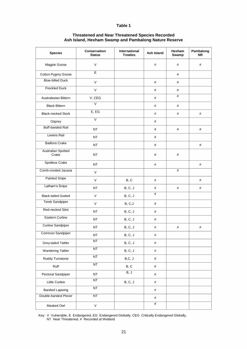
21
Table 1
Threatened and Near Threatened Species Recorded Ash Island, Hexham Swamp and Pambalong Nature Reserve
Species
Conservation Status
International Treaties
Ash Island Hexham Swamp
Pambalong NR
Magpie Goose
V # # #
Cotton Pygmy Goose E
#
Blue-billed Duck
V # #
Freckled Duck
V # #
Australasian Bittern V, CEG # #
Black Bittern V
# #
Black-necked Stork E, EG
# # #
Osprey V
#
Buff-banded Rail
NT # # #
Lewins Rail
NT #
Baillons Crake
NT # #
Australian Spotted Crake
NT # #
Spotless Crake
NT # #
Comb-crested Jacana
V #
Painted Snipe
V B, C # #
Latham’s Snipe
NT B, C, J # # #
Black-tailed Godwit V B, C, J #
Terek Sandpiper
V B, C,J #
Red-necked Stint
NT B, C, J #
Eastern Curlew
NT B, C, J #
Curlew Sandpiper
NT B, C, J # # #
Common Sandpiper
NT B, C, J #
Grey-tailed Tattler NT
B, C, J #
Wandering Tattler NT
B, C, J #
Ruddy Turnstone NT
B,C, J #
Ruff NT
B, C #
Pectoral Sandpiper NT B, J
#
Little Curlew NT
B, C, J #
Banded Lapwing NT
#
Double-banded Plover
NT
#
Masked Owl V #
Key: V Vulnerable, E Endangered, EG Endangered Globally, CEG Critically Endangered Globally, NT Near Threatened, # Recorded at Wetland
22
References Atkinson, P. W., Crooks, S, Grant, A. and Rehfisch, M. M. 2001. The success of creation and restoration
schemes in producing intertidal habitat suitable for waterbirds. English Nature Research Reports, Peterborough, UK ISSN 0967-876X.
Carr, B. 2000a. Speech to the Brisbane Institute. Cited in Harty, C. 2003. Strategic planning for mangrove
management. Australian Planner, 40(1), p. 44. Carr, B. 2000b. A matter of national importance: Protecting Australia’s coastline. Transcript of audience
participation. Brisbane Institute 19 April. Website: www.brisinst.org.au/papers Carr, B. 2000c. Premier thoughts on the environment. The Brisbane Institute, Article, 13 April. Website:
www.brisinst.org.au/resources/carr_bob_enviro.html Clark, C. J. and van Gessel, F W. C.1983. Habitat evaluation – birds. Pp. 117-144 in Moss, T. Investigation
of the natural areas of Kooragang Island. NSW Department of Environment and Planning. Coffey, E. J. 1973. Public Inquiry into pollution from Kooragang Island. State Pollution Control Commission,
NSW Government. CSIRO 2003. Media Release 2003/94 of 5 June. Cited in Wilton, K. 2003 Wetlands and Natural Resources
News 6 June. Davis, T. J. 1994. The Ramsar Convention Manual: A guide to the Convention on Wetlands of International
Importance especially as waterfowl habitat. Ramsar Convention Bureau, Gland Switzerland. Environment Australia 1999a. An overview of the Environment Protection and Biodiversity Conservation Act.
Commonwealth of Australia, Canberra, ACT. Environment Australia 1999b. Australian Ramsar management principles. Consultation Paper,
Commonwealth of Australia, Canberra. Environment Australia 2001a. Referral 2001/231, 3 April, Public Notices. Austeel Pty
Ltd/Industry/Newcastle/NSW/Steel Mill. www.environment.gov.au.epbc. Environment Australia 2001b. Austeel Pty Ltd / Industry / Newcastle / NSW/Steel Mill. Referral 2001/242
April 11. In Public notices: referrals assessments and approvals, EPBC Act 1999. Website www.environment.gov.au/epbc.
Environment Australia 2001c. Newcastle Port Corporation / Marine Infrastructure / Hunter River (South
Arm). Referral 2001/249 April 18. In Public notices: referrals assessments and approvals, EPBC Act 1999. Website www.environment.gov.au/epbc
Environment Australia 2001d. NSW State Govt. / Marine Infrastructure / Newcastle / NSW / Hunter River
Port and Transport Corridor. Referral 2001/419 August 29. In Public notices, referrals assessments and approvals, EPBC Act 1999.
Website www.environment.gov.au/epbc. Environment Australia 2003. Newcastle Port Corporation/Water Transport/Newcastle/NSW/ Hunter River
South Arm Dredging. Referral 2003/950. In Public Notices, referrals, assessments and approvals, EPBC Act 1999. Website www.environment.gov.au/epbc
GDH Pty Ltd. 2001. Proposed cold mill facility Kooraqang Island: Environmental impact statement. Bondi
Junction: Protech Steel. Geering, D. and Winning, G. 1994. Recommended rehabilitation strategy for migratory shorebird habitat at
Stockton Bridge Sandspit. Report Hunter Catchment Management Trust and NSW Public Works. Healthy Rivers Commission 2001. Independent inquiry into the Hunter River system: Draft Report
December. Sydney: Castlereagh St.

23
Heydorn, A. E. F. 1996. Human population growth, land use and wise use wetland management: A challenge for the future. In Ramsar Convention (1996) Proceedings of the 6th Conference of Contracting Parties, Brisbane. Technical Sessions Vol. 10/12: 43-52.
Hunter Ramsar Committee 2001. Minutes of meeting 23 October. The Wetlands Centre. KBR 2003. Newcastle port environs concept proposal: Background report prepared for Planning NSW,
Newcastle, Kellogg Brown and Root Pty Ltd, February. Kingsford, R.T. and Ferster Levy R. 1997. Changes to the Hunter Estuary, 1801-1996, and their implications
for migratory wading birds and other wading birds. National Parks and Wildlife Service, Hurstville NSW.
Kushlan and Hafner 2000. Heron conservation. Academic Press. Moss, J. 1983. Investigation of the natural areas of Kooragang Island, Hunter River NSW. NSW
Department of Environment and Planning. National Research Council 2001. Compensating for wetland losses under the Clean Water Act. Washington
DC USA, National Academy Press. McDonald, K. 1978. Case studies in environmental education: Kooragang Island (Newcastle NSW) – man’s
impact upon an estuarine ecosystem. The Australian Science Teachers Journal 24(1): 5-16. Maddock, M. 2003a. An analysis of environmental issues and international treaty obligations concerning
development proposals within and adjacent to the Ramsar listed Kooragang Nature Reserve. 22 May.
Maddock, M. 2003b. Impacts of proposed developments on threatened species in the Hunter Estuary and
catchment wetlands. 18 May. Maddock, M. 2003c. Critical events and development affecting the Hunter Estuary since 1970. 10 June. NSW Government 2001. Flood Plain Management Manual. NSW National Parks and Wildlife Service 1998. Kooragang Nature Reserve and Hexham Swamp Nature
Reserve: Plan of Management. Hurstville: NSWNPWS ISBN 0 7310 7691 5. NSW NPWS 2002. Lower Hunter conservation issues paper (Draft) March. Northern Directorate. Patterson Britton and Partners 1996. Lower Hunter Valley floodplain management study. Volume A:
Assessment of strategic options for community consultation. Issue No 1 October. Patterson Britton and Partners 1997. Lower Hunter Valley floodplain management study. Volume A:
Assessment of strategic options for community consultation. Issue No 1 April. Patterson Britton and Partners 1998. Tomago wetlands rehabilitation environmental impact statement.
Kooragang Wetland Rehabilitation Project. Patterson Britton and Partners 2001. Lower Hunter floodplain study, Volume B, Planning implementation
study, Issue 5. Price, S. 2003. Carr’s vision: Hunter minister part of promises. Newcastle Herald, 20 February. Prietto, C. 2003a. The Hunter Wetlands Conservation Park. Submission to the NSW Government,
February. The Wetlands Centre Australia. Prietto, C. 2003b. Submission to the Newcastle Port Environs Concept Proposal. The Wetlands Centre
Australia, June. Ramsar Convention 1996. Proceedings of the 6th Conference of Contracting Parties, Brisbane. Ramsar
Bureau, Gland Switzerland.

24
Ramsar Convention 1999. Conference of Contracting Parties. Proceedings 7th Meeting Costa Rica. Ramsar Bureau, Gland, Switzerland:.
Smith, P. 1991. The biology and management of waders (Suborder Charadrii) NSW. Species Report 9,
NSW NPWS. Straw, P. 1999. Hunter River Estuary wader habitat investigation. Report to NSW NPWS. Straw, P. 2000. Hunter River Estuary wader habitat investigation. Report to NSW NPWS. Stuart, A. 2002. The birds of Ash Island. Hunter Bird Observers Club. Umwelt Australia 2002. Draft Newcastle coastal management plan. Newcastle City Council and Department
of Land and Water Conservation. Whitehead, J H., Geary, P. M. and Kidd, R. W. 2000. Advances in environmental management in the Hunter
Region. Hunter Environmental Institute Inc. Springwood Conference Publications. Williams R.J., Watford, F.A. and Balashov, V. 2000. Kooragang Wetland Rehabilitation Project: History of
changes to estuarine wetlands of the Lower Hunter River. Cronulla: NSW Fisheries Office of Conservation.
Related Documents