Jackson Hydroelectric Project Study 18: Riverine, Riparian and Wetland Assessment Technical Report March 2008 Study Plan 18: Riverine, Riparian, and Wetland Habitat Assessment Technical Report Prepared for Snohomish County Public Utility District No. 1 Everett, WA Prepared by Stillwater Sciences 1314 NE 43 rd Street, Suite 210 Seattle, WA 98105 Meridian Environmental 1900 N Northlake Way Suite 211 Seattle, WA 98103 March 2008

Welcome message from author
This document is posted to help you gain knowledge. Please leave a comment to let me know what you think about it! Share it to your friends and learn new things together.
Transcript

Jackson Hydroelectric Project
Study 18: Riverine, Riparian and Wetland Assessment Technical Report March 2008
Study Plan 18: Riverine, Riparian, and Wetland Habitat Assessment Technical Report
Prepared for
Snohomish County Public Utility District No. 1 Everett, WA
Prepared by
Stillwater Sciences 1314 NE 43rd Street, Suite 210
Seattle, WA 98105
Meridian Environmental
1900 N Northlake Way Suite 211 Seattle, WA 98103
March 2008


Jackson Hydroelectric Project
Study 18: Riverine, Riparian and Wetland Habitat Assessment Technical Report Page i March 2008
TABLE OF CONTENTS
List of Figures ..................................................................................................................... ii List of Tables ..................................................................................................................... iii List of Appendices .............................................................................................................. v Acronym Guide.................................................................................................................. vi Executive summary............................................................................................................. 1 1.0 STUDY OBJECTIVES AND DESCRIPTION...................................................... 2 2.0 BACKGROUND INFORMATION ....................................................................... 3 3.0 METHODS ............................................................................................................. 5
3.1. Study Area Description and River Reach Delineation ....................................... 7 3.2 Riverine Habitat Mapping and Large Woody Debris Survey........................... 10
3.2.1 Delineation of In-River Habitat Units....................................................... 11 3.2.2 In-River LWD Inventory .......................................................................... 14 3.2.3 Characterization of River Channel Substrate............................................ 15
3.3 Riparian and Wetland Habitat Mapping ........................................................... 15 3.4 Geo-referenced Habitat Mapping ..................................................................... 18 3.5 Deviations from Revised Study Plan 18 ........................................................... 19
4.0 RESULTS ............................................................................................................. 20 4.1 Survey Results: Riverine Habitat and Large Woody Debris ............................ 20
4.1.2 Results: Riverine Habitat Survey.............................................................. 20 4.1.3 Results: Large Woody Debris Survey....................................................... 28 4.1.4. Characterization of River Channel Substrate............................................ 34 4.1.5 Data Layers ............................................................................................... 34
4.2 Riparian and Wetland Habitat Mapping ........................................................... 40 4.2.1 Forested Cover Types ............................................................................... 40 4.2.2 Wetland Cover Types ............................................................................... 42
5.0 DISCUSSION............................................................................................................. 43 5.1 Riverine habitat characteristics ......................................................................... 44 5.2 Large woody debris (LWD) characteristics...................................................... 45 5.3 Sediment characteristics.................................................................................... 47 5.4 Riparian areas.................................................................................................... 47 5.5 Wetland areas.................................................................................................... 49
6.0 REFERENCES ..................................................................................................... 51
Jackson Hydroelectric Project
Study 18: Riverine, Riparian and Wetland Habitat Assessment Technical Report Page ii March 2008
LIST OF FIGURES
Figure 2-1. Project Area: Sultan River below Culmback Dam. .......................................4
Figure 3-1. Operational and process reach juxtaposition downstream of Culmback Dam. .............................................................................................8
Figure 3-2. Profile of Sultan River channel gradient from the confluence with the Skykomish River upstream to Culmback Dam........................................9
Figure 4-1. Box-and-whisker plots of surveyed riverine habitat unit surface area by core unit type and river operational reach (OR) in the Sultan River below Culmback Dam. .............................................................24
Figure 4-2. Box-and-whisker plots of surveyed residual pool depth by river operational reach within the Sultan River below Culmback Dam.................26
Figure 4-3. Average length (expressed as a percent) of bar edge per sub-unit type habitat unit by river operational reach (OR) in the Sultan River downstream of Culmback Dam............................................................27
Figure 4-4. Distribution and frequency of surveyed LWD within the Sultan River downstream of Culmback Dam............................................................28
Figure 4-5. Box-and-whisker plots of overall LWD lengths by diameter size categories and by river operational reach in the Sultan River downstream of Culmback Dam .....................................................................30
Figure 4-6. Percent composition of large woody debris (LWD) and location within the channel of the Sultan River by reach. ...........................................31
Figure 4-7. Composition of individual LWD pieces by species and respective decay class. ................................................................................................32
Figure 4-8. Example of aerial photo tile with delineated habitat units.............................36
Figure 4-9. Example of riverine habitat distributions by habitat type classification ..................................................................................................37
Figure 4-10. Riverine habitat showing Large Woody Debris (LWD) concentration and Debris Jams. .....................................................................38
Figure 4-11. Riverine habitat showing channel gradient....................................................39
Figure 4-12. Hierarchy of land type classification and area. ..............................................40

Jackson Hydroelectric Project
Study 18: Riverine, Riparian and Wetland Habitat Assessment Technical Report Page iii March 2008
LIST OF TABLES
Table 3-1. Riverine (instream) habitat type and substrate attributes...............................10
Table 3-2. Large woody debris attributes........................................................................11
Table 3-3. Criteria definitions used to identify core and sub-unit habitat types and associated field code acronyms..........................................12
Table 3-4. List of pool forming factors and associated field codes. ...............................13 Table 3-5. Imagery type and source. ...............................................................................16 Table 3-6. Forest type attributes......................................................................................17 Table 3-7. Wetland type attributes. .................................................................................17 Table 4-1. Composition of surveyed riverine habitat unit types by river
operational reach (OR) of the Sultan River downstream of Culmback Dam. .............................................................................................21
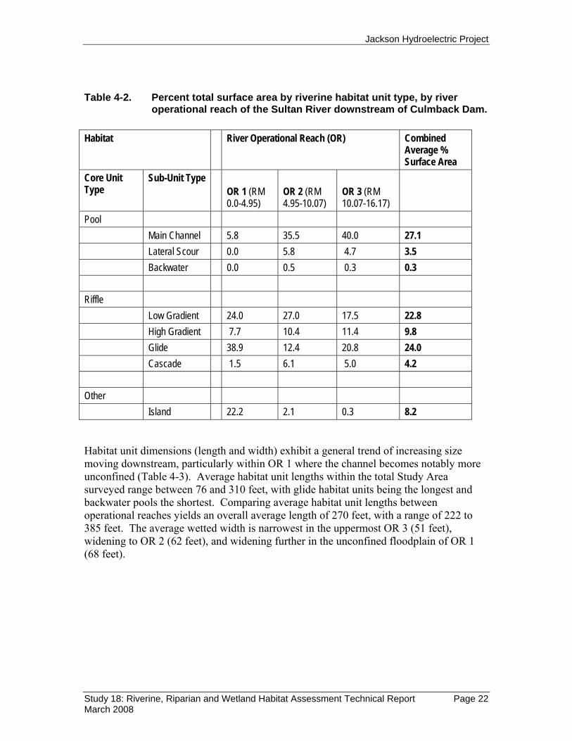
Table 4-2. Percent total surface area by riverine habitat unit type, by
river operational reach of the Sultan River downstream of Culmback Dam. .............................................................................................22
Table 4-3. Average unit length (ft) by surveyed riverine habitat unit
types within operational reaches of the Sultan River downstream of Culmback Dam. ....................................................................23
Table 4-4. Primary pool forming factors for habitat units surveyed by
river operational reach in the Sultan River downstream of Culmback Dam. .............................................................................................25
Table 4-5. LWD density in the Sultan River downstream of Culmback
Dam................................................................................................................28 Table 4-6. Abundance and distribution of individual LWD pieces by
size, category type, and river operational reach within the Sultan River downstream of Culmback Dam. ...............................................29
Table 4-7. Abundance and composition of LWD debris jams within
river operational reaches of the Sultan River downstream of Culmback Dam. .............................................................................................33

Jackson Hydroelectric Project
Study 18: Riverine, Riparian and Wetland Habitat Assessment Technical Report Page iv March 2008
Table 4-8. Approximate size distribution (in mm) of river substrate material from sample sites throughout the Sultan River Study Area. ....................................................................................................34
Table 4-9. Acres and percent of forested cover types. ....................................................41 Table 4-10. Forested plant associations. ...........................................................................41 Table 4-11. Acres of wetlands in the Study Area..............................................................42 Table 4-12. Wetlands connected to the river.....................................................................43 Table 5-1. Wetlands within the Sultan River flood plain................................................49 Table 5-2. Wetlands outside the Sultan River flood plain. .............................................50

Jackson Hydroelectric Project
Study 18: Riverine, Riparian and Wetland Habitat Assessment Technical Report Page v March 2008
LIST OF APPENDICES
Appendix A: Riparian and wetland mapping classification system and cover type descriptions
Appendix B: Riparian and cover type maps
Appendix C: Riverine habitat and LWD data field collection forms and criteria

Jackson Hydroelectric Project
Study 18: Riverine, Riparian and Wetland Habitat Assessment Technical Report Page vi March 2008
ACRONYM GUIDE
DEM Digital elevation model FERC Federal Energy Regulation Commission GIS Geographic Information System LiDAR Light detection and ranging LWD Large woody debris NSO Natural sequence order OR Operational reach PAD Pre-application document RM River mile RSP Revised study plan USGS United States Geological Survey WDOE Washington State Department of Ecology WDFW Washington State Department of Fish and Wildlife

Jackson Hydroelectric Project
Study 18: Riverine, Riparian and Wetland Habitat Assessment Technical Report Page 1 March 2008
EXECUTIVE SUMMARY
The objective of Study Plan 18: Riverine, Riparian, and Wetland Habitat Assessment is to characterize and quantify riverine (in-river), riparian, and wetland habitats in the Sultan River corridor from Culmback Dam to the confluence with the Skykomish River. This report presents methods, results, and a brief discussion of remote sensing tools and field measurements used to delineate and describe in-river and adjacent riparian and wetland habitats.
Results from this study, as well as results of other studies conducted as part of the Henry M. Jackson Hydroelectric Project, FERC No. 2157 (the Project) relicensing process, will determine what effects Project operations have on aquatic and terrestrial resources – including anadromous fish populations.
The Study Area encompasses the lowermost 16.5 miles of the Sultan River below Culmback Dam, and is divided into three operational reaches bound on the upstream extent by Project related structures; Culmback Dam at river mile (RM) 16.5, a Diversion Dam at RM 9.7, and a powerhouse at RM 4.3. The geomorphic environment of the river transitions from a highly confined bedrock gorge in the uppermost 13 miles of the Study Area to an unconfined alluvial plain in the lowermost extent.
Riverine habitat attributes recorded for this study include in-stream unit type (e.g., pools, riffles, glides, islands), measurements of wetted unit surface area dimensions (length and width), average unit depths, unit margin features (lengths of undercut banks and bar edges), and the distribution and characterization of large woody debris (LWD). Pools and riffles are the predominant unit type in the uppermost reaches of the Study Area, whereas glides and islands are the predominant unit type in the lowermost reach. Not surprisingly, all side channel habitat is contained within the lowermost operational reach, and overall unit dimensions generally increase moving downstream. Side channels and island unit types provide habitat complexity and are characteristic of unconfined channels. LWD abundance was significantly lower in the lowermost operational reach than in the upstream confined reaches. Study 22: Sultan River Physical Process Studies discusses the spatial distribution and volume of LWD in more detail.
Riparian and wetland attributes recorded include cover type and distribution for an area of 14,429 acres adjacent to the wetted river channel. Undeveloped coniferous forest is the dominant cover type, occupying 78.6 percent (9,741 acres) of the landscape. 50.7 percent (6,284 acres) of all forest cover types are mid-successional, with only 4.4 percent (546 acres) classified as old-growth and 13.9 percent (1,723 acres) classified as seedling/sapling. Wetlands occupy 273.2 acres of the Study Area, 30 acres of which are located within the current floodplain and exhibit a direct connection with the river. All wetlands not directly connected to the river during high flow events are located above the current and historical floodplain.
The nature and spatial distribution of instream habitat types was as expected for a river study area of ~ 16.5 miles that is largely confined to a bedrock canyon for all but the

Jackson Hydroelectric Project
Study 18: Riverine, Riparian and Wetland Habitat Assessment Technical Report Page 2 March 2008
lower 2.7 miles. The boulder and bedrock dominated channel bed form encourage the preponderance of long, deep pools, cascades and riffles. Especially in OR 3, that portion of the river above the diversion dam that receives ~ 20 cfs flow release, pools are long and deep while riffles are shallow. The relative volume of LWD is greatest in the middle section of the river (OR 2), closely followed by OR 3. Wood volume is lowest (less than half of that found in OR 2) in the lower river (OR 1) where the channel is unconfined and wide. LWD does not appear to be a significant factor in terms of pool formation within the Sultan River study area, especially so in OR 3 and OR 1.
All data collected in the course of this study report are compiled in a geo-referenced digital database that can be used to inform habitat protection and enhancement measures. This GIS database links geospatial data on channel and sideslope gradient, plan views of the riparian, wetland and in-river habitat distributions, and links field data and field photos that allow the reader to examine the distributions and dimensions in an interactive GIS system.
1.0 STUDY OBJECTIVES AND DESCRIPTION
The primary goal of this study is to describe the characteristics of riparian, wetland and instream aquatic habitats along the Sultan River below Culmback Dam. The nature, spatial distribution and key dimensions of these habitats were determined through air photo interpretation and ground surveys. This information is archived and summarized in an integrated GIS database. Data from this study, coupled with analyses from Revised Study Plan (RSP) 3: Sultan River Instream Flow Study and RSP 22: Sultan River Physical Process Studies, can be used by the Public Utility District No. 1 of Snohomish County (District) and stakeholders in the overall analysis of Project effects on aquatic and terrestrial resources in the lower Sultan River.
As part of the formal relicensing process, the Riverine, Riparian, and Wetland Habitat Assessment (RSP 18) is designed to address Federal Energy Regulation Commission (FERC) requirements for a detailed description of aquatic and terrestrial resources of the Project-related environment below Culmback Dam. The assessment encompasses the mainstem Sultan River to its confluence with the Skykomish River, as described in the Pre-Application Document (Public Utility District No. 1 of Snohomish County and City of Everett 2005). Study objectives are designed to provide the District with the information required to make management decisions pursuant to FERC guidelines as well as other federal, state, and local requirements.
Maintaining and protecting habitat to support salmonid populations within the Project-related environment is of great importance to multiple stakeholders and the District. The Tulalip Tribes requested a comprehensive survey of the quality and quantity of aquatic habitat in the Sultan River, its side channels, and its adjacent flood plain. These needs are addressed in RSP 18. In addition, Washington Department of Fish and Wildlife (WDFW) and Washington Department of Ecology (WDOE) requested an assessment of geomorphic processes in the Sultan River downstream of Culmback Dam to identify Project effects on “channel forming processes that include side-channel formation and

Jackson Hydroelectric Project
Study 18: Riverine, Riparian and Wetland Habitat Assessment Technical Report Page 3 March 2008
function, sediment movement, logjam formation, pool to riffle frequency and size, and other channel characteristics.” These concerns are addressed in both RSP 18 and RSP 22. WDFW and WDOE state that information gathered in this study, when coupled with the results of other complementary studies, will help managers understand if instream flows need to be modified and will lead to the identification of various potential habitat projects if it is necessary to create habitat to mitigate for Project effects. Project effects that may benefit the riverine environment are also identified for further consideration in discussions with the resource agencies.
This report presents the results of the application of remote sensing assessment tools and field observations to describe in detail the riverine, riparian and adjacent wetland habitats in the lowermost 16.5 miles of the Sultan River below Culmback Dam. The report presents survey and analytical methods in addition to results for the following study components:
1. air photo interpretation and field efforts to delineate and quantify riverine, riparian and wetland habitats;
2. characterization of in-river large woody debris (LWD) and its relationship to aquatic habitats;
3. characterization of stream substrate; and 4. representation and archiving of all survey data within geo-referenced digital
databases and maps, created using GIS tools that: a. showcase habitat characteristics including spatial distribution and size and b. are linked to corresponding field data summaries.
While results presented in this report are limited to a basic statistical summary, survey data recorded in the GIS database provide attribute information that can be used to inform discussion of habitat protection and enhancement measures and formulation of monitoring strategies for the next licensing term (30 to 50 years).
2.0 BACKGROUND INFORMATION
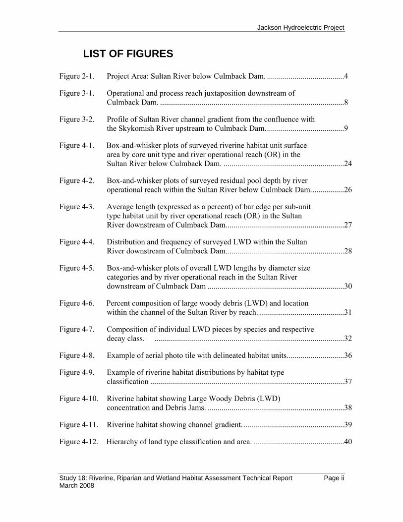
The Pre-Application Document (PAD) filed with FERC provides detailed descriptions of the physical setting of the Project and the Sultan River, as well as extensive descriptions of the biotic resources of concern (Public Utility District No. 1 of Snohomish County and City of Everett 2005). Figure 2-1 illustrates the Project Area within the Sultan River Basin. Text following Figure 2-1 provides additional context.
Jackson Hydroelectric Project
Study 18: Riverine, Riparian and Wetland Habitat Assessment Technical Report Page 4 March 2008
Figure 2-1. Project Area: Sultan River below Culmback Dam. Shaded relief and LiDAR-derived digital elevation model surface. The blue line represents the area of riverine habitat field-mapping. The green outline is the area of vegetation cover aerial photo interpretation. River miles are calculated from the GIS channel centerline. Washington State Plane projection, Zone 4601 North, Datum NAD83.

Jackson Hydroelectric Project
Study 18: Riverine, Riparian and Wetland Habitat Assessment Technical Report Page 5 March 2008
The results of this study are closely linked to those of RSP 22: Sultan River Physical Process Studies, which is still in progress. RSP 22 provides essential descriptions of the physical processes occurring within the basin that drive the expression of ecological functions, including the nature of and spatial distributions of instream habitats, channel form, sediment characteristics and large woody debris dynamics. Interpretation of the study results from RSP 18 can be significantly enhanced after full consideration of the results from RSP 22, when available.
The Sultan River below Culmback Dam is a highly confined, steeply graded river that flows approximately 16 miles to its confluence with the Skykomish River. The canyon that confines the river creates a high-energy environment that significantly affects the nature of instream habitats found within. At approximately river mile (RM) 3.3 the river transforms into a less confined, alluvial valley where the channel widens and gravels from upstream sources accumulate.
The Sultan River below Culmback Dam currently provides spawning and rearing habitat for numerous species of resident and anadromous salmonids. Anadromous species including Chinook (Oncorhynchus tshawytscha), coho (O. kisutch), pink (O. gorbuscha), chum (O. keta), coastal cutthroat (O. clarki) and steelhead (O. mykiss) are utilizing habitats within the river downstream of the Diversion Dam (RM 9.7), which at present is a barrier to upstream passage. Bull trout (Salvelinus confluentus) have not been observed spawning in the Sultan River but are known to use the lower river as rearing/foraging habitat during odd years when pink salmon eggs are prevalent. The reach between the Culmback Dam and the Diversion Dam supports self-sustaining stocks of resident rainbow trout (O. mykiss), cutthroat trout (O. clarki), and mountain whitefish (Prosopium williamsoni). All fish species and amphibians depend on aquatic habitats that are affected by Project operations.
Aquatic habitat conditions in the Sultan River below Culmback Dam were surveyed in 2003 and 2004 and the results were presented in Section 5.3.2 of the PAD (Public Utility District No. 1 of Snohomish County and City of Everett 2005). However the District agreed that a more thorough and current view of the river channel, including side channels, is necessary to quantify the amount and distribution of habitat for fish, amphibian, and terrestrial wildlife species in the lower Sultan River.
3.0 METHODS
RSP 18 provides an initial description of the assessment methods prescribed for completion of the study (Section 18.6, RSP 18). In this section detailed descriptions of specific methods are provided to aid interpretation of survey results.
The primary objectives of RSP 18 are to describe quantitatively the amount and distribution of habitat available for fish, amphibian, and terrestrial wildlife species within and adjacent to the Sultan River (including wetland, riparian, and side channel habitat), to map the quantitative information using GIS mapping tools, and to link these geographic

Jackson Hydroelectric Project
Study 18: Riverine, Riparian and Wetland Habitat Assessment Technical Report Page 6 March 2008
data to associated data tables. The map-based format and display of study results should aid subsequent analyses and interpretation of the significance of aquatic, wetland, and riparian habitat features.
Overview The general methods used to generate the required habitat delineations and produce the initial GIS maps and data layers involved four key steps, as described below. More detailed methods of field data collection and habitat verification for mapping of aquatic, riparian, and wetland features are described in Sections 3.1 and 3.2.
RSP 18 requires the use of a comprehensive mapping classification system to ensure consistency. The first-order identification and mapping of aquatic, riparian, and wetland areas follow standard aerial photo interpretation and mapping procedures. A classification system specified in RSP 18 was used to account for all habitat types encountered (see Appendix A). Cover and habitat types are defined so that each is unique and provides the information necessary for the analyses.
Aerial photos were acquired that cover the extent of the mapping area. Cover and habitat types were identified and delineated within the central area of the aerial photos. The scale, color, contrast, flight date, and flight line orientation of existing photography, in addition to landscape and terrain features, control the scale of information that can be interpreted and mapped from aerial photography. A minimum mapping unit defines the smallest cover/habitat feature that can be identified and delineated on the photography. Field identification and mapping were required for any features smaller than this minimum.
Photo mapping results were transferred to a geo-referenced base map by transferring mapped polygons aerial photos to orthophoto images. This process removes the non-uniform scale distortion that is inherent in aerial photography. The new information, added to the geo-referenced base map, was then digitized and assigned classification attributes to create the GIS databases.
Following the initial mapping procedure, the accuracy and consistency of the mapping was field-checked. Field visits were used to verify initial interpretation and to conduct additional mapping of features that were smaller than the minimum unit feasibly mapped by aerial photo interpretation. This procedure worked well for the identification and mapping of riparian and wetland features. However, the resolution of air photo imagery and the prevalent shadow cast within the canyon made in-river habitat unit identification and boundary delineation relying solely on air photo imagery impossible. Therefore, a full in-river habitat census was required to identify riverine habitat features. Base maps of the channel were constructed from geo-referenced aerial orthophotos and were used by the field survey crews to record the location and dimensions of instream habitats and LWD. The data available from remote sensing tools (existing digital elevation models and analyses of Light Detection and Ranging (LiDAR) data) were used to further refine the

Jackson Hydroelectric Project
Study 18: Riverine, Riparian and Wetland Habitat Assessment Technical Report Page 7 March 2008
spatial alignment of habitat units to increase the accuracy of GIS maps. A digital elevation model (DEM) was used to increase the spatial accuracy of riverine habitat unit positions within the GIS database. The DEM was derived from LiDAR imagery data from several separate surveys (2004-2006) that were merged to form a single "bare earth" elevation model for the river corridor. The resulting DEM was used to construct contour lines at vertical intervals as fine as one foot. The model was used to calculate channel gradients and to identify the positions of river channel margins. The riverine unit field mapping data were digitized and spatially adjusted to reflect a best-fit with the field measurements and with the LiDAR-derived terrain and channel margins. Examples of map representation of these data are provided below in the results section.
3.1. Study Area Description and River Reach Delineation
The Study Area defined by the District includes approximately 16.5 miles of the Sultan River from Culmback Dam to its confluence with the Skykomish River. The lateral extent of the riverine habitat mapping is limited to the bankfull width area, as defined by Harrelson et al. 1994. The area outside of this zone is included in the riparian and wetland habitat mapping. Mapping of riparian and wetland habitat areas extend laterally in the upper confined reach (above approximately RM 3) to the top of the first prominent break in the hillside adjacent to the river. The lateral extent of the riparian and wetland habitat mapping in the lower unconfined reach (below approximately RM 3) of the Sultan River extends the width of the valley floor to the base of the first major hillslope. As used in this study, the terms “riparian” or “riparian area” refer to the general extent of the Study Area as described above. These terms are not used in their strict geomorphic or ecological sense to identify specific areas immediately adjacent to streams or wetlands that are a result of the interaction between the aquatic and terrestrial ecosystem, such as described by Bilby (1988).
Land ownership within the Study Area consists of a mixture of federal, state, local government, and private holdings. The pattern of forest successional stages and level of development within the lower Sultan River watershed reflects the respective land ownership objectives.
Within the Study Area, the river is divided into sub-reaches based on both Project operational structures (operational reaches) and physical and geomorphic characteristics (process reaches). A description of designated operational reaches (herein referred to as OR) and process reaches (PR) are provided below. Process reaches will be defined in greater detail in the final report for RSP 22. Figure 3-1 illustrates the geographic location and overlap by river mile. Because the beginning and ending points for the process reaches (PR) are not precise, they are not easily identified in the field, and so we used the operational reaches to reference discrete boundaries during the field surveys.

Jackson Hydroelectric Project
Study 18: Riverine, Riparian and Wetland Habitat Assessment Technical Report Page 8 March 2008
Figure 3-1. Operational and process reach juxtaposition downstream of Culmback Dam. River miles are noted in the horizontal bars.
The uppermost operational reach (OR 3) extends from Culmback Dam (RM 16.5) downstream to the Diversion Dam (RM 9.7) and is wholly contained in the uppermost process reach (PR 5 [RM 16.5–5.4]). OR 3 is best described as a high gradient, highly confined bedrock gorge characterized by higher rates of sediment transport as compared to subsequent downstream reaches.
The middle operational reach (OR 2) extends from the Diversion Dam (RM 9.7) downstream to the powerhouse (RM 4.5) and contains two process reaches: (1) PR 5 (RM 16.5 to RM 5.4), best described as a bedrock gorge, and (2) PR 4 (approximately RM 5.4 to RM 4.5) above the powerhouse. Channel confinement and slope in PR 4 are moderate in comparison to PR 5, and gravel patches, LWD, and sediment deposition are more evident.
The lowermost operational reach (OR 1) extends from the Powerhouse (RM 4.5) to the Sultan River’s confluence with the Skykomish River (RM 0.0). This reach contains three process reaches: PR 3 (RM 4.5 to 3.3) which is defined as the lowermost extent of bedrock gorge; PR 2 (RM 3.3 to RM 0.7) which is predominately a low gradient unconfined alluvial reach; and PR 1 (RM 0.7 to RM 0.0) which is also a low-gradient unconfined alluvial reach, though it differs from PR 2 in that it is subject to backwater effects of Skykomish River flood events.

Jackson Hydroelectric Project
Study 18: Riverine, Riparian and Wetland Habitat Assessment Technical Report Page 9 March 2008
Operational reach designations were used to stratify the survey field effort and data for quantifying in-river habitat and LWD. This approach was selected because of unambiguous field identification of river reach breaks.
Channel gradient and confinement by canyon walls is relatively consistent through 13 miles of the river channel below Culmback Dam (PR 3), excluding the steep 0.7-mile section immediately downstream of the dam. The lower 3.3 miles (PR 2 & 1), extending to the confluence with the Skykomish River, differ substantially in gradient and confinement from the rest of the river.
A plot of channel gradient (Figure 3-2) within the Study Area suggests that the channel has relatively consistent gradients of 1-2% through most of its length, with average gradients decreasing to less than 1% in the lower 3.3 miles (PR 2 & 1) to its confluence with the Skykomish River. The steepest sections in the river are the 0.7 mile section just below Culmback Dam and the one mile section just below the Diversion Dam (RM 9-10). At the finer scale of local habitat units, slopes can average up to 3-5% over 100s-1000s of feet, in OR 2-3 for example.
Figure 3-2. Profile of Sultan River channel gradient from the confluence with the Skykomish River upstream to Culmback Dam (RM 0-16.5) (OR = “operational reach”; vertical exaggeration 50x).
Sultan River Profile
100 200 300 400 500 600 700 800 900
1000 1100 1200 1300
0 10000 20000 30000 40000 50000 60000 70000 80000 90000
Distance from Skykomish River confluence (feet)
Elev
atio
n (fe
et)
OR 1RM 0.0-4.5
OR 2 RM 4.5-9.7
OR 3RM 9.7-16.5

Jackson Hydroelectric Project
Study 18: Riverine, Riparian and Wetland Habitat Assessment Technical Report Page 10 March 2008
3.2 Riverine Habitat Mapping and Large Woody Debris Survey
The use of recent aerial photographs and a helicopter flight survey in May 2007 were helpful for identifying broad riverine habitat characteristics and providing an initial survey of LWD distribution. These aerial survey data have been compiled as a data layer in the GIS database. A subsequent field census of the complete Study Area was necessary, given the required level of detail for identification of habitat attributes and the limited resolution of aerial photographs available. Aerial photographs were used to develop initial base maps onto which instream habitat attributes and LWD data were recorded during field surveys.
LiDAR remote sensing data and post-processing techniques were used to provide refinement and discrimination of terrain features in the river canyon corridor. LiDAR data and post-processing ultimately provided enhanced detail for topographic mapping of both the channel and the adjacent hillslope, and allowed a more accurate representation of the juxtaposition of in-river habitat features and associated LWD.
As called for in the RSP 18, methods used to quantify in-river habitat units and associated LWD were selected to provide repeatable identification of habitat types, dimensions, and locations, as well as documentation of associated LWD and sediment characteristics. All information has been catalogued within a GIS database framework. The classification schemes used to identify specific habitat unit types, substrate sizes, and LWD attributes are given in Table 3-1 and Table 3-2.
Table 3-1. Riverine (instream) habitat type and substrate attributes. Reach Delineation Operational Reach (3) Process Reach (5) Habitat Types Pool Riffle Cascade Rapid Glide Island Side Channel Undercut Banks Backwater Areas Bar Edges Substrate Category Mud

Jackson Hydroelectric Project
Study 18: Riverine, Riparian and Wetland Habitat Assessment Technical Report Page 11 March 2008
Silt Sand Gravel Cobble Small Boulder Large Boulder Bedrock
Table 3-2. Large woody debris attributes (LWD). LWD JAM Number of pieces Dimension (length, width, height) Channel Position (bank, mid-channel, bar) Percent of Channel Width Largest Piece Size LWD Piece Length Diameter Decay Class Species Class (conifer, deciduous) Rootwad (yes, no) Anchoring (bed bank) Channel Position (bank, mid-channel, bar)
3.2.1 Delineation of In-River Habitat Units In-river habitat unit classification system and field methods were adapted from those commonly used in Washington State (Pleus et al. 1999 and Schuett-Hames et al. 1999). They provide consistency for unit type identification and for recording unit dimensions. Habitat attributes recorded include unit type (e.g., pools, riffles, etc.), measurements of wetted unit surface area dimensions (length and width), average unit depths, unit margin features (lengths of undercut banks and bar edges), and LWD characteristics. Example habitat unit field data collection forms and respective criteria for identification are provided in Appendix C.
The habitat and LWD assessments were conducted in June and July 2007 within the Study Area of the Sultan River. The involved a field survey (or census) of the Study Area by a three-person crew, and was conducted in three stages corresponding to the three

Jackson Hydroelectric Project
Study 18: Riverine, Riparian and Wetland Habitat Assessment Technical Report Page 12 March 2008
operational reaches. Each reach presented unique challenges, including access, turbidity, and the controlled release of high flows for the purpose of other studies associated with Project relicensing. OR 3 was surveyed first, moving upstream beginning at the Diversion Dam. OR 2 and OR 1 were subsequently surveyed in that order, moving downstream from the Diversion Dam and the powerhouse, respectively.
The field crew surveyed each OR sequentially to identify habitat unit boundaries and associated attributes. Data were collected in a hierarchical manner to first identify habitat unit locations within each OR, assign a core or primary unit-type designation, and indicate a category to define the unit position within the lateral channel. These first-order reach-unit scale data were recorded using an alphanumeric coding system that assigned (1) a unique numeric data identifier (Natural Sequence Order or NSO unit number); (2) a core unit type (riffle, pool, sub-surface flow, obscured, or other [Pleus et al. 1999]); and (3) a ranking that defined the degree to which the unit occupied the wetted channel. The latter included primary main channel units (category 1), secondary main channel habitat units (category 2), and side channel habitat units separated from the main channel by an island (category 3). Islands were identified according to Schuett-Hames et al. (1999) where the length of such island units is at least two times the bankfull channel width and the terrestrial area is vegetated by perennial plants two meters or greater in height. The sum of all Category 1 habitat units is equivalent to the actual linear river length of the OR surveyed.
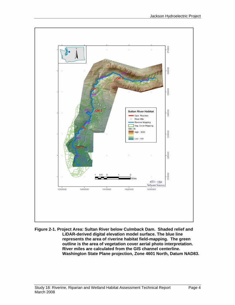
Subsequent data, including unit subtype and dimension measurements, were recorded for NSO. Length, average depth (except in pool habitat units), and three wetted width measurements were recorded for each delineated habitat unit. Habitat unit subtypes were designated for pool and riffle core units according to the criteria given in Table 3-3. Additional information was recorded for pools, including maximum depth, residual pool depth, and the dominant factor forming the pool according to the criteria given in Table 3-4 (Pleus et al. 1999).
Table 3-3. Criteria definitions used to identify core and sub-unit habitat types and associated field code acronyms. (Sub-unit designations and definitions are adapted from Flosi et al. 1998.)
Core Habitat Unit Type
Sub-Habitat Unit Type Criteria Definition
Riffle (R) Low Gradient Riffle (LGR) Shallow reaches with swiftly flowing, turbulent water with some partially exposed substrate. Gradient <4% is usually cobble dominated.
Rapid (RPD) Steep sections of moderately deep, swift, and very turbulent water. Amount of exposed substrate is relatively high. Gradient is >4%, and substrate is boulder dominated. In Flosi et al. (1998), these are ‘high gradient riffles’.
Jackson Hydroelectric Project
Study 18: Riverine, Riparian and Wetland Habitat Assessment Technical Report Page 13 March 2008
Core Habitat Unit Type
Sub-Habitat Unit Type Criteria Definition
Glide (GLD) Wide uniform channel bottom. Flow with low to moderate velocities, lacking pronounced turbulence. Substrate usually consists of cobble, gravel, and sand.
Cascade (CAS) The steepest riffle habitat, consisting of alternating small waterfalls and small shallow pools. Substrate is usually bedrock and boulders.
Pool (P) Main Channel Pool (MCP) Large pools formed by mid-channel scour. Water velocity is slow, and the substrate is highly variable.
Lateral Scour Pool (SCP) Formed by flow impinging against a partial channel-bank obstruction.
Other (OT) Island (ISL) Bars or land segments within the stream channel that are relatively stable, usually vegetated, and normally surrounded by water.
Table 3-4. List of pool forming factors and associated field codes (Pleus, et al.
1999). Definitions for individual large woody debris (LWD) pieces versus debris jams are according to Schuett-Hames et al. (1999).
Field Code Pool Forming Factor 1 LWD Log(s) 2 LWD Rootwad(s) 3 LWD Jam 4 Roots of standing tree(s) or stump(s) 5 Boulder(s) 6 Bedrock 7 Channel bedform 8 Resistant bank 9 Artificial bank 10 Beaver dam 11 Other / Unknown

Jackson Hydroelectric Project
Study 18: Riverine, Riparian and Wetland Habitat Assessment Technical Report Page 14 March 2008
3.2.2 In-River LWD Inventory Survey methods to characterize and enumerate LWD within the Sultan River followed methods refined for the Timber Fish and Wildlife Monitoring Program (Schuett-Hames et al. 1999). Deviations from survey methods included consolidating LWD into size categories and characterizing LWD in debris jams by tallying individual pieces and rootwads. Example field data collection forms and criteria are provided in Appendix C.
For the field survey, LWD was defined as dead logs, limbs, or rootwads partially or entirely located within the bankfull channel. LWD was enumerated according to a minimum size and length criteria. Individual downed logs and rootwads tallied had a minimum length of two meters and a mid-point diameter of twenty centimeters or greater. Total length for each piece was recorded, and a diameter class was assigned. Diameter classes were defined as (1) ≥20 cm to <40 cm, (2) ≥40 cm to <60 cm, or (3) ≥60 cm. The location of LWD either within the wetted channel (zone 1) or within the bankfull channel width (zone 2) was also recorded based on present wetted channel conditions. Additional LWD data attributes recorded were:
• anchor feature (root system, boulder, pinned or unstable [Schuett-Hames et al. 1999]);
• species class (conifer, deciduous or unknown);
• decay class (1-5, [Robison and Beschta 1990 cited in Schuett-Hames et al.1999]); and
• the presence or absence of an intact rootwad.
In addition to individual pieces of LWD, debris jams were recorded on base maps and dimensions estimated. The criteria for identifying debris jams was the accumulation of ten or more pieces of interlocked LWD (including rootwads) where at least ten pieces were ≥20 cm in diameter, >1.82 m (6 feet) in length, and the majority of the debris jam was located within the bankfull channel (Schuett-Hames et al. 1999). Attribute data recorded for debris jams included a tally of all pieces and rootwads meeting the criteria described above, and approximate length, width, and height dimensions. Specific diameter and length measurements were recorded for the most prominent individual piece within each jam.
Exceptionally large LWD (whether individual pieces or within debris jams) were recorded according to key piece criteria used in Schuett-Hames et al. (1999). Key pieces are of interest given their potential longevity, stability, and influences on river geomorphology. Key piece criteria varied throughout the river corridor based on the relationship between the width of the bankfull channel and dimensions of the LWD piece in question.
All LWD locations were identified by recording the associated habitat unit NSO in addition to other data described above. These tabular data files are accessible within the GIS database.
Jackson Hydroelectric Project
Study 18: Riverine, Riparian and Wetland Habitat Assessment Technical Report Page 15 March 2008
3.2.3 Characterization of River Channel Substrate A modified Wolman (1954) approach was used to characterize the surface size distribution of discrete patches of spawning-sized gravel. This is similar to the method described in GeoEngineers (1984) report. Patches of gravel deposited along channel margins, pool tail-outs, or on the lee of large mid-channel obstructions were identified as sample sites. One hundred particles were chosen at random throughout the selected patch, and the diameter of the secondary axis was measured to the nearest millimeter with a ruler. Sampled substrate represents gravels and cobbles within the size range of salmonid spawning habitat. The underlying particles represent the subtending bed surface. See RSP 22: Sultan River Physical Process Studies for a more detailed discussion of particle size distribution in the Sultan River.
3.3 Riparian and Wetland Habitat Mapping The cover type classification system for the riparian and wetland mapping is based on the existing cover type mapping for the Project wildlife habitat management lands (Snohomish County PUD and City of Everett 1988). Some modifications to the original cover type classes were made to create better consistency between classes and to match the land type classification hierarchy. Additional attribute information was added to the classification system to provide descriptive information expected to be valuable during future site specific planning, such as seral stage and stand density attributes for all forest types. Additional information also included detailed wetland cover types and modifier attributes based on Cowardin (1979). The complete land type classification hierarchy and cover type classes are detailed in Appendix A. The general identification and interpretation of cover types was conducted using aerial photos taken during August 2001 (1:12,000 scale natural color). These photos are the most recent photo series available at a scale large enough for clear interpretation and delineation of the features of interest. More recent photo projects were flown at higher altitudes which resulted in lower resolution photos. The 2001 photos appear to have been taken mid-day, thus producing minimal shadowing. The color balance of photos was heavy skewed toward a green tint which made the distinction of some cover types difficult, particularly conifer versus cottonwood. Photo interpretation from the 2001 photos was supplemented by reviewing digital versions of aerial photos (non-stereo) taken in April 1997 during leaf-off conditions to assist in the identification of areas containing deciduous trees. Photo interpretation was conducted in several stages. The first stage identified all distinct polygons on the aerial photos composed of forest types and large wetland types. Polygons were labeled with a unique ID number corresponding to a spreadsheet of tabular data. These polygons were then digitized into the GIS database using the 2006 orthophoto base map provided by the U.S. Department of Agriculture National

Jackson Hydroelectric Project
Study 18: Riverine, Riparian and Wetland Habitat Assessment Technical Report Page 16 March 2008
Agriculture Imagery Program. This process created a shapefile with a unique ID number assigned to each polygon. The spreadsheet of attribute data was then imported to the GIS and assigned to the polygons. Field verification of forested cover types was conducted between the first and second stages of photo interpretation to identify and rectify errors in interpretation. A second stage of photo interpretation was conducted to find small wetland types generally more difficult to identify in the aerial photos. Second-stage photo interpretation allowed the small wetland polygons to be more accurately integrated and geographically referenced with digital maps produced from the first-stage photo interpretation. Second-stage photo interpretation was conducted using a combination of aerial images, including stereo photo pairs of 2001 aerial photos, the 2006 orthophoto image, an elevation shaded image from the 2006 LiDAR flight, and the 1997 aerial photos. The use of multiple imagery sources during this stage provided better reliability that all wetlands were identified, and improved the accuracy in identifying the boundary between wetland and upland areas. All imagery sources used for interpretive purposes during the cover type mapping are listed in Table 3-5 below. Table 3-5. Imagery type and source. Year Photo Type Media Source 2001 1:12,000 scale
natural color 9” by 9” stereo photo prints
Washington State Department of Natural Resources
2006 High altitude orthorectified color image
Georeferenced image mosaic
US Department of Agriculture National Agriculture Imagery Program Mosaic (NAIP) http://datagateway.nrcs.usda.gov/GatewayHome.html
2006 LiDAR Georeferenced digital elevation data
Washington State Department of Natural Resources and Snohomish County Department of Surface Water Management
1997 Natural color aerial photos, originally flown at 1:12,000 scale stereo pairs
Digital copies of original photo prints
Washington State Department of Natural Resources
Second-stage photo interpretation also updated the cover type information to reflect 2006 conditions. The 2006 orthophoto base map was used to identify areas where recent land use changes had occurred, such as recent timber harvest or residential development. Cover type polygons and attribute codes were updated to reflect observed changes. Field verification of wetland cover types was conducted to verify the presence or absence of a hydrological connection between wetland areas and the Sultan River, as well as to confirm the presence of small wetlands that were difficult to identify on various imagery sources.
Cover type attributes were edited in the GIS database to reflect changes identified during field verification. Data attributes were cross-checked for consistency within the cover

Jackson Hydroelectric Project
Study 18: Riverine, Riparian and Wetland Habitat Assessment Technical Report Page 17 March 2008
type mapping hierarchy. The riparian and wetland GIS database was finally merged with the riverine habitat mapping (Section 3.2), and checked to verify proper joining and edge matching of map layers.
Additional attribute information was recorded in the GIS database for all forested and wetland cover types to describe other features of importance for these areas. Additional information recorded for forested cover types included the plant association, seral stage, and stand density, identified in Table 3-6. Additional information recorded for wetland cover types included the seasonality of inundation, level of development, and connectivity to the Sultan River. These attributes are identified in Table 3-7. Detailed descriptions of cover type mapping attributes are provided in Appendix A.
Table 3-6. Forest type attributes. Seral Stage Seedling / Sapling (< 1" dbh) SS Pole (1 - 9" dbh) P Mid-Successional (10 - 20" dbh) MS Mature (> 20" dbh) M Old-Growth (> 24" dbh) OG Density Low ( < 30% canopy cover) L Medium (30 - 60% canopy cover) M High (> 60% canopy cover) H Plant Association Western Hemlock / Alaska Huckleberry TSHE / VAAL Western Hemlock / Swordfern-Oregon Grape TSHE / POMU-BENE Western Hemlock / Swordfern-Salal TSHE / POMU-GASH Western Hemlock / Swordfern-Foamflower TSHE / POMU-TITR Western Hemlock / Devil's Club-Ladyfern TSHE / OPHO-ATFI Western Hemlock / Skunkcabbage TSHE / LYAM Table 3-7. Wetland type attributes. Inundation Permanently Flooded PF Intermittently Exposed IE Seasonally Flooded SF Saturated S Artificially Flooded AF Development Excavated EX

Jackson Hydroelectric Project
Study 18: Riverine, Riparian and Wetland Habitat Assessment Technical Report Page 18 March 2008
Impounded IM Diked DK Partly Drained PD Partly Filled PF Farmed F Artificial A Not Developed ND Side Channel Yes No Connectivity Discharges water to river DIS Receives water from river REC Discharges and receives water from
river DR
Not connected to river NC Unknown connection to river UNK
3.4 Geo-referenced Habitat Mapping Aerial photographs were used to guide field efforts. Large-format air photos were assembled into a folio for use in the field. In deeply shaded areas of the Sultan River canyon, aerial photograph series from 1997 and 1983 were orthorectified within ArcMap and used to supplement the 2003 coverage. These photos served as the template onto which measurements of habitat unit boundaries were recorded. Information recorded on the photos was digitized and used to create geographically referenced map layers with GIS tools.
In order to create corresponding digital map data layers using GIS tools, a variety of techniques and tools were employed. First, a digital elevation model (DEM) was used to increase the spatial accuracy of positions of field identified riverine habitat units within the GIS database. Rather than relying on existing USGS 1:24,000 elevation datasets, the DEM was customized by derivation from available LiDAR imagery data from several separate surveys (2003-2006) that were merged to form a single "bare earth" elevation model for the river corridor. The DEM has horizontal resolution of 6-foot grid cells, resulting in contour lines at vertical intervals as fine as one foot. The model was used to calculate channel gradients and to identify the positions of river channel margins. The riverine unit field-mapping data have been digitized and spatially adjusted to reflect a best-fit with the field measurements and with the LiDAR-derived terrain and channel margins.

Jackson Hydroelectric Project
Study 18: Riverine, Riparian and Wetland Habitat Assessment Technical Report Page 19 March 2008
GIS feature data containing the riparian and wetlands habitat were integrated with the riverine habitat feature data.
3.5 Deviations from Revised Study Plan 18 The implementation of riverine habitat and LWD field surveys presented challenges that required slight modifications to methods outlined and implied in the study plan. Deviations from the revised study plan and justification for modifications are listed below.
a) The habitat census and LWD survey omitted the uppermost ~0.7 mile of OR 3 below Culmback Dam.
The reach immediately below Culmback Dam is very steep and characterized by boulder drops and steep chutes. Although the study plan specifies a complete census of the river below Culmback Dam, concerns for crew safety resulted in the decision to cease the census at approximately RM 16.2, the location termed Cascade #1 by Ruggerone (2006). Ruggerone’s survey provides sufficient detail to understand the nature of the riverine habitat within the uppermost ~0.7 miles of OR 3. This steep section is represented in the upper right hand corner of Figure 3-2.
b) Channel bed substrate was nominally accomplished through pebble counts.
Characterization of substrate within the Study Area was not thoroughly assessed during the field survey in June and July 2007. Turbidity obscured the view of substrate below a depth of a few inches, precluding accurate characterization of substrate size and distribution within the wetted channel. Alternatively, a limited number of pebble counts were conducted at patch deposits to determine substrate size characteristics on gravel bars distributed throughout the Study Area. A more detailed characterization of river channel substrate is presented in the final report for RSP 22: Sultan River Physical Process Studies. A quantitative assessment of river channel substrate is also provided by the 2003 and 2004 Sultan River aquatic habitat survey (Section 5.3.2, Public Utility District No. 1 of Snohomish County and City of Everett 2005).
c) LWD survey field methods were modified The LWD survey field methods deviated from methods in the approved RSP 18 in terms of LWD diameter categories. After discussions with representatives of the Tulalip Tribes and the District, it was agreed that LWD would be characterized using three diameter-size categories rather than the five categories initially requested by eliminating the two smallest size categories. The objectives of modifying field survey methods were to streamline data collection and to improve the overall accuracy of the data. It was often difficult or impossible to definitively measure the mid-point diameter of all LWD pieces due to physical conditions, including channel confinement and sheer canyon walls. In

Jackson Hydroelectric Project
Study 18: Riverine, Riparian and Wetland Habitat Assessment Technical Report Page 20 March 2008
these instances it was necessary to use calibrated visual estimates that could be translated into diameter classes within defined size ranges. Since there is no project nexus to the growth of riparian trees and their rate of input into the channel, except for the lowermost three miles of river, this modification seemed appropriate and could still provide sufficient data regarding current loading of LWD.
4.0 RESULTS
4.1 Survey Results: Riverine Habitat and Large Woody Debris
After examination of field data, minor discrepancies in the actual lengths of each operational reach were evident when comparing lengths derived from summed field measured lengths and lengths previously asserted in RSP 18. For the purpose of this report, survey results assume total reach lengths based on the 2007 field survey data for riverine habitat and LWD. Differences in surveyed lengths and reported lengths are as follows:
• 4.95 river miles in OR 1 (versus 4.3 river miles reported in the RSP18)
• 5.12 river miles in OR 2 (versus 5.4 river miles reported in RSP18)
• 6.80 river miles in OR 3 (consistent with 6.80 river miles reported in RSP 18, including approximately 0.7 miles of river cascades not surveyed immediately below Culmback Dam [see Ruggerone 2006]).
Based on the surveyed river reach lengths, total distance from the confluence of the Sultan River with the Skykomish River to Culmback Dam is 16.87 river miles versus the previously reported 16.5 miles. Because the uppermost 0.7-mile reach directly below Culmback Dam was not included in the field survey, field results are reported for a total distance of 16.17 river miles.
4.1.2 Results: Riverine Habitat Survey A total of 364 in-river habitat units were surveyed within the total Study Area. The spatial distribution of these habitats is best viewed using Arc GIS tools, although examples are given in Section 4.1.5 of this report. In order of prevalence, main channel pools, low-gradient riffles, and glides are the most abundant habitat units and in total account for 72% of all habitat units surveyed. Low-gradient riffles, glides and islands characterize the lowermost portion of the river (OR 1), whereas pools and cascades are increasingly more abundant in the upstream reaches (OR 2 and OR 3).

Jackson Hydroelectric Project
Study 18: Riverine, Riparian and Wetland Habitat Assessment Technical Report Page 21 March 2008
Table 4-1. Composition of surveyed riverine habitat unit types by river operational reach (OR) of the Sultan River downstream of Culmback Dam.
Habitat River Operational Reach (OR) Total Number of Habitat Units
Core Unit Type Sub-Unit Type OR 1 (RM 0.0-4.95)
OR 2 (RM
4.95-10.07)
OR 3 (RM
10.07-16.17)
Pool Main Channel 7 34 48 89 Lateral Scour 0 6 6 12 Backwater 0 4 3 7 Riffle Low Gradient 37 28 23 88 Rapid 6 16 19 41 Glide 34 17 33 84 Cascade 2 10 14 26 Other Island 11 4 2 17 Total Habitat Units
97 119 148 364
In terms of habitat unit by overall surface area within the surveyed Study Area, main channel pools account for 27% of all wetted unit surface area, glides for 24%, and low-gradient riffles for 23% of total surface area (Table 4-2). Combining total riverine area into pool and riffle “core habitat unit types,” riffle units account for 71% of total wetted surface area surveyed, whereas only 29% of the wetted surface area is comprised of pool habitat unit types. Total pool-to-riffle surface area comparisons are largely skewed by the absence of pools within the lowermost portion of the river, OR 1. Within both OR 2 and OR 3 total percent surface areas are about equal at ~ 55% for riffles and 45% pools.
Jackson Hydroelectric Project
Study 18: Riverine, Riparian and Wetland Habitat Assessment Technical Report Page 22 March 2008
Table 4-2. Percent total surface area by riverine habitat unit type, by river operational reach of the Sultan River downstream of Culmback Dam.
Habitat River Operational Reach (OR) Combined
Average % Surface Area
Core Unit Type
Sub-Unit Type OR 1 (RM 0.0-4.95)
OR 2 (RM 4.95-10.07)
OR 3 (RM 10.07-16.17)
Pool Main Channel 5.8 35.5 40.0 27.1 Lateral Scour 0.0 5.8 4.7 3.5 Backwater 0.0 0.5 0.3 0.3 Riffle Low Gradient 24.0 27.0 17.5 22.8 High Gradient 7.7 10.4 11.4 9.8 Glide 38.9 12.4 20.8 24.0 Cascade 1.5 6.1 5.0 4.2 Other Island 22.2 2.1 0.3 8.2
Habitat unit dimensions (length and width) exhibit a general trend of increasing size moving downstream, particularly within OR 1 where the channel becomes notably more unconfined (Table 4-3). Average habitat unit lengths within the total Study Area surveyed range between 76 and 310 feet, with glide habitat units being the longest and backwater pools the shortest. Comparing average habitat unit lengths between operational reaches yields an overall average length of 270 feet, with a range of 222 to 385 feet. The average wetted width is narrowest in the uppermost OR 3 (51 feet), widening to OR 2 (62 feet), and widening further in the unconfined floodplain of OR 1 (68 feet).

Jackson Hydroelectric Project
Study 18: Riverine, Riparian and Wetland Habitat Assessment Technical Report Page 23 March 2008
Table 4-3. Average unit length (ft) by surveyed riverine habitat unit types within operational reaches of the Sultan River downstream of Culmback Dam.
Habitat River Operational Reach (OR) Total Average
Unit Length (ft) Core Unit Type Sub-Unit Type
OR 1 (RM 0.0-4.95)
OR 2 (RM
4.95-10.07)
OR 3 (RM
10.07-16.17)
Pool Main Channel 349 318 263 291 Lateral Scour -- 256 258 257 Backwater -- 96 49 76 Riffle Low Gradient 295 230 250 262 Rapid 456 201 183 230 Glide 463 190 215 310 Cascade 351 203 140 180 Other Island 435 135 122 328 Total Average Unit Length (ft)
385 237 222 270
Main channel pools, riffles and islands were longest in the unconfined floodplain reach of OR 1, with average lengths of 349 feet. Unit lengths in OR 2 and OR 3 are shorter, but still long relative to their widths. Islands were few in number in both OR 2 and OR 3, likely reflecting the limited tendency for accumulation of gravel deposits and vegetation in these reaches subject to scouring flood flows.

Jackson Hydroelectric Project
Study 18: Riverine, Riparian and Wetland Habitat Assessment Technical Report Page 24 March 2008
Figure 4-1. Box-and-whisker plots of riverine habitat unit surface area by habitat unit type and river operational reach (OR) in the Sultan River below Culmback Dam. The boundary of a box closest to zero indicates the 25th percentile, line within a box marks the median and the boundary of a box farthest from zero indicates the 75th percentile. Box whiskers indicate the 10th and 90th percentile range with outlying data point values indicated by open circles.

Jackson Hydroelectric Project
Study 18: Riverine, Riparian and Wetland Habitat Assessment Technical Report Page 25 March 2008
According to survey criteria, side channels are areas with discernable flow connected to the mainstem of the river by an upstream inlet and a downstream outlet (Pleus et al. 1999). All surveyed side channel habitat is located within OR 1, which is an unconfined alluvial floodplain. The confined channel of OR 2 and OR 3 preclude formation of side channels. The total length of side channel habitat is approximately 0.9 miles and accounts for 4.7% of the length of all riverine habitat surveyed. Side channel habitat is composed nearly equally of glides (54%) and low-gradient riffles (46%). Surveyed side channel areas are features separated from the river mainstem by an island. Accordingly, the vast majority of island habitat units (in terms of both unit abundance and size) are also located within OR 1.
4.1.2.1 Additional Pool Habitat Unit Attributes The apparent primary factor responsible for each pool’s formation was recorded during field survey efforts, as specified in the study plan. Within the total Study Area surveyed, bedrock is the primary factor in the formation of pool habitats (67%), with boulder(s), channel bedform, and resistant banks providing the factors responsible for pool formation in nearly all (30%) of the remaining surveyed pools (Table 4-4).
Table 4-4. Primary pool forming factors for habitat units surveyed by river operational reach in the Sultan River downstream of Culmback Dam.
River Operational Reach (OR) Total Pool-Forming Factor
OR 1 (RM 0.0-4.95)
OR 2 (RM
4.95-10.07)
OR 3 (RM
10.07-16.17)
Roots of standing trees or stumps 0 1 0 1 Boulder(s) 6 1 6 13 Bedrock 1 30 41 72 Channel Bedform 0 4 7 11 Resistant Bank 0 7 1 8 Artificial Bank 0 1 1 2 Total 7 44 56 107
Residual pool depth measurements for a given stream provide the number and spatial distribution of deep pool habitats that support aquatic life even through annual low flow periods. Residual pool depth is the maximum wetted depth minus the wetted pool crest depth (Lisle 1987). Median residual pool depths were comparable between operational reaches, ranging from 6.3 ft (OR 2) to 4.7 feet (OR3). Residual depths were more
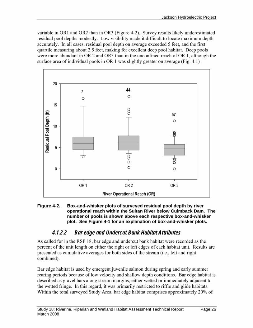
Jackson Hydroelectric Project
Study 18: Riverine, Riparian and Wetland Habitat Assessment Technical Report Page 26 March 2008
variable in OR1 and OR2 than in OR3 (Figure 4-2). Survey results likely underestimated residual pool depths modestly. Low visibility made it difficult to locate maximum depth accurately. In all cases, residual pool depth on average exceeded 5 feet, and the first quartile measuring about 2.5 feet, making for excellent deep pool habitat. Deep pools were more abundant in OR 2 and OR3 than in the unconfined reach of OR 1, although the surface area of individual pools in OR 1 was slightly greater on average (Fig. 4.1)
Figure 4-2. Box-and-whisker plots of surveyed residual pool depth by river
operational reach within the Sultan River below Culmback Dam. The number of pools is shown above each respective box-and-whisker plot. See Figure 4-1 for an explanation of box-and-whisker plots.
4.1.2.2 Bar edge and Undercut Bank Habitat Attributes As called for in the RSP 18, bar edge and undercut bank habitat were recorded as the percent of the unit length on either the right or left edges of each habitat unit. Results are presented as cumulative averages for both sides of the stream (i.e., left and right combined).
Bar edge habitat is used by emergent juvenile salmon during spring and early summer rearing periods because of low velocity and shallow depth conditions. Bar edge habitat is described as gravel bars along stream margins, either wetted or immediately adjacent to the wetted fringe. In this regard, it was primarily restricted to riffle and glide habitats. Within the total surveyed Study Area, bar edge habitat comprises approximately 20% of

Jackson Hydroelectric Project
Study 18: Riverine, Riparian and Wetland Habitat Assessment Technical Report Page 27 March 2008
stream length. Bar edge habitat is more abundant in OR 1 (34%) and OR 2 (18%) versus OR 3 (6%), not surprising given the confined nature of the later two reaches and the preponderance of riffles in the alluvial channels of the lower ~ 3 miles of OR 1. At the habitat sub-unit scale, bar edge habitat is generally most abundant in low gradient riffles, glides and rapids (Figure 4-3).
0
5
10
15
20
25
30
35
40
45
50
BKW MCP SCP LGR RPD GLD CAS
Habitat Sub-Unit Type
Perc
ent B
ar E
dge H
abita
t per
Uni
t Stre
amba
nk
OR 1OR 2OR 3Overall Average
Figure 4-3. Average length (expressed as a percent) of bar edge per sub-unit
type habitat unit by river operational reach (OR) in the Sultan River downstream of Culmback Dam. Habitat sub-unit types as described in Table 3-3: backwater pool (BKW), main channel pool (MCP), lateral scour pool (SCP), low gradient riffle (LGR), rapid (RPD), glide (GLD) and cascade (CAS).
Undercut banks associated with habitat units provide refuge–cover and habitat complexity for fish and other aquatic organisms. Throughout the total surveyed Study Area, only 15 habitat units had undercut banks. The majority of undercut bank habitat observed is present in OR 1 and was primarily associated with main channel pools, where they accounted for approximately 5% of the total cumulative perimeter length of all such pools. Across all operational reaches, undercut bank features were essentially absent (0.6% per habitat unit stream length) and predominantly found along side of main channel pools (average of 2% of stream perimeter length). The lateral depth of undercut bank areas was relatively narrow, with an overall average incision depth of 0.82 ft.

Jackson Hydroelectric Project
Study 18: Riverine, Riparian and Wetland Habitat Assessment Technical Report Page 28 March 2008
4.1.3 Results: Large Woody Debris Survey A field census of abundance and key attributes of LWD was included with the riverine habitat survey of the Sultan River corridor below Culmback Dam. Within the surveyed Study Area a total of 2,029 LWD pieces were tallied, including individual pieces and pieces within debris jams (Figure 4-4). Individual pieces account for 67% of surveyed LWD, with the remaining 33% present within debris jams.
Figure 4-4. Distribution and frequency (number of pieces) of surveyed LWD within the Sultan River downstream of Culmback Dam. Debris Jam frequency value indicates the number of individual pieces in each jam.
The density of LWD can be presented using a variety of denominators. For this report, density of LWD is presented as pieces per mile of stream channel, stratified by operational reaches. Using river operational reach lengths and including all LWD surveyed (according to survey methods outlined in Section 3.2.2), LWD density is highest in middle reach (OR 2), followed by the upper reach (OR 3). The lowest density occurs in the lowermost alluvial section (OR 1) (Table 4-5).
Table 4-5. LWD density per mile in the Sultan River downstream of Culmback Dam.
River Operational Reach (OR)
OR Length (mi)
LWD density per mile including only
individual pieces
LWD density per mile including individual
pieces and debris jam pieces
OR 1 4.95 47 80 OR 2 5.12 114 196
0
10
20
30
40
50
60
70
80
90
100
0 2 4 6 8 10 12 14 16
River Mile
Freq
uenc
y
LWD Rootwads and Single Pieces Debris Jams
Operational Reach 1 Operational Reach 2 Operational Reach 3
# Pi
eces

Jackson Hydroelectric Project
Study 18: Riverine, Riparian and Wetland Habitat Assessment Technical Report Page 29 March 2008
River Operational Reach (OR)
OR Length (mi)
LWD density per mile including only
individual pieces
LWD density per mile including individual
pieces and debris jam pieces
OR 3 6.10 90 102
4.1.3.1 LWD - Individual Pieces Data collected for individual LWD pieces included categories of piece diameter, length estimates, species type, and decay class. For purposes of the survey, individual LWD pieces were tallied separate from pieces occurring within debris jams. Approximately 47% of all individual LWD pieces are downed trees of a small diameter class (20 to 40 cm), 37% are of medium diameter (>40–60 cm), and 15% are of large diameter (>60 cm). LWD occurring as rootwads constitute less than 1% of all individual LWD pieces within the total surveyed Study Area.
The abundance of LWD pieces is greatest in OR 2, followed by OR 3 with the least volume seen in the unconfined lower three miles of OR 1. Large LWD pieces (defined by diameter class) are most abundant in OR 3 and account for 55% of all large LWD pieces encountered in the total surveyed Study Area (Table 4-6).
“Key pieces” are LWD of exceptional size, both in terms of diameter and length, and are of interest given their resistance to downstream movement and the influence they have on channel-forming processes. A total of 26 individual key pieces (not including those in debris jams) are present in the Study Area. A majority of the total key LWD pieces are found in OR 3 (23 of the total 26 key pieces), as can be examined in the corresponding GIS data layer using Arc GIS tools.
Table 4-6. Abundance and distribution of individual LWD pieces by size, category type, and river operational reach within the Sultan River downstream of Culmback Dam.
Number of individual LWD pieces by River Operational Reach (OR)
LWD Size Category Type
OR 1 (RM 0.0-4.95)
OR 2 (RM
4.95-10.07)
OR 3 (RM
10.07-16.17)
Total
Rootwad 4 2 7 13 Small ( >20 – 40 cm) 106 300 235 641 Medium ( >40 – 60 cm) 88 229 196 513 Large ( > 60 cm) 35 55 112 202
Total 233 586 550 1369

Jackson Hydroelectric Project
Study 18: Riverine, Riparian and Wetland Habitat Assessment Technical Report Page 30 March 2008
Figure 4-5. Box-and-whisker plots of overall LWD lengths by diameter size categories (plot A) and by river operational reach (plot B) in the Sultan River downstream of Culmback Dam. Plots depict individual LWD pieces within the bankfull channel that are >20 cm in diameter and >6 feet in length. Refer to Figure 4-1 for an explanation of box-and-whisker plots.
Jackson Hydroelectric Project
Study 18: Riverine, Riparian and Wetland Habitat Assessment Technical Report Page 31 March 2008
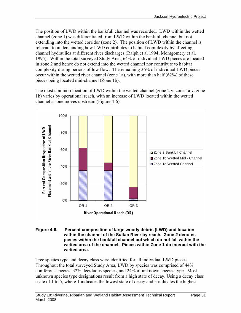
The position of LWD within the bankfull channel was recorded. LWD within the wetted channel (zone 1) was differentiated from LWD within the bankfull channel but not extending into the wetted corridor (zone 2). The position of LWD within the channel is relevant to understanding how LWD contributes to habitat complexity by affecting channel hydraulics at different river discharges (Ralph et al 1994; Montgomery et al. 1995). Within the total surveyed Study Area, 64% of individual LWD pieces are located in zone 2 and hence do not extend into the wetted channel nor contribute to habitat complexity during periods of low flow. The remaining 36% of individual LWD pieces occur within the wetted river channel (zone 1a), with more than half (62%) of these pieces being located mid-channel (Zone 1b).
The most common location of LWD within the wetted channel (zone 2 v. zone 1a v. zone 1b) varies by operational reach, with an increase of LWD located within the wetted channel as one moves upstream (Figure 4-6).
0%
20%
40%
60%
80%
100%
OR 1 OR 2 OR 3
River Operational Reach (OR)
Perc
ent C
ompo
sitio
n Re
spec
tive o
f LW
D Pl
acem
ent w
ithin
the R
iver B
ankf
ull C
hann
el
Zone 2 Bankfull ChannelZone 1b Wetted Mid - ChannelZone 1a Wetted Channel
Figure 4-6. Percent composition of large woody debris (LWD) and location within the channel of the Sultan River by reach. Zone 2 denotes pieces within the bankfull channel but which do not fall within the wetted area of the channel. Pieces within Zone 1 do interact with the wetted area.
Tree species type and decay class were identified for all individual LWD pieces. Throughout the total surveyed Study Area, LWD by species was comprised of 44% coniferous species, 32% deciduous species, and 24% of unknown species type. Most unknown species type designations result from a high state of decay. Using a decay class scale of 1 to 5, where 1 indicates the lowest state of decay and 5 indicates the highest

Jackson Hydroelectric Project
Study 18: Riverine, Riparian and Wetland Habitat Assessment Technical Report Page 32 March 2008
state of decay, the majority (71% ) of individual LWD pieces are either of decay class 2 or 3 (Figure 4-7). This suggests that most of the LWD within the channel is of somewhat recent origin, likely within the last few decades.
Figure 4-7. Composition of individual LWD pieces by species and respective decay class (1 indicates the lowest state of decay and 5 indicates the highest state of decay).
0
100
200
300
400
500
600
1 2 3 4 5
LWD Decay Class
Num
ber o
f Indi
vidua
l LW
D Pi
eces
UnknownDeciduousConifer
0%
10%
20%
30%
40%
50%
60%
70%
80%
90%
100%
1 2 3 4 5
LWD Decay Class
Perc
ent C
ompo
sitio
n
UnknownDeciduousConifer

Jackson Hydroelectric Project
Study 18: Riverine, Riparian and Wetland Habitat Assessment Technical Report Page 33 March 2008
4.1.3.2 LWD Debris Jams For the purpose of this study debris jams are defined as the accumulation of ten or more downed trees and/or rootwads that exceed 20 cm in diameter, exceed 1.82m (6 feet) in length, and are physical interlocked or in contact with one another (Schuett-Hames et al. 1999). Within the total surveyed Study Area there are 21 debris jams, 8 of which are located in OR 3, 10 in OR 2, and 3 in the unconfined reaches of OR 1 (Figure 4-4 and Table 4-7). Collectively, debris jams contain approximately 660 LWD pieces. Debris jams of notable size include two located within OR 2, which each contain nearly eighty pieces (Figure 4-4).
Within each debris jam observed, the diameter and length were recorded for the largest piece of LWD. Five of the debris jams contain LWD that can be classified as a “key piece” (of exceptional size both in terms of length and diameter [Table 4-7]).
The majority of debris jams (15 of 21) are located entirely or partially within the wetted portion of the river channel (at time of survey), while the remaining six (6) debris jams were located entirely outside of the wetted portion of the river.
Table 4-7. Abundance and composition of LWD debris jams within river
operational reaches of the Sultan River downstream of Culmback Dam.
River Operational Reach (OR) Total
OR 1 (RM 0.0-4.95)
OR 2 (RM
4.95-10.07)
OR 3 (RM
10.07-16.17)
Number of LWD Debris Jams
3 10 8 21
LWD Debris Jam Composition
Total Number of LWD Pieces
(including rootwads and key pieces)
162 420 78 660
Number of Rootwads
2 2 0 4
Number of LWD Key
Pieces
0 2 3 5

Jackson Hydroelectric Project
Study 18: Riverine, Riparian and Wetland Habitat Assessment Technical Report Page 34 March 2008
4.1.4. Characterization of River Channel Substrate RSP 18 calls for a characterization of bed sediment size, although it does not specify methods for identifying substrate composition as an attribute of riverine habitat. RSP 22 will describe channel substrate quantitatively and provide an in-depth characterization of sediment and sediment movement throughout the Sultan River basin. Pebble counts were conducted throughout an limited number of sites within the Study Area using methods developed by Wolman (1954). Sampling was limited to exposed gravel deposits (patch gravels) within deposits potentially suitable for spawning habitat. A D50 value ranging from 20 to 60 mm with less than 10% of particles smaller than 0.85 mm in diameter is considered suitable substrate size for spawning anadromous fish (Kondolf and Wolman, 1993; Kondolf 2000). Results from Wolman pebble counts are presented in Table 4-8. Table 4-8. Approximate size distribution (in mm) of river substrate material
from sample sites throughout the Sultan River Study Area presented as calculated D16, D50 (the 16% and median or 50th percentile substrate size as a measure of the b-axis length in mm) and D84 range values (i.e. 84% of all particles are smaller than this size) (Wolman 1954).
Stream Substrate Particle Size (mm)
River Operational Reach (OR)
River Mile D16 D50 D84
OR 1 0.96 9 21 47 OR 2 8.98 13 37 54 OR 3 10.37 11 28 45 OR 3 10.79 10 20 38 OR 3 11.89 15 30 50 OR 3 12.84 11 30 60 OR 3 13.47 16 31 71 OR 3 14.61 7 15 27 OR 3 15.08 23 39 54
4.1.5 Data Layers Data layers accessible through the project GIS include both field-mapped habitat data and a set of base map data for visual orientation and analysis. Several of these layers are shown in Figure 4-8. Field data compiled in a tabular format can be accessed via the GIS data layers in real time.

Jackson Hydroelectric Project
Study 18: Riverine, Riparian and Wetland Habitat Assessment Technical Report Page 35 March 2008
The aerial photograph layer consists of tiled orthophotos collected in 2003. The spatial resolution of these photos is sufficient to resolve many habitat features and landmarks such as large boulders. Figure 4-8 shows a four-foot vertical interval contour line overlay. Channel gradient (Figure 3-2) was derived from a smoothed 2-foot contour coverage intersected with the channel centerline.
Base map layers specific to the Sultan River corridor include a point shapefile of approximate river miles, and a river centerline used for length calculations (not shown in Figure 4-8). The channel centerline and channel left and right banks were derived from the DEM and aerial photographs to reflect the inferred bankfull channel width. Details on the individual data layers, their sources, and a summary of the attributes within the layer are available in the GIS metadata.
The primary field data layer is the delineated habitat units, labeled by consecutive number within each operational reach and shown in blue in Figure 4-8. Unit boundaries were mapped in the field and transferred to the GIS, and were then intersected with channel bank lines. Habitat polygons are linked to the field mapped data based on habitat unit (or NSO) number. Within the GIS, the attribute table for the habitat polygon layer includes “hyperlinks” to field photographs where available. A base layer of roads, obtained from Snohomish County, is included in the GIS but not shown in Figure 4-8.
Field-mapped data layers in the GIS also include debris jams (not shown in Figure 4-8) and "landmarks" (labeled in red in Figure 4-8) such as large semi-permanent boulders used for linking the filed map tiles to the aerial photo layers in the GIS. Corresponding data layers are available in the documentation associated with the GIS data-layers provided as part of this study.
The compilation of census data and its integration into corresponding data-layers developed through the Arc GIS format provide a means to examine a multitude of relationships among the survey metrics. For example, as shown in Figure 4-9, instream habitat units can be displayed for a given section of the river. This example is located at River Mile 5 near the boundary between Operational Reaches (OR) 1-2. Habitat units are numbered by OR and Natural Sequence Order (NSO) as defined in the field. The interactive database allows one to access the actual field data for any given habitat unit of interest.
Similarly, associations of Large Woody Debris (LWD) accumulations and Debris Jams as they occur within individual habitat units can be displayed as depicted in Figure 4-10. This example is located at River Mile 11 (Operational Reach 3) coincident with the powerhouse and at the boundary between OR 2 and OR 1. Habitat units are labeled by OR and NSO number, along with general habitat category (“Pool” vs. “Run”).
Channel gradients coincident with habitat units can also be represented in map form as illustrated by Figure 4-11. This example is located near River Mile 14 where the “Stringer Bridge” is accessible from the north via a closed unimproved road. Using Arc GIS tools allows the interested user to run a multitude of views compiling different data layers to examine spatial relationships of interest.

Jackson Hydroelectric Project
Study 18: Riverine, Riparian and Wetland Habitat Assessment Technical Report Page 36 March 2008
Figure 4-8. Example of aerial photo tile with delineated habitat units.
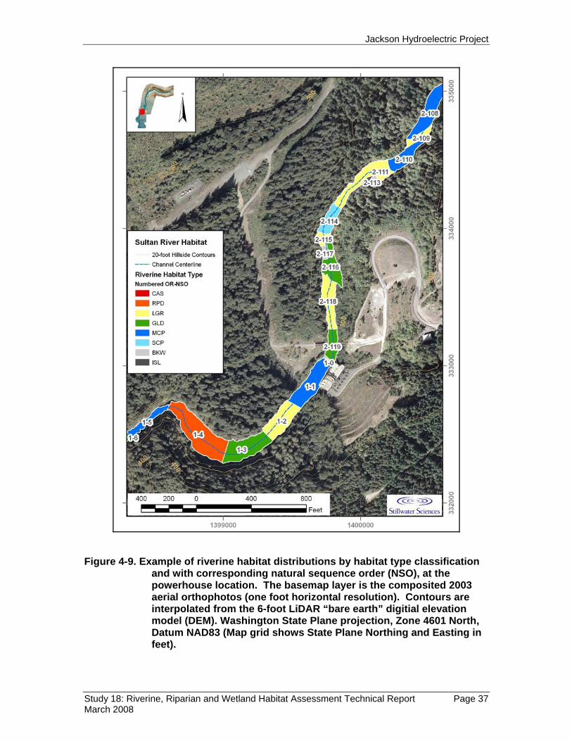
Jackson Hydroelectric Project
Study 18: Riverine, Riparian and Wetland Habitat Assessment Technical Report Page 37 March 2008
Figure 4-9. Example of riverine habitat distributions by habitat type classification and with corresponding natural sequence order (NSO), at the powerhouse location. The basemap layer is the composited 2003 aerial orthophotos (one foot horizontal resolution). Contours are interpolated from the 6-foot LiDAR “bare earth” digitial elevation model (DEM). Washington State Plane projection, Zone 4601 North, Datum NAD83 (Map grid shows State Plane Northing and Easting in feet).

Jackson Hydroelectric Project
Study 18: Riverine, Riparian and Wetland Habitat Assessment Technical Report Page 38 March 2008
Figure 4-10. Riverine habitat showing Large Woody Debris (LWD) concentration and Debris Jams. This example is located at River Mile 11 (Operational Reach 3). Note map is oriented with North to the left side of the page. Habitat units are labeled by OR and NSO number, along with general habitat category (“Pool” vs. “Run”). The basemap layer is shaded relief over the LiDAR “first return” grid, processed to show generalized vegetation height (dark green represents >20-foot tree heights; light gray = zero height, i.e. unvegetated surface). Contours are interpolated from the 6-foot LiDAR “bare earth” digitial elevation model (DEM). Washington State Plane projection, Zone 4601 North, Datum NAD83 (Map grid shows State Plane Northing and Easting in feet).

Jackson Hydroelectric Project
Study 18: Riverine, Riparian and Wetland Habitat Assessment Technical Report Page 39 March 2008
Figure 4-11. Riverine habitat showing channel gradient. This example is located near River Mile 14 where the “Stringer Bridge” is accessible from the north via a closed unimproved road. Note map is oriented with North to the left side of the page. Habitat units are labeled by habitat type (see report text for abbreviations). Contours are interpolated from the 6-foot LiDAR “bare earth” digitial elevation model (DEM). Washington State Plane projection, Zone 4601 North, Datum NAD83 (Map grid shows State Plane Northing and Easting in feet).

Jackson Hydroelectric Project
Study 18: Riverine, Riparian and Wetland Habitat Assessment Technical Report Page 40 March 2008
4.2 Riparian and Wetland Habitat Mapping The non-riverine portion of the Study Area encompasses an area of 14,353.2 acres along both sides of the Sultan River. This area consists of 98.8 acres of open water and 14,254.4 acres of land. The land portion of the Study Area is further divided into developed and undeveloped areas with forested cover types the dominant feature on the landscape. Figure 4-12 shows the acres within the hierarchy of the major mapping categories in the Study Area. Only 7.6 percent of the Study Area has been developed, with 92.4 percent of the Study Area remaining in an undeveloped condition with native vegetation cover or open water wetlands.
Figure 4-12. Hierarchy of land type classification and area.
4.2.1 Forested Cover Types Forested cover types represent the dominant vegetation class within the Study Area, representing 85.9 percent of the total. Table 4-9 shows the total acres in each cover type and the proportion of each seral stage within a cover type. The dominant cover type / seral stage combination within the project area is the mid-successional conifer class. This class represents approximately 35 percent of the entire Study Area. Maps displaying cover type data are provided in Appendix B.
Study Area 14,353.2 acres
Land 14,254.4 acres
Water (Open Water
Wetlands) (excluding Sultan
River)
Developed 1,092.4 acres
Undeveloped 13,162.0 acres
Non-Forested 826.0 acres
Forested 12,336.0 acres
Wetland 114.7 acres
Upland 711.3 acres
Wetland 60.4 acres
Upland 12,275.6 acres
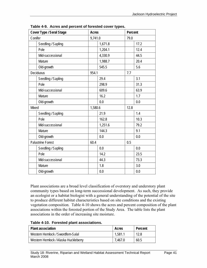
Jackson Hydroelectric Project
Study 18: Riverine, Riparian and Wetland Habitat Assessment Technical Report Page 41 March 2008
Table 4-9. Acres and percent of forested cover types. Cover Type / Seral Stage Acres Percent Conifer 9,741.0 79.0 Seedling / Sapling 1,671.8 17.2 Pole 1,204.1 12.4 Mid-successional 4,330.9 44.5 Mature 1,988.7 20.4 Old-growth 545.5 5.6 Deciduous 954.1 7.7 Seedling / Sapling 29.4 3.1 Pole 298.9 31.3 Mid-successional 609.6 63.9 Mature 16.2 1.7 Old-growth 0.0 0.0 Mixed 1,580.6 12.8 Seedling / Sapling 21.9 1.4 Pole 162.8 10.3 Mid-successional 1,251.6 79.2 Mature 144.3 9.1 Old-growth 0.0 0.0 Palustrine Forest 60.4 0.5 Seedling / Sapling 0.0 0.0 Pole 14.2 23.5 Mid-successional 44.3 73.3 Mature 1.8 3.0 Old-growth 0.0 0.0 Plant associations are a broad level classification of overstory and understory plant community types based on long-term successional development. As such, they provide an ecologist or a habitat biologist with a general understanding of the potential of the site to produce different habitat characteristics based on site conditions and the existing vegetation composition. Table 4-10 shows the acres and percent composition of the plant associations within the forested portion of the Study Area. The table lists the plant associations in the order of increasing site moisture.
Table 4-10. Forested plant associations. Plant association Acres Percent Western Hemlock / Swordfern-Salal 1,581.1 12.8 Western Hemlock / Alaska Huckleberry 7,467.0 60.5

Jackson Hydroelectric Project
Study 18: Riverine, Riparian and Wetland Habitat Assessment Technical Report Page 42 March 2008
Plant association Acres Percent Western Hemlock / Swordfern-Oregon Grape 2,080.3 16.9 Western Hemlock / Swordfern-Foamflower 1,142.8 9.3 Western Hemlock / Devil's Club-Ladyfern 4.5 < 0.1 Western Hemlock / Skunkcabbage 60.4 0.5
4.2.2 Wetland Cover Types There are three general categories of wetlands within the hierarchy of land type classification, open water, non-forested, and forested (see Figure 4.9 above) representing a total of 273.9 acres in the Study Area. Open water wetlands include large ponds and small lakes and cover a total of 98.8 acres, 36.1 percent of all wetlands. Non-forested wetlands cover 114.7 acres and forested wetlands cover 60.4 acres, respectively 41.9 and 22.1 percent of all wetlands. Table 4-11 shows the number of acres by each wetland type in the Study Area.
Photo interpretation of landscape features across the Study Area shows that wetlands are located in two distinct topographic positions in the Study Area, within the recent historical flood plain terrace of the Sultan River, and outside or upland of the river flood plain. These locations are a result of different historical geological forces present in each area which produce different types of wetland features. Wetlands in the flood plain are in a low topographic position relative to the river and occur on alluvial soils. Wetlands outside of the flood plain are either a result of geological scour, or are located in areas where ancient river terraces are isolated from the river by a large elevational difference.
The flood plain wetlands area generally located throughout the rural developed areas in the city of Sultan, adjacent to the lower 1.5 miles of the Sultan River. Wetlands originating from geological scour are generally located upstream of Process Reach #2 at river mile (RM) 3.3. Ancient river terraces containing wetlands are present in several locations between approximately RM 1 and RM 10.
Table 4-11. Acres of wetlands in the Study Area. Cover Type Acres Percent Lacustrine Open Water 26.0 9.5 Palustrine Open Water 72.8 26.6 Riverine Unconsolidated Shore 3.0 1.1 Palustrine Emergent 41.4 15.1 Palustrine Shrub / Scrub 70.3 25.7 Palustrine Forested 60.4 22.1 Total 273.9 100

Jackson Hydroelectric Project
Study 18: Riverine, Riparian and Wetland Habitat Assessment Technical Report Page 43 March 2008
Wetlands that are within the current flood plain of the Sultan River, and in relative proximity to the river, were evaluated to identify if there is a direct hydrological connection between the wetland and the river. Table 4-12 shows the wetlands that were identified having a connection to the river, and the relationship of that connection.
Table 4-12. Wetlands connected to the river. Cover Type # of
Wetlands Acres Connection Type Comment
Lacustrine Open Water 1 26.0 Discharges water to river.
This is the mapped portion of Spada Lake within the Study Area.
Palustrine Open Water 2 1.9 Discharges water to river.
One wetland near RM 1 and city park. One wetland near RM 15.5 and existing kayaker access point.
Riverine Unconsolidated Shore
5 3.0 Discharges and receives water from river.
All wetlands are gravel bars along the existing river margin or adjacent to mid-river islands.
Palustrine Emergent 0 0 Palustrine Shrub / Scrub 0 0 Palustrine Forested 0 0 The only wetlands that receive a flow of water from the Sultan River to support their condition are unvegetated gravel bars along the existing river margin, or adjacent to mid-river islands. There are two vegetated wetlands adjacent to the Sultan River that have a direct connection discharging water to the river. One wetland is located on the east side of the river near RM 1 within the city park. This wetland is part of an old river oxbow where the discharge flows into Winters Creek (Appendix B, Map 2). There are signs that beavers also provide a function in maintaining this wetland feature. A second wetland that discharges to the river is located on the south side of the river near RM 15.5. The existing river access point for miners and kayakers is present a short distance downstream of this wetland. Upstream of the outlet, this wetland is isolated from the river by a small ridge running parallel to the river. Therefore all water input to this wetland is received from the adjacent upland hillslope. This wetland has an open water component throughout most of the year, but during dry summer periods the pond may also go dry. Field verification at this site during the first week of August 2007 found a dry pond, however open water is visible on aerial photos dated August 9, 2001.
5.0 DISCUSSION
Interpretation of the results of this survey of riparian, wetland and instream aquatic habitats should await completion of a number of related ongoing studies associated with Project relicensing. These include Study Plan 3: Sultan River Instream Flow Study; Study Plan 5: Juvenile Fish Abundance, Life History and Distribution ; Study Plan 22:

Jackson Hydroelectric Project
Study 18: Riverine, Riparian and Wetland Habitat Assessment Technical Report Page 44 March 2008
Sultan River Physical Process Studies Jackson Hydroelectric Project; and Study Plan 23: Indicators of Hydrologic Alteration/Range of Variability Analysis (IHA/RVA) in the Sultan River Downstream of Culmback Dam.
5.1 Riverine habitat characteristics Aquatic habitat conditions in the Sultan River below Culmback Dam were surveyed in 2003 and 2004 and the results were presented in Section 5.3.2 of the PAD (Snohomish County PUD and City of Everett 2005). This survey employed a rapid ground survey complemented by use of low-elevation aerial video of the river. Study Plan 18 resulted from a desire for a more systematic survey using more standardized field methods. Earlier results from the 2003 and 2004 surveys are useful in providing an historic frame of reference of habitat conditions, but because methods differed from the present study, a direct comparison of results is not particularly useful at this time. However, it seems unlikely that there would be much change in overall habitat distribution over such a short period of time, given both the resilience to change channel form imposes and the relatively insignificant role that LWD plays in forming pools.
This field effort involved a complete census of instream habitat types and associated in-river large woody debris. The only section that was excluded in this effort is the highly confined 0.7 mile section immediately below Culmback Dam, as its character was thoroughly described by Ruggerone (2006). The objective was descriptive, with the intent to characterize the nature and spatial distribution of habitat types and their coincidence with LWD. The characteristics of in-channel aquatic habitats and LWD within the Sultan River below Culmback Dam are determined by the geomorphic context of the river. This will be discussed in greater detail in the report for RSP 22: Sultan River Physical Process Studies. A brief synopsis is provided here.
The Sultan River through the gorge (OR 3 and OR2) is a confined plane bed channel, with step-pool to cascade sections that are frequently infused with landslide deposits. The uppermost section of ~ 0.7 miles below Culmback Dam is a slot canyon with steep falls and cascade drops over large boulders or bedrock chutes as described by Ruggerone (2006). For most of its course from here downstream (~RM 16.2 to 2.7), the river flows through a highly confined canyon corridor that restricts channel migration or formation of side channels.
There is little or no influence by in-channel wood on pool or riffle formation as the confined channel at flood stage exhibits substantial stream power and consequent high transport capacity to limits LWD deposits to accumulate under current conditions. Rather, the main pool forcing mechanism is by landsliding and resulting debris dams. Although adequate sediment exists in the channel, for the most part the channel is steep in gradient and highly confined such that it does not exhibit a braided form. The exception to this condition is in the lower 2.7 miles of channel upstream from its confluence with the Skykomish River.
Channel reach morphology and associated aquatic habitat types encountered in the uppermost and middle reaches of the Study Area are those one would expect to see in a
Jackson Hydroelectric Project
Study 18: Riverine, Riparian and Wetland Habitat Assessment Technical Report Page 45 March 2008
highly confined river (Montgomery et al. 1995, Montgomery et al. 1996, Montgomery and Buffington 1997, Bisson et al. 2006). Geomorphic features and habitat units in both OR 3 and OR 2 are characterized by long and relatively narrow pools, riffles, cascades or glides (i.e. plane bed, step pool, and cascade reaches). Bankfull width is typically synonymous with habitat unit width. Glide-like pools are the dominant feature in OR 2 and OR 3 and are typically hundreds of feet in length, but are punctuated by bedrock pools of great depth. In sharp contrast, the river in OR 1 (especially from RM 2.7 downstream) flows through a lower gradient, much unconfined alluvial valley (plane bed and pool riffle reaches). Here, low gradient riffles, glides and islands are more typical than seen in the higher energy canyon reaches.
A second factor governing habitat formation is the contrasting range of flows in each operational reach of river. The present form river channel was shaped by historic flows over the last ~ 12,000 years since retreat of regional ice sheets. Current flow regimes, especially in the bypass reach are significantly below those prior to installation of the existing dam. In the highly confined uppermost reach of OR3, project release flows from Culmback Dam are ~ 20 cfs, with some minor contributions from tributary inputs. This volume of flow imparts a reduced flow velocity through the channel that may change velocity profiles through units and thus create more pool habitat than would be likely if flows were increased. These phenomena will be examined in the results of the instream flow study in RSP 3. Under current flow releases, pools are long with depths determined by the relative elevation of the downstream hydraulic control on water surface elevations. Riffles are typically shallow and narrow, with widths determined by bedrock the proximity of the canyon walls.
In OR 2, which starts at the diversion dam at RM 10.07 and ends at the powerhouse at river mile 4.95, flow within the channel is typically supplemented by return flow from Lake Chaplain. This added flow, combined with areas of channel that are slightly less constrained results in habitat units that are deeper and exhibit greater flow velocities than seen in OR 3. Likewise, flows in the river (OR 1) below the powerhouse return flow at RM 4.95 increase in proportion to power generation. These powerhouse release flows also change the velocity characteristic within downstream habitat units. These flow regimes, when coupled with a distinct change in river morphology at ~ RM 2.7 (coincident with the BPA transmission line crossing) result in habitat units that are more typical of an alluvial valley river, that is dominated by low gradient riffles and glides, with significantly fewer pools overall when compared with the middle and upper reaches (see table 4-1).
5.2 Large woody debris (LWD) characteristics An extensive literature documents the influence of LWD on channel morphology and consequent habitat complexity in forested mountain basins (Ralph et al. 1994, Montgomery et al. 1995, Abbe and Montgomery 1996, Montgomery and Buffington 1997, Fox et al. 2003, Fox and Bolton 2007). Geomorphic factors such as channel width, gradient, confinement, bed form, and reach morphology can also influence quantity and organization of instream wood (see summary in Booth and Fox 2004).

Jackson Hydroelectric Project
Study 18: Riverine, Riparian and Wetland Habitat Assessment Technical Report Page 46 March 2008
Given that Culmback Dam blocks wood debris from the upper watershed from entering the river, wood input sources in the upper and middle reaches (OR 3 and OR 2) are from landslides or windthrow from adjacent hill slopes (as opposed to bank erosion). Although except for the lower 2.7 miles of OR 1, instream LWD appears modestly abundant in the study area (see Table 4-6), much of it is small to medium in size. The results suggest that the role of large woody debris in forming habitats, especially pool habitats is very limited in the more confined reaches of OR 3 and OR 2 (see Table 4-4). Size of instream LWD does matter in terms of transport by high winter flow events, especially in the high energy confined reaches of the Sultan River where only the very largest pieces of LWD would likely be resistant to transport. It does seem likely that wood entering the middle and upper reaches is retained for only the interval between significant seasonal flow events. The study report for RSP 22 (Physical Process Study) will examine this issue in much greater detail.
As the data shows, LWD in the three study reaches of the Sultan River is largely positioned along the channel margins. It appears that logs are floated during rare winter flood events and are transported downstream where they become perched along the channel margins and on boulders when water surface elevations return to normal. Wood in this position does not provide much obstruction to flow and therefore contributes little to channel and habitat complexity.
Fox (2001, 2003) reported that in rivers of Washington State wood volume per 100 m increases as channels become wider, and that greater volumes per 100 m occur in unconfined streams than in streams that are confined. Fox (2001, 2003) also noted that with the exception of basins <4 km2in area wood volume observed increased in confined alluvial channels as compared to confined bedrock channels. The study report being prepared for RSP 22 will present a more thorough analysis of LWD volume. A graph of LWD volume per channel width will be presented in this report that compares the Sultan River volumes per channel width, with those presented in Fox (2003). This graph illustrates that LWD volme in the Sultan River is less than reported in other rivers of comparable bankfull channel width. This might reflect the influence of stream power in moving LWD out of the confined channel. There is very little LWD in the lower 2.7 miles of OR 1, and what is there, is primarily aggregated in jams (Figure 4-4, Tables 4-6 and 4.7).
For the upper two reaches, OR 3 and OR 2, the confined, bedrock and boulder channel form is the dominant determinant of pool formation. Riffles appear closely associated with lag deposits from landslides into the gorge (Byron Amerson, pers. Com), although this phenomena will be examined more thoroughly in the geomorphic analysis report of RSP 22. Of all of the major pools in all reaches, LWD was only found to be associated with forming the pool in one instance. Bedrock obstructions and boulders are the dominant pool forming factor in all reaches. In the unconfined, alluvial lowermost river reach (OR1) where one would expect LWD to significantly account for pool formation, there is little wood of sufficient size to provide the needed structural complexity that would lead to pool formation. In addition, the lower 0.7 miles of the Sultan River is subject to backwater flooding effects when the Skykomish River is at flood stage or

Jackson Hydroelectric Project
Study 18: Riverine, Riparian and Wetland Habitat Assessment Technical Report Page 47 March 2008
above. This too can contribute to entrainment and transport downstream of wood in the lower river.
5.3 Sediment characteristics This instream habitat census also included limited data on bed particle size distribution sampled from patch gravels encountered throughout the census. The initial suggestion that the method used be a visual characterization of gravel size was stymied by persistent turbid water during the census. Determining locations and characteristics of suitable spawning gravels was not an objective of this study, so inferences as to suitability of gravels to accommodate salmonid spawning should await consideration of the results from several related studies including as noted above. Some recent analysis of spawning habitat in the Sultan River has been completed (see for example, Beck and Reiser 2006). Additional analysis of overall sediment supply and characteristics will be included in the study report for RSP 22 Sultan River Physical Process Study.
5.4 Riparian areas The riparian area immediately adjacent to the Sultan River was reviewed to evaluate whether the continued operation of the project and the regulation of river flows influence the plant community composition and seral stage development of these areas. Field verification of the cover type mapping provided an opportunity to observe the existing plant community composition at numerous locations along the river below the dam.
The topography of the area immediately adjacent to the Sultan River and the history of land use practices has been the dominant influence on the existing vegetation composition in this area. Several distinct riparian segments were identified based on these features.
• Segment 1 – Culmback Dam downstream to RM 12. This segment of the riparian area is east-west oriented and generally has long continuous slopes to the river, with only small bluffs immediately adjacent to the river.
• Segment 2 – RM 12 downstream to RM 10. This segment of the riparian area is oriented in a northeast-southwest direction. There are long continuous slopes on the southeast side of the river similar to the segment immediately upstream. The northwest side of the river has a very steep, mostly inaccessible hillslope with some bluffs.
• Segment 3 – RM 10 downstream to RM 3.3. This segment of the riparian area is mostly north-south oriented, has gently sloping topography set back from the river and tall steep bluffs immediately adjacent to the river.
• Segment 4 –RM 3.3 downstream to mouth. This segment of the riparian area is north-south oriented with a broad flood plain on both sides of the river.
Jackson Hydroelectric Project
Study 18: Riverine, Riparian and Wetland Habitat Assessment Technical Report Page 48 March 2008
The riparian area in Segment 1 is dominated by mature coniferous forest on most of the hillslope above both sides of the river. The mature forest originated after timber harvest was conducted during the early to mid-1900’s. Logging systems could not reach areas immediately adjacent to the river, therefore there is generally an area of 100-200 feet upslope from the river that has retained it’s old-growth characteristics.
There are very few flat areas immediately adjacent to the river in this segment, as the hillslope is continuous to the bank of the river. One of these flat areas was observed immediately upstream of the miner and kayak access point. This site is a gravel and cobble bar that may become a side channel to the river during high flow events. The area is vegetated with a young alder sapling stand that may range from 5-10 years old. Alder is an early successional species and commonly colonizes areas with high soil disturbance and low nutrient availability. The establishment of alder at this site indicates that normal successional patterns are occurring immediately adjacent to the river, that seed sources are available and being dispersed through the area and natural germination was not hindered by existing river flows.
The riparian area in Segment 2 is dominated by mature coniferous forest on most of the hillslope on both sides of the river. On the southeast side of the river the vegetation composition and successional development is similar to the river segment immediately upstream. The old-growth forest was harvested to approximately 100-200 feet upslope of the river and this area has developed to a mature forest composition. On the northwest side of the river, steep slopes and bluffs have prevented the harvest of old-growth near the river, therefore the change in plant communities between old-growth and mature forest is further upslope than in other riparian segments. The northwest side of the river receives more sunlight than the upstream segment due to its orientation, and appears to be a drier site, possibly due to different soil and geological conditions. Mixed forest stands are common immediately adjacent to the northwest side of the river in this segment.
There were no flat areas adjacent to the river observed in this segment, as the hillslope is generally continuous to the bank of the river and there is often steep bluffs immediately adjacent to the river. Therefore, there is little opportunity for river flows to directly influence the development of vegetation immediately adjacent to the river.
The riparian area in Segment 3 is dominated by a mixture of mature and old-growth forest on both sides of the river. Immediately adjacent to the river, on both sides throughout this segment, there are very steep forested bluffs. Timber harvest has not occurred on these steep slopes and site disturbance is dominated by hillslope erosion, landslides, and windfall. There were no flat areas adjacent to the river observed in this segment, as the riparian hillslopes are very steep. Therefore, there is little opportunity for river flows to directly influence the development of vegetation immediately adjacent to the river.
The riparian area in Segment 4 is dominated by forested stands of mid-successional and mature, conifer, mixed, and deciduous cover. The topography immediately adjacent to the river in this segment is a gentle sloping low elevation flood plain. A wide range of land use activities occur within the riparian zone, and non-forested areas include pasture

Jackson Hydroelectric Project
Study 18: Riverine, Riparian and Wetland Habitat Assessment Technical Report Page 49 March 2008
lands, rural residential development, city parks, and commercial buildings. The low gradient unconfined geomorphology of the river in this segment allows the river the opportunity for lateral migration and the deposition of sediment. These characteristics of the river create areas where lateral and mid-channel bars of sand, gravel, and cobble are created or exposed. Primary successional development is occurring on these sites as evidenced by changes in the composition of vegetation along a transect perpendicular to the river. These transects show a gradient from unvegetated gravel bars, to herbaceous pioneer species, to shrubs (willow species and salmonberry), to young stands of small diameter deciduous species (alder and cottonwood), to mid-successional stands of deciduous and mixed species. Only three acres, distributed among five wetland areas, in this segment are classified as riverine unconsolidated shore (Table 5-1). Adjacent to the gravel bars are areas classified as young forest types. Therefore, the historical river flows are not preventing the successful colonization of these areas with native species, and the existing river flows are allowing successional development to proceed with minimal repeated disturbances.
5.5 Wetland areas The management of wetlands within the Study Area are predominantly controlled by the rules and guidelines regulating forest practices, and county regulations regarding rural and urban development. As described in Section 4.2.2, there are two main groupings of wetlands within the Study Area, those within the recent historical flood plain of the Sultan River and those topographically upland or outside of the existing flood plain. The flood plain wetlands are located within Process Reach #1 and #2 below RM 3.3. The wetlands outside of the Sultan River flood plain are generally in areas being managed for forest products, or natural forest habitats owned by federal, state or private land owners. Table 5-2 shows the number and type of wetlands that are outside of the Sultan River flood plain. State of Washington forest practice rules would apply to the management of forest land administered by the State and by private land owners. These rules identify riparian and wetland protection requirements (WAC 222-30). The Northwest Forest Plan applies to federal forest land administered by the US Forest Service. The Northwest Forest Plan amended the Forest Plan for the Mt. Baker-Snoqualmie National Forest to define management areas and protection measures for fish, wildlife, and plant species throughout the forest (US Forest Service and Bureau of Land Management 1994). Table 5-1. Wetlands within the Sultan River flood plain. Wetland Type # of Wetlands Acres Riverine Unconsolidated Shore 5 3.0 Palustrine Open Water 8 20.9 Palustrine Emergent 3 2.2 Palustrine Scrub / Shrub 7 21.9 Palustrine Forest 6 14.8 Total 29 62.8

Jackson Hydroelectric Project
Study 18: Riverine, Riparian and Wetland Habitat Assessment Technical Report Page 50 March 2008
Table 5-2. Wetlands outside the Sultan River flood plain. Wetland Type # of Wetlands Acres Lacustrine Open Water 1 26.0 Palustrine Open Water 9 51.9 Palustrine Emergent 2 39.2 Palustrine Scrub / Shrub 13 48.4 Palustrine Forest 14 45.5 Total 39 211.0 The management of the river flows by the project would have no effect on the wetlands that are outside of the Sultan River flood plain. Snohomish County PUD does own and manage some forest land within the Study Area as part of their wildlife mitigation lands. The management of forests and wetlands owned by the PUD in the Study Area would be regulated under the state forest practices rules and would not affect existing wetland conditions.
Wetlands within the Sultan River flood plain would have the potential to be influenced by the operation of the project depending on their location relative to the river, their connectivity to the river, and the operation of the project to manage flows in the Sultan River. Table 5-1 shows the number and type of wetlands that are present within this portion of the Study Area. Flood plain wetlands represent approximately 23 percent of the total wetlands within the Study Area. Most of the flood plain wetlands occur in curved topographic depressions that indicate their origin is a result of historical river channels. These same wetlands are also present within the area that is being developed for urban and rural housing in the city of Sultan. Land use regulations protected these wetlands from being converted to other uses.
Wetlands identified within the Sultan River flood plain were reviewed to classify their connection to the river. With the use of the project facilities to prevent or mitigate high flow events in the lower Sultan River, there are no wetlands that receive water from the river, and only two wetlands that discharge water to the river.
One wetland is located at approximately RM 1 and discharges water into Winters Creek. This wetland is part of an old river oxbow that is within a city park and a designated natural area. The second wetland is located near RM 15.5, and is not included in Table 5-2 above. It is classified as a palustrine open water wetland that is approximately 0.2 acres in size. This wetland receives water from hillslope drainage adjacent to the river and is separated from the river by a small topographic ridge. The wetland discharges water to the river through gravel bed near the river access point used by miners and kayakers.

Jackson Hydroelectric Project
Study 18: Riverine, Riparian and Wetland Habitat Assessment Technical Report Page 51 March 2008
6.0 REFERENCES
Abbe, T. B. and D. R. Montgomery. 1996. Large Woody Debris Jams, Channel Hydraulics and Habitat Formation in Large Rivers. Regulated Rivers: Research & Management 12(2-3): 201-221. 1996 John Wiley & Sons, Ltd.
Beck, Stuart M. and Dudley W. Reiser. 2006. Spatial and Temporal Comparison of
Spawning Gravel Quality in the Sultan River, Washington. Prepared for: Snohomish County Public Utility District No. 1 Everett, Washington, by R2 Resource Consultants, Inc.
Bilby, Robert E. 1988. Interactions between aquatic and terrestrial ecosystems. In Streamside management: riparian wildlife and forestry interactions. Edited by Kenneth J. Raedeke. Proceedings of a symposium on riparian wildlife and forestry interactions held February 11-13, 1987, at the College of Forest Resources, University of Washington, Seattle.
Bisson, P. A., J. M. Buffington and D. R. Montgomery. 2006. Valley Segments, Stream Reaches, and Channel Units. In F. R. Hauer and G.A. Lamberti (Eds) Methods in Stream Ecology. Elsevier Academic Press.
Booth, D. B. and M. J. Fox. 2004 The Role of Large Woody Debris in Lowland Puget
Sound Streams and Rivers. Center for Water and Watershed Studies, University of Washington, Seattle, WA
Cowardin, L.M., V. Carter, F.C. Golet and E.T. LaRue. 1979, Classification of Wetlands and Deepwater Habitats of the United States. U.S. Fish and Wildlife Service. FWS/OBS-79/31.
Flosi, G., Downie, S., Hopelain, J., Bird, M., Coey, R. and Collins, B. California Salmonid Stream Habitat Restoration Manual. 1998. 3rd ed. California Department of Fish and Game. 495 p.
Fox, M. J. 2001. A new look at the quantities and volumes of instream wood in forested basins within Washington State. Master of Science thesis. College of Forest Resources, University of Washington.
Fox, M. J. 2003. Spatial organization, position, and source characteristics of large woody
debris in natural systems. Ph.D. dissertation. College of Forest Resources, University of Washington. Seattle, Washington.
Fox, M. J., Bolton, S., Conquest, L. 2003. Reference conditions for instream wood in
western Washington. In Montgomery, D.R., S.M. Bolton, D.B. Booth, and L.

Jackson Hydroelectric Project
Study 18: Riverine, Riparian and Wetland Habitat Assessment Technical Report Page 52 March 2008
Wall, eds. Restoration of Puget Sound Rivers. University of Washington Press, Seattle, p. 361-393.
Fox, M.J. and S. Bolton. 2007. A regional and geomorphic reference for quantities and
volumes of instream wood in unmanaged forested basins of Washington State. No. Am. J. Fish. Mgmt. 27: 342-359. Geoengineers. 1984. Phase 1 Report, River Gravel Quantity Study. Prepared for Public Utility District No. 1 of Snohomish County, Everett, Washington.
Harrelson, C.C., C. L. Rawlins, and J. P. Potyondy. Stream channel reference sites: an illustrated guide to field technique. USDA Rocky Mountain Forest and Range Experiment Station, GTR-RM-245, Fort Collins, CO.
Kondolf, G.M. 2000. Assessing salmonid spawning gravels. Transactions of the American Fisheries Society 129:262-281.
Kondolf, G.M., and M.G. Wolman. 1993. The sizes of salmonid spawning gravels. Water Resources Research 29:2275-2285.
Lisle, T.E. 1987. Using “residual depths” to monitor pool depths independently of discharge. USDA – Forest Service, Pacific Southwest Forest and Range Experiment Station, Research Note PSW-394. Berkeley, CA.
Mongtomery, D. R., J. M. Buffington, R. D. Smith, K. M. Schmidt and G. Pess. 1995. Pool spacing in forest channels. Water Resources Research Vol 4 (31): 1097-1105.
Montgomery, D. R., T. B. Abbe, J. M. Buffington, N. P. Peterson, K. M. Schmidt, and J. D. Stock. 1996. Distribution of bedrock and alluvial channels in forested mountain drainage basins. Nature 381: 587-589.
Montgomery, D.R., Buffington, J.M. 1997. Channel-reach morphology in mountain
drainage basins. Geol. Soc. Am. Bull. 109: 596-611.
Pleus, A.E., D. Schuett-Hames, and L. Bullchild. 1999. TFW Monitoring Program method manual for the habitat unit survey. Prepared for the Washington State Dept. of Natural Resources under the Timber, Fish and Wildlife Agreement. TFW-AM9-99-003; DNR#105.
Public Utility District No. 1 of Snohomish County and City of Everett. 1988. Wildlife Habitat Management Plan, Henry M. Jackson Hydroelectric Project; 3 volumes.
Public Utility District No. 1 of Snohomish County and City of Everett. 2005. Pre-Application Document; Henry M. Jackson Hydroelectric Project, FERC No. 2157. December 2005.

Jackson Hydroelectric Project
Study 18: Riverine, Riparian and Wetland Habitat Assessment Technical Report Page 53 March 2008
Ralph, S. C., G. C. Poole, L. L. Conquest, and R. J. Naiman. 1994. Stream channel morphology and woody debris in logged and unlogged basins of Western Washington. Canadian Journal of Fisheries and Aquatic Sciences 51:37-51.
Robison, E.G. and R.L. Beschta. 1990. Characteristics of coarse woody debris for several coastal streams of southeast Alaska, USA. Canadian Journal of Fisheries and Aquatic Sciences 47:1684-1693.
Ruggerone, G.T. 2006. Evaluation of salmon and steelhead migration through the upper Sultan River canyon prior to dam construction. Report to the City of Everett, pp. 48.
Schuett-Hames, D., A.E. Pleus, J. Ward, M. Fox, and J. Light. 1999. TFW Monitoring Program method manual for the large woody debris survey. Prepared for the Washington State Dept. of Natural Resources under the Timber, Fish, and Wildlife Agreement. TFW-AM9-99-0004. DNR#106.
Snohomish County PUD and City of Everett. 1988. Wildlife Habitat Management Plan, Henry M. Jackson Hydroelectric Project, 3 Volumes.
US Forest Service. 1992. Field guide to the forested plant associations of the Mt. Baker-Snoqualmie National Forest. USDA Forest Service, Pacific Northwest Region. Technical Paper R6-ECOL-TP-028-91.
US Forest Service and Bureau of Land Management. 1994. Record of decision for amendments to Forest Service and Bureau of Land Management planning documents within the range of the northern spotted owl. Standards and guidelines for management of habitat for late-successional and old-growth forest related species within the range of the northern spotted owl. U.S. Department of Agriculture, Forest Service and U.S. Department of the Interior, Bureau of Land Management. Portland, Oregon. April 1994.
WAC 222-30. Washington Administrative Code, Chapter 222-30. Timber Harvesting Rules, effective July 1, 2005.
Wolman, G.M. 1954. A method of sampling coarse river-bed material. Transactions, American Geophysical Union v35, Number 6.


Jackson Hydroelectric Project
Study 18: Riverine, Riparian and Wetland Habitat Assessment Technical Report March 2008
Appendices


Jackson Hydroelectric Project
Study 18: Riverine, Riparian and Wetland Assessment Technical Report March 2008
APPENDIX A
Riparian and wetland mapping classification system and cover type descriptions


Jackson Hydroelectric Project
Study 18: Riverine, Riparian and Wetland Assessment Technical Report March 2008
A-1
Riparian and Wetland Mapping Classification System A classification system encompassing the range of riparian and wetland types expected to be present in the Study Area included a hierarchical classification of land use features. This classification system permits different land use information to be identified from the cover type data. A complete table of the hierarchical classification system is shown in Table A-1, with additional attributes recorded for selected cover types shown in Tables A-2 and A-3.
Table A-1. Hierarchical mapping classification system. Land Code
Develop Code
Forest Code
Upland Code
Wetland Class
Cover Type Code
Water Riverine see aquatic habitat types in Table 3-3 of this report
Water Wetland Palustrine Palustrine Open Water POW Water Wetland Lacustrine Lacustrine Open Water LOW Land Developed Non-
Forested Upland Project Facilities FAC
Land Developed Non-Forested
Upland Commercial COM
Land Developed Non-Forested
Upland Residential RES
Land Developed Non-Forested
Upland Agricultural AG
Land Developed Non-Forested
Upland Recreational REC
Land Developed Non-Forested
Upland Rock Pit RP
Land Undeveloped Non-Forested
Wetland Riverine Riverine Unconsolidated Shore RUS
Land Undeveloped Non-Forested
Wetland Lacustrine Lacustrine Unconsolidated Shore LUS
Land Undeveloped Non-Forested
Wetland Palustrine Palustrine Emergent 1 PEM
Land Undeveloped Non-Forested
Wetland Palustrine Palustrine Shrub / Scrub 1 PSS
Land Undeveloped Non-Forested
Upland Rock Outcrop RO
Land Undeveloped Non-Forested
Upland Rock Talus RT
Land Undeveloped Non-Forested
Upland Shrubland SH
Land Undeveloped Non- Upland Grass / Meadow MD

Jackson Hydroelectric Project
Study 18: Riverine, Riparian and Wetland Assessment Technical Report March 2008
A-2
Land Code
Develop Code
Forest Code
Upland Code
Wetland Class
Cover Type Code
Forested Land Undeveloped Forested Wetland Palustrine Palustrine Forested 2 PFO Land Undeveloped Forested Upland Conifer 2 C Land Undeveloped Forested Upland Deciduous 2 D Land Undeveloped Forested Upland Mixed 2 M Land Undeveloped Forested Upland Mosaic 2 MO 1 See additional wetland type attributes in Table A-2 below. 2 See additional forest type attributes in Table A-3 below.
Cover Type Definitions
Forested Cover Types Forested cover types are areas containing greater than 30 percent cover of forest species. These cover types may include areas that are currently dominated by shrubs due to recent timber harvest activities.
Conifer – Coniferous forest tree species are present in greater than 60 percent of the forest canopy. Recent timber harvest areas are assumed to be reforested with conifer species.
Deciduous – Deciduous forest tree species are present in greater than 60 percent of the forest canopy.
Mixed – Both coniferous and deciduous forest trees are present with neither type occupying greater than 60 percent of the forest canopy. The spatial distribution of the conifers and deciduous species may be uniformly mixed or in a patchy distribution.
Mosaic – Both coniferous and deciduous forest trees are present with neither type occupying greater than 60 percent of the forest canopy. These areas can not be characterized by a uniform or patchy distribution. The deciduous portion of this type may be associated with stream courses, abandoned road grades, or patterns of soil disturbance associated with historical logging activity.
Wetland Cover Types The description and classification of wetland cover types are based on those defined by Cowardin (1979). Additional attributes describing features of the wetlands in Table A-2 are based on the modifiers described by Cowardin.
Lacustrine Open Water – A freshwater basin or catchment of non-flowing water, generally greater than 20 acres in size.

Jackson Hydroelectric Project
Study 18: Riverine, Riparian and Wetland Assessment Technical Report March 2008
A-3
Lacustrine Unconsolidated Shore – A substrate of organic material, mud, sand, gravel, or cobbles situated adjacent to a freshwater basin greater than 20 acres in size.
Riverine Unconsolidated Shore – A substrate of organic material, mud, sand, gravel, or cobbles situated adjacent to, or within, a channel of flowing water.
Palustrine Open Water – A freshwater basin or catchment of non-flowing water, generally less than 20 acres in size.
Palustrine Emergent – A freshwater basin or catchment of non-flowing water, generally less than 20 acres, containing vegetation composed of emergent vegetative species.
Palustrine Shrub / Scrub – A freshwater basin or catchment of non-flowing water, generally less than 20 acres, containing vegetation composed of shrub or trees species less than 20 feet tall.
Palustrine Forest – A freshwater basin or catchment of non-flowing water, generally less than 20 acres, containing vegetation dominated by trees or shrub species greater than 20 feet tall.
Developed Cover Types Project Facilities – An area containing project facilities, such as a powerhouse.
Commercial – An area of commercial, industrial, or retail buildings, including supporting facilities and infrastructure.
Residential – An area dominated by urban or rural housing developments.
Recreational – An area designated for recreational activities, such as parks, playfields, or campgrounds.
Rock Pit – An area cleared of vegetation and used for the extraction of hard rock materials.
Vegetated Non-Forested Cover Types Agriculture – An area used for the growing and harvesting of planted row crops. This cover type may include vegetated areas and also areas of barren soil between crop seasons.
Grass / Meadow – An area dominated by grass species. These areas may be used for grazing of farm animals, or cropped for hay production.
Shrubland – An area dominated by shrub species generally less than 20 feet tall. This cover type does not include recently harvested forests that would be maintained in forest production and are assumed to contain seedling and sapling size trees.

Jackson Hydroelectric Project
Study 18: Riverine, Riparian and Wetland Assessment Technical Report March 2008
A-4
Undeveloped and Non-Vegetated Cover Types Rock Outcrop – An area dominated by barren ground with less than 30 percent vegetation cover. This cover type includes recent land slides.
Rock Talus – An area of large unconsolidated rocks and boulders with less than 30 percent vegetation cover.
Wetland cover type attributes Wetland cover types were assigned additional attributes information to describe important features of the wetland. The attributes in Table A-2 are based on modifiers described by Cowardin (1979).
Table A-2. Wetland type attributes. Inundation Permanently Flooded PF Intermittently Exposed IE Seasonally Flooded SF Saturated S Artificially Flooded AF Development Excavated EX Impounded IM Diked DK Partly Drained PD Partly Filled PF Farmed F Artificial A Not Developed ND Side Channel Yes No Connectivity Discharges water to river DIS Receives water from river REC
Discharges and receives water from river DR
Not connected to river NC Unknown connection to river UNK

Jackson Hydroelectric Project
Study 18: Riverine, Riparian and Wetland Assessment Technical Report March 2008
A-5
Wetland Inundation Attributes Permanently Flooded – Water covers the land surface throughout the year in all years. Vegetation is composed of obligate hydrophytes.
Intermittently Exposed – Surface water is present throughout the year except in years of extreme drought.
Seasonally Flooded – Surface water is present for extended periods, especially early in the growing season, but is absent by the end of the growing season in most years. When surface water is absent, the water table is often near the land surface.
Saturated – The substrate is saturated to the surface for extended periods during the growing season, but surface water is seldom present.
Artificially Flooded – The amount and duration of flooding is controlled by pumps or siphons in combination with dikes or dams.
Wetland Development Attributes Excavated – The wetland lies within a basin or channel excavated by man.
Impounded – The wetland is created or modified by a barrier or dam which purposefully or unintentionally obstructs the outflow of water. Barriers could be constructed by man or beavers.
Diked – The wetland is created or modified by a man made barrier or dike designated to obstruct the inflow of water.
Partly Drained – The water level of the wetland has been artificially lowered, but the area is still considered a wetland because soil moisture is sufficient to support hydrophytes. Drained areas are no longer considered wetlands if they no longer support hydrophytes.
Partly Filled – A wetland that has been reduced in size due to the reclamation of the area for development.
Farmed – The soil surface has been physically or mechanically altered for the production of crops, but hydrophytes would become reestablished if farming were discontinued.
Artificial – Wetlands that have been created by man using artificial materials in order to maintain saturated soil conditions, or to provide habitat features.
Not Developed – Natural wetlands that have not been disturbed or modified by man.
Wetland Side Channel Yes – The wetland has an inflow and outflow connection to a river during a portion of the typical seasonal hydrograph of the river.
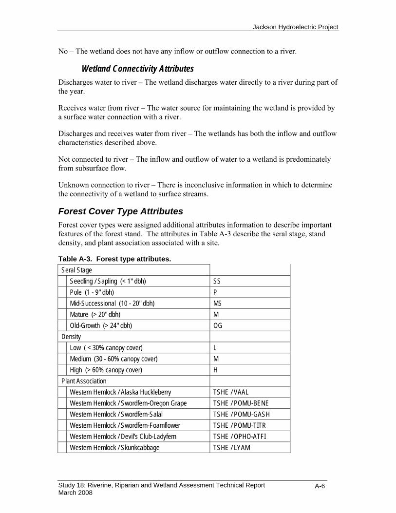
Jackson Hydroelectric Project
Study 18: Riverine, Riparian and Wetland Assessment Technical Report March 2008
A-6
No – The wetland does not have any inflow or outflow connection to a river.
Wetland Connectivity Attributes Discharges water to river – The wetland discharges water directly to a river during part of the year.
Receives water from river – The water source for maintaining the wetland is provided by a surface water connection with a river.
Discharges and receives water from river – The wetlands has both the inflow and outflow characteristics described above.
Not connected to river – The inflow and outflow of water to a wetland is predominately from subsurface flow.
Unknown connection to river – There is inconclusive information in which to determine the connectivity of a wetland to surface streams.
Forest Cover Type Attributes Forest cover types were assigned additional attributes information to describe important features of the forest stand. The attributes in Table A-3 describe the seral stage, stand density, and plant association associated with a site.
Table A-3. Forest type attributes. Seral Stage
Seedling / Sapling (< 1" dbh) SS
Pole (1 - 9" dbh) P
Mid-Successional (10 - 20" dbh) MS
Mature (> 20" dbh) M
Old-Growth (> 24" dbh) OG Density
Low ( < 30% canopy cover) L
Medium (30 - 60% canopy cover) M
High (> 60% canopy cover) H Plant Association
Western Hemlock / Alaska Huckleberry TSHE / VAAL
Western Hemlock / Swordfern-Oregon Grape TSHE / POMU-BENE
Western Hemlock / Swordfern-Salal TSHE / POMU-GASH
Western Hemlock / Swordfern-Foamflower TSHE / POMU-TITR
Western Hemlock / Devil's Club-Ladyfern TSHE / OPHO-ATFI
Western Hemlock / Skunkcabbage TSHE / LYAM
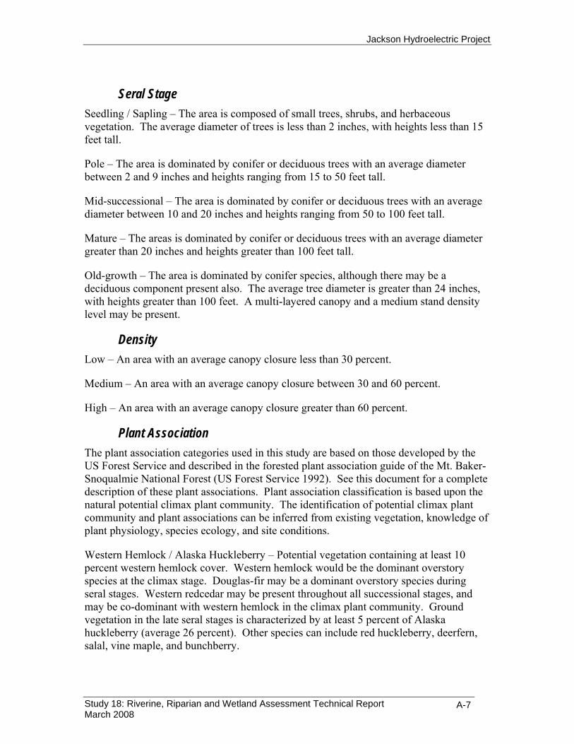
Jackson Hydroelectric Project
Study 18: Riverine, Riparian and Wetland Assessment Technical Report March 2008
A-7
Seral Stage Seedling / Sapling – The area is composed of small trees, shrubs, and herbaceous vegetation. The average diameter of trees is less than 2 inches, with heights less than 15 feet tall.
Pole – The area is dominated by conifer or deciduous trees with an average diameter between 2 and 9 inches and heights ranging from 15 to 50 feet tall.
Mid-successional – The area is dominated by conifer or deciduous trees with an average diameter between 10 and 20 inches and heights ranging from 50 to 100 feet tall.
Mature – The areas is dominated by conifer or deciduous trees with an average diameter greater than 20 inches and heights greater than 100 feet tall.
Old-growth – The area is dominated by conifer species, although there may be a deciduous component present also. The average tree diameter is greater than 24 inches, with heights greater than 100 feet. A multi-layered canopy and a medium stand density level may be present.
Density Low – An area with an average canopy closure less than 30 percent.
Medium – An area with an average canopy closure between 30 and 60 percent.
High – An area with an average canopy closure greater than 60 percent.
Plant Association The plant association categories used in this study are based on those developed by the US Forest Service and described in the forested plant association guide of the Mt. Baker-Snoqualmie National Forest (US Forest Service 1992). See this document for a complete description of these plant associations. Plant association classification is based upon the natural potential climax plant community. The identification of potential climax plant community and plant associations can be inferred from existing vegetation, knowledge of plant physiology, species ecology, and site conditions.
Western Hemlock / Alaska Huckleberry – Potential vegetation containing at least 10 percent western hemlock cover. Western hemlock would be the dominant overstory species at the climax stage. Douglas-fir may be a dominant overstory species during seral stages. Western redcedar may be present throughout all successional stages, and may be co-dominant with western hemlock in the climax plant community. Ground vegetation in the late seral stages is characterized by at least 5 percent of Alaska huckleberry (average 26 percent). Other species can include red huckleberry, deerfern, salal, vine maple, and bunchberry.

Jackson Hydroelectric Project
Study 18: Riverine, Riparian and Wetland Assessment Technical Report March 2008
A-8
Western Hemlock / Swordfern-Oregon Grape – Potential vegetation containing at least 10 percent western hemlock cover. Douglas-fir may be present at the climax stage, and is often the dominant overstory species during seral stages. Western redcedar may be present throughout all successional stages, and may be co-dominant with western hemlock in the climax plant community. Ground vegetation in the late seral stages is characterized by at least 5 percent cover of Oregon grape (average 11 percent), and usually 3-30 percent cover of swordfern. Other species can include rattlesnake plantain, red huckleberry, twinflower, foamflower, and vine maple.
Western Hemlock / Swordfern-Salal – Potential vegetation containing at least 10 percent western hemlock cover. Douglas-fir may be present at the climax stage, and is often the dominant overstory species during seral stages. Western redcedar may be present throughout all successional stages, and may be co-dominant with western hemlock in the climax plant community. Ground vegetation in the late seral stages is characterized by at least 10 percent cover of salal and 3-30 percent cover swordfern. Other species can include Oregon grape, evergreen violet, red huckleberry, vine maple, twinflower, rattlesnake plantain and deerfern.
Western Hemlock / Swordfern-Foamflower – Potential vegetation containing at least 10 percent western hemlock cover. Douglas-fir may be present at the climax stage, and is often the dominant overstory species during seral stages. Western redcedar may be present throughout all successional stages, and may be co-dominant with western hemlock in the climax plant community. Red alder can be the dominant tree species in early seral stands. Ground vegetation in the late seral stages is characterized by at least 10 percent cover of swordfern (average 48 percent). Other species can include vine maple, red huckleberry, foamflower, ladyfern, deerfern, devil’s club, and fragrant bedstraw.
Western Hemlock / Devil's Club-Ladyfern – Potential vegetation containing at least 10 percent western hemlock cover. Western hemlock would be the dominant overstory species at the climax stage. Western redcedar may be present throughout all successional stages, and may be co-dominant with western hemlock in the climax plant community. Douglas-fir may be a dominant overstory species during seral stages, and may be present at the climax stage. Ground vegetation in the late seral stages is characterized by at least 10 percent cover of devil’s club (average 23 percent) and 5 percent cover of ladyfern (average 17 percent). Other species can include salmonberry, oakfern, deerfern, and false lily-of-the-valley.
Western Hemlock / Skunkcabbage – Potential vegetation containing at least 10 percent western hemlock cover. Western hemlock and western redcedar would be dominant in the late seral stages. Sitka spruce may also be present in some late seral stands. Douglas-fir is generally absent from late seral stages and may only be a minor component of the stand in early seral stages. Ground vegetation in the late seral stages is characterized by at least 5 percent cover of skunk cabbage (average 25 percent). Other species can include vine maple, devil’s club, lady fern, three-leaved foamflower, enchanter’s nightshade, oakfern, and deerfern.

Jackson Hydroelectric Project
Study 18: Riverine, Riparian and Wetland Assessment Technical Report March 2008
A-9


Jackson Hydroelectric Project
Study 18: Riverine, Riparian and Wetland Assessment Technical Report March 2008
APPENDIX B
Riparian and wetland cover type maps


Jackson Hydroelectric Project
Study 18: Riverine, Riparian and Wetland Assessment Technical Report March 2008
B-1

Jackson Hydroelectric Project
Study 18: Riverine, Riparian and Wetland Assessment Technical Report March 2008
B-2

Jackson Hydroelectric Project
Study 18: Riverine, Riparian and Wetland Assessment Technical Report March 2008
APPENDIX C
Riverine habitat and LWD data field collection forms and criteria


Jackson Hydroelectric Project
Study 18: Riverine, Riparian and Wetland Assessment Technical Report March 2008
C-1
IN-RIVER HABITAT UNIT SURVEY CODE SHEET AND CRITERIA Habitat Unit Survey Datasheet Codes
Survey Reaches (OR Operational Reach)A (OR 1) RM 0.0 - 2.7
Confluence with Skykomish River upstream to BPA transmission line crossing
B (OR 1) RM 2.7 - 4.3BPA transmission line crossing upstream to Jackson Powerhouse
C (OR 2) RM 4.3 - 9.7Jackson Powerhouse upstream to City of Everett Diversion Dam
D (OR 3) RM 9.7 - 16.5City of Everett Diversion Dam upstream to Culmback Dam
Habitat Unit Codes
Core Unit Types Pool forming features (Pg 24 TFW Manunal Pleus et al. 1999)Riffle R 1 LWD log(s)Pool P 2 LWD rootwad(s)Sub-surface flow SSF 3 LWD jamWetland W 4 Roots of standing trees or stump(s)Obscured OB 5 Boulder(s)Other OT 6 Bedrock
7 Channel bedform8 Resistant bank9 Artificial bank10 Beaver dam11 Other / unknown
Sub - unit types (see Flosi et al. 1998)Pool MCP main channel pool (e.g. trench pool, mid-channel pool, channel conf. pool, step pool)
SCP scour pool (e.g. corner pool, scour enhanced by root wad - log - boulder)BKW backwater pool
Riffle LGR Low gradient riffle (shallow swift turbulent water, exposed cobble dominated substrate, <4% gradient)HGR High gradient riffle (swift turbulent water, exposed boudler dominated substrate, .>4% gradient)GLD Glide (wide uniform channel bottom, lacking pronounced surface turbulence)CAS Cascade (steepest riffle habitat consisting of alternating small waterfalls and shallow pools)
Unit Category
1 primary units: dominant units in the mainchannel
2 secondary units: sub-dominant units within the main channel that span less than 50% of the wetted channel width along less than half their channel length
3 side channel units: units in smaller clearly defined channels that are separated from main low flow channel (say by an island for example)

Jackson Hydroelectric Project
Study 18: Riverine, Riparian and Wetland Assessment Technical Report March 2008
C-2
IN-RIVER HABITAT FIELD DATA FORM SULTAN IN-RIVER HABITAT SURVEY Date QC
Reach Form # of Date
NSO (cont) Crew QC'er
BFW Criteria Recorder
nso core unit
typesub unit
typeunit
category length wet
width1wet
width2wet
width3
Pool Out
Depth
Pool Form Fact
Pool Max
DepthDive (Y/N)
bar % left bank
bar % right bank
uc % left bank
uc width (m)
uc % right bank
uc width (m)
Wetted Width Bar Edges Undercut bankPool Data

Jackson Hydroelectric Project
Study 18: Riverine, Riparian and Wetland Assessment Technical Report March 2008
C-3
ZONE 1 defined as the portion of the bankfull channel that is wetted at the time of the survey, regardless of whether the water is flowing or stagnant
ZONE 2 defined as the area between the bankfull channel edge on both banks, below an imaginary line that connects those points, above the wetted gravel bars channel surface, and includes areas such as dry gravel bars
LWD Log Criteria1 dead2 the root system (if present) no longer supports the weight of the stem / bole 3 minimum diameter of 0.1 meters along 2 meters of its length, AND4 minimum 0.1 meter of length extending into the bankfull channel
LWD Rootwad Criteria1 dead2 root system detached from original position3 minimum diameter of 0.2 meters with a total length <2 meters; AND,4 minimum 0.1 meter of length extending into the bankfull channel
LWD Jam Identification / Criteria(a) minimum 10 qualifying pieces of LWD either physically touching at one or more points, or a
ssociated with jam structure
(b) minimum 0.1 meter of one LWD piece's length extending into the bankfull channel
LWD KEY PIECE CRITERIASee pg 17 and Appendix C of TFW Large Woody Debris Survey Manual (Schuett-Hames et al. 1999)
LWD Anchoring (see "Stability Factors' pg 20 Schuett-Hames et al. 1999)R RootwadP PinnedB BoulderU Unanchored
LWD Decay Class (see pg 22 TFW Manual Schuett-Hames et al. 1999)Bark Twigs Texture Shape Wood Color
1 Intact Present Intact-Firm Round Original2 Intact Absent Intact-Firm Round Original3 Trace Absent Smooth Round Original-Darkening4 Absent Absent Abrasion - Holes Round-Oval Dark5 Absent Absent Vesicular Irregular Dark
LWD Survey Codes and Associated Criteria

Jackson Hydroelectric Project
Study 18: Riverine, Riparian and Wetland Assessment Technical Report March 2008
C-4
LWD SINGLE PIECES FIELD DATA FORM Sultan River LWD SURVEY SINGLE PIECES Date
Reach Form # of
NSO (cont) Crew
BFW Recorder
NSO
Rtwd diam ? 20cm
Small ?20 to <40cm
Med ?40 to <60cm
Large >60cm Length (m)
Zone 1 or 2
Mid-chan (Y/N)
Rtwd (Y/N)
Anchor R / P / B / U
Species Conf /
Dec / Unk
Decay Class (1 - 5)
Key Piece #
Piece Diam (cm)
QC'D BY DATE:
KEY PIECESDiameter

Jackson Hydroelectric Project
Study 18: Riverine, Riparian and Wetland Assessment Technical Report March 2008
C-5
LWD DEBRIS JAMS FIELD DATA FORM Sultan River LWD SURVEY DEBRIS JAMS Date QC
Reach Form # of OC'er
NSO (cont) Recorder Date
BFW Criteria
NSO Jam #
Lowest Zone (1or2)
Mid-Chan (Y/N)
Tally Rtwd
diam ? 20cm
Tally Pieces
Approx ?20 cm
Key Piece#
Diam (cm) Length (m)
DJ Length (m)
DJ Width (m)
DJ Height (m)
LWD DEBRIS JAMS
DJ Largest Piece DJ Dimensions

Jackson Hydroelectric Project
Study 18: Riverine, Riparian and Wetland Assessment Technical Report March 2008
C-6
AERIAL PHOTO MAPPING COMMENTS FORM S u lta n R iv e r H a b S u r v e y A e r ia l P h o to M a p p in g : F e a tu r e s / P h o to / C o m m e n ts L o g
D a te :
R iv e r R e a c h :
F e a tu r e C o m m e n ts N S O ID / I te m # P h o to # G P S ID In fo

Jackson Hydroelectric Project
Study 18: Riverine, Riparian and Wetland Assessment Technical Report March 2008
C-7
Related Documents