Study on Geothermal Resources of South Asia Afghanistan, Bangladesh, Bhutan, India, Nepal, Pakistan and Sri Lanka December 2011 SAARC ENERGY CENTRE [email protected] www.saarcenergy.org Newly Discovered Geothermal Spring in Polonnaruwa, Sri Lanka

Welcome message from author
This document is posted to help you gain knowledge. Please leave a comment to let me know what you think about it! Share it to your friends and learn new things together.
Transcript

Study on Geothermal Resources of South Asia
Afghanistan, Bangladesh, Bhutan, India, Nepal, Pakistan and Sri Lanka
December 2011
SAARC ENERGY CENTRE [email protected] www.saarcenergy.org
Newly Discovered Geothermal Spring in Polonnaruwa, Sri Lanka

STUDY ON GEOTHERMAL RESOURCES OF SOUTH ASIA
Supervision Mr. Hilal A. Raza
Director SAARC Energy Centre
Islamabad, Pakistan
Regional Expert Mr. Shaji Alam
Islamabad, Pakistan
External Reviewer Dr. Md. Nehal Uddin
Director Geological Survey of Bangladesh, Energy and Mineral Resources
Division, Ministry of Power, Energy and Mineral Resources, Dhaka, Bangladesh
Programme Coordinator and Internal Reviewer Dr. Muhammad Pervaz
Programme Leader, Technology Transfer SAARC Energy Centre
Islamabad, Pakistan
Published by
SAARC Energy Centre
697, Street 43, NPF, E-11/4, Islamabad, Pakistan
Tel: + (92 51) 222 8802&4; Fax: + (92 51) 222 1937 [email protected] www.saarcenergy.org
December, 2011

Geothermal Resources of South Asia - © 2011 SAARC Energy Centre, All Rights Reserved. i
CONTENTS
Executive Summary..............................................................................................................................xi
Chapter – 1 Introduction .................................................................................................................... 1
1.1 Background ....................................................................................................................................1
1.2 Objectives of the Study .................................................................................................................2
1.3 Methodology and Terms of Reference ..........................................................................................2
1.4 List of Geothermal Related Institutions in SAARC Countries ........................................................3
Chapter – 2 Understanding Geothermal Energy .................................................................................. 7
2.1 Internal Structure of Earth ............................................................................................................7
2.2 Heat Expulsion ...............................................................................................................................8
2.3 Geothermal Fields ...................................................................................................................... 10
2.4 Geothermal Energy for Power Generation ................................................................................ 11
2.5 Types of Power Generation Plants ............................................................................................. 12
2.5.1 Dry Steam System .......................................................................................................... 13
2.5.2 Flash Steam System ....................................................................................................... 13
2.5.3 Binary Cycle System ....................................................................................................... 14
2.5.4 Geothermal Heat Pumps ............................................................................................... 15
2.6 Geothermal Power Generation and Direct uses in the World ................................................... 15
2.7 Environmental Impacts ............................................................................................................... 19
2.8 Mitigation of Geothermal Emissions .......................................................................................... 21
2.8.1 Hydrogen Sulfide (H2S) .................................................................................................. 21
2.8.2 Mercury ......................................................................................................................... 21
2.8.3 Noise Pollution............................................................................................................... 21
2.8.4 Water Use ...................................................................................................................... 21
2.8.5 Water Quality ................................................................................................................ 21
2.8.6 Land Use ........................................................................................................................ 21
2.8.7 Induced Seismicity ......................................................................................................... 22
Geothermal Resources of South Asia - © 2011 SAARC Energy Centre, All Rights Reserved. ii
2.8.8 Impact on Wildlife and Vegetation ................................................................................ 22
2.9 Economics of Geothermal Energy .............................................................................................. 22
2.10 Bibliography ................................................................................................................................ 29
Chapter – 3 Geothermal Resources of Afghanistan ............................................................................ 35
3.1 Geology of Afghanistan .............................................................................................................. 35
3.2 Potential of the Hindu Kush Geothermal Province .................................................................... 39
3.3 Potential of Active Magmatic and Volcanic Geothermal Province ............................................ 42
3.4 Geopressured Prospect .............................................................................................................. 44
3.5 Potential of Harirud-Badakhshan Geothermal Province ............................................................ 44
3.6 Potential of Helmand-Arghandab Geothermal Province ........................................................... 46
3.7 Potential of Farahrud Geothermal Province .............................................................................. 46
3.8 Potential of Baluchistan Geothermal Province .......................................................................... 47
3.9 Surface Indications of Geothermal Potentials ............................................................................ 47
3.10 Hydrogeochemistry of Thermal Waters ..................................................................................... 47
3.11 Dynamics of Hydrothermal Activities ......................................................................................... 49
3.12 Conclusions and Recommendations .......................................................................................... 51
3.13 Bibliography ................................................................................................................................ 52
Chapter – 4 Geothermal Resources of Bangladesh ............................................................................ 55
4.1 Geological Framework ................................................................................................................ 55
4.2 Surface Indicators of Geothermal Activity ................................................................................. 59
4.2.1 Warm Ground ................................................................................................................ 60
4.2.2 Hot Steaming Ground .................................................................................................... 60
4.2.3 Hot Pools........................................................................................................................ 60
4.2.4 Hot Lakes ....................................................................................................................... 60
4.2.5 Hot Springs..................................................................................................................... 60
4.2.6 Fumaroles ...................................................................................................................... 60
4.2.7 Geysers .......................................................................................................................... 60
Geothermal Resources of South Asia - © 2011 SAARC Energy Centre, All Rights Reserved. iii
4.2.8 Hydrothermal Eruptions ................................................................................................ 61
4.2.9 Geothermal Seepages .................................................................................................... 61
4.3 Geothermal Gradients ................................................................................................................ 61
4.4 Geothermal Prospects of Sub-himalayan Foredeep .................................................................. 64
4.5 Geothermal Prospects of Rangpur Saddle ................................................................................. 65
4.6 Geothermal Prospects of Bogra Shelf ........................................................................................ 66
4.7 Geothermal Prospects of Deep Sedimentary Basin ................................................................... 70
4.8 Geothermal Prospects of Folded Belt ........................................................................................ 70
4.9 Conclusions and Recommendations .......................................................................................... 71
4.10 Bibliography ................................................................................................................................ 73
Chapter – 5 Geothermal Resources of Bhutan ................................................................................... 77
5.1 Geological Framework ................................................................................................................ 77
5.1.1 Bhutan Stratigraphy ....................................................................................................... 77
5.1.2 Structural Geology ......................................................................................................... 81
5.2 Surface Indications of Geothermal Energy ................................................................................. 85
5.3 Conclusions ................................................................................................................................. 89
5.4 Bibliography ................................................................................................................................ 90
Chapter – 6 Geothermal Resources of India ...................................................................................... 95
6.1 Geological Framework of India ................................................................................................... 95
6.1.1 Tectonic Evolution ......................................................................................................... 95
6.2 Stratigraphy ................................................................................................................................ 97
6.2.1 Precambrian Super-eon ................................................................................................. 97
6.2.2 The Dharwar System ...................................................................................................... 97
6.2.3 The Archean System ...................................................................................................... 98
6.2.4 Palaeozoic ...................................................................................................................... 99
6.2.5 Mesozoic ........................................................................................................................ 99
6.2.6 Cenozoic....................................................................................................................... 100

Geothermal Resources of South Asia - © 2011 SAARC Energy Centre, All Rights Reserved. iv
6.3 History of Geothermal Studies ................................................................................................. 100
6.4 Geothermal Resources of India ................................................................................................ 103
6.5 Potential of Beas and Parbati Valley Geothermal Province ..................................................... 104
6.6 Potential of Tapoban Geothermal Province ............................................................................. 104
6.7 Potential of Sohana Geothermal Province ............................................................................... 105
6.8 Potential of West Coast Geothermal Province ......................................................................... 105
6.9 Conclusions ............................................................................................................................... 105
6.10 Bibliography .............................................................................................................................. 108
Chapter – 7 Geothermal Resources of Nepal ................................................................................... 113
7.1 Geological Framework .............................................................................................................. 113
7.1.1 Gangetic Plain .............................................................................................................. 114
7.1.2 Sub-himalayan (Siwalik) Zone ...................................................................................... 116
7.1.3 Lower Siwalik ............................................................................................................... 117
7.1.4 Middle Siwalik .............................................................................................................. 118
7.1.5 Upper Siwalik ............................................................................................................... 118
7.1.6 Lesser Himalayan Zone ................................................................................................ 118
7.1.7 The Greater Himalayan Zone ....................................................................................... 120
7.1.8 The Tibetan-Tethys Zone ............................................................................................. 120
7.2 Physiography of the Nepal Himalaya ....................................................................................... 121
7.3 Surface Manifestations of Geothermal Resources ................................................................... 123
7.3.1 The Darchula District Thermal Springs ........................................................................ 123
7.3.2 The Bajhang District Thermal Springs .......................................................................... 124
7.3.3 The Jumla District Thermal Springs ............................................................................. 124
7.3.4 The Dhanchauri Area Thermal Springs ........................................................................ 125
7.3.5 Riar Thermal Spring ..................................................................................................... 125
7.3.6 The Mayangdi Thermal Spring ..................................................................................... 125
7.3.7 Surai Khola Thermal Spring.......................................................................................... 125

Geothermal Resources of South Asia - © 2011 SAARC Energy Centre, All Rights Reserved. v
7.3.8 Thak Khola – Mustang Thermal Spring ........................................................................ 125
7.3.9 The Western Region Thermal Springs ......................................................................... 125
7.3.10 The Eastern Region Thermal Springs ........................................................................... 125
7.4 Geothermal Potential ............................................................................................................... 126
7.5 Estimation of Reservoir ............................................................................................................ 129
7.6 Conclusions ............................................................................................................................... 131
7.7 Bibliography .............................................................................................................................. 132
Chapter – 8 Geothermal Resources of Pakistan ............................................................................... 135
8.1 Plate Tectonics (After Wandrey, Law, and Shah, 2000) ........................................................... 135
8.2 Stratigraphy (After Wandrey, Law, and Shah, 2000) ................................................................ 139
8.2.1 Precambrian and Paleozoic Stratigraphy ..................................................................... 139
8.2.2 Mesozoic Stratigraphy ................................................................................................. 140
8.2.3 Cenozoic Stratigraphy .................................................................................................. 142
8.3 Surface Indications of Geothermal Source ............................................................................... 143
8.4 Geothermal Potential of Himalaya-Karakorum-Hindu Kush Zone ........................................... 145
8.4.1 Murtazabad Hot Spring ............................................................................................... 147
8.4.2 Budelas Hot Springs ..................................................................................................... 147
8.4.3 Tatta Pani Hot Springs ................................................................................................. 148
8.4.4 Moshkin Valley Hot Springs ......................................................................................... 148
8.4.5 Darkot Hot Spring ........................................................................................................ 148
8.4.6 Choutron Hot Spring .................................................................................................... 148
8.4.7 The Other Hot Spring in Baltistan ................................................................................ 149
8.4.8 Garam Chashma .......................................................................................................... 149
8.4.9 Reservoir Temperature ................................................................................................ 150
8.4.10 Geothermal System and Main Mantle Thrust ............................................................. 150
8.5 Geothermal Prospects of Chagai Volcanic Arc Zone ................................................................ 152
8.5.1 Chiken Dik Spring ......................................................................................................... 152

Geothermal Resources of South Asia - © 2011 SAARC Energy Centre, All Rights Reserved. vi
8.5.2 Koh-e-Sultan Springs .................................................................................................... 152
8.5.3 Chemical Properties of Geothermal Water ................................................................. 153
8.6 Geothermal Prospects in Geopressured Areas ........................................................................ 154
8.6.1 Upper Indus Basin Geothermal Prospects ................................................................... 155
8.6.2 Salt Range Hot Springs ................................................................................................. 155
8.6.3 Middle Indus Geothermal Prospects ........................................................................... 155
8.6.4 Hot Spring Occurrences ............................................................................................... 156
8.6.5 Geothermal Prospects of Lower Indus Basin ............................................................... 157
8.6.6 Hot Springs in Lower Indus Basin ................................................................................ 158
8.7 Conclusions ............................................................................................................................... 159
8.8 Bibliography .............................................................................................................................. 160
Chapter – 9 Geothermal Resources of Sri Lanka .............................................................................. 165
9.1 Tectonics of Sri Lanka ............................................................................................................... 165
9.2 Stratigraphy .............................................................................................................................. 168
9.2.1 Crustal Units ................................................................................................................ 168
9.2.2 Sedimentary Rocks ...................................................................................................... 170
9.3 Surface Manifestations of Geothermal Resources ................................................................... 171
9.4 Hydrogeological Studies ........................................................................................................... 176
9.5 Geothermal Potential ............................................................................................................... 178
9.6 Conclusions ............................................................................................................................... 178
9.7 Bibliography .............................................................................................................................. 180
Chapter – 10 Conclusions and Recommendations ........................................................................... 185

Geothermal Resources of South Asia - © 2011 SAARC Energy Centre, All Rights Reserved. vii
LIST OF TABLES AND FIGURES
Tables
Table 2.1: The Electricity Power Generation by Leading 25 Countries in the World (after IGA, 2010) .. 16
Table 2.2: Summary of Direct-use Data from Individual Countries (After IGA, 2010) ........................... 17
Table 2.3: Emissions from Geothermal and Coal Based Power Plants (after Kagel et al. 2007) ............ 20
Table 2.4: Selected Cost Parameters of a Geothermal Power Plant (After Kagel, 2006) ....................... 27
Table 4.1: The Generalized Stratigraphy of the Bengal Basin ............................................................. 59
Table 4.2: Temperature Data Collected from Exploration Wells Located in the Eastern Bengal Basin .. 68
Table 4.3: Temperature Data Collected from Exploration Wells ......................................................... 69
Table 6.1: Geothermal Studies currently being undertaken in India ................................................. 106
Table 7.1: Physiographical Divisions of the Nepal Himalaya (Modified after Upreti, 1999) ................ 122
Table 7.2: Geothermal Localities and their Salient Features (After Ranjit 2005) ................................ 126
Table 7.3: Chemical Composition of Some Thermal Spring Waters (After Ranjit 2005) ...................... 127
Table 7.4: Isotopic Composition of Waters from Central Nepal (Modified After Grabczak and Kotarba, 1985).......................................................................................................................... 130
Table 8.1: Physical and Chemical Characteristics of Hot Springs in Himalaya-Karakaram-Hindukush Areas (After Todaka et al., 1999) ................................................................................. 151
Table 8.2: Physical and Chemical Characteristics of Hot Springs in Chagai Volcanic Arc (After Todaka etal., 1999) ................................................................................................................. 154
Table 8.3: Physical and Chemical Characteristics of Karachi Hot Springs ........................................... 159
Table 9.1: Electrical Conductivity and pH Variation in the Kinniya Hot Spring .................................. 177
Table 9.2: Electrical Conductivity and pH Variation in the Madunagala Hot Spring ........................... 178
Figures
Figure 2.1: Interior of Earth and its Temperatures (After Kious and Tilling; Butler, 1995) ...................... 7
Figure 2.2: Major Plate Boundaries (Topinka, USGSICVO, 1997) ........................................................... 8
Figure 2.3: Schematic Diagram of the Dry Steam Power Plant ............................................................ 13
Figure 2.4: Schematic Diagram of the Flash Steam Power Plant ......................................................... 14
Figure 2.5: Schematic Diagram of the Binary Cycle Power Plant ......................................................... 14
Figure 2.6: Sulfur Dioxide and Carbon Dioxide Emissions from Fossil-Fueled and a Geothermal Power Plants (After Goddard & Goddard, 1990) ....................................................................... 20
Figure 2.7: Levelized Costs of Selected Technologies (After Blodgett and Slack, 2009) ........................ 28
Figure 3.1: Geological Map of Afghanistan (After Geological Survey of Afghanistan) .......................... 36
Figure 3.2: Major Structural Features of Afghanistan (After Saba et al., 2004; Schindler, 2002) ........... 40

Geothermal Resources of South Asia - © 2011 SAARC Energy Centre, All Rights Reserved. viii
Figure 3.3: Occurrences of Geothermal Springs (After Saba et al. 2004) ............................................. 41
Figure 3.4: Neotectonic Activity in the Hindu Kush Resulting in Uplift and Displacement of the Crust (Photo of the Bande-Azhdar, Bamiyan), (After Saba et al., 2004) .................................... 42
Figure 3.5: The Obe Shefa Hot Spring, Obe Township, 120 km to the East of Herat City, with a Surface Temperature of 52ºC and a Very Hot Ground in a Granitic Contact Zone. (After Saba et. al 2004)............................................................................................................................ 45
Figure 3.6: Southern View of the Kalu Valley with Hot Spring (After Saba et. al 2004) ....................... 46
Figure 4.1: Tectonic Map of Bangladesh and Adjoining Areas (After Banglapedia, 2006). .................... 56
Figure 4.2: Geological Map of Bangladesh showing Extent of Sedimentary and Igneous Rocks. .......... 58
Figure 4.3: Locations of Exploratory Wells Used in this Study ............................................................ 62
Figure 4.4: Average Geothermal Gradient in Bengal Basin(BAPEX, and Matin et al., 1982) .................. 63
Figure 4.5: Characteristics Geothermal of Basinal Areas (After BAPEX and Matin et al., 1982) ............ 63
Figure 4.6: Geothermal Map of Bangladesh at 3 km Depth. (After Guha et al., 2010).......................... 64
Figure 4.7: Generalized Section NW-SE Across the Crystalline Basement Rise of the Rangpur Saddle (Gray). (After Guha et al., 2010) .................................................................................... 65
Figure 4.8: Near surface temperature profiles in: A) Madhyapara (alluvium, clay, sandstone, hard rock, not shown), B) Barapukuria (Pliocene sediments (clay yellow), Gondwana sandstone and coal beds (dark gray)), and C) Thakurgaon (alluvium, clay (blue), sand, that illustrate the high near surface temperature regime in the Rangpur Saddle (After Guha et al., 2010). It may be noted that the Geological Survey of Bangladesh drilled a well at Thakurgaon in 2011 up to the depth of 561m and recorded 44.75°C temperature at 560m depth. ......... 66
Figure 4.9 : Litho-stratigraphic correlation between the wells Singra, Kuchma and Bogra, showing vertical displacements related to faulting and the occurrence of potentially permeable lithologies at depth where temperatures are above the minimum required for electricity production. (After Guha et al, 2010). ............................................................................. 67
Figure 5.1: Geological Map of the Bhutan Himalaya (after Gansser 1983) .......................................... 78
Figure 5.2: Geological Map of the Kuru Chu Valley, Bhutan ............................................................... 79
Figure 5.3: Balanced Cross-section of the Kuru Chu Region, Bhutan ................................................... 82
Figure 5.4: Simplified Geological Map of Bhutan Showing Occurrence of Leucogranite in the Greater Himalayan Sequence (After Grujic et al., 2002) .............................................................. 85
Figure 5.5: Road Map of Bhutan Showing Important Locations in Bhutan .......................................... 86
Figure 5.6: Route of Trekking for Duer Hot Spring ............................................................................. 88
Figure 5.7: People Taking Bath in Hot Springs for Health Benefits ...................................................... 89
Figure 6.1: Northward Flight of the Indian Plate ................................................................................ 96
Figure 6.2: Distribution of Dharawars System in India ....................................................................... 98
Figure 6.3: Geoethermal Regions in Central India (After Chandrasekharam, 2000) ........................... 103
Figure 7.1: Geological Map of Nepal (Modified from Dahal, 2006) ................................................... 113
Figure 7.2: Generalized Cross Section of Himalaya (Modified After Dahal 2006) ............................... 114
Figure 7.3: Subsurface Condition of Terai Zone of Nepal (After Daha, 2006) ..................................... 116

Geothermal Resources of South Asia - © 2011 SAARC Energy Centre, All Rights Reserved. ix
Figure 7.4: Geological Map of Hetauda-Bakiya Khola Area (After Ulak and Nakayama, 1999) ........... 117
Figure 7.5: Interbedding Sandstone and Mudstone in Middle Siwalik, Butwal-Tansen Section of Siddhartha Highway ................................................................................................... 118
Figure 7.6: Aerial Photograph of Udaypur District (Eastern Nepal) Well Marked Main Boundary Thrust (MBT) is Passingthrough Middle of Photograph ........................................................... 119
Figure 7.7: MBT Observed in Butwal-Tansen Section of Siddhartha Highway ................................... 119
Figure 7.8: South Tibetan Detachment System Separating Higher Himalayan Zone from Tibetan - Tethys Zone, Chhaktan Khola, North West from Kokhethati, Mutang ( Adopted from Dahal 2006 ). .............................................................................................................. 121
Figure 7.9: Cliff of limestone belongs to Tibetan-Tethys Zone, Jomsom, Mustang (Adopted from Dahal 2006).......................................................................................................................... 121
Figure 7.10: Physiography of the Nepal Himalaya (After Dahal and Hasegawa, 2008) ....................... 123
Figure 7.11: Location of Geothermal Springs in Nepal (After Ranjit 2005) ......................................... 124
Figure 7.12: δ18O - δ D Correlation of Analyzed Waters (Grabczak and Kotarba, 1985) .................... 129
Figure 8.1: Northward Drift of Indian Plate since Cretaceous (Modified from Scotese and Others, 1988; Scotese, 1997) ............................................................................................................ 137
Figure 8.2: Tectonic Map of Pakistan .............................................................................................. 139
Figure 8.3: Generalized Stratigraphy of the Upper Indus Basin Area (Modified from OGDC, 1996; Quadri and Quadri, 1996; Kemal, 1992; Raza, 1992; Iqbal and Shah, 1980; and Shah, 1977).......................................................................................................................... 141
Figure 8.4: Geological Map of Pakistan ........................................................................................... 143
Figure 8.5: Locations of Known Geothermal Springs in Pakistan (After AEDB) .................................. 144
Figure 8.6: The Occurrences of Geothermal Resources in Pakistan ................................................... 145
Figure 8.7: Tectonic sketch map of Northern Pakistan and surrounding regions. Modified from Zanchiet al., 2000 and Boulin, 1988. MFT: Main Frontal Thrust, MBT: Main Boundary Thrust, MMT: Main Mantle Thrust; SS: Shyok Suture; TMF: Tirich Mir Fault Zone, EHK East Hindu Kush, ACM Alitchur mountains, RPZ: Rushan-Pshart Zone; WAS: Wanch-Akbaital Suture, N-P: North Pamir, C-P: Central Pamir, SE-P: SE Pamir, SW-P: SW Pamir, WAZ: Waziristan, K: Kabul. 1: Quaternary, 2: Tertiary foredeeps, 3: Paleozoic belts, 4: Terranes of Gondwanan affinity, 5: Kabul Block, 6: Wasser-Panjao Suture, 7: Waziristan ophiolitic complex, 8: Kohistan-Ladakh arc terranes, 9: Himalayas. Heavy lines represent main sutures. (After Gaetani et al., 2004). .................................................................................................. 146
Figure 8.8: Views of Chutran Hot Spring .......................................................................................... 149
Figure 8.9: View of Garam Chasma Pool .......................................................................................... 150
Figure 8.10: Depth of Geopressured Neogene Sequence in Upper Indus Basin (After Wandrey et al., 2004).......................................................................................................................... 155
Figure 8.11: Cross Section of Middle Indus Basin Showing the Depth of Geopressured Neogene Sequence (After Wandrey et al, 2004) ......................................................................... 156
Figure 8.12: View of Hot Spring in Bugti Area .................................................................................. 157
Figure 8.13: Cross Section of Lower Indus Basin Showing the Depth of Geopressured Neogene Sequence (After Wandrey et al, 2004) ......................................................................... 157

Geothermal Resources of South Asia - © 2011 SAARC Energy Centre, All Rights Reserved. x
Figure 9.1: Geological Map of Sri Lanka ........................................................................................... 167
Figure 9.2: The Location of Important Geothermal Springs in Sri Lanka ............................................ 172
Figure 9.3: Location Map of the Wahawa Hot Spring ....................................................................... 173
Figure 9.4: Views of the Wahawa Spring-1 ...................................................................................... 174
Figure 9.5: Views of the Kanniya Hot Spring .................................................................................... 175
Figure 9.6: Views of the Mahaoya Hot Springs ................................................................................ 175
Figure 9.7: View of Newly Discovered Geothermal Spring in Polonnaruwa....................................... 176

Geothermal Resources of South Asia - © 2011 SAARC Energy Centre, All Rights Reserved. xi
EXECUTIVE SUMMARY
The global geothermal industry will be more than triple from its current installed base from 10.5
GW to over 31 GW by 2020 (Emerging Energy Research, 2009). At present majority of
generation capacity is concentrated in the U.S., the Philippines, Indonesia, Mexico, Iceland and
New Zealand.
Harnessing the geothermal potential in SAARC countries will have a significant impact on their
economic development as the countries are energy deficient and heavily rely on imported fuel
for electric power generation. Utilization of geothermal energy is not only cost effective but also
provides energy security to the region. The impact of utilization of fossil fuel can be viewed in
term of the unreliable cost and incremental cost fluctuation of fuel cost coupled with the harmful
effects on environment. Therefore, geothermal energy will have an important input in reducing
burden on foreign exchange resources and it will contribute towards environment protection.
The tectonic and geological setting of the South Asia indicates that SAARC region is endowed
with a ample geothermal potential which has not yet been used, and has only been explored to
a limited extend despite existence of favorable conditions for its exploration and development for
power generation as well as its direct use. Partially developed hydroelectricity sector, meager
economy, and short of technological knowledge had a restraining influence on levels of
exploration and development for geothermal energy resources in SAARC Member States.
Currently, the highly exasperated price of imported fossil fuels and prolonged period of drought
in some member countries resulting in shortfalls in electricity supply from the hydropower
stations, demands that energy mix in these countries be diversified and alternative sources of
energy be explored. Geothermal power is a reliable, low-cost, environmental friendly, alternative
energy supply and an indigenous, renewable energy source, suitable for electricity generation in
times to come.
This report has been prepared by collecting, reviewing, compiling and interpreting the relevant
online material and published literature on the geothermal resources of SAARC Region. The
data collected was freely used where ever it was needed, the data was condensed. For the
benefit of those who wish more detailed information a bibliography has been attached with each
chapter. However, the SAARC Energy Centre or any of its employee(s), makes any warranty,
express or implied, or assumes any legal liability or responsibility for the accuracy,
completeness, or usefulness of any information.
Where it was possible the efforts were made to discuss the three facts of geothermal energy i.e.
1) resource base, 2) its potential for electric power generation and 3) potential nonelectric use
for each of the SAARC Country. The potential for geothermal energy was evaluated in the light
of geological and geophysical frame work, surface manifestations and research carried out for
its utilization by the researchers from abroad or from within the country. As such evaluation of
geothermal energy potential and its utilization has been heavily based on published projections
made by professionals and organizations in SAARC member countries. The information thus

Geothermal Resources of South Asia - © 2011 SAARC Energy Centre, All Rights Reserved. xii
obtained has not been amended or edited. Secondly historical use of geothermal springs, and
their relevance to geology and geophysics has also been highlighted. The geothermal resource
base underlying the continental crust to a depth of 3 km and at temperatures higher than 60°C
has been considered worth exploiting.
Geothermal resource of each country has been discussed in separate chapters. Bangladesh,
India and Nepal are making efforts for setting up geothermal power plants of limited capacity.
Afghanistan, Pakistan and Sri Lanka need to further explore the true potential and should make
efforts for attracting domestic and international investments for establishing geothermal power
base plants to meet the power deficiency. According to Emerging Energy Research, geothermal
power plant investment could reach between US$13 billion and US$19.9 billion annually by
2020.
Bhutan has significant hydrothermal resources and the country intends have energy mix by
introducing solar, wind, biomass and small hydropower projects. It needs to start a systematic
exploration program of its geothermal resources as most of the knowledge about its geothermal
springs is derived from travel and tour operators for touristic attractions.
Geological studies show that the Maldives started as a chain of oceanic volcanoes.
Subsequently, these volcanoes subsided into the ocean often leaving just part the crater
exposed. As the volcanoes sank reefs were formed. Sometimes the volcanoes sank faster than
the reefs could grow leaving them under water. In other instances the reefs were left exposed
and formed Atolls. Today the Maldives consists of 1192 island. This indicates the possibility of
geothermal resource which needs to be explored through modern technology. Since data
pertaining to known geothermal energy resources for Maldives was not available; it has not
been discussed in the report.
The data available for this study is mainly limited to the surface manifestation of geothermal
energy mainly in the form of hot springs. Evaluation of these indications in the context of
regional setting facilitated interpretation of the following potential locations for further exploration
in SAARC countries.
1. Afghanistan: Hindu Kush geothermal springs seem suitable sites for further exploration for
power generation and direct uses. Geothermal manifestations in these areas are mostly
marked in the fracture systems of active faults within basins and linear faulted valleys or
wide valleys of the southern structural component of Afghanistan.
2. Bangladesh: Saddle and Bogra Shelf areas have a thin veneer of sedimentary overburden
above igneous/metamorphic basement with relatively higher temperature regime due to
uplifted basement. Abandoned onshore wells with high geothermal gradients in Bangladesh
may be tested for geothermal energy exploration.
3. Bhutan: Most of the thermal springs are sporadically located in Greater Himalayan regions
near the exposure of leucogranites. Further research in the area is needed to determine
potential geothermal locations.

Geothermal Resources of South Asia - © 2011 SAARC Energy Centre, All Rights Reserved. xiii
4. India: It has a history of geothermal exploration and some of the areas are in advance stage
of setting up thermal power plants. Tattapani geothermal field where a project for tapping the
electric generation for 5 MWe capacity is being planned; other promising geothermal sites
are Puga, Chhumathang and Manikaran. Proposal of setting up geothermal power plants are
under consideration at Khammam district of Andhra Pradesh and in Gujarat state.
5. Nepal: In the central region of Sribagar area thermal spring (surface temperature 73°C), and
Sadhu Khola spring area (surface temperature 68°C) can be considered as candidate for
generation of electricity due to possibility of a large geothermal reservoir.
6. Pakistan: Murtazabad area in the Himalaya-Karakorum-Hindu Kush Zone represents one of
the major geothermal occurrences, with seven hot springs discharging hot water flowing at
the rate of 50 to 1200 liter per minute with the surface temperature from 40 to 94°C.The
other potential area worth investigation is Koh-e-Sultan spring area in Baluchistan Province.
Although the surface temperature and discharge of these hot springs is low, it is interpreted
that due to several phases of vocanic activity a sustantial geothermal reservoir may exit.
7. Sri Lanka: A number of springs exhibit out flow temperatures ranging from 34°C to 61°C.
Wahawa hot springs are the most favorable location for consideration of further
investigation. These springs show measured temperatures between 50 to 60°C with a flow
rate of 0.016 liter/sec, with an area of discharge of about 10x5m, with sulfurous gas bubbling
through mud.
8. Maldives: There is no Information on geothermal occurrences.
For direct use, the potential for geothermal is very large, as space heating and water heating are
a significant part of the energy budget in big cities of the SAARC countries. The literature review
for the report indicate that there are widespread low-temperature geothermal occurrences in
most of the areas of thermal springs, which can be widely used for space heating, balneology,
fish farming and greenhouses during the cold winter months.
In conclusion, geothermal energy for power generation and its direct use in the SAARC region is
viable option but further research and exploration is required. In this context significant allocation
of funds are needed to ensure economic feasibility and to identify a stable source of heat for
high temperature geothermal applications.

Geothermal Resources of South Asia - © 2011 SAARC Energy Centre, All Rights Reserved. 1
CHAPTER – 1 INTRODUCTION
1.1 Background
In 2010 the fossil fuels contribution was 87% in the total primary commercial energy
consumption of the world. The renewable energy (wind, geothermal, solar, biomass and waste)
in power generation grew by 15.5% in 2010 and accounted for 1.3% of global primary energy
consumption and share of renewable energy in global power generation was 3.3%
(BP Statistics 2011).
It is increasingly becoming evident that current pattern of rising conventional energy
consumption cannot be sustained in the future due to two reasons: the environmental
consequences of heavy dependence on fossil fuels and the depletion of fossil fuels. In recent
years, global warming has emerged as the most serious environmental threat ever faced by
mankind. Urban air pollution and acid rains are also major problems associated with the use of
fossil fuels. Therefore, at present, a near consensus appears to be emerging that renewable
energy technologies need to be promoted if global energy supplies are to be placed on an
environmentally sustainable path.
Despite the efforts of various research institutions, universities of developing countries and
international development organizations, renewable energy technologies are yet to make a
substantial contribution for betterment of the quality of life in the developing countries. In this
background, SAARC Energy Centre envisaged a study on Geothermal Resources of SAARC
Region.
Geothermal energy is energy derived from the heat of the earth’s core. It is clean, abundant, and
reliable. If properly developed, it can offer a renewable and sustainable energy source. There
are three primary applications of geothermal energy: electricity generation, direct use of heat,
and ground-source heat pumps. Direct use includes applications such as heating buildings or
greenhouses and drying foods, whereas ground source heat pumps are used to heat and cool
buildings using surface soils as a heat reservoir. Tapping a long, successful track record and a
growing urgency to increase renewables generation worldwide, geothermal project activity is
escalating significantly after relatively slow growth over the past two decades. Attractive for its
unique combination of base load power, cost-competitiveness and zero-emissions, geothermal
power is gaining increased attention from governments and the private sector as a renewable
generation technology with scaling potential.
According to recent market forecasts, the global geothermal industry will more than triple from
its current installed base from 10.5 GW to over 31 GW by 2020 (Emerging Energy Research,
2009).In addition, according to Emerging Energy Research, geothermal power plant investment
could reach between US$13 billion and US$19.9 billion annually by 2020. At present majority of
generation capacity is concentrated in the U.S., the Philippines, Indonesia, Mexico, Iceland and
New Zealand.

Geothermal Resources of South Asia - © 2011 SAARC Energy Centre, All Rights Reserved. 2
Some geothermal exploration has been carried in SAARC Counties like Afghanistan,
Bangladesh, India, Pakistan to name a few, that has generated valuable data through surface,
geoscientific studies. According to Geological Survey of India (GSI) about 10,000 MW could be
generated from geothermal resources located in various parts of India. Similarly in Pakistan hot
springs in Karachi, Chagai Volcanic Arc and Northern part of the country may prove potential
sites for geothermal energy. It is expected other SAARC countries may have geothermal
resources, which could be utilized for power generation. This will reduce their dependence on
imported oil and it will contribute towards energy security. Keeping in view the potential of this
renewable energy resource SAARC Energy Centre proposed the present study to highlight the
known geothermal sites.
1.2 Objectives of the Study
- to explore and evaluate an alternate and non-conventional energy resources for meeting
increasing energy demands of South Asia
- to assess the geothermal resource potential of the region
- to facilitate and promote regional R&D activities on geothermal energy
1.3 Methodology and Terms of Reference
SAARC Energy Centre (SEC) has engaged the short-term expert to compile available published
information and data with relevant regional and international organizations on the geothermal
resources of SAARC Member States.
The term of reference as set by SEC include the followings:
i. Review the status of technology pertaining exploration and utilization of geothermal
resources including direct use as a source of heat and power generation.
ii. Enumerate economic and environmental aspects with reference to regional and
international perspectives;
iii. Provide a comprehensive account of SAARC countries scenario, institutions and
organizations involved in geothermal resources exploration and exploitation;
iv. Describe R&D activities and programmes of South Asia;
v. Collate available information on geological, geophysical, geochemical studies in the
region;
vi. Identify potential geothermal zones and sites for power generation in the region;
The primary objective of this report is to gather hitherto scattered geothermal energy data of
SAARC region so as to provide fundamental information base to serve as an access and
analysis point which would be available to SAARC member countries to chalk out programmes
for development geothermal resources and further studies in this regard. As such an attempt
has been made to congregate as much data as possible from all available resources. The report
contains and identifies key data and information on the geothermal resources and shows the
gaps to be filled in for developing them.
Geothermal Resources of South Asia - © 2011 SAARC Energy Centre, All Rights Reserved. 3
1.4 List of Geothermal Related Institutions in SAARC Countries
The following organizations are engaged in undertaking research in geological, geophysical and
geochemistry on geothermal resources in SAARC countries.
Afghanistan
Afghanistan Geological Survey
Email:[email protected] Web: http://www.bgs.ac.uk/afghanminerals/
Department of Mines Affairs
Ministry of Mines and Industries (MMI)
Pashtunistan Square, Kabul, Afghanistan
Tel: +93-20-2100-309
Email: [email protected] Web:http://www.bgs.ac.uk/afghanminerals/DMA_Home.htm
Bangladesh
Geological Survey of Bangladesh (GSB)
Energy and Mineral Resources Division, Ministry of Power, Energy and Mineral Resources
153 Pioneer Road, Segunbagicha, Dhaka 1000, Bangladesh
Tel: +880-2 9349502/8314810 to 8314814; Fax: +880-2 9339309
Email: [email protected]:http://www.gsb.gov.bd
Renewable Energy Information Network (REIN)
Chief Engineer
Local Government Engineering Department
Sher-e-Bangla Nagar, Agargaon
Dhaka-1207, Bangladesh
Tel: +88-02-8114808
Fax:+88-02-811 6390
Sustainable Rural Energy (SRE)
Local Government Engineering Department
Sher-e-Bangla Nagar, Agargaon
Dhaka-1207, Bangladesh
Tel: +88-02-814 4058(Office); Fax: +88-02-811 6390
Email:[email protected]

Geothermal Resources of South Asia - © 2011 SAARC Energy Centre, All Rights Reserved. 4
Bhutan
Geological Survey of Bhutan
Department of Geology and Mines, Ministry of Economic Affairs
P.O. Box 173, Thimphu, Bhutan
Tel: +975-2-323096/322879/323349; Fax: +975-2-323013/326134/324193
Web: http://www.mti.gov.bt/dgm/dgm.htm; Email: [email protected]
India
Geological Survey of India
27, Jawaharlal Nehru Road
Kolkata 700016, India
Tel: +91-33-22861641/65/73/72; Fax:+91-33-22861656
Web: http://www.portal.gsi.gov.in;Email: [email protected]
National Geophysical Research Institute, Hyderabad
Council of Scientific & Industrial Research
Uppal Road Hyderabad, 500007, India
Tel: +91 40 23434700
http://www.ngri.org.in/
Mesy (India) Pvt. Ltd
1-15, UPSIDC Industrial Area
Chinhat
Lucknow-226019, India
Tel: +91-522-2818359, 2818393, 2818948, +91-522-3298789
Fax +91-522-2818359

Geothermal Resources of South Asia - © 2011 SAARC Energy Centre, All Rights Reserved. 5
Nepal
Department of Mines and Geology
Ministry of Industry, Commerce & Supplies
Lainchour, Kathmandu, Nepal
Tel: +977-1-4412065/4414740
Fax: +977-1-4414806
Email: [email protected];[email protected]
Royal Nepal Academy of Science & Technology
P.O. Box 3323, Khumaltar Lalitpur, Kathmandu, Nepal
Tel: 977-1-547714/-/547718; Fax: +977-1-547713
Web: http://www.nast.org.np; Email: [email protected]
Alternative Energy Promotion Centre (AEPC)
Khumaltaar Heights , Lalitpur,Nepal
Tel:+9771-5539390, 5539391 Fax: +9771-5542397
Web: www.aepc.gov.npEmail:[email protected]
Pakistan
Geological Survey of Pakistan (GSP)
Ministry of Petroleum and Natural Resources
P.O. Box No. 15, Sariab Road, Quetta
Tel: +92-81-9211032/9211045; Fax: +92-81-9211018
Web: http://www.gsp.gov.pk; Email: [email protected]
Hydrocarbon Development Institute of Pakistan (HDIP)
Plot # 18 Street # 6, Sector H-9/1 P.O Box 1308 Islamabad, Pakistan
Tel: +92-51-9258301; Fax: +92-51-9258310
Web: http://www.hdip.com.pk; Email: [email protected]

Geothermal Resources of South Asia - © 2011 SAARC Energy Centre, All Rights Reserved. 6
Pakistan Council of Renewable Energy Technologies (PCRET)
25, H-9, Islamabad, Pakistan
Tel: +92-51-9258228 Fax: +92-51-9258229
http://www.pcret.gov.pk: E-mail: [email protected]; [email protected]
Alternative Energy Development Board (AEDB)
House # 3, Street #8, F-8/3,
Islamabad, Pakistan
Ph: +92 51 9262947-48; Fax: +92 51 9261426
Web: www.aedb.org; Email: [email protected]
Sri Lanka
Geological Survey and Mines Bureau (GSMB)
No.4, Galle Road, Senanayake Building, Dehiwala
Tel: +94-11-2739307/2739308; Fax: +94-11-2735752
Web: http://www.gsmb.gov.lk Email: [email protected]
Sri Lanka Sustainable Energy Authority (SEA)
36-17, BMICH
BauddhalokaMawatha
Colombo 07, Sri Lanka
Tel: +94-11- 2 677 445; Fax: +94-11- 2682534
Web: www.energy.gov.lk Email: [email protected]
Institute of Fundamental Studies
Hantana Road
Kandy 20000, Sri Lanka
Tel: +94-81-2232 002; Fax:+94 81- 2232131
Web: http://www.ifs.ac.lk Email: [email protected]

Geothermal Resources of South Asia - © 2011 SAARC Energy Centre, All Rights Reserved. 7
CHAPTER – 2 UNDERSTANDING GEOTHERMAL ENERGY
2.1 Internal Structure of Earth
The word geothermal comes from Greek words geo (earth) and thermal (heat) meaning heat
from the earth. The earth is divided into in to six regions (Jordan, 1979). Figure 2.1 shows three
main layers of earth - the core, the mantle and the crust and their characteristics. The core is the
inner part of the earth, the crust is the outer part and between them is the mantle. The oceanic
crust is thinner under the oceans (6-11 km thick); while continental crust is about 25-90 km thick.
The rigid layer about 100-200 km thick comprising the crust and the upper mantle is defined as
lithosphere. The Mohorovicic discontinuity is the separation between the crust and the upper
mantle. Below the lithosphere between about 100 and 250 kilometers depth, upper mantle
exhibits plastic properties and is defined asthenosphere. The lower mantle flows slowly, at a rate
of a few centimeters per year. Convection (heat) currents carry heat from the hot inner mantle to
the cooler outer mantle. The mantle is about 2,750 km thick. The mantle gets warmer with
depth; the top of the mantle is about 870°C; towards the bottom of the mantle, the temperature
reaches about 2,200-3,700°C. The mantle contains most of the mass of the Earth. The
Gutenberg discontinuity separates the outer core and the mantle.
Figure 2.1: Interior of Earth and its Temperatures (After Kious and Tilling; Butler, 1995)
The core of the earth is about 3,440 km in radius. The inner core may have a temperature up to
about 7,200 °C, which is hotter than the surface of the Sun. The inner core (which has a radius

Geothermal Resources of South Asia - © 2011 SAARC Energy Centre, All Rights Reserved. 8
of about 1,228 km is solid. The outer core is in a liquid state and is about 2,260 km thick. Heat is
continually produced there, mostly from the decay of naturally radioactive materials such as
uranium and potassium. The amount of heat within 10,000 meters of Earth's surface contains
50,000 times more energy than all the oil and natural gas resources in the world (Anne, 2003).
2.2 Heat Expulsion
Heat from inner earth gets transferred to surface and this heat transfer is the major mover of
lithosphere, which is broken into huge plates (Figure 2.2) that move apart (Divergent Plates) or
push together (Convergent Plates).Convection of semi-molten rock in the upper mantle helps
drive plate slowly (only a few centimeters each year) atop the less rigid mantle.
Figure 2.2: Major Plate Boundaries (Topinka, USGSICVO, 1997)
The areas with the highest underground temperatures are in regions with active or geologically
young volcanoes. These "hot spots" occur at plate boundaries or at places where the crust is
thin enough to let the heat through. The Pacific Rim, often called the Ring of Fire for its many
volcanoes, has many hot spots, including some in Alaska, California, and Oregon. Nevada has
hundreds of hot spots, covering much of the northern part of the USA. Likewise new crust forms
along mid-ocean spreading centers and continental rift zones. When plates collide, one can
slide beneath another and plumes of magma rise from the edges of sinking plates. Thinned or
fractured crust allows magma to rise to the surface as lava. Most magma doesn't reach the
surface but heats large regions of underground rock. These regions are also seismically active.
Earthquakes and magma movement break up the rock covering, allowing water to circulate.

Geothermal Resources of South Asia - © 2011 SAARC Energy Centre, All Rights Reserved. 9
Seismically active hotspots are not the only places where geothermal energy can be found.
There is a steady supply of milder heat—useful for direct heating purposes—at shallow depths
below the surface virtually in any location on Earth, which has enough heat to control the
temperature in buildings in the community. In addition, there is a vast amount of heat energy
available from dry rock formations very deep below the surface (4–10 km). Using a set of
emerging technologies known as Enhanced Geothermal Systems (EGS), we may be able to
capture this heat for electricity production on a much larger scale than conventional technologies
allow.
Surface water can seep down faults and fractured rocks for miles and after being heated returns
towards the surface as steam or hot water it can form fumaroles, geysers, hot springs and mud
pots. The water in these systems can be more than 200°C. When the rising hot water and steam
is trapped in permeable and porous rocks under a layer of impermeable rock, it can form a
geothermal reservoir. There is a continual flow of heat energy outwards towards the surface.
The surface manifestations of heat flow from the earth are volcanoes, hot springs and geysers.
As earlier mentioned that as heat from inner earth gets transferred to surface and this heat
transfer is the major mover of tectonic plates. On places where tectonic plates are connected,
leaking of magma to upper layers is possible and this magma then gets cooled creating in
process new layer of the Earth's crust. When magma gets to surface it can create volcanoes,
but in most cases stays beyond surface making huge reservoirs and here it's cooled in the
process that lasts from 5000 to one million years. Areas underneath which these magma pools
can be found have higher temperature gradient which means that temperature rises very fast as
the depth increases and these areas are therefore favorable for exploitation of the geothermal
energy.
The Earth's internal thermal energy flows to the surface by conduction at a rate of 44.2 terawatts
(Pollack et. al,1993)and is replenished by radioactive decay of minerals at a rate of 30TW
(Rybach, 2007).These power rates are more than double the world’s current energy
consumption from all primary sources, but most of this energy flow is not recoverable. In
addition to the internal heat flows, the top layer of the surface to a depth of 10 meters is heated
by solar energy during the summer, and releases that energy and cools during the winter.
Outside of the seasonal variations, the geothermal gradient of temperatures through the crust is
25–30 °C per kilometer of depth in most of the world. The conductive heat flux averages
0.1 MW/km2. These values are much higher near tectonic plate boundaries where the crust is
thinner. They may be further augmented by fluid circulation, either through magma conduits, hot
springs, hydro thermal circulation or a combination of these.
A geothermal heat pump can extract enough heat from shallow ground anywhere in the world to
provide home heating, but industrial applications need the higher temperatures of deep
resources. The thermal efficiency and profitability of electricity generation is particularly sensitive
to temperature. The more demanding applications receive the greatest benefit from a high
natural heat flux, ideally from using a hot spring. The next best option is to drill a well into a hot

Geothermal Resources of South Asia - © 2011 SAARC Energy Centre, All Rights Reserved. 10
aquifer. If no adequate aquifer is available, an artificial one may be built by injecting water to
hydraulically fracture the bedrock. This last approach is called hot dry rock geothermal energy in
Europe, or enhanced geothermal systems in North America. Much greater potential may be
available from this approach than from conventional tapping of natural aquifers (Holm, 2010).
Estimates of the potential for electricity generation from geothermal energy vary six fold, from
0.35 to 2TW depending on the scale of investments (Fridleifsson, et.al, 2008). Upper estimates
of geothermal resources assume enhanced geothermal wells as deep as 10 kilometers,
whereas existing geothermal wells are rarely more than 3 kilometers deep (Fridleifsson, et.al,
2008).Wells of this depth are now common in the petroleum industry. The deepest research well
in the world, the Kola super deep borehole is 12 kilometers deep (Cassino, 2003).This record
has recently been imitated by commercial oil wells, such as Exxon’s Z-12 well in the Chayvo
field, Sakhaline (Watkins, 2008).
2.3 Geothermal Fields
The source of heat is generally a magmatic intrusion into earth crust. The magma intrusion
generally measures 600-900°C at depth of 7-15 km. The bed rock containing the intrusion
conducts heat to overlying aquifers capped by a seal of shale in an anticlinal structure. A
productive geothermal generally produces about 20 tons of steam or several hundred tons of hot
water per hour.
There are three general types of geothermal fields: hot water, wet steam and dry steam. Hot
water fields contain reservoirs of water with temperature between 60-100°C, and are suitable for
space heating and agricultural applications. For hot water fields to be commercially viable, they
must contain a large amount of water with temperature of at least 60°C and lie within 2000m
depth.
Wet steam fields, contain water under pressure and usually measure 100°C. These are the most
common commercially exploitable fields. When the water is brought to the surface, some of the
water flashes into steam, and the steam may drive turbines that can produce electrical power.
Dry steam fields are geologically similar to wet steam fields, except that superheated steam is
extracted from aquifer. Dry steam is relatively uncommon.
Because superheated water explosively transforms into steam when exposed to atmosphere, it
is much safer and generally more economical to use geothermal energy to generate electricity.
Because of relatively low temperature of steam/water, geothermal energy may be converted into
electricity with an efficiency of 10-15% as opposed to 20-25% for coal or oil fired generated
electricity.
To be commercially viable, geothermal electrical generation plants must be located near large
source of easily accessible geothermal energy. A further complication in practical utilization of
geothermal energy may derive from corrosive properties of most ground water and steam. While
geothermal energy is generally presented as nonpolluting energy source, water from geothermal

Geothermal Resources of South Asia - © 2011 SAARC Energy Centre, All Rights Reserved. 11
fields often contains large amounts of hydrogen sulfide and dissolved metals, making its
disposal difficult.
Geothermal energy sources for space heating and agriculture have been extensively used in
Iceland, and to some degree Japan, New Zealand and former Soviet Union. Other applications
include paper manufacturing and water salination.
The hot water reservoirs heated by molten rock usually at depths of up to 3,000 m are
considered workable. Wells similar to those used to produce crude oil and natural gas are drilled
to recover the water. Once captured, steam and hot water are separated. The steam is cleaned
and sent to the power plant. The separated water is returned to the reservoir, helping to
regenerate the steam source.
Only a small group of places around the globe provide the special conditions needed to
generate geothermal energy. At these locations, deep fractures in the earth's crust allow the
molten magma to surge close enough to the earth's surface to heat water underground.
2.4 Geothermal Energy for Power Generation
In addition to providing clean, renewable power, geothermal energy has significant
environmental advantages. Geothermal emissions contain few chemical pollutants and little
waste. It consists of mostly water, which is re-injected into the earth.
Geothermal energy is a reliable source of power that can reduce the need for imported fuels for
power generation. It's also renewable because it is based on a practically limitless resource of
natural heat within the earth.
Unlike most power stations, a geothermal system does not create any pollution. It may once in a
while release some gases from deep down inside the earth, that may be slightly harmful, but
these can be contained quite easily.
The cost of the land to build a geothermal power plant is usually less expensive than
constructing an oil, gas, coal, or nuclear power plant. The main reason for this is the land space,
as geothermal plants take up very little room, so there is no need to purchase a larger area of
land. Since geothermal energy is very clean, so it invites tax cuts, and/or no environmental bills
or quotas to comply with the countries carbon emission scheme (if they have one).
No fuel is used to generate the power, which in return, means the running costs for the plants
are very low as there are no costs for purchasing, transporting, or cleaning up of fuels you may
consider purchasing to generate the power.
The overall financial aspect of these plants is outstanding, as it requires providing power to the
water pumps, which can be generated by the power plant itself anyway.

Geothermal Resources of South Asia - © 2011 SAARC Energy Centre, All Rights Reserved. 12
There are some disadvantages of geothermal energy utilization. Geothermal heat is extracted
from deep within the earth’s crust, and this is the main disadvantage concerning finding a
suitable build location.
There are some other deciding factors that may convince a constructor to build a different type
of renewable energy power plant in a different location.
So, the main disadvantages of building a geothermal energy plant mainly lie in the exploration
stage. During exploration, researchers will do a land survey (which may take several years to
complete) and then post their findings to the company that contracted the survey.
Many companies who order surveys are often disappointed, as quite often the land they were
interested in cannot support a geothermal energy plant. To extract the heat we have to find
certain hot spots within the earth crust, these are very common around fault lines, but who
wants to build their geothermal energy plant next to a fault line if it is an active one.
Some areas of land may have the sufficient hot rocks to supply hot water to a power station, but
what if these areas are contained in high up in mountains.
The questions that are usually asked during a survey are: Is the rock soft enough to drill
through? Do the rocks deep down contain sufficient heat? Will this heat be sustainable for a
significant amount of time? Is the environment fit for a power plant? If the answer to these basic
questions is yes, a more in depth survey should go ahead.
Another big disadvantage of geothermal energy extraction is that in many cases, a site that has
happily been extracting steam and turning it into power for many years may suddenly stop
producing steam. This can happen and last for around 10 years in some cases.
Developers of such sites must be careful and aware that in some cases, harmful gases can
escape from deep within the earth through the holes drilled by the constructors. The plant must
be able to contain any leaked gases, but disposing of the gas can be very tricky to do safely. It is
important to take care of a geothermal site because if the holes were drilled improperly, then
potentially harmful minerals and gas could escape from underground. These hazardous
materials are nearly impossible to get rid of properly. Pollution may occur due to improper
drilling at geothermal stations. Unbelievably, it is also possible for a specific geothermal area to
run dry or lose steam.
2.5 Types of Power Generation Plants
The most common current way of capturing the energy from geothermal sources is to tap into
naturally occurring "hydrothermal convection" systems where cooler water seeps into earth's
crust, is heated up, and then rises to the surface. When heated water is forced to the surface, it
is a relatively simple matter to capture that steam and use it to drive electric generators.
Geothermal power plants drill their own holes into the rock to more effectively capture the
steam.

Geothermal Resources of South Asia - © 2011 SAARC Energy Centre, All Rights Reserved. 13
There are three designs for geothermal power plants, all of which pull hot water and steam from
the ground, use it, and then return it as warm water to prolong the life of the heat source. In the
simplest design, the steam goes directly through the turbine, then into a condenser where the
steam is condensed into water. In a second approach, very hot water is depressurized or
"flashed" into steam which can then be used to drive the turbine. In the third approach, called a
binary system, the hot water is passed through a heat exchanger, where it heats a second liquid
such as isobutene in a closed loop. The isobutane boils at a lower temperature than water, so it
is more easily converted into steam to run the turbine. The working of the three systems is
shown below in the schematic diagrams (Figure 2.3, Figure 2.4 and Figure 2.5).
2.5.1 Dry Steam System
Power plants using dry steam systems were the first type of geothermal power generation plants
built. They use steam from the geothermal reservoir as it comes from wells and route it directly
through a turbine/generator unit to produce electricity. An example of a dry steam generation
operation is at the Geysers Region in northern California.
Figure 2.3: Schematic Diagram of the Dry Steam Power Plant
2.5.2 Flash Steam System
Flash steam plants are the most common type of geothermal power generation plants in
operation today. They use water at temperatures greater than 182°C that is pumped under high
pressure to the generation equipment at the surface. Upon reaching the generation equipment,
the pressure is suddenly reduced, allowing some of the hot water to convert or “flash” into
steam. This steam is then used to power the turbine/generator units to produce electricity. The
remaining hot water not flashed into steam, and the water condensed from the steam, is
generally pumped back into the reservoir. An example of an area using the flash steam
operation is the Cal Energy Navy I flash geothermal power plant at the Coso geothermal field.

Geothermal Resources of South Asia - © 2011 SAARC Energy Centre, All Rights Reserved. 14
Figure 2.4: Schematic Diagram of the Flash Steam Power Plant
2.5.3 Binary Cycle System
Binary cycle geothermal power generation plants differ from dry steam and flash steam system
because the water or steam from the geothermal reservoir never comes in contact with the
turbine/generator units. In the binary system, the water from the geothermal reservoir is used to
heat another “working fluid,” which is vaporized and used to turn the turbine/generator units. The
geothermal water and the “working fluid” are each confined in separate circulating systems or
“closed loops” and never come in contact with each other. The advantage of the binary cycle
plant is that they can operate with lower temperature waters (110-182°C) by using working fluids
that have an even lower boiling point than water. They also produce no air emissions. An
example of an area using a binary cycle power generation system is the Mammoth Pacific
binary geothermal power plants at the Casa Diablo geothermal field.
Figure 2.5: Schematic Diagram of the Binary Cycle Power Plant

Geothermal Resources of South Asia - © 2011 SAARC Energy Centre, All Rights Reserved. 15
The choice of which design to use is determined by the resource. If the water comes out of the
well as steam, it can be used directly, as in the first design. If it is hot water of a high enough
temperature, a flash system can be used, otherwise it must go through a heat exchanger. Since
there are more hot water resources than pure steam or high-temperature water sources, there is
more growth potential in the heat exchanger design.
The largest geothermal system now in operation is a steam-driven plant in an area called the
Geysers, north of San Francisco, California. Despite the name, there are actually no geysers
there, and the heat that is used for energy is all steam, not hot water. Although the area was
known for its hot springs as far back as the mid-1800s, the first well for power production was
drilled in 1924. Deeper wells were drilled in the 1950s, but real development didn't occur until
the 1970s and 1980s. By 1990, 26 power plants had been built, for a capacity of more than
2,000 MW.
2.5.4 Geothermal Heat Pumps
The shallow ground, the upper 3 meter of the earth, maintains a nearly constant temperature
between 10°C and 16°C. Like a cave, this ground temperature is warmer than the air above it in
the winter and cooler than the air in the summer. Geothermal heat pumps take advantage of this
resource to heat and cool buildings.
Geothermal heat pump systems consist of basically three parts: the ground heat exchanger, the
heat pump unit, and the air delivery system (ductwork). The heat exchanger is basically a
system of pipes called a loop, which is buried in the shallow ground near the building. A fluid
(usually water or a mixture of water and antifreeze) circulates through the pipes to absorb or
relinquish heat within the ground.
2.6 Geothermal Power Generation and Direct uses in the World
Presently, some sixty countries around the world are either plugging into the earth, tapping its
heat, and drawing some of it off in the forms of steam and hot water to run geothermal power
plants and produce electricity, or are in the process of developing their geothermal resources.
Other countries use this source for residential and district heating systems, heating greenhouses
for growing vegetables, fruits, and flowers, or simply use it for balneological applications. It is
suggested that wherever geothermal energy is used, in the long run, it turns out to be cheaper
than oil or coal, natural gas or nuclear power (Goldin, 1981; WEA, 2000).
International Market Update 2010 by SUSTAINABLE BUSINESS.COM reports that 24 countries
increased power online by 20 percent since an International Geothermal Association report in
2005. With over 10,000 megawatts (MW) installed, geothermal power is providing electricity
worldwide to over 52 million people. The reviews revealed that: (1) geothermally-fueled electric
power is being generated in 24 nations as of 2010; (2) the installed capacity has reached
1O709.7 MWe, which is about 20% increase since 2005. Table 2.1 below shows the countries
generating geothermal power in 2010.

Geothermal Resources of South Asia - © 2011 SAARC Energy Centre, All Rights Reserved. 16
Roughly half the world’s existing electricity generating capacity is in the United States and
Philippines. Indonesia, Mexico, Italy, and Japan account for most of the remainder. Altogether
some 24 countries now convert geothermal energy into electricity. El Salvador, Iceland and the
Philippines respectively get 26, 25 and 18 percent of their electricity from geothermal power
plants (www.geo-energy.org).
Beyond geothermal electrical generation, an estimated 100,000 thermal megawatts of geothermal energy are used directly without conversion into electricity- to heat homes and greenhouses and as process heat in industry. This includes for example, the energy used in hot baths in Japan and to heat homes in Iceland and greenhouses in Russia. (sustainabloghttp://s.tt/12wCQ)
Table 2.1: The Electricity Power Generation by Leading 25 Countries in the World (after IGA, 2010)
Country 1990 MWe 1995 MWe 2000 MWe 2005 MWe 2010 MWe
Argentina 0.7 0.6 0 0 0
Australia 0 0.2 0.2 0.2 1.1
Austria 0 0 0 1 1.4
China 19.2 28.8 29.2 28 24
Costa Rica 0 55 142.5 163 166
El Salvador 95 105 161 151 204
Ethiopia 0 0 8.5 7 7.3
France (Guadeloupe) 4.2 4.2 4.2 15 16
Germany 0 0 0 0.2 6.6
Guatemala 0 33.4 33.4 33 52
Iceland 44.6 50 170 322 575
Indonesia 144.8 309.8 589.5 797 1197
Italy 545 631.7 785 790 843
Japan 214.6 413.7 546.9 535 536
Kenya 45 45 45 127 167
Mexico 700 753 755 953 958
New Zealand 283.2 286 437 435 628
Nicaragua 35 70 70 77 88
Papua New Guinea 0 0 0 39 56
Philippines 891 1227 1909 1931 1904
Portugal (The Azores) 3 5 16 16 29
Russia (Kamchatka) 11 11 23 79 82
Thailand 0.3 0.3 0.3 0.3 0.3
Turkey 20.6 20.4 20.4 20.4 82
USA 2774.6 2816.7 2228 2544 3093
Source: International Geothermal Association
Besides power resources, geothermal energy can be harnessed for other means as well. Table
is a summary, by country, of the peak flow rates, capacity, annual utilization, and capacity factor,
http://geothermal-energy.org/234,welcome_to_our_page_with_data_for_italy_electricity_generation.html
http://geothermal-energy.org/235,welcome_to_our_page_with_data_for_japan_electricity_generation.html

Geothermal Resources of South Asia - © 2011 SAARC Energy Centre, All Rights Reserved. 17
wells drilled, professional person-years and investment reported by the various authors. There
are 55 countries reporting use of geothermal energy, as compared to 28 in 1995 and 24 in 1985.
As may be seen from Table 2.2 that the geothermal energy is extensively used in many
countries, including China, Hungary, Iceland, Italy, Japan, Mexico, New Zealand, the
Philippines, and the USA (California).
Table 2.2: Summary of Direct-use Data from Individual Countries (After IGA, 2010)
Country 1995 Power MWt
1995 Energy TJ/year
2000 Power MWt
2000 Energy TJ/year
2005 Power MWt
2005 Energy TJ/year
2010 Power MWt
2010 Energy TJ/year
Albania 9.6 8.5 11.5 40.5
Algeria 100 1657 100 1586 152.3 2417 55.6 1723.1
Argentina 25.7 449 149.9 609.1 307.5 3906.7
Armenia 1 15 1 15 1 15
Australia 34.4 351 109.5 2968 33.3 235.1
Austria 21.1 200 255.3 1609 352 352 662.9 3727.7
Belarus 1 13.3 3422 33.8
Belgium 3.9 101.6 3.9 107 63.9 431.2 117.9 547
Bosnia &Herzegovina
21.7 255.4
Brazil 360.1 6622.4 360.1 6622.4
Bulgaria 133.1 778.5 107.2 1637 109.6 1671.5 98.3 1370.1
Canada 1.7 47 377.6 1023 461 2546 1126 8873
Caribbean Islands
0.1 1 0.1 2.8 0.1 2.8
Chile 0.4 7 8.7 131.1 9.1 131.8
China 1915 16981 2282 37908 3687 45373 8898 75348.3
Colombia 13.3 266 14.4 287 14.4 287
Costa Rica 1 21 1 21
Croatia 113.9 555 114 681.7 67.5 468.9
Czech Republic
12.5 128 204.5 1220 151.5 922
Denmark 3.5 45 7.4 75 821.2 4360 200 2500
Ecuador 5.2 102.4 5.2 102.4
Egypt 1 15 1 15 1 15
El Salvador 2 40
Estonia 63 356
Ethiopia 1 15 2.2 41.6
Finland 80.5 484 260 1950 857.9 8370
France 599 7350 326 4895 308 5195.7 1345 12929
Georgia 245 7685 250 6307 250 6307 24.5 659.2
Germany 32 303 397 1568 504.6 2909.8 2485.4 12764.5
Greece 22.6 135 57.1 385 74.8 567.2 134.6 937.8
Cont’d
http://geothermal-energy.org/259,welcome_to_our_page_with_data_for_czech_republic_-_direct_uses.html

Geothermal Resources of South Asia - © 2011 SAARC Energy Centre, All Rights Reserved. 18
Country 1995 Power MWt
1995 Energy TJ/year
2000 Power MWt
2000 Energy TJ/year
2005 Power MWt
2005 Energy TJ/year
2010 Power MWt
2010 Energy TJ/year
Guatemala 2.6 83 4.2 117 2.1 52.5 2.3 56.5
Honduras 0.7 17 0.7 17 1.9 45
Hungary 340 5861 472.7 4086 694.2 7939.8 654.6 9767
Iceland 1443 21158 1469 20170 1791 23813 1826 24361
India 80 2517 203 1606.3 265 2545
Indonesia 2.3 43 2.3 42.6 2.3 42.6
Iran 30.1 752.3 41.6 1064.2
Ireland 20 104.1 152.9 764
Israel 44.2 1196 63.3 1713 82.4 2193 82.4 2193
Italy 307 3629 325.8 3774 606.6 7554 867 9941
Japan 319 6942 1167 26933 413.4 5161.1 2099.5 15698
Jordan 153.3 1540 153.3 1540 153.3 1540
Kenya 1.3 10 10 79.1 16 126.6
South Korea 35.8 753 16.9 175.2 229.3 1954.7
Latvia 1.6 31.8
Lithuania 21 599 21.3 458 48.1 411.5
F.Y.R. of Macedonia
69.5 509.6 81.2 510 62.3 598.6 47.2 601.4
Mexico 164.2 3919 164.7 1931.8 155.8 4022.8
Mongolia 6.8 213.2 6.8 213.2
Morocco 5. 79.1
Nepal 1.1 22 2.1 51.4 2.7 73.7
Netherlands 10.8 57 253.5 685 1410.3 10699.4
New Zealand 264 6614 307.9 7081 308.1 7086 393.2 9552
Norway 6 32 450 2314 3300 25200
Papua New Guinea
0.1 1 0.1 1
Peru 2.4 49 2.4 49 2.4 49
Philippines 1 25 3.3 39.5 3.3 39.6
Poland 63 740 68.5 275 170.9 838.3 281 1501.1
Portugal 5.5 35 30.6 385.3 28.1 386.4
Romania 137 2753 152.4 2871 145.1 2841 153.2 1265.4
Russia 210 2422 308.2 6144 308.2 6143.5 308.2 6143.5
Serbia 88.8 2375 100.8 1410
Slovak Republic
99.7 1808 132.3 2118 187.7 3034 132.2 3067.2
Slovenia 37 761 42 705 48.6 712.5 104.2 1136.4
South Africa 6.01 114.8
Spain 22.3 347.2 141 684
Sweden 47 960 377 4128 3840 36000 4460 45301
Switzerland 110 3470 547.3 2386 581.6 4229.3 1060.9 7714.6
Cont’d

Geothermal Resources of South Asia - © 2011 SAARC Energy Centre, All Rights Reserved. 19
Country 1995 Power MWt
1995 Energy TJ/year
2000 Power MWt
2000 Energy TJ/year
2005 Power MWt
2005 Energy TJ/year
2010 Power MWt
2010 Energy TJ/year
Tajikistan 3 55.4
Thailand 0.7 15 1.7 28.7 2.5 79.1
Tunisia 23.1 201 25.4 219.1 43.8 364
Turkey 140 1987 820 15756 1177 19623.1 2084 36885.9
Ukraine 10.9 118.8 10.9 118.8
United Kingdom
2.9 21 10.2 45.6 186.6 849.7
USA 1874 13890 3766 20302 7817.4 31239 12611.5 56551.8
Venezuela 0.7 14 0.7 14 0.7 14
Vietnam 30.7 80.5 31.2 92.3
Yemen 1 15 1 15 1 15
Yugoslavia 80 2375 80 2375
Total 8604 112441 15145 190699 27824.8 261418 50583 438071
Source: International Geothermal Association
2.7 Environmental Impacts
Increasing interest in controlling atmospheric pollution and the spreading concern about global
warming provide a framework for a continuing strong market for geothermal electrical generation
and heat energy extraction. Geothermal development will serve the growing need for energy
sources with low atmospheric emissions and proven environmental safety. Among all
renewables, the geothermal energy currently produces the third most energy, after
hydroelectricity and biomass. This source of energy does not require fuel-burning to produce
heat or electricity, thus, with its proven technology and abundant resource, can make a
significant contribution towards reducing the emission of greenhouse gases.
Geothermal fluids contain minerals leached from the reservoir structure, as well as a variable
quantity of gases, mainly nitrogen, carbon dioxide and small amounts of hydrogen sulphide, and
ammonia. The amounts depend on the geological conditions encountered in the different fields.
Virtually the entire minerals content of the fluid and some of the gases are reinjected back into
the reservoir. Only an inconsiderable amount of no condensable gas is released into the
environment.
The industrial exploitation of a geothermal system is based on the heat mining from the rocks by
using the geothermal fluids as vectors, without any specific process of CO2 generation.
Geothermal power plants emit little carbon dioxide (fossil-fuel power plants produce 1000 to
2000 times as much), no nitrogen oxides, no particulate matter, and very low amounts of sulfur
dioxide. Steam and flash plants emit mostly water vapor.
Binary power plants run on a closed-loop system, so no gases are emitted as shown in the
following chart (Figure 2.6). In the chart, the amount of sulfur dioxide and carbon dioxide

Geothermal Resources of South Asia - © 2011 SAARC Energy Centre, All Rights Reserved. 20
emissions between two fossil-fueled power plants (coal, and oil) and a geothermal power plant
with and without waste gas reinjection into the ground has been compared.
Figure 2.6: Sulfur Dioxide and Carbon Dioxide Emissions from Fossil-Fueled and a Geothermal Power Plants (After Goddard & Goddard, 1990)
Nowadays geothermal power plants are designed to virtually prevent air emissions. Kagel et al.
(2007) has mentioned that a case study has shown a coal based power plant updated with
scrubbers and other emissions control technologies emits 24 times more carbon dioxide, 10,837
times more sulfur dioxide, and 3,865 times more nitrous oxides per megawatt hour than a
geothermal steam plant. They have also listed averages of four significant pollutants, as emitted
from geothermal and coal facilities as shown in Table 2.3 below.
Table 2.3: Emissions from Geothermal and Coal Based Power Plants (after Kagel et al. 2007)
Emissions Nitrogen oxide Sulphur dioxide Particular matter Carbon Dioxide
Impact Lung irritation, coughing, smog Formation, Water quality deterioration
Wheezing, chest tightness, respiratory illness, ecosystem damage
Asthma, bronchitis, cancer, atmospheric deposition, visibility impairment
Global warming, increase sea level, flood risk, glacial melting
Geothermal emissions (lb/MWh)
0 0-0.35 0 0-88.8
Coal emissions (lb/MWh)
4.31 10.39 2.23 2191
Emissions offset by geothermal use. (per year)
32 thousand tons 78 thousand tons 17 thousand tons 16 million tons

Geothermal Resources of South Asia - © 2011 SAARC Energy Centre, All Rights Reserved. 21
2.8 Mitigation of Geothermal Emissions
2.8.1 Hydrogen Sulfide (H2S)
Hydrogen sulfide is now routinely reduced at geothermal power plants as the hydrogen sulfide
from geothermal no condensable gases is converted over 99.9 percent into elemental sulfur,
which can then be used as a non-hazardous soil amendment and fertilizer feedstock. Since
1976, hydrogen sulfide emissions have declined from 1,900 lbs/hr to 200 lbs/hr or less, although
geothermal power production has increased from 500 megawatts (MW) to over 2,000 MW
(Kagel et al. 2007).
2.8.2 Mercury
Although mercury is not present in every geothermal resource, where it is present, mercury
reducing equipment’s typically reduce emissions by 90 percent or more. The comparatively
highest mercury emitters, two facilities at The Geysers in California, release mercury at levels
that do not trigger any health risk analyses under strict California regulations (Kagel et al. 2007).
2.8.3 Noise Pollution
According to common sound level standards, normally geothermal power plant operation
typically produces less noise than the equivalent produced by the leaves rustling from breeze. It
is thus not considered an issue of concern.
2.8.4 Water Use
Geothermal plants use 5 gallons of freshwater per megawatt hour, while binary air-cooled plants
use no fresh water. This compares with 361 gallons per megawatt hour used by natural gas
facilities.
2.8.5 Water Quality
Geothermal fluids used for electricity are injected back into geothermal reservoirs using wells
with thick casing to prevent cross-contamination of brines with groundwater systems. As such
there is no impact on ground water and affect the surface waterways.
2.8.6 Land Use
Geothermal power plants can be designed to blend-in to their surrounding more so than fossil
fuel fired plants, and can be located on multiple-use lands. Over 30 years, the period of time
commonly used to compare the life cycle impacts from different power sources; a geothermal
facility uses 404 square meters of land per gig watt hour, while a coal facility uses 3632 square
meters per gig watt hour. Low-temperature geothermal applications are usually no more
disturbing of the environment than regular water wells. Geothermal development projects often
coexist with agricultural land uses, including crop production or grazing.

Geothermal Resources of South Asia - © 2011 SAARC Energy Centre, All Rights Reserved. 22
Subsidence, or the slow, downward sinking of land, may be linked to geothermal reservoir
pressure decline. Injection technology, employed at all geothermal sites in the United States, is
an effective mitigating technique.
2.8.7 Induced Seismicity
While earthquake activity, or seismicity, is a natural phenomenon, geothermal production and
injection operations have at times resulted in low-magnitude events known as micro
earthquakes. These events typically cannot be detected by humans, and are often monitored
voluntarily by geothermal companies.
2.8.8 Impact on Wildlife and Vegetation
Before geothermal construction can begin, an environmental review may be required to
categorize potential effects upon plants and animals. Power plants are designed to minimize the
potential effect upon wildlife and vegetation, and they are constructed in accordance with a host
of regulations that protect areas set for development.
2.9 Economics of Geothermal Energy
Heat production from renewable energy sources is considered to be commercially competitive
with conventional energy sources and represented half of newly installed electric capacity
worldwide in 2010, and they are becoming increasingly important in the heating and transport
Sectors (Reni, 2011).Of these, biomass constitutes 93% of the total direct heat production from
renewable energy sources, geothermal 5%, and solar heating 2% (IGA, 2011).
In order to enhance the usage of geothermal energy research sponsored by developed
countries and companies continues to improve geothermal technology. Despite higher initial
cost, the life-cycle cost of geothermal energy utilization is reasonably low. When the
environmental benefits are factored in, the case for increased geothermal use among other
renewables is undeniable (IGA, 2011).
Current geothermal power plant installation costs are in the range 1000-3000 USD/kW, which is
equivalent to the production cost of 2.2 to 5.4 US cents/kWh. The investment cost of a
conventional direct heat district heating system is in the range 400-1400 USD/kW. This
corresponds to a production cost of some 0.8-3 US cents/kWh (IGA, 2001). A comparison of the
renewable energy sources by UN World Energy Assessment Report shows that the current
electrical energy cost is 2-10 US cents/kWh for geothermal and hydro, 5-13 US cents/kWh for
wind, 5-15 US cents/kWh for biomass, 25-125 US cents/kWh for solar photovoltaic and 12-18
US cents/kWh for solar thermal electricity (WEA, 2000). These figures indicate that currently
electricity produced by geothermal power plants is becoming cost-competitive with other forms
of energy.
It is also apparent that the cost of geothermal electrical energy generation is compatible with the
cost that is incurred in laying pipelines for importing fossil fuel from neighboring countries. An
example is of Afghanistan which is paying for electricity purchased for a period of ten years from

Geothermal Resources of South Asia - © 2011 SAARC Energy Centre, All Rights Reserved. 23
Iran and Turkmenistan respectively at the rate of 2.8 US cents/kWh and 2.0 US cents/kWh
(Saba et al. 2004). These prices are on top of the installation expenses of 16 million USD for
132km of high voltage lines and a transfer substation with a capacity of 50MWe from Iran; and
6.3 million USD for 120 km transfer lines and 2.3 million USD transfer substation with a capacity
of 30MWe from Turkmenistan, respectively (DEPCH, 2003). For the time being these projects
may seem to be right and proper deals, and the immediate cost to Afghanistan is much lower
than if it had developed few small-scale geothermal power plants. But, if we factor in the price
that would be paid out of the country’s reserves for the consumption of the power supply,
continuously for the lifetime of these projects, the lost of job opportunities for the local
population, the underdeveloped renewable energy potentials of the country, environmental,
strategic, as well as national security issues, then they may not be sweet deals at all (Saba et al.
2004).
Though, such cross-border projects may be viable options for certain SAARC countries, they
may not be feasible options for supplying energy to remote communities. Small scale
geothermal power plants can be extremely useful substitute to meet the demands of isolated
and remote communities. Such plants could not only provide significant power to the isolated
populations, but could also open up new venues for local small industries and creating job
opportunities for people who are in dire need of it.
Since electricity supply is in serious shortage all over SAARC Region, in particular in their
remote rural areas, it is severely affecting their overall modernization efforts and economic
development. Development of industry, agriculture and food processing is not possible without a
sustainable supply of electricity. Moreover, increasing forest cutting and use of animal waste is
progressively damaging the severely degraded natural environment of these countries. Potential
geothermal energy reserves in SAARC Region could provide part of the electricity needs
required to satisfy the demand. Electrical power production is the most profitable use of
geothermal energy, and worldwide has grown the most, comparing to other geothermal
applications. Electricity is produced with geothermal steam in 21 countries, with the USA being
the top producer. In the Philippines, about 22% of the electricity is generated with geothermal
steam. Other countries presently generating 10-20% of their electricity with geothermal energy
are Costa Rica, El Salvador, Iceland and Nicaragua (Huttrer, 2001). Currently many developing
countries such as Turkey, Kenya, Taiwan, Chile, and Tibet in China are also developing their
geothermal fields.
To generate electricity from geothermal hot water, two prerequisites are required to be fulfilled:
adequate technology, and an abundant high-temperature water or steam. At present, efficient
and durable technology is readily available to produce low-cost electricity from the geothermal
resources. The studies have shown that the tectonic structure of SAARC Region countries imply
adequate hot water circulation systems underground. But only under certain conditions of depth,
temperature, and chemistry does it pay to drill into these systems. Favorable conditions for
identification of suitable sites require further explorations to be undertaken.

Geothermal Resources of South Asia - © 2011 SAARC Energy Centre, All Rights Reserved. 24
In planning for a geothermal electrical plant, the following questions has to be answered: how
much steam can be exploited form the geothermal fields, how long will the steam last, and
where should the drilling take place? When the hot-water wells are of low temperature, either a
flash steam or a binary cycle system would be installed. These systems are used where the
geothermal fluids are just barely mineralized. Additionally, the costs of these systems are higher
than the simple steam and turbine system. However, low temperature water can be used very
economically for non-electrical purposes.
In water-dominated geothermal systems water comes into the wells from the reservoir, and the
pressure decreases as the water moves toward the surface, allowing the water to boil. Only part
of the water boils to steam, and a separator is installed between the wells and the power plant to
separate the steam and water. The steam goes into the turbine, and the low temperature water
is then circulated through heat exchangers to heat a secondary liquid, usually an organic
compound such as isobutene, with a low temperature of boiling. The resulting organic vapor
then drives another type of turbine, called a binary power system. The cooler water then could
be used for direct applications and at the end reinjected back into the reservoir to sustain the
geothermal hydraulic system (Wikipedia, 2010).
In a flash system, where the steam is the dominant phase, the hot geothermal fluid is piped up
to a separator. As soon as the pressure is released, some of this fluid flashes into steam that
rushes off to turn a turbine that spins a generator. The spent steam is then chilled in a
condenser and changed to water to be pumped back into the ground. However, in a binary
system, a heat exchange method is used. In this system, heat from the geothermal fluid is
transferred to another liquid, a refrigerant such as Freon or isobutane that vaporizes and turns
into a highly pressurized gas that flows up a pipe leading to the turbine. The vaporized
refrigerant is then recycled back into the system to continue its work.
Direct-use geothermal technologies use naturally hot geothermal water for commercial
applications. Masses in SAARC Region know the medicinal and healing properties of hot water
springs, especially its therapeutic power for skin conditions and rheumatic arthritis. Medicinal
bathing or balneology is an important sector to be considered for modern developments of some
of the well-known healing hot springs in the region. This has the potential to attract tourism in
the region and to contribute in the improving standard of life and the overall wellbeing of the
people, while creating hundreds of new and permanent jobs. As such it is necessary to preserve
some of their current available geothermal resources in their natural state and use them only for
recreation and tourism industry. Thus, not all of the resources currently known may be made
available for development.
Shallow resources suitable for heat pumps are available and accessible in the remote parts of
the region. Geothermal Heat Pumps (GHP), which can be used almost anywhere remote as well
as in urban areas, utilize the constant temperature of the top 15-18 meters of Earth's surface to
heat buildings in the winter and cool them in the summer. This mode of using geothermal energy
has enjoyed the largest growth rate in recent years all over the world (IGA, 2001).

Geothermal Resources of South Asia - © 2011 SAARC Energy Centre, All Rights Reserved. 25
Geothermal heat pumps can contribute significantly to improving energy utilization efficiency and
are developing considerable momentum. If installation of GHPs is combined with the
construction of the foundations of new buildings, its initial capital cost significantly decreases, as
successfully demonstrated in the construction of GHP loops that have been incorporated in the
foundation piles of the new International Airport Building in Zurich (IGA, 2001). In GHP
applications, USA leads the way with approximately 400,000 GHP units (about 4800 MW of heat
energy) and energy production of 3300 GWh/y in 1999 (Lund and Boyd, 2000) followed by
Switzerland, which is traditionally not known for hot springs or geysers. The energy extracted
out of the ground with heat pumps in Switzerland amounts to 434 GWh/y, with an annual growth
rate of 12% (Rybach, et al., 1999). It is suggested that any major construction project in SAARC
Region should consider incorporating this option in the design of the projects.
Other non-electrical applications of geothermal energy can involve a wide variety of end uses,
such as chemical industry, greenhouse industry, food processing, and fish farming, etc. The
technology, reliability, economics, and environmental acceptability of direct use of geothermal
energy have been demonstrated throughout the world. Currently the main types of direct uses
are bathing/swimming/balneology (42%), space heating (35% including 12% with geothermal
heat pumps (GHs), greenhouse (9%), fish farming (6%), and industry (6%)(Lund and Freeston,
2000).
Some economically feasible and useful applications of low-temperature waters are suggested to
be: hatching and fish farming, greenhouse by combined space and hotbed heating, mining, fruit
drying and processing, food processing, refrigeration by ammonia absorption, wool processing,
carpet cleaning, tourist and therapeutic bathing facilities, district heating, drying and curing of
light aggregate cement slabs, extraction of industrial chemical salts by evaporation and
crystallization, biodegradation, fermentation, mushroom farming, and other small-scale local
industries.
Direct application uses, however, are more site specific for the market, as steam and hot water
is rarely transported long distances from the geothermal site. The production cost/kWh for direct
utilization is highly variable, but commonly under 2 US cents/kWh, proven so economic for
Chinese, that their direct utilization is expanding at a rate of about 10% per year, mainly in the
space heating, bathing, and fish farming sectors. Other examples of a high growth rate in the
direct use of geothermal are found in developing countries such as Turkey and Tunisia. In the
latter, for example, geothermal heated greenhouses have expanded from 10,000m2 in 1990 to
955,000m2 in 1999, with the main products in the greenhouses for export to Europe, creating
thousands of new jobs in this oasis (Fridleifsson, 2000). Turkey, while developing its geothermal
resources for electricity production, is focused on the recreational and other direct applications
of this natural resource.
Using geothermal resources for power can help protect against volatile electricity prices. For any
power plant, the price of the fuel used to generate power influences the price of the electricity
produced; if the price of fuel is unpredictable, the price of electricity is unpredictable. Unlike
traditional power plants that require fuel purchases, geothermal power plants secure their fuel

Geothermal Resources of South Asia - © 2011 SAARC Energy Centre, All Rights Reserved. 26
supply before the plants begin operating. Since the price of geothermal resources will not
change, it is possible to know what the price of electricity generated at a geothermal power plant
will be over time. The price of electricity from new geothermal power plants ranges from
between $0.05 per kWh and $0.08 per kWh. Once capital costs for the projects are recovered,
the price of power can decrease below $0.05 per kWh (National Geothermal Collaborative,
2004).
Factors affecting the cost of geothermal power development and production are needed to be
fully comprehended before engaged in geothermal project development and power production.
In order to understand the structure and parameters affecting the cost of geothermal power
development, the cost of power is splited into its major components and analyzes the various
factors influencing each cost component.
Geothermal power production costs are composed of two major cost components: paying back
of the initial capital investment and power production operation and maintenance costs. Both
these components are affected by a series of parameters.
Capital costs of geothermal projects are site and resource specific apart of lease acquisition,
permitting, exploration, confirmation and site development costs as well as a series of
associated costs lumped together as soft costs. The resource temperature, depth, chemistry
and permeability are major factors affecting the cost of the power project. The resource
temperature will determine the power conversion technology (steam vs. binary) as well as the
overall efficiency of the power system. The site accessibility and topography, local weather
conditions, land type and ownership are additional parameters affecting the cost and time
required to bring the power plant online.
Capital structure and financial conditions (debt length and interest rate) accessible to the
developer also have a major impact on the resulting power production costs. These financial
parameters also impact the cost of the interests paid during construction or the cost related to
any time delays. Market parameters also impact the price of goods and services needed during
construction. Raw material and service costs may become volatile and rise significantly due to
market imbalance.
The project size determines the extent of economies of scale, and its type (Greenfield vs.
expansion) provides information about the extent of new exploration, confirmation and
infrastructure construction work needed to build the project.
Power plant and steam field operation and maintenance (O&M) costs correspond to all
expenses needed to keep the power system in good working status. O&M costs are also
strongly affected by site and resource characteristics, notably through the resource depth and
chemistry. Important economies of scale apply to labor costs of large power plants. (Hance,
2006)

Geothermal Resources of South Asia - © 2011 SAARC Energy Centre, All Rights Reserved. 27
Important trade-offs between initial capital costs and later O&M costs were noted in the early
years of the industry. These may be explained by the lack of experience of the industry and the
high interest rates of the late seventies.
Geothermal production costs are thus extremely related to the site and resource characteristics.
Market parameters however seriously impact capital costs and, to a lesser extend, O&M costs.
Future projects may concern sites and resources with less favorable characteristics. Regular
industry grow is therefore the best way to learn how to deal with more difficult conditions at
reasonable cost. Market parameters also play an important role on the resulting cost of power
but are behind the control of developers. A more favorable legislative framework could reduce
permitting procedures and delays and provide guarantees helping developers leverage less
expensive capital.
Geothermal’s upfront cost, comprising mainly of exploration and development, make up the
majority of cost accrued over the life of the plant. The operation and maintenance (O&M) phase
accounts for a very small percentage of total costs, but can vary depending upon the location of
the facility. O&M costs are low because geothermal relies on a sustainable, environmentally
friendly, low-maintenance fuel that is basically free once it is developed. Most geothermal
developers agree that the levelized cost of power for new geothermal projects ranges from
about 5.5 to 7.5 cents per kilowatt-hour (kWh). The following Table 2.4 displays the average
cost figures for several phases of geothermal development.
Table 2.4: Selected Cost Parameters of a Geothermal Power Plant (After Kagel, 2006)
Phase Sub-phase Cost USD/kW
Cost for 50 MW Plant (USD)
Exploration 150 7.5 million
Site Development Permitting 20 1 million
Drilling 750 37.5 million
Steam Gathering 250 12.5 million
Power Plant
Equipment & Construction
1500 75 million
Transmission 100 5 million
While the cost of a new geothermal power plant is higher than that of a comparable natural gas
facility, in the long run the two are similar over time. This is because natural gas construction
costs account for only one third of the total price of the facility, while the cost of the fuel at a
natural gas facility represents two thirds of the cost. The initial construction costs of a
geothermal facility, in contrast, represent two thirds or more of total costs. So although initial
investment is high for geothermal, natural gas and geothermal are still economically comparable
over a long term. A comparison of the levelized cost of different technologies is shown in
Figure 2.7 below.

Geothermal Resources of South Asia - © 2011 SAARC Energy Centre, All Rights Reserved. 28
Figure 2.7: Levelized Costs of Selected Technologies (After Blodgett and Slack, 2009)
Using geothermal resources for power can help protect against volatile electricity prices. For any
power plant, the price of the fuel used to generate power influences the price of the electricity
produced; if the price of fuel is unpredictable, the price of electricity is unpredictable. Unlike
traditional power plants that require fuel purchases, geothermal power plants secure their fuel
supply before the plants begin operating. Since the price of geothermal resources will not
change, it is possible to know what the price of electricity generated at a geothermal power plant
will be over time. The price of electricity from new geothermal power plants ranges from
between $0.05 per kWh and $0.08 per kWh. Once capital costs for the projects are recovered,
the price of power can decrease below $0.05 per kWh (National Geothermal Collaborative,
2004).
It is important to note, when considering the figures in the table above, that actual cost figures
vary considerably from site to site based upon a number of factors. These factors include:
1. Type of project: expansion of an existing project will entail less exploration cost than a
Greenfield project (one that hasn’t been previously drilled), where specific resource
locations are unknown.
2. Plant size: the larger the plant, the less the cost per megawatt (economies of scale).
3. Well characteristics: depth, diameter, productivity, subsurface geology, rock formation
properties.
4. Site accessibility and location.
5. Time delays.
6. Ease with which the resource can be retrieved, influenced by permeability, depth of the
reservoir, and pressure.
7. Characteristics of the geothermal fluid/steam, including chemistry and temperature.

Geothermal Resources of South Asia - © 2011 SAARC Energy Centre, All Rights Reserved. 29
2.10 Bibliography
1. Alison, H., Leslie, B., Dan, J., Gawell, K., (2010), Geothermal Energy: International
Market Update, Geothermal Energy Association, 77p.
2. Anne E. E., (2003), Earth Structure: A Virtual Journey to the Center of the Earth, Vision
learning Vol. EAS. (http://www.visionlearning.com/library/module_viewer.php?mid=69)
3. Armstead, H. C. H. (1978), Geothermal energy. John Wiley and Sons, New York.
4. Axelsson, G., Stefánsson, V., Björnsson, G., Liu, J., (2005), Sustainable Management of
Geothermal Resources and Utilization for 100 – 300 Years, Proceedings World Geothermal
Congress 2005(International Geothermal Association).
5. Bargagli, R., Catenil, D., Nellil, L., Olmastronil, S., Zagarese, B. (1997), Environmental
Impact of Trace Element Emissions from Geothermal Power Plants, Environmental
Contamination Toxicology (New York: Springer) 33(2): 172–181.
6. Bertani, R., Thain, I., (2002), Geothermal Power Generating Plant CO2 Emission Survey,
IGA News (International Geothermal Association) (49): 1–3.
7. Bertani, R., (2009), Geothermal Energy: An Overview on Resources and Potential,
Proceedings of the International Conference on National Development of Geothermal Energy
Use, Slovakia.
8. Bertani, R., (2007), World Geothermal Generation in 2007, Geo-Heat Centre Quarterly
Bulletin (Klamath Falls, Oregon: Oregon Institute of Technology) 28 (3): 8–19.
9. Blodgett, L., and Slack, K., (Eds), 2009, Geothermal 101: Basics of Geothermal Energy
Production and Use, Geothermal Energy Association, 55 p.
10. Bloomquist, R. G. (1999), Geothermal Heat Pumps, Four Plus Decades of Experience,
Geo-Heat Centre Quarterly Bulletin (Klamath Falls, Oregon: Oregon Institute of Technology)
20(4): 13–18.
11. Bullard, E.; Runcorn, S.K., eds. (1965).A Symposium on Continental Drift, held in 28
October 1965. Philosophical Transactions of the Royal Society of London. Series A,
Mathematical and Physical Sciences.258. The Royal Society of London. pp.323.
12. Butler, J.C. (1995)."Class Notes - The Earth's Interior”. Physical Geology Grade Book.
University of Houston.
13. Casino, A. (2003), Depth of the Deepest Drilling, The Physics Fact book (Glenn Elert).
14. Cataldi, Raffaele (1993),Review of historiographic aspects of geothermal energy in the
Mediterranean and Mesoamerican areas prior to the Modern Age,Geo-Heat Centre Quarterly
Bulletin(Klamath Falls, Oregon: Oregon Institute of Technology)18(1): 13–16.
15. Connerney, J.E.P., Acuña, M.H.; Ness, N.F., Kletetschka, G., Mitchell D.L., Lin R.P.,
Rème H. (2005). Tectonic implications of Mars crustal magnetism. Proceedings of the National
Academy of Sciences 102(42): 14970–1470.

Geothermal Resources of South Asia - © 2011 SAARC Energy Centre, All Rights Reserved. 30
16. Conrad, C. P., Lithgow-Bertelloni, C., (2002).How Mantle Slabs Drive Plate Tectonics
.Science298(5591): L45.
17. Davies, Ed; Lema, Karen (2008), Pricey oil makes geothermal projects more attractive
for Indonesia and the Philippines, the New York Times.
18. DEPCH (2003): Corresponding documents of the Department of Electrical Power of the
City of Herat (DEPCH) in response to inquiries by the University of Herat, Afghanistan.
19. Dietz, R. S. (1961). Continent and Ocean Basin Evolution by Spreading of the Sea Floor.
Nature190 (4779): 854–857.
20. Dickson, M. H., Fanelli, M. (2004), what is Geothermal Energy?, Pisa, Italy: Institute di
Geoscienze e Georisorse.
21. Erkan, K., Holdmann, G., Benoit, W., Blackwell, D. (2008), Understanding the Chena Hot
Springs, Alaska, geothermal system using temperature and pressure data, Geothermics 37(6):
565–585.
22. Frankel, H. (1978). Arthur Holmes and continental drift. The British Journal for the
History of Science11 (2): 130–150.
23. Fridleifsson, I.B., (2000) geothermal energy for the benefit of the people worldwide,
United Nations University - Geothermal Training Programme. Orkustofnun.
24. Fridleifsson, I. B., Bertani, R., Huenges, E., Lund, J. W., Ragnarsson, A., Rybach, L.,
(2008), O. Hohmeyer and T. Trittin, ed.,The possible role and contribution of geothermal energy
to the mitigation of climate change, Luebeck, Germany, pp.59–80.
25. Gannon, R., (1978),"Ground-Water Heat Pumps - Home Heating and Cooling from Your
Own Well", Popular Science (Bonnier Corporation) 212(2): 78–82.
26. Gillian R. (2010). "Plates vs. Plumes: A Geological Controversy.".Wiley-Blackwell,
364 pp.
27. Goldin, A. R., (1981), Geothermal Energy- : A hot prospect, Harcourt Brace Jovanovich
(New York), 128p.
28. Hance, C., N., 2006, Factors Affecting Cost of Geothermal Power Development, A
Publication by the Geothermal Energy Association for the U.S. Department of Energy, 64 p
29. Hancock, P. L., Skinner, Brian J., Dineley, D. L., (2000).The Oxford Companion to The
Earth. Oxford University Press.
30. Hanova, J; Dowlatabadi, H (2007), Strategic Gh reduction through the use of ground
source heat pump technology, Environmental Research Letters2: 044001.
31. Heezen, B. (1960). "The rift in the ocean floor”. Scientific American203 (4): 98–110.
32. Heirtzler, James R.; Le Pichon, Xavier; Baron, J. Gregory (1966). "Magnetic anomalies
over the Reykjanes Ridge”. Deep Sea Research13 (3): 427–432.
33. Holm, A., (2010),Geothermal Energy: International Market Update, Geothermal Energy
Association, pp.7, retrieved 2010-05-24

Geothermal Resources of South Asia - © 2011 SAARC Energy Centre, All Rights Reserved. 31
34. http://www1.eere.energy.gov/geothermal/low_temperature_resources.html Lower
Temperature Resources.
35. Huttrer, G.W. (2001). The status of world geothermal power generation 1995-
2000.Geothermics 30, p.1-27. 9
36. IGA (2001) Newsletter, Quarterly No. 44, International Geothermal Association
37. Jordan, T. H., (1979), Structural Geology of the Earth's Interior, Proceedings of the
National Academy of Science, 76(9): 4192–4200.
38. Kagel, A., 2006, A Handbook on the Externalities, Employment, and Economics of
Geothermal Energy, Geothermal Energy Association, 75 p
39. Kagel, A., Bates, D., Gawell, K., 2007, A Guide to Geothermal Energy and the
Environment, Geothermal Energy Association, 73 pp.
40. Kasting, J. F. (1988). "Runaway and moist greenhouse atmospheres and the evolution of
Earth and Venus".Icarus 74(3): 472–494.
41. Khan, M. A. (2007), the Geysers Geothermal Field, an Injection Success Story, Annual
Forum of the Groundwater Protection Council.
42. Kious, W.J and Tilling, R. I., (1996).This dynamic earth,USGS, Box 25286, Building 810
Denver Federal Center Denver, CO 80225
43. Korgen, Ben J. (1995)."A voice from the past: John Lyman and the plate tectonics
story"(PDF).Oceanography (The Oceanography Society) 8(1): 19–20.
44. Kroeker, J. D., Chewning, R. C. (1948), A Heat Pump in an Office Building, ASHVE
Transactions54: 221–238.
45. Le Pichon, X., (1968). "Sea-floor spreading and continental drift”. Journal of Geophysical
Research73 (12): 3661–3697.
46. Lliboutry, L., (2000).Quantitative geophysics and geology. Springer. pp.480.
47. Lovekin, J., Sanyal, S., Sener, A., C., Tiangco, V., Santana, P., G., 2006, Potential
Improvements to Existing Geothermal Fields in California, GeothermEx, Inc. USA, 15p
48. Lund, J. W. (June 2007),"Characteristics, Development and utilization of geothermal
resources", Geo-Heat Centre Quarterly Bulletin (Klamath Falls, Oregon: Oregon Institute of
Technology) 28(2): 1–9.
49. Lund, J. W., Freeston, D. H., Boyd, T. L., (2005),"World-Wide Direct Uses of Geothermal
Energy 2005", Proceedings World Geothermal Congress, Antalya, Turkey.
50. Lund, J.W., Freeston, D.H. and Boyd, T.L., 2005. Direct application of geothermal
energy: 2005Worldwide review, Geothermics 34,691-727.
51. Lund, J. W., (2004), 100 Years of Geothermal Power Production", Geo-Heat Centre
Quarterly Bulletin (Klamath Falls, Oregon: Oregon Institute of Technology) 25(3): 11–19.

Geothermal Resources of South Asia - © 2011 SAARC Energy Centre, All Rights Reserved. 32
52. Lund, J. W., (2003), "The USA Geothermal Country Update”,Geothermics, European
Geothermal Conference 2003 (Elsevier Science Ltd.)32(4-6): 409–418.
53. Lund, J. W., Freeston, D. H., (2000), World-Wide Direct Uses Of Geothermal Energy
2000, Proceedings World Geothermal Congress 2000, Kyushu - Tohoku, Japan.
54. Lund, J. W., Boyd, T. (1999),"Small Geothermal Power Project Examples", Geo-Heat
Centre Quarterly Bulletin (Klamath Falls, Oregon: Oregon Institute of Technology) 20(2): 9–26.
55. Lyman, J.; Fleming, R.H. (1940). "Composition of Seawater”. Journal of Marine
Research3: 134–146.
56. Mc Kenzie, D.; Parker, R.L. (1967). "The North Pacific: an example of tectonics on a
sphere". Nature216 (5122): 1276–1280.
57. McKnight, T., (2004).Geographica: The complete illustrated Atlas of the world. New York:
Barnes and Noble Books.
58. McLarty, L., Reed, M. J., (1992),"The U.S. Geothermal Industry: Three Decades of
Growth", Energy Sources, Part A: Recovery, Utilization, and Environmental Effects (London:
Taylor & Francis) 14(4): 443–455.
59. Meissner, R., (2002).The Little Book of Planet Earth. New York: Copernicus Books.
pp.202.
60. Moore, G. W. (1973). "Westward Tidal Lag as the Driving Force of Plate
Tectonics".Geology1 (3): 99–100.
61. Morgan, W. Jason (1968)."Rises, Trenches, Great Faults, and Crustal Blocks”. Journal of
Geophysical Research73(6): 1
62. National Geothermal Collaborative, 2004, Benefits of geothermal energy, publication of
NGC, 4p.
63. Oreskes, N., ed. (2003).Plate Tectonics: An Insider's History of the Modern Theory of the
Earth. Westview.
64. Pollack, H.N., Hurter, S. J., Johnson, J. R., (1993),"Heat Flow from the Earth's Interior:
Analysis of the Global Data Set",Rev. Geophys.30(3): 267–280
65. Raff, A. D., Mason, R. G., (1961). "Magnetic survey off the west coast of the United
States between 40°N latitude and 52°N latitude”. Bulletin of the Geological Society of America72
(8): 1267–1270.
66. Ragnarsson, Á. (2005),"Geothermal Development in Iceland 2000-2004", Proceedings
World Geothermal Congress, Antalya, Turkey.
67. Reif, T. (2008),"Profitability Analysis and Risk Management of Geothermal Projects",
Geo-Heat Centre Quarterly Bulletin (Klamath Falls, Oregon: Oregon Institute of Technology)
28(4): 1–4.
68. Reni 21, 2011, Renewables 2011 GLOBAL STATUS REPORT, Renewable Energy
Policy Network for 21st Century, Version 1.1 |07/2011, 116p.

Geothermal Resources of South Asia - © 2011 SAARC Energy Centre, All Rights Reserved. 33
69. Rinehart, J. S. (1980) Geysers and geothermal energy. Springer-Verlag, New York
70. Rybach, L. (2007),"Geothermal Sustainability", Geo-Heat Centre Quarterly Bulletin
(Klamath Falls, Oregon: Oregon Institute of Technology) 28(3): 2–7.
71. Saba, D. S., Najaf, M. E., Musazai, A. M., and Taraki, S. A., (2004). Geothermal Energy
in Afghanistan: Prospects and Potential Centre on Internal Cooperation, New York University,
New York, USA, & Afghanistan Centre for Policy and Development Studies, Kabul, Afghanistan.
72. Sanyal, S. K., Morrow, James W., Butler, S. J., Robertson-Tait, A. (2007),"Cost of
Electricity from Enhanced Geothermal Systems", Proc. Thirty-Second Workshop on Geothermal
Reservoir Engineering, Stanford, California, retrieved 2010-01-17
73. Scalera, G., and Lavecchia, G. (2006). "Frontiers in earth sciences: new ideas and
interpretation”. Annals of Geophysics, Vol. 49, No. 1, Supplement. Series of papers.
74. Scoppola, B.; Boccaletti, D.; Bevis, M.; Carminati, E.; Doglioni, C. (2006). "The westward
drift of the lithosphere: A rotational drag? “Geological Society of America Bulletin118: 199–209.
75. Segev, A (2002)."Flood basalts, continental breakup and the dispersal of Gondwana:
evidence for periodic migration of upwelling mantle flows (plumes)".EGU Stephan Mueller
Special Publication Series2: 171–191.
76. Soderblom, L. A., Tomasko, M. G., Archinal, B. A., Becker, T. L., Bushroe, M. W., Cook,
D. A., Doose, L. R., Galuszka, D. M., Hare, T. M., Howington-Kraus, E., Karkoschka, E., Kirk, R.
L., Lunine, J. I., McFarlane, E. A, Redding, B. L.; Rizk, B., Rosiek, M. R., See, C., Smith, P. H.,
(2007). "Topography and geomorphology of the Huygens landing site on Titan".Planetary and
Space Science 55(13): 2015–2024.
77. Tanimoto, T., Lay, T. (2000). "Mantle dynamics and seismic tomography". Proceedings
of the National Academy of Science, 97(23): 12409–12410.
78. Tester, J. W., et. al. (2006), The Future of Geothermal Energy, Impact of Enhanced
Geothermal Systems (Egs) on the United States in the 21st Century: An Assessment, Idaho
Falls: Idaho National Laboratory, pp.1–8 to 1–33 (Executive Summary).
79. Thain, I. A., (1998),"A Brief History of the Wairakei Geothermal Power Project",Geo-Heat
Centre Quarterly Bulletin(Klamath Falls, Oregon: Oregon Institute of Technology)19(3): 1–4.09-
06-02
80. Thomson, W (1863). "On the secular cooling of the earth".Philosophical Magazine 4(25):
1–14.
81. Tiwari, G. N.; Ghosal, M. K. (2005).Renewable Energy Resources: Basic Principles and
Applications. Alpha Science.
82. Topinka, L., 1997, Active Volcanoes and Plate Tectonics, Hot Spots" and the Ring of
Fire, USGS/Cascades Volcano Observatory, Vancouver, Washington.
83. Torsvik, T. H., Steinberger, B., Gurnis, M., Gaina, C., (2010)."Plate tectonics and net
lithosphere rotation over the past 150 My".Earth and Planetary Science Letters291: 106–112.
Geothermal Resources of South Asia - © 2011 SAARC Energy Centre, All Rights Reserved. 34
84. Turcotte, D. L.; Schubert, G. (2002), "4", Geodynamics (2 ed.), Cambridge, England, UK:
Cambridge University Press, pp.136–137.
85. Valencia, Diana; O'Connell, Richard J.; Sasselov, Dimitar D (November 2007).
"Inevitability of Plate Tectonics on Super-Earths".Astrophysical Journal Letters 670(1): L45–L48.
86. Van Dijk, J., Okkes, F.W. M. (1990). "The analysis of shear zones in Calabria;
implications for the geodynamics of the Central Mediterranean".Rivista Italiana di Paleontologia
e Stratigrafia 96(2–3): 241–270.
87. Van Dijk, J., (1992). "Late Neogene fore-arc basin evolution in the Calabrian Arc (Central
Mediterranean). Tectonic sequence stratigraphy and dynamic geohistory. With special reference
to the geology of Central Calabria".Geologica Ultrajectina92: 288.
88. Vine, F.J.; Matthews, D.H. (1963). "Magnetic anomalies over oceanic ridges".Nature199
(4897): 947–949.
89. Waffel, M., (2008),"Buildings Crack Up as Black Forest Town Subsides",Spiegel Online
International(Der Spiegel).
90. Watkins, E., (2008),"Exxon Mobil drills record extended-reach well at Sakhalin-1",Oil &
Gas Journal.
91. WEA (World Energy Assessment), (2000) Energy and the Challenge of Sustainability –
Overview,United Nations Development Programme, Bureau for Development Policy, One United
Nations Plaza,New York, NY 10017
92. William E. G., (2010) Geothermal Energy: Renewable Energy and the EnvironmentCRC
Press.
93. White, R.; McKenzie, D., (1989). "Magmatism at rift zones: The generation of volcanic
continental margins and flood basalts".Journal of Geophysical Research94: 7685–7729.
94. Wikipedia (2010). Geothermal Electricity Production, org/wiki/Geothermal_electricity
95. Zhao, Guochun, Sun, M., Wilde, Simon A., and Li, S.Z. (2004). "A Paleo-
Mesoproterozoic supercontinent: assembly, growth and breakup".Earth-Science Reviews, 67,
pp. 91–123.
96. Zhen S. H. (1997)."Speed of the Continental Plates".The Physics Factbook.
97. Zhong, S., Zuber, M. T., (2001). "Degree-1 mantle convection and the crustal dichotomy
on Mars".Earth and Planetary Science Letters189: 75.
98. Zogg, M. (20–22 May 2008),"History of Heat Pumps Swiss Contributions and
International Milestones", 9th International IEA Heat Pump Conference, Zürich, Switzerland.

Geothermal Resources of South Asia - © 2011 SAARC Energy Centre, All Rights Reserved. 35
CHAPTER – 3 GEOTHERMAL RESOURCES OF AFGHANISTAN
3.1 Geology of Afghanistan
This section is derived from several published articles of Afghanistan Geological Survey, and
papers published in various journals and books by Sborsschckikov, et al. (1973), Treloar and
Izatt, (1993), Shareq (1981), Bowersox and Chamberlin (1995), Leven (1997), Badshah et al.
(2000),Brookfield and Hashmat (2001), Schindler (2002), and Saba et al. (2004).
Since ancient times, Afghanistan has been known as a source of precious and semi-precious
stones, such as spinel and lapis that were mined in the mountains of Badakhshan (Bowersox
and Chamberlin, 1995).These gemstones have been referenced for centuries in travel
manuscripts and ancient Persian poems. Some of the earliest indications of mining, anywhere in
the world, come from Afghanistan and date back 6,000 years (Bowersox & Chamberlin, 1995;
Kuo, 2006).
Afghanistan sits astride the collision zone of the Indo-Pakistan and Asian crustal plates which
has given rise to the Himalayas, and as a result has some of the most complex and varied
geology in the world (Treloar and Izatt, 1993). Studies by Afghanistan Geological Survey
indicate that the oldest rocks are Archaean which are succeeded by rocks from the Proterozoic
and every Phanerozoic system up to the present day. Accordingly the bedrock geology of
Afghanistan can be thought of as a jigsaw of crustal blocks separated by fault zones, each with
a different geological history and mineral prospectivity. This jigsaw has been put together by a
series of tectonic events dating from the Jurassic (Figure 3.1).
The country has a long and complicated tectonic history, partly related to its position at the
western end of the Himalayas. The tectonic history of the area appears to be the result of
successive accretion of fragments of Gondwanaland to the active margin of Laurasia since the
end of the Palaeozoic. Hence, Afghanistan is an assemblage of crustal blocks separated by fault
zones, each with a different geological history. This diverse geological foundation has resulted in
significant potential for geothermal resources (Schindler, 2002).
According to Brookfieldand Hashmat (2001) the North Afghan platform has a pre-Jurassic
basement unconformably overlain by a Jurassic to Paleogene oil- and gas-bearing sedimentary
rock platform cover, unconformably overlain by Neogene syn- and post-orogenic continental
clastics.
The pre-Jurassic basement has four units: (1) An? Ordovician to Lower Devonian passive
margin succession developed on oceanic crust. (2) An Upper Devonian to Lower Carboniferous
(Tournaisian) magmatic arc succession developed on the passive margin. (3) A Lower

Geothermal Resources of South Asia - © 2011 SAARC Energy Centre, All Rights Reserved. 36
Carboniferous? (Visean) to Permian rift–passive margin succession. (4) A Triassic continental
magmatic arc succession.
The Mesozoic–Palaeogene cover has three units: (1) A? Late Triassic to Middle Jurassic rift
succession is dominated by variable continental clastics. Thick, coarse, lenticular coal-bearing
clastics were deposited by braided and meandering streams in linear grabens, while bauxites
formed on the adjacent horsts. (2) A Middle to Upper Jurassic transgressive–regressive
succession consists of mixed continental and marine Bathonian to Lower Kimmeridgian clastics
and carbonates overlain by regressive Upper Kimmeridgian–Tithonian evaporite-bearing
clastics. (3) A Cretaceous succession consists of Lower Cretaceous red beds with evaporites,
resting unconformably on Jurassic and older deposits, overlain (usually unconformably) by
Cenomanian to Maastrichtian shallow marine limestones, which form a fairly uniform
transgressive succession across most of Afghanistan. (4) A Palaeogene succession rests on the
Upper Cretaceous limestones, with a minor break marked by bauxite in places. Thin Palaeocene
to Upper Eocene limestones with gypsum are overlain by thin conglomerates, which pass up
into shales with a restricted brackish-water ? Upper Oligocene–?Lower Miocene marine fauna.
The Neogene succession consists of a variable thickness of coarse continental sediments
derived from the rising Pamir Mountains and adjacent ranges. Almost all the deformation of the
North Afghan platform began in the Miocene.
Figure 3.1: Geological Map of Afghanistan (After Geological Survey of Afghanistan)
A synthesis of the available tectonic, structural, magmatic and geochronologic data from
Afghanistan and western Pakistan suggests that collision between the Indian Plate and the

Geothermal Resources of South Asia - © 2011 SAARC Energy Centre, All Rights Reserved. 37
Afghan Block (a collage of blocks assembled during the Cimmeride orogeny), took place during
the Pliocene. Prior to this, the thinned western margin of the Indian Plate, together with the
transitional to oceanic crust which separated the Indian Plate from the Afghan Block, was
overlain by a wedge of Tertiary clastic sediments deposited in a large flexural basin that
included what is now the Katawaz basin. At least three phases of collision can thus be
recognized in the northwest Himalaya: the first, at about 100 Ma involved the suturing of the
Kohistan-Ladakh-East Nuristan island arc to southern Asia; the second, at about 55 Ma involved
India-Asia collision and the third, during the Pliocene, involved India-Afghanistan collision.
During the Eocene and Miocene, the Afghan block was displaced southwards in response to
Indian indentation into Asia. Simultaneous counterclockwise rotation of the Afghan Block
resulted in intracontinental extension causing alkaline magmatism and right lateral
displacements along the Herat Fault. As the Indian Plate moved northward with respect to
Afghanistan, some of the wedge of clastic sediments deposited on the Indian transitional crust
were accreted to the leading edge of the Afghan block and displaced sinistrally with respect to
the rest of the sediments in the wedge. These displaced sediments now form the Makran
sequence. Collisional structures on both sides of the India-Afghan collision zone in the Helmand
block and the Sulaiman-Kirthar Ranges probably represent the inversion of continental margin
basins rather than thrust belts with large shortening amounts. After initial inversion, the dominant
feature of this highly oblique collision has been transpressional tectonics. Prior to its final
docking with the Afghan Block, the Kabul block was a continental slice, completely surrounded
by oceanic crust, and located northwest of continental India. Palaeocene collision between India
and the Kabul block could have led to thickening of the Indian Plate prior to initiation of India-
Asia collision (Badshah et.al, 2000).
The structural and tectonic development of Afghanistan interrelating crustal blocks as defined by
Sborsschckikov, et al. (1973) is summarized by Afghanistan Geological Survey as under:
North Afghanistan
The Tadjik block of northern Afghanistan formed the southern margin of the Eurasian continental
plate during Permo-Triassic times. The Palaeozoic basement was intruded by Triassic granitoids
as a result of subduction related to the first stages of the closure of the Tethys Ocean during the
Cimmeride Orogeny. Subsequent to this, a Jurassic clastic sequence was deposited, which
changes upwards to Cretaceous carbonate platform sedimentation. This area is now the prime
target for hydrocarbon exploration, although the exposed granitoids in the northeast of the block
are prospective particularly for precious (and base) metal mineralisation, and further exploration
of the occurrences identified to date is warranted.
The Cimmeride Orogeny
During the Triassic, parts of the northern edge of the Gondwanaland supercontinent broke away
and began drifting north, before colliding with the Tadjik block, resulting in the Cimmeride
Orogeny. The orogeny is marked by two distinct collisions which brought Himalaya at first the
Farad block against the Tadjik block, followed closely by the Helmand block against the Farad
block. The Herat Fault system marks the suture line of this first collision, which was finished by

Geothermal Resources of South Asia - © 2011 SAARC Energy Centre, All Rights Reserved. 38
the beginning of the Cretaceous, and the Panjao Suture marks the line of the second collision
that was complete by early Cretaceous times. Both suture zones are ophiolite bearing, and the
Herat Fault system in particular has had a long history of sedimentation and igneous activity up
to the present. The Farad block was subsequently overlain by Upper Jurassic-Cretaceous
sediments and the Helmand block by Cretaceous sediments only. During this period the Pamir
and West Nuristan blocks of northeast Afghanistan were also accreted onto Eurasia. These four
blocks, together with the Tadjik block, are collectively known as the Afghan Block. Due to
processes discussed below, the southeastern margin of this Block is considered prospective for
precious and base metal mineralisation, as well as rare metals in the numerous pegmatite fields.
The Himalayan Orogeny
Following a brief period of quiescence, tectonic activity began once again as India drifted north,
away from Gondwanaland and towards the enlarged Eurasian plate with the Afghan block at its
southern margin. The first evidence of this is preserved as the Kandahar volcanics, which
marked the beginning of the development of a volcanic arc on the margins of the Eurasian plate.
These were intruded by subduction-related, 'I-type' granitoids in the Helmand and West Nuristan
blocks (during the Cretaceous to early Tertiary). This geological setting is highly prospective for
a number of different mineralisation styles, and the large number of mineral discoveries to date
only reinforces the potential of the east-central Afghanistan region. Igneous activity was not
confined to this region, with younger (Oligocene) alkaline intrusions and basaltic extrusions in
the Farad Block and the sedimentary basins within the Herat Fault Zone. The chemistry of these
rocks suggests derivation from a mantle source beneath a zone of continental extension (within
an overall setting of dextral transtension). Oligocene granitoids were also intruded into the
thickened continental crust of northeast Afghanistan. By the start of the Tertiary, the widespread
marine sedimentation that had preceded the Himalayan Orogeny had become restricted to the
Tadjik Block and by Neogene times even this had become localised as the collision of India
began to raise the area above sea level. Himalayan deformation of the Afghan Block resulted in
the reactivation of many of the internal block boundaries including the Herat Fault system (as
discussed above, but not active since the Miocene) and the Chaman Fault system (which marks
the southeast edge of the Afghan Block and is still active to the present day). Folding and
thrusting of the Mesozoic sediments also led to basin inversion and imbrication with the
Palaeozoic basement.
East Afghanistan
To the east of the Afghan Block is a complex collage of tectonic units that marks the collision
zone with the Indian plate. During the Cretaceous period, the East Nuristan volcanic arc was
accreted to the margin of Eurasia (although magmatism continued into the Eocene). This was
followed by the docking of the Kabul Block. The Kabul Block is somewhat of an enigma in
Afghan geology. It includes, to the west and east, the Kabul and Khost ophiolites respectively,
but is itself formed of Lower Palaeozoic basement overlain by Mesozoic sediments. It is now
believed that the Block was a sliver of continental crust, separated from the Indian and Afghan
blocks by oceanic crust that got caught up in the collision and was accreted to the edge of the
Afghan Block before final collision with India. The Kabul Block is particularly prospective for

Geothermal Resources of South Asia - © 2011 SAARC Energy Centre, All Rights Reserved. 39
sediment-hosted copper in its basement sediments and chromite in the ophiolites. The final
block in the Afghanistan jigsaw is the Katawaz Basin in Southeast Afghanistan. This is
interpreted as a flexural basin on the western margin of the Indian Plate where subsidence
synchronous with sedimentation resulted in the deposition of more than 10 km of Tertiary
sediments before shortening and inversion in the late Tertiary as India finally collided with
Afghanistan. Sedimentation across the country since this time has been continental, with large
areas of Quaternary deposits particularly across the very north and south of the country.
Early in the Mesozoic, Pangaea began to break apart into Laurasia to the north of the Tethys
Sea and Gondwana to the south. Smaller landmasses split off from Gondwana into the Tethys
Sea. During the Cretaceous, central Afghanistan south of the Hari Rud fault was sutured against
Eurasian Plate. India was another one of these landmasses, migrating during the Cretaceous
and Paleocene across the Tethys; by the middle Eocene, it had begun to collide with Eurasian
Plate northeast of Afghanistan, forming the beginning of the Himalayan orogeny. A tongue of the
Tethys Sea remained between Afghanistan and India until the Pliocene. Upon this remnant of
oceanic crust marine sediments were deposited. With the subduction of oceanic crust westward
beneath Afghanistan, igneous activity increased along the eastern margin of Afghanistan that is
now west of the Chaman fault. This sea also contained another small landmass that now
surrounds Kabul; it collided with Laurasia and then India collided with it. Today, the Kabul
landmass is encircled by suture zones. The marine sediments of the Katawaz basin folded as
the ocean crust disappeared in the Pliocene time. Afghanistan is a complex juxtaposition of
geologic units: Colliding landmasses formed crustal sutures at their boundaries that have
rejuvenated and multiplied into abundant lateral and thrust faults that in turn are compensating
for continued crustal displacement. Geologic maps of Afghanistan illustrate this composition with
many slivers of very different lithologies and ages bounded by faults.
GEOTHERMAL POTENTIALS
3.2 Potential of the Hindu Kush Geothermal Province
As stated earlier the Herat-Panjshir fault is a deep seated strike-slip fault dipping as deep as up
to 700 kilometer into the mantle is the result of colliding fragments of Gondwana onto Eurasian
Plate (Saba et. al, 2004).Along this plane the Hindu Kush was uplifted since the end of the
Cretaceous (Tapponnier, et al., 1981). This major structural fault and the subsequent
Neotectonic movements produced fracture system in the area which are considered to provide
excellent seepage of water into the superheated zones in the crust to produce geothermal fluids
(Saba et al. 2004). Along these features wide spread occurrences of hot springs have been
found indicating active geothermal areas in Afghanistan (Figure 3.2).

Geothermal Resources of South Asia - © 2011 SAARC Energy Centre, All Rights Reserved. 40
Figure 3.2: Major Structural Features of Afghanistan (After Saba et al., 2004; Schindler, 2002)
Likewise hot springs associated with the Chaman-Moqor fault and associated secondary faults
indicate geothermal energy resources associated with them (Figure 3.2 and Figure 3.3).
Saba and Avasia (1995a) noted that since end of the Cretaceous neotectonic movements
generated by collisional and uplifting of the Hindu Kush mountain ranges divided Afghanistan
into northern and southern structural components. The dynamic characters of the resulting
structures indicate north-south compression and east-west extension. In addition, neotectonic
movements show strong vertical uplifting, total rising and differential tilting. Seismic activities in
Afghanistan show a decreasing tendency from east to west, with the strongest seismic activity
occurring in the northeaster Badakhshan province, where the most active structures of the
country are located (Figure 3.3).
Recent tectonic movements are characterized by seismic and geothermal activities in
Afghanistan. Active geothermal systems are generally located in the main axis areas along the
Herat fault system of the Hindu Kush, extending from Herat in the west to the Wakhan area in
the Afghan Pamirs (Figure 3.3). This structure marks the plate boundary of the Eurasian plate
and the Gondwana fragments. Although the collision along these plates in Afghanistan appears
to end approximately at the beginning of Palaeogene (Beck, et al., 1995), but the geo-structural
components of Afghanistan are still under enormous stress from the south, exerted upon them

Geothermal Resources of South Asia - © 2011 SAARC Energy Centre, All Rights Reserved. 41
by the ongoing movement of the Indian plate northwards (Saba and Avasia, 1995b). This
process produces enormous frictional seismic and heat energy in the crust of this region,
particularly along the geosutures, faults and fracture zones.
As mentioned earlier that the geothermal occurrences in Afghanistan are closely associated with
the fault and fracture networks, seismic activity and young magmatism encountered at the plate
boundary and its associated branching fault systems.
Prospects of low to medium temperature geothermal resources are widespread all over
Afghanistan. These resources has tremendous potential for direct–use applications, such as in
the food processing, fruit drying, refrigeration, fish hatchery and farming, carpet and wool
processing, recreation and tourism, and many other possible small-scale local industries.
Figure 3.3: Occurrences of Geothermal Springs (After Saba et al. 2004)
Saba et al. (2004) consider that geothermal activities in Afghanistan are closely associated with
active terrains. Due to the collision of many Gondwana micro plates moving northwards onto the
southern margin of Eurasian plate, the strongest Neotectonic movements and intensive
associated hydrothermal activities are evidenced south of the Hindu Kush main axis or the
Herat-Panjshir geosuture. Thus, major geothermal manifestations are located along the Herat-
Panjshir geosuture and the Chaman-Moqor fault systems in central Afghanistan active terrain

Geothermal Resources of South Asia - © 2011 SAARC Energy Centre, All Rights Reserved. 42
(Figure 3.4). The neotectonic activity results in uplift and displacement of the crust in central
Afghanistan.
Geothermal occurrences in these areas are mostly located in the fracture systems of active
faults, within basins and linear faulted valleys or wide valleys of the southern structural
component of Afghanistan.
Figure 3.4: Neotectonic Activity in the Hindu Kush Resulting in Uplift and Displacement of the Crust (Photo of the Bande-Azhdar, Bamiyan), (After Saba et al., 2004)
3.3 Potential of Active Magmatic and Volcanic Geothermal Province
Shareq, et al., (1980) has reported widespread continental volcanism of Palaeogene, Neogene
and Quaternary periods in Central, and Southwestern Afghanistan, where more than 50 dormant
volcanic cones together form a volcanic zone with two distinct belts. A variety of magmatic
intrusive rocks ranging in age from Precambrian era to Quaternary period covers approximately
eight percent of the total surface area of the Afghanistan (Musazai, 1994).
Most of the geothermal indicators in Northeastern, Central, Western and Southwestern
Afghanistan are found in the form of linear magmatic structures associated with the Palaeogene-
Neogene magmatic formations. In these geothermal fields, the energy source of geothermal
activity is controlled by magma chambers, which are located in shallow and intermediate depths
with various intrusion periods, depths and volumes.
Almost all thermal indicators in Afghanistan are located in close contacts with young granitic
massifs, which are void of pegmatitic or aplitic vein formations. This implies that the permeability
in these rocks is controlled by fractures, which are already sealed by pegmatite-aplite bearing
mineralization and the successive hydrothermal alteration minerals, reducing the overall
permeability of reservoir rocks.

Geothermal Resources of South Asia - © 2011 SAARC Energy Centre, All Rights Reserved. 43
Geothermal fields associated with intrusive margins generally exhibit laterally continuous
permeability zones and turnout more easily predicted continuous targets (Bogie and Lawless,
2000). The prospect of geothermal energy is much higher in association with intrusive contacts
of such magmatic terrains, which occupy the core of the Hindu Kush mountain system,
extending from northeastern extensions of the ranges towards central, southern, and
southwestern Afghanistan.
These include magmatic complexes such as the Wakhan with a surface area of 300km2, Baghe
Aareq with a surface area of 2,500km2, and Shiva, with multiple sub-complexes of up to 300km2
each, in the northeast; the Baraky, with multiple sub-complexes of up to 35km2 each, the
Helmand, which has not been fully exposed on the surface, but exhibit multiple sub-complexes
of up to 50km2, and the Arghandab complex with a surface exposure area of 15000km2 in
central Afghanistan. Without exception, all of these complexes are of Palaeogene-Neogene
ages, forming granitoid plutons in multiple temporal phases, exhibiting linear and extended
structures with northeast-southwest strikes (Musazai, 1994).
The volcanic-subvolcanic complexes of the Nawor desert to the west of the city of Ghazni have
dacite-andesitic compositions, forming volcanic cones with basal diameters of 100-500m, and
sometimes up to 1.5 km. The conical subvolcanic carbonatite complex in Khan-Nashin to the left
flank of the Helmand River, which is the most recent volcanic activity in Afghanistan
(Quaternary), has a diameter of 7km with a very shallow carbonatitic cover. Similarly, the Malek-
Dukan carbonatite conical volcanic complex, located in the Rigestan desert on the foothills of
the Chagai-e mountain range in the southwestern corner of Afghanistan, has a basal diameter of
3.6 km, with the carbonatitic cover thickness reaching 500-800m. All volcanic-subvolcanic
complexes of Afghanistan, including those in the upstream of the Farahrud in the province of
Farah, have young ages that extend from Late Neogene into the Quaternary period (Shareq, et
al., 1980).
Some of these geothermal prospect fields may be void of adequate groundwater resources as a
heat transport medium, but dry hot rock is also a source of geothermal energy. By definition, dry
hot rocks are naturally heated unmelted crustal rocks, which lie beneath the surface in areas
where the geothermal gradients are two to three times greater than normal. Dry hot rocks are
absolutely certainly present in volcanic and active magmatic regions in shallow depths. The
temperature in dry hot rocks hovers around 177°C in shallower depths, while at a depth of many
kilometers, the heat may increase to up to 760°C (Tester, and Smith (1978/79). Since the rocks
are bone dry, there is no medium to transport the heat energy to the surface. The process of
artificially making a geothermal reservoir within hot buried rocks is difficult and expensive, but if
successful, the potential is enormous. The technology to tap this resource is already in
existence in developed countries, but it is yet to be developed into commercially viable means
for tapping this resource.
In the view of the authors of this report, considering the recent volcanic activities in south-
southwestern structural blocks in Afghanistan, the prospect of these volcanic regions for
geothermal energy is very promising. Other prospects associated with the young magmatic

Geothermal Resources of South Asia - © 2011 SAARC Energy Centre, All Rights Reserved. 44
complexes of Afghanistan, particularly in the vicinity of fault and fracture systems are as
promising and interesting in regards to their potential geothermal energy reserves.
3.4 Geopressured Prospect
These very high-pressured geothermal energy prospects are associated with the hydrocarbon-
bearing strata of northern Afghanistan. Geopressured thermal zones are deposits of water
trapped and buried under thousands of feet of rocks and clay. This kind of water is very old,
perhaps a million year or more, which is under abnormally high pressure, and is hot, with
temperatures at times as high as 296ºC. In these zones, which generally lay some 3-8km below
the surface, the heat is trapped and insulated by encircling layers of sand, clay, and shale. The
Geopressured zones are a dual source of heat and methane at the same time (Holt, 1977).
Indications of this type of prospects are recorded in the oil and gas fields of the Jozjan and
Balkh provinces of northern Afghanistan (Kurenoe and Belianin, 1969).
3.5 Potential of Harirud-Badakhshan Geothermal Province
The geosuture structural zone of central Afghanistan including the deep-seated fault system of
Harirud and the central Badakhshan faults with their associated fracture system form the main
and axial component of the geothermal activity in the country (Figure 3.3).The zone extends
eastward, beginning from Herat in western Afghanistan, to Panjao, Ghorband, Panjshir,
Badakhshan, and up to the Pamirs to the most northeasterly corner of the country.
Of major hydrothermal indications in the western extensions of this field are the nitrogen-bearing
siliceous hot springs in the Obe district of Herat province, 120 km to the east of Herat city, and
8km to northwest of the Obe township, as well as the Safed-Koh hot spring with surface
temperatures of 48-52ºC as measured in September 2003 (Figure 3.5). In Panjao-Bande Amir
region of central Afghanistan, many CO2 bearing thermal springs with carbonate-chloride-
calcium-sodium salts are recorded to have surface temperatures of 24-35ºC and a TDS of up to
3 gram/liter. The pH in these waters is controlled by the amount of CO2 (up to 4 gram/liter),
which ranges from 6.1-6.5. Geochemical elements in these waters include Be, Ge, Ba, Sr, Ti, V,
As, Ga, Ni, Co, Fe, and traces of Rb, Cs, Cu, Pb, P. (Belianin, et al., 1970).

Geothermal Resources of South Asia - © 2011 SAARC Energy Centre, All Rights Reserved. 45
Figure 3.5: The Obe Shefa Hot Spring, Obe Township, 120 km to the East of Herat City, with a Surface Temperature of 52ºC and a Very Hot Ground in a Granitic Contact Zone.
(After Saba et. al 2004)
The hot springs in the Kalu and Ghorband valleys, as well as Khwaja Qeech, and Ghorghauri
hot springs in central Afghanistan are examples from the central portions of the Harirud-
Badakhshan geothermal field. Generally, these waters with chloride-bicarbonate-sodium or
chloride-sodium compositions are having high concentrations of elements such as Ge, Be, B,
Fe, Ag, Zn, Pb, Ba, Li, Rb, Sr, and Sc (Kurenoe and Belianin, 1969).
High mineralizations in these thermal waters could be attributed to the higher amounts of CO2 in
the metamorphic hydro-geochemical environment, which facilitates the release of microelements
from the surrounding country rocks into the solution. Of these springs, those in the Kalu Valley
(Figure 3.6), which is located 20 km to the east of the Bamiyan township, have promising
potentials for balneological applications and tourist attraction, as well as the development of a
small scale geothermal power plant, probably in the range of up to 10MW, in the immediate
future.
In the eastern extensions of this field, in the Andarab-Panjshir region, as well as in the
Badakhshan and the Pamirs, fewer hydrothermal manifestations are exposed on the surface.
These are mainly of the nitrogen-bearing category, e.g., the Qala-e Saraab hot springs in
Andarab, and Bobe-Tangi and Sarghaliyan hot springs in the Wakhan and Badakhshan regions,
respectively. In comparision to the more westerly hot springs, these are having lower
concentrations of geochemical elements. The Bobe-Tangi and Sarghaliyan also contains some
amounts of hydrogen sulfide in their solutions.

Geothermal Resources of South Asia - © 2011 SAARC Energy Centre, All Rights Reserved. 46
Figure 3.6: Southern View of the Kalu Valley with Hot Spring (After Saba et. al 2004)
3.6 Potential of Helmand-Arghandab Geothermal Province
With mainly CO2 and nitrogen-bearing waters, hydrothermal activities in this geothermal field are
associated with the Helmand-Arghandab granitoid massifs, connecting to the main geothermal
axis through southern extensions of the fault and fracture systems of central Afghanistan. The
deep-seated Chaman-Moqor fault system and other groups of secondary faults are the main
structural factors in the formation of this geothermal field, which covers regions such as
Helmand, Moqor, and Tirin-Azhdar in south-central Afghanistan. The latter having thermal
springs with the highest water discharges in the country. Hydrothermal activity here is mostly
characterized by categories of CO2 and nitrogen-bearing springs, which are normally rich in
silicic acid and many solid minerals as micro-components in the solution.
The main areas of activity in this field are those in the vicinities of the Chaman-Moqor fault
system, which is characterized with many CO2-bearing thermal springs, rich in alkali and rare
earth elements. In the Helmand fault and fractures system, thermal springs are more similar in
their hydrogeochemical composition to those of the Panjao-Bande Amir hot springs. Geothermal
activity in the vicinity of Helmand-Arghandab granitoid complex in the Tirin-Aajar area is very
typical, in the sense that in southeasterly direction from the main Helmand fault system, the
content of CO2 decreases as the amount of nitrogen and nitric acid increases.
3.7 Potential of Farahrud Geothermal Province
This field is located in the Farahrud structural depression to the southwest of the main
geothermal axis in southwestern Afghanistan. Geothermal activity in the form of hydrothermal
springs in this field is associated with Pasaband deep-seated fault and fracture system. In its
southwestern extension, it joins the nitrogen-bearing hydrothermal system of the Helmand-

Geothermal Resources of South Asia - © 2011 SAARC Energy Centre, All Rights Reserved. 47
Arghandab geothermal field. Bicarbonate-calcium nitrogen-bearing thermal waters rich in silica
and void of CO2 are the norm in this geothermal field.
3.8 Potential of Baluchistan Geothermal Province
To the extreme southwestern corner of Afghanistan lies the volcanic terrain of Chagai-e in
Baluchistan, with lots of hydrothermal activity, mainly of brine nature, rich in CO2 and calcium.
Two types of brine waters are typical for this field: thermal chloride-sodium rich pressured
waters with a pH level of 6-6.6 that release high amounts of gases from the solution at the
surface, leaving behind travertine and halite deposits; and chloride thermal waters with little or
no gas in the solution, having a pH level of 7.8-8. These hydrothermal activities are suggested to
be associated with carbonatitic post-volcanic processes in this region, resulting in the deposits
of beautiful onyx marbles.
3.9 Surface Indications of Geothermal Potentials
The average geothermal gradient of producing wells of the North Afghanistan is about
34.6 °C/km. Assuming that the geothermal gradient has been stable since Early Tertiary in the
entire country, it appears that: 1) Hot Water Fields can be expected from 2km to 2.5 km depth in
all the basinal areas; 2) the Wet Steam Fields can be expected from a depth of 3km depth in the
thermal gas window zone in the deeper parts of the Afghan-Tajik sub-basin.
3.10 Hydrogeochemistry of Thermal Waters
Reservoir fluids are usually complex mixtures of various chemicals exhibiting a wide range of
compositions and concentrations of solutes that generally increases with the temperature of the
associated geothermal systems.
There are a diversity of thermal water types in Afghanistan, i.e., bicarbonate, chloride, sulphate,
and sodium-chloride, all produced by complex geological, metamorphic and metasomatic
processes in a variety of geochemical and hydrogeological conditions. Many categories of
thermal waters are distinguished in Afghanistan, such as carbon dioxide rich, which in some
instances having viable amounts of REE (Rare Earth Elements) contents, nitrogen-bearing,
hydrogen sulfide-bearing, Fe-Al-bearing, and brine. All these categories of thermal waters are
originating from three major hydro-geochemical environments: metamorphic, reducing, and
oxidizing (Kurenoe and Belianin, 1969).
CO2 is the dominant gas phase constituent in the main geothermal axis of the Hindukush.
Carbon dioxide and CO2-nitrogen-bearing waters are mostly originating from metamorphic
environments associated with granitoid complexes. In this case, they are mainly characterized
with high surface temperatures (>37ºC), high pH levels (>7.5), and low solid mineral contents in
the solution (1-2.5 gm/lit). Such geothermal systems are located in the areas of higher CO2 flux,
resulting from their peculiar geological structures that give origin to the geothermal reservoirs of
these systems. As a matter of fact, a larger amount of natural CO2 is produced at depth, mainly
by thermo-metamorphism of marine carbonate rocks. This CO2 is usually trapped in deep

Geothermal Resources of South Asia - © 2011 SAARC Energy Centre, All Rights Reserved. 48
structures, saturates the deep aquifers and is discharged with hydrothermal activities at the
surface in the form of carbonated thermal waters.
The Geological Survey of Afghanistan surveyed a number of thermal springs with high CO2
reactivity in the Kalu, Ghorband, Dara-e-Soof, and Istalif valleys in 1968-69. It was found that
many of these are comparable with some therapeutically famous thermal waters of Russia, with
many of them exhibiting high to moderate concentrations of REE elements (Kurenoe and
Belianin, 1969), which are of extreme value in balneological applications.
Spatially, in some instances, nitrogen-bearing hydrothermal activities are also associated with
the same structures that exhibit carbonated hydrothermal activities. Most of the times, these two
types of waters coexist in single systems, thus creating a spatial transition in between their
typology. Carbonated waters are a characteristic of the central portions of the main geothermal
axis, and are closely related with deep-seated faults. As the distance from the main axis
increases towards the peripheries, the nitrogen-bearing waters are becoming more typical of the
hydrothermal activities, to the extent that at the peripheries of the main axis, the nitrogen gas
becomes the dominant gas species.
Hot water springs associated with the contact zones of granitoid batholiths generally contain
Nitrogen-bearing waters originating from reducing geochemical environments and having high
surface temperatures (>37°C), considerable water discharges (1-10 lit/sec), and high pH levels
(>7.5). These kind of hydrothermal activities are normally rich in silicic acid (1-100 mg/liter).
Their geochemistry is reflective of their host rocks, mainly those of granitoid affinity. They
include chemical elements such as Mo, W, Sn, Be, Li, Ge, etc., in the solution as reported by
GSA (Kurenoe and Belianin, 1969). Though having higher surface temperatures, nitrogen-
bearing thermal waters are generally poor in their microelement contents comparing to carbon
dioxide-rich thermal waters, which are normally having higher amounts of Li, Rb, Cs, Ge, B, and
Sr in their solutions.
The hydrogen-sulfide-bearing thermal waters are basically associated with reducing hydro-
geochemical environments. These are mainly observed in association with hydrocarbon-bearing
structures of northern Afghanistan, and probably would be found in similar strata in southeastern
Afghanistan. Example of this type could be the “Chahe Gandzh” geopressured system in
Sheberghan province, in which the surface temperature is recorded to be 51°C.
Hydrogen-sulfide-bearing category of thermal water is also found in the areas of contacts with
granitoid batholiths in central as well as northwestern Afghanistan, associated with oxidizing
environments in the vicinity of the main geothermal axis of the Hindu Kush. Emission of
hydrogen sulfide is a characteristic of such springs, which are also sometimes rich in silica,
nitrogen and CO2. In the Arghandab district of southwestern Afghanistan, thermal water springs
in oxidation environments are characterized by their high discharge volumes, low pH levels, and
richness in sulfides. Chemical elements such as Li, Ga, Ti, Cr, Se, Be, Ba, Pb, Zn, Ag, and As,
are the defining microelements in these waters, where sometimes they reach industrial
Geothermal Resources of South Asia - © 2011 SAARC Energy Centre, All Rights Reserved. 49
proportions, e.g., the amount of Li up to 10mg/liter in some of these springs is not unusual
(Kurenoe and Belianin, 1969).
Oxidizing hydro-geochemical environment in Afghanistan also produces brine waters associated
with Mesozoic and Cenozoic evaporites (a mixture of salt and anhydrate) strata of the country.
Low temperature, iron-aluminum-bearing acidic springs are also produced in this environment.
In this case, they are associated with the oxidation zones of the sulfide deposits, such as in the
Aynak area, which exhibit a surface temperature of 18°C.
3.11 Dynamics of Hydrothermal Activities
Heat transport from magma and geothermal fluids is a relatively fast process driving the high
temperature geothermal systems encountered in young volcanic and in seismic areas at the
boundaries of tectonic plates, such as in the Hindu Kush. On the other hand, thermal conduction
in a geological setting is a relatively slow process, where a time constant of the order of
hundreds of years is needed to characterize the system. In this process, heat is transferred from
the earth’s interior towards the surface mostly by the conduction process, causing the
temperatures to rise with increasing depth by an average of 25-30°C per kilometer of depth. Dry
hot rock geothermal systems are associated with such thermal conductions.
The water that comes from the rain and snow seeps into the ground. It will reach impermeable
rock layers. There it will spread along the lines of least resistance until it comes to a system of
fault and fractures in the surrounding structure. Down the cracks of this system, it will flow to the
aquifer or the porous rocks that permits water to flow through it. If the aquifer is deep enough, it
may rest on the impermeable rock layer that is in contact with superhot magma. Such an aquifer
will be very hot, soaking up heat and circulating it through its structural components.
The heat from the superhot magma moves up through the impermeable rock layers into the
aquifers and heats the water. If the heated water encounters some fracture leading upward, it
expands, becomes less dense and more buoyant, and consequently rises to the surface as hot
water or steam. The rising water is then replaced with denser cold water seeping into the
aquifer. Hot-water deposits though abundant, but do not always announce their location in the
form of hot springs or geysers. They are often hidden in volcanic and earthquake regions, and in
some sedimentary areas. Thus, knowing the geology and the structure of the geothermal fields
will facilitate the delineation of favorable prospects.
In Afghanistan, it is suggested that one of the main controlling factors in the formation of thermal
water systems is continuous Neotectonic activity that facilitate the creation of passageways
through fault and fracture zones in the lithosphere of this region. A structural analysis indicates
that hydrothermal activities in Afghanistan are closely associated with major faults that divide the
country into smaller structural blocks (see Figure 3.1, Figure 3.2 and Figure 3.3).
Comparatively, plentiful reserves of thermal waters are associated with the structures located in
the junction areas of fault systems, e.g., where the Herat-Panjshir deep-seated fault system
intersects with the Moqor and the Panjao fault systems, respectively. Such intersections form

Geothermal Resources of South Asia - © 2011 SAARC Energy Centre, All Rights Reserved. 50
fracture networks that cover vast areas in central Afghanistan, controlling the permeability of the
reservoirs of geothermal systems in these fields. It is along these networks that the geothermal
fluids move to the surface and forms the geothermal prospects of the country. A second and
determining factor in hydrothermal activity is young magmatism of the Hindu Kush, which
provides the thermal energy for percolating underground reservoirs in the vicinity of granitic
intrusive complexes throughout the country.
Infiltration dynamics, particularly the altitude of the watershed, also play a determining role, as
most of the hydrothermal activity depends on the amount of atmospheric water that could feed
the hydrothermal systems. At high altitude and latitude the atmospheric precipitation contains
lighter isotopes than in the lowlands. The isotopic analyses of water samples from springs and
wells gives information about the origin of the field discharges, their age and possible
underground mixing processes between different waters, about water-rock interaction and about
steam separation processes (Nuti, 1991). Oxygen isotope analysis of five representative
samples from thermal waters in Afghanistan reveals a value of δO18 (a deviation in parts per
thousand of the sample from standards mean ocean water) in the range of -10.5 to -11.7
(Belianin, et al., 1970). This implies that the major volumes of thermal waters in Afghanistan are
of meteoric origin, derived mainly from recharged water, rather than juvenile.
All the aforementioned factors contribute to the formation of a single hydrothermal system in
Afghanistan, in which the high hydrostatic pressure forces the cold meteoric waters downward
towards hot magmatic chambers that define the basic hydro-geochemical composition of the
thermal fluids in the source region. The heated water, which is rich in dissolved gases,
particularly CO2, is much lighter than colder incoming water, thus moving upward through
fractures and pores in different strata, picking many other elements into the solution en route to
the surface.
Considering the complex geotectonic structure and endogenic processes in Afghanistan, the
most potential prospects of geothermal reserves are suggested to be associated with the
junctions of major fault systems, as well as the currently dormant volcanoes. A general trend in
hydro-geochemical categories of thermal waters could be established, such as the changes in
the category and types of water. For example, as the system gets closer to the main geothermal
axis, it becomes richer in its CO2 and total dissolved solid (TDS) mineral contents. In the
contrary, as the system gets farther away from the main geothermal axis, the surface
temperature of water increases and the water becomes richer in its nitrogen and silica contents,
with an overall lower TDS contents of less than 1gram/liter.
Saba et al., (2004) are of the view that geothermal fields in Afghanistan are mainly water-
dominated systems, where liquid water at high temperature and under high hydrostatic pressure
is the pressure-controlling medium, filling the fractured and porous rocks. Thus, major faults and
fracture zones provide the initial structural components of these hydrothermal systems, based
on which the following interconnected geothermal fields could be distinguished in the country:
the Harirud-Badakhshan, the Helmand-Arghandab, the Farahrud, and the Baluchistan
geothermal fields.

Geothermal Resources of South Asia - © 2011 SAARC Energy Centre, All Rights Reserved. 51
3.12 Conclusions and Recommendations
The tectonics, magmatic, and metamorphic events in Afghanistan exhibit colossal potential of
geothermal energy in this country. Hot springs occurrences along with some blind potential
along the Herat-Panjshir and Chaman-Moqor fault systems are the most promising prospects for
geothermal exploration and characterization of known and hidden reservoirs are in regions.
For industrial exploitation, these potentials need systematic geological, geochemical and
geophysical exploration including fluid inclusion geothermometry, stable isotope analysis,
electrical resistivity surveys, self-potential (SP) surveys (Ross, et al., 1995).Seismic survey of
limited areas may also be undertaken to locate the blind reservoirs and delineate shallow
producing geothermal fields to accurately identify depth of hot water reservoirs and for
exploratory drilling. Thus, a major exploration effort is needed to characterize geothermal
reservoirs and build the inventory of prospective geothermal areas for further development.
Considering the benefits of geothermal resources and their wide spread occurrences, it is
recommended that programs including exploration research, development of these resources
and their marketing to meet the energy requirements may be undertaken by the Government of
Afghanistan.
A thorough assessment of the country‘s geothermal resource potential for use in electrical
power generation, district heating, cooling of homes and buildings, food processing, green
house industry, fish farming and hatchery, refrigeration, recreation and tourism, and a myriad of
other industries may be undertaken. To facilitate the accomplishment of these goals, policies
and regulations that promote investment in development of geothermal resources has to be
worked out.
It is suggested that the United Nations, World Bank, Asian Developing Bank, and other
interested global institutions should include strong geothermal energy components in their
developing programs in Afghanistan, and encourage geothermal industries and agencies
worldwide to help in the development of geothermal resources of this country as a component of
the international cooperation in the rebuilding of Afghanistan.

Geothermal Resources of South Asia - © 2011 SAARC Energy Centre, All Rights Reserved. 52
3.13 Bibliography
1. Afghanistan, (2010), Encyclopedia Britannica. Retrieved March 17, 2010.
2. Akhi, M. Wazir (2001), the Services of Abdullah Khan Malekyar in Herat. Hand scripted biography, in Persian. London, Ontario, 605pp.
3. Badshah, M. S., Gnos, E., Jan, M. Q., Afridi,M. I., (2000). Stratigraphic and tectonic evolution of the northwestern Indian plate and Kabul Block. Geological Society, London, Special Publications,2000,170:467-476,
4. BBC News, (2010), Afghanistan country profile, Retrieved November 7, 2010.
5. Beck, R. A., et al. (1995), Stratigraphic evidence for an early collision between northwest India and Asia. Nature, 373, pp.55-58.
6. Belianin, V. I., Sobolev, B. I., and Ataei, G. (1970), The Report of Studies on Mineral Waters of Afghanistan from 1969-1970. Geo. Surv. Afghanistan, Kabul.
7. Bogie, I., and Lawless, J. (2000), Application of mineral deposit concepts to geothermal exploration. Proceedings of the World Geothermal Congress 2000, Japan, May 28 - June 10, pp.1003-1006.
8. Bowersox, G. W. and Chamberlin, B. E., 1995, Gemstones of Afghanistan, Geoscience Press, Tucson. pp. 210.
9. Brookfield, M. E., Hashmat, A.(2000),The geology and petroleum potential of the North Afghan platform and adjacent areas (northern Afghanistan, with parts of southern Turkmenistan, Uzbekistan and Tajikistan), Earth-Science Reviews, volume 55, issue1-2, pages 41-71
10. Central Statistics Office of Afghanistan,(2003), Official data presented during the Workshop on National Human Development Report of Afghanistan, 8-9 December 2003, Kabul, Afghanistan.
11. CIA Worldbook, 2011, on internet
12. DEPCH (2003): Corresponding documents of the Department of Electrical Power of the City of Herat (DEPCH) in response to inquiries by the University of Herat, Afghanistan.
13. Du Shaoping, (2000), Exploration, Development and Utilization of Geothermal Resources in Tibet, in: Proceedings of the World Geothermal Congress 2000, Japan, pp. 1095-1101.
14. Fridleifsson, I.B., (2000), Geothermal Energy for the Benefit of the People. Submitted to Renewableand Sustainable Energy Reviews, Elsevier, UK, 14pp.
15. Goddard, and Goddard, (1990), Proceedings of the International Symposium on Geothermal Energy, Geothermal Resource Council Transactions, No.14, pp.643-649.
16. Goldin, Augusta R., (1981), Geothermal Energy, A Hot Prospect. HBJ Publishers, NY, 128pp.
17. Griffin, Luke, (2002), the Pre-Islamic Period, Afghanistan Country Study. Illinois Institute of Technology. Retrieved October 14, 2010.
18. Holt, B., (1977), Geopressured Resource: A Sleeping Giant. Geothermal Energy, Vol.5, No.11, pp.30-32.
19. Huttrer, G.W., (2001), the Status of World Geothermal Power Generation 1995-2000. Geothermics, n.30, pp.1-27.

Geothermal Resources of South Asia - © 2011 SAARC Energy Centre, All Rights Reserved. 53
20. IEA,(1998), International Electricity Consumption Comparison in 1998. International Energy Agency Combined State Energy Data Systems 1997. Available at: http://www.sfgate.com/cgi-bin/article.cgi?f=/chronicle/archive/2001/02/11/MN182761.DL.
21. IGA, (2001), Contribution of Geothermal Energy to the Sustainable Development. Report of the International Geothermal Association (IGA) submitted to the 9th Conference on Sustainable Development, Pisa, Italy, 2001, 13pp.
22. Kuo, C. S. (2006)"The Mineral Industry of Afghanistan".2006 Minerals Yearbook.U.S. Geological Survey.
23. Kurenoe, V.V., and Belianin, V.I., (1969) Mineral waters of Afghanistan, Dept. Geol. Surv., Kabul, Afghanistan.
24. Leven, E. Ja. (1997), Permian stratigraphy and Fusulinida of Afghanistan with their paleogeographic and paleotectonic implications, Special Paper Geol. Soc. Am., 316, 134.
25. Lund, J.W. and Boyd, T.L., (2000), Geothermal direct-use in the United States, Update 1995-1999. WGC2000,CD-ROM, p.297-305.
26. Lund, J.W. and Freeston, D.H., (2001), World-wide direct uses of geothermal energy 2000. Geothermics, n.30, pp.29-68.
27. Meisen, P., Azizy, P., (2008). Rural Electrification in Afghanistan, Global Energy Network Institute (GENI), USA. 26p.
28. Musazai, A., (1994), Research on ultrabasites of Afghanistan and their industrial mineralization. Research monograph, Kabul Polytechnic Inst., Afghanistan, 127pp. (in Persian)
29. Nuti, S., (1991), Isotope techniques in geothermal studies. In: D´Amore (coordinator), Applications of geochemistry in geothermal reservoir development. UNITAR/UNDP publication, Rome, 215-251.
30. Nyrop, R. F., and Seekins, D. M., (1986), Afghanistan: A Country Study. Foreign Area Studies, the American University, pp.170-171.
31. Ross, H. P., Blackett, R. E., and Witcher, J. C., (1995), The Self-Potential method: Cost-effective exploration for moderate-temperature geothermal resources, Proceedings,World Geothermal Congress, Florence, Italy, Vol. 1, pp.645-648.
32. Rybach, L., Brunner, M., and Gorhan, H., (2000), Swiss geothermal energy update 1995-2000. WGC2000, CD-ROM, pp.413-426.
33. Saba, D.S., Najaf, M.E., Musazai, A.M., Taraki, S. A., 2004,Geothermal Energy in Afghanistan: Prospects and Potential,Center on International Cooperation, New York University, New York, USA and Research Institute for Economic Development and Social Policy, Kabul, Afghanistan.
34. Saba, D.S., and Avasia, R. K., (1995a), Structural patterns and economic prospects of Hidukush. Abstract Volume of the"10th Himalaya-Karakoram-Tibet Workshop", 4-8 April, Ascona, Switzerland, (Eds): David A.Spencer, Jean-Pierre Burg and Cinzia Spencer-Cervato, ETH-Zurich, Switzerland, 4pp.
35. Saba, D.S., and Avasia,R. K., (1995b), Evolution and uplift of Hindukush - A precursor to the Himalayan Orogeny. Abstract Volume of the "10th Himalaya-Karakoram-Tibet Workshop", 4-8 April 1995, Ascona, Switzerland, (Eds): David A. Spencer, Jean-Pierre Burg and Cinzia Spencer-Cervato, ETH-Zurich, Switzerland, 3pp.
36. Sborsschckikov, et al. (1973). Structural and tectonic development of Afghanistan, Classified Report, Afghanistan Geological Survey.
37. Schindler, J., S., (2002). Afghanistan: Geology in a Troubled Land, Geotimes, USA.
Geothermal Resources of South Asia - © 2011 SAARC Energy Centre, All Rights Reserved. 54
38. Shareq, A., Chemeriov, V. M., and Dronov, V. I., (1980), Goelogy and Mineral Resources of Afghanista, Book II: Geology. Nedra, Moscow, 535pp. (in Russian).
39. Shareq, A., 1981, Geological observations and geophysical investigations carried out in Afghanistan over the period of 1972–1979, inZagros, Hindu Kush, Himalaya: Geodynamic Evolution, Geodyn. Ser., vol. 3, edited byH. K. GuptaandF. M. Delany, pp. 75–86, doi:10.1029 /GD003p0075, AGU, Washington, D. C.
40. SIGAR Audit, 2010, Afghanistan Energy Supply Has Increased but An Updated Master Plan Is Needed and Delays and Sustainability Concerns Remain, Office of the Special Inspector General for Afghanistan Reconstruction, Kabul, Afghanistan.
41. Tapponnier, P., Mattuauer, M., Proust, F. and Cassaigneau, C., (1981), Mesozoic ophiolites, structure and large-scale tectonic movements in Afghanistan, Earth and Planetary Science Letters, 52, pp.355-371.
42. Tester, J. W., and Smith, M.C., (1978), Energy Extraction Characteristics of Hot Dry Rock Geothermal Systems. Geothermal World Directory, pp.340-347.
43. The World Factbook, (2010), Background: Afghanistan, CIA. Retrieved June 24, 2010
44. The World Factbook, (2010), Population of Afghanistan, CIA. 2010. Retrieved October 12, 2010.
45. Treloar, P. J. and Izatt, C. N., 1993, Tectonics of the Himalayan collision between the Indian Plate and the Afghan Block: a synthesis, Geological Society, London, Special Publications74, 69-87p.
46. UN Data, (2011), Composition of macro geographical (continental) regions, geographical sub-regions, and selected economic and other groupings,Retrieved 2011-07-13
47. UNEP, (2003), Afghanistan: Post-Conflict Environmental Assessment, UNEP, Geneva, 175pp.
48. WEA, (2000), World Energy Assessment Report. Prepared by the UNDP, UN-DESA and the World Energy Council. United Nations, New York.
49. WEC,(1993), Energy for Tomorrow’s World. World Energy Council, St. Martin’s Press, USA, pp. 320.
50. WGC, (2000), Preamble of the Declaration of the World Geothermal Congress 2000, Beppu/Morioka, Japan.

Geothermal Resources of South Asia - © 2011 SAARC Energy Centre, All Rights Reserved. 55
CHAPTER – 4 GEOTHERMAL RESOURCES OF BANGLADESH
4.1 Geological Framework
This part is mainly derived from the Banglapedia (2006). The Geology of Bangladesh is affected
by the country's location, as Bangladesh is a rivine country. It is the eastern two-thirds of the
Ganges and Brahmaputra River delta plain stretching to the north from the Bay of Bengal. While
the eastern part of Bangladesh is the continuation of the frontal belt of the Indo-Burma Range.
Bengal delta is one of the largest deltas in the world. Geological evolution of Bengal delta is
related to the uplift of the Himalaya due to collision of Indian and Asian plates. The Bengal delta
is characterized by enormous sediment supply from Himalaya, rapid sedimentation and
subsidence resulting in huge thickness of siliciclastic deltaic sediments. This process is ongoing
into the present Bay of Bengal.
Tectonically Bangladesh lies in the northeastern Indian Plate near the edge of the Indian craton.
Stable Pre-Cambrian Platform and a huge geosynclinal basin in the southeast are dominating
tectonic features of Bangladesh which are separated by a narrow northeast-southwest trending
hinge zone, currently known as palaeo continental slope (Salt et al, 1986, Banglapedia, 2003).
Stable Pre-Cambrian Platform covers the country to the west and northwest of the hinge zone
and is divided into three major zones: Rangpur Saddle, Bogra slope and Dinajpur slope
(Figure 4.1). It is composed of continental crust overlain by Cretaceous to Recent clastic
sediment along with Eocene Limestone. However, Permo-Carboniferous sediments with coal
seams of considerable thickness and extent are deposited in isolated depressions on the stable
shelf. The thickness of sedimentary column on the stable shelf of Bengal Basin varies from less
than 200m to 8,000m (Banglapedia, 2006).
Rangpur Saddle connects the Indian Shield with the Shillong and the Mikir Hills Massif resulting
in uplifted basement with thin cover of sedimentary rocks. In Madhyapara area the basement is
encountered at 130m depth and overlain by Plio-Pliestocene sediments. The northern and
southern slopes of Rangpur Saddle are quite gentle and the basement plunges gently from
Madhyapara towards the southeast up to the Hinge Zone. It separates the Bengal Fore deep
and the Himalayan Fore deep. The Northern Slope of Rangpur Saddle is also recognized as
Dinajpur Slope, and gently slopes towards the Sub-Himalayan Fore deep.

Geothermal Resources of South Asia - © 2011 SAARC Energy Centre, All Rights Reserved. 56
Figure 4.1: Tectonic Map of Bangladesh and Adjoining Areas (After Banglapedia, 2006).
Bogra Shelfis in continuation of the southern slope of Rangpur Saddle and also marks the
transition between the Rangpur Saddle and the Bengal Fore deep. The width of Bogra Shelf
varies from 60 km in north to125 km in the southeast with progressive increase in thickness of
the sedimentary sequence. The area is traversed by a number of NE-SW trending faults of
which Bogra Fault being the most prominent.
The Hinge Zone or palaeo continental slope is the reflection of Calcutta-Mymen singh Gravity
High. The Hinge Zone is a narrow strip of about 25 km wide complex flexure zone, which

Geothermal Resources of South Asia - © 2011 SAARC Energy Centre, All Rights Reserved. 57
separates the Bengal Fore deep from the shelf. This zone is characterized by the sharp change
in the dip of the basement rocks associated with deep-seated displacements in faults and is
reflected on the gravity and magnetic anomalies.
The southeastern part of Bangladesh is covered by the geosynclinals basin characterized by the
huge thickness (maximum of about 20km near the basin centre) of Tertiary age clastic
sedimentary rocks (Banglapedia, 2006). The huge thickness of sediments in the basin is a result
of tectonic mobility or instability of the areas causing rapid subsidence and sedimentation in a
relatively short span of geologic time.
The geosynclinals basin is subdivided into fold belt in the east and Bengal fore deep to the west.
Bengal Foredeep occupies the vast area between Hinge Line and fold belt of Arakan Yoma
Folded System. It comprises a platform region in the west and a folded region in the east. The
western platform flank is characterized by several highs and lows namely Faridpur Trough,
Barisal-Chandpur High, Hatiya Trough, Madhupur High and Sylhut Trough.
Folded Belt represents the most prominent tectonic element of Bengal Fore deep with general
sub-meridional trending hills parallel to the Arakan Yoma Folded System. A large number of
narrow, elongated N-S trending folds of the eastern part of Bangladesh occupy the Folded Belt
west of the Arakan Yoma Folded System. The folds are en-echelon and are forming box-like
structures having high amplitude with variable width. Some of the structures are thrusted
showing increase in the intensity of folding gradually from west to east.
Stratigraphy of Bangladesh is controlled by its major tectonic elements. A thin veneer of
sedimentary sequence ranging in age from Permian to Recent covers crystalline basement In
the Precambrian platform area. Likewise the geosynclinal basin, received huge clastic sediment
pile of mostly Tertiary age. The geological map of Bangladesh (Figure 4.2) illustrates the
distribution of exposed sedimentary and igneous sequences in the country.
The Precambrian basement, which forms the base of all sedimentary rock units, is dominantly
composed of granite, granodiorite and gneiss. The basement occurs at a shallowest depth of
130m below the surface in the Rangpur area and dips towards southeast with increasing
sedimentary cover ranging in age from Permian (Gondwana group) to Holocene deposits.
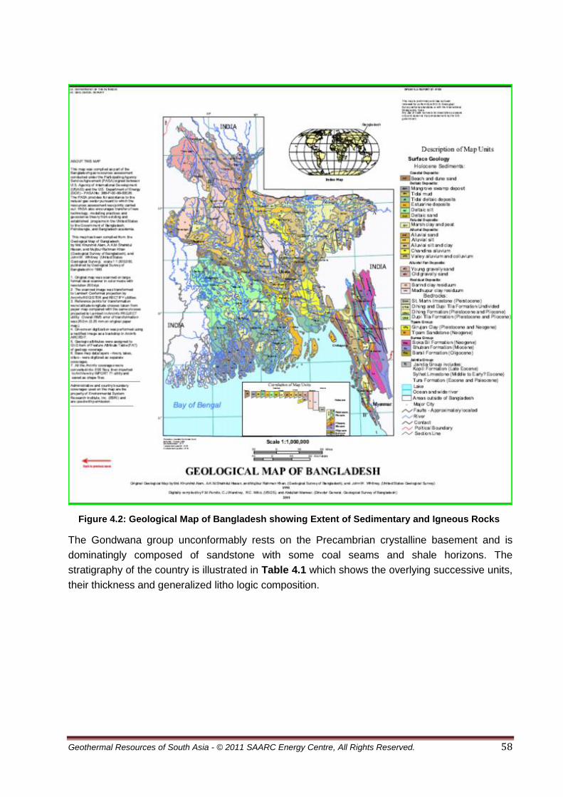
Geothermal Resources of South Asia - © 2011 SAARC Energy Centre, All Rights Reserved. 58
Figure 4.2: Geological Map of Bangladesh showing Extent of Sedimentary and Igneous Rocks.
The Gondwana group unconformably rests on the Precambrian crystalline basement and is
dominatingly composed of sandstone with some coal seams and shale horizons. The
stratigraphy of the country is illustrated in Table 4.1 which shows the overlying successive units,
their thickness and generalized litho logic composition.
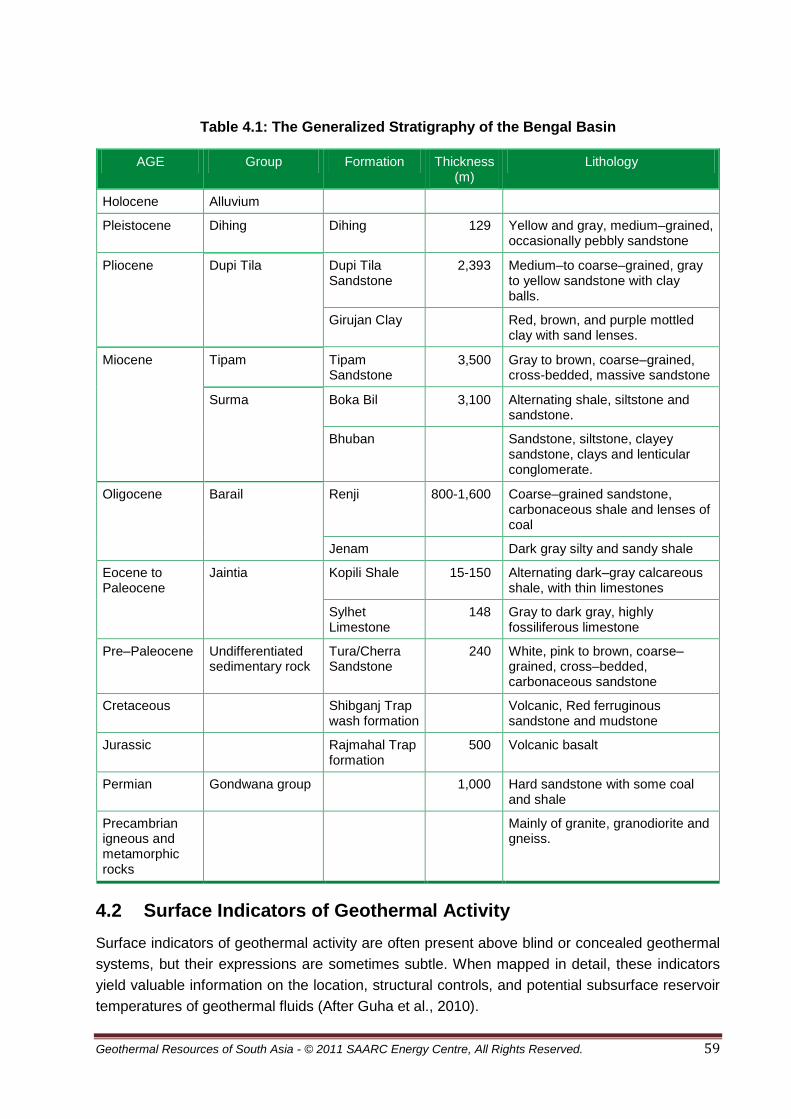
Geothermal Resources of South Asia - © 2011 SAARC Energy Centre, All Rights Reserved. 59
Table 4.1: The Generalized Stratigraphy of the Bengal Basin
AGE Group Formation Thickness (m)
Lithology
Holocene Alluvium
Pleistocene Dihing Dihing 129 Yellow and gray, medium–grained, occasionally pebbly sandstone
Pliocene Dupi Tila Dupi Tila Sandstone
2,393 Medium–to coarse–grained, gray to yellow sandstone with clay balls.
Girujan Clay Red, brown, and purple mottled clay with sand lenses.
Miocene Tipam Tipam Sandstone
3,500 Gray to brown, coarse–grained, cross-bedded, massive sandstone
Surma Boka Bil 3,100 Alternating shale, siltstone and sandstone.
Bhuban Sandstone, siltstone, clayey sandstone, clays and lenticular conglomerate.
Oligocene Barail Renji 800-1,600 Coarse–grained sandstone, carbonaceous shale and lenses of coal
Jenam Dark gray silty and sandy shale
Eocene to Paleocene
Jaintia Kopili Shale 15-150 Alternating dark–gray calcareous shale, with thin limestones
Sylhet Limestone
148 Gray to dark gray, highly fossiliferous limestone
Pre–Paleocene Undifferentiated sedimentary rock
Tura/Cherra Sandstone
240 White, pink to brown, coarse–grained, cross–bedded, carbonaceous sandstone
Cretaceous Shibganj Trap wash formation
Volcanic, Red ferruginous sandstone and mudstone
Jurassic Rajmahal Trap formation
500 Volcanic basalt
Permian Gondwana group 1,000 Hard sandstone with some coal and shale
Precambrian igneous and metamorphic rocks
Mainly of granite, granodiorite and gneiss.
4.2 Surface Indicators of Geothermal Activity
Surface indicators of geothermal activity are often present above blind or concealed geothermal
systems, but their expressions are sometimes subtle. When mapped in detail, these indicators
yield valuable information on the location, structural controls, and potential subsurface reservoir
temperatures of geothermal fluids (After Guha et al., 2010).

Geothermal Resources of South Asia - © 2011 SAARC Energy Centre, All Rights Reserved. 60
Listed below are the surface manifestations of geothermal activity, which are needed to be
studied in more detailed to demarcated prospective areas for geothermal energy in Bangladesh.
4.2.1 Warm Ground
Warm ground represents a low level of geothermal activity. The ground temperature is raised at
1 m depth but not at the surface. Warm ground is not visible on infrared images but changes to
vegetation can be identified. The Gondwana sandstone sequence below the coal seams in
Barakupuria coal mine has a temperature of 50°C at a depth of 400m.
4.2.2 Hot Steaming Ground
Hot ground is the result of underground thermal conduction. Hot vapours rise near the surface
but are not actually discharged. The vapourscondense and drain away without being released to
the atmosphere. A thin layer of steam may condense under moist air conditions. If the air is dry
then no steam is observed.
4.2.3 Hot Pools
Hot pools are the result of hot water or steam heating a pool of groundwater. Hot pools may be
calm, ebulliant (effervescent) or boiling. Guha et al (2010) has mentioned that warm water, up to
36°C, has been observed in irrigation wells at depths of 80m at Thakurgaon.
4.2.4 Hot Lakes
These lakes fill hydrothermal depressions in geothermal areas. They are a subclass of volcanic
lakes.
4.2.5 Hot Springs
Hot springs are the most common type of geothermal activity. They are located where water
from a geothermal system reaches the surface. Some springs in Iceland pulsate and release
water in cycles. Hot springs have been observed at Barbarkund and Gobaniya Chara in the
Sitakund anticline with temperatures of up to 35°C. (Guha and Henkel 2005).
4.2.6 Fumaroles
A fumarole is a steam discharge from a hydrothermal or volcanic system. A solfatara contains
sulfur emissions. Soffioni emit boric acid. Fumaroles can burn, so be careful when approaching
them.
4.2.7 Geysers
A geyser is a vent from which hot water and steam are violently emitted. They are very rare but
well known and extensively studied. Requirements for geyser formation include fractured rocks
and boiling water at a shallow depth.

Geothermal Resources of South Asia - © 2011 SAARC Energy Centre, All Rights Reserved. 61
4.2.8 Hydrothermal Eruptions
Hydrothermal eruptions are caused by catastrophic discharges of water close to the boiling
point. It is a phreatic eruption. No ash, incandesence, or clasts are erupted. Hydrothermal
eruptions may be caused by a reduction in the overlying pressure.
4.2.9 Geothermal Seepages
A seepage is a general term which describes any subsurface discharge of warm fluids from a
geothermal area. Seepages may occur into rivers or lakes. A river seepage may be identified by
differing non reactive constituents above and below the seepage outlet.
4.3 Geothermal Gradients
Thermal methods for geothermal exploration involve the measurement of subsurface
temperature at specified depths in exploratory boreholes. Using temperature-depth
measurements, geothermal gradient can be determined and (when coupled with other down-
hole data) heat flow. These down-hole temperature measurements comprise the only
geothermal exploration method for direct detection of geothermal resources. Temperature logs
of boreholes are made by lowering a sensitive thermostat probe -- capable of measuring
temperature differences of about 0.01°C on a conductor cable, recording probe resistance, and
converting resistance data to temperatures at specified depths in the borehole. All data in this
report were obtained from the logs of exploratory wells drilled in various tectonic zones of
Bangal Basin. Temperatures in the range of 100-120°C at depths of 2100-2500m and these
temperatures could be used for generating electricity using a binary power plant technology
Till 2002 fifty–two onshore and twelve offshore exploration wells were drilled in Bangladesh,
twenty–two of which have been reported successful in locating oil and gas fields (Imam and
Hussain, 2002). Figure 4.3 shows the well locations in various parts of sedimentary basin of
Bangladesh. Of these only a few wells have been drilled in NE part of the basin.
The majority of the wells drilled so far in eastern fold belts and foreland basin areas of the
Bengal basin encountered overpressure zones in the Lower Miocene Bhuban Formation (Surma
Group) at depths ranging from between less than 1 km at Patharia-5 to 4.5 kmat Muladi-1 (Imam
and Hussain, 2002). It seems probable that the overpressure zones are caused by compactional
disequilibria of thick shale sequences in the Bhuban Formation (Imam and Hussain, 2002). It
may be noted that rapid burial with high geothermal gradients favours the most rapid volume
change and produces the high overpressure zones.

Geothermal Resources of South Asia - © 2011 SAARC Energy Centre, All Rights Reserved. 62
Figure 4.3: Locations of Exploratory Wells Used in this Study
(After Hossain, M. S., 2009). .
The deeper parts of the Bengal basin covering central, eastern, and southern Bangladesh has
an average geothermal gradient of about 21.3°C/km (Figure 4.5). However, data from a total of
62 wells drilled in the deeper part of the Bengal basin indicate significant variations in
geothermal gradient across the basin. In the deeper part of the basin, depths of the petroleum
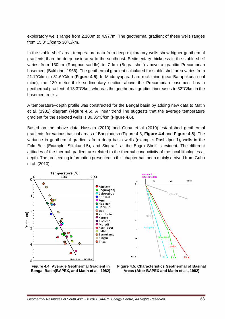
Geothermal Resources of South Asia - © 2011 SAARC Energy Centre, All Rights Reserved. 63
exploratory wells range from 2,100m to 4,977m. The geothermal gradient of these wells ranges
from 15.8°C/km to 30°C/km.
In the stable shelf area, temperature data from deep exploratory wells show higher geothermal
gradients than the deep basin area to the southeast. Sedimentary thickness in the stable shelf
varies from 130 m (Rangpur saddle) to 7 km (Bogra shelf) above a granitic Precambrian
basement (Bakhtine, 1966). The geothermal gradient calculated for stable shelf area varies from
21.1°C/km to 31.6°C/km (Figure 4.5). In Maddhyapara hard rock mine (near Barapukuria coal
mine), the 130–meter–thick sedimentary section above the Precambrian basement has a
geothermal gradient of 13.3°C/km, whereas the geothermal gradient increases to 32°C/km in the
basement rocks.
A temperature–depth profile was constructed for the Bengal basin by adding new data to Matin
et al. (1982) diagram (Figure 4.6). A linear trend line suggests that the average temperature
gradient for the selected wells is 30.35°C/km (Figure 4.6).
Based on the above data Hussain (2010) and Guha et al (2010) established geothermal
gradients for various basinal areas of Bangladesh (Figure 4.3, Figure 4.4 and Figure 4.5). The
variance in geothermal gradients from deep basin wells (example: Rashidpur-1), wells in the
Fold Belt (Example: Siltakund-5), and Singra-1 at the Bogra Shelf is evident. The different
attitudes of the thermal gradient are related to the thermal conductivity of the local lithologies at
depth. The proceeding information presented in this chapter has been mainly derived from Guha
et al. (2010).
Figure 4.4: Average Geothermal Gradient in Bengal Basin(BAPEX, and Matin et al., 1982)
Figure 4.5: Characteristics Geothermal of Basinal Areas (After BAPEX and Matin et al., 1982)

Geothermal Resources of South Asia - © 2011 SAARC Energy Centre, All Rights Reserved. 64
The geothermal gradients calculated from bottom hole temperatures in the well logs of 62 wells
have been utilized by Guha et al (2010) to develop a geothermal map of Bangladesh. The map
shows distribution of temperatures at three km depth.
The map (Figure 4.6) shows that deep wells in the Bogra Shelf are the primary target for further
investigations of their geothermal energy potential and establishing geothermal power plant. The
following details of geothermal energy in different parts of Bangladesh have been derived from
Guha et al., 2010.
Figure 4.6: Geothermal Map of Bangladesh at 3 km Depth. (After Guha et al., 2010)
4.4 Geothermal Prospects of Sub-himalayan Foredeep
The Himalayan Foredeep lies south of the Main Boundary Thrust (MBT) all along the foothills of
the Himalayas. In this area at the NW tip of Bangladesh the basement occurs at 2,500m depth
as encountered in Salbanhat-1 well. At this depth 79°C bottom hole temperature is recorded.
The Neocene of the Siwaliks are well developed in the Himalayan Foredeep and attains

Geothermal Resources of South Asia - © 2011 SAARC Energy Centre, All Rights Reserved. 65
thickness of 3 to 4.5 km with predominantly sandstones, subordinate shales and clay and gravel
beds. Although the sedimentary units have high porosity and the upper sedimentary units
contain very good quifer, the thermal gradient is too low to make a geothermal prospect for
immediate consideration.
4.5 Geothermal Prospects of Rangpur Saddle
As stated earlier the Rangpur Saddle represents the Indian Platform and connects the Indian
Shield with the Shillong Massif and the Mikir Hills. Figure 4.7 shows a generalized thermal
section across the Rangpur Saddle.
In the western part of the Rangpur Saddle, a number of graben and half graben structures have
been found with Gondwana sediments, some of which contain coal seams. The Gondwana
sandstone sequence below the coal seams in Barakupuria coal mine has a temperature of
50 °C at a depth of 400 m. The coal seams together have an insolating effect resulting in
increased temperature in the basement below.
At Thakurgaon warm water, up to 36°C, has been observed (Rahman 2006) in irrigation wells at
depths of ca 80m. Here Madhupur Clay (ca 20m) is acting as an insolating layer, resulting in the
observed increased temperatures below. Figure 4.8 shows a compilation of some observed
shallow temperature profiles with their respective lithostratigraphy. The thermal contours (red) in
Figure 4.7 are based on measurements in the Salbanhat and Singra wells and the Barapukuria
Gondwana graben (green).Geothermal resources in the Rangpur Saddle would be found in the
crystalline basement.
Figure 4.7: Generalized Section NW-SE Across the Crystalline Basement Rise of the Rangpur Saddle (Gray). (After Guha et al., 2010)
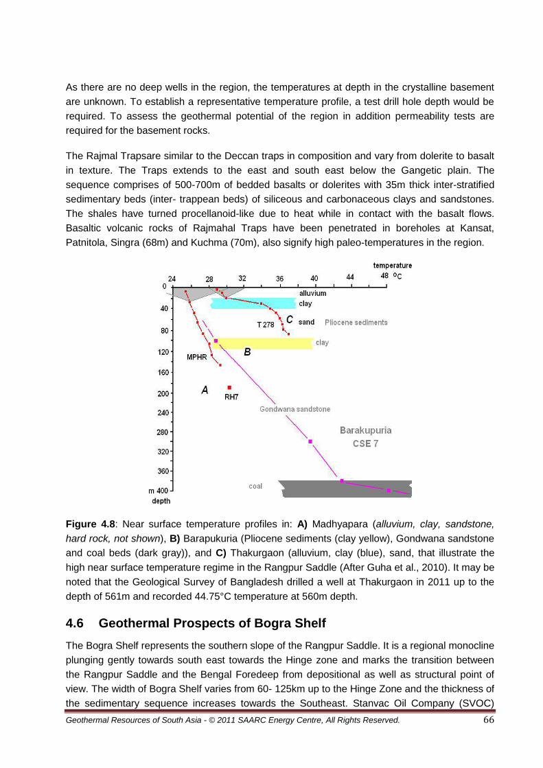
Geothermal Resources of South Asia - © 2011 SAARC Energy Centre, All Rights Reserved. 66
As there are no deep wells in the region, the temperatures at depth in the crystalline basement
are unknown. To establish a representative temperature profile, a test drill hole depth would be
required. To assess the geothermal potential of the region in addition permeability tests are
required for the basement rocks.
The Rajmal Trapsare similar to the Deccan traps in composition and vary from dolerite to basalt
in texture. The Traps extends to the east and south east below the Gangetic plain. The
sequence comprises of 500-700m of bedded basalts or dolerites with 35m thick inter-stratified
sedimentary beds (inter- trappean beds) of siliceous and carbonaceous clays and sandstones.
The shales have turned procellanoid-like due to heat while in contact with the basalt flows.
Basaltic volcanic rocks of Rajmahal Traps have been penetrated in boreholes at Kansat,
Patnitola, Singra (68m) and Kuchma (70m), also signify high paleo-temperatures in the region.
Figure 4.8: Near surface temperature profiles in: A) Madhyapara (alluvium, clay, sandstone,
hard rock, not shown), B) Barapukuria (Pliocene sediments (clay yellow), Gondwana sandstone
and coal beds (dark gray)), and C) Thakurgaon (alluvium, clay (blue), sand, that illustrate the
high near surface temperature regime in the Rangpur Saddle (After Guha et al., 2010). It may be
noted that the Geological Survey of Bangladesh drilled a well at Thakurgaon in 2011 up to the
depth of 561m and recorded 44.75°C temperature at 560m depth.
4.6 Geothermal Prospects of Bogra Shelf
The Bogra Shelf represents the southern slope of the Rangpur Saddle. It is a regional monocline
plunging gently towards south east towards the Hinge zone and marks the transition between
the Rangpur Saddle and the Bengal Foredeep from depositional as well as structural point of
view. The width of Bogra Shelf varies from 60- 125km up to the Hinge Zone and the thickness of
the sedimentary sequence increases towards the Southeast. Stanvac Oil Company (SVOC)

Geothermal Resources of South Asia - © 2011 SAARC Energy Centre, All Rights Reserved. 67
carried out aero-magnetic and seismic surveys in the mid-fifties followed by drilling two wells at
Kutchma and Bogra. Four deep wells have been drilled in the Bogra slope at distances of
22 – 26km: Singra to the southwest, Bogra to the northeast and Kuchma in between. The litho-
stratigraphic correlation between these wells is shown in Figure 4.9.
Figure 4.9 : Litho-stratigraphic correlation between the wells Singra, Kuchma and Bogra,
showing vertical displacements related to faulting and the occurrence of potentially permeable
lithologies at depth where temperatures are above the minimum required for electricity
production. (After Guha et al, 2010).
Geothermal gradient in the Kutchma well (TD 2,875m) has been calculated at 27°C/km
indicating temperature of more than 100°C at 3 km depth. The Bogra-1 well (TD 2,187m)

Geothermal Resources of South Asia - © 2011 SAARC Energy Centre, All Rights Reserved. 68
showed the bottom hole temperature and interpreted geothermal gradient 30°C/km. The
Singrawell (TD 4100m and geothermal gradient 30°C/km) drilled by Petrobangla in 1981 is the
deepest well ended at the top of the basement. Borehole EDH-4 at Jaipurhat penetrated
basement (11m) on which laid younger stratigraphic succession. The litho-stratigraphic columns
show that faulting took place in the Singra – Kuchma – Bogra area with vertical displacements of
about 400 m between Singra and Kuchma occur with respect Sylhet limestone marker horizon.
Rajmahal Trap is absent in Bogra while it occurs in Kuchma at a depth of 2.3 km and here the
vertical displacement between Kuchma and Bogra is about 700m, restricted to the stratigraphy
below the Sylhet Limestone and Cherra formation.
The geothermal gradients observed at Singra, Kuchma and Bogra are very similar and reach up
to 31 °C/km (see Figure 4.5 and Table 4.2). In this region, potential geothermal energy
resources are in the Sylhet Limestone, the Cherra and Gondwana sequences.
Table 4.2: Temperature Data Collected from Exploration Wells Located in the Eastern Bengal Basin
Well Name Longitude Latitude Estimated Temperature at Geothermal Gradient (°C/km) 1 km 2 km 3 km 4 km
ARCO-1 90.72861 21.25748 45.7 68.9 91.5 115.0 23.1
Atgram-1 92.32978 24.99588 41.8 61.0 80.5 100.2 19.5
Bakhrabad-2 90.88885 23.61639 54.0 84.0 114.0 144.0 30.0
Beani Bazar 92.13679 24.75859 43.0 62.5 81.8 101.0 19.3
BINA-1 91.43665 20.99455 42.2 56.4 73.0 89.5 15.8
BODC-1 91.88177 20.83720 44.0 64.0 84.0 104.0 20.0
Bogra-XI 89.40175 24.93491 52.0 82.0 112.0 142.0 30.0
Cox's Bazar 91.79688 21.15396 47.0 70.0 93.0 116.0 23.0
Fenchuganj-2 91.87305 24.59348 39.5 57.5 75.5 93.5 18.0
Feni-1 91.40912 22.97042 47.5 71.0 95.0 119.0 23.8
Feni-2 91.39715 22.95150 45.0 66.0 87.0 108.0 21.0
Habiganj 91.38514 24.20239 44.0 64.0 84.4 104.4 20.1
Hazipur 90.08885 24.58864 43.5 66.2 89.5 112.2 22.9
Jaldi-1 92.08836 22.09958 44.0 64.0 84.0 104.0 20.0
Jaldi-3 92.11399 22.07280 46.5 69.0 89.8 114.3 22.6
Kailashtila 91.93514 24.81257 43.0 61.0 79.5 98.0 18.3
Kuchma-XI 89.14137 24.78355 54.0 81.0 109.0 136.0 27.3
Kutubdia-1 91.16751 21.89365 43.0 62.5 81.5 101.0 19.3
Muladi-1 90.42365 23.13880 47.0 67.8 88.0 108.8 20.6
Muladi-2 90.44021 23.13604 47.0 67.8 88.0 108.8 20.6
Cont’d
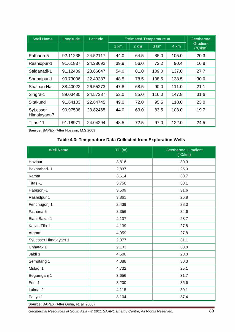
Geothermal Resources of South Asia - © 2011 SAARC Energy Centre, All Rights Reserved. 69
Well Name Longitude Latitude Estimated Temperature at Geothermal Gradient (°C/km) 1 km 2 km 3 km 4 km
Patharia-5 92.11238 24.52117 44.0 64.5 85.0 105.0 20.3
Rashidpur-1 91.61837 24.28692 39.9 56.0 72.2 90.4 16.8
Saldanadi-1 91.12409 23.66647 54.0 81.0 109.0 137.0 27.7
Shabajpur-1 90.73006 22.49287 48.5 78.5 108.5 138.5 30.0
Shalban Hat 88.40022 26.55273 47.8 68.5 90.0 111.0 21.1
Singra-1 89.03430 24.57387 53.0 85.0 116.0 147.8 31.6
Sitakund 91.64103 22.64745 49.0 72.0 95.5 118.0 23.0
SyLesser Himalayaet-7
90.97508 23.82465 44.0 63.0 83.5 103.0 19.7
Titas-11 91.18971 24.04294 48.5 72.5 97.0 122.0 24.5
Source: BAPEX (After Hossain, M.S.2009)
Table 4.3: Temperature Data Collected from Exploration Wells
Well Name TD (m) Geothermal Gradient (°C/km)
Hazipur 3,816 30,9
Bakhrabad- 1 2,837 25,0
Kamta 3,614 30,7
Titas -1 3,758 30,1
Habigonj-1 3,509 31,6
Rashidpur 1 3,861 26,8
Fenchugonj 1 2,439 28,3
Patharia 5 3,356 34,6
Biani Bazar 1 4,107 28,7
Kailas Tila 1 4,139 27,8
Atgram 4,959 27,8
SyLesser Himalayaet 1 2,377 31,1
Chhatak 1 2,133 33,8
Jaldi 3 4.500 28,0
Semutang 1 4.088 30,3
Muladi 1 4.732 25,1
Begamganj 1 3.656 31,7
Feni 1 3.200 35,6
Lalmai 2 4.115 30,1
Patiya 1 3.104 37,4
Source: BAPEX (After Guha, et. al. 2005)
Geothermal Resources of South Asia - © 2011 SAARC Energy Centre, All Rights Reserved. 70
4.7 Geothermal Prospects of Deep Sedimentary Basin
The Hinge Zone is a tectonic element of regional importance and has played a major role in the
development of the Bengal Basin. It is a narrow zone trending SSW-NNE from Sylhet-
Mymensingh-Pabna. It is bound by the Bogra Shelf (or south slope of the Rangpur Saddle) by
the seismic depth of 3500 m to the top of the Eocene Sylhet Limestone. The seismic depth of
5000m of the Sylhet Limestone is the south-eastern boundary of the Hinge Zone, also known as
the Hinge Line. The dips increase from 3-50 in the shelf monocline to 15-200 in the Hinge Zone
as evident from Sylhet Limestone. The Hinge Zone is possibly tectonically related to a deep
seated basement fault that probably started with the breakup of the eastern Gondwana
continent. The Sylhet Limestone reflector can be traced into the basin clearly up to 6500m depth
and flattens below 5000m depth. In the northeast, Hinge Zone is connected with the Dauki Fault
by a series of west–east trending faults.
The Faridpur Trough situated adjacent to Hinge Zone and is characterized by a general gravity
low and the development of Neogene sequences. The Sylhet Limestone is at 6500m depth in
area south of the confluence of the Padma and the Jamuna rivers. The Barisal-Chandpur High
is a tectonic zone of uplift. Located between the Faridpur Trough and the Hatiya Trough of the
Bengal foredeep, the Barisal-Chandpur High is characterized by general gravity maxima with
SW-NE trend. The width of the zone is about 60km and corresponds to an uplift of the
sedimentary cover.
The Hatiya Trough represents the deepest trough of the Bengal Basin and has received the
highest accumulation of clastic sediments. The axis of the Bengal Foredeep runs through the
apex of the Hatiya Trough. Shahbazpur (Bhola), Kutubdia, Sangu and a number off-shore
anticlinnal structures are located here, of which Sangu is under hydrocarbon production while
Shahbazpur and Kutubdia are awaiting development.
The Madhupur High is a Pleistocene terrace separating the Faridpur Trough from the Sylhet
Trough (Surma Basin). Here the basement is relatively uplifted as evident from gravity and aero-
magnetic data. Morphological studies reveal a pronounced recent morphological upheaval east
of Madhupur. The Nagarpur dome and the Nandina high are regarded as protrusions from the
basement without deforming the sedimentary sequence overlying these features.
In the deep sedimentary basin the average geothermal gradient is about 20°C /km, and less,
which is rather low and therefore of limited interest for geothermal resources, unless the
abandoned wells are extremely deep.
4.8 Geothermal Prospects of Folded Belt
The Folded Belt (or the folded eastern flank of Bengal Foredeep) represents the most prominent
tectonic element of the Bengal Foredeep, with general sub-meridional trending hills parallel to
the Arakan Yoma Folded System. The Folded belt extends S-N within Bangladesh for 450 km
and is about 150km wide, covering an area of 35 000 square km of on-shore area. The folds are
characterized by ridges, box-like in cross section with variable width and high amplitude,

Geothermal Resources of South Asia - © 2011 SAARC Energy Centre, All Rights Reserved. 71
oriented enechelon with the adjacent structures. The elevation of these elongated anticline folds
ranges from 100 to1,000m in Bangladesh. Some of the structures are faulted and thrusted and
the intensity of folding increases gradually from west to east. Consequently the structures of the
eastern part are tightly folded, faulted and thrusted with narrower synclines between them. The
Neogene sedimentary sequence developed here are largely un-fossiliferous and consists mainly
of the alteration of shales, clays, clay stones, siltstones and sandstones with occasional intra-
formational conglomerates which can be subdivided into 9 formations on the basis of litho logy
(Kitovani and Guha 1965).
The Paleocene sediments are subsided to greater depths and have not been encountered in
any well except in Atgram IX (Reiman 1986). The depth of basement is not known but can be of
the range of ca 20 km. The Folded Belt is sub-divided into a Western Zone and an Eastern Zone
according to the intensity of folding and other structural features. The Western Zone consists of
a large number of relatively simple anticline structures with 27 known structures in Bangladesh
(ten in adjacent regions of India and 3 in Myanmar). The Western Zone is the most important
and prospective oil and gas province of Bangladesh with 12 fields from Kailas Tila in the north to
Semutang in the south.
Hot springs have been observed at Barbarkund and Gobaniya Chara in the Sitakund anticline
with temperatures of up to 35°C. (Guha and Henkel 2005). In the Sitakund well 5, the
geothermal gradient is 25°C per km. In the sedimentary sequence to 2.3 km depth, consisting of
mainly shales, the gradient is slightly higher, indicating a lower thermal conductivity and hence
an insolating effect to warmer and deeper formations. In the Bakhrabad well 1, the geothermal
gradient has been found at 30°C per km-1 (Kabir 2008). The geothermal gradient for Sitakund-5
is seen in Figure 4.5.
The Eastern Zone includes11 more steep folded and faulted anticline structures in Bangladesh.
The anticline structures can turn out to be of significance geothermal energy prospects as there
are many deep dry wells with high temperatures.
4.9 Conclusions and Recommendations
Bangladesh is facing an acute energy scarcity which is hampering its industrial growth and
economic progress. Setting up of new power plants is inevitably dependent on import of highly
volatile fossil fuels. Thus, it is essential to tackle the energy crisis through judicious utilization of
abundant renewable energy resources, such as biomass, solar, wind and geothermal.
Bangladesh is heavily dependent on fossil fuels for its energy needs. Most of the power
generation is carried out by coal and mineral oil-based power plants which contribute heavily to
greenhouse gases emission.
Geothermal studies so far carried out in Bangladesh indicate that the country is ideally suited for
further detailed studies to tap the geothermal energy by carrying concentrated effort to fully
explore the potential of the country particularly in Bogra Shelf and Rangpur Saddle areas.

Geothermal Resources of South Asia - © 2011 SAARC Energy Centre, All Rights Reserved. 72
Guha et al. (2005) have suggested utilization of deep abandoned oil and gas wells for
production of geothermal electricity for meeting the requirements of rural population of
Bangladesh (Table 4.3). Accordingly they have also remmended use of efficient pumps for
cooling the buildings and heating for warm water production.
Considering the economic conditions of the country, there is need for transition from petroleum-
based energy systems to one based on renewable resources in general and geothermal in
particular. This would help to decrease reliance on depleting reserves of fossil fuels and to
mitigate climate change. In addition, geothermal energy has the potential to create many
employment opportunities at all levels, especially in rural areas. An emphasis on presenting the
real picture of geothermal energy potential, it would be possible to attract foreign investments.
Exploration of geothermal energy resource should be given emphasis as it is environmental
friendly, continuously available, independent of weather variations. The geothermal exploration
cost be reduced by using the existing/abandoned on-shore dry wells where the geothermal
gradient is sufficiently high (like over 30°C/km) and where porous and permeable reservoir
sandstones are penetrated.
The tectonic and geothermal maps of Bangladesh clearly demonstrate a pattern of geothermal
conditions in Bangladesh. Accordingly the work of Guha et al (2010) suggests occurrence of
geothermal potential of the various tectonic element by using the data of available information
derived from deep abandoned exploratory wells.
The Sub-Himalayan foredeep in NW Bangladesh is barely feasible to explore for geothermal
energy due to limited data from one deep drill hole exhibiting relatively low thermal gradients.
The Rangpur saddle. This area is characterized by relatively high surface temperatures reported
from some irrigation wells, in coal bearing graben structures and underground hard rocks mine.
The geothermal resource is likely located within the uplifted basement and would require
hydraulic fracturing methods to create permeability at depth with sufficient high temperature for
present technology of electricity generation. As fairly high temperatures may be reached at
reasonable drilling depth, further study of the region is recommended by pilot drill holes to ca 1
km depth to establish a proper geothermal gradient.
The Bogra Shelf, with the deep wells at Singra, Kuchma and Bogra potentially offers such
favorable conditions for geothermal energy. The Singra well with over 150 °C bottom hole
temperature is the most promising of the three areas and a feasibility study is part of the
ongoing project. The porosity of Bhuban sandstone, Sylhet limestone, Cherra sandstone and
Gondwana sandstone varies from 7-20%. The permeability needs to be ascertained from cores
of the Singra well regarding the Lower Bhuban to Gondwana sandstones. Similar studies should
also be done for the cores of the Kutchma and Bogra wells. Additional reflection seismic lines
may also needed in the Singra and Kuchma areas for the assessment of available volumes for
geothermal energy.

Geothermal Resources of South Asia - © 2011 SAARC Energy Centre, All Rights Reserved. 73
The Deep Basin areas are continuously loaded with cool sediments and the geothermal
gradients are very low. Despite some deep drill holes, they are barely feasible to explore for
geothermal energy with present technology for electricity generation.
Further mapping of the margin of the Folded Belt may be rewarding as local tectonic structures,
occurrence of hot springs, and relatively high geothermal gradients indicate suitable conditions
for geothermal energy exploration.
4.10 Bibliography
1. Alam, M., 1989, Geology and depositional history of Cenozoic sediments of the Bengal Basin of Bangladesh: Palaeogeog Palaeoclim Palaeoecol, v. 69, p. 125-139.
2. Alam, M., Khurshid, H., Shahidul, K., Rahman, M., Whitney, J. W., 1990, Geological map of Bangladesh: Geological Survey of Bangladesh, scale: 1:1,000,000. Ahmed, A., 1983, Oligocene stratigraphy and sedimentation in the Surma Basin, Bangladesh: University of Dhaka, Dhaka, 96 p.
3. Alam, M. M., 1991, Paleoenvironmental study of the Barail succession exposed in northeastern SyLesser Himalayaet, Bangladesh: Bangladesh Journal of Scientific Research, v. 9, p. 25– 32.
4. Ali, S. M. M., and Raghava, M. S. V., 1985, The Bouguer gravity map of Bangladesh and its tectono-geologic implications: Bangladesh Journal of Geology, v. 4, p. 43-56.
5. Ameen, S. M. M., Wilde, S. A., Kabir, M. Z., Akon, E., Chowdhury, K. R., and Khan, M. S. H., 2007, Paleoproterozoic granitoids in the basement of Bangladesh: A piece of the Indian shield or an exotic fragment of the Gondwana jigsaw?: Gondwana Research, v. 12, p. 380-387.
6. Bakhtine, M. I., 1966, Major tectonic feature of Pakistan. Part-II. Eastern Province: Science and Industry, v. 4, p. 89-100.
7. Banerji, R. K., 1981, Cretaceous-Eocene sedimentation, tectonism and biofacies in the Bengal basin, India: Palaeogeography Palaeoclimatology Palaeoecology, v. 34, p. 57-85.
8. Bangladesh Government, 2011, power division, http:/www.power division.gov.bd/index.php?page_id=262
9. Cerveny, P. F., 1986, Uplift and erosion of the Himalaya over the past 18 million years: evidence from fission track dating of detrital zircons and heavy mineral analysis [M.Sc. thesis]: Dartmouth College, Hanover, 198 p.
10. Chowdhury, K. R., Haque, M., Nasreen, N., and Hasan, R., 2003, Distribution of planktonic foraminifera in the northern Bay of Bengal: Sedimentary Geology, v. 155, p. 393-405.
11. Copeland, P., and Harrison, T. M., 1990, episodic rapid uplift in the Himalaya revealed by 40Ar/39Ar analysis of detrital K-feldspar and muscovite, Bengal Fan: Geology, v. 18, p. 354-357.
12. Curray, J. R., Emmel, F. J., Moore, D. G., and Raitt, R. W., 1982, Structure, tectonics and geological history of the northeastern Indian Ocean, in Nairn, A.E.M., and Stehli, F.G., eds.: The Ocean Basin and Margins, v. 6, The Indian Ocean: New York, Plenum, p. 399-450.
13. Curray, J. R., and Moore, D. G., 1971, the growth of the Bengal Deepsea Fan and denudation in the Himalayas: Geological Society of America Bulletin, v. 82, p. 563– 572.
14. Davies, C., Best, J., and Colllier, R.: 2003, Sedimentology of the Bengal Shelf Bangladesh: comparison of late Miocene sediments, Sitakund anticline, with modern, tidally dominates shelf. Sedimentary Geology 155: 271-300,(2003).

Geothermal Resources of South Asia - © 2011 SAARC Energy Centre, All Rights Reserved. 74
15. DeCelles, P. G., Gehrels, G. E., Najman, Y., Martin, A. J., Carter, A., and Grarzanti, E., 2004, Detrital geochronology and geochemistry of Cretaceous - Early Miocene strata of Nepal: Implications for timing and diachroneity of initial Himalayan orogenesis: Earth and Planetary Science Letters, v. 227, p. 313-330.
16. DiPippo, R. (1999): Small Geothermal Power Plants: Design, Performance and Economics. GHC Bulletin, June 1999, page. 1-8.
17. Guha, D., K., Henkel, H., Imam, B., 2010,Geothermal Potential in Bangladesh - Results from Investigations of Abandoned Deep Wells, Proceedings World Geothermal Congress 2010, Bali, Indonesia, 8p.
18. Guha, D.K., Henkel, H., Jacks, G. Badrul. I., 2005, Abandoned on-shore deep wells – a potential for geothermal energy resource for rural Bangladesh. Proceedings of the World Geothermal Congress 2005 paper 2214, 11 pp.
19. Guha, D.K, 1978. Tectonic Framework and Oil & Gas Prospects of Bangladesh. Proc.of the 4th annual Conf. Bangladesh Geol. Soc.: 65-75.
20. Holtrop, J. F., 1971, Some aspects of the stratigraphy and correlation of the Surma Basin wells, East Pakistan in Stratigraphic Correlation between Sedimentary Basins in the ECAFE Region (second volume), United Nations ECAFE Min. Resources Development Ser, v. 36, p. 143-154.
21. Hossain, I., and Tsunogae, T., 2008, Fluid inclusion study of pegmatite and aplite veins of Palaeoproterozoic basement rocks in Bangladesh: Implications for magmatic fluid compositions and crystallization depth: Journal of Mineralogical and Petrological Sciences, v. 103, p. 121-125.
22. Hossain, M. S., 2009, Overpressure in the Eastern Bengal Basin, Bangladesh, and Its Relation to Compressional Tectonics, A Thesis Submitted to Auburn University, USA.
23. Hossain, I., Tsunogae, T., and Rajesh, H. M., 2009, Geothermobarometry and fluid inclusions of dioritic rocks in Bangladesh: Implications for emplacement depth and exhumation rate: Journal of Asian Earth Sciences, v. 34, p. 731-739.
24. Hossain, I., Tsunogae, T., Rajesh, H. M., Chen, B., and Arakawa, Y., 2007, Palaeoproterozoic U–Pb SHRIMP zircon age from basement rocks in Bangladesh: A possible remnant of the Columbia supercontinent: Comptes Rendus Geoscience, v. 339, p. 979-986. 91
25. Hoque, M., 1982, Tectonic set-up of Bangladesh and its relation to hydrocarbon accumulation: Center for Policy Research, Dhaka, Bangladesh, 177 p.
26. Imam, M. B.,, 2005, Energy resources of Bangladesh: Dhaka, University Grants Commission of Bangladesh, 280 p.
27. Imam, M., B., 2011,Energy Crisis and Potential in Bangladesh, Strategic Analysis, volume 35, issue 2, page 248-264
28. International Crisis Group, 2006, Bangladesh Today, Asia Report No. 121,Population density - Persons per sq km 2010 Country Ranks".
29. Islam, R., 2002.The right to tell: the role of mass media in economic development. World Bank Publications. p.268.
30. Ismail, M., and Shamsuddin, A.H.M., 1991. Organic matter maturity and its relation to time, temperature and depth in the Bengal Foredeep, Bangladesh. Journal of Southeast Asia Eart Science 5:381-390.
31. Johnson, S. Y., and Nur Alam, A. M., 1991, Sedimentation and tectonics of the Sylhet trough, Bangladesh: Geological Society of America Bulletin, v. 103, p. 1513– 1527. 92

Geothermal Resources of South Asia - © 2011 SAARC Energy Centre, All Rights Reserved. 75
32. Khan, M. R., and Muminullah, M., 1980, Stratigraphy of Bangladesh: Ministry of Petroleum and Mineral Resources, Government of Bangladesh, p. 35-40.
33. Khan, A. A., 1991a, Tectonics of the Bengal basin: Journal of Himalayan Geology, v. 2, p. 91–101.
34. Khandoker, R. A., 1989, Development of major tectonic elements of the Bengal Basin: a plate tectonic appraisal: Bangladesh Journal of Scientific Research, v. 7, p. 221-232.
35. Kuehl, S. A., Harju, T. M., and Moore, W. S., 1989, Shelf sedimentation of the Ganges-Brahmaputra river system: Evidence for sediment bypassing to the Bengal fan: Geology v. 17, no. 1132-1135.
36. Lindsay, J. F., Holliday, D. W., and Hulber, A. G., 1991, Sequence stratigraphy and evolution of the Ganges-Brahmaputra delta complex: American Association of Petroleum Geologists Bulletin, v. 75, p. 1233-1254.
37. Logan, S., 2008.Asian communication handbook 2008. AMIC. p.115.
38. London, E., (2004).Bangladesh. Gareth Stevens Pub.. p.29.
39. Kabir, S. M., 2008. Subsurface temperature and geothermal gradient in Bangladesh. Unpublished M.Sc. Thesis at Guha et al 8 the Department of Geology, Dhaka University.
40. .Khan, F.H., 1991. Geology of Bangladesh. University Press, Dhaka.
41. Khandoker, R.A., and Haque, M., 1984. Temperature Distribution and its Relation to Hydrocarbon Accumulation in Sylhet Trough, Bangladesh. Bangladesh Journal of Geology 3:19-25.
42. Mannan, M.A., and Mirhamidov, 1977. Report on Gravity Survey of Bangladesh, Petrobangla Report, National Energy Policy, May 2004
43. Mannan, A., 2002, Stratigraphic evolution and geochemistry of the Neogene Surma group, Surma basin, SyLesser Himalayaet, Bangladesh [Ph.D. thesis]: University of Oulu, Oulu, 162 p.
44. Matin, M. A., Denega, B. I., and Huq, M., 1982, Regional distribution of temperature and pressure gradient of Bangladesh (unpublished): Bangladesh Oil Gas and Minerals Corporation (BOGMC) data center.
45. Mitchell, A. H. G., 1993, Cretaceous-Cenozoic tectonic events in the western Myanmar (Burma)-Assam region: Journal of the Geological Society [London], v. 150, p. 1089–1102.
46. Rahman, M. W., 2008, Sedimentation and Tectonic Evolution of Cenozoic Sequences From Bengal and Assam Foreland Basins, Eastern Himalayas: Auburn University, Auburn, 162 p.
47. Rahman, M., 2006. Geothermal Potential Resources in Thakurgaon District, Northern Bangladesh. Bangladesh Journal of Geology 25:13-30.
48. Reiman, K., 1993: Geology of Bangladesh. GebrFCder Borntraeger, Berlin-Stuttgart.
49. Sanner, B.: Shallow geothermal energy. GHC Bulletin June( 2001)
50. Schallenberg, K., Erbas, E., Huenges, E., and Mentzel, H.(ed), 1999, Geotherm isches Heizwerk Neustadt-Glewe :Zustands- und Stoffparameter, Prozessmodel-lierungen, Betriebserfahrungen und Emissionsbilan-zen. Geothermal district heating plant Neustadt-Glewe: Conditional and material parameters, process modeling, production experience and emission budget). Geoforschungszentrum Potsdam.Geothermie Report 99-1, 206 pp.
51. Sen Gupta, S., 1966. Geological & Geophysical Studies in Western part of Bengal Basin. Am. Assoc. of Petroleum Geologists Bull. 50:1001-1017.

Geothermal Resources of South Asia - © 2011 SAARC Energy Centre, All Rights Reserved. 76
52. Salt, C. A., Alam, M. M., and Hossain, M. M., 1986, Bengal Basin: Current exploration of the hinge zone of southwestern Bangladesh, In: Proc. 6th Offshore Southeast Asia Conference: Singapore p. 55-67.
53. Shamsuddin, A. H. M., Brown, T. A., Lee, S., and Curiale, J., 2001, Petroleum systems of Bangladesh: Proceedings of the 13th SEAPEX Exploration Conference, April, 2001, Singapore.
54. Uddin, A., and Lundberg, N., 1998a, Cenozoic history of the Himalayan-Bengal system; sand composition in the Bengal Basin, Bangladesh: Geological Society of America Bulletin, v. 110, no. 4, p. 497-511.
55. USAID, 2011, Energy situation in Bangladesh, a publication of USAID.
56. World Energy Council, 2010, Report on renewable energy resources, a publication by WEC, London, UK.
57. (www.worldenergy.org/wecgeis/publications/reports/renewable/introduction)
58. Zaher, M. A., 1970, Limestone deposits of the western part of the Takerghat area, district Sylhet, Pakistan, Rec. Geological Survey of Pakistan 20 (2), p. 57-75.
59. Zahid, K. M., 2005, Provenance and basin tectonics of Oligocene-Miocene sequences of the Bengal basin, Bangladesh [M.Sc. thesis]: Auburn University, Auburn, 162 p.
60. Zahid, K. M., and Uddin, A., 2005, Influence of overpressure on formation velocity evaluation of Neogene strata from the eastern Bengal Basin, Bangladesh: Journal of Asian Earth Sciences, v. 25, p. 419-429.

Geothermal Resources of South Asia - © 2011 SAARC Energy Centre, All Rights Reserved. 77
CHAPTER – 5 GEOTHERMAL RESOURCES OF BHUTAN
5.1 Geological Framework
The fundamental geological appraisal of Bhutan carried out by Gansser (1983) paved way for
some interesting researches by a number of professionals from all over the world. Among lot of
the geogists worth mentioning are Long, S.P., McQuarrie, N., Tobgay, T., Grujic, D., and
Hollister, L, Whynot, N. M.P. Searle, J.M. Cottle, M.J. Streule, and D.J. Waters etc ( See
references).The details on the stratigraphic and Structural description of Bhutan has been
extracted from the paper entitled “Preliminary stratigraphic and structural architecture of Bhutan:
Implications for the along strike architecture of the Himalayan system” by Nadine McQuarrie,
Delores Robinson, Sean Long, Tobgay Tobgay, Djordje Grujic, George Gehrels, Mihai Ducea.
5.1.1 Bhutan Stratigraphy
The stratigraphy of Bhutan is explained in term of the following tectonostratigraphic units.
Sub-Himalaya
The Sub-Himalaya of Bhutan (Figure 5.1) is characterized by the discontinuity of the Siwalik
Group along strike. Consequently the map pattern of synorogenic sediments is patchy, with
20–40 km portions of the belt either covered by Quaternary sediments, or overridden by the
Main Boundary thrust (MBT) or apparently never deposited (Gansser, 1983). The most complete
Siwalik Group section is in eastern Bhutan where It is 4-6km thick and dips consistently
northward at 30–40°. The entire package is generally coarsening upward sequence from clays
and silts in the lowest portions of the section exposed just north of the Main Frontal thrust
(MFT), to fluvial siltstone and sandstone in the middle sections grading to sandstones and
gravelly braided river deposits in the upper sections.
Mapping from Gansser (1983), Gokul (1983), Bhargava (1995), Hollister and Grujic (2006), and
McQuarrie et al, 2008. Dolomite lenses (grey) are from Gansser (1983) and indicate presence of
the Baxa Group. Location of Diuri formation to the west of ransect is from Bhargava (1995). The
folded Shumar thrust is inferred from Bhargava (1995) and Gokul (1983). Strike and dip symbols
indicate mapping and blue dots are sample locations discussed in text; Greater Himalayan
Sequence, MCT, ain Central thrust, MBT, Main Boundary thrust, MFT, Main Frontal thrust. (After
McQuarrie et al, 2008).

Geothermal Resources of South Asia - © 2011 SAARC Energy Centre, All Rights Reserved. 78
Figure 5.1: Geological Map of the Bhutan Himalaya (after Gansser 1983)
Lesser Himalaya
Lesser Himalayan rocks in Bhutan have historically been divided into four units (Gansser, 1983;
Bhargava, 1995; Gokul, 1983). Although lack of fossils and radiometric age dates have led to
confusion regarding the exact stratigraphic order (Gansser, 1983; Bhargava, 1995), recently
conducted field studies as well as preliminary geochronology and isotope geochemistry data
allowed to delineate the relative ages of the Lesser Himalaya from following oldest to youngest
groups(McQuarrie et al., 2008).
Daling–Shumar Group
The Daling–Shumar Group was named by Gansser (1983) correlating with phyllitic Daling
Formation identified in Sikkim–Darjeeling (Sengupta and Raina, 1978) and the quartzite rich
Shumar Formation in eastern Bhutan (Jangpangi, 1974,1978). McQuarrie et al., 2008 divided
the Shumar–Daling Group in Bhutan into 2 distinct formations, the Shumar Formation quartzite
and the overlying Daling Formation phyllite. An entire Shumar–Daling Group section is exposed
in the Kuru Chu valley (Figure 5.2).
The basal unit of the Lesser Himalaya in Bhutan is the Shumar Formation quartzite of varying
thickness from west to east Bhutan with maximum thickness of 6 km in the Kuru Chu valley. It is
a well-bedded, medium to thickly bedded, white to greenish grey, fine-grained, re-crystallized
quartzite with thin to 3 m thick interbeds of phyllite or schist. The Shumar Formation often forms
several-hundred-meter-high cliffs.

Geothermal Resources of South Asia - © 2011 SAARC Energy Centre, All Rights Reserved. 79
Figure 5.2: Geological Map of the Kuru Chu Valley, Bhutan
The Daling Formation overlying the Shumar Formation with a transitional contact is 4km thick
dominantly chloritic to sericitic schist (in the north) and becomes more phyllitic to the south.
Geothermal Resources of South Asia - © 2011 SAARC Energy Centre, All Rights Reserved. 80
Intercalated quartzite beds, common especially near the base of the unit, range from a clean,
white, fine-grained rock with 5–10cm thick lithic-rich beds. Sedimentary structures include ripple
marks and planar cross-beds. The schist and phyllite display irregular and scaly foliation with
common quartz veins and blebs. The Daling Formation rarely forms cliffs but rather has a
characteristic blocky weathering.
Baxa Group
The Baxa Group is broadly comprised of white to buff, gritty to pebbly quartzite, meta-siltstone,
greenish grey to grey slate, and massive to bedded, grey to yellow dolomite and limestone
(Tangri, 1995a). Tangri (1995a) divided the Baxa Group into 4 formations (Pangsari,
Phuntsoling, Manas and Jainti Formations) with the various formations most likely representing
significant lateral variations during deposition. For simplicity, the Baxa Group nomenclature is
used to refer to all Baxa formations. In the Kuru Chu valley, the Baxa Group is primarily a
massive cliff forming quartzite. It is a fine- to medium-grained gritty quartzite, locally pebbly to
conglomeratic and contains distinct clasts of jasper and rose quartz. Intercalations of light to
dark grey phyllitic slate and non-persistent limestone–dolomite horizons are common. Dolomite
horizons are lenticular in map view and may represent patch reefs deposited in a deltaic
environment. Quartzite beds are lenticular, often separated by thin beds of shale and display
ubiquitous trough cross bedding. The road from Trashigang to Sandrup Jonkhar exposes an
11 km thick consistently northward dipping section of Baxa Group rock. We propose that the
minimum thickness of the Baxa Group is 2.5 km, but is tectonically repeated along 5 thrust
faults.
Diuri Formation
The Diuri Formationis ∼2–2.5km thick diamictite with interbedded slates which overlies the Baxa
Group (Gansser, 1983; Jangpangi, 1974; Tangri, 1995b). The Diuri Formation contains pebbly
shale, slate and minor sandstone. Pebbles vary from 0.5 to 5 cmand are sub angular to well-
rounded. Clast types include white and dark grey quartzite, white vein quartz and yellowish
dolomite. Groundmass shows clear schistosity.
Gondwana Sequence
This sequence of Feld spathic sandstone, siltstone, shale, coal lenses and plant fossils was
initially designated as the Damuda Formation and later correlated to the Gondwana Super group
(Lakshminarayana,1995). In Bhutan both the northern and southern boundaries of the
Gondwana sequence are faulted making its initial relationship to older units uncertain. However,
the stratigraphic age of the unit is Permian (Lakshminarayana, 1995). Along the road to
Samdrup Jonkhar the Gondwana Sequence contains finely-laminated, dark, salt-and-pepper
sandstone and quartzite, coal seams and carbonaceous shale and slate. Sandstone and
quartzite have thick- to massive-bedding. Total thickness of the Gondwana sequence is ∼2 km.
Greater Himalaya
Much of Bhutan is dominated by exposed Greater Himalayan rock, which crops out over a
north–south width of 60–100 km between the STD and the MCT (Figure 5.1). Greater Himalaya

Geothermal Resources of South Asia - © 2011 SAARC Energy Centre, All Rights Reserved. 81
rocks in Bhutan are composed of paragneiss, orthogneiss, (increasingly migmatitic in the higher
structural levels) schist, quartzite, Miocene age leucogranites, and less common marble and
amphibolite layers. In the Kuru Chu valley, the MCT places Greater Himalaya augen gneiss
(with leucosomes) over Lesser Himalaya quartzite and pelitic schist (2 mica +quartz+lithics
+/−garnet) in the footwall. Within Greater Himalaya rocks, paragneiss and quartzite become
more common up-section until the Kakhtang thrust which places migmatite over garnet-
staurolite schists (Davidson et al., 1997; Grujic et al., 2002; Daniel et al., 2003).
5.1.2 Structural Geology
Lesser Himalaya from the MCT to the MBT provides the first order structural framework of this
portion of the eastern Himalayan orogen. To help interpret the structures a composite balanced
cross-section (Figure 5.3) and geologic maps (Figure 5.1 and Figure 5.2) compiled by Gansser
(1983), Gokul (1983) and Bhargava (1995). The cross-section is line-length balanced
(Dahlstrom, 1969), without incorporating small-scale deformation that characterizes some of the
stratigraphic units and brittle and ductile deformation with Greater Himalaya rocks. No
subsurface data are available for this region except the deep crustal reflection seismic profile of
IN-DEPTH (Hauck et al., 1998) and broad-band telesesimic data (Mitra et al., 2005) which
broadly constrains the dip of the Main Himalayan decollement. As is typical through most of the
Himalaya, the hanging wall cut-offs of the thrust sheets are not preserved. However, the
southward extent of Greater Himalaya over lower Lesser Himalaya rock and the southward
extent of lower Lesser Himalaya (Daling–Shumar) over upper Lesser Himalaya rock (Baxa
Group) limit the magnitude of slip that can be proposed for this region on faults below the MCT.
With these considerations, the cross-section (Figure 5.3) should be viewed as initial attempt
that will undoubtedly be changed as new data become available.
5.1.3. (i). Siwalik Group
The Siwalik Group outcropping immediately north of Samdrup Jonkhar is an ∼8 km north–south
exposure of northward dipping rocks with dips varying between 25° and 65° with most dips
clustering between 30° and 40° northwest. The section is not repeated by faults although some
meso-scale folds with gently west plunging fold hinges are present in the finer-grained units near
the base of the section. The Siwalik Group was interpreted as a continuous 6 km thick section
uplifted by motion along the MFT. The magnitude of slip (9 km) is the minimum required to move
the hanging wall cut-off (which, if exposed, would be southward dipping rocks) through the
erosion surface (Figure 5.3).

Geothermal Resources of South Asia - © 2011 SAARC Energy Centre, All Rights Reserved. 82
Figure 5.3 Balanced cross-section of the Kuru Chu region, Bhutan. MFT, Main Frontal thrust, MBT, Main Boundary thrust, MCT, Main Central thrust, STD, South Tibetan Detachment, KT,Kakhtang thrust. See Fig. 5.2 for location.
1. Displacement on MFT is 9 km. Enough to move the hanging wall through the erosion surface.
2. Extra length of Gondwana through the erosion surface is necessary to align upper LH footwall
ramp (*) with steep dips measured at the surface.
3.The length of eroded Diuri section needs to equal total length of Baxa Fm, repeated in the duplex.
4. Baxa horse (B) has enough out of sequence deformation to break through roof thrust and place Baxa over Diuri.
5. This horse could be Gondwana sequence, but that would place to top of the upper LH ramp5+ km farther north.
6. The decollement (flat) on top of Diuri corresponds to very shallow dips measured at the surface.
7. Upper LH footwall ramp corresponds to dip increase in the Shumar/Daling section at surface.
Figure 5.3: Balanced Cross-section of the Kuru Chu Region, Bhutan
Note: MFT: Main Frontal Thrust; MBT: Main Boundary Thrust; MCT: Main Central Thrust
STD: South Tibetan Detachment, KT: Kakhtang Thrust
5.1. 3. (ii). Upper Lesser Himalaya
In the hanging wall of the MBT, a 2.5 km wide surface exposure of steeply northward
dipping(40°–86°) Gondwana sequence rocks is followed northward by a 9km wide exposure of
gently folded Diuri Formation. The extra length of the Gondwana sequence shown above the
erosion surface (Figure 5.3,#2) is needed to align footwall ramps in the upper Lesser Himalaya
with a change in apparent dips measured at the surface from very shallow dips ∼10° to N30°
(footwall ramp identified on the cross-section with a symbol of⁎). The two thrust sheets of
Gondwana sequence rocks shown in the cross-section fill space between Diuri Formation
exposed at the surface and its projected location in the subsurface as well as provide a
mechanism for passively folding the Diuri Formation. The broadly synclinal nature of the
exposed Diuri Formation implies that much of the original section of Diuri (a length equal to the
cumulative length of Baxa Group to the north) has been removed by erosion (Figure 5.3). It was
proposed that the last thrust sheet underneath the Diuri syncline is composed of Baxa Group
rock, because making that thrust sheet Gondwana sequence rock would push the footwall cut-
offs of the upper Lesser Himalaya 5+ km to the north, which is in compatible with the surface
geology (Figure 5.3, #4). An 11 km thick section of consistently northward dipping Baxa Group
was mapped (Figure 5.2). This is unreasonably thick for a simple stratigraphic section. We use
field observations of a ∼2.5km thick section of Baxa Group in each limb of an anticline
immediately south of the Shumar thrust (Figure 5.2) and prominent ENE to WNW valleys and

Geothermal Resources of South Asia - © 2011 SAARC Energy Centre, All Rights Reserved. 83
saddles spaced ∼3 km apart along the Trashigang–Samdrup Jongkhar road to support dividing
the Baxa Group into 5 additional thrust repeated sections.
5.1. 3. (iii). Lower Lesser Himalaya
The sedimentary package of Shumar–Daling Group with augen gneiss intrusions in the upper
Daling Formation is repeated once along the upper Kuru Chu valley (Figure 5.2&Figure 5.3).
Both thrust sheets carry an∼8–11 km thick section, comparable to the Lesser Himalaya
thickness in the Arun River valley of eastern Nepal (Schelling and Arita, 1991). Apparent dips
along the line of section describe northward dipping rocks (∼45°) adjacent to the southern Baxa
Group contact and then a long section (∼30km) where the apparent dips are very flat (∼5°– 10°)
before significant northward dips are measured again, close to the northern Shumar–Daling
Formation contact (Figure 5.2 and Figure 5.3). This pattern of dips defines a ramp–flat–ramp
geometry, where the southern ramp is related to the Baxa Group duplex system, the regional flat
is above the Diuri Formation and the northern ramp is the regional ramp through upper Lesser
Himalaya rock (Figure 5.3, #5). Maps of Bhutan (Gansser, 1983; Bhargava, 1995; Gokul, 1983)
show lower Lesser Himalaya rock extending ∼30km farther south along the Kuru Chu valley
(Figure 5.2).One explanation for this map pattern is a folded roof thrust of lower Lesser
Himalaya rock (similar to the Ramgarh thrust identified in Nepal) (i.e. Pearson and DeCelles,
2005) over an upper Lesser Himalaya rock duplex system (Figure 5.3). The southern extent of
the Daling–Shumar Group was used to the west to N (Figure 5.3). Balanced cross-section of
the Kuru Chu region, Bhutan supports the extension of the Shumar thrust over the Baxa Group
duplex. Black diamonds are sample locations with sample numbers. DZ is detrital zircon sample
location, END is an ɛNd(0) sample location, MFT(Main Frontal thrust). MBT (Main Boundary
thrust), MCT (Main Central thrust), STD (South Tibetan Detachment), KT (Kakhtang thrust). See
Figure for location. Displacements on each of the thrusts in the lower Lesser Himalaya rocks are
35 km (northern thrust) and 56 km (southern thrust). All of the measured cross-beds in the
Daling–Shumar Group indicate that strata are right side up from immediately in the footwall of
the MCT to the Shumar thrust. These data combined with structural observations suggest that
there is no large scale, tight to isoclinal folding of Lesser Himalaya rock near the MCT. Based on
our DZ and ɛNd data, we suggest that there are upper Lesser Himalaya rocks stratigraphically
above lower Lesser Himalaya rocks in the footwall of the MCT. The thickness of this unit is
∼2 km. Comparing the stratigraphy of lower Lesser Himalaya rock from western Nepal (3–4.5km
(Robinson et al., 2006) to Eastern Nepal (11km (Schelling and Arita, 1991)) and Bhutan
(∼8–11 km) initially suggests that a first order change exists in the stratigraphic thickness, which
may result in shortening variations between the central and eastern Himalaya.
5.1. 3. (iv). Greater Himalaya
Pervasive ductile fabrics through the MCT in conjunction with mineral assemblages, thermo
barometric datasets, and the widespread presence of migmatite and leucogranite in most
exposures of Greater Himalaya rocks are used to support the idea that the rocks may have
flowed at midcrustal depths (Davidson et al., 1997; Ganguly et al., 2000; Daniel et al., 2003;
Hollister and Grujic, 2006; Searle and Szulc, 2005; Grujic et al., 1996; Hodges et al., 2001;
Searle et al., 2003). The ductile fabrics throughout Greater Himalaya rocks emphasizes that any

Geothermal Resources of South Asia - © 2011 SAARC Energy Centre, All Rights Reserved. 84
estimate of displacement on the MCT is a bare minimum; however, the southernmost extent of
Greater Himalaya rock from east and west of our line of section can be used to determine the
absolute minimum displacement estimate of ∼100km. On average, throughout Bhutan, the main
foliation in Greater Himalaya rocks dips gently (∼20–30°) to the north; however, the foliation is
affected by long wavelength, low amplitude E–Wand N–S trending folds. The interference of the
two fold sets produces gentle basin and dome structures seen in the map patterns of the region
(Figure 5.1). The Kuru Chu valley is the topographic expression of one of the prominent N–S
trending antiforms in Bhutan. Normal fault bounded klippen of the TH Chekha Formation (Grujic
et al., 2002) exposed east and west of the Kuru Chu valley, are preserved in the core of a
prominent E–W trending synform (Figure 5.1 and Figure 5.2).It was proposed that many of
these map scale folds preserved in Greater Himalaya rocks are a result of duplexing of Lesser
Himalaya rock at depth. That the Lesser Himalaya strata immediately below the MCT contains
500Ma zircon grains and Chekha Formation directly above the Greater Himalaya only contains
grains as young as ∼850 suggests that the MCT must have first been emplaced as a thrust over
Baxa Group equivalents and that MCT displacement must be greater than STD displacement by
∼100 km. North of the MCT the Kakhtang thrust places sillimanite bearing migmatite over lower
grade paragneiss (Grujic et al., 2002; Daniel et al., 2003). It also cuts across penetrative fabrics
and metamorphic isograds (Davidson et al., 1997). Like the MCT the minimum magnitude of
displacement on the Kakhtang thrust it could be estimated. Assuming the Kakhtang thrust roots
into the Main Himalayan thrust (Nelson et al., 1996), and that the hanging wall cut-off is
immediately above the erosion surface, the minimum amount of displacement on the Kakhtang
thrust is 33km (Figure 5.3).
location, MFT, Main Frontal thrust, MBT, Main Boundary thrust, MCT, Main Central thrust, STD,
South Tibetan Detachment, KT, Kakhtang thrust. See (Figure 5.2) for location (after McQuarrie
et al, 2008).

Geothermal Resources of South Asia - © 2011 SAARC Energy Centre, All Rights Reserved. 85
Figure 5.4: Simplified Geological Map of Bhutan Showing Occurrence of Leucogranite in the Greater Himalayan Sequence (After Grujic et al., 2002)
5.2 Surface Indications of Geothermal Energy
Occurrence of leucogranite in eastern part of Himalaya indicates metamorphic history of Bhutan.
Earlier researchers believed in the intrusive origin of some igneous rocks, such as granite, which
were believed to have been injected, in a molten state, into previously existing rocks; Further
studies (Hallam 1983) led M.P. Searle (2010) to deduce the thermal history of the Himalaya
involving following four stages during part of a 50 m.y. continuum
1. During initial stage of crustal subduction of leading edge of Indian Plate at > 100 km depth
and 720-770°C at 46.4 Ma.
2. Crustal thicknening resulted in 550-680°C at ca. 37-30 Ma
3. Wide spread metamorphism attaining temperature 620-770°C accompanied by partial
melting and leucogranite formation at ca. 23-16 Ma.
4. Burial and thickening followed by heating, decomposition, partial melting and rapid
exhumation and cooling.
As such leucogranites were generated during the Early Miocene along the entire 2200 km length
of Greater Himalaya. Crustal melting occurred at relatively shallow depths of ca. 15-20 km depth
(Searle et al, 2010).
Leucogranit
e

Geothermal Resources of South Asia - © 2011 SAARC Energy Centre, All Rights Reserved. 86
Hot springs known as Tshachus in local language are found in most places in Bhutan and have
been used for centuries to cure the Bhutanese of various ailments. Since long time it is a
tradition for the Bhutanese to visit the hot springs during winter months.
Figure 5.5: Road Map of Bhutan Showing Important Locations in Bhutan
Potential of Punakha Area
Gasa dzongkhagis famous for its hot springs (tshachhu) known for their healing powers. In fact
it's about the only attraction the country's remotest and poorest district can boast of. The hot
spring at Gasa in western Bhutan is situated close to the banks of the Mo Chu River. Getting to
Gasa hot spring is about ten hours trek from Punakha district or one can choose to travel half
way by vehicle till a village called Damji. From Damji is about six hours trek till Gasa hot spring
through beautiful hills of pine, bamboo and oak forests and small streams. On reaching a pass
one can see a beautiful view of Gasa dzong (fortress) seated below snow covered mountain.
Located about two hours walk downhill from the dzong, beside the Mochhu River, Gasashachhu
is believed to cure rheumatism, arthritis, ulcers, indigestion, skin diseases, even tuberculosis
and other ailments. Results come if one soaks for more days.
The healing water attracts more than 7,000 visitors a year, most visit the hot springs in winter.
Bhutanese, old and young, from far and near, with weeks' rations, converge at the Gasa
tshachhu to seek the curative powers. The few houses around the tshachhu are occupied to the
full and many pitch tents that sometimes number as much as 60. Some visitors stay for months.
Experts say that the tshachhu is rich in sodium, potassium, calcium chloride and several other
minerals.

Geothermal Resources of South Asia - © 2011 SAARC Energy Centre, All Rights Reserved. 87
Gasa Hot Spring has four main ponds of about three feet deep, of concrete and rock, all roofed,
and each meant for different ailments. One pond can hold about 12 people each. There is also a
pond to wash up before dipping. Regular visitors say that the Gasa tshachhu is cleaner than
before.
The other well-known hot spring in Punakha area is the Chubu tshachu. It is located at 2,930m
above sea level by the banks of the Pho Chu River. The hot spring is reported to contain water
at 43-45 °C temperature. It can be reached within a day’s journey from Punakha town. Chhubu
hot spring can also be reached by a vehicle upto Walathang road head from where it takes two
hours walk. The mountain trail gently passes through a chir pine forest into the cool, temperate
mixed forest.
The hot springs at Nye in Kurtoe, Koma and Chuphu in Punakha and Dunbang in Zhemgang are
also known to coccur in the north western part of Bhutan but there are no details available.
Bumthang Area
In central eastern Bhutan in Bumthang area two hot springs have been reported. The Dur
Tshachu is located in the village of Dur. These are considered to be the most beautiful natural
hot springs in the Himalayas. The Duer Hot Spring Trek is a demanding nine day trek along the
same route as the finishing of the Snowman Trek. As shown at Figure 5.6 that some part of the
track is motor able while from Gorsum upto the Duer Hot Springs it involves four long days with
steep and long ascents.

Geothermal Resources of South Asia - © 2011 SAARC Energy Centre, All Rights Reserved. 88
Figure 5.6: Route of Trekking for Duer Hot Spring
This tshachu also has been used for its medicinal value and are known to cure body aches.
Then we have the Duenmang tshachu in Zhemgang. Situated by the banks of Mangde Chu
River, Duenmang tshachu is also being frequented by the Khengpas and the rest of the
Bhutanese population.
Gelephu Area
In southern Bhutan, hot spring is located near a stream in the foothills at distance of 15km from
Gelephu the Tsachu is located. There are four proper ponds which are used as bath tubs for
soaking by the people. The tshachu is mostly frequented by the local residents and in winter by
the other Bhutanese people that take trips to get cure themselves of diseases. The Tsachu gets
crowded from December to February every year. People from Trashiyangtse, Trashigang,
Lesser Himalayauentse, Bumthang, Trongsa, Zhemgang and Thimphu alongwith people from
eastern and western districts.
The following photograph shows the belief of the common Bhutanese about the medicinal
values of the hot springs. It can also be deduced that the temperature of these springs is
bearable for human body.

Geothermal Resources of South Asia - © 2011 SAARC Energy Centre, All Rights Reserved. 89
Figure 5.7: People Taking Bath in Hot Springs for Health Benefits
5.3 Conclusions
Although Bhutan has ample resources for development of its energy base through
hydroelectricity, wind, solar and biomass, the use of geothermal may be utilized in the energy
mix as most of the occurrences of geothermal are located in far flung and remote areas.
In this connection a scientific study is necessary for detailed evaluation of all the geothermal
springs. As mentioned earlier that occurrences of leucogranites indicate that crustal melting
occurred at relatively shallow depths of ca. 15-20 km depth during Early Miocene at about
15-20 km depth (Searle et al, 2010). These magmatic rocks are considered to generate
sufficient heat energy for disseminating at shallow depths at places of their occurrence in
Bhutan.

Geothermal Resources of South Asia - © 2011 SAARC Energy Centre, All Rights Reserved. 90
5.4 Bibliography
1. Beaumont, C., Jamieson, R. A., Nguyen, M. H. & Lee, B. 2001. Himalayan tectonics
explained by extrusion of a low-viscosity channel coupled to focus surface denudation. Nature
414, 738-742.
2. Beyssac, O., Bollinger, L., Avouac, J.-P. and Goffe, B., 2004, Thermal metamorphism in
the lesser Himalaya of Nepal determined from Raman spectroscopy of carbonaceous material,
Earth and Planetary Science Letters 225, 233-241.
3. Bhargava, O.N., 1995. The Bhutan Himalaya: a Geological Account. Geological Survey
of India Special Publication, vol. 39. 245 pp.
4. Célérier, J., and others, 2009, The Kumaun and Garwhal Lesser Himalaya, India: Part 2.
Thermal and deformation histories, Geol. Soc. Am. Bulletin, 121, 1281–1297.
5. Dahlstrom, C.D.A., 1969. Balanced cross-sections. Can. J. Earth Sci. 6, 743–75.
6. Daniel, C. G., Hollister, L. S., Parrish, R. R. and Grujic, D. 2003, Extrusion of the Main
Central Thrust Zone from Lower Crustal Depths, Eastern Bhutan Himalaya, Journal of
Metamorphic Geology. 21, 317-334.
7. Davidson, C., Grujic, D.E., Hollister, L.S., Schmid, S.M., 1997. Metamorphic reactions
related to decompression and synkinematic intrusion of leucogranite, High Himalayan
crystallines, Bhutan. J. Metamorph. Geol. 15, 593–612.
8. Department of Energy, 2009, Overview of Energy Policies of Bhutan, Ministry of
economic Affairs, Thimphu, 12pp
9. Dietrich, V and Gansser, A. 1981, the leucogranites of Bhutan Himalya (crustal anatexis
versus mantal melting), Schweiz. Mineral.Petrgr. Mitt., 61, 177-202.
10. England, P. C. & Houseman, G. A. 1989. Extension during continental convergence, with
application to the Tibetan Plateau. Journal of Geophysical Research 94,
17561-79.
11. Ganguly, J., Dasgupta, S., Cheng, W., Neogi, S., 2000. Exhumation history of a section
of the Sikkim Himalayas, India: records in the metamorphic mineral equilibria and compositional
zoning in garnet. Earth Planet. Sci. Lett. 183, 471–486.
12. Gansser, A. 1974, The Himalayan Tethys, Riv. Ital. Paleont. Strat. Mem., 45, 393-411.
13. Gansser, A., 1983, Geology of the Bhutan Himalaya. Denkschr. Schweiz. Naturf. Ges.
96,181.

Geothermal Resources of South Asia - © 2011 SAARC Energy Centre, All Rights Reserved. 91
14. Ghose, N. C. 1980, Hydrothermal melting relationship of some high grade metamorphic
rocksof Darjeeling,in Metamorphic Rock Sequences of Eastern Himalaya (ed. P.K. Verma)
Calcutta, pp139-149.
15. Grujic, D., Hollister, L.S., and Parrish, R.R., 2002, Himalayan metamorphic sequence as
an orogenic channel: insight fromBhutan: Earth and Planetary Science Letters, v. 198, p. 177-
191.
16. Heim, A. and Gansser, A. 1939, Central Himalya. Geological observations of Swiss
expedition 1936, Denkschr. Schweiz. Naturf. Ges. , 73. 245.
17. Hodges, K.V., 2000, Tectonics of the Himalaya and southern Tibet from two
perspectives: Geological Society of America Bulletin, v. 112, p. 324-350.
18. Jamieson, R. A., Beaumont, C., Medvedev, S. and Nguyen, M. H., 2004, Crustal channel
flows: 2. Numerical models with implications for metamorphism in the Himalayan-Tibetan
orogen, Journal of Geophysical Research, 109, 1–24.
19. Jangpangi, B. S., 1974, Stratigraphy and Tectonics of parts of Eastern Bhutan. -
Himalayan Geology, 4,117-136.
20. Karan, P.P. 1967, Bhutan, a physical and cultural geography, Lexington, University of
Kentucky Press, p. 103.
21. Kellett, D. A., Grujic, D. & Erdmann, S. 2009. Miocene structural reorganization of the
South Tibetan detachment, eastern Himalaya: Implications for continental collision. Lithosphere
1(5), 259-281.
22. Lakshminarayana, G., 1995. Damuda Supergroup. In: Bhargava, O.N. (Ed.), The Bhutan
23. Himalaya: a Geological Account. Spec. Publ. Geol. Surv. India, 39, pp. 29–33.
24. Le fort, P. , Debon, F., Pecher, A. et al , 186, The 500 Ma magmatic event in southern
Asia, a thermal episode at Gondwana scal, Sci. de la Terre, Nancy, Mem. 47, 191-209.
25. Long, S.P., McQuarrie, N., Tobgay, T., and Gehrels, G., 2007, Preliminary stratigraphy
and structure of the Lesser Himalayan portion of the Himalayan fold-thrust belt, eastern Bhutan:
Eos Trans., American Geophysical Union, 88(52), Fall Meet. Suppl., Abstract T23D-1649.
26. Long, S.P., McQuarrie, N., Tobgay, T., and Reiners, P.W., 2010, Preliminary timing
constraints on Lesser Himalayan duplex development from zircon (U-Th)/He
thermochronometry, eastern Bhutan: Geological Society of America Abstracts with Programs,
Vol. 42., No. 5, p. 665.
27. Long, S.P., MQuarrie, N., and Tobgay, T., 2010, Internal strain and deformation

Geothermal Resources of South Asia - © 2011 SAARC Energy Centre, All Rights Reserved. 92
28. temperature of Lesser Himalayan thrust sheets, Bhutan: in Leech, M.L., Klemperer, S.L.,
and Mooney, W.D., eds., Proceedings for the 25th Himalaya-
29. Karakoram Tibet Workshop, San Francisco, California, U.S.A.: U.S. Geological
30. Survey, Open-File Report 2010-1099, 2 p., http://pubs.usgs.gov/of/2010-1099/long/.
31. McQuarrie, N., Robinson, D., Long, S., Tobgay, T., Grujic, D., Gehrels, G. and Ducea,
M., 2008, Preliminary stratigraphic and structural architecture of Bhutan: Implications for the
along strike architecture of the Himalayan system, Earth and Planetary Science Letters, 272,
105-117.
32. McQuarrie, N., Long, S.P., Tobgay, T., Reiners, P., and Coutand, I., 2010, Tracking
burial, displacement and exhumation in the Lesser Himalayas, eastern Bhutan: Eos Trans.,
American Geophysical Union, 91(55), Fall Meet. Suppl., AbstractT43B-2198.
33. McQuarrie, N., and Long S.P., 2010, Magnitude of strain in a low-grade Greater
34. Himalayan section, central Bhutan: implications for channel flow: in Leech, M.L.,
Klemperer, S.L., and Mooney, W.D., eds., Proceedings for the 25th Himalaya- Karakoram Tibet
Workshop, San Francisco, California, U.S.A.: U.S. Geological Survey, Open-File Report 2010-
1099, 2 p., http://pubs.usgs.gov/of/2010- 1099/mcquarrie/
35. Moores, E.M., Fairbridge, R.W. (Eds), 1998, Encyclopedia of European and Asian
Regional Geology, Springer, 825 p.
36. Nautiyal, S.P. Jangpangu, B.S., Singh, P., et al 1964, Apreliminary note on the geology
of Bhutan Himalaya, Int. Geol. Congr. 22nd Sess., 11, 1-14.
37. Nelson, K.D., Zhao, W., Brown, L.D., Kuo, J., Che, J., Liu, X., Klemperer, S.L.,
Makovsky, Y., Meissner, R., Mechie, J., Kind, R.,Wenzel, F., Ni, J., Nabelek, J., Chen, L., Tan,
H.,Wei,W., Jones, A.G., Booker, J., Unsworth, M., Kidd, W.S.F., Hauck, M., Alsdorf, D., Ross,
A., Cogan, M., Wu, C., Sandvol, E., Edwards, M., 1996. Partially molten middle crust beneath
southern Tibet: a synthesis of Project INDEPTH results. Science 274, 1684–1688.
38. Norbu, C., Baillie, I., Dorji, T., Dorj, T., Tamang, H. B., Tshering, K., Hutcheon, A., 2003,
A Provisional Physiographic Zonation of Bhutan, Journal of Bhutan Studies,volume 8. 54-87
39. Olschak, B.C., 1979, Ancient Bhutan, a study of early Buddhism in the Himalaya. Swiss
Found. For Alpine Res., Zurich, P 222.
40. Osmani, Siddiqur R.; Bajracharya, B.B.; Tenzing, S.; Wangyal, T. (2007),
Macroeconomics of Poverty Reduction: The Case Study of Bhutan (2 ed.). Colombo: UNDP. p.
302. ISBN9789551416003.

Geothermal Resources of South Asia - © 2011 SAARC Energy Centre, All Rights Reserved. 93
41. Pantic, N., Hochuli, P. A., Gansser, A., 1981. Jurassic palynomorphs below the Main
Central Thrust of East Bhutan (Himalaya), Ecologea Geol. Helv., 74, 883-892.
42. Pearson, O.N., DeCelles, P.G., 2005. Structural geology and regional tectonic
significance of the Ramgarh thrust, Himalayan fold-thrust belt of Nepal. Tectonics 24.
43. Pecher, A., and Le Fort, P., 1986, the metamorphism in central Himalaya, its relation
with thrust tectonics. Sci. de la Terre, Nancy, Mem.47, 285-309
44. Price, R.A, 1988, the mechanical paradox of large overthrusts. Geol. Soc. Am.Bull. 100,
1898-19908
45. Ray, S.K., Bandyyopadhyay, B.K. and Razdan, R.K, 1989, Tectonics of a part of
Shummar Allocthon in eastern Bhutan, Tectonophysics,169,51-58.
46. Richards, A; Parrish, Randall R; Harris, N; Argyles, T; Li, Z. 2006 Correlation of
lithotectonic units across the Eastern Himalaya, Bhutan. Geology, 34 (5). 341-344.
47. Roy, A.B. (Ed.), 1988, Precambrian of Aravalli Mountains Rajastan, India. Geol. Soc.
India Mem.7, Banglore, 439.
48. Robinson, D.M., Pearson, O.N., 2006. Exhumation of Greater Himalaya rock along the
Main Central Thrust in Nepal: implications for channel flow. In: Law, R. D., Searle, M., Godin, L.
(Eds.), Channel Flow, Extrusion and Exhumation of Lower-mid Crust in Continental Collision
Zones.Geological Society of London Special Publications, vol. 268, pp. 255–268.
49. Survey of India, 1972, 1:250,000 topographical map of Bhutan.
50. Searle, M. P., Cottle, J. M., Streule, M. J. and Waters, D. J., 2010, Crustal melt granites
and migmatites along the Himalaya: melt source, segregation, transport and granite
emplacement mechanisms, Earth and Environmental Science Transactions of the Royal Society
of Edinburgh, 100, 219–233, (for 2009).
51. Schelling, D., Arita, K,1991. Thrust tectonics, crustal shortening, and the structure of
thefar-eastern Nepal Himalaya. Tectonics 10, 851–862.
52. Sengupta, S., Raina, P.L., 1978. Geology of parts of Bhutan foothills adjacent to the
53. Darjeeling District. Indian J. Earth Sci. 5, 20–33.
54. Tobgay, T., McQuarrie, N., and Long, S., P., 2010, Constraining age and rate of the Main
Central Thrust displacement in western Bhutan: Eos Trans., American
55. Geophysical Union, 91(55), Fall Meet. Suppl., Abstract T43B-2184.
Geothermal Resources of South Asia - © 2011 SAARC Energy Centre, All Rights Reserved. 94
56. Verma, R.K. and Krishna Kumar, G.V.R., 1987, Seismicity and the nature of plate
movements along Himalayan arc, northeast India and Arakan-Yoma: a review. Tectonophysics,
134, 153-175.
57. Wangchhuk, Lily (2008). Facts about Bhutan: The Land of the Thunder Dragon.
Thimphu: Absolute Bhutan Books. ISBN9993676004.
58. Warren, C.J., Grujic, D., Kellett, D.A., Cottle, J., Jamieson R.A., and Ghalley, K.S.
Probing the depths of the India-Asia collision: U-Th-Pb monazite chronology of granulites from
NW Bhutan, Tectonics, in review.
59. Whynot, N.*, Grujic, D., Long, S. and McQuarrie, N., 2010, Apparent Temperature
Gradient across the Lesser Himalayan Sequence: Raman Spectroscopy on Carbonaceous
Material in the Eastern Bhutan Himalaya, in Leech, M.L., and others, eds., Proceedings for the
25th Himalaya-Karakoram-Tibet Workshop: U.S. Geological Survey, Open-File Report 2010-
1099, 1 p. [http://pubs.usgs.gov/of/2010/1099/whynot/].
60. Yin, A., 2006. Cenozoic tectonic evolution of the Himalayan orogen as constrained by
61. Along-strike variation of structural geometry, exhumation history, and foreland
sedimentation. Earth-Sci. Rev. 76, 1–131.
62. Yin, A., Dubey, C.S., Kelty, T.K., Gehres, G.E., Chou, C.Y., Grove, M., Lovera, O., 2006.
63. Structural evolution of the Arunachal Himalaya and implications for asymmetric
development of the Himalayan orogen. Curr. Sci. 90, 195–206.
64. Zhang, P.Z., Shen, Z.,Wang, M., Gan,W., Bürgmann, R., Molnar, P.,Wang, Q., Niu, Z.,
Sun, J., Wu, J., Hanrong, S., Xinzhao, Y., 2004. Continuous deformation of the Tibetan
65. Plateau from global positioning system data. Geology 32, 809–812.

Geothermal Resources of South Asia - © 2011 SAARC Energy Centre, All Rights Reserved. 95
CHAPTER – 6 GEOTHERMAL RESOURCES OF INDIA
6.1 Geological Framework of India
Geology of India is as diverse as its geography and people. It contains rocks covering almost
the entire spectrum of the Geological Time Scale. The Indian craton was once part of the
supercontinent of Pangaea and was attached to Madagascar and southern Africa on the south
west coast and Australia along the east coast. During the Jurassic Period, rifting caused
Pangaea to break apart into two supercontinents namely, Gondwana in the south and
Laurasiato the north (International Commission on Stratigraphy;ICS2004). The Indian craton
remained attached to Gondwana, until the supercontinent began to drift apart about in the early
Cretaceous (ICS 2004). The Indian Plate then drifted northward toward the Eurasian Plate, at a
pace that is the fastest movement of any known plate. It is generally believed that the Indian
plate separated from Madagascar about 90 Ma (ICS 2004), however some biogeographical and
geological evidence suggests that the connection between Madagascar and Africa was retained
at the time when the Indian plate collided with the Eurasian Plate about 50 Ma (ICS 2004).This
orogeny, which is continuing today, is related to closure of the Tethys. The closure of this ocean
created Himalaya and the Plateau in South Asia. The current orogenic event is causing parts of
the Asian continent to deform westward and eastward on either side of the orogeny. India's
geographical land area can be classified into Deccan trap, Gondwana and Vindhyan regions.
Geological studies indicate that the Deccan Trap was formed as result of sub-aerial volcanic
activity associated with the continental deviation during the Mesozoic era (Chandrasekharam
and Parthasarathy, 1978). During its northward drift after breaking off from the rest of
Gondwana, the Indian Plate passed over a geologic hotspot, which caused extensive melting
underneath the Indian craton. The melting broke through the surface of the craton in a massive
flood basalt event, creating what is known as the Deccan Traps. It is also thought that the
Reunion hotspot caused the separation of Madagascar and India. The Gondwana and Vindhyan
include within fold parts of India. The Gondwana Super group forms a unique sequence of
fluviatile rocks deposited in Permo- Carboniferous time.
6.1.1 Tectonic Evolution
Due to continental, the India Plate split from Madagascar and collided with the Plate resulting in
the formation of the Himalayas. The earliest phase of tectonic evolution was marked by the
cooling and solidification of the upper crust of the earth surface in the Archaean era (prior to 2.5
billion years) which is represented by the exposure of gneisses and granites especially on the
Peninsula. These form the core of the Indian. The Aravalli Rangeis the remnant of an early
Proterozoic orogen called the Aravali-Delhi orogen that joined the two older segments that make
up the Indian craton (Figure 6.1). It extends approximately 500 kilometers from its northern end
to isolated hills and rocky ridges into Haryana, ending near Delhi. Minor igneous intrusions,
deformation (folding and faulting) and subsequent metamorphism of the Aravalli Mountains

Geothermal Resources of South Asia - © 2011 SAARC Energy Centre, All Rights Reserved. 96
represent the main phase of orogenesis. The erosion of the mountains and further deformation
of the sediments of the Dharwaian group (Bijawars) marks the second phase. The volcanic
activities and intrusions, associated with this second phase are recorded in composition of these
sediments.
Figure 6.1: Northward Flight of the Indian Plate
Early to Late Proterozoic calcareous and arenaceous deposits, which correspond to humid and
semi-arid climatic regimes, were, deposited the Cuddapah and Vindhyan basins. These basins
which border or lie within the existing crystalline basement, were uplifted during the Cambrian
(ICS 2004). The sediments are generally under formed and have in many places preserved their
original horizontal stratification. The Vindhyans are believed to have been deposited between
~1700 and 650 Ma (ICS 2004).Early Paleozoic rocks are found in the Himalayas and consist of

Geothermal Resources of South Asia - © 2011 SAARC Energy Centre, All Rights Reserved. 97
southerly derived sediments eroded from the crystalline craton and deposited on the Indian
platform.
In the Late Paleozoic, Permo-Carboniferous glaciations left extensive glacio-fluvial deposits
across central India, in new basins created by sag/normal faulting. These tillites and glacially
derived sediments are designated the Gondwanas series. The sediments are overlain by rocks
resulting from a Permian marine transgression around 270 Ma (ICS 2004)).
The late Paleozoic coincided with the deformation and drift of the Gondwana supercontinent. To
this drift, the uplift of the Vindhyan sediments and the deposition of northern peripheral
sediments in the Himalayan Sea can be attributed.
During the Jurassic, as Pangea began to drift apart, large grabens formed in central India filling
with Upper Jurassic and Lower Cretaceous sandstones and conglomerates.
By the Late Cretaceous India had separated from Australia and Africa and was moving
northward towards Asia. At this time, prior to the Deccan eruptions, uplift in southern India
resulted in sedimentation in the adjacent nascent Indian Ocean. Exposures of these rocks occur
along the south Indian coast at Pondicherry and in Tamil Nadu.
At the close of the Mesozoicone of the greatest volcanic eruptions in earth’s history resulted the
Deccan covering more than 500,000 square kilometers area. These mark the final break from
Gondwana.
In the early Tertiary, the first phase of the Himalayan orogeny, the Karakoram phase occurred.
The Himalayan orogeny has continued to the present day.
6.2 Stratigraphy
6.2.1 Precambrian Super-eon
A considerable area of peninsular India is covered by the Indian and consists of Precambrian
rocks. It has been classified into two systems, namely the Dharwar system and the Archaean
system (Wikipedia, 2011).
6.2.2 The Dharwar System
The rocks of the Dharwar system are mainly sedimentary in origin, and occur in narrow
elongated synclines resting on the gneisses found in Bellary district, Mysore and the Aravalis of
Rajputana (Figure 6.2). These rocks are enriched in Manganese and ore which represents a
significant resource of these metals. They are also extensively mineralized with gold most
notably the mines located in Kolar. In the north and west of India, the Vaikrita system, which
occurs in Hundes, Kumaon and Spiti areas, the Dailing series in Sikkim and the Shillong series
in Assam are believed to be of the same age as the Dharwar system (Wikipedia, 2011).

Geothermal Resources of South Asia - © 2011 SAARC Energy Centre, All Rights Reserved. 98
Figure 6.2: Distribution of Dharawars System in India
The metamorphic basement consists of gneisses which are further classified into the Bengal
gneiss, the Bundelkh and gneiss and the Nilgirigneiss. The Nilgiri system comprises
Charnockites ranging from granites to gabbros (Wikipedia, 2011).
6.2.3 The Archean System
Archean System covering pensular India consists of crystalline, gneisses and schistose rocks
which are considered oldest rocks form an enormous extent of the surface of India. By far the
largest part of the Peninsula is occupied by this ancient crystalline complex. In the extra-
Peninsula, gneisses and crystalline rocks are exposed along the whole length of the Himalayas,
building all their highest ranges and forming the core of the mountain-system.
Chronostratigraphic Divisions of India

Geothermal Resources of South Asia - © 2011 SAARC Energy Centre, All Rights Reserved. 99
6.2.4 Palaeozoic
Lower Paleozoic Rocks of the earliest Cambrian period are found in the Salt range in Punjab
and the Spiti area in central Himalayas and consist of a thick sequence of fossili ferous
sediments. In the Salt range, the stratigraphy starts with the Salt Pseudomorph zone, which has
a thickness of 137m and consists of dolomites and sandstones. It is overlain by magnesian
sandstones with a thickness of 76m, similar to the underlying dolomites. These sandstones have
very few fossils. Overlying the sandstones is the Neobolus Shale, which is composed of dark
shales with a thickness of 30m. Finally there is a zone consisting of red or purple sandstones
having a thickness of 76m to 122m called the Purple Sandstone. These are unfossiliferous and
show sun-cracks and worm burrows which are typical of sub aerial weathering. The deposits in
Spiti are known as Haimanta system and they consist of Slates, micaceous quartzite and
dolomitic lime stones. The Ordovician rocks comprise flaggy shales, limestones, red quartzites,
quartzites, sandstones and conglomerates. Siliceous limestones belonging to the Silurian overlie
the Ordovician rocks. These limestones are in turn overlain by white quartzite and this is known
as Muth quartzite (Wikipedia, 2011).
Upper Paleozoic-Devonian fossils and corals are found in grey limestone in the central
Himalayas and in black limestone in the Chitralarea. The Carboniferousis composed of two
distinct sequences, the Upper Carboniferous, and the Lower Carboniferous Lipak. Fossils of
Brachiopods and someTrilobites are found in the calcareous and sandy rocks of the Lipak
series. The Po series overlies the Lipak series, and the Fenestella shales are interbedded within
a sequence of quartzites and dark shales. In many places Carboniferous strata are overlaid by
grey agglomeratic slates, believed to be of volcanic origin. Many genera of productidsare found
in the limestones of the Permo - Triassic, which has led to these rocks being referred to as
"product us limestone". This limestone is of marine origin and is divided into three distinct litho-
stratigraphic units based on the productus chronology: the Late Permian Chideru, which
contains many ammonites, the Late - Middle Permain Virgal, and the Middle Permian Amb unit.
6.2.5 Mesozoic
In the Triassic the Ceratite beds consist of arenaceous limestones, calcerous sandstones and
marls. The Jurassic consists of two distinct units. The Kioto limestone extends from the lower
the middle Jurassic with a thickness 610m to 914m. The Upper Jurassic is represented by the
Spiti black shales, and stretches from the Karakoram to Sikkim. Cretaceous rocks cover an
extensive area in India. In South India, the sedimentary rocks are divided into four stages; the
Niniyur, the Ariyalur, the Trichinopoly, and the Utatur stages. In the central provinces, the well
developed beds of Lameta contain fossil records which are helpful in estimating the age of the
Deccan Traps. This sequence of basaltic rocks was formed near the end of the Cretaceous
period due to volcanic activity. These lava flows occupy an area of 520,000 sq. km. These rocks
are a source of high quality building stone and also provide a very fertile clayeyloam, particularly
suited to cotton cultivation (Wikipedia, 2011).
Geothermal Resources of South Asia - © 2011 SAARC Energy Centre, All Rights Reserved. 100
6.2.6 Cenozoic
Tertiary period- In this period the Himalayan orogeny began, and the volcanism associated with
the Deccan Traps continued. Further north the rocks found in the Simla area are divided into
three series, the Sabathu series consisting of grey and red shales, the Dagshai series
comprising bright red clays and the Kasauli series comprising sandstones. Towards the east in
Assam, Nummulitic limestone is found in the Khasi hills. Along the foothills of the Himilayas the
Siwalik molasse is composed of sandstones, conglomerates and shales with thicknesses of
4,877m to 6,096m and ranging from Eocene to Pliocene. These rocks are famous for their rich
fossil vertebrate fauna including many fossil hominoids. Quaternary period- The alluvium which
is found in the Indo-Gangetic plain belongs to this era.
6.3 History of Geothermal Studies
Ninety-nine well-known thermal springs were documented in India as early as
1864.Subsequently R. D. Oldham published the monumental work of his father T. Oldham
(1882) which included an inventory of three hundred thermal springs covering the entire country.
La Taiche published a list of mineral springs in 1918. Further studies on the hot springs were
carried out by various workers including Heim and Ganssar (1938), Ghosh (1954), Chatterjee
and Guha (1964) and Guha (1986). The Ministry of Power and Irrigation constituted a committee
on 'Hot Springs' in the year 1963 to explore the commercial utilization potential of thermal
springs in India. The committee inducted members from the GSI, NGRI and Jadavpur
University, Kolkata. All the thermal springs of India were classified on the basis of their geo-
tectonic setup and grouped into six Geothermal Provinces as follows:
I. Himalayan Province comprising Tertiary Orogenic Active belt with Tertiary magmatism. There
are about 100 thermal springs with surface temperatures as high as 90°C discharging more than
190 tones/h of thermal water. Post Tertiary granite intrusives are responsible for the high
temperature gradient (> 100 °C/km) and heat flow (> 468 mW/m2) recorded in the 500 m drill-
hole in this province (Chandrasekharam, 2010). Geothermal reservoir between depths 1 and
3 km was delineated from magneto-telluric recordings (Singh and Nabetani, 1995).The first and
the last pilot binary 5 kW power plant using R 113 binary fluid was successfully operated by the
Geological Survey of India at Manikaran which proved the power producing capability of this
province. Presence of epidote in drill-cuttings recovered from 500m drill-holes support estimated
reservoir temperature of 260°C. Space heating experiments were also successfully conducted
using thermal discharge by the Geological Survey of India (Chandrasekharam, 2010).
II. Areas of faulted blocks comprising Aravalli belt, Naga-Lushi, West coast regions and Son-
Narmada lineament.
This province extending from Cambay in the west to Bakreswar in the east is an area with very
high heat flow and geothermal gradient and encloses the well known Tattapani geothermal
province spreading over an area of about 204,800 sq km (

Geothermal Resources of South Asia - © 2011 SAARC Energy Centre, All Rights Reserved. 101
Figure 6.3). The Tattapani province encloses 23 thermal discharge sites with surface
temperatures varying between 60 and 95°C and flow rate greater than 4000 l/m. Nine thermal
springs are discharging waters at 90°C. These waters, compared to those of west coast, are low
in Cholorine (Cl) content (60-70 ppm) and the chemical composition of the thermal discharge is
controlled by water-rock interaction. Based on thermal gradient and experimental results,
estimated reservoir temperatures are as high as 217°C at 3km depth. (Chandrasekharam and
Antu, 1995). In certain bore holes drilled by the Geological Survey of India, thermal discharge
was not encountered but the recorded thermal gradient in these bore holes exceed 100 °C/km
(G.S.I, 1991). Suchsites are best suited for experimenting Hot Dry Rock (HDR) projects
(Chandrasekharam, 1996). GSI drilled five production wells of 6 inches diameter to commission
a pilot power plant of 3.17 MW capacity. The pressure of the thermal discharge is 5 kg/cm2and
the estimated life of the reservoir is about 20 years (Pitale et al., 1995). It is not yet confirmed
that the proposed power plant at Tattapani is commissioned or not.
Unapdeo and Nazardeo, the two thermal provinces located between Tattapani and Cambay and
enclosed by the Tapi rift within the SONATA, discharge 59°C thermal waters. Though these
springs issue through Deccan basalts, chemical signature of the springs indicate that they are in
chemical equilibrium with underlying Na-rich granites, recorded through magneto-telluric surveys
(Rao, et.al., 1995). Estimated reservoir temperatures are 105°C and 133°C respectively
(Chandrasekharam and Prasad, 1998).
Bakreswar-Tantloi thermal area falls in Bengal and Bihar districts and marks the junction
between SONATA and Singbhum shear zone (
Figure 6.3). High Helium (He) gas is encountered in all the thermal discharges (water and
gases) and it is proposed to install a pilot plant to recover Helium (He) from the thermal
manifestation of this region. The Helium discharge is 4 l//h (Nagar et.al., 1996).
Godavari valley in Andhra Pradesh is a northwest-southeast trending graben filled with
Gondwana sedimentary formations. The roks of lower Gondwana group exposed towards the
southwestern part of the graben consist of sandstone, shale and clays and hosts 13 thermal
discharges with surface temperature varying from 50 to 60°C. This graben falls within zone II
(100 - 180 mWm2) on the heat flow map of India and has a thermal gradient of 60°C/km (Ravi,
1988). Two thermal springs, Bugga and Manuguru, discharging 1000 l//m of water, were studied
in detail. Talchir sandstone, which forms a unit in the lower Gondwana group, is the reservoir
rock with an effective porosity of 35%. The storage capcity of the Talchir sandstone is
35 x 106m3which is expected to yield thermal discharge for about 75 years. Geochemical
thermometers indicate reservoir temperatures in the range of175 to 215°C. The reservoir is
reported to be at a depth of 2.5 km. It has been estimated that 38 MW power can be generated
from this province (Chandrasekharam and Jayaprakash, 1996). A 1-6 shell and tube heat
exchanger to suite the thermal discharge conditions has been designed to dehydrate 10,000
lb/hr of onions with an air volume of 20,000 m3(Chandrsekharam et.al., 1996).
Geothermal Resources of South Asia - © 2011 SAARC Energy Centre, All Rights Reserved. 102
The west coast Area is located within the Deccan flood basalts region of Cretaceous age.
Attenuation and foundering of the continental crust prior to the out pouring of the large volume of
lavas along the coast (Chandrasekharam and Parthasarathy, 1978) resulted in the development
of several faults and graben structures (Chandrasekharam, 1985) which are channeling thermal
waters. This province enjoys a thin lithosphere of 18 km thickness (Pande et.al., 1984) thereby
rendering this province as one of the most promising sites for exploitation. The thermal
discharges are saline with Cl content varying from 800 ppm to little over 1500 ppm
(Ramanathan, 1993). Hence, geothermometers may not indicate the true reservoir
temperatures. About 1% saline component has been estimated in these thermal discharges.
The reservoir temperatures calculated, after making necessary correction for 1% saline
component, are between 102 and 137°C (Chandrasekharam et.al., 1989). One thermal
discharge, located at Rajapur, within the Deccan basalts along the coast is an exception to the
other thermal discharges mentioned above. The thermal reservoir of this discharge is located
within the Precambrian formation, like the Puttur thermal waters, with reservoir temperatures
varying between 120 and 200°C (Ramanatha and Chandrasekharam, 1997).
III. Volcanic arc comprising Andaman and Nicobar arc.
The Andaman - Nicobar island chain in the Bay of Bengal and is located 116 km ENE of Port
Blair. Recent volcanic activity was recorded in 1991 which resulted in the appearance of high
temperature steaming ground and thermal discharges. Fumarolic discharge recorded
temperatures varying between 100 and 500°C. Detailed exploration work needs to be
commissioned in this province.
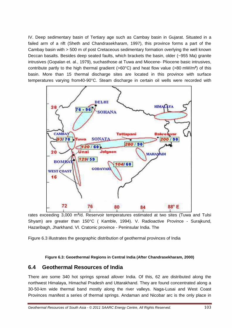
Geothermal Resources of South Asia - © 2011 SAARC Energy Centre, All Rights Reserved. 103
IV. Deep sedimentary basin of Tertiary age such as Cambay basin in Gujarat. Situated in a
failed arm of a rift (Sheth and Chandrasekharam, 1997), this province forms a part of the
Cambay basin with > 500 m of post Cretaceous sedimentary formation overlying the well known
Deccan basalts. Besides deep seated faults, which brackets the basin, older (~955 Ma) granite
intrusives (Gopalan et. al., 1979), suchasthose at Tuwa and Miocene- Pliocene basic intrusives,
contribute partly to the high thermal gradient (>60°C) and heat flow value (>80 mW/m2) of this
basin. More than 15 thermal discharge sites are located in this province with surface
temperatures varying from40-90°C. Steam discharge in certain oil wells were recorded with
rates exceeding 3,000 m3/d. Reservoir temperatures estimated at two sites (Tuwa and Tulsi
Shyam) are greater than 150°C ( Kamble, 1994). V. Radioactive Province - Surajkund,
Hazaribagh, Jharkhand. VI. Cratonic province - Peninsular India. The
Figure 6.3 illustrates the geographic distribution of geothermal provinces of India
Figure 6.3: Geoethermal Regions in Central India (After Chandrasekharam, 2000)
6.4 Geothermal Resources of India
There are some 340 hot springs spread allover India. Of this, 62 are distributed along the
northwest Himalaya, Himachal Pradesh and Uttarakhand. They are found concentrated along a
30-50-km wide thermal band mostly along the river valleys. Naga-Lusai and West Coast
Provinces manifest a series of thermal springs. Andaman and Nicobar arc is the only place in

Geothermal Resources of South Asia - © 2011 SAARC Energy Centre, All Rights Reserved. 104
India where volcanic activity has been reported. Some of the islands like Barren are still active.
The area is in the continuation of the Indonesian geothermal fields and can be good potential
sites for geothermal energy. Cambay graben geothermal belt is 200 km long and 50 km wide
with Tertiary sediments. Thermal springs have been reported from the belt although they are not
of very high temperature and discharge. The area contains oil and gas at considerable depths.
High subsurface temperature and thermal fluid have been reported in deep drill wells in depth
ranges of 1.7 to 1.9 km. Steam blowout have also been reported in the drill holes in depth range
of 1.5 to 3.4km. The thermal springs in the peninsular region are more related to the faults,
which allow down circulation of meteoric water to considerable depths. The circulating water
acquires heat from the normal thermal gradient in the area, and depending upon local condition,
emerges out at suitable localities. The area includes Aravalli range, Son-Narmada-Tapti
lineament, Godavari and Mahanadi valleys and South Cratonic Belts. Some of the important
geothermal fields of India are described as follows (G.S.I., 1991; Chandrasekharam, 2000).
6.5 Potential of Beas and Parbati Valley Geothermal Province
Beas and Parbati valleys are well known for their hot springs in Kulu district, Himachal Pradesh.
The springs lie between altitude of 1,300 m and 3,000 m. The famous thermal springs in the
Beas valley are Bashist, Kalath, Rampur and Kulu, whereas in the Parbati valley, the springs are
at Jan, Kasol, Manikaran, Pulga and Khirganga. The rocks in the area belong to Proterozoic age
and are classified in Vaikrita, Kulu and Rampur Groups. The temperature of springs ranges from
22°C to 59°C in Beas and 21°C to 96°C (96°C being the boiling point at the altitude) in Parbati
valley, respectively.
In the Parbati valley, the thermal springs and drill holes contain low TDS water, which rarely
exceeds 1000 mg/l in the Beas valley, except at Kulu where it goes up to 4094 mg/l. The pH
varies from neutral to slightly alkaline. Classification of thermal water has been made on
Shoeller and Giggenbach diagrams, which indicate water is bicarbonate type and has gone
shallow subsurface circulation. The water has meteoric origin and is of peripheral nature. The
shallow circulation in presence of high CO2 has converted water rich in HCO3. The Na/K ratio in
springs and drill hole is <3 or very high >22, which does not favor high temperature reservoir.
Springs and drill hole plot on Na-K-Mg diagram shows that samples fall in the immature field and
thus no rock-water equilibrium has taken place with respect to rock minerals in the reservoir.
This supports the concept of low temperature reservoir in Beas valley. Parbati valley shows that
the thermal water from springs and drill holes are again of low TDS of around 1000 mg/l. The
silica content hardly exceeds 110 mg/l.
6.6 Potential of Tapoban Geothermal Province
The geothermal field falls in Dhauliganga Valley, a tributary to Alaknanda river in Chamoli
district, Uttarakhand. There are several thermal springs in this part of Dhaluliganga and
Alaknanda Valleys in the temperature range of 25 °C to 65 °C. One of the most prominent
springs is at Tapoban, located 15 km from Joshimath along Joshimath-Malari road. The
exposed rocks belong to Crystalline and Garhwal Groups separated by the Main Central Thrust.

Geothermal Resources of South Asia - © 2011 SAARC Energy Centre, All Rights Reserved. 105
High thermal water discharge of 950 lit/min with 65 °C has been observed in the area, but the
maximum temperature in free flow discharge is 92 °C with thermal fluid discharge of 800 lit/min.
The drill hole and spring water in the area is neutral to alkaline with TDS less than 1,000 mg/l.
There is high SO4 and HCO3 content but low Cl (<20 mg/l) and silica (<120 mg/l). The Na/K ratio
is either very low (<5) or high (>20). All the above chemical characters indicate that the thermal
reservoir is of low to medium temperature. Further, the Na-K-Mg diagram indicates immature
water for Tapoban geothermal field. The chalcedony and quartz geothermometry suggests a
base temperature of the geothermal reservoir to be not more than 100±10 °C, thereby bringing it
in low enthalpy.
6.7 Potential of Sohana Geothermal Province
The Sohana Hot Spring is located close to Gurgaon, Haryana. The rocks of the area belong to
Alwar and Ajabgarh Groups of Proterozoic age. Post intrusive in the form of pegmatite and
quartz veins are of Post Delhi age. The Geological Survey of India drilled a total of 10 holes in
the depth range of 90.1 to 547.2 m. Down hole measurement indicated a maximum temperature
of around 56 °C. Water from drill hole is neutral to alkaline with high TDS (up to 4,818 mg/l) and
Cl (1348 mg/l). Despite high Cl and TDS contents, very low silica (<49 mg/l) and high Mg
(226 mg/l) do not support a high temperature environment for the geothermal field. The exacted
base temperature in the area is 50°C±10°C, based on log SiO2 vs log K2/Mg diagram of
Giggenbach (1988).
6.8 Potential of West Coast Geothermal Province
The area has about 60 thermal springs all along the west coast of Maharashtra. The belt
extends along the coast for a distance of about 350 km from Konkere in the north to Rajapur in
the south with average width of 20 km. The eastern boundary is marked by NNW-SSE trending
Sahyadri mountain range constituting part of the Western Ghats whose western limit is
demarcated by the Arabian Sea coast line. Geologically, the area is marked by thick Deccan
Basalt Flows overlying rocks of Precambrian age. The prominent thermal springs are Rajapur
(42°C), Math (61°C), Sangameshwar (45°C), Rajwadi (61°C), Tural (62°C), Aravil (43 °C), Khed
(35°C), Unhavre (Khed-71 °C), Unhave (Tamhane-54 °C), Vadavli (35°C), Sov (42°C), Pali
(43°C), Akloli (54°C), Ganeshpuri (52°C), Sativli (58°C), Haloli (43 C), Paduspada (42°C), and
Koknere (54°C).13 exploratory holes were drilled along the coast. The spring and drill hole water
are neutral to alkaline and low in TDS except at Unhavre where it is up to 2391 mg/l. The Cl
content in thermal discharge is high but silica is low in amount-maximum around 100 mg/l.
Water has been classified as Na-Cl type on Cl-SO4 –HCO3 diagram and the plots fall close to Cl
apex but none is geothermally matured. The diagram also indicates mixing of thermal and
seawater in the area. The Na/K ratio is very high (>70), which confirms a low temperature
reservoir.

Geothermal Resources of South Asia - © 2011 SAARC Energy Centre, All Rights Reserved. 106
6.9 Conclusions
India has comprehensive data base on the geothermal energy occurrences in the country which
shows that it has reasonably good potential for utilization of geothermal energy. It has been
estimated that the potential geothermal provinces can produce 10,600 MW of power
(D. Chandrasekharam, 2010). But yet geothermal power projects has not been exploited at all,
owing to a variety of reasons, the chief being the availability of plentiful coal at cheap costs.
However, with increasing environmental problems with coal based projects, India will need to
start depending on clean and eco-friendly energy sources in future; one of which could be
geothermal.However some of the fields are actively being studied in detail as given here under
in Table 6.1.
Table 6.1: Geothermal Studies currently being undertaken in India
Geothermal Field Estimated Min. Reservoir Temperature
Status
Puga geothermal field 240°C at 2000m From geochemical and deep geophysical studies (MT)
Tattapani Sarguja (Chhattisgarh) 120°C - 150°C at 500 meter and 200 Cat 2000 m
Magnetotelluric survey done by NGRI
Tapoban Chamoli (Uttarakhand) 100 °C at 430 meter Magnetotelluric survey done by NGRI
Cambay Garben (Gujrat) 160°C at 1900 meter (From Oil exploration borehole)
Steam discharge was estimated 3,000 cu meter/ day with high temprature gradient.
Badrinath Chamoli (Uttarakhand) 150°C estimated Magneto-telluric study was done by NGRI Deep drilling required to ascertain geothermal field
Geothermal Field Reservoir Temp (Approx) Status
Surajkund Hazaribagh (Jharkhand) 110°C Magneto-telluric study was done by NGRI. Heat rate 128.6 mW/m2
Manikaran Kullu (H P)
100°C Magneto-telluric study was done by NGRI Heat flow rate 130 mW/m2
Kasol Kullu (H P)
110°C Magneto-telluric study was done by NGRI
According to Sharma (2010) ONGC estimated power generating capacity of 300 KWe from the
shallow secondary reservoir of Tattapani geothermal field having 105°C at a depth of up to
500m. Also on basis of the Magneto - Tellurics (MT) survey conducted by the National
Geophysical Research Institute (NGRI) which revealed the presence of a vast primary reservoir
of about 260°C at nearly 3 to 3.5 km at the Tattapani Geothermal Field, The National
Hydroelectric Power Corporation (NHPC) technical collaboration with the ONGC and with the
financial assistance Ministry of Non-Conventional Energy Sources (MNES), is developing the
Tattapani Geothermal Field for tapping the electric generation for 5MWe capacity besides
various direct heat applications (Sharma 2010). The project is likely to be operative in near

Geothermal Resources of South Asia - © 2011 SAARC Energy Centre, All Rights Reserved. 107
future. This will also lead to developing other promising geothermal sites like Puga and
Manikaran.
Some companies has also taken initiative and announced to launch geothermal power plants
from other geothermal fields. India’s first geothermal power plant with an initial capacity of 25
mega watt (MW) is expected to come up by 2012 in the Khammam district of Andhra Pradesh
(AP). It is estimated that an investment of US$ 64.66 million will be made for the completion of
the project. It will be set up by Mumbai-based Geo Syndicate Power Private Ltd, a company
incubated by the Indian Institute of Technology (IIT), Bombay, which has a special focus on
exploration and production of geothermal energy. It has already entered into a power purchase
agreement (PPA) with Warangal-based Northern Power Distribution Company that was recently
signed under the aegis of the Non-conventional Energy Development Corporation of Andhra
Pradesh Limited (NEDCAP). Another company namely Avin Energy Systems Pvt Ltd has
explored possibilities of setting up geothermal power projects in Gujarat. Plans are underway to
set up the first 5 MW power generating plant using geothermal energy. Avin has already done
most of the ground work in regard to geothermal power generation in Gujarat and in the coming
future expects to set up geothermal power generating units in Gujarat in the order of 1000 MW
capacity which should, in a way, feed the electricity requirements of not only the State but also
the neighbouring States. Now thecompany is looking for financiers and investors to get the
project off the ground. ([email protected])
With available advance technology, the geothermal resources can be developed for setting up
power projects. Local and foreign entrepreneurs will be attracted in setting up pwer project
through a liberal policy of the Government. Commissioning of at least one geothermal based
power project is going to change the entire future electricenergy scenario of India. It is also
recommended that further exploration and drilling programes be initiatd in the geothermal
provinces. Data on thermal gases and geochemical investigation carried out by collaborative
project between India and Italy be also made public (Minissale et al., 2000).

Geothermal Resources of South Asia - © 2011 SAARC Energy Centre, All Rights Reserved. 108
6.10 Bibliography
1. Achache, José; Courtillot, Vincent; Xiu, Zhou Yao, 1984, Paleogeographic and tectonic
evolution of southern Tibet since Middle Cretaceous time: New paleomagnetic data and
synthesis.Journal of Geophysical Research 89(B12): 10311–10340.
2. Besse, J.; Courtillot, V.; Pozzi, J.P.; Westphal, M.; Zhou, Y.X., 1984, Palaeomagnetic
estimates of crustal shortening in the Himalayan thrusts and Zangbo Suture".Nature 311(5987):
621–626.
3. Besse, Jean; Courtillot, Vincent (10 October 1988). "Paleogeographic maps of the
continents bordering the Indian Ocean since the Early Jurassic".Journal of Geophysical
Research 93(B10): 11791–11808.
4. Bingham, Douglas K.; Klootwijk, Chris T., 1980, Palaeomagnetic constraints on Greater
India's underthrusting of the Tibetan Plateau. Nature 284(5754): 336–338.
5. Blanford, W.T.; Medlicott, H.B., 1879,.A manual of the geology of India. Calcutta.
6. Briggs, J. C., 2003, the biogeographic and tectonic history of India. Journal of
Biogeography 30:381–388.
7. Brookfield, M.E. 1993, The Himalaya passive margin from Precambrian to Cretaceous
times".Sedimentary Geology84: 1–35.
8. Burbank, D. W., Leland, J., Fielding, E. Anderson, R. S., Brozovic, N., Reid, M. R.,
Duncan, C., 1996, Bedrock incision, rock uplift and threshold hillslopes in the northwestern
Himalayas.Nature379(6565): 505–510.
9. Chandrasekharam, D., Ramesh, R., Balasubramanian, J., 1989, Geochemistry, oxygen
and hydrogen isotope ratios of thermal springs of western continentalmargin of India - field and
experimental results.In: 6thWater-Rock Interaction, D.L.Miles, (Ed), A.A.Balkema.Pub. Co.,
TheNetherlands,pp 149-154.
10. Chandrasekharam, D., 1996, Potential HDR sites and prospectus of geothermal energy
in India. 3 rd Inter. HDR Forum, New Mexico, May 13-16, 1996 p 141, (Ex-abst).
11. Chandrasekharam, D., 1995, Industrial applications of geothermal
energy.IndustrialProductsFinder,Vol., 23, pp 223-225.
12. Chandrasekharam, D. and Antu, M.C., 1995, Geochemistryof Tattapani thermal springs,
Madhya Pradesh, India: Field and experimental investigations.Geothermics, Vol. 24, pp 553-
559.
13. Chandrasekharam, D. and Parthasarathy, A. 1978, Geochemical and tectonic studies on
the coastal and inland Deccan Trap volcanic and a model for the evolution of Deccan Trap
volcanism.N. Jb. Min. Abh., Vol., 132,pp 214-229.
14. Chandrasekharam, D,1985, Structure and evolution of the western continental margin of
India deduced from gravity,seismic,geomagnetic and geochronological studies. Phy. Earth.
Planet. Interiors, Vol., 41, pp 186-198.
15. Chandrasekharam, D, and Jayaprakash, S. J., 1996, Geothermal Energy assessment:
Bugga and Manuguruthermal springs, Godavari valley, Andhra Pradesh. Geoth, Res.
Bulletin,Vol. 25, pp 19-21.

Geothermal Resources of South Asia - © 2011 SAARC Energy Centre, All Rights Reserved. 109
16. Chandrasekharam, D., Rao, V.G. and Jayaprakash, S.J., 1996, Geothermal Energy
potential and direct use of Geothermal springs, Godavarivalley,andPradesh, Geol. Sur. India,Sp.
Pub., Vol. 45,pp155-161.
17. Chandrasekharam, D., Minissale, A., Vaselli, O., Tassi, F. and Magro, G., 1997, Gas
geochemistry of certain thermal springs, India.In: Rare Gases Geochemistry, IV International
Conference, 8-10 October, 1997, Rome. p 43 (Abst).
18. Chandrasekharam, D., andPrasad, S.R, 1998, Geothermalsystem inTapi rift basin,
Northern DeccanProvince, India. In: 9thWater - Rock Interaction, G.B.Arehart and J.R. Hulston,
(Eds) .A.A. Balkema, Pub. Co, the Netherlands,pp 667-670.
19. Choubert, G. and Faure-Muret, A., 1976, Geological World Atlas, UNESCO, sheet ll,
scale: 1:10,000,000.
20. CIA.Face Book, 2011.
21. Dasgupta, A. K., Ghose, A., and Chakraborty, K. K., 1993, Geological map of India:
Hyderabad, Geological Survey of India, scale: 1:5,000,000.
22. Dewey, J.F.1988, Extensional collapse of orogens.Tectonics7(6): 1123–1139.
23. Dewey, J.F.; Cande, S.; Pitman III, W.C., 1989, Tectonic evolution of the Indian/Eurasia
Collision Zone.Eclogae geologicae Helvetiae 82(3): 717–734.
24. Ding, L., Kapp, P., Wan, X., 2005, Paleocene-Eocene record of ophiolite obduction and
initial India-Asia collision, south central Tibet. Tectonics 24(3): TC3001.
25. Economic Times.1999. Times of India Publication.dated 2 June 1999.
26. Economic Times.1999. Times of India Publication. Dated 8 June 1999.
27. Environmental Systems Research Institute Inc., 1992, ArcWorld 1:3M Environmental
Systems Research Institute, Inc. (ESRI), Digital database, available from ESRI, Redlands, CA,
scale: 1:3,000,000.
28. Energy Information Administration (EIA), 2005b, India- Analysis,
http://www.eia.gov/cabs/India/Background.html
29. Frank, W., Gansser, A, Trommsdorff, V. 1977, Geological observations in the Ladakh
area (Himalayas); a preliminary report.Schweizerische Mineralogische und Petrographische
Mitteilungen Bulletin 57(1): 89–113.
30. Ghose, A., Chatterjee, D., and Bannerjee, J., 1990, Geological map of South and East
Asia: Commission for Geological Map of the World, Subcommission for South and East Asia,
UNESCO, scale: 1, 5,000,000.
31. Giggenbach, W. F.1976. Chemistry of thermal discharges from Parbati river, Sohana and
west coast fault geothermal fields. U.N. ProjectReportIND-73-008.
32. Giggenbach, W. F., Gonfiantini, R., Jangi, B. L. and Truesdell, A.H. 1983. Isotope and
chemical composition of Parbati valley geothermal discharges, North-westHimalaya, India.
Geothermics, Vol., 12, pp 199-222.
33. Girard, M., Bussy, F., 1998, Late Pan-African magmatism in Himalaya: new
geochronological and geochemical data from the Ordovician Tso Morari metagranites (Ladakh,

Geothermal Resources of South Asia - © 2011 SAARC Energy Centre, All Rights Reserved. 110
NW India).Schweizerische Mineralogische und Petrographische Mitteilungen Bulletin79:
399–418.
34. Gopalan, K., Trivedi, J. R., Merh, S. S., Patel, P. P. and Patel, S. G. 1979. Rb-Sr age of
Godhra and related granites, Gujarat, India. Proceed. Indian Acad. Sci., Vol. 88,
pp 7-17.
35. Gupta, M. L.1981. Surface heat flow andigneous intrusion in the Cambay basin.
J.Volanol. Geother. Res., Vol., 10, pp 279-292.
36. G.S.I., 1987. “Geothermal Volume”. Geol. Surv. IndiaRecords, 115,206p.
37. G.S.I., 1991. “Geothermal Atlas of India”. Geol. Surv. IndiaSpe. Pub., 19, 144 p.
38. Heim, A., Gansser, A., 1939, Central Himalaya; geological observations of the Swiss
expedition 1936.Schweizer. Naturf. Ges, Denksch. 73(1): 245.
39. International Monetary Fund, World Economic Outlook Update, June 2011, p.2, retrieved
22 July 2011.
40. India Core Information, 2011, www.indiacore.com/overview-energy.html.
41. International Commission on Stratigraphy (ICS), (2004), A Geologic Time
Scale,Gradstein, Felix M.; Ogg, J. G.; Smith, A. G.. Cambridge: Cambridge University Press.
42. JEBCO Seismic Ltd., compilers, 1984, Geological world atlas U.S.S.R. and surrounding
areas: extract from the Geological World Atlas, sheets 10 through 13, Commission for the
Geological Map of the World/UNESCO, scale: 1:10,000,000.
43. Joga Rao, M. V., Rao, A .P., 1987, Results of Geophysical Survey in the Tattapani Hot
Spring Area, Distt. Surguja, Madhya Pradesh, GSI Records, Vol. 115, Part6, 66.83.
44. Kaila, K.L. andKrishna, V.G. (1992).Deep seismic sounding studies in India and major
discoveries. Current Sci., Vol. 62, pp 117-154.
45. Kamble, S. R. 1994. Hydrogeochemistry of Tuwa and Tulsi Shyam thermal springs,
Gujarat. M.Sc., Dissertation, IIT, Bombay (unpublished).
46. Klett, T. R., Ahlbrandt, T. S., Schmoker, J. W., and Dolton, G. L., 1997, Ranking of the
world's oil and gas provinces by known petroleum volumes: U.S. Geological SurveyOpen-File
Report 97-463.
47. Klootwijk, C.T.; Conaghan, P.J.; Powell, C. Mc. A., 1985, The Himalayan Arc: large-scale
continental subduction, oroclinal bending and back-arc spreading.Earth and Planetary Science
Letters 75(2–3): 167- 183.
48. Klootwijk, C. T., Gee, J. S., Peirce, J. W., Smith, G. M., McFadden, P. L., 1992, An early
India-Asia contact: Paleomagnetic constraints from Ninetyeast Ridge, ODP Leg
121".Geology20(5): 395–398.
49. Krishnaswami, V.S., and Ravi S., 1982, Scope of Development, Exploration and
preliminary assessment of the geothermal resource potential of India. Records of GSI, Vol.111,
Pt.2.
50. Le Fort, P.; Cronin, V. S., 1988, Granites in the Tectonic Evolution of the Himalaya,
Karakoram and Southern Tibet. Philosophical Transactions of the Royal Society of London.
Series A, Mathematical and Physical Sciences 326(1589): 281–299.

Geothermal Resources of South Asia - © 2011 SAARC Energy Centre, All Rights Reserved. 111
51. Le Pichon, X., Fournier, M., Jolivet, L., 1992, Kinematics, topography, shortening, and
extrusion in the India-Eurasia collision.Tectonics 11(6): 1085–1098.
52. Minissale, A., Vaselli, O., Chandrasekharam, D., Magro, G., Tassi, F. and Casiglia, A.
2000. Origin and evolution of 'intracratonic' thermal fluids from central-western peninsular India.
Earth. Planet. Sci. Lett., 181, 377-398.
53. Molnar, P.; Tapponnier, P., 1975, Cenozoic tectonics of Asia; effects of a continental
collision.Science 189(4201): 419–426.
54. Muffler, P., and Cataldi, R., 1987, Methods for Regional Assessment of Geothermal
Resources, Geothermics, Vol. 7, 53-89.
55. Nagar, R.K., Viswanathan, G., Surendra Sagar, and Sankaranarayanan, A. 1996.
Geological, geophysical and geochemical investigations in Bakreswar-Tantloi thermal field,
Birbhum and Santhal Parganas districts, west Bengal and Bihar, India. Geol. Survey India, Spe.
Pub., 45, pp 349-360.
56. Nevada, S.V. andRao, S.M. 1991. Isotope studies of some geothermal waters in India.
Isopenpraxis, Vol. 27, pp 153-163.
57. Oldham, T., 1882, the thermal springs of India, dited by R. D. Oldham, Mem. Geol. Surv.
of India, 19, 99-161 Calcutta.
58. Pande, D .K. Misra, K. N. and Sharma, S. (1984). Source bed history of Bombay
offshore region. In: Oil and Gas fields, Proced. Inter. Geol. Cong., Moscow, Vol. 13, pp 211-244.
59. Patriat, P., Achache, J., 1984, India-Eurasia collision chronology has implications for
crustal shortening and driving mechanism of plates .Nature 311(5987): 615–621.
60. Pitale, U., Padhi, R. and Sarolkar, P. 1995. Pilot geothermal power plant and scope of
commericial utilization of Tattapani geothermal field, Surguja district, Madhya Pradesh, India.
Proceed. World Geothermal Congress, 1995, Florence, Italy, Vol., 2, pp 1257-1262.
61. Petroconsultants International Data Corporation, 1988, World Sedimentary Basins:
Geneva, Switzerland, scale: 1:23,000,000.
62. Planning Commission, 1999, review of tenth and eleventh plans, Government of India.
63. Ramanathan, A.1993. Geochemistry of thermal springs located along the west coast,
India. Ph.D. Thesis, IIT, Bombay (unpublished).
64. Ramanathan, A. and Chandrasekharam, D. 1997. Geochemistry of Rajapur and Puttur
thermal springs of the west coast, India. J. Geol. Soc. India. Vol., 49, pp 559-565.
65. Gosh, P. K.’ 1954, Records, Geological Survey of India, Vol. 80. Pp. 541-558
66. Guha, S. K. and Chatterjee, G. C., 1964, Studies on the geological and hydrological
controls of thermal areas, Bihar, Part XXII Int. Geol. Cong., New Delhi, pp.194-204.
67. Guha, S. K., 1986, Status of exploration for geothermal resources in India, Geothermics,
vol. 15, no. 5/6, pp665-675.
68. Rao, C.K., Gokarn, S.G. and Singh, B.P., 1995 Upper crustal structure in the Torni-
Purnad region, central India using magnetotelluric studies. J. Geomag. Geoelec., Vol. 47, pp
411-420.

Geothermal Resources of South Asia - © 2011 SAARC Energy Centre, All Rights Reserved. 112
69. Ravi S., 1988, Heat - flow map of India and discussions on its geological and economic
significance. Indian Miner, Vol., 42, pp 89-110.
70. Ravi S., 1987, Status of Geothermal Exploration in Maharashtra and Madhya Pradesh
(C.R), GSI Records, Vol. 115, part 6, 7-29.
71. Ravi S., Guha, S. K, Seth, N.N., Muthuraman, K., Pitale, U.L., Jangi, B.L., Prakash, G,
Bandopadhyay, A.K. and Sinha, R.K., 1992,: Geothermal Atlas of India. Special Publication No.
19,Geological Survey of India, 144.
72. Ricou, L.M., 1994, Tethys reconstructed: plates, continental fragments and their
Boundaries since 260 Ma from Central America to South-eastern Asia.Geodinamica Acta7(4):
169–218.
73. Sarolkar, P.B., 1993, Subsurface geological studies in Tattapani Geothermal field, M.P.,
GSI Records vol. 126, pt. 6, 36.
74. Sharma, S. K. 2010, Geothermal: a Sustainable Energy Outlook for India, Proceedings
World Geothermal Congress Bali, Indonesia, 25-29 April (2010), 4pp.
75. Sheth, H. C. and Chandrasekharam, D. 1997. Plume-rift interaction in the Deccan
volcanic province. Phy.Earth. Planet. Inter., Vol., 99, pp 179-187.
76. Singh, R. P. andNabetani, S., 1995, Resistivity structure of Puga geothermal field.
Proceed. World Geoth. Congr. 1995, Florence, Italy. Vol., 2, pp 887- 892.
77. Stampfli, G.M.; Mosar, J.; Favre, P.; Pillevuit, A.; Vannay, J.-C., 1998, Permo-Triassic
evolution of the western Tethyan realm: the Neotethys/east-Mediterranean basin
connection.PeriThetys3.
78. Stampfli, G.M.; Borel, G.D., 2002, A plate tectonic model for the Paleozoic and Mesozoic
constrained by dynamic plate boundaries and restored synthetic oceanic isochrons".Earth and
Planetary Science Letters 196(1): 17–33.
79. Steck, A., Spring, L., Vannay, J.C., Masson, H., Stutz, E., Bucher, H., Marchant, R.,
Tièche, J.C., 1993,Geological Transect Across the Northwestern Himalaya in eastern Ladakh
and Lahul (A Model for the Continental Collision of India and Asia).Eclogae Geologicae
Helvetiae86(1): 219–263.
80. Steck, A.., spring, L., Vannay, J.C., Masson, H., Bucher, H., Stutz, E., Marchant, R.,
Tieche, J.C., 1993, Treloar, P. J.; Searle, M. P.ed. The tectonic evolution of the northwestern
Himalaya in eastern Ladakh and Lahul, India, in Himalayan Tectonics.Geological Society,
London, Special Publications(London: Geological Society of London)74: 265–276.
81. Thussu, J. L, Prasad, J.M. and Saxena, R. K., 1987, Geothermal Energy Resources
Potential of Tattapani Hot Spring Belt, Distt. Surguja, M.P, GSI Records Vol. 115, pt. 6, 30-55.
82. Wikipedia, 2001, Geology of India.
83. Wirtz, D., Muhlfeld, R., Weippert, D., and Wittekindt, H., compilers, 1964, Geological map
of Afghanistan Central and Southern Part: Hanover, Geological Survey of the Federal Republic
of Germany, and Afghanistan Geological and Mineral Survey (Kabul), scale: 1:1,000,000.
84. Yin, A., 2006, Cenozoic tectonic evolution of the Himalayan orogen as constrained by
along-strike variation of structural geometry, exhumation history, and foreland
sedimentation.Earth-Science Reviews 76(1–2): 1–131.

Geothermal Resources of South Asia - © 2011 SAARC Energy Centre, All Rights Reserved. 113
CHAPTER – 7 GEOTHERMAL RESOURCES OF NEPAL
7.1 Geological Framework
Nepal occupies the central sector of Himalayan Arc. Nearly one third of the 2400km long
Himalayan range lies within Nepal. Similar to other parts of the Himalaya, from south to north,
Nepal can be also subdivided into the following five major tectonic zones characterized by their
own lithology, tectonics, structures and geological history (After Ranjan Kumar Dahal,
2006;Figure 7.1).
Gangetic Plain
Sub-Himalayan (Siwalik) Zone
Lesser Himalayan Zone
Higher Himalayan Zone
Tibetan-Tethys Himalayan Zone
All these tectonic zones are separated from each other by the thrust faults (Figure 7.2). The
southernmost fault, the Main Frontal Thrust (MFT) separates the Sub-Himalayan (Siwalik) Zone
from Gangetic Plains. The Main Boundary Thrust (MBT) separates the Lesser Himalayan Zone
from Siwalik. The Main Central Thrust (MCT) separates the Higher Himalayan Zone from the
Lesser Himalayan Zone. The South Tibetan Detachment System (STDS) marks the boundary
between the Higher Himalayan Zone and the overlying fossiliferous sequence of the Tibetan-
Tethys Himalayan Zone. The Indo-Tsangpo Suture Zone is the contact knot between Indian
plate and Tibetan (Eurasian) Plate in terms of plate tectonics.
Figure 7.1: Geological Map of Nepal (Modified from Dahal, 2006)

Geothermal Resources of South Asia - © 2011 SAARC Energy Centre, All Rights Reserved. 114
Figure 7.2: Generalized Cross Section of Himalaya (Modified After Dahal 2006)
The main geological zones of the Nepal Himalaya are described below.
7.1.1 Gangetic Plain
The Gangetic Plain is also called as Terai Zone and it is the Nepalese portion of the Gangetic
Plain that extends from the Indian Shield in the South to the Sub-Himalayan (Siwalik) Zone to
the North. The plain is in less than 200 meters above sea level and usually has thick (nearly
1,500 m) alluvial sediments. The alluvial sediments contain mainly boulder, gravel, silt and clay.
The width of Terai Zone varies from 10 to 50 km and forms a nearly continuous belt from east to
west. Exceptionally at two place, Chitwan and Rapti valleys, the Terai Zone is interrupted by
Siwalik for 70 km and 80 km respectively. Terai Zone is a foreland basin and has sediment
originated from peaks of Northern part. To the north, this zone is separated by an active thrust
system called as the Main Frontal Thrust (MFT) with Siwalik. At some places along MFT, the
Siwalik rocks are observed to rest over the recent sediments of the Terai (Dahal 2006).
A large number of borehole logs and geophysical investigation made during the groundwater
investigation and petroleum exploration in Terai play a lead role to study the surface and
subsurface geology of the Terai. It further helps to classify the Terai into Northern Terai or
Bhabhar Zone, Middle Terai and Southern Terai.
Northern Terai (Bhabar Zone)
The northern Terai is adjoining to the foothills of Siwalik and continues southward to a maximum
width of 12 km. This part of Terai is also known as Bhabar Zone. This zone is mainly composed
of boulders, pebbles, cobbles and coarse sand derived from the rocks of Siwalik and Lesser
Himalaya. These boulders, pebbles, and cobbles are mostly made up of sandstones
(Figure 7.3) and the rocks from the immediate northern vicinity. Bhabhar Zone acts as a
recharge zone for the groundwater of Terai. Most of the rivers lose their water while passing
through this zone. In this Zone, water tables in wells show very sharp fluctuations between the
summer and rainy seasons. At some places the wells become completely dry in summer. Due to
the very course nature of the sediments, low water table and quick percolation of rainwater, this
zone is particularly not productive for agriculture and therefore ideal for the development of
forest resources.

Geothermal Resources of South Asia - © 2011 SAARC Energy Centre, All Rights Reserved. 115
Middle Terai (Marshy) Zone
This is a narrow zone of about 10-12 km wide and lying between the Northern Terai Zone and
the Southern Terai Zone. This zone is characterized by pebbly and brown to grey colored
unconsolidated sandy sediments with few clay partings. Clay is mostly dark grey colored and
intercalated with brown colored sand layers. The medium to coarse grained sandy layers
possesses good groundwater reservoir. Because of marked change in elevation from Bhabar
Zone, this zone comprises marked development of spring line, natural ponds, marshland and
lakes (Dahal 2006). Immediate south of spring lines, there are many artesian layers are found in
depth of 25 m to 200 m. The permeability of Middle Terai Zone diminishes towards south and
finally non permeable layers are encountered in boundary of the Southern Terai Zone
(Figure 7.3).
Southern Terai Zone
Southern Terai Zone is southern most part of Terai up to Nepal-India border and also continues
into India. This zone consists of main sediments of Gangetic Plain. Basically, sand, silt and clay
(Figure 7.3) are the main sediments of this zone. This zone is composed of finer sediments than
the Middle Terai Zone. To the extreme south bordering the Indian Plains, the sediments become
finer and also show change of facies. The water table is about 3 m below the surface and
aquifers are poor (Figure 7.3). Only in old river channels area north-south extending better
aquifers are found. Therefore, except at the northern part and along old river channels, there are
particularly no good aquifers in the lower horizons (Dahal 2006).For this reason, in the southern
Terai of Nepal, the development of the groundwater also appears to be difficult by deep tube
wells.

Geothermal Resources of South Asia - © 2011 SAARC Energy Centre, All Rights Reserved. 116
Figure 7.3: Subsurface Condition of Terai Zone of Nepal (After Daha, 2006)
7.1.2 Sub-himalayan (Siwalik) Zone
The Sub-Himalaya Zone is also called as Siwalik Zone and is delimited on the south by the Main
Frontal Thrust (MFT) and on the north by the Main Boundary Thrust (MBT). It consists basically
of fluvial deposits of the Neogene age (23 millions years to 1.6 millions years old). This zone
extends all along the Himalaya forming the southernmost hill range with width of 8 to 50 km. The
Lesser Himalayan rocks thrust southward over the rocks of Siwalik along the MBT (Dahal,
2006).
The general dip of beds of Siwalik has northward trend with varying angles and the overall strike
is east-west. The Siwalik Zone has number of east-west running thrusts. Siwalik Zone is also
rich with fossils. Fossils of plants, fishes, reptiles and mammals (Carnivora, Proboscidea,
Artiodactyla, Rodentia and Primates) have been reported from Siwalik.
The three-fold classification of Siwalik in Potwar region of Pakistan and western Indian Himalaya
was freely applied to the equivalent Siwalik of Nepal (Burbank et al., 1996) from the beginning of
the geological studies in Nepal. According to three fold classification, Siwalik can be classified
as follow.
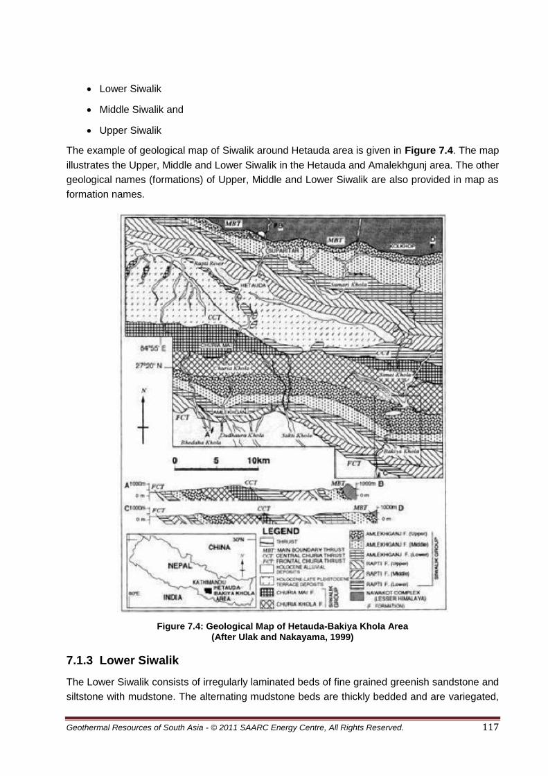
Geothermal Resources of South Asia - © 2011 SAARC Energy Centre, All Rights Reserved. 117
Lower Siwalik
Middle Siwalik and
Upper Siwalik
The example of geological map of Siwalik around Hetauda area is given in Figure 7.4. The map
illustrates the Upper, Middle and Lower Siwalik in the Hetauda and Amalekhgunj area. The other
geological names (formations) of Upper, Middle and Lower Siwalik are also provided in map as
formation names.
Figure 7.4: Geological Map of Hetauda-Bakiya Khola Area (After Ulak and Nakayama, 1999)
7.1.3 Lower Siwalik
The Lower Siwalik consists of irregularly laminated beds of fine grained greenish sandstone and
siltstone with mudstone. The alternating mudstone beds are thickly bedded and are variegated,

Geothermal Resources of South Asia - © 2011 SAARC Energy Centre, All Rights Reserved. 118
red, purple, and brown coloured. The best exposures of Lower Siwalik are found in Surainaka,
Amlekhgunj, Arun Khola, Barahchhetra and Rato Khola area of Nepal.
7.1.4 Middle Siwalik
The Middle Siwalik are comprised of medium to coarse grained salt-and-pepper (looks like
mixture of salt and black pepper) sandstones interbedded with mudstone (Figure 7.5). This is
differentiated from the Lower Siwalik in lacking variegated mudstone and sandstone. In upper
part of the Middle Siwalik, pebbly sandstone beds are also found. In Middle Siwalik the
sandstone beds have thickness mostly ranges from 1 m to 45 m. The exposures of Middle
Siwalik are found mainly in Surkhet, Surai Khola, Hetauda, and Butwal.
Figure 7.5: Interbedding Sandstone and Mudstone in Middle Siwalik, Butwal-Tansen Section of Siddhartha Highway
7.1.5 Upper Siwalik
The Upper Siwalik is comprised of conglomerate and boulder beds and subordinately sand and
silt beds. The mudstone beds of the Upper Siwalik are massive and irregularly bedded and
contain many invertebrate fossils including Brachiopods and Gastropods. The upper part of this
sequence contains conglomerate beds, which have mostly boulder and cobble size rounded to
sub angular fragments of Lesser Himalayan rocks. In Bardibas, Hetauda, Bhalubang, and
Chitwan the good exposure of Upper Siwalik can be seen.
7.1.6 Lesser Himalayan Zone
The Lesser Himalayan Zone is bounded to the north by the Main Central Thrust (MCT) and to
the south by Main Boundary Thrust (MBT). MBT can be traced out in entire Nepal Himalaya
(Figure 7.6 and Figure 7.7). The rocks of Lesser Himalayan Zone have been transported

Geothermal Resources of South Asia - © 2011 SAARC Energy Centre, All Rights Reserved. 119
southwards in several thrust slices. Generally two types of sequences namely autochthonous
and allochthonous can be distinguished in this zone throughout the Himalayas. The both
sequences of the Lesser Himalaya mainly have unfossiliferous, sedimentary, and meta
sedimentary rocks such as slate, phyllite, schist, quartzite, limestone, dolomite, etc, ranging in
age from Precambrian to Eocene. There are also some granitic intrusions in this zone.
Figure 7.6: Aerial Photograph of Udaypur District (Eastern Nepal) Well Marked Main Boundary Thrust (MBT) is Passingthrough Middle of Photograph
Figure 7.7: MBT Observed in Butwal-Tansen Section of Siddhartha Highway

Geothermal Resources of South Asia - © 2011 SAARC Energy Centre, All Rights Reserved. 120
From east to west, the Lesser Himalayan Zone of Nepal varies in rock type, age, structures, and
igneous rock intrusion. Eastern Nepal is characterized by the development of extensive thrust
sheets (allochthonous) of high grade metamorphic rocks (gneiss and schist) which have moved
southwards. Below this sequence, due to erosion, large exposure of the low-grade metamorphic
rocks (autochthonous) can be seen. In Central Nepal, a large thrust sheet called the Kathmandu
Nappe (allochthonous) covers a wide area around the Kathmandu region. Whereas west of
Kathmandu, between the Budhi Gandaki and Bheri rivers, amount of transported high grade
metamorphic rocks (allochthonous) is very low and the area is generally covered by
autochthonous sequence. But in west of the Bheri River, up to the western border of Nepal
(Dadeldhura-Baitadi) high-grade metamorphic rocks reappear and cover much of the terrain.
7.1.7 The Greater Himalayan Zone
The Higher Himalayan zone mainly consists of huge pile of strongly metamorphosed rocks.
Geologically, the Greater Himalayan Zone includes the rocks lying north of the Main Central
Thrust (MCT) and below the highly fossiliferous Tibetan-Tethys Zone. This zone is separated
with Tibetan-Tethys Zone by normal fault system called as South Tibetan Detachment System
(STDS). Higher Himalayan Zone consists of an approximately 10 km thick succession of
strongly metamorphosed coarse grained rocks. It extends continuously along the entire length of
the country as in whole Himalaya, and its width varies from place to place (see Figure 7.1). The
kyanite - sillimanite minerals bearing gneisses, schists, and marbles of the zone form the
basement of the Tibetan-Tethys Zones. Granites are found in the upper part of the unit.
7.1.8 The Tibetan-Tethys Zone
The Tibetan-Tethys Zone lies in northern part of the country. It begins from the top of the South
Tibetan Detachment System (STDS) and extends to the north in Tibet (Figure 7.8). In Nepal, the
fossiliferous rocks of the Tibetan-Tethys Zone are well-developed in Mustang, Manang and
Dolpa area (Figure 7.9). In eastern part, amount of exposure of the Tibetan Tehys Zone is
almost negligible and found only in top of the Mount Everest (Figure7.1). Most of the other Great
Himalayan peaks of Nepal such as Manaslu, Annapurna, and Dhaulagiri have rocks of Tibetan-
Tethys Zone. This zone is composed of sedimentary rocks, such as shale, limestone, and
sandstone, ranging in age from Cambrian to Eocene. This zone in some area is found as
continuous deposits of Higher Himalayan Zone without normal fault.

Geothermal Resources of South Asia - © 2011 SAARC Energy Centre, All Rights Reserved. 121
Figure 7.8: South Tibetan Detachment System Separating Higher Himalayan Zone from Tibetan - Tethys Zone, Chhaktan Khola, North West
from Kokhethati, Mutang ( Adopted from Dahal 2006 ).
Figure 7.9: Cliff of limestone belongs to Tibetan-Tethys Zone, Jomsom, Mustang (Adopted from Dahal 2006)
7.2 Physiography of the Nepal Himalaya
Physiographic division of Nepal has been in practice since 1950s. It was 1969, Tony Hagen
successively divided Nepal into eight well defined physiographic provinces from south to north.
These provinces are E-W running and can also be incorporated in Indian Himalayan belt. The
Hagen classification is the most appropriate classification and represents all characteristic
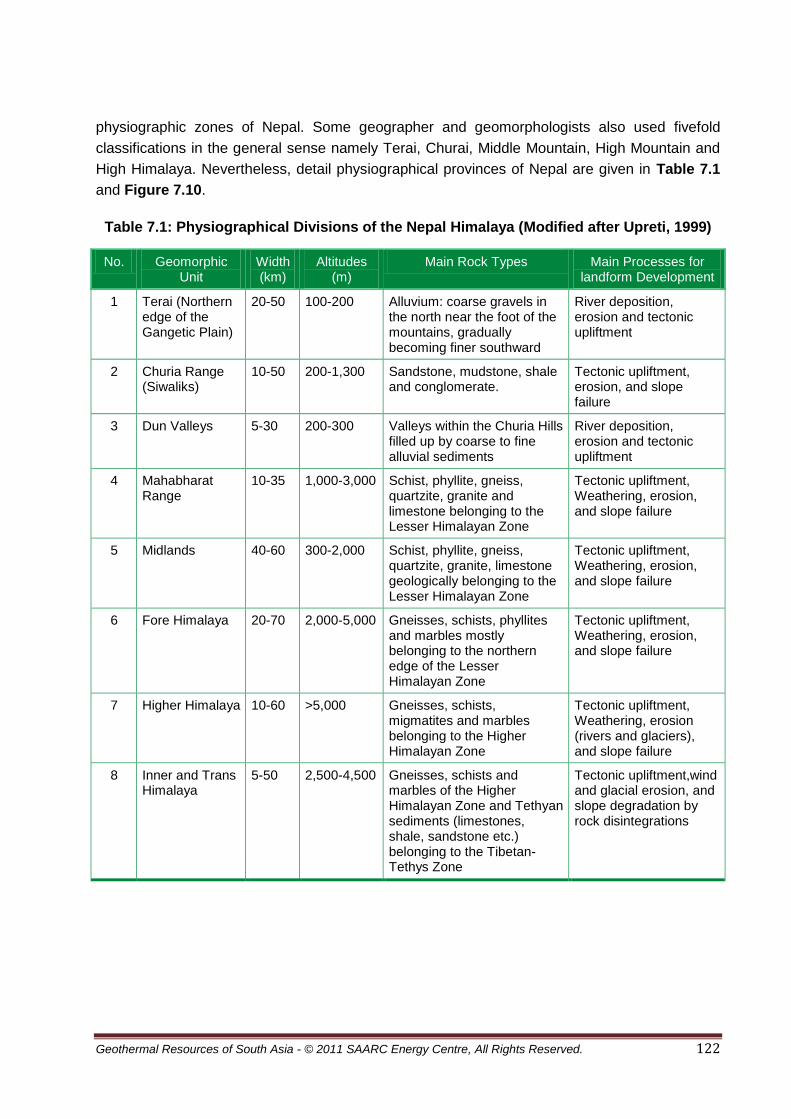
Geothermal Resources of South Asia - © 2011 SAARC Energy Centre, All Rights Reserved. 122
physiographic zones of Nepal. Some geographer and geomorphologists also used fivefold
classifications in the general sense namely Terai, Churai, Middle Mountain, High Mountain and
High Himalaya. Nevertheless, detail physiographical provinces of Nepal are given in Table 7.1
and Figure 7.10.
Table 7.1: Physiographical Divisions of the Nepal Himalaya (Modified after Upreti, 1999)
No. Geomorphic Unit
Width (km)
Altitudes (m)
Main Rock Types Main Processes for landform Development
1 Terai (Northern edge of the Gangetic Plain)
20-50 100-200 Alluvium: coarse gravels in the north near the foot of the mountains, gradually becoming finer southward
River deposition, erosion and tectonic upliftment
2 Churia Range (Siwaliks)
10-50 200-1,300 Sandstone, mudstone, shale and conglomerate.
Tectonic upliftment, erosion, and slope failure
3 Dun Valleys 5-30 200-300 Valleys within the Churia Hills filled up by coarse to fine alluvial sediments
River deposition, erosion and tectonic upliftment
4 Mahabharat Range
10-35 1,000-3,000 Schist, phyllite, gneiss, quartzite, granite and limestone belonging to the Lesser Himalayan Zone
Tectonic upliftment, Weathering, erosion, and slope failure
5 Midlands 40-60 300-2,000 Schist, phyllite, gneiss, quartzite, granite, limestone geologically belonging to the Lesser Himalayan Zone
Tectonic upliftment, Weathering, erosion, and slope failure
6 Fore Himalaya 20-70 2,000-5,000 Gneisses, schists, phyllites and marbles mostly belonging to the northern edge of the Lesser Himalayan Zone
Tectonic upliftment, Weathering, erosion, and slope failure
7 Higher Himalaya 10-60 >5,000 Gneisses, schists, migmatites and marbles belonging to the Higher Himalayan Zone
Tectonic upliftment, Weathering, erosion (rivers and glaciers), and slope failure
8 Inner and Trans Himalaya
5-50 2,500-4,500 Gneisses, schists and marbles of the Higher Himalayan Zone and Tethyan sediments (limestones, shale, sandstone etc.) belonging to the Tibetan-Tethys Zone
Tectonic upliftment,wind and glacial erosion, and slope degradation by rock disintegrations

Geothermal Resources of South Asia - © 2011 SAARC Energy Centre, All Rights Reserved. 123
Figure 7.10: Physiography of the Nepal Himalaya (After Dahal and Hasegawa, 2008)
7.3 Surface Manifestations of Geothermal Resources
The only information on hot springs and geothermal resources of Nepal is from two papers by
Ranjit (2005) and Ranjit (2010) which were published in the proceedings of World Geothermal
Congress 2005 and 2010 respectively. This part of the report is mainly derived from these
papers.
Surface display of geothermal energy in Nepal occurs in more than twenty-eight localities,
mostly occurring along the Main Central Thrust in Lesser and Greater Himalyan Region while a
few are located scattered near the Main Boundary Fault. Figure 7.11 shows the location of the
important hot springs.
7.3.1 The Darchula District Thermal Springs
It is the farthest western region which has three thermal springs located at Sina, Sribagar and
Chamaliya localities. The Sina thermal springs occur in crystalline rocks located near the thrust
contact between the overlying augen gneiss and the underlying sericitic schist and quartzite.
The thrust is displaced by a recent fault on which many springs are aligned. The hot spring in
Sribagar is located in the recent river sediments. The area is near the tectonic contact between
the autochthonous metasedimentary zone and the crystalline sheet. The tectonic contact is
marked by the highly crushed chlorite-sericite quartz phyllites on the ridge east of Sribagar. The
Chamaliya spring issues from the recent terrace deposit and is confined to a meta sedimentary
autochthonous zone composed of slates and carbonate rocks.

Geothermal Resources of South Asia - © 2011 SAARC Energy Centre, All Rights Reserved. 124
7.3.2 The Bajhang District Thermal Springs
The thermal springs in this district are near the major thrust between the crystalline
allochthonous and meta sedimentary autochthonous zones. The purple shale and green
sandstone with gritty quartzites are highly folded. The major thermal source is located near the
thrust zone whereas the minor sources are either near some fault or the contact zone of
different lithological units.
Figure 7.11: Location of Geothermal Springs in Nepal (After Ranjit 2005)
7.3.3 The Jumla District Thermal Springs
In Jumla district, the thermal springs occur mainly in Tila Nadi and Dhanchauri. The right bank of
Tila Nadi accommodates a number of closely located hot springs. Gas seepage occurs in some
of them in recent deposits of gravel and boulders with sandy-silty clay. Mini-folds and micro
faults can be observed along the Tila Nadi valley indicating the neotectonic activity. Two
seepages occur at the fracture joints in the calcareous gneiss and marble.
Legend
MCT Main Central Thrust MBF Main Boundary Thrust
Hot Spring location

Geothermal Resources of South Asia - © 2011 SAARC Energy Centre, All Rights Reserved. 125
7.3.4 The Dhanchauri Area Thermal Springs
In Dhanchauri area the springs issue from the light-grey platy dolomite and are characterized by
a thick tuffaceous deposit consisting of carbonate and silica. Three major hot springs are located
here.
7.3.5 Riar Thermal Spring
It is located at the south of the Siwalik formation (a northern chain of hills reaching a height of
some 1500 m and the rock in the immediate vicinity is covered by soil.
7.3.6 The Mayangdi Thermal Spring
The spring issues from the base of a cliff of poorly cemented Quaternary conglomerates. An
extensive fault passes through it and carbonaceous and schist and siltstone are exposed on
both sides of the fault. There are four springs in this locality.
7.3.7 Surai Khola Thermal Spring
The rocks surrounding thermal spring in this area are sandstone, siltstone and clay, belonging to
the middle Siwalik. There are two discharge points in this area.
7.3.8 Thak Khola – Mustang Thermal Spring
The springs in the area are located at the foot of a berm about 100 m high on the bank of the
Kali Gandaki River. Five springs are located here. However, the flow rates are extremely low
and all the springs are issuing from a single source.
7.3.9 The Western Region Thermal Springs
Some other prominent geothermal springs in the Western Region are Bhurung Tatopani,
Dokhola, Singha Tatopani (Myagdi district). One more thermal spring has been reported at the
bank of a river near Darbang in the Myagdi District. No further specify information is available.
The other occurrences of hot springs are Chhumrung and Dhadkharka (Parbat district), Dhee
and Lo-Manthang (Mustang district), Chame (Manang district), Bhulbhule Khar (Lamjung district)
and Khar Pani (Kaski district). Unlike most of the springs that occur along the river banks, the
spring in Chilime issues on the top of a cliff. The surrounding bedrock of this thermal spring
consists of quartz, biotite sandstone, graphitic argillaceous schist and siliceous limestone. In
Syabru Besi, two springs can be noted in the river bank. One of them has been extensively used
by the trekkers and the local hotel businessmen for cooking purposes. In the Kodari area, hot
water issues at several points. The surrounding bedrock is of quartz biotite sandstone overlain
by slightly graphitic argillaceous schist and underlain by siliceous limestone. The physical
infrastructure of the spring area is under improvement despite continuous land slides.
7.3.10 The Eastern Region Thermal Springs
Only one thermal spring has been identified in the eastern part of Nepal. Even though this spring
at Hatiya (Sankhuwasabha district) is popular among local community and the access road
made more comfortable to attract increased number of visitors, no geochemical studies have
been made so far.

Geothermal Resources of South Asia - © 2011 SAARC Energy Centre, All Rights Reserved. 126
7.4 Geothermal Potential
The updated chemical data of the thermal springs are given in Table 7.2. Sribagar records the
maximum surface temperature (with 73.4°C) among the thermal waters in Nepal. This is
followed by 71°C in Bhurung Tatopani at Myagdi district. Temperatures above 40°C were
recorded for six other springs.
Table 7.2: Geothermal Localities and their Salient Features (After Ranjit 2005)
Locality
Sym
bo
l
Location
Flo
w S
urf
ac
e
(l/s
)
Su
rfac
e
Tem
p. (°
C)
Geothermometer Temp.(°C)
Ionic Balance Diff.(%)
Discharge Enthalpy (kJ/kg)
Lat. (E) Long. (N) SiO2 Chalce
Dony
Na/K
Ratio
Darchula A
Sribagar 80.6° 29.9° 0.9 73 85.1 54.2 88.2 -34.3 380
Sina Tatopani 80.7° 29.9° 0.8 30 37.6 55 52.3 4.8 255
Chamaliya 80.6° 29.7° 0.3 30 55.1 100.4 1.61 158
Tapoban B 81.2° 29.6° 0.3 31 106.9 115.3 -0.19 126
Jumla C
Dhanchauri- 82.3° 29.3° 0.8 24 110.6 4.52 448
Luma 82.1° 29.2° 1.3 42 50.1 -21.03 464
Tilanadi 82.7° 27.9° 1.5 33 50.3 227
Riar D 83.3° 27.8° 1.7 36 115.4 210
Surai Khola E 83.7° 29.8° 3 22 109.8 211
Jomsom F 83.7° 28.5° 1.8 72 89.8 484
Bhurung Tatopani
G 115.4° 28.4° 1.5 68 91 460
Sadhu Khola H 84.1° 28.4° 0.4 49 98.8 376
Kharpani I 83.5° 28.4° 2 40 86.5 452
Mayangdi J 83.3° 28.2° 6 54 96.5 386
Singha Tatopani
KL 84.2° 28.2° 1.2 34 365
Bhulbhule Khar
M 85.3° 28.3° 0.9 48 17
Chilime N 85.2° 28.1° 0.4 34
Syabru Besi O
Kodari 83.9° 27.9° 5.5 42
The results of the chemical analyses for some thermal springs are shown in Table 7.3. Studies
from the available chemical data of geothermal spring waters show extensive interaction with

Geothermal Resources of South Asia - © 2011 SAARC Energy Centre, All Rights Reserved. 127
rock at comparatively low temperatures (Table 7.3). The spring waters of Jomsom, Sadhu
Khola, Bhurung Tatopani, Chilime, Sribagar, Dhanchauri and Tila Nadi are in equilibrium and all
the other springs waters are unsaturated with the most common hydrothermal alteration
minerals. The spring waters at Bhurung Tatopani and Sadhu Khola are chloride waters
(relatively mature) and those of Jomsom, Dhanchauri-Luma, Mayangdi, Surai Khola and Chilime
are representative of the waters with high CO2 reactivity. Somewhat detailed chemical analyses
of thermal springs including isotopic composition indicate that a large geothermal reservoir
exists in the western Nepal. There also exists a good opportunity to exploit this energy resource
for various direct uses in this region because of the comparatively good terrain and possibility of
future road network development.
Table 7.3: Chemical Composition of Some Thermal Spring Waters (After Ranjit 2005)
Location pH Na K Mg Ca Cl SO4 HCO3 SiO2 B TDS
BhurungTatopani 7 370 95 27 108 583 207 370 71 14.1 1,650
Jomsom 8 60 5.6 54 113 96 249 302 14.3 2.4 850
Tila Nadi 7.3 56 0 1.2 6 45 130 0 60 0 353
Dhanchauri Luma 7 49 1.3 0.2 6.1 82 104 217 56 0 803
Mayangdi 8 460 49 17 2 351 68 430 43 0.3 1,340
Riar 9 310 4 3 4 14 70 7.9 37.5 6 788
Surai Khola 9 123 3.9 28 18 3.2 70 370 38.5 0.1 510
Sribagar 7 100 11 8.5 na 34.2 18.5 Na 35 0 516
Chamliya 7 Na Na Na na 39.6 10.7 Na 10 na 1,320
Tapoban Bajhang 5 Na 22 10 na 50.1 25.9 Na 16 0 444
Sadhu Khola 7 300 12 0.6 10 286 197 78 60 0 954
Chilime 7 7.35 8.1 20.8 25.8 10 6 180 47.1 0 166
Singha Tatopani 7.2 64 1.5 1.8 6.8 51 140 10 68 0 353
Syabru Besi 1 8 73 44 84 38 66 94 848 59.7 na 620
Syabru Besi 2 7.5 7.2 12.5 90.5 75.9 12 121.4 760 35.3 na 1,300
Kodari 7.3 147 29.7 20.5 53.5 31.5 85.6 412.5 44.3 1.36 NA
One of the notable achievements in the geothermal update period is that the government has
prepared ‘Alternative Energy Perspective Plan’ (2002-2017) which recognizes geothermal
energy as one of the alternate source of energy for Nepal. The plan includes updating the
geothermal data; undertake feasibility studies for direct heat use and popularization activities.
The Government of Nepal initiated geothermal programmes in 2001 through Alternative Energy
Promotion Centre and carried out field surveys of two popular and accessible geothermal
locations (Kodari and Singha Tatopani). However, the study limited to undertaking preliminary
chemical analysis of thermal water. General information of other thermal springs has been
updated by Ranjit (2005).

Geothermal Resources of South Asia - © 2011 SAARC Energy Centre, All Rights Reserved. 128
The hot springs are presently being used for bathing activities alone. Considerable attention has
been paid to make the spring areas environmentally sound with proper management and
minimizing the use of solid wastes in the vicinity. This sort of awareness is growing rapidly in
areas where the number of visitors is increasing. No other environmental laws, legislations or
policies exist at any level in exploiting geothermal resource in Nepal because its development is
still at the grass root level.
Ranjit (2010) carried out an evaluation of geothermal reservoir in Central Nepal on the basis of
geochemical parameters (Figure 7.12). According to him the oxygen-18/16 and deuterium ratios
of water samples collected from 36 hot springs have been determined in the central region. The
tritium activity of 14 of them shows that the thermal waters where outflow temperatures are up to
71 °C are characterized by two features, results of stable isotope measurements fit the so-called
world meteoric line and all the springs tested have tritium activity between 7 and 68 T.U. The
author has combined the results of other geochemical data of the thermal water in the area with
the results of the above isotope study to undertake preliminary estimation of the reservoir size.
If the tritium content is appreciable and variable with time, it means that an appreciable amount
of water younger than 40 years is present and the variations imply a short circulation time of the
order of a few years. Another possibility is that waters from two different sources are present: a
mixture of old tritium-free water and a young water containing tritium. If the tritium content is
appreciable and constant in time, the younger water is well mixed in the aquifer with old water
and the size of the reservoir masks any fluctuations in recharge.
However, it has been found that the waters at Sadhu Khola, Tatopani-Mustang and Mayangdi
lying in this region have relatively high chloride content suggesting that the waters are fairly
mature. Variation in oxygen and hydrogen isotopes show the high possibility that waters from
two different sources are mixed. Since tritium is present inappreciable quantity, younger water is
well mixed in the aquifer with old water and the size of the reservoir masked any fluctuations in
recharge. Hence there is possibly a large geothermal reservoir in the Sadhu Khola – Jomsom
area in the central region of Nepal.
The tritium activity of 14 of them shows that the thermal waters where outflow temperatures are
up to 71°C are characterized by two features, results of stable isotope measurements fit the
so-called world meteoric line and all the springs tested have tritium activity between 7 and 68
T.U. ( Table 7.4 and Figure 7.12).

Geothermal Resources of South Asia - © 2011 SAARC Energy Centre, All Rights Reserved. 129
Figure 7.12: δ18O - δ D Correlation of Analyzed Waters (Grabczak and Kotarba, 1985)
7.5 Estimation of Reservoir
Even though the Table 7.2 suggests that none of the springs have a huge mass flow rate, a
number of springs emerging in the vicinity could have lowered the flow rate. Water containing
chloride concentration less than 100 ppm in case of Jomsom and Singha Tatopani (only two
springs applicable here) does not meet the mixing characteristics since their pH values do not lie
between 6 and 7; calcite is either supersaturated or almost saturated in Jomsom, Mayangdi and
Sadhu khola, suggesting that there is no mixing. No high concentration of silica is observed
relative to discharge temperature in all the five spring waters. However, there is a variation in
oxygen isotopes ranging between -7.6 and -15.7 and variation in hydrogen isotopes between -
52 and -118. It leads to conclude that the waters are mixed. The waters at Sadhu Khola,
Tatopani-Mustang and Mayangdi lying in this region have relatively high chloride, suggesting
that the waters are fairly mature as indicated by the Giggen bach’s diagram of concentrations of
the major anions, Cl-, SO4 and HCO3. Appreciable tritium content shows that the younger water
is well mixed in the aquifer with old water and the size of the reservoir masked any fluctuations
in recharge.
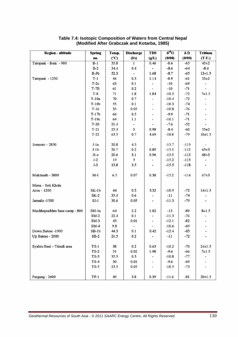
Geothermal Resources of South Asia - © 2011 SAARC Energy Centre, All Rights Reserved. 130
Table 7.4: Isotopic Composition of Waters from Central Nepal (Modified After Grabczak and Kotarba, 1985)

Geothermal Resources of South Asia - © 2011 SAARC Energy Centre, All Rights Reserved. 131
7.6 Conclusions
The isotopic study by Ranjit (2010) indicates possibility of a large geothermal reservoir in the
Sadhu Khola–Jomsom area in the central region of Nepal. However these qualitative
estimations can be ascertained by geophysical investigations.
If sufficient geothermal reservoirs at localities such as Sribagar (surface temperature 73°C), and
Sadhu Khola (surface temperature 68°C) can be considered as candidate for generation of
electricity. Evidently, other geothermal springs with low temperature are not technically and
economically viable for the generation of electricity in Nepal.
The use of geothermal water in Nepal is still constrained by the lack of road network. The
update period witnessed the opening of two trade ports in the mountainous districts viz.
Kimathanka and Chid (Sankhuwasabha district) and Nechung and Lizi (Mustang district)
bordering China. These ports will soon yield greater access to the adjacent geothermal areas.
The on-going construction of north-south highways (Surkhet-Jumla, Baitadi-Darchula, and
Baglung- Jomsom) will play significant role in connecting a number of geothermal springs upon
their completion.
The concept of using low temperature water for purposes other than bathing cannot be realized
in Nepal without some pilot scale demonstration projects. The efforts in this direction are needed
from the government side as well research organizations and academia.

Geothermal Resources of South Asia - © 2011 SAARC Energy Centre, All Rights Reserved. 132
7.7 Bibliography
1. Arnason, B., 1976: Groundwater systems in Iceland traced by deuterium. Societas
Scientiarum Islandica, XLII, Reykjavik.
2. Arnorsson, S., 1975, Application of silica geothermometer in low temperature
hydrothermal area in Iceland. Am. J. Sci., 275, 763-784.
3. Bista, Dor B., 1967, People of Nepal. Dept. of Publicity, Ministry of Information and
Broadcasting, Govt. of Nepal.
4. Craig, H., 1961a Standards for reporting concentrations of deuterium and oxygen-18 in
natural waters. Science 133, 1833-1834.
5. Craig, H., 1961b, isotopic variations in meteoric waters. Science, 133, 1702-1703.
6. Dahal, R., K., 2006, Geology of Nepal, published in personal home page
geology_of_nepal-htm.
7. Dahal, R., K., 2006, Geology for Technical Students, Bhrikuti Academic Publications,
Kathmandu, Nepal, 746p.
8. Dervla Murphy (1968).The Waiting Land: A Spell in Nepal. Transatlantic Arts.
9. Grabczak, J., and Kotarba, M., 1985, Isotopic composition of the thermal waters in the
central part of the Nepal Himalayas, Geothermics, 14, 567-575
10. GRDP, 1994, Reassessment of the Groundwater Development Strategy for irrigation in
the Terai, Vol. 3 Groundwater, HMG, Department of Irrigation, Groundwater Resources
Development Project.
11. Hagen, T., 1969, Report on the geological survey of Nepal preliminary reconnaissance:
Zürich,Mémoiresde la soc. Helvétique des sci. naturelles, 185 p.
12. http://www.geocities.com/geologyofnepal/geology.html
13. http://www.oecd.org/dataoecd
14. http://www.sdnpbd.org/wssd/preparatoryprocess/nationallevel/
15. http://www.politicalresources.net/nepal.htm
16. http://www.geographia.com/nepal/
17. Jackson M. and Bilham roger (1994) Constraints on Himalayan deformation inferred from
vertical velocity fields in Nepal and Tibet. Journal of Geophysical Research 99 (B7)
13897-13912.

Geothermal Resources of South Asia - © 2011 SAARC Energy Centre, All Rights Reserved. 133
18. Kizaki, K., 1994, An Outline of the Himalayan Upheaveal, A case study of the Nepal
Himalayas, Kathmandu, Japan International Cooperation Agency (JICA), 127p.
19. Le Fort, P., 1975, Himalaya, the collided range, Present knowledge of the continental
arc. Am. J. Sci., 275A, 1-44.
20. Le Fort, P., 1996, Evolution of the Himalaya. In Yin, A., and Harrison, T.M., (Eds.), the
Tectonic Evolution of Asia. Cambridge University Press, 95-109.
21. Le Fort P. 1994, French Earth Sciences research in Himalaya region. Alliance Francaise
publication, Kathmandu, 174 pp.
22. Moores, E.M., Fairbridge, R.W., (Eds.), 1998, Encyclopedia ofEuropean and Asian
Regional Geology. Chapman & Hall, London.
23. Nepal: Information Portal”. Explore Nepal. Retrieved 1 September 2007.
24. Nepal: Basic Fact Sheet”. Nepal homepage. Retrieved 23 September 2005.
25. Nuti, S., 1991, Isotope techniques in geothermal studies. In: D’Amore (co-ordinator),
Applications of geochemistry in geothermal reservoir development. UNITAR/UNDP Publication,
Rome, 215-251.
26. Pandey M. R. Tandukar R. P. Avouac J. P. Lavé J. and Massot J. P. (1995) Interseismic
strain accumulation on the Himalayan crustal ramp (Nepal): Geophysical Research Letters, 22,
751-754.
27. Ranjit, M., 1994 Geochemical studies of some thermal springs in Nepal, Reports 1994,
11, The United Nations University Geothermal Training Programme, Reykjavik,267-290.
28. Ranjit, M., 2005, Geothermal Energy Update of Nepal, Proceedings of World Geothermal
Congress, Turkey.
29. Ranjit, M., 2010, Preliminary Evaluation of Geothermal Reservoir in Central Nepal Using
Geochemical Data Geothermal Energy Update of Nepal, Proceedings of World Geothermal
Congress, Indonesia.
30. Rishikesh Shaha (2001).Modern Nepal: A Political History. Manohar Publishers and
Distributors.
31. Rowley, D.B., 1996, Age of collision between India and Asia: A review of the
stratigraphic data. Earth Planet. Sci. Lett., 145, 1-13.
32. Schärer, U., 1984, the effect of initial 230Th disequilibrium on young U-Pb ages: the
Makalu case, Himalaya. Earth Planet. Sci. Lett., 67, 191-204.

Geothermal Resources of South Asia - © 2011 SAARC Energy Centre, All Rights Reserved. 134
33. Shaha, Rishikesh (1992).Ancient and Medieval Nepal. New Delhi: Manohar Publications.
34. Ulak P., D., Nakayama, K., 1999, Lithostratigraphy and the evolution of the the fluvial
style of the Siwalik Group in the Hetauda-Bakiya Khola area, Central Nepal. Bull.Dept. Geol.
Tribhuvan Univesity,6-14.
35. Upreti, 1999, An overview of the stratigraphy and tectonics of the Nepal Himalaya,
Journal of Asian Earth Sciences 17 (1999) pp. 577- 606.
36. Upreti, B. N and Yoshida, M, (Eds.) 2005,Guidebook for Himalayan Trekkers, Series No.
1, Geology and Natural Hazards along the Kaligandai Vallley, nepal, Department of Geology,
Tri-Chandra Campus, Tribhuvan University, Kathmandu, Nepal, 165p.
37. USGS, 1999, Understanding Plate Motion,
URL:http://pubs.usgs.gov/publications/text/understanding.html

Geothermal Resources of South Asia - © 2011 SAARC Energy Centre, All Rights Reserved. 135
CHAPTER – 8 GEOTHERMAL RESOURCES OF PAKISTAN
8.1 Plate Tectonics (After Wandrey, Law, and Shah, 2000)
The structural and stratigraphic features of Pakistan are derived from tectonic events associated
with plate movements that occurred from latest Paleozoic time to the present. In the Late
Precambrian, Pakistan was on the northern margin of Gondwana facing the Tethyan Ocean
(Scotese et al., 1988). The northern margin of Gondwana was undergoing intracratonic rifting
with deposition of thick clastics, marine carbonates and locally evoporite sequence. The north of
the country was in a passive margin setting, while sediments to the south of that were probably
laid down under partly restricted shallow marine conditions in interior rifts in intermittent
connection with Tethys. Cambrian sequences of Oman, Pakistan, India and central Australia
appear to be deposited on near shelf environment.
Widely separated outcrops of Ordovician, Silurian, Devonian and carboniferous rocks are
present in comlexly tectonized orogenic belts along the western and northern rim of Indian Plate
(Gaetani, 1997). In Indus Basin, Cambrian sediments are overlain unconformably by the
Permian, and it is not certain whether the intervening systems were deposited and then eroded,
or whether they were ever deposited at all.
Paleogeographic setting suggest that Tethys was at its widest in the Late Permian and From
Permian through Middle Jurassic time, the Indian plate, including its continental shelf was
located in the southern hemisphere, between the African, Antarctic, and Australian plates which
were part of southern Gondwana. A thin strip of continental fragments that now underlie Iran
were separating from the Arabian Plate. Basal Permian glacial deposits on the southern part of
the Indian plate and Lower Permian Tobra Formation tillites in the Kohat-Potwar area (Upper
Indus Basin) indicate a cool Permian climate (Shah, 1977). Following the period of glaciation,
the area that is now the Upper Indus Basin, Kohat and Potwar Plateaus, and Sulaiman-Kirthar
fold belts became part of a shelf system. The shelf and shallow marine stages are reflected in
the rocks of the Permian Nilawahan and Permian Zaluch Groups. More or less the same
situation existed up to the Late Triassic, although a rift system had formed between the Indian
Plate and the Afghanistan-Arabia-Africa Plates. In the Triassic, shelf-system strata extended to
the Lower Indus Basin and are preserved in the Triassic Wulgai Formation and Jurassic
Shirinab Group. A carbonate-dominated shelf environment persisted at least intermittently on
the western part of the Indian plate through Late Jurassic, exemplified by the interbedded shales
and thick limestones of the Springwar Formation and as much as 1,400 m of the Middle and
Late Jurassic Sulaiman Limestone Group, which accumulated on the western and northern
portions of the plate. The earlier shallow marine continental interior of western Pakistan was
also replaced by the development of passive marginal environments. In the Early Jurassic,
passive margin thermal subsidence resulted in the deposition of a thick succession of fine
grained clastics in western part of Pakistan. By the Late Jurassic, the combination of widespread

Geothermal Resources of South Asia - © 2011 SAARC Energy Centre, All Rights Reserved. 136
passive margin conditions and tectonic quiescence resulted in the establishment of a
widespread carbonate platform over much of the country.
Gondwana continued break-up during the Late Jurassic to Early Cretaceous and contributed to
a postulated deep-seated shear zone and horst-and-graben regime and later, a division of the
greater Indus Basin into three subbasins at the Mari-Kandhot and Sargodha structural highs
(Kemal and others, 1992). Late Jurassic rifting also initiated separation of Australia and
Antarctica from India. During Early Cretaceous time the Indian plate drifted northward
and on the western shelf, marine shales, limestones, and near shore sandstones of the Lower
Cretaceous Sembar and Goru Formations were deposited over a regional erosional surface on
the Sulaiman Limestone Group. In the Kohat-Potwar area, this erosional surface is present at
the top of the Samana Suk Limestone Formation and is overlain by Lower Cretaceous Chichali
Formation sandstones and shales (Shah, 1977; Iqbal and Shah, 1980). Conditions were once
again more quiescent by the mid-Senonian, as reflected by the development of a widespread
carbonate platform across much of western Pakistan. Along the eastern portion of the Indian
plate, Rajmohal Trap volcanics and the Bolpur and Ghatal Formations were deposited. Although
the carbonates are recognized primarily on the eastern and western shelves today, it is likely
that they were deposited over much of the northern Indian shelf. This shelf environment
persisted through Late Cretaceous time when regressive sandstones such as the Lumshiwal
and Pab Formations in the west and Tura Formations in the east were deposited. At this stage
too, the micro continental fragments on the north side of Tethys were coalescing to form the
southern edge of the Eurasian Plate, and Tethys was closing, but there was as yet no effect of
this in Pakistan.
During the Late Cretaceous, India continued drifting northward and split away from Madagascar.
Northward plate movement continued during the latest Cretaceous, and a transform fault
became active along the ninety-east ridge with extensional faulting or reactivated as the western
part of the Indian plate sheared southward relative to the main plate (Kemal and others, 1992).
India also passed over the Reunion hot spot, resulting in the eruption of the Deccan Trap. These
events resulted once again in uplift of the continental interior of the Indian Plate, and the
replacement of the carbonate platform by a more clastic-dominated regime. From Late
Cretaceous through middle Paleocene time, trap deposits and basal sands continued to
accumulate on the Assam-Arakan, Indus, Bombay, and Bengal shelves (Figure 9.1).
Oblique convergence of the Indo-Pakistan plate with the Afghan and other micro plates resulted
in wrench faulting and development or reactivation of regional arches such as the Jacobabad
and Sargodha Highs in the Indus Basin (Kemal and others 1992). At this time too, there was
interaction between the northwestern edge of the Indian Plate and the Afghan and Kakar-
Khorasan micro continental blocks, resulting in sinistral transpression between them.
The Indian plate continued to move northward at an accelerated rate of 15-20 cm/yr. When the
eastern edge of the plate passed over the Kerguelen hot spot, a chain of islands began to form
near E 90° longitude. Northward-directed subduction has also continued beneath the Hindu
Kush from the Mesozoic, when the region formed part of the southern margin of Asia, until

Geothermal Resources of South Asia - © 2011 SAARC Energy Centre, All Rights Reserved. 137
today. The Kohistan arc was accreted at ca. 100 Ma, followed by the Indian plate at 54–50 Ma.
After the India-Asia collision, a regional crustal-melting event occurred at ca. 25–21 Ma to the
east of the Hindu Kush in the Karakoram Range, producing the Baltoro pluton. In the eastern
Hindu Kush Range, most of the granitoids appear to be subduction-related plutons that predate
the India-Asia collision. However, the Gharam Chasma pluton is a two-mica (± garnet ±
tourmaline) leucogranite that has intruded into staurolite-grade schists and (sillimanite ± K-
feldspar)–grade migmatites. U-Pb ages on monazite, xenotime, and uraninite from undeformed
samples of the Gharam Chasma pluton and a leucogranite dike that crosscuts the migmatites
indicate that crustal melting occurred at ca. 24 Ma, synchronous with the Baltoro melting event.
This age also provides an upper limit on the age of the regional staurolite-grade metamorphism
in the eastern Hindu Kush (Hildebrand et al., 2001).
a. Paleogeographic Map of the Latest
Cretaceous (Approximately 69 Ma)
b. Perspective is from lat 20°S., long 68°E
Figure 8.1: Northward Drift of Indian Plate since Cretaceous (Modified from Scotese and Others, 1988; Scotese, 1997)
Continued northward movement and counter-clockwise rotation of the Indian plate slowly closed
the Tethyan Sea along the northern and northwestern plate boundaries. The Sulaiman-Kirthar
fold belt began to develop as a result of the oblique collision and rotation, with the Sulaiman lobe
developing in a thin-skinned roof-duplex geometry (Jadoon et al., 1994). Regional uplift and
rising mountain ranges on the Eurasian plates to the north and west created a new sediment
source, and the prevailing sediment transport direction of south to north was reversed. From
Eocene through middle Miocene time, carbonate platform buildup occurred intermittently on the
shelves around much of the Indian plate. A trench formed along the subduction zone as the
Indian plate began to slip beneath the Eurasian plate. The Eurasian plate shed large volumes of
sediments into the trench as subduction continued. This terrestrial sediment influx from the

Geothermal Resources of South Asia - © 2011 SAARC Energy Centre, All Rights Reserved. 138
rapidly rising Himalayan, Sulaiman-Kirthar, Sino-Burman and Indo-Burman Ranges significantly
exceeded carbonate buildup rates on late Miocene platforms (Roy Choudhury and Deshpande,
1982) and smothered carbonate reef formation along the shelf areas. The former shelf areas
along the collision zones were either subducted or became emergent fluvial-deltaic
environments. The shelf in the greater Indus Basin area tilted downward toward the west and
northwest. In the Kohat-Potwar geologic province, shallow southwest-northeast-trending
anticlines and overturned folds developed on multiple detachment surfaces. The detachment
surfaces as deep as Eocambrian salts developed as a result of continued plate convergence
and associated crustal shortening of as much as 55 km occurred (Kemal et al., 1992; Jaswal et
al., 1997).
The proto Indus, Narmada, Ganges, Brahmaputra, Meghna, Chindwin, and Irrawaddy Rivers
developed extensive deltas as the Himalayas and other ranges continued to shed sediments at
a high rate. Today, uplift of the mountain ranges, crustal shortening, and subduction of the
Indian plate continues and the growth rate of the Indus, Ganges-Brahmaputra (Megna), and
Irrawaddy deltas remains high.
The Main Mantle Thrust (MMT) represents the tectonic boundary between metamorphic shield
and platform rock of the Indian plate hinterland, and dominantly mafic and ultramafic rock of the
Kohistan-Ladakh arc complex in Pakistan. In some areas, this boundary is a sharp planar fault
with development of mylonite; in other areas, it is a brittle-ductile imbricate zone; in still other
areas, it contains large, discontinuous, slices of internally sheared and deformed ophiolitic
mélange. The character of the MMT along its entire trace is discussed and it is concluded that
there is no single continuous fault which marks the contact between the Indian plate and the
Kohistan-Ladakh arc. On this basis a revised definition for the MMT is proposed that is
consistent with both the original definition and with the usage of the term in literature. We
suggest that the MMT fault contact be defined as the series of faults of different age and tectonic
history that collectively define the northern margin of the Indian plate in Pakistan. On this basis,
faults that define the MMT vary in age from Quaternary to possibly as old as Late Cretaceous.
Discontinuous lenses of ophiolitic mélange that overlie the MMT fault contact and which
intervene between the Indian plate and the Kohistan-Ladakh arc, are considered to be part of an
MMT zone that is equivalent with the Indus Suture Zone. (DiPietro,etal. 2000).Tectonic map of
Pakistan (Figure 8.2) exhibits the tectonostratigraphic subdivision and structural configuration
resulting from northward drifting of Indian Plate and its collision with the Eurasian Plate.

Geothermal Resources of South Asia - © 2011 SAARC Energy Centre, All Rights Reserved. 139
Figure 8.2: Tectonic Map of Pakistan
8.2 Stratigraphy (After Wandrey, Law, and Shah, 2000)
8.2.1 Precambrian and Paleozoic Stratigraphy
Precambrian and Paleozoic rocks are exposed in the Upper Indus Basin/Kohat-Potwar area. In
the Middle and Lower Indus Basins, Precambrian and Paleozoic rocks have been encountered
during drilling and observed in outcrop only at the easternmost edge of the basin. Precambrian
granite basement rocks are overlain by the Precambrian-Cambrian, closed-basin, sedimentary
rocks of the Jhelum Group. In the Kohat-Potwar area the Jhelum Group includes the Salt Range
Formation shales and evaporites and the Middle and Lower Indus Basins are floored by the
Indian Shield, Nagar Parkar Granite, and the younger interbedded slates, quartzites, andesites,
and rhyolites of the Kirana Group (Iqbal and Shah, 1980; Shah, 1977).
Following a basin wide hiatus lasting from Cambrian to Permian, the Permian Nilawahan Group
was deposited at least in the Kohat-Potwar area. The Nilawahan Group consists of the Tobra

Geothermal Resources of South Asia - © 2011 SAARC Energy Centre, All Rights Reserved. 140
Formation glacial tillites, siltstones, and shales; the Dandot Formation glacial coarse sandstones
and shales; the Warchha Formation coarse grained argillaceous sandstones and minor shales
and the sandstones and shales of the Sardhai Formation (Shah, 1977; Iqbal and Shah, 1980;
and Kemal, 1992). Overlying the Nilawahan Group are the shelf carbonates of the Middle to
Upper Permian Amb and Wargal Formation of Permian Amb and Wargal Formation of the
Zaluch Group and the marls and coarsening-upward sandstones of the Chhidru Formation. The
Tobra and Wargal Formations have produced oil and gas on the Potwar Plateau.
8.2.2 Mesozoic Stratigraphy
Mesozoic rocks in the Indus Basin are generally preserved in the Salt Range and southeast
Potwar Basin; however, part or all of the Mesozoic stratigraphic section is missing from the
Kohat Plateau and northwestern Potwar deformed zone (Jaswal et al., 1997). Westward
depositional thinning and erosion account for the missing rocks. The Triassic Musa Kehl Group
Mianwali and Tredian Formations continental, sandstones, shales, and carbonates were
deposited unconformably on the Permian rocks. Overlying the Tredian are shelf carbonates of
the Triassic Kingriali Formation. The Triassic formations were formerly referred to collectively as
the Wulgai Formation. The overlying Jurassic rock sequence includes the Shirinab or Datta and
Shinawari Formations that were deposited as near shore variegated siliciclastics containing
some non-marine sandstone intervals (Khan et al., 1986). The Datta has produced oil and gas.
Overlying these near shore rocks are as much as 900m of platform carbonates of the Samana
Suk Formation. The Lower Cretaceous section consists of Chichali basinal shales and massive
cross bedded sandstones of the Lumshiwal Formation (maximum basin flooding surface). The
Upper Goru, Ranikot, Pab, and Moghal Kot siliciclastics, representing Late Cretaceous low
stand events, are present southeast of the Salt Range but are not reported within the Potwar
Basin.
The Cambrian-early Mesozoic hiatus in the Middle and Lower Indus Basin was probably
followed by deposition of shallow-marine shales and limestones of the Triassic Wulgai
Formation that are exposed in the Axial belt (Iqbal and Shah, 1980; Shah, 1977). Jurassic
shallow-marine limestones and shales of the Shirinab, Chiltan, and Mazar Dirk Formations
extend over the Lower Indus Basin, Sulaiman-Kirthar geologic province and Axial belt
(Figure 8.3). The top of the Jurassic is marked by a basin wide unconformity.
Lower Cretaceous rocks are represented by as much as 250m of black shale and siltstone and
argillaceous limestone of the Sembar Formation and as much as 500m of limestone,
interbedded shale, and sandstone of the lower Goru Formation. The shelf to shallow-marine
environment persisted through most of Late Cretaceous time, represented by carbonates of the
Parh, shales, sandstones, and limestones of the Moghal Kot, and limestones and shales of the
Fort Munro/Pab Formations. The regressive Pab Sandstone represents a change to a near
shore environment. Unconformably overlying the Pab are the shallow marine limestones and
shales of the Upper Cretaceous Moro Formation (Iqbal and Shah, 1980; Shah, 1977). iii)
Cenozoic Stratigraphy

Geothermal Resources of South Asia - © 2011 SAARC Energy Centre, All Rights Reserved. 141
In the Lower Indus Basin and the Sulaiman-Kirthar geologic province, fluvial sandstones and
estuarine shales and limestones make up the Paleocene Ranikot Group. Shallow marine to
estuarine limestones and calcareous shales of the Eocene Laki Formation and
contemporaneous shales and sandstones of the Ghazij Formation are conformably overlain by
interbedded limestones and shales of the Eocene Kirthar Formation. The Kirthar was deposited
in the Lower Indus Basin, Sulaiman-Kirthar geologic province, and Kohat Plateau (Iqbal and
Shah, 1980; Shah, 1977). Nearshore sandstones and shales of the Oligocene Nari Formation
and shales of the lower Miocene Gaj Formation make up the Momani Group. The Miocene to
Pliocene clays, sandstones, and conglomerates of the Siwalik Group mark a change to
nonmarine deposition.
Figure 8.3: Generalized Stratigraphy of the Upper Indus Basin Area (Modified from OGDC, 1996; Quadri and Quadri, 1996; Kemal, 1992; Raza, 1992; Iqbal and Shah, 1980; and Shah, 1977).

Geothermal Resources of South Asia - © 2011 SAARC Energy Centre, All Rights Reserved. 142
8.2.3 Cenozoic Stratigraphy
In the Lower Indus Basin and the Sulaiman-Kirthar geologic province, fluvial sandstones and
estuarine shales and limestones make up the Paleocene Ranikot Group. Shallow marine to
estuarine limestones and calcareous shales of the Eocene Laki Formation and
contemporaneous shales and sandstones of the Ghazij Formation are conformably overlain by
interbedded limestones and shales of the Eocene Kirthar Formation. The Kirthar was deposited
in the Lower Indus Basin, Sulaiman-Kirthar geologic province, and Kohat Plateau (Iqbal and
Shah, 1980; Shah, 1977). Nearshore sandstones and shales of the Oligocene Nari Formation
and shales of the lower Miocene Gaj Formation make up the Momani Group. The Miocene to
Pliocene clays, sandstones, and conglomerates of the Siwalik Group mark a change to
nonmarine deposition.
Hangu Formation siliclastics were deposited first, on an erosional surface marking the top of the
Cretaceous Lumshiwal. There is a transitional contact between the Hangu and the overlying
Lockhart Formation carbonate shelf system. The contact between the Lockhart and the
overlying Patala Formation is also transitional (Shah, 1977, Iqbal and Shah, 1980, and Kemal
1992). The overlying Eocene Namal and Panoba Formations are shallow-marine to lagoonal
shales and interbedded limestones with a transitional contact between the Patala and the
Namal. Overlying the Namal and Panoba are marine limestones and shales of the Eocene
Sakesar or Margala Hill Formations. Although Iqbal and Shah (1980) indicated that the probably
contemporaneous lower Eocene Bahadur Khel Salt is present only in the Kohat Plateau area.
The Chharat Group includes marine shales and interbedded limestones in the early Eocene
Chorgali Formation, shale in the upper Eocene Kohat Formation shale, and shales and
carbonates in the Oligocene Kirthar Formation. Oligocene rocks are missing or not recognized in
most of the Upper Indus Basin. Unconformably overlying Eocene rocks are fluvial sandstones,
siltstones, and clays of the Miocene to Pliocene Murree Formation, Kamlial Formation, and
Rawalpindi Group. The Murree Formation contains the youngest reported oil production in the
Kohat-Potwar geologic province. Fluvial sandstones and conglomerates in the Pliocene and
Pleistocene Siwalik Group are the youngest rocks in the Kohat-Potwar area.
Figure 8.4 is a simplified geological map of Pakistan displaying salient geological features which
are a blend of its geological history and tectonics exhibiting the style and evolution of foreland
structures.
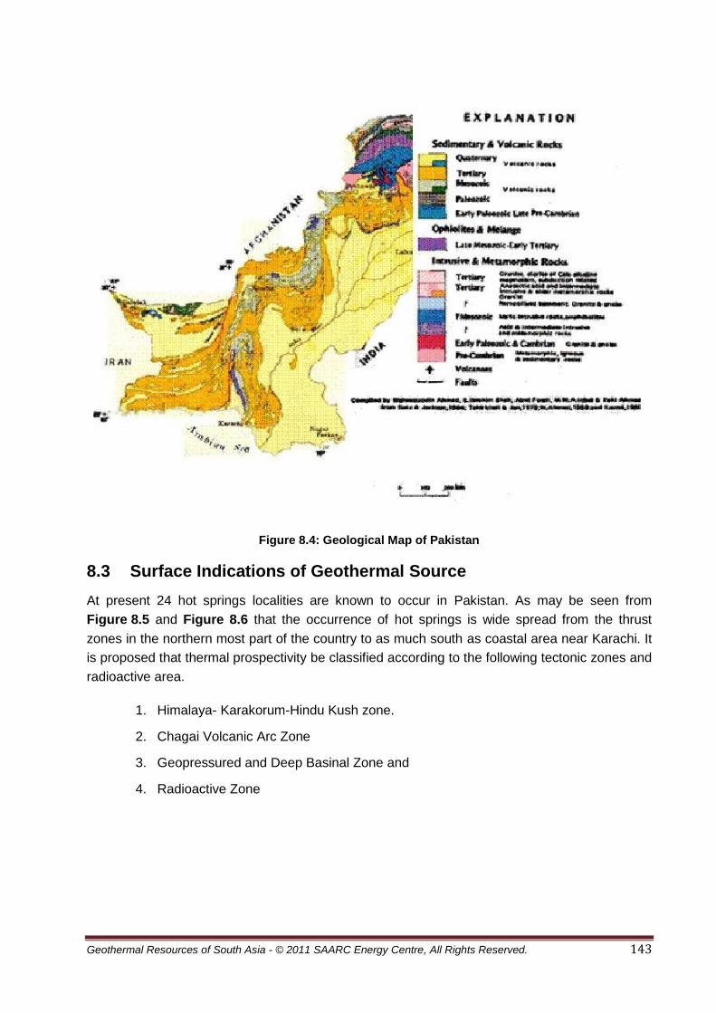
Geothermal Resources of South Asia - © 2011 SAARC Energy Centre, All Rights Reserved. 143
Figure 8.4: Geological Map of Pakistan
8.3 Surface Indications of Geothermal Source
At present 24 hot springs localities are known to occur in Pakistan. As may be seen from
Figure 8.5 and Figure 8.6 that the occurrence of hot springs is wide spread from the thrust
zones in the northern most part of the country to as much south as coastal area near Karachi. It
is proposed that thermal prospectivity be classified according to the following tectonic zones and
radioactive area.
1. Himalaya- Karakorum-Hindu Kush zone.
2. Chagai Volcanic Arc Zone
3. Geopressured and Deep Basinal Zone and
4. Radioactive Zone

Geothermal Resources of South Asia - © 2011 SAARC Energy Centre, All Rights Reserved. 144
Figure 8.5: Locations of Known Geothermal Springs in Pakistan (After AEDB)

Geothermal Resources of South Asia - © 2011 SAARC Energy Centre, All Rights Reserved. 145
Figure 8.6: The Occurrences of Geothermal Resources in Pakistan
Source: Geological Survey of Pakistan
8.4 Geothermal Potential of Himalaya-Karakorum-Hindu Kush Zone
The rock units of the area range in age from Pre-Cambrian to recent. They represent sequences
of the Indian Plate margin, Kohistan Island arc, Tirich Mir boundary zone and Hindu Kush
region. The Indian Plate sequences comprise Cambrian stromatolitic dolomites transgressed on
remobilised gneisses, around 500 Ma old granitoids exhibiting the widespread magmatic event,
Phanerozoic shelf sequence of Gondwana of Middle-Paleozoic age, Metabasaltic dikes and
granite gneiss of Early-Permian magmatic ages intruding into older Indian gneiss, and
carbonatites (Kazmi & Jan 1997). Sedimentary records indicate that the onset of extension
tectonics is Early Carboniferous (Pogue et al. 1992, Pogue et al. 1999). Marine shelf
Figure 8.4: Hot Spring of Pakistan

Geothermal Resources of South Asia - © 2011 SAARC Energy Centre, All Rights Reserved. 146
sedimentation was re-established in the Late Triassic. The Mesozoic sedimentary history is that
of carbonates deposited during thermal subsidence of a continental margin on the southern side
of Neo-Tethys. All these rocks were deformed and metamorphosed between 75 and 40 Ma
(Treloar et al. 1989, Chamberlain et al. 1991).
Figure 8.7: Tectonic sketch map of Northern Pakistan and surrounding regions. Modified from
Zanchiet al., 2000 and Boulin, 1988. MFT: Main Frontal Thrust, MBT: Main Boundary Thrust,
MMT: Main Mantle Thrust; SS: Shyok Suture; TMF: Tirich Mir Fault Zone, EHK East Hindu
Kush, ACM Alitchur mountains, RPZ: Rushan-Pshart Zone; WAS: Wanch-Akbaital Suture, N-P:
North Pamir, C-P: Central Pamir, SE-P: SE Pamir, SW-P: SW Pamir, WAZ: Waziristan, K:
Kabul. 1: Quaternary, 2: Tertiary foredeeps, 3: Paleozoic belts, 4: Terranes of Gondwanan
affinity, 5: Kabul Block, 6: Wasser-Panjao Suture, 7: Waziristan ophiolitic complex, 8: Kohistan-
Ladakh arc terranes, 9: Himalayas. Heavy lines represent main sutures. (After Gaetani et al.,
2004).
The Kohistan terrane in NE Pakistan is regarded as a fossil island arc obducted between the
collided Indian and Asian plates (Bard et al. 1980, Tahirkheli et al., 1979).
The Karakoram sequences are represented by southern and intermediate metamorphosed belt,
Karakoram batholiths and northern Karakoram sedimentary sequences.
The Tirich Mir Zone forming a narrow belt of amphibolites, met gabbros, peridotites, gneisses,
and quartzites (Zanchi et al., 1997, 2000) and in Hindu Kush block the oldest rocks include
possibly Cambrian deformed granitoids, the Qal’a-e Ust Gneiss in tectonic contact with the
Paleo-Mesozoic meta sedimentary successions. Most of the belt consists of the Paleozoic
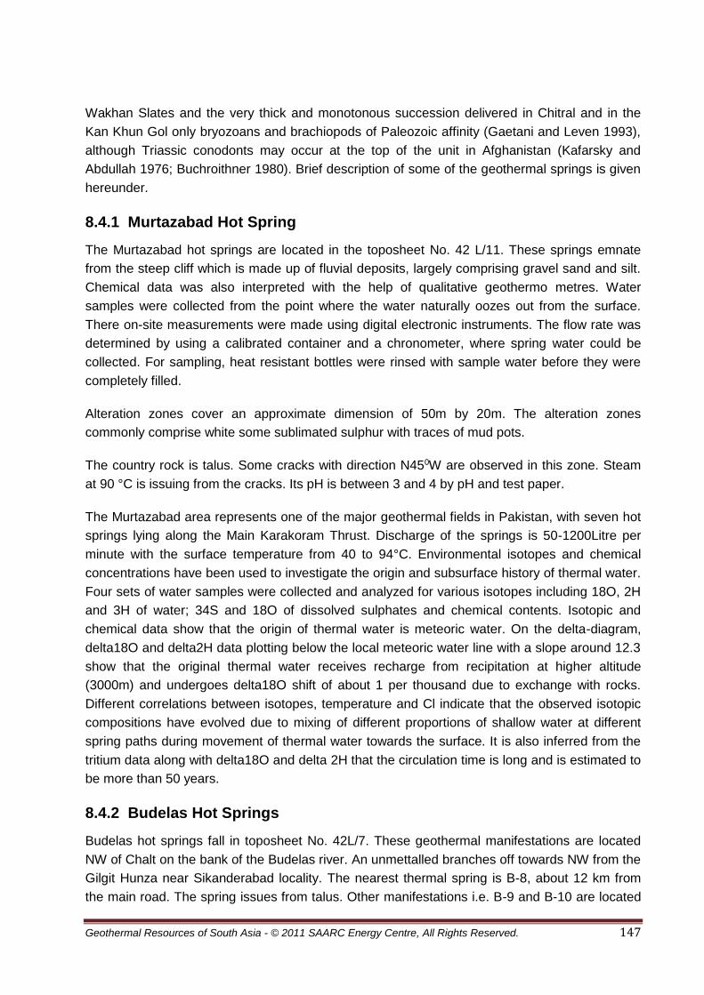
Geothermal Resources of South Asia - © 2011 SAARC Energy Centre, All Rights Reserved. 147
Wakhan Slates and the very thick and monotonous succession delivered in Chitral and in the
Kan Khun Gol only bryozoans and brachiopods of Paleozoic affinity (Gaetani and Leven 1993),
although Triassic conodonts may occur at the top of the unit in Afghanistan (Kafarsky and
Abdullah 1976; Buchroithner 1980). Brief description of some of the geothermal springs is given
hereunder.
8.4.1 Murtazabad Hot Spring
The Murtazabad hot springs are located in the toposheet No. 42 L/11. These springs emnate
from the steep cliff which is made up of fluvial deposits, largely comprising gravel sand and silt.
Chemical data was also interpreted with the help of qualitative geothermo metres. Water
samples were collected from the point where the water naturally oozes out from the surface.
There on-site measurements were made using digital electronic instruments. The flow rate was
determined by using a calibrated container and a chronometer, where spring water could be
collected. For sampling, heat resistant bottles were rinsed with sample water before they were
completely filled.
Alteration zones cover an approximate dimension of 50m by 20m. The alteration zones
commonly comprise white some sublimated sulphur with traces of mud pots.
The country rock is talus. Some cracks with direction N450W are observed in this zone. Steam
at 90 °C is issuing from the cracks. Its pH is between 3 and 4 by pH and test paper.
The Murtazabad area represents one of the major geothermal fields in Pakistan, with seven hot
springs lying along the Main Karakoram Thrust. Discharge of the springs is 50-1200Litre per
minute with the surface temperature from 40 to 94°C. Environmental isotopes and chemical
concentrations have been used to investigate the origin and subsurface history of thermal water.
Four sets of water samples were collected and analyzed for various isotopes including 18O, 2H
and 3H of water; 34S and 18O of dissolved sulphates and chemical contents. Isotopic and
chemical data show that the origin of thermal water is meteoric water. On the delta-diagram,
delta18O and delta2H data plotting below the local meteoric water line with a slope around 12.3
show that the original thermal water receives recharge from recipitation at higher altitude
(3000m) and undergoes delta18O shift of about 1 per thousand due to exchange with rocks.
Different correlations between isotopes, temperature and Cl indicate that the observed isotopic
compositions have evolved due to mixing of different proportions of shallow water at different
spring paths during movement of thermal water towards the surface. It is also inferred from the
tritium data along with delta18O and delta 2H that the circulation time is long and is estimated to
be more than 50 years.
8.4.2 Budelas Hot Springs
Budelas hot springs fall in toposheet No. 42L/7. These geothermal manifestations are located
NW of Chalt on the bank of the Budelas river. An unmettalled branches off towards NW from the
Gilgit Hunza near Sikanderabad locality. The nearest thermal spring is B-8, about 12 km from
the main road. The spring issues from talus. Other manifestations i.e. B-9 and B-10 are located

Geothermal Resources of South Asia - © 2011 SAARC Energy Centre, All Rights Reserved. 148
7 km and 10 km further north on the right and left banks of the river. The springs are located
between the Main Karakoram Thrust and the Karakoram granodiorite. The physical features of
these manifestations are shown in Table 8.1.
8.4.3 Tatta Pani Hot Springs
The Karakoram highway is the major link heading up the mountains and yonder into China's
Xinjiang and Tibet. It is also the source of many hot springs. The Tatta pani hot springs, named
after a small villageTato(alternatively Tatta, meaning 'warm') in the Rakhiot Valley, are located in
the right bank of the Indus river near Raikot (Rakhiot) bridge. The springs and seepages are
numerous and strech along a 2-3 km wide zone located approximately SW of the Gilgit town.
The springs emanate from unconsolidated to semi consolidated fluvial deposits. Amphibolites
which are fractured by the Main Mantle Thrust constitute the hard rocks exposed along these
thermal manifestations. These springs are located at the altitude of 1200 m. Brief characteristics
are shown in Table 8.1.
8.4.4 Moshkin Valley Hot Springs
This geothermal manifestation is located on the top sheet no. I/11 on an unmetalled road off the
Karakoram highway on the left bank of the Astore River at an altitude of 2135 m. The valley is
very narrow with steep sides, and the exposed rocks around the spring are Nanga Parbat
gneisses.
8.4.5 Darkot Hot Spring
Yasen valley is famous for the existence of various kinds of springs, which attract people from
different parts of the Northern Areas. The Hot spring at Darkot, which flows at the height of
about 10,000 feet near glacier of Darkot, is used for medicinal bath. Another spring of the same
nature is situated at Thoi (Dooshter). The third spring Qaqabul is situated at Nazber
(Asqurthan).It has slightly astringent teast. Most of the people believe and experienced that this
is a certain cure of stomach diseases.
There is yet another kind of spring, which has a taste very much like 7 up, lying at the distance
of one and half hour walk from Barkolti at Chelpay. This spring lowers the body temperature
during high-grade fever and also proves to be an effective treatment for hot natured people,
reduced high blood pressure and highly effective in peptic ulcer. In the Yasin valley two more
hot springs at Pechuz and nearby area http://www.iknowgreatplaces.com/community).
8.4.6 Choutron Hot Spring
It is located in Basho valley also known as Chutung. 'The name literally means "hot water";
"Chu" means water and "tran" means hot in the Baltil language. The chuatran hot spring occurs
at the faulted contact of Triassic dolomite and underlying stratified gneiss (Record Geological
Survey of India, Volume 14-14).Chutran is about 2 1/2 hours from Shigar or a little over 3 hours
from Skardu. It is being used as a medicinal hot springs. Over the decades, the spa has become
popular with the local people, who are even coming from beyond Hunza (15 hours by road) to

Geothermal Resources of South Asia - © 2011 SAARC Energy Centre, All Rights Reserved. 149
soak in the 40°C plus hot water. Nestled at the base of the northeast side of the Haramosh
Range, Chutron is partially shaded and thereby relatively cool (Figure 8.8).
There is a government rest house with an outhouse which has supply of hot spring water.
Apparently, there is another hot spring 3 hours further away, which is also used for medicinal
purposes.
Figure 8.8: Views of Chutran Hot Spring
8.4.7 The Other Hot Spring in Baltistan
Other valleys in the north of Baltistan contain their own hot springs such as Bisil (Arandu valley,
Baltistan). Bisil has a hot spring, with the small pool emitting strong smells of sulfur.
(www.bergdias.de/pakistan/pakistan4).
There are hot springs in Dowo Kraming (Khaplu), quite close to the border with China. Dassu
Hot spring and Sassi Hot Spring the details are not known.
8.4.8 Garam Chashma
Garam Chashma (Hot Spring; Figure 8.9) is located at an elevation of 1859 meters (6,100 feet).
It is 45 km North West of Chitral and takes 3 hours to reach by jeep. Visitors have to take a
spectacular drive up the Latbo/Latkho River through deep and narrow gorges to reach this
place. This unspoiled enchanting valley of orchards, verdant fields and snow clad peaks is
renowned for its boiling sulphur springs which are famous for healing effect on skin diseases,
gout, rheumatism and chronic headache. The hot water comes from the hills. Near the
residential area, a small steaming stream branch off to enter rooms for soaking and swimming
pool before it joins the main course again (www.taravel guide.pk/gramchasma).

Geothermal Resources of South Asia - © 2011 SAARC Energy Centre, All Rights Reserved. 150
Figure 8.9: View of Garam Chasma Pool
8.4.9 Reservoir Temperature
Temperatures measured by silica and Na-K-Ca are shown in Table 8.1. The estimated
temperature of Budelas is excluded because of the effect of mixing of fresh water with the
geothermal water. The temperature inferred by the silica geothermometer is generally lower
than the temperature measured by the Na-K-Ca geothermometer. This is considered to be due
to the influence of mixing of non-thermal water. The temperature estimated at Tatta pani ranges
from 93-128°C, and at Mashkin it is about 169°C. On the other hand the silica geothermometre
indicates temperatures from 51 to 97°C at Tatta pani, 86°C at Mashkin and 40°C at Sassi. It is
noted that most of them are considered to be mixed with non-thermal waters.
8.4.10 Geothermal System and Main Mantle Thrust
The geothermal system at Tatta pani and Sassi lies along the Main Mantle Thrust. The hot springs come from the Quaternary talus deposits. The linear occurrences of the hot springs indicate that the MMT and the sub-fault system provided passage for hot water to seep from subsurface. However, the role played by the granitic rocks in the vicinity is uncertain. It has also been observed that the massive amphibolite sequence of the Kohistan Island arc is fractured by the MMT and micro fracture are likely to extend along the strike of fault. The strike of the MMT changes at Tatta pani from ENE to SSW. It is assumed that changes in strike direction may have also some affect in enhancing the permeability and transmitting the geothermal fluid (Bakhat, 2005). The hot springs water at Tatta pani is classified at the boundary of HCO3 and SO4 type and somewhat richer in Cl composition in comparison with the chemical composition of Murtazabad water. The chemical composition indicates possibility of high temperature regime in the deep reservoir source. Geochemical data for Mashkin and other hot springs is insufficient and more geological and geochemical studies are needed for complete understanding of the geothermal system.
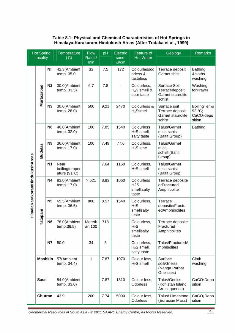
Geothermal Resources of South Asia - © 2011 SAARC Energy Centre, All Rights Reserved. 151
Table 8.1: Physical and Chemical Characteristics of Hot Springs in Himalaya-Karakaram-Hindukush Areas (After Todaka et al., 1999)
Hot Spring Locality
Temperature ( C)
Flow RateL/
min
pH Electric cond.
/u/cm
Feature of Hot Water
Geology Remarks
Him
ala
Kara
ko
ram
Hin
du
ku
sh
Are
as
Mu
rtazab
ad
N! 42.3(Ambient temp. 35.0
33 7.5 172 Colourlessodorless & tasteless
Terrace deposit Garnet shist
Bathing &cloths washing
N2 30.0(Ambient temp. 33.5)
6.7 7.8 - Colourless, H2S smell & sour taste
Surface Soil Terracedeposit Garnet staurolite schist
Washing forPrayer
N3 30.0(Ambient temp. 28.0)
500 9.21 2470 Colourless & H2Ssmell
Surface soil Terrace deposit. Garnet staurolite schist
BoilingTemp92 °C; CaCO3deposition
Bu
dela
s
N8 46.0(Ambient temp. 32.0)
100 7.85 1540 Colourless H2S smell, salty taste
Talus/Garnet mica schist (Baltit Group)
Bathing
N9 36.0(Ambient temp. 17.0)
100 7.49 77.6 Colourless, H2S sme
Talus/Garnet mica schist.(Baltit Group)
N1 Near boilingtemperature (91°C)
7.64 1160 Colourless, H2S smell
Talus/Garnet mica schist (Baltit Group
Tata
pan
i
N4 83.0(Ambient temp. 17.0)
> 621 8.83 1060 Colourless H2S smell,salty taste
Terrace deposite orFractured Amphibolite
N5 65.5(Ambient temp. 36.5)
800 8.57 1540 Colourless, H2S smellsalty teste
Terrace deposite/FracturedAmphibolites
N6 78.0(Ambient temp.36.5)
Morethan 100
718 - Colourless, H2S smellsalty taste
Terrace deposite Fractured Amphibolites
N7 80.0 34 8 - Colourless, H2S smell. salty taste
Talus/FracturedAmphibolites
Mashkin 57(Ambient temp. 34.4)
1 7.87 1070 Colour less, H2S smell
Surface soil/Gneiss (Nanga Parbat Gneisses)
Cloth washing
Sassi 54.0(Ambient temp. 33.0)
7.87 1310 Colour less, Odorless
Talus/Gneiss (Kohistan Island Are sequerice)
CaCO3Deposition
Chutran 43.9 200 7.74 5090 Colour less, Odorless
Talus/ Limestone (Eurasian Mass)
CaCO3Deposition

Geothermal Resources of South Asia - © 2011 SAARC Energy Centre, All Rights Reserved. 152
8.5 Geothermal Prospects of Chagai Volcanic Arc Zone
The area comprises a narrow belt which extends eastwards and truncates against the Chaman
transform fault. Subduction of the Arabian plate under Eurasian plate resulted in formation of a
trench south of Makran coast and emergence of a volcanic arc in Chagai area. The Koh-e-
Sultan volcano and other volcanic cones in the Chagai area are part of the volcanic arc. The
water from the thermal springs in Koh-e-Sultan area has been analysed and subsurface
temperatures from 150°C to 170°C were reported (Schoppel, 1977).
The arc, together with an over 300km wide classic accretionary prism to its south (Platt et al.,
1986), overrides the active Makran subduction zone (MSZ). The longstanding activity on the
MSZ is manifested in intermittent magmatism in the Chagai Arc spanning about 70 Ma from the
Late Cretaceous to the Pleistocene, which is unmatched in Neotethyan arcs preserved
elsewhere in the Himalaya and Zagros Ranges (Alam, 2003). The Chagai arc exposes a
>10,000 m stratigraphic succession from Late Cretaceous to Pliocene-Pleistocene, comprising
volcanic, volcano-sedimentary and sedimentary rocks. A thick (~2,500 m) succession of
massive basaltic-andesite lava flows (associated with lapilli tuff, volcanoclastic sediments and
minor felsic lavas) dominates the Late Cretaceous Sinjarani Group (Ahmed et aa., 1972;
Siddiqui, 1996, 2004), the oldest unit exposed in the Chagai Arc. Volcanic rocks abundantly
occur in younger stratigraphic units including the Paleocene Juzzak Formation, Eocene Saindak
Formation, Oligocene Amlaf Formation, Miocene Buz Mashi Koh Formation, and Pliocene-
Pleistocene Koh-i-Sultan Formation (Alam, 2004). The Late Cretaceous-Paleocene volcanism is
dominated by basalts and basaltic andesites. In comparison, Eocene and younger volcanism is
dominantly andesitic to dacitic with minor basalts.
Detailed major, trace, and rare-earth geochemistry classifies the temporal volcanism in the
Chagai Arc into three groups; 1) Late Cretaceous-Paleocene, 2) Eocene, and 3) Oligocene and
younger (Heuberger et al., 2007). The following thermal springs occur in Chagai area.
8.5.1 Chiken Dik Spring
The Chiken dik spring is located 7.8 km southeast of Mashki Chah (Toposheet No. 35I/5). It is
located at an altitude of 830m. The water is discharged from holes about 100m deep which
Pakistan Industrial Development Co. has drilled for Iron ore in Mashki Chah. The water table
was 2.3m at the sampling time. The surface rocks are recent deposits, however they may
penetrate the Chagai intrusions or the rocks of Sinjrani volcanic group (Arthurton et al., 1979).
The physical features of the springs are shown in Table 8.2.
8.5.2 Koh-e-Sultan Springs
The Koh-e-Sultan springs are located in the vicinity of the Miri crater (Toposheet No. 30 G/16).
The hotsprings seep from the river bed which consists of lava and agglomerate. The water
temperature ranges from 25-32°C. The temperature is lower than the ambient temperature in
the summer season. The spring waters in the alteration zone are strongly acidic. Their brief
physical features are shown in Table 8.2.

Geothermal Resources of South Asia - © 2011 SAARC Energy Centre, All Rights Reserved. 153
8.5.3 Chemical Properties of Geothermal Water
Four water samples from thermal springs and one from the well in the vicinity of Koh-e-Sultan
were collected and analysed in Karachi Laboratory of the Geological Survey of Pakistan.
Table 8.2 shows the results of analysis of the water samples. There is a high concentration of
salts in the water. The electric conductivity is more than 10,000 s/cm and the TSM ranges from
13,700 to 67,540 mg/l. Gas is continuously dissolved into the very little amount of groundwater
available in the area, resulting in a concentrated water.
It is assumed that the SO4type water flows horizontally into a shallow zone and is mixed with Cl
type water from the deeper levels. By this way the water changes from SO4 type to Cl,SO4 type.
As mentioned by Bakhat (2000) Anion Index can be calculated by the following equation.
Anion Index (A.I.)= 0.5 SO4 + Cl SO4 + SO4 + HCO3
Cl
Higher values of A.I. indicate higher geothermal activity in a volcanic area. The reservoir
temperature calculated by application of geothermometres may not reflect the true reservoir
temperature. It is assumed that the process of mixing of ground water with the gases does not
show the reservoir temperature at all.
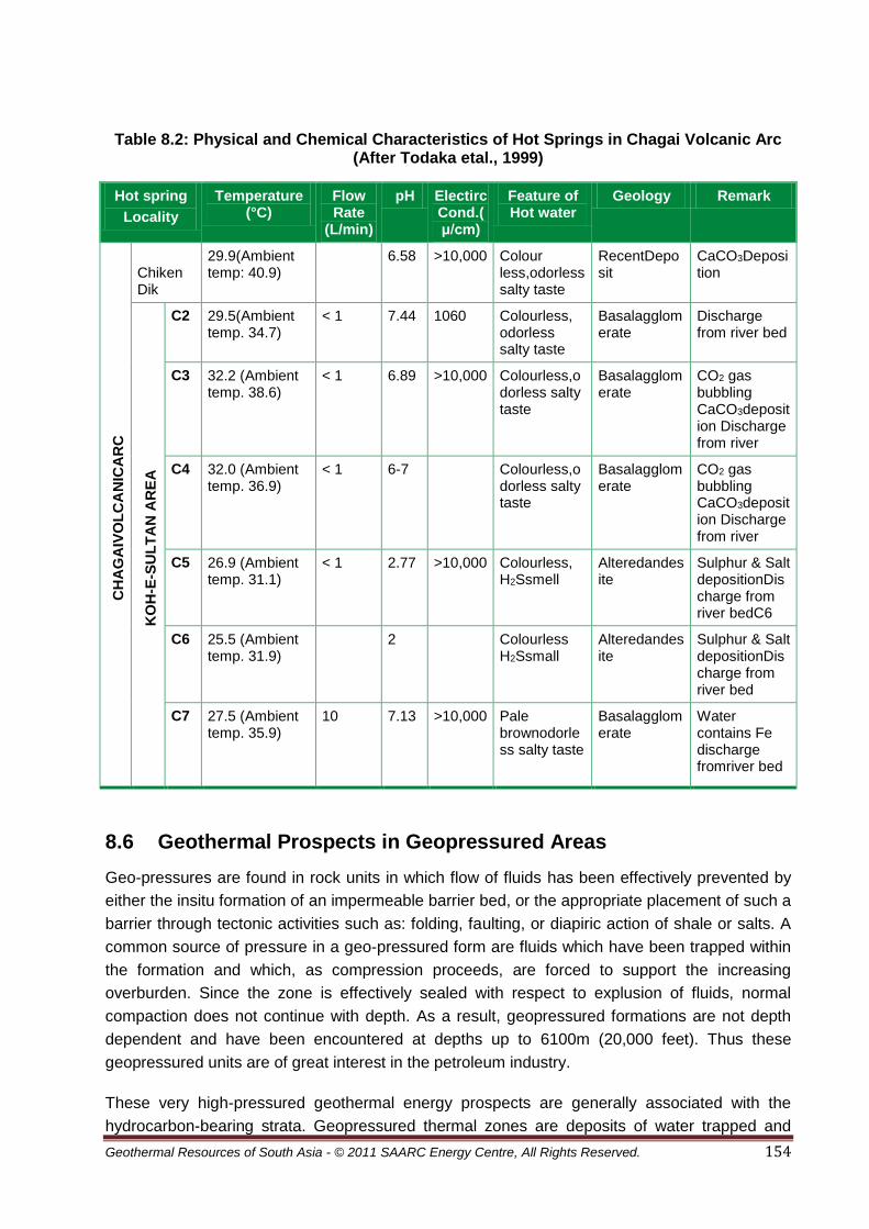
Geothermal Resources of South Asia - © 2011 SAARC Energy Centre, All Rights Reserved. 154
Table 8.2: Physical and Chemical Characteristics of Hot Springs in Chagai Volcanic Arc (After Todaka etal., 1999)
Hot spring
Locality
Temperature (°C)
Flow Rate
(L/min)
pH ElectircCond.(μ/cm)
Feature of Hot water
Geology Remark
CH
AG
AIV
OL
CA
NIC
AR
C
Chiken Dik
29.9(Ambient temp: 40.9)
6.58 >10,000 Colour less,odorless salty taste
RecentDeposit
CaCO3Deposition
KO
H-E
-SU
LT
AN
AR
EA
C2 29.5(Ambient temp. 34.7)
< 1 7.44 1060 Colourless, odorless salty taste
Basalagglomerate
Discharge from river bed
C3 32.2 (Ambient temp. 38.6)
< 1 6.89 >10,000 Colourless,odorless salty taste
Basalagglomerate
CO2 gas bubbling CaCO3deposition Discharge from river
C4 32.0 (Ambient temp. 36.9)
< 1 6-7 Colourless,odorless salty taste
Basalagglomerate
CO2 gas bubbling CaCO3deposition Discharge from river
C5 26.9 (Ambient temp. 31.1)
< 1 2.77 >10,000 Colourless, H2Ssmell
Alteredandesite
Sulphur & Salt depositionDischarge from river bedC6
C6 25.5 (Ambient temp. 31.9)
2 Colourless H2Ssmall
Alteredandesite
Sulphur & Salt depositionDischarge from river bed
C7 27.5 (Ambient temp. 35.9)
10 7.13 >10,000 Pale brownodorless salty taste
Basalagglomerate
Water contains Fe discharge fromriver bed
8.6 Geothermal Prospects in Geopressured Areas
Geo-pressures are found in rock units in which flow of fluids has been effectively prevented by
either the insitu formation of an impermeable barrier bed, or the appropriate placement of such a
barrier through tectonic activities such as: folding, faulting, or diapiric action of shale or salts. A
common source of pressure in a geo-pressured form are fluids which have been trapped within
the formation and which, as compression proceeds, are forced to support the increasing
overburden. Since the zone is effectively sealed with respect to explusion of fluids, normal
compaction does not continue with depth. As a result, geopressured formations are not depth
dependent and have been encountered at depths up to 6100m (20,000 feet). Thus these
geopressured units are of great interest in the petroleum industry.
These very high-pressured geothermal energy prospects are generally associated with the
hydrocarbon-bearing strata. Geopressured thermal zones are deposits of water trapped and

Geothermal Resources of South Asia - © 2011 SAARC Energy Centre, All Rights Reserved. 155
buried under heavy overburden during process of sedimentation. In these zones the heat is
trapped and insulated by encircling layers of sand, clay, and shale. The Geopressured zones
are a dual source of heat and methane at the same time (Holt, 1977).
8.6.1 Upper Indus Basin Geothermal Prospects
Two distinct pressure regimes in Potwar foreland fold and thrust belt basin has been identified:
one in Neogene rocks and another in pre-Neogene rocks. Pore pressures in Neogene rocks are
as high as lithostatic and are interpreted to be due to tectonic compression and compaction
disequilibrium associated with high rates of sedimentation. Pore pressure gradients in pre-
Neogene rocks are generally less than those in Neogene rocks, commonly ranging from 0.5 to
0.7 psi/ft (11.3 to 15.8 kPa/m) and are most likely due to a combination of tectonic compression
and fluid pressure. The top of abnormally high pressure is highly variable and doesn't appear to
be related to any specific lithologic seal (Figure 8.10). The Neogene sequence in this area
attains as much geothermal gradient as 2.5°C/100 m depth (Raza, 1981; Khan & Raza, 1986).
Figure 8.10: Depth of Geopressured Neogene Sequence in Upper Indus Basin (After Wandrey et al., 2004)
8.6.2 Salt Range Hot Springs
A number of hot springs and seepages are reported following the alignment of syntaxial bend
and Salt Range thrust.
Rocks in the Salt range area range from Pre-Cambrian to recent. However the majority of the
rocks are Tertiary. Temperatures of the thermal springs are from 25-32°C. The spring water is
sulphurous and is known to have therapeutic value for skin disease.
8.6.3 Middle Indus Geothermal Prospects
In foredeep region of Middle Indus Basin, the Giandari well recorded the highest geothermal
gradient of 4.1 °C/100 m. Around this hot spot further west ward gas fields of Mari, Kandhkot,
Sui, Uch Pirkoh and Jandran occur showing geothermal gradients ranging from 3°C/ 100 m to
3.4 °C/100 m (Khan & Raza, 1986).

Geothermal Resources of South Asia - © 2011 SAARC Energy Centre, All Rights Reserved. 156
Huge accumulation of sediments in the foredeep region is mainly due to deposition of thick
Neogene sequences alongwith thickening of underlying Mesozoic strata and westward tilting of
the basement. (Figure 8.11). Since the Neogene strata were rapidly deposited pockets of
abnormal formation pressures have been encountered in some of oil and gas exploratory wells.
Geothermal gradient map of the area indicates that zone of high temperature regime follow the
NS structural style in the periphery of Sulaimanf foredeep area.
Figure 8.11: Cross Section of Middle Indus Basin Showing the Depth of Geopressured Neogene Sequence (After Wandrey et al, 2004)
8.6.4 Hot Spring Occurrences
In Middle Indus Basin thermal springs have been recorded at Uch, Garm Ab at the base of Mari
Hills, Zinda Pir, Taunsa and Bakkur demonstrating vast area of geothermal energy (Oldham,
1882; Bakr, 1965). There are a number of other unrecorded geothermal springs in the area,
which needs to be studied in some details. Compiled fromweb-based information a hot springs
has been reported in Bugti area (Figure 8.12) and Kala Pani Hot spring Near fort Manro.
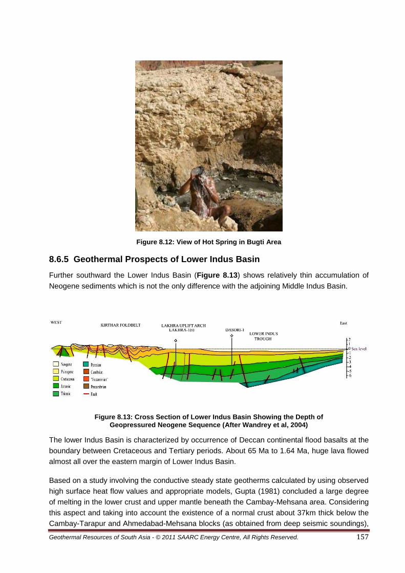
Geothermal Resources of South Asia - © 2011 SAARC Energy Centre, All Rights Reserved. 157
Figure 8.12: View of Hot Spring in Bugti Area
8.6.5 Geothermal Prospects of Lower Indus Basin
Further southward the Lower Indus Basin (Figure 8.13) shows relatively thin accumulation of
Neogene sediments which is not the only difference with the adjoining Middle Indus Basin.
Figure 8.13: Cross Section of Lower Indus Basin Showing the Depth of Geopressured Neogene Sequence (After Wandrey et al, 2004)
The lower Indus Basin is characterized by occurrence of Deccan continental flood basalts at the
boundary between Cretaceous and Tertiary periods. About 65 Ma to 1.64 Ma, huge lava flowed
almost all over the eastern margin of Lower Indus Basin.
Based on a study involving the conductive steady state geotherms calculated by using observed
high surface heat flow values and appropriate models, Gupta (1981) concluded a large degree
of melting in the lower crust and upper mantle beneath the Cambay-Mehsana area. Considering
this aspect and taking into account the existence of a normal crust about 37km thick below the
Cambay-Tarapur and Ahmedabad-Mehsana blocks (as obtained from deep seismic soundings),

Geothermal Resources of South Asia - © 2011 SAARC Energy Centre, All Rights Reserved. 158
it has been inferred that the heat flow anomaly is due to transient thermal perturbations
introduced from tectonic activity in the form of magmatic intrusions.
Geological frame work of Lower Indus Basin suggest a close similarity with the Cambay Basin, it
is, therefore, inferred that heat flow may have cause high geothermal gradients in some of the
exploratory wells drilled in Lower Indus Basin. The oil & gas wells drilled at Lakhra show thermal
gradients above normal (3.3°C/100 m). Farther southward the oil & gas wells at Sari and
Karachi revealed a geothermal gradient of about 3ºC/l00m.
The geological setting of the south-Kirthar geothermal zone is similar to that of the south-
Sulaiman geothermal zone. The Kirthar zone also includes, a depression containing a pile of
sediments 6-10km thick. The region is seismically active and epicenters of shallow earthquakes
ranging in magnitude from 3 to 5 on Richter scale have been recorded.
The Lower Indus trough and the offshore geothermal zone are characterized by geothermal
gradients above normal, which were encountered in borehole drilled for the oil & gas
exploration. The well Damiri-1 had a geothermal gradient of 4ºC/100m (Khan and Raza, 1986),
whereas the wells at Talhar and Khaskheli have encountered geothermal gradients in the range
of 3 °C to 3.5°C/100 m. The offshore well at Dabbo Creek revealed a geothermal gradient of
3.7 ºC/100 m.
8.6.6 Hot Springs in Lower Indus Basin
In the Dadu area there is a large concentration of thermal springs where the average surface
temperature is 40°C (Bakr, 1965).
In Karachi, two hot springs exist one at Mangho Pir and one at Karsaz. Table 8.3 shows
physical and chemical characteristics of these hot springs. There are hot and cold springs about
a kilometer from the Manghopir shrine. Warm water is sulphurous and is said to contain some
medicinal qualities.
Lakha Pir Hot Spring
This hot spring occurs in District Kachi at 27° 31' 0" North, 67° 31' 20. Blandford 1880 noted it at
about 6 miles of its termination, the range is traversed by a small valley, in which a hot spring
known as Lakha Pir with temperature of 44°C. The water issues in the bed of stream and is
strongly impregnated with sulphurated hydrogen, like the spring of the same name at Laki, near
Sehwan. At the spring no fault can be traced in the rocks which are Kirthar Limestone, and dip
at from 20 to 40 eastward (Blanford, 1880).

Geothermal Resources of South Asia - © 2011 SAARC Energy Centre, All Rights Reserved. 159
Table 8.3: Physical and Chemical Characteristics of Karachi Hot Springs
Hot Spring Locality Temperature (°C)
pH Electric Cond. (μ/cm)
Feature of Hot Water
Remark
Karachi Mangopir 50.3(Ambient temp.36.0)
7.45 2,380 Colourless; odorless
Surface soil CO2 gas bubbling
Karsaz 39.0(Ambient temp. 5.4)
7.87 7,910 Colourless; H2S small
CO2 gas bubbling
Source: Todaka et al., 1999
8.7 Conclusions
Tapping the geothermal energy appear attractive, as the hot springs are perennial and their
surface temperature ranging from 37 to 90°C, but only attainable with strong technical base and
commitment by the policy makers in the country. The earlier work summarized in the report
provide preliminary knowledge concerning the geothermal occurrences in various parts of
Pakistan. Further exploration is needed to undertake the surface-based studies that could
constrain models for the deep thermal state of these occurrences. As stated above, even though
the range of possible thermal conditions is large but uncertain, there is ample evidence of
extensive hot reservoir from the ages of volcanic rocks in northern part of the country and
Chagai volcanic arc as well as basaltic event of the Deccan Trap in southern part of the country.
Because of the unique nature of the hydrology of these areas, in particular the deep water table
and the large lateral hydraulic gradients, the depth, size, and temperature of this system remain
indeterminate.

Geothermal Resources of South Asia - © 2011 SAARC Energy Centre, All Rights Reserved. 160
8.8 Bibliography
1. Ahmed, M. (2007). Meeting Pakistan’s Energy Needs, in Hathaway, Muchhala, R.M., B. Kugelman, M. (Eds.) Fuelling the Future: Meeting Pakistan’s Energy need in the 21st Century, Woodrow Wilson International Center for Scholars, pp. 17-34.
2. Alam, S, (2003) Tectonic Thickening of the Western Makran Accretionary Wedge, Southwest Pakistan, presented at Geological Society of America 2002 Denver Annual Meeting, Denver, USA.
3. Alternate Energy Development Board (AEDB), 2009, Geothermalenergy in Pakistan and the world,
4. Arthurton, R. S., G. S. Alam, S. A. Ahmed and S. Iqbal, (1979) Geological history of Alam Reg -Mashki Chah area, Chagai District, Balochistan. In Farah, A. and DeJong, K. A., (eds.), Geodynamics of Pakistan. Geol. Surv. Pakistan, 325-331.
5. Arthurton, R. S., A. Farah, and W. Ahmed, (1982) The Late Cretaceous-Cenozoic history of western Balochistan, Pakistan - the northern margin of the Makran subduction complex. In Leggett, J. K., (ed.), Trench Fore-Arc Geology. Geol. Soc. London, Spec Pub., (10): 343-385.
6. Anczkiewicz, R., Burg, J.-P., Villa, I. M. and Meier, M. (2000). Late Cretaceous blueschist metamorphism in the Indus Suture Zone, Shangla region, Pakistan Himalaya. Tectonophysics 324, 111-134.
7. Asif, M., (2009), Sustainable Energy Options for Pakistan, Renewable and Sustainable Energy Reviews, May, 903–909.
8. Bakr, M.A., (1965), Thermal springs of Pakistan: Geol. Surv. Pak. Rec. 16, p.3-4, Quetta.
9. Bakhat, M. S, (2000) An Overview of Geothermal Resources of Pakistan, Proceedings World Geothermal Congress 2000Kyushu - Tohoku, Japan, May 28 - June 10, 2000.
10. Blanford, H. F., 1880, Geology of Western Sindh. GSI Memoir 17, Page 75.
11. Burbank, D.W., and Raynolds, R.G.H., (1988), Stratigraphic keys to the timing of thrusting in terrestrial foreland basins; Applications to the northwestern Himalaya, in Kleinspehn, K.L., and Paola, Chris, eds., New perspectives in basin analysis: New York, Springer-Verlag, p. 331–351.
12. Buchroithner, M (1980). An outline of the geology of the Afghan Pamirs. Tectonophysics 62, 13-35.
13. Calkins, J.A., Jamiluddin, S., Bhuyan, K. & Hussain, A., (1981), Geology and mineral resources of Chitral Partsan area, Hindu Kush Range, northern Pakistan: U.S.Geol.Surv.Pr. Paper 716-G, 33 pp., Reston, Va.
14. Chamberlain, C. P., Zeitler, P. K., Erickson, E., 1991, Constraints on the tectonic evolution of the northwestern Himalaya from geochronologicand petrographic studies of Babusar Pass Pakistan, Journal of Geology, 99, 829-849.
15. DiPietro, J. A. & Isachsen, C. E. 2001. U-Pb zircon ages from the Indian plate in northwest Pakistan and their signifi cance to Himalayan and pre-Himalayan geologic history. Tectonics 20(4), 510-525.
16. Drewes, H, (1995), Tectonics of the Potwar Plateau region and the development of syntaxes, Punjab, Pakistan: U.S. Geological Survey Bulletin 2126, 22 p.
17. Fedral Bureau of Statics, (1998), 50-Years of Pakistan in statistics: Federal Bureau of Statistics (FBS), Government of Pakistan, Vol. I, p.124-137.

Geothermal Resources of South Asia - © 2011 SAARC Energy Centre, All Rights Reserved. 161
18. FD (Finance Division), (2001), Economic Survey 2000-2001: Government of Pakistan, Economic Adviser’s Wing, Finance Division, Islamabad.
19. Gaetani, M., Zanchi, A, Angiolini, A., Olivini, G., Sciunnach, D., Brunton, H., Nicora, A. and Mawson, R. (2004). The Carboniferous of the Western Karakoram (Pakistan). Journal of Asian Earth Sciences.
20. Gaetani, M., Burg , J.P., Zanchi, A., Jan, Q.M. (2004) A geological transect from the Indian Plate to the East Hindu Kush, Pakistan, Italian Agency for the Environmental Protection and Technical Services - Via Vitaliano Brancati, 48 - 00144 Roma – Italy, 55pp.
21. Gee, E.R., 1989, Overview of the geology and structure of the Salt Range, with observations on related areas of northern Pakistan, in Malinconico, L.L., Jr., and Lillie, R.J., eds., Tectonics of the western Himalayas: Geological Society of America Special Paper 232, p. 95–111.
22. GEP (Geothermal Energy Program, (2002), Environmental and Economic Impacts: www.eren.doe.gov/geothermal/geoimpacts.html.
23. Government of Pakistan, 2010. History in Chronological Order. http://www.infopak.gov.pk/History.aspx
24. Government of Pakistan, (2006) Policy for Development of Renewable Energy for Power Generation. Government Policy, Government of Pakistan.
25. Hagler Bailly Pakistan. (2008). Pakistan Energy Supply and Demand Forecast. Final Draft Report: HBP Ref: D8PE1AEO, DHA Cogan Limited, Karachi.
26. Harijan, K., Uqaili, M. A., Memon. (2008) Renewable Energy for Managing Energy Crisis in Pakistan. Jamshoro: Springer Berlin Heidelberg, 2008.
27. Hildebrand, P.R., Noble, S.R., Searle, M.P., Waters, D.J., Parrish R.R., 2001, Old origin for an active mountain range: geology and geochronology of the eastern Hindu Kush, Pakistan, GSA Bulletin, 113 (2001), pp. 625–639
28. IAEE (International Association for Energy Economics), (1988), South and Southeast Asia Pricing Issue,v.9, http://www.iaee.org/documents/SP_SOU88.pdf
29. IGA (International Geothermal Association) (2003), Installed Generating Capacity:http://iga.igg.cnr.it/electricitygeneration.php.
30. Iqbal, M.W.A., and Shah, S.M.I., 1980, A guide to the stratigraphy of Pakistan, Geological Survey of Pakistan Records: Geological Survey of Pakistan, Quetta, v. 53, p. 34.
31. Leghari, S. M., Jahangir, T. M., Khuahawar. M. Y., (2005). Limnological study of Lakha pir, hot spring (Distt: Kachi) Baluchistan, Pakistan.Jour. Scientific Sindh.
32. Jadoon, Ishtiaq A.K., Lawrence, Robert D., and Lillie, Robert J., 1994,Seismic data, geometry, evolution, and shortening in the active Sulaiman Fold-and-Thrust Belt of Pakistan, southwest of theHimalayas: American Association of Petroleum Geologists Bulletin, v. 78, no. 5, p. 758–774.
33. Jaswal, T.M., Lillie, R.J., and Lawrence, R.D., 1997, Structure and evolution of the northern Potwar deformed zone, Pakistan: American Association of Petroleum Geologists Bulletin, v. 81, no. 2, p. 308–328.
34. Jaumé, S.C., and Lillie, R.J., 1988, Mechanics of the Salt Range–Potwar Plateau, Pakistan—A fold-and-thrust belt underlain by evaporites: Tectonics, v. 7, p. 57–71.
35. Kafarskyi, A. Kh. and Abdullah, J., 1976, Tectonics of the North-east Afghanistan (Badakhshan, Wakhan, Nurestan) and relationship with the adjacent territories. Atti Convegni Lincei Roma 21, 87-113.

Geothermal Resources of South Asia - © 2011 SAARC Energy Centre, All Rights Reserved. 162
36. Kaneko, Y., Katayama, I., Yamamoto, H., Misawa, K., Ishikawa, M., Rehman, H. U., Kausar, A. B. & Shiraishi, K. (2003). Timing of Himalayan ultrahighpressure metamorphism: sinking rate and subduction angle of the Indian continental crust beneath Asia. Journal of Metamorphic Geology 21(6), 589-599.
37. Kazmi, A. H., (1979), Active fault systems in Pakistan: In Farah, A. & Dejong, K.A. (eds.); Geodynamics ofPakistan 286-294, Geol. Surv. Pak., Quetta.
38. Kazmi, A.H. and Jan, M.Q., (1997), Mineral fuels: In Geology & tectonics of Pakistan, Graphic Publishers, Karachi, Pakistan, p.483-500.
39. Kazmi, A.H. & Rana, R.A., (1982), Tectonic map of Pakistan, Sale 1: 2,000,000, Geol, Surv. Pak. Map Series, Quetta.
40. Kemal, A., Balkwill, H.R., and Stoakes, F.A., 1992, Indus Basin hydrocarbon plays, in Ahmed,G., Kemal, A., Zaman, A.S.H., and Humayon, M., eds., New directions and strategies for accelerating petroleum exploration and production in Pakistan: Proceedings of an international petroleum seminar, Ministry of Petroleum and Natural Resources, Islamabad, Pakistan, November, 22-24, 1991, p. 76-105.
41. Khan, M.A. & Raza, H.A. (1986), Role of geothermal gradients in hydrocarbon exploration in Pakistan: Jour. Petrol. Geol., 9 (3) p245-258, London.
42. Masud, J. (2009). Clean Energy Development in Pakistan. Pakistan Power Point Presentation at ADB Climate Change and Energy Workshop, Bangkok, March 26 – 27, 2009.
43. Ministry of Economic Affairs and Statistics, 2010, Official Pakistani Population clock". http://www.statpak.gov.pk/depts/pco/
44. Nawab, S.H (2007). Important Gas Pipeline Projects. Third Oil & Gas Pakistan Conference. Energy Sector Issues: Energy Efficiency and Energy Environmental Links.
45. O’Brien, P. J., Zotov, N., Law, R., Khan, M. A. & Jan, M. Q. 2001. Coesite in Himalayan eclogite and implications for models of India-Asia collision. Geology 29(5), 435-438.
46. Oldham, T., 1882, Thermal springs of India: Geol. Surv. India, Mem. 19, (2), 63 pp.; Calcutta.
47. Pakistan, 2008. World Factbook. CIA. https://www.cia.gov/library/publications/the-world-factbook/geos/pk.html.
48. Perri, M.C., Molloy, P.D. and Talent, J.A. (2004). Earliest Triassic conodonts from Chitral, Northernmost Pakistan. Rivista Italiana di Paleontologia e Stratigrafi a 110.
49. Petterson, M. G. and Windley, B. F. (1985). Rb-Sr dating of the Kohistan arc-batholith in the Trans-Himalaya of north Pakistan, and tectonic implications. Earth and Planetary Science Letters 74(1), 45-57.
50. Petterson, M. G. and Treloar, P. J. (2004). Volcanostratigraphy of arc volcanic sequences in the Kohistan arc, North Pakistan: volcanism within island arc, back-arc-basin, and intra-continental tectonic settings. Journal of Volcanology and Geothermal Research 130(1-2), 147-178.
51. Platt,J. P., Leggett,J. K., Young,J., Raza,H., Alam,S., (1985), Large-scale sediment underplating in the Makran accretionary prism, southwest Pakistan, Geological Society of America, v. 13 no. 7 p. 507-511.
52. Platt,J.P., Leggett,J.K., Alam,S. (1988) Slip vectors and fault mechanics in the Makran accretionary wedge, southwest Pakistan. Journal of Geophysical Research, Vol. 93, NO. B7, PP. 7955-7973.

Geothermal Resources of South Asia - © 2011 SAARC Energy Centre, All Rights Reserved. 163
53. Pogue, K. R., Hylland, M. D., Yeats, R. S., Khattak, W. U. & Hussain, A. (1999). Stratigraphic and structural framework of Himalayan foothills, northern Pakistan. Geological Society of America, Special Paper 328, 257-274.
54. Population Census Organization, Government of Pakistan, 2008,Area, Population, Density and Urban/Rural Proportion by Administrative Units". http://www.statpak.gov.pk/depts/pco/statistics/area_pop/area_pop.html
55. Quintavalle, M., Tongiorgi, M. and Gaetani, M. (2000). Lower to Middle Ordovician acritarchs and chitinozoans from Northern Karakoram Mountains, Pakistan. Rivista Italiana di Paleontologia e Stratigrafi a 106, 3-18.
56. Quittmeyer, R.C., Farah, A. & Jacob, K.H., (1979), the seismicity of Pakistan and its relation to surface faults: In Farah, A. & Dejong, K. A. (eds.) Geodynamics of Paksitan: 271-284, 9 figs., Geol. Surv. Pak., Quetta.
57. Raza, H.A., Ali, S.M& Ahmed, R., (1990), Petroleum geology of Kirthar sub-basin and part of Kutch Basin: Pak. J. Hydroc. Res. 2(1), p29-74, Islamabad.
58. Raza, H.A. and Bander F.K., (1995), Energy resources: In Geology of Pakistan, Gebruder Borntraeger, Berlin, Stuttgart p.182-201.
59. Roychoudhury, S.C., and Deshpande, S.V., 1982, Regional distribution of carbonate facies, Bombay Offshore region, India, American Association of Petroleum Geologists Bulletin, v. 66 no. 10, p. 1483–1496.
60. Schroeder, S. (2004). Devonian rugose corals from the Karakorum Mountains (Northern Pakistan). Rivista Italiana di Paleontologia e Stratigrafi a 110.
61. Scotese, C.R., Gahagan, L.M., and Larson, R.L., 1988, Plate tectonic reconstructions of the Cretaceous and Cenozoic ocean basins: Tectonophysics, v. 155, p. 27-48.
62. Searle, M.P. (1991). Geology and Tectonics of the Karakoram Mountains. Wiley and Son. 358 pp.
63. Searle, M. P., Asif Khan, M., Fraser, J. E. and Gough, S. J. (1999). The tectonic evolutions of the Kohistan-Karakoram collision belt along the Karakoram Highway transect, north Pakistan. Tectonics 18(6), 929-949.
64. Shuja, T.A., (1983), Geothermal resources and possibility of their development in Pakistan: Geol. Bull, Punjab 000 Univ., 18, p22-23, Lahore.
65. Shuja, T.A. & Khan, A.L., (1984), Prospects of geothermal energy in Pakistan: Geol. Surv. Pak. Info. Rel., 242, 22pp.; Quetta.
66. Shuja, T.A. & Sheikh, M.I., (1983), A study of geothermal resources of Gilgit and Hunza agencies, northern Pakistan: Geol. Surv. Pak. I.R., 179, 22pp., Quetta.
67. Tahirkheli, R. A. K., Mattauer, M., Proust, F. & Tapponnier, P. (1979). The India Eurasia Suture Zone in Northern Pakistan: Synthesis and interpretation of recent data at plate scale. In: Geodynamics of Pakistan (edited by Farah, A. & De Jong, K. A.). Geological Survey of Pakistan, Quetta, 125-130.
68. Todaka, N., Shuja, T.A., Jamiluddin, S., Khan, N.A., Pasha, M.A., and Iqbal, M., (1999) A preliminary study of geothermal energy resources of Pakistan: Geiol. Surv. Pak, I.R. 407.
69. Treloar, P. J., Petterson, M. G., Qasim Jan, M. and Sullivan, M. A. (1996). A re-evaluation of the stratigraphy and evolution of the Kohistan arc sequence, Pakistan Himalaya: implications for magmatic and tectonic arc-building processes. Journal of the Geological Society of London 153, 681-693.

Geothermal Resources of South Asia - © 2011 SAARC Energy Centre, All Rights Reserved. 164
70. Wandrey, C.J., Law, B.E., Shah, H. A. (2004),Sembar Goru/Ghazij Composite Total Petroleum System, Indus and Sulaiman-Kirthar Geologic Provinces, Pakistan and India,U.S. Geological Survey Bulletin 2208.
71. Warwick, P. D., (1999), Overview of the Geography, Geology, and Structure of the Potwar Regional Framework Assessment Project Study Area, Northern Pakistan, U.S. Geological Survey Professional Paper.
72. Yamamoto, H. and Nakamura, E. (2000). Timing of magmatic and metamorphic events in the Jijal complex of the Kohistan arc deduced from Sm-Nd dating of mafi c granulites. In: Tectonics of the Nagna Parbat Syntaxis and the Western Himalaya (edited by Khan, M. A., Treloar, P. J., Searle, M. P. & Jan, M. Q.). Geological Society Special Publication, London, 170, 321-331.
73. Yasmeen. N. M., 2007, Pakistan: a global studies handbook. ABC-CLIO publishers, 2007, ISBN 1-85109-801-1.
74. Yoshida, M., Zaman, H. and Ahmad, M. N. (1996). Paleopositions of Kohistan Arc and surrounding terranes since Cretaceous time: the paleomagnetic constraints. Proceedings of Geoscience Colloquium, Geoscience Laboratory Project, Islamabad, Pakistan 15, 83-101.
75. Zaigham, N.A, (2005), Geothermal Energy Resources of Pakistan, Proceedings World Geothermal Congress 2005 Antalya, Turkey, 24-29 April 2005.
76. Zanchi, A. (1993). Structural evolution of the North Karakorum cover, North Pakistan. In. Himalayan Tectonics (Ed. by Treloar, P.J. & Searle, M.P.) Geological Society of London, Special Publication 74: 21-38.
77. Zanchi, A., Gaetani, M., Angiolini, L. and De Amicis, M. (2001). The 1:100.000 geological map of westerncentral Northern Karakoram terrain (northern areas, Pakistan). Journal of Asian Earth Sciences 19/3A, 79.
78. Zanchi, A., Poli, S., Fumagalli, P., Gaetani, M., (2000). Mantle exhumation along the Tirich Mir Fault Zone, NW Pakistan: pre mid-Cretaceous accretion of the Karakoram terrane to the Asian margin. In: Khan M.A., Treloar P.J., Searle M.P. and Jan M.Q- (eds.) - Tectonics of the Nanga Parbat Syntaxis and the Western Himalayas. Geological Society of London, Special. Publication, 170, 237-252.
79. Zeitler, P. K. (1985). Cooling history of the NW Himalaya, Pakistan. Tectonics 4(1), 127-151.
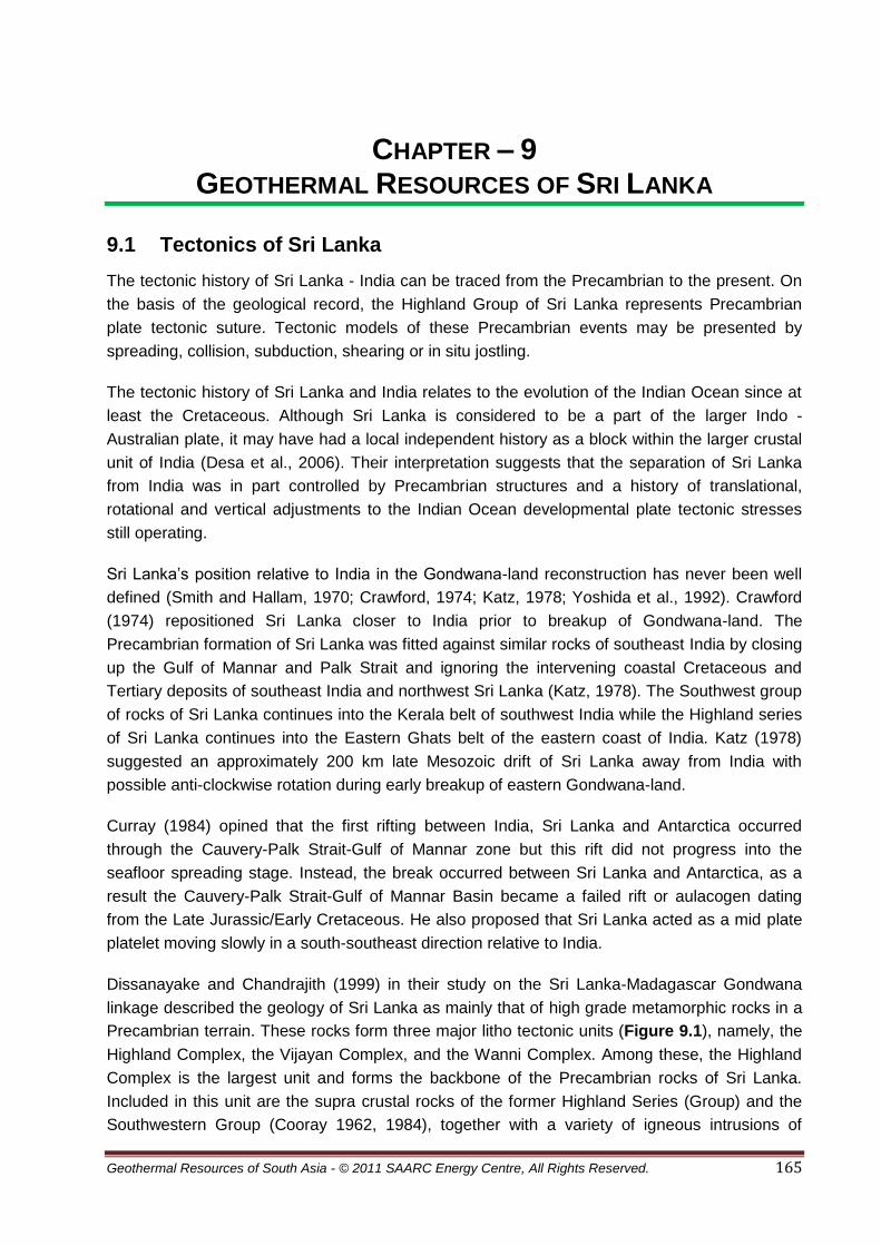
Geothermal Resources of South Asia - © 2011 SAARC Energy Centre, All Rights Reserved. 165
CHAPTER – 9 GEOTHERMAL RESOURCES OF SRI LANKA
9.1 Tectonics of Sri Lanka
The tectonic history of Sri Lanka - India can be traced from the Precambrian to the present. On
the basis of the geological record, the Highland Group of Sri Lanka represents Precambrian
plate tectonic suture. Tectonic models of these Precambrian events may be presented by
spreading, collision, subduction, shearing or in situ jostling.
The tectonic history of Sri Lanka and India relates to the evolution of the Indian Ocean since at
least the Cretaceous. Although Sri Lanka is considered to be a part of the larger Indo -
Australian plate, it may have had a local independent history as a block within the larger crustal
unit of India (Desa et al., 2006). Their interpretation suggests that the separation of Sri Lanka
from India was in part controlled by Precambrian structures and a history of translational,
rotational and vertical adjustments to the Indian Ocean developmental plate tectonic stresses
still operating.
Sri Lanka’s position relative to India in the Gondwana-land reconstruction has never been well
defined (Smith and Hallam, 1970; Crawford, 1974; Katz, 1978; Yoshida et al., 1992). Crawford
(1974) repositioned Sri Lanka closer to India prior to breakup of Gondwana-land. The
Precambrian formation of Sri Lanka was fitted against similar rocks of southeast India by closing
up the Gulf of Mannar and Palk Strait and ignoring the intervening coastal Cretaceous and
Tertiary deposits of southeast India and northwest Sri Lanka (Katz, 1978). The Southwest group
of rocks of Sri Lanka continues into the Kerala belt of southwest India while the Highland series
of Sri Lanka continues into the Eastern Ghats belt of the eastern coast of India. Katz (1978)
suggested an approximately 200 km late Mesozoic drift of Sri Lanka away from India with
possible anti-clockwise rotation during early breakup of eastern Gondwana-land.
Curray (1984) opined that the first rifting between India, Sri Lanka and Antarctica occurred
through the Cauvery-Palk Strait-Gulf of Mannar zone but this rift did not progress into the
seafloor spreading stage. Instead, the break occurred between Sri Lanka and Antarctica, as a
result the Cauvery-Palk Strait-Gulf of Mannar Basin became a failed rift or aulacogen dating
from the Late Jurassic/Early Cretaceous. He also proposed that Sri Lanka acted as a mid plate
platelet moving slowly in a south-southeast direction relative to India.
Dissanayake and Chandrajith (1999) in their study on the Sri Lanka-Madagascar Gondwana
linkage described the geology of Sri Lanka as mainly that of high grade metamorphic rocks in a
Precambrian terrain. These rocks form three major litho tectonic units (Figure 9.1), namely, the
Highland Complex, the Vijayan Complex, and the Wanni Complex. Among these, the Highland
Complex is the largest unit and forms the backbone of the Precambrian rocks of Sri Lanka.
Included in this unit are the supra crustal rocks of the former Highland Series (Group) and the
Southwestern Group (Cooray 1962, 1984), together with a variety of igneous intrusions of

Geothermal Resources of South Asia - © 2011 SAARC Energy Centre, All Rights Reserved. 166
predominantly granitoid composition that now occur as banded gneisses. The rocks comprising
the Highland Complex are mainly of granulite facies metamorphites, predominantly varieties of
granulites including charnockites, quartz-feldspargarnet- sillimanite-graphite schists, quartzites,
marbles, and calc-gneisses. On the basis of field and petrological evidences, Kro¨ner et al.
(1991) infer that a significant proportion of the rocks in the Highland Complex are of granitoid
origin. Widespread Charnockite Formation has been observed within this unit (Hansen et al.
1987). These rocks are dated at about 550 Ma (Baur et al. 1991).
The Vijayan Complex, lying to the east of the central Highland Complex (Figure 9.1) consists of
biotite-hornblende gneisses and scattered bands of met sediments and charnockitic gneisses.
Among the other prominent geological features of the Vijayan Complex are the small plutons of
granites and acid charnockites near the east coast (Jayawardena and Carswell 1976) and the
north-west-trending suite of dolerite dikes at Kallodai. Milisenda et al. (1988) and Milisenda
(1991) have described the gneissose granitoids of the Vijayan Complex as having compositions
ranging from tonalite to leucogranite.
The Vijayan Complex is mostly of amphibolite-facies grade, and the fact that it has not been
subjected to granulite facies metamorphism has been interpreted by Kro¨ner et al. (1991) to
mean that the charnockitic bodies within the Vijayan domain are klippen and/or unfolded or
intersliced fragments of the Highland Complex. These are similar to the Kataragama klippe
(Figure 9.1), of which the derivation from the latter complex has been established (Cooray
1978; Vitanage 1985).
The Wanni Complex consists of a suite of granitoid gneisses, charnockitic gneisses, and
granites, along with a variety of amphibolite- to granulite facies rocks such as meta sediments of
predominantly pelitic to semipelitic composition (Milisenda et al. 1991). Studies of detrital zircons
from metapelites have shown that the Wanni Complex is younger than the Highland Complex,
even though the boundary between these two litho tectonic units is still poorly defined.
Their study further suggests that Sri Lanka occupies a unique geologic position in Gondwana.
Accordingly on the basis of recent age and isotopic data they concluded that the high-grade
basement rocks of Sri Lanka are more closely associated with the southeastern part of
Madagascar than with the Archean granulites of southern and eastern parts of India. They
further noted that the occurrences of gem minerals and graphite in the centrally located
Highland Complex of Sri Lanka can also be correlated with those of the Kerala Khondalite Belt
(KKB) at the southern tip of India and of southeast Madagascar south of the Ranotsara Shear
Zone. As such they were of the view that these geological and mineralogical features indicate
the juxtaposition of Sri Lanka with Madagascar and also with the Lutzow-Holm Bay area in
Antarctica. The very close juxtaposition of Sri Lanka with Madagascar suggested by them
implies that there exists a distinct mineralized belt running from Antarctica through the Highland
Complex of Sri Lanka into Madagascar, Mozambique, Tanzania, and farther north. This mineral
belt is clearly of Pan-African origin and is now considered to be an important geosuture
associated with the main Mozambique Belt. The position of Sri Lanka in Gondwana is of

Geothermal Resources of South Asia - © 2011 SAARC Energy Centre, All Rights Reserved. 167
particular significance because Sri Lanka acts as a bridge across the main East African and
Antarctica crustal fragments.
Figure 9.1: Geological Map of Sri Lanka
Geothermal Resources of South Asia - © 2011 SAARC Energy Centre, All Rights Reserved. 168
9.2 Stratigraphy
More than 90 percent of Sri Lanka's surface lies on Precambrian strata. The metamorphic rock
surface was created by the transformation of ancient sediments under intense heat and
pressure during mountain-building processes. Corray (1997) described the Precambrian units
and sedimentary strata. The extract from his paper is given here under:
9.2.1 Crustal Units
Precambrian
The Precambrian is subdivided into three main parts and one subordinate lithotectonic unit.
(1)High Land Complex occupying the central highland zone extending from SWTO THE NE of
the island; (2) the Wani Complex occupying the lowlands to W of Highland complex; and (3) The
Vijayan Complex to the E and S of it.
Highland Complex
The Highland Complex consists of supracrustal and igneous rocks characterisied by common
structural history and a granulitic facies of metamorphic grade and derived from ancient source
rocks. Themet sedimentary rocks are meta quartzite, forsterite marbles, scapolite-wollastonite
granulite and gneisses, garnet silliminite-graphite gneisses and quartz-feldspar granulites
intercalated with these meta sediments and forming over 50% of HC are rocks of granitoid
origin. These are quartzo-feldspathic banded gneisses and charnockitic gneisses. The bande
nature of the gneisses is due to original compositional differences, dyke intrusion and
metamorphic differentiation; tight isoclinal folding and thrusting has modified the original
intrusive relations and stratigraphic sequences.
The main structural elements in HC are well developed geisseic foliation and a strong mineral
and stretching lineations, both of which vary from E-W in the S to NNW-SSE in the center and to
NNE- SSW in the N of the belt. At least four phases of ductile deformation with corresponding
episodes of folding have been recognized in many parts of Precambrian basement. The main
folding episode gave rise to prominent upright to overturned folds which predominate the
present structure; they were preceded by mostly obliterated and isoclinals, sub horizontal to
recumbent folds (Berger and Jayasinghe, 1976 and Kriegeman, 1991).
The depositional age of the supracrustal rocks is ca. 2000 Ma and the granitoids range from
1942 Ma to 650 Ma. Hence the HC represents a 2-3 Ga crust. Regional granulitic facies
metamorphism took place at 665 t0 550 Ma. Metamorphic conditions vary from ca. 3-5 kbar and
600-700°C in W to about 8-10 kbar and 800-900°C.
Wanni Complex
Wanni Complex (WC) consists of (1) scattered relics of a supracrustal series in (2) a suite of
completely folded granodioritic gneisses, intruded by (3) a late microcline granite. The Tonigala
Granite, and it surrounding granitic migmatites younger than 1100 Ma. A large extent of

Geothermal Resources of South Asia - © 2011 SAARC Energy Centre, All Rights Reserved. 169
charnockitic terrane is present in the N of WC, E of Vaviuniya. Preliminary data suggests the
WC rocks to be about 1000 to 1100 Ma old and Nd model ages of 1.5 to 1.6 Ga.
The WC rocks are of lower metamorphic grade than those of HC, but there is no clear structural
break between the two units. Various boundaries have been drawn between them on the basis
of lithology or isotopic data, but there is as yet no conclusive evidence for either the nature or
the position of WC_HC boundary.
Vijayan Complex
The Vijayan Complex (VC) consists of a variety of gneisses and granitoids ranging in
composition from tonalite to leucogranite and containing xenoliths of metaquartzite and
siliciclastic rocks. The original granitoids are strongly migmatized at many places and display
well defined compositional layering. Zircon ages suggest that the metaquartzites have ages
around 1100 Ma. Thus indicates that the enclosing granitoids are younger. Nd isotopic
systematic sand chemical criteria show the Vijayan orthogeneisses to be derived magmatic
precursors.
Much of the structural history of VC is compare able to that of the HC, but the two units are of
completely different origin, brought together by thrusting. Within VC are tectonic klippen of HC
rocks as at Kataragama and Maligawila.
Kadugannawa Complex
Infolded within HC is the Kadugannawa Complex. These rocks occupy distinct, well defined,
elongated, upright doubly plunging synformal basins (arenas) around Kandy. They consist
mainly of biotite-horn blend and biotite gneisses, to gather with concordant amphibolites, minor
quartzo-feldspathic and pelitic gneisses and metaquartzites. Early recumbent folds were over
folded by asymmetric, reclined folds; large upright structures with variable axial planes gave rise
to the present basin and dome pattern. There is still no agreement as to the origin of these
rocks, though it is thought that all the rocks in the arenas once experienced granulite facies
metamorphism.
The gneisses are tonalitic, trondhjemmitic and granodioritic, with calc alkaline affinity, minor
layered mafic and ultramafic rocks being more tholeiitic in nature. One interesting suggestion is
that the latter represent a deformed and metamorphosed, large synchronous, layered intrusion.
The recent advances in knowledge of the geology of Sri Lanka (Mathavan, Prame, &Cooray,
1999) favour a strong geological correlation of the HC, and the VC of Sri Lanka, respectively,
with the Lutzöw-Holm Complex, and the Yatmato-Belgica Complex in the East Antarctica. The
geology of the WC suggests a possible correlation with Madagascar, and East Africa. The
amalgamation of the three crustal units of Sri Lanka, is apparently related to the two distinct
orogenic events that resulted in the assembly of the Gondwana supercontinent.

Geothermal Resources of South Asia - © 2011 SAARC Energy Centre, All Rights Reserved. 170
9.2.2 Sedimentary Rocks
The island contains relatively limited strata of sedimentation surrounding its ancient hills. Aside
from recent deposits along river valleys, only two small fragments of Jurassic sediment occur in
Puttalam District, while a more extensive belt of Miocene limestone is found along the northwest
coast, overlain in many areas by post Miocene deposits. The details are hereunder:
Jurassic
Upper Gondwana beds occupy two small basins in the NW at Tabbowa and Andgma-Pallama,
which are faulted into the Precambrian basement. The Tabbowa basin is internally faulted and
tilted and the rocks are exposed at the surface. The major rock types at Tabbowa are arkose,
feldspathic sandstone, siltstone and mudstone; they are thought to be a deltaic facies.
Fossilized plant remains, several forms of which are identical to those found in Upper
Gondwana deposits of India.
The Andigama beds, 30km S of Tabbowa, are mainly carbonaceous shales and calcareous
sandstones, covered by recent deposits. Gravity data indicates that the thickness of sediments
is 500km at Tabbowa and 900 to 1200m at Andigama (Hatherton, Pattiarachchi and
Ranasinghe, 1975).
Exploration wells in the Palk Strait between Sri Lanka and India show a sedimentary succession
of over 2500m of shales, limestone, claystone and siltstone, ranging from Lower Cretaceous to
Upper Pliocene-Miocene. The basin has horst and graben structure and several unconformities
are present in the succession.
Tertiary (Miocene)
The Jaffna Peninsula and surrounding islands in the extreme N and the NW coastal strip
extending to Puttalam are underlain by the Jaffina Limestone of Miocene age. It is mostly partly
crystalline, indistinctly bedded, creamy coloured rock, richly fossiliferous in parts (Wayland and
Davies, 1923), and mostly flat bedded. Gravity data suggest (Hatherton, Pattiarachchi and
Ranasinghe, 1975) that it forms and elongated NW-trending basin, 300m thick in the E but
reaching 4000m in the W, due either to down warping or faulting. A sandy facies is present in
the NE, the result of periodic step-faulting. A small outcrop of Miocene rocks is present at
Minhagalkande on the SE coast.
Post Miocene
The post Miocene rocks of the NW coastal belt have been subdivided into an Older and
Younger Group. The Older Group consists of (1) a basal ferruginous gravel, 6m thick at places;
(2) the Red Beds, 3-30m thick, forming prominent ridges and narrow, elongated plateaus
parallel to coast; (3) terrace gravel, which form scattered deposits, 4-9 m above abandoned river
courses.
The Younger Group consists of (1) lagoonal, lacustrine and estuarine clays and sand, alluvium;
(2) beach and dunes sands and (3) beach rock.
Geothermal Resources of South Asia - © 2011 SAARC Energy Centre, All Rights Reserved. 171
The post Miocene coastal deposits occur also in the S and E coastal strips, especially N and S
of Batticaloa. Literate (30 to 35m thick) occurs extensively in the SW sector.
9.3 Surface Manifestations of Geothermal Resources
Considering that Sri Lanka is not an active volcanic region or situated within proximity to an
active plate margin little attention was paid for extensive exploration of the source of hot dry
rocks and geothermal reservoirs and their flow regimes. However surface manifestation of
geothermal energy has been recorded at no less than 10 to 12 thermal springs.
In Sri Lanka these geothermal springs are distributed along a narrow eastern low land belt
running from Hambantotata to Trincomalee and occur within the boundary of two main
geological units – the Highland and Viyayan complexes (Dissanayake & Jayasena: 1987). About
80% of hot springs belongs to the Vijayan complex and 20% to the Highland
www.complex.amazinglanka.com has pointed out the following 12 hot springs in five districts of
Sri Lanka.
Trincomalee District
1. Rankihiriya / Ulpotha / Gomarankadawala
2. Kanniya
Polonnaruwa District
1. Madawawa
2. Nelum Wewa / Gal Wewa
3. Mutugalwela/ Gurukuburain Maduru Oya national park
Polonnaruwa District
1. Madawawa
2. Nelum Wewa / Gal Wewa
3. Mutugalwela/ Gurukuburain Maduru Oya national park
Ampara District
1. Mahaoya
2. Wahawa
3. Kapurella
4. Kivulegama- Jayanthi Wewa (Emmbilinne?)
Hambanthota District
Madunagala / Mahapelessa /Sooriyawewa

Geothermal Resources of South Asia - © 2011 SAARC Energy Centre, All Rights Reserved. 172
The Figure 9.2 exhibits locations of some of the important geothermal springs in Sri Lanka.
.
Figure 9.2: The Location of Important Geothermal Springs in Sri Lanka
Available details of these hot springs are given hereunder:
Wahawa Springs
The Wahawa hot spring is located at about 10 km SE of Padiyatalwa town ( 70 21’ N810 18 E ),
in southern part of the Ampara District, in the eastern province of Sri Lanka (Figure 9.3).
Wahawa-Padiyatalawa is situated at 100 m above MSL. The Maha Oya River is the main
surface water source which runs through a valley cutting through the dolerite dike formation for a
distance of about 12.4km with a width of about 2 km across the Wahawa area (Senaratne and
Chandima, 2011).

Geothermal Resources of South Asia - © 2011 SAARC Energy Centre, All Rights Reserved. 173
Figure 9.3: Location Map of the Wahawa Hot Spring
The Wahawa hot springs occur in the Vijayan Complex underlain by granites, granitic gneisses,
quartzites and dolerite bodies (Dahanayake and Jayasena,1983). Unmetamorphosed dolerite
dikes occurs cutting across the granitic gneisses of the Vijayan Complex (Cooray,1978). Based
on the K-Ar dating of dolerite dike present in the Wahawa area is of Triassic-Cretaceous age
ranging from 152.6+ to 7.6 Ma (Yoshida et al 1988). The dolerite dike occurs westward of the
thermal springs. The dike is 50m in width and more than 20km in length. Strike of the dike is N
600 W. Senaratne and Chandima (2011) studied 4 major hot springs out of approximately 18 to
20 closely spaced springs scattered in the village and the paddy fields. They are built in form of
tanks but it seems that only a few that are being used. Among these wells are flowing artesian
well which is used by the villages for bathing and washing.
Wahawa-1 hot spring has a temperature range of 50–52°C with a flow rate of 0.5 L/s (Figure 9.3
and Figure 9.4). The spring appears in a paddy field along fractures in the granitic gneiss.
Physically, the flowing water of the hot spring is clear with bubbles of sulfurous gas.
Wahawa hot spring–2 has measured temperatures between 55-60°C with a flow rate of 0.016
L/s, with an area of discharge of about 10x5 m, with sulfurous gas bubbling through mud.
Altered minerals are white, black, and brown in color.

Geothermal Resources of South Asia - © 2011 SAARC Energy Centre, All Rights Reserved. 174
Wahawa hotspring-3 has a temperature of 51-55°C with a flow rate of 0.017 L/s. The water is
muddy with no sulfur smell.
Wahawa hot spring- 4 was observed near a fracture in granitic gneiss. It has temperatures
between 53 and 55°C with a flow rate of 0.015L/s. No alteration or sulfur smell was noted in
spring no.4.
Figure 9.4: Views of the Wahawa Spring-1
Mahapelessa spring
This spring is located near Embilipitiya lying in the deep south of the Hambantota district. The
hot spring shows out flow temperature ranging between 44 to 46°C. Medicinal bathing is popular
at the Mahapelessa spring due to healing properties including the therapeutic power for skin
conditions and rheumatic arthritis. (amazinglanka.com)
Kanniya Hot Spring
There are 7 hot springs now converted to bathing wells (Figure 9.5). The temperature of each is
slightly different from each other. It is also believed the water from the wells have therapeutic
healing powers and can cure many aliments.
This well goes back in the times of King Ravana who ruled the country over 5000 years ago.
(www.amazinglanka.com).

Geothermal Resources of South Asia - © 2011 SAARC Energy Centre, All Rights Reserved. 175
Figure 9.5: Views of the Kanniya Hot Spring
Mahaoya Hot Springs
Mahaoya Hot Springs is located about 2km off Mahaoya town. This is said to be the hottest
spring of all the hot springs on Sri Lanka. At this locality there are seven well maintained hot
springs with different temperatures (Figure 9.6). The temperature of the hottest well is about
56 °C. Only two wells are of bathing temperature. The other wells emit continuous stem and its
evaporation (www.amazinglanka.com).
Figure 9.6: Views of the Mahaoya Hot Springs
Polonnaruwa Hot Spring
This is newly known hot spring identified in Polonnaruwa near the Nelum Wewa and Gal Wewa
reservoir close to the foothills of Dimbulaga mountain range in the Mahaweli B Zone. Out of the
hot springs in Sri Lanka this is the most recent discovery. The existence of the spring was made
public in 2009 (www.amazinglanka.com). A faculty member of the Peradeniya University who
has studied the spring has measured the temperature of the water to be 61°C, which makes it
the hottest spring in Sri Lanka. This spring is also unique in the sense that it is inside a wewa
reservoir and submerged during the October 2009 rains. About six more springs surrounding

Geothermal Resources of South Asia - © 2011 SAARC Energy Centre, All Rights Reserved. 176
this area has also being discovered and considering the picturesque location, attempts are
made to make it a tourist attraction (Figure 9.7).
Figure 9.7: View of Newly Discovered Geothermal Spring in Polonnaruwa
9.4 Hydrogeological Studies
A hydro geological study was conducted by Ranjana, U. K. Piyadasaand P.R.E.R. Ariyasena,
(2011) on two types of hot springs at Kinniya springs in Trincomalee and Madunagala springs in
Sooriyawawa which are located in the Highland and Vijayan geological complexes. The
research objective was to identify hydro geological characteristics of the spring areas and
identify physical and chemical characteristics of the hot springs. The results of their study are
reproduced here.
The Kinniya springs and Madunagala springs belong to the semi arid zones. Further, the Kinniya
springs are located in the eastern coastal belt and the Madunagala springs to southern lower flat
plains. The annual rainfall for Kinniya is 1200-2000mm and the Madunagala area receives
950-1500mm. The study area receives rainfall from both the southeast and northeast
monsoons. Geological structures of the studied thermal springs were completely different.
Geologically, quaternary unconsolidated alluvial deposits extensively covered the thermal spring
areas and several small outcrops are exposed sporadically in and nearby the thermal springs.
Water samples from thermal springs were collected in August and December 2009 and April
2010 to identify water quality parameters. Thermal water temperature was identified using the
geothermometer and electrical conductivity and pH was measured using the portable Electrical
Conductivity (EC) and pH meter. The temperature of spring water was measured directly in the
field by a standard thermometer. To determine the chemical properties of thermal water,
laboratory analyses were carried out subject to cation and anions.

Geothermal Resources of South Asia - © 2011 SAARC Energy Centre, All Rights Reserved. 177
The surface temperatures of the Kinniya spring water range from 30ºC to 37ºC, all of which can
be classified as warm springs. The spring water is classified as weakly basic as indicated by the
invariable pH from 6.7 to 7.3. Conductivity of the Kinniya hot springs at 25ºC shows insignificant
variation ranging from 288 to 428 μS/cm (Table 9.1andTable 9.2). In the surface temperatures
of the Madunagala spring water range from 34ºC to 46ºC, all of which can be classified as warm
thermal springs. The spring water is classified as weakly basic as indicated by the invariable pH
from 6.8 to 7.9. The Conductivity of the hot springs at 25ºC shows insignificant variation ranging
from 6800 to 7890 μS/cm (Table 9.1). Further study reveals that due to increases of
atmospheric precipitation decreases the thermal temperature decreases and a corresponding
decrease atmospheric precipitation which defines increases the thermal water. Therefore, there
is an existing intimate relation between atmospheric precipitation and thermal groundwater.
The chemical analysis results revealed that Kinniya spring water contains more HCO3 and
Madunagala spring water contained more Cl ions. Our geochemical analyses of Madunagala
spring waters reveal that they belong to the Steam Heated water- type with quite high contents
of SO4 over recommended standards and the Kinniya springs belong to the mature water with
high concentration of Cl (Chloride).
Table 9.1: Electrical Conductivity and pH Variation in the Kinniya Hot Spring

Geothermal Resources of South Asia - © 2011 SAARC Energy Centre, All Rights Reserved. 178
Table 9.2: Electrical Conductivity and pH Variation in the Madunagala Hot Spring
Geologically Kinniya area belongs to Highland series and it‘s containing some calcium
carbonate sediments. Using the Ternary diagram, the type of water identified and its reveals that
Kinniya thermal groundwater belongs to chloride type and Madunagala thermal water contains
more SO4. The study identified the temperature regime of the thermal springs and the results
reveal that the Madunagala thermal springs water temperature is higher than the Kinniya spring
water.
9.5 Geothermal Potential
There is no dearth of geothermal springs in Sri Lanka which shows out flow temperature suitable
for direct use as well as for generation of electricity. At Mahapelassa off Embilipitiya, Kanniyai
off Trincomalee and Mahaoya springs show their out flow temperature ranging between 34 °C to
45°C. The hottest springs lie at Polonnaruwa (61°C), followed by Kapurella (56 °C) and
Mahaoya (55°C), Marangala-Wahawa close to Padiyatalawa (42-45°C), Mahapelassa (44-46°C)
and Nelumwewa, which was known earlier as Madawewa and now under a lake, records 4 °C in
mud samples (Fonseka 1994, Premasiri, 2006).
An interesting observation reveals that most of geothermal springs in Sri Lanka are located near
dolorite dykes in Highland and Viyayan complexes. Takigami et.al. (1999) has ascertained the
ages of these dolorite dykes on the basis of 40Ar-39Ar as 160-170Ma.This shows the youngest
intrusions in the area and providing sufficient heat energy.
Hydrogeological studies combined with Magneto Telluric (MT) investigations of the areas of the
hottest geothermal springs would ascertain the size of the reservoir for basing a power plant
9.6 Conclusions
Even though, Sri Lanka is not located in an active volcanic ground unlike the vast majority of the
countries that utilize geothermal energy, there are indications that a sufficient reservoir of
geothermal energy exists at low enthalpy. The contact of Highland and Viyayan complex
extends for over 300km and runs through some of the most underdeveloped regions of the
country and occurrences of geothermal springs can be utilized for power generation or direct
uses.

Geothermal Resources of South Asia - © 2011 SAARC Energy Centre, All Rights Reserved. 179
Sri Lanka has a major challenge ahead in its search for alternate fuels with the ever growing
demand for power and energy sources and research into other forms of energy has long been
overdue. Environmental concerns have always impeded the utilization of many fuels and
geothermal energy has minimum negative environmental impacts.
The alternative power system can be used to solve electrical power problem in some areas in
Sri Lanka. One of the low cost and popular energy systems in many countries over the world is
geothermal sources. Many of the western and Asian countries use these resources to generate
electricity, USA - 2.8GW, Mexico - 743MW, Italy - 742MW, Philippines - 1.8 GW, Indonesia 589
MW etc. They use different technologies, such as flash steam, dry steam and binary systems.
Therefore after assessing the potential geothermal energy resources in Sri Lanka, a suitable
electricity generating system can be designed. Therefore, it is necessary to assess the all
geothermal potential in Sri Lanka with the view of generating electricity for the country. Here use
of geophysical techniques along with drilling to estimate capacity of geothermal reservoirs can
be planned. Finally, the suitable locations are needed to be economically assessed for
establishment of geothermal electricity generating plants in Sri Lanka.
These hot water or thermal springs along a narrow belt running from Hambantota to
Trincomalee occur within the boundary of two main geological units — Highland and Vijayan
complexes. This boundary is considered as the priority region due to occurrence of youngest
intrusions of dolerite dykes with K-Ar age of 150Ma. The presence of thermal springs in
association with a dyke indicates that the thermal component may have been added from
relatively young intrusion.
However, to develop the potential geothermal prospects for industrial exploitation, systematic
geological, geochemical and geophysical techniques are required to locate and delineate
shallow producing geothermal fields. Such work will pinpoint with accuracy the particular depths
of hot-water reservoirs for drilling exploratory investigation boreholes.
Institute of Fundamental Studies (IFS), with the assistance of the Government Geological
Survey and Mines Bureau had planned a joint survey utilizing a modern scientific technique
known as Magneto Tellurics (MT) to map out the geothermal reservoirs from the Southern
region of the tectonic belt at Mahapelessa in Hambantota and to be continue up to the North
(www.priu.gov.lk/.../20100622sl_develop_geothermal_power.ht). Though the results of the
survey are not known, yet it is the first step towards exploration and utilization of geo thermal
energy in Sri Lanka.

Geothermal Resources of South Asia - © 2011 SAARC Energy Centre, All Rights Reserved. 180
9.7 Bibliography
1. Baillie, P. W., Shaw, R. D., Liyanaarachchi, D. T. P, Jayaratne. M. G., 2002. A new
Mesozoic Sedimentary Basin, offshore Sri Lanka, EAGE, 64th Conference and Exhibition, Italy.
2. Bard, J. P., Maluski, H., Matte, P., Proust, F., 1980, The Kohistan sequence: Crust and
mantle of an obducted island arc, Geol. Bull. Univ. Peshawar, 13, 67-93.
3. Berger, A. R., Jayasinghe, N. R., 1976, Precambrian structure and chronology in the
Highland Series of Sri Lanka, Precambrian Research, Vol. 3, 559-576.
4. Bergh, H. W., 1977. Mesozoic seafloor off Dronning Maud Land, Antarctica,
Nature 269, 686-687.
5. Brian Roberts, (2006).Sri Lanka: Introduction.Urbanization and sustainability in Asia:
case studies of good practice.ISBN9789715616072. Retrieved 21 August 2011.
6. Bull, J. M., Martinod, J., Davy, P., 1992. Buckling of the oceanic lithosphere from
geophysical data and experiments, Tectonics 11, 537-548.
7. Bush, S.A., Bush, P.A. (1969), "Trincomalee and Associated Canyons,” Deep Sea
research, 16, 655-660.
8. Coates, J.S.(1935) “The Geology of Ceylon”. Ceylon Journal of Science (B),
19, 101-187.
9. Cooray,P.G.(1978) “Geology of Sri Lanka” .Proc.3rd Regional Conference on Geology
and Mineral Resources of SE Asia,Bangkok,Thailand,14-18, 701-710.
10. Cooray, P.G.(1984) “An Introduction to the geology of Sri Lanka (Ceylon)” ,2nd revised
ed. Colombo: National Museums Department ,340.
11. Cooray, P.G. (1994) “The Precambrian of Sri Lanka: a historical review”, Precambrian
Res., 66, 3-18.
12. Corea, Gamani; Kelegama, Saman (2004),Economic policy in Sri Lanka: Issues and
debates, SAGE,ISBN978-0761-932-78-9
13. Crawford, A. R., 1974. Indo-Antarctica, Gondwanaland, and the distortion of a granulite
belt, Tectonophysics 22, 141-157.
14. Curray, J. R., 1984. Sri Lanka: is it a mid-plate platelet? J. NARA 31, 30-50.
15. Curray, J. R., 1994. Sediment volume and mass beneath the Bay of Bengal, Earth
Planet. Sci. Lett. 125, 371-383.
16. Curray, J. R., Emmel, F. J., Moore, D. G., Raitt, R. W., 1982. Structure, tectonics and
geological history of the Northeastern Indian Ocean, in: A. E. Nairn, F. G. Stehli (Eds.), The
Ocean Basins and Margins, 6, Plenum, New York, pp.399-450.
17. Curray, J. R., Munasinghe, T., 1991. Origin of the Rajmahal Traps and the 85°E Ridge:
Preliminary reconstructions of the trace of the Crozet hotspot, Geology 19, 1237-1240.

Geothermal Resources of South Asia - © 2011 SAARC Energy Centre, All Rights Reserved. 181
18. Dahanayake, K, Jayasena,H.A.H (1983) “Textural Studies of some Granites and
Gneisses from the Precambrian Vijayan Complex of Sri Lanka”. National Science Council of Sri
Lanka 11(1), 77-86.
19. Desa, M., Ramana, M. V. & Ramprasad, T., 2006. Seafloor spreading magnetic
anomalies south off Sri Lanka, Mar. Geol., 229, 227 - 240.
20. De Silva, K. M. (1981),A history of Sri Lanka,University of California Press,ISBN978-
0520-043-20-6
21. Dissanayake. C. B, Jayasena. H.A.A., (1987) Origin of Geothermal systems of Sri Lanka,
Geothermic, v 17, No: 04, pp657- 669
22. Disanayake. C. B, Weerasooriya. S. V. R. (1985). The Hydrogeochemical Atlas of Sri
Lanka, National Science Foundation, Colombo, Sri Lanka
23. Diament, M., Goslin, J., 1986. Emplacement of the Marion Dufresne, Lena and Ob
seamounts (South Indian Ocean) from a study of isostasy, Tectonophysics 121, 253-262.
24. Fonseka. G. M. (1994), Geothermal system in Sri Lanka and Exploration of Geothermal
Energy, J. of the Geol. Sci. of Sri Lanka, v 5, pp 127- 133
25. Geology map of Padiyatalawa area 1:100000 Provisional map series (2010) ,Geological
26. Survey and mines Bureau of Sri Lanka.
27. Gradstein, F. M., Agterberg, F. P., Ogg, J. G., Hardenbol, J., van Veen, P., Thierry, J.,
Huang, Z., 1994. A Mesozoic time scale, J. Geophys. Res. 99, 24051-24074.
28. Hatherton, T.,Pattiarachchi, D. B. andRanasinghe, V. V. C., 1975, Gravity map of Sri
Lanka, 1: 1,000,000 scale, Sri Lanka, Geological Survey Department, Prof. Paper.
29. Heezen, B. C., Tharp, M., 1964. Physiographic diagram of the Indian Ocean, map, Geol.
Soc. Am., Boulder, Colorado.
30. Holt, 1977 18. Holt, B., 1977, Geopressured Resource - Sleeping Giant.Hydrocarbon
Processing, 56, (7), 96-98.
31. Johnson, B. D., Powell, C. M., Veevers, J. J., 1976. Spreading history of the Eastern
Indian Ocean and Greater India’s Flight from Antarctica and Australia, Geol. Soc. Am. Bull. 87,
1560-1566.16
32. Kahle, H. G., Naini, B. R., Talwani, M., Eldholm, O., 1981. Marine geophysical study of
the Comorin Ridge, North Central Indian Basin, J. Geophys. Res. 86 (B5), 3807-3814.
33. Katz, M. B., 1978. Sri Lanka in Gondwanaland and the evolution of the Indian Ocean,
Geological Magazine 115 (4), 237-244.
34. Kriegsman, L. M., 1991, Structural geology of the Sri Lankan basement- a preliminary
review, In Kroner, A. (Ed.): The crystalline crust of Sri Lanka, part 1, summary of the German-Sri
Lankan Consortium, Geological Survey Department of Sri Lanka, professional paper, 5, 52-68

Geothermal Resources of South Asia - © 2011 SAARC Energy Centre, All Rights Reserved. 182
35. Krishna, K. S., Ramana, M. V., Gopala Rao, D., Murthy, K.S.R., Malleswara Rao, M. M.,
Subrahmanyam, V., Sarma, K.V.L.N.S., 1998. Periodic deformation of oceanic crust in the
Central Indian Ocean, J. Geophys. Res. 103 (B8), 17859-17875.
36. Kröner, A. Cooray, P.G, Vitanage, P.W. (1991) “Lithotectonic subdivision of the
Precambrian basement in Sri Lanka.” In: Kröner, A. (ed.), the crystalline crust of Sri Lanka.Part
1: Summery of Research of the German-Sri Lanka consortium, Geological. Survey Department
of Sri Lanka Prof. Paper 5, 5-21.
37. Larson, R. L., 1977. Early Cretaceous breakup of Gondwanaland off Western Australia,
Geology 5, 57-60.
38. Markl, R. G., 1974. Evidence of breakup of Eastern Gondwanaland by Early Cretaceous,
Nature 251, 196-200.
39. Mathavan, W. K., Prame, B. N., and Cooray, P. G., 1999, Geology of the high grade
Proterozoic terrains of Sri Lanka and assembly of Gondwana; an update on recent
development, In: Roy (Ed.) Neoproterozoic crustal evolution and India-Gondwana Linkage,
Gondwana Research (April 1999)2 (2), 237-250.
40. McKenzie, D., Sclater, J. G. 1971. The evolution of the Indian Ocean since the late
Cretaceous, Geophys. J. R. Astr. Soc. 25, 437-528.
41. Munasinghe,T, Dissanayake,C.B.(1979). “Is the Highland –eastern Vijayan boundary in
Sri Lanka a possible mineralized belt?” Econ.Geol.74, 1495-1496.
42. Norton, I. O., Sclater, J. G. 1979. A model for the evolution of the Indian Ocean and the
break up of Gondwanaland, J. Geophys. Res. 84, 6803-6830.
43. Nubin, Walter (2002),Sri Lanka: Current issues and historical background,Nova
Publishers,ISBN978-1590-335-73-4
44. Powell, C. M., Roots, S. R., Veevers, J. J., 1988. Pre-breakup continental extension in
East Gondwanaland and the early opening of the eastern Indian Ocean, Tectonophysics 155,
261-283.
45. Premasiri, H.M.R. 2006, Development of conceptual geological model for the formation
of hot water springs in Sri Lanka, M. Phil thesis, Department of Earth Resources Engineering,
University Of Moratuwa, Sri Lanka.
46. Ramana, M. V., Nair, R. R., Sarma, K. V. L. N. S., Ramprasad, T. Krishna, K. S.,
Subrahmanyam, V., D’Cruz, M., Subrahmanyam, C., Paul, J., Subrahmanyam, A. S.,
Chandrasekhar, D. V., 1994. Mesozoic anomalies in the Bay of Bengal, Earth Planet. Sci. Lett.
121, 469-475.
47. Ramana, M. V., Ramprasad, T., Desa, M., 2001. Seafloor spreading magnetic anomalies
in the Enderby basin, East Antarctica, Earth Planet. Sci. Lett. 191, 241-255.
48. Ramana, M. V., Subrahmanyam, V., Sarma, K.V.L.N.S, Desa, M., Malleswara Rao, M.
M., Subrahmanyam, C., 1997a. Record of the Cretaceous Magnetic Quiet Zone: A precursor to
the understanding of the evolutionary history of the Bay of Bengal, Curr. Sci. 72, 669-673.

Geothermal Resources of South Asia - © 2011 SAARC Energy Centre, All Rights Reserved. 183
49. Ramana, M. V., Subrahmanyam, V., Chaubey, A. K., Ramprasad, T., Sarma, K. V. L. N.
S., Krishna, K. S., Desa, M., Murty, G. P. S., 1997b. Structure and origin of the 85°E Ridge, J.
Geophys. Res., 102, 17995-18012.
50. Ranjana,U. K. Piyadasa& P.R.E.R. Ariyasena, 2011, Hydrogeological characteristics in
the geothermal springs inSri Lanka (a case study of the Madunagala and Kinniya geothermal
springs), University of Columbo, www.cmb.ac.lk/?page_id=2375
51. Ratansthen B, Ramingong. T, (1982), The intrusion of thermal water in to domestic
Groundwater system in the areas of San Kamaeng and Lamphun, Annual Technical meeting
1981, Department of Geological Sci., Chiang Mai University Thailand, pp 137-147.
52. Robb, M. S., Taylor, B., Goodliffe, A. M., 2005. Re-examination of the magnetic
lineations of the Gascoyne and Cuvier Abyssal Plains, off NW Australia, Geophys. J. Int., 163,
42-55.
53. Rogers, S., Sedghi, A. (2011)."How Fitch, Moody's and S&P rate each country's credit
rating".The Guardian. Retrieved 28 May 2011.
54. Rohr, K., Twigt, W., 1980. Mesozoic complementary crust in the North Atlantic, Nature
283, 758-761.
55. Royer, J.-Y., Sandwell, D. T., 1989. Evolution of the eastern Indian Ocean since the Late
Cretaceous: Constraints from GEOSAT altimetry, J. Geophys. Res. 94, 13755-13782.
56. Royer, J. Y., Sclater, J. G., Sandwell, D. T., 1989. A preliminary tectonic fabric chart of
the Indian Ocean, in: Brune, J. N., (Eds.), Proc. Ind. Acad. Sci., Earth Planet. Sci. 98, 7-24.
57. Royer, J-Y., Peirce, J. W., Weissel, J. K., 1991. Tectonic constraints on the hotspot
58. formation of Ninetyeast Ridge, in: Weissel, J. K et al., (Eds.), Proc. ODP, Sci. Res., 121,
pp. 763-776.
59. Sandwell, D. T., Smith, W. H. F., 1997. Marine gravity anomaly from GEOSAT and ERS-
1 satellite altimetry, J. Geophys. Res. 102, 10039-10054.
60. Schoeppel, R.J., 1977 Prospects of Geothermal power in Saindak area, Baluchistan
province, Pakistan. Final report for Oil and Gas Development Co. 15p.
61. Schlich, R., 1982. The Indian Ocean: aseismic ridges, spreading centers and ocean
basins, in: A. E. Nairn, F. G. Stehli (Eds.), The Ocean Basins and Margins, 6, Plenum, New
York, pp. 51-147.
62. Sclater, J. G., Fisher, R. L., 1974. Evolution of the east Central Indian Ocean with
emphasis on the tectonic setting of the Ninetyeast Ridge, Geol. Soc. Amer. Bull. 85, 683-702.
63. Scotese, C. R., Gahagan, L. M., Larson, R. L. 1988. Plate tectonic reconstructions of the
Cretaceous and Cenozoic ocean basins, Tectonophysics 155, 27-48.
64. Senaratne, A., and Chandima, D., 2011, Exploration of a potential geothermal resource
at Wahawa, Padiyatalawa area in Sri Lanka, Stanford Geothermal Workshop, 2011.

Geothermal Resources of South Asia - © 2011 SAARC Energy Centre, All Rights Reserved. 184
65. Shemenda, A. I., 1992. Horizontal lithosphere compression and subduction: Constraints
provided by physical modeling, J. Geophys. Res. 97, 11097-11116.
66. Simpson, E. S. W., Sclater, J. G., Parsons, B., Norton, I. O., Meinke, L., 1979. Mesozoic
magnetic lineations in the Mozambique Basin, Earth Planet. Sci. Lett. 43, 260-264.
67. Smith, A. G., Hallam, A., 1970. The fit of the southern continents, Nature 225, 139-144.
68. Stein, C. A., Cloetingh, S., Wortel, R., 1990. Kinematics and mechanics of the Indian
Ocean diffuse plate boundary zone, in: J. R. Cochran, D. A. V.Stow et al., (Eds.), Proc. ODP,
Sci. Res. 116, College Station, TX, pp. 261-277.
69. Sri Lanka Board of Tourism, 2011, Sri Lanka at a Glance.. Retrieved 21 August 2011
70. Tarduno, J. H., Lowrie, W., Sliter, W. V., Brallower, T. J., Heller, F., 1992. Reversed
polarity characteristic magnetizations in the Albian Coutessa section, Umbrian Apenniner, Italy;
Implications for the existence of a mid-Cretaceous mixed polarity interval, J. Geophys. Res. 97,
241-271.
71. Vitanage, P.W. (1972). “Post Precambrian uplifts and regional neotectonic movements in
Ceylon” 24th Intern.Geol.congr.Sec. 3, 642-654.
72. Vitanage, P.W. (1987) “Precambrian and later lineament tectonic event in Sri Lanka”.
Geological Survey Department Spec.publ.Geological Survey Department of Sri Lanka,
Colombo. IGCP 236, 33.
73. Waring. G. A. (1978), Thermal Springs of the U. S and other countries of the World, a
Summery, U.S. Geol. Sci. Prof. Paper 492, pp 382.
74. Wessel, P., Smith, W. H. F., 1998. New improved version of Generic Mapping Tools
released, EOS Trans. AGU 79, 579.
75. Yoshida, M., Funaki, M., Vitanage, P. W., 1992. Proterozoic to Mesozoic east
Gondwanaland: the juxtaposition of India, Sri Lanka and Antarctica, Tectonics 11, 381-391.
76. Yoshida, M, Funakai,M and Vitanage,P.W. (1989). “Jurassic-Cretaceous dolerite dike
from Sri Lanka”. Journal Geological Society of India, 33, 71-75.

Geothermal Resources of South Asia - © 2011 SAARC Energy Centre, All Rights Reserved. 185
CHAPTER – 10 CONCLUSIONS AND RECOMMENDATIONS
1. The energy-related challenges of the SAARC countries will become manifolds during the
coming decades. The technical and policy actions must be taken to overcome these
challenges. The geothermal energy industry and business can play important role in
designing and implementing efficient solutions.
2. Data gathered during the present assessment indicates that there is high probability of a
geothermal system existing in the Himalayan part as well as uplifted basement areas of
the SAARC countries.
3. Tectonics and stratigraphic evolution of SAARC region is indicative of suitable conditions
for widely distributed occurrence of low to high temperature geothermal resources and
hot water springs in SAARC Member States. These potentials are suitable for direct-use
and power generation.
4. Given the current low level of exploration, it is recommended that testing to demonstrate
the presence of a geothermal system can best be completed by undertaking a
coordinated exploration programme and drilling.
5. Generally locations of geothermal sites are near the plate boundary or in the vicinity of
volcanic activity along with occurrences of hot water springs. However, it is not
necessary that these have to lead to viable thermal reservoirs. There could be blind
geothermal resources as well with no indications at the top surface.
6. To develop the potential geothermal prospects for industrial exploitation, systematic
geological, geochemical and geophysical techniques are required to locate and delineate
shallow producing geothermal reservoir fields. Such work will pinpoint with accuracy the
particular depths of hot-water reservoirs for drilling exploratory investigation boreholes. A
major exploration effort is needed to characterize geothermal reservoirs and prepare an
inventory of potential geothermal areas for further development.
7. The following schematic diagram illustrates various aspects for identifying a geothermal
power plant site.

Geothermal Resources of South Asia - © 2011 SAARC Energy Centre, All Rights Reserved. 186
8. The first step for determing the technical suitability and geothermal exploration is to
identify potential geothermal sites for electric power generation or direct use. In this context all
available data of hot water springs in context to regional geological environment are to be
obtained. This provides basis to estimate cons and pros for geothermal utilization.
9. The size of the resource and preliminary potential is established by undertaking
geothermal geological mapping/structural mapping, lineament analysis, chemical analyses and
interpretation of fluids from the geothermal springs, surface geophysical methods including
10. Time Domain Electromagnetics (TEM) and Magnetotellurics MT resistivity surveys, study
of geothermal gradients of the oil and gas wells if they exist in the area, micro-seismic study,
drilling, reservoir evaluation, and environmental study.
11. Subsequently after establishing the geothermal resource further exploration and
development work is to be carried out including appraisal/development drilling, well testing, fluid
sampling and chemical analyses and final geological, geochemical and reservoir modeling is
required to establish the size of the geothermal power plant.
12. Identified Potential Locations of Geothermal Resources
The data available for this study from all available sources is mainly limited to surface
manifestation of geothermal energy mainly in the form of hot springs. Evaluation of these
indications in the context of regional setting facilitated interpretation of the following potential
locations have been identified for further exploration of geothermal resources in South Asia.

Geothermal Resources of South Asia - © 2011 SAARC Energy Centre, All Rights Reserved. 187
Afghanistan: The Hindu Kush geothermal springs seem suitable sites for further exploration for
power generation and direct uses. Geothermal manifestations in these areas are mostly marked
in the fracture systems of active faults within basins and linear faulted valleys or wide valleys of
the southern structural component of Afghanistan.
Bangladesh: The Rangpur Saddle and Bogra Shelf areas have a thin veneer of sedimentary
overburden above igneous/metamorphic basement with relatively higher temperature regime
due to uplifted basement. Abandoned onshore wells with high geothermal gradients in
Bangladesh may be tested for geothermal energy exploration.
Bhutan: Most of the thermal springs are sporadically located in Greater Himalayan regions near
the exposure of leucogranites. Further research in the area is needed to determine potential
geothermal locations.
India: It has a history of geothermal exploration and some of areas are in advance stage of
setting up thermal power plants. Tattapani geothermal field where a project for tapping the
electric generation for 5 MWe capacity is being planned; other promising geothermal sites are
Puga, Chhumathang and Manikaran. Proposal of setting up geothermal power plants are under
consideration at Khammam district of Andhra Pradesh and in Gujarat state.
Nepal: In the central region of Sribagar area thermal spring (surface temperature 73°C), and
Sadhu Khola spring area (surface temperature 68°C) can be considered as candidate for
generation of electricity due to possibility of a large geothermal reservoir.
Pakistan: The Murtazabad area in the Himalaya-Karakorum-Hindu Kush Zone represents one
of the major geothermal occurrences, with seven hot springs discharging hot water flowing at
the rate of 50 to 1200 liter per minute with the surface temperature from 40 to 94°C.The other
potential area worth investigation is Koh-e-Sultan spring area in Balochistan Province. Although
the surface temperature and discharge of these hot springs is low, it is interpreted that due to
several phases of volcanic activity a substantial geothermal reservoir may exist.
Sri Lanka: A number of springs exhibit out flow temperatures ranging from 34°C to 61°C. The
Wahawa hot springs are the most favorable location for consideration of further investigation.
These springs show measured temperatures between 50 to 60°C with a flow rate of 0.016
liters/sec, with an area of discharge of about 10x5 m, with sulfurous gas bubbling through mud.
Maldives: There is no Information on geothermal occurrences in Maldives.
13. The geothermal renewable energy resources can be exploited on cost competitive basis
for today’s energy starved SAARC region. Geothermal energy resources are available by
extracting natural hot water or underground rocks by appropriate technology, which is readily
accessible. High-temperature geothermal resources suitable for power generation are generally
located in volcanic or seismic activity areas at or near plate boundaries, where geothermal
resources can make a worthwhile contribution by providing a reliable and renewable energy
source for the region. Geothermal energy is not dependent on the weather unlike solar, wind or
hydro power. Therefore, the development of potential geothermal energy resources of the
Member States can meet significant part of their energy requirements.

Geothermal Resources of South Asia - © 2011 SAARC Energy Centre, All Rights Reserved. 188
14. In the electricity sector, the geographical distribution of suitable geothermal fields is more
restricted and mainly confined to countries or regions on active plate boundaries or with active
volcanoes. With an interconnected grid, it would be easy to provide the electricity to the entire
country. In order to determine the feasibility of a project based on geothermal energy at a
particular location there are number of factors to be considered via:
i. Electricity and / or heat demand in the region
ii. Proximity to transmission and distribution infrastructure
iii. Volume and surface expression of a geothermal reservoir
iv. Reservoir life and replacement wells
v. Circulating fluid chemistry
vi. Flash vs. binary technology
vii. Cost / installed MWe and cost / MWh delivered to a local or regional market
viii. Plant reliability and safety.
15. The commercial viability of geothermal power production is influenced by capital costs
for land, drilling and physical plant; operating and maintenance costs; the amount of power
generated and sold from the plant; and the market value of that power. However, because
geothermal power plants incur high capital costs at the beginning of the project, they are
typically at an economic disadvantage to conventional fossil fueled power plants. Fossil fuel
plants have lower up-front capital costs, but incur fuel costs for the life of the plant.
16. A geothermal system is made up of four main elements: a heat source, a reservoir, a
fluid, which is the carrier that transfers the heat, and a recharge area. The typical geothermal
system used for electric power generation must yield approximately 10kg of steam to produce
one unit (kWh) of electricity (Manzella, 1995).Production of large quantities of electricity, at rates
of hundreds of megawatts, requires the production of great volumes of fluid. Thus, one aspect of
a geothermal system is that it must contain great volumes of fluid at high temperatures or a
reservoir that can be recharged with fluids that are heated by contact with the rock.
17. The utilization of geothermal energy is a viable option for SAARC Member States as
presently they are heavily dependent on imported oil. The most important economic aspect of
geothermal energy use is that it's homegrown. Utilization of indigenous resources reduces the
dependency of the country on imported energy sources, which in turn will decrease the annual
trade deficit that translates into more jobs and a fairly healthy economy. At the same time, a vital
measure of national security is gained when the country control its own energy supplies.
Geothermal Resources of South Asia - © 2011 SAARC Energy Centre, All Rights Reserved. 189
18. Although fossil fuels are draining the foreign exchange reserves of these countries being
very costly, their consumption is growing and will continue to grow in the foreseeable future by
necessity, causing further stress to the overall economy and to the very fragile economic
environment of most of SAARC countries. On the other hand, geothermal energy is a clean,
renewable and sustainable energy source, available for exploitation on its own turf, either
directly as a heat source or to generate electric power.
19. Geothermal power, in addition to easing SAARC region’s energy problems, it will also
offset global gas emissions. One of the major concerns of modern times is the ever-increasing
emissions of greenhouse gases into the atmosphere and the threat of global warming. There is
an international acceptance that a continuation of the present way of producing most of the
energy needed - by burning fossil fuels - will bring about significant climate change, global
warming, rises in sea level, floods, droughts, deforestation, and extreme weather conditions.
The sad fact is that the poorest people in the world, who have done nothing to bring on the
changes, will suffer the most. One of the key solutions to avoid these difficulties is to reduce the
use of fossil fuels and increase the sustainable use of renewable energy sources. In many parts
of the world, geothermal energy can play an important role in this respect.
20. As geothermal is one of the environmentally clean and friendly sustainable renewable
energy sources, the member countries may also be able to get financing under the Clean
Development Mechanism (CDM) promoted by the Kyoto Protocol, which encourages developed
countries to invest in renewable energy projects in developing countries. The greenhouse gas
credits created by geothermal power plants could be sold on global markets to bring extra cash
revenues.
21. In the direct use sector, the potential for geothermal is very large, as space heating and
water heating are a significant part of the energy budget in large parts of big cities of the SAARC
countries. The literature review for the report indicate that there are widespread low-temperature
geothermal occurrences in most of the areas of thermal springs, which can be widely used for
space heating, balneology, fish farming and greenhouses during the cold winter months, and
also for tap water in the summer.
22. Legislative amendments may be required in some of the Member States for direct use
and for power generation. Geothermal direct use could have a very positive impact on the
economy and living standard of masses by supporting existing industrial, agricultural and
domestic requirements, promoting diversified agriculture, creating jobs, and reducing
dependence on imported fossil fuels.
23. From the study it can be concluded that geothermal energy for power generation
especially the direct use is a viable option for the South Asia. In this context a significant
allocation of funds are needed to ensure economic feasibility and to explore a stable source of
heat for a high temperature geothermal application.
Related Documents