Study of forest soils on an area of magnetic and geochemical anomaly in north-eastern Poland Tadeusz Magiera a, ⁎, Michał Jankowski b,1 , Marcin Świtoniak b,1 , Marzena Rachwał a a Institute of Environmental Engineering, Polish Academy of Sciences, Zabrze, Poland b Institute of Geography, Nicholas Copernicus University, Toruń, Poland abstract article info Article history: Received 12 January 2010 Received in revised form 27 October 2010 Accepted 6 November 2010 Available online 9 December 2010 Keywords: magnetic susceptibility rusty soil geochemical anomaly topsoil profile The Kolno Plateau located in NE Poland is an area of wide soil geochemical and magnetic anomaly whose origin has not been reliably recognized up to now. Field measurements of surface magnetic susceptibility (κ) as well as 34 vertical topsoil profiles (25 cm) were performed in small forests as they were more or less regularly distributed in the whole area of study, where the profiles were not disturbed by current cultivation. Selected topsoil cores of 30 cm were sampled for grain size and chemical (heavy metals) analysis. Additionally, six deep soil pits were excavated for study of soil morphology and soil type identification. The predominant soil type of the study areas was described as rusty soils according to the “Taxonomy of Polish Soils” (1989) (IUSS, 2006: Brunic Arenosols). Such soils have characteristic Bwo horizons and developed from sandy and/or gravelly material. The topsoil magnetic screening exhibited very low values of κ between 2 and 11×10 −5 SI units. In soil profiles the maximum κ value as well as the maximum total Fe content (up to 5250 mg . kg −1 ) was observed mostly in A (Ap) or Bwo horizons without magnetic enhancement in the uppermost organic horizon typical for polluted soils. The κ value in the topsoil profile is rather stable at depths between 2 and 20 cm, which is commonly observed in arable soils. It suggests the former agricultural use of studied soils which are now afforested. These values together with the pattern of their vertical distribution in soil profile suggest that the measured κ values are of geogenic origin. These soils did not exhibit any increased concentration of heavy metals (max. Pb = 21, Zn = 19, and Cu = 6 mg . kg −1 ). The former arable use of rusty soils was also confirmed by morphological observation of the studied profiles, where in many cases the Ap horizon of relatively large thickness with considerable homogenization and a distinct underneath boundary was distinguished. Geochemical and magnetic topsoil anomalies in the area of Kolno Plateau reported in former publications are probably limited to more fertile Haplic Luvisols used as arable soils. In this case the sources of their geochemical and magnetic enrichments are moraine tills occurring in the geological background, which are usually enriched in heavy metals connected with clay mineral fractions. © 2010 Elsevier B.V. All rights reserved. 1. Introduction According to the “Geochemical Map of Poland” (Lis and Pasieczna, 1995), Kolno Plateau, located in north-east Poland, is an area of wide geochemical anomaly where the concentration of some heavy metals is higher than the regional background. Also, measurement of the magnetic susceptibility of soil samples from the same dataset that was used to create the comprehensive national map of soil magnetic susceptibility revealed the existence of magnetic anomaly in the same area (Magiera et al., 2002). Up to now the origin of these anomalies has not been credibly explained. The soil samples for both geoche- mical and magnetic studies were collected from the uppermost, mixed 20 cm layer in a regular 5 km grid. Such a sampling methodology was not useful for interpretation of vertical differenti- ation of soil horizons or their spatial variability. What is more, in forest areas, organic litter (O horizon) was removed before sampling. The organic soil horizon is a very important layer where most of the elements are accumulated as a result of atmospheric dust deposition, which plays an important role in the bio-geochemical element cycle (Fürst et al., 2007; Klose and Makeschin, 2005). Magnetic anomaly is a result of accumulation in soil magnetic minerals (mostly iron oxides and hydroxides) of both natural and anthropogenic origin. Their presence in soil can be easily detected by the measurement of magnetic susceptibility, which is a concentration dependent parameter (Thompson and Oldfield, 1986). Detailed investigation of magnetic susceptibility changes in vertical patterns is a simple way to explain the origin of soil magnetic anomalies and has been applied by many authors. Magnetic susceptibility in vertical topsoil profiles for pollution study was used to characterize the Geoderma 160 (2011) 559–568 ⁎ Corresponding author. Fax. + 48 32 2716950. E-mail addresses: [email protected] (T. Magiera)8 [email protected] (M. Jankowski), [email protected] (M. Świtoniak) [email protected] (M. Rachwał). 1 Fax: +48 56 6114755. 0016-7061/$ – see front matter © 2010 Elsevier B.V. All rights reserved. doi:10.1016/j.geoderma.2010.11.004 Contents lists available at ScienceDirect Geoderma journal homepage: www.elsevier.com/locate/geoderma

Welcome message from author
This document is posted to help you gain knowledge. Please leave a comment to let me know what you think about it! Share it to your friends and learn new things together.
Transcript
Geoderma 160 (2011) 559–568
Contents lists available at ScienceDirect
Geoderma
j ourna l homepage: www.e lsev ie r.com/ locate /geoderma
Study of forest soils on an area of magnetic and geochemical anomalyin north-eastern Poland
Tadeusz Magiera a,⁎, Michał Jankowski b,1, Marcin Świtoniak b,1, Marzena Rachwał a
a Institute of Environmental Engineering, Polish Academy of Sciences, Zabrze, Polandb Institute of Geography, Nicholas Copernicus University, Toruń, Poland
⁎ Corresponding author. Fax. +48 32 2716950.E-mail addresses: [email protected] (T. Magier
(M. Jankowski), [email protected] (M. Świtoniak) marzenara(M. Rachwał).
1 Fax: +48 56 6114755.
0016-7061/$ – see front matter © 2010 Elsevier B.V. Aldoi:10.1016/j.geoderma.2010.11.004
a b s t r a c t
a r t i c l e i n f oArticle history:Received 12 January 2010Received in revised form 27 October 2010Accepted 6 November 2010Available online 9 December 2010
Keywords:magnetic susceptibilityrusty soilgeochemical anomalytopsoil profile
The Kolno Plateau located in NE Poland is an area of wide soil geochemical and magnetic anomaly whoseorigin has not been reliably recognized up to now. Field measurements of surface magnetic susceptibility (κ)as well as 34 vertical topsoil profiles (25 cm) were performed in small forests as they were more or lessregularly distributed in the whole area of study, where the profiles were not disturbed by current cultivation.Selected topsoil cores of 30 cm were sampled for grain size and chemical (heavy metals) analysis.Additionally, six deep soil pits were excavated for study of soil morphology and soil type identification. Thepredominant soil type of the study areas was described as rusty soils according to the “Taxonomy of PolishSoils” (1989) (IUSS, 2006: Brunic Arenosols). Such soils have characteristic Bwo horizons and developed fromsandy and/or gravelly material. The topsoil magnetic screening exhibited very low values of κ between 2 and11×10−5 SI units. In soil profiles the maximum κ value as well as the maximum total Fe content (up to5250 mg.kg−1) was observed mostly in A (Ap) or Bwo horizons without magnetic enhancement in theuppermost organic horizon typical for polluted soils. The κ value in the topsoil profile is rather stable at depthsbetween 2 and 20 cm, which is commonly observed in arable soils. It suggests the former agricultural use ofstudied soils which are now afforested. These values together with the pattern of their vertical distribution insoil profile suggest that the measured κ values are of geogenic origin. These soils did not exhibit any increasedconcentration of heavy metals (max. Pb=21, Zn=19, and Cu=6 mg.kg−1). The former arable use of rustysoils was also confirmed by morphological observation of the studied profiles, where in many cases the Aphorizon of relatively large thickness with considerable homogenization and a distinct underneath boundarywas distinguished. Geochemical and magnetic topsoil anomalies in the area of Kolno Plateau reported informer publications are probably limited to more fertile Haplic Luvisols used as arable soils. In this case thesources of their geochemical and magnetic enrichments are moraine tills occurring in the geologicalbackground, which are usually enriched in heavy metals connected with clay mineral fractions.
a)8 [email protected]@ipis.zabrze.pl
l rights reserved.
© 2010 Elsevier B.V. All rights reserved.
1. Introduction
According to the “Geochemical Map of Poland” (Lis and Pasieczna,1995), Kolno Plateau, located in north-east Poland, is an area of widegeochemical anomaly where the concentration of some heavy metalsis higher than the regional background. Also, measurement of themagnetic susceptibility of soil samples from the same dataset that wasused to create the comprehensive national map of soil magneticsusceptibility revealed the existence of magnetic anomaly in the samearea (Magiera et al., 2002). Up to now the origin of these anomalieshas not been credibly explained. The soil samples for both geoche-
mical and magnetic studies were collected from the uppermost,mixed 20 cm layer in a regular 5 km grid. Such a samplingmethodology was not useful for interpretation of vertical differenti-ation of soil horizons or their spatial variability.What is more, in forestareas, organic litter (O horizon) was removed before sampling. Theorganic soil horizon is a very important layer where most of theelements are accumulated as a result of atmospheric dust deposition,which plays an important role in the bio-geochemical element cycle(Fürst et al., 2007; Klose and Makeschin, 2005).
Magnetic anomaly is a result of accumulation in soil magneticminerals (mostly iron oxides and hydroxides) of both natural andanthropogenic origin. Their presence in soil can be easily detected bythe measurement of magnetic susceptibility, which is a concentrationdependent parameter (Thompson and Oldfield, 1986). Detailedinvestigation of magnetic susceptibility changes in vertical patternsis a simple way to explain the origin of soil magnetic anomalies andhas been applied by many authors. Magnetic susceptibility in verticaltopsoil profiles for pollution study was used to characterize the
560 T. Magiera et al. / Geoderma 160 (2011) 559–568
distribution of technogenic magnetic particles and related heavymetals (Kapička et al., 2003, 2008; Magiera et al., 2008; Spiteri et al.,2005;). The anthropogenic, pedogenic or geogenic character of topsoilmagnetic anomalies may also be distinguished by the study of topsoilvertical profiles. Themagnetic signal from industrial dust deposition isconcentrated only in the uppermost organic soil horizon (Oe or Oasubhorizons of forest litter). The profile with a dominant lithogeniccontribution is strongly enhanced at the bottom as an effect ofbedrock influence (Fialová et al., 2006; Magiera et al., 2003, 2006;). Ifthe lithogenic contribution is strongly dominant, it is also of primarysignificance for topsoil magnetic susceptibility, and the anthropogeniccontribution cannot be that easily assessed. In contrast, in soils fromareas with a negligible lithogenic contribution of strongly magneticminerals, mass specific magnetic susceptibility alone is reliable indiscriminating magnetically enhanced topsoils from the unaffectedsubsoils (Fialová et al., 2006). Moreover, differentiation between theupper, polluted organic horizons and the lower, natural mineralhorizons or background is possible with a sufficiently large set ofvertical magnetic susceptibility curves and their proper interpretation(Blaha et al., 2008). Also, pedogenic processes related to Fe migrationdown the soil profile can be investigated with the help of magneticmeasurements. For example, in some podzolic soils, besides thetopsoil magnetic enhancement, other local susceptibility maxima ofpedogenic originmay occur for instance in the B horizon as an effect ofsecondary iron oxides and/or hydroxides precipitation in the illuvialzone. The most important processes of magnetic enhancement vianatural reduction-oxidation cycles which occur under normalpedogenic conditions were described by Mullins (1977). Thepedogenic magnetic enhancement and depletion can be also result
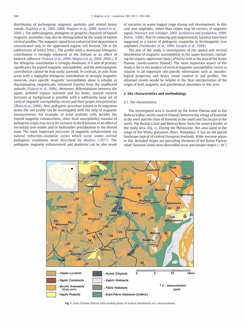
Fig. 1. Soils of Kolno Plateau with marked points
of variation in water-logged stage during soil development. In thiscase iron sulphides, rather than oxides may be carriers of magneticsignal (Hanesch and Scholger, 2005; Jordanova and Jordanova, 1999;Maher, 1998). Also Fe-reducing andmagnetotactic bacteria have beensuggested as a source of pedogenic magnetite or ferrimagnetic ironsulphides (Fassbinder et al., 1990; Stanjek et al., 1994).
The aim of the study is investigation of the spatial and verticaldistribution of magnetic susceptibility in the upper horizons (includ-ing the organic uppermost layer) of forest soils in the area of the KolnoPlateau (north-eastern Poland). The most important aspect of thestudy is the in situ analysis of vertical magnetic susceptibility curves inrelation to all important site-specific information such as morpho-logical properties and heavy metal content in soil profiles. Theobtained results would be helpful in the final interpretation of theorigin of both magnetic and geochemical anomalies in this area.
2. Site characteristics and methodology
2.1. Site characteristics
The investigated area is located on the Kolno Plateau and in theBiebrza Valley (north-eastern Poland) between the village of Kumelskin the west and the cities of Stawiski in the south and Szczuczyn in thenorth. The Rudzki Canal and Biebrza River form the eastern border ofthe study area (Fig. 1). During the Pleistocene, this area layed in therange of the Warta glaciation (Riss). Nowadays, it has an old glaciallandscape typical of central European lowlands. Wide moraine plainsor flat, denuded slopes are prevailing elements of the Kolno Plateaurelief; however somemore diversified areas and steeper slopes (N18°)
of vertical distribution of κ measurements.
561T. Magiera et al. / Geoderma 160 (2011) 559–568
are also present. Such high differences are observed along two chainsof terminal moraines and geomorphological forms, being the result ofareal deglaciation as kame hills or mounds, wide plateaus, and ribbedmoraines (Musiał, 1983).
Sediments of the Kolno Plateau consist of Pleistocene glacial tills ofground moraine as well as sandy and gravelly material depositedduring deglaciation periods (ablational and glaciofluvial material).The uppermost layers of these sediments, which are the parentmaterial of recent soil, bear traces of periglacial transformations likedecalcification, enrichment in clay fraction, or accumulation of glacialboulder pavement layers (Kopp and Jäger, 1972).
Haplic Luvisols (IUSS, 2006) developed from glacial moraine tillsand sandy tills of relatively fine grain size are the dominant soil typeon the Kolno Plateau (Fig. 1). Because of the relatively high fertilityof these soils, they are used as arable land. Only small forests arescattered in the agricultural land, growing mostly on BrunicArenosols (IUSS, 2006) developed from sandy and/or gravelly parentmaterial. These types of soils, according to the Taxonomy of PolishSoils (1989), are called rusty soils and represent the sandy analog ofCambisols. They are mainly characterized by the presence of andiagnostic Bwo horizon (sideric: Bv; Charzyński et al., 2005;Taxonomy of Polish Soils, 1989) underlying a humus A or Aphorizon. Locally, small forests also appear on semi-hydromorphicGleysols and hydromorphic Histosols.
2.2. Methods
Field measurements were carried out at 34 points located in smallforest complexes that are quite evenly distributed on the KolnoPlateau and Biebrza Valley area (Fig. 1). The measurements of volumemagnetic susceptibility (κ×10−5 SI units) were conducted directly onthe soil surface (Oi subhorizon) without any preparation except forremoving high grass or twigs, using an MS2D Bartington loop sensorwith a diameter of 185 mm, according to a procedure developed in theframe of the MAGPROX project (Schibler et al., 2002). The MS2Magnetic Susceptibility Meter was fully integrated with the globalpositioning system (GPS) (Trimble Pathfinder). At 32 measuringpoints, the vertical distribution of magnetic susceptibility (κ) withinthe uppermost 20 cm of soil was measured using a SM 400 fieldmagnetometer. The instrument was designed for “in situ” measure-ment of the uppermost magnetic susceptibility of soil profiles with aresolution of 2 mm (Petrovský et al., 2004). The measurement wasperformed in holes remaining after the sampling of soil cores by aHumax soil corer. The uppermost 25–30 cm soil cores (dependent onsoil conditions), preserving natural soil profile structure, were takenin plastic tubes and transported to the laboratory for pedologicalanalysis (grain size distribution, Munsell colour charts, and soilmorphology description). These cores were also used for chemical
Table 1Grain size analysis of soil horizons from selected soil profiles from Kolno Plateau.
Profile no. 5 8 14
Horizon A(p) Bwo A(p) Bwo A(p)
Grain size (mm) Proportion (%)N1 4 5 16 24 91.0–0.1 83 85 89 91 780.1–0.05 4 4 3 2 90.05–0.02 6 3 3 1 50.02–0.005 2 4 3 1 30.005–0.002 3 1 1 2 3b0.002 2 3 1 3 2
Total sand fraction (1.0–0.1) 83 85 89 91 78Total silt fraction (0.1–0.02) 10 7 6 3 14Total clay fraction (b0.02) 7 8 5 6 8
analysis of heavy metal contents in the upper soil horizon. At thepoints 14, 17, and 20 where the vertical κ distribution wasconsiderably different from the typical pattern obtained in otherrusty soils, the second vertical profile was measured at a distance of1 m from the first one and additional core was taken for analysis.Finally, deep (150 cm) soil pits were dug at points 5, 8, 14, 17, 20, and26 to describe the whole soil profile morphology.
Heavy metal contents (Fe, Mn, Zn, Cu, Co, Pb, Cr, Ni, and Cd) wereanalyzed by atomic absorbance spectroscopy (AAS) in soil materialtaken from the organic horizon of soil cores. The soil material wasdissolved in 2 M HNO3 (Desaules et al., 2001).
3. Results
3.1. Soil typology and morphology
The occurrence of rusty soils (Brunic Arenosols) was found at 31measuring points (Fig. 1, Appendix A). On this type of soil, freshconiferous forests (Pinus sylvestris) are predominant. They are mostlytimber forests, pine monocultures, or pine forests with differentadmixtures of deciduous species. The only exception was profile 23,which was taken NE of Ławsk village in wet alder and ash forest(Fraxino-Alnetum) developed on Humic Gleysol. All the study soilswere developed from sandy deposits of glacial or glaciofluvial origin.The mineral horizons consist mostly of sand fraction with single grainstructure. Over 70% of grains in all analyzed soil horizons were within1.0–0.1 mm. The content of sand fraction was even higher (83 to 91%)in profiles 5 and 8 located in the eastern part of studied area close toBiebrza Valley. Considerably high amount of coarser fraction(N1.0 mm)was found in profiles 8 and 17 (up to 24% in Bwo horizon).The content of silt fraction was b10% in profiles 5 and 8, between 12and 17% in profiles 14 and 17 and above 20% in profiles 23 and 26.Among the studied profiles the highest variability between Ap andBwo horizons were observed in profile 20 located on kame hill wherethe content of silt fraction in Ap is 15%, whereas in Bwo horizon itincreased up to 29%. The total content of clay fraction in all cases wasb10% (Table 1).
The studied rusty soils exhibit a sequence of genetic horizons: O-A(p) or ABwo(p)-Bwo-C typical for that soil unit distinguished in“Guidelances for soil description” (FAO, 2006) as well as in Taxonomyof Polish Soils (1989). Organic horizons (O) have an average depthbetween 3.5 and 5.5 cm and generally two subhorizons could bedistinguished within this layer: forest litter (Oi) consisting of freshplant material, and fermentative subhorizon (Oe) consisting of plantremains in themedium stage of decomposition. In someprofiles, in thebottomof theOe horizon, lenses of highly decomposed humicmaterial(Oa) were observed; however they did not build a continuous layer.Such a structure of organic horizon is a result of the young age of tree
17 20 23 26
Bwo A(p) Bwo A(p) Bwo A(p) ACr A(p) Bwo
13 12 23 5 3 0 5 4 781 80 81 76 68 73 73 74 717 10 9 11 23 19 17 16 205 7 3 4 6 5 5 7 54 2 5 5 3 1 4 2 21 1 1 4 0 1 1 1 12 0 1 0 0 1 0 0 1
81 80 81 76 68 73 73 74 7112 17 12 15 29 24 22 23 257 3 7 9 3 3 5 3 4
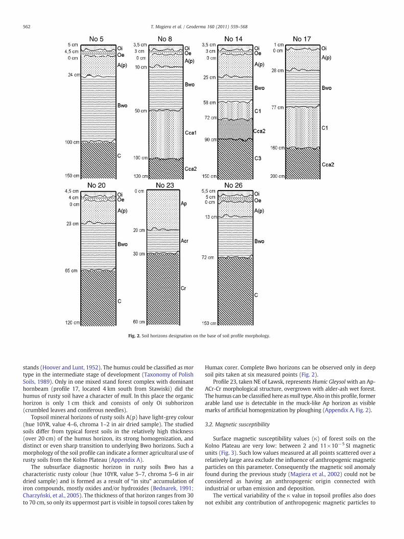
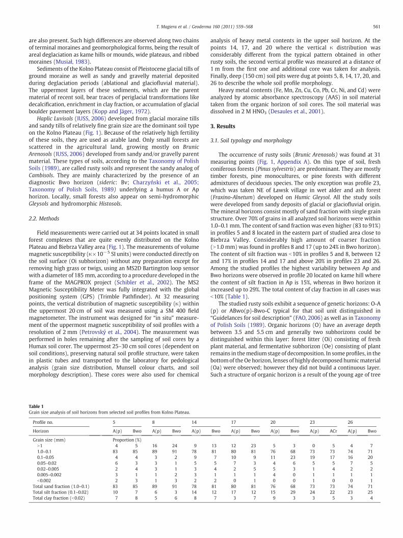
Fig. 2. Soil horizons designation on the base of soil profile morphology.
562 T. Magiera et al. / Geoderma 160 (2011) 559–568
stands (Hoover and Lunt, 1952). The humus could be classified asmortype in the intermediate stage of development (Taxonomy of PolishSoils, 1989). Only in one mixed stand forest complex with dominanthornbeam (profile 17, located 4 km south from Stawiski) did thehumus of rusty soil have a character of mull. In this place the organichorizon is only 1 cm thick and consists of only Oi subhorizon(crumbled leaves and coniferous needles).
Topsoil mineral horizons of rusty soils A(p) have light-grey colour(hue 10YR, value 4–6, chroma 1–2 in air dried sample). The studiedsoils differ from typical forest soils in the relatively high thickness(over 20 cm) of the humus horizon, its strong homogenization, anddistinct or even sharp transition to underlying Bwo horizons. Such amorphology of the soil profile can indicate a former agricultural use ofrusty soils from the Kolno Plateau (Appendix A).
The subsurface diagnostic horizon in rusty soils Bwo has acharacteristic rusty colour (hue 10YR, value 5–7, chroma 5–6 in airdried sample) and is formed as a result of “in situ” accumulation ofiron compounds, mostly oxides and/or hydroxides (Bednarek, 1991;Charzyński, et al., 2005). The thickness of that horizon ranges from 30to 70 cm, so only its uppermost part is visible in topsoil cores taken by
Humax corer. Complete Bwo horizons can be observed only in deepsoil pits taken at six measured points (Fig. 2).
Profile 23, taken NE of Ławsk, represents Humic Gleysolwith an Ap-ACr-Cr morphological structure, overgrown with alder-ash wet forest.The humus can be classifiedhere asmull type. Also in this profile, formerarable land use is detectable in the muck-like Ap horizon as visiblemarks of artificial homogenization by ploughing (Appendix A, Fig. 2).
3.2. Magnetic susceptibility
Surface magnetic susceptibility values (κ) of forest soils on theKolno Plateau are very low: between 2 and 11×10−5 SI magneticunits (Fig. 3). Such low values measured at all points scattered over arelatively large area exclude the influence of anthropogenic magneticparticles on this parameter. Consequently the magnetic soil anomalyfound during the previous study (Magiera et al., 2002) could not beconsidered as having an anthropogenic origin connected withindustrial or urban emission and deposition.
The vertical variability of the κ value in topsoil profiles also doesnot exhibit any contribution of anthropogenic magnetic particles to
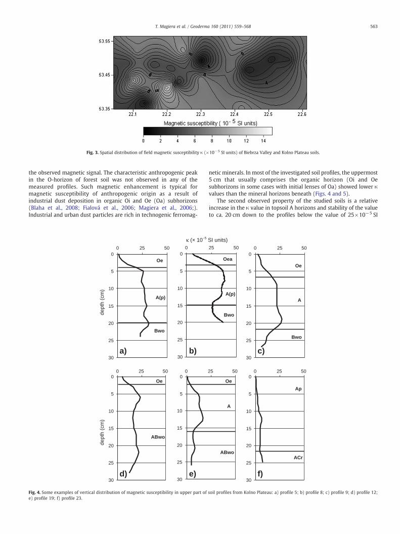
Fig. 3. Spatial distribution of field magnetic susceptibility κ (×10−5 SI units) of Biebrza Valley and Kolno Plateau soils.
563T. Magiera et al. / Geoderma 160 (2011) 559–568
the observed magnetic signal. The characteristic anthropogenic peakin the O-horizon of forest soil was not observed in any of themeasured profiles. Such magnetic enhancement is typical formagnetic susceptibility of anthropogenic origin as a result ofindustrial dust deposition in organic Oi and Oe (Oa) subhorizons(Blaha et al., 2008; Fialová et al., 2006; Magiera et al., 2006;).Industrial and urban dust particles are rich in technogenic ferromag-
0
5
10
15
20
25
30
0 25 50
Oe
A(p)
Bwo
0
5
10
15
20
25
30
0
0
5
10
15
20
25
30
0 25 50
Oe
ABwo
0
5
10
15
20
25
30
0
dept
h (c
m)
dept
h (c
m)
a) b)
d) e)
κ (× 10–5
Fig. 4. Some examples of vertical distribution of magnetic susceptibility in upper part ofe) profile 19; f) profile 23.
netic minerals. In most of the investigated soil profiles, the uppermost5 cm that usually comprises the organic horizon (Oi and Oesubhorizons in some cases with initial lenses of Oa) showed lower κvalues than the mineral horizons beneath (Figs. 4 and 5).
The second observed property of the studied soils is a relativeincrease in the κ value in topsoil A horizons and stability of the valueto ca. 20 cm down to the profiles below the value of 25×10−5 SI
25 50
A(p)
Oea
Bwo
0
5
10
15
20
25
30
0 25 50
Oe
A
Bwo
25 50
Oe
A
ABwo
0
5
10
15
20
25
30
0 25 50
Ap
ACr
c)
f)
SI units)
soil profiles from Kolno Plateau: a) profile 5; b) profile 8; c) profile 9; d) profile 12;
0
5
10
15
20
25
30
0 25 50
Oea
A
Bwo
0
5
10
15
20
25
30
0 25 50
Oe
A(p)
Bwo
0
5
10
15
20
25
30
0 25 50
Oe
Ap
Bwo
0
5
10
15
20
25
30
0 25 50
Oe
A(p)
Bwo
0
5
10
15
20
25
30
0 25 50
Oe
Ap
ABwo
0
5
10
15
20
25
30
0 25 50
Oeh
A
dept
h (c
m)
κ (× 10–5 SI units)
dept
h (c
m)
a) b) c)
d) e) f)
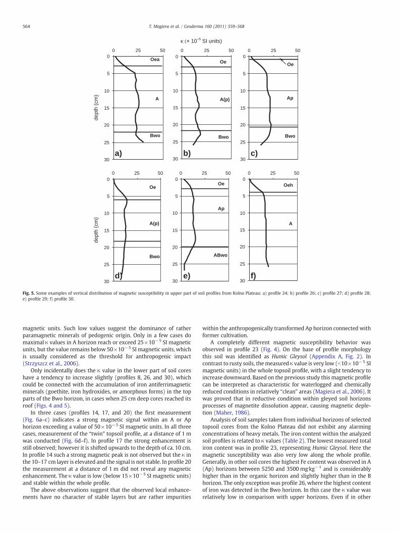
Fig. 5. Some examples of vertical distribution of magnetic susceptibility in upper part of soil profiles from Kolno Plateau: a) profile 24; b) profile 26; c) profile 27; d) profile 28;e) profile 29; f) profile 30.
564 T. Magiera et al. / Geoderma 160 (2011) 559–568
magnetic units. Such low values suggest the dominance of ratherparamagnetic minerals of pedogenic origin. Only in a few cases domaximal κ values in A horizon reach or exceed 25×10−5 SI magneticunits, but the value remains below 50×10−5 SI magnetic units, whichis usually considered as the threshold for anthropogenic impact(Strzyszcz et al., 2006).
Only incidentally does the κ value in the lower part of soil coreshave a tendency to increase slightly (profiles 8, 26, and 30), whichcould be connected with the accumulation of iron antiferrimagneticminerals (goethite, iron hydroxides, or amorphous forms) in the topparts of the Bwo horizon, in cases when 25 cm deep cores reached itsroof (Figs. 4 and 5).
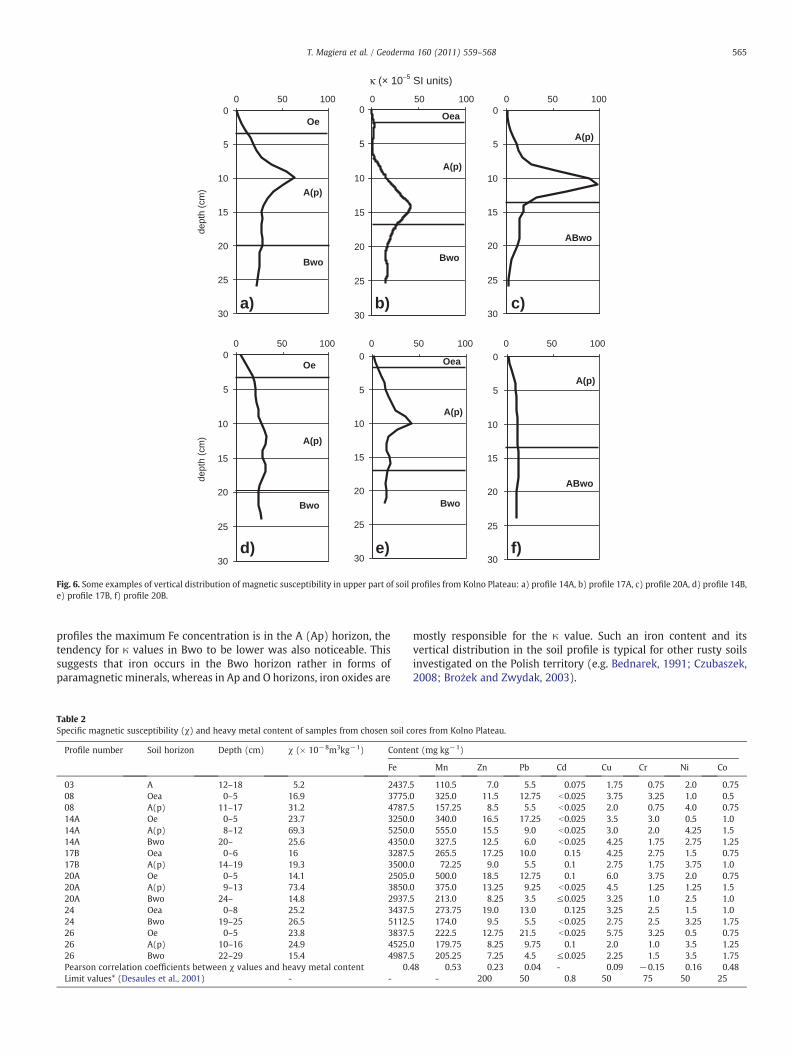
In three cases (profiles 14, 17, and 20) the first measurement(Fig. 6a–c) indicates a strong magnetic signal within an A or Aphorizon exceeding a value of 50×10−5 SI magnetic units. In all threecases, measurement of the “twin” topsoil profile, at a distance of 1 mwas conducted (Fig. 6d–f). In profile 17 the strong enhancement isstill observed; however it is shifted upwards to the depth of ca. 10 cm.In profile 14 such a strong magnetic peak is not observed but the κ inthe 10–17 cm layer is elevated and the signal is not stable. In profile 20the measurement at a distance of 1 m did not reveal any magneticenhancement. The κ value is low (below 15×10−5 SI magnetic units)and stable within the whole profile.
The above observations suggest that the observed local enhance-ments have no character of stable layers but are rather impurities
within the anthropogenically transformed Ap horizon connected withformer cultivation.
A completely different magnetic susceptibility behavior wasobserved in profile 23 (Fig. 4). On the base of profile morphologythis soil was identified as Humic Gleysol (Appendix A, Fig. 2). Incontrast to rusty soils, themeasured κ value is very low (b10×10−5 SImagnetic units) in the whole topsoil profile, with a slight tendency toincrease downward. Based on the previous study this magnetic profilecan be interpreted as characteristic for waterlogged and chemicallyreduced conditions in relatively “clean” areas (Magiera et al., 2006). Itwas proved that in reductive condition within gleyed soil horizonsprocesses of magnetite dissolution appear, causing magnetic deple-tion (Maher, 1986).
Analysis of soil samples taken from individual horizons of selectedtopsoil cores from the Kolno Plateau did not exhibit any alarmingconcentrations of heavy metals. The iron content within the analyzedsoil profiles is related to κ values (Table 2). The lowest measured totaliron content was in profile 23, representing Humic Gleysol. Here themagnetic susceptibility was also very low along the whole profile.Generally, in other soil cores the highest Fe content was observed in A(Ap) horizons between 5250 and 3500 mg.kg−1 and is considerablyhigher than in the organic horizon and slightly higher than in the Bhorizon. The only exception was profile 26, where the highest contentof iron was detected in the Bwo horizon. In this case the κ value wasrelatively low in comparison with upper horizons. Even if in other
0
5
10
15
20
25
30
0 50 100
Oe
A(p)
Bwo
0
5
10
15
20
25
30
0 50 100
Oea
A(p)
Bwo
0
5
10
15
20
25
30
0 50 100
A(p)
ABwo
0
5
10
15
20
25
30
0 50 100
Oe
A(p)
Bwo
0
5
10
15
20
25
30
0 50 100
Oea
A(p)
Bwo
0
5
10
15
20
25
30
0 50 100
A(p)
ABwo
dept
h (c
m)
κ (× 10–5 SI units)
dept
h (c
m)
a) b) c)
d) e) f)
Fig. 6. Some examples of vertical distribution of magnetic susceptibility in upper part of soil profiles from Kolno Plateau: a) profile 14A, b) profile 17A, c) profile 20A, d) profile 14B,e) profile 17B, f) profile 20B.
565T. Magiera et al. / Geoderma 160 (2011) 559–568
profiles the maximum Fe concentration is in the A (Ap) horizon, thetendency for κ values in Bwo to be lower was also noticeable. Thissuggests that iron occurs in the Bwo horizon rather in forms ofparamagnetic minerals, whereas in Ap and O horizons, iron oxides are
Table 2Specific magnetic susceptibility (χ) and heavy metal content of samples from chosen soil c
Profile number Soil horizon Depth (cm) χ (× 10−8m3kg−1) Conte
Fe
03 A 12–18 5.2 2437.508 Oea 0–5 16.9 3775.008 A(p) 11–17 31.2 4787.514A Oe 0–5 23.7 3250.014A A(p) 8–12 69.3 5250.014A Bwo 20– 25.6 4350.017B Oea 0–6 16 3287.517B A(p) 14–19 19.3 3500.020A Oe 0–5 14.1 2505.020A A(p) 9–13 73.4 3850.020A Bwo 24– 14.8 2937.524 Oea 0–8 25.2 3437.524 Bwo 19–25 26.5 5112.526 Oe 0–5 23.8 3837.526 A(p) 10–16 24.9 4525.026 Bwo 22–29 15.4 4987.5Pearson correlation coefficients between χ values and heavy metal content 0.4Limit values* (Desaules et al., 2001) - -
mostly responsible for the κ value. Such an iron content and itsvertical distribution in the soil profile is typical for other rusty soilsinvestigated on the Polish territory (e.g. Bednarek, 1991; Czubaszek,2008; Brożek and Zwydak, 2003).
ores from Kolno Plateau.
nt (mg kg−1)
Mn Zn Pb Cd Cu Cr Ni Co
110.5 7.0 5.5 0.075 1.75 0.75 2.0 0.75325.0 11.5 12.75 b0.025 3.75 3.25 1.0 0.5157.25 8.5 5.5 b0.025 2.0 0.75 4.0 0.75340.0 16.5 17.25 b0.025 3.5 3.0 0.5 1.0555.0 15.5 9.0 b0.025 3.0 2.0 4.25 1.5327.5 12.5 6.0 b0.025 4.25 1.75 2.75 1.25265.5 17.25 10.0 0.15 4.25 2.75 1.5 0.7572.25 9.0 5.5 0.1 2.75 1.75 3.75 1.0
500.0 18.5 12.75 0.1 6.0 3.75 2.0 0.75375.0 13.25 9.25 b0.025 4.5 1.25 1.25 1.5213.0 8.25 3.5 ≤0.025 3.25 1.0 2.5 1.0273.75 19.0 13.0 0.125 3.25 2.5 1.5 1.0174.0 9.5 5.5 b0.025 2.75 2.5 3.25 1.75222.5 12.75 21.5 b0.025 5.75 3.25 0.5 0.75179.75 8.25 9.75 0.1 2.0 1.0 3.5 1.25205.25 7.25 4.5 ≤0.025 2.25 1.5 3.5 1.75
8 0.53 0.23 0.04 - 0.09 −0.15 0.16 0.48- 200 50 0.8 50 75 50 25
566 T. Magiera et al. / Geoderma 160 (2011) 559–568
Other metals (Mn, Zn, Cu, Co, Pb, Cr, Ni, and Cd) appeared in lowquantities at the level of the geochemical background of north-easternPoland (Lis and Pasieczna, 1995). In the organic horizon, slightlyincreased values of Pb (12–21 mg.kg−1) and Zn (11–19 mg.kg−1)were also observed. Increased concentrations of manganese werefound in organic horizons and also in the Ap horizon of core 14 at adepth of 8–12 cm. It is correlated with strong magnetic enhancementand considerable high Fe content (5250 mg.kg−1) here. This value hasno reflection in concentrations of other heavy metals usuallyconsidered as anthropogenic (Pb, Zn, Cu, and Cd). There are probablyFe and Mn oxides which occurred as a result of pedological processesor impurities of anthropogenic origin remaining in the soil as a resultof former cultivation.
4. Discussion
Most of studied soil profiles had characteristic features that werepreviously observed in arable soils where periodical ploughing causedsoil homogenization and physical “dilution” of magnetic minerals inthe whole Ap horizon (Magiera et al., 2006). This finding confirmsearlier morphological observations reported in Appendix A. Therelatively low fertility of the rusty soils of the studied area meant thatthey were excluded from agricultural use and were afforested;however in soil profile morphology as well as in magnetic patternstheir former agricultural use is still visible.
The observed small magnetic enhancements in the upper part ofsome profiles (5, 8, 12, and especially 17) rather exclude itsrelationship with the deposition of airborne particles, which areusually responsible for anthropogenic enhancement of κ value in theuppermost organic layer. Morphological analyses of the topsoil coresas well as deep soil profiles (Appendix A and Fig. 2) confirm that theanomalies are also not connected with specific layers or horizons ofthe soil profile. Moreover, detailed study of the deep soil profilemorphology suggests that the anomalies are located within the Aphorizon, which exhibits features typical for anthropogenicallytransformed soils as a result of former cultivation. This horizon canbe very simply identified also in most of studied magnetic soil profilesby relatively stable magnetic susceptibility curve within the thick Aphorizon (Figs. 4 and 5). The vertical distribution of κ is here similar tothis observed in arable soil profiles. The pedological Ap-horizon wasclearly seen in the magnetic properties also by other authors thatwere studying para-brown earth from Southern Germany (Haneschand Petersen, 1999).
Morphologically humus A horizons in all deep profiles differ fromtypical autogenic forest soils in their relatively large thickness(N20 cm), strong homogenization, and sharp boundary with theBwo horizon. Usually in non-ploughed rusty soils, the A horizon isonly 10–15 cm in thickness with shading into the underlying horizonwithout a distinct boundary.
Geochemical analysis carried out within these studies of forestsoils did not find the increased values of cuprum that were observedin the Kolno Plateau area in the “Geochemical Map of Poland” (Lis andPasieczna, 1995). According to the authors of the map, the Cuconcentrations in soils of this region are up to 80 mg.kg−1, which wasthe basis for establishing the local geochemical anomaly here. Themaximum Cu content in measured soil samples from forest topsoilcores was 6 mg.kg−1 in the organic horizon of core 20, whereas thegeological background for northern Poland has been defined as8.8 mg.kg−1 (Czarnowska and Gworek, 1987).
Although the slight enrichment of Pb and Zn obviously points tothe anthropogenic origin of these elements, its contents are muchbelow the threshold for contamination level. In the cases of Cd, Cr, Ni,and Co, only the natural geochemical level was detected. The Pearsoncorrelation coefficients between κ values and most of analyzed heavymetals were very low (even negative in case of Cr), which means thatmost of these elements are related to natural geochemical background
(Table 2). Only in case of Fe, Mn and Co the correlation coefficientswere around 0.50, but these elements are usually connected with ironoxides also in natural (unpolluted) soil environment.
Sampling points for geochemical analysis used in former studies(Lis and Pasieczna, 1995; Magiera et al., 2002) were located only inarable soil, which is the dominant type of land use in this area. Thissuggests that the origin of the geochemical and also the magneticanomaly observed here on the “Geochemical Map of Poland” isconnected with land use or the specific lithology of agriculturallyused soil types. Theoretically, increased Cu concentration may berooted in agrotechnical measures (agricultural chemicals, manurefrom intensive swine farming, or sewage sludge application) (Alloway,1995; Jongbloed and Lenis, 1998). However, comparing the lowlevel of agricultural development and its structure in the Kolnoregion with other areas of Poland, such intensive application of swinemanure or sewage sludge as well as agricultural chemicals seemsimprobable.
A geogenic origin of the observed anomaly is most probable.According to Gworek (1985), the content of heavy metals includingCu in soils of northern Poland developed on tills of the Vistulianglaciation is considerably higher than the national mean value. Theapproximate quantity of Cu there is 28 mg.kg−1, but locally it can beeven higher. Considering the fact that arable soils on the Kolno Plateauare mostly Haplic Luvisols developed on glacial moraine boulders, theenrichment of the arable layer (the uppermost 20 cm that wassampled for the geochemical mapping) in Cu and also in otherelements observed on the “Geochemical Map of Poland” (Lis andPasieczna, 1995) is due to their natural concentrations in thegeological background. In the case of the studied forest rusty soilsfrom this area, developed on mineralogically and chemically poorersandymaterials, this concentration was not observed. Also the usuallyhigher Fe content in clay minerals of boulder loams (mostlyparamagnetic minerals) can give rise to the local magnetic anomaly(Magiera et al., 2002).
Such an interpretation can explain the observed differencesbetween the results obtained during this study and the previousgeochemical and magnetic mapping of Kolno Plateau and BiebrzaValley topsoils (Lis and Pasieczna, 1995; Magiera et al., 2002). Such anexplanation is confirmed by other authors who studied forest soilsfrom other regions of Poland (Brożek and Zwydak, 2003). Theseauthors found that in mineral horizons of forest Haplic Luvisols, the Cucontent was between 10 and 30 mg.kg−1, and it was much higherthan in the same horizons of rusty soils, where Cu content was 1 to8 mg.kg−1.
5. Conclusions
1. The physical (including magnetic parameters) and chemical studyof 32 forest topsoil profiles from Kolno Plateau (NE Poland) did notconfirm the existence of a magnetic and geochemical anomaly.
2. Low magnetic susceptibility values as well as low content of heavymetals occurring on the level of the national geochemicalbackground suggest a lack of soil pollution caused by industrialand urban dust emission and deposition.
3. The vertical distribution of magnetic susceptibility in the studiedforest topsoil reflects the morphological pattern of arable soil as aresult of former cultivation (presence of Ap and/or ABwo(p)horizons displaying traces of former ploughing) and present-dayinfluence of planted pine forest vegetation (organic subhorizonsOi-Oe(Oa), diagnostic of mor type of forest humus).
4. Geochemical and magnetic topsoil anomalies in the area of KolnoPlateau reported in previous publications are probably limited toHaplic Luvisols used as arable soils and the sources of theirgeochemical and magnetic enrichments are moraine boulderloams occurring in the geological background.
567T. Magiera et al. / Geoderma 160 (2011) 559–568
Appendix A
Morphologic characteristics of soils of investigated cores from Kolno Plateau.
Number and location ofsoil core
Soil horizon1) Depth Munsell chartcolour
textural class/ structure/ boundary withunderlying horizon/ other features
Soil type2)
Biebrza Valley03 - Osowiec Oea 0–1 - detritus – crumbled needles and leaves Brunic Arenosols Rusty soil
A 1–16.5 10 YR 3/2 sand/ single grain/ gradualBwo 16.5–30 10 YR 4/6 sand/ single grain
04 - Osowiec Oe 0–0.5 - dry rot – partly decomposed remains of pinewood plants Brunic Arenosols Rusty soilformerly arableABwop 0.5–30 10 YR 5/1 sand/ single grain
05 - Szyjki Oe 0–4 - dry rot – partly decomposed remains of pinewood plants Brunic Arenosols Rusty soilformerly arableA(p) 4–20 10 YR 4/2 sand/ single grain / clear
Bwo 20–30 10 YR 5/4 sand/ single grain06 - Wagi Oe 0–2 - dry rot – partly decomposed remains of pinewood plants Brunic Arenosols Rusty soil
A 2–17 10 YR 5/2 sand/ single grain / gradualA/Bwo 17–30 10 YR 5/3 sand/ single grain
07 - Osowiec Oe 0–2 - dry rot – partly decomposed remains of pinewood plants Brunic Arenosols Rusty soilA 2–13 10 YR 5/2 sand/ single grain / gradualBwo 13–30 10 YR 5/4 sand/ single grain / fine pieces of charcoal
Kolno Plateau08 - Modzele Oea 0–3 - detritus – crumbled needles and leaves Brunic Arenosols Rusty soil
formerly arableA(p) 3–15 10 YR 5/1 sand/ single grain / clearBwo 15–30 10 YR 5/6 sand/ single grain
09 - Zalesie Oe 0–7 - dry rot – partly decomposed remains of pinewood plants Brunic Arenosols Rusty soilA 7–22 10 YR 4/2 sand/ single grain / clearBwo 22–30 10 YR 4/6 sand/ single grain
10 - Szczuczyn Oe 0–2 - dry rot – partly decomposed remains of pinewood plants Brunic Arenosols Rusty soilformerly arableAp 2–20 10 YR 6/2 sand/ single grain / clear
Bwo 20–30 10 YR 5/4 sand/ single grain11 - Obrytki Oe 0–4.5 dry rot – partly decomposed remains of pinewood plants Brunic Arenosols Rusty soil
A 4.5–18 10 YR 5/1 sand/ single grain / gradualABwo 18–30 10 YR 6/4 sand/ single grain
12 - Dobrzyce Oe 0–2 - dry rot – partly decomposed remains of pinewood plants Brunic Arenosols Rusty soilABwo 2–30 10 YR 5/3 sand/ single grain
13 - Konopki Oe 0–3 - dry rot – partly decomposed remains of forest plants Brunic Arenosols Rusty soilA 3–20 10 YR 5/1 loamy sand/ weak granular/ gradualBwo 20–30 10 YR 4/4 loamy sand/ aggregate unstable
14 - Dzięgiele Oe 0–3 - dry rot – partly decomposed remains of pinewood plants Brunic Arenosols Rusty soilformerly arableA(p) 3–20 10 YR 5/2 sand/ single grain / clear
Bwo 20–30 10 YR 5/4 sand/ single grain15 - Stawiski W Oe 0–4.5 - dry rot – partly decomposed remains of pinewood plants Brunic Arenosols Rusty soil
formerly arableAp 4.5–18 10 YR 4/2 sand/ single grain / clearBwo 18–24 10 YR 4/5 sand/ single grain
16 - Stawiski SW Oe 0–4 - dry rot – partly decomposed remains of pinewood plants Brunic Arenosols Rusty soilformerly arableAp 4–23 10 YR 5/2 sand/ single grain / clear
Bwo 23–30 10 YR 6/4 sand/ single grain17 - Stawiski S Oea 0–2.0 - detritus – crumbled needles and leaves Brunic Arenosols Rusty soil
formerly arableA(p) 2–17 10 YR 5/2 sand/ single grain / clearBwo 17–30 10 YR 5/4 sand/ single grain
18 - Kurkowo W Oe 0–2 - dry rot – partly decomposed remains of pinewood plants Brunic Arenosols Rusty soilA 2–18 10 YR 5/2 loamy sand / single grain / gradualBwo 18–30 10 YR 4/6 loamy sand / single grain
19 - Kurkowo E Oe 0–2 - dry rot – partly decomposed remains of forest plants Brunic Arenosols Rusty soilA 2–16 10 YR 5/2 sand/ single grain / gradualABwo 16–30 10 YR 6/3 sand/ single grain
20 - Siwki A(p) 0–14 10 YR 4/2 sand/ single grain / clear Brunic Arenosols Rusty soilformerly arableABwo 14–30 10 YR 5/3 sand/ single grain / gradual
21 - Nieciki Oe 0–2 - dry rot – partly decomposed remains of pinewood plants Brunic Arenosols Rusty soilA 2–12 10 YR 5/1 sand/ single grainABwo 12–19 10 YR 5/2 sand/ single grain / gradualBwo 19–30 10 YR 5/6 sand/ single grain / gradual
22 - Słucz A 0–10 10 YR 5/1 sand/ single grain / gradual Brunic Arenosols Rusty soilBwo 10–30 10 YR 6/4 sand with gravel/ single grain / pieces of charcoal
23 - Ławsk Ap 0–22 2.5 Y 2/2 loam/ tubercular / gradual Humic GleysolsACr 22–30 2.5 Y 4/4. patches 10 YR 5/7 loam/ granular
24 - Żebry Oea 0–2.5 - detritus – crumbled needles and leaves Brunic Arenosols Rusty soilA 2.5–22 10 YR 5/1 sand/ single grain / diffuseBwo 22–30 10 YR 4/6 sand with gravel/ single grain
25 - Kownatki Oi 0–1 - fresh leaf fall Brunic Arenosols Rusty soilformerly arableAp 1–20 10 YR 5/1 sand/ single grain / clear
Bwo 20–30 10 YR 5/4 sand/ single grain26 - Stawiski W2 Oe 0–3 - dry rot – remains of pinewood plants Brunic Arenosols Rusty soil
formerly arableA(p) 3–22 10 YR 5/1 sand/ single grain / clearBwo 22–30 10 YR 4/6 sand/ single grain
(continued on next page)
Appendix (continued)
Number and location ofsoil core
Soil horizon1) Depth Munsell chartcolour
textural class/ structure/ boundary withunderlying horizon/ other features
Soil type2)
Kolno Plateau27 - Stroda Oe 0–1 - dry rot – remains of pinewood plants Brunic Arenosols Rusty soil
formerly arableAp 1–21 10 YR 4/2 sand/ single grain / distinct transition to underneath horizonBwo 21–30 10 YR 5/6 sand/ single grain
28 - Grabowo Oe 0–6 - dry rot – remains of forest plants Brunic Arenosols Rusty soilformerly arableA(p) 6–18 10 YR 4/2 sand/ single grain / clear
Bwo 18–30 10 YR 5/6 sand/ single grain29 - Grabowo Oe 0–2.5 - dry rot – remains of forest plants Brunic Arenosols Rusty soil
formerly arableAp 2.5–20 10 YR 5/2 sand/ single grain / clearABwo 20–30 10 YR 5/3 sand/ single grain
30 - Wiszowate Oeh 0–4 - detritus – crumbled needles and leaves Brunic Arenosols Rusty soilA 4–30 10 YR 5/2 sand/ single grain
31 - Rydzewo Oe 0–5 - dry rot – remains of pinewood plants Brunic Arenosols Rusty soilformerly arableA(p) 5–22 10 YR 5/1 sand/ single grain / diffuse
Bwo 22–30 10 YR 5/4 sand/ single grain32 - Kossaki Oe 0–4 - dry rot – remains of pinewood plants Brunic Arenosols Rusty soil
A 4–14 10 YR 6/2 sand/ single grain / gradualABwo 14–30 10 YR 6/4 sand/ single grain
33 - Kumelsk Oea 0–2.5 - detritus – crumbled needles and leaves Brunic Arenosols Rusty soilA 2.5–12 10 YR 5/2 sand/ single grain / gradualABwo 12–30 10 YR 5/4 sand/ single grain /
34 - Kolonia Przyborów Oe 0–4 - dry rot – remains of pinewood plants Brunic Arenosols Rusty soilABwo 4–23 10 YR 5/3 sand/ single grain
35 - Klonowo Oea 0–1.5 - detritus – crumbled needles and leaves Brunic Arenosols Rusty soilA 1.5–7 10 YR 4/1 sand/ single grain / gradualABwo 7–17 10 YR 4/3 sand/ single grain / gradualBwo 17–30 10 YR 5/6 sand/ single grain
1) Soil horizon designation acc. to FAO, 2006.2) According to the WRB, 2006 (FAO, 2006) and the Polish Soil classification System 1989 (Taxonomy of... 1989).
568 T. Magiera et al. / Geoderma 160 (2011) 559–568
References
Alloway, B.J., 1995. Heavy metals in soils 2nd ed. Blackie, London.Bednarek, R., 1991. Wiek, geneza i stanowisko systematyczne gleb rdzawych w świetle
badań paleopedologicznych w okolicach Osia. Ph.D. Thesis, University of Toruń,Poland.
Blaha, U., Appel, E., Stanjek, H., 2008. Determination of anthropogenic boundary depthin soil profiles and semi-quantification of heavy metal loads using magneticsusceptibility. Environ. Pollut. 156 (2), 278–289.
Brożek, S., Zwydak, M., 2003. Atlas gleb leśnych Polski. Informing Center of NationalForests, Warsaw.
Charzyński, P., Hulisz, P., Bednarek, R., 2005. Diagnostic subsurface horizons insystematics of Polish soils. Eurasian Soil Sci. 38 (Suppl. 1), 55–59.
Czarnowska, K., Gworek, B., 1987. Metale ciężkie w niektórych glebach środkowej ipółnocnej Polski. Soil Sci. Ann. 38, 41–57.
Czubaszek, R., 2008. Systematic position of the podzolic soils developed on theinpeatland dunes in the Biebrza River Valley and Narew River Valley. Pol. J. Soil Sci.41 (2), 175–182.
Desaules, A., Hämmann, M., Weisskopf, M., 2001. Commentary on the Ordinance of 1July 1998 relating to impacts on the soil (OIS). Swiss Agency for the Environment,Forest and Landscape, Berne.
FAO, 2006. Guidelines for soil description. 97 pp.Fassbinder, J.W.E., Stanjek, H., Vali, H., 1990. Occurrence of magnetic bacteria in soil.
Nature 343, 161–163.Fialová, H., Maier, G., Petrovský, E., Kapička, A., Boyko, T., Scholger, R., MAGPROX Team,
2006. Magnetic properties of soils from sites with different geological andenvironmental settings. J. Appl. Geophys. 59, 273–283.
Fürst, C., Lorz, C., Makeschin, F., 2007. Development of forest ecosystems after heavydeposition loads considering Dübener Heide as example− challenges for a processoriented forest management planning. Forest. Ecol. Manage. 248 (1/2), 6–16.
Gworek, B., 1985. Pierwiastki śladowe w glebach uprawnych wytworzonych z glinzwałowych i utworów pyłowych północno-wschodniego regionu Polski, cz. II.Ogólna zawartość pierwiastków śladowych w glebach wytworzonych z glinzwałowych. Soil Sci. Ann. 36 (2), 43–59.
Hanesch, M., Petersen, N., 1999. Magnetic properties of a recent parabrown-earth fromSouthern Germany. Earth Planet. Sci. Lett. 169, 85–97.
Hanesch, M., Scholger, R., 2005. The influence of soil type on the magnetic susceptibilitymeasured throughout soil profiles. Geophys. J. Int. 161, 50–56.
Hoover, M.D., Lunt, H.A., 1952. A key for the classification of forest humus types. Proc.Soil Sci. Soc. Am. 16, 368–370.
IUSS Working Group WRB, 2006. World reference base for soil resources 2006(2nd ed.). World Soil Resources Reports No. 103. FAO, Rome.
Jongbloed, A.W., Lenis, N.P., 1998. Environmental concerns about animal manure.J. Anim. Sci. 76 (10), 2641–2648.
Jordanova, D., Jordanova, N., 1999. Magnetic characteristics of different soil types fromBulgaria. Stud. Geophys. Geod. 43, 303–318.
Kapička, A., Jordanova, N., Petrovský, E., Podrázský, V., 2003. Magnetic study of weaklycontaminated forest soils. Water Air Soil Pollut. 148, 31–44.
Kapička, A., Petrovský, E., Fialová, H., Podrázský, V., Dvořák, I., 2008. High resolutionmapping of anthropogenic pollution in Giant Mountains National Park using soilmagnetometry. Stud. Geophys. Geod. 52, 271–284.
Klose, S., Makeschin, F., 2005. Soil properties in coniferous forest stands along a fly-ashdeposition gradient in eastern Germany. Pedosphere 15 (6), 681–694.
Kopp, D., Jäger, K.D., 1972. Das Perstruktions und Horizontprofil als Trennmerkmalperiglaziärer und extraperiglaziärer Oberflächen im nordmitteleuropäischen Tief-land. Wiss. Zeitschr. Der M. A. Univ. Greifswald Jg. XXI 1, 77–84.
Lis, J., Pasieczna, A., 1995. Geochemical Atlas of Poland. PGI, Warsaw.Magiera, T., Lis, J., Nawrocki, J., Strzyszcz, Z., 2002. Magnetic Susceptibility of Soils in
Poland. PGI, Warsaw.Magiera, T., Strzyszcz, Z., Ferdyn, M., Gajda, B., MAGPROX Team, 2003. Screening of
anthropogenic dust pollutions in topsoil by using magnetic proxies. In: Pawłowski,L., Rudzińska, M.R., Pawłowski, A. (Eds.), Environmental Engineering Studies.Kluwer Academic/Plenum Publishers, New York, pp. 399–407.
Magiera, T., Strzyszcz, Z., Kapička, A., Petrovský, E., 2006. Discrimination of lithogenicand anthropogenic influences on topsoil magnetic susceptibility in Central Europe.Geoderma 130, 299–311.
Magiera, T., Kapička, A., Petrovský, E., Strzyszcz, Z., Fialová, H., Rachwał, M., 2008.Magnetic anomalies of forest soils in the Upper Silesia-Northern Moravia region.Environ. Pollut. 156 (3), 618–627.
Maher, B.A., 1986. Characterisation of soils by mineral magnetic measurements. Phys.Earth Planet. Inter. 42, 76–92.
Maher, B.A., 1998. Magnetic properties of modern soils and loessic paleosols:Implications for paleoclimate. Paleogeogr. Paleoclimatol. Paleoecol. 137, 25–54.
Mullins, C.E., 1977. Magnetic susceptibility of the soil and its significance in soil science-a review. J. Soil Sci. 28, 223–246.
Musiał, A., 1983. Rozwój rzeźby glacjalnej Wysoczyzny Kolneńskiej. PWN, Warsaw.Petrovský, E., Hulka, Z., MAGPROX Team, 2004. A new tool for in situ measurements of
the vertical distribution of magnetic susceptibility in soils as basis for mappingdeposited dust. Environ. Technol. 25, 1021–1029.
Schibler, L., Boyko, T., Ferdyn, M., Gajda, B., Höll, S., Jordanova, N., Rösler, W., MAGPROXTeam, 2002. Topsoil magnetic susceptibility mapping: Data reproducibility andcompatibility, measurement strategy. Stud. Geophys. Geod. 46, 43–57.
Spiteri, C., Kalinski, V., Rösler, W., Hoffmann, V., Appel, E., MAGPROX Team, 2005.Magnetic screening of a pollution hotspot in the Lausitz area, Eastern Germany:Correlation analysis between magnetic proxies and heavy metal contamination insoils. J. Appl. Geophys. 46, 1–9.
Stanjek, H., Fassbinder, J.W.E., Vali, H., Wagele, H., Graf, W., 1994. Evidence of biogenicgreigite (ferrimagnetic Fe3S4) in soil. Eur. J. Soil Sci. 45, 97–104.
Strzyszcz, Z., Magiera, T., Rachwał, M., 2006. Application of soil magnetometry foridentification of technogenic anomalies of trace metals and iron contents: a casestudy in the Katowice Forest District. Pol. J. Environ. Stud. 15 (2a), 176–184.
Taxonomy of Polish Soils, 1989. Soil Sci. Ann. 40 (3/4), 1–62.Thompson, R., Oldfield, F., 1986. Environmental Magnetism. Allen and Unwin, London.
Related Documents