STUDIES IN ANCIENT TECHNOLOGY BY R. J. fORBES VOLUME II WITH 38 FIGURES AND 7 TABLES SECOND REVISED EDITION LEIDEN E. J. BRILL 1965

Welcome message from author
This document is posted to help you gain knowledge. Please leave a comment to let me know what you think about it! Share it to your friends and learn new things together.
Transcript

STUDIESIN ANCIENT TECHNOLOGY
BY
R. J. fORBES
VOLUME II
WITH 38 FIGURES AND 7 TABLES
SECOND REVISED EDITION
LEIDEN
E. J. BRILL1965

CHAPTER THREE
LAND TRANSPORT AND ROAD BUILDING
INTRODUCTION
Trame on land was slower to develop than that on sea. This waspartly due to the fact that the first urban centers arose in the AncientNear East and the Indus valley, regions ordained by Nature for rivertransport. Early water transport also took away from the land thosefew goods traded over long distances and thus eliminated one of themost powerful incentives for an evolution oEland transport. Prehistorictrade in Europe followed the big rivers as far as possible (fig. 32) (1).The Assyrian traders stationed in Asia Minor sent their goods down to
the Euphrates or to the Tigris to be shipped home by water (2). Theancient Egyptian foreign trade with Crete, the Syrian coast and Somaliland or Araby was practically entirely coastal shipping to certain ports(3). Ancient Mesopotamian trade relied almost entirely on river transport (4).
Land tramc may hate and avoid the ascent and descent of hills andmountains, its real enemies are extreme cold and heat. Cold has madethe extreme northern and southern regions of the earth sparsely populated, there roadbuilding becomes costly and uneconomic, generallyspeaking. The heat of the tropics and its deserts and dense jungles wereformidable obstacles to ancient traffic until the advent of the railway,the motor-car and aviation.
Trame and trade are related to a certain extent only. However, morepowerful factors create long-distance communication and roadbuilding.A fanatical religion like Islam with its holy wars, its missionary urgesand its pilgrimages promotes it. The rise of the early empires and theircentralized organisations were based on quick information by letterand messenger. The mechanisation of armies which began with theintroduction ofthe horse-drawn warchariot about 1500 B.C. demandedsomething better than a primitive track. A messenger service neededstations and rest-houses for men and beasts and supplies ofwater alongthe way at fairly regular intervals. The merchant followed the extensionof power and his demands created a more stable and solid form ofmeans of communication.

132 LAND TRANSPORT AND ROAD BUILDING
Upto that moment only human beings and messages made up traffic.Prehistoric trade is a barter from tribe to tribe. It never entails massproduced goods but only such very valuable materials as preciousmetals and stones, pearls, amber, furs, silk, spices, salt and slaves. Latertextiles and highly valued foodstuffs and other luxury goods wereadded. Even in classical antiquity such mass-produced goods like grain,
..
N.
wte ,:.s .
! ·•···....'
Fig. 32.Traderoutes in Prehistoric Europe
olive-oil or wine took the way of the river and the sea, for every 100miles of land transport doubled their price.
From the point ofview of traffic the Mediterranean world was greatlyprivileged. Climate, situation and indentation are ideal for the evolutionof long-distance communication (6). To the north of the borderingmountain-ranges are the north-European, Russian and Asianplains with their slaves, furs and corn, which appealed to ancienttrade. To the south it was enclosed by the deserts of the Sahara, Nubia

INTRODUCTION 133
and Arabia, which are broken by the Nile valley (and the rather unnavigable Red Sea), the gate to India and the East for the ancients.Though divided in three distinct zones by the peninsulas of Italy and'"'>_"""", it has four important gateways to regions beyond, Iberia, theBlack Sea, Egypt and Syria. Mesopotamia and Persia with its second setof communications to India and the East belong to the Mediterraneanworld rather than to Asia.
Its mountain-ranges (generally east-west or northeast to southwest) have steep slopes, deep valleys lead into highlands poor in rain.The short rivers with strongly varying volume of water are hardlynavigable and of little use to water-wheels generally. This is particularly true of North Africa and Asia Minor. Agriculture in the easternpart is dominated by irrigation, in the west "dry farming" dominates.The highlands were quickly denuded not only through human agencybut mainly by the herds of goats held by the ancients.
In Antiquity the centre of this world, which was only united bythe Roman Empire, moved from the east (Alexandria) to the west(Rome) and back to the east (Baghdad) with the advent of Islam.But wherever its focus was, nature had shaped it for sea-traffic. Eventhe Romans, who were unwillingly drawn into naval warfare withCarthago in which they invented the corvus to suit their army tactics,dominated their empire by being masters of the Mediterranean. Henceland-traffic and its conspicuous result, road-building could onlygradually gain ground by a series of strongly centralised politicalpowers, the Persian Empire, the Hellenistic monarchies and the RomanEmpire. In Roman times Western Europe had hardly more than 5-12inhabitants per km2 against 18-27 per km2 in the Mediterranean world.Therefore even in Roman Europe the network of roads, dictatedprimarily by strategic considerations, was never as dense as in the southand the east, where over 50 million Roman subjects lived.
LAND-TRAFFIC IN THE PERSIAN EMPIRE
Long before the Persian of kings started to develop a consistenttraffic-policy tracks and bridle-paths had connected the settlementsmen all over the world. In certain cases they had grown into systemslike the ridge-ways and trackways of prehistoric Britain (7) which werelevelled and traced to a certain extent and which converged on SalisburyPlain with its religions monuments such as Stonehenge, Woodhengeand Avebury. Hence they may not only have served a modest trade on

134 LAND TRANSPORT AND ROAD BUILDING
pack-animals but also may have been pilgrim-ways. In other parts ofprehistoric Europe tracks had been constructed through swamps andmarshes. These log-roads avoided great detours (8). In prehistoricMalta the strange artificial ruts cut into the rocky soil seem to haveserved to guide the carts loaded with earth and pulled inland by manpower to the terraces on the hillsides (9). Recent practical tests haveproved that these ruts were not made for wheeled vehicles but forslidecars, consisting of two wooden shafts supported at the front endby the draft animal (horse or ox), while the rear-end trails along theground. The shafts widen towards the "heels" and the body of the"car" usually made of wickerwork hangs somehwere in the middle ofthe shafts. The ruts do not only lead from the valleys to the hills butsome keep to the hills, others to the low grounds and hence they alsoseem to have been used for the transport ofgoods between settlements.The Egyptians had built causeways and roads from the quarries to theNile for the transport ofbuilding materials. In Crete a tracksystem withguardhouses across the island from Gortyna to Knossos may date backto 2500 B.C. (10).
In the urban centers of the Near East attempts at road-building hadbeen made for centuries and most of the main streets and market squares
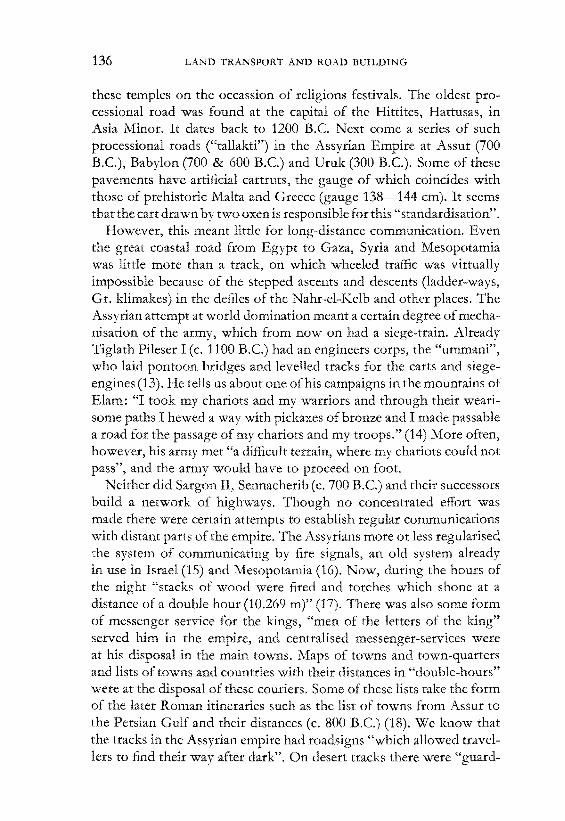
Fig. 33.Procession-road in the temple ofIshtar at Assur
of Egyptian and Mesopotamian towns were paved with flagstones andslabs often brought down from the mountains at great cost. Some ofthese pavements are properly constructed on a brick foundation, theslabs being set in bitumen mortar, specially designed joints preventingthe bitumen to sweat out and spoil the pavement in summer-time (11).Some ofthese paved streets are "processional roads" connecting templesin the city with the "festival-houses" (temples) outside the city-walls.On these roads carts carrying the statues ofthe gods were drawn between

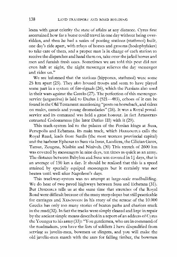
LAND TRAFFIC IN THE PERSIAN EMPIRE 135
Fig. 34.The main Persian highways
136 LAND TRANSPORT AND ROAD BUILDING
these temples on the occassion of religions festivals. The oldest processional road was found at the capital of the Hittites, Hattusas, inAsia Minor. It dates back to 1200 B.C. Next come a series of suchprocessional roads ("tallakti") in the Assyrian Empire at Assur (700B.C.), Babylon (700 & 600 B.C.) and Uruk (300 B.C.). Some of thesepavements have artificial cartruts, the gauge of which coincides withthose of prehistoric Malta and Greece (gauge 138-144 em). It seemsthat the cart drawn by two oxen is responsible for this "standardisation".
However, this meant little for long-distance communication. Eventhe great coastal road from Egypt to Gaza, Syria and Mesopotamiawas little more than a track, on which wheeled traffic was virtuallyimpossible because of the stepped ascents and descents (ladder-ways,Gr. klimakes) in the defiles of the Nahr-el-Kelb and other places. TheAssyrian attempt at world domination meant a certain of mechanisation of the army, which from now on had a siege-train. AlreadyTiglath Pileser I (c. 1100 B.C.) had an engineers corps, the "ummani",who laid pontoon bridges and levelled tracks for the carts and siegeengines (13). He tells us about one ofhis campaigns in the mountains ofElam: "I took my chariots and my warriors and through their wearisome paths I hewed a way with pickaxes of bronze and I made passablea road for the passage of my chariots and my troops." (14) More often,however, his army met "a difficult terrain, where my chariots could notpass", and the army would have to proceed on foot.
Neither did Sargon II, Sennacherib (c. 700 B.C.) and their successorsbuild a network of highways. Though no concentrated effort wasmade there were certain attempts to establish regular communicationswith distant parts of the empire. The Assyrians more or less regularisedthe system of communicating by fire signals, an old system alreadyin use in Israel (15) and Mesopotamia (16). Now, during the hours ofthe night "stacks of wood were fired and torches which shone at adistance of a double hour (10.269 m)" (17). There was also some formof messenger service for the kings, "men of the letters of the king"served him in the empire, and centralised messenger-services wereat his disposal in the main towns. Maps of towns and town-quartersand lists of towns and countries with their distances in "double-hours"were at the disposal of these couriers. Some of these lists take the formof the later Roman itineraries such as the list of towns from Assur tothe Persian Gulf and their distances (c. 800 B.C.) (18). We know thatthe tracks in the Assyrian empire had roadsigns "which allowed travellers to find their way after dark". On desert tracks there were "guard-

LAND TRAFFIC IN THE PERSIAN EMPIRE 137
stations at regular distances and wells were sunk" (19). Ferries (nabiru)made the crossing of large rivers possible in certain cases bridges(tiluru, gisru) were built such as the one at Babylon, over which classicalauthors waxed enthousiastic (20).
Though Sanherib remarks that "roads should be well kept and streetswell constructed" and Essarhaddon in rebuilding states that it wouldbe his policy "to open their roads throughout the land so that they canresume traffic with all neighbouring countries" this meant little morethan levelling tracks and policing them. It did not improve on thespeed of travelling since the news of the rise of the Nile at Elephantinereached to Memphis with a speed of about 11 km per hour (c. 2000B.C.) or Hammurabi could write to an official at Larsa (200 km away):"Day and night you shall travel, so that you may arrive at Babylonwithin two days." (21)
Though the Assyrians knew different types of four wheeled cartsfor the transport of building materials, a kind of covered waggon (forwomen?) and two-wheeled chariots none of these played an importantpart in land-traffic. Moreover the comparative study ofancient chariotsand waggons is still in its infancy (2la). However, in this period fallsan important change, the use of the horse as a riding animal. After thehorse was introduced in the Ancient Near East (c. 2000 B.c.) from theNorth it had only served to draw war-chariots. Both in the Near Eastand the Far East (22) men had ridden on donkeys, but the donkey as ariding animal plays no part in the story of the road. Since the days ofSargon II, however horses were occasionally ridden, and his army hadcavalry (710 B.C.), the earliest traces go back to the days ofAssurnasirpal (c. 875 B.C.) In Egypt it was still a matter of surprise that a prince ofSals rode on his charger and "asked not for his chariot" (c. 750 B.c.).Sometimes the later Assyrian kings send horsemen (ragab) as messengers to foreign countries (23). This art of riding horses came from theNorth and the East (Persia) and for the first few centuries it was stillconfined to nobility. Only much later did the horse affect the development of road-building, as few merchants used it.
The horse came into its own after Cyrus (550-530) founded thePersian empire, for the Persians were a horse-loving and horse-ridingpeople. The Persian kings tried to get a firm grip on a subject by amalgamating them into one nation. A good stable currency for the wholeempire was one oftheir means to achieve this and so was the messengerservice on which the classical authors inform us (24). This "arrangementwas devised to meet the huge size of the empire and enable the king to
138 LAND TRANSPORT AND ROAD BurLDING
learn with great celerity the state of affairs at any distance. Cyrus firstascertained how far a horse could travel in one day without being overridden, and then he had a series of posting stations (stathmoi) built,one day's ride apart, with relays of horses and grooms (hodophylakes)to take care of them, and a proper man is in charge of each station toreceive the dispatches and hand them on, take over the jaded horses andmen and furnish fresh ones. Sometimes we are told this post did noteven halt at night, the night messenger relieves the day messengerand rides on."
We are informed that the stations (hippones, stathmoi) were some25 km apart (25). They also housed troops and seem to have playedsome part in a system of fire-signals (26), which the Persians also usedin their wars against the Greeks (27). The perfection of this messengerservice (angarelon) is laid to Darius I (521-485), echoes of it can befound in the Old Testament mentioning "posts on horseback, and riderson mules, camels and young dromedaries" (28). It was a Royal postalservice and its command was held a great honour. In fact Artaxerxesentrusted Codomannus (the later Darius III) with it (29).
This track-system led to the palaces of the Persian kings at Susa,Persepolis and Ecbatana. Its main track, which HERODOTUS calls theRoyal Road, leads from Sardis (the most western provincial capital)and the harbour Ephesus to Susa via Issus, Laodicea, the CiHcian Gates,Tarsus, Zeugma, Nisibin and Niniveh. (30) This stretch of 2600 kmwas covered by messengers in nine days, ten times as quick as an army.The distance between Babylon and Susa was covered in 1t days, that isan average of 150 km a day. It should be realised that this is a speedattained by specially equiped messengers but it certainly was notbeaten until well after Napoleon's days.
This trackway-system was no attempt at large-scale roadbuilding.We do hear of two paved highways between Susa and Ecbatana (31).But DIODORUS tells us at the same time that stretches of the RoyalRoad were difficult because of the many steep slopes but still practicablefor carriages and XENOPHON in his story of the retreat of the 10.000Greeks has only too many stories of beaten paths and chariots stuckin the mud (32). In fact the tracks were simply cleared and kept in repairby the ancient simple means described in a report ofan address ofCyrusthe Younger to his army (33): "You gentlemen, who are in command ofthe roadmakers, you have the lists of soldiers I have disqualified fromserving as javelin-men, bowmen or slingers, and you will make theold javelin-men march with the axes for falling timber, the bowmen

LAND TRAFFIC IN THE PERSIAN EMPIRE 139
with mattocks and the slingers with shovels. They will advance bysquads in front of the waggons so that if there is any roadmaking to bedone, you may get at work at once, and in case of need, I may knowwhere to get the men I want." Roadbuilding here simply meant levelling a track, and that was its meaning in the East until well in the Romantimes.
Apart from perfecting postal services the Persians were also responsible for the general introduction of the dromedary and the camelas a riding animal and a beast ofburden (34). The camel was domesticated in Central Asia in late neolithic times, at the same time the dromedarywas tamed and bred in Arabia. The Egyptians by their contacts withthe desert-dwellers knew the dromedary from pre-dynastic times onwards and so did the Jews from the time of the patriarchs. About 1100B.C the camel was introduced from Media by the Assyrians formountain traffic; they adopted the dromedary for desert travel about700 B.C The basis of the ancient southern Arabian kingdoms wascamel-breeding. The true camel, an animal of temperate zones, thoughintroduced there about 1100 B.C, was never a succes in Arabia. Thedromedary, however, became the most important means of deserttransport until the advent of the motor-car in our era.
The rise of camel-transport as a more international form of trafficbegan in the Syrian desert (35). Its rise became possible when the twohorns of the Fertile Crescent were held by one political power or atleast two friendly interdependent ones willing to take the short cutthrough the desert for trade's sake. Also the Arabs should by then besufficiently advanced in camel-breeding to have sufficient riding- andpack-animals available to trade such specific agricultural or coastalproducts as salt, on which trade Palmyra was to grow rich. It wasimportant that routes be traced with a perennial water-supply fromsprings or wells, no toll-bariers, the chronic threat of desert robbersfirm in hand. As a matter of fact the early Arab tribes had their intertribal wars and supplied warrior-bands to their allies in the fertileCrescent but left the traders of Syria and Mesopotamia alone in theearlier centuries of desert trade. Desert robbers are first mentioned inthe third century A.D. (36).
The above conditions were first fulfilled in Persian times. Tadmormay appear in inscriptions of Tiglath PiIeser I, but the first traceabledesert tracks date of the Persian period. The keys to this trans-deserttraffic between Egypt and Syria on the one hand and Mesopotamiaon the other hand are Palmyra and Petra, but their rise is due to dif-

140 LAND TRANSPORT AND ROAD BUILDING
ferent political causes. Palmyra flourished in the Persian period but itsuffered a decline in the Hellenistic period when the direct route fromSyria to southern Mesopotamia was deserted until well in the secondcentury B.C. Then Palmyra grew in importance again, especially whenthe Romans and Parthians came to a mutual and advantageous understanding about the importance of desert trade on the eve of the firstcentury A.D. These desert roads were retraced from the air and this isnot the only field where air archaeology has proved invaluable forretracing the ancient network of roads and tracks (37). The Romansdeveloped a series of highways throughout Palestine, Syria and Transjordania well-marked with milestones as "feeders" of these desertroutes, which remained unpaved but well-marked and supplied withwells or cisterns every 30 miles (38).
Palmyrene trade reached its apex when Petra declined and Armeniabecame a battlefield between Romans and Parthians. Its decline camewith its fall in 271 A.D. but there was a short revival after the reign ofJustinian VI until the early Muslim period. The revival in the eighthcentury lasted some 500 years but dropped off sharply after the sack ofBaghdad (1258) and ended with the fall of Constantinople (1453).
Petra first became important in the Persian period and its prosperityrose with the rivalry of the Ptolemies and the Seleucids (second centuryB.C.) which tended to diverge all trade with S. Arabia to Damascusand Syria instead to Egypt where the Ptolemies tried to draw it. Pompey's conquest of Syria awakened Petra's interest in the Palmyra roadwhich interest was maintained until the reign of Trajan. Early in theChristian era Basra began to take over Petra's role as the "desert port"of Arabia Felix and Petra declined. The Persians may therefore wellclaim the honour of having initiated a new form of traffic, dromedarytransport through the desert, which ever since was important in theconnections of the Mediterranean world and Europe with the Far Eastand with Africa where the camel was introduced in Roman times.
TRAFFIC IN THE GREEK \VORLD
The coast of the Greek homeland was strongly indentated and nearlyevery Greek town could smell the tang ofthe sea. "The Hellenes engaged together in no enterprise before the Trojan war on account ofweakness and lack of intercourse. And they were united only whenthey were making considerable use of the sea." (39) Even "those whodwell more in the interior and away from any trade route" (40) sought
THE TRAFFIC IN THE GREEK WORLD 141
the shortest route to the sea. Even in STRAno's days the roads ofGreecewere generally bad and hardly ever drained (41). This frustrated development of roads was partly due to the fact that mountain-rangesupto 3000--5000' cut the country up into sharply divided valleys.More important still was the lack of political unity which persistedupto Roman times. When ARISTOTLE wants to describe the politicalstructure of Greece he has to review the laws of some 150 city statesor poleis. This lack of a strong central power may well be the reasonfor the bad road-system. When unity was finally enforced by foreigndomination, Greece was no longer an important factor in the economyof the ancient world and none of the great Roman highways touchedthe Greek homeland.
We have little direct information on Greek road-building (42) butwe are sure that it was not due to Phoenician influence, formerlymuch overestimated. The Mycenean civilisation of Greece, heir tothe older Minoan traditions had indeed constructed some "cyclopean"roads in the region of Argolis and Mycenae. These roads have a pavement of polygonal slabs, well-drained foundations and several bridges(43). These may represent the "well-drained roads" mentioned in byHOMER (44) for we hardly find any well-built road in Greece beforeRoman times. This is clear from many passages in PAUSANIAS' description of Greece (150 A.D.) where many roads are proclaimed to"grow steeper and more difficult to man on foot," "a mere footpath","easier for men than for mules" and "impassible for carriages by reasonof its narrowness" (45). Only in a few cases they are "suitable forcarriages". On the very important route-from Megara to Corinth hesays "it was first, they say, made possible for footpassengers by (themythical) Schon, when he was war-minister of Megara; but the emperor Hadrian made it so wide and convenient, that even chariots couldmeet on it."
In fact most Greek roads were hardly more than footpaths or bridlepaths, mostly hardly suitable for pack-animals, as steep slopes weretaken by steps cut into the rocks (klimakes, basmides). Carriages existedbut were unpopular. Their use was considered effiminate and evenforbidden in certain cases, such as processions from Athens to Eleusis.A kind of covered waggon (kanadron) was used almost exclusively bywomen and priestesses. Carts (hamaxa) were used in certain localitiesfor the transport of grain, marble, and the like if the roads permittedit. In a few cases special roads were built for such purposes from themines and quarries to the coast (45a). There was one to the quarries of
FORBES Studies II 10

142 LAND TRANSPORT AND ROAD BUILDING
the famous Pentelic marble in Attica, well-paved with slabs, and withholes along the side which probably held poles to prevent the sledgesor carts with quarried marble from sliding from this regularly slopingroad. However, such roads built for special purposes can not bequoted as proofs that the ancient Greek roads formed a good means ofpromoting land-transport and even the much better Roman roadsystem never invited a really important road traffic or long-distancehaulage of goods important in everyday life such as cereals and thelike. There was a limited land-transport for luxury goods, but generally speaking the rule held, that larger quantities of heavy goods weretransported as quickly as possibly to the nearest navigable point of ariver or to the coast. Another one with artificial wheelruts led from thewhite marble quarries of Agrilesa to Kamaresa.
Road signs were formed by piles of stones. Hesychius, commentingon these roadmarks tells us that Mercury after killing Argus had tothrow an "absolution stone" on the roadside. This custom of throwinga stone on a pile at certain points of the road after saying a prayer stillexists in many countries. In historical times square stone pillars withone or more busts ofHermes, god of the travellers, and called "hermae"were erected at such spots. The Greeks seldom resorted to the plantingof trees along their roads. P AUSANIAS mentions only the roads along theIsthmus which ran between "rows of pinetrees most of them shootingstraight up into the air "and that along the Alpheus near Herea" plantedwith myrtles and other trees" (46). However there was a general sprinkling of resthouses and inns along these tracks for "roads without innsare no better than life without holidays' (47).
Road building was therefore seldom considered a serious task ofthe state, though in Sparta the two kings "were to judge in all mattersconcerning highways" (48) and Peisistratos of Athens made a trafficlaw for Attica and had the roads measured and repaired (550 B.C.).These special surveyors, called bematistai, mapped the roads from acentral point, e.g. the agora (market place) of Athens (49). Actual roadbuilding was even in disrepute for "Epaminondas (of Thebes) undertook the survey and inspection of all roads which the citizen who disliked him had entrusted to his care to insult him for this work was indescredit. However by his excellent administration he made manyThebans compete for this job as a high honour" (50).
However, there was one exception, the sacred road. This pavementwith artificial wheelruts already attracted the attention ofearly travellersin Greece. "The term rut must not be understood in the sense of a

THE TRAFFIC IN THE GREEK WORLD 143
hole or inequality worn by long use and neglect in a level road, but ofa groove or channel purposely scooped out at distances adapted to theordinary span of a carriage, for the purpose of steadying and directingthe course of the wheels and lightening the weight of the draught onrocky or precipituous ground in the same way as the socket of ourrailroads. Some of these tracts or stone railways, for such they may infact be called, are in a good state ofpreservation, chiefly when excavatedin strata of solid rock." (51)
These sacred roads connect a city with a sanctuary and they usuallyrepresent the journey of a god on earth. Such roads as that from Athensto Eleusis, Sparta to Amyklai or to Olympia were used for pilgrimages and religious festivals. Others lead to the famous oracle of Delphi.
The ruts were carefully hewn, polished and levelled so as to forma perfectly smooth and easy track for the cart wheels. The levellinginstrument used was probably the dioptra. The Greeks consideredthe rut (ogmos) the real road and sometimes left the rest of the roadsurface unpaved. When these whee1ruts were used by ordinary trafficdifficulties might be expected if there was only one pair of wheelruts.One was lucky if one could say with Ion: "I seldom was molested,from my track no villain drove me." (52) In case oftwo chariots meetingeach other, one had to give way, leaving the ruts to stand aside. Thismight become a reason for a violent quarrel like the one in whichOedipus killed his father, unknown to him, on the Cleft Way to Delphi(53). Some of these roads have points (ektropai) built in at certaindistances.
The gauge of these ruts (usually 7-10 cm deep and 20-22 cm wide)was 138-144 cm like those of Maltese and Etruscan roads, thoughno connection has been traced between these systems. A few ordinaryroads had such ruts too, sometimes even double tracks like that fromAthens to Delphi, Sparta and Elis and Athens to Pyrgos. In the lattercase a low wall crosses these tracks, it may have been a toll-barrierwhere the goods were transferred. Some of the sacred roads wereentrusted to religious authorities such as the Amphictyones, the boardof the Delphi oracle whose law of380-379 B.C. says: " ...and the bridgesthe Amphictyones shall repair, each his own part, and they shall seeto it that they are not damaged, and the ambassadors of the Amphictyones shall look after the roads, whatever is needed for them, and theyshall punish (those who damage their roads)." (54)
Ancient Greece never had anything like the Persian postal service.The Greeks used fire signals occasionally (55) and most cities had two

144 LAND TRANSPORT AND ROAD BUILDING
or more fast-sailing ships (56) for quick long-distance communication.Some cities also had special messengers or runners (hemerothromoi,dromokerykes) which in time of war served as spies. Merchants hadslaves which they used as runners.
A factor in this story of Greek roadbuilding was the gradual deforestation of the homeland. In the days of the Persian wars "the stayof Xerxes in Pieria lasted for several days during which a third part ofthe army was employed in cutting down the woods on the Macedonianmountain range to afford his forces a free passage into Perrhaebia." (57)When Macedonian power grew and its armies had an engineering corpswith Thracian road-engineers (58) and a siege-train, it became necessary"to build fortresses and cut straight roads for military purposes" (59).The Greek armies now had their war-engines and became convincedof the necessity of good roads when they marched into Asia with Alexander. With the Persian tracksystem Alexander's army could make anaverage of 30-33 km a day but on certain occasions even marched74 km. This meant that even when the central power of the ofkings declined the satrap or local governors kept the roads in goodrepair.
Even when Alexander's empire was cut up into four major Hellenistic monarchies this lesson was well remembered and the Persian postalservice maintained notably in Egypt. The Zenon and Hibeh papyri (60)confirm this statement of classical authors (61). It was definitely astate-service (62) headed by officials called cleruchs. The land-mailservice included a series of stations headed by a horographos wherehorses are cared for and messengers could rest. Apart from this therewas a river-mail service. The land service ran two routes east and westof the Nile and sometimes took private letters. Apart from this therewas a service of cameIriders (camelites) and one of runners. The servicewas financed by taxes levied. This "liturgy" sometimes took the formof exaction of animals and fodder from the local population or requisitioning of houses. Later the right of the official to requisition wasreduced and certain classes of priests exempted from this tax.
There never was any appreciable road-travel in Hellenistic or RomanEgypt, though a time-table of the camel-post was found (63). Theease with which passengers and goods could move up and down theriver made roads superfluous. The camel, now universally used forlandtransport was antagonistic to paved roads. Nor were any largebodies of troops stationed in Egypt, and a military road-system wasnever developed. However a road-system was developed and im-

THE TRAFFIC IN THE GREEK WORLD 145
proved in Hellenistic times, that of the Nile to the Red Sea which wasso important for Alexandria's trade with Arabia, India and the FarEast. Traffic sailed up the Nile to Coptos and then struck eastward tothe coast of the Red Sea of old (64). The oldest road led straight toKoseir (Albus Portus) where the ships could then be loaded, thusavoiding the long and dangerous passage through the gulf of Suez.Later more northern ports like Myos Hormos and Kenah (KainopoHs)were used, though the Roman traffic often struck south along the coastat Koseir to reach the port of Berenice. These roads were in reality alltracks but fortified watering stations (hydreumata) were pl0vided alongthe route. These were hostels with substantial rubble-walls and flankingtowers at the angles and at either side of the gate way. In the centrewas an open space for the animals and a well. Most had brick reservoirslined with cement for storing water. The Coptos-Koseir road wasfurther marked out by a system ofintervisible beacons or signal towers.
In the other Hellenistic monarchies the ancient systems were keptmore or less in repair and changed little until Roman times. The oldPersian roads of Asia Minor (65) still ended in the few available westernharbours. The harbour of Miletus got silted up first, Ephesus followedin the Middle In the meantime, however, traffic became centeredon Byzantium and the main routes now cut the province diagonally.Even under Turkish rule the postal service was still maintained.
EVOLUTION OF THE ROMAN ROADS
What failed to be achieved by the Greeks was realized by the Romanswho inherited from them the complex ofideas belonging to the maintenance of city life. The (polis) came to be characteristic for the formofgroup-selfexpression ofthe Western Mediterranean and it was supplemented by the legists and civil engineers of Rome. With the stubbornness and tenacity of the peasant, wbich they always remained at heart,the Romans achieved an excellent land-transport system (66).
When BERGIER wrote the first modern handbook on road-buildingin 1622 (67) he believed that the Phoenicians and Carthaginians hadinstructed the Romans in this art. This opinion based on passages fromlater encyclopedists (68) have been repeated frequently (69). ISIDORUStells us: "A street (strata) is so called because it is worn by the feet ofthe public." LUCRETIUS says: "And the streets of the roads already wornsmooth by the feet of the public." The same "strata" also means "laiddown", that is spread with stones. Now the Carthaginians are said to

146 LAND TRANSPORT AND ROAD BUILDING
have been the first to pave the roads with stones; afterwards the Romanslaid them out over almost the whole, for "directness of journeys and toprevent the populace being workless". But not being a roadengineer heconfuses embankment, pavement and other elements of roads andthen introduces startingly modern theories about road-policy, whichhave proved all wrong.
It is true that the Carthaginians paved their streets and made a fewtracks and embankements (70) but the true impulse came from Italiansoil. The Romans learnt their townplanning from their Iron Age ancestors of the Po valley, whose settlements contain log roads and otherprimitive forms of pavements (71). The Etruscans taught them theart ofengineering, drainage and road-building (72). Though some havediscussed and even depicted very sophisticated types of "Etruscan"roads (73), it now seems quite clear that most of them are just welldrained tracks on which the later Roman roads were built (such as theV. Aurelia, V. Clodiaand V. Cassia) (74). Some ofthese roads must havebeen well passable for carriages, like the one on which the VestalVirgins travelled from Rome to Caere when the Gauls invaded Italy(75). Some of these roads had artificial wheelruts and shunts like theEtruscan limestone paving slabs discovered at Fiesole, Perugia andGraviscae(76). They had also invented the slabs with a series ofgrooves,called "cordonato" by the modern Italian, which anti-slip pavementthey lay in steep streets (e.g. at Fiesole). Finally the Romans used theextensive knowledge of building materials of the Greeks and adaptedtheir lime-mortar and their "macadam" city-pavement (lithostratos).These three elements the Roman engineers welded into an excellent artof their own.
The Romans therefore inherited a system of tracks such as the laterVia Gabina, Via Latina and those already mentioned (77). The mostimportant of these was the Via Salaria which carried the prehistoricsalt trade from the sea coast to the Sabine highlands (78). It was firstpaved as far as Reate, but Augustus paved it as far as Truentum on theAdriatic. Also there were cattledrifts like those from the meadows ofSamnium to the Apulian lowlands. Most of these tracks disappearedin the course ofhistory, being used as a foundation for later roads. Thusthe Via Appia partly covered the old gravel road (V. Norbana) fromVelitrae-Cora to Norba.
The need for better roads arose from the expansion of Rome about500 B.C. Conquest and colonisation want hand in hand. The newcolonies of Roman citizens, often rebuilt older towns, and the re-
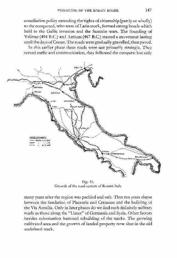
EVOLUTION OF THE ROMAN ROADS 147
conciliation policy extending the rights ofcitizenship (partly or wholly)to the conquered, who were of Latin stock, formed strong bonds whichheld in the Gallic invasion and the Samnite wars. The founding ofVelitrae (494 B.C.) and Antium (467 B.C.) started a movement lastinguntil the days ofCeasar. The roads were gradually gravelled, then paved.
In this earlier phase these roads were not primarily strategic. Theyserved traffic and communication, they followed the conquest but only
pAVEp t11Gt1WAY~ :
- REAOY e ~,240
., ,70........ .. A 0.100
Fig. 35.Growth of the road-system of Roman Italy
many years after the region was pacified and safe. Thus ten years elapsebetween the fundation of Placentia and Cremona and the building ofthe Via Aemilia. Only in later phases do we find such definitely militaryroads as those along the "Limes" of Germania and Syria. Other factorsbesides colonisation hastened rebuilding of the tracks. The growingcultivated area and the growth of landed property now shut in the oldundefined track.
148 LAND TRANSPORT AND ROAD BUILDING
Techmcal improvements like the introduction of lime mortar fromthe Greek cities in southern Italy (300 B.C.) and the natural cementcalled "puzzolano" (150 B.C.) hastened this process. The flagstonepavement could now be made watertight and rested on a solid foundation. The first of the great highways, the Via Appia, from Rome toCapua was paved by the hlind censor Appius Claudius (312 B.C.) inorder to bring the Campania and its harvests within reach of the oldcity. It began as a gravelled road but after the Samnite wars the sectionto Bovilae (296-293 B.C.) was paved with the "fines levied on cattlebreeders" (79). In 289 B.C. the oldest stretch was widened and two sidewalks were constructed. Shortly after the invasion of Pyrrhus the ViaAppia was gradually extended to Brundisium and Tarentum.
Shortly after the Gallic invasion Gaius Flaminius divided up the"ager gallicus" and hence the Via Flaminia had to be extended beyondSpoleto to Fanum Fortunae (220 B.C.). The twenty years at the end ofthis century, because of the Second Punic War, show a lull in the progress. Then the defeat of Hannibal inaugurated a period of virgorousexpansion. The valley was conquered and the colonisation of Bolognaand Aquilea meant the building of the Via Aemilia. Around 175 B.c.the V. Aurelia and V. Cassia followed, financed by the Carthaginianwar indemnity. The Via Postuma followed and the west coast roadfrom Aquilea to Brundisium. At the same time the streets of Rome werepaved and "the roads outside Rome were covered with gravel andfootpaths raised at the sides." (80).
Then the three Macedonian Wars gave the Balkan Peninsula toRome. In 148-145 B.C. on the farther coast of the Adriatic oppositeBrundisium an extension of the V. Appia, the V. Egnetia, was builtreaching from Dyrrhachium to Thessalonica and later beyond to theHebrus (81). It was later connected with the new Greek highwaysconstructed under the Empire. Nero built the road from Byzantiumto Thrace, Trajan and Hadrian paved roads along the westcoast of theBlack Sea to Tomi (82).
The Civil Wars inaugurated another period of slackness. Still G.Gracchus succeeded in getting his Lex Sempronia viaria adopted (123B.C.). It ordered the extension of the Italian roadsystem, with moreattention to be devoted to drainage and foundation problems, and alsoincreased the number of milestones. In the meantime the occupationof most of Asia Minor led to a repair of the existing Hellenistic systemby M. Aeguilius (129 B.C.). In the Gracchian period puzzolano, anatural volcanic trass found near Puteoli, was discovered. It promoted

EVOLUTION OF THE ROMAN ROADS 149
the application of concrete constructions on a much larger scale. Theconsul Marius extended the road along Italy's west coast (V. AemiliaScaurus) from Luna to Genoa, which together with new roads in thePo valley now connected Italy through southern Gaul with the newroads in Spain from Gades (Cadix) through Numantia to the Pyrenees.The link from the mouths of the Rhone (Arles) to Genoa ran over theMont Genevre (Alpes Cottiae), only during Augustus' reign was thepresent Riviera road (V. Julia Augusta) was built (13 B.C.).
..v CLAlJDIA ~..... v~
,"
V-CASSIA····, ,···'.. t veil
.......~1 .... ...,
V. TQIUMPHAtl,S' ..
Fig. 36.Roads radiating from Rome
'.
.-.... "(/1 v. NOMeN TAN A
.. ........... -...,: ...........
...... VLATINA-.".'0, Y AP'PtA
Caesar's Gallic Wars started organised roadbuilding in GauL Beforethe Roman Conquest there were many native tracks but the great highways belong to the Empire. Their natural centre was Lugdunum(Lyons), whence a road south along the Rhone led to ArIes and thecoastal roads. A western road running through the country of theAverni reached the mouth of the Loire and then struck south to thepresent Bordeaux. A road to the north-west reached the coast oppositeBritain, the north-eastern road led to the valley of the Rhine andGermania. These large roads fonned the backbone of an intricate web

150 LAND TRANSPORT AND ROAD BUILDING
of roads built by Claudius, Trajan, Nerva and Vespasian. Trajan connected this system with the roads leading through Germany to theDanube and the Black Sea.
Already in Republican days two roads penetrated the newly-wonterritory of Spain. However Augustus laid out a proper road-systemcomparable to Agrippa's plans for Gaul. He surrounded Spain witha great circle of roads with one or two branches penetrating to the inlandmining districts of Rio Tinto, Almaden and the Sierra Morena. Oneof the chief functions of these roads was conveying the ores and metalsto the seaports for shipping to Rome. The frequency of relaying roadspoints to intensive traffic and the determination to exploit the resourcesof the district. Older tracks were rebuilt into important trade-routeswhich were kept in good repair as is evident from van SICKLE'S (83)data compiled in Table I.
Claudius' occupation of Britain resulted in the building of durablecommercial highways, partly trackways rebuilt. London remainedthe centre whence trade went to the Channel ports. Military roads werebuilt in Wales and the Lake District as well as along the Wall. Nomilestones earlier than Hadrian survived, during whose reign the roadsalong the north Welsh coast were taken in hand (83a).
Africa, one of the granaries of Rome, was completely pacified byAugustus, who founded colonies, constructed roads and providedthe province with police forces. Then whole triangle Carthage-CirtaTacape needed good communications between the agricultural districtsand the seaports and roads for the patrols of the military police (84).More to the west there were towns belonging to Spain rather than toAfrica for the traffic went mainly by sea as there seems to have been abreak in the road-system along the coast.
In Syria and Palestine the old roads were gradually paved (84a) andprovided with hill forts along the desert against brigandage. Thisgradual construction ofwell-built roads started by Herod and his familywas crowned when Trajan annexed Arabia Petrae (Transjordan) andbuilt a splendid system of roads with a line of watchtowers and posts.The roads of Syria and Judea were carefully paved and garrisoned, theroad from Antioch to the East constantly repaired and in northern Syriamiles of roads of black basalt were built which have survived almostintact. The trade from Arabia to the north was sheltered by the StrataDiocletiana during the rise of the Sassanian Empire which militaryroad was well-equipped with forts, water-supply from wells (85) andcamps for the Bedouin auxilliaries.

EVLLUTION OF THE ROMAN ROADS 151
In Asia Minor a consistent road-system was only possible after theRomans give up the system of buffer-states between themselves and theParthians. Thus its roads were mainly built by the Flavians, Vespasian,Titus, Nerva and Hadrian. Here again we find many military roads onthe protected border, the "Limes", which system the Flavians alsoadopted on the Rhine and Danube frontier. The road-system on theRhine was begun between 73 and 84 A.D. but the "limes germanicus"was not completed until the reign of Trajan. The log-roads built byCaecina and Domitus from the Rhine eastwards into the territory ofthe German tribes were also military roads to combate the danger ofraiding tribesmen. Thus, at the zenith of its power, the Roman Empiredisposed ofa 90.000 km system of paved highways, 14.000 km of whichwere located in Italy proper. If we include the secondary, tertiary andgravelled roads we obtain a total of 300.000 km. Twenty-three highways radiated from the capital, Rome, and led to the confines of theEmpire. The topography of these roads has been studied in great detail(86) and new finds constantly increase the total mentioned above.
ROMAN MATERIALS AND ROAD-CONSTRUCTIONS
Unfortunately we possess no Hellenistic or Roman handbooks onroad building. Even VITRuVruS (87) is rather vague on the paving ofstreets though he is more explicit on floors which were composedof four strata, as confirmed by excavations. VrrRuv's instructions are:"If we must lay our floor (ruderatio) on level ground, we must inquirewhether the soil is solid throughout; it is then to be levelled and uponit the foundation (statumen) carrying another layer (rudus) shall belaid. But if it is a made site, in whole or in part, it must be very carefullyrammed with piles."After discussing the building ofupper floors and theplanks to be used he continues: "Next a layer of stones (statumen) willbe laid each of which it at least fist-size. When the statumen has beenlaid the rudus, a mixture of hardcore and lime, shall cover it. If freshbricks are broken up for use, one should use three parts on one part oflime; if it is of old materials, five parts of rubble are to be mixed withtwo of lime. Let it then be laid on, and rammed down with repeatedblows by gangs (decuriae) of men using wooden stamps. When thestamping is finished it must be not less than nine inches thick.
Upon this, a nucleus of powdered pottery is to be laid, three parts toone of lime, forming a layer of six inches. On the finishing coat, apavimentum is to be laid to rule and level."
152 LAND TRANSPORT AND ROAD BUILDING
Excavations have proved that roads too consist of four differentlayers (statumen, rudus, nucleus and pavimentum or summum dorsum). The statumen can be compared with our handlaid foundation,the rudus is a watertight layer shutting out the damp from the statumen.Thus statumen + rudus together form the foundation proper. Thenucleus is perhaps intended to serve as a "binder" for the pavement.The Roman authors (89) and poets have little say about roadbuildingexcept Statius, the poet-laureate ofthe emperorDomitian, who describesthe building of the Via Domitiana (90 A.D.) in these words (90):
"Now the first stage of the work was to ditches and to run atrench in the soil between them. Then this empty ditch was filled upwith the foundation courses and a watertight layer or binder and afoundation was prepared to carry the pavement. For the surface shouldnot vibrate, otherwise the base is unreliable or the bed in which thestones are rammed is too loose. Finally the pavement should be fastenedby pointed blocks and held at regular distances by wedges. Many handswork outside the road itself. Here trees are cut down and the slopes ofhills are bared; there the pickaxe levels the rock or creates a log froma tree; there clamps are driven into the rocks and walls are woven fromslaked lime and grey tufa. Hand-driven pumps drain the pools formedby underground water and brooks are turned from their courses."
However, the Roman road-engineer never stuck rigidly to this fourlayer scheme. He shows great skill in varying it to local conditions, inusing local materials and constructions to achieve his goal and he wa~
never dogmatic to his own disconfiture. The type of construction wasadapted to the type of traffic. It will be clear that a "transport road"like the one constructed by Hadrian for the transport of Numidianmarble from the quarries at Simitthus to the harbour of Thabrace willdiffer from the simple country track. Such tracks or "viae vicinales",just levelled, rolled and drained, existed along many superior types ofroads. \Ve know little about the Roman gravel roads because most ofthem have disappeared by now. However in the days ofPalladio (1 5181580), famous architect of the Italian Renaissance, methods werestill in use reputed to be Roman practice (91). Probably all secondaryroads (viae vicinales) were at least gravelled. The course of the roadwas levelled, sometimes rammed or even rolled with wooden or stonerollers (92), then an embankment of sand with a gravelled surface or agravel layer was laid. Stones from the neighbouring fields served ascurbstones. On both there were ditches down to 6'-8' below theroad surface.

ROMAM MATERIALS AND ROAD-CONSTRUCTIONS 153
Paving the road surface meant limiting the width. Thus the 120'100' old track gradually became the 40' metalled road surface as decreed by Augustus for great highways (viae munitae). The delimitedroad, the "agger publicus" was state property. The shoulders, often6-9 m wide, enclose the "actus" or carriage road and its sidewalks(iter) for foot passengers, which were often separated by a low stonewall (umbo) or a strip of grass. Gravel roads of this type survived inFrance under the name of "chaussees de Brunhaut" or "chaussees enaccotements".
The Romans also used cobble roads, laying the cobbles in a 10 cmsand-bed. Most cobble-surfaces survived in city pavements. A primitivemacadam road-type was imported from Greece. Like this "lithostratos" the Roman macadam road was made by spreading chips, taken from
Fig. 37.Normal Roman Highway (1 :85)
20-40 em stone setts or gravel concrete30-32 em concrete with crushed stone and trass30-50 em slabs and blocks in cement mortar20-30 cm mortar layer on top of sand course
the stone quarries, on the subsoil and ramming or rolling (ingenticylindro) them to compaction. Repairs consisted of a fresh layer ofchips rammed into the original suface.
As soon as lime and puzzolana were known mortars for groutingand concrete mixes could be used. Pavement slabs were usually cutfrom lava (silex) or tufa, hence the term "silicarii" for paviours. Agreen variant (cappellaccio) of tufa, was very popular and so was peperino, a conglomerate of volcanic ash and gravel. Bricks (testae) ortiles (tegulae) were also used, pounded tiles forming the main ingredientof the concrete (caementum) used. Even forge cinders or slags wereused to surface the so-called "viae ferrae" many examples ofwhich werefound in Britain (92).
Lime mortars were used to grout the joints of paving slabs and alsogravel layers. The varying qualities of different sands were earlyrealised. VITRUVIUS proposes the following sand-lime ratios for river
154 LAND TRANSPORT AND ROAD BUILDING
sand, down sand and quarry sand: 2-1; 2-1 and 3-1. If gravel (glarea),chips or crushed bricks were added to the mortar (usually three to one)the common concrete (caementum) was obtained. For road-buildinga gravel concrete was very popular with a mortar consisting of one partoflime, three parts ofpuzzolanoand23j4 to31/ 2 parts of sand. This stronghydraulic mortar compares very favourably with modern portlandcement mortars. As during the Empire other deposits of trass, besidesPuteoli, were found and exploited, e.g. in the EifId district.
The usual type of main highway consisted of a 20-30 cm statumenof hand-laid slabs, a 30--50 cm rudus of grouted cobbles or crushedstones, a 30~50 cm nucleus of rich gravel concrete and a 20-30 cmpavimentum of 30~100 cm square stone slabs or a rich trass-concretewith aggregate upto 6 em. This total depth of 100-140 cm is some3-4 times that of a modern roadcarpet and hence the Roman roadshave aptly been called "walls on the flat" (93). Even with the relativelysmall traffic (though dense locally) they stood up to the wear of irontyred wheels and hoofs of unshod animals for 70-100 years beforethey needed thorough reconstruction as shown by the data from Spain,though on more frequented stretches a 30-40 years' service is moreprobably. We have few figures on the extent of traffic and the frequencyand costs ofrepairs. Though the Romans used perfectly sound buildingmethods their invention of concrete halted the development of moreplastic road carpets like cobble and macadam roads. Their rollers werenot heavy enough for compaction of such roads. The care for drainageof the foundation was excellent and thus saved the rigid thick concretemass from breaking up by frost or water. The pavement had no expansion joint and thus was little suited to climates of extreme temperature changes. The use of local materials meant dissimilar materials indifferent stretches of the road subjected to the same hammering actionof hoofs and tyres.
In the northern parts of the Empire cracks and potholes formedmore easily and thus in the later Empire constant repair took the overhand over construction of new roads. The cobble and macadam roadsprobably had a life of 1O~15 years. There were ofcourse many variantsof the common constructions mentioned here (95) but the above figuresgive averages obtained by the comparison of ancient and modernroads (96). The width ofa 40' carriage road plus side-walks andshouldersis about 80', the other roads have 12'_16' paved surface on a totalwidth of 36'-40'. On some military roads the side-walks were usedby carts, the main road being used by the marching legions. The ditches
ROMAN MATERIALS AND ROAD-CONSTRUCTIONS 155
(sulci) were usually 10' wide and as deep as the foundation course,though often they go 10' deep. The usual camber is 1: 20. Milestones,the invention ofwhich was ascribed to G. Gracchus (97), were ofcoursemuch older. The Roman milestones, the oldest of which go back to
about 250 A.D. have made the study oftheRoman highway system mucheasier (98).
Disposing of efficient surveyors' instruments the Romans couldset out (99) their roads perfectly straight as far as natural conditionswould permit. CODRINGTON found that in Britain they seldom deviatedmore than half a mile on 20-30 mile stretches (100). In general inclinations are gelow 6 %, though some of 8% occur.
Peculiar constructions were found all over the Empire. Artificialwheelruts (101) were made in certain Alpine passes, the Balkan and theAlpine provinces and in certain parts of Gaul, the gauge being againthe same as in early Malta and Greece. Cuttings and embankements werevery common. The Via Appia ran through a cutting driven 120' intoMount S. Angelo near Terracina (102) and near Arrida 43 m retainingwalls support the same road. Part of the road through the Medwayvalley near Rochester was built on a foundation of oak piles (103).In the Kasan pass and the Greben defile on the Danube the road wasconstructed on a wooden scaffolding let into the rock. Both Tiberiusand Trajan made such roads, a picture of which occurs on Trajan'scolumn. The structure has now disappeared and the road is recognisable only as a ledge in the rocky shore (104). On part of the Via TibUitina, in order to protect it from the waters of hot sulphur-springs, theroad ran in a concrete channel, the outside of which was protected bytravertine slabs. The log-roads, first mentioned as "pontibus palude"by Caesar (105) were built on the right bank of the Rhine by Domitiusand Caecina (106) after earlier examples built by the prehistoric tribesnorth of the Rhine (107). These few instances will show the ingenuityof the Roman road-engineer to cope with difficult local conditions.
CONTROL AND FINANCING OF ROAD AND TRAFFIC
Many ofthese roads were built by the army. The excellently organisedRoman legions and their army train (impedementa) with large quantitiesof artillery like ballistae and catapultae needed good roads. Hence inpeace-time the army and its engineering corps (the "centuria accessorum velatorum" formed at the end of the Republic) built roads as wellas bridges, camps and forts. This was particularly true in Africa and the

156 LAND TRANSPORT AND ROAD BUILDING
Danube and Rhine provinces. During Augustus' reign there wereseveral revolts because of this road-building. Claudius alsoused gladiators for roadbuilding, and captives were put to thiskind of work too.
About 200 B.C. the provincial authorities began to procure additionallabour and they gradually took over the greater part of roadbuilding, charging contractors (redemptores) with the actual workand retaining only the supervision. Such contracts were very popularduring the Empire but also the source of many frauds. In A.D. 21 "thestate of the public roads was made the subject ofa debate by the senatorGn. Domitius Corbulo. The highways, he said, were in a bad conditionthroughout Italy, everywhere and in some places impassible.He attributed the mischief to the fraudulent practices of the contractorsand the inattention of the magistrates. He came to superintend thebusiness, but the advantage, whatever it was, that accrued to the public,did not counterbalance the ruin of individuals, who suffered both inreputation and fortune, by the harsh decisions of Corbulo and in theconfiscation of their effects." (108) Claudius later punished Corbulo(109). In centuries the authorities often ressorted to forced labouror exactions of money for road building (110).
During early Roman history the task ofbuilding roads was entrustedto individual censores, who like Appius Claudius or Flaminius oftenattached their name to this particular road. Later on emperors, generalsor rich private individuals often did the same, prompted by rewardssuch as special medals, statues, memorial stones or even the right toerect a triumphal arch. Then special aediles called curatores viarumwere installed as temporary functionaries, special senators often beingentrusted with the supervision of traffic. As legislation on public andprivate roads became more complicated (111) the emperorcreated special permanent boards (22 B.C.) called curationes viaedirectly controlled by the emperor for special roads, districts or towns.Nero created the lower rank of subcurator. Many local authoritiesserved on these boards particularly during the later Empire whenroad-building became less important than repairs and the army leftthis to the authorities. The provincial roads were administrated by theprovincial governor and his nominees, but during the later Empire allthese functions were taken by state officers.
Financing these roads was an old problem. The earliest roads wereoften financed from the booty taken from conquests. An agrarian law of 111 B.C. wanted to make all those living along the road
CONTROL AND FINANCING OF ROADS AND TRAFFIC 157
contribute towards its building and upkeep. In 50 B.C. the senator L.Scribonius Curo failed to push a tax on wheeled vehicles. Usuallybuilding and repairs were paid by the treasury from direct taxes. Incertain cases emperors or private individuals face the costs. ThusAugustus pays most of the Via Flaminia but leaves part to the triumphant general C. Calvisius Sabinus who then builds his triumphal archat Rimini. Private individuals or governors have left us word suchacts on milestones (112). Certain towns like Nuceria were granted tollsto raise sufficient funds for road-building (113). The same forms offinancing applied to secondary roads (114).
Data on the actual costs of roads are scarce. The curator A. VibiusTemundinus repaired a 20 mile stretch of the V. Caecilia, regravellingpart and re-paving the rest of the road in the Apennines at the cost of150.000 sesterces (£4500.-) about 80 B.C. (115). The emperor Hadrianrepaved part (15 miles, 750 passus) of the Via Appia "paying himself1.147.000 sesterces, while the owners of the neighbouring lands hadcollected 569.100 sesterces" which works out to something like £3.000a mile (116). The same emperor entirely rebuilt this road from Beneventum to Aeclinum(20 miles) at the cost of£18.000 per mile includingthe price of the land. In view of the size of these "walls" these pricesseem comparatively low.
The roads served the army and state officials for whom the statepost (cursus publicus) catered. They were also the servants ofcommercebut one should not the volume of Roman trade and commerce in which much of the traffic was carried on only part of the year.Only the navigable rivers and the sea provided cheap avenues to themarkets. The Mediterranean was the finest asset in Rome's imperialeconomy, even if the Romans always disliked the sea and spoke littleof sea-transport (117). The motives of travel in Antiquity differedfrom ours (118). Apart from the displacements of atmy troops therewas a large amount of official travel and business trips. Sightseeingwas not common in the earlier periods. The ancients did not appreciatenature as we do and abhorred the mountains. They went to seasideresorts for their health and later in the Imperial period only tourismto famous towns and monuments became popular, mainly for instruction and education. This is particularly noticeable in Egypt in thesecond century A.D. However there was a tax on road travel therevarying according to the rank of the traveller (119), the tariffs forcourtesans were practically prohibitive. This money went into roadbuilding funds.
FORBES - Studies II 11
158 LAND TRANSPORT AND ROAD BUILDING
The provincial governor, in the case of Egypt the prefect (120), hadto provide the traveller with a passport. The local authorities surveyedand ran local hostels for officials, but there were many other forms ofinns and hostels (121). In the case ofimportant officials travelling abroadspecial instructions were given and requisitions were ordered (122).Scientists and students travelled to different universities such as thatof Alexandria famous for its doctors of medicine (123). Then therewere ofcourse pilgrims going to different shrines. Some ofthese travellers succeeded in getting permission to use the official postal servicebut most of them had to provide for their own means of transport.
The "cursus publicus", the state postal- and messenger service, wasthe backbone of this passenger transport. By it the emperors couldrule from Rome by letter alone according to classical authors (124.)Its origin goes back to the third century B.C. when officials tried tokeep in touch with each other and with Rome. Requisitions for travelling facilities were even then possible (125) for senators. Later Caesargives written permits to travellers and transports. The provincialgovernors had their messengers (statores) and the taxfarrning companiestheir own couriers (tabellarii) (126). However, we find no definite tracesof the postal service said "to have been instituted by Gaius Graechus"(127) though there was some postal service between Rome and Rhegium (128).
The emperor Augustus completely organised and centralised suchearlier services (129). The Ptolemaic system seems to have inspiredhim for he tried to finance it by making the cities and population alongthe roads pay for it (130). It was first confined to the neighbourhood ofRome but gradually gew to embrace the whole empire under Trajan.Gradually the old system of financing became impossible and Hadrianmade it a state-organisation. Private tabellarii were not allowed to useits facilities, which served officials only who had to get an official passport (diploma). However soon private travellers were allowed itsfacilities as a favour, animals and ships were allotted to private individuals and at the hostels presents lay awaiting them. At regular intervals laws had to be enacted to combat such abuses.
This combined postal-, passenger- and goods-service had strict regulations. Along the main highways there were stops where horsescould be changed (mutationes) and larger stations and hostels (mansiones). The mansiones were about one day's journey (37 km) apart. Onrivers there were ferries, and the sea routes were covered "dromones"or "cursioriae", fast sailing ships. The diploma rigidly prescribed the
CONTROL AND FINANCING OF ROADS AND TRAFFIC 159
type and amount of transport one was allowed as well as the hospitalityin the mansiones. For travel on the secondary roads or branch road oneneeded a special "evectio".
The heavy clabulariae (angariae) drawn by oxen carried a maximumof 1500 Roman pounds each (492 kgr) of army goods, parchement andpapyri, products from the imperial estates, etc. The number of oxenor horses for this slow cursus clabularius was 8 in summer and 10 inwinter, lower officials were allowed only this form of transport, alsosoldiers if travelling far and all sick people. Express goods and preciousmetals were transported by the cursus velox which used several typesof carriages: 1) the rheda (vehiculum, carpentum), a four-wheeled cartwith mules (8 in summer, 10 in winter) and a maximum load of 1000lbs (330 kgr); 2) the carrus, g four-wheeled cart carrying 600 lbs (198kgr) max.; 3) the verreda, originally used by women only, which wasdrawn by 4 mules and could transport 2-3 persons and max. 300 lbs(99 kgr.); and finally 4) the two-wheeled birota with 3 mules carrying200 lbs (66 kgr) and 1-2 passengers. The cursus velox also had ridinghorses (veredi) and pack-horses (parhippi) which carried a maximumof 100 lbs (33 kgr). The animals served only between certain mansionesand had to be exchanged at certain determined spots. Their hay was tobe exacted from the local population. The mansiones also served ascentral offices for all taxes paid "in natura".
The cursus velox could only be used by high officials, their familiesand the imperial messengers (tabellarii) (131). Originally this servicewas controlled by the praefectus praetoriae but later a special officialvir illustris magister officiorum was appointed. The maximum loadsof the different types of vehicles was carefully prescribed to avoidexcessive wear of the roads (132). The average speed of the imperialpost was some fifty Roman miles a day (5 miles per hour) (75 km).Special despatch bearers did sometimes attain double that amount,but 240 km a day allowing for halts is the maximum ever reported (133).It was certainly already better than the 24 miles which Cicero could doin 51 B.C. as a provincial governor (134). The regularity, certainty andspeed of travel of the cursus publicus were not surpassed until the daysof Napoleon. The ox-drawn carts travelled some 10-15 km a day.
The Romans tried to reduce the time ofland transport and to increaseits capacity in order to overcome the difficulty of feeding the greatdties. The solution adopted was a control of most of the land and seatransport by liturgical (compulsory) services. Stables were built byforced labour, one quarter of the horses needed for the mansiones were

160 LAND TRANSPORT AND ROAD BUILDING
requisitioned yearly from the population living nearby. The excellenteffort broke down even when economy dominated road building duringthe later Empire. Transport costs, which doubled the price of grainfor every 100 miles of transport, were so high as to make the carriageof wares, whose value was small in relation to bulk or weight, overany appreciable distance out of the question. Corn, ores or metalswent straight to the nearest harbour and then by water. Thus local trafficmay have been dense but long-distance transport was negligible. Thedevelopment of roads helped only in a few cases, e.g. it brought downthe price of vegetables in Rome.
The great and apparently beneficial road-system broke down throughofficial abuse and the fundamental mistake in providing for its maintenance by compulsory exactions. There was an increasing and oftenfraudulent demand for free transportation of military and state officials.The municipial authorities already loaded with work could not exercizea proper control. Drastic reforms by Julian, Valentinian I and Theodosius helped only temporarily. The imperial fiscal administration had bythe time of Constantine already destroyed one by one all the chiefsources of revenue and traffic by land and sea gradually dwindled to afraction of its former volume as private enterprise was completelyabsorbed by the state.
Having already mentioned milestones and directionpusts as aids totravellers we should now devote a few words to maps and travellinghandbooks. The Babylonians and their ancestors had had their maps(135) and the Greeks had greatly improved this art (136). Cartographywas a well-known art at the beginning of our era. Maps of all typeswere available (137). During the consulate of Caesar and Mark Antonya survey of the empire was started by Zenodoxus, Theodotus andPolyclitus and finished in 25 years. Augustus' friend M. VipsaniusAgrippa ordered a new survey of Spain, Gaul (including the LowCountries) and the Danube provinces. The results were embodied ina sculptured marble map hung near the Pantheon at Rome. A 40' X 60'marble map ofthe 14 quarters ofRome was ordered by Vespasian, partsof this "Forma Urbis" have survived.
There were also maps for the general staff which accurately depictedthe roads, the mansiones and their distances (138). A fragmentary copyof such a map on the leather shield of a soldier of Dura Europos gavethe route and mansiones on the Black Sea highway from the mouths ofthe Danube to Artaxata in Armenia (139). It is the prototype of later"itineraria" like that ofRavenna (VIIth century A.D.) and the Peutinger
CONTROL AND FINANCING OF ROADS AND TRAFFIC 161
map made by Castorius, of which we possess a copy of the XIIthcentury. This latter map is mathematically deformed to suit the pocketin the form of a roll, but all the distances are marked correctly (140).
Part of the troubles of ancient land transport sprang from the inefficient use of draught-animals (141). This was first of all due to theancient form of harness, which was not a shoulder-collar with breaststrap, but which throttled a horse or mule that pulled too hard. Eachanimal could pull a maximum of 62 kgr, only a quarter of the modernfigure. Also the only way of yoking more than one animal to a cartconsisted in augmenting the amount of yokes. The Romans did notknow how to arrange them in line tandem and thus not only complicatedtheir manipulation (by multiplying the number of reins) but also reduced the total energy-output considerably.
Again horses were not shoed in Antiquity (142). Though the problemis still far from settled it seems that the ancients knew metal, leather orstraw soleae, hypodemata or hipposandales attached to the legs ofhorses, mules or camels if the ground was hard or slippery. Real ironhorseshoes, attached permanently with nails, seem to have been adoptedfrom the nomads by German, Aleman, Helvetian & Sueban tribes ofprehistoric Europe about the second century B.C. In the northernRoman provinces a few horseshoes were found before becomecommon about the eighth century A.D. Then a type of horsehoe witha better grip on the hoof were generally used from which thedifferent local European types began to evolve in the ninth century,when the emperor Leo mentions them in his Tactics, together with therein and the stirrup both unknown to the Romans (143), which maderiding a horse more difficl.'lt and which hindered the evolution ofcavalry as a heavy arm.
Stirrups and horseshoes contributed to the rise of cavalry as an important "shock-tactic" element in warfare and formed one of thecornerstones of the rise of chivalry, the mounted gentleman and hisretainers who rode the highways in Chaucer's days along with thetravelling clergy and merchants.
Related Documents