Structure of a sheet-laccolith system revealing the interplay between tectonic and magma stresses at Stardalur Volcano, Iceland Federico Pasquarè a , Alessandro Tibaldi b, ⁎ a Dipartimento di Scienze Chimiche e Ambientali, Università dell'Insubria, Como, Italy b Dipartimento di Scienze Geologiche e Geotecnologie, Università di Milano Bicocca, Milan, Italy Received 25 April 2006; received in revised form 24 August 2006; accepted 27 November 2006 Available online 22 January 2007 Abstract This paper provides detailed structural data on the faults and intrusions of the eroded Stardalur volcano, in the Esja peninsula at the SW margin of the Icelandic rift, and new lithostratigraphic data on the host rocks. A swarm of centrally-dipping sheets, emplaced with a fan-shaped geometry in section view, depicts an ellipse in plan view with an about E–W major axis. Sheet intensity reaches 80% in one 100-m transect near the central portion of the swarm, where sheets strike E–W with sub-vertical dip. A 200-m-thick, multiply-intrusive body forms a laccolith in the middle of the centrally-dipping sheet swarm, at a higher altitude. Individual intrusive units within this laccolith are sub-vertical and strike E–W in the center, acquiring a sill-like geometry outwards, and were emplaced in a stress field locally dominated by a N–S-directed least principal stress (σ3). Within the inclined sheet swarm, the stress tensor rotated in response to an excess magma pressure, probably linked to an underlying magma chamber, which interacted with the tectonic stresses. Crosscutting relationships between the various intrusions and with the host rock indicate that the activity in the central zone of the Stardalur volcano ended with the emplacement of the laccolith. Later eruptions, if they occurred at all, were fed by centrally-dipping sheets. In the final stage, NNE-striking regional vertical dykes and normal faults cut the previous structures in response to dominant regional plate tectonic stresses with a WNW–ESE directed σ3 and a NNE–SSW directed intermediate principal stress (σ2). © 2006 Elsevier B.V. All rights reserved. Keywords: Iceland; Stardalur; Esja; sheet swarm; regional dykes; faults 1. Introduction The reconstruction of the structure of subvolcanic bodies by actual field examples is fundamental for un- derstanding magma emplacement near the Earth surface. Taking into consideration that the erupted magma can be a fraction of the volume of magma injected into the volcanic edifice (e.g. Allard et al., 1994), the inner growth of cones by repeated intrusions represents a very important aspect of volcanoes' evolution. These intru- sions can occur with different geometries, ranging from vertical dykes to horizontal sills or more complicate structures, that correspond to different deformations at the surface. Intrusion-generated volcano deformations can span from local, elongated depressions (Pollard, 1973; Tibaldi and Groppelli, 2002) to large displace- ments of huge sectors of the cone (Borgia et al., 1992; Tibaldi, 2001). Understanding the geometries and causes of possible magma paths into a volcano is thus fundamental both to improve the comprehension of the general behaviour of volcanoes, and to facilitate Journal of Volcanology and Geothermal Research 161 (2007) 131 – 150 www.elsevier.com/locate/jvolgeores ⁎ Corresponding author. E-mail address: [email protected] (A. Tibaldi). 0377-0273/$ - see front matter © 2006 Elsevier B.V. All rights reserved. doi:10.1016/j.jvolgeores.2006.11.009

Welcome message from author
This document is posted to help you gain knowledge. Please leave a comment to let me know what you think about it! Share it to your friends and learn new things together.
Transcript
al Research 161 (2007) 131–150www.elsevier.com/locate/jvolgeores
Journal of Volcanology and Geotherm
Structure of a sheet-laccolith system revealing the interplay betweentectonic and magma stresses at Stardalur Volcano, Iceland
Federico Pasquarè a, Alessandro Tibaldi b,⁎
a Dipartimento di Scienze Chimiche e Ambientali, Università dell'Insubria, Como, Italyb Dipartimento di Scienze Geologiche e Geotecnologie, Università di Milano Bicocca, Milan, Italy
Received 25 April 2006; received in revised form 24 August 2006; accepted 27 November 2006Available online 22 January 2007
Abstract
This paper provides detailed structural data on the faults and intrusions of the eroded Stardalur volcano, in the Esja peninsula atthe SW margin of the Icelandic rift, and new lithostratigraphic data on the host rocks. A swarm of centrally-dipping sheets,emplaced with a fan-shaped geometry in section view, depicts an ellipse in plan view with an about E–W major axis. Sheetintensity reaches 80% in one 100-m transect near the central portion of the swarm, where sheets strike E–W with sub-vertical dip.A 200-m-thick, multiply-intrusive body forms a laccolith in the middle of the centrally-dipping sheet swarm, at a higher altitude.Individual intrusive units within this laccolith are sub-vertical and strike E–W in the center, acquiring a sill-like geometry outwards,and were emplaced in a stress field locally dominated by a N–S-directed least principal stress (σ3). Within the inclined sheetswarm, the stress tensor rotated in response to an excess magma pressure, probably linked to an underlying magma chamber, whichinteracted with the tectonic stresses. Crosscutting relationships between the various intrusions and with the host rock indicate thatthe activity in the central zone of the Stardalur volcano ended with the emplacement of the laccolith. Later eruptions, if theyoccurred at all, were fed by centrally-dipping sheets. In the final stage, NNE-striking regional vertical dykes and normal faults cutthe previous structures in response to dominant regional plate tectonic stresses with a WNW–ESE directed σ3 and a NNE–SSWdirected intermediate principal stress (σ2).© 2006 Elsevier B.V. All rights reserved.
Keywords: Iceland; Stardalur; Esja; sheet swarm; regional dykes; faults
1. Introduction
The reconstruction of the structure of subvolcanicbodies by actual field examples is fundamental for un-derstanding magma emplacement near the Earth surface.Taking into consideration that the erupted magma can bea fraction of the volume of magma injected into thevolcanic edifice (e.g. Allard et al., 1994), the innergrowth of cones by repeated intrusions represents a very
⁎ Corresponding author.E-mail address: [email protected] (A. Tibaldi).
0377-0273/$ - see front matter © 2006 Elsevier B.V. All rights reserved.doi:10.1016/j.jvolgeores.2006.11.009
important aspect of volcanoes' evolution. These intru-sions can occur with different geometries, ranging fromvertical dykes to horizontal sills or more complicatestructures, that correspond to different deformations atthe surface. Intrusion-generated volcano deformationscan span from local, elongated depressions (Pollard,1973; Tibaldi and Groppelli, 2002) to large displace-ments of huge sectors of the cone (Borgia et al., 1992;Tibaldi, 2001). Understanding the geometries andcauses of possible magma paths into a volcano is thusfundamental both to improve the comprehension ofthe general behaviour of volcanoes, and to facilitate
132 F. Pasquarè, A. Tibaldi / Journal of Volcanology and Geothermal Research 161 (2007) 131–150
interpretation of pre- and syn-eruptive geophysical andgeodetic signals. This is of a great importance in termsof the prevention of volcanic hazard.
Apart from cylindrical conduits, magma paths arearranged into four main patterns of sheet intrusions: i)Swarms of regional, parallel vertical dykes (e.g. Geikie,1897), ii) swarms of local, inclined sheets (Gudmunds-son and Brenner, 2005); iii) sills (Gudmundsson, 1990);and iv) radial vertical dykes possibly passing at distanceto sub-parallel swarms (e.g. Muller and Pollard, 1977;Nakamura et al., 1977). The radial-sub-parallel case (iv),usually interpreted as the effect of a radial magmapressure produced along the walls of a circular verticalconduit, is not represented in the area under study. Thedefinition of inclined sheets was first used by Harker(1904) for intrusions at Skye and the term “cone sheets”was later introduced by Bailey et al. (1924), in view ofthe fact that these sheets are generally arranged in aconical swarm geometry around a main intrusion.Swarms of cone sheets are normally circular or slightlyelliptical in plan view and are usually related to centralvolcanoes; they are originated by stress concentrationsaround magma chambers with internal pressure or also inthe case of no excess pressure (Walker, 1992; Gud-mundsson, 1998; Gudmundsson, 2002; Klausen, 2004;Gudmundsson and Brenner, 2005). By contrast, regionaldykes are normally parallel to sub-parallel striking, occurin elongate swarms, and usually are controlled byregional tectonic stresses (Gudmundsson, 1995). Possible“intermediate stress field” conditions can occur, althoughworks describing these conditions by detailed field dataare scarce in the literature (e.g. Klausen, 2006).
Studies of dykes or inclined sheets have been widelycarried out both by field data and/or by numericalmodelling (e.g. Pollard, 1973; Pollard and Muller, 1976;Halls and Fahrig, 1987; Parker et al., 1990; Baer andHeimann, 1995; Gudmundsson, 2002; Tibaldi, 2003;Gudmundsson and Brenner, 2005). Some of these aremainly focused on analysing the static stress fieldsaround magma sources of various geometries, takingfield data into account (Muller and Pollard, 1977;Delaney and Pollard, 1982; Pollard and Segall, 1987),whereas other works deal more with fluid dynamics ofmagma flow within dykes (Wilson and Head, 1981;Spence and Turcotte, 1985; Spence et al., 1987; Listerand Kerr, 1991; Rubin, 1995; Fialko and Rubin, 1999;Bolchover and Lister, 1999). Some works have alsobeen carried out by using analogue, physically-scaledmodels which mimic dyking within volcanoes withdifferent morphologies (Fiske and Jackson, 1972;Menand and Tait, 2002; Watanabe et al., 2002; Acocellaand Tibaldi, 2005). Theoretical works on the emplace-
ment of sub-volcanic intrusions must be tested byquantitative field studies.
The principal aim of this paper is to provide detailedfield data on the spatial distribution and geometries ofdykes, inclined sheets and a complex and thick centralintrusion, as well as on the geometry and kinematics ofbrittle tectonic deformations and on the lithostratigraphyof the host rock succession. The purpose is to re-construct the architecture of the entire intrusive complexand the stress field related to the emplacement of theintrusions. By integrating all this data, we then discusshow the stress field developed in the area and how muchit depended on magmatic forces or tectonic regionalforces, or a combination of these. The small dimensionof the sheet system does not provide a very large amountof data on sheet geometry, which is necessary to performdetailed statistical analyses such as the ones by Klausen(2004). Therefore, we present locally-significant data onsheets, putting also emphasis on brittle tectonic andlithostratigraphic data.
2. Geological setting
Iceland is the largest landmass exposed along theMid-Ocean Ridge. It has been constructed over the past15 Ma by a huge and persistent plume along the NEAtlantic plate boundary (Schilling, 1973). Its origin goesas far back as to the early-Tertiary opening phase of thenorth-Atlantic ocean, with continental break-up andsubsequent oceanic crust formation (e.g. Klausen andLarsen, 2002).
The geology of Iceland is dominated by Tertiary pilesof flood basalts flanking sub-glacial eruptive productsand the currently active rift systems crossing the islandfrom SW to NNE. The Tertiary flood basalts, locatedEast and West of the active rift zones, dip gently towardsthe rift axes, as a result of progressive subsidence underthe loading of the rift zone crust. This process inducedthe burial of great rock piles under high geothermalgradients, leading to metamorphism up to amphibolitefacies and ultimately some partial melting that gave riseto rhyolitic melts (Thordarsson and Hoskuldsson, 2002).
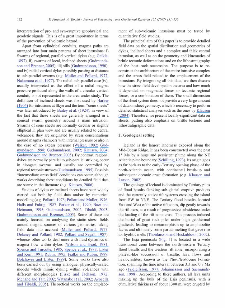
The Esja peninsula (Fig. 1) is located in a widetransitional zone between the north-western Tertiaryflood basalts and the western rift zone, incorporating aplateau-like succession of basaltic lava flows andhyaloclastites, known as the Plio-Pleistocene Forma-tion, spanning the time interval between 3.3 and 0.8 Maago (Fridleifsson, 1977; Johannesson and Saemunds-son, 1998). According to these authors, all lava unitsmaking up the bulk of the Esja peninsula, with acumulative thickness of about 1300 m, were erupted by
Fig. 1. Geographic location of the study area and regional geological framework. Inset shows Iceland with rift zones. Simplified after Johannessonand Saemundsson (1998) and Villemin et al. (1994). A) Kjalarnes–Thervell central volcano; B) Stardalur central volcano; C) Midsandur centralvolcano. Rectangle: location of the study area.
133F. Pasquarè, A. Tibaldi / Journal of Volcanology and Geothermal Research 161 (2007) 131–150
the Kjalarnes, Hvalfjordur and Stardalur volcanicsystems, active respectively 2.8, 2.0 and 1.7 Ma ago.During a subsequent hiatus in the volcanic activity,glacial erosion dissected the Esja peninsula, exposingthe subvolcanic interior of these systems (mainlydoleritic and subordinately granophyric intrusions)along the flanks of the peninsula (Johannesson andSaemundsson, 1998). The Stardalur volcano, in partic-ular, was affected by a caldera collapse before theemplacement of the studied intrusive bodies (Fridleifs-son, 1977). After 0.8 Ma ago, volcanism resumed alongthe south-eastern foothill of the dissected Esja plateau,producing the large Mosfellsheidi basaltic shield vol-cano, whose lava flows reached the sea shore (Fig. 1).
Fridleifsson (1972) produced the most detailed mapof the Esja area up to now available (Fig. 2), showing, inthe study area, a doleritic body surrounded by asequence of lavas and hyaloclastites; this lava-hyalo-clastite succession is locally intruded by inclined sheets.The caldera is outlined by scarp breccia deposits and thesudden offset of pre-caldera rocks, which are mainlycomposed of a succession of sub-parallel lava flows andbreccia outpoured by the older Stardalur's activity andby other volcanoes originally located in the surroundingareas. Thanks to data provided by log exploration for
geothermal purposes, Fridleifsson (1977) recognizes thecentral dolerite body as a laccolith, sketched in hisgeological section reproduced in Fig. 2. Some of thesheets we have studied are represented in the originalmap by Fridleifsson (1972), but no detailed data on theirgeometry, thickness, etc., have been provided by him orother authors in available published papers.
The structural data of the area have been illustratedby Fridleifsson (1972) and by Villemin et al. (1994).Both works describe the presence of NNE- to NE-striking normal faults and dykes (Fig. 1), and a regionaltilting of the lava succession in the order of 8–10°towards SE. Villemin et al. (1994) provided statisticaldata on dykes and inclined sheets in the Esja peninsula,but all of them were grouped without distinction of thesheets' different sources.
3. Field data
We mapped the lithostratigraphic units and structures(at a 1:10,000 scale) of part Fridleifsson's study area(Fig. 3), which allow us to improve the knowledge of thelocal stratigraphy and geometry of magmatic intrusionsand fracture systems. Dykes and sheets are particularlywell exposed in rivers and gullies, where they were
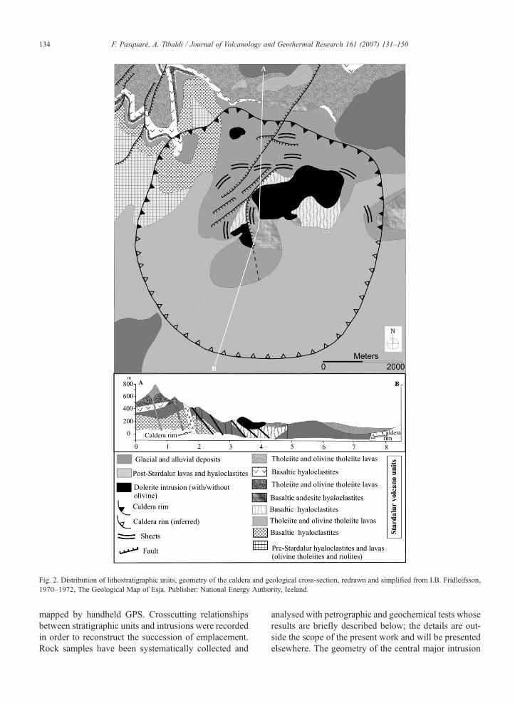
Fig. 2. Distribution of lithostratigraphic units, geometry of the caldera and geological cross-section, redrawn and simplified from I.B. Fridleifsson,1970–1972, The Geological Map of Esja. Publisher: National Energy Authority, Iceland.
134 F. Pasquarè, A. Tibaldi / Journal of Volcanology and Geothermal Research 161 (2007) 131–150
mapped by handheld GPS. Crosscutting relationshipsbetween stratigraphic units and intrusions were recordedin order to reconstruct the succession of emplacement.Rock samples have been systematically collected and
analysed with petrographic and geochemical tests whoseresults are briefly described below; the details are out-side the scope of the present work and will be presentedelsewhere. The geometry of the central major intrusion
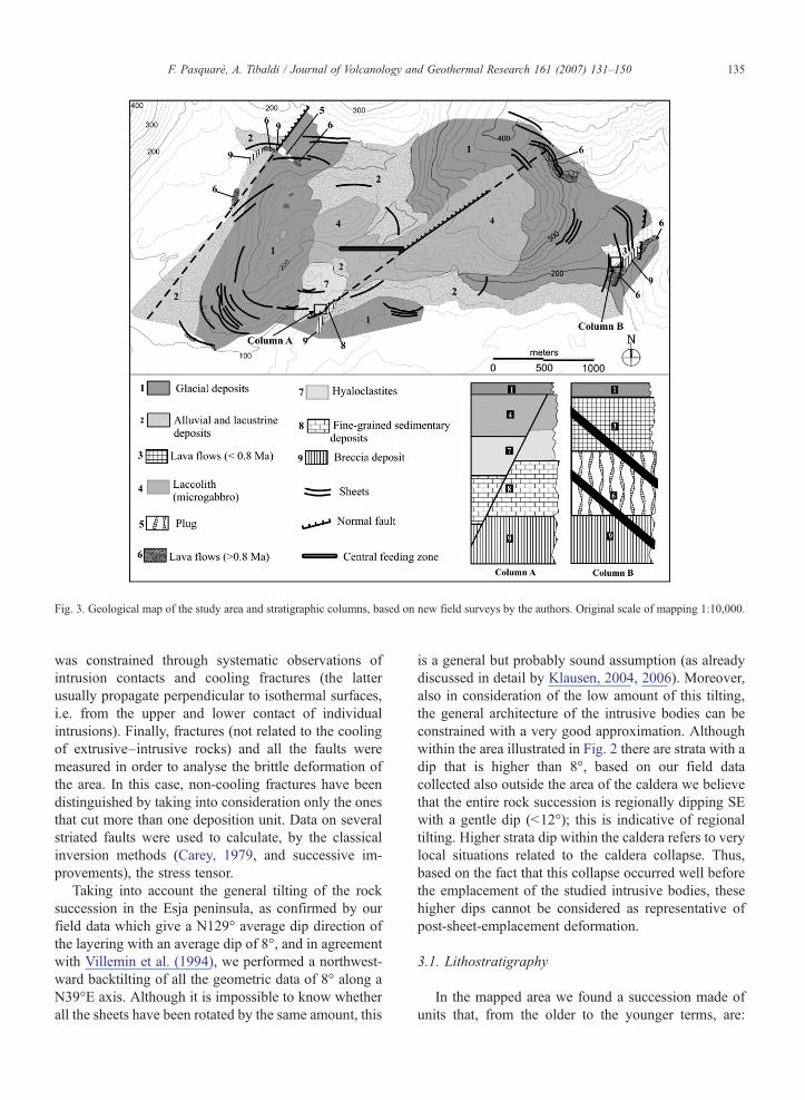
Fig. 3. Geological map of the study area and stratigraphic columns, based on new field surveys by the authors. Original scale of mapping 1:10,000.
135F. Pasquarè, A. Tibaldi / Journal of Volcanology and Geothermal Research 161 (2007) 131–150
was constrained through systematic observations ofintrusion contacts and cooling fractures (the latterusually propagate perpendicular to isothermal surfaces,i.e. from the upper and lower contact of individualintrusions). Finally, fractures (not related to the coolingof extrusive–intrusive rocks) and all the faults weremeasured in order to analyse the brittle deformation ofthe area. In this case, non-cooling fractures have beendistinguished by taking into consideration only the onesthat cut more than one deposition unit. Data on severalstriated faults were used to calculate, by the classicalinversion methods (Carey, 1979, and successive im-provements), the stress tensor.
Taking into account the general tilting of the rocksuccession in the Esja peninsula, as confirmed by ourfield data which give a N129° average dip direction ofthe layering with an average dip of 8°, and in agreementwith Villemin et al. (1994), we performed a northwest-ward backtilting of all the geometric data of 8° along aN39°E axis. Although it is impossible to know whetherall the sheets have been rotated by the same amount, this
is a general but probably sound assumption (as alreadydiscussed in detail by Klausen, 2004, 2006). Moreover,also in consideration of the low amount of this tilting,the general architecture of the intrusive bodies can beconstrained with a very good approximation. Althoughwithin the area illustrated in Fig. 2 there are strata with adip that is higher than 8°, based on our field datacollected also outside the area of the caldera we believethat the entire rock succession is regionally dipping SEwith a gentle dip (b12°); this is indicative of regionaltilting. Higher strata dip within the caldera refers to verylocal situations related to the caldera collapse. Thus,based on the fact that this collapse occurred well beforethe emplacement of the studied intrusive bodies, thesehigher dips cannot be considered as representative ofpost-sheet-emplacement deformation.
3.1. Lithostratigraphy
In the mapped area we found a succession made ofunits that, from the older to the younger terms, are:
136 F. Pasquarè, A. Tibaldi / Journal of Volcanology and Geothermal Research 161 (2007) 131–150
breccia deposits, fine-grained sedimentary deposits,hyaloclastites and lava flows (Fig. 3). All these unitsare ascribed to the older terms of the Plio-PleistoceneFormation, and their identification contributes toillustrate the stratigraphic succession in the study areain a more precise way than done by previous authors (inparticular, debris flow deposits and the fine-grainedsedimentary deposits had not been identified andmapped). These units, in turn, are cut by various typesof intrusions (a plug, a major subvolcanic body, severalinclined sheets) and are overlain by a lava sequencebelonging to the Upper Pleistocene Formation (youngerthan 0.8 Ma ago), which is not cut by any intrusions.
Subaerial lavas within the older sequence are massiveand greysh, showing a porphyritic texture composed ofplagioclase, clinopyroxene and olivine phenocrysts in afine-grained to aphanitic groundmass made up of pla-gioclase, clinopyroxene, glass and, subordinately, oliv-ine. Interleaved with the lavas, we found hyaloclastitedeposits consisting of monogenic, angular to subangularglass and lava fragments formed by disintegration of
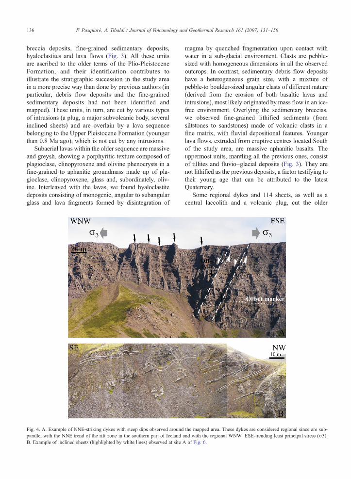
Fig. 4. A. Example of NNE-striking dykes with steep dips observed aroundparallel with the NNE trend of the rift zone in the southern part of Iceland aB. Example of inclined sheets (highlighted by white lines) observed at site A
magma by quenched fragmentation upon contact withwater in a sub-glacial environment. Clasts are pebble-sized with homogeneous dimensions in all the observedoutcrops. In contrast, sedimentary debris flow depositshave a heterogeneous grain size, with a mixture ofpebble-to boulder-sized angular clasts of different nature(derived from the erosion of both basaltic lavas andintrusions), most likely originated by mass flow in an ice-free environment. Overlying the sedimentary breccias,we observed fine-grained lithified sediments (fromsiltstones to sandstones) made of volcanic clasts in afine matrix, with fluvial depositional features. Youngerlava flows, extruded from eruptive centres located Southof the study area, are massive aphanitic basalts. Theuppermost units, mantling all the previous ones, consistof tillites and fluvio–glacial deposits (Fig. 3). They arenot lithified as the previous deposits, a factor testifying totheir young age that can be attributed to the latestQuaternary.
Some regional dykes and 114 sheets, as well as acentral laccolith and a volcanic plug, cut the older
the mapped area. These dykes are considered regional since are sub-nd with the regional WNW–ESE-trending least principal stress (σ3).of Fig. 6.
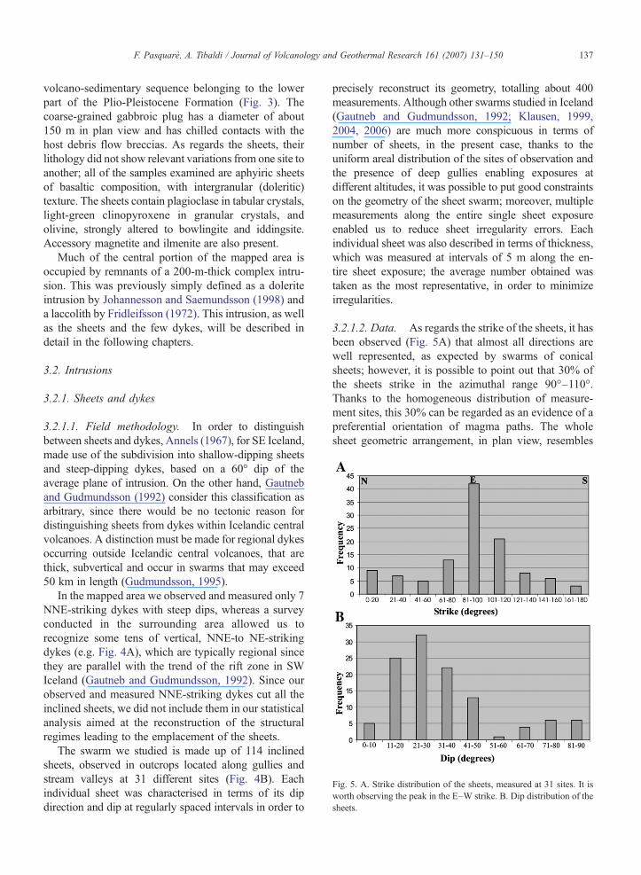
Fig. 5. A. Strike distribution of the sheets, measured at 31 sites. It isworth observing the peak in the E–W strike. B. Dip distribution of thesheets.
137F. Pasquarè, A. Tibaldi / Journal of Volcanology and Geothermal Research 161 (2007) 131–150
volcano-sedimentary sequence belonging to the lowerpart of the Plio-Pleistocene Formation (Fig. 3). Thecoarse-grained gabbroic plug has a diameter of about150 m in plan view and has chilled contacts with thehost debris flow breccias. As regards the sheets, theirlithology did not show relevant variations from one site toanother; all of the samples examined are aphyiric sheetsof basaltic composition, with intergranular (doleritic)texture. The sheets contain plagioclase in tabular crystals,light-green clinopyroxene in granular crystals, andolivine, strongly altered to bowlingite and iddingsite.Accessory magnetite and ilmenite are also present.
Much of the central portion of the mapped area isoccupied by remnants of a 200-m-thick complex intru-sion. This was previously simply defined as a doleriteintrusion by Johannesson and Saemundsson (1998) anda laccolith by Fridleifsson (1972). This intrusion, as wellas the sheets and the few dykes, will be described indetail in the following chapters.
3.2. Intrusions
3.2.1. Sheets and dykes
3.2.1.1. Field methodology. In order to distinguishbetween sheets and dykes, Annels (1967), for SE Iceland,made use of the subdivision into shallow-dipping sheetsand steep-dipping dykes, based on a 60° dip of theaverage plane of intrusion. On the other hand, Gautneband Gudmundsson (1992) consider this classification asarbitrary, since there would be no tectonic reason fordistinguishing sheets from dykes within Icelandic centralvolcanoes. A distinction must be made for regional dykesoccurring outside Icelandic central volcanoes, that arethick, subvertical and occur in swarms that may exceed50 km in length (Gudmundsson, 1995).
In the mapped area we observed and measured only 7NNE-striking dykes with steep dips, whereas a surveyconducted in the surrounding area allowed us torecognize some tens of vertical, NNE-to NE-strikingdykes (e.g. Fig. 4A), which are typically regional sincethey are parallel with the trend of the rift zone in SWIceland (Gautneb and Gudmundsson, 1992). Since ourobserved and measured NNE-striking dykes cut all theinclined sheets, we did not include them in our statisticalanalysis aimed at the reconstruction of the structuralregimes leading to the emplacement of the sheets.
The swarm we studied is made up of 114 inclinedsheets, observed in outcrops located along gullies andstream valleys at 31 different sites (Fig. 4B). Eachindividual sheet was characterised in terms of its dipdirection and dip at regularly spaced intervals in order to
precisely reconstruct its geometry, totalling about 400measurements. Although other swarms studied in Iceland(Gautneb and Gudmundsson, 1992; Klausen, 1999,2004, 2006) are much more conspicuous in terms ofnumber of sheets, in the present case, thanks to theuniform areal distribution of the sites of observation andthe presence of deep gullies enabling exposures atdifferent altitudes, it was possible to put good constraintson the geometry of the sheet swarm; moreover, multiplemeasurements along the entire single sheet exposureenabled us to reduce sheet irregularity errors. Eachindividual sheet was also described in terms of thickness,which was measured at intervals of 5 m along the en-tire sheet exposure; the average number obtained wastaken as the most representative, in order to minimizeirregularities.
3.2.1.2. Data. As regards the strike of the sheets, it hasbeen observed (Fig. 5A) that almost all directions arewell represented, as expected by swarms of conicalsheets; however, it is possible to point out that 30% ofthe sheets strike in the azimuthal range 90°–110°.Thanks to the homogeneous distribution of measure-ment sites, this 30% can be regarded as an evidence of apreferential orientation of magma paths. The wholesheet geometric arrangement, in plan view, resembles
138 F. Pasquarè, A. Tibaldi / Journal of Volcanology and Geothermal Research 161 (2007) 131–150
the shape of an ellipse, with the major axis also trendingE–W (Figs. 3 and 6).
The studied swarm has an average sheet dip of 35°,with a peak in dip distribution between 20° and 30°(Fig. 5B). This in agreement with other sheet swarms inIceland whose average dip is 34° (Gudmundsson et al.,1996) and slightly lower than at Gran Canaria, CanaryIslands (average dip of 41°, Schirnick et al., 1999).
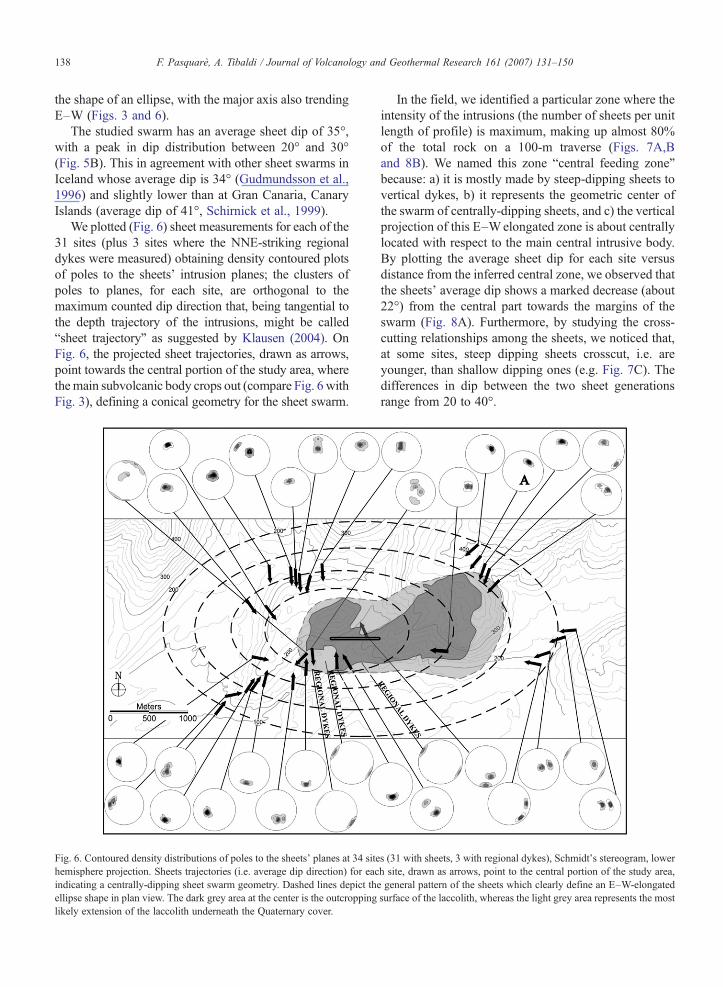
We plotted (Fig. 6) sheet measurements for each of the31 sites (plus 3 sites where the NNE-striking regionaldykes were measured) obtaining density contoured plotsof poles to the sheets’ intrusion planes; the clusters ofpoles to planes, for each site, are orthogonal to themaximum counted dip direction that, being tangential tothe depth trajectory of the intrusions, might be called“sheet trajectory” as suggested by Klausen (2004). OnFig. 6, the projected sheet trajectories, drawn as arrows,point towards the central portion of the study area, wherethemain subvolcanic body crops out (compare Fig. 6 withFig. 3), defining a conical geometry for the sheet swarm.
Fig. 6. Contoured density distributions of poles to the sheets' planes at 34 sitehemisphere projection. Sheets trajectories (i.e. average dip direction) for eacindicating a centrally-dipping sheet swarm geometry. Dashed lines depict thellipse shape in plan view. The dark grey area at the center is the outcroppinglikely extension of the laccolith underneath the Quaternary cover.
In the field, we identified a particular zone where theintensity of the intrusions (the number of sheets per unitlength of profile) is maximum, making up almost 80%of the total rock on a 100-m traverse (Figs. 7A,Band 8B). We named this zone “central feeding zone”because: a) it is mostly made by steep-dipping sheets tovertical dykes, b) it represents the geometric center ofthe swarm of centrally-dipping sheets, and c) the verticalprojection of this E–Welongated zone is about centrallylocated with respect to the main central intrusive body.By plotting the average sheet dip for each site versusdistance from the inferred central zone, we observed thatthe sheets' average dip shows a marked decrease (about22°) from the central part towards the margins of theswarm (Fig. 8A). Furthermore, by studying the cross-cutting relationships among the sheets, we noticed that,at some sites, steep dipping sheets crosscut, i.e. areyounger, than shallow dipping ones (e.g. Fig. 7C). Thedifferences in dip between the two sheet generationsrange from 20 to 40°.
s (31 with sheets, 3 with regional dykes), Schmidt's stereogram, lowerh site, drawn as arrows, point to the central portion of the study area,e general pattern of the sheets which clearly define an E–W-elongatedsurface of the laccolith, whereas the light grey area represents the most
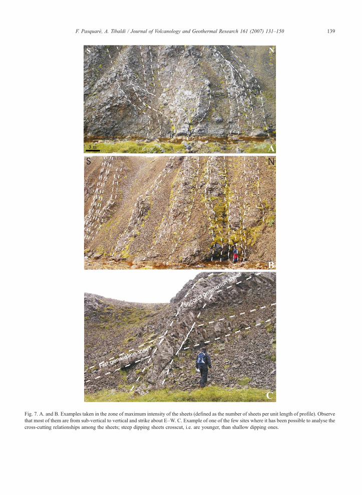
Fig. 7. A. and B. Examples taken in the zone of maximum intensity of the sheets (defined as the number of sheets per unit length of profile). Observethat most of them are from sub-vertical to vertical and strike about E–W. C. Example of one of the few sites where it has been possible to analyse thecross-cutting relationships among the sheets; steep dipping sheets crosscut, i.e. are younger, than shallow dipping ones.
139F. Pasquarè, A. Tibaldi / Journal of Volcanology and Geothermal Research 161 (2007) 131–150
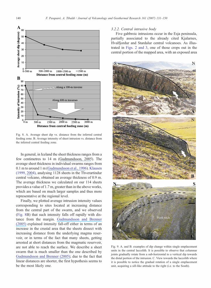
Fig. 9. A. and B. examples of dip change within single emplacementunits in the central laccolith. It is possible to observe that columnarjoints gradually rotate from a sub-horizontal to a vertical dip towardsthe distal portion of the intrusion. C. View towards the laccolith whereit is possible to notice the gradual rotation of a single emplacementunit, acquiring a sill-like attitude to the right (i.e. to the South).
Fig. 8. A. Average sheet dip vs. distance from the inferred centralfeeding zone. B. Average intensity of sheet intrusion vs. distance fromthe inferred central feeding zone.
140 F. Pasquarè, A. Tibaldi / Journal of Volcanology and Geothermal Research 161 (2007) 131–150
In general, in Iceland the sheet thickness ranges from afew centimetres to 14 m (Gudmundsson, 2005). Theaverage sheet thickness in individual swarms ranges from0.1m to around 1m (Gudmundsson et al., 1996). Klausen(1999, 2004), analysing 1128 sheets in the Thverartindurcentral volcano, obtained an average thickness of 0.9 m.The average thickness we calculated on our 114 sheetsprovides a value of 1.7m, greater than in the above works,which are based on much larger samples and thus morerepresentative at the regional level.
Finally, we plotted average intrusion intensity valuescorresponding to sites located at increasing distancefrom the central part of the swarm, and we observed(Fig. 8B) that such intensity falls off rapidly with dis-tance from the margin. Gudmundsson and Brenner(2005) explained intensity fall-off either in terms of anincrease in the crustal area that the sheets dissect withincreasing distance from the underlying magma reser-voir, or in terms of the fact that many sheets, gettingarrested at short distances from the magmatic reservoir,are not able to reach the surface. We describe a sheetswarm that is much smaller than the one described byGudmundsson and Brenner (2005); due to the fact thatlinear distances are shorter, the first hypothesis seems tobe the most likely one.
3.2.2. Central intrusive bodyFive gabbroic intrusions occur in the Esja peninsula,
partially associated to the already cited Kjalarnes,Hvalfjordur and Stardalur central volcanoes. As illus-trated in Figs. 2 and 3, one of those crops out in thecentral portion of the mapped area, with an exposed area
141F. Pasquarè, A. Tibaldi / Journal of Volcanology and Geothermal Research 161 (2007) 131–150
of 3 km2 plus a surface hidden by overlying glacial andfluvial deposits that, most likely, is around 0.5 km2. Itsaverage thickness measured by us in the field, is around200 m, about the same as in the cross section (Fig. 2) byFridleifsson (1972). Based on this thickness, theresulting volume is about 0.7 km3.
All its rock samples correspond to a microgabbrowith subophitic texture; the observed paragenesisconsists in: a) light green augitic clinopyroxene; b)plagioclase in elongated crystals, generally included inthe clinopyroxene; c) olivine, partially altered to Fe-oxides/hydroxides and green bowlingite; d) few opa-ques scattered through the samples, represented byequidimensional magnetite crystals and elongatedilmenite. The observed grainsize is consistent with thatof an intrusion emplaced at shallow depths. Based on themeasurement of the thickness of the surrounding rocksbelonging to the Plio-Pleistocene Formation and on thealtitude of the intrusion outcrops, the emplacementdepth can be estimated at about 1300 m.
In all the studied outcrops, this central body ispervaded by well-developed and spectacular columnar,cooling joints. Outwards from the central portion of thisbody, columnar joints gradually rotate their dip fromabout horizontal to vertical, and at the same time thesurfaces from where columns depart, rotate from sub-
Fig. 10. A. Photo of the central subvolcanic body. The geometry of the discjoints indicate that it resembles, as a whole, a sort of laccolith with a depresssketch illustrating the main architecture of the laccolith, with the stacked thicksurrounded by a swarm of centrally-dipping sheets whose dip decreases with
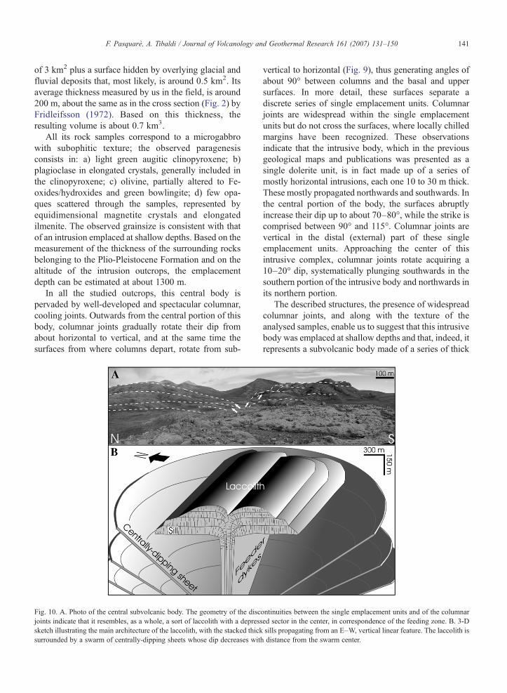
vertical to horizontal (Fig. 9), thus generating angles ofabout 90° between columns and the basal and uppersurfaces. In more detail, these surfaces separate adiscrete series of single emplacement units. Columnarjoints are widespread within the single emplacementunits but do not cross the surfaces, where locally chilledmargins have been recognized. These observationsindicate that the intrusive body, which in the previousgeological maps and publications was presented as asingle dolerite unit, is in fact made up of a series ofmostly horizontal intrusions, each one 10 to 30 m thick.These mostly propagated northwards and southwards. Inthe central portion of the body, the surfaces abruptlyincrease their dip up to about 70–80°, while the strike iscomprised between 90° and 115°. Columnar joints arevertical in the distal (external) part of these singleemplacement units. Approaching the center of thisintrusive complex, columnar joints rotate acquiring a10–20° dip, systematically plunging southwards in thesouthern portion of the intrusive body and northwards inits northern portion.
The described structures, the presence of widespreadcolumnar joints, and along with the texture of theanalysed samples, enable us to suggest that this intrusivebody was emplaced at shallow depths and that, indeed, itrepresents a subvolcanic body made of a series of thick
ontinuities between the single emplacement units and of the columnared sector in the center, in correspondence of the feeding zone. B. 3-Dsills propagating from an E–W, vertical linear feature. The laccolith isdistance from the swarm center.
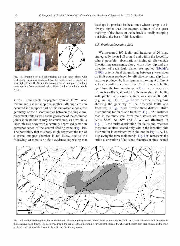
Fig. 11. Example of a NNE-striking dip–slip fault plane withslickenside lineations (indicated by the white arrows) displayingvery high pitches. The Schmidt's stereogram is an example of resultingstress tensors from measured striae. Sigma3 is horizontal and trendsN100°.
142 F. Pasquarè, A. Tibaldi / Journal of Volcanology and Geothermal Research 161 (2007) 131–150
sheets. These sheets propagated from an E–W linearfeature and stacked atop one another. Although erosionoccurred in the upper part of this subvolcanic body, thegeometry of the discontinuities between the single em-placement units as well as the geometry of the columnarjoints indicate that it may be considered, as a whole, alaccolith-like body with a centrally depressed sector, incorrespondence of the central feeding zone (Fig. 10).The possibility that this body might represent the top ofa crustal magma chamber is not likely, due to thefollowing: a) there is no field evidence suggesting that
Fig. 12. Schmidt's stereograms, lower hemisphere, illustrating the geometry othe area have been drawn. The dark grey area in the center is the outcroppingprobable extension of the laccolith beneath the Quaternary cover.
its shape is spherical; b) the altitude where it crops out isalways higher than the outcrop altitude of the greatmajority of the sheets; c) the bedrock is locally croppingout below the base of this laccolith.
3.3. Brittle deformation field
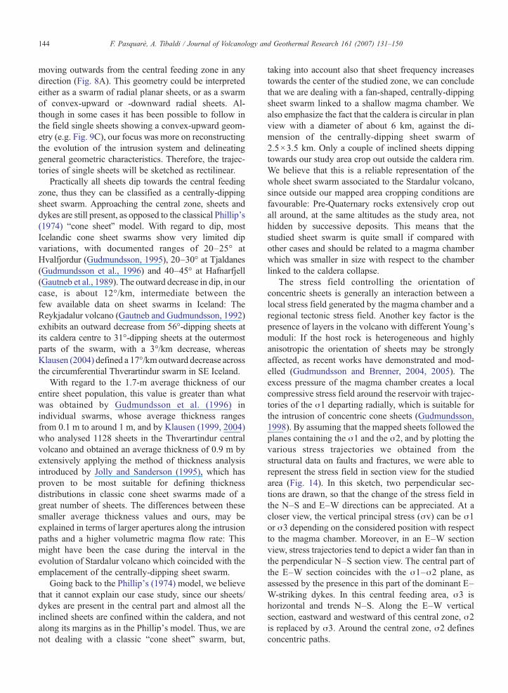
We measured 165 faults and fractures at 20 sites,strategically located all around and within the laccolith;where possible, observations included slickensidelineation measurements, along with strike, dip and dipdirection of each fault plane. We applied Tibaldi's(1996) criteria for distinguishing between slickensideson fault planes produced by effective tectonic slip fromtextures produced by lava segments moving at differentvelocities within the lava flow. Most observed faults,apart from the two ones drawn in Fig. 3, are minor, withdecimetric offsets; almost all of them are dip–slip faults,with pitches of slickenside lineations around 80–90°(e.g. in Fig. 11). In Fig. 12 we provide stereogramsshowing the geometry of the observed faults andfractures; in Fig. 13 we provide three different strikedistributions for faults and fractures. Fig. 13A illustratesthat, in the study area, three main strikes are present:NNE–SSW, NE–SW and E–W. We illustrate inFig. 13B the strike distribution for faults and fracturesmeasured at sites located only within the laccolith; thisdistribution is consistent with the one in Fig. 13A, i.e.displaying the three main trends. Fig. 13C represents thestrike distribution of faults and fractures at sites located
f the observed fractures and faults at 20 sites. The main faults mapped insurface of the laccolith, whereas the light grey area represents the most
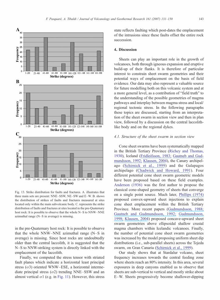
Fig. 13. Strike distribution for faults and fractures. A. illustrates thatthree main sets are present: NNE–SSW, NE–SW and E–W. B. showsthe distribution of strikes of faults and fractures measured at siteslocated only within the main subvolcanic body. C. represents the strikedistribution of faults and fractures at sites located in the pre-Quaternaryhost rock: It is possible to observe that the whole N–S to NNW–NNEazimuthal range (N–S in average) is missing.
143F. Pasquarè, A. Tibaldi / Journal of Volcanology and Geothermal Research 161 (2007) 131–150
in the pre-Quaternary host rock: It is possible to observethat the whole NNW–NNE azimuthal range (N–S inaverage) is missing. Since host rocks are undoubtedlyolder than the central laccolith, it is suggested that theN–S to NNW-striking system is directly linked with theemplacement of the laccolith.
Finally, we computed the stress tensor with striatedfault planes which indicate a horizontal least principalstress (σ3) oriented WNW–ESE, a horizontal interme-diate principal stress (σ2) trending NNE–SSW and analmost vertical σ1 (e.g. in Fig. 11). However, this stress
state reflects faulting which post-dates the emplacementof the intrusions since these faults offset the entire rocksuccession.
4. Discussion
Sheets can play an important role in the growth ofvolcanoes, both through igneous expansion and eruptivebuild-up of their flanks. It is therefore of particularinterest to constrain sheet swarm geometries and theirpotential ways of emplacement on the basis of fieldevidence. Our data may also represent a valuable sourcefor future modelling both on this volcanic system and ata more general level, as a contribution of “field truth” tothe understanding of the possible geometries of magmapathways and interplay between magma stress and local/regional tectonic stress. In the following paragraphsthese topics are discussed, starting from an interpreta-tion of the sheet swarm in section view and then in planview, followed by a discussion on the central laccolith-like body and on the regional dykes.
4.1. Structure of the sheet swarm in section view
Cone sheet swarms have been systematically mappedin the British Tertiary Province (Richey and Thomas,1930), Iceland (Fridleifsson, 1983; Gautneb and Gud-mundsson, 1992; Klausen, 2004), the Canary archipel-ago (Schirnick et al., 1999) and the Galapagosarchipelago (Chadwick and Howard, 1991). Fourdifferent potential cone sheet swarm geometric modelshave been proposed based on these field examples.Anderson (1936) was the first author to propose theclassical cone-shaped geometry of sheets that convergeon a single point source. Much later, Phillips (1974)proposed convex-upward sheet injections to explaincone sheet emplacement within the British TertiaryProvince. More recent papers (Gudmundsson, 1988;Gautneb and Gudmundsson, 1992; Gudmundsson,1998; Klausen, 2004) proposed concave-upward sheetswarm geometries above ellipsoidal shallow crustalmagma chambers within Icelandic volcanoes. Finally,the number of potential cone sheet swarm geometrieswas increased by the model proposing uniform sheet dipdistributions (i.e., sub-parallel sheets) across the Tejedaswarm, on Gran Canaria (Schirnick et al., 1999).
Our study shows that at Stardalur volcano, sheetfrequency increases towards the central feeding zonewhere sheets reach an 80% intensity. In this area, severalexposures in deep canyons enabled us to observe thatsheets are sub-vertical to vertical and mostly strike aboutE–W. Sheets progressively become shallower-dipping
144 F. Pasquarè, A. Tibaldi / Journal of Volcanology and Geothermal Research 161 (2007) 131–150
moving outwards from the central feeding zone in anydirection (Fig. 8A). This geometry could be interpretedeither as a swarm of radial planar sheets, or as a swarmof convex-upward or -downward radial sheets. Al-though in some cases it has been possible to follow inthe field single sheets showing a convex-upward geom-etry (e.g. Fig. 9C), our focus was more on reconstructingthe evolution of the intrusion system and delineatinggeneral geometric characteristics. Therefore, the trajec-tories of single sheets will be sketched as rectilinear.
Practically all sheets dip towards the central feedingzone, thus they can be classified as a centrally-dippingsheet swarm. Approaching the central zone, sheets anddykes are still present, as opposed to the classical Phillip's(1974) “cone sheet” model. With regard to dip, mostIcelandic cone sheet swarms show very limited dipvariations, with documented ranges of 20–25° atHvalfjordur (Gudmundsson, 1995), 20–30° at Tjaldanes(Gudmundsson et al., 1996) and 40–45° at Hafnarfjell(Gautneb et al., 1989). The outward decrease in dip, in ourcase, is about 12°/km, intermediate between thefew available data on sheet swarms in Iceland: TheReykjadalur volcano (Gautneb and Gudmundsson, 1992)exhibits an outward decrease from 56°-dipping sheets atits caldera centre to 31°-dipping sheets at the outermostparts of the swarm, with a 3°/km decrease, whereasKlausen (2004) defined a 17°/kmoutward decrease acrossthe circumferential Thverartindur swarm in SE Iceland.
With regard to the 1.7-m average thickness of ourentire sheet population, this value is greater than whatwas obtained by Gudmundsson et al. (1996) inindividual swarms, whose average thickness rangesfrom 0.1 m to around 1 m, and by Klausen (1999, 2004)who analysed 1128 sheets in the Thverartindur centralvolcano and obtained an average thickness of 0.9 m byextensively applying the method of thickness analysisintroduced by Jolly and Sanderson (1995), which hasproven to be most suitable for defining thicknessdistributions in classic cone sheet swarms made of agreat number of sheets. The differences between thesesmaller average thickness values and ours, may beexplained in terms of larger apertures along the intrusionpaths and a higher volumetric magma flow rate: Thismight have been the case during the interval in theevolution of Stardalur volcano which coincided with theemplacement of the centrally-dipping sheet swarm.
Going back to the Phillip's (1974) model, we believethat it cannot explain our case study, since our sheets/dykes are present in the central part and almost all theinclined sheets are confined within the caldera, and notalong its margins as in the Phillip's model. Thus, we arenot dealing with a classic “cone sheet” swarm, but,
taking into account also that sheet frequency increasestowards the center of the studied zone, we can concludethat we are dealing with a fan-shaped, centrally-dippingsheet swarm linked to a shallow magma chamber. Wealso emphasize the fact that the caldera is circular in planview with a diameter of about 6 km, against the di-mension of the centrally-dipping sheet swarm of2.5×3.5 km. Only a couple of inclined sheets dippingtowards our study area crop out outside the caldera rim.We believe that this is a reliable representation of thewhole sheet swarm associated to the Stardalur volcano,since outside our mapped area cropping conditions arefavourable: Pre-Quaternary rocks extensively crop outall around, at the same altitudes as the study area, nothidden by successive deposits. This means that thestudied sheet swarm is quite small if compared withother cases and should be related to a magma chamberwhich was smaller in size with respect to the chamberlinked to the caldera collapse.
The stress field controlling the orientation ofconcentric sheets is generally an interaction between alocal stress field generated by the magma chamber and aregional tectonic stress field. Another key factor is thepresence of layers in the volcano with different Young'smoduli: If the host rock is heterogeneous and highlyanisotropic the orientation of sheets may be stronglyaffected, as recent works have demonstrated and mod-elled (Gudmundsson and Brenner, 2004, 2005). Theexcess pressure of the magma chamber creates a localcompressive stress field around the reservoir with trajec-tories of the σ1 departing radially, which is suitable forthe intrusion of concentric cone sheets (Gudmundsson,1998). By assuming that the mapped sheets followed theplanes containing the σ1 and the σ2, and by plotting thevarious stress trajectories we obtained from thestructural data on faults and fractures, we were able torepresent the stress field in section view for the studiedarea (Fig. 14). In this sketch, two perpendicular sec-tions are drawn, so that the change of the stress field inthe N–S and E–W directions can be appreciated. At acloser view, the vertical principal stress (σv) can be σ1or σ3 depending on the considered position with respectto the magma chamber. Moreover, in an E–W sectionview, stress trajectories tend to depict a wider fan than inthe perpendicular N–S section view. The central part ofthe E–W section coincides with the σ1–σ2 plane, asassessed by the presence in this part of the dominant E–W-striking dykes. In this central feeding area, σ3 ishorizontal and trends N–S. Along the E–W verticalsection, eastward and westward of this central zone, σ2is replaced by σ3. Around the central zone, σ2 definesconcentric paths.
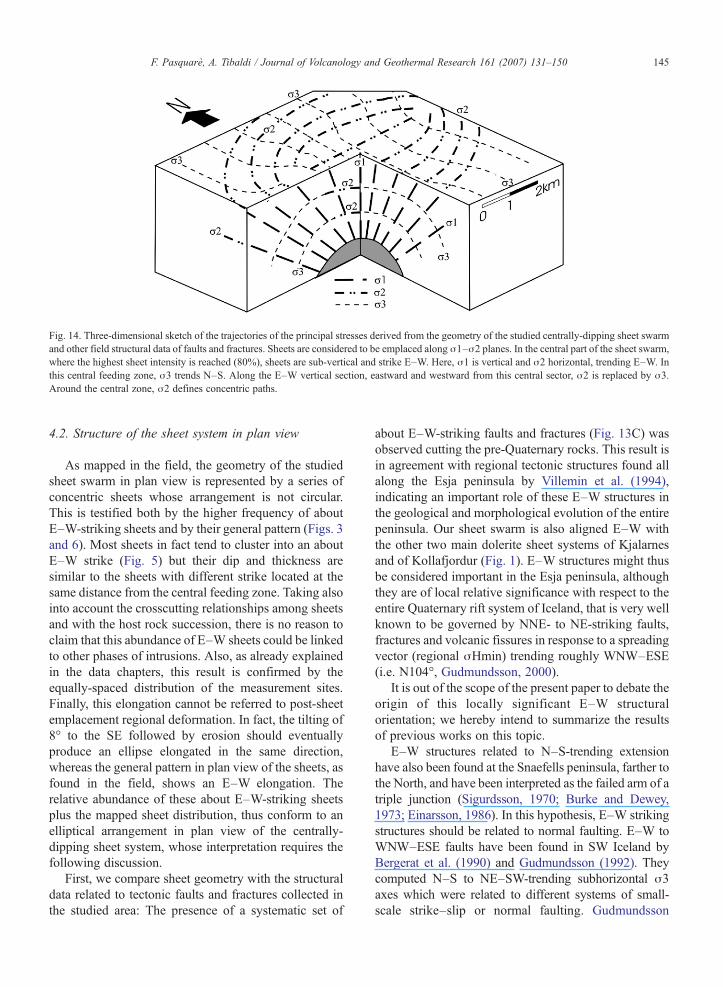
Fig. 14. Three-dimensional sketch of the trajectories of the principal stresses derived from the geometry of the studied centrally-dipping sheet swarmand other field structural data of faults and fractures. Sheets are considered to be emplaced along σ1–σ2 planes. In the central part of the sheet swarm,where the highest sheet intensity is reached (80%), sheets are sub-vertical and strike E–W. Here, σ1 is vertical and σ2 horizontal, trending E–W. Inthis central feeding zone, σ3 trends N–S. Along the E–W vertical section, eastward and westward from this central sector, σ2 is replaced by σ3.Around the central zone, σ2 defines concentric paths.
145F. Pasquarè, A. Tibaldi / Journal of Volcanology and Geothermal Research 161 (2007) 131–150
4.2. Structure of the sheet system in plan view
As mapped in the field, the geometry of the studiedsheet swarm in plan view is represented by a series ofconcentric sheets whose arrangement is not circular.This is testified both by the higher frequency of aboutE–W-striking sheets and by their general pattern (Figs. 3and 6). Most sheets in fact tend to cluster into an aboutE–W strike (Fig. 5) but their dip and thickness aresimilar to the sheets with different strike located at thesame distance from the central feeding zone. Taking alsointo account the crosscutting relationships among sheetsand with the host rock succession, there is no reason toclaim that this abundance of E–W sheets could be linkedto other phases of intrusions. Also, as already explainedin the data chapters, this result is confirmed by theequally-spaced distribution of the measurement sites.Finally, this elongation cannot be referred to post-sheetemplacement regional deformation. In fact, the tilting of8° to the SE followed by erosion should eventuallyproduce an ellipse elongated in the same direction,whereas the general pattern in plan view of the sheets, asfound in the field, shows an E–W elongation. Therelative abundance of these about E–W-striking sheetsplus the mapped sheet distribution, thus conform to anelliptical arrangement in plan view of the centrally-dipping sheet system, whose interpretation requires thefollowing discussion.
First, we compare sheet geometry with the structuraldata related to tectonic faults and fractures collected inthe studied area: The presence of a systematic set of
about E–W-striking faults and fractures (Fig. 13C) wasobserved cutting the pre-Quaternary rocks. This result isin agreement with regional tectonic structures found allalong the Esja peninsula by Villemin et al. (1994),indicating an important role of these E–W structures inthe geological and morphological evolution of the entirepeninsula. Our sheet swarm is also aligned E–W withthe other two main dolerite sheet systems of Kjalarnesand of Kollafjordur (Fig. 1). E–W structures might thusbe considered important in the Esja peninsula, althoughthey are of local relative significance with respect to theentire Quaternary rift system of Iceland, that is very wellknown to be governed by NNE- to NE-striking faults,fractures and volcanic fissures in response to a spreadingvector (regional σHmin) trending roughly WNW–ESE(i.e. N104°, Gudmundsson, 2000).
It is out of the scope of the present paper to debate theorigin of this locally significant E–W structuralorientation; we hereby intend to summarize the resultsof previous works on this topic.
E–W structures related to N–S-trending extensionhave also been found at the Snaefells peninsula, farther tothe North, and have been interpreted as the failed arm of atriple junction (Sigurdsson, 1970; Burke and Dewey,1973; Einarsson, 1986). In this hypothesis, E–W strikingstructures should be related to normal faulting. E–W toWNW–ESE faults have been found in SW Iceland byBergerat et al. (1990) and Gudmundsson (1992). Theycomputed N–S to NE–SW-trending subhorizontal σ3axes which were related to different systems of small-scale strike–slip or normal faulting. Gudmundsson
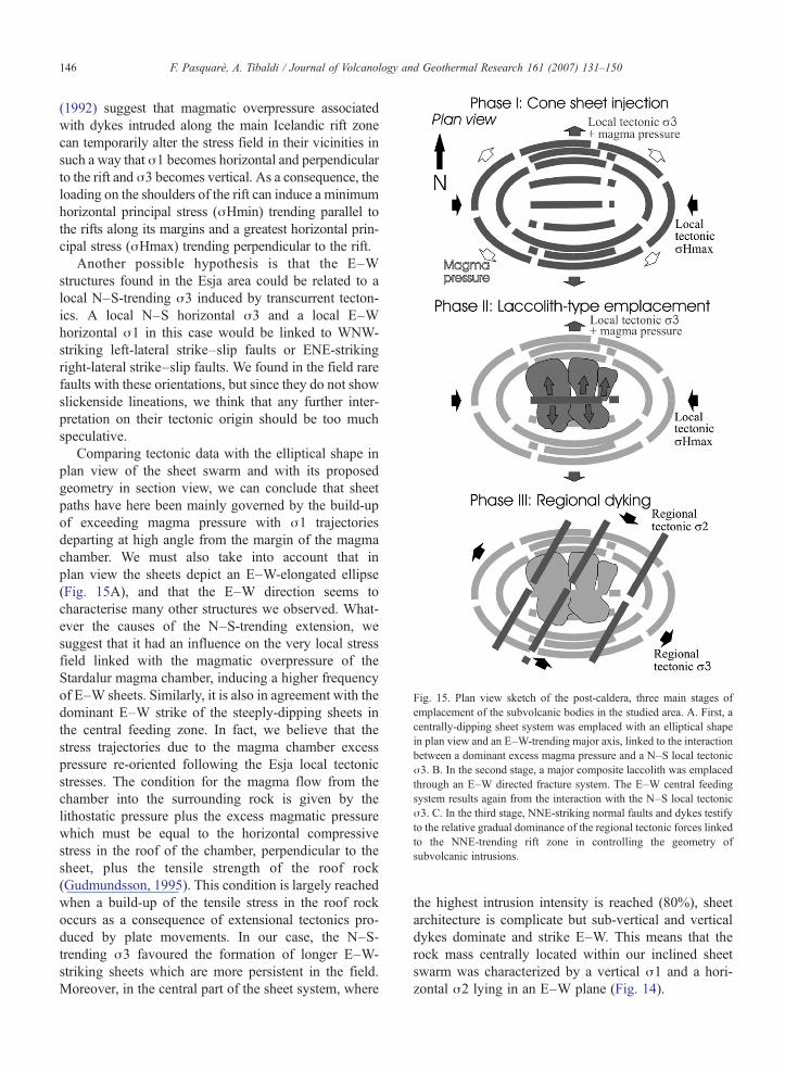
Fig. 15. Plan view sketch of the post-caldera, three main stages ofemplacement of the subvolcanic bodies in the studied area. A. First, acentrally-dipping sheet system was emplaced with an elliptical shapein plan view and an E–W-trending major axis, linked to the interactionbetween a dominant excess magma pressure and a N–S local tectonicσ3. B. In the second stage, a major composite laccolith was emplacedthrough an E–W directed fracture system. The E–W central feedingsystem results again from the interaction with the N–S local tectonicσ3. C. In the third stage, NNE-striking normal faults and dykes testifyto the relative gradual dominance of the regional tectonic forces linkedto the NNE-trending rift zone in controlling the geometry ofsubvolcanic intrusions.
146 F. Pasquarè, A. Tibaldi / Journal of Volcanology and Geothermal Research 161 (2007) 131–150
(1992) suggest that magmatic overpressure associatedwith dykes intruded along the main Icelandic rift zonecan temporarily alter the stress field in their vicinities insuch a way that σ1 becomes horizontal and perpendicularto the rift and σ3 becomes vertical. As a consequence, theloading on the shoulders of the rift can induce a minimumhorizontal principal stress (σHmin) trending parallel tothe rifts along its margins and a greatest horizontal prin-cipal stress (σHmax) trending perpendicular to the rift.
Another possible hypothesis is that the E–Wstructures found in the Esja area could be related to alocal N–S-trending σ3 induced by transcurrent tecton-ics. A local N–S horizontal σ3 and a local E–Whorizontal σ1 in this case would be linked to WNW-striking left-lateral strike–slip faults or ENE-strikingright-lateral strike–slip faults. We found in the field rarefaults with these orientations, but since they do not showslickenside lineations, we think that any further inter-pretation on their tectonic origin should be too muchspeculative.
Comparing tectonic data with the elliptical shape inplan view of the sheet swarm and with its proposedgeometry in section view, we can conclude that sheetpaths have here been mainly governed by the build-upof exceeding magma pressure with σ1 trajectoriesdeparting at high angle from the margin of the magmachamber. We must also take into account that inplan view the sheets depict an E–W-elongated ellipse(Fig. 15A), and that the E–W direction seems tocharacterise many other structures we observed. What-ever the causes of the N–S-trending extension, wesuggest that it had an influence on the very local stressfield linked with the magmatic overpressure of theStardalur magma chamber, inducing a higher frequencyof E–W sheets. Similarly, it is also in agreement with thedominant E–W strike of the steeply-dipping sheets inthe central feeding zone. In fact, we believe that thestress trajectories due to the magma chamber excesspressure re-oriented following the Esja local tectonicstresses. The condition for the magma flow from thechamber into the surrounding rock is given by thelithostatic pressure plus the excess magmatic pressurewhich must be equal to the horizontal compressivestress in the roof of the chamber, perpendicular to thesheet, plus the tensile strength of the roof rock(Gudmundsson, 1995). This condition is largely reachedwhen a build-up of the tensile stress in the roof rockoccurs as a consequence of extensional tectonics pro-duced by plate movements. In our case, the N–S-trending σ3 favoured the formation of longer E–W-striking sheets which are more persistent in the field.Moreover, in the central part of the sheet system, where
the highest intrusion intensity is reached (80%), sheetarchitecture is complicate but sub-vertical and verticaldykes dominate and strike E–W. This means that therock mass centrally located within our inclined sheetswarm was characterized by a vertical σ1 and a hori-zontal σ2 lying in an E–W plane (Fig. 14).
147F. Pasquarè, A. Tibaldi / Journal of Volcanology and Geothermal Research 161 (2007) 131–150
4.3. Central subvolcanic body
The data collected in the present work suggest thatthe subvolcanic body, located in the central portion ofthe mapped area, is made of a series of stacked thicksheets that propagated from an E–W linear feature.Although erosion occurred in the upper part of thisbody, the geometry of the discontinuities between thesingle emplacement units and of the columnar jointsindicate that it might be regarded as a laccolith-likebody, with a relatively depressed sector in the center,in correspondence of the main feeding zone (Fig. 10B).Outwards from this sub-vertical feeding zone, thesingle emplacement units acquired a sill attitude. Thus,the studied central intrusion is an example of alaccolith made up of a series of sills directly intocontact each others, without interlayered host rocks.This architecture is very similar to what has recentlybeen observed in the Henry Mountains of SouthernUtah by Horsman et al. (2005).
The E–W fractures that affect this laccolith arevertical and thus should result from a tensile stress witha horizontal N–S-trending σ3. The presence of thisfracture set in the laccolith and in the surrounding rockssuggests that it is related to a stress field of tectonicorigin. A similar discussion can be done for the aboutE–W normal faults which have been found and areconsistent with the regional structures of this peninsula(Villemin et al., 1994). The laccolith is also affected by aset of about N–S-striking, vertical to sub-verticalfractures. These fractures offset in a non-systematic waythe E–W-striking fractures, thus these two sets can berecognized to be contemporaneous. The presence oforthogonal fracture sets developed within the same timeinterval indicates the presence of two horizontal exten-sional axes producing the so called “chocolate tablestructures”. The N–S-striking fracture set is here limitedto the laccolith, ruling out the hypothesis that the N–S setcould belong to regional tectonic structures. These datacan be interpreted in view of a horizontal bi-extensionaldeformation related to an upward-directed force andbulging of part of the laccolith, most likely induced byexpansion of various underlying intrusive units.
Taking into account the E–W strike of the feedermagma paths to the various sills composing thelaccolith, we believe that once again, as occurred withthe centrally dipping sheets, the tectonics of the Esjapeninsula influenced the geometry of the laccolith. TheE–W feeding paths were in fact favoured by the N–S-trending extension related to a possible local tectonic σ3acting here in that period (Fig. 15B). The horizontal sillswhich compose the major part of this laccolith could be
once again the expression of the interaction with an E–W-trending σHmax and/or a consequence of itsemplacement at the boundary level between hyaloclas-tites and lava flows (in the second case, a strong controlcould have been exerted by the different rheologies ofthe host rocks).
We must point out that a partially alternative viewmight relate the E–Welongation of the sheet swarm andof the laccolith feeding paths to a parallel elongation ofthe magma chamber. This stimulating hypothesis wouldneed validation by new, very detailed geophysicalprospecting into the underlying pluton or a complexanalysis based on three-dimensional numerical model-ling, which are out of the scope of this work.
We also highlight that the laccolith is not dissected byany intrusion related to vertical conduits feeding magmato the Stardalur volcano. Since all the reconstructions(Fridleifsson and Kristjansson, 1972; Fridleifsson, 1977;Villemin et al., 1994; Johannesson and Saemundsson,1998; our observations) suggest that this volcano shouldhave been originally placed in coincidence with thecaldera and the studied area, the lack of post-laccolithvertical conduits indicates a likely cessation of theeruptive activity in the summit part of the edifice. Latereruptions, if they occurred at all, were fed by centrally-dipping sheets and took place at lateral/flank centers.
4.4. Regional dykes
Like already mentioned, a few dykes were observed inthe study area: They cut the centrally-dipping sheets andall the host rock succession, systematically strike NNE–SSW and, spanning from 0.4 to 1 m, are thinner than theaverage Pleistocene regional dykes of SW Iceland, whosemean thickness is 1.4 m (Gudmundsson, 1992, 1995).The entire intrusive and effusive rock succession is alsooffset by a system of NNE- to NE-striking normal faultswith striations indicating a horizontal WNW–ESE-trending σ3 (e.g. Fig. 11). Most normal faults of thisyounger system dip towards WNW with dip of 60–75°(e.g. Fig. 4A). The observed dykes instead are morevertical and apparently did not use pre-existing faults asfeeding path at the uppermost level of emplacement. Thissuggests that these regional dykes occurred throughopening of new fractures or already existing fractures ona plane normal to σ3.
When the compressive stress field around themagma chamber induced by magma excess pressureis weak or disappears as it freezes, the effect of theregional tectonic stress field becomes dominant on thedevelopment of dykes, and a parallel dyke swarm willbe formed if σ3 is horizontal. The structural difference
148 F. Pasquarè, A. Tibaldi / Journal of Volcanology and Geothermal Research 161 (2007) 131–150
between the studied concentric sheets and the NNE-striking dyke swarm reflects the possible fact thatregional dykes were emplaced when the Stardalurvolcano was completely non active.
The above evidence indicates an anticlockwise shiftwith time of the local extensional axis from N–S toWNW–ESE which controlled the younger emplacementof dykes which are no more related to the centrally-dipping sheet system (Fig. 15C). At the time of em-placement of the NNE-striking dykes, the regionaltectonic forces completely controlled the geometry ofintrusions.
5. Conclusions
By analysing structural field data on sheets, dykes,faults and fractures, we identified a three-staged de-velopment of the subvolcanic system emplaced under-neath the Stardalur volcano, in the Esja peninsula,highlighting the relationships between magma andtectonic stresses.
– First stage. A centrally-dipping sheet swarm wasemplaced. In plan view, they were emplaced with anelongated shape and an E–W-trending major axis.The swarm developed contemporaneously to theformation of about E–W faults and fractures. Thearchitecture of the intrusive system has been inter-preted here as derived from the interaction between adominant excess magma pressure linked to a rela-tively small magma chamber located at a low depth, aN–S-trending local tectonic σ3 and an E–W-trendinglocal σHmax.
– Second stage. Based on the fact that no sheets cutthrough the major laccolith-like body, we suggestthat it was emplaced at a later stage. This laccolith iscentrally located with respect to the sheet swarmbut at higher altitude, and was emplaced through anE–W linear feature. The single intrusive units movedupwards along vertical planes and then bendedoutwards, acquiring a sill-like attitude. The geometryof the E–W central feeding zone of the laccolith-likebody has been controlled by a N–S-trending localhorizontal σ3. The sill attitude of the external parts ofthis body could be linked to an E–W-trending localσHmax and/or contrasting rheologies of the hostrocks. We think that the second hypothesis is morelikely since the laccolith was emplaced at therheological boundary between dominant upperlavas and lower hyaloclastites. It is likely that nomore eruptive activity occurred in the summit zone ofthe Stardalur volcano.
– Third stage. The entire rock succession in the studiedarea is offset by a system of NNE-striking normalfaults and a few dykes. Fault striations indicate ahorizontal WNW–ESE-trending σ3. At this stage,the regional tectonic forces completely controlled thegeometry of subvolcanic intrusions.
All these data indicate an anticlockwise shift withtime of the extensional axis from N–S to WNW–ESEwhich controlled, with increasing dominance, thegeometric pattern of emplacement of sub-volcanicintrusions. This reflects a decrease in the role ofmagma pressure with respect to regional, far-fieldstresses in controlling magma paths.
Acknowledgments
We would like to express our sincerest thanks to A.Gudmundsson and M. B. Klausen for their prompt andthorough reviews of the original manuscript, whichallowed us to considerably improve the final version.This is a contribution to the UNESCO-IUGS-IGCPproject 455 and to the ILP project “New tectonic causesof volcano failure and possible premonitory signals”.
References
Acocella, V., Tibaldi, A., 2005. Dike propagation driven by volcanocollapse: a general model tested at Stromboli, Italy. Geophys. Res.Lett. 32. doi:10.1029/2004GL022248.
Allard, P., Carbonelle, J., Metrich, N., Loyer, H., Zettwoog, P., 1994.Sulphur output and magma degassing budget of Stromboli. Nature368, 326–330.
Anderson, E.M., 1936. Dynamics of formation of cone-sheets, ring-dikes, and cauldron subsidences. Proc. R. Soc. Edinb. 56, 128–157.
Annels, A.E., 1967. The geology of the Hornafjordur Region. PhDThesis, University of London.
Baer, G., Heimann, A. (Eds.), 1995. Physics and Chemistry of Dykes.Balkema, Rotterdam.
Bailey, E.B., Clough, C.T., Wright, W.B., Richey, J.E., Wilson, G.V.,1924. The Tertiary and Post-Tertiary Geology of Mull, Loch Alineand Oban: Geological Survey of Scotland Memoir. 445 p.
Bergerat, F., Angelier, J., Villemin, T., 1990. Fault systems and stresspatterns on emerged oceanic ridges: a case study in Iceland.Tectonophysics 179, 183–197.
Bolchover, P., Lister, J.R., 1999. The effect of solidification on fluid-driven fracture with application to bladed dykes. Proc. R. Soc. Lond.,A 455, 2389–2409.
Borgia, A., Ferrari, L., Pasquarè, G., 1992. Importance of gravitationalspreading in the tectonic and volcanic evolution of Mount Etna.Nature 357, 231–235.
Burke, K., Dewey, J.F., 1973. Plume-generated triple junctions: keyindicators in applying plate tectonics to old rocks. J. Geol. 81,406–433.
Carey, E., 1979. Recherche des directions principales de contraintesassociees au jeu d’une population des failles. Rev. Geogr. Phys.Geol. Dyn. 21 (1), 57–66.
149F. Pasquarè, A. Tibaldi / Journal of Volcanology and Geothermal Research 161 (2007) 131–150
Chadwick Jr., W.W., Howard, K.A., 1991. The pattern of circumfer-ential and radial eruptive fissures on the volcanoes of Fernandinaand Isabela Islands, Galapagos. Bull. Volcanol. 53, 259–275.
Delaney, P.T., Pollard, D.R., 1982. Solidification of basaltic magmaduring flow in a dike. Am. J. Sci. 282, 856–885.
Einarsson, P., 1986. Seismicity along the eastern margin of the NorthAmerican Plate. In: Vogt, P.R., Tucholke, B.E. (Eds.), The Geologyof the North America. Geol. Soc. Am., vol. M, pp. 99–116.
Fialko, Y.A., Rubin, A., 1999. Thermal and mechanical aspects ofmagma emplacement in giant dike swarms. J. Geophys. Res. 104,23,033–23,049.
Fiske, R.S., Jackson, E.D., 1972. Orientation and growth of Hawaiianvolcanic rifts. Proc. R. Soc. Lond. 329, 299–326.
Fridleifsson, I.B., 1972. Geological Map of Esja. Southwest Iceland.1:50,000 scale. National Energy Authority, Iceland.
Fridleifsson, I.B., 1977. Distribution of large basaltic intrusions in theIcelandic crust and the nature of the layer 2-layer 3 boundary. Geol.Soc. Amer. Bull. 88, 1689–1693.
Fridleifsson, G.O., 1983. The geology and the alteration history of theGeitafell central volcano, southeast Iceland. PhD Thesis, Univer-sity of Edinburgh, 371 pp.
Fridleifsson, I.B., Kristjansson, L., 1972. The Stardalur magneticanomaly, SW Iceland. Jokull 22, 69–78.
Gautneb, H., Gudmundsson, A., 1992. Effect of local and regionalstress fields on sheet emplacement in West Iceland. J. Volcanol.Geotherm. Res. 51, 339–356.
Gautneb, H., Gudmundsson, A., Oskarsson, N., 1989. Structure,petrochemistry, and evolution of a sheet swarm in an Icelandiccentral volcano. Geol. Mag. 126, 659–673.
Geikie, A., 1897. The Ancient Volcanoes of Great Britain. Macmillan,London.
Gudmundsson, A., 1988. Effect of tensile stress concentration aroundmagma chambers on intrusion and extrusion frequencies.J. Volcanol. Geotherm. Res. 35, 179–194.
Gudmundsson, A., 1990. Emplacement of dykes, sills and crustalmagma chambers at divergent plate boundaries. Tectonophysics176, 257–275.
Gudmundsson, A., 1992. Formation and growth of normal faults at thedivergent plate boundary in Iceland. Terra Nova 4, 464–471.
Gudmundsson, A., 1995. Infrastructure and mechanics of volcanicsystems in Iceland. J. Volcanol. Geotherm. Res. 64, 1–22.
Gudmundsson, A., 1998. Magma chambers modeled as cavities explainthe formation of rift zone central volcanoes and their eruption andintrusion statistics. J. Geophys. Res. 103 (B4), 7401–7412.
Gudmundsson, A., 2000. Dynamics of volcanic systems in Iceland.Annu. Rev. Earth Planet. Sci. 28, 107–140.
Gudmundsson, A., 2002. Emplacement and arrest of sheets and dykesin central volcanoes. J. Volcanol. Geotherm. Res. 116, 279–298.
Gudmundsson, A., Brenner, S.L., 2004. How mechanical layeringaffects local stresses, unrests, and eruptions of volcanoes.Geophys. Res. Lett. 31, L16606. doi:10.1029/2004GL020083.
Gudmundsson, A., Brenner, S.L., 2005. On the conditions of sheet injec-tions and eruptions in stratovolcanoes. Bull. Volcanol. 67, 768–782.
Gudmundsson, A., Bergerat, F., Angelier, J., 1996. Off-rift and rift-zonepalaeostresses in northwest Iceland. Tectonophysics 255, 211–228.
Halls, H.C., Fahrig, W.F. (Eds.), 1987. Mafic Dyke Swarms.Geological Association of Canada Special Paper, vol. 34. 503 pp.
Harker, A., 1904. The Tertiary igneous rocks of Skye. Mem. Geol.Surv. 1–481.
Horsman, E., Tikoff, B., Morgan, S., 2005. Emplacement-relatedfabric and multiple sheets in the Maiden Creek Sill, HenryMountains, Utah. J. Struct. Geol. 27 (8), 1426–1444.
Johannesson, H., Saemundsson, K., 1998. Geological Map of Iceland.Tectonics, 2nd ed. Icelandic Museum of Natural History andIceland Geodetic Survey, Reykjavik.
Jolly, R.J.H., Sanderson, D.J., 1995. Variations in the form anddistribution of dikes in the Mull swarm, Scotland. J. Struct. Geol.17 (11), 1543–1557.
Klausen, M.B., 1999. Structure of rift-related igneous systems andassociated crustal flexures: examples from a Late Tertiary rift zonein SE Iceland and the Early Tertiary volcanic rifted margin in eastGreenland. PhD Thesis, University of Copenhagen, 283 pp.
Klausen, M.B., 2004. Geometry and mode of emplacement of theThverartindur cone sheet swarm, SE Iceland. J. Volcanol.Geotherm. Res. 138, 185–204.
Klausen, M.B., 2006. Geometry and mode of emplacement of dikeswarms around the Birnudalstindur igneous centre, SE Iceland.J. Volcanol. Geotherm. Res. 151, 340–356.
Klausen, M.B., Larsen, H.C., 2002. The East Greenland coast-paralleldyke swarm and its role in continental breakup. In: Menzies, M.A.,Klemperer, S.L., Ebinger, C.J., Baker, J. (Eds.), Volcanic RiftedMargins. Boulder, Colorado, Geol. Soc. Am. Spec. Paper, vol. 362,pp. 133–158.
Lister, J.R., Kerr, R.C., 1991. Fluid-mechanical models of crackpropagation and their application to magma transport in dykes.J. Geophys. Res. 96, 10,049–10,077.
Menand, T., Tait, S., 2002. The propagation of a buoyant liquid-filledfissure from a source under constant pressure: An experimentalapproach. J. Geophys. Res. 107 (B11), 2306. doi:10.1029/2001JB000589.
Muller, O.H., Pollard, D.D., 1977. The stress state near Spanish Peaks,Colorado, determined from a dike pattern. Pure Appl. Geophys.115, 69–86.
Nakamura, K., Jacob, K., Davies, J., 1977. Volcanoes as possibleindicators of tectonic stress orientation — the Aleutians andAlaska. Pure Appl. Geophys. 115, 87–112.
Parker, A.J., Rickwood, P.C., Tucher, D.H., 1990. Mafic Dykes andEmplacement Mechanics. Balkema, Rótterdam.
Phillips, W.J., 1974. The dynamic emplacement of cone sheets.Tectonophysics 24, 69–84.
Pollard, D.D., 1973. Derivation and evaluation of a mechanical modelfor sheet intrusions. Tectonophysics 19, 233–269.
Pollard, D.D., Muller, H., 1976. The effect of gradients in regionalstress and magma pressure on the form of sheet intrusions in crosssection. J. Geophys. Res. 81 (5), 975–984.
Pollard, D.D., Segall, P., 1987. Theoretical displacement and stressesnear fractures in rock: with applications to faults, joints, veins,dikes, and solution surfaces. In: Atkinson, B.K. (Ed.), FractureMechanics of Rock. Academic Press, Inc., pp. 277–349.
Richey, J.E., Thomas, H.H., 1930. The Geology of Ardnamurchan,Northwest Mull and Coll. Mem. Geol. Surv., Scotl. (393 pp.).
Rubin, A.M., 1995. Propagation of magma-filled cracks. Annu. Rev.Planet. Sci. 23, 287–336.
Schilling, J.G., 1973. Iceland mantle plume: geochemical study ofReykjanes Ridge. Nature 242, 565–571.
Schirnick, C., van den Bogaard, P., Schmincke, H.-U., 1999. Conesheet formation and intrusive growth of an oceanic island — theMiocene Tejeda complex on Gran Canaria (Canary Islands).Geology 27 (3), 207–210.
Sigurdsson, H., 1970. Structural origin and plate tectonics of theSnaefellsnes volcanic zone, Western Iceland. Earth Planet. Sci.Lett. 10, 129–135.
Spence, D.A., Turcotte, D.L., 1985. Magma-driven propagation ofcracks. J. Geophys. Res. 90 (1), 575–580.

150 F. Pasquarè, A. Tibaldi / Journal of Volcanology and Geothermal Research 161 (2007) 131–150
Spence, D.A., Sharp, P.W., Turcotte, D.L., 1987. Buoyancy-drivencrack propagation: a mechanisms for magma migration. J. FluidMech. 174, 135–153.
Thordarsson, T., Hoskuldsson, A., 2002. Iceland. Classic Geology inEurope. Terra Ed., 200 p.
Tibaldi, A., 1996. Non-tectonic faulting: examples from lateQuaternary trachytes of Ischia Island and basalts of Mt. Etna,Italy. Acta Vulcanol. 8 (1), 91–98.
Tibaldi, A., 2001. Multiple sector collapses at Stromboli volcano,Italy: how they work. Bull. Volcanol. 63 (2/3), 112–125.
Tibaldi, A., 2003. Influence of volcanic cone morphology on dikes,Stromboli, Italy. J. Volcanol. Geotherm. Res. 126, 79–95.
Tibaldi, A., Groppelli, G., 2002. Volcano–tectonic activity along thestructures of the unstable NE flank of Mt. Etna, Italy. J. Volcanol.Geotherm. Res. 115 (3–4), 277–302.
Villemin, T., Bergerat, F., Angelier, J., Lacasse, C., 1994. Brittledeformation and fracture patterns on oceanic rift shoulders: theEsja peninsula, SW Iceland. J. Struct. Geol. 16 (12), 1641–1654.
Walker, G.P.L., 1992. Coherent intrusive complexes in large basalticvolcanoes — a new structural model. J. Volcanol. Geotherm. Res.50, 41–54.
Watanabe, T., Masuyama, T., Nagaoka, K., Tahara, T., 2002. Analogueexperiments of magma-filled cracks: Competition betweenexternal stresses and internal pressure. Earth Planets Space 54,1247–1261.
Wilson, L., Head, J.W., 1981. Ascent and eruption of basaltic magmaon the Earth and Moon. J. Geophys. Res. 86, 2971–3001.
Related Documents