STRUCTURE AND TECTONICS OF THE SOUTHERN GEBEL DUWI AREA, EASTERN DESERT OF EGYPT BY MICHAEL J. VALENTINE 34°20' 26°15' 26°0 5' 26°00 ' 34°00' 0 MILE S 34° 1 0' I I -v I ' ... 0 0 0 I 26°10' "QUSEIR BASIN" \ \..) \ \ \ 26°05' Wis e, Gr eene, Volentine, Abu Zied B Trueblood, 1 983 26000 , 34°20' CONTRIBUTION N0 . 53 DEPARTMENT OF GEOLOGY 8 GEOGRAPHY UNIVERS ITY OF MASSACHUSETTS

Welcome message from author
This document is posted to help you gain knowledge. Please leave a comment to let me know what you think about it! Share it to your friends and learn new things together.
Transcript

STRUCTURE AND TECTONICS OF THE SOUTHERN GEBEL DUWI AREA, EASTERN DESERT OF EGYPT
BY MICHAEL J. VALENTINE
34°20' ,------------:;::-:::-::--~;:--~~---.,.-.,-,---;---.=---------------, 26°15'
26°05'
26°00' 34°00'
0 MILES
34° 10'
I I -v I ' ...
0 0 0
I 26°10'
"QUSEIR BASIN"
\ \..) \ \
\
26°05'
Wis e, Greene, Volentine, Abu Zied B Trueblood, 1983 26000
,
34°20'
CONTRIBUTION N0.53
DEPARTMENT OF GEOLOGY 8 GEOGRAPHY
UNIVERSITY OF MASSACHUSETTS
AMHERS~MASSACHUSETTS

STRUCTURE AND TECTONICS
OF THE
SOUTHERN GEBEL DUWI AREA
EASTERN DESERT OF EGYPT
By
Michael James Valentine
Contribution No. 53
Department of Geology and Geography
University of Massachusetts
Amherst, Massachusetts
April, 1985
Prepared in cooperation with the
Earth Sciences and Resources Institute
of the University of South Carolina


"x:l
'i
0 ::i
c+
I-'·
(/l
"d
I-'·
CD
(}
CD I I
0 t-
' I-
"):.>
~
c+
t::
~
(/)
CD
:.>
1-J
0 CD
'i
o"
CD
CD
c+
I-'
c 'i
t::l
::i
c :(
cJ
I-'•
CD
P>
P>
El
'i
CD
<
P>
......
p,
I-'·
(}
0 ::i
rri:
..
.

ABSTRACT
This study examines the Precambrian through.Tertiary
tectonic elements of an area of about 350 square km
the Red Sea coast utilizing geologic mapping
petrofabric work. The resulting data are used to
along
and
test
ideas concerning faulting, stress history, and the effects
of older anisotropies. The study area,
Suez and 10 km inland from the Red Sea,
500 km south of
contains the
largest preserved remnants of late Cretaceous to early
Tertiary cover along the Egyptian Red Sea coast. These
600 meter-thick platform sediments are preserved as
outliers downfaulted along trends atypical of the Eastern
Desert. Fault trends are most prominent in the northwest
trending, 40 km long Gebel Duwi fault block and appear to
be reactivated Precambrian structures: the northwest-.
striking,
superimposed
grain.
Eocambrian Najd strike-slip fault zone
upon a north-northwest Proterozoic fold
Red Sea-related structures began to disrupt the area
in Oligocene to early Miocene time; a pattern of small
conjugate strike-slip faults of that age suggests N25E
compression. The Tertiary faulting hierarchy involves a
pattern of northeast-tilted, northwest-trending blocks
terminating against older north-south zones with some
iv

suggestion of en echelon patterns of the younger blocks.
Typical throws on major faults are 500-800 meters.
Tilting was followed by an eastward shift of tectonic
activity to form the main Red Sea basin. A post-tilting
regional erosion surface developed during mid-Miocene
quiescence and has since suffered minor disruption.
Folding is minor except for drag folding along major
fault zones and a 50 meter wavelength overturned fold atop
Gebel Duwi, which may be the result of gravity tectonics.
The data suggest a multi-stage history for the Red
Sea: 1) post-early Eocene uplift accompanied by N25E
compression; 2) Oligocene to early Miocene major faulting,
block tilting, and subsequent erosion; 3) early to mid-
Miocene major activity to the east of the study area
producing the main Red Sea trough while the regional
erosion surface was enhanced along the shoulders; 4)
post-mid-Hiocene final adjustments producing coast-
parallel horsts, with subdued tectonic activity continuing
through the present.
Results of the study have implications for the
evolution and style of deformation of the shoulders of
developing ocean basins. Possible continuations of the
same tilted fault block structural style controlled by
basement grain along the zone of Najd trends should be of
interest for offshore petroleum exploration.
v

TABLE OF CONTENTS
Abstract . . . . . . . . . . . . . . . . . . . . . . Chapter
I. INTRODUCTION . . . . . . . . . . Geographic Setting • • • • • • • • • • Regional Geologic Setting • • • • • • • • • Previous and Current Work • • • • • • • • • Geologic Nap and Gross Structural
Features ••............. Acknowledgements • • • • • • • • • ••
II. PRECAMBRIAN BASEMENT STRUCTURE AND ANISOTROPY • • • • • • • • • • • • • •
Basement of the Study Area •••••• Precambrian Tectonic Setting and Basement Correlations • • • • • • • • • • • • •
Volcanic arc accretion model • • • • • Volcanic-plutonic rocks ••• Ophiolite melange •••••••• Gneisses and schists •••••• Melange-type sediments
Summary of Arabian-Nubian Shield development •••.•••••••••
Regional Structural Grain • • • • • • • •• North-south Hijaz-Asir grain • Northwest Najd grain •••••••
Folding • • • • • . . • • • Bedding and volcanic layering
Foliations and cleavages Lineations
Dikes and Sills •• Quartz Veins • • • • • • • • • • •
III. STRATIGRAPHY OF THE SEDIMENTARY COVER
. .
Cretaceous to Eocene Sediments . . . . llubia Formation Quseir Formation Duwi Formation Dakhla Formation Tarawan Formation
vi
. . . . . . . . . . .
iv
1
3 3 8
1 2 1 5
20
20
24 26 28 29 29 31
31 33 37 37 38 41 43 46 48 51
55
55 55 59 61 63 64

Esna Formation Thebes Formation
. . . . . . . Topographic expression • • ••
Post-Lower Eocene to Pre-Middle Miocene Deposits • • • • • • • •
Nakheil Formation • • • • • • Middle Miocene to Recent Deposits
Recent wadi alluvium • • • •
IV. STRUCTURAL FABRIC ••••
Faults Joints Veins • Lineaments
. . . . . . . Basement lineaments Cover lineaments • • •
V. MAJOR FAULT AND FOLD STRUCTURES
. . . .
. . . .
Faul ts • • • • • • • • • • • • • • • • • • Wadi el Isewid Fault Zone .••• Wadi Nakheil Fault Zone • • • Wadi Hammadat-Wadi Kareim Fault
Zone • • • • • • • • • • • • • • Bir Inglisi Fault Zone •••••• Gebel Nasser-Gebel Ambagi Fault
Zone Gebel Atshan Fault Zone
Folds • • • • • •
VI. REGIONAL TECTONICS
65 65 66
68 68 71 71
72
72 77 80 80 80 84
87
87 87 88
90 90
94 101 102
106
Tectonic History of the Study Area • • • • 106 Tectonic Heredity • • • • • • • • • • • • • 112 The Red Sea •••••••••••••••• 115 The Falvey Model • • • • • • • • • • • • • 119
VII. SUMMARY AND CONCLUSIONS •
History of the Study Area • • • • • Major Achievements of the Study Future Work • • • • • • • • • • • •
vii
. .
123
123 126 127


LIST OF TABLES
1. Said 1 s Cretaceous to Recent Stratigraphy 2. Akkad and Noweir's Basement Stratigraphy 3. Precambrian History ••••••••••••• 4. Phanerozoic History •••••••••••
ix
10 . 22 & 2.3
25 111

ILLUSTRATIONS
Plate 1 • Geologic Map of the Southern Gebel Duwi Area 2. Geologic Cross Sections
[Plates in back pocket]
Frontispiece--LANDSAT Return Beam Vidicon (RBV) Image of the Gebel Duwi Area • • •
Figure 1 • Index Geologic Nap of the Gebel Duwi Area 2. Topography of the Study Area ••••••••• 3. Main Features of the Study Area ••••••• 4. Geologic Map of Egypt •••••••••••• 5. Major Faults and Fault Blocks •••••••• 6. Structural Contour Map on Basement of
the Southern Gebel Duwi Area •• 7. Structural Contour Map on Basement of
the Quseir-Safaga Region • • • • • • • • • • 8. Ophiolite Belts of the Arabian-Nubian Shield • 9. The Alignment of Najd Trends in Egypt and
Saudi Arabia Prior to Red Sea Development Structural Grain of the Arabian Shield •••• 1 0 •
11 • 1 2 • 13. 1 4 . 1 5 • 1 6. 1 7 •
1 8 • 1 9 . 20. 21 • 22.
Basement Fold Data ••••••• Basement Planar Fabric Data ••••• Three Phases of Basement Folding •• Basement Linear Fabric Data Basement Intrusions . . . . . Basement Quartz Veins •.••• Stratigraphy of the Cretaceous to
Eocene Cover • • • • • • • • • • Fault Data • . • • • • • • • • • • • • • N20E Compression •••• Joint Data •••••••
. . .
. . . Veins in the Sedimentary Cover •••••••• Basement Lineaments, Southern Gebel
iii
2 4 5 6
14
1 6
1 7 30
34 36 40 42 45 47 50 52
56 73 76 78 81
Duvri Area •..•••••••••••••• 82 23. 24. 25. 26. 27. 28.
Basement Lineaments, Quseir-Safaga Area • • • 83 Lineaments of the Sedimentary Cover • • • • • 86 Geology of the Gebel Nakheil Area • • • • 92 & 93 Geology of the Gebel Nasser Area • • • • • 96 & 97 Gebel Nasser Structure • • • • • • • • • • • • 98 Slip on Joints as a Mechanism of Folding ••• 100
x

C H A P T E R I
INTRODUCTION
Much recent geologic interest in the Red Sea region
has centered on mechanisms of continental rifting, small
ocean basin formation, and the relation of these processes
to offshore petroleum exploration and developnent. This
study examines the mechanisms of deformation, stress
history, influences of tectonic heredity, and the
interplay of these elements in an area adjacent to the Red
Sea.
The study area is near Quseir on the Red Sea coast of
Egypt about 500 km south of Suez (Figure 1) and was
chosen for its excellent exposure of tilted basement
blocks and their Cretaceous to Tertiary cover. Gebel
Duwi, the most prominent of the tilted fault blocks in
that area, is the focus of the study. The area is
characterized by divergence of structural trends from the
typical Red Sea-parallel trends present along the Egyptian
coast. The main objective of this study is a better
understanding of the interaction of Tertiary stresses with
pre-existing anisotropies to produce the unusual pattern
of Red Sea-related structures present in the Quseir area.
1

LEGEND ~Wadi Alluvium
" I
[<~~-=;]Miocene-Recent Sediments
m Cretaceous- Eocene Sediments
Ll Precambrian Basement
25° ,
50
, ..,.- Normal Fault-ticks on down side \. RICHARDSON 250 -:t~~~~~~~~-,~~~~~~J_~.:__,-~_:'._~~~~~~~~~:11.:50'
3 3 ° 5 o' 34°201
Figure 1. Map of the Quseir-Safaga region of Egypt showing location, general geology, and study areas of recent workers (geology after Said, 1962).

3
Geographic Setting
The 17 by 20 kilometer area considered in this study
lies about 8 kilometers west of the coastal town of Quseir
along the Quseir-Qena road and is centered around the
southeastern end of Gebel Duwi, the most conspicuous ridge
in the Quseir area (Figure 1 ). The terrain is· rugged,
with over 300 meters of total relief (Figure 2). Access
to the more remote areas can be gained from the raain
Quseir-Qena asphalt road via a series of dirt tracks
maintained by the Quseir Phosphate Company (Figure 3).
Several gebels (mountains), wadis (dry fluvial valleys),
and birs (brackish-water wells) will be used as landmarks
when discussing the geology.
Regional Geologic Setting
The Eastern Desert of Egypt includes the area between
the Nile River and the Gulf of Suez/Red Sea (Figure 4).
Its most prominent feature is a north-northwest trending
range of mountains that parallels the Red Sea coast. This
Red Sea Range extends from Gebel Urn Tenassib (latitude 28°
30'N) in the north, southeastward into Sudan forming a
more-or-less linear series of mountain groups, rather than
a true continuous chain. Sedimentary plateaus occur to

.-----:::-- --~
Main Rood
Wadi Course
Topogroph1c
Contour
Contour Interval
"50 merers
0 I 2 3 4
K M
RED SEA
26°10· N
\ \ "' U '\ 11 I "\ \ \ r J 26° N
Figure 2. Topographic map of the southern Gebel Duwi area. ~

26° 10' N
0 Wadi ai\uVllUm
D Dutt.to,"
'""¥ _,...,.,,_..road ---- Plrt tr.11.::.ll• •ucu1IJl'ic
~ '4· whe~ dnve Y~hu.\c-. 1" frnnq, lW
~~tc"'"e • ,,..U.k ••h 1,,.-inr:i /wdl
26001'NI LJ ~~~ ;f q "(,~ ~- ""~ ;.,,,~~ l <:=- Yr<-~::::·.:.,-;,~ ~.':'":-:.: .::;;.
Figure J. Hain fea~ures of the southern Gebel Duwi area. V1

E'J Recent
Q OliQoccnc-P1erstocene
~ Cr etoceo1.1s-Eoc.ene
• Combrion-Tr1oss1c
LJ Precomb11on
KM
SAUDI
ARABIA
30°
I I
izeo
I
j 26° I
124°
22°
Figure 4. Geologic map of Egypt (after Said, 1962).
6
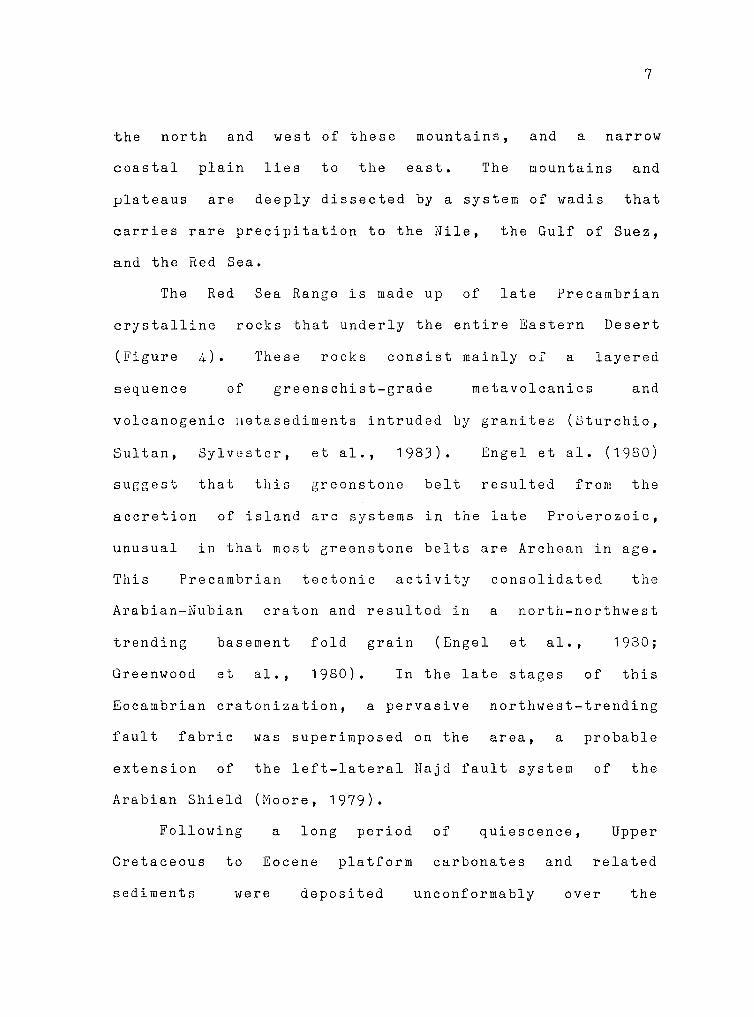
7
the north and west of these mountains, and a narrow
coastal plain lies to the east. The mountains and
plateaus are deeply dissected by a system of wadis that
carries rare precipitation to the Nile, the Gulf of Suez,
and the Red Sea.
The Red
crystalline
(Figure 4).
Sea Range is made up of late Precambrian
rocks that underly the entire Eastern Desert
These rocks consist mainly of a layered
sequence of greenschist-grade metavolcanics and
volcanogenic 11etasediments intruded by granites (Sturchio,
Sultan, Sylvester, et al., 1983). Engel et al. (1980)
suggest that this greenstono belt resulted from the
accretion of island arc systems in the late Proterozoic,
unusual in that most greenstone belts are Archean in age.
This Precambrian tectonic activity consolidated the
Arabian-Nubian craton and resulted in a north-northwest
trending basement fold grain (Engel et al., 1980;
Greenwood et al., 1980). In the late stages of this
Eocambrian cratonization, a pervasive northwest-trending
fault fabric was superimposed on the area, a
extension of the left-lateral Najd fault system
Arabian Shield (Moore, 1979).
Following
Cretaceous to
a long period
Eocene platform
of quiescence,
carbonates and
probable
of the
Upper
related
sediments were deposited unconformably over the

8
Precambrian basement of the Eastern Desert. These
sediments form the plateaus to the west of the mountains
and are best exposed in the western part of the desert
where erosion has produced a series of scarps stepping
down into the Nile Valley. Uplift along the Red Sea Range
during post-early Eocene time resulted in removal of the
sedimentary cover by erosion except in isolated outliers
preserved by downfaulting associated with Red Sea rifting.
Much of this study is concerned with a group of these
downfaulted sedimentary outliers in the Quseir area.
Middle Miocene and younger Red Sea-related sediments
were deposited along the coastal plain unconformably over
crystalline basement rocks and Cretaceous to Eocene
sediments. These sediments are well preserved along most
of the Red Sea/Gulf of Suez coast from the southern end of
the Gulf of Suez to Ras Benas (23° 09 1 N).
Previous ~ Current Work
Barron and Hume (1902) studied the central Eastern
Desert of Egypt and produce~ the first geologic map that
included the Quseir area. Since then, interest in the
phosphate deposits of the Cretaceous Duwi Formation has
prompted more work in this area of the desert. Ball

9
(1913) examined and mapped the Um el Huetat area to the
north, while Hume (1927) discussed the entire Quseir
Safaga district with respect to oil potential of the
sediments.
Beadnell (1924) produced a series of four geologic
maps of the coastal area between Quseir and Wadi Ranga at
a scale of 1:100,000. These were the first good maps of
the area produced at a useful scale. The sedimentary
rocks were separated into two groups; the Cretaceous to
Lower Eocene group and the "Newer Tertiaries and
Pleistocene" group.
Youssef (1949; 1957) studied the Upper Cretaceous
rocks in detail and divided them into four formations.
Said (1962) summarized the relevant literature and
split the
subdivisions.
sedimentary rocks of the area
Said's stratigraphy (Table 1),
modified and refined, is still in use.
into two
slightly
Several studies in the Quseir area since that time
(El Akkad and Dardir, 1966a; 1966b; Abd el Razik, 1967;
Issawi et al., 1969; Issawi et al., 1971) have been
concerned with the stratigraphy and general structure of
the sedimentary cover. Nairn and Ismail (1966) did a
microfacies study of the Nakheil Formation (El Akkad and
Dardir, 1966b) to determine the depositional environment
of this conglomerate-sandstone series.
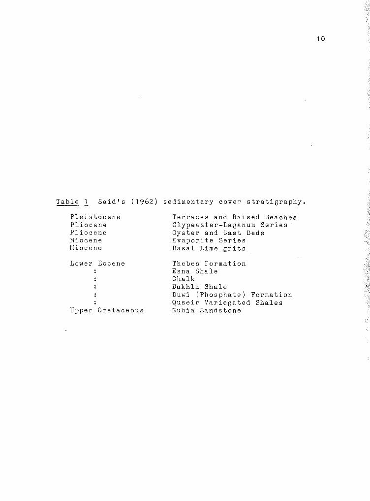
Table 1 Said 1 s (1962) sedimentary cover stratigraphy.
Pleistocene Pliocene Pliocene Miocene !Hoc ene
Lower Eocene
Upper Cretaceous
Terraces and Raised Beaches Clypeaster-Laganum Series Oyster and Cast Deds Evaporite Series Basal Lime-grits
Thebes Formation Esna Shale Chalk Dakhla Shale Duwi (Phosphate) Formation Quseir Variegated Shales Hubia Sandstone
1 0
11
Schurmann (1966) combined over 50 years of personal
work in Egypt with prior studies into his comprehensive
text on the Precambrian of the northern Eastern Desert and
the Sinai. The stratigraphic sequence in that basement
area and other related questions are still being debated.
Data from recent studies (Akkad and Noweir, 1980; Dixon,
1979; Stern, 1979; Engel et al., 1980; Sturchio, Sultan,
Sylvester, et al., 1983) and better radiometric dating may
help to clarify the Precambrian history of the area.
Since the mid-1970 1 s, the Egyptian Studies Group of
the Earth Sciences and Resources Institute at the
University of South Carolina at Columbia has been
supporting studies in the Eastern Desert through various
institutions. Much of the work has been concentrated
farther to the west of the Quseir area or has involved
larger areas. Of particular interest to the present work
are studies of Trueblood (1981), Richardson (1982), and
Greene (1984) as well as work in progress by Abu Zied (in
preparation). All these studies involve areas directly
adjacent to that considered in this study (Figure 1).
Prior to these investigations, only scanty structural data
were available for this part of the Eastern Desert.
Much work has also been done by the U. S. Geological
Survey in Saudi Arabia. Most of this work has
concentrated on the Precambrian basement of the Arabian

1 2
Shield (Greenwood et al., 1980; Moore, 1979; Schmidt et
al., 1979) with individual mapping of quadrangles along
the Red Sea coast (Smith, 1979; Davies, 1980; 1981). Some
work has also been done in the Arabian Shield by the
French Bureau de Recherche Geologiques et Minieres.
Numerous studies have also been done on the structure
and evolution of the Red Sea (e.g. Lowell and Genik, 1972;
Coleman, 1974; Girdler and Styles, 1974; Cochran, 1983).
Several of these studies will be discussed in Chapter VII.
Geologic Hap and Gross Structural Features
IJo suitable base maps were available at the outset of
field work. However, the Egyptian government made
available a series of high quality black-and-white air
photos at a 1 :40,000 scale. These photos, taken in 1955,
are ideal for location in the field and tracings of them
were used as a base for the resulting geologic map (Plate
1 ). The use of the air photos as a base resulted in some
distortion around the edges of individual photos. As the
photos were available only during my stay in Egypt, it was
necessary to construct a best-fit map in the field (Plate
1) that has been adjusted subsequently using satellite
imagery, but still contains minor distortions.

1 3
Most of the mapping northeast of the major fault
bounding the northeast side of Wadi Nakheil, including
Gebel Ambagi, is from Trueblood (1981) and Greene (1984).
It is included in Plate 1 for the purposes of continuity
and completeness.
The general structure of the map area results from
interplay of three major fault groups striking N60E, N15W
to N15E, and N50-60W, The faults break the area into two
major blocks,
Atshan block
the Gebel Duwi block and the smaller
(Figure 5). These blocks are, in
Gebel
turn,
broken into smaller blocks by subsequent faulting. The
"jagged" or "stepping" appearance of major N-S and N50-60W
faults indicates possible reactivation of older fault
trends by later stresses.
The Gebel Duwi block terminates to the southeast
against the north-south Bir Inglisi, Gebel Nasser-Gebel
Ambagi, and Gebel Atshan Fault Zones. Another tilted
block with a trend similar to that of the Duwi block runs
off the southern end of the Atshan block toward the Red
Sea coast. This block is covered by the Cretaceous to
Eocene sediments of Gebel Hammadat (Figure 1).
Other more-or-less north-south zones can be seen on
satellite imagery to disrupt the Duwi block (see
Frontispiece). These zones may also mark changes in the
orientation of the Gebel Duwi block from Red Sea-parallel

-+~"'""'..,,.~~~-::-~""'r-~~~~~~~~.-~~~~~-;- 26°10'N
FAULT BLOCK
~CONTACT
D BEDROCK
r.:J WADI
~ KM
2 J
8:.:.1 ALLUVIUM ' I 'S::d· .h lt;.K 1dz-. c=:: .. ·:.'b"' I 26° 01' N
34° 05' E 34°12'E
14
Figure 5. Major fault blocks and normal fault zones of the study area.

1 5
to a more westerly orientation. Figures 6 and 7 show the
general fault block geometry of the Quseir-Safaga region.
The major faults generally dip 50° or more at the
surface. Consistent northeast dips of the platform
sediments suggest rotation of the tilted fault blocks and
may indicate shallowing of listric fault dips at depth.
This shallowing at depth is consistent with models for Red
Sea extension. Greater than 600 meters of vertical
displacement is indicated on portions of these faults
where the upper Thebes Formation is in contact with the
basement (Plate 2).
Most large-scale folds in the cover of the area trend
parallel to, and are the result of, drag along post-Eocene
faults. Examples of this style of deformation can be seen
in the broad folding of the cover of the Gebel Duwi Block
and in the open Gebel Nasser syncline. The only fuajor
exception to this style of folding is the large fold atop
the ridge of Gebel Duwi (Plate 2), which is discussed in
detail in Chapter V.
Acknowledgements
Dr. Donald U. Wise of the University of Massachusetts
acted as advisor and provided much needed advice and
assistance in all phases of the study. Three-and-one-half

26• 10'
2s·o5'
"'-
2s·oo· 34'00
STRUCTURAL CONTOURS ON RECONSTRUCTED TOP OF BASEMENT Quseir Area, Red Seo Coast of Egypt
34•to' 34•20' - - 2s•15'
-- Fault• > '00 tn tttrow -- Faultl 200-~m rt1row
-- Fouttl < 200 m fhr'Ow
I R E D I
I ·.J I SE A ,f
§ I
"OUSEIR BASIN"
\ '.:i \ \
\
26'10'
26'05'
0 KM
0 MILES
34•10'
~IN, Gfetnrt, iloliMttM, Abc.i l1" 8 Tr11tblood, r9!J 126
•00
,
34•20'
16
Figure 6. Structural contour map on reconstructed top of basement of the Quseir-Gebel Duwi area. Contour interval= 100 meters.

GENERALIZED STRUCTURAL CONTOURS ON RECONSTRUCTED TOP OF BASEMENT Quself-Safaga Region, Red Sea Coast of Egypt
33°50' 34°00' 34•10' 34°20'
26°40'
26°30'
0 ~
\~ ""' \ ~ '"
}.
.,..,) j RABAH 'f AREA y
26°20'1---~ \
"J"oo \
\ \ -~ \-~\
- F04J1f1 .> !500m tttrow --- Fou/11 200·500m tttrow --- F~lrt < 200m fhl'Ow
26°40'
R E D
S E A
26°30'
--l 26°20' \
" \ _.a:P\ \
( \ \ "QUSEIR \ \ BASIN"\ \
\ " '\
26°t0' 1-- "<. ··--· I. M/\W'UC'll , /';)[;~~ \ . •\ :t. ·~c'C'1\ C'I A•l"7 \ '--l 26°10'
26°26'
0 KM 10
0 MILES 10
GEBEL HAMMAOAT AREA---
W1u, Greene a Volentine, 1983 (GeoloQte boH after Akkad 6 Dardir, 1965)
33•50' 34•00'
'•~ '\ ,_,
" '\ 26°00'
34•10' 34•20'
17
Figure 7. Structural contour map on reconstructed top of basement of the Quseir-Safaga region. Contour interval= 500 meters.

1 8
months of field work in the winter and spring of 1982 were
funded by the National Science Foundation and the U. · S.
State Department. Professors W. H. Kanas, Steven Schamel,
and Hobert Ressetar of the Earth Sciences and Resources
Institute at the University of South Carolina administered
these funds and offered helpful advice.
Administrative and logistical support in Egypt were
provided by Dr. E. l·i. El Shazly, llr. Hafez Aziz, and all
of the Egyptian staff connected with the Egyptian Studies
Group. The Egyptian drivers Faried, Kamal, Ahmed, and
l:oustafa somehow got me to the most inaccessible places.
The staff of the guest house at the Quseir Phosphate
Company took care of meals and housekeeping,
to concentrate on ecology.
allowing me
Professors George E. McGill and Charles W.
served on my thesis committee and offered many
suggestions for the improvement of this manuscript.
Pitrat
helpful
David Greene and Hassan Abu Zied, fellow students and
workers in the Quseir area, provided friendship and
companionship making the three-and-one-half months in the
desert much more comfortable. In addition, discussions of
the geology with David Greene greatly facilitated the
development of this thesis.
Laura Menahen helped with drafting and lettering and
provided encouragement and moral support throughout the

• S:llU"Bl{'.J. Alli
·q.~a~oJd s1qq. JO uo1q_uJnp

C H A P T E R II
PRECAMBRIAN BASEMENT STRUCTURE AND ANISOTROPY
Some Tertiary structures were probably controlled, in
part, by basement anisotropy. This chapter is designed to
establish the nature of this anisotropy, structural and
compositional. Due to the complexity of basement
fracturing patterns and their resemblance to those of the
Cretaceous to Eocene cover, a fuller discussion of
basement fracturing will be included in Chapter IV.
Basement of the Study Area
The basement of the study area, like most of the
Eastern Desert basement, is dominated by a sequence of
metavolcanics and volcanically derived metasediments. The
volcanics are aphanitic to porphyritic in character; the
volcaniclastic metasediments are generally coarse grained,
commonly conglomeratic. Both types are highly fractured.
The metavolcanics and metasediments correspond to the
upper part of Akkad and Noweir 1 s (1980) Abu Ziran Group
(Table 2). A few small exposures of serpentinite present
south and southwest of Gebel Nasser may be part of the
Rubshi Group (Table 2).
20
21
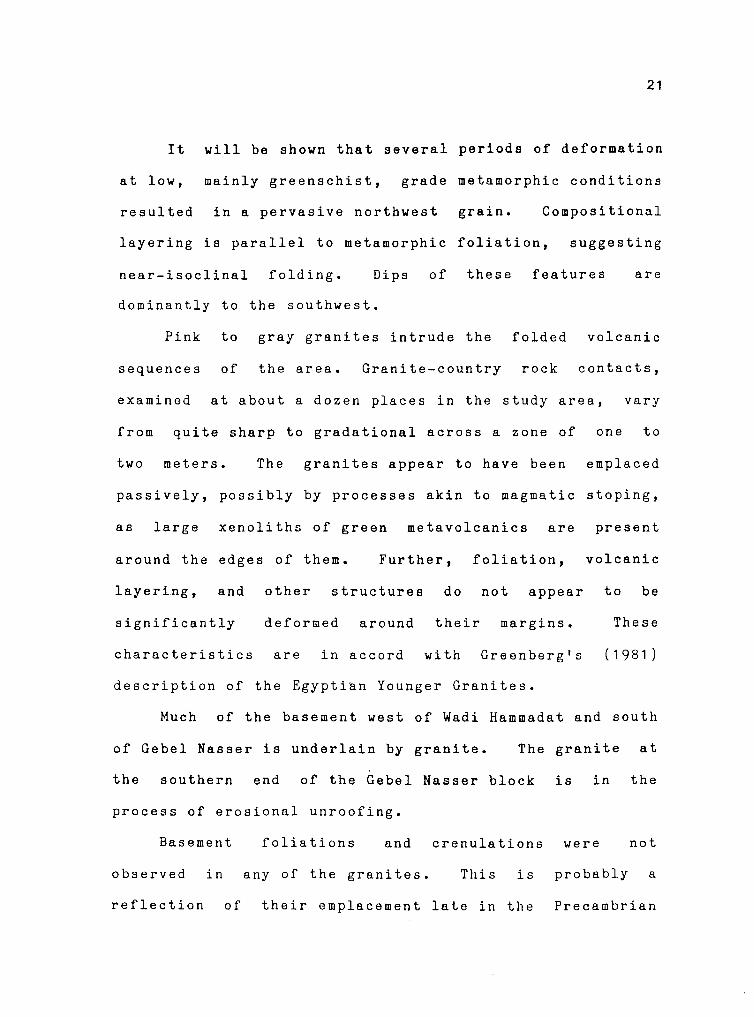
It will be shown that several periods of deformation
at low, mainly greenschist, grade metamorphic conditions
resulted in a pervasive northwest grain. Compositional
layering is parallel to metamorphic foliation, suggesting
near-isoclinal folding. Dips of these features are
dominantly to the southwest.
Pink to gray granites intrude the folded volcanic
sequences of the area. Granite-country rock contacts,
examined at about a dozen places in the study area, vary
from quite sharp to gradational across a zone of one to
two meters. The granites appear to have been emplaced
passively, possibly by processes akin to magmatic stoping,
as large xenoliths of green metavolcanics are present
around the edges of them. Further, foliation, volcanic
layering, and other structures do not appear to be
significantly deformed around their margins. These
characteristics are in accord with Greenberg's (1981)
description of the Egypti~n Younger Granites.
Much of the basement west of Wadi Hammadat and south
of Gebel Nasser is underlain by granite. The granite at
the southern end of the Gebel Nasser block is in the
process of erosional unroofing.
Basement foliations and crenulations were not
observed in any of the granites. This is probably a
reflection of their emplacement late in the Precambrian

SUPERGROUP .t: GROUP
f- ~' < - >--= ..,. - - -.C:- • c.i
<::: ~ = ::; - ' -:'i~ ~~ < =
·~ = =·~.; ~~~2 -'·- =~ ::.:- :i
::: "' ... c:
i~ ':..; -= z.E <'V OI: c: - ... """" ::::> ~ =~ < u
MEATIQ GROUP
Table ') ,... .
FORMATION
Kab Ahsi Esscxite Gabbro
Kho" Volcanics
Nubia Sandstone
Younger Granites
Post-Hammamat Felsites
Qash Volcanics
2. Shihimiya Formation
I lgla Formation
0.>khan Volcanics
lunmetamorphoscd)
Older Granites
' Sid Metagabbros
I. Barramia Scrpcntinites
8. Abu Diwan Formation
7. Eraddia Formation
6 Sukkari Metabasalts
< Um Scleimat Formation
4 Atalla Formation
J Atud Formation
' Muweilih Formation
I. Hammuda Formation
-\hu Fannani Schists
ROCK UNITS
MEMBER (and remarks)
-(dislodging of contact between Nubia Sandstone and basement)
(regional unconformity)
Phase /fl South Eraddia pluton Phase II Gidami, Kab Amiri. Eraddia, Um Effein. Um Had, Um
Hombos and Sancyat plutons Phase I Ahu Qarahish. Sodmein, Kab Absi. Atalla EJ Murr.
Atalla. Atalla gold mine, East Um Effein. Fawakhir and Arak plutons
Atalla. Rasafa-Shihimiya, Atshan, Qash, Mahdaf, Kohel, Arak and Zeidun members
c. Um HaHa Greywacke Member
b. Um Had Conglomerate Member
a. Rasafa Siltstone Mcmhcr
- (local unconformity)
- - - - - - - - - (regional unconformity)
_ (transforming some Older Granite' into cataclastic-mylonitic gnci"e< of Shairian typ• or Shait Granites)
Um Shager. Abu Ziran and N & E Eraddia plutons
Hammuda. Khors, Fannani. Sid. Fawakhir, Esh El-Zarga, Erad
dia. Saqia, Abu Diwan. Ruhshi and Abu ziran complexes
Muweilih. Sancyat, Fannani, Alalla. Rubshi, Kab Amiri .t: Saqia
ranges
- - - - - - - - - - (local unconformity)
d. Absi Metamudslone Member
c. Khors Schist Member
b. Um Hombos Melapyroclaslic Lentil
a. Um Shager Metagrcywacke Memhcr
Thick succession of high grade siliceous gneisses and 'chists. Subdivision inlo unils in progress.
Akkad and Noweirts (1980) stratigraphy and
22

Aae
Lower
Cretaceous
62(}..5~
Ma
660-700
Ma
900-1000
Ma
1300~~
Ma
history
l.LJ Cl)
< :c Q.,
~ z l.LJ
8 a: c
Stages o(
evolution
'l.LJ ZVl >- < Cl) :c Oa.. l.LJ .J 9< t;;~ 0 .J a..u
.. u U.!:: E c
" .. tiG ·§~
.. ~ 1: c ,.. '...!.In ·;; ~ c 0 ·:;vu> 5 ,.VlEu
..... 't:I t; .5-= g~~::: :;:;,;:E-;,., 0;:: 0 c 'El ·;- ~'; .g ·c E -l! Q.~ :l
l.LJ Cl)
< :c Q.,
'.:::! z l.LJ
8 a: t:ij Q., l.LJ
~ c .2 .. c u E
:.; ~
~ !!'
~ .. :; E E "' ~·= ·-a .9 ·c-= ..... -a.~ > c .. u ... ·- .. -~~ ""' .. cc
till ·::
olj::: ~"';
i..§ ::i ..
:::; EE .S ~ - "'"' •·-·-c .&:. c
.2 e- .9 .. 0 ::i ~ E Q.
l.LJ Cl)
< :i: Q.,
.J < z J u z >Cl)
0 l.LJ 0
!!' ·;:; '2 "' u 0 > ,.,
:E ti .. .!.!
" E : E"' 1! ~ :§ i -l!.!.! cj
.2 "~ cu u -§j ""'" u ...
~~ >. 0 ";' c .&:. 0 u·-~ 2 -=-
PRINCIPAL EVENTS
- Emplacement o( alkallne plutonites
- Explosive volcanism o( trachyte lavas. pyroclas11cs and associated dykes
- Rejuvenation o( old N.W.-S.E. faults
- Transgressive deposition o( quartz-aremles and shales on stable shelf
- Prolonged quiescence, erosion and peneplanation
- Uplift and main rejuvenation of old N.W.-S.E. faults
- Emplacement of granite plu!Ons a> final epeirogemc mamfeslation. assoc1aled with and
followed by various dykes
- Granite pluton cutting Phases I and II
- Adamellite plutons cutting Phase I. Hammamal Group, Posl-Hammamat Felsites and
effecting pronounced contact metamorphism
- Elongate granodiorite plutons along N.W.-S.E. trends
- Intrusion of felsites as huge bodies. sheets and dykes along N W.-S.E. trends
- Earliest indication of N.W.-S.E. dJSlocauom controlling later emplacement of Post-
Hammamat Felsites and Phase I of Younger Granite'
- Eruption of tuffs & intrusion of subvolcanics into folded Hammamat Group
- Folding & faulting of Hammamal Group & older rock unit> - second phase folding
- Deposition of dark greywackes
- Deposition of conglomerates derived from older units and reworked lgla Formallon
- Uplift in source area
- Deposition of grey siltstones. minor greywackes and conglomerates
- Deposition of primary red beds of purple s1ltstones. greywackes. minor arenole' and
conglomerates
- Rapid severe erosion and peneplanat1on
- Epcirogenic uplift accompanied by intrusion and eruption of andesiles and porphyries.
Subareal eruption of andesitic agglomerates and tuffs
- Regional fault and thrust movements
- Emplacement of tonalite, grandiorite & monzomte during waning phase of orogeny
- Emplacement of basic plutonites during orogemc folding and regional metamorphism
affecting these and all older rock units
- Recurrent intrusion of concordanl ultramafic bodies at different horizons in lhe Abu Ziran
Group, heralding main phase of orogeny
- Intrusion of diabases
- Eruption and intrusion of andesites. andesitic luffs and minor hasalts
- Effusion of basalts and basaltic luffs
- Intrusion and eruption of basalts. minor andesiles .ind luffs
- Eruption of rhyolite, dacite, porphyries. acidic tuffs and minor interbcdded mudstones,
siltstones and arkosic greywackes
- Deposition of alternating conglomerates and greywackes. minor siltstone, mudstone and
intraforrnational breccia
- Uplift in source area
- Effusion of pillowed spilites. diabase flows. spilitic crystal luffs. epiclastic adinole and
intrusive andesites
- Deposition of siliceous tuffaceous mudstones and minor greywacke
- Deposition of alternating shales and calc-shales. minor siliceous limestone and car-
bonaceous chert
- Eruption of lapilli-. lithic-. crys!al-tuffs merging into ep1clastic sediments
- Deposition of allerna!ing greywacke. muds!one. minor conglomerate and pd1te
- Deposition of successive quartz-arenites, calc·pelite\ and greywack<,, 1ransotu1nal to
proper turbidi!e facies
- Extrusion of acidic tuffs and flow'
23
of the Egyptian baseoent through the lower Cretaceous.
21+
sequence of events, as opposed to some of the older,
highly foliated and lineated granites of the Eastern
Desert. Quartz veins, felsite dikes, and a single mafic
dike were observed to cut the granites. Aplitic dikes
were noted in the metavolcanics in close proximity to the
large granitic body in the southeastern part of the area
and will be discussed further. A summary of the
Precambrian history of the study area is presented in
Table 3.
Precambrian Tectonic Setting and Basement Correlations
The Precambrian basement of Egypt has been given
serious study since the establishment of the Geological
Survey of Egypt in 1896. In 1911, the first geologic map
of Egypt was produced by the Survey with explanatory notes
by Hume (1912). The map was based largely on
reconnaissance geology and about one-third of the country
remained ''terra incognito". A revised edition of this map
was later published in the Atlas of Egypt (Little, 1928).
Hume (1934), Andrew (1938; 1939), Neubauer (1962),
and Schurmann ( 1 966) developed Egyptian basement
stratigraphies without the benefit of adequate radiometric
dating. As a result, much confusion remained as to ages,

0 ...:I
"' ~ "' "' ;z: < ~
"' => ;z:
' ;z: < ~
"' < a:: <
<
"' 0:: < ... 0 ::i ... "'
MILLIO~S 0F YEARS BEFORE PRESENT
2100 1100 1000 900 800 700 bOO 500
•AHCIEHT• GKEISSES AT GEBEL OWEIKAT, W, DESERT, EGYPT [ 1]
OLDEST DATED ARABIAN OPHIOLITE [ 2]
OLDEST DATED ARABIAN METAYOLCA~ICS (21
HIJAZ TEC70NIC CYCLE (J]
OLDEST DATED EGYPTIAN METAYOLCANICS (41
OLDEST DATED EGYPTIAN OPHIOLITES [ 4]
EGYPTIAN SINTECTOttIC GRAllITES [ 5, 6 I EMPLACEMENT AND METAMORPHISM OF EGYPTIAN GNEISSES AllD SCHIS7S (4]
DEYELOPMEllT OF MEATIQ DOME [&]
BULK OF DATED EASTERN DESERT METAYOLCANICS [a)
LATE TO POST-TECTONIC EGYPTIAU GRANITES [6]
POST-TECTONIC GRANITE~ IN THE EASTERN DESERT [5]
ARABIAN POST-TECTONIC GRANITES [7]
DOKHAN VOLCANICS [5]
DEPOSITION OF MOLASSETYPE SEDIMENTS (HAMMAHAT Flo!. OF EGYPT) (J,51
YOUNGEST PRECAMBRIAN ARABIAN CALK-ALKALINE VOLCANICS [J)
NAJD FAULTING (J,7]
OLDER, SHAT7ERED QUARTZ VEINS
0
0
0
FIRST PHASE FOLDING, HAIN FOLIA7ION, LillEATIONS, HETAHORPHISH, OLDER NORTHEAST QUARTZ VEINS
SECOND PHASE roLDillG, SECOND FOLIATION/SCHISTOSITI
RED GRAKITES EHPLACED, YOUNGEST QUARTZ VEINS, APLITE DIKES
CREllULATION CLEAVAGES
HAFIC DIKES AND SILLS
BRIC~ RED-WEATHERING FELS ITES
REFEREllCES1 (1] Schurcann, 1974.
f2j Flock ot al., 1980.
(5] Ries ot al., 198), (6] Engel ot al., 1980. [7) Schmidt et al., 1979.
0
0
J Greenwood et al., 1980. (4] Hashad, 1980. (8] Sturchio, Sultan, 3ylve1ter, et al., 1983
Table b Summary of Prccar.ibrian history.
..._..
1-----t
1----4
1----i
1--1
1-----1
0
~
~ -i
? -i
, ____ , . .
?-----·-:
25

origins, and regional correlations of units.
El Ramly (1972) published a basement
stratigraphy of the central Eastern Desert
Western Desert of Egypt. Based on work since
26
map and
and South-
1963 along
the Qift-Quseir Road in the Hammamat-Um Seleimat District,
Akkad and Noweir (1980) developed a basement stratigraphic
sequence similar to El Ramly 1 s (Table 2). All of the
aforementioned authors placed the gneisses and schists of
the Meatiq Group at the base of the column, making them
the oldest exposed rocks in the Eastern Desert, with a
tentative age of about 1300 ~.y. (Akkad and Noweir, 1980).
Basahel (1980) and Greenwood et al. (1980) have
attempted to correlate the basement stratigraphy of Egypt
with other parts of northeast Africa. Although the
lithologic units of the Arabian-Nubian Shield have been
adequately described, there is even now much disagreement
as to ages, origins, and regional correlations.
Volcanic Arc Accretion llodel
Until relatively recently, it was thought that
northeast Africa and Saudi Arabia were underlain by an
ancient sialic crust like that of western and southern
Africa. Many of the notions concerning the antiquity of
the northeast African craton were based on the now

27
outmoded premise that the more highly tectonized and
metamorphosed rocks are, the older they must be. With
little or no radiometric dating to constrain the ages, it
was assumed that the gneisses and schists of the basement
were Archean in age, and they were correlated with similar
rocks in other parts of Africa.
With the development and refinement of various
radiometric dating techniques, absolute ages for basement
rocks became available. The only reported Archean dates
for basement rocks of the Arabian-Nubian Shield are Rb-Sr
ages on microcline and whole rock from the gneisses of
Gebel Oweinat in the Western Desert (Schurmann, 1974).
Rogers et al. (1978) state that data were unavailable to
evaluate the validity of these dates, and consequently,
they do not accept them. If these dates are eventually
borne out, these ancient rocks may represent a small block
of sial "floating" in younger surrounding rocks. It has
been proposed that ancient sial is present under much of
northeast Africa, but it seems unlikely that it would be
exposed only at Gebel Oweinat.
Many problems with the development of a model for the
evolution of the northeast African craton have resulted
from the lack of agreement on a stratigraphic sequence for
the area. Ries et al. (1983) feel that they have solved
this problem with a structural/tectonic sequence for the

28
shield, rather than a simple stratigraphic one. The
contacts they see between the major rock types in the
central Eastern Desert of Egypt are dominantly tectonic.
They have therefore divided the basement rocks into four
groups baseu on environment of development as outlined
below.
Volcanic-Plutonic Rocks. The bulk of the Saudi Arabian and
Egyptian basements consists of calcalkaline volcanics and
volcanogenic sediments intruded by granites (Shackleton,
1979). The volcanics and granites are chemically similar
to igneous products associated with present-day island
arcs (Greenwood et al.,
Dixon, 1979; Stern,
1980; Gass,
1979; Engel
1977;
et al.,
1979; 1981;
1 980) ; the
associated sediments are very similar to those found in
modern back-arc basins (Greenwood et al.,
al., 1980).
1980; Engel et
Radiometric ages for the metavolcanics and granites
range from about 1000 M.y. to 450 M.y. (Greenwood et al.,
1980; Gass, 1979; Rashad, 1980; Roobol et al., 1983) with
most Eastern Desert dates at 700-600 M.y. (Engel et al,
1980; nies et al., 1983). The rocks become younger to the
east across the Arabian Shield and exhibit an eastward
geochemical evolution suggestive of a maturing island arc
(Fleck et al., 1980; Greenwood et al., 1980; Darbyshire et
al., 1983; Roobol et al., 1983).

29
Ophiolite Melange. The existence of ophiolites in the
Arabian-Nubian Shield has been recognized only recently
(Baker et al., 1976; Gass, 1977; 1981; Dixon, 1979; Engel
et al., 1980; Shackleton et al, 1980). Complete ophiolite
sequences are rare, but partial sequences are relatively
common in the Arabian-Nubian Shield. These slivers of
abducted sea floor are located in north-south and
northwest trending discontinuous belts in the Arabian
Nubian Shield (Figure 8) and may mark old sutures.
Radiometric dates of 825 M.y. and 860 H.y. were obtained
for Egyptian mafic volcanics (Hashad, 1980) and a single
date of 1165 tl.y. was obtained from Saudi Arabia (Fleck et
al., 1980). These rocks may have been erroneously
classified as part of the Hubshi Group of mafic intrusives
by earlier workers.
Gneisses and Schists. These rocks were originally termed
the 11 fundamental 11 gneisses and were thought to be part of
an ancient craton underlying northeast Africa. They have
now been identified as metamorp~osed younger plutonic
and/or sedimentary rocks with dates of emplacement and
metamorphism ranging from 763 M.y. to 584 M.y. (Schmidt et
al. ,
al. '
1979; Rashad, 1980; Sturchio, Sultan, Sylvester, et
In many places, volcanics have been thrust
over
1 983).
the gneisses. The gneisses, in turn, rose
diapirically, possibly during compressional episodes

_,-' ... ~ \ .. ~ ' . ;
' " :• .. ~ :o-· .... ~~.;;. \ ~ ... ~ .. ·.:~ ... ~·~·· ·. ·.•.':··· .•.... :-:::·'· . ~ ........ · .. :-::~ ~ ......... ·~ ... ~ ·:.:. :· ... ··~·.'·. . ./·.··· '_f#" •:H~ :. -. ::• ~~: f..~:
Figure 8. Distribution of Egypt Eastern
et al., Desert 1976).
of
~
~
[-]
......... -~-.~~:!·
, .. 1.11114 "'"'""'" ,_, .. 111 outtt.,11"4Katd 111 Mad
Ra• Su S.1t1r1. Alma '" "'""'
"""'''*'· "*• fltltd dKkWtat lly 1 ti tm C-'ttl clH•I
ClystathM l!Ht.aftt COYtftd "' ,_,
~f I 1<t11•y Vale"''" 11\d .-CeflllOhhtd M,.llfl
Pt.tftfftretC H4tMtftl8fl Cl'llf
SOQUI
mafic/ultramafic and western Saudi
zones Arabia
30
in the (Bakor

(Greenwood et al., 1980)
complex tectonics (Sturchio,
31
or during metamorphic core
Sultan, and Batiza, 1983),
and were later exposed by erosion as mantled gneiss domes.
Molasse-type Sediments. Stratigraphically, these are
generally the youngest rocks in the structural/tectonic
sequence. They include the Hammamat Group of Egypt dated
at 616±9 M.y. to 590±11 H.y. (Ries et al., 1983) and the
Murdarna Group of Saudi Arabia. These sediments are
elastic-dominated and are interpreted as being orogenic in
origin (Greenwood et al., 1980; Schmidt et al., 1979; Ries
et al., 1983).
Summary of Arabian-Hubian Shield DevelopL1ent
The chemistry, ages, and structure of rocks in the
Arabian-Nubian Shield suggest that the craton formed
through the accretion of island arc materials in the late
Proterozoic.
al., 1983)
Single arc (Greenwood et al., 1980; Roobol et
and multiple arc (Schmidt et al., 1979;
Shackleton, 1979) models have been proposed; in the
multiple-arc schemes, ophiolite belts mark the suture
positions.
trending
Collisions along north-south to northwest
lines produced mainly greens chi st grade
metamorphism, the Hijaz tectonic grain, dominant west to
northwest trending lineations, and west to northwest fold

32
vergence seen in the shield. The gneisses and schists
formed from sediments and/or plutons during collisional
metamorphism, which locally reached amphibolite grade
(Sturchio, Sultan, Sylvester, et al., 1983).
Uplift resulting from the collisions caused erosion
and deposition of molasse-type sediments. At the same
time, the last pulses of subduction-related maematism
cut all the pre-existing rocks to produce the Dokhan
Volcanics of Eeypt (Mourad and Ressetar, 1980) and minor
andesites and rhyolites within the Murdama Group of Saudi
Arabia (Greenwood et al., 1980). These events overlapped
with intrusion of the collision-generated post-tectonic
granites that stabilized and ''cratonized" the new crust.
The Ilajd fault system developed between 520 and 590
I.J. y • ago ( Greenwood et a 1 • , 1 9 8 0 ; Schmidt et a 1 • , 1 9 7 9 ) in
response to the continuing collision of the Proterozoic
African craton with the newly-created Arabian-Nubian
continent (Greenwood et al., 1930; Fleck et al., 1980) or
as the result of a collision with a continent to the east
(Schmidt et al., 1979). A risid indenter model similar to
that of Molnar and Tapponier (1977) has been applied to
both cases (Schmidt et al., 1979; fleck et al., 1980).
During the hiatus in tectonic activity that followed
the late Precambrian assembly of the Arabian-Hubian

33
craton, a widespread erosion surface developed over much
of the craton. Cretaceous to Eocene platform sediments
were subsequently deposited on this surface. This
extensive older surface is preserved in the western
Eastern Desert as a general concordance of basement peak
elevations where the sedimentary cover has been removed.
Within the study area, it can be seen as a weathered
basement surface along the basal contact of the Nubia
Formation.
Many details of this model need to be worked out, but
the general scheme is gaining wide acceptance. The rapid
development of this area, unusual mafic intrusions noted
by Dixon (1979), the unusually young age of this
greenstone belt, lack of arc-type blueschists, and the
extent of the Pan-African tectono-thermal event all point
to anomalous mantle conditions beneath Africa in the late
Precambrian. This may prove to be a fruitful field for
future investigation.
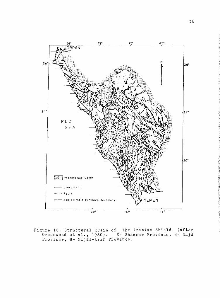
Regional Structural Grain
On the scale of LANDSAT imagery (Figure 9), areas
bordering the edge of the Red Sea are seen to be dominated
by more or less north-south braided structural trends and
northwest structural trends (Greenwood and Anderson,

A
"' Joo ~ -\!..,
<! w (f)
0 w ex::
'
J;>
""' 0 O'
0
oi., ,.,(o
JVflJ//J. \1J;:_ l<-">o
"' • I ~ WI'\.,' ~1
I
o'v 0)
J <\10'1/
\
"' 0 ca ,.,
34
B
A\~ l<-">oA/
Figure 9. Palinspastic reconstruction of the northern Red Sea prior to Tertiary rifting (after Greenwood and Anderson, 1977): a) line drawing of the northern Red Sea showing lineaments visible on LANDSAT images; b) reconstructed Red Sea margins prior to rifting. Lines represent Hijaz- and Najd-parallel lineaments in Precambrian terrains. Note alignment of Gebel DuwiGebel Hammadat of Egypt and Wadi Azlam of Saudi Arabia (both in heavy black) prior to rifting.
l ~
1

35
1977). These can be associated with the Hijaz-Asir (N-S)
and Najd (NW) tectonic provinces (Figure 10) of the
Arabian Shield (Greenwood et al., 1980) and their
extensions into northeast Africa. A third trend parallels
the Red Sea and is associated with Tertiary rifting.
In the Arabian Shield, where extensive basement
mapping has been done, structures paralleling the two
dominant grain directions are well-known (Greenwood et
al. , 1980; Smith, 1979; Davies, 1980; 1981). Although
published structural data for the Eastern Desert are
somewhat sparse, north-south and northwest trends have
been noted in the basement (Abdel Khalek, 1979; Engel et
al., 1980; Gass, 1981; Ries et al., 1983). Minor groups
of east-west and northeast trending faults have also been
noted in ~gypt (El Shazly, 1964; 1977; Garson and Krs,
1976; Abdel Khalek, 1979; Gass, 1981) and Saudi Arabia
(Garson and Krs, 1976; Davies, 1980; 1981 ).
Northwest-southeast lineations are present throuGhout
the Precambrian of the Eastern Desert and have shallow
northwest or southeast plunges (Shackleton et al., 1980;
Ries et al., 1983; Sturchio, Sultan, Sylvester, et al.,
1983; Sturchio, Sultan, and Batiza, 1983). These are
mainly stretched pebble and mineral smearing lineations
that suggest northwestward tectonic transport. Similarly
oriented lineations are present in the Saudi Arabian
z4°
RED SEA
[::::=.:):!Phanerozoic Cover
--- Lineament
....... Fault
39°
- Approximate Province Boundary
39°
42°
42°
36
45°
N
r
28°
24°
20°
YEMEN
45°
Figure 10. Structural grain of the Arabian Shield (after Greenwood et al., 1980). S= Shammar Province, N= Najd Province, II= Hijaz-Asir Province.
·~ ~
_.;;
1
j .-l

37
basement (Greenwood et al.,
1980) •
1980; Smith, 1979; Davies,
North-South Hijaz-Asir Grain
The braided nature of the north-south Hijaz fault
grain (Figure 10) results from northwest, north-south, and
northeast trending individual faults, folds, and plutonic
belts. This pattern was produced by the complex tectonic
events of the late Precambrian (Greenwood et al., 1980).
Northwest Najd Grain
Nost important to the present study are the mostly
northwest trending structures of the late Precambrian
left-lateral llajd faulG system (Figure 10) of the Arabian
Nubian Shield (Greenwood et al., 1980; Moore,1979). Najar
right~lateral, north to northeast trending, strike-slip
faults, which would be the theoretical conjugate
complements to the northwest set, are rare. The Najd
system is superimposed on and cuts the older Hijaz
structures.
Najd faults in Saudi Arabia form a braided system at
the surface with en echelon and curved faults converging
and diverging (Moore, 1979). The pattern of the Najd

38
system is very similar to that developed in the
experiments of Wilcox et al. (1973) in which wrench
faulting of rigid blocks at depth resulted in the
development of primary and secondary extensional and
compressional structures in an overlying, less rigid
medium.
The Najd fault system extends over 1100 kilometers
across the Arabian Shield. Block motion in the
Phanerozoic cover southeast of the Arabian Shield, along
the extension of the Najd zone, may indicate a total
length approaching 2000 kilometers (Moore, 1979) • The
zone narrows to the northwest as it approaches the Red
Sea, where it is terminated and locally reactivated by Red
Sea rifting. Possible extensions of the Najd zone can be
found in similar trends on the western side of the Red Sea
(Figure 9). Because some of the faults bordering Gebel
Duwi parallel Najd trends, it is this northwest extension
into the Eastern Desert of Egypt and possible later normal
reactivations that are of particular interest in this
study.
Folding
There are at least three, perhaps four, phases of
folding that have affected the basement rocks of the study

39
area. Only the granites, felsite dikes, and youngest
quartz veins show no evidence of being affected. The
three phases of folding are coaxial, producing shallow
plunging, southeast-northwest to north-south trending fold
axes (Figure 11a). Axial surfaces of the folds exhibit
dominantly northwest-southeast strikes with variable
southwest dips (Figure 11b).
The Meatiq Dome, about 10 kilometers west of the
study area (Figure 1), has an overall double-plunging,
north-northwest trending anticlinal form (Sturchio,
Sultan, and Batiza, 1983) and exhibits related N35W/S35E,
gently plunging minor folding. El Shazly (1964) also
notes northwest trendinc folds in Egyptian basement near
the Red Sea. Greene (1984) has mapped the large, S40E
plunging, el Isewid synfor~ in basement immediately east
of Gobel Atshan, notinc rare coaxial outcrop-scale folds.
The large U60V trending ilamrawein Synclinorium lies in Abu
Zietl's area (Figure 1) to the north (Wise et al., 1983).
The map pattern of planar features in the casement of
area of the present study (Plate 1) does not suegest
obvious major structures. Most minor folds noted in
the
any
this
study are subparallel to the axis of the el Isewid
synform, and lie on the flanks of this larger structure.
Sturchio, Sultan, Sylvester, et al. (1983) have dated
two late Proterozoic compressional events that affected

N
0
0
a +
0
a o
• First Phase O Second Phase
• NW Crenulat1on
0 NE Crenulat1an S 25 E
0 Unknown Assoc1at1on N
0 0
0
b a +
a
0
S 30 E
Figure 11. a) Fold axes the in Precambrian basement of the study area.
b) Poles to axial planes of folds in the Precambrian basement of the study area.
40

41
the Meatiq Dome. The first event resulted in metamorphism
up to epidote-amphibolite grade and formed a low-angle
ductile shear zone up to 1800 meters thick containing
northwest trending lineations. The end of this event is
dated at 613±5 M.y. by U-Pb dating of zircons from a
syntectonic tonalite. Similar structures elsewere in the
Eastern Desert suggest the regional nature of this event.
The second tectonic event was the uplift that
resulted in the deposition of the Hammamat sediments.
This Gave the Meatiq Dome its anticlinal structure and is
dated at around 600 M.y. (Sturchio, Sultan, Sylvester, et
al., 1983).
Bedding and Volcanic Layering
Much of the basement of the study area is faintly or
indistinctly bedded with monotonous units. Further, it is
comaonly broken and jumbled to such 1Ln extent that
consistent bedding orientations are not maintained over
significant distances.
layering orientations
Therefore,
measured in
bedding/volcanic
the field are
comparatively rare. These orientations are plotted in
Figure 12a and on the geologic map (Plate 1). Most beds
dip moderately to the southwest. The remaining poles plot
as a diffuse northeast-southwest girdle suggesting a gross

N
+
a
N
+
c
. .
. . . ". . ,/' - . .. .
5 40E
. .
·.
..
N
. . . . \. • ' ,. V' . ' . . .. ..
42
. ' . -:-.:.: .. ~.· ·~ ... . . ,_.._,: . ' ~.
I • • •.:.• • ~ . ( ::,: ... : . .. .. + .I\ .... .
. . ..
b
N
+
d
Figure 12. Precambrian basement fabric nets: a) poles to bedding/volcanic layering; b) poles to main foliation; c) poles to second foliation/schistosity; d) poles to crenulation cleavaees.

43
south-southeast plunging fold system.
Foliations and Cleavages. Folds in the basement of the
study area are associated with several basement
foliations. The first recognized phase of folding
produced the main basement foliation; a w~ll-developed
spaced cleavage which is present in almost all of the
metavolcanics and metasediments. It is the most prominent
fabric feature of the basement and dips predominantly
southwest at moderate to steep angles (Figure 12b). A weak
northeast-southwest girdle is defined by the remaining
poles. Similar orientations of the main foliation have
been noted to the north of the study area (Ries et al.,
1983).
A second phase of folding affected bedding and the
main foliation, producing a second basement foliation. It
appears as a weaker spaced cleavage in the volcanic layers
and as a schistosity in the fine-grained
volcanic ash. The second foliation
sediments and
is commonly
subparallel to the main foliation and, where strongly
developed,
foliation.
may be indistinguishable from the main
Northwest strikes and moderate to steep
southwest dips are characteristic of the second foliation
(Figure 12c). Again, a weak northeast-southwest girdle is
defined by poles to this feature. Ries et al. (1983) note
two cleavages with similar orientations in Wadi Um Esh to

44
the northwest of the study area.
Weak crenulation cleavage with a consistent northwest
strike and very steep dips (Figure 12d) developed as a
result of a third phase of deformation. This cleavage is
present only locally and, even where best developed, is
poorly expressed. This cleavage is seen to affect bedding
and the two older foliations.
All three phases of folding are evident in an outcrop
on the north side of Wadi Hammadat (Figure 13). Folding
and coaxial refoldinG of bedding and early axial planar
features
for the
by subsequent deformational phases
variable orientations of these
may account
features as
represented by the girdles that their poles form on
stereonets. Tertiary faulting may also have affected the
orientations of Precambrian foliations.
A second crenulation cleavage, which may be the
result of a fourth phase of deformation, was noted at two
stations in the basement between Wadi Kareim and Wadi
Hammadat. This cleavage is very strongly developed with a
N60-65E strike and a nearly vertical dip (Figure 12d).
The second crenulation must be younger than the second
phase, as it affects schistosity, but its age relative to
the other crenulation is not known. Ries et al. (1983)
note that post-cleavage crenulations and kink b6nds are
common northeast of the study area.

First Phase Fold•
0 Aids Q Aida I Plane
Second Phase Fold•
G Axis (Approximate)
0 Axial Plane
Crenulation•
&,Axis 6 Axial Plane
First Phase
Fold Axis
S15E, 16
Second Phase
Fold Axis
S07E,ll
N
&>
+
[>
Crenulat1on
0 0
~Bedding
Main Fahat1on
0 5 L-1
CM
45
Figure 13. Block diagram and net showing three phases of folding of Precambrian basement as noted in an outcrop along the central southern edge of the Wadi Inglisi Horst Block. The fold affects a sandy· bed within finer-grained metasediments.

46
Lineations. Lineations formed by the intersections of
planar basement features are of various kinds.
Intersections of the main and second foliations are most
common. 'l'he s e features have systematic northwest-
southeast to south-southeast trends and shallow plunges
(Figure 14a), paralleling fold axes.
Smeared mineral lineations are found on first phase
foliation surfaces, generally within volcanic layers,
whereas stretched pebbles are found within conglomeratic
layers. These features also have fairly consistent
northwest-southeast to south-southeast trends and shallow
plunges (Figure 14b). Ries et al. (1983) note northwest-
southeast stretching lineations with very similar
orientations in the plane of the nain foliation in Wadi Um
Esh (Ries et al. 1983, Figure 7b). They state that this
northwest-southeast orientation is noted everywhere, even
where the stretching is weakly developed. A pencil-like
lineation parallel to the stretching lineation was also
noted at several locations in their area. Sturchio,
Sultan, Sylvester, et al. (1983) also note similarly
oriented stretched pebble lineations at the 11eatiq Dome.
~ineral and stretched pebble lineations are parallel
to fold axes, yet appear to be, and have been proposed as,
indicators of the direction of tectonic transport. This
would require the rotation of early-formed fold axes into

a
b
Fit;ure 14.
N
•
+
0
• 0 S.ddi~tCi.cnao•
e Pr1rnory/S..c0f'\dor)' Fot1alt0tll------....---• "rim.ory Fcl1Ql1on/ NW Cr•~IOl•Ol'I Q Pr1mar7 F!)looh(ll'l/N[ Crtcftulot1cn
G StC.OtldQry Fohat10f1INW Cr.-n~llotl
N
• ••
•
+
• S1r11i:"-d~t • • $m401'1d Jlll,11.,o•s
.. •
Precambrian basement lineations: a) intersection lineations; b) smeared mineral and stretched
pebble lineations.
47
48
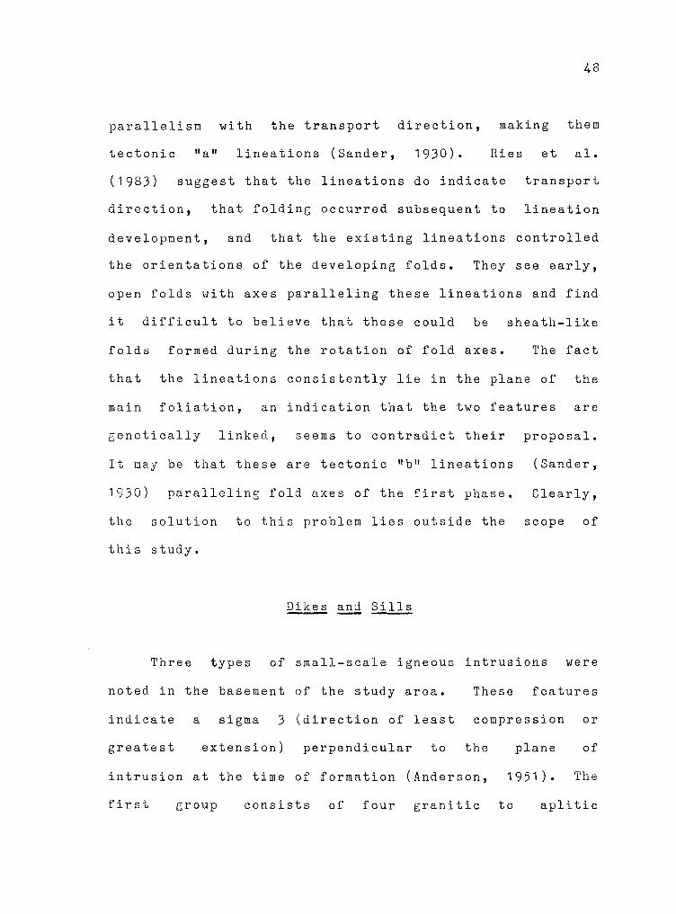
parallelism with the transport direction, making them
tectonic "a" lineations (Sander, 1930). Ries et al.
(1983) suggest that the lineations do indicate transport
direction, that folding occurred subsequent to lineation
development, and that the existing lineations controlled
the orientations of the developing folds. They see early,
open folds with axes paralleling these lineations and find
it difficult to believe that these could be sheath-like
folds formed during the rotation of fold axes. The fact
that the lineations consisGently lie in the plane of the
main foliation, an indication that the two features are
genetically linked, seems to contradict their
It may be that these are tectonic "b" lineations
proposal.
(Sander,
1930) paralleling fold axes of the first phase. Clearly,
the solution to this problem lies outside the scope of
this study.
Dikes and Sills
Three types of small-scale igneous intrusions were
noted in the basement of the study area. These features
indicate a sigma 3 (direction of least compression or
greatest extension) perpendicular to the plane of
intrusion at the time of formation (Anderson, 1951). The
first group consists of four granitic to aplitic

49
intrusions located around the borders of the granites in
the southeastern portion of the area. They have no
consistent orientation (Figure 15a) and are probably
associated with
The intrusion
the emplacement of the larger plutons.
of these small bodies caused minor
perturbations of the main foliation.
Two groups of mafic intrusions were identified: west
northwest to north-northwest striking dikes and nearly
horizontal sills (Figure 15b). They are fine-grained
rnetabasalts with the exception of a large, coarse-grained,
north-south striking dike which weathers to a dark olive
green.
The mafic sills were intruded parallel to volcanic
layering, and their orientations were probably controlled
by the layerine;. The dikes are indicative of north-
northeast to east-northeast extension. At least one is
youne;er than the granite w:1ich it cuts, but others exhibit
a weak foliation indicating an earlier origin.
are cut by the youngest quartz veins.
Several
North-northeast- to northwest-striking felsite dikes
indicate west-northwest--east-southeast to northeast-
southwest extension (Figure 15c). These dikes contain pink
phenocrysts less than four millimeters in length in an
aphanitic groundmass. Deep weathering to a brick-red
color makes it almost impossible to obtain a fresh

50
N
'l~ 4
a •
• • +
b r,
•
• + •
• • • • •
J ~,I
~ •
• • • •
• +
• • • •
c \ •
Figure 15. Poles to dikes and sills in Precambrian basement: a) aplitic dikes; b) mafic dikes and sills; c) felsite dikes.

51
sample. Similar dikes were noted in the basement
immediately to the east of the field area (D. Greene,
personal communication).
The brick-red felsite dikes are relatively young
basement features and are not nearly as shattered as the
bulk of the basement. They cut granites, rnafic dikes, and
shattered quartz veins; none was seen to be folded.
FaultinG did affect these features, but the age of the
faults cutting them was not determined.
Quartz Veins
The orientations of 137 quartz veins were measured in
the basement of the field area. Especially high
concentrations occur in areas adjacent to the granitic
bodies in the southeastern section of the area (Plate 1 ).
The veins exhibit fairly consistent orientations, having
northeast to north-northeast strikes and steep dips
(Figure 16). A small population of northwest-striking,
steeply dipping veins is also present.
Quartz veins also are interpreted as having developed
under the influence of a stress field with sigma 3
oriented normal to the plane of the vein. Hence, the
dominant northeast strike and steep dip indicate nearly
horizontal northwest-southeast extension during quartz

•• •
• ' ti
... .:.·'. --:r--: -... • . -. -.. . •
• •• •
•
... • • •
•
• •
•
• •
• •• •
•
•
•
N
• • • •
• • • • •
• ' •
• • • • • - • • • •
' • •• • •
• • L£1=U

53
vein development. The northwest-striking veins may have
developed under local stress fields, in part associated
with emplacement of the granites. The granites may also
have provided a source for silica-rich solutions. Five of
the northeast-striking veins with thicknesses greater than
20 centimeters have zones of pink to deep red feldspar
within them, giving them a granitic appearance. This may
be taken as a further indication that some quartz veining
was associated with granite emplacement and with related
stresses in the country rock roofing the plutons.
Greenberg (1981) also associates quartz veining with
emplacement of the Younger Granites of Egypt.
The northeast-striking veins apparently belong to at
least two major subsets; older, commonly shattered veins
and a younger group which is little affected by subsequent
deformation. Some members of the older family exhibit the
main foliation and are cut by felsite dikes and faults.
Only one was observed to be folded. Younger quartz veins
were not seen to be deformed, except by faulting, and show
no evidence of foliation.
dikes or siGnificant faults.
None was seen to cut felsite
The only quartz-bearing structural features in the
platform sediments are microjoint fillings. This suggests
a pre-Mid-Cretaceous origin for all quartz veins, most

54
probably in the late Precambrian. Older, shattered veins
developed prior to, or during, the early stages of the
first phase of folding, and their origin is unclear. The
development of the younger, northeast striking veins has
tentatively been linked to the first phase of folding,
which also produced much of the metamorphism of the
basement (Sturchio, Sultan, Sylvester, et al., 1983). The
veins may have formed as A-C joints perpendicular to the
regional sigma 3, with the metamorphism providing a source
of quartz. Finally, quartz veins of various orientations
were developed in association with emplacement of the
granites.

C H A P T E R III
STRATIGRAPHY OF THE SEDIMENTARY COVER
Two groups of Phanerozoic sedimentary rocks occur in
Egypt's Eastern Desert. The older of the two groups
consists of Cretaceous to Eocene platform carbonates and
related elastics that were deposited unconformably on
Eocambrian basement. Resting unconformably both on the
basement and the older sediments is the second group:
mostly littoral deposits associated with the formation of
the Red Sea.
Cretaceous to Eocene Sediments
There are seven mappable formations throughout the
area west of Quseir (Figure 17), deposited during a late
Cretaceous through Early Tertiary southward transgression
of the Tethyan Sea.
Nubia Formation
The Nubia Sandstone was a name applied by Russegar
(1837) to sandstones cropping out along the Nile River
south of Aswan. Since then, several variations of the
55

Hakheil Formation- thickness extremely chert nodule/pebble conglomerates1 and sandy ahalee; commonly limey, places
variable; sandatonee salty in
Thebes Formation- limestone, marl, and calcareoue shale near the baee paeeing upward into chalky and marly limestone near the top; plentiful black and brown chert nodules, lenses, and banda increasing upward from the base
f:·.; :- '·
1fff!fi:1:\)
c
56
POST-EOCENE
Ypresian
t::::l 0 Cl tr:l z t::::l
~~"'"'~~~~-0 .. ~~~0"'~~0~:::::::::c~~~-=- ~ I Esna Formation- gray to gray-green
somewhat calcareous near baae shales; --- Landenian
1-tJ > t""' t::::l 0 Cl t::::l z t::l
Dakhla Formation- gray to green to red-brown fissile ehalea; weather• to aal•on pink; •arly near base and top; high concentration of fibrous gypou• vein• near baee
Cl)
a:: ;::cl E-< ::£! ~
L...
100
50
0
t=- ~ ------1
- -
- ------ --------- ------------- - ----=--==- -
Duvi For•ation- phosphoritea, li•eatonea, and marls; highly foaailiferoua; economic phoaphate beds
--------------------------O::~::s:::::c:s:=:=C:=::m=-=-...:.ii:i Quseir Formation- variegated shale and siltstone,
some sandy; blue-gray to yellow-brown to graygreen to red-brown; •anganeee concretion• and staining com•on
Nubia Formation- clean terrigenoue aandatoneo; cream-colored, often kaolinitic basal layer; trough and tabular croes-bedding common; top grades upward into Queeir Formation ohalee
Basement- Eocambrian greenstonee, metavolcanice and meteeedi•ente do•inate the atudy area
"
,fl
/
-r-··~
i:-.--- ·-· -,..-.<;:: """ "" '-<::-
~
r:::::. ~ ~ '"""" """"' "" ""<:;: ' F".
l """ ~ ~ "" -.;;:
! . .... ,I J J 7 J
F.' 7
7 7 7 7 .J
""""/ 7 7 7 7
J(
• )
Hontian
Dani an
Ha es-
trichtian
Campanian
Santonian
Conie.cian
(/)
t::l z 0 z H > z
c:: 1-tJ 1-tJ t::l :::0
0 :::0 t::l >-3 > 0 tr:l 0 c:: C/l
PRECAMBRIAN
Figure 17. platform
Stratigraphy sediments.
of the Cretaceous to Eocene

57
name have been applied to sandstones and sandy shales over
most of northeast Africa, often without regard to age or
stratigraphic position. Throughout this study, use of the
term Nubia Formation will conform to the usage of Youssef
(1957) as applied to a predominantly nonmarine sequence
lying unconformably on the Precambrian basement complex.
Its upper boundary is marked by a transition to poorly
consolidated, varicolored shales.
Based on sparse fossil evidence within the Nubia
Formation and the overlying Quseir Formation, the Nubia in
this region is tentatively dated as Coniacian to early
Campanian in 1ge. It has been considered by others to be
as old as Cenomanian (Ward and McDonald, 1979; Van Houten,
personal communication) and as young as early
Maestrichtian (Issawi, 1972) in various parts of Egypt.
It should be noted that northward, in the Sinai, an older
"Nubian Sandstone" of Paleozoic age lies beneath units
correlative with the Cretaceous formation of the map area.
The thickness of the Nubia Formation in the Eastern
Desert is highly variable, thinning over basement
topographic highs. Within the study area, its thickness
varies from 70 to nearly 200 meters.
The Nubia can be divided into three distinct
lithologic units in the Qusoir area. These are, from
oldest to youngest, trough-cross-bedded conglomeratic

58
sandstone,
laminated
tabular-cross-bedded sandstone, and ripple-
siltstone and lenticular sandstone units
as described by Ward and McDonald (1979).
The lowermost trough-cross-bedded sandstones rest
unconformably on basement, which is often kaolinitized
along the contact. Within the study area, the base of the
Nubia is consistently marked by a light cream-colored
coarse sandstone to pebble conglomerate exhibiting
lavender and locally yellow staining. The basal zone is
unbedded or poorly bedded. The remainder of the lowermost
unit consists mainly of yellow-brown to red-brown, non-
bedded to trough-cross-bedded sands. The basal unit
attains a maximum thickness of about 80 meters in the
vicinity of Quseir and is 50 to 60 meters thick at the
southern end of Gebel Duwi. Great local thickness
variations are observed due to basement topography. The
characteristics of the lowermost unit are consistent with
deposition on an alluvial plain (l!ard and ~cDonald, 1979).
The second unit within the Nubia Formation is made up
of broad lenses of nonbedded sands and spectacular
tabular-cross-bedded sands that interfinger with ripple
laminated fine sands to silts. Cross-bedded sands account
for more than half the thickness of this unit, which also
was deposited on an alluvial plain (Ward and MCdonald,

~ "
' !>
59
1 979). A variable thickness of 50 to 140 meters is
reported for this unit in the Eastern Desert (Ward and
McDonald, 1 979) • At Gebel Duwi, it has a thickness
slightly greater than the underlying trough-cross-bedded
sands.
The third and uppermost lithologic subdivision of the
Nubia Formation is dominated by dark brown to dark red-
brown fine sandstones and sandy siltstones. Some of the
sands are trough-cross-bedded, particularly near the base
of the unit. An alluvial coastal plain/shallow marine
environment is postulated for the deposition of this unit.
The unit grades upward into the variegated shales of the
Quseir Formation. Precise placeIT.ent of a contact between
the Nubia and Quseir Formations is difficult as there is a
transitional zone where sandy silts and variegated shales
are interbedded. A fairly subjective boundary was drawn
where the variegated shales become dominant. The
thickness of the upper unit varies from about 20 meters at
Gebel Atshan to about 30 meters at Gebel Duwi.
Quseir Formation
The variegated shales of the Quseir Formation were
long considered to be part of the upper Nubia Formation.
Youssef (1949) described them in detail, calling them the

60
"variegated clays". The name Kossier Variegated Shales
was later applied to them by Youssef (1957), but Ghorab's
(1956) name, the Quseir Formation, has gained wider
acceptance.
The Quseir Formation consists mainly of poorly
consolidated shales, locally sandy, that vary in color
from gray-green to blue-gray to red-brown with rare
yellow-brown horizons. Manganese staining and concretions
are common and some gypsum veining is evident. Local thin
phosphate bands are present in the upper part of the
formation.
Some workers (Abd El Razik, 1967; Trueblood, 1981 )
put the upper contact of the Quseir formation at the
lowermost phosphate band. However, as the lithology
continues to be dominated by variegated shales above these
isolated bands, Youssef's (1957) placement of the contact
at the base of a hard, brown, one meter phosphatic horizon
will be used. Varicolored shales exist above this
horizon, but are secondary. This placement of the contact
yields a thickness of 50 to 75 meters for the Quseir
Formation in the study area. ~
Many of the early fossil-based age determinations for i -it
the "Nubian Sandstones" were, in fact, based on evidence j
from the variegated shales. A Senonian age is indicated J by these fossils and agreed upon by most authors (Said,

,' ;:.
~; f\z-~ ' ~ F
f-r f, t
L
~
' ~' r, f
1;_
J
61
1962; Issawi et al., 1969). In the Quseir area, a more
precise age determination of Campanian (Youssef, 1957; El
Tarabili, 1966; Abd El Razik, 1967; El Dawoody, 1970) or
possibly Campanian to early Maestrichtian (Issawi et al.,
1971 ; Issawi, 1972) has been made on the basis of fossil
gastropods and pelycypods from the Quseir and Duwi
Formations.
Fossils found in the Quseir Formation are of marine
and fresh water origin (Newton, 1909). Plant remains and
fossil wood (Seward, 1935; Issawi et al., 1971) indicate
a marginal marine to estuarine environment of deposition.
The Quseir Formation marks an upward transition from a
continental environment to the shallow marine environment
that produced the remainder of the platform sequence.
Duwi Formation
Resting conformably on the Quseir Formation is the
Duwi Formation. It was originally named the Phosphate
Formation by Youssef (1949), and that name continues to be
used by many workers, particularly along the Nile River
and in the Western Desert. Ghorab 1 s (1956) name, Duwi
Formation, given for its type locality in the southern
Gebel Duwi area will be used here. This name is used by

62
most workers in the Eastern Desert.
The formation consists mainly of hard, semi-
crystalline or siliceous limestones, phosphatic beds,
marls, and shales and contains chert bands, lenses, and
nodules. The phosphatic beds are mined for tricalcium
phosphate. Within the study area, the lower contact is
marked by a series of hard porcellanite and siliceous
phosphate bands interbedded with marls and coquina
limestones.
The upper half of the formation is dominated by marls
and oyster coquinas. Q~1r£~ Yi11~£, with a ribbed, ~ .. ,
triangular shell, is the dominant fossil found throughout
the formation. A one to three meter, soft, gray,
phosphatic bed marks ~he top of the Duwi Formation. In
the ~useir area, this formation is 50 to 70 meters thick.
Various workers (El Tarabili, 1966; Abd El Razik,
1967; Issawi, 1972) assign a Maestrichtian age to the
entire Duwi Formation, based on fossil dating. However,
Youssef (1957) dates the lower part of the formation as
Campanian on the basis of fossil ammonites, gastropods,
and oysters.
Bays connected to the open sea where strong currents
reworked the bottom sediments are the environments
suggested by Said (1962) for the deposition of the Duwi
Formation. Nairn (1978) notes that the fossil assemblages

63
indicate an open shelf environment and suggests that the
phosphates originated in shallow coastal basins behind
shoals or bars, with coarser deposits forming during
storms.
Dakhla Formation
Conformably overlying the Duwi Formation is the
Dakhla Formation, which is composed mostly of gray to
green to red-brown shales. These weather to a salmon pink
color characteristic of the Dakhla slopes. Youssef (1957)
includes these rocks in the Esna Formation, but Said
(1962) gives them separate formational status.
The lower part of the Dakhla Formation is marly with
local limestone beds. Immediately above the lower contact
are several meters of dark gray-brown shales with
abundant, irregular, fibrous gypsum veins. These are
known as the "gypsy shales" by the local miners and are
used as an indication of proximity to the uppermost
phosphate bed of the Duwi Formation. The balance of the
Dakhla Formation is dominated by fissile shales, which
terminate at the base of the chalk of the Tarawan
Formation. The thickness of the Dakhla Formation ranges
between 145 and 170 meters.

64
Fossils in the Dakhla have fixed its age as
Maestrichtian at the base to early Landenian at the top
(Issawi et al., 1969; Issawi, 1972). Other authors
(Youssef, 1957; Said, 1962) assign a Danian age to the
upper Dakhla. The fossils are of shallow-water marine
organisms indicating near-shore deposition.
Tarawan Formation
The shales of the upper Dakhla For~ation grade upward
into the white marls and marly chalks of the Tarawan
Formation. It is often called the Chalk Formation (Said,
1962) or lumped together with the overlying Esna
Formation. Because these white, tan-weathering chalks are
lithologically distinct from the shales above and below
and have average thicknesses of 10 to 20 meters in the
study area, they will be treated as a separate formation.
However, because the outcrop pattern at the 1 :40,000 scale
of the original geologic mapping is very narrow, the unit
is combined with the Esna Formation on the map (Plate 1).
On the basis of fossil foraminifera, a Landenian age
has been assigned to this unit (Issawi et al., 1969;
Issawi et al., 1971; Issawi, 1972). It was deposited in a
shallow marine environment.

65
Esna Formation
The Esna Formation rests conformably on the white
chalks of the Tarawan. In the Quseir area, this unit
consists of 50 to 60 meters of gray to green, thin-bedded
shales with a few marly and silicic beds at the top. A
brown silicified zone containing pelccypod fragments
commonly forms the lowermost bed.
This unit is dated as Landenian to early Ypresian in
age on the basis of fossil foraminifera (Issawi et al.,
1971; Issawi, 1972). It was deposited in a near-shore
environment and represents a temporary regression
following the somewhat more distal deposition of the
Tara wan.
Thebes Formation
The uppermost unit of the Cretaceous to Eocene
sequence is the Thebes Formation. It is also known in the
literature as the "Operculina limestone",
and "limestone with flint" (Sail, 1962).
"lower Libyan",
In the study area, the base of the Thebes Formation
is generally marked by hard limestone with chert overlain
by a hard, gray to brown-gray limestone containing
Turritella casts. ---------- From the base to the top of the main

66
ridge of the Thebes, the lithology is dominated by chalky
limestone interbedded with thin crystalline limestone,
massive gray limestone, nodular, recemented limestone
conglomerate, marl, and some shale. Dark brown, gray, and
black chert is very common in the form of nodules, bands,
and lenses. Above
limestones tend to be
the
more
main ridge-forming beds, the
crystalline and thinly bedded,
with chert slightly less common.
The thickness of the Thebes Formation in the study
area is everywhere greater than 160 meters and can exceed
200 1aeters. The amount of erosion of the top of the unit
controls its thickness.
Fossil foraminifera indicate a Ypresian age for this
formation (Said, 1962; El Tarabili, 1966; Issawi, 1972)
and its deposition marks a return to a more distal, deeper
water environment. Uplift in the Eastern Desert during
the early Eocene, possibly related to the early stages of
Red Sea development, terminated its deposition and
eventually brought the area above sea level, resulting in
the subsequent erosion.
Topographic Expression
The units of the Cretaceous to Lower Eocene sequence
exhibit characteristic topographic expressions which help

67
to identify them in the field and on air photos. The
profile of the stratigraphic column (Figure 17) indicates
each unit's relative resistance to erosion.
The Nubia Formation can be distinguished easily from
the underlying basement by its brown color and its
weathering pattern. The lower two subunits tend to form
steep slopes, which are commonly covered with talus. The
top of the second subunit is commonly present as a minor
dip slope with the less resistant upper subunit stepping
up to the overlying shales.
The Quseir Formation weathers relatively easily and
develops gentle slopes between the two more resistant
units that bound it. It is commonly covered with its own
debris and that from the Duwi Formation. This makes it
difficult, in places, to determine whether the material is
in place or slumped.
The Duwi Formation, especially the resistant
limestones and coquinas, forms cliffs and ridGes that are
easily identifie~ in the field and on air photos. The
uppermost coquina bed can be seen as a stripped dip slope
that generally dips northeast in the study area. The
Duwi-Dakhla contact is almost always covered with debris
from the overlying strata.
The relatively soft shales of the Dakhla Formation

68
are eroded back from the Duwi ridges and slope gently up
to the more resistant chalks of the Tarawan Formation.
The slope steepens near the top where the shales are
protected by the chalk, which forms a narrow, debris
covered ledge.
The soft Esna Formation slopes moderately up to where
it, in turn, is protected by the limestones of the Thebes
Formation. The protective cap of massive Thebes
limestones forms ridges that are the most prominent
topographic features of the Quseir area. The main ridge
is formed at the boundary between the chalky lower half of
the formation and the more crystalline limestones of the
upper Thebes. A minor cliff is formed approximately a
third of the way up from tho base of the main ridge.
Post-Lower Eocene to Pre-Middle Miocene Deposits
Nakheil Formation
Over much of the area, the Nakheil Formation
unconformably overlies the platform sequence. Along the
northeast side of Wadi Nakheil it rests on basement. The
bulk of the Nakheil deposits occur in the downfaulted
troughs northeast of Gebel Duwi and east of Gebel Atshan.
Youssef (1949) first described these rocks as the

"Conglomerate
The sequence
69
and Sandstone Series" in the Quseir area.
is extremely variable lithologically,
consisting of chert nodule and limestone conglomerates,
sandstones, sandy shales, and sandy limestones. The basal
bed of the unit is usually a chert and limestone cobble
conglomerate. The formation fines upward and in some
instances appears to fine laterally with increasing
distance from major faults.
similar in appearance to
Several of its upper beds are
the shales of the Quseir
Formation and can be gypsiferous and/or salty.
Dy strict definition, the Nakheil Formation contains
no basement fragments (Trueblood, 1981) suggesting that
basement was not exposed at the time of deposition of this
unit. However, some quartz pebbles of possible basement
origin were noted in the conglomerates in Wadi Nakheil.
As basement is in contact with this unit in Wadi Nakheil,
these pebbles may have come directly from this source.
They may also have come via the platform sediments,
however.
To date, the Nakheil Formation has proved completely
unfossiliferous, even in thin section (Nairn and Ismail,
1966). It is therefore very difficult to assign it a
precise age. Said (1962) proposes an early Eocene age,
while El Akkad and Dardir (1966b) and Issawi et al. (1969)

70
assign it to the Oligocene, and Abd El Razik (1967) calls
it Middle Miocene. Similar conglomerates of Oligocene age
occur in the Gulf of Suez with only slight angular
unconformity with respect to the Thebes and older units
(private communication from petroleum company sources).
Limestone and chert conglomerates of pre-middle Miocene
age are also exposed along the Gulf of Aqaba/Dead Sea rift
(Garfunkel et al., 1974).
The thickness of this formation is extremely variable
due to its deposition as a tectonically controlled unit.
Multiple conglomeratic beds within the Nakheil Formation
suggest several periods of tectonic activity during its
deposition. It cannot be determined from this study
whether major normal faulting disrupted the platform
sediments prior to, during, or after deposition of the
Nakheil Formation. A much more detailed study of facies,
transport directions, and sources of elastic material
would be necessary to determine whether it was deposited
in downwarps or in fault-bounded troughs. El Akkad and
Dardir (1966b), Issawi et al. (1971), and Richardson
(1982) favor the fault-bounded trough origin, perhaps in a
lacustrine environment. However, as these studies provide
no concrete support for this preference, the validity of
their conclusions is uncertain.
The lower conglomeratic beds tend to form low ridges,

71
readily identifiable on the ground and on air photos.
Middle Miocene to Recent Deposits
A group of mostly littoral deposits of middle Miocene
to Recent age lies unconformably over the basement and the
aforementioned sediments. This group is associated, for
the most part, with Red Sea formation and deposition in
the resulting basin. These sediments crop out as a narrow
strip along the western coasts of the Gulf of Suez and Red
Sea (Figure 4). In the Quseir area, the strip is 5 to 10
kilometers wide and consists of five distinct units. With
the exception of the recent alluvial deposits, they have
only minor or no exposure in the mapped area (Plate 1).
For a more detailed description, see Greene (1984).
Recent Wadi Alluvium
The present wadi system in the Quseir area cuts
across all of the other units seen in the Eastern Desert.
Wadi floors are covered with a thin veneer of elastic
sediments ranging in size from clay to boulders. These
deposits cover large sections of the mapped area and are
transported toward the Red Sea by catastrophic flooding of
wadis following rainstorms.

C H A P T E R IV
STRUCTURAL FABRIC
Faults, folds, joints and a small number of veins
were noted in the Cretaceous-Tertiary platform sediments.
As previously mentioned, faults and joints in basement
also are discussed in this chapter.
Faults
Most major fault surfaces in the study area are
eroded and buried under talus. Consequently, inferences
concerning regional fault motions are based on minor
faults, which yield reasonably consistent results.
Attitudes of 190 faults were measured within the
Cretaceous to Eocene platform sediments and the Nakheil
Formation of the study area (Figure 18), 116 of which
exhibit slickensides
sense of motion.
(Figure 18) and have an ascertainable
Few of the fault surfaces show
significant mineralization; calcite mineralization is most
common, and some surfaces exhibit minor silicification. A
single fault surface has chert developed along it and is
associated with a set of chert-mineralized joints.
~ineralization is probably the result of precipitation
72

ffi iS en :i ~ I>:
! I>: i:i..
N
. . oo-r
' . ..
"
. .
N n •12 . no•ll
/ ' . . \
. . +
N N ~ "o"6 A Oa•IO
A•· Cj\
•o .. .. + .. + .... ..
0 .. ....... ..
0 .. 0
A ~
1---...----- Normal Fault;s Oblique-slip Faults Reverse Faults-----+---- Strike-slip Faults
Cl f5 u i...i z i...i u s g en
~ ~ I>: u
n.~140 no•73
··.
. .
.. N
.. . . ·- · . ., . : . 0•
001•11•0• ••
0 O 0 o°: •• e -o0 00 e .,
I• ,~ 00~ Cl
0 . . ' ., . . . \
. . ' . •.lo •o ; •
oo!Jrf o
' . . . . . .< ••
... . ~·· ..
• I
-
• Pole to Fault
O Slickenside
n.=18 no=IB
' ' '
N
+
n.•22 n,,•17
•Pole to Left-lateral Fault
• Pole to Right-lateral Fault
N
.·
i+'
n.•3 N n.z4
..,-A A
#
• • .. \ I I .. + ..
O Left-lateral Slickenside
6. Right-lateral Slickenside
Figure 20. Poles to joints in the study area. .....J \.tJ

74
from groundwater circulating through the cracks.
Attitudes of 84 faults in basement rocks were
measured (Figure 18). Minor chlorite was noted on a few
of the surfaces and post-faulting silicification is fairly
common. Thirty-seven of these fault surfaces exhibit
identifiable slickensides (Figure 18).
The area is dominated by west-northwest- to north-
northwest-striking, steeply to moderately dipping normal
faults (Figure 18), as would be expected in an area that
has undergone regional northeast-southwest extension in
Tertiary time. These faults cut the entire platform
sequence as well as basement, indicating their post-early
Eocene age.
A small number of northeast-striking reverse faults
in basement and cover (Figure 18) suggests possible
northwest-southeast Tertiary compression while a larger
number
platform
of northwest-striking
sediments (Figure
reverse faults
18) suggests
in the
northeast-
southwest compression. Many of the moderately dipping,
northwest-striking reverse faults are parallel or sub
parallel to bedding and are in close proximity to major
normal faults. These reverse faults are probably the
result of flexural slip out of drag-folded synclines.
Steeply dipping, northwest-striking minor reverse
faults may have formed as normal faults prior to block
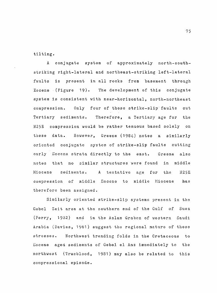
75
tilting.
A conjugate system of approximately north-south
striking right-lateral and northeast-striking left-lateral
faults is present in all rocks from basement through
Eocene (Figure 19). The development of this conjugate
system is consistent with near-horizontal, north-northeast
compression. Only four of these strike-slip faults cut
Tertiary sediments. Therefore, a Tertiary age for the
H25E compression would be rather tenuous based solely on
these data. However, Greene (1984) notes a similarly
oriented conjugate system of strike-slip faults cutting
early Eocene strata directly to the east. Greene also
notes that no similar structures were found in middle
.Miocene sediments.
compression of middle
therefore been assigned.
A tentative
Eocene to
age for the
middle Miocene
112 5E
has
Similarly oriented strike-slip systems present in the
Gebel Zeit area at the southern end of the Gulf of Suez
(Perry, 1982) and in the Azlam Graben of western Saudi
Arabia (Davies, 1981) suggest the regional nature of these
stresses. Northwest trending folds in the Cretaceous to
Eocene aged sediments of Gebel el Anz immediately to the
northwest (Trueblood, 1981) may also be related to this
compressional episode.

a
c
Riqhl·IOIUCI'
fo11Ul 011• Sl1clii•rit•••~
N
~·~~-6
/4"--/ HS
/ ... hwlu
-A> 4
4
1
:•: 4 4 4
',4 . . !<!!"
4
n•22
~, / /
Yi~ ~· _/
:i•q""o I
N
+
. .
76
Ltll·lol•rol
Faul" and Sl1c•tt1tide1
b N
~
d N I HZ>E
c~~u.ian
.,/'
y
I
Figure 19. Tertiary N20E compression: a) and b) combined strike-slip fault data; c) calculated causal maximum compressive stress orientations; d) N20E comression and resultant strike-slip fault system.

77
Some segments of the major north-south normal fault
zones may be reactivated right-lateral faults related to
N25E compression. Four of the right-lateral faults,
including a section of the northern end of the Gebel
Atshan Fault Zone, have experienced both right-lateral and
younger normal motion. Greene (1984) also notes numerous
strike-slip faults reactivated as normal faults and
tentatively associates this reactivation with the
initiation of Red Sea rifting.
Joints
Attitudes of 282 joints were measured in the study
area; 117 in basement and 165 in the platform sediments
(Figure 20). Two or three examples of each prominent
joint set present at separate stations throughout the
study area were measured to obtain these data. Both
basement and cover display approximately east-west- and
north-south-striking, steeply dipping major joint sets
with some scatter. Steeply dipping, northeast-striking
joints are present in both sequences, but are better
developed in the cover.
A northwest-striking set with moderate to steep dips
is better developed in cover. Joints of this set in
basement have extremely variable dips, uhich may indicate

+
'® N
SlNIOr 1N3W3S\f8
·'· .. ,~ • • • • • . • • •• • •
• ••• • •
•• • • • • . • •• •
•• • • •
• • • • •
+ o. • • •
• 0 • • • •
• 0
•• I .:'( .. ,,
•• N
8l
puo ·.,_i;'•J,,!i '%1
;f.o•l,IUJ)O ... 0
1u•ur e
N
SlNIOr 'M3AOJ
. . • •
·": : ... 0
• ..,, .. ... ..
• •
+
• • •
'·t • • • •
•
• • •• •••
,::• .: • •
N
• • • • • • •
•
"" • • •
• ·' 1:91••

79
that they are old and have been folded prior to deposition
of the platform sediments. They also appear very similar
to the main spaced cleavage in the basement; hence some of
these "joints" may actually be incorrectly identified
cleavage surfaces.
The major north-south and east-west joint sets appear
to bear little relation to any other observed structural
grains, although some of the older north-south joints may
be related to east-southeast extension which would have
complemented N25E compression. Similarly,
striking joints may be the result of northeast,
related extension.
northwest-
Red Sea-
In most cases, joints are undeformed and cut all
othej' structural features, indicating that they are among
the youngest features in the study area. Age relations
within and between joint groups are complex and commonly
contradictory. At many locations, older, silicified sets
parallel fresher, younger sets.
Much more detailed work specifically concentrating on
joints
these
is necessary to clearly understand the meaning
features. However, based on a similarity
of
of
orientations and character of basement and cover joints,
it is proposed that most jointing is post-early Eocene.

80
Veins
Three northeast-striking, steeply dipping chert veins
were noted in the upper Thebes Formation atop Gebel Nasser
(Figure 21). They appear to have resulted from syn
sedimentary deformation in the Early Eocene and may be
related to an early northwest-southeast extension. A
small number of other veins were noted in the cover
(Figure 21), but because of the small sample size, no
useful information can be derived from them.
As previously stated, high concentrations of gypsum
veins are located in the lower Dakhla Formation. Although
no examination of these features was undertaken, they may
prove a fruitful subject for future study.
Linearaents
Basement Lineaments. Basement lineaments were drawn on
LANDSAT return beam vidicon (RBV) images at two scales:
1 :208,000 and 1 :606,000. The 1 :208,000 image (Figure 22)
includes both Greene's (1984) area and the present study
area (see Figure 1), whereas the 1:606,000 image
23) includes the entire Quseir-Safaga district.
images show N30-70E trends of moderate intensity,
(Figure
Both
which
correspond to the major N60E faults of the study area.
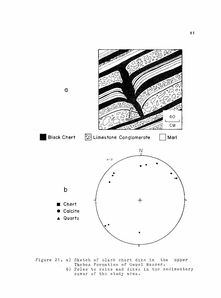
a
II Black Chert ~§1 Limestone Conglomerate 0Marl
N
n=/2~ • •
• • • I
b I
• Chert +
• Calcite A Quartz
\· •
Figure 21 • a) Sketch of black chert dike in the upper Thebes Formation of Gebel Nasser.
81
b) Poles to veins and dikes in the seJimentary cover of the study area.

2b 0 20 IN
Rtu SU
,\ \ '\ /
, \,•'-:rr ~j ~I • • ,_ ,,, ft , '"j!:[R I '.~'- x,' 'Yf?_ ~'· ; , ::::f' ' / .,.,.. -x~ .
/, ,· \'/ ~/ ..---'/ . ' ' . )(.......--,- ~........ \'
,/ , ·I - - ) ~' --'' ' x ,,,.-" ;" / \<~/, :\\~
, ,,_,.
2\olu'N ~ ..,
)4 ° uo IE
w
~
" ,,
i'
I
""· . '.
''\
* ·S
'° " .. ~ r..,., ~ --·~,_,_
N
34° ~U'E
CJHCENTRA.T [UN fACTOil 9Y SUHBER
:uNCENT~ATIOM FACTOR BY i..t:Nl.ITH
t.:C.CEN7RAT[O!f
r 1:.:;cR
Figure 22. Lineaments in the basement of the study area.
82
TOP: Sketch map of the studied area with lineaments superimposed.
CENTER: Rose diagram of lineament azimuths. BOTTOM: Histogram of lineament azimuths by number. Rose diagram and histogram are twice smoothed using a ten degree running average calculated for every degree.

26° 40'N
0 10 ~
KM
25° 40'N -t--~~~~~~~~~~~-L 33° 30'E
w
H
3: => 0
'---
/
"" "' U)
I N
0 U)
W I cc: z
/
'---
/~~ /
/ "---··/ ~
34° 20'E
CONCENTRATION FACTOR BY NUMBER
CONCENTRATION FACTOR BY LENGTH
[ 5
CONCENTRATION
FACTOR
E. 0
83
Figure 23. Lineaments in the basement of the Quseir-Safaga area.
TOP: Sketch maµ of the studied area with lineaments superimposed.
CENT~R: Rose diagram of lineament azimuths. BOTTOM: Histogram of lineament azimuths by number. Rose diagram and histogram are twice smoothed using a ten degree running average calculated for every degree.

84
North-south trends show up only weakly on the
1:208,000 image, but are stronger on the 1 :606,000 image.
This may be because they are overwhelmed on the 1:208,000
image by trends parallel to the Red Sea that are very
prominent in the basement of the southern Gebel Duwi area.
Although the Red Sea trends are present on the regional
image, they are not as strong, perhaps due to greater
coverage of areas at increased distances from the Red Sea.
Although the regional image exhibits more diffuse
northwest trends, the N60W Gebel Duwi (Najd) trend is
clearly present. Its presence is also evident on the
1 :208,000 image as would be expected. The strength of the
rose diagram peaks representing the length and number of
Duwi-parallel lines indicates that, although the number of
these lines does not approach the number of Red Sea
parallel lines, the total length of lines for these two
groups is nearly identical.
DiverGence of these results from data gathered in the
field lies in the absence of east-west lineaments. East-
west faults are relatively common in the basement of the
study area and have also been reported in the literature
(see Chapter II). East-west faults may be of diminutive
size in the Quseir-Safaga region, being too small to be
picked up on the RBV images.
Cover Lineaments. Lineaments in the Cretaceous to Eocene

85
cover were drawn on 1 :47,000 copies of the air photos used
during field work (Figure 24). Northwest trends, Duwi
(Najd) trends, and Red Sea trends show weakly. Minor
north-south trends are best represented in the southern
end of Gebel Duwi and along the Bir Inglisi Fault Zone.
East-northeast and N20-30E trends are present along
the northeastern dip slope of Gebel Duwi. Although
neither of these trends is particularly well-expressed in
field data for faultine (Figure 17) or jointing (Figure
19), they may be the result of structurally controlled
drainage down the dip slope of Gebel Duwi. Several large
joints paralleling wadis on the dip slope of Gebel Duwi
were noted in the field, but as relatively few stations
were located along the dip slope, these features may be
underrepresented in the data.
With the exception of the dip slope lineaments, all
of the lineament trends have corresponding fractures
present in the ground data. Generally, these are the
same trends noted by El Tarabili (1964; 1971) in the
Quseir area. llowever, his study showed much stronger Red
Sea-parallel trends based on ground data. Although
fractures parallel to the Red Sea dominate the sedimentary
cover (Figure 18), they must be relatively diminutive as
they do not appear as strongly on the air photos.

26° 10 1 11
.26° 05'H
34° OS'E J4° 10'E
\Y~/',\ °'
T',, \ /-~'~l/1 /\ .. -.. , \ \ - '-~ 1V - \, -,/ ~ I - \ \\
,_, J,-~ - ''-----',~,_ I ~
Ce ,· / /,_,/_ --; \ .'-
e, 0,---~ '( \ -.: ~ l;~ ... -~ - Du,._; Ir ;:.-J1 , ___ \-- I \-~ I-\ - ,\ /('
',, I ..-r;__: \~~7 .. , ~ \~ , ' 11-. ~ ~·
~--;_~ ;~v) '
~ ~ ,; /1 1;\ ;' ·,1
KH
\~:s's/ER~ \ \
~ 7 ' ( 1 ·,J I \ ~ \
\J ',
~17 r / i
i 1 \ I
.. .... c -o~ w Jr-I• !I') ::l!l')Jr:
"' :m ;:ii :n :i..c :::> ~ ' ·-:.::
~-"IC
W N
·\~ y
COHCENTRATIOH FAC:'JR BT •UMBER
CONCENTRATION FACTOR B't LENGTH
f s l CONCENTRATION
/\ f FACTOR
Ea
86
Figure 24. Lineaments in the sedimentary cover of the study area.
TOP: Sketch map of the studied area with lineaments superimposed.
CENTER: Rose diagram of lineament azimuths. BOTTOM: Histogram of lineament azimuths by number. Rose diagram and histogram are twice smoothed using a ten degree running average calculated for every degree.

C H A P T E R V
MAJOR FAULT AND FOLD STRUCTURES
Faults
Six major fault zones cut and bound the tilted blocks
of the study area (Figure 7): 1) Wadi el Isewid Fault
Zone, 2) Wadi Nakheil Fault Zone, 3) Wadi Hammadat- Wadi
Kareio Fault Zone, 4) Bir Inglisi Fault Zone, 5) Gebel
Nasser-Gebel Ambagi Fault Zone, and 6) Gebel Atshan Fault
Zone.
Wadi el Isewid Fault ~
The Wadi el Isewid Fault Zone forms the southern
boundary of the Gebel Atshan Fault Block. The main fault
zone is exposed in outcrop between the southern end of
Wadi Beda el Atshan and Wadi llammadat (Figure 3) where it
is a highly brecciated, quartz-cemented zone with evidence
of normal motion on it. The fault zone marks a sharp
boundary between areas of moderate to extensive unroofing
of the granite to the south and only initial unroofing of
the granite to the north. The established north-side-down
nature of the fault motion can therefore be inferred to
87

88
offset the granite in that fashion. Youngest quartz
veining, which cuts the granites, may also have figured
in the silicification of the breccia zone. Although Garson
and Krs (1976) contend that U60E faults are the oldest in
the basement, some normal motion occurred within tqe study
area on this fault subsequent to the emplacement of the
Younger Granites (see Table 3).
In the study area, evidence for Tertiary reactivation
of this zone is lacking. However, Greene's central Nubia
valleys, small downfaulted areas of preserved Hubia
Formation, are bounded on their southern ends by
northeastward extensions of the Wadi el Isewid Fault Zone.
This suggests that at least those portions of the zone
were active in Tertiary time.
Wadi Nakheil Fault Zone
The Wadi Nakheil Fault Zone bounds the northeast side
of the Gebel Duwi Fault Dlock. An extension of this zone
may also bound the northern end of the Gebel Atshan Block.
This zone strikes approximately N55W and dips about 50
degrees to the southwest at the surface. Cretaceous to
Eocene platform sediments of Gebel Duwi, which parallels
the Wadi Nakheil Fault Zone, are preserved within the
half-graben formed by normal motion on this zone.

89
A minimum of 600 meters of post-early Eocene throw
places Thebes limestones against Precambrian greenstones
and tilted basement and cover to the northeast. Total
throw between Gebel Ambagi and Gebel Hakheil is probably
substantially greater than 600 meter~ as the Thebes
basemont contact lies below an undetermined thickness of
wadi fill and Nakheil Formation. Drag along the fault
folded the platform seuiments of this monocline into a
broad, open, synclinal form (Plate 2).
At Gebel Uakheil, the fault steps to the left where
it is interrupted by and curves into a N60E fault segnent
that transferred normal motion from one section of the
fault zone to another. Several such parasitic steps and
changes of orientation of the northwestern border fault of
the Gebel Duwi Block can be seen on regional LANDSAT
imagery (Frontispiece).
To the southeast, the Wadi Hakheil Fault Zone may
step to the southwest and continue to a termination
against the Gebel Atshan Fault Zone. Alternatively, the
fault between the northern end of Gebel Atshan and Gebel
Ambagi may be an extension of the Gebel Atshan Fault Zone.
The Thebes Formation at the northern end of Gebel Atshan
appears to dip under the Precambrian rocks of Gebel
Ambagi, which has a total topographic relief in excess of

90
100 meters. Therefore, total normal offset on the short
northwest trending fault segment must exceed 700 meters.
Wadi Hammadat-Wadi Kareim Fault Zone
The southeastern end of the Gebel Duwi Fault Block is
bounded along its southwestern edge by the Wadi llammadat
Wadi Kareim Fault Zone. Faults dip northeast and
southwest on either side of the Wadi Inglisi Horst Block.
These faults terminate to the southeast against the Gebel
Nasser-Gebel Ambagi Fault Zone.
Motions on these faults are less than those on faults
bounding the opposite side of the Gebel Duwi Block. The
minor offset of a north-northwest striking felsite body
(Plate 1) indicates only slight motion on the northeast
dipping fault. More substantial motion occurred on
southwest dipping members. Approximately 300-400 meters
of Cretaceous or later southwest-down throw is required
across the entire zone.
Bir Inglisi Fault Zone
The northwest trending Gebel Duwi Block is broken by
transverse zones trending approximately north-south, both
within the study area and to the northwest. The north-

91
south ridges extending between the dip slope of
southwestern Gebel Duwi and Gebel Hakheil developed in
such a zone (Plate 1). These ridges consist of a series
of horst-and-graben-like structures that are less dropped
or tilted to the northeast than the areas on either side
of them.
Faulting imparted a gross anticlinal structure to the
north-south ridees. The ridges are bounded by hinge
faults that exhibit increasing throw northward along their
strikes. Nowhere is the throw on these faults greater
than the thickness of the Thebes Formation. Displacements
become negligible to the south where the faults die out as
they intersect Gebel Duwi. The faults may be scissors
faults as a series of similar structures present south of
the main Gebel Duwi ridge exhibit increasing throw to the
south.
Gebel Nakheil is a short north-south ridge of
Cretaceous to Eocene sediments lying at the northern end
of the Bir Inglisi Fault Zone (Figure 25) and, like the
ridges to the south, has an anticlinal structure. It is
located where the tladi tlakheil Zone steps to the left at
the intersection with the Bir Inglisi Fault Zone. The
platform sediments of Gebel Nakheil dip east to the east
of the step and west to the west of it.

92
Figure 25. Geologic map of the Gebel Nakheil area. Precambrian basement; Kn= Nubia Fm.; Kv= Quseir Kd= Duwi Fm.; Td= Dakhla Fm.; Te= Tarawan and Fms.; Tt= Thebes Fm.; Tn= Nakheil Fm.; Qa= alluvium.
PC= Fm. ; Esna wadi
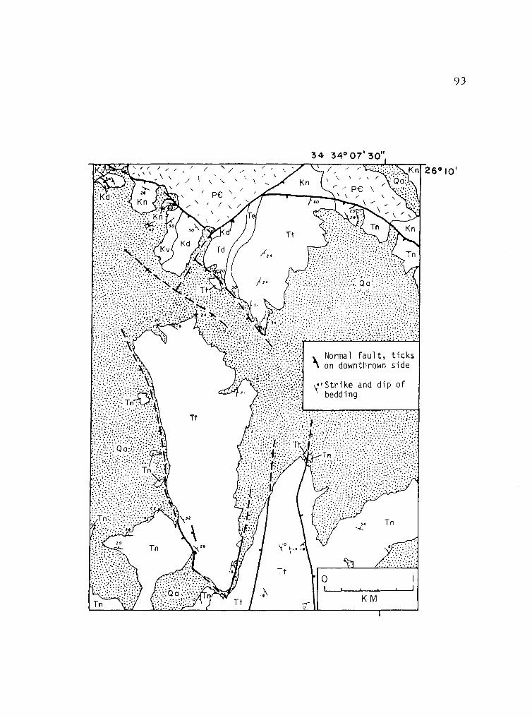
I' '/ /
/ '\ ' '- \
PC '· /
/ , /
-' 0
\'Strike and dip of bedding
KM
93
26°10'

94
It may be that the series of anticlinal ridges in the
platform sediments result from drape folding over faulted
basement blocks. The north-south zone is truncated
against the step in the Wadi Nakheil Fault Zone and does
not appear in the basement to the north (Abu Zied, in
preparation). However, exposures of the Bir Inglisi Fault
Zone south of Gebel Duwi suggest a structure of this kind.
There, faults in basement form a graben that extends
upward into the Nubia Formation, but the overlying Duwi
and Dakhla Formations are folded into a broad syncline
(Plate 1). A trend of N20W, 15NW was estimated for the
axis of this fold by constructing a best-fit beta diagram
using bedding orientations measured around the fold. The
Bir Inglisi Fault Zone appears to be truncated to the
south where it intersects the Wadi Hammadat-Wadi Kareim
and Gebel Nasser-Gebel Ambagi Fault Zones.
Gebel Nasser-Gebel Ambagi Fault ~
The Gebel Nasser-Gebel Ambagi Fault Zone forms the
southeastern termination of the Gebel Duwi Block and its
bounding faults, and also bounds the western side of the
Gebel Atshan Block. The fault disappears under the Miocene
and younger sediments to the north and under wadi fill to
the south, where it may terminate against the Wadi el
95
Isewid Fault Zone.
An exposure at the southern end of Gebel Nasser shows
the fault zone dipping west-northwest at 45-50 degrees.
Upper Thebes limestones are in fault contact with Duwi
Formation along the eastern side of Gebel Nassser
indicating a throw of over 300 meters at that location.
Topographically, Gebel Nasser resembles an
amphitheater with its broadly curved, deeply dissected,
north-facing dip slope. This shape is the result of open
folding of the platform sediments where they have been
dragged along the Gebel Nasser-Gebel Ambagi Fault
A beta diagram was constructed using
Zone.
orientations measured around the "amphitheater" of
bedding
Gebel
IJasser's Thebes Formation. The axis is oriented
approximately N10E, 20HE. Approximately east-west bedding
plane slip noted in the Duwi Formation of southern Gebel
Nasser is probably a result of this folding.
The eastern side of Gebel Nasser, along Wadi Beda el
Atshan, was examined in some detail as it appears to
involve numerous structural complexities (Figure 26). A
sliver of this southeastern end of tho Gebel Duwi Block
apparently collapsed along the main fault to. create a
small, graben-like structure. A sketch of the ridge
(Figure 27) between stations 1253 and 1310 (see Fieure 26)

96
Figure 26. Geologic map of the Gebel Nasser area. PC= Precambrian basement; Kn= Nubia Fm.; Kv= Quseir Fm.; Kd= Duwi Fm.; Td= Dakhla Fm.; Te= Tarawan and Esna Fms.; Tt= Thebes Fm.; Qa= wadi alluvium.

/Nonnal fault, ticks on /" downthrown side
;i' Trend of gently plunging, minor 1110nocl fne Rotation sense fndicated
")""Strike and dip of beddfng
• Statfon location discussed '0
" in text
0
KM
Tt
I]
............ •5 _.....
10
---'-
••
,. /
',, / ,, \ ',.',....-' 34°
26
05'
Tt
'° -...J

NW
a
w
b
1310
[J Wadi Alluvium 1 / / '
Im Nakhei I Formation ~Platform Sediments 0 PC Basement
Talus
Wadi Seda
e I Atshan
98
SE
E
Figure 27. Gebel Nasser-Gebel Ambagi Fault Zone: a) sketch of view of the ridge between stations 1310 and 1253 showing style of deformation; b) sketch cross-section of Gebel Nasser showing faulting and extensional collapse along Wadi Beda el Atshan.

99
and
27)
a generalized cross-section of Gebel Nasser
illustrate the structural relations. Many
(Figure
of the
"structural complexities" initially noted in this zone are
the result of extensional collapse of large blocks between
the two oppositely dipping normal faults.
Several minor southwest-down normal faults and folds
are present in the Duwi Formation of southern Gebel Nasser
(Figure 26). They are approximately parallel to the trend
of the Gebel Duwi Block and the faults bounding it.
Therefore, they may be associated with the faultinG and
tilting of this block. Age relations between these
structures and north-south structures are uncertain.
llowever, these features do not extend across the Gebel
l!asser-Gebel Arnbai:;i Fault Zone into the
basement south of Gebel Nasser; their
Precambrian
termination
suggests that the north-soutl1 zone may have existed prior
to the development of the northwest~trending zone.
Other evidence suGgcsts a greater antiquity for the
northwest-trending structures. One mechanism for folding
of the Duwi Formation alon; these northwest trends
involves slip on joint surfaces. Gentle warping resulting
from this mechanism was noted at station 1002 (see Figure
26). Joint surfaces at this location and slickensides on
them are both perpendicular to now tilted bedding (Figure
28), suggesting that motion on the joints predates

,,.
"
. n\S
?\a\'0(\'11 se<l\\'lle
Figure 28. Slip on joints perpendicular to Duwi bedding as a mechanism of folding at station 1002, southeast Gebel Nasser. Flexure zone is approximately 3 meters across. GN-GA= Gebel :iasser-Gebel Ambagi Fault Zone.
0 0

101
tilting.
Gebel Atshan Fault ~
Gebel Atshan is an east-tilted block of platform
sediments along the eastern edge of the study area.
Quseir through Thebes Formations are exposed along its
west facing erosional scarp; the main ridge, like Gebels
Duwi and Nasser, is capped by Thebes limestones. A north
south fault zone with a dip of 60-70 degrees to the west
at the surface bounds the Atshan block to the east.
Surfaces within this zone near Wadi Ambagi exhibit early
right-lateral slickensides and younger normal
slickensides. The Thebes and overlying Nakheil Formations
are dropped into contact with the basement along this
fault indicating more than 600 meters of normal motion.
Slivers of the platform sediments are exposeu along the
Gebel Atshan Fault Zone as a result of drag on the fault.
Drag on a small, westward-projecting irregularity in tl1e
fault surface about one-half kilometer south of Wadi
Ambagi resulted in a small-scale anticlinal upbulgine
(Plate 2). The fault zone terminates to the south against
the Wadi el Isewid Fault Zone.
is unclear.
Its northward termination
An elongate, elevated basin is formed between the

102
main ridge of Gebel Atshan and the basement highlands to
the east. An outlet of this basin into Wadi Hakheil cuts
through the Thebes ridge at its northern end. Along the
western margin of this basin, basal llakheil conglomerate
beds are nearly concordant with underlying Thebes
limestone bedding. Dips of the two formations are within
8 degrees of one another. 'l' h e s e Ii a k h e i 1 d e p o s i t s f i n e
upward to sands and sandy silts with a few coarse
interbeds. The uppermost part of the Nakheil Formation,
which largely underlies recent alluvium, approaches a
horizontal attitude. Hakheil conglomerates along the
eastern ed~e of the basin are also nearly horizontal. The
geometry su~gests that episodic motion and tilting
continued during deposition of the Nakheil Formation.
Folds
A small number of folds were noted in the platform
sediments. llost are folds in the Thebes 1''orma ti on; the
three exceptions fold bods in the Duwi l'orma ti on. The
folds are generally very open synclines formed by drat;
along normal fault surfaces. Therefore, their axes and
axial planes tend to trend north-south to northwest-
southeast, paralleling Tertiary fault strikes. Folds

1 03
range in size from regional features of 1-5 kilometers
wavelength to outcrop-scale structures \Iith wavelengths of
less than a meter and amplitudes on tlie order of a few
tens of centimeters. This relationship can be seen on a
large scale in the broad, open foldinc of Gebel Nasser.
It is also visible where the platforQ sediments of Gebel
Duwi dip under the fill of Uadi Uakheil and reappear again
3 to 4 kilometers to the northeast alone the fault
boundine the northeast side of this valley (Plates 1 and
2).
A major exception to this style of folding is the
large overturned fold in the Theb3s Foruation atop the
main ridGe of Gebel Duwi (Plate 2) and minor folds
associated with jt. The main fold has a wavelength and an
amplitude creater than 50 neters,
northwest-southeast-trending axis,
a nearly horizontal,
a gently southwest
d!pping axial surface, and a sou th we s t-over-:10rtheas t
rotation sense. Minor folds associated with this
structure have approximately eact-west striking axial
surfaces and enst-west trending, gently plunging axes. No
evidence was seen to indicate that the strata below the
Thebes were folded. To accommodate this folding in the
The be f; limestones, bedding-plane faulting- probably
occur1·ed in the underlying shales of the Esna Formation.
As tho shales could only be examined with binoculars from

the wadi floor below,
not be confirmed.
104
the existence of these faults could
Although the ~hebes Formation as a whole was ductile
enough to be folded, nunerous minor faults are present.
ifany of the ci1e rty and more brittle line stone beds
involved in this laq~e fold are broken. Depth of burial
at the time of foldinc was probably less than 100 meters
as the fold involves the lower half of the Thebes
Formation. Thus, only the upper part of the Thebes would
have overlain the observed folded strata at the time of
deforr.1a ti on. Lower Eocene deposits can be several hundred
meters thicker in other parts of Egypt (Said, 1962), but
no evidence of thicknesses greater than 200 meters exists
in the Quseir-Safa~a region. Even if these thicker
deposits were present, maximum depth of burial should not
have exceeded 500 meters.
Two possible origins coce to mind for this structure.
First, it could be due to regional compression at a high
angle to the fold axial trends. This cowpression could
have produced folding in the limestone and bedding plane
thrusts in the underlying shales. Strike-slip faulting
provides evidence of late Eocene to early Miocene north
northeast compression that could have caused the folding.
A second possible mode of formation is by gravity

105
tectonics. ~ollowing the tilting of the fault blocks, the
steepened Thebes Formation may have 11 slid downhill" to the
northeast on the underlying, less competent shales causing
folding and buckling. The main fold trends approximately
parallel to bedding strikes in Gebel Duwi and has the
proper transport sense for this mechanism.
Because the fold root lies to the southwest of the
cliffs of the Gobel Duwi ridgo and has beon eroded away,
the choice between tho two possible modes of origin is not
clear-cut. The fold was not followed out to its northwest
termination due to time constraints and difficulties of
accesn. The block tilting and gravity sliding origin is
preferrod as it seems more feasiblo. The lack of
deformation of similar style in the area is the basis for
this preference. Nost of the significant deformation from
the N25E compression was apparently brittle in nature.
The only other folds not directly attributable to drag on
fault surfaces are open, gent~o warpings (Trueblood,
1 981 ) • However, it must be borne in mind that the large
overturned fold, although a large and prominent feature,
had not been previously reported.
undiscovered.
Others may yet remain

C H A P T E R VI
REGIONAL TECTONICS
Phanerozoic History 2f ih.2, Study Area
Following the cratonization of northeast Africa at
the end of the Proterozoic, the Quseir area became
tectonically
Paleozoic
stable and remained so throughout
and much of the Mesozoic. During
the
Late
Cretaceous tl1rough Eocene time, a sequence of platform
sediments was deposited as a result of the southward
transgression of a shallow epicontinental sea over
northeast Africa.
The relative stability of the Quseir area was
disrupted in the middle Eocene by epeirogenic uplift,
which resulted in the cessation of deposition. Regional
north-northeast compression in tho middle Eocene to middle
~iocene res~lteJ in the development of a conjugate system
of strike-slip faults in the Quseir area (Figure 19) as
well as in the Gulf of Suez region (Perry, 1982) and Saudi
Arabia (Davies, 1981). Schamel and Wise (1934) note a
similarly oriented coupression of ~ocene to Miocene age in
the Sinai and tentatively relate it to the late stages of
development of Syrian Arc structures. Further, they feel
106

1 07
that the system of conjugate strike-slip faults developed
under the influence of this compresional episode later
controlled the orientations of the Gulf of Suez/Red Sea
and the Gulf of Aden. North-northeast to north-northwest-
striking, right-lateral faults and northeast-striking
left-lateral faults were produced in the Quseir area by
this compression. N20E corapression also may have resulted
in folding noted by Trueblood (1981) and in downwarps
within which the llakheil Formation may have been deposited
(Gebel Duwi, Wadi Nakheil, and Gebel Atshan lows, see
Figure 6).
During Oligocene to early Miocene time, regional
stresses chanced resulting in northeast-southwest
extension related to the early development of the Red Sea
rift. A conjugate system of northwest-striking normal
faults developed under these stresses, and appropriately
oriented older faults were reactivated. This normal
faultinb dropped and tilted blocks of Cretaceous to Eocene
platform sediments into trOUGhS where they were
subsequently preserved as outliers. The Hakheil Formation
may have been deposited in these downfaulted troughs
rather than in earlier downwarps.
The style of Tertiary deformation is clearly shown on
structure contour maps for the top of reconstructed
basement of the southern Gebel Duwi-Quseir area (Figure 6)

108
and the Quseir-Safaga region (Figure 7). These maps show
that block faulting and tilting toward the Red Sea
dominate the study area. This is noted in the field as a
northeast tilt of the Nubia-basement contact.
In many parts of the world, reverse drag is commonly
present in areas dominated by block faulting along listric
normal faults. It seems unusual that this type of
extensional structure is present only in eastern Gebel
Nasser along the Gebel Nasser-Gebel Ambagi Fault Zone.
Conversely, true drag can be seen alonJ most of the major
fault zones in the area.
Intersection relationships of most major faults could
not be directly observed due to their burial beneath wadi
alluvium. However, map patterns indicate that, generally,
northwest-striking faults terminate against north-south
faults. ~orth-south faults terminate, in turn, against
N60E faults. This suggests that il60E faults are the
oldest in the study area and that northwest striking
faults are the youngest. Relations in areas to the north
(Abu Ziad, in preparation) and to the east (Greene, 1984)
are somewhat more ambiguous. Smaller-scale structures in
this study area also provide inconclusive evidence.
Eocene to early Miocene uplift was apparently
followed by a period of relative quiescence, with a middle

109
to late Miocene erosion surface developing along the Red
Sea coast of Egypt and Saudi Arabia (Brown, 1970; Schmidt
et al., 1982; Greene, 1984). The lack of major elevation
differences across normal fault zones in the study area is
a reflection of this erosion surface. Therefore, most of
the motion on these faults predated this Late Miocene
surface. Faults bounding Gebel Ambagi however, must have
experienced substantial motion following the development
of the nid-Tertiary erosion surface. ~he Miocene basal
Gebel el Rusas Formation deposited on a segment of this
erosion surface atop Gebel Ambagi now sits more than 100
meters above similar surfaces in the surrounding area. A
regular decrease
northeast
represent
suri'ace.
across
the
in basement peak elevation to
individual tilted blocks may
the
also
slightly tilted cid-Tertiary erosion
~rosion resultinc from Eocene to Miocene uplift and
faulting removed tl1e bulk of the Cretaceous to Tertiary
cover during creation of the mid-Tertiary erosion surface.
The iakheil Formation may well represent part of the
material removed, but an enormous quantity of sediment
must have been deposited in the proto-ned Sea rift.
Johnson (1977) notes Oligocene to Lower Miocene redbeds
deposited on Precambrian basement in the Ras Benas-Abu
Ghussun area of the Red Sea coast (near 24°u). Clastics

11 0
and boulder beds of Oligocene to Miocene ace are found in
drill cores offshore from Quocir and Safaga (Tewfik and
Ayyad, 1982). Carella and Scarpa (1962) report similar
deposits in southern Egypt and the Sudan. Pre-middle
Miocene redbeds and boulder conglomerates also exist in
the Gulf of Suez region (Garfunkel and Bartov, 1977). Ho
similar redbeds were noted in the study area or in areas
to the east (Trueblood, 1981; Greene, 1984).
With the exception of generally minor motion on
faults that disrupted the mid-Tertiary erosion surface
(e.g. the faults bordering Gebel Ambagi), the Quseir area
has remained relatively quiet for the past 10 ~. y. Upper
Miocene evaporites along the Red Sea coast to the east of
the study area are cut by some minor faults, but most of
the deformation of these units is the result of flowage
and tiltin~ in a zone of coastal flexure (Greene, 1984).
Tilting of the ~iocene to Pleistocene sediments toward the
Red Sea appears to have ended by the beginning of the
Quaternary as Pleistocene and lecent deposits have barely
noticeable dips. Iience, al though uplift has resulted in
the deep dissection of Upper Iiiocene and younger sediments
and the creation of several terrace levels along the coast
and in wadis, little faulting has occurred in the area
since middle ~iocene time. Table 4 summarizes the

Table h Phanerozoic history of the study area.
TIME PERIOD
Cambrian to Mid-Cretaceous
Mid-Cretaceous to Middle Eocene
Middle Eocene
Late Eocene to Early Miocene
Early to :.; i d d 1 e : \i o c e n e
r;iddle lliocene to present
SUMMARY OF EVENTS AND INTERPRETATION
Tectonic stability. Peneplanation of Precambrian basement by erosion.
Formation of large intracratonic basin over much of northeast Africa. Platform sediments deposited in this basin. This may be a precursor to Red Sea tectonics.
Uplift ends deposition of the platform sediments. Erosion creates an unconformity atop the Thebes Formation. Crustal doming is proceding prior to rifting.
1) il20S regional compression results in the development of a conjugate system of stri~e-slip faults: ililE to ilHW trending right-lateral and UE trending left-lateral faults. This compression may also have warped the platform sediments. fhis may be an early stage of Rod Sea-related tectonics.
2) ilE-SW extenional stresses become dominant resulting in new northwest striking normal faults. Horth to northwest striking preexisting structures are reactivated as normal faults, emplacing outliers of Cretaceous to Eocene sedi~cnts. This phase is related to initiation and widening of the Reri Sc~ rift.
~oto: Tho ~akheil For~ation is deposited during this time either in downwarps created by ;i20E compression or in fault-bounded troughs associate with northeast extension.
Uplift and relative quiescence of the study area results in the development of the Mid-Tertiary erosion surface adjacent to the Red Sea. A few faults experience substantial motion, but major activity is centered closer to the rift.
1) Deposition of coastal sediments in early Red Sea basin.
2) Slow, gentle uplift presaGes breakup and active sea-floor spreading in the northern Red Sea. This results in the dissection of the Miocene erosion surface and creation of raised beaches and terraces along tho Red Sea.
1 1 1

11 2
Phanerozoic history of the study area.
Tectonic Heredity
Obvious deviations from Red Sea fault trends occur in
the Quseir-Safaga area. The most prominent is that which
controls much of the orientation of the Gebel Duwi fault
block. Another fault dropped and tilted the Gebel
Hammadat-Bahari block to the southeast (Figure 1). It can
be seen on LANDSAT imagery (Frontispiece) that the Gebel
Duwi Fault Zone jumps from Najd-parallel segments to Red
Sea-parallel segments as does the fault bordering the
northeast side of Gebel llammadat. Tertiary extension
created Red Sea-parallel fault segments connecting
reactivated Najd segments.
Garson and Krs (1976) note that several zones in
Precambrian rocks along the Egyptian Red Sea coast
parallel the Gebel Duwi trend and claim evidence for left
la teral motion on many of these zones. They feel that the
movement was a secondary feature of left-lateral, strike
slip motion on the Red Sea rift during Cretaceous to Early
Tertiary sea-floor spreading in the Gulf of Aden. Lacking
evidence of Cretaceous to Eocene stresses in the study
area that could have produced such motion, it is here
proposed that any left-lateral motion on these faults is

11 3
more likely to be Precambrian in age and associated with
Najd faulting.
Old Najd fault trends exert much control over fault
orientations in this part of the Eastern Desert. As can
be seen in Figure 6, many of the faults which dropped and
tilted Cretaceous to Eocene sediments made use of both Red
Sea-parallel and Najd-parallel fractures. These trends
are, in turn, commonly disrupted by north-south faults.
It is possible that the Red Sea faulting may have
reactivated more ancient north-south Hijaz grain, although
this grain does not appear strongly in the bulk of study
area basement.
The idea of the reactivation of Najd trends by later
stresses is further supported by Greenwood and Anderson's
(1977) palinspastic reconstruction of the Arabian-Nubian
Shield. This reconstruction (Figure 9) shows the Wadi
Azlam graben of Saudi Arabia aligned with the Gebel Duwi
Gebol Hammadat fault blocks prior to separation. Although
these authors push the Red Sea back together farther than
may be warranted, this alignment of old llajd trends across
the Red Sea is not unrealistic. Smith (1979) and Davies
(1981) note reactivation of Najd trends to form the faults
that bound the Azlam basin, and Smith (1979) also
describes a Tertiary stratigraphy in the Wadi Azlam graben

114
of sandstone, gypsiferous, multicolored shales, and
fossiliferous (abundant Q~1E~~) limestone very reminiscent
of the platform sediments in the Quseir area. The
similarities of the Tertiary histories of these basins
suggest a similar origin and common control of their
orientations by Najd trends in the basement.
At the northern end of the Gebel Atshan Fault Zone,
right-lateral faults associated with Tertiary N25E
compression are connected by younger normal fault segments
with more northwest strikes. The later normal motion also
reactivated the right-lateral fault segments and resulted
in the jagged map pattern of the fault zone.
Typically, faulting and block rotation occur on
normal faults that dip toward and step down into a
developing rift. Red Sea-ward dipping normal faults
appear adjacent to the Gulf of Suez (Schamel and Wise,
1984) and are responsible for the preservation of
sedimentary outliers north of Quseir (Figure?). The dips
of major normal faults away from the Red Sea in the Quseir
area and to the south as far as Mersa Alam (El Akkad and
Dardir, 1966a) are unusual. It may be that this unusual
geometry is related to the existence of steeply dipping
planes of weakness, the strike-slip faults, at the onset
of regional extension. Thus, both Najd faults and earlier
Tertiary strike-slip faults may have exercised control

11 5
over not only the strike of later normal faulting, but
also over dip directions of these faults.
The Red Sea
Several models have been proposed for the structure
and evolution of the Red Sea. The most widely debated
question is the extent to which true sea-floor spreading
has occurred and therefore, how much of the Red Sea is
floored by true oceanic crust. Two schools of thought
exist regarding this question: that the Red Sea is floored
entirely by oceanic crust (McKenzie et al., 1970; Girdler
and Styles, 1974) or that sea-floor spreading has begun
relatively recently and that only the axial trough of the
southern Red Sea is floored by oceanic crust (Hutchinson
and Engels, 1972; Lowell and Genik, 1972; Coleman, 1974;
Tewfik and Ayyad, 1982; Cochran, 1983). Although
contradictory geological and geophysical data leave this
question unsettled at present, the evidence favors the
latter model.
Seismic reflection studies are inconclusive as
basement is lost beneath thick, seismically opaque Miocene
to Recent evaporites and marine sediments that cover much
of the main trough of the Red Sea. Seismic refraction

116
work is also inconclusive, but yields variable velocities,
most of which could be attributed to continental crust.
Evidence for an axial trough floored by oceanic crust
comes from magnetic surveys. The axial trough clearly
exhibits sharp, short-wavelength, high-amplitude,
symmetrical magnetic anomalies characteristic of ocean
crust (Girdler and Styles, 1974; 1976; Roeser, 1975).
Broad, smooth,
associated with
low-amplitude magnetic anomalies
the main trough and shelves of the
are
Red
Sea. Girdler and Styles (1974) correlate these broad
anomalies with the geomagnetic reversal scale of Heirtzler
et al. (1968) for the period 41-34 M.y. ago. Based on
this correlation, they propose a two-stage spreading
history for the Red Sea with spreading arrested between 34
and 5 M.y. before present. Recent paleomagnetic work in
the As Sarat Volcanics of southwest Saudi Arabia by
Kellogg and Reynolds (1983) places constraints on models
involving two stages of Red Sea-floor spreading. Their
results indicate that most of the motion of Arabia
relative to Africa has occurred since the eruption of
these rocks. The Oligocene to Miocene ages (29-24 M.y.)
of these volcanics would seem to preclude a major phase of
Eocene to Oligocene sea-floor spreading.
Geologic studies along the shores of the Red Sea give
no reason to believe that Red Sea-parallel normal faulting

117
and block tilting does not continue out under the Red Sea
itself. Hutchinson and Engels (1972) propose this type of
structure for the Danakil Depression. Lowell and Genik
(1972) concur and show seismic and bathymetric evidence
that this structural style continues northward to 19°N.
Frazier (1970) interprets the magnetic pattern of the main
trough as resulting from tilted fault block structures
similar to those along the coast of the Red Sea. In
addition, Hall et al. (1977) show Girdler and Styles'
(1974) anomaly 15 (40 M.y. isochron) continuing over
Precambrian basement of the Buri Penninsula.
The biggest problem with a model that proposes that
only the axial trough is floored by true oceanic crust is
the amount of separation between Africa and Saudi Arabia.
A substantial amount of separation between the two land
masses is required to account for the more than 100
kilometers of Cenozoic sinistral strike-slip motion on the
Gulf of Aqaba-Dead Sea rift (Freund et al., 1968; Hatcher
et al., 1981). Cochran (1983) shows however, that the
separation need not be due to the creation of new crust
under the Red Sea, but may be the result of crustal and
lithospheric stretching and thinning due to block faulting
and dike injection. Normal faults associated with block
faulting may be listric at depth as in the Bay of Biscay

118
margin (de Charpal et al., 1978), which would imply block
rotation and allow for sufficient separation without sea
floor spreading.
Cochran's (1983) model calls for an extended period
of lithospheric rifting and attenuation over a diffuse
zone prior to small ocean basin formation. A broad zone
of crustal attenuation can account for the high heat flow
of the entire Red Sea region (Girdler, 1970; Coleman,
1974) as well as sea-floor spreading can.
~he spreading ridge seems to be extending itself
northward from its present area of activity. Presently,
active spreading can be documented between 15°30 1 N and
21°N (Cochran, 1983). Between 21°N and 25°N, axial deeps
and hot brine pools suggest that a transition from crustal
attenuation to true sea-floor spreading is taking place
with no continuous, organized spreading center yet
established. The northern Red Sea is still in the pre
spreading extension phase.
Crustal attenuation followed by eventual continental
rupture and active spreading fits the geological and
geophysical data with fewer problems than a Red Sea
floored entirely by oceanic crust. Although the required
amount of extension by block faulting and rotation is
great, it is not unreasonable for this mechanism (see
Watts and Steckler, 1979; Steckler and Watts, 1980; Keen

11 9
and Barrett, 1981; Watts, 1981) and can account for the
Aqaba-Dead Sea fault motion.
The Falvey Model
Falvey (1974) proposed a model for the development of
ocean basins and continental margins that explains nicely
much of what is seen in the study area and the Red Sea
region. According to this model, the first sign of
regional tectonic activity can be the development of a
large intracratonic basin (or basins) 50 to 150 M. y.
prior to continental break-up and the onset of actual sea
floor spreading. This basin accumulates fluvio-deltaic
and shallow marine sediments. The Cretaceous to Eocene
platform sediments of Egypt represent deposition in such a
basin. Maestrichtian to Paleocene shallow marine strata
along the Red Sea coast of Sudan (Carella and Scarpa,
1962) and similar deposits of the Asfar Series north of
Jiddah, Saudi Arabia (Karpoff, 1957) indicate that the
basin extended southward to at least 21°N.
A temperature anomaly in the asthenosphere results in
thermal expansion and initial epeirogenic uplift about 50
M. Y• prior to break-up. The result is erosion, crustal
thinning, and the development of a widespread

120
unconformity. Swartz and Arden's (1960) paleogeographic
reconstructions indicate that uplift began in the southern
Red Sea in the mid-Cretaceous. As doming propagated
northward, the shallow seas of the intracratonic basin
retreated. Middle Eocene uplift and regression in the
Quseir area are marked by the Nakheil unconformity atop
the platform sediments.
Falvey predicts phase boundary migrations and
resultant density and volume changes in the lithosphere
about 40 M. y. prior to breakup. These changes result in
collapse of an axial graben accompanied by alkaline
volcanism. The rift valley thus formed is characterized
by block faulting with en echelon horsts and grabens.
Continental and deltaic sediments then begin to fill the
rift valley basin. The rift valley continues to widen
outward by block collapse until the initiation of sea-
floor spreading. It should be emphazised here that in
this discussion, rift valley formation and widening, which
involve attenuation of continental crust, are not to be
confused with later continental break-up/rupture and
attendant sea-floor spreading.
The rift initiation and widening phase is represented
by Oligocene to mid-Miocene faulting in the study area,
northern Red Sea, and Gulf of Suez. Redbeds and boulder
conglonerates were initially deposited in the widening

121
rift valley. These were followed by littoral and
evaporitic deposits resulting from episodic invasion of
the rift valley basin by waters from the Mediterranean Sea
to the north. Oligocene evaporites in the southern Red
Sea (Hutchinson and Engels, 1972) indicate that rift basin
formation was initiated to the south and spread northward
as northern Red Sea evaporites are Miocene in age (Tewfik
and Ayyad, 1982).
Eocene to Oligocene plateau basalts of Ethiopia,
Yemen, and Saudi Arabia (Coleman, 1974) accompanied rift
formation and widening in the southern Red Sea. Middle
Miocene alkaline basalts are present north of Jiddah,
Saudi Arabia and in a north-south band between Ammam,
Jordan and Turayf, Saudi Arabia (Coleman, 1974). The
Egyptian side of the Red Sea has few Neogene volcanics.
However, Ressetar, Nairn, and Monrad (1981) report some
Oligocene to Miocene basalts along the Red Sea coast of
Egypt and in the Nile Valley that they tentatively
associate with rift valley widening.
The Red Sea Hills appear to be the maximum westward
extent of major Red Sea-related faulting or uplift in
Egypt. The relative quiescence following initial faulting
related to rift valley widening allowed for the
development of the mid-Tertiary erosion surface, which may

122
reflect a proposed time lag. Once stresses had been
relieved along the far edges of the affected area,
tectonic activity was dominated by subsidence closer to
the rift axis. This quiescence on the western side of the
Red Sea is also evident in the sparsity of mid-Tertiary
magmatism noted above. As heat built up sufficiently
under the lithosphere, areas further from the axis once
again began to experience renewed, but subdued, tectonic
activity as indicated by minor fault motions and uplift.
Falvey proposes that rift valley development extends
through actual continental break-up. In Pliocene time,
major continental rupture initiated sea-floor spreading
and new crustal generation in the southern Red Sea
(Hutchinson and Engel, 1972; Lowell and Genik, 1972;
Cochran, 198.3). This resulted in a permanent connection
between the Red Sea and the Indian Ocean through the Gulf
Of Aden. As discussed previously, continental rupture has
not yet occurred in the northern Red Sea. Post-Hiocene
uplift resulting in dissection of the mid-Tertiary erosion
surface and the series of terraces and raised beaches
along the northern Red Sea may be the result of slow,
gentle, regional uplift preceeding continental break-up.
C H A P T E R VII
SUMMARY AND CONCLUSIONS
This is a case study of the effect of opening a
continental-scale rift structure oblique to and
superimposed on a San Andreas-scale strike-slip zone:
Sea tectonic trends (NJOW) are superimposed on
Precambrian Najd (N60W) strike-slip structures. In
Red
late
the
Quseir region, the result is downfaulting and preservation
of anomalously oriented fault blocks along master faults
that dip away from the Red Sea rift. The final product is
a jagged, sawtooth pattern characteristic of parasitic
faulting. The results of this study may have implications
for offshore structures under the Red Sea and for
structure in similar settings elsewhere in the world.
History of ~ Study ~
The Arabian-Nubian Shield was assembled through the
consolidation of island arc materials in the late
Precambrian. In the study area, this Proterozoic activity
resulted in three phases of coaxial folding. N25-JOW fold
axes and N40W axial planar cleavages produced by this
123
124
folding form the dominant basement grain of the study
area. Precambrian N30E quartz veins and north-south
felsite dikes are also present in basement.
The
developed
left-lateral Najd strike-slip fault
across the Arabian-Nubian Shield in
system
latest
Precambrian through Early Cambrian time, possibly as a
result of a collision of the young craton with another
continent to the east or west. Few minor structures
related to this system were found in the study area, but
Tertiary motion on the Wadi Nakheil and Wadi Hammadat-Wadi
Kareim Fault Zones reactivated ancient Najd structures.
The change of dominant basement erain to a U60W
orientation north of the study area is related to the old
Hajd grain (Abu Ziad, in preparation).
Quiescence in Cambrian through mid-Cretaceous time
was followed by deposition of platform carbonates and
related elastics in the Late Cretaceous through early
Eocene. Middle Eocene uplift resulted in the development
of the unconformity atop the platform sediments. The
Nakheil Formation may have been deposited in downwarps at
that time.
Post-middle Eocene,
compression caused the
pre-middle
formation of
Miocene, N25E
north-south and
northeast-striking strike-slip faults as a conjugate
system. This compression may be related to an early phase

125
of Red Sea-related tectonic activity, but its meaning is
unclear at present.
Following north-northeast compression, northeast-
southwest, Red Sea-related extension became dominant,
dropping and tilting northwest trending basement blocks
and overlying sediment to the northeast. The Nakheil
Formation may also have been deposited in fault-bounded
troughs during this activity. Four major tectonic trends
were active during that time:
1) N60E trends representing reactivated Precambrian faults;
2) N50-60W trends repesenting reactivated grain control the orientation of much of Gebel Duwi Block;
Najd the
3) N-S trends terminating the Gebel Duwi Block to the southeast;
4) N25-30W trends associated with Red Sea rifting.
The north-south trend seems unusual in that Precambrian
anisotropies do not seem to account for it and evidence
for Tertiary causal stresses are lacking.
Intersection relationships of Tertiary faults in the
Cretaceous-Eocene sediments suggest that N60E trends are
oldest, followed by N50-60W, N-S, and N25-30W trends, in
that order. However, these apparent age relations may
reflect older basement age relations or dominance of
anisotropies.

126
Middle Miocene quiescence resulted in the creation of
a Mid-Tertiary erosion surface. Renewed, but much subdued
tectonic activity has continued since the late Miocene
through the present.
A second phase of motion on segments of Red Sea-
related master faults supports the notion of a two-stage
Red Sea history. This late motion may also have produced
a coastal horst in the area with the Gebel Duwi and Gebel
Hammadat lows forming small coastal basins. This horst-
and-graben coastal structure may be part of a general
style of deformation along the Red Sea, but may be visible
only where outliers of covering sediments are preserved.
Alternatively, this may be a unique situation resulting
from the interplay of Najd and Red Sea trends. In either
case, the existence of this kind of structure has
implications for offshore structure, which may have
particular importance to petroleum exploration efforts in
the Red Sea.
Ma.jar Achievements of the Study
Major achievements of this study include the
following:
1) creation of a detailed geologic map of the southern Gebel Duwi area;

2) recognition of anisotropies and structure;
major their
Precambrian control over
127
basement Tertiary
3) filling of a gap in the structural-tectonic cross-section of the Eastern Desert at the latitude of Quseir, including the construction of a structural contour map of the area;
4) definition formation of
of the Tertiary
geometry and mechanisms fault blocks;
of
5) provision of further evidence for Tertiary northnortheast compression noted by Greene (1984) and Schamel and Wise (1984);
6) discovery of large overturned folds limestones atop Gebel Duwi, structures of this sort reported in the Eocene sediments of the Eastern Desert;
in Thebes the only Cretaceous-
7) tentative recognition of a class of horst-andgraben coast-parallel structures.
Future ~
Several areas of future investigation suggest
themselves as a result of this study.
1) Further work is needed on basement anisotropy and how it controls the orientation of Tertiary faulting. Of particular interest are variations in the orientation of the Wadi Nakheil Fault Zone northeast of the study area, controls on the northsouth trends, and the anomalous dips of faults away from the Red Sea.
2) Determination of the relationship between Gebel Duwi and Gebel Hammadat would be helpful. Are they en echelon zones?
3) Determination of the environment and timing of deposition of the Nakheil Formation could be accomplished through provenance, facies, and

128
paleocurrent studies.
4) More work on the extent and age of erosion surfaces would be helpful in elucidation of Red Sea history.
5) Determination of the areal extent of evidence for N25E compression and its relation to early stages of Red Sea tectonics would better the understanding of Red Sea development. Recognition of its presence or absence in the Nakheil Formation would help to tie down the timing of this compressional episode.
6) Location of more folds like that atop Gebel Duwi might tell us more about the origin of the folding.
7) The presence of a coastal horst-and-graben structure elsewhere in basement of the Eastern Desert could indicate a general deformational style for the Red Sea and other developing ocean basins.
It has been shown that the Hajd fault system affects
a zone greater than ten kilometers wide along the Egyptian
Red Sea coast, controlling much of the Tertiary
deformation there. The affected area straddles the main
highway across the Eastern Desert, allowing easy access.
It is hoped that this study will serve as a guide for
field trips and visitors interested in the geology of this
region.

REFERENCES
Abdel Khalek, M. L., 1979, Tectonic evolution of the basement rocks in the southern and central Eastern Desert of Egypt, in Tahoun, S. A., ed., Evolution and Mineralization of the Arabian-Nubian Shield: v. 1, Pergammon Press, New York, p. 53-62.
Abd El Razik, T. M., 1967, Stratigraphy of the sedimentary cover of Anz-Atshan-south Duwi district: Bull. Fae. Sci., Cairo University, no. 41, p. 153-176.
Abu Zied, H., in preparation, Geology of a portion of the basement complex north of Quseir, Eastern Desert, Egypt: Ph. D. Thesis, University of South Carolina, Columbia.
Akkad, M. K., and Noweir, A. M., 1980, Geology and lithostratigraphy of the Arabian Desert orogenic belt between latitudes 25° 35' and 26° 30'N, in Cooray, P. G., and Tahoun, S. A., eds., Evolution and Mineralization of the Arabian-Nubian Shield: v. 4, Pergamon Press, New York, p. 127-135.
Anderson, E. M., 1951, The dynamics of faulting: Oliver and Boyd, Edinburgh, 206 p.
Andrew, G., 1938, On Imperial Porphyry: Bull. Inst. Desert Egypte, v. 20, p. 63-81.
-------, 1939, The greywackes of the Eastern Desert of Egypt: Bull. Inst. Desert Egypte, v. 21, p. 153-190.
Baker, A. R., Gass, I. G., and Neary, C. R., 1976, Jabal al Wask, northwest Saudi Arabia: an Eocambrian backarc ophiolite: Earth Planet. Sci. Lett., v. 30, p. 1-9.
Ball, J., 1913, A brief note on the phosphate deposits of Egypt: Egypt. Survey Dept., Cairo, 6 p.
129

130
Barron, T., and Hume, W. F., 1902, Topography and geology of the Eastern Desert of Egypt (central portion): Egypt. Geol. Survey, Cairo, 331 p.
Basahel, A. N., 1980, Tentative correlation of the Precambrian rock units of Saudi Arabia, Sudan, and Egypt, in Cooray, P. G., and Tahoun, S. A., eds., Evolution and Mineralization of the Arabian-Nubian Shield: v. 4, Pergamon Press, New York, p. 51-59.
Beadnell, H. J. L., 1924, Report on the geology of the Red Sea coast between Quseir and Wadi Ranga: Petrol. Res. Bull., Gov 1 t. Press, Cairo, 37 p.
Brown, G. F., 1970, Eastern margin of the Red Sea and the coastal structures in Saudi Arabia: Royal Soc. London Philos. Trans., v. 267A, p. 75-87.
Carella, R., and Scarpa, M., 1962, Geological results of exploration in Sudan by AGIP Mineraria: 4th Arab Petroleum Congr., Beirut, 23 p.
Cochran, J. R., 1983, A model for development of Red Sea: Am. Assoc. Pet. Gaol. Bull., v. 67, p. 41-69.
Coleman, R. G., 1974, Geologic background of the Red Sea, in Burk, C. A., and Drake C. L., eds., The Geology of Continental Margins: Springer-Verlag, New York, p. 743-751.
Darbyshire, D. P. F., Jackson, ll. J., Ramsay, C. R., and Roobol, N. J., 1983, Rb-Sr isotope study of latest Proterozoic volcano-sedimentary belts in the central Arabian Shield: Gaol. Soc. London Jour., v. 140, P• 203-213.
Davies, F. B., 1980, Reconnaissance geologic map of the Duba quadrangle, sheet 27/35D, Kingdom of Saudi Arabia: Saudi Arabian Directorate General of Mineral Resources Geologic Map GM-57, 23 p. scale 1:100,000

131
-------, 1981, Reconnaissance geologic map of the Wadi Thalbah quadrangle, sheet 26/36A, Kingdom of Saudi Arabia: Saudi Arabian Directorate General of Mineral Resources Geologic Map GM-42, 42 p., scale 1 :100,000.
de Charpal, o., Guennoc, P., Montadert, L., and Roberts, D. G., 1978, Rifting, crustal attenuation, and subsidence in the Bay of Biscay: Nature, v. 275, p. 706-711.
Dixon, T. H., 1979, The evolution of continental crust in the Late Precambrian Egyptian Shield: Ph. D. Thesis, University of California, San Diego, 231 p.
El Akkad, s., and Dardir, A. A., 1965, Geologic map of the coastal strip between Qena-Safaga Road and Wadi Sharrn El Bahari, scale 1:100,000 (lat. 250 45 1 -260 45 1 N, and long. 330 44 1 -340 25 1 E), unpublished.
-------, 1966a, Geology of Red Sea coast between Ras Shagra and Mersa Alam: Egypt. Geol. Survey, Cairo, Paper No. 35, 67 p.
-------, 1966b, Geology and phosphate deposits of Wasif, Safaga area: Egypt. Geol. Survey, Cairo, Paper No. 36, 35 P•
El Dawoody, A. S., 1970, Stratigraphical and paleontological studies on some Cretaceous and Lower Tertiary sediments in Egypt: Ph. D. Thesis, University of Cairo, 559 P•
El Ramly, M. F., 1972, A new geologic map for the basement rocks in the Eastern and South-Western Deserts of Egypt: Egypt. Geol. Survey Annals, v. II, p. 1-18.
El Shazly, E. M., 1964, On the classification of the Precambrian and other rocks of magmatic affiliation in Egypt, U. A. R.: Int. Geol. Congr., India, Report of the 22nd Session, Part X, p. 88-105.

132
-------, 1977, The geology of the Egyptian region, in Nairn, A. E. M., Kanes, W. H., and Stehli, F. G., eds., Ocean Basins and Margins: v. 4A, Plenum Press, New York, p. 379-444·
El Tarabili, E. s., structures of the central part of the Wadi Qena's southern v. 14, P• 27-43.
1964, General outlines of the sedimentary formations in the Eastern Desert, Quseir-Safagapart: Bull. Inst. Desert Egypte,
-------, 1966, General outlines of epeirogenesis and sedimentation in the region between Safaga, Quseir, and southern Wadi Qena area, Eastern Desert, Egypt: Am. Assoc. Pet. Geol. Bull., v. 30, p. 1890-1898.
-------, 1971, Tektonische pragung der tafelsedimente des stabilen schelf s in Agypten am beispiel des KosseirSafaga-gebiets am Roten Meer, U. A. n.: Geologie, v. 20, P• 236-250.
Engel, A. E. J., Dixon, T. H., and Stern, R. J., 1980, Late Precambrian evolution of Afro-Arabian crust from ocean arc to craton: Geol. Soc. Am. Bull., v. 91, p. 699-706.
Falvey, D. A., 1974, The development margins in plate tectonic theory: Expl. Assoc. Jour., v. 6, p. 95-106.
of continental Australian Pet.
Fleck, R. J., Greenwood, W. R., Hadley, D. G., Anderson, R. E., and Schmidt, D. L., 1980, Rubidium-Strontium geochronology. and plate-tectonic evolution of the southern part of the Arabian Shield: U. S. Geol. Survey Professional Paper 1131, 37 p.
Frazier, S. B., 1970, Adjacent structures of Ethiopia, that portion of the Red Sea coast including Dahlak Kebia Island and the Gulf of Zula: Royal Soc. London Philos. Trans., v. 267A, p. 131-141.

133
Freund, R., Zak, I., and Garfunkel, z., 1968, Age and rate of the sinistral movement along the Dead Sea rift: Nature, v. 220, p. 253-255.
Garfunkel, z. Suez Rift: 1-44.
and Bartov, J., 1977, The tectonics of the Geol. Survey of Israel Bull., no. 71, p.
Garson, M. S., and Krs, M., 1976, Geophysical geological evidence of the relationship of Red transverse tectonics to ancient fractures: Geol. Am. Bull., v. 87, P• 169-181.
and Sea
Soc.
Gass, I. G., 1977, The evolution of the Pan-African crystalline basement in northeast Africa and Arabia: Geol. Soc. London Jour., v. 134, p. 129-138.
-------, 1979, Evolutionary model for the Pan-African crystalline basement, in Tahoun, S. A., ed., Evolution and Mineralization of the Arabian-Nubian Shield: v. 1, Pergamon Press, New York, p. 11-20.
-------, 1931, Pan-African (Upper Proterozoic) plate tectonics of the Arabian-Nubian Shield, in Kroner, A., ed., Precambrian Plate Tectonics: Elsevier, Amsterdam, p. 387-405.
Ghorab, M. A., 1956, A summary of a proposed rock stratigraphic classification for the Upper Cretaceous rocks in Egypt: Read before Egypt. Geol. Soc., April 1 9 .
Girdler, R. W., 1970, A review of Red Sea heat flow: Royal Soc. London Philos. Trans., v. 267A, p. 191-203.
-------, and Styles, P., 1974, Two-stage Red Sea floor spreading: Nature, v. 247, p. 7-11.

134
-------, and -------, 1976, The relevance of magnetic anomalies over the southern Red Sea and Gulf of Aden to Afar, in Pilger, A., and Rosler, A., eds., Afar between continental and oceanic rifting: Schweizerbart, Stuttgart, p. 156-170.
Greenberg, J. K., 1981, Characteristics and origin of Egyptian Younger Granites: summary: Geol. Soc. Am. Dull., v. 92, p. 224-232.
Greene, D. C., 1984, Structural geology of the Quseir area, Red Sea coast, Egypt: Contribution No. 52 (M. S. Thesis), Department of Geology and Geography, University of Massachusetts, Amherst, 159 p.
Greenwood, W. R., and Anderson, R. E., 1977, Palinspastic map of the Red Sea area prior to Miocene sea-floor spreading, in Hilpert, L. S., ed., Red sea Research 1970-1975: Saudi Arabian Directorate General of Mineral Resources Bull. 22, p. Q1-Q6.
Greenwood, W. R., Anderson, R. E., Fleck, R. J., and Roberts, R. J., 1980, Precambrian history and plate tectonic evolution of the Arabian Shield: Saudi Arabian Directorate General of Mineral Resources Bull. 24, 35 P•
Hall, S. A., Andreasen, G. E., and Girdler, R. W., 1977, Total-intensity magnetic anomaly map of the Red Sea and adjacent coastal areas, a description and preliminary interpretation, in Hilpert, L. S., ed., Red Sea Research 1970-1975: Saudi Arabian Directorate General of Mineral Resources Bull. 22, p. F1-F15.
Rashad, A. H., 1980, Present status of geochronological data on the Egyptian basement complex, in Cooray, P. G., and Tahoun, S. A., eds., Evolution and Mineralization of the Arabian-Nubian Shield: v. 3, Pergamon Press, New York, p. 31-46.

135
Hatcher, R. D., Jr., Zietz, I., Regan, R. D., and AbuAjamieh, M., 1981, Sinistral strike-slip motion on the Dead Sea Rift: confirmation from new magnetic data: Geology, v. 9, p. 458-462.
Heirtzler, J. R., Dickson, G. O., Herron, E. M., Pitman, W. C., and Le Pichon, X., 1968, Marine magn~tic anomalies, geomagnetic field reversals, and motions of the ocean floor and continents: Jour. Geophys. Res., v. 73, p. 2119-2136.
Hume, W. F., 1912, Explanatory notes to accompany the geological map of Egypt: Egypt Survey Dept., Cairo, 50 P•
-------, 1927, The phosphate deposits in Egypt: Egypt. Geol. Survey, Cairo, Paper 41, 20 p.
-------, 1934, Geology of Egypt, Volume II: Part I. The metamorphic rocks: Egypt. Survey Dept., Cairo, 300 p.
Hutchinson, R. W., and Engels, G. G., 1972, Tectonic evolution in the southern Red Sea and its possible significance to older rifted continental margins: Geol. Soc. Am. Bull., v. 83, p. 2989-3002.
Issawi, B., 1972, Review of Upper Cretaceous-Lower Tertiary stratigraphy in central and southern Egypt: Am. Assoc. Pet. Geel. Dull., v. 56, p. 1448-1463.
-------, Francis, M., El Hinnawi, M., and Mehanna, A., 1969, Contribution to the structure and phosphate deposits of Quseir area: Egypt. Geol. Survey, Cairo, Paper 50, 35 P•
-------, -------, -------, -------, and El Deftar, T., 1971, Geology of Safaga-Quseir coastal plain and of Mohamed Rabah area: Egypt. Geol. Survey Annals, v. 1, p. 1-19.

136
Johnson, M. A., 1977, Stratigraphy and paleogeographicpaleotectonic history of the Middle Miocene Gebel el Rusas Formation: Red Sea coast, Egypt: M. S. Thesis, University of South Carolina, Columbia, 95 p.
Karpoff, R., 1957, Sur l 1 cxistence du Maestrichtien au nord du Djeddah: Acad. Sciences, Concile de Recherche, v. 245, p. 1322-1324.
Keen, C. E., and Barrett, D. L., 1981, Thinned and subsided crust on the rifted margin of eastern Canada: crustal structure, thermal evolution and subsidence history: Royal Astron. Soc. Geophys. Jour., v. 65, P• 443-465.
Kellogg, K. S., and Reynolds, R. L., 1983, Opening of the Red Sea: constraints from a paleomagnetic study of the As Sarat volcanic field, south-western Saudi Arabia: Royal Astron. Soc. Geophys. Jour., v. 74, p. 649-665.
Little, O. H., 1928, Explanatory note to the geological map: Atlas of Egypt, Survey of Egypt, Cairo.
Lowell, J. D., and Genik, G. J., 1972, Sea floor spreading and structural evolution of the southern Red Sea: Am. Assoc. Pet. Geol. Bull., v. 56, p. 247-259.
McKenzie, D. P., Davies, D., and Molnar, P., tectonics of the Red Sea and east Africa: 226, p. 243-248.
1970, Plate Nature, v.
Molnar, P., and Tapponier, P., 1977, Relation of the tectonics of eastern China to the India-Eurasia collision: application of slip-line field theory to large-scale continental tectonics: Geology, v. 5, P• 212-216.

Monrad, J. R. and Ressetar, R., 1980, Dokhan Egyptian Eastern Desert: transition from to stable continental crust: Geol. Soc. with Programs, v. 12, p. 486.
137
Formation, island arc Am. Abstr.
Moore, J. M., 1979, Primary and secondary faulting in the Najd fault system, Kingdom of Saudi Arabia: U. S. Geol. Survey Saudi Arabian Project Report 262, 22 p.
Nairn, E. M., and Ismail, M. M., 1966, A microfacies study of the conglomerate and sandstone series in Quseir area: Fae. Sci. Bull., Alexandria University, v. 7, P• 265-280.
Nairn, A. E. M., 1978, Moullade, M., and Phanerozoic geology Elsevier, Amsterdam,
Northern and eastern Africa, in Nairn, A. E. M., eds., The of the world: The Mesozoic,
p. 329-370.
Neubauer, W. H., 1962, Geologie der Goldlagerstatte von El Sid in Oberagypten mit einem Beitrag zur geologie der zentralen Arabischen wuste: Geol. Jahrb., v. 80, p. 117-160.
Newton, R. B., 1909, On some fossils from the sandstone series of Egypt: Geology Magazine, p.352-359.
Nubian v. 6,
Perry, S. K., 1982, The geology of the Gebel Zeit region: Gulf of Suez, Egypt: Earth Sci. and Resources Inst. Occasional Pub. No. 2 (M. S. Thesis), University of South Carolina, Columbia, 126 p.
Ressetar, R., Nairn, A. E. N., and Monrad, J. R., 1981, Two phases of Cretaceous-Tertiary magmatism in the Eastern Desert of Egypt: paleomagnetic, chemical and K-Ar evidence: Tectonophysics, v. 73, p. 169-193·

138
Richardson, M., 1982, A depositional model for the Cretaceous Duwi (Phosphate) Formation, south of Quseir, Red Sea coast, Egypt: M. S. Thesis, University of South Carolina, Columbia, 385 p.
Ries, A. C., Shackleton, R. H., Graham, R. 11., and Fitches, W. R., 1983, Pan-African structures, ophiolites, and melanges in the Eastern Desert of Egypt: a traverse at 26oN: Geol. Soc. London Jour., v. 140, p. 75-95.
Roeser, il. A., 1975, A detailed magnetic survey of the southern Red Sea: Geol. Jahrb., v. 13, p. 131-153.
P.ogers, J. J. W., Ghuma, f.1. A., Hagy, R. N., Greenberg, J. K., and Fullagar, P. D., 1978, Plutonism in the PanAfrican belts and tho geologic evolution of northeastern Africa: Earth Planet Sci. Lett., v. 39, p. 109-117.
Roobol, M. J., Ramsay, C. R., Jackson, ll. J., and Darbyshire, D. P. F., 1983, Late Proterozoic lavas of the central Arabian Shield-evolution of an ancient volcanic arc system: Geol. Soc. London Jour., v. 140. p. 185-202.
Russegar, J. R., 1837, Kreide und sandstein: einfluss van granit auf letzteren: Neues Jahrb. Mineral., 1837, P• 665-669.
Said, R., 1962, The geology of Egypt: Elsevier, New York, 377 p.
Sander, B., Vienna,
1930, 352 p.
Gefugekunde der gesteine: Springer,
Schamel, S. and Wise, D. U., 1984, Structure of the Nazzarat-Wadi Feiran Area, east-central Gulf of Suez (Egypt): Joint Publication of Conoco Egypt and ERSI of the University of South Carolina, 66 p.

139
Schmidt, D. L., Hadley, D. G., and Stoeser, D. B., 1979, Late Proterozoic crustal history of the Arabian Shield, southern Najd province, Kingdom of Saudi Arabia, in Tahoun, S. A., ed., Evolution and Mineralization of the Arabian-Nubian Shield: v. 2, Pergamon Press, New York, p. 41-58.
Schmidt, D. L., Hadley, D. G., and Brown, G. F., 1982, Middle Tertiary continental rifting and evolution of the Red Sea in southwestern Saudi Arabia: Saudi Arabian Deputy Ministry of Min. Resources Open-File Report USGS-OF-03-6, 56 p.
Schurmann, H. M. E., 1964, Rejuvenation of Pre-Cambrian rocks under epirogenetical conditions during old Paleozoic times in Africa: Geol. Mijnbouw, v. 43, p. 196-200.
-------, 1966, The Precambrian along the Gulf of Suez and the northern part of the Red Sea: E. J. Brill, Leiden, The Netherlands, 404 p.
-------, 1974, The Precambrian in north Africa: E. J. Brill, Leiden, The Netherlands, 352 p.
Sestini, J., 1965, Cenozoic stratigraphy and depositional history: Red Sea coast, Sudan: Am. Assoc. Pet. Geol. Bull., v. 53, p. 1453-1472.
Seward, A. Nubian Cairo,
c., 1935, Sandstone
21 p.
Leaves of of Egypt:
dicotyledons from the Egypt. Geol. Survey,
Shackleton, R. M., 1979, Precambrian tectonics of northeast Africa, in Tahoun, S. A., ed., Evolution and Mineralization of the Arabian-Nubian Shield: v. 2, Pergamon Press, New York, p. 1-6.
-------, Ries, A. c., Graham, R. H., and Fitches, W. R., 1980, Late Precambrian ophiolitic melange in the eastern desert of Egypt: Nature, v. 285, p. 472-474.

140
Smith, J. w., 1979, Geology of the Wadi Azlam quadrangle, sheet 27/36C, northwestern Hijaz, Kingdom of Saudi Arabia: Saudi Arabian Directorate General of Mineral Resources Geologic Map GM-36, 30 p., scale 1 :100,000.
Steckler, M. S., and Watts, A. B., 1980, The Gulf of Lion: subsidence of a young continental margin: Nature, v. 287, p. 425-429.
Stern, R. J., 1979, Late Precambrian ensimatic volcanism in the centrtal Eastern Desert of Eeypt: Ph. D. Thesis, University of California, San Diego, 210 p.
Sturchio, N. C., Sultan, H., and Batiza, R., 1983, Geology and origin of the Meatiq Dome, Egypt: a Precambrian metamorphic core complex?: Geology, v. 11, P• 72-76.
Sturchio, N. C., Sultan, M., Sylvester, P., Batiza, R., Hedge, C., El Shazly, E. M., and Abdel-Maguid, A., 1983, Geology, age, and origin of the Heatiq Dome: implications for the Precambrian stratigraphy and tectonic evolution of the Eastern Desert of Egypt, in Al-Shanti, A. H., ed., Proc., Int. Geol. Correlation Prag. first symposium on Pan-African crustal evolution of the Arabian-Nubian Shield: King Abdulasiz University Fae. Earth Sci. Bull. 6.
Swartz, D. H., and Arden, D. D., 1960, Geologic history of the Red Sea area: Am. Assoc. Pet. Geol. Bull., v. 44, p. 1621-1637.
Tewfik, N., and Ayyad, M., 1982, Petroleum exploration in the Red Sea shelf of Egypt: Sixth Exploration Seminar, Egypt. Geol. Pet. Congr., Cairo, 30 p.
Trueblood, P. M., 1981, Explanatory text for a geologic map of an area north of Quseir, Egypt: M. S. Thesis, Bryn Mawr College, Bryn Mawr, Pennsylvania, 75 p.

Ward, W. C., and McDonald, K. c., the central Eastern Desert, and depositional setting: Bull., v. 63, P• 975-983.
14 1
1979, Nubia Formation of Egypt-major subdivisions Am. Assoc. Pet. Geol.
Watts, A. B., 1981, The U. S. Atlantic continental margin: subsidence history, crustal structure and thermal evolution, in Geology of passive continental margins: history, structure and sedimentological record (with special emphasis on the Atlantic margin): Am. Assoc. Pet. Geol., Course Notes Ser. 19, p. 2.1-2.75.
-------, and Steckler, H. S., 1979, Subsidence and eustacy in the continental margin of eastern North America, in Talwani, M., Hay, W., and Ryan, W. F. B., eds., Deep sea drilling results in the Atlantic Ocean: continental margins and paleoenvironment: Maurice Ewing Symp. Proc. Ser. No. 3, p. 218-234.
Wilcox, R. E., Harding, T. P., and Seely, D. R., 1973, Basic wrench tectonics: Am. Assoc. Pet. Gaol. Bull., v. 57, p. 74-96.
Wise, D. U., Greene, D., Valentine, H., Schamel, s., Perry, s., and Abu Zied, H., 1983, Tectonic trends, timing, and mechanics of the Egyptian edge of the Red Sea and Gulf of Suez: Am. Assoc. Pet. Geol. Bull., v. 67, p. 571.
Youssef, M. I., 1949, Stratigraphical studies in Kosseir area: Ph. D. Thesis, Farouk I University, Cairo, 146 p.
-------, 1957, Upper Cretaceous rocks in Kosseir area: Bull. Inst. Desert Egypte, v. 7, p. 35-53.


34° oo' E PLATE I
~ ~------~~.._ __________ ,... ....... ___________ _,,
~Xf'l.ANA1"\0N [Q!J 0U2tenury A\\uv1um
[QI] Ou:atern2r'{ ierrale~
lliJ 6e~el e\ R'u-527 fm.
[lli] N2khe1\ f m.
[EJ lhe't7e~ fm.
lliJ f ~ na ~ '12 r.aw.:an F!Tl1.
O"[J [72khta rm. @]C7uw1 fm.
[0 Ou1e1r Fm.
IBQJ Nub12 fm.
~ Youn~er 6r.an1{ej
~ Older ltiArnte.~
fil] bre~ to R'ed Fd11te'7
lliJ Gre\f. rme-6r.a1ned, fmeBe.dde.d ~~..d1rne.m5
I frnv I Green to ~\:ack Metavolc:an1c:.7
I P"mr I Met.a-P'dlow B.a52\t5 (5uv-t71V171on of Vmv)
/ 17m7 J 6r~e.n Md25ed1mcnt5
.............. 6eo\0~1L2\ C.ont..:ic.t
_,.. Norm:al r:ault
/"' l?uned Norm2\ r.ault
1' fxten?ton ot Norm21 / F.ault B2jed on
, P'hotoline2ment7
?/ fof~tvle f2uH B.a7ed .,. On fihorol1ne.ament5
7rnKe ~ l/117 o~ '/ f;eda1nq/ Volt2ntc
1.-ayenn~
",r ?tn~e ~ rt1r o.f M.:a1n fol12hon
'/ 5tnl<e ~ t7tf of 7econd foll2t1on
\ F"ol<'.'.1 lrend { P'lun~e
\ Ne:ar i-+orrzont.;:i\ ro\.d frend
\
34° 12' E
MAP'
DUW\ AREA
• \ ~ • \-- . .,..~~ \
26° Ol 1 N -1-----------~----~~~~~------~--1-~--~~-..::~....::r~:__--__.~~~~--~~~--------~~---J~,;.._~~..1--=--~~~~~~~~......__..__....--,-....--26°011 N
34°00'E 0 1 2 3
Kiiometers

PLATE
- iOOO
"' ~ \i..l ~ 700 \U
6 -z. 0 <::i \-
~ -700 \U
~ \ll
-·woo
2
0
l ~ 1000 t'i'. ill 't-ill 500 2
z 2 0
:$ ill _j -500 lD
SCALE 1:40 000
2
Kilometers
WADI KARt::IM
3
Q;3
P"(
WADI IN6L-l71
4
Geologic Cross Sections
Southern Gebel Duwi Area,
Eastern Desert, Egypt
WAp1 6tsDA EL- Al?H-AN
6t::Bt:l-Duw1
vi 1000
'500
-;;oo
1000
'f 00
ff.A 1.-f'..VEt ...
~'JOO
WAP\ 6t::t?E:L.. NAK\-+t:\ L.. ~AK }..1t;. IL..
Related Documents