Western Washington University Western CEDAR WWU Graduate School Collection WWU Graduate and Undergraduate Scholarship Winter 1986 Structure and Petrology of the Grandy Ridge-Lake Shannon Area, North Cascades, Washington Moira T. (Moira Tracey) Smith Western Washington University, [email protected] Follow this and additional works at: hps://cedar.wwu.edu/wwuet Part of the Geology Commons is Masters esis is brought to you for free and open access by the WWU Graduate and Undergraduate Scholarship at Western CEDAR. It has been accepted for inclusion in WWU Graduate School Collection by an authorized administrator of Western CEDAR. For more information, please contact [email protected]. Recommended Citation Smith, Moira T. (Moira Tracey), "Structure and Petrology of the Grandy Ridge-Lake Shannon Area, North Cascades, Washington" (1986). WWU Graduate School Collection. 721. hps://cedar.wwu.edu/wwuet/721

Welcome message from author
This document is posted to help you gain knowledge. Please leave a comment to let me know what you think about it! Share it to your friends and learn new things together.
Transcript
Western Washington UniversityWestern CEDAR
WWU Graduate School Collection WWU Graduate and Undergraduate Scholarship
Winter 1986
Structure and Petrology of the Grandy Ridge-LakeShannon Area, North Cascades, WashingtonMoira T. (Moira Tracey) SmithWestern Washington University, [email protected]
Follow this and additional works at: https://cedar.wwu.edu/wwuetPart of the Geology Commons
This Masters Thesis is brought to you for free and open access by the WWU Graduate and Undergraduate Scholarship at Western CEDAR. It has beenaccepted for inclusion in WWU Graduate School Collection by an authorized administrator of Western CEDAR. For more information, please [email protected].
Recommended CitationSmith, Moira T. (Moira Tracey), "Structure and Petrology of the Grandy Ridge-Lake Shannon Area, North Cascades, Washington"(1986). WWU Graduate School Collection. 721.https://cedar.wwu.edu/wwuet/721
MASTER'S THESIS
In presenting this thesis in partial fulfillment of the
requirements for a master's degree at Western Washington
University, I agree that the Library shall make its copies
freely available for inspection. I further agree that
extensive copying of this thesis is allowable only for
scholarly purposes. It is understood, however, that any
copying or publication of this thesis for commercial
purposes, or for financial gain, shall not be allowed
without my written permission.
Bellin^hum, W'Mihington 9HZZS □ izoai aTG-3000
STRUCTURE AND PETROLOGY OF THE
GRANDY RIDGE-LAKE SHANNON AREA,
NORTH CASCADES, WASHINGTON
By
Moira T. Smith
Accepted in Partial Completion
of the Requirements for the Degree
Master of Science
aduate School
ADVISORY COMMITEE:
Chairperson
MASTER’S THESIS
In presenting this thesis in partial fulfillment of the requirements for a master’s degree at Western Washington University, I grant to Western Washington University the non-exclusive royalty-free right to archive, reproduce, distribute, and display the thesis in any and all forms, including electronic format, via any digital library mechanisms maintained by WWU. I represent and warrant this is my original work, and does not infringe or violate any rights of others. I warrant that I have obtained written permissions from the owner of any third party copyrighted material included in these files. I acknowledge that I retain ownership rights to the copyright of this work, including but not limited to the right to use all or part of this work in future works, such as articles or books. Library users are granted permission for individual, research and non-commercial reproduction of this work for educational purposes only. Any further digital posting of this document requires specific permission from the author. Any copying or publication of this thesis for commercial purposes, or for financial gain, is not allowed without my written permission.
Moira Smith February 20, 2018
STRUCTURE AND PETROLOGY OF THE
GRANDY RIDGE-LAKE SHANNON AREA,
NORTH CASCADES, WASHINGTON
A Thesis
Presented to
the Faculty of
Western Washington University
in Partial Fulfillment
of the Requirements for the Degree
Master of Science
By
Moira T. Smith
1
ABSTRACT
The Grandy Ridge-Lake Shannon area contains four major 1 ithologic
units: the Chilliwack Group, the Yellow Aster Complex, and the informally
named "chert/basalt" and "Triassic dacite" units. The units are
juxtaposed along anastomosing low angle faults of Late Cretaceous age.
Additional deformation took place at a more recent time.
Lithologies of the Chilliwack Group predominate in the study area,
with fine-grained sedimentary rocks of the lower clastic sequence present
at lower elevations in the map area, and relatively mafic volcanic rocks
present mostly at higher elevations. Sedimentary rocks in the vicinity of
Upper Baker Dam, originally mapped as part of the Nooksack Group, are in
this study assigned to the Chilliwack Group, based on lithologic,
metamorphic, and structural considerations. The Chilliwack Group contains
metamorphic mineral assemblages indicative of high pressure-low
temperature metamorphic conditions. Reibeckite and crossite are reported
for the first time in this unit.
Lithologies of the Chilliwack Group are present at the structurally
lowest levels in the map area. A low angle thrust contact separates these
rocks from overlying rocks of the Triassic dacite unit in many locations.
The chert/basalt unit appears to be the structurally highest unit in the
study area.
Evidence of two deformations is present in the Chilliwack Group. An
early deformation is manifested by a persistent, low angle, slaty to
phyllitic cleavage ^S]^) in fine-grained rocks, a northwest-trending
stretching lineation ^Lj^) in volcanic and coarse clastic rocks, and by
infrequent northeast-trending folds. The second deformation ^02) is less
extensive, primarily manifested by northwest-trending F2 folds.
11
The li lineations consist of stretched clasts and amygdules, and are
most common along the top of Grandy ridge and in the vicinity of Upper
Baker Dam. They are interpreted to represent the direction of shearing
during the first deformation. Study of shear sense indicators suggests
that the upper plate moved northwest relative to the lower plate. Strain
magnitudes associated with these L]^ lineations vary, but average
approximately 3.5:1 in the XZ principal plane. This evidence suggests a
minimum of several kilometers of northwest displacement of the
approximately one kilometer thick section of rock exposed in the study
area. The first deformation appears to have post-dated crystallization of
the high pressure minerals, as evidenced by the presense of cracked and
boudinaged lawsonite grains.
Evidence for northwest-southeast directed movement is present
elsewhere in the Chilliwack Group, and is also present along segments of
the Shuksan Fault. This movement may be related to emplacement of the
structural units present in the western North Cascades.
Ill
I am indebted to a number of people who have contributed in a variety
of ways to the completion of this project. I would like to thank Ned
Brown, who interested me in this study and provided direction, support and
patience from start to finish. I would also like to thank Chris Suczek and
Scott Babcock for their suggestions and critical reviews of the
manuscript.
Conversations with Dave Silverberg, Jeff Jones, Dave Blackwell, Greg
Reller, Chuck Ziegler, and Rowland Tabor regarding the complexities of
North Cascades Geology are greatly appreciated. Mike Hylland, Jeff Jones,
Jennie DeChant, Ned Brown, and Keith Marcott accompanied me in the field
one or more times. Jim Talbot provoked my interest in and explained the
complexities of strain analysis. The assistance of George Mustoe, Patty
Combs, and Vicki Critchlow has been invaluable.
I am indebted to the people at Scott Paper Company for providing me
with maps and information, and to the people at Puget Power and Light in
Concrete for providing access to the dam and other information. Partial
funding for this project was provided through a National Science
Foundation grant to E. H. Brown, and from a Geological Society of America
Penrose Grant to the author.
I would like to thank Jeff Jones and Jennie DeChant for their
invaluable friendship during this time, and everyone who has provided
moral support through skiing. Finally, I would like to thank my parents,
Chris Smith and Jim Smith, for their support and encouragement of all my
strange endeavors.
ACKNOWLEDGEMENTS
/
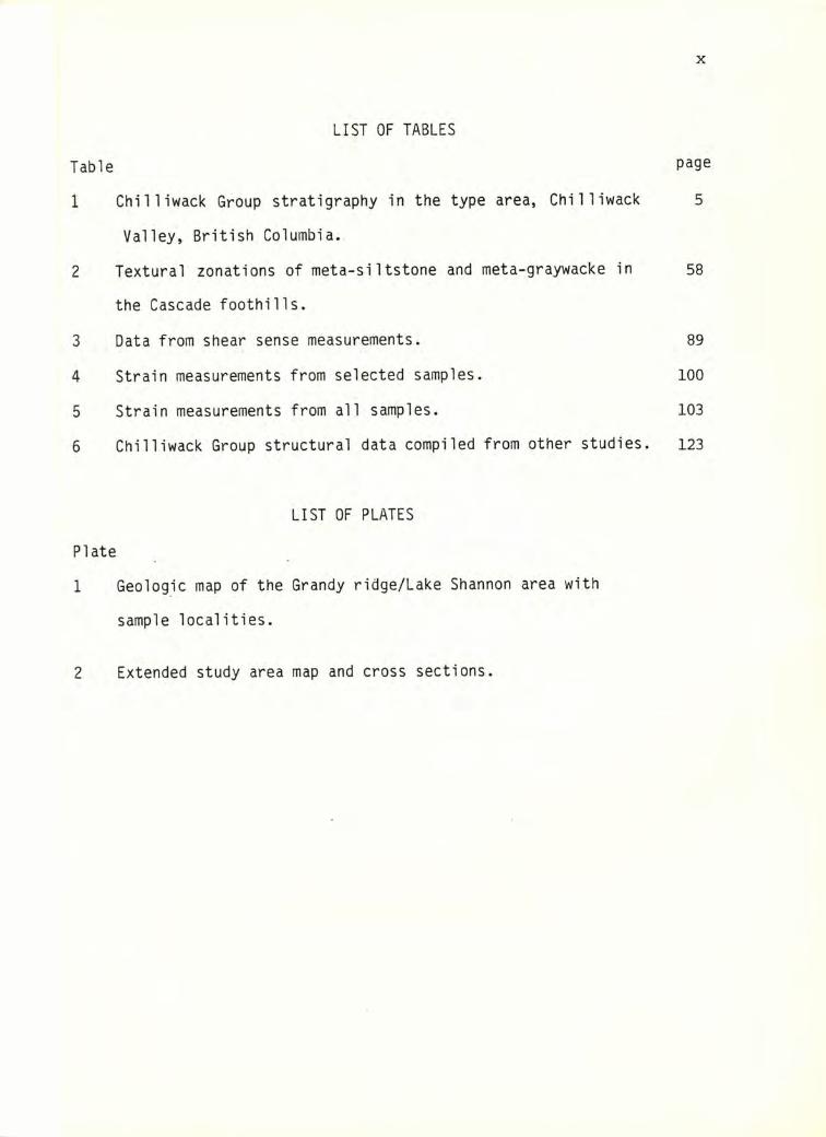
TABLE OF CONTENTS
PAGEABSTRACT i
ACKNOWLEDGEMENTS i i i
LIST OF FIGURES vi
LIST OF TABLES x
LIST OF PLATES x
I. INTRODUCTION 1
A. Previous Work/Regional Geology 1
B. Objectives 13
II. LITHOLOGIC UNITS AND PETROGRAPHY 15
A. Chilliwack Group 15
1. Volcanic Rocks 16
2. Limestone 26
3. Clastic Sedimentary Rocks 27
4. Depositional environments 36
B. Other Units 39
1. Yellow Aster Complex 39
2. Chert/Basalt unit 40
3. Tertiary Dikes 41
4. Baker Volcanics 43
III. METAMORPHISM OF THE CHILLIWACK GROUP 44
IV. STRUCTURE 56
A. Structures Internal to the Chilliwack Group 56
1. Descriptions of elements 56
2. Orientations of elements 69
3. Kinematic significance of li lineations 80
4. Shear sense 85
V
5. Strain magnitudes 92
6. Timing of deformation with respect to metamorphism 107
B. Extraformational Structure 112
1. Structure within the map area 113
2. Structure of the extended study area. 118
C. Interpretation 122
V. SUMMARY AND CONCLUSIONS 130
VI. REFERENCES 135
APPENDIX 1: PETROGRAPHY OF SELECTED SAMPLES 145
APPENDIX 2: MICROBROBE DATA 154
APPENDIX 3: SAMPLE LOCATIONS IN EXTENDED STUDY AREA 156
VI
LIST OF FIGURES
Figure page
1 Regional compilation map of the western North Cascades. 2
2 Structural stratigraphy of the western North Cascades based 8
on Misch Il966).
3 Interpreted movement directions in the North Cascades 9
during the Late Cretaceous orogeny Abased on Misch, 1966).
4 Sketch map from Misch U977) showing the location of the 11
Mount Baker Window.
5 Study area locations in the vicinity of the present study 12
area.
6 Generalized stratigraphic column of the Chilliwack Group 17
and Triassic dacite unit in the map area.
7 Photomicrograph of dacite flow rock. 21
8 Hand sample of Chilliwack Group gabbro. 21
9 Gabbro photomicrograph showing pumpellyite and chlorite 23
habits.
10 Photomicrograph of hydrothermal vein in Chilliwack Group 23
gabbro.
11 Photomacrograph of lithic lapilli tuff. 25
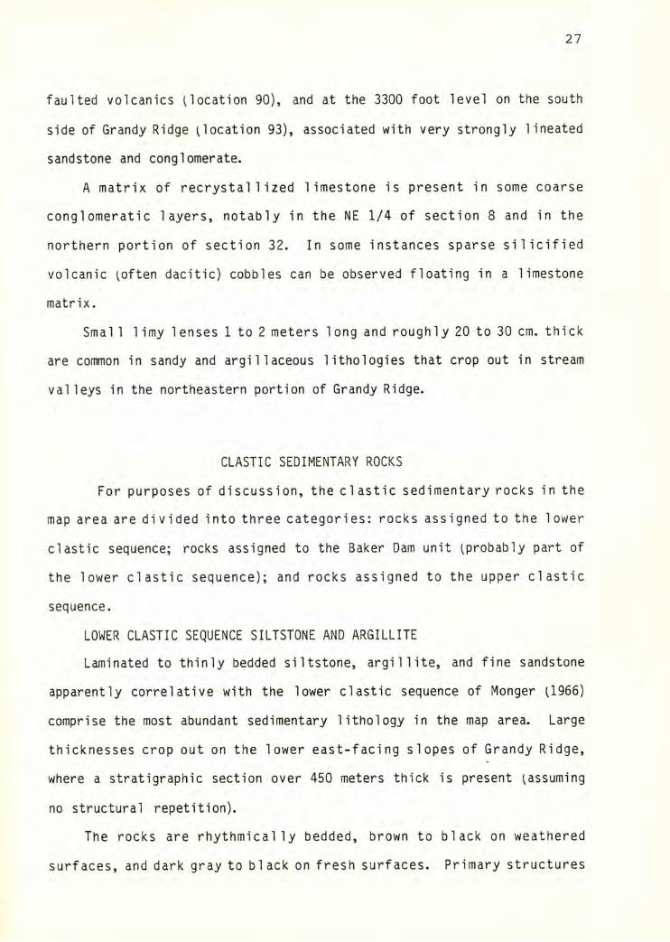
12 Photomacrograph of worm burrows in siltstone. 29
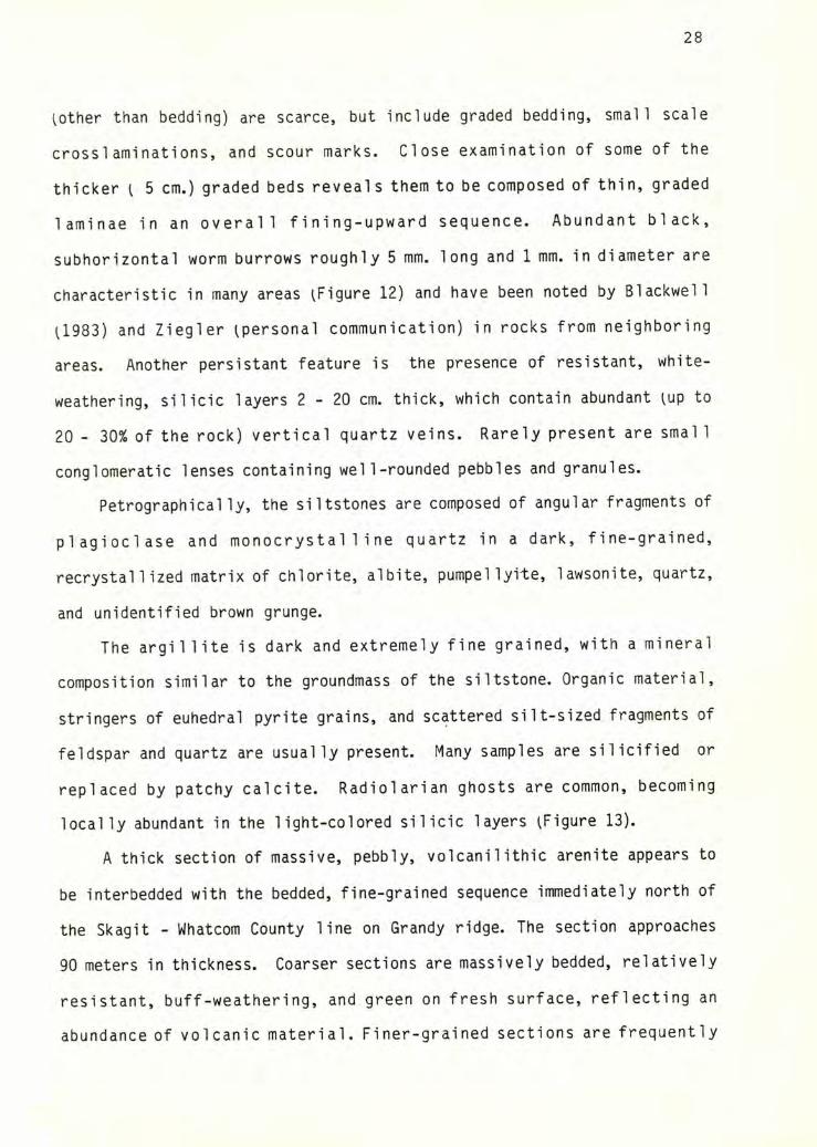
13 Photomicrograph of radiolarian ghosts in lower clastic 29
sequence argillite.
14 Photomacrograph of argillite with boudinaged feldspar 32
grains from the Baker Dam unit.
15 Photomicrograph of well preserved radiolarian from Baker 32
Dam unit argillite.
16 Conglomerate lens with sheared contact. 35
17
18
19
20
21
22
23
24
25
26
27
28
29
30
31
32
Vll
Turbiditic siltstone from the lower clastic sequence. 33
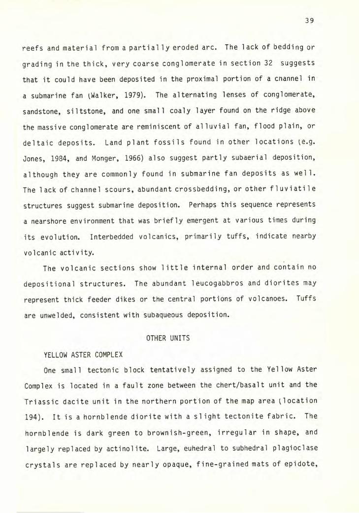
Photomicrograph of feathery quench texture in albite 42
crystals in a leucocratic dike.
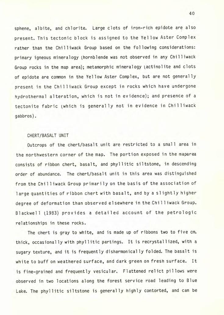
Photomacrograph of mineralogy and texture in a hornblende 42
diorite dike.
Photomicrograph of Na-amphibole needles growing at margins 43
of a pyroxene grain in a diabase.
Photomicrograph of Na-amphibole grain used for microprobe 48
analysis.
Plot of end-member compositions of Na-amphiboles from the 50
Chilliwack Group, Shuksan Suite, and Baker Lake blueschist.
A-C-F diagrams for the Chilliwack Group. 52
T-XCO2 curves for reactions involving H2O and CO2 54
equilibria.
Photomacrograph of stretched conglomerate. 60
Photomicrograph of stretched sandstone with extensive vein 60
formation perpendicular to the stretching direction.
Photomicrograph of boudinaged quartz grain in Baker Dam 62
unit argillite.
Photomacrograph of boudinaged sandstone layer in the Baker 62
Dam unit.
Photomacrograph of pressure shadows associated with a 53
pyrite grain.
Small F2 fold in Baker Dam unit argillite. 65
Photomacrograph of S2 sxisl planar cleavage associated with 66
F2 fold in Baker Dam unit argillite.
Detail of shear fabric in a fault zone between Chilliwack 68
VXll
Group siltstone and the Triassic dacite unit.
33 Contoured Pi diagram of poles to in the southwest 70
subarea.
34 Contoured Pi diagram of poles to S-^ in the northwest 71
subarea.
35 Contoured Pi diagram of poles to in the Baker Dam 72
subarea.
36 Contoured stereonet plot of regional li data. 73
37 Regional map showing distribution of data from Figure 74
36.
38 Stereonet plot of F]^ and ?2 orientations. 76
39 Stereonet plot of orientations of small shear zones. 77
40 Diagrammatic representation of structural data for 78
Chilliwack Group clastic rocks in the map area.
41 Effects of progressive simple shear of a passive, spherical 82
marker.
42 Broken plagioclase grain in a lapilli tuff. 86
43 Handsample of a volcanic breccia displaying cisallement 88
fabric.
44 Regional structure map displaying shear sense data. 90
45 Hand sample of lapilli tuff with cut surfaces parallel to 93
the principal planes of strain.
46 Regional map showing locations, orientations, and strain 104
magnitudes of measured samples.
47 Photomicrograph illustrating relationships between two sets 109
of lawsonite grains.
48 Na-amphibole orientation in a sheared portion of a tuff. 110
49 Na-amphibole orientation in a quartzose nodule. 112
IX
50 Cross-section through lithologies of the Baker Dam unit. xi7
51 Diagrammatic structural stratigraphy of the map units in X21
the extended study area.
52 Kula and Farallon relative plate motions 50 and 75 ma before 127
present, from Engebretson and others p‘n press).
53 Two deformational types exhibited in fault zones in western 128
Washington, from Cowan and Miller (1980).
X
LIST OF TABLES
Table
1 Chilliwack Group stratigraphy in the type area, Chilliwack 5
Valley, British Columbia.
2 Textural zonations of meta-siItstone and meta-graywacke in 58
the Cascade foothills.
3 Data from shear sense measurements. 89
4 Strain measurements from selected samples. 100
5 Strain measurements from all samples. 103
6 Chilliwack Group structural data compiled from other studies. 123
LIST OF PLATES
Plate
1 Geologic map of the Grandy ridge/Lake Shannon area with
sample localities.
2 Extended study area map and cross sections.
1INTRODUCTION
The primary objective of this study was to map and study in detail
the pre-Tertiary units that crop out in an area around Grandy Ridge and
upper Baker Dam, and additionally to characterize the metamorphic
structures and fabrics in the rock units present in this and the
surrounding region. This study is part of a larger effort to map and
interpret structures and lithologic units in the western North Cascades,
in order to better interpret the tectonic events which formed this portion
of the North American Cordillera.
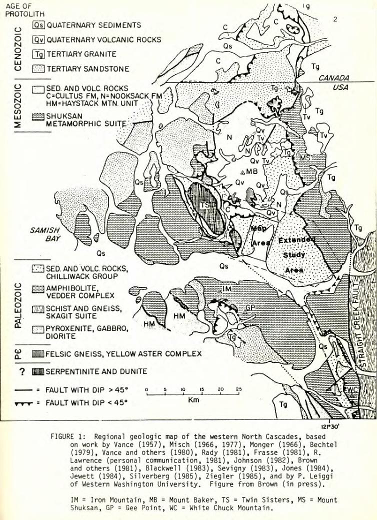
The study area is situated in the western North Cascades,
approximately 50 km. east of Bellingham (Figure 1). The area mapped
includes a northwest-southeast-trending ridge (informally known as Grandy
ridge) and the bedrock knobs present around Upper Baker Dam. The map area
is bordered on the west by the field area of Blackwel 1 (1983) and to the
north by the field area of Ziegler (1985). Portions of the 1952 Hamilton
and Lake Shannon 15 minute topographic quadrangle maps were enlarged to a
scale of four inches equivalent to one mile (1 : 15,840) to use as base
maps. In addition, an area on the east side of Lake Shannon, including
the Thunder Creek and Jackman Creek drainages, and areas to the west of
the map area, including the Wan lick Creek and South Fork Nooksack River
drainages, were used for observation and data collection for structural
analysis (Figure 1). This extended study area is bounded on the west by
the Twin Sisters dunite body, and on the east by the Shuksan Fault.
Relief in these areas is moderate, with elevations ranging from 550
to approximately 4000 feet. Since the area is entirely below treeline, the
vegetation is dense, particularly in recent clearcuts, which comprise well
over half the area. Exposure is moderate, with numerous roadcuts, steep
stream valleys and cliffs yielding the best exposures.
PALE
OZO
ICI
IM
ESO
ZOIC
IC
ENO
ZOIC
'9AGE OF PftOTOLITH
Qs QUATERNARY SEDIMENTS
QyJ QUATERNARY VOLCANIC ROCKS
T^ TERTIARY GRANITE
TERTIARY SAN DSTON E
rnSED. AND VOLC. ROCKS ^C^CULTUS FM,N=NOOKSACK HM=HAYSTACK MTN. UNIT
ISHUKSAN METAMORPHIC SUlTf;'
SAMISHBAY
E3 SED. AND VOLC. ROCKS, CHILLIWACK GROUP
^AMPHIBOLITE, ^VEDDER COMPLEX
1221 SCHIST AND GNEISS, SKAGIT SUITE
fTTlPYROXENlTE, GABBRO,^DIORITE
(i>o.
? mSERPENTINITE AND DUNITE
------- = FAULT WITH DIP >45“
= FAULT WITH DIP <45*
FELSIC GNEISS, YELLOW ASTER COMPLEX
I2r30‘
FIGURE 1: Regional geologic map of the western North Cascades, basedon work by Vance (1957), Misch (1966, 1977), Monger (1966), Bechtel (1979), Vance and others p980), Rady (1981), Frasse (1981), R. Lawrence (personal communication, 1981), Johnson (1982), Brown and others (1981), Blackwell (1983), Sevigny (1983), Jones (1984), Jewett (1984), Silverberg (1985), Ziegler (1985), and by P. Leiggi of Western Washington University. Figure from Brown (in press).
IM = Iron Mountain, MB = Mount Baker, TS = Twin Sisters, MS = MountShuksan, GP = Gee Point, WC = White Chuck Mountain.
3
This study involved approximately 50 days of fieldwork during the
summers of 1984 and 1985.
GEOLOGIC SETTING AND PREVIOUS WORK
Until fairly recently, most work in the western North Cascades has
been carried out in a reconnaissance fashion due to the inaccessabi1ity
and precipitous nature of the terrain. Better access due to prolific road
building has afforded a more detailed look at many areas. The following
paragraphs summarize some of the more important contributions and
introduce the geologic units and structures of the northwest Cascades and
the geology of the areas in and around the current study area.
LITHOLOGIES
Chi 11iwack Group and Cultus Formation The earliest studies of the
Chilliwack Group and Cultus Formation were focused primarily on areas well
to the north of the present study area, in or near the type section in the
Chilliwack Valley, British Columbia. In the type area, Daly U912) mapped
a lower sedimentary section termed the Chi 1 1iwack Series and an upper
section of andesitic volcanics termed the Chilliwack Volcanic Series,
which he deduced to be of Carboniferous age. He also mapped Mesozoic
strata of the Cultus Formation in that area.
More recent contributions, notably by Danner U957, 1966) and Monger
U966, 1977) have further defined the ages and lithologies present in the
Chilliwack Group and Cultus Formation. Danner U957, 1966) focused
primarily on the fossi1iferous limestones in the Chilliwack Group,
ascribing Devonian, Late Mississippian to Early Pennsylvanian, and Early
Permian dates to them. On the basis of these findings, he divided the
Chilliwack Group into the lower Red Mountain Formation, consisting
4
primarily of fine-grained volcanic siltstone and sandstone overlain by the
Mississippian to Pennsylvanian limestone, and the Black Mountain
Formation, consisting primarily of sandstone, massive cobble conglomerate,
volcanic rocks, and the Permian limestone. Danner additionally mapped
occurrences of Chilliwack Group limestone throughout the Cascades.
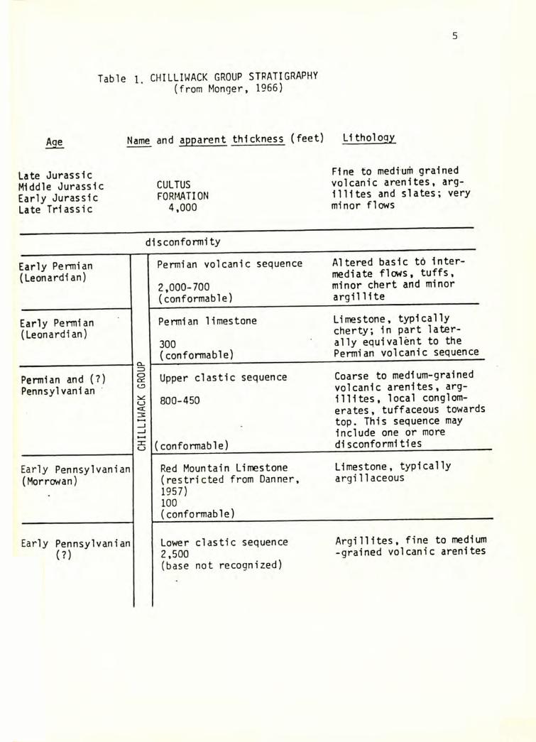
Monger further studied the lithologies and structures in the
Chilliwack Group and Cultus Formation in the type area. His findings are
summarized in Table 1. Monger ^966) restricted Danner's usage of Red and
Black Mountain Formations to the limestones, and developed the following
stratigraphy: a lower clastic sequence consisting of bedded volcaniclastic
siltstone, with minor volcanic arenite, conglomerate, limestone lenses and
volcanic rocks; the Red Mountain Formation limestone; an upper clastic
sequence of coarse volcanic arenite, cobble conglomerate, and minor
siltstone, argillite, and volcanic rocks; the Permian Black Mountain
limestone; and a Permian volcanic sequence composed primarily of basic to
intermediate flow rocks and tuffs. The contact between these and strata
of the Cultus Formation was observed by Monger U966) to be disconformable
in the type area.
Monger (1966) characterized the structure present in the type area of
the Chill iwack Group as two nappes overlying rel ati vely autochthonous
rocks. Additionally, he found the Chilliwack Group and Cultus Formation
to contain isoclinal recumbant folds with northeast-trending axes. These
features have been noted in other areas, e.g., Misch (1966), Jones (1984)
and Blackwell (1983).
Other Units A unit consisting of ribbon chert, argillite, and
and titaniferous-augite-bearing basalt, previously mapped as part of the
Chi 1 1 iwack Group, has been informal ly termed the "chert/basal t" unit.
First recognised by Testa and others (1982), these rocks have since been
5
Table 1. CHILLIWACK GROUP STRATIGRAPHY (from Monger, 1966)
' hSl Name and apparent thickness (feet) L1thology
Late Jurassic Middle Jurassic Early Jurassic Late Triassic
CULTUSFORMATION
4,000
Fine to medium grained volcanic arenites, argillites and slates; very minor flows
dlsconformlty
Early Permian (Leonardian)
Permian volcanic sequence
2,000-700(conformable)
Altered basic to Intermediate flows, tuffs, minor chert and minor argilllte
Early Permian (Leonardian)
Permian limestone
300(conformable)
Limestone, typically cherty; In part laterally equivalent to the Permian volcanic sequence
Permian and (?) Pennsylvanian
CH
ILLI
WAC
K GR
OUP
Upper clastic sequence
800-450
(conformable)
Coarse to medium-grained volcanic arenites, argillites, local conglomerates, tuffaceous towards top. This sequence may Include one or more d1sconformities
Early Pennsylvanian (Morrowan)
Red Mountain Limestone (restricted from Danner, 1957)100(conformable)
Limestone, typically argi1laceous
Early Pennsylvanian (?)
Lower clastic sequence2,500(base not recognized)
Argillites, fine to medium -grained volcanic arenites
6
mapped by numerous workers, including Lieggi ^in progress), Sevigny
U983), Blackwell U983), Jones U984), Ziegler U985), and Brown
(unpublished). On the basis of differences in mineralogy, deformational
history, and geochemistry, these rocks appear to represent a unit distinct
from the Chilliwack Group.
Blackwell (1983) mapped large amounts of dacite and siltstone in
areas around Loomis Mountain. Fossils from limestone clasts in a breccia
found near the top of the dacite section yielded a Triassic age, and the
dacite flows appear to interfinger with the Triassic Cultus Formation at
the top of the section. This informally named "Loomis Mountain dacite
center" is thought by Blackwell (1983) to be related to the Permian
volcanic sequence in the Chilliwack Group or to be a previously
unrecognised facies of the Cultus Formation. It will be referred to in the
text as the Triassic dacite unit.
The Nooksack Group is a thick sequence of siltstone and volcanic
arenite, with lesser amounts of conglomerate, argillite, and volcanic
rock (Misch, 1966). Abundant Buchia, Pleuromya, belemnites, and other
diagnostic fossils yield a Late Visean (Jurassic to Cretaceous) age
(Danner, 1957).
The Precambrian Yel low Aster Complex, named by Misch (1966), is a
diverse grouping of metaplutonic rocks, ranging from gabbro to trondjemite
in composition. These rocks are present as tectonic slices al ong major
faults and have been interpreted by Misch (1966) to represent slices of
the original autochthonous basement.
Other units present in the western North Cascades include the Shuksan
Suite, composed primarily of quartzose phyllite and greenschist; the
Vedder Complex; the Wells Creek Volcanics; and various ultramafic bodies.
7
including the Twin Sisters dunite body. None of these units are present in
the map area, although all but the Wells Creek Volcanics are present in
the extended study area.
STRUCTURE
The rocks of interest to this study lie west of the Eocene right-
lateralStraightCreekfault^Vance, 1957), a major tectonic boundary.
Misch U966) and his students at the University of Washington are
primarily responsible for establishing the regional distribution of the
various units found in the North Cascades and a basic structural
interpretation of the area. Misch U966, 1977) interprets the basic
structure of the western North Cascades as two thrust plates overlying a
relative autochthon, with rocks in the lower sections being exposed in the
core of a large northwest-southeast-trending anticline known as the Mount
Baker window. A structural stratigraphy based on this interpretation is
outlined in Figure 2. Relatively autochthonous rocks of the Nooksack
Group and Wells Creek Volcanics are separated from the overlying Church
Mountain plate by the Church Mountain thrust fault. The Church Mountain
plate, containing the Chilliwack Group and Cultus Formation, is separated
from overlying rocks of the Shuksan Suite, a unit consisting of
greenschist and phyllite, by the Shuksan thrust fault. The Shuksan thrust
is characterized by the presence of a steep root zone and a wide imbricate
zone of anastomozing faults containing exotic fragments of Yellow Aster
Complex, Vedder Complex, and ultramafic rocks, thought to represent slices
of the underlying basement ^Misch, 1966). Movement along these thrusts is
thought to have occurred in the Late Cretaceous, with the sense of motion
dominantly westward ^Figure 3).
METAMORPHISM
Beatty U974) studied the Permian volcanic sequence of the Chilliwack
8
Figure 2: Diagrammatic structural stratigraphy of the western North Cascades (based on Misch, 1966).
9
Figure 3: Movement directions along major faults in the North Cascades during the middle Late Cretaceous orogeny (modified slightly from Misch, 1966).
10
Group in the type area in Chilliwack Valley, British Columbia, and found
an increase in metamorphic grade from west to east as follows: prehnite-
chlorite, pumpel lyite-1 awsonite-chl orite, pumpel lyite-actinol ite, and
epidote-actinol ite. This change in grade was attributed to increased
depth of burial towards the east.
Brown and others U981) defined the characteristic metamorphic
assemblages present in the North Cascades. The Chilliwack Group and
Cultus Formation are characterized by assemblages containing lawsonite,
aragonite, pumpel lyite, epidote, and hematite, with ubiquitous albite,
chlorite, and quartz. These high pressure - low temperature assemblages
are thought to reflect conditions found in a subduction zone environment.
Rocks in the Nooksack Group are similar, but contain prehnite, and calcite
instead of aragonite.
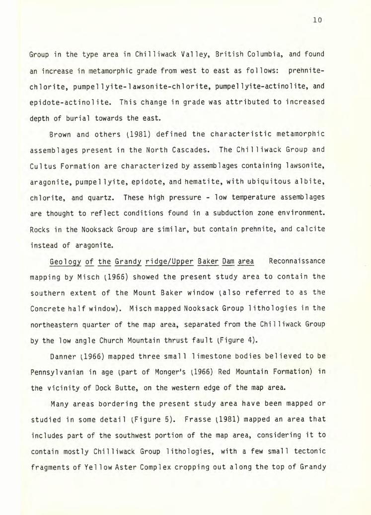
Geol ogy of the Grandy ridge/Upper Baker Dam area Reconnaissance
mapping by Misch U966) showed the present study area to contain the
southern extent of the Mount Baker window uiso referred to as the
Concrete half window). Misch mapped Nooksack Group lithologies in the
northeastern quarter of the map area, separated from the Chilliwack Group
by the low angle Church Mountain thrust fault ^Figure 4).
Danner U966) mapped three small limestone bodies believed to be
Pennsylvanian in age ^part of Monger's (,1966) Red Mountain Formation) in
the vicinity of Dock Butte, on the western edge of the map area.
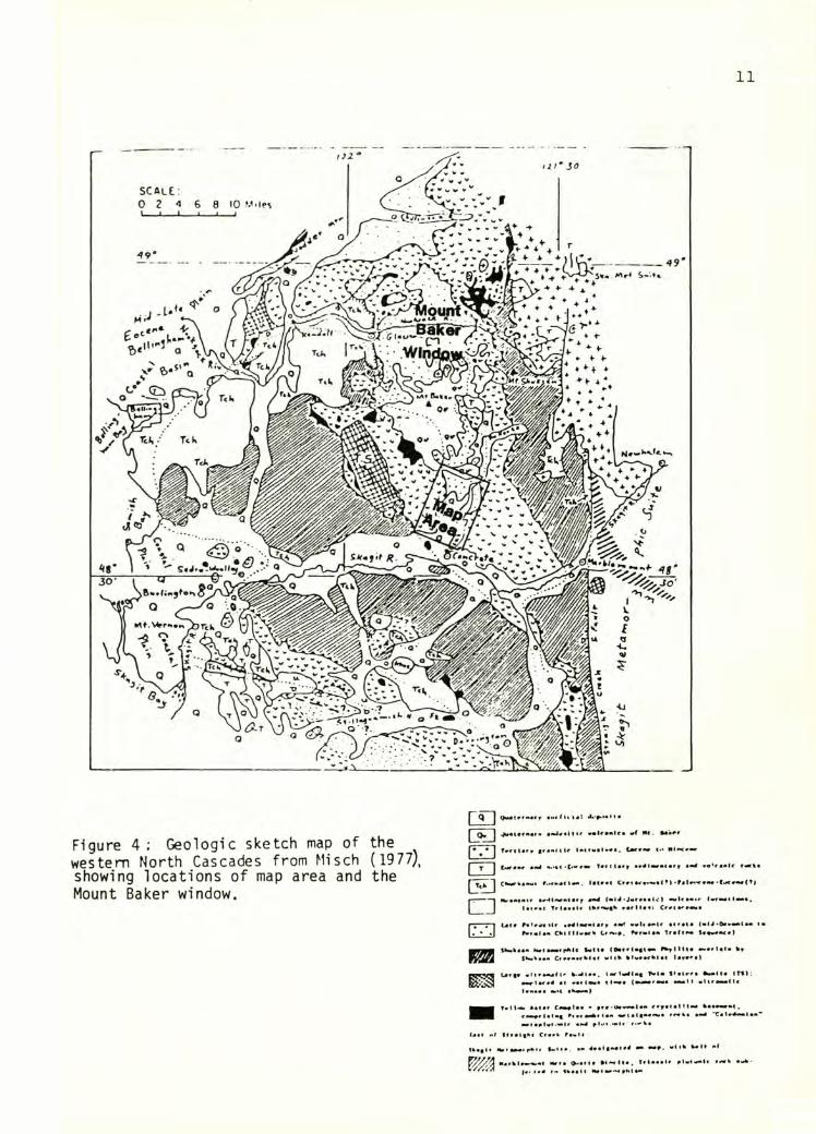
Many areas bordering the present study area have been mapped or
studied in some detail ^Figure 5). Frasse U981) mapped an area that
includes part of the southwest portion of the map area, considering it to
contain mostly Chilliwack Group lithologies, with a few small tectonic
fragments of Yel low Aster Complex cropping out along the top of Grandy
11
i
Figure 4; Geologic sketch map of the western North Cascades from Misch ( 1977), showing locations of map area and the Mount Baker window.
L£]raO
□
•lUaamf
tuettt* aa^twaiaff a«4 r«c%a
CWwrh««M« !•(*«« Cr*i a*-*****! t}t|
1*4 J •Jwraaalc)laiaat Triaaala vartlaai
Lata r«t«*«ilr »mt! w«l« anU airata |«I4•»****(#« i*^f*ia« Ct>«lll«r*rk far*4a* TrartMi $««*•*<«)
IlkitkaaM MatMMfiAU «*Ma (•attl*«t«*SWwa«a« *4ilt ai*«a<klat lav*'*)
Latt* •ltaa*afl' ^^laa. l*rl*4(«g 1^1* f*atr«a •Malta ITtI;
laaaaa «**l aW*«*)
T*I1<*> aata* C4M»laa - a«a-oaM**U* aafatalM*# •aa**»*t.r«*>atlalag f»»<aiA»laa *»ta4taa^a rraLt a*4 “CaW^**la* aM<a»l«(-m4r aU»#.«*lt f-'ka
l-M*. a* 4#a4t«*aia4 •••.
nargl*«M*.«l »aa»a 0.a»ia •4««(ta. triaaal# alMiaalc »««ak
(f> taaali Mat a*«ta*
Figure 5: Approximate boundaries of study areas located near the present
study area.
13
Ridge. Blackwel 1 U983) mapped an area to the west, projecting several
structures into the map area, including a large tectonic block of
chert/basalt unit, and a fault separating Chilliwack Group proper from his
Loomis Mountain dacite center. He additionally reexamined the Yellow
Aster Complex fragments mapped by Frasse (1981) on Grandy Ridge and
interpreted them to be Chilliwack Group basalts.
An area bordering the northern edge of the field area has been mapped
by Ziegler U985), who projected numerous low angle structures southward
until they are covered by more recent Mount Baker volcanics. Large areas
of fine-grained sedimentary rocks, formerly assigned to the Nooksack Group
in the Mount Baker window by Misch U966), were reassigned to the
Chilliwack Group by Ziegler ^985).
Christensen (1981) studied the Chilliwack Group structure and
geochemistry in an area to the southeast of the study area, finding the
volcanic rocks to reflect a tholeiitic to calc-alkaline trend. He found
the Chilliwack Group to be extensively tectonised along low angle faults,
so that no coherent stratigraphy could be deduced.
An area to the east of Lake Shannon has been mapped by Brown
(unpublished), who found the chert/basalt unit to structurally overly the
Chilliwack Group along a low angle thrust contact.
OBJECTIVES
The two primary objectives of this study were to map and interpret
structures and 1 ithol ogic units in the map area and to characterize the
nature and extent of deformation and the direction of movement in areas of
penetratively sheared or faulted rocks in the region around the map area.
Hence, uni ike most previous work, the main emphasis of this study was a
characterization of deformation within the Chilliwack Group and other
units, rather than the relationship between units.
14
Other goals were to establish:
A) The stratigraphy, depositional environments, and metamorphic
histories of the units in the map area;
B) The validity ^or lack thereof) of the thrust stratigraphy and the
Mount Baker window conceptsas proposed by Misch U966) in the map area;
C) The rel at ion ship of structures and lithologic units in the map
area to those in adjacent areas.
15
LITHOLOGIES
Chilliwack Group
Rocks belonging to the Chilliwack Group comprise nearly all of the
map area, with the exception of the chert/basalt unit, the Tertiary Baker
Volcanics, and one smal 1 block that is questionably part of the Yel low
Aster Complex.
Positive identification of many rocks was difficult. Large
thicknesses of fine-grained clastic rocks are common in the lower clastic
sequence of the Chi 1 1 iwack Group, the Nooksack Group, and in the Cul tus
Formation. They are generally differentiated on the basis of fossil
evidence, which is normally fairly abundant in the latter two and missing
from the former. Where fossil evidence is lacking, as is the case in the
map area, positive identification is difficult or impossible. Many of the
sedimentary rocks in the northeastern portion of the map area were
previously mapped as Nooksack Group by Misch ^1966) but are here assigned
to the Chilliwack Group, for reasons discussed in a later section.
Coarse-grained igneous rocks, apparently plutonic in origin, are common in
the map area, particularly on the south end of Grandy ridge. Previously
assigned to the Yellow Aster Complex by Frasse U981), they were 1 ater
reassigned to the Chilliwack Group volcanic sequence by Blackwell U983).
In this study they are tenatively assigned to the Chilliwack Group. A
characteristic apparently unique to the Chilliwack Group in the map area
is the presence of sodic amphibole in a number of volcanic rocks.
Due to a high degree of tectonic fragmentation, poor exposure, lack
of fossils, and rapid facies changes, relationships of units and positive
correlation of the Chilliwack Group within the map area to the units found
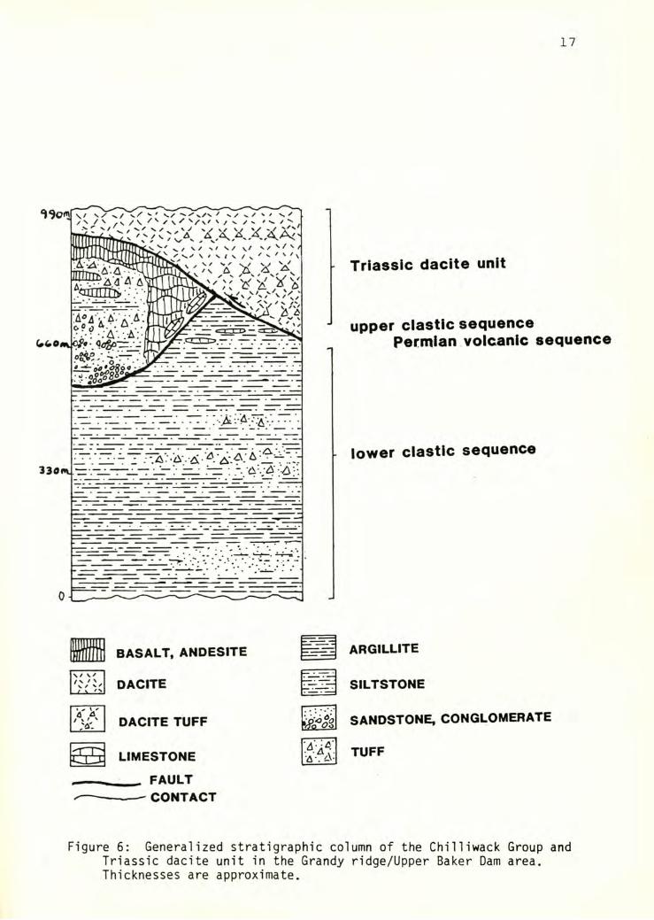
in the type area is difficult. A generalized stratigraphic column for the
16
area is presented in Figure 6. Monger's (1966) lower clastic sequence of
rhythmical ly bedded sandstone and siltstone appears to be fairly wel1
represented in the lower elevations throughout the map area. A sequence
of fairly coarse grained conglomerate, sandstone, siltstone, tuff, and
minor flows on the south side of Grandy Ridge may be correlative with the
upper clastic sequence. Abundant mafic volcanic rocks capping the top of
Grandy Ridge may be part of the Permian volcanic sequence. Limestone is
present in minor amounts, with recrystallization and limited lateral
extent making positive identification of units difficult. Widespread
dacite occurrences in the northern half of the field area are probably
correlative with the Triassic dacite center of Blackwell (1983).
In this section, volcanic, clastic, and carbonate rocks will be
described separately, the volcanic rocks by order of abundance, as they
show little internal stratigraphic order, and the clastic rocks in
presumed stratigraphic order. Sections on depositional environment and
metamorphism wi 11 follow. Complete mineral assemblages for selected
samples are listed in Appendix 1.
VOLCANIC ROCKS
Volcanic rocks dominate the lithologies present above an elevation of
approximately 2700 feet throughout the study area, with sporadic
occurrences below this elevation. In most locations, the contact of the
volcanic unit with underlying sedimentary rocks is not exposed; but where
contacts are exposed they are tectonic, particulary to the north.
Compositional ly, basalt or basaltic andesite and dacite are the most
voluminous volcanic rocks. Andesite is relatively rare. Texturally, the
volcanic rocks range from flow rocks to lapillistone to very fine-grained
17
Triassic dacite unit
upper clastic sequencePermian volcanic sequence
lower clastic sequence
« BASALT, ANDESITE
\/V ^ ^ DACITE
A ^ DACITE TUFF
LIMESTONE
FAULTCONTACT
argillite
SILTSTONE
SANDSTONE, CONGLOMERATE
TUFF
Figure 6: Generalized stratigraphic column of the Chilliwack Group andTriassic dacite unit in the Grandy ridge/Upper Baker Dam area. Thicknesses are approximate.
18
Crystal, 1ithic, and vitric tuffs. Hypabbysal equi valents of the more
basic varieties are very common.
DACITE
Large, often cliffy exposures of dacite are common, particularly in
the northwest portion of the map area, along the north- and east-facing
slopes of Grandy Ridge. The structurally lowest boundary of the dacite,
where observable, is in fault contact with sheared, black, argillaceous
sedimentary rocks lying beneath.
When these dacite outcrops are projected south and westward into the
field area of Blackwell U983), they appear to be associated with the
Triassic dacite unit, dated as such by the presence of an interbedded
sedimentary breccia containing fossi 1 iferous limestone in the Loomis
Mountain area. No fossils were found in association with dacite exposures
in the map area, but lithologic similarities and structural setting
suggest that they can be correlated with some confidence.
Outcrops of flow rocks and crystal tuffs are generally massive,
blocky, and white to tan weathering, with few observable primary or
metamorphic structures. Fresh surfaces are generally white to apple green
or gray, often with a distinctive network of randomly oriented, weathered
cracks. Dacitic 1 api 11istones, often highly sheared, are common on the
north-facing side of Grandy ridge. They are light green to maroon and
form thick layers interbedded with the flows.
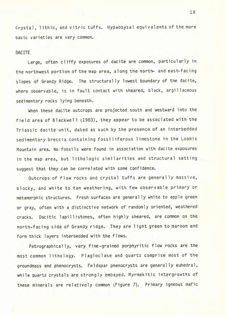
Petrographical ly, very fine-grained porphyritic flow rocks are the
most common lithology. Plagioclase and quartz comprise most of the
groundmass and phenocrysts. Feldspar phenocrysts are generally euhedral,
while quartz crystals are strongly embayed. Myrmekitic intergrowths of
these minerals are relatively common ^Figure 7). Primary igneous mafic
19
minerals are completely nonexistent, although small amounts of chlorite
and iron-rich pumpel lyite which are present in the groundmass may have
replaced these original phases. Nearly all samples contain pyrite,
occasionally in abundance. Coarser-grained equivalents of these rocks
were found in a few places; they may represent feeder dikes or sills.
Because of the association of relatively sodic plagioclase and
quartz with no K-felspar or mafic minerals noted, these rocks should
probably be termed quartz keratophyres ^Babcock, 1985, personal
communication). However, because of the prior use of the word dacite to
describe these rocks and name the unit to which they belong, the term
dacite was adopted to avoid confusion.
Dacitic lapilli tuffs and finer-grained crystal and lithic tuffs are
interbedded with the flow rocks. Crystal tuffs appear to be relatively
common, although they are quite difficult to distinguish from the fine
grained flow rocks. The matrix is slightly less homogeneous, and
phenocrysts are commonly cracked, broken, and unevenly distributed.' The
lapilli tuffs are composed of sheared dacite clasts in a groundmass
composed of abundant chlorite, pumpel lyite, and nearly opaque black
material. Euhedral pyrite is very abundant in some samples.
BASALT, BASALTIC ANDESITE, AND DIABASE
Basalt or basaltic andesite and their shallow plutonic equivalents
crop out predominantly above the 2800 foot level on the southern half of
Grandy Ridge. The commonest occurrences are as coarse diabase and fine
grained flow rock. Exact categorization of these rocks by composition is
difficult due to alteration of the feldspars to albite, and advanced
replacement of mafic minerals.
Primary igneous minerals include plagioclase ^now mostly altered to
20
albite + epidote + lawsonite), augite, and ilmenite. Chlorite- and
pumpellyite- filled spaces between pi agiocl ase grains may indicate the
original presence of an additional phase or phases.
The diabasic varieties are tan to greenish brown on weathered
surfaces and dark green on fresh surfaces. They are subophitic to
intergranular in texture, and range in composition from rocks containing
large augite phenocrysts and abundant groundmass pyroxene, to varieties
containing no pyroxene. Chlorite and pumpel lyite are present in large
quantities in the groundmass. Ilmenite is present as skeletal grains, now
largely altered to sphene.
Finer-grained flow rocks are generally brown- to green-weathering and
dark green on fresh surface. All varieties are porphyritic, with the
proportion of phenocrysts ranging from 5 - 30%, and from approximately 90%
plagioclase to 90% augite in composition. The groundmass is usually
extremely fine grained and dark, consisting primarily of augite, epidote,
i Ilmenite, sphene, chlorite, and unidentified brown grunge. Textures
range from massive to felty or trachytic where feldspar laths are wel 1
developed. Commonly amygdules are filled with radial chlorite and,
rarely, quartz.
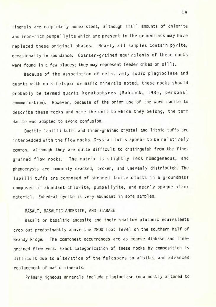
GABBRO
Coarse-grained, probably shallow plutonic rocks crop out in places
along the top of Grandy ridge, in a drainage east of Dock Butte, at a
location in the Bear Creek drainage, and at locations 10 and 54 in the
extreme northern portion of the map area. These rocks are buff- to white-
on weathered surfaces and light green to blue-green on fresh surfaces
^Figure 8). A slight tectonite fabric is evident in sample lOe, but most
samples have a random fabric.
Petrographical ly, the rocks are composed of approximately 70 - 90%
21
Figure 7: Photomicrograph of fine-grained porphyritic dacite flow rockshowing granophyric texture (crossed polars).
Figure 8: Hand sample of Chilliwack gabbro showing plutonictexture. Scale at bottom of photo is in inches.
22
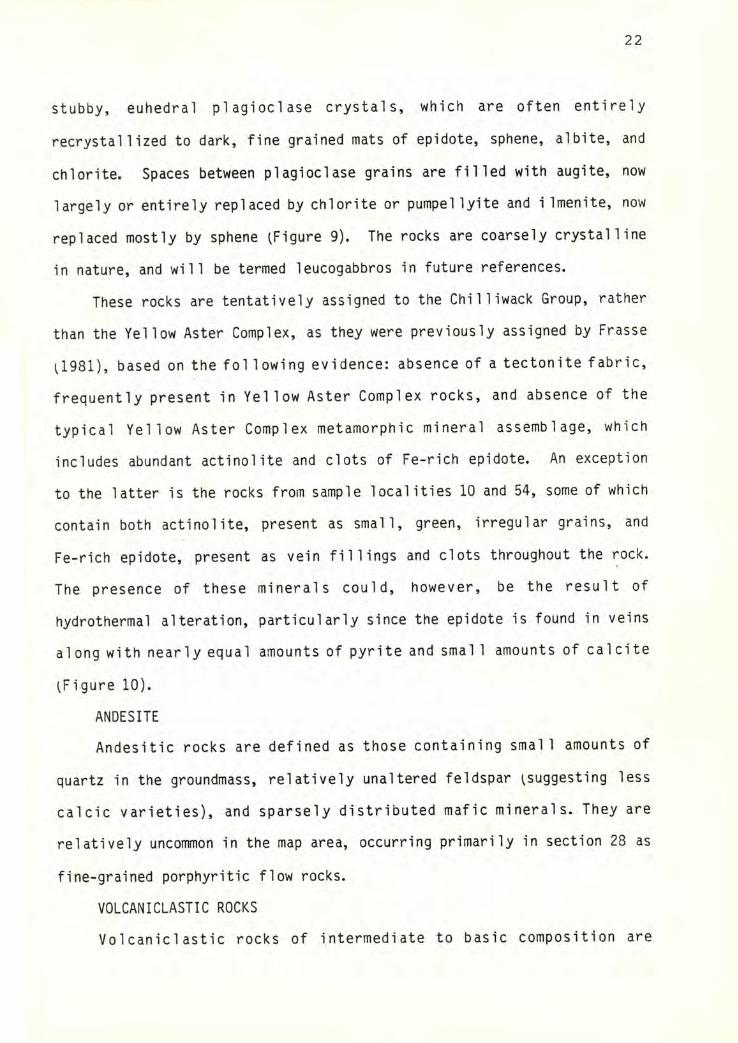
Stubby, euhedral plagioclase crystals, which are often entirely
recrystallized to dark, fine grained mats of epidote, sphene, albite, and
chlorite. Spaces between plagioclase grains are filled with augite, now
largely or entirely replaced by chlorite or pumpel lyite and iImenite, now
replaced mostly by sphene (Figure 9). The rocks are coarsely crystalline
in nature, and will be termed leucogabbros in future references.
These rocks are tentatively assigned to the Chilliwack Group, rather
than the Yellow Aster Complex, as they were previously assigned by Frasse
(1981), based on the fol lowing evidence: absence of a tectonite fabric,
frequently present in Yellow Aster Complex rocks, and absence of the
typical Yellow Aster Complex metamorphic mineral assemblage, which
includes abundant actinolite and clots of Fe-rich epidote. An exception
to the latter is the rocks from sample localities 10 and 54, some of which
contain both actinolite, present as small, green, irregular grains, and
Fe-rich epidote, present as vein fillings and clots throughout the rock.
The presence of these minerals could, however, be the result of
hydrothermal alteration, particularly since the epidote is found in veins
along with nearly equal amounts of pyrite and smal 1 amounts of calcite
(Figure 10).
ANDESITE
Andesitic rocks are defined as those containing small amounts of
quartz in the groundmass, relatively unaltered feldspar (suggesting less
calcic varieties), and sparsely distributed mafic minerals. They are
relatively uncommon in the map area, occurring primarily in section 28 as
fine-grained porphyritic flow rocks.
VOLCANICLASTIC ROCKS
Vo 1canic1astic rocks of intermediate to basic composition are

Figure 9: Photomicrograph of a gabbro, showing the habits of pumpel lyiteand chlorite. Many spaces such as the one i 11ustrated are completely fi 1 led with metamorphic minerals, such that the original phase or phases are no longer in existence. ^Plane polarized light. Pp=pumpel- lyite, Ch=chlorite, and dark areas are altered piagioclase.)
Figure 10: Photomicrograph of vein in a coarse grained igneous rock fromsample location 54. Fe-rich epidote and pyrite are the primary constituents, with quartz and calcite present as fracture fillings in the pyritized areas. ^Crossed polars. Colored areas are composed of epidote; dark areas are pyrite.
24
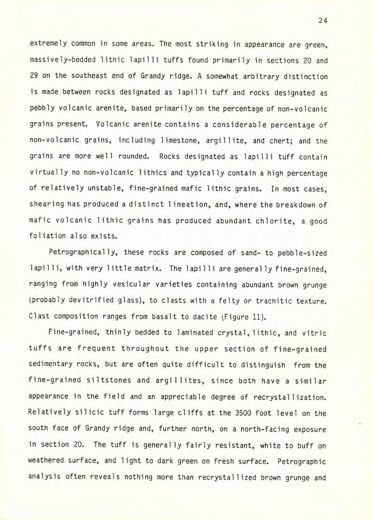
extremely common in some areas. The most striking in appearance are green,
massively-bedded lithic lapilli tuffs found primarily in sections 20 and
29 on the southeast end of Grandy ridge. A somewhat arbitrary distinction
is made between rocks designated as lapilli tuff and rocks designated as
pebbly volcanic arenite, based primarily on the percentage of non-volcanic
grains present. Volcanic arenite contains a considerable percentage of
non-volcanic grains, including limestone, argillite, and chert; and the
grains are more well rounded. Rocks designated as lapilli tuff contain
virtually no non-volcanic lithics and typically contain a high percentage
of relatively unstable, fine-grained mafic lithic grains. In most cases,
shearing has produced a distinct 1 ineation, and, where the breakdown of
mafic volcanic lithic grains has produced abundant chlorite, a good
foliation also exists.
Petrographically, these rocks are composed of sand- to pebble-sized
lapilli, with very 1ittle matrix. The lapilli are generally fine-grained,
ranging from highly vesicular varieties containing abundant brown grunge
iprobably devitrified glass), to clasts with a felty or trachitic texture.
Clast composition ranges from basalt to dacite ^Figure 11).
Fine-grained, thinly bedded to laminated crystal,1 ithic, and vitric
tuffs are frequent throughout the upper section of fine-grained
sedimentary rocks, but are often quite difficult to distinguish from the
fine-grained siltstones and argillites, since both have a similar
appearance in the field and an appreciable degree of recrystallization.
Relatively silicic tuff forms large cliffs at the 3500 foot level on the
south face of Grandy ridge and, further north, on a north-facing exposure
in section 20. The tuff is general ly fairly resistant, white to buff on
weathered surface, and light to dark green on fresh surface. Petrographic
analysis often reveals nothing more than recrystallized brown grunge and
25
f-
3 mm
Figure 11; Photomacrograph of a lapilli tuff containing a variety of clast compositions and textures. Da=dacite, Ba=basalt, Ph=p1agioclase phenocryst ^plane polarized light).
26
opaque minerals, with occasional plagioclase phenocrysts.
LIMESTONE
Limestone is relatively uncommon in the map area. All limestones
observed have undergone recrystallization to the extent that no
distinctive fossil assemblages could be identified for dating. Crinoid
columnals could occasionally be observed on weathered, silicified surfaces
of some limestone outcrops; however, by themselves they are not diagnostic
of a particular time period.
Danner U966) mapped three small limestone bodies near Dock Butte on
the western edge of the field area. He deduced that they are
Pennsylvanian in age based primarily on stratigraphic relationships, as
they are poorly exposed and recrystallized.
Within the field area, only three limestone bodies of any significant
size were located. A 75-meter-thick layer is exposed in a stream-cut near
the southern border of section 17. Sheared tuffaceous sediments were
observed below it and volcanics above it, although the contacts were not
visible. The limestone is yellow- to buff- weathering, extensively
recrystallized, and partly silicified. A similar outcrop approximately
30 meters thick is located in the NW 1/4 of section 28, in roughly the
same stratigraphic position as the first. It is markedly sandy near the
top of the section. A third, sandy to conglomeratic limestone body
approximately 30 meters thick is present in the extreme northwest corner
of the map area. The bottom is not exposed, and it grades upward into
a massive black sandstone layer, which in turn is truncated by a fault.
Small chunks of gray, recrystallized limestone containing abundant
chert nodules are located on the top of Grandy Ridge, associated with
27
A matrix of recrystallized limestone is present in some coarse
conglomeratic layers, notably in the NE 1/4 of section 8 and in the
northern portion of section 32. In some instances sparse silicified
volcanic (often dacitic) cobbles can be observed floating in a limestone
matrix.
Smal 1 1 imy lenses 1 to 2 meters long and roughly 20 to 30 cm. thick
are common in sandy and argillaceous lithologies that crop out in stream
valleys in the northeastern portion of Grandy Ridge.
faulted volcanics (location 90), and at the 3300 foot level on the south
side of Grandy Ridge (location 93), associated with very strongly lineated
sandstone and conglomerate.
CLASTIC SEDIMENTARY ROCKS
For purposes of discussion, the clastic sedimentary rocks in the
map area are divided into three categories: rocks assigned to the lower
clastic sequence; rocks assigned to the Baker Dam unit (probably part of
the lower clastic sequence); and rocks assigned to the upper clastic
sequence.
LOWER CLASTIC SEQUENCE SILTSTONE AND ARGILLITE
Laminated to thinly bedded siltstone, argillite, and fine sandstone
apparently correlative with the lower clastic sequence of Monger (1966)
comprise the most abundant sedimentary lithology in the map area. Large
thicknesses crop out on the lower east-facing slopes of Grandy Ridge,
where a stratigraphic section over 450 meters thick is present (assuming
no structural repetition).
The rocks are rhythmically bedded, brown to black on weathered
surfaces, and dark gray to black on fresh surfaces. Primary structures
28
^other than bedding) are scarce, but include graded bedding, small scale
crosslaminations, and scour marks. Close examination of some of the
thicker ^ 5 cm.) graded beds reveals them to be composed of thin, graded
laminae in an overall fining-upward sequence. Abundant black,
subhorizontal worm burrows roughly 5 mm. long and 1 mm. in diameter are
characteristic in many areas ^Figure 12) and have been noted by Blackwell
U983) and Ziegler ^personal communication) in rocks from neighboring
areas. Another persistant feature is the presence of resistant, white
weathering, silicic layers 2-20 cm. thick, which contain abundant ^up to
20 - 30% of the rock) vertical quartz veins. Rarely present are smal 1
conglomeratic lenses containing well-rounded pebbles and granules.
Petrographical ly, the siltstones are composed of angular fragments of
plagioclase and monocrystalline quartz in a dark, fine-grained,
recrystallized matrix of chlorite, albite, pumpellyite, lawsonite, quartz,
and unidentified brown grunge.
The argillite is dark and extremely fine grained, with a mineral
composition similar to the groundmass of the siltstone. Organic material,
stringers of euhedral pyrite grains, and scattered silt-sized fragments of
feldspar and quartz are usually present. Many samples are silicified or
replaced by patchy calcite. Radiolarian ghosts are common, becoming
locally abundant in the light-colored silicic layers ^Figure 13).
A thick section of massive, pebbly, volcani1ithic arenite appears to
be interbedded with the bedded, fine-grained sequence immediately north of
the Skagit - Whatcom County line on Grandy ridge. The section approaches
90 meters in thickness. Coarser sections are massively bedded, relatively
resistant, buff-weathering, and green on fresh surface, reflecting an
abundance of volcanic material. Finer-grained sections are frequently
Figure 12: Photomacrograph of worm burrows in a siltstone from the lowerclastic sequence ^plane polarized light).
Figure 13: Photomicrograph of radiolarian ghosts in argillite from thelower clastic sequence ^plane polarized light).
30
BAKER DAM UNIT
This unit differs from most other rocks of the Chi 1 1 iwack Group in
the map area in its higher degree of deformation and by the similarity of
foliation attitudes over a large area ^Plate 1). This unit and other very
similar rocks west of Baker Lake were originally assigned to the Nooksack
Group by Misch U966). The very contorted nature of these rocks was
ascribed to their proximity to the Church Mountain thrust. Ziegler U985)
reassigned most of the Nooksack rocks north of the map area to the lower
clastic sequence of the Chilliwack Group, with only a few blocks of
fossi1iferous, relatively undeformed Nooksack Group imbricated within.
Thick, structureless to faintly bedded sections of dark gray
argi1 1 ite, separated by thin U - 10 cm.) white, gray, or 1ight green,
possibly graded sandy beds are the most common lithologic type, exhibiting
a number of distinctive features:
A) slaty to phyllitic cleavage parallel to the sandy layers;
B) crenulation cleavage or kink folding with axial planes at right
angles to the SI cleavage;
C) abundant quartz and fewer cal cite veins oriented at right angles
to the bedding surfaces in the light-colored layers;
D) quartz and cal cite veins frequently oriented subparal lel to the
SI cleavage;
E) ellipsoidal, dark brown carbonate concretions, 5 - 20 cm long.
Petrographically, the argillite is extremely fine-grained, making
thinly bedded, with graded bedding and small scale crossbeds up to 20 cm.
thick. Evidence of soft sediment deformation, including slump features
and convoluted bedding, was noted in a few places. Petrographically, the
sandstone is identical to that seen in the upper clastic sequence,
described on page 36.
31
positive identification of many of the mineral constituents difficult.
The presence of albite, chlorite, quartz, lawsonite, calcite and white
mica were detected in thin section and verified by x-ray diffraction. The
slaty cleavage is defined by the preferred orientation of lawsonite,
chlorite, and white mica. Stringers of small, euhedral pyrite grains
parallel the foliation. Large areas of thin sections are almost
completely replaced by patchy calcite. Highly boudinaged feldspar grains
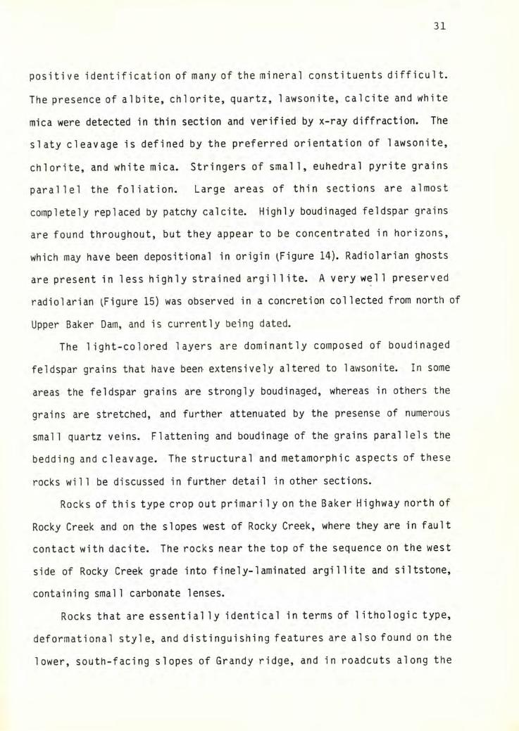
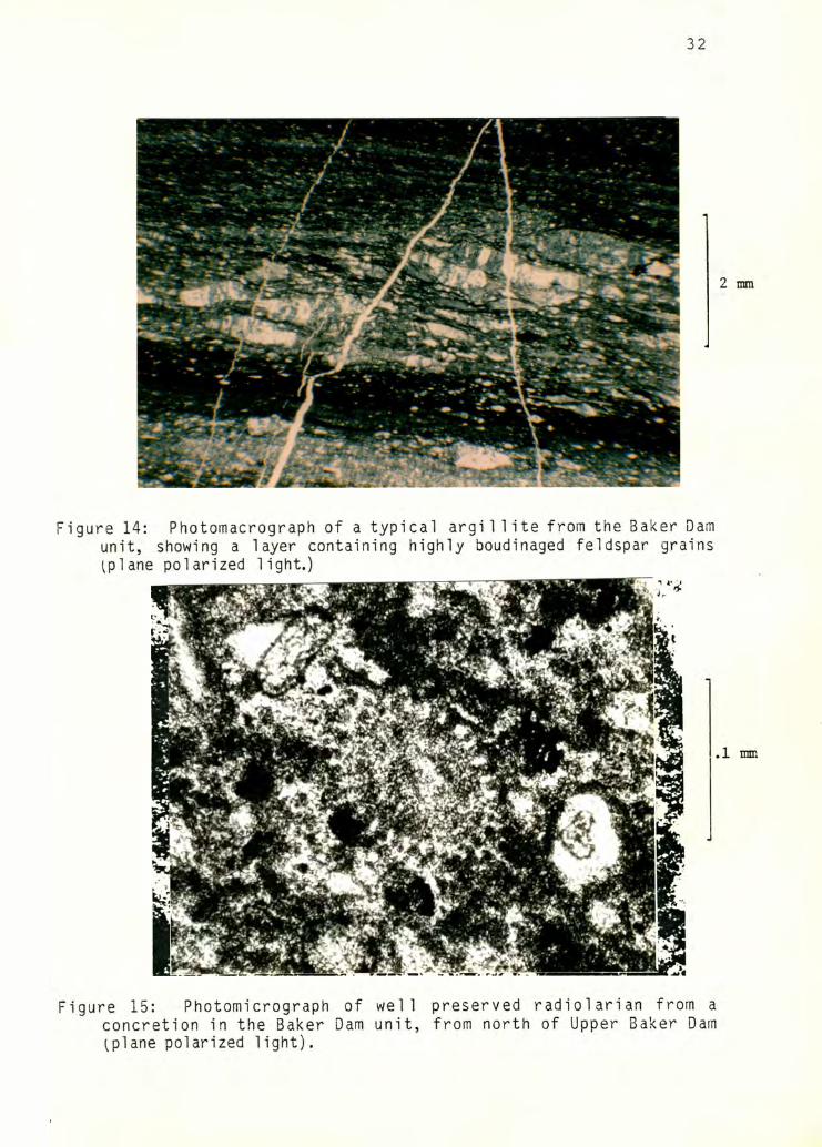
are found throughout, but they appear to be concentrated in horizons,
which may have been depositional in origin ^Figure 14). Radiolarian ghosts
are present in less highly strained argillite. A very well preserved
radiolarian ^Figure 15) was observed in a concretion collected from north of
Upper Baker Dam, and is currently being dated.
The light-colored layers are dominantly composed of boudinaged
feldspar grains that have beer> extensively altered to lawsonite. In some
areas the feldspar grains are strongly boudinaged, whereas in others the
grains are stretched, and further attenuated by the presense of numerous
small quartz veins. Flattening and boudinage of the grains parallels the
bedding and cleavage. The structural and metamorphic aspects of these
rocks will be discussed in further detail in other sections.
Rocks of this type crop out primari ly on the Baker Highway north of
Rocky Creek and on the slopes west of Rocky Creek, where they are in fault
contact with dacite. The rocks near the top of the sequence on the west
side of Rocky Creek grade into finely-laminated argillite and siltstone,
containing small carbonate lenses.
Rocks that are essential ly identical in terms of 1 ithologic type,
deformational style, and distinguishing features are also found on the
lower, south-facing slopes of Grandy ridge, and in readouts along the
32
Figure 14: Photomacrograph of a typical argillite from the Baker Damunit, showing a layer containing highly boudinaged feldspar grains ^plane polarized light.)
Figure 15: Photomicrograph of well preserved radiolarian from aconcretion in the Baker Dam unit, from north of Upper Baker Dam^plane polarized light).
33
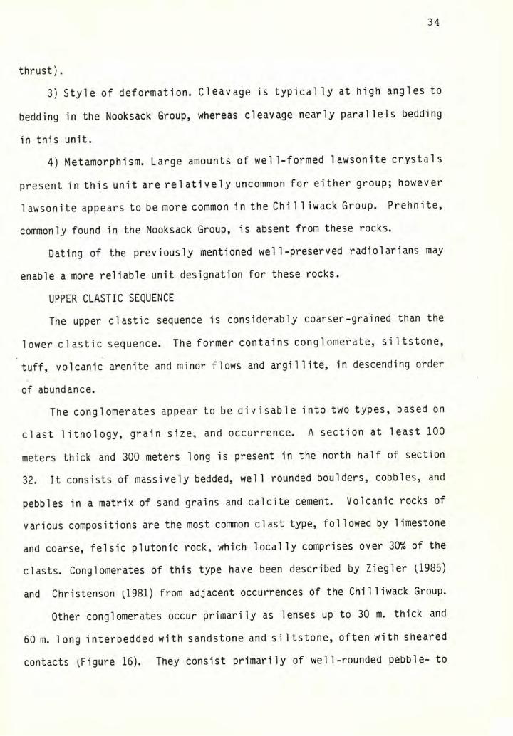
Other lithologies in this unit include coarse sandstone,
volcani1ithic conglomerate and pebbly sandstone, and tuff. All
lithologies, including argillite, are present at location 110-49 on the
Baker Highway. Massive, green, pebbly conglomerate containing
argillaceous clasts grades into argillite containing cobble-sized clasts
of green conglomerate. Interbedded tuffs are green and thin bedded.
These coarser rocks are found throughout the southern extent of this unit,
particularly in sections 11 and 12. Bedded tuff and pebbly sandstone are
also found on the hill immediately north of upper Baker Dam, and on top of
a hill ^elevation 1799) north of Rocky Creek.
The bedding and foliation strike northwest and dip northeast in most
areas in the Baker Dam unit. If the unit has not been markedly disrupted
by faulting, then the coarser sediments are present primarily toward the
bottom and again at the top of the section. There is some evidence that
the massive pebbly sandstone described in the section on the lower clastic
sequence may be correlative with the coarser-grained rocks in the Baker
Dam unit, as the sandstone appears to lie along strike with these rocks.
The rocks of the Baker Dam unit are assigned to the lower clastic
sequence of the Chilliwack Group based on the following observations:
1) Lack of megafossils. Although this lack does not eliminate the
Nooksack Group from consideration, it is usual ly highly fossi 1 iferous.
Additionally, Ziegler U985) found Paleozoic!?) forams in concretions from
identical lithologies that crop out to the north.
2) High degree of deformation. Most accounts comparing the Chilliwack
and Nooksack Groups note the generally lower degree of deformation
sustained by the Nooksack Group, even in the proximity of major faults
!e.g., Jones, 1984) in the Church Mountain area of the Church Mountain
Baker Lake Highway. They are interpreted to be part of the same unit.
34
thrust).
3) Style of deformation. Cleavage is typically at high angles to
bedding in the Nooksack Group, whereas cleavage nearly parallels bedding
in this unit.
4) Metamorphism. Large amounts of well-formed lawsonite crystals
present in this unit are relatively uncommon for either group; however
1 awsonite appears to be more common i n the Chill iwack Group. Prehnite,
commonly found in the Nooksack Group, is absent from these rocks.
Dating of the previously mentioned well-preserved radiolarians may
enable a more reliable unit designation for these rocks.
UPPER CLASTIC SEQUENCE
The upper clastic sequence is considerably coarser-grained than the
lower clastic sequence. The former contains conglomerate, siltstone,
tuff, volcanic arenite and minor flows and argillite, in descending order
of abundance.
The conglomerates appear to be divisable into two types, based on
clast lithology, grain size, and occurrence. A section at least 100
meters thick and 300 meters long is present in the north half of section
32. It consists of massively bedded, well rounded boulders, cobbles, and
pebbles in a matrix of sand grains and calcite cement. Volcanic rocks of
various compositions are the most common clast type, followed by limestone
and coarse, felsic plutonic rock, which locally comprises over 30% of the
clasts. Conglomerates of this type have been described by Ziegler U985)
and Christenson U981) from adjacent occurrences of the Chilliwack Group.
Other conglomerates occur primarily as lenses up to 30 m. thick and
60 m. long interbedded with sandstone and siltstone, often with sheared
contacts ^Figure 16). They consist primarily of well-rounded pebble- to
35
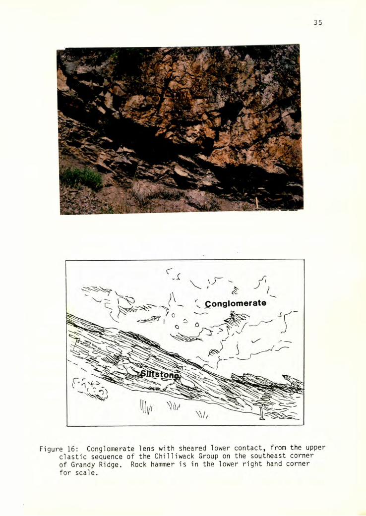
Figure 16: Conglomerate lens with sheared lower contact, from the upperi clastic sequence of the Chilliwack Group on the southeast cornerI of Grandy Ridge. Rock hammer is in the lower right hand cornerI for scale.
36
cobble-sized volcanic clasts of andesitic to basaltic composition in a
matrix of coarse sandstone and calcite cement. These rocks frequently
exhibit a strong lineation defined by stretched mafic clasts, which are
often entirely replaced by chlorite.
Thinly-bedded si 1 tones and tuffs are found in close association with
the conglomerates. On fresh surfaces, alternating green and black
laminations seen in some samples may represent interbedded sedimentary and
volcaniclastic lithologies. Most of the volcaniclastic rocks described in
the volcanic section can tentatively be placed in the upper clastic
sequence.
Volcanic arenite occurs in massive, pebbly lenses associated with
volcanics and lapilli tuff on the south side of Grandy ridge, and with the
large conglomerate outcrops. The sandstone is relatively resistant, green
to gray or black on fresh surface, and buff-weathering.
Petrographical ly, the coarse sandstone is a volcani1ithic arenite,
the clast fraction of which is primarily composed of subrounded basaltic
to dacitic volcanic 1ithic grains, feldspar, argillite chips, limestone,
monocrystalline quartz, and epidote. Very little primary matrix is
present in most samples, although up to half of some samples are composed
of psuedomatrix formed by the breakdown of volcanic 1 ithic grains.
Monocrystalline quartz is rare, but may approach approximately 20% of the
mean clast composition in rocks containing abundant dacite fragments.
DEPOSITIONAL ENVIRONMENTS/CORRELATION
It would be unwise to state that the Chilliwack Group, which spans a
significant portion of the Paleozoic era, was deposited in a single basin
associated with one plate margin. In addition to the long time interval,
tectonic fragmentation and poor exposure hamper interpretation.
Nevertheless, it would appear that the Chilliwack Group represents a
37
shal 1 owing-upward sequence of deposition in basins on and adjacent to a
volcanic arc or arcs. The fol lowing interpretations can be made in the
map area for various units, with no correlation implied between them:
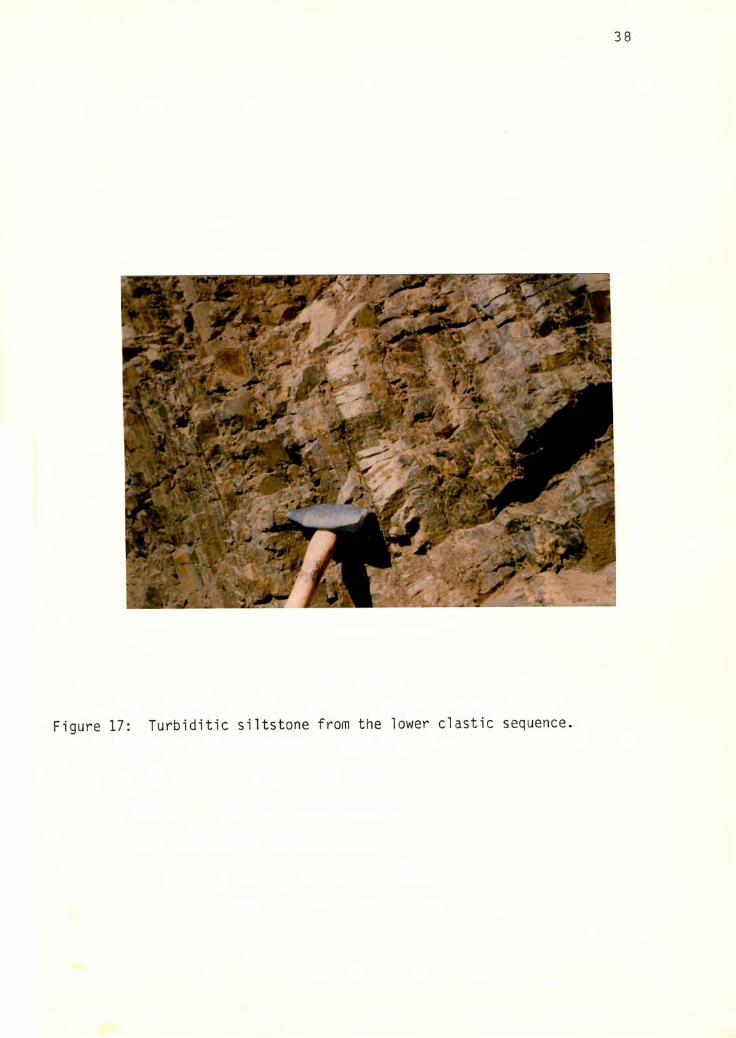
The thick, relatively undisturbed sequences of rhythmically bedded
siltstone, shale, and sandstone correlated with the lower clastic sequence
of Monger U966) resemble thinly-bedded turbidites ^Figure 17). A, b, d,
and e Bouma intervals are most frequently represented. Liszak (1981) has
interpreted the lower clastic sequence to represent upper submarine fan
lateral overbank deposits. Another interpretation might be that the
turbidites represent deposition on more distal (lower) areas of a
submarine fan. Evidence from rocks in the map area, including abundant
horizontal worm burrows in some layers, and the presense of small lenses
of sandy limestone in places near the top of the sequence may support the
shallower water hypothesis.
The lower clastic sequence may represent a period of relative
tectonic quiescence, but tuffaceous layers found near the top of the
sequence and abundant radiolarians found in some layers (possibly
indicative of a silica-rich environment) suggest nearby volcanic activity.
The 1 imestones are characterized by their 1 imited 1ateral extent,
proximity to volcanics, abundance of chert, and the presence of shallow
marine fossils such as crinoids. This evidence suggests that they could
have formed as fringing or barrier reefs on a volcanic arc (Wilson, 1975).
Similar deposits are being formed presently in tropical to subtropical
volcanic arc settings.
The coarse-grained nature and the mixed volcanic, plutonic,
sedimentary, and limestone clast lithologies of the upper clastic sequence
suggest a more proximal source, which might have included the underlying
38
Figure 17: Turbiditic siltstone from the lower clastic sequence.
t
39
reefs and material from a partial ly eroded arc. The lack of bedding or
grading in the thick, very coarse conglomerate in section 32 suggests
that it could have been deposited in the proximal portion of a channel in
a submarine fan (Walker, 1979). The alternating lenses of conglomerate,
sandstone, siltstone, and one small coaly layer found on the ridge above
the massive conglomerate are reminiscent of alluvial fan, flood plain, or
deltaic deposits. Land plant fossils found in other locations (e.g.
Jones, 1984, and Monger, 1966) also suggest partly subaerial deposition,
although they are commonly found in submarine fan deposits as well.
The lack of channel scours, abundant crossbedding, or other fluviatile
structures suggest submarine deposition. Perhaps this sequence represents
a nearshore environment that was briefly emergent at various times during
its evolution. Interbedded volcanics, primarily tuffs, indicate nearby
volcanic activity.
The volcanic sections show little internal order and contain no
depositional structures. The abundant leucogabbros and diorites may
represent thick feeder dikes or the central portions of volcanoes. Tuffs
are unwelded, consistent with subaqueous deposition.
OTHER UNITS
YELLOW ASTER COMPLEX
One small tectonic block tentatively assigned to the Yellow Aster
Complex is located in a fault zone between the chert/basalt unit and the
Triassic dacite unit in the northern portion of the map area (location
194). It is a hornblende diorite with a slight tectonite fabric. The
hornblende is dark green to brownish-green, irregular in shape, and
largely replaced by actinolite. Large, euhedral to subhedral plagioclase
crystals are replaced by nearly opaque, fine-grained mats of epidote.
40
sphene, albite, and chlorite. Large clots of iron-rich epidote are also
present. This tectonic block is assigned to the Yellow Aster Complex
rather than the Chilliwack Group based on the following considerations:
primary igneous mineralogy (hornblende was not observed in any Chilliwack
Group rocks in the map area); metamorphic mineralogy (actinolite and clots
of epidote are common in the Yellow Aster Complex, but are not generally
present in the Chilliwack Group except in rocks which have undergone
hydrothermal alteration, which is not in evidence); and presence of a
tectonite fabric (which is generally not in evidence in Chilliwack
gabbros).
CHERT/BASALT UNIT
Outcrops of the chert/basalt unit are restricted to a small area in
the northwestern corner of the map. The portion exposed in the maparea
consists of ribbon chert, basalt, and phyllitic siltstone, in descending
order of abundance. The chert/basalt unit in this area was distinguished
from the Chill iwack Group primari ly on the basis of the association of
large quantities of ribbon chert with basalt, and by a slightly higher
degree of deformation than observed elsewhere in the Chil liwack Group.
Blackwell (1983) provides a detailed account of the petrologic
relationships in these rocks.
The chert is gray to white, and is made up of ribbons two to five cm.
thick, occasionally with phyllitic partings. It is recrystallized, with a
sugary texture, and it is frequently disharmonical ly folded. The basalt is
white to buff on weathered surface, and dark green on fresh surface. It
is fine-grained and frequently vesicular. Flattened relict pillows were
observed in two locations along the forest service road leading to Blue
Lake. The phyllitic siltstone is generally highly contorted, and can be

41
distinguished from phyllitic siltstones in the Chilliwack Group by a
higher degree of deformation.
TERTIARY DIKES
A leucocratic dike approximately 20 cm. thick is exposed in a roadcut
on the Baker Lake Highway in the Baker Dam unit (location 143). The dike
was emplaced into phyllitic argillite, and has sheared contacts
subparallel to the foliation. Petrographically, the dike is composed of
albitized plagioclase crystals displaying a feathery quench texture, with
a groundmass of metamorphic (deuteric?) chlorite and cal cite (Figure 18).
The dike is undeformed, and therefore assigned a Tertiary age.
A series of at least five parallel hornblende diorite dikes crops out
in a roadcut on the south side of Grandy ridge (location 151), emplaced
into silicified siltstone and tuff. The largest dike is roughly four
meters thick, with dark, fine-grained (chilled) margins and a coarse,
diabasic center. Flow banding parallel to the margins was observed in this
and a few of the smaller dikes. The smaller dikes range from
approximately 30 cm. to 2 m. in thickness, and are finer-grained than the
largest dike.
Petrographical ly, the dikes are ophitic to hypidiomorphic in texture,
and are composed of abundant elongate, brown, euhedral to spongy textured
hornblende crystals in a matrix of euhedral to subhedral plagioclase.
apatite and an opaque phase (ilmenite?) are common accessories. The dikes
are relatively fresh in appearance, although they have been metamorphosed
slightly, with abundant chlorite and lesser amounts of sphene and quartz
present in the groundmass (Figure 19).
Although slightly metamorphosed, the dikes are interpreted to be
Tertiary in age, based on their relatively fresh appearance and the fact
42
Figure 18: Photomicrograph of feathery quench texture in a leucocraticdike from the Baker Dam unit ^crossed polars).
Figure 19: Photomacrograph of a Tertiary hornblende diorite dikeintruded into Chilliwack Group siltstones. (.Plane polarized light. Hb=hornblende, Pl=plagioclase, Ch=chlorite.)
43
that they cross-cut features associated with the first deformation.
BAKER VOLCANICS
Tertiary volcanics associated with eruptions of Mount Baker are
present along the northern boundary of the area in the Sulphur Creek
valley, and capping the prominent knob, elevation 1760, west of Upper
Baker Dam.
The Sulphur Creek volcanics are dark gray, porphyritic flow rocks,
which crop out in uneven mounds of large blocks. Sections in road cuts
exhibit columnar jointing.
Consolidated lahars or pyroclastic rocks and minor flow rocks crop
out on the knob, elevation 1760. The contact of this unit with underlying
rocks of the Baker dam unit is exposed in a quarry cut, at location 110-
47. The lahar deposits are brown- to buff-weathering and heavily
fractured. Rare fresh surfaces are dark green. Petrographical ly, the
rocks are composed of rounded andesitic volcanic fragments enclosed in a
matrix of feldspar laths and brown grunge, probably altered glass.
44
METAMORPHISM
Metamorphic mineral assemblages in and the degree of recrystalliza
tion of units within the Chi 1 1 iwack Group in the map area appear to be
largely controlled by lithology and by the degree of deformation
sustained. All samples examined have undergone relatively low temperature
and high pressure metamorphism, based on the presence of characteristic
mineral assemblages. Metamorphism in the dacite unit, the Baker Dam unit
of the Chi 1 1 iwack Group, and the rest of the Chi 1 1 iwack Group will be
discussed separately, and related at the end of the section.
Quartz, albite, and chlorite are present in virtually every sample.
Quartz is commonly present as vein or amygdule fillings and in a very
fine-grained form in the groundmass of fine-grained volcanic and
sedimentary rocks. Albite replaces more calcic varieties of plagioclase,
and is also found in the groundmass of sedimentary and volcanic rocks.
Chorite often completely replaces mafic volcanic grains in tuffs, and it
is also found in the groundmass of fine-grained sedimentary and volcanic
rocks, partially replacing pyroxene grains, and filling the interstices
between plagioclase and pyroxene grains in diabasic rocks. It can be
assumed that these minerals are present in all assemblages mentioned in
the following discussion.
DACITE UNIT
The dacite unit is characterized by a relatively fresh, unaltered
appearance, at least partially due to the lack of mafic minerals and
calcic plagioclase. Calcite + Fe-rich pumpel lyite is the most common
assemblage, with pumpellyite found throughout the groundmass, and calcite
present in patches and veins. Sphene and pyrite are common accessories,
with the latter present in copious quantities in some areas. Fine mats of
45
lawsonite were observed in a few slides.
BAKER DAM UNIT
The rocks in the Baker Dam unit have sustained considerable
deformation and are more fully recrystallized than comparable lithologies
elsewhere in the Chilliwack Group. The fine-grained argillites are
characterized by the assemblage lawsonite + calcite + white mica.
Preferentially oriented lawsonite is very abundant, present both as fine
grained needles throughout the argi 1 1 ite 1 ayers and as "clots" in many
quartzose layers. Calcite was identified and verified by X-ray
diffraction in nearly all samples. It occurs as veins and in patchy
areas, which in some instances completely obscure original structures.
Euhedral pyrite is a common accessory mineral.
Tuffaceous lithologies commonly contain the assemblage Fe-rich
pumpellyite + calcite +/- lawsonite.
CHILLIWACK GROUP
The rest of the Chilliwack Group ^excluding the rocks containing
Na-amphibole) is generally more recrystallized than the dacite unit, but
less so than the Baker Dam unit. The stable assemblages observed include
calcite + pumpellyite + lawsonite, pumpellyite + lawsonite, pumpellyite +
epidote, pumpellyite + calcite, and pumpellyite + epidote + 1awsonite,
with partial assemblages also observed. One sample UlO-92) contains the
assemblage hematite + pumpellyite + epidote.
Relatively unstrained sedimentary rocks have a barely metamorphosed
appearance and typical ly contain cal cite, lawsonite, and pumpel 1yite
assemblages. Volcanic rocks range from barely recrystallized ifresh
looking feldspars, little replacement of pyroxenes) to ones that are
substantial ly recrystal 1 ized. The leucogabbros in particular contain
46
plagioclase grains that are entirely recrystallized to dark, fine-grained
mats of epidote, pumpellyite, lawsonite, sphene and albite. Pyroxenes are
often 80 - 90% recrystallized to chlorite and pumpellyite. Ilmenite is
partially replaced by sphene. A few samples contain irregular, fairly
pleochroic grains of actinolite, probably a result of hydrothermal
alteration.
Fine-grained flow rocks typical ly contain a dark, recrystal 1ized
matrix of pumpellyite, epidote, chlorite, albite and sphene, with little
alteration of phenocrysts.
Common accessories.incl ude pyrite, sericite, and white mica, which
are abundant in sedimentary rocks, and apatite, commonly found as needles
in plagioclase grains.
Several samples, including 59, 59a, 59e, 69, 76, 89, and 2-803,
contain abundant, extremely fine-grained needles of Na-amphibole, the
presence of which was verified by X-ray diffraction and microprobe
analysis. These are the only reported occurrences of Na-amphibole in the
Chi 11iwack Group.
Samples 69, 76, and 89 are coarse diabases with no fabric. The Na-
amphibole needles are randomly oriented, but they are restricted primarily
to the margins of pyroxene grains, where they appear to "sprout" (Figure
20). The margins of the pyroxenes often show a brownish discoloration or
overgrowth resembling aegerine. The presence of sodic amphibole cannot be
visually detected in hand specimen, and the rocks resemble other coarse
diabases in all other respects.
Samples 59a, 59e, and 59 are from a sheared lapilli tuff located at
the 2000 foot level near the boundary of sections 20 and 29. Most of the
Na-amphibole needles show a strong preferred orientation parallel to the
47
lineation direction. The Na-amphibole-containing rocks form a blue-green
band roughly 2 meters thick which grades into less deformed, non-Na-
amphibole-containing tuff on either side. Sample 2-803 is a lapilli tuff
collected from near Marblemount by E. H. Brown (1985, personal
communication).
Microprobe analyses of the Na-amphibole from these samples were
carried out in an effort to characterize the type of Na-amphibole present
and to relate this information to pressure and temperature conditions and
Na-amphibole occurrences in other units. All samples analysed contain the
assemblage albite + quartz + chlorite + Na-amphibole +/- pumpellyite +/-
calcite +/- sphene.
Due to the extremely fine-grained nature of the Na-amphibole in these
rocks, suitable grains (those over approximately 10 microns wide) are very
scarce. Analyses were carried out on two grains from two slides from
sample 2-803 (Figure 21) and one grain from sample 69. One pyroxene grain
was also analysed.
The samples were analysed using the University of Washington ARL
5-channel microprobe, which necessited the use of two runs for a complete
analysis including 8 elements. Several points per grain were analysed.
Relocation of points in the second run over points in the first run is
necessary for an accurate analysis, but in practice was very difficult to
accomplish due to compositional zoning. Many spots were later discarded
because of unsuitable match-ups.
The weight percent data were merged and run through the Bence-Albee
correction program at University of Washington. The amphibole data were
further reduced using the AMPH program at Western Washington University,
which translates total iron (reported as ferrous iron) into percent
ferrous and ferric iron, and reports formula units in cations per 23
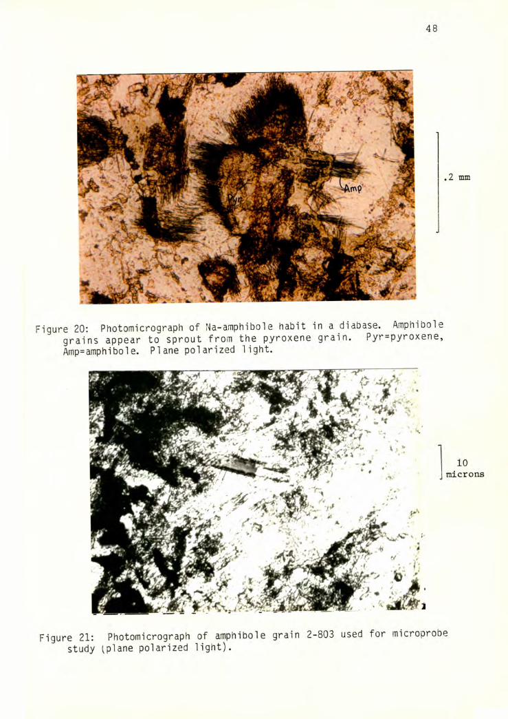
48
Figure 20: Photomicrograph of Na-amphibole habit in a diabase. Amphibolegrains appear to sprout from the pyroxene grain. Pyr=pyroxene, Amp=amphibole. PIane polarized light.
l[
10microns
Figure 21: Photomicrograph of amphibole grain 2-803 used for microprobestudy ^plane polarized light).
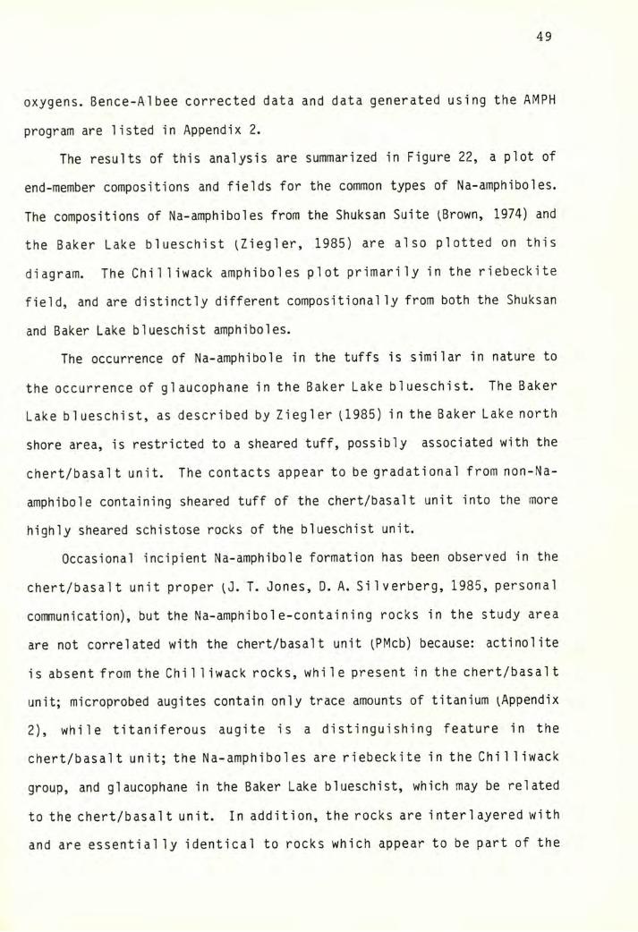
49
oxygens. Bence-Albee corrected data and data generated using the AMPH
program are listed in Appendix 2.
The results of this analysis are summarized in Figure 22, a plot of
end-member compositions and fields for the common types of Na-amphiboles.
The compositions of Na-amphiboles from the Shuksan Suite ^Brown, 1974) and
the Baker Lake blueschist ^Ziegler, 1985) are also plotted on this
diagram. The Chilliwack amphiboles plot primarily in the riebeckite
field, and are distinctly different compositionally from both the Shuksan
and Baker Lake blueschist amphiboles.
The occurrence of Na-amphibole in the tuffs is similar in nature to
the occurrence of glaucophane in the Baker Lake blueschist. The Baker
Lake blueschist, as described by Ziegler U985) in the Baker Lake north
shore area, is restricted to a sheared tuff, possibly associated with the
chert/basalt unit. The contacts appear to be gradational from non-Na-
amphibole containing sheared tuff of the chert/basalt unit into the more
highly sheared schistose rocks of the blueschist unit.
Occasional incipient Na-amphibole formation has been observed in the
chert/basalt unit proper (J. T. Jones, D. A. Silverberg, 1985, personal
communication), but the Na-amphibol e-containing rocks in the study area
are not correlated with the chert/basalt unit ^PMcb) because: actinolite
is absent from the Chill iwack rocks, while present in the chert/basal t
unit; microprobed augites contain only trace amounts of titanium ^Appendix
2), while titaniferous augite is a distinguishing feature in the
chert/basalt unit; the Na-amphiboles are riebeckite in the Chilliwack
group, and glaucophane in the Baker Lake blueschist, which may be related
to the chert/basalt unit. In addition, the rocks are interlayered with
and are essentially identical to rocks which appear to be part of the
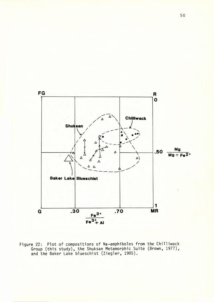
50
MgMg + Fe2+
Figure 22: Plot of compositions of Na-amphiboles from the ChilliwackGroup (this study), the Shuksan Metamorphic Suite (Brown, 1977), and the Baker Lake blueschist (Ziegler, 1985).
51
Chi 11iwack group.
One pyroxene grain was also microprobed, and the data run through the
OMPH program at Western Washington University, which calculates pyroxene
composition in percentages of the end members jadite, omphacite, and
diopside ^Appendix 2). The pyroxene grain probed is composed almost
entirely of diopsidic augite component, indicating little metamorphic
alteration.
Phase relations
The assemblages detailed above can all be represented graphically on
a triangular diagram with Al, Ca, and Fe3+ at the apices, with the
diagnostic minerals projected from a constant subassemblage of quartz +
chlorite + albite + (C02, H2O) (Figure 23b). Locations of the points are
approximate, based on theoretical val ues for mineral composition. The
observed mineral assemblages are denoted by x's. Figure 23a is a
triangular diagram from Brown and others (1981) illustrating the typical
assemblages found elsewhere in the Chilliwack Group. From Figure 23a to
Figure 23b, the aragonite-hematite tie line is broken and a new tie line,
pumpellyite-Na-amphibole created.
The reaction producing this tie line switch was obtained using the
REACT program at Western Washington University, using data from microprobe
analysis of Na-amphibole, the composition of Fe-rich pumpel lyite from
Brown (1974), and theoretical compositions of the other phases. The
reaction
3.91 Qtz + 2.04 Albite + .94 Chi + 3.57 Cc + .82 Hem + .14 H2O
= .82Pp + 3.57CO2 + l.ONa-A
relates Figures 23a and 23b. The higher volatile component (3.57C02 as
opposed to .I4H2O) is on the right side of the reaction, corresponding to
the higher entropy side.
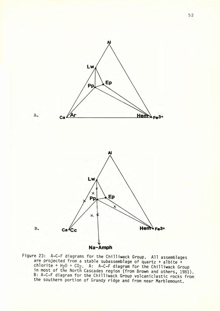
52
Al
C
B.
Al
Fe3+
Figure 23: A-C-F diagrams for the Chilliwack Group. All assemblagesare projected from a stable subassemblage of quartz + albite + chlorite + H2O + CO2. A: A-C-F diagram for the Chilliwack Groupin most of the North Cascades region (from Brown and others, 1981).
A-C-F diagram for the Chilliwack Group volcaniclastic rocks fromthe southern portion of Grandy ridge and from near Marblemount.
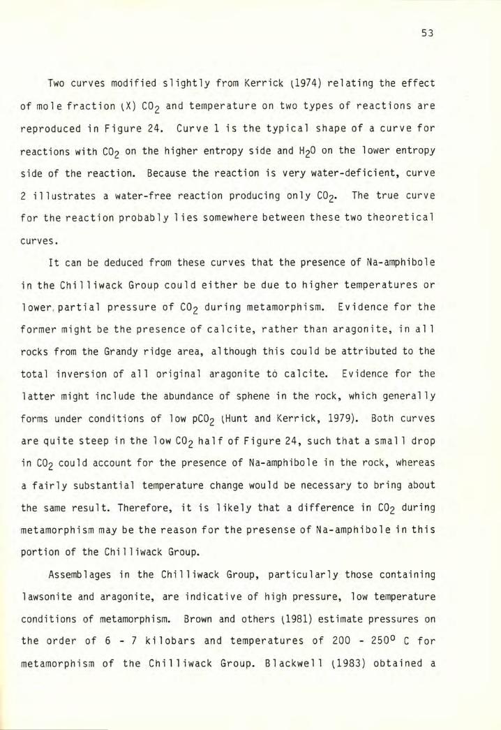
53
Two curves modified slightly from Kerrick ^1974) relating the effect
of mole fraction (X) CO2 and temperature on two types of reactions are
reproduced in Figure 24. Curve 1 is the typical shape of a curve for
reactions with CO2 on the higher entropy side and H2O on the lower entropy
side of the reaction. Because the reaction is very water-deficient, curve
2 illustrates a water-free reaction producing only CO2. The true curve
for the reaction probably lies somewhere between these two theoretical
curves.
It can be deduced from these curves that the presence of Na-amphibole
in the Chilliwack Group could either be due to higher temperatures or
1ower,partial pressure of CO2 during metamorphism. Evidence for the
former might be the presence of calcite, rather than aragonite, in al 1
rocks from the Grandy ridge area, although this could be attributed to the
total inversion of all original aragonite to calcite. Evidence for the
latter might include the abundance of sphene in the rock, which generally
forms under conditions of low PCO2 ^Hunt and Kerrick, 1979). Both curves
are quite steep in the low CO2 half of Figure 24, such that a smal 1 drop
in CO2 could account for the presence of Na-amphibole in the rock, whereas
a fairly substantial temperature change would be necessary to bring about
the same result. Therefore, it is likely that a difference in CO2 during
metamorphism may be the reason for the presense of Na-amphibole in this
portion of the Chilliwack Group.
Assemblages in the Chilliwack Group, particularly those containing
lawsonite and aragonite, are indicative of high pressure, low temperature
conditions of metamorphism. Brown and others (1981) estimate pressures on
the order of 6 - 7 kilobars and temperatures of 200 - 250° C for
metamorphism of the Chilliwack Group. Blackwell (1983) obtained a
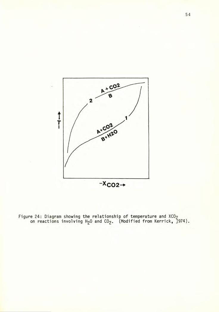
54
Figure 24: Diagram showing the relationship of temperature and XCOpon reactions involving H2O and CO2. (Modified from Kerrick, J974).
55
vitrinite reflectance temperature of 200°C from an interbedded coal bed in
the sedimentary sequence of the Chilliwack Group.
56
STRUCTURES INTERNAL TO THE CHILLIWACK GROUP
In previous studies, comparatively little emphasis has been placed on
internal structures (metamorphic fabrics, etc.) in the Chilliwack Group.
It is hoped that this study will contribute to an understanding of
deformation within the Chilliwack Group, and that this information will
in turn contribute to an understanding of the tectonic history of the
western North Cascades region. A large number of topics will be covered
in this section, including: descriptions of the metamorphic fabric
elements, mylonites, and other strain indicators present in the study
area; orientations of the above-mentioned features; interpretation of the
stretching lineations; interpretation of the sense of shear; strain
analysis techniques and applications; and timing of the deformation with
regard to the metamorphism.
Locations of samples collected in the extended study area for
structural analysis are given in Appendix 3. Numbers preceded by the
number "2" were collected by E. H. Brown.
STRUCTURAL ELEMENTS: DESCRIPTIONS
Two significant deformations have affected the rocks in the study
area, an earlier ^D]^) penetrative deformation, which is present in nearly
all lithologies except for the diabasic volcanics, and a later ^D2)
deformation, which is generally in evidence only in the finer-grained
lithologies.
Pre-deformation (Sg) surfaces are readily apparent in bedded rocks
^as relict bedding) but rarely in others.
The deformation is manifested by a penetrative S^ foliation, found
57
in nearly all lithologies except the coarser volcanic rocks. is
present as a slaty to phyllitic cleavage in argillite and siltstone, as
flattened clasts in coarser sedimentary and volcaniclastic rocks, and as
f 1 attenedamygdulesandphenocrysts in VO 1 canicrocks.
A textural classification was developed by Frasse U981, modified
from Bishop, 1972) to classify meta-siItstone and meta-graywacke in his
study area along the western margin of the Twin Sisters dunite body ^Table
2). This classification is relevent in the present study area as wel 1.
Many siltstones along the lower, east-facing slopes of Grandy ridge are in
textural zone I. Lithologies in the Baker Dam unit are mostly zone IIB,
with some fine-grained samples approaching IIIA. The volcanic arenites
and tuffs from the south end of Grandy ridge are largely in zone IIA, with
small areas of zone IIB. Textural classifications of appropriate
lithologies are included in Appendix 1.
S-^ is nearly always subparallel to parallel to Sg in areas where a
relationship can be observed.
Abundant stretching lineations ^L;L) associated with the
first deformation. lineations are defined most commonly by stretched
clasts in volcanid astic and sedimentary rocks, stretched amygdules in
volcanic flow rocks, parallel alignment of elongate metamorphic mineral
grains, and less commonly by boudins or pressure shadows behind resistant
grains. Each type is described in more detail below.
Stretched clasts Nearly all sedimentary and volcaniclastic rocks
in the map area exhibit stretching to some degree, although this is not
always evident in outcrop except in coarser lithologies. Large areas of
stretched lapilli tuff and pebbly sandstone are present in sections 20 and
29 on the southeast end of Grandy ridge. Coarse-grained lithologies in
the Baker Dam unit also appear well lineated in the field. In many
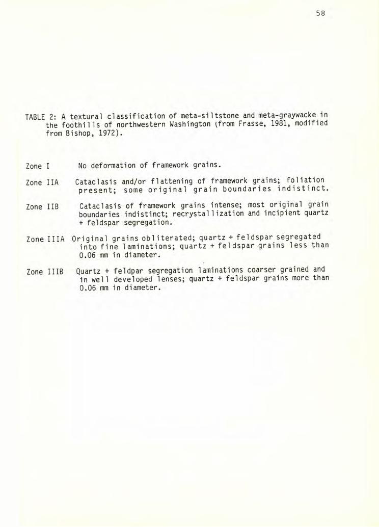
58
TABLE 2: A textural classification of meta-siItstone and meta-graywacke in the foothills of northwestern Washington ifrom Frasse, 1981, modified from Bishop, 1972).
Zone I No deformation of framework grains.
Zone IIA Cataclasis and/or flattening of framework grains; foliation present; some original grain boundaries indistinct.
Zone IIB Cataclasis of framework grains intense; most original grain boundaries indistinct; recrystallization and incipient quartz + feldspar segregation.
Zone IIIA Original grains obliterated; quartz + feldspar segregated into fine laminations; quartz + feldspar grains less than 0.06 mm in diameter.
Zone IIIB Quartz + feldpar segregation laminations coarser grained and in well developed lenses; quartz + feldspar grains more than 0.06 mm in diameter.
59
Clasts in the coarser volcani1ithic rocks deform variably depending
on composition and grain size. Basic volcanic and argillitic clasts
deform readily, whereas dacite clasts are quite resistant ^Figure 25).
Monocrystalline quartz and feldspar are very resistant, normally deforming
by boudinage or by passive rotation, as evidenced by the presence of
asymmetric pressure shadows around them.
Sandy beds composed primarily of plagioclase grains occur frequently
in the Baker Dam unit. The grains generally deform by boudinage, or, in a
few places, appear to be flattened, then further attenuated by the
crosscutting of small veins ^Figure 26).
Stretched phenocrysts and amygdu1es Lineations are relatively
uncommon in volcanic flow rocks, but at several locations, particularly at
the top of Grandy ridge le.g., location 89), chlorite-filled amygdules
define a measurable lineation. A samplei2-683) containing slightly
stretched plagioclase phenocrysts was collected from the east side of Lake
Shannon by E. H. Brown (1984, oral communication).
Elongate metamorphic mineral grains This type of lineation can
only be discerned in thin section. Relatively uncommon in the study area,
it is found only in rocks containing abundant white mica, chlorite,
lawsonite, and Na-amphibole. This type of lineation will be discussed in
more detail in the section on timing of deformation.
instances, however, lineations are only evident on cut surfaces.
Boudins and pressure shadows Boudins associated with sandstone
layers and resistant grains and pressure shadows associated with resistant
grains are present primarily in the Baker Dam unit, in other fine-grained,
highly strained sedimentary rocks, and in highly strained felsic tuffs
from the north side of Grandy ridge. Quartz grains (Figure 27), feldspar
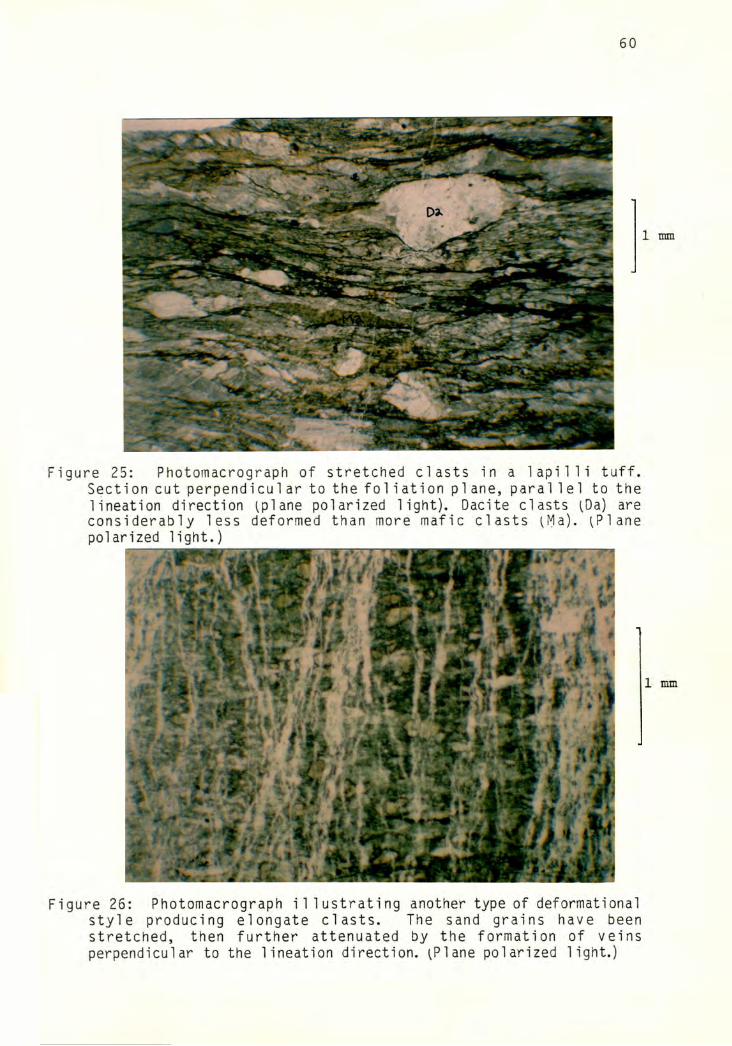
60
Figure 25: Photomacrograph of stretched clasts in a iapilli tuff.Section cut perpendicular to the foliation plane, parallel to the lineation direction (plane polarized light). Dacite clasts (Da) are considerably less deformed than more mafic clasts (Ma). (Plane polarized light.)
Figure 26: Photomacrograph illustrating another type of deformationalstyle producing elongate clasts. The sand grains have beenstretched, then further attenuated by the formation of veinsperpendicular to the lineation direction. (Plane polarized light.)
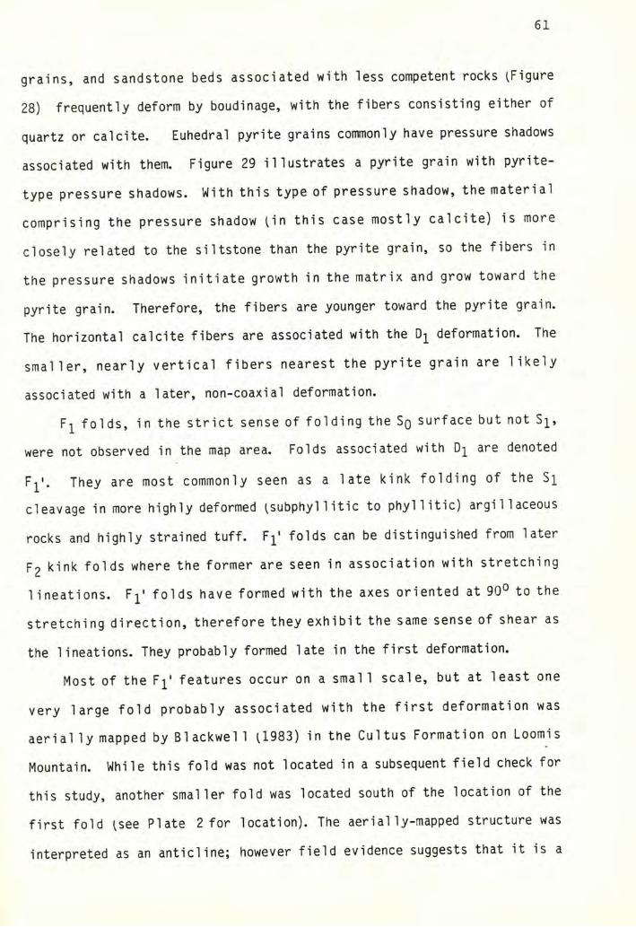
61
grains, and sandstone beds associated with less competent rocks (Figure
28) frequently deform by boudinage, with the fibers consisting either of
quartz or cal cite. Euhedral pyrite grains commonly have pressure shadows
associated with them. Figure 29 illustrates a pyrite grain with pyrite-
type pressure shadows. With this type of pressure shadow, the material
comprising the pressure shadow (in this case mostly calcite) is more
closely related to the siltstone than the pyrite grain, so the fibers in
the pressure shadows initiate growth in the matrix and grow toward the
pyrite grain. Therefore, the fibers are younger toward the pyrite grain.
The horizontal calcite fibers are associated with the deformation. The
smaller, nearly vertical fibers nearest the pyrite grain are likely
associated with a later, non-coaxial deformation.
F^ folds, in the strict sense of folding the Sq surface but not S^,
were not observed in the map area. Folds associated with D]^ are denoted
Fj^'. They are most commonly seen as a late kink folding of the S]^
cleavage in more highly deformed (subphyl1itic to phyllitic) argillaceous
rocks and highly strained tuff. Fj^' fo^ds can be distinguished from later
F2 kink folds where the former are seen in association with stretching
lineations. folds have formed with the axes oriented at 90° to the
stretching direction, therefore they exhibit the same sense of shear as
the lineations. They probably formed late in the first deformation.
Most of the F]^' features occur on a small scale, but at least one
very large fold probably associated with the first deformation was
aerial ly mapped by Blackwel 1 (1983) in the Cultus Formation on Loomis
Mountain. While this fold was not located in a subsequent field check for
this study, another smaller fold was located south of the location of the
first fold (see Plate 2 for location). The aerially-mapped structure was
interpreted as an anticline; however field evidence suggests that it is a
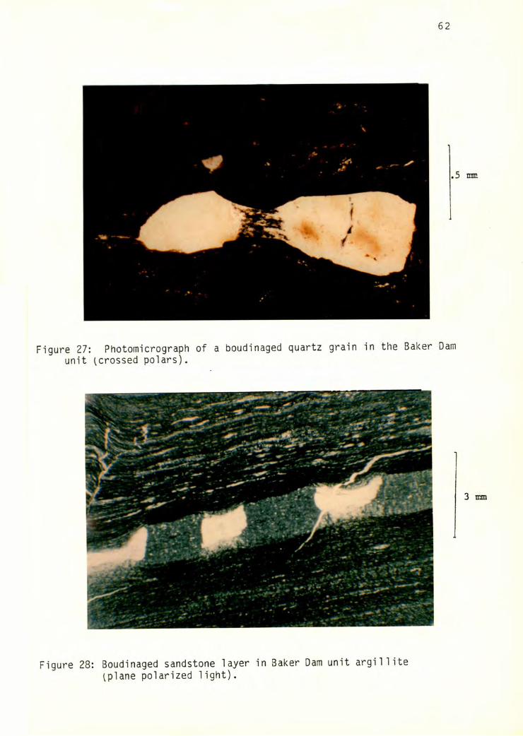
Figure 27: Photomicrograph of a boudinaged quartz grain in the Baker Damunit ^crossed polars).
Figure 28: Boudinaged sandstone layer in Baker Dam unit argillite (plane polarized light).
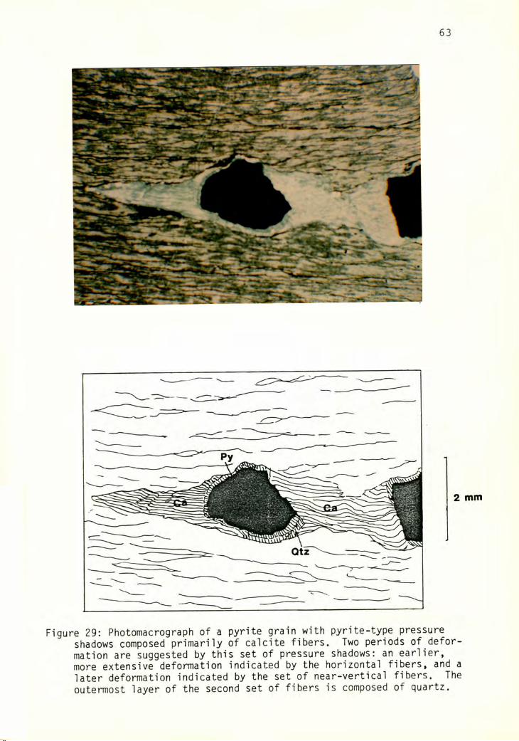
63
Figure 29: Photomacrograph of a pyrite grain with pyrite-type pressureshadows composed primarily of calcite fibers. Two periods of deformation are suggested by this set of pressure shadows: an earlier, more extensive deformation indicated by the horizontal fibers, and a later deformation indicated by the set of near-vertical fibers. The outermost layer of the second set of fibers is composed of quartz.
I,
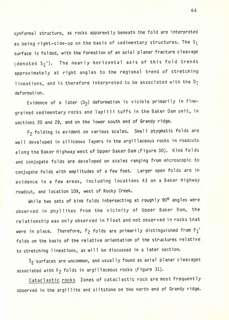
64
synformal structure, as rocks apparently beneath the fold are interpreted
as being riglit-side-up on the basis of sedimentary structures. The
surface is folded, with the formation of an axial planar fracture cleavage
^denoted S^'). The nearly horizontal axis of this fold trends
approximately at right angles to the regional trend of stretching
lineations, and is therefore interpreted to be associated with the
deformation.
Evidence of a later ^02) deformation is visible primarily in fine
grained sedimentary rocks and lapilli tuffs in the Baker Dam unit, in
sections 20 and 29, and on the lower south end of Grandy ridge.
F2 folding is evident on various scales. Small ptygmatic folds are
well developed in siliceous layers in the argillaceous rocks in roadcuts
along the Baker Highway west of Upper Baker Dam' ^Figure 30). Kink folds
and conjugate folds are developed on scales ranging from microscopic to
conjugate folds with amplitudes of a few feet. Larger open folds are in
evidence in a few areas, including locations 43 on a Baker Highway
roadcut, and location 109, west of Rocky Creek.
While two sets of kink folds intersecting at roughly 90° angles were
observed in phyllites from the vicinity of Upper Baker Dam, the
relationship was only observed in float and not observed in rocks that
were in place. Therefore, F2 folds are primarily distinguished from F^'
folds on the basis of the relative orientation of the structures relative
to stretching lineations, as will be discussed in a later section.
S2‘surfaces are uncommon, and usually found as axial planar cleavages
associated with F2 folds in argillaceous rocks ^Figure 31).
Cataclastic rocks Zones of cataclastic rock are most frequently
observed in the argillite and siltstone on the north end of Grandy ridge.
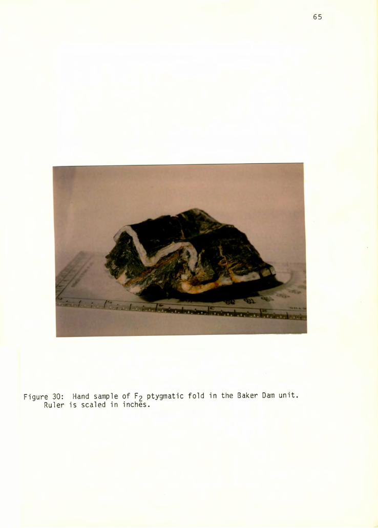
Figure 30: Hand sample of F2 ptygmatic fold in the Baker Dam unit.Ruler is scaled in inches.
66
Figure 31: Photomacrograph of S2 planar cleavage associated withsmall p2 fold in the Baker Dam unit ^plane polarized light).
5mrT\
67
A commonly observed progression is of coherent, foliated rock grading into
disharmonically folded ^but still largely coherent) foliated rock grading
into completely disrupted cataclastite containing rounded to streaked-out
blobs of quartz, cal cite, argillite, and sandstone iFigure 32). In areas
where this sequence can be observed, the faulting appears largely to
postdate the formation of the S]^.
Cataclastic rocks are also common associated with volcanic rocks near
the top of the south end of Grandy ridge. They are black to gray, with a
well defined, scaly fabric. They are composed of volcanic clasts and
segregations of quartz and feldspar in a matrix of chlorite and
pseudotachylite.
Small zones in highly strained tuffaceous rocks also exhibit
cataclastic deformation grounding and cataclasis of grains and formation
of brown grunge).
DEFORMATION POSTDATING D^ AND D2 DEFORMATIONS
A few small Tertiary^?) faults have been noted from the map area, the
most prominent being a vertical fault striking approximately N50E, located
near the boundary of sections 29 and 30 on the south end of Grandy ridge.
It juxtaposes phyllitic siltstone against resistant dacite tuff. The
deformation associated with this fault is fairly negligible, except for
the presence of drag folds in the phyllite, which indicate that the
northwest side moved up relative to the southeast side. Other small,
vertical, northeast-trending faults and joints are also present in the
vicinity of the larger fault.
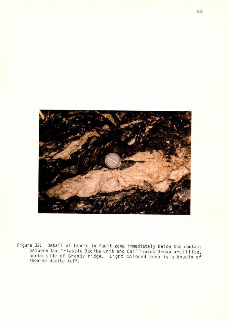
Figure 32: Detail of fabric in fault zone immediately below the contactbetween the Triassic Dacite unit and Chilliwack Group argi 11ite, north side of Grandy ridge. Light colored area is a boudin of sheared dacite tuff.
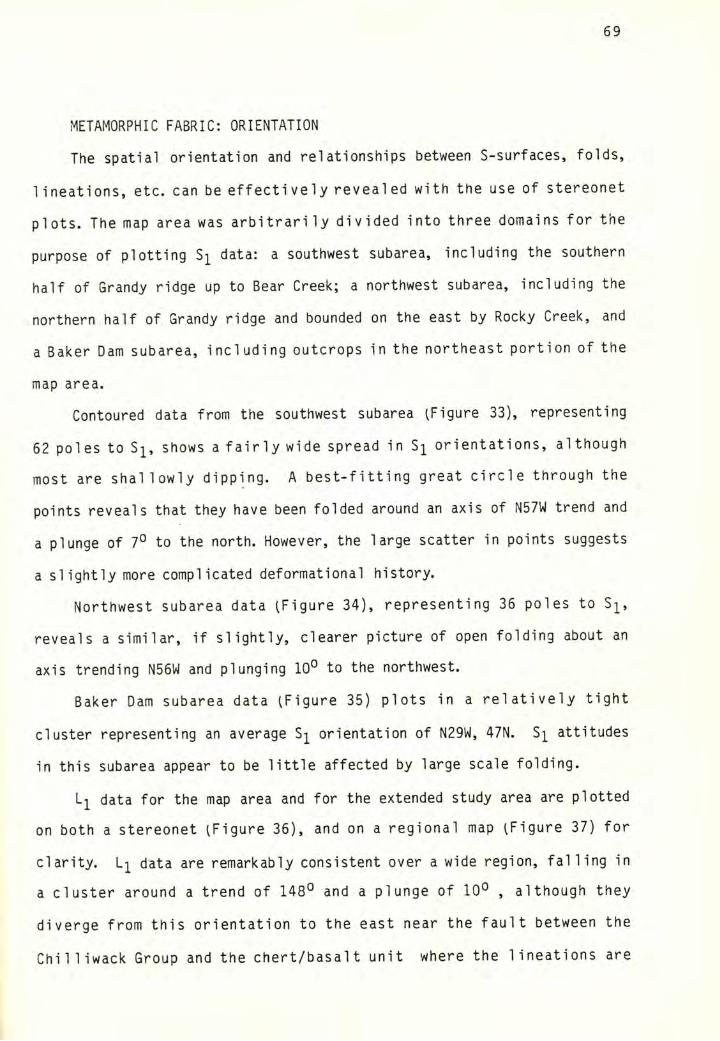
69
METAMORPHIC FABRIC: ORIENTATION
The spatial orientation and relationships between S-surfaces, folds,
lineations, etc. can be effectively revealed with the use of stereonet
plots. The map area was arbitrarily divided into three domains for the
purpose of plotting Si data: a southwest subarea, including the southern
half of Grandy ridge up to Bear Creek; a northwest subarea, including the
northern half of Grandy ridge and bounded on the east by Rocky Creek, and
a Baker Dam subarea, including outcrops in the northeast portion of the
map area.
Contoured data from the southwest subarea (Figure 33), representing
62 poles to S]^, shows a fairly wide spread in orientations, although
most are shallowly dipping. A best-fitting great circle through the
points reveals that they have been folded around an axis of N57W trend and
a plunge of 7° to the north. However, the large scatter in points suggests
a slightly more complicated deformational history.
Northwest subarea data (Figure 34), representing 36 poles to S]^,
reveals a similar, if slightly, clearer picture of open folding about an
axis trending N56W and plunging 10° to the northwest.
Baker Dam subarea data (Figure 35) plots in a relatively tight
cluster representing an average S]^ orientation of N29W, 47N. attitudes
in this subarea appear to be little affected by large scale folding.
data for the map area and for the extended study area are plotted
on both a stereonet (Figure 36), and on a regional map (Figure 37) for
clarity. li data are remarkably consistent over a wide region, falling in
a cluster around a trend of 148° and a plunge of 10° , although they
diverge from this orientation to the east near the fault between the
Chilliwack Group and the chert/basalt unit where the lineations are
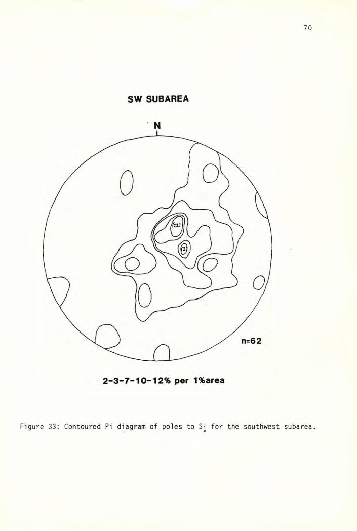
70
SW SUBAREA
N
Figure 33: Contoured Pi diagram of poles to Sj for the southwest subarea.
71
NW SUBAREA
N
3-6-9-13-23% per 1% area
Figure 34: Contoured Pi diagram of poles to Sj for the northwest subarea.
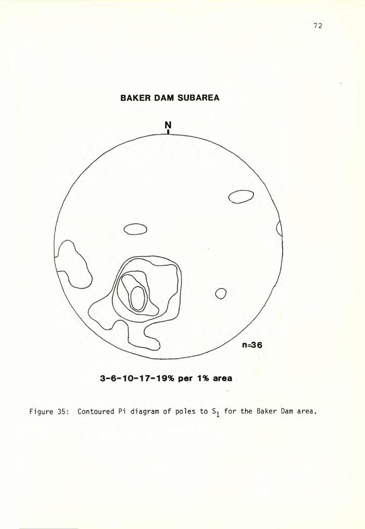
72
BAKER DAM SUBAREA
N
Figure 35: Contoured Pi diagram of poles to Sj for the Baker Dam area.
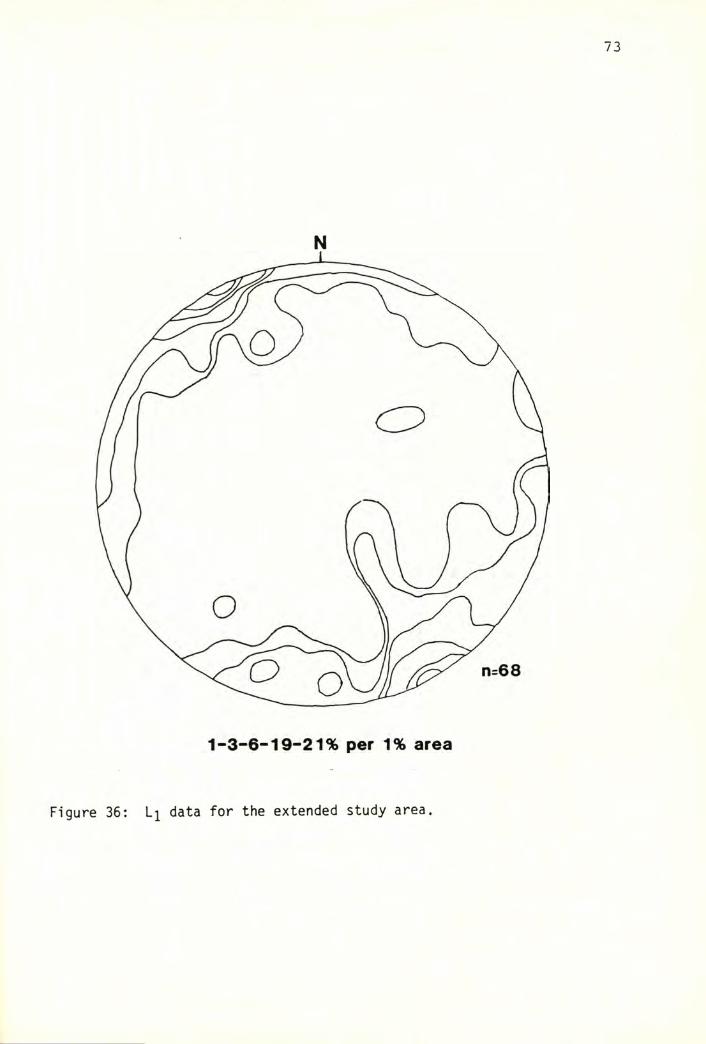
73
N
Figure 36: Lj data for the extended study area.
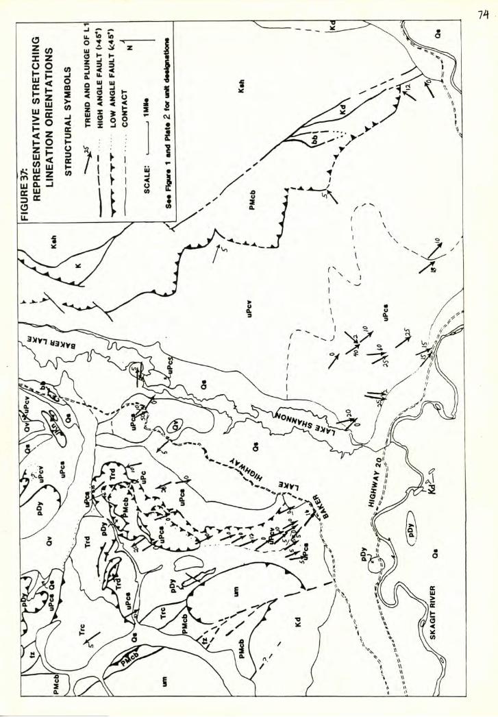
75
predotninant 1 y northeast-trending.
Eleven F]^' fold axes were measured, and are plotted in Figure 38.
The points form a cluster around a nearly horizontal line trending N52E.
Nine fold axes were measured, and are plotted on the same figure for
comparison. These points loosely cluster around a nearly horizontal axis
trending N43W.
A consistent sense of fold vergence was general ly not noted in most
areas. A few areas showed some consistency in F]^' orientations. F^' kink
folds in phyl 1 itic rock cropping out in a creek bed on the south-facing
side of Grandy ridge are generally oriented with short limbs dipping
north. The large F^^' folds on Loomis Mountain are recumbant folds
overturned to the northwest. Observations of Fj^' folds from other areas
generally show no consistent sense of asymmetry; nearly as many folds are
oriented with the short limbs dipping to the northwest as to the
southeast. F2 folds normally show little sense of asymmetry. The large
folds previously mentioned are both overturned to the northeast. At least
one set of F2 kink folds noted in a creek near the Whatcom/Skagit county
line are oriented with short limbs dipping to the southwest.
Data from small shear zones and faults are plotted in Figure 39. They
show a similar orientation to St^ data from the northwest subarea, from
which most of the measurements were taken.
Discussion
The deflection of attitudes in the southwest and northwest
subareas around the axes of N57W, 7N and N56W, ION respectively, corres
ponds fairly well with the average measured F2 direction of N43W and
horizontal, and hence can probably be attributed to F2 folding.
Comparison of and F^^ data shows the average Fj^ fold axis, at
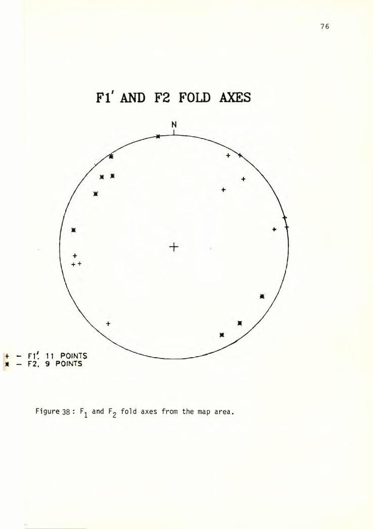
FI' AND F2 FOLD AXES
N
F2. 9 POINTS
Figure 38 •' F^ and F2 fold axes from the map area.
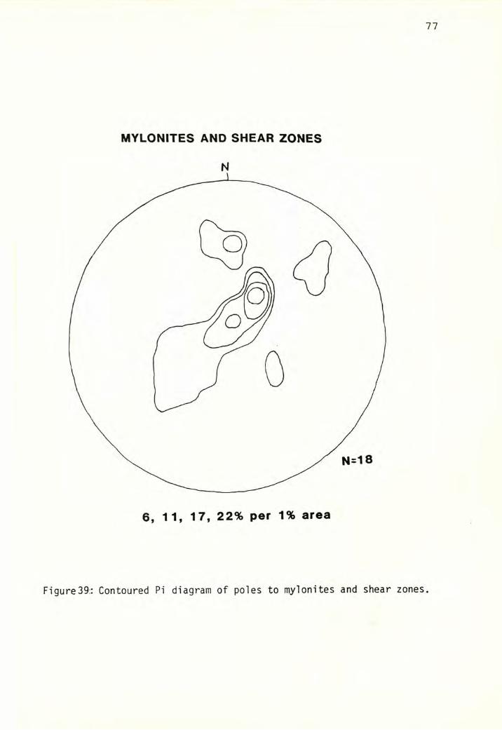
MYLONITES AND SHEAR ZONES
6, 11, 17, 22% per 1% area
Figure39:: Contoured Pi diagram of poles to mylonites and shear zones.
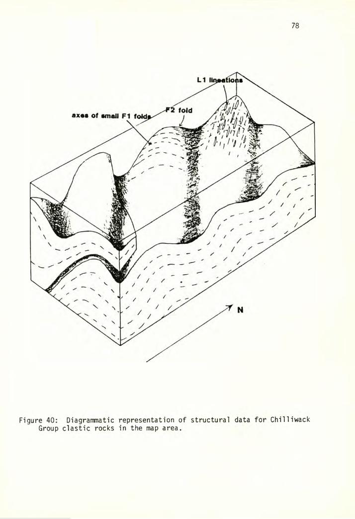
78
Figure 40: Diagrammatic representation of structural data for ChilliwackGroup clastic rocks in the map area.
79
N52E and horizontal, to be oriented 84° fom the average measured value
U48° trend, 5° plunge) in a slightly south-dipping plane. This is very
close to the expected difference of 90° between and directions.
The large, nearly horizontal fold on Loomis Mountain, with an axis
trending N55E, is probably an F]^' fold based on the similarity of its
orientation to other F^' folds. The absence of significant scatter in the
orientations, expected due to later folding, can probably be attributed
to the near parallelism of li and ?2 orientations.
Figure 40 is a diagrammatic representation of the orientations of the
common structural features present in the map area.
The regional map of lineations ^Figure 37) reveals that, while
directions are very consistent in the vicinity of Grandy Ridge, a
significant number of northeast-trending lineations are present near the
eastern boundary of the regional map, near the fault between the
Chilliwack Group and the chert/basalt unit. Also of interest is the
concentration of li measurements along Grandy Ridge and to the southeast.
This is partially a reflection of the distribution of appropriate
lithologies; but, in a number of areas with no or few li orientations
plotted, the rocks were only weakly fol iated and contained no definite
1ineation.
80
KINEMATIC INTERPRETATION OF LI STRETCHING LINEATIONS
The relationship of the elongation directions in stretched rocks to
the kinematic directions is normally a complex one, although it is often
possible in a general sense to interpret, for example, relative movement
directions between two blocks separated by a shear zone containing
stretched clasts or other lineations. This is a subject not without
controversy, however, as the significance of stretching lineations has
been interpreted in at least three different ways.
Jefferey U923) pi aced pro 1 ate and oblate ell ipso ids in a viscous
liquid and subjected the system to simple shear. He found that the
prolate forms tended to align in the plane of shear with the long axes
perpendicular to the shear direction. Two conditions make this a poor
model for most rocks containing ellipsoidal particles. One is that the
particles and matrix in the Jefferey study were of vastly different
competency, such that no deformation was sustained by the grains, and the
second is that the stable configurations were reached only after hundreds
of rotations, a condition probably not realized in most rocks.
On a similar note, Blake and others U981) found lineations in rocks
of the Cycladic blueschist belt in Greece and used them as evidence in
orienting a paleo-subduction zone parallel to the line ation direction
^therefore perpendicular to the subduction or shear direction).
Ave Lallemant U983) found no apparent relationship between mineral
lineations and folding and thrusting in a Mesozoic thrust belt in eastern
Oregon, interpreting the lineations to be the result of pressure solution.
A majority of workers, however, favor the idea that stretching
lineations are oriented roughly parallel to movement directions, e. g..
81
Bryant and Reed U969), Escher and Watterson U974), Rodgers U984),
Shackleton and Ries U984). These papers address the subject of
lineations in association with thrusting or subduction, and conclude that
the elongation direction is perpendicular to the overall shortening
direction, and approximately parallel to the shear direction.
This concept is illustrated in Figure 41. A passive, spherical
marker, when subjected to simple shear, will record the shape of the
strain ellipsoid, which is normally represented by the lengths of the long
^X), intermediate (Y), and short (Z) axes. The marker in Figure 41, when
subjected to simple shear, elongates at an acute angle to the shear plane,
with the X-axis orientation approaching the shear direction at high strain
magnitudes. The length of the Y-axis remains constant while the Z-axis
shortens; the result is that a foliation is formed parallel to the XY
plane. Simple shear also produces a characteristic ratio of axial
lengths, such that the equation [^X/Y)-l] / [(Y/Z)-l] is numerically equal
to one. This value is refered to as the K value ^Flinn, 1956). Escher
and Watterson U974) also note the tendency of randomly oriented lines to
rotate into parallelism with the shear direction at high strain
magnitudes.
This general premise, that the long direction of stretched clasts and
elongate objects points in the direction of shear while the foliation
forms subparallel to the shear plane, is adopted in this study, based in
part on the following observations:
1) Indicators of extension, such as quartz fibers in pressure shadows
and boudinaged grains, are oriented parallel to the long axis directions
of stretched clasts and elongate mineral grains.
2) Shear directions, indicated by asymmetric pressure shadows, etc.
associated with resistant grains that rotate rather than passively deform.
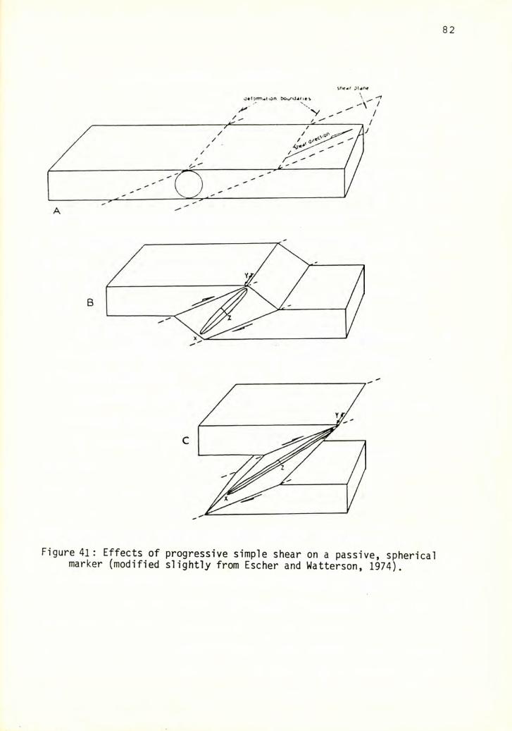
82
sne^r pUn«
Figure 41: Effects of progressive simple shear on a passive, spherical marker (modified slightly from Escher and Watterson, 1974).
83
are consistent with the above interpretation.
Unfortunately, it is not often possible to discern whether simple
shear, pure shear, or some other mechanism such as pressure solution is
responsible for the strain observed in deformed rocks. A model of
homogeneous simple shear was used by Escher and Watterson U974) to
explain the occurrence of elongate clasts in rocks from a variety of
areas, based on the observed continuity of structures such as bedding
planes across deformation boundaries (as Figure 41 illustrates, the size
and shape of the boundary planes remain unchanged throughout shearing).
Other evidence for strain produced by simple shear might include:
1) K Va 1ues of 1.
2) The elongation direction in stretched clasts oriented at an angle
to slaty cleavage in finer grained rocks, assuming the latter exactly
parallels the shear plane.
Evidence for strain induced by pure shear (flattening) might include:
1) K values< 1 (which would indicate flattening).
2) No continuity of structures such as bedding across deformation
boundaries.
3) The XY plane in stretched clasts paralleling the slaty cleavage in
adjacent finer grained rocks.
K values > 1 may indicate more than one period of deformation.
The above criteria are based on very simple models; inhomogeneities
can exist on all scales. Mechanisms such as pressure solution can produce
similar relationships. Figure 26, p. 60, illustrates some of the
complexities involved in the deduction of a mechanism.
In Figure 26, it can be noted that: grain flattening is roughly
parallel to the foliation and that a network of small veins is present.
84
oriented perpendicular to the flattening direction. It is estimated that
43% of the extension in the XZ plane is due to the presense of quartz
veins. Veins of this nature normally form parallel to the direction of
maximum compression. This and the observation that the elongation and
cleavage directions are parallel suggest either pure shear ^flattening) or
pressure solution as possible mechanisms. However, the influence of these
mechanisms does not rule out a component of simple shear. Other samples
from the same vicinity contain evidence of rotational shear such as
asymmetric pressure shadows around augen; and a computed K value for this
rock is approximately 1.2, very close to the expected value for simple
shear deformation.
The model proposed by Escher and Watterson U974) is probably too
simple an explanation for the strain in this sample. However, a majority
of samples do not exhibit these phenomena, and also have K values near 1
(see strain analysis section). On an outcrop or regional scale, the
strain can probably also be considered fairly homogeneous, although
clearly it may not be on a smaller scale (as in Figure 25, p.60) The
simple shear model, although an oversimplification, will be adopted for
analyses and calculations in the rest of this study, because nearly all
samples contain evidence of some type of rotational strain, and because it
is the easiest model to employ in calculations.
85
SENSE OF SHEAR IN SANDSTONES AND TUFFS
In rocks which contain a primary stretching lineation, the assumption
is often made that the rock underwent shear deformation. The foliation is
normally assumed to correspond approximately to the plane of shear, with
the lineation direction indicating the direction of maximum elongation.
Less obvious are indicators of the sense of shear, particularly in areas
where the boundaries of shear deformation and offset marker horizons are
absent or not wel 1 establ ished, as is the case in the Grandy Ridge area.
For this study, an attempt to determine the sense of shear in suitable
rocks was carried out primarily using methodology outlined in Simpson and
Schmid U983), by examining structures internal to the rocks. The sense
of shear is determined primarily by examination of asymmetrical augen,
asymmetric pressure shadows around resistant grains, displacements of
broken grains, and intersections of c- ^shear) and s- ^foliation)
surfaces. Other indicators, such as asymmetric kink folds in slates and
phyllites, were also examined.
Oriented samples of sandstones and mylonites containing resistant
quartz and feldspar grains were collected from within the map area and in
the extended study area. Thin sections were made from sections cut
parallel to the lineation direction and perpendicular to the foliation and
were scrutinized for evidence of shear. A majority of samples proved to
be of no use in determining shear sense, apparently because the magnitude
of strain was not sufficient to produce the necessary structures. Due to
the relatively low grade nature of these rocks, the most abundant and
useful structures for determining shear sense are pressure shadows and
broken grains ^Figure 42). In some rocks, a "cisai 1 1ement" or shear
fabric ^Berthe and others, 1979) has developed at low angles to the
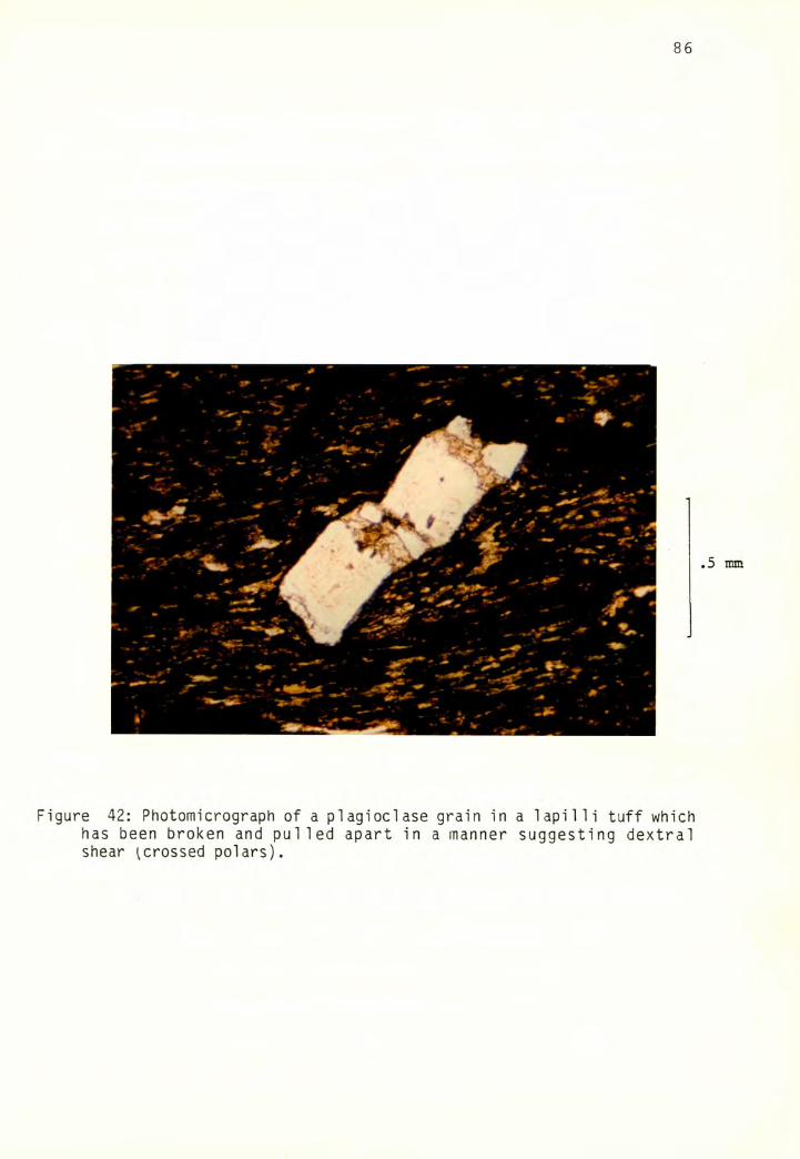
86
I
Figure 42: Photomicrograph of a plagioclase grain in a lapilli tuff which has been broken and pulled apart in a manner suggesting dextral shear ^crossed polars).
4
87
original s-surface, parallel to the boundaries of shear. These so called
c-surfaces represent discrete zones of high strain, and can be used to
determine shear sense because the original s-surfaces are deflected by the
c-surfaces (Figure 43). Grains from the same slides often give conflicting
evidence of shear sense, so as many grains as possible were examined in
each slide before a determination of shear sense was made. Table 3
summarizes the results of observations of 18 oriented thin sections. The
information in Table 3 is also plotted on a regional map (Figure 44).
DISCUSSION
Although the sense of shear in several samples suggests southward
translation of the upper plate, a majority of samples contain small scale
features that suggest northward translation. In one sample (209) the
foliation plane is nearly vertical, such that the relative shear sense is
right-1ateral.
Fold vergences are another criteria for determination of shear sense
in rocks that are not highly contorted. As previously discussed, a number
of F]^' features are overturned or have short limbs dipping north,
indicating that the upper plate moved north. However, a significant
number of folds have an opposite sense of asymmetry.
The shear sense indicated in these samples appears not to be related
to either $i attitudes (i. e., whether the rocks are dipping northeast or
southwest) or the type of indicator used to determine shear sense.
The results of this sense of shear study are not particularly
conclusive; however, since more samples show an upper-plate-northward
sense of shear, it will be assumed that this is the dominant sense of
motion in the Chilliwack group in the study area.
Reasons for the apparent indeterminate nature of the data generated
by this study may be several, including: misinterpretation of shear sense;
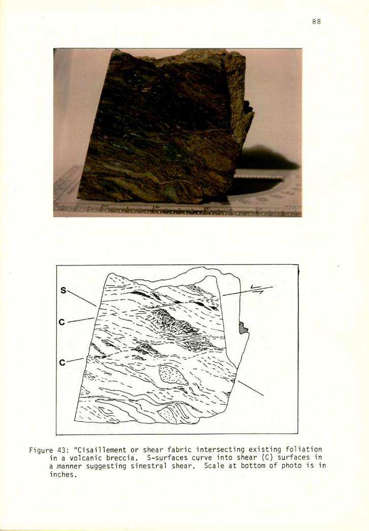
Figure 43; "Cisainement or shear fabric intersecting existing foliation in a volcanic breccia. S-surfaces curve into shear (C) surfaces in a JTianner suggesting sinestral shear. Scale at bottom of photo is in inches.
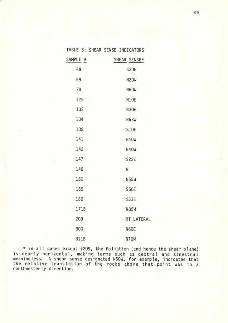
89
TABLE 3: SHEAR SENSE INDICATORS
SAMPLE # SHEAR SENSE*
49 S30E
59 N20W
78 N60W
125 NlOE
132 N30E
134 N63W
138 SlOE
141 N40W
142 N40W
147 S22E
148 N
160 N55W
165 S50E
168 S53E
171B N85W
209 RT LATERAL
800 N60E
811B N70W
* in all cases except #209, the foliation (and hence the shear plane)is nearly horizontal, making terms such as dextral and sinestralmeaningless. A shear sense designated N50W, for example, indicates thatthe relative translation of the rocks above that point was in anorthwesterly direction.
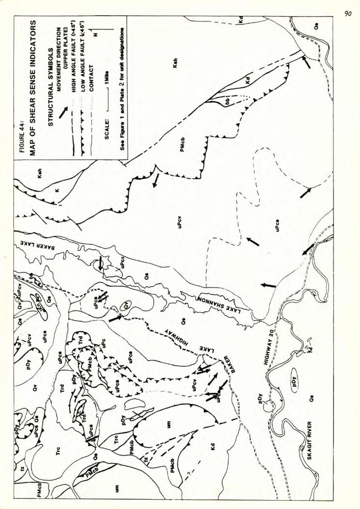
91
the small number of samples which yielded useful information; or the
effects of two periods of deformation. iNotably in samples with c-surfaces
intersecting s-surfaces, a slightly later period of deformation is
possible.) A fourth possibility is that the deformation is more complex
than simple shear, with the development of both thrust and lag faults
between units of differing competency accounting for the divergence of
shear directions. Monger (1966) identified a fault between two nappes
(the McGuire and Liumption nappes) in the type area as a lag fault.
In apparent agreement with the tentative findings of this study.
Monger (1966) also interpreted dominantly upper-plate-northwestward
movement in the Chilliwack Valley, B. C., based primarily on the geometry
of the McGuire nappe. The McGuire nappe is an anticlinal structure
overturned to the north, bounded from below by a thrust fault. Although
the large, overturned synforms on Loomis Mountain are also overturned to
the northwest, the sense of shear is probably indeterminate.
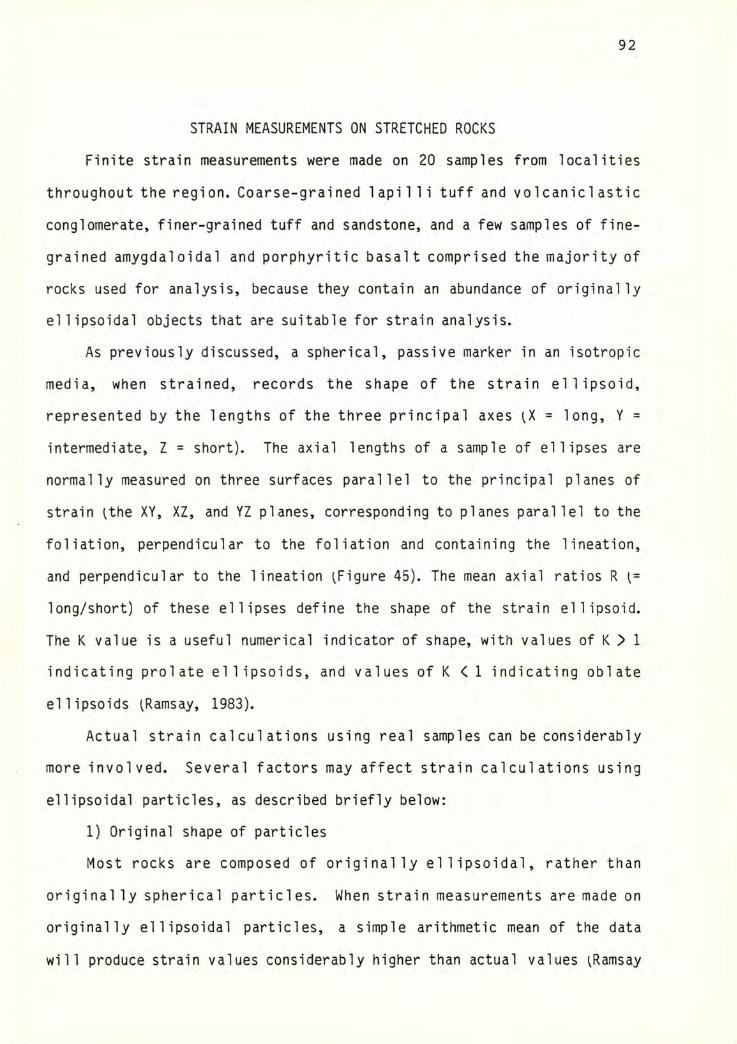
92
STRAIN MEASUREMENTS ON STRETCHED ROCKS
Finite strain measurements were made on 20 samples from localities
throughout the region. Coarse-grained 1api1 1 i tuff and volcaniclastic
conglomerate, finer-grained tuff and sandstone, and a few samples of fine
grained amygdaloidal and porphyritic basalt comprised the majority of
rocks used for analysis, because they contain an abundance of originally
ellipsoidal objects that are suitable for strain analysis.
As previously discussed, a spherical, passive marker in an isotropic
media, when strained, records the shape of the strain ellipsoid,
represented by the lengths of the three principal axes = long, Y =
intermediate, Z = short). The axial lengths of a sample of ellipses are
normally measured on three surfaces parallel to the principal planes of
strain ^the XY, XZ, and YZ planes, corresponding to planes parallel to the
foliation, perpendicular to the foliation and containing the lineation,
and perpendicular to the lineation ^Figure 45). The mean axial ratios R [=
long/short) of these ellipses define the shape of the strain ellipsoid.
The K value is a useful numerical indicator of shape, with values of K > 1
indicating prolate ellipsoids, and values of K < 1 indicating obi ate
ellipsoids (Ramsay, 1983).
Actual strain calculations using real samples can be considerably
more involved. Several factors may affect strain calculations using
ellipsoidal particles, as described briefly below:
1) Original shape of particles
Most rocks are composed of originally ellipsoidal, rather than
originally spherical particles. When strain measurements are made on
originally ellipsoidal particles, a simple arithmetic mean of the data
will produce strain values considerably higher than actual values (Ramsay
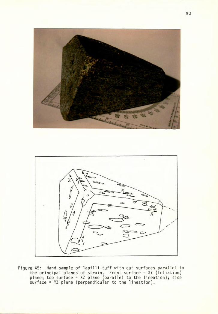
93
Figure 45: Hand sample of lapilli tuff with cut surfaces parallel tothe principal planes of strain. Front surface = XY (foliation) plane; top surface = XZ plane (parallel to the lineation); side surface = YZ plane (perpendicular to the lineation).
A.
94
and Huber, 1983; Lisle, 1981). In rocks that are not highly strained, the
range in orientation of the ellipsoids makes location of the principal
planes difficult. The latter difficulty was not a problem in most of the
rocks measured for this study, since at high strain magnitudes, such as
those present in the rocks studied, the long axes of particles rotate into
near-parallel configurations.
2) Competency differences
When the matrix is more easily deformed than the clasts, the clasts
may rotate rather than deform, leading to lower than actual strain
values if only the clasts are considered. This was not considered to be a
significant problem in the rocks measured for this study, as very little
matrix was observed, and evidence of rotation was found only in
monocrystalline quartz and feldspar grains, which were normally not
measured for this reason. A more significant problem in the coarser-
grained rocks is the variety of volcanic lithic types present and the
corresponding range in strain magnitudes from one type to another.
3) Original preferred orientation of particles
A semi-planar, semi-linear, or imbricate preferred orientation of
ellipsoidal particles is common in sedimentary rocks and may significantly
affect strain calculations. A few methods have been devised for dealing
with this factor ^eg., Dunnet and Siddans, 1971, and Elliot, 1970) but
these are of limited effectiveness and are difficult to apply, so this
problem was ignored in the present study.
4) Volume change
Volume loss, such as that due to compaction, can affect strain
calculations by creating a non-random clast spacing or an initial
preferred orientation of platy grains prior to shearing. It was assumed
95
that no volume loss took place before or during the strain event because:
volume loss is difficult to evaluate, platy grains were not measured, and
compactable matrix is at a minimum in these rocks.
5) Type of deformation
Most models assume homogeneous strain, but inhomogeneous strain or
mechanisms such as pressure solution can complicate calculations of total
strain. These factors are variable and difficult to evaluate. As
previously mentioned, the assumption is made that the strain observed in
stretched rocks is largely the result of homogeneous simple shear.
Therefore, small inhomogeneities, such as more deformation in one clast
relative to another, or more deformation in one portion of a thin section
relative to another, are simply averaged into the total.
Many methods have been devised to calculate the shape of the strain
ellipse in rocks containing originally ellipsoidal particles. Several of
these methods were investigated and, where suitable, applied to a suite of
four samples so that they could be evaluated for apparent accuracy and for
applicability to a large number of samples. Brief descriptions of four of
the commonest methods are given below, followed by the results of
application and evaluation.
Methods involving grain shape calculations
All methods relying only on grain shape ^or orientation) calculations
will yield strain values applicable only to the clast fraction, and will
underestimate the strain for the rock as a whole. Significant departures
from actual strain values will occur in rocks containing significant
amounts of matrix or in rocks containing resistant clasts which rotate
rather than deform.
A) Arithmetic and Harmonic means
These methods involve computing the lengths of the three principal
96
axes of the strain ellipse from the means of the el 1ipticities of a sample
of grains measured on surfaces cut paral lei to the principal planes of
strain. Two commonly used calculations are the arithmetic mean,
Rf = + R2 + R3 + ... + R|^)/n,
and the harmonic mean,
H = n/^Ri‘l + R2‘^ + ... + Rn'^)-
The harmonic mean was found to yield axial ratios closest to the
shape of the strain ellipse in experimental ly deformed conglomerates
(Lisle, 1979). Hossack U968) estimated that 30 pebble measurements ^per
side) were adequate for relatively precise strain determinations using the
arithmetic mean. The number of measurements is probably similar for the
harmonic mean. Fairly significant departures of mean values from actual
strain values occur where the initial el 1ipticities of the grains are
high, or where strain magnitudes are low.
B) Rf/0
This method involves measuring the ellipticity Rf of each clast on a
given face and plotting this against 0, the angle the long axis makes with
an arbitrary line. The resulting curve is then compared to existing
theoretically-deduced curves. The closest fit determines the strain
magnitude and the average initial ellipticity of the particles. (For a
complete treatment of the mathematics and theoretical curves, see Dunnet,
1969). At least 50 clast measurements per side are necessary for a
precise analysis (Dunnet, 1969).
This method yields a high degree of precision with a relatively small
number of data points, can be used to deduce original preferred
orientation of the clasts, and provides one with a value for the original
el 1ipticities of the clasts. It is not, however, appropriate for use in
97
cases where the magnitude of strain is relatively high; in such cases, the
fluctuation ^the maximum range of 0 values) becomes very small, and it is
difficult to measure the angles and compare the experimental to the
theoretical curves.
Methods using point separations
Two methods using the relationship of distances between the midpoints
of grains are discussed below. These methods, where applicable, probably
provide a more reliable measure of strain in the rock as a whole, rather
than just the clast fraction, and would be more accurate where large
ductility contrasts exist between clasts or between the clasts and matrix.
One constraint on the use of either method involves the distribution
pattern of the points. A totally random, or Poisson, distribution of
points, where object positions are mutual ly independent, wi1 1 retain a
random distribution after deformation; hence these methods are not
applicable to random point distributions. Homogeneous point distributions
of relatively uniform density ^anticlustered distributions) are needed to
employ these techniques. Employing them on an originally perfectly
isotropic, anticlustered point distribution will theoretically produce
results that very closely approximate the shape of the strain ellipse.
All other configurations will yield results that are lower than true
strain values ^Fry, 1979). In terms of clastic rocks, a well-sorted and
well-rounded sandstone would produce a homogeneous distribution of clast
center points on a cut surface, whereas a poorly sorted rock would produce
a more random distribution.
A) Nearest neighbor method
For this method, an overlay is used, and the midpoints of all the
grains in a sample are plotted. Lines are drawn between points,
connecting the "nearest neighbors" to each point. The length of each of
98
these lines is plotted against the angle the line makes with an arbitrary
reference line, producing a curve with a maximum corresponding to the
angle where the longest lines occur, which is the direction of maximum
extension in the rock. The maximum is compared to the minimum for the
ellipticity of the strain ellipse, and the proceedure is repeated on
another face to obtain the axial length of the third axis of the strain
ellipsoid. Ramsay and Huber U983) suggest that the sample size will
probably be determined by the time alloted to analysis, although 50 points
appear to be adequate for fairly precise results.
This method is very time consuming, and will only be reliable where
it is possible to prove that the nearest neighbors to a point in the
strained rock are the same nearest neighbors to the same point in the
unstrained rock U-e., that relative object positions have not changed).
B) Fry method
The Fry method, or "all object - object separations" method ^Fry,
1978) also involves plotting the centers of all points in a sample on an
overlay. Another overlay is placed on top of the first, and a reference
point is chosen near the center of the sample. A1 1 other points in the
sample are then plotted on the second overlay. The reference point is
then moved to an adjacent point on the first overlay, and the new
positions of the points are plotted on the second overlay. This process
is repeated until enough points are located to define an elliptical girdle
and an area containing no points around the reference point, which
corresponds approximately to the shape of the strain ellipse. Fry U978)
suggests that at least 300 and up to 1000 points are needed to obtain a
high degree of precision using this method.
While application of this method is considerably less time-consuming
99
and exacting than application of the nearest neighbors method, and it does
not require that relative object positions stay the same before and after
deformation, the 1 arge number of data points needed puts a 1 imit on its
usefulness.
Four samples were chosen for original analyses using all of the
techniques mentioned, to compare difficulty, accuracy, and precision of
the methods, in order to determine which would be most suitable to apply
to all samples. These samples included three lapilli tuffs, for one of
which only the chloritic clasts were measured, since grain boundaries
between other lithologies were indistinct, and one porphyritic volcanic
rock, for which only the phenocrysts were measured. Samples were cut
along the three mutual ly perpendicular principal planes and polished using
#600 grit. The arithmetic and harmonic means were calculated using 30
axial ratio measurements each off the three faces, which were measured
using a ruler with 50 divisions to the inch. The Rf/0 method was deemed
not applicable to these rocks due to the very small fluctuation in 0
values. The nearest neighbor method was applied to 25 points on a single
face of one sample and was found to be too laborious and time-consuming
for general application. The Fry method was applied using acetate overlays
and plotting the center points of roughly 200 grains on each of two
principal planes (the XY and XZ). Ellipses approximating the elliptical
girdles were traced in, and the axial ratios measured from them.
The results are summarized in Table 4. As expected, values obtained
using the arithmetic mean are higher than those using the other methods.
Values of the harmonic mean are slightly higher than for the Fry method in
two cases, significantly higher in one case (sample 70, where only the
chloritic clasts were measured), and lower in one case (sample 683, where
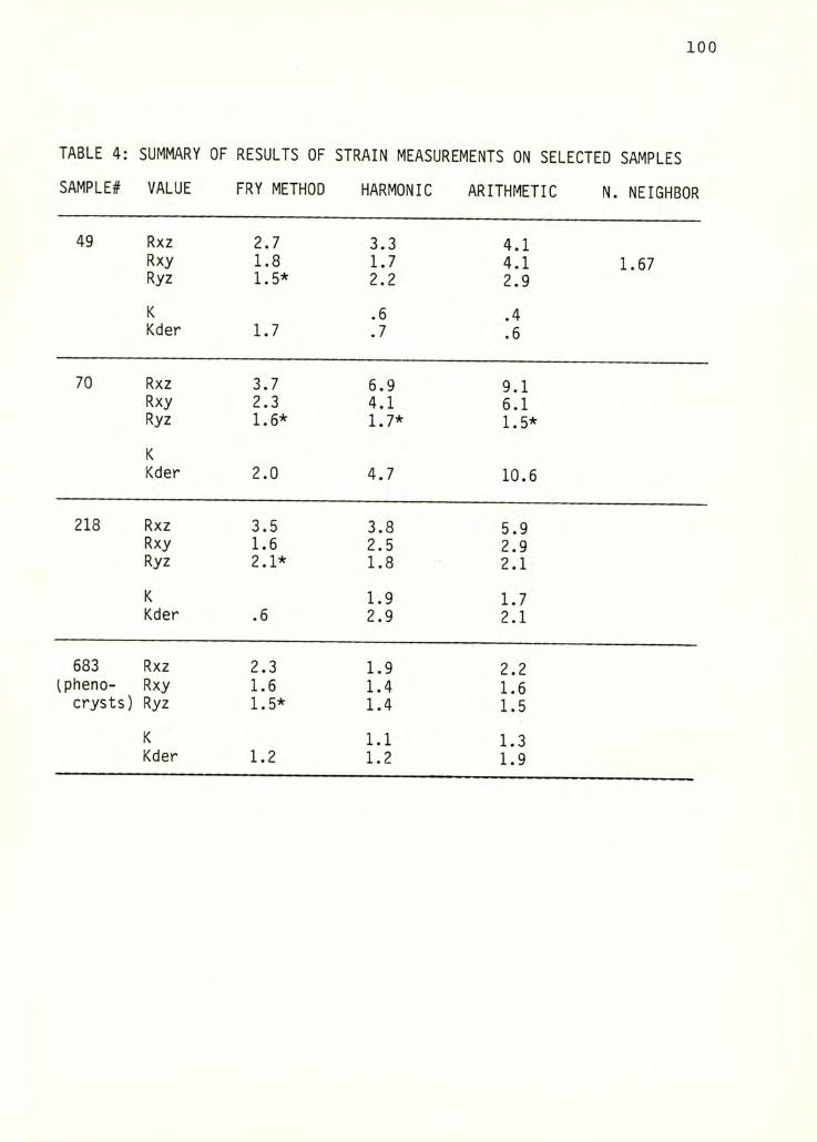
TABLE 4: SUMMARY OF RESULTS OF STRAIN MEASUREMENTS ON SELECTED SAMPLES
SAMPLE# VALUE FRY METHOD HARMONIC ARITHMETIC N. NEIGHBOR
49 Rxz 2.7 3.3 4.1Rxy 1.8 1.7 4.1 1.67Ryz 1.5* 2.2 2.9
K .6 .4Kder 1.7 .7 .6
70 Rxz 3.7 6.9 9.1Rxy 2.3 4.1 6.1Ryz 1.6* 1.7* 1.5*
KKder 2.0 4.7 10.6
218 Rxz 3.5 3.8 5.9Rxy 1.6 2.5 2.9Ryz 2.1* 1.8 2.1
K 1.9 1.7Kder .6 2.9 2.1
683 Rxz 2.3 1.9 2.2ipheno- Rxy 1.6 1.4 1.6
crysts) Ryz 1.5* 1.4 1.5
K 1.1 1.3Kder 1.2 1.2 1.9
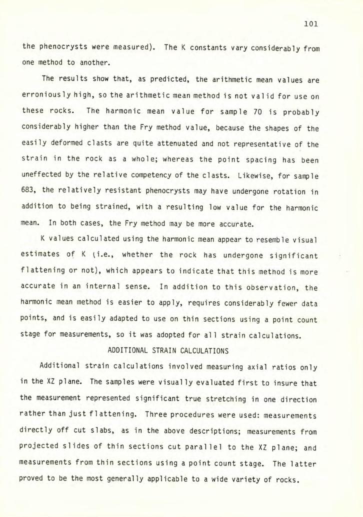
101
the phenocrysts were measured). The K constants vary considerably from
one method to another.
The results show that, as predicted, the arithmetic mean values are
erroniously high, so the arithmetic mean method is not valid for use on
these rocks. The harmonic mean value for sample 70 is probably
considerably higher than the Fry method value, because the shapes of the
easily deformed clasts are quite attenuated and not representative of the
strain in the rock as a whole; whereas the point spacing has been
uneffected by the relative competency of the clasts. Likewise, for sample
683, the relatively resistant phenocrysts may have undergone rotation in
addition to being strained, with a resulting low value for the harmonic
mean. In both cases, the Fry method may be more accurate.
K values calculated using the harmonic mean appear to resemble visual
estimates of K u'.e., whether the rock has undergone significant
flattening or not), which appears to indicate that this method is more
accurate in an internal sense. In addition to this observation, the
harmonic mean method is easier to apply, requires considerably fewer data
points, and is easily adapted to use on thin sections using a point count
stage for measurements, so it was adopted for all strain calculations.
ADDITIONAL STRAIN CALCULATIONS
Additional strain calculations involved measuring axial ratios only
in the XZ plane. The samples were visually evaluated first to insure that
the measurement represented significant true stretching in one direction
rather than just flattening. Three procedures were used: measurements
directly off cut slabs, as in the above descriptions; measurements from
projected slides of thin sections cut parallel to the XZ plane; and
measurements from thin sections using a point count stage. The latter
proved to be the most generally applicable to a wide variety of rocks.
102
The results are summarized in Table 5, with sample numbers, methods,
and apparent Rxz strain ratios indicated. These data are graphically
displayed on a regional map iFiqure 46), with compass directions of the X
- axes also shown. The XZ pi ane is paral lei to the 1 i neat ion, which is
roughly horizontal, and perpendicular to the foliation, which is roughly
horizontal to gently dipping over much of the region. Therefore, the X
axes can be fairly accurately represented in map view, but the Z axes
would actually be oriented normal to the plane of the map.
Discussion
Measured XZ-plane strain ratios range from 1.9 to 5.8, with a
significant number of samples falling in the 3.5-4.5 range. The highest
degree of stretching has occurred in the Baker Dam unit and in the
tuffaceous rocks near the south end of Grandy ridge. Rocks from other
areas, such as those to the southeast of the map area, record lesser
amounts of stretching. The absense of measurements from some areas, such
as the Thunder Creek drainage in the northeast quarter of the region and
in areas around the north end of Grandy ridge, is partially the result of
a lack of appropriate lithologies. More significantly, however, it is a
reflection of the fact that appropriate lithologies did not contain
evidence of stretching in one direction, but instead showed flattening,
with X=Y. To an extent, the distribution pattern and magnitudes of strain
shown in Figure 46 probably do represent the true distribution of
unidirectional strain in this region, with the most highly deformed rocks
found in the Grandy ridge/Upper Baker Dam area, and correspondingly less
deformation in other areas.
While the magnitude of deformation recorded in rocks from this region
is not exceptionally large, this amount is fairly significant when large
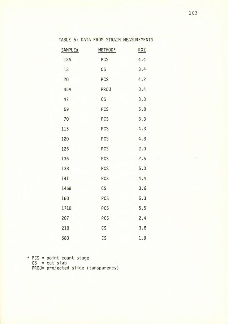
TABLE 5: DATA FROM STRAIN MEASUREMENTS
SAMPLE# METHOD* RXZ
12A PCS 4.4
13 CS 3.4
20 PCS 4.2
45A PROJ 3.4
47 CS 3.3
59 PCS 5.8
70 PCS 3.3
115 PCS 4.3
120 PCS 4.8
126 PCS 2.0
136 PCS 2.5
138 PCS 5.0
141 PCS 4.4
146B CS 3.6
160 PCS 5.3
171B PCS 5.5
207 PCS 2.4
218 CS 3.8
683 CS 1.9
PCS = point count stage CS = cut slabPR0J= projected slide ^tansparency)
SKA
GIT
RIV
ER
105
volumes of rock are considered. The ellipticity, R, of the strain ellipse,
and y (=tan^), the translation of the upper boundary of shear relative to
the lower boundary of shear ^see Figure 41), are related by the quadratic
equation
a =[.5(y2 + 2) +/- y[y^ + 4)-5],
where a is the quadratic extension U+e'^)2, and U+ei)/U+e2) = R, with e^
always the larger number ^Ramsay, 1984). The largest recorded extension
lR=5.8) would, for example, correspond to y=2. If this strain magnitude
was consistent over a section one kilometer thick, it would correspond to
a translation of two kilometers of a point on one shear boundary relative
to a fixed point located on the other boundary.
The strain magnitudes measured represent minimum values. In the
Baker Dam unit, strain ratios are probably significantly underestimated,
because rel atively competent sandstone 1ayers were actual ly measured;
whereas the more voluminous phyllites, which probably sustained
considerably more deformation, did not lend themselves well to this type
of analysis. In other areas, discrepencies of this type are probably less
pronounced. The R value and thickness used in the above computations
probably are close to the actual ones, if not slightly underestimated.
Therefore, the Chilliwack Group in the Grandy ridge/Upper Baker Dam area
^with the exception of the competent volcanics) probably has undergone
approximately 2:1 extension, corresponding to several kilometers of
northwestward translation of the structurally uppermost rocks relative to
the lowermost exposed rocks.
The well developed slaty to phyllitic cleavage present in much of the
argillaceous rock in the map area is indicative of shortening
perpendicular to cleavage of at least 65-75%, with corresponding
elongation ^probably mostly in one preferred direction) in the cleavage
106
plane (Wood, 1974).
TIMING OF D1 AND D2 WITH RESPECT TO METAMORPHISM
Although all rocks in the Chilliwack Group are recrystallized to some
degree, almost none contain the correct metamorphic minerals in sufficient
quantities for a consideration of the relationship between metamorphism
and deformation. Evidence for the relationship between deformation and
metamorphism is apparently lacking from most other areas as well.
Christenson ^1981) observed rocks containing a crude lawsonite foliation
in the Sauk Mountain area, although most rocks he observed contained no
preferred orientation of metamorphic minerals. From this he deduced that
the high pressure metamorphism was largely static in nature, slightly
overlapping the first deformation but largely postdating it.
Monger (1966) cited the lack of evidence for a relationship between
deformation and metamorphism in the type area in the Chilliwack Valley,
British Columbia, but speculated that the metamorphism was a burial type
in an area of low geothermal gradient, and preceded the first
deformation. Monger (1966) felt that D]^ and D2 were separated by a
significant period of time, based on the lack of new metamorphic minerals
associated with D2 structures. He noted that D2 predated the Oligocene
intrusion of the Chilliwack Composite Batholith in the type area, based on
the presense of contact metamorphic minerals growing across D2 structures.
In the highly deformed argillaceous rocks which comprise most of the
Baker Dam unit, the dominant metamorphic minerals are lawsonite, white
mica, quartz, chlorite, and calcite. Lawsonite is present as fine-grained
needles showing a weak preferred orientation in the foliation plane, and
some tendency to align parallel to the LI direction defined by stretched
clasts (and parallel to F2 fold hinges). White mica shows a stronger
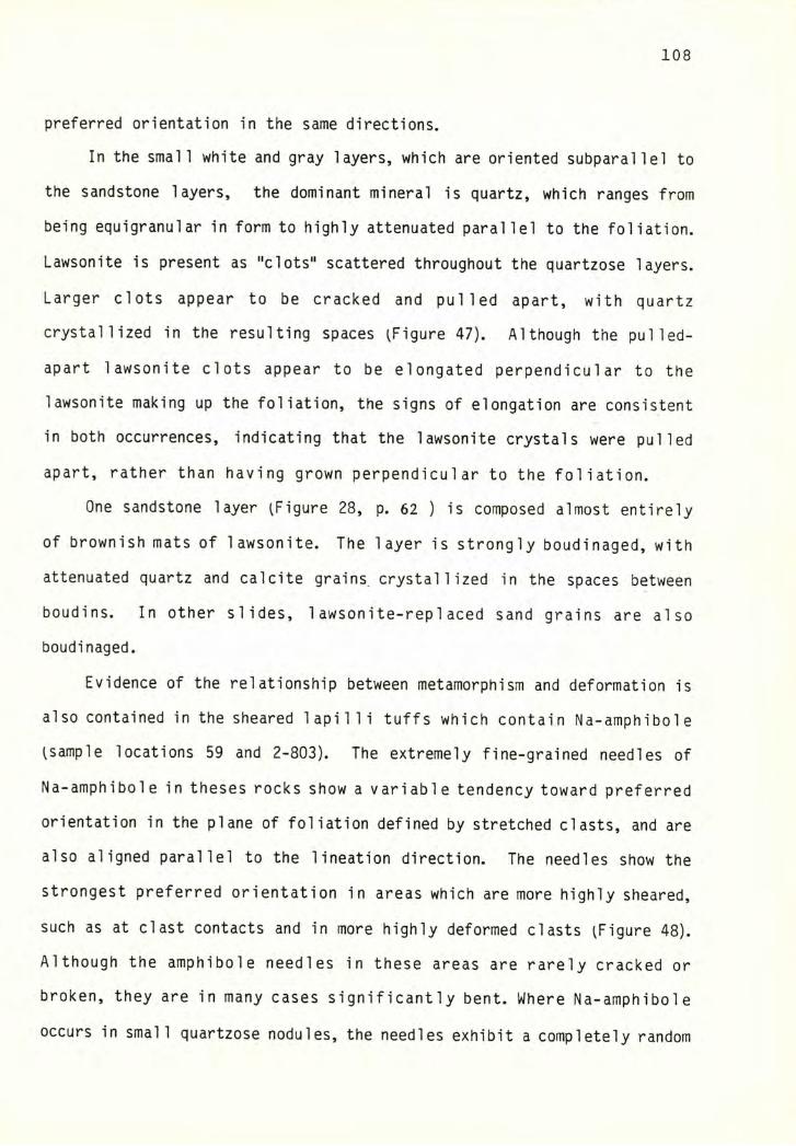
108
preferred orientation in the same directions.
In the small white and gray layers, which are oriented subparallel to
the sandstone layers, the dominant mineral is quartz, which ranges from
being equigranular in form to highly attenuated parallel to the foliation.
Lawsonite is present as "clots" scattered throughout the quartzose layers.
Larger clots appear to be cracked and pulled apart, with quartz
crystallized in the resulting spaces iFigure 47). Although the pulled-
apart lawsonite clots appear to be elongated perpendicu1ar to the
lawsonite making up the foliation, the signs of elongation are consistent
in both occurrences, indicating that the lawsonite crystals were pulled
apart, rather than having grown perpendicular to the foliation.
One sandstone layer iFigure 28, p. 62 ) is composed almost entirely
of brownish mats of lawsonite. The layer is strongly boudinaged, with
attenuated quartz and calcite grains, crystallized in the spaces between
boudins. In other slides, 1awsonite-replaced sand grains are also
boudinaged.
Evidence of the relationship between metamorphism and deformation is
also contained in the sheared lapilli tuffs which contain Na-amphibole
(sample locations 59 and 2-803). The extremely fine-grained needles of
Na-amphibole in theses rocks show a variable tendency toward preferred
orientation in the plane of foliation defined by stretched clasts, and are
also aligned parallel to the lineation direction. The needles show the
strongest preferred orientation in areas which are more highly sheared,
such as at clast contacts and in more highly deformed clasts (Figure 48).
Although the amphibole needles in these areas are rarely cracked or
broken, they are in many cases significantly bent. Where Na-amphibole
occurs in small quartzose nodules, the needles exhibit a completely random
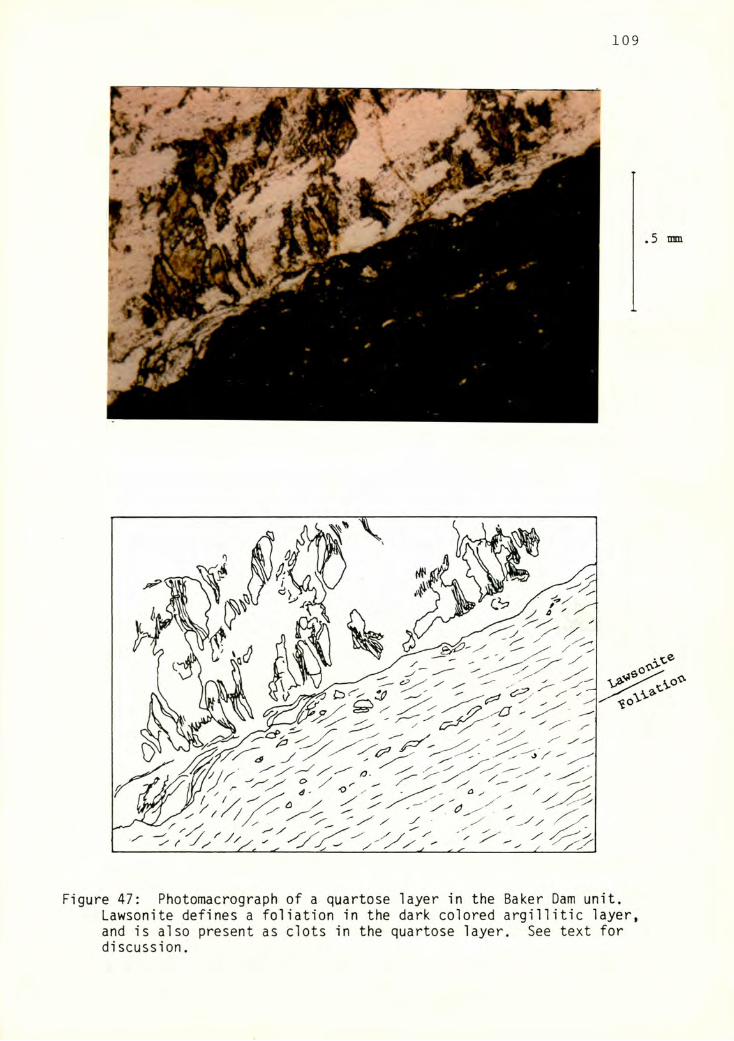
109
Figure 47: Photomacrograph of a quartose layer in the Baker Dam unit.Lawsonite defines a foliation in the dark colored argillitic layer, and is also present as clots in the quartose layer. See text for discussion.
Figure 48: Na-Amphibole habit in a highly strained area. The amphiboleexhibits a preferred orientation in the foliation plane. Plane polarized light.
Ill
to occasionally radial pattern ^Figure 49). The needles were never
observed to extend beyond the boundaries of these areas.
Na-atnphibole in the diabasic rocks shows no tendency toward preferred
alignment, except with reference to the individual pyroxene grains from
which they eminate.
Discussion
In both cases described above, the high pressure minerals appear to
have crystallized prior to the deformational event. This suggests that
the formation of the high pressure minerals either preceded the
deformational event, or may have been partly synkinematic, with the
deformation outlasting the high pressure metamorphic event.
No major metamorphic event appears to have accompanied the 02
deformation. The formation of some quartz and calcite veinsappears to
coincide with D2, as some are seen to both crosscut and conform with F2
folds. Quartz and calcite anneal cracks in grains bent by F2 kink folds.
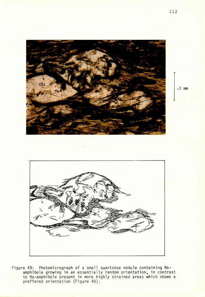
Figure 49: Photomicrograph of a small quartzose nodule containing Na-amphibole growing in an essentially random orientation, in contrast to Na-amphibole present in more highly strained areas which shows a proffered orientation (Figure 48).
113
EXTRAFORMATIONAL AND LARGE SCALE STRUCTURES
Before a description of the relationships between units, a few
conments are in order regarding the mapping and placement of many of the
structures. Because of poor exposure due to thick glacial and vegetative
cover and the inaccessibility of many outcrops, faulted contacts are
invariably either covered or out of reach. Therefore, the the placement
of some faults is partly conjectural and based largely on ^limited)
outcrop patterns; alternative arrangements using the same data certainly
exist. Interpretation is also hampered by the fact that much of the
faulting is internal to the Chilliwack Group, such that it is often
difficult to ascertain whether drastic changes in lithology are the result
of fault juxtaposition, or are simply part of a conformable sequence. The
structural interpretation given here includes a minimum of faults.
GRANDY RIDGE AREA
A cross section (C - C, Plate 2) was constructed along the crest of
Grandy ridge. Three to four major tectonic blocks are present in the
northern portion of the map area. The lowermost block, consisting of
1 aminated siltstone and argil lite luPcs), is separated from overlying
massive dacite ^Trd) belonging to the Triassic dacite unit by a low angle
fault contact. The contact is well exposed in a steep stream cut on the
middle north side of Grandy ridge. The argillite is pervasively sheared
for several tens of meters below the contact, with sheared boudins of
limestone and dacite present immediately below the contact ^Figure 32, p.
68)- Elsewhere, the contact was generally not observed, although its
position is fairly well constrained by numerous dacite and siltstone
exposures which wrap around the north and east faces of Grandy ridge. The
dacite unit appears to be quite variable in thickness, nearly pinching out
114
at location 177 ^P^ate 1) but in other places exceeding 1000 feet in
thickness.
Sporadic exposures of Chilliwack Group are present above the Triassic
dacite unit in the northern portion of the map area. They are interpreted
to represent blocks associated with a wide fault zone separating the
Triassic dacite unit from the overlying chert/basalt unit. The smal 1
block of Yel low Aster Complex observed in this area al so appears to be
associated with this fault zone. Outcrop patterns suggest that this fault
is nearly horizontal in the map area.
From Blue Lake south, the Chilliwack Group blocks in the fault zone
increase in size and thickness. A thick, relatively coherent section of
volcanic rock is exposed in section 5, immediately south of the
Whatcom/Skagit County line iPlate 1). The dacite unit pinches out
entirely in approximately the same place, about one mile south of Dock
Butte. A tectonic block of Chilliwack sedimentary rock was mapped by
Blackwell U983) capping Dock Butte and is included in the cross section,
although the existence of this separate tectonic block was not verified
in the course of my study.
In the vicinity of Scott Ridge, Chi 1 1 iwack volcanics are in faul t
contact with Chilliwack sedimentary rocks. This low angle fault contact
is exposed in a roadcut at the bottom of section 8 ^Plate 1, location
101). The contact appears to slant down gradually to the south across the
east face of Grandy ridge, disappearing under Quaternary morainal deposits
in section 28. The irregular nature of the contact suggests that it might
be offset by later faulting, particularly in section 20. Substantial
thicknesses of limestone are present at the contact in two locations.
The top of the south end of Grandy ridge appears to be a zone of
disrupted blocks, characterized by fault juxtaposition of blocks of
115
leucogabbro, vesicular flow rocks, diabase, cherty limestone, tuff, and
mylonitized argillite. Beneath these rocks the structure is not well
understood. The lower south end of Grandy ridge is comprised of a
bewildering array of sedimentary, volcanic, and volcaniclastic rocks with
very little apparent stratigraphic order. The reader is referred to Plate
1 for the following discussion, as the small scale of the structures
cannot be expressed in cross section. The conglomeratic rocks that crop
out in section 30, in the extreme southwest corner of the map area, may
represent a single marker bed, based on consideration of bedding attitudes
and the similarities of the lithologies. Bedded siltstone and sandstone
appear to underly the conglomerate. A fault, which nearly parallels the
slope angle, is present in the SE 1/4 of section 30. It separates
phyllitic rocks ^which are underneath and exposed to the east) from lower
grade rocks. It is not known, however, whether this fault is a small
shear or whether it actually represents a significant tectonic boundary in
the Chilliwack Group. The phyllitic rocks are fairly continously exposed
in a steep creek bed in the SW 1/4 of section 29. A Tertiary^?) fault
^described on p.67) juxtaposes tuffaceous siltstone against the phyllite,
but the siltstone and phyllite could belong to the same unit. The section
appears to be fairly continuous up to the 3500' level. Another problematic
feature is the presence of the thick lenses of conglomerate cropping out
on the southeast corner of Grandy ridge. Field evidence and bedding
attitudes do not suggest that the conglomerates represent a single marker
bed, but are instead a thick sequence of interbedded sediments. The
relationship between the coarse-grained rocks and the phyllitic and
tuffaceous rocks to the west is not well defined.
Approximately in the vicinity of the Skagit River (west end of cross-
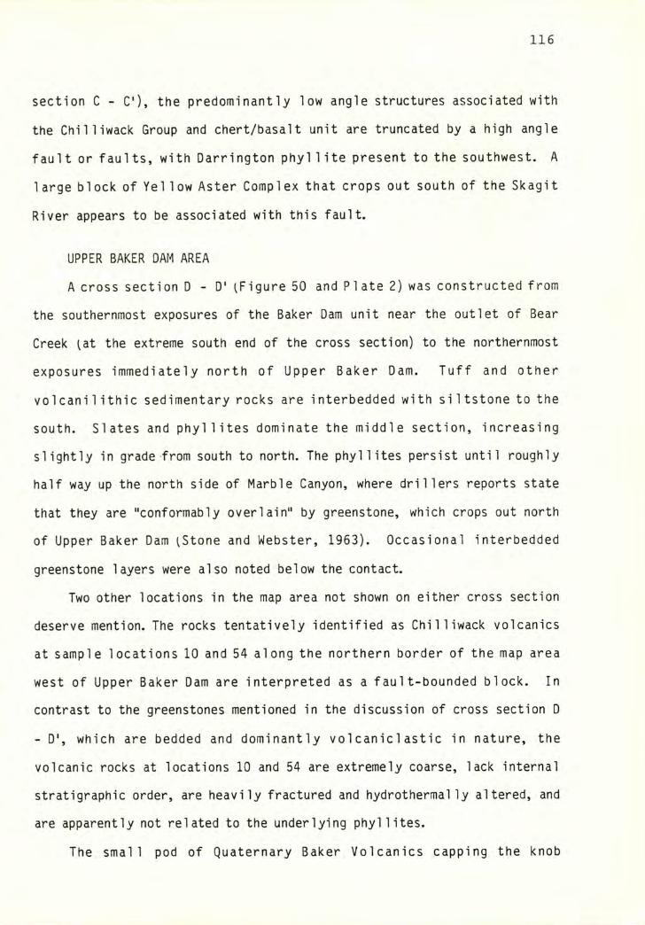
116
section C - C), the predominantly low angle structures associated with
the Chilliwack Group and chert/basalt unit are truncated by a high angle
fault or faults, with Darrington phyl 1ite present to the southwest. A
large block of Yel low Aster Complex that crops out south of the Skagit
River appears to be associated with this fault.
UPPER BAKER DAM AREA
A cross section D-D' ^Figure 50 and Plate 2) was constructed from
the southernmost exposures of the Baker Dam unit near the outlet of Bear
Creek lat the extreme south end of the cross section) to the northernmost
exposures immediately north of Upper Baker Dam. Tuff and other
volcani1ithic sedimentary rocks are interbedded with siltstone to the
south. Slates and phyllites dominate the middle section, increasing
slightly in grade from south to north. The phyllites persist until roughly
half way up the north side of Marble Canyon, where drillers reports state
that they are "conformably overlain" by greenstone, which crops out north
of Upper Baker Dam ^Stone and Webster, 1963). Occasional interbedded
greenstone layers were also noted below the contact.
Two other locations in the map area not shown on either cross section
deserve mention. The rocks tentatively identified as Chilliwack volcanics
at sample locations 10 and 54 along the northern border of the map area
west of Upper Baker Dam are interpreted as a fault-bounded block. In
contrast to the greenstones mentioned in the discussion of cross section D
- D', which are bedded and dominantly volcaniclastic in nature, the
volcanic rocks at locations 10 and 54 are extremely coarse, lack internal
stratigraphic order, are heavily fractured and hydrothermal ly altered, and
are apparently not related to the underlying phyllites.
The small pod of Quaternary Baker Volcanics capping the knob
117
a>ȣa
«<oCO
Figure 50* Cross section illustrating structure and stratigraphy in theBaker Dam unit. See Plate 2 for location of cross section.
tuff,
volc
anic
aren
ita
118
leievation 1760) in section 2 is probably an erosional remnant of a more
extensive flow issuing from the valley containing Sulfur and Rocky Creeks.
As previously stated, the sedimentary rocks on the west side of Rocky
Creek, extending down into Skagit County, are in essence identical to the
rocks found on the east side of Rocky Creek. Many rocks as far south as
the south end of Grandy ridge are of similar lithology and structural
grade. Therefore, the Baker Dam unit is considered to be part of a larger
domain which includes all of the siltstones which crop out at the lower
elevations along Grandy ridge.
STRUCTURE OF THE EXTENDED STUDY AREA
The nature of the map area as a long ridge of limited width makes
consideration of structure in other areas essential to understanding the
structure within the map area. A main objective of this study is to tie
together structures from the field area of Blackwell U983) to structures
mapped on the east side of Lake Shannon. Two cross sections ^A - A' and B
- B', Plate 2) illustrate the relationship of structures in the map area
to structures to the east and west.
Cross-section A - A' is drawn from the Twin Sisters dunite body
through the north end of the map area, to near Anderson Butte on the east
side of Baker Lake.
The lowermost structural unit exposed in the cross section is the
Chilliwack Group, which is composed of sedimentary rocks to the west and
tuffaceous and volcanic rocks to the east. As previously illustrated, the
contact appears to be gradational, with numerous interfingerings of tuff
and siltstone on the north and west sides of Lake Shannon. The Chilliwack
Group is internally tectonized in this area as well.
The Chilliwack Group is in fault contact with the Cultus Formation at
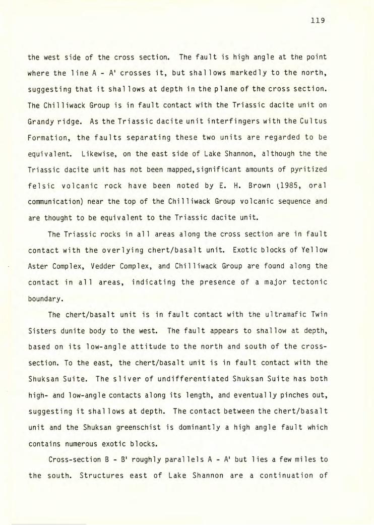
119
the west side of the cross section. The fault is high angle at the point
where the line A - A' crosses it, but shallows markedly to the north,
suggesting that it shal lows at depth in the plane of the cross section.
The Chilliwack Group is in fault contact with the Triassic dacite unit on
Grandy ridge. As the Triassic dacite unit interfingers with the Cultus
Formation, the faults separating these two units are regarded to be
equivalent. Likewise, on the east side of Lake Shannon, although the the
Triassic dacite unit has not been mapped,significant amounts of pyritized
felsic volcanic rock have been noted by E. H. Brown U985, oral
communication) near the top of the Chilliwack Group volcanic sequence and
are thought to be equivalent to the Triassic dacite unit.
The Triassic rocks in all areas along the cross section are in fault
contact with the overlying chert/basalt unit. Exotic blocks of Yellow
Aster Complex, Vedder Complex, and Chilliwack Group are found along the
contact in all areas, indicating the presence of a major tectonic
boundary.
The chert/basalt unit is in fault contact with the ultramafic Twin
Sisters dunite body to the west. The fault appears to shallow at depth,
based on its low-angle attitude to the north and south of the cross-
section. To the east, the chert/basalt unit is in fault contact with the
Shuksan Suite. The sliver of undifferentiated Shuksan Suite has both
high- and low-angle contacts along its length, and eventually pinches out,
suggesting it shal lows at depth. The contact between the chert/basalt
unit and the Shuksan greenschist is dominantly a high angle fault which
contains numerous exotic blocks.
Cross-section B - B' roughly parallels A - A' but lies a few miles to
the south. Structures east of Lake Shannon are a continuation of
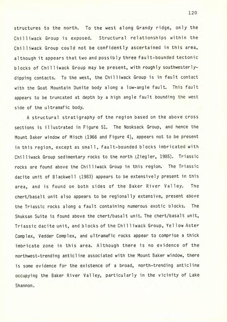
120
structures to the north. To the west along Grandy ridge, only the
Chilliwack Group is exposed. Structural relationships within the
Chilliwack Group could not be confidently ascertained in this area,
although it appears that two and possibly three fault-bounded tectonic
blocks of Chilliwack Group may be present, with roughly southwesterly
dipping contacts. To the west, the Chilliwack Group is in fault contact
with the Goat Mountain Dunite body along a low-angle fault. This fault
appears to be truncated at depth by a high angle fault bounding the west
side of the ultramafic body.
A structural stratigraphy of the region based on the above cross
sections is illustrated in Figure 51. The Nooksack Group, and hence the
Mount Baker window of Misch (1966 and Figure 4), appears not to be present
in this region, except as small, fault-bounded blocks imbricated with
Chilliwack Group sedimentary rocks to the north (Ziegler, 1985). Triassic
rocks are found above the Chilliwack Group in this region. The Triassic
dacite unit of Blackwell (1983) appears to be extensively present in this
area, and is found on both sides of the Baker River Valley. The
chert/basalt unit also appears to be regionally extensive, present above
the Triassic rocks along a fault containing numerous exotic blocks. The
Shuksan Suite is found above the chert/basalt unit. The chert/basalt unit,
Triassic dacite unit, and blocks of the Chilliwack Group, Yellow Aster
Complex, Vedder Complex, and ultramafic rocks appear to comprise a thick
imbricate zone in this area. Although there is no evidence of the
northwest-trending anticline associated with the Mount Baker window, there
is some evidence for the existence of a broad, north-trending anticline
occupying the Baker River Valley, particularly in the vicinity of Lake
Shannon.
PMcb
uPcs "
Figures!: Diagramniatic structural stratigraphy of units in the extendedstudy area. Solid lines = faults; dashed lines = lithologic contacts.See Plate 2 for unit designations.
122
DISCUSSION
The Chilliwack Group in the extended study area is variably deformed,
with the most highly deformed rocks occurring in the southern Grandy ridge
and Upper Baker Dam areas. S]^ foliation attitudes are dominantly shallow.
There is limited structural evidence for relative north-northwestward
transport of the upper plate. Strain measurements suggest a minimum of
several kilometers of shear displacement in the exposed thickness of rock,
with significant thinning of the units as well.
Table 6 is a compilation of structural data from other locations in
the Chilliwack Group. Although the data are rather scant, those available
are fairly consistent. Sg and S]^ are generally of shallow dip and
parallel, with a northwest-trending fabric discernible in many areas.
Near-vertical S]^ attitudes are present in areas proximal to high-angle
segments of the Shuksan Fault (e. g. Sevigney; 1983, and Silverberg,
1985). folds are nearly horizontal and generally trend northeast.
Uncommon F2 folds are horizontal and trend northwest.
On the basis of this information, it appears that the Chilliwack
Group underwent early (Dj^) and late ^82) deformations with fairly
consistent orientations of strain throughout the extent of the unit.
Timing of and ^ with respect to regional events
Monger U966) equates D]^ with internal imbrication and nappe
emplacement in the Chilliwack Group, and with the imbrication of map units
in the western North Cascades. Misch Il966) also equates Dj^ with the
thrust emplacement of these units in the late Cretaceous. Monger
correlates D2 deformation with a mid-Tertiary Cascades Orogeny.
D]^ and D2 in this study appear to be correlative with Monger's
U966) Dj^ and D2 based on the similarity of orientations of structural
elements, however no direct evidence equates Dj^ and D2 in the present
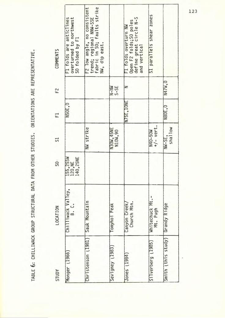
TAB
LE 6:
CHIL
LIW
AC
K GR
OUP S
TRU
CTU
RA
L DA
TA FR
OM
OTHER
STU
DIE
S. ORIE
NTA
TIO
NS A
RE R
EPR
ESEN
TATI
VE.
123(UC<u •»-
4-> S- CO</) 4-> CO LU 4-> to (U<U CO •f- 00 to to 1 cC <U to UO (U z 0
s C 1 CO 3 >— N0 3 +-> Z 0 (U
0 -M <J Z r— Q-f—•I- s- Z 3 C U ro4-> 0 0 ro $- 0 s- c;C C 1—1 C 1— <4- 3 to -r- JCrd ro 4-» 0 to
0 C • s- to<u •»-> >> <U 0 0 4-> QJ XJ 4-> r— toL. X) r— •!“ 00 to > 1— (d <0
Ln ro *0 0^ 0^ rO 0 0 0) CJh- O) -a C (U C (U 4- S- T-2: CO c 0) rO ^ to O-MUJ T3 S- T3 Q. ^ CVJ s- ro2: r— 3 •— 3 .« 0 »— U. 0) <us 0 -»-> 0 0 TJ T- T3 0 c > ro0 *4- 1. <+- r- C S- 14- C CD.0 0 0) JD <U 4- T3
t-H > 0 CVJ s- <0 3 r-( Q. CD c rHU_ 0 00 |J_ +-> M- Z Lt- 0 *a 'O to
S UJ zCVJ z c/1u. 1 1
Z 00 z
LU0 1^
A 0 0UJ rH A0 LUm LU 0
u. zr LT> COz
z
<v LU sz 0 3 S_ 0lT> 0 O) r“
u ^ #» LO >f-H 4-> "3 1 bu <a(/) to S CD 0 1 to JZ
0 t-H *0" ^ 1 CO3 ro z z + 3z z z
3: UJ00 z
0 un LU ur>00 CNJ Z CM
A ^mooUO CMt-H t-H
*»>)0)
1•
ro c ^ • +J> • ^ c 2: <u
2: 0 ro ro OJ 4H CT>0 (U QJ S ^ JZ ■al-H 0 • C a. S- 0 o> •r—1— ro CQ 3 0 £ 3 3 calcC 5 0 ►r— u ^ Ci.0 *r* s: 0 c t. 00 -C 0 3 0) • ■0
>> >i-c: +-> 4-> c•r" 3 s c 0 •>- S ro
rO 0 ro .c S-C_> LT) 1— C_) 3 CI3
,_^i-H >1CX3 LO *00 •—*s CO 3i"H ro <Ti
CXD I-H to«D 0 MX'VO c I-H tocn 0 WK* CXD cn ►1“i"H to CT> s- .c
c r-H 0> 4->dJ 0) MX*
S- ■M c S->- O) to 0 to 0) JZ0 C7> •r" (U >ID C > c r“
0 JZ <u 0 •r- E00 E______ 0 to to to
124
study area with other regional deformational events. Two pieces of
indirect evidence link with the regional imbrication of units: The
similarity of directions in the map area with those mapped along the
Shuksan Fault; and the similarity of S]^ attitudes in the map area with
the attitudes of faults and shears in the map area.
Along the eastern extent of the Shuksan Fault, stretching lineations
are dominantly horizontal and trend north to northwest, averaging N20W
^Brown, in press; Jewett, 1983; Silverberg, 1985). Most of the stretching
lineations measured in the extended study area also trend northwest,
although they lie in low-angle foliation planes.
The similarity of Si attitudes in the northwest subarea (Figure 34)
to fault and shear plane attitudes (both intra- and extraformational),
most of which were measured in the northwest subarea (Figure 39), also
suggests a .genetic relationship between $i formation and regional
imbrication of units. S]^ and fault plane attitudes in the map area are
dominantly low angle. To the south, in the Mount Pugh-Whitechuck Mountain
area, $i attitudes in the Chilliwack Group are high angle and parallel the
plane of the Shuksan Fault (Silverberg, 1985). The same relationship has
been observed to the north of the present study area, in the Mount SI esse
area (Jewett, 1983).
On the basis of these relationships, it is concluded that S^^ in the
present study area was formed during the emplacement of the map units.
Exact dating of the deformation producing the stretching lineations along
the Shuksan Fault is necessary to pinpoint the actual time of deformation.
The presense of the set of northeast-trending L]^ stretching
lineations in the eastern portion of the extended study area and in the
type area in the Chilliwack Valley, B. C. (Brown, 1985, personal
125
communication) is enigmatic. Assuming that the trend of stretching
iineations does represent the tectonic transport direction, areas where
northeast-trending Iineations occur may represent minor regional
variations in transport direction. In the type area, however, the
northeast-trending Iineations are found in association with the McGuire
Nappe and other structures indicating a northwestward transport dirction.
It is conceivable that the northeast-trending Iineations represent a
period of deformation that pre- or postdates the event labeled D]^.
Deformation associated with D2 is minor in most areas, usually manifested
by folding and faulting, and hence unlikely to produce stretching
Iineations. A more likely explanation for the northeast-trending
Iineations is that they predate structures associated with D^. A similar
but more extensive set of stretching Iineations averaging N70E are present
in the Shuksan Suite ^Brown, in press). These Iineations are thought to
predate the N20W-trending set of Iineations associated with the Shuksan
Fault.
Assuming the structures associated with D]^ were produced during the
regional imbrication of units, the tectonic transport indicated by the
orientation of these structures is somewhat different than that proposed
by Misch (1966). As Figure 3, p. 9 indicates, west-directed thrusting is
postulated during emplacement of the map units, with the direction
becoming more northwesterly near the Canadian border, and southwesterly
from the present study area south. Evidence from this study suggests
northwest-directed und possibly southeast-d-irected) tectonic transport
throughout the extent of the Chilliwack Group.
Westward-directed thrusting from a root zone might be expected at a
strictly convergent plate margin, with the direction of thrusting
126
perpendicular to the plate margin. However, Engebretson and others pn
press) have postulated very oblique convergence (transpression) at the
Kula or Farallon and Pacific Plate boundaries during the late Cretaceous
when imbrication of the units is thought by some workers ^e. g., Misch,
1966; Monger, 1966) to have taken place ^Figure 52).
The set of structures diagnostic of a transpressi ve regime has not
been well defined, but appears to include such structures as thrust
faults, wrench- and strike-slip faults formed nearly parallel to the plate
margin, and the presense of exotic material brought up from significant
depths in the crust ^Sanderson and Marchini, 1984). The tectonic transport
direction deduced from structures in the Chilliwack Group, which nearly
parallels the present-day plate margin, is suggestive of formation in a
transpressi ve plate tectonic setting ^assuming that no significant
rotation of the rocks has taken place since the time of deformation).
The structures in the Chilliwack Group do not exactly parallel the
more northerly trending present-day plate margin. Crickmay U930)
postulated that the trend to structures in the western North Cascades
could have been the result of the "geosynclinal accumulation" being
wrapped around the southern end of the "Coast Range Batholith". While
this interpretation is problematic in light of recent evidence that none
of the rocks present near the present-day plate margin formed in place,
none- the-less it is possible that the Coast Plutonic Complex may have
served as a buttress during deformation, producing northwest-trending
rather than strictly north-trending structures and tectonic transport
direction.
The style of deformation exhibited in the extended study area is
consistent with that described by Cowan and Miller U980, Figure 53).
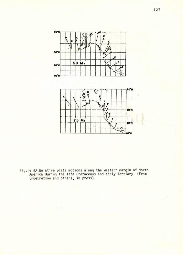
Figure 52:Relative plate motions along the western margin of North America during the late Cretaceous and early Tertiary. (From Engebretson and others, in press).
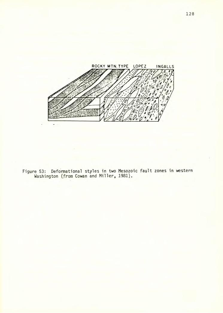
128
ROCKY MTN. TYPE LOPEZ INGALLS
Figure 53: Defonnational styles in two Mesozoic fault zones in westernWashington (from Cowan and Miller, 1981).
129
They describe two end-member types of deformation during the Mesozoic in
western Washington: the Lopez type, characteristic of the Lopez fault zone
on San Juan Island, and the Ingalls type, characteristic of the Navajo
Divide fault zone in the Ingalls ophiolite. Both types consist of
numerous, heterogeneous tectonic blocks justaposed along anastomosing
fault zones containing sheared matrix. The Ingalls type is characterized
by smaller tectonic blocks in abundant sheared matrix, whereas the Lopez
type is characterized by larger, fault bounded tectonic blocks. These
types represent end members in a continuum. The structure present in the
map area is in essence a megascopic expression of the Lopez type of
deformational style, which has also been noted in other areas where
Misch's U966) imbricate zone is present (e. g. Blackwel 1 , 1983; Jewett,
1984, Ziegler, 1985). Similar deformational styles have been described
from the Franciscan Terrane ^e. g. Hsu, 1968).
130
SUMMARY AND CONCLUSIONS
The Grandy ridge/Upper Baker Dam area and the surrounding regionare
dominated by lithologies of the Chilliwack Group, the Triassic dacite unit
and related Cultus Formation, and the chert/basalt unit, juxtaposed along
1ow angle thrust faults. The Yellow Aster Comp lex is found as small
tectonic blocks emplaced along fault zones. The region studied is bounded
on the west by the Twin Sisters and Goat Mountain dunite bodies, and to
the east by a high angle fault separating the chert/basalt unit from the
Shuksan Suite.
Within the map area, the Chilliwack Group is composed of voluminous
sedimentary rocks and lesser amounts of volcanic and volcaniclastic rock.
The sedimentary unit is dominantly composed of laminated to thinly bedded
siltstone, sandstone, and argillite of the lower clastic sequence.
Massive argillite with sparse interbeds of sandstone are more typical in
some areas, particularly in the northern portion of the map area. There
is a gradation from west to east from fine-grained sedimentary rocks to
fine-grained rocks with interbedded sandstone and tuff. The Baker Dam
unit, originally mapped by Misch U966) as part of the Nooksack Group, is
assigned to the Chilliwack Group clastic sequence in this study. A thick
section of boulder to cobble conglomerate is present on the southeast side
of Grandy ridge. Lapi 1 1 i tuff and fine grained crystal and 1 ithic tuff
with interbedded siltstones are common on the upper south- and east-facing
sides of the south end of Grandy ridge. Volcanic rocks ranging from fine
grained flows to diabase to plutonic rocks are present above approximately
2700' on the south half of Grandy ridge. Limestone is uncommon in the map
area and, where observed, is completely recrystal 1 ized.
The Chilliwack Group represents mostly subaqueous deposition on and
adjacent to a volcanic arc. The Chilliwack Group has undergone low
131
temperature, high pressure metamorphism characterized by assemblages
containing quartz + albite + chlorite +/- pumpel lyite +/- epidote +/-
calcite +/- lawsonite. In addition, a number of rocks contain Na-
amphibole of crossitic to riebikitic composition.
The Triassic dacite unit of Blackwell (1983) is present in the
northern part of the map area, and is also present on the east side of
Lake Shannon. It consists of massive dacite flows with interbedded
crystal and 1 api 11 i tuff and rare si 1 tstone. It records a metamorphic
history similar to the Chilliwack Group.
The chert/basalt unit is also present in the northern portion of the
map area. It consists of fine-grained basalt, ribbon chert, and phyllitic
si 1tstone, and has sustained higher temperature conditions of metamorphism
and more deformation than the Chilliwack Group.
One small tectonic block of Yellow Aster Complex was noted from the
vicinity of a fault between the Triassic dacite unit and the chert/basalt
unit. It appears to be a hornblende diorite.
The Chi 1 1 iwack Group in the map area and in the surrounding region
has undergone two significant deformations, denoted and D2, with a few
late northeast-trending vertical faults also noted. Dj is manifested by
a pervasive foliation ^S]^) which is usually subhorizontal and in places
folded around horizontal fold axes. Small kink folds and at least two
larger recumbent folds oriented with horizontal axes trending
northeast and overturned to the northwest, are also associated with D]^.
Stretching lineations (L]^) are present in a number of lithologies and are
generally northwest-trending and horizontal. F2 folds ranging from kink
folds to large open folds generally trend northwest. A number of small
zones of cataclastic rocks were also noted in the map area, usually with
132
subhorizontal orientations. They appear to be syndeformational with or to
slightly postdate S]^, but the exact timing of formation of these
structures is not known.
Stretching lineations, formed most notably by stretched clasts, are
abundant in the map area. They are interpreted to parallel the movement or
shear direction, based on consideration of associated extensional features
such as veins and boudinaged layers, and of the model of homogeneous
simple shear. While simple shear is not the only mechanism responsible
for the deformation in these rocks, it was adopted as a working model.
Shear sense indicators, including asymmetric pressure shadows behind
resistant grains, c- and s-surface intersections, and fold asymmetries,
mostly suggest relative northwestward translation of overlying rocks. A
number of indicators, however, particularly in the southeast part of the
region, suggest southeastward translation. This is particularly true of
shear sense deduced from c-s surface intersections. It is possible that
two periods of shearing are indicated, with the southeast translation
associated with the latter period, as the c-surfaces disrupt S]^. Many
samples are not sufficiently strained to lend themselves to analysis.
Finite strain measurements yield XZ-plane strain values ranging from
1.9 to 5.8, and represent minimum strain values. Strain magnitudes are
highest in rocks from the Baker Dam unit and in rocks from the south end
of Grandy ridge. Rocks from other areas are less deformed. Extension and
resultant northward translation on the order of several kilometers are
postulated for the Chilliwack Group in the map area.
Sheared rocks containing lawsonite and Na-amphibole contain clues to
the relationship between the high pressure metamorphism and the
deformational events. The presence of cracked and boudinaged mineral
grains and evidence of the rotation of grains into the foliation direction
133
suggest that the high pressure metamorphism in part predated the first
deformation, but may have been partly synkinematic.
Sedimentary rocks of the Chilliwack Group are found in the
structurally lowest levels in the map area and in the surrounding region.
They are in fault contact in the map area with the overlying Triassic
dacite unit, which may also be present on the east side of Lake Shannon.
The Cultus Formation is faulted over the Chilliwack Group to the east.
Overlying the Triassic dacite and Cultus formation in most areas is the
chert/basalt unit. The fault zone contains fragments of Yellow Aster
Complex, Vedder Complex, and Chilliwack volcanics. While anastomosing low
angle faults predominate in the map area and in the structural units just
described, high angle faults are present between the chert/basalt unit and
dunite bodies to the west,'and between the chert/ basalt unit and the
Shuksan Suite to the east. There is no evidence in the map area for the
existence of an area where Nooksack Group lithologies are exposed in the
axis of a northwest-trending anticline (the Mount Baker window of Misch,
1966). However, a broad, north-northeast trending anticline appears to be
present in the Lake Shannon and lower Baker Lake valley, with Chilliwack
group lithologies present in the structurally lowest levels.
The Chilliwack Group in the map area is more highly deformed than it
is in most other areas, based in descriptions in the literature. One area
of equal ly highly deformed rocks is in the vicinity of Mount Pugh and
Whitechuck Mountain, where both highly lineated and phyllitic rocks have
been mapped in association with the Shuksan fault (Silverberg, 1985).
Subphyllitic rocks have also been noted to the north, in proximity to the
Church Mountain (e. g., Jones, 1984) and Shuksan (e. g., Jewett, 1984)
faults. Deformation in other areas is apparently relatively low.
134
suggesting that the rocks in the vicinity of the map area represent a
distinct zone of higher deformation internal to the Chilliwack Group.
Orientation of structures associated with the D]^ and D2 deformations
correlate well with evidence from a number of areas, including the type
area in the Chill iwack Valley i Monger, 1966), where northeast trending
horizontal folds indicating northwestward translation are present along
with later, open, northwest trending folds. To the south, northwest
trending, horizontal stretching lineations were observed by Silverberg
U985). Areas containing northeast-trending stretching lineations may
may indicate the presense of an earlier phase of deformation.
The orientation of structures in the study area and postulated late
Cretaceous plate motions along the coast of North America indicate that
the deformation in the Chilliwack Group may have occurred in a
transpressive plate tectonic environment.
135
BIBLIOGRAPHY
Armstrong, R. L., 1980, Geochronometry of the Shuksan Metamorphic Suite,
North Cascades, Washington: Geological Society of America Abstracts
with Programs, v. 12, no. 3, p. 94.
AveLal1ement, H. G., 1983, The kinematic insignificance of mineral
lineations in a late Jurassic fold and thrust belt in eastern Oregon,
U. S. A., jjn: Friedman, M., and Toksoz, M. N., ^eds.). Continental
Tectonics: Structure, kinematics, and dynamics: Tectonophysics, v.
100, pp. 389-404.
Beatty, R. J., 1974, Low grade metamorphism of Pennsylvanian to Early
Cretaceous volcanic and volcaniclastic rocks near Chilliwack, British
Columbia: B. S. thesis. University of British Columbia, Vancouver, 68
P-
Bechtel Report, 1979, Report for geologic investigation in 1978-1979,
Skagit Nuclear Power Project, for Puget Sound Power and Light
Company, Seattle, Washington, Volumes 1 and 2.
Berthe, D., P. Choukroune, and P. Jegouzo, 1979, Orthogneiss, mylonite,
and non-coaxial deformation of granites: The example of the South
Armorican Shear Zone: Journal of Structural Geology, v. 1, pp. 31-42.
Bishop, D. G., 1972, Progressive metamorphism from prehnite-pumpel lyite to
greenschist facies in the Dansey Pass area, Otago, New Zealand:
Geological Society of America Bulletin, v. 83, pp. 3177-3198.
Blackwell, D. L., 1983, Geology of the Park Butte - Loomis Mountain area,
Washington (Eastern Margin of the Twin Sisters Dunite): M. S.
thesis. Western Washington University, Bellingham, Washington, 253 p.
136
Brown, E. H., 1974, Comparison of the mineralogy and phase relations of
blueschists from the North Cascades, Washington, and greenschists
from Otago, New Zealand: Geological Society of America Bulletin, v.
85, pp. 333 - 344.
, E. H., 1983, Field guide to the Shuksan Metamorphic Suite: Penrose
conference on Blueschists and related eclogites. Geological Society
of America; Western Washington University, Bellingham, Washington, 27
P.
, p'n press). Geology of the Shuksan Suite, North Cascades,
Washington, U. S. A.: Geological Society of America Memoir.
Brown, E. H., M. L. Bernardi, B. W. Christenson, J. R. Cruver, R. A.
Haugerud, P. M. Rady, and J. N. Sondergaard, 1981, Metamorphic facies
and tectonics in part of the Cascade Range and Puget Lowland of
northwest Washington: Geological Society of America Bulletin, v. 92,
pp. 170 - 178.
Bryant, B., and Reed, J. C., 1969, Significance of lineation and minor
folds near major thrust faults in the southern Appalachians and the
British and Norwegian Caldonides: Geology Magazine, v. 106, pp.
412 - 429.
Chen, P. Y., 1977, Table of key lines in X-ray powder diffraction patterns
of minerals in clays and associated rocks: Department of Natural
Resources Geological Survey Occasional Paper 21, 67 pp.
Christenson, B. W., 1981, Structure, Petrology, and Geochemistry of the
Chilliwack Group near Sauk Mountain, Washington: M. S. thesis.
137
Western Washington University, Bellingham, Washington, 181 p.
Cloos, E., 1947, Oolite deformation in the South Mountain Fold, Maryland:
Geological Society of America Bulletin, v. 58, pp. 843 - 918.
Cowan, D. S., and Miller, R. B., 1981, Deformational styles in two
Mesozoic fault zones, western Washington, U. S. A.: j_n: McClay, K.
R., and Price, N. J., eds.. Thrust and nappe tectonics. The
Geological Society of London Special Paper, v. 9, pp. 483-490.
Crickmay, C. H., 1930, The structural connection between the Coast Range
of British Columbia and the Cascade Range of Washington: Geological
Magazine, v. 67, pp. 482-491.
Daly, R. A., 1912, Geology of the North American Cordillera at the
Forty-ninth parallel: Geological Society of Canada, Memoir 38, 857 p.
Danner, W. R., 1957, A stratigraphic reconnaisance in the northwest
Cascades and San Juan Islands of Washington State, volume 1,
Paleozoic - Triassic: Ph. D. thesis. University of Washington,
Seattle, Washington, 562 p.
, 1966, Limestone resources of western Washington: Washington
Division of Mines and Geology Bulletin, vol. 52, 474 p.
Dunnet, D., 1969, A technique of finite strain analysis using elliptical
particles: Tectonophysics, v. 7, pp. 117 - 136.
, and Siddans, A. W. B., 1971, Nonrandom sedimentary fabrics and
their modification by strain: Tectonophysics, v. 12, pp. 307 - 325.
138
El 1 iot, D., 1970, Determination of finite strain and initial shape from
deformed elliptical objects: Geological Society of America Bulletin,
V. 81, pp. 2221 - 2236.
Engebretson, D. C., Cox, A., and Gordon, R. G., Relative motions between
oceanic and continental plates in the Pacific basin: Geological
Society of America Special Paper, ^in press).
Escher, A., and Watterson, J., 1974, Stretching fabrics, folds, and
crustal shortening: Tectonophysics, v. 22, pp. 223-231.
Flinn, D., 1956, On the deformation of the Funzie Conglomerate, Fetlar,
Shetland: Journal of Geology, v. 64, pp. 480 - 505.
Frasse, F. I., 1981, Geology and Structure of the Western and Southern
Margins of the Twin Sisters Mountain, North Cascades, Washington: M.
S. thesis. Western Washington University, Bellingham, Washington,
187 p.
Fry, N., 1971, Random point distribution and strain measurement in rocks:
Tectonophysics, v. 60, pp. 89 - 105.
Harland, W. B., 1971, Tectonic transpression in the Caledonian
Spitsbergen: Geological Magazine, v. 108, pp.27-42.
Haugerud, R. A., 1980, The Shuksan Metamorphic Suite and Shuksan Thrust,
Mount Watson area. North Cascades, Washington: M. S. thesis. Western
Washington University, Bellingham, Washington, 125 p.
Hobbs, B. E., W. D. Means, P. F. Wi 1 1 iams, 1976, ^ Outl ine of Structural
Geology: John Wiley and Sons, New York, 571 p.
139
Hossack, J. R., 1968, Pebble deformation and thrusting in the Bygdin area
^southern Norway): Tectonophysics, v. 5, pp. 315 - 339.
Hsu, K. J., 1968, Principles of melanges and their bearing on the
Franciscan-Knoxvi 1 le paradox: Geological Society of America Bui letin,
V. 79, pp. 1063-1074.
Hunt, J. A., and Kerrick, D. M., 1977, The stability of sphene;
experimental redetermination and geological implications: Geochimica
Cosmochimica Acta, v. 41, pp. 279-288.
Jeffrey, G. B., 1923, The motion of el 1 ipsoidal particles immersed in a
viscous fluid: Royal Society of London Proceedings, Series A, v. 102,
pp. 161 - 177.
Johnson, S. Y., 1982, Stratigraphy, sedimentology, and tectonic setting of
the Eocene Chuckanut Formation, northwest Washington: Ph.D. thesis.
University of Washington, Seattle Washington, 221 p.
Jones, J. T., 1984, The Geology and Structure of the Canyon Creek - Church
Mountain area. North Cascades, Washington: M. S. thesis. Western
Washington University, Bellingham, Washington, 125 p.
Kerrick, D. M., 1974, Review of mixed H2O-CO2 equilibria: American
Mineralogist, v. 59, pp. 729-762.
Leake, B. E., 1978, Nomenclature of amphiboles: American Mineralogist, v.
63, pp. 1023-1052.
Leiggi, P. A., Un progress). Structure and petrology along a segment of
the Shuksan Thrust Fault, Mount Shuksan area, Washington: M. S.
thesis. Western Washington University, Bellingham, Washington.
140
Lisle, R. J., 1977, Clastic grain shape and orientation in relation to
cleavage from the Aberystwyth Grits, Wales: Tectonophysics, v. 39,
pp. 381-395.
-------- , 1979, Strain analysis using deformed pebbles: the influence of
original pebble shape: Tectonophysics, v. 60, pp. 263 - 277.
Liszak, J. L., 1982, The Chilliwack Group, Black Mountain, Washington: M.
S. thesis. Western Washington University, Bellingham, Washington, 181
P-
Miller, R. B., 1976, The ophiolitic Ingalls Complex, north-central
Cascades mountains, Washington: Geological Society of America
Bulletin, v. 96, pp 27 - 42.
Mattinson, J. M., 1972, Ages of zircons from the northern Cascade
Mountains, Washington: Geological Society of America Bulletin, v. 83,
pp. 3769 - 3784.
Misch, P., 1960, Large overthrusts in the northwest Cascades near the 49th
parallel ^abstract): Geological Society of America Builetin, v. 71,
no. 12, part 2, p. 2069.
, 1966, Tectonic evolution of the North Cascades of Washington State,
In: Symposium on Tectonic History and Mineral Deposits in the Western
Cordillera in British Columbia and Neighboring United States:
Canadian Institute of Mining and Metallurgy, special volume 8, pp.
101 - 148.
141
, 1977, Bedrock Geology of the North Cascades, jji: Brown, E. H., and
R. C. Ellis, eds.. Geological Excursions in the Pacific Northwest:
Western Washington University, Bellingham, Washington, pp. 1-62.
Monger, J. W. H., 1966, Structure and Stratigraphy of the Type Area of the
Chilliwack Group, Southwest British Columbia: Ph. D. thesis.
University of British Columbia, Vancouver, British Columbia, 158 p.
, 1977, Upper Paleozoic rocks of the western Canadian Cordillera and
their bearing on Cordilleran Evolution: Canadian Journal of Earth
Science, v. 14, pp. 1832 - 1859.
, 1984, Cordilleran tectonics: a Canadian perspective. Geological
Society of France Bulletin, v. 26, pp. 255 - 278.
Phillips, W. R., and Griffen, D. T., 1981, Optical Mi neral ogy. The
Non-opaque Minerals: W. H. Freeman and Company, San Francisco, 677 p.
Quinquis, H., C. L. Andren, J. P. Brun, P. R. Cobbold, 1978, Intense
progressive shear in He de Groix blueschists and compatibility with
subduction or obduction: Nature, v. 273, pp. 43-45.
Rady, P. M., 1981, Structure and petrology of the Groat Mountain area.
North Cascades, Washington: M. S. thesis. Western Washington
University, Bellingham, Washington, 133 p.
Ramsay, J. G., 1967, Folding and Fracturing in Rocks: McGraw-Hi11, New
York, 568 p.
, and Huber, M. I., 1983, The Techniques of Modern Structural
Geology, Volume 1: Strain Analysis: Academic Press, New York, 307 p.
142
Rodgers, J., 1984, A geologic reconnaissance of the Cycladic blueschist
belt, Greece: Discussion: Geological Society of America Bulletin, v.
95, pp. 117-121.
Sanderson, D. J., and Marchini, W. R. D., 1984, Transpression: Journal of
Structural Geology, v. 6, pp. 449-458.
Selley, R. C., 1976, In Introduction to Sedimentology: Academic Press, New
York, 408 p.
Sevigny, J., 1983, Structure and petrology of the Tomyhoi Peak area. North
Cascades, Washington: M. S. thesis. Western Washington University,
Bellingham, Washington, 203 p.
Shackleton, R. M., and Ries, A. C., 1984, The relation between regionally
consistent stretching lineations and plate motions: Journal of
Structural Geology, v. 6, pp. Ill - 117.
Silverberg, D., 1985, Structure and Petrology of the Whitechuck Mountain-
Mount Pugh area. North Cascades, Washington: M. S. thesis. Western
Washington University, Bellingham Washington.
Simpson, C. and Schmid, S. M., 1983, an evaluation of criteria to deduce
the sense of movement in sheared rocks: Geological Society of America
Bulletin, v. 94, pp. 1281 - 1288.
Sondergaard, J. N., 1979, Stratigraphy and Petrology of the Nooksack Group
in the Glacier Creek-Skyline Divide area. North Cascades, Washington:
M. S. thesis. Western Washington University, Bellingham, Washington.
125 p.
143
Stone and Webster Engineering Corporation, 1963, Report on additional
drainage - blocks 5-10 Upper Baker Dam for Puget Sound Power and
Light Company, Bellevue, Washington, 40 p.
Testa, S. M., P. Misch, and P. W. Weigland, 1982, Widespread Ti-augites
in meta-basalts at Church Mountain and elsewhere in the northwest
Cascades: Geological Society of Canada Abstracts with Programs, May,
1982, Winnepeg, Manitoba.
Vance, J. A., 1957, The Geology of the Sauk River Area in the Northern
Cascades of Washington: Ph. 0. thesis. University of Washington,
Seattle, Washington, 313 p.
, M. A. Dungan, 0. P. Blanchard, and J. M. Rhodes, 1980, Tectonic
setting and trace element geochemistry of Mesozoic ophiolitic rocks
in western Washington: American Journal of Science, v. 280a, pp. 359
- 388.
Whetten, J. T., R. E. Zartmen, R. J. Blakely, and D. L. Jones, 1980,
A1lochthanous Jurassic ophiolite in northwest Washington: Geological
Society of America Bulletin, v. 91, pp. 359 - 368.
Williams, H., F. J. Turner, and C. M. Gilbert, 1954, Petrography: An
Introduction to the Study of Rocks in Thin Sections: W. H. Freeman
and Company, San Francisco, 406 p.
Wilson, J. L., 1975, Carbonate Facies in Geologic History: Springer-
Verlag, New York, 471 p.
144
Wood, D. S., 1974, Current views on the development of slaty cleavage: jn
Stauffer, M. R., 1983, Fabric of ductile strain: Benchmark papers in
geology, v. 75, Huchinson Ross, Stroudsberg, Pennsylvania.
Ziegler, C. B., 1985, Structure and petrology of the Swift Creek area.
North Cascades, Washington: M. S. thesis. Western Washington
University, Bellingham, Washington.
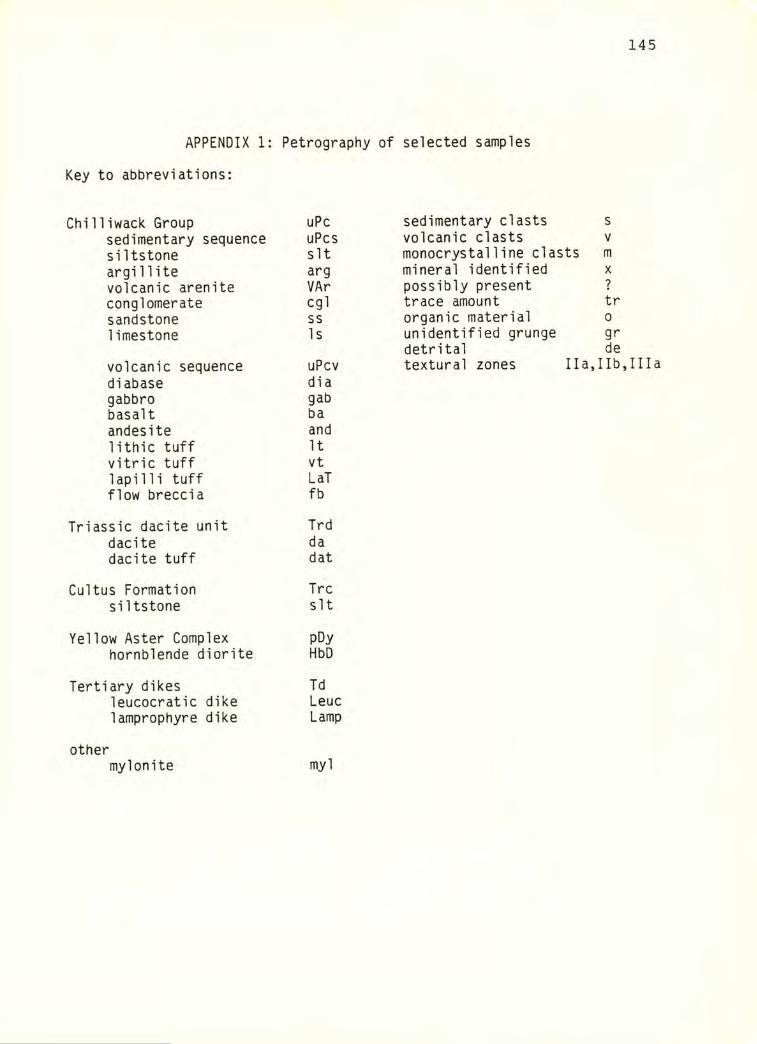
145
APPENDIX 1: Petrography of selected samples
Key to abbreviations:
Chilliwack Group uPc sedimentary clasts ssedimentary sequence uPcs volcanic clasts Vsiltstone sit monocrystalline clasts margillite arg mineral identified Xvolcanic arenite VAr possibly present ?conglomerate cgl trace amount trsandstone ss organic material 0limestone Is unidentified grunge gr
detrital devolcanic sequence uPcv textural zones Ila, lib,Iliadiabase diagabbro gabbasalt baandesite andlithic tuff Itvitric tuff vtlapilli tuff LaTflow breccia fb
Triassic dacite unit Trddacite dadacite tuff dat
Cultus Formation Trcsiltstone sit
Yellow Aster Complex pDyhornblende diorite HbD
Tertiary dikes Tdleucocratic dike Leuclamprophyre dike Lamp
othermyIonite myl
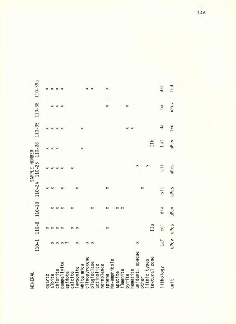
MIN
ERA
L SA
MPL
E NUM
BER
110-
1 110-8
110-18
110-24
110-25
110-28
110-35
110-38
110-39
a
146
X X X X XX X I— -oId s-“O I—
>XXX XX Id o^ Q-
3
X X X X X X X Id -oTD S-
XXX X
jQ I— >HH Id o►-I a.
3
X > +J toX X X X X a
lO Q.
XXX X X o
XXX X X XXX
X X X X X XId
X X X X X X X
<V3o; D" <V
c OJ Id CO c<u cu <v Q. 0) OId X CO ID (I) o O Cl N•r* (U u o Id T3 n >>
<v 4-> C •r- (U <u • 1—4-> f— 0) 0) •r“ B >> u (U <U +J +J 4-> IdN (U ♦p" f— +-> 4-> C 0.0 0 o Q. -t-> -1- 0) •»- C o s-•»-> 4-> CD O -r- o <V O -r- C .O c e •<- c 4-> -♦-> d) s- •r- 13S- •!- o Q.-0 O 00 •M C CD-r- c o to +J O) •f— Id “O 0) JCId ^ E -r- r- •r* •r- Id 4-> s. .c 1 to E s- E •1- ^ 4-> X3 f— JC 3 Q. Id Id r— r— O o a. (0 Q.I— >> 0) C 4-> .1- IDcr Id o CL 0) O r— 5 U Q. Id .c t/i Z to T- Q-.C 3 O r— +J
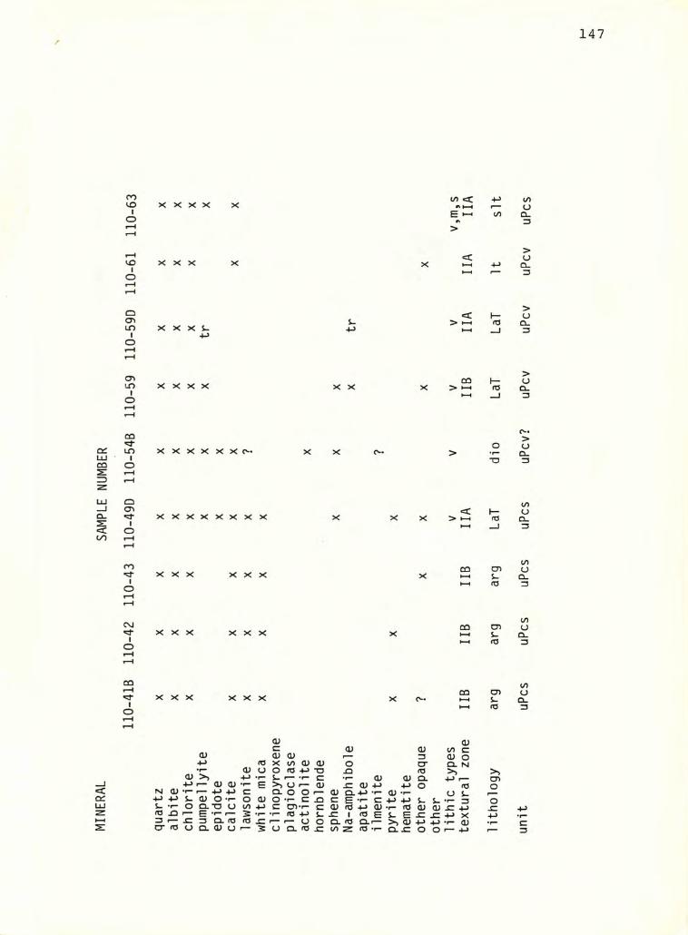
110-
41B
110-
4211
0-43
110-
49D
110-
54B
110-
5911
0-59
D11
0-61
110-
63
147
X X X X X (/> i/IuQ.3
XXX>uQ.
X X X s- •M
s. < I—> HH rc
>OQ.3
X X X X X X CQ h-X > »—• (T3
>oQ.3
X X X X X X 0- XX c^« o■o
>uQ.3
xxxxxxxx X X > I rOi/Iua.3
XXX XXXCO tyis-
(/)(JQ-3
<ex:UJ
XXX XXX
XXX XXX
CO
a;-»->•r- <UOJ >> -M4^1— O) O)N a; -p +J c4- > 4-> s- a; o *1“ o5- T- o Ci. “D O t/>
fO XJ r- E 53 I— ^ 3 Q. rO fO
er (O u Q. O) o »—
CDS-
S-fd
(U 0)c <u O) CO c0) CD 3 cu oX i/l <V CU o CT CL No fd +j -o rd >> >5S- f— c •1- <u OJ Q. 4-> •— CT)(J r— <D ^ O) 4-> +-> O rd OCL O O <u Q. +J -r- o; .1- U S-o •*- c c E •<- C +-> +j s- s- *1- 3 OC CD«r- C <D ro +J dJ ro 0) <U JC•r- rd 4-> -C 1 <0 E S- E ^ x: ■P X -p(J o CL <d CL«— >N O) 4-> -M •r- o;O CL <d CO Z T- CL ^ o o •— -p 1—
IDuQ.
i/Iuo_3
c3
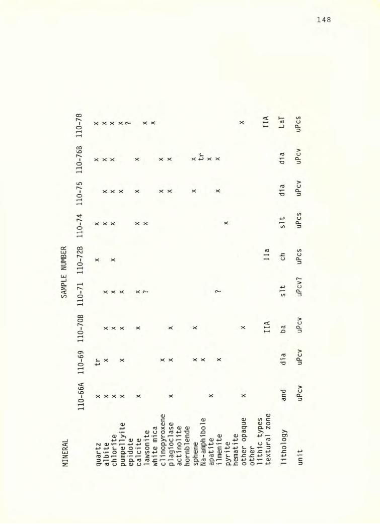
110-
66A
110-69
110-70
B 110-
71 110-
72B
110-74
110-75
110-76
B 110-
78
148
X X X X C- XX <C I— X 1—1(0
XXX X XX s-X -)-> X X(O•r"*o
XXX X XX X X •r“T3
XXX XX X
X X o
XXX X o-«
X X X X X X<X I-H rdH-1 ^
S- X XX XX X fd“O
<q:
X X X X
<u-M I— a; a; N o> -M +J
X X X X X
OJ <Vc 0) <u t/> c
a> 0) <u 3 0) o4-> (O X t/) O) <L> o O' Q. N
(U O o <d •P -o fd
-f-rd ^ 3 I—cr rd
<u o T- o_ Q-“0 U ^ E 5^ 3 Q- ^d <d U Q- O) O •—
(UO)
s- . _U r— <D Q. O O _o T- c ja cC cn»r- c cu.i- <d +j s- x:
»— <J O Q.I/)5 o Q- ^
a; 0)•r“ C •P <u rd ECL.— fd T-
<D -p<D -r-
•p -p•I- <dS- E >> <D O.JC
Q.o
s- s-CU CD
<du s-•I- 3
o o •—
X<D
T3cfd
>>CDOOJZ-p
unit
uPcv
uPcv uP
cv uPcv?
uPcs
uPcs uP
cv uPcv
uPcs
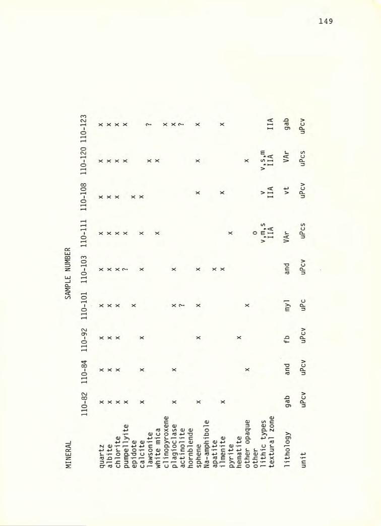
110-
82 110-
84 110-
92 110-
101 110
-103
110-11
1 110-1
08 110-
120 1
10-1
23
149
X X X X X X C- <c -aHH fO I—I
x: X X X X X£(/) HH <c
XXX XX
<
> I—•
X X X Xto
s-<
X X X c- TOc<d
XXX X O-E
XXX
XXXT3crO
<
X X X X X X X X rd
(U CUc OJ CU to c:
a; a; (U r— 3 a; ord X to (U 0) o O' CL N
0) U o to “O <d >>(U >> -M s- •r* c •r“ CU CU Q. 4-> f— o>
4-> r-* CU (U E >> u n— CU (U 4-> o rd oM O) 4-> ■4-^ c CL o O r— (U CL 4-* •r- CU •r* O s- r—
4-> +-> s- a; O •r- o CU o c JD c E C 4-> -M s- s. 3 os. •r“ o CL *o o to 4-> c cn C CU rd +-> CU <d CU CU JZ 4->
E 1— 2 •r“ •r“ td +J s- 1 rd E S- E JC jC XZ3 f—• sz o CL <0 SZ r" u o CL rd Qu r* >> <u +-> -M •r- CU •r“cr <0 u Q. o; u r— 2 u Q. #d JZ to z rd •r* Q. o o (— 4-> '— un
it uP
cv uPcv
uPcv
uPc uPcv uPcs
uPcv
uPcs uP
cv
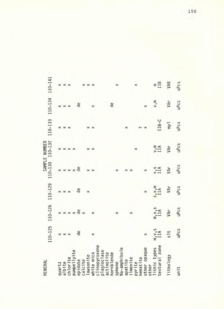
MIN
ERA
L SA
MPL
E NUM
BER
110-
125 110
-126
110-12
9 110-1
30 110-
132 110
-133
110-13
4 110-1
41
150
CO OdX X X X X X E »-• <
H-1 >
i-Q) 0) tk■o X ■o X > >
o1
00X
XX
X o« X HH BHH
E <X X X X X t-H <
> »—1 >
<u in <C S-X X X X X X X X HH <> HH >
E i.0) #.€SC <
X ■o X X > »-H HH(/>
>
</>a; s-
X X -o X X X X > »—1 <A HH >E
ind> •»<C -M
X ■o X X > H-H f—A toE
<D CUC (U CD </> c
(U <D o; r— 3 CJ orO X (/) O) CU o cr Q. rsi
♦r“ a; O O rt3 +J ■a <0 >) >><v 4-> s- »— ••- c ■r- <U 0) CL -M •— CT>
4-> •—<1)0; •r" E >> u a; <U -l-> o rO O*r“ •— 4-> C CL o O 0) Q.-l-> -t- CD <J S-s- a; o -r- o (U o ••- c C E -r- C •M S. S- •r- 3 oo Q.-0 u 1/) 4-> c cn«f- C OJ <o +-> OJ ••- rO 0) (D ^ -M £:
E •r* .f- ro +J 1 (0 E S- E ^ x: +-> XJZ 3 Q. <d <T3 p— r— o o Ol <0 Q-r— >> <U 4J .1- (VU Q. <D O r— 2 0 0.^0 JC t/> z re -r- Q-i: o O •— -M unit
uPcs
uPcs uP
cs uPcs
uPcs
uPcs uP
cs uPcs
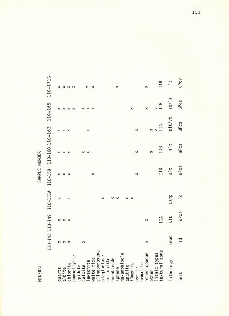
110-
143 1
10-1
49 110-
151A
110-15
9 110-1
60 11
0-16
3 11
0-16
5 11
0-17
1B
151
CD 4->
X X X X 0-* X X X HH
CO
X X X X XXX X X
CD> I—I
COCO
<c>
XXX X X O > HH CO
XXX XX X
CD
o »—•CO
CD 4->
XXX X X CO
X X X XX XXCLE03
XXX XCO
XXX X Xu3<D
CD CD£ CD CD CO £
<u CD CD 3 CD 005 X CO CD CD 0 cr Q. N
•r* CD U 0 05 4-> TD 05 >><U >> -M •r- ^ r— ‘t^ £ •1- 0) CD a. +-> •— CO4-> •— <U CD E >> CJ CD ^ CD 4-> 4-> 0 05 0
< NJ 0) •r“ 1— 4-> C Q. 0 0 r-~ CD Q.+4 ‘r- CD T- U S-cc •t-> •(-> S- <D 0 0 CD 0 T- C JD ££••-£ +J +J S. L. •1- 3 0UJ S- T- 0 Q--0 U CO C CTi-t- £ CJ 05 4>> 0) •r- 05 CD a; ^ -Mz 05 ^ E •!— 1— 2 • r- rd 4-) £ ^ 1 03 e S- E ^ ^ X •Ml-H 3 I— jC 3 CL 05 JZ 1— n- 0 0 CL 05 CL«— >s <U 4-> 4-> •r- CU •f“2: O" 05 0 Q. CD (J 1— 2 0 Q. 05 £: CO Z 05 T" CL^ 0 0 1— 4-> un
it Td
uP
cs Td
uPcs
uPcs uP
cs uPcs
uPcv
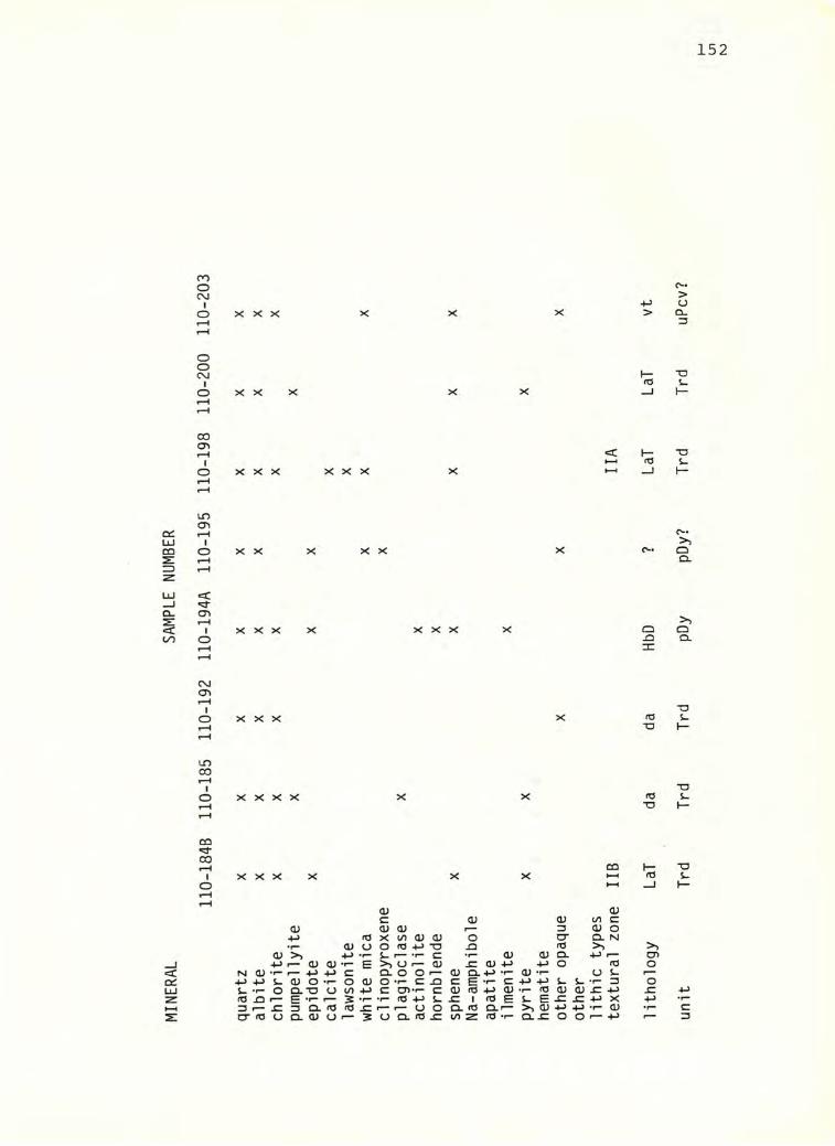
min
era
l sa
mpl
e nu
mb
er
152
oooCVJIo XXX
c->CJ
> Q-
ooCVJIo X X
00
oI
o XXX XXX
incr>
Io X X X X
<
Io XXX XXX
C\JCTlI
o XXX
IT)00
Io X X X X
OQ00 T“HIo
COXXX
<V <Dc OJ (U to C(U a; <u fmmm 3 <D O•M <T3 X U) (U 0) o O' Cl NJ•r" <U U o n3 TO JD rO >)<D >> s. r— C •1— <V Q. +J r—+-> I— O) <U •!- E M d) -r- I— +J +J c:
+j+js_qjom-o<uS_'|-0Q.T30W1+J to ^ r— E ^ 2 •!— Z3 r— JC 3 0.(0 (0.0 CT(0OQ.ajOr— 3
>>0(— (u x:a)+-> +->o (OQ.OOr— (UQ.+J •(-(!;•(- us-Ot-CJ3CE-(-C4J-MS-S--<-3c cn-(- cd)(04-><U'i-(0<i)<i;.c4J•i-(0+JS_.c I (0ES-E.cx:4->x [— (— U O Q. (O Q.r— >, <U +J +J •!- CU O Q.(O.C 1/)Z (O-I- 0.0 O 0>— +-> lit
holo
gy LaT d
a da
H
bD
? La
T LaT
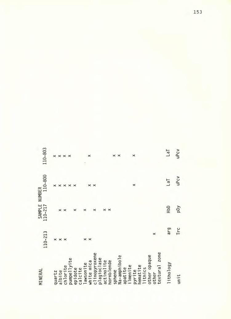
MIN
ERA
L SA
MPL
E NUM
BER
110-
213
110-
217
110-
800
110-
803
153
fOX X X X X X X
X X X X X XX X rd
XX X X X XX QJD31
XXX XXX s-(T3
-!->S-
fC XU3 f—O’ fO
OJC CU (U 3
O) cu (U p—• 3 ofd X cn (U (U o O’ N
•f" (U o o <d 4-> ■o 3 rd<D >) 4-> s- c (U <u Q. o>
4-> 0) OJ •r— E >> o cu 3 CU -p -p (/I O fd o•1— c Q. o O r— <U Q. (U O s- f—"S- 0) o o O O •r» c -Q 3 E 3 ■p S- S- 3 oo Q, ■o o (A 3 O) •r“ 3 CU rd (U •r-* rd 3 0> cu 3
E ♦r“ 5 •r“ fd S- 3 1 cd E S. E -P 3 3 X 4->JZ 3 Q. rd rd r— U o Q. rd Q. r~ >> (U •r" -P -P (Uo Q. 0^ O r— 3 u Q. <d 3 0^ z <d •r" o..3 O o •p un
it Tr
c pDy uP
cv
uPcv
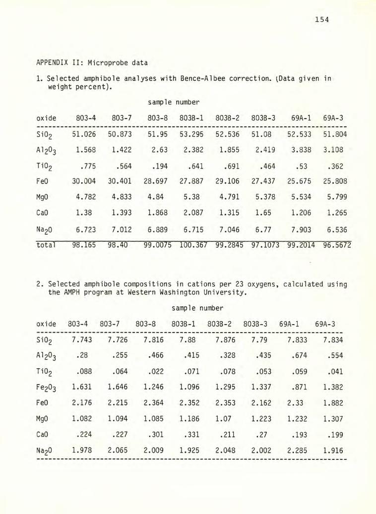
154
APPENDIX II: Microprobe data
1. Selected amphibole analyses with Bence-Albee correction. ^Data given inweight percent).
sample number
oxide 803-4 803-7 803-8 803B-1 803B-2 803B-3 69A-1 69A-3
Si02 51.026 50.873 51.95 53.295 52.536 51.08 52.533 51.804
AI2O3 1.568 1.422 2.63 2.382 1.855 2.419 3.838 3.108
Ti02 .775 .564 .194 .641 .691 .464 .53 .362
FeO 30.004 30.401 28.697 27.887 29.106 27.437 25.675 25.808
MgO 4.782 4.833 4.84 5.38 4.791 5.378 5.534 5.799
CaO 1.38 1.393 1.868 2.087 1.315 1.65 1.206 1.265
Na20 6.723 7.012 6.889 6.715 7.046 6.77 7.903 6.536
total 98.165 98.40 99.0075 100.367 99.2845 97.1073 99.2014 96.5672
2. Selected amphibole compositions in cations per 23 oxygens, calculated usingthe AMPH program at Western Washington University.
sample number
oxide 803-4 803-7 803-8 803B-1 803B-2 803B-3 69A-1 69A-3
Si02 7.743 7.726 7.816 7.88 7.876 7.79 7.833 7.834
AI2O3 .28 .255 .466 .415 .328 .435 .674 .554
Ti02 .088 .064 .022 .071 .078 .053 .059 .041
Fe203 1.631 1.646 1.246 1.096 1.295 1.337 .871 1.382
FeO 2.176 2.215 2.364 2.352 2.353 2.162 2.33 1.882
MgO 1.082 1.094 1.085 1.186 1.07 1.223 1.232 1.307
CaO .224 .227 .301 .331 .211 .27 .193 .199
Na20 1.978 2.065 2.009 1.925 2.048 2.002 2.285 1.916
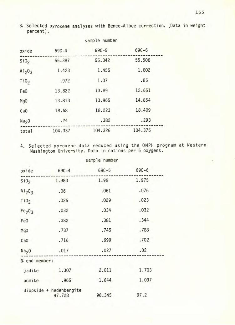
155
3. Selected pyroxene analyses with Bence-Albee correction. ^Data in weightpercent).
oxide 69C-4
sample number
69C-5 69C-6
Si02 55.387 55.342 55.508
AI2O3 1.423 1.455 1.802
Ti02 .972 1.07 .85
FeO 13.822 13.89 12.651
MgO 13.813 13.965 14.854
CaO 18.68 18.223 18.409
Na20 • ro .382 .293
total 104.337 104.326 104.376
4. Selected pyroxene data reduced using the OMPH program at Western.Washington University. Data in cations per 6 oxygens.
sample number
oxide 69C-4 69C-5 69C-6
Si02 1.983 1.98 1.975
AI2O3 .06 .061 .076
Ti02 .026 .029 .023
F®2^3 .032 .034 .032
FeO .382 .381 .344
MgO .737 .745 .788
CaO .716 .699 .702
Na20 .017 .027 .02
% end member:
jadite 1.307 2.011 1.703
acmite .965 1.644 1.097
diopside + hedenbergite97.728 96.345 97.2
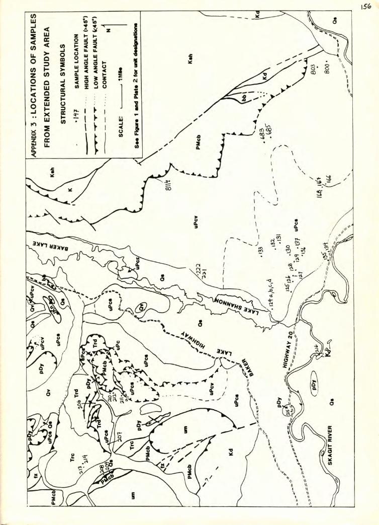
Related Documents


