Strippable Coal in Custer and Powder River Counties Montana GEOLOGICAL SURVEY BULLETIN 995-B

Welcome message from author
This document is posted to help you gain knowledge. Please leave a comment to let me know what you think about it! Share it to your friends and learn new things together.
Transcript
Strippable Coal in Custer and Powder River Counties Montana
GEOLOGICAL SURVEY BULLETIN 995-B
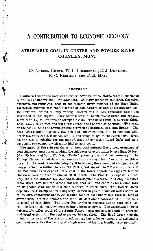
A CONTRIBUTION TO ECONOMIC GEOLOGY
STRIPPABLE COAL IN CUSTER AND POWDER RIVER COUNTIES, MONT.
By ANDREW BROWN, W. C. CULBERTSON, R. J. DUNHAM, R. C. KERFERLE, and P. R. MAY.
ABSTRACT
Southern Ouster and northern Powder River Counties, Mont., contain enormous quantities of undeveloped low-rank coal. At many places in this area, the thick extensive flat-lying coal beds in the Tongue River member of the Fort Union formation underlie less than 120 feet of soft sandstone and shale and are par ticularly well suited to strip mining. Eleven of the most favorable areas are described in this report. They cover a total of about 56,000 acres and contain more than 1% billion tons of strippable coal. The beds range in average thick ness from 7 to 25 feet and with few exceptions are free of partings. The rank of the coal is near the boundary line between subbituminous O and lignite. The coal has an advantageously low ash and sulfur content, but, in common with other low-rank coals, it slacks readily and tends to ignite spontaneously. Even so, the coal is suitable for the manufacture of synthetic liquid fuels and on a cost basis can compete with many higher rank coals.
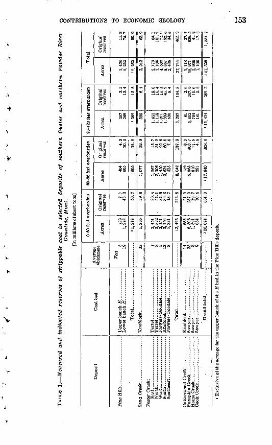
The maps of the selected deposits show coal outcrop lines, measurements of coal thickness, and areas in which the thickness of overburden is less than 60 feet, 60 to 90 feet, and 90 to 120 feet. Table 1 presents the total coal reserves in the 11 deposits and subdivides the reserves into 3 categories of overburden thick ness. In the most favorable category, 0 to 60 feet, the amount of strippable coal ranges from 10.4 million tons in the Cook Creek deposit to 287.9 million tons in, the Pumpkin Creek deposit. The coal in the latter deposit averages 25 feet in thickness over an area of almost 19,000 acres. The Pine Hills deposit is prob ably the most suitable for immediate development because it is only 14 miles from Miles City, has the second thickest coal bed, and contains 50 million tons of strippable coal under less than 60 feet of overburden. The Foster Creek deposits are a group of five compactly located deposits about 50 miles south of Miles City, containing about 224 million tons of coal under less than 60 feet of overburden. Of this amount, the south deposit alone contains 86 million tons in a bed 13 feet thick. The other Foster Creek deposits are in coal beds less than 10 feet thick, but they contain fairly large reserves. The Cottonwood Creek deposit, 1% miles south of the South Foster Creek deposit, is small in reserves and areal extent, but the coal averages 14 feet thick. The Sand Creek deposit, a few miles east of the Foster Creek group, has a large tonnage of strippable coal, and underlies the flat top of a high mesa, which is a locality very favorable
151

152 CONTRIBUTIONS TO ECONOMIC GEOLOGY
to strip mining. The Home Creek deposit and the Cook Creek deposit are small deposits located in the southwestern part of the area, about 45 miles southeast of the railhead at Colstrip.
INTRODUCTION
The deposits of coal suitable for strip mining that are described in this report were mapped by the U. S. Geological Survey as part of the Interior Department's program for the integrated development of the Missouri River basin.
Commercial mining of coal by stripping dates in the United States from about 1910, when large full-revolving power shovels were first employed in the midwestern coal fields (Koenig, 1950, p, 27). For many years the tonnage recovered by strip mining was relatively small, the average for the years 1920-24 being only about 2 percent of the nation's annual production. By 1950, however, strip-mined coal was 23.9 per cent of the total (Bureau of Mines, 1951, p. 20). This rapid growth is explained by the fact that a large part of the nation's coal can be produced more cheaply by strip mining than by under ground mining. In the mines of Illinois, for example, the amount of coal produced per man-day in 1950 was 18.7 tons by strip mining, as compared to 8 tons by underground mining (Bureau of Mines, 1951, p. 20). In addition to the more efficient use of manpower, strip mining requires a smaller initial investment than underground mining, except in very small mines. The investment necessary to equip a modern strip mine in the midwest was roughly estimated in 1949 to be about $4 per ton of annual capacity, whereas the investment necessary to equip a modern underground mine in the same area was estimated to be $5 to $7 per ton of annual capacity (Koenig, 1950, p. 28). Further more, in strip mining, 80 to 90 percent of the coal in the ground is recovered (Koenig, 1950, p. 28 and G. A. Nugent, oral communication) ; whereas in underground mining only about 50 percent is recovered (Averitt and Berryhill, 1950, p. 8).
In view of its demonstrated efficiency, the trend toward strip mining may be expected to continue and to accelerate in the foreseeable future,thus creating a demand for information about undeveloped deposits of strippable coal. The purpose of the present report is to describe 11 deposits of coal in southern Ouster and northern Powder Kiver Counties, Mont., which are particularly well suited to strip mining, and which contain 1,551 million tons of coal under less than 120 feet of overburden. (See table 1.)
LOCATION OF THE AEEA
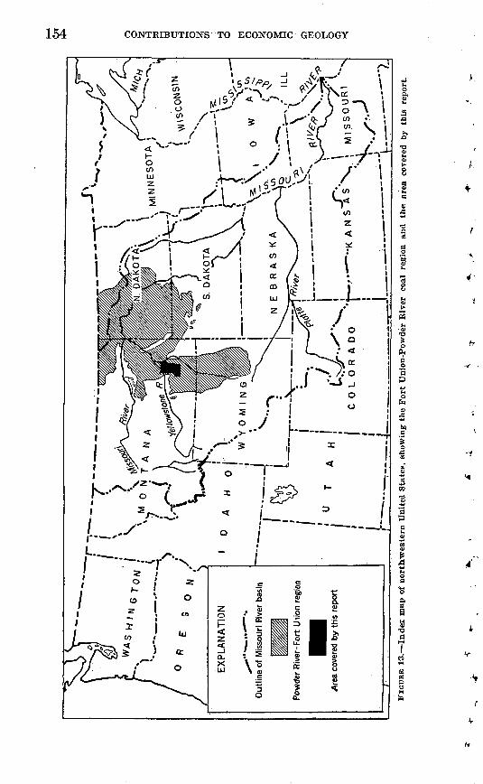
The investigated area is part of the Powder River-Fort Union regionof the northern Great Plains. (See fig. 13.) This region contains the
CONTRIBUTIONS TO ECONOMIC GEOLOGY 153
*
3"o EH
a<o d
a£o
1siaCD
1
O
IB .2
8
dCD g
a,0
0
^
i
S
!
i^
1|OS*
W
1"3 en2 ®
'So ^j*C wo 2
£j
11.60 fe
O £
3b
ra wCQ o5.sj>
§1
"ii ^
' i$ .2
15 3
dS ao 0
^a
E"*
CO
Q
CNt^
28
558 VCN
C^T).
CON
COCO
coco"8
S 10
t-o^3
CO 00
"^
C00>
%.V^
Upper bench E. . Lower bench E. .
a
W 2S
en
oCO
sCN
-
CO
>o
en
CO
CN
i
^s
g~
a
1
OS
sCN
n.CO
i
Ol
?5
s
<oo> co
i"<"
N
Knoblock ____
8so da03to
^r-e cow3< * Ci i CN -th
CO CO CN t^- COt-OOOOCOCOr* i-l "O CO *
o^x^a^oococomoo
>o w5 1«< o> o>
t^lNCO^TX
i-l CO CN CO
COOCNCNCN CMIMTt-CO«O
'tf* fH CO CO t*»
co^coooS
^iSgicfco"cN"co"rt"
«--ooa>cooo
Terret........... Terret.... ....... Flowers- Qoodale. Knoblock.-... ... Flowers- Qoodale.
*
I *
Illlllg
01
If
5̂CM
00
S
1co
co
CO
1
oo
§
>o o>
»
1
t^iOCNCO
CNCO«~
00-H >OO ^-ct-CDOI-H OJ d I <
1-1
OOOCO
N^jOCN
CM
00 O O CO
ui
OOt~"OCO
COCOj-,-*.
tNCOO"-!ioa5rHCn 100 00 CM
0>COt-*
CNCoSS
oo *c co coCO"PH"
tfooooo*rHCN
1...p HillU a coco
.<o2^oggC'S'S
5 a'a^
Q£WO
t-
5
egCO
«o
CO
o>CO
1co"
TK
§
00
^
o
3
og""
Grand total
'1o
d
3ppa
I
CD£
le upper bench of t!
§cjCDA*sCD t>
I
W
154 CONTRIBUTIONS TO ECONOMIC GEOLOGY

STRIPPABLE COAL, CUSTER AND POWDER RIVER COUNTIES, MONT. 155
largest reserves of strippable coal in the United States. Its thick and extensive beds of lignite and subbituminous coal are flat lying, or nearly so; in many places the coal beds are at shallow depths, and the rocks overlying the coal are relatively soft and easily stripped. The investigated area covers about 2,300 square miles south of Miles City in the west-central part of the region. It is bounded on the west by Rosebud County, Mont., on the north by the north edge of Township 8 North, on the east by the Powder River and its tributary Mizpah Creek, and on the south by the south edge of Township 3 South. (See fig. 14.)
PREVIOUS GEOLOGIC WORK
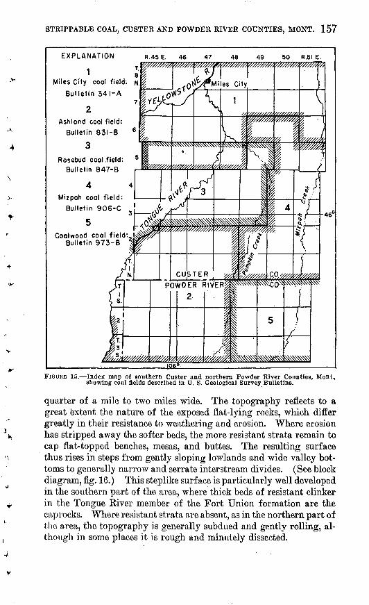
The area covered by this report has been investigated previously by the U. S. Geological Survey. The results of these earlier investigations are available in bulletins on the following coal fields: Ashland, by N. W. Bass (1932); Rosebud, by W. G. Pierce (1936); Mizpah, by F. S. Parker and D. A. Andrews (1939); Miles City, by A. J. Collier and C. D. Smith (1909); and Coalwood, by R, P. Bryson (1952); as well as on the Baker lignite field, by C. F. Bowen (1912). Figure 15 shows the locations of these fields insofar as they lie within the area covered by this report. The writers have drawn freely from each of the reports in investigating the deposits of strippable coal that are described in this report.
ACKNOWLEDGMENTS
The writers greatly appreciate the information and hospitality given by the Nuxoll family, the Fessler family, W. L. Vawter, and other ranchers in the area. T. W. Buell and A. L. Draine generously provided copies of a large number of logs of water wells drilled by them. Copies of other water-well logs were provided by the Custer County and Powder River County offices of the Production and Mar keting Administration, U. S. Department of Agriculture, and by H. J. Sawtell. The Miles City office of the Bureau of Land Management, U. S. Department of the Interior, kindly allowed the use of aerial photographs. T. E. Fleming, operator of the Storm King mine, and Josef Beilage, owner of the North Star mine, provided chemical an alyses of the coal on their properties. George Nugent, vice president of the Big Horn Coal Co. of Sheridan, Wyo., gave valuable informa tion about strip mining and storing of subbituminous coal.
The field work forming the basis for this report was done during the second half of 1950. R. D. Forester was associated with the writers during the summer, and D. M. Brown during the early part of the summer. The writers gratefully acknowledge the contributions of these men.
156 CONTRIBUTIONS TO ECONOMIC GEOLOGY
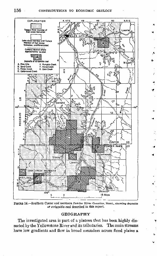
Deposits of strippable coal A. One Hills E. Pumpkin Creek B. Sand Creek F. Home Creek C. Foster Creek G. Cook Creek
FlOUBB 14. rSOUthern Custer and northern Powder River Counties, Mont., showing depositsof strippable coal described in this report.
GEOGRAPHY
The investigated area is part of a plateau that has been highly dis sected by the Yellowstone River and its tributaries. The main streams have low gradients and flow in broad meanders across flood plains a
STRIPPABLE COAL, CUSTER AND POWDER RIVER COUNTIES, MONT. 157
EXPLANATION
iMiles City cool field: N
Bulletin 341-A
Ashland cool field:
Bulletin 831-B 6
3Rosebud coal field: 5
Bulletin 847-B
4 4
Mizpoh coal field: Bulletin 906-C
5Coalwood cool field:
Bulletin 973-B
R.45E. 46 47 48 50 R.5I E.
FIGURE 15. Index map of southern Custer and northern Powder River Counties, Montn showing coal fields described in U. S. Geological Survey Bulletins.
quarter of a mile to two miles wide. The topography reflects to a great extent the nature of the exposed flat-lying rocks, which differ greatly in their resistance to weathering and erosion. Where erosion has stripped away the softer beds, the more resistant strata remain to cap flat-topped benches, mesas, and buttes. The resulting surface thus rises in steps from gently sloping lowlands and wide valley bot toms to generally narrow and serrate interstream divides. (See block diagram, fig. 16.) This steplike surface is particularly well developed in the southern part of the area, where thick beds of resistant clinker in the Tongue River member of the Fort Union formation are the caprocks. Where resistant strata are absent, as in the northern part of the area, the topography is generally subdued and gently rolling, al though in some places it is rough and minutely dissected.

CONTRIBUTIONS TO ECONOMIC GEOLOGY
STRIPPABLE COAL, CUSTER AND POWDER RIVER COUNTIES, MONT. 159
The total relief of the area is about 2,000 feet, though locally it ex ceeds 500 feet in few places. The altitude above sea level ranges from 2,350 feet, in the Yellowstone River valley at Miles City, to 4,350 feet, in the Cook Creek Mountains 50 miles to the south.
DRAINAGE AND WATER SUPPLY
The Yellowstone River receives all the runoff of the area, principally by means of its perennial northward-flowing tributaries the Tongue and Powder Rivers. (See map, fig. 14.) The Tongue River drains the western part of the area and flows into the Yellowstone River at Miles City. Its principal tributary is Pumpkin Creek, an intermit tent stream. The Powder River drains the eastern part of the area and enters the Yellowstone River to the north of the investigated area. The principal tributary of the Powder River is Mizpah Creek, also an intermittent stream.
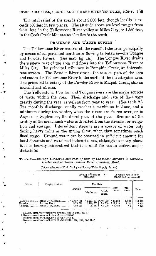
The Yellowstone, Powder, and Tongue rivers are the major sources of water within the area. Their discharge and rate of flow vary greatly during the year, as well as from year to year. (See table 2.) The monthly discharge usually reaches a maximum in June, and a minimum during the winter, when the rivers are frozen over, or in August or September, the driest part of the year. Because of the aridity of the area, much water is diverted from the streams for irriga tion and storage. Intermittent streams are a source of water only during heavy rains or the spring thaw, when they sometimes reach flood stage. Ground water can be obtained in sufficient amount f or local domestic and restricted industrial use, although in many places it is so heavily mineralized. that it is unfit for use in boilers and is distasteful.
TABLE 2. Average discharge and rate of flow of the major streams in southern Custer and northern Powder River Counties, Mont.
[Information from U. S. Geological Survey Water Supply Papers]
River
Yellowstone-
Gaging station
Averaga discharge (acre-feet)
Annual
1 7, 737, 000 2 573, 300 « 309, 200
Monthly
Maximum
i 2, 221, 000 2 183, 700
< 78, 580
Mini mum
1 191, 000 J 4, 900 < 3, 000
Average rate of flow (cubic feet per second)
Maxi mum
3 63, 500 1 13, 820
< 3, 420
Mini mum
'1,800 2201
<8
Mean
> 10, 470 2 835 4 426
' Records used were inclusive of years 1930-38 and 1940-47.* Records used were inclusive of years 1940-47.' Records used were inclusive of years 1940-47.« Records used were inclusive of years 1931, 1932, 1941, and 1947.
160 CONTRIBUTIONS TO ECONOMIC GEOLOGY
CLIMATE
The climate in southern Custer and northern Powder River Coun ties is semiarid. The average annual precipitation is about 14 inches, of which about 70 percent falls as rain from April to September, the remainder falling as snow during the other six months. The tem perature drops to as low as 40 degrees below zero in the winter, and rises to more than 100 degrees during the summer, but these tem perature extremes are usually of short duration. The summer season is short, and below-freezing temperatures may be expected as early as the middle of September and as late as the middle of May.
SETTLEMENT
Miles City, the county seat of Custer County and the only large town in the area, had a population in 1950 of 9,185. Ashland, with a population of about 120, is the next largest settlement in the area shown on the map. Each of the other towns is characteristically a post office operated in conjunction with a general store and fill ing station. The total population density of the area is about three persons per square mile; outside the towns, however, the density is less than one person per square mile.
TRANSPORTATION
The main lines of both the Northern Pacific Railway and the Chi cago, Milwaukee, St. Paul, and Pacific Railway pass through Miles City and parallel the Yellowstone River. No railroads extend south into the principal coal-bearing parts of the area, though in 1923 a roadbed was graded for a considerable distance up the Tongue River from Miles City. A branch line of the Northern Pacific Railway extends from Forsyth to Colstrip, Mont., which is about 35 miles northwest of Ashland.
Three asphalt-paved U. S. highways cross the area. (See map, fig. 14.) U. S. Highways 10 and 12 pass through Miles City from Glendive and Baker on the east to Billings on the west. U. S. High way 212 extends south from Miles City through Volborg and Broadus and on to the Black Hills. All of the strip deposits described in this report can be reached by way of U. S. Highway 212 with the exception of the Pine Hills deposit, which is east of Miles City on U. S. Highway 12. The State highways are gravel- or clinker-sur faced, well drained, and capable of carrying moderate traffic. State Route 8, the best unpaved road in the area, crosses the southern part of the area between Ashland and Broadus. State Route 30 connects Mizpah with U. S. Highway 12 in the northern part of the area. The county roads are few and far between; some are surfaced.

STRIPPABLE COAL, CUSTER AND POWDER RIVER COUNTIES, MONT. 161
but most are merely graded. The best of the county roads within the area are the Tongue River and Pumpkin Creek roads. The Tongue River road connects Ashland and U. S. Highway 212, and the Pumpkin Creek road extends from IT. S. Highway 212 at Volborg to State Route 8, by way of Loesch. In dry weather, it is possible to go almost anywhere in the area, provided fairly good field cars are used. In wet weather only the surfaced roads are passable.
ELECTRIC POWER
The only source of electric power within the area is at Miles City, which has a local plant, and a nearby substation with a combined output capacity of about 12,500 kilowatts. Lines from these plants extend parallel to the Yellowstone River.
LAND USE
The principal industry of the southern Custer and northern Powder River Counties area is the raising of livestock, and more than three- fourths of the area is used for that purpose. Many of the valley bottoms and some of the level uplands are cultivated by dry-farming methods, and a few of the flat valley floors are irrigated. The chief crops are hay and small grains. The value of the grazing land was $12 to $18 per acre early in 1951; farmlands sold for somewhat higher prices.
A small amount of lumbering is carried on in the area, although there are not enough trees to support a major lumbering enterprise. Some of the more rugged uplands support fair stands of pine, cedar, and scrub jumper, and the bottomlands of the main streams support cottonwood trees.
LAND OWNERSHIP
Most of the area covered by this report lies within the limit of land grants to the Northern Pacific Railway, under which the railroad was given title to all odd-numbered sections in every township for 60 miles on .each side of the right-of-way. Of the even-numbered sec tions, those numbered 16 and 36 were granted to the State of Montana as school land, and the other 16 remained the property of the Federal Government until homesteaded or sold. The railroad has sold much of its land but has retained the mineral rights on most of the land that was sold. Of the Government lands, the surface rights to the better and more accessible tracts have been disposed of, but mineral rights on most of the tracts have been retained. As a rule, the State of Montana has retained both the surface and mineral rights to its school lands.
162 CONTRIBUTIONS TO ECONOMIC GEOLOGY
STRATIGRAPHY
All the rocks exposed in the area belong to the Fort Union forma tion of Paleocene age (Andrews and others, 1944). Quaternary al luvium obscures the bedrock in the larger stream valleys, and isolated remnants of formerly extensive terrace gravel deposits cover benches high on the sides of the largest valleys.
FORT UNION FORMATION
The Fort Union formation consists of three lithologic units. These are, from bottom to top, the Tullock member, the Lebo shale member, and the Tongue River member. The Tongue River member includes all the thick, extensive beds of clean coal in the area; the coal beds in the two lower members are both thin and dirty. Because only the areas near the selected strippable coal deposits were investigated in detail, the reader is referred to the works cited in the list of references for more complete descriptions of the three members, and for dis cussion of the interesting stratigraphic problems they present.
Tullock member. The Tullock member crops out in the valley of the Yellowstone River near Miles City and in the lower valleys of the Tongue River and Pumpkin Creek. It is about 250 feet thick and consists of dark and light gray shale, sandy shale, sandstone, and some thin dirty coal beds.
Lebo shale member. In the hills above the Yellowstone River the Lebo shale member forms conspicuous outcrops, and it can be traced in the valleys of Pumpkin Creek and the Tongue River as far south as the northern edge of Powder River County, and even farther south in the valley of Mizpah Creek. The thickness of the Lebo shale mem ber ranges from 150 feet in the Ashland coal field to 170 feet in the Rosebud coal field (Pierce, 1936, p. 59). Because of similarities in lithology and coloring, the contact between the Lebo shale member and the underlying Tullock member cannot be located accurately at many places east of Pumpkin Creek. The member consists mostly of soft clay shale that weathers dull yellow or dark gray and contains thin coal beds of negligible value. It supports little or no vegetation and erodes easily to produce low rounded hills and spectacular badlands.The old term "somber beds" is an excellent descriptive title for this member, for on the whole the Lebo landscape is dark, lifeless, and generally depressing.
Tongue River member. The Tongue River member crops out across nearly 1,200 square miles of the area covered by this report, occurring chiefly in the highlands between major stream valleys.(See map, fig. 14.) The original thickness of the member in this area is unknown, for the upper part has been removed by erosion. The

STRIPPABLE COAL, CUSTER AND POWDER RIVER COUNTIES, MONT. 163
remaining lower part of the member has an average thickness of about 400 feet, although it reaches 1,150 to 1,600 feet in the Cook Creek mountains in T. 2 S., Rs. 45 and 46 E., and in high buttes in Tps. 1 and 3 S., R. 47 E. (Bass, 1932, p. 32). The member is com posed of sandstone, shale, sandy shale, thick coal beds, and a few thin limestone beds. In most places the rocks weather light yellow and contrast markedly with the gray or dull yellow of the underlying Lebo shale member. Extensive masses of pink, red, or brown clinker produced by the burning of the coal beds are almost as diagnostic of the Tongue River member as is the light yellow color. Although many of the individual beds are lenticular and can be traced for only short distances, groups of beds are generally persistent and can be followed continuously over large areas. Rugged land forms of marked relief characterize most of the outcrop area of the Tongue River member because of the prevalence of resistant clinker, lime- stone, and massive sandstone overlying soft, easily eroded beds of sandstone and shale. Where these more resistant beds are absent, as east of Pumpkin Creek, the land surface is gently rolling.
TERRACE GRAVEL DEPOSITS AND ALLUVIUM
Remnants of terrace gravel deposits occur at as many as 12 dif ferent levels along the valleys of most of the major streams (Bass, 1932, p. 43). Most of these deposits lie less than 300 feet above the present level of the streams in the southern part of the area. Along the north-trending streams, practically all the terrace deposits occur on the west side of the valleys, a fact attributed by Bass (1932, p. 48) to regional tilting. A few of the terrace deposits are as old as Oligocene or Miocene(?), but most of them date from Pleistocene time. They consist mainly of rounded fragments of igneous rocks, quartzite, limestone, and clinker, most of which are from 1 to 3 inches in diameter.
Alluvial clay, silt, fine sand, and some lenses of gravel cover the floors of most of the stream valleys. In the larger valleys the al- luvium commonly attains a thickness of 30 feet and provides some of the most fertile farmland in the area.
STRUCTURAL GEOLOGY
With minor exceptions, the strata in the investigated area are so nearly horizontal that their slight inclination is not apparent to the unaided eye. Surveying instruments reveal, however, that the strata southeast of the Tongue River dip generally northwestward at a rate of a few tens of feet per mile. The strata northwest of the river dip generally southeastward at a correspondingly low angle. The
265154 54 2
164 CONTRIBUTIONS TO ECONOMIC GEOLOGY
Tongue River thus approximately follows the trough line of the broad, low downwarp that Bass (1932, p. 47-48) named the Tongue River syncline. He remarks that it constitutes the major syncline between the Black Hills uplift and the Porcupine dome, which is near Forsyth, Mont. Small faults cut the rocks at a few localities in the investigated area, but none of the deposits of strippable coal de scribed on the following pages show evidence of faulting.
COAL
Most of the strippable coal described in this report is black and clean at fresh exposures, though some is brownish black and shows a woody structure. Vitrain or previtrain, a type of coal having bright luster and conchoidal fracture, occurs in long lenses ranging in thickness from a fraction of an inch to several inches, and commonly gives the coal beds a banded appearance. Fresh samples of the coals are generally brittle, though most of those containing much moisture are somewhat tough. Some of the coal beds contain resin globules, pyrite concretions, gypsum crystals, and silicified tree remains, but as a rule ash and sulfur contents are low.
Analyses (table 3) indicate that the coal beds in the area range in rank from lignite on the east to subbituminous C in the west. The available analyses are too few, however, to establish the exact location of the dividing line. The rank of the coal is defined here according to the standard specifications of the American Society for Testing Materials in which the distinction between lignite and subbituminous coal is based on the heating value of the coal calculated on a moist, mineral-matter-free basis. Coal that has a heating value of less than 8,300 Btu on the moist, mineral-matter-free basis is classed as lignite; that which has a heating value of more than 8,300 Btu but less than 9,500 Btu is classed as subbituminous C coal. In table 3, form A represents the coal "as-received" in the laboratory and shows the approximate composition of the coal as it is mined; form B represents the composition of the coal excluding moisture; and form C excludes both moisture and ash.
Important characteristics of both lignite and subbituminous coal are their tendencies to lose moisture on exposure to air; to slack; and to ignite spontaneously. Because of these tendencies the coal cannot be shipped in open cars for long distances or stock-piled for long periods, unless special care is taken to minimize the moisture loss. Several methods of storing have been found successful. One method is to submerge the coal under water; another is to store it in open pits or in .compacted piles; yet another is to cap storage piles, with an airtight cover such as road tar.
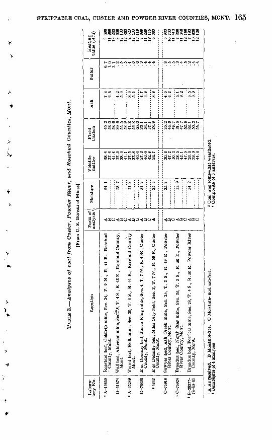
TABL
E 3
. A
naly
ses
of c
oal
fro
m C
uste
r, P
owde
r R
iver
, an
d R
oseb
ud C
ount
ies,
Mon
t.
[Fro
m U
. S.
Bur
eau
of M
ines
]
Lab
ora
to
ry N
o.
' A-1
9659
D-5
1574
» A
-422
89
D-7
6806
»596
2
C-7
5916
« C
-759
24
' B
-293
77-
78-8
0-81
Loc
atio
n
Ros
ebud
bed
, C
olst
rip
min
e, S
ec.
34,
T.
2 N
., R
. 41
E.,
Ros
ebud
Wal
l bed
, Ald
'ers
on m
ine,
Sei
.^8,
T.
4 S.
, R
. 43
E.,
Ros
ebud
Cou
nty,
Ter
ret
bed,
Hol
t m
ine,
Sec
. 20
, T
. 3
S.,
R.
44 E
., R
oseb
ud C
ount
y
.Eor
Dom
iny
bed,
Sto
rm K
ing
min
e, S
ec. 4
. T.
7 N
., R
. 49E
., C
uste
r
.Eor
Dom
iny
bed,
Mile
s C
ity
fiel
d, S
ec.
3, T
. 7
N.,
R.
50 E
., C
uste
r
Saw
yer
bed,
Ash
Cre
ek m
ine,
Sec
. 35
, T
. 2
S.,
R.
49 E
., P
owde
r
Bro
adus
bed
, N
orth
Sta
r m
ine,
Sec
. 21
, T
. 2
S.,
R.
50 E
., P
owde
r
Bro
adus
bed
, Pe
erle
ss m
ine,
Sec
. 23,
T.
4 S.
, R
. 50
E.,
Pow
der
Riv
er
For
m o
f an
alys
is '
A
B C A
B C A
B C A
B C A A
B C A
B C A
B C
Moi
stur
e 24.1
28.7
27.3
31.9
35.5
35.2
33.9
34.2
Vol
atil
e m
atte
r 28.4
37
.441
.427
.5
38.6
41.1
27.5
37
.840
.027
.3
40.0
42.9
26.7
30.6
47
.250
.328
.5
43.1
47.5
26.3
39
.9
Fix
ed
Car
bo
n 40.2
53
.058.6
.39
.6
55.5
58.9
41.3
56
.860
.036
.1
53.1
57.1
28.9
30.2
46
.649
.731
.547
.752
.533
.1
50.2
Ash
7.3
9.6
4.2
5.
9
3.9
5.4
4.7
6.
9
8.9
4.0
6.
2
6.1
9.2 6.5
9.9
Su
lfu
r 0.7
1.0
1.1 .3
.5 .5 .4
.6 .6 .3
.4 .4 .4 .3 .5 .5 .3
.4 .5 .2
.4 .4
Hea
ting
va
lue
(Btu
)
9,09
0 11
,960
13,2
308,
630
12, 1
0012
,860
9,02
0 12
,400
13, 1
107,
680
11,2
8012
, 11
56,
363
6,93
0 10
,700
11,4
107,
300
11,0
4012
,160
7,19
0 10
, 920
12, 1
20
B O
.O Ii A
As
rece
ived
. B
Moi
stur
e-fr
ee.
) C
ompo
site
of 4
ana
lyse
sC
Moi
stur
e- a
nd a
sh-f
ree.
* C
oal
was
som
ewha
t w
eath
ered
. <
Com
posi
te o
f 3
anal
yses
.
05
Cn
166 CONTRIBUTIONS TO ECONOMIC GEOLOGY
CLINKER AND ITS RELATION TO COAL
The extensive burning of thick coal beds, probably caused by spon- taneous combustion at the outcrop, has destroyed much of the coal originally present in the area. This burning has resulted in the for mation of abundant and conspicuous masses of reddish-brown clinker, or "scoria", as it is called locally.
The term clinker includes the several types of rock that have been produced from sandstone and shale by the melting, partial fusion, and baking resulting from the intense heat of gases that rise from burning coal beds. Clinker masses show a rough zoning of thermal alteration that ranges upward from complete melting to simple baking. The melted rock resembles common furnace clinker or volcanic lava. It has a vitreous appearance, shows flow lines, and contains frothy vesicular masses. The baked rock retains its original texture and bedding, but the individual grains are fused together, giving it a much greater hardness than unaltered rock. An intermediate, type is a breccia of fused angular blocks of baked rock. This type is pro duced when rocks overlying a burning coal bed crack and slump as their support is burned away. The dominant color of clinker is a brick red, but in the fused zone many parts are gray, black, yellow, or greenish. Clinker strongly resists weathering and erosion; it forms the cap rock on most of the buttes and mesas in the area and makes rough escarpments on many slopes.
The burning of coal beds has little or no effect on the underlying rocks. The clinkered zone extends upwards from the level of the original base of the coal for distances that depend generally on the original thickness of the coal bed. Thus, coal 5 to 10 feet thick nor- mally produces a clinkered zone 20 to 50 feet thick, and thicker beds may produce as much as 100 feet of clinker. Depending largely on the thickness of the cover, clinkering may extend back from the outcrop for distances ranging from a few feet to more than a mile. Clinker makes good all-weather road surfacing, and is extensively used on most of the better unpaved roads in this region.
PRINCIPAL COAL BEDS
The coal beds that contain strippable coal deposits selected for mapping are, beginning with the lowest, the E bed of the Miles City coal field, the Terret bed, the Flowers-Gooclale bed, the Knoblock bed, and the Sawyer bed, all in the Tongue River member of the Fort Union formation. The generalized columnar sections (fig. 17) show the rocksequence in the vicinity of each strippable deposit. Figures 18, 19,and 20 show the areal variations in the thickness of each of the coal beds except the E. These maps and columnar sections were

STRIPPABLE COAL, CUSTER AND POWDER RIVER COUNTIES, MONT. 167
A
COOK CREEK-
HOME CREEK AREAS
nPUMPKIN CREEK
AREA
FIGURE 17.-
Adopttd from W.G. Plirce, Th* Roubud cool field: U.S. Geol. Survty Bull. 847-B, 1936
-Generalized columnar sections In southern Custer and northern Powder River Counties, Mont., showing correlations of the bases of coal beds.
compiled from data derived from coal-field bulletins, from sections measured by the writers, and from water-well logs.
E cod bed. The E coal bed of the Miles City coal field, (Collier and Smith, 1909, p. 56), or the Dominy lignite group, as it is also called, underlies the high uplands between the Tongue River, the Yellowstone River, and the Powder River, in the extreme north-central part of the area. Exposures of the bed are few, principally because the coal has burned extensively along its outcrop to form great thick nesses of clinker. The E bed in most places is made up of two benches separated by a parting which generally ranges between 4 and 6 feet thick in the west and increases eastward to as much as 13 feet thick. The lower bench is the thicker; it attains a maximum thickness of 24.5 feet near its western outcrop, thins to the east, and probably averages 10 to 15 feet thick. The upper bench ranges in thickness from a feather edge to 9 feet, and probably averages 5 feet. The E bed lies approximately 170 feet above the base of the Tongue River member (fig. IT). Pierce (1936, p. 79) correlates the E bed of the Miles City coal field with the Burley coal bed of the Ashland and Rosebud coal fields to the south. The Pine Hill deposit is the only deposit of strippable coal mapped in this bed.
168 CONTRIBUTIONS TO ECONOMIC GEOLOGY
R. 45 E. 46 R.48E. EXPLANATION
Outcrops of Terret coal bed and younger Sawyer coal bed. Coal lies on stippled side of line
15 '-Thickness contour of Sawyer coal bed,
showing thickness in feet; dashed where inferred. Isopach interval 5 feet
4 Thickness contour of Terret coal bed,
showing thickness in feet; dashed where inferred. Isopach interval 2 feet
ERRET COAL|\BED
\ CUSTER co
\ -rSAWYER COAL
FIGURE 18. Map showing thicknesses of Terret and Sawyer coal beds near Volborg, Mont.
Terret coal bed. The Terret coal bed crops out mainly in the southern three tiers of townships in Ouster County along the divide between Pumpkin Creek and the Tongue River (fig. 18). This bed is one of the thinner beds containing strippable deposits. It ranges from 6 to 12 feet in thickness over most of the area, and averages about 8 feet. The maximum thickness observed is 13.3 feet. The bed thins eastward and abruptly pinches out east of Pumpkin Creek. Measure ments west of the Tongue River show that toward the northwest the bed splits into several thin benches not suitable for mining. The interval between the Terret bed and the base of the Tongue River member decreases eastward from 160 feet west of the Tongue River
V-
v

STRIPPABLE COAL, CUSTER AND POWDER RIVER COUNTIES, MONT. 169
R.48 E. EXPLANATION
Outcrop of Flowers - Goodole cool bed. CooP ties on stippled side of line
Thickness contour of Flowers-Goodale coal bed, showing thickness in feet; dashed where
vol Z feet
FIGURE 19. Map showing thickness of Flowers-Goodale coal bed near Volborg, Mont.
R. 45 E. 46 47 48 49 R. 50 E.
Thickness contour of Knoblock coal bed, showing thickness in feet; dashed where inferred. Isopach interval 5 feet
FIGURE 20. Map showing thickness of Knoblock coal bed near Volborg, Mont.
170 CONTRIBUTIONS TO ECONOMIC GEOLOGY
to about 70 feet east of Pumpkin Creek. Two of the Foster Creek deposits occur in this coal bed.
Flowers-Goodale coal bed. The Flowers-Goodale bed crops out in the uplands west of Pumpkin Creek near the Custer-Powder River County line (fig. 19). The greatest number of exposures of the bed are concentrated at the extreme western part of its outcrop line in T. 2 S., R. 45 E. where it attains a thickness of 12 feet. Enough exposures are found elsewhere along its outcrop, however, to indicate that its thickness probably averages 8 feet throughout most of the area and ranges from 2 feet to 12 feet. The Flowers-Goodale bed lies from 60 to 120 feet above the Terret bed, and from 55 to 140 feet below the Knoblock bed (fig. IT). It is found at approximately the same stratigraphic level as the Rosebud bed of the Rosebud coal field (Pierce, 1936) to the west, and may correlate with the Broadus bed of the Coal wood coal field (Bryson, 1952) to the southeast. The Flowers- Goodale bed is absent east of Pumpkin Creek in the Mizpah coal field (Parker and Andrews, 1939). The only two strippable deposits selected from this coal bed are the Southeast and the West Foster Creek deposits.
Knoblock coal bed. The Knoblock coal bed occurs west of Mizpah Creek in the southernmost tier of townships in Custer County and in adjoining townships in the northern part of Powder River County. (See fig. 20.) The bed consists of two benches east of Pumpkin Creek, but, as the lower bench is separated from the upper by an interval of from 35 to 60 feet, only the upper bench is shown on figure 20. Although the Knoblock coal has burned almost everywhere along its outcrop line, and back from the outcrop for distances of as much as life miles, about 80 exposures of the bed have been measured. The greatest concentration of these exposures is in T. 1 N., Rs. 46 and 47 E., and T. 1 S., R. 46 E., where partings are present in the coal. Relatively few exposures occur along the valley of Pumpkin Creek. The thick ness of the coal ranges from 2 feet at its eastern outcrop on the Pumpkin Creek-Mizpah Creek divide to 26 feet just east of the Tongue River. Well logs suggest that it attains a thickness of 40 feet in the extreme southwestern part of the area. The bed probably averages from 10 to 15 feet thick along its entire outcrop. The base of the Knoblook W is 300 feet above the base of the Tongue River member in the Tongue Kiver valley, but the interval decreases eastward to between 100 and 200 feet just east of Pumpkin Creek. Three strip pable coal deposits have been selected from the Knoblock bed: Cotton- wood Creek, Sand Creek, and the South Foster Creek deposit.
Sawyer coal bed. The Sawyer coal bed underlies the uplands westof Mizpah Creek in northern Powder River County (fig. 18). The maximum measured thickness and the average thickness of this coal
STRIPPABLE COAL, CUSTER AND POWDER RIVER COUNTIES, MONT. 171
bed are greater than those of any of the other coal beds in the area. The thickness of the bed exceeds 15 feet over two fairly large areas, one of which is centered in T. 2 S., R. 45 E., the other in T. 2 S., R. 49 E. The maximum measured thickness of the bed is 33 feet. Exposures of the Sawyer bed are few and widely scattered, most of them occurring where the bed is less than 10 feet thick. Where the bed is thicker, burning has been so extensive that, with a few exceptions, the resultant masses of clinker mark the former outcrop. The interval between the Sawyer bed and the underlying Knoblock bed thins eastward from 300 feet in the Cook Creek mountains to 135 feet just east of Pumpkin Creek. The three strippable deposits mapped in the Sawyer coal bed are the Cook Creek, Home Creek, and Pumpkin Creek deposits.
UTILIZATION OF THE COAL
The local demand for coal in the Powder River-Fort Union region is small. Very little of the coal is mined for domestic use; most of it is used as fuel for locomotives. Diesel oil has begun to replace coal in this market to such an extent, however, that the regional demand for coal has dwindled.
Increased demand for the coal is probably dependent on increased industrialization of the western part of the Missouri River basin. Should industrialization continue at its present rate, within a com paratively short time the eventual demand for power will make it necessary to supplement hydroelectric plants with steam electric plants using coal, natural gas, or petroleum products as a fuel. In this area, coal probably would be the most suitable fuel.
Another possible use of the lignite and subbituminous coal of the Powder River-Fort Union region is for the production of synthetic liquid fuels, as the low-rank coal is well suited for use in the syn thesizing processes. The number of synthetic fuel plants in this region would be limited, however, by the scarcity of water, for the minimum water requirement for a typical hydrogenation plant having a daily output of 10,000 barrels of fuel is more than 7 million gallons per day,1v/hich amount would place severe demands on the few streams in this ^ * dry region.
A potential market for the coal from this region is in the Pacific Northwest. The rapid increase in the industrialization of the States of Oregon and Washington calls for a corresponding increase in their imports of coal, for local supplies of coal and other fuels are inade quate. The Powder River-Fort Union region is particularly well suited to meet this demand, for it not only contains an abundant
1 Corps of Engineers, Department of the Army, 1948, Report to the Bureau of Mines of 'the' Survey of southeastern : Montana for areas suitable for synthetic-liquid,fuel ̂ plants : Office, Chief of Engineers, Washington, D. C.
172 CONTRIBUTIONS TO ECONOMIC GEOLOGY:
supply of coal that can be mined cheaply, but it has excellent rail connections with the Pacific Northwest. These facts may compensate s for the low rank and consequent low heating value of the coal and for the handicaps of its tendency to slack and burn spontaneously. *
SCOPE AND METHOD OF INVESTIGATION
The deposits described in this report were selected as being es pecially well suited for strip mining. It is emphasized, however, ^ that these deposits do not exhaust the places in southern Ouster and northern Powder River Counties where coal can be strip-mined eco nomically, but cover only the larger and better located deposits that offer attractive possibilities for large-scale surface mining. The standards used in evaluating the various properties of deposits of strippable coal, though of necessity somewhat arbitrary, are based on ' advanced stripping practices of the present day with allowance for > probable advances in the future.
STANDARDS OF SELECTION
Of the many factors that might determine whether one strippable deposit is more favorable for exploitation than another, five factors * are particularly applicable in the investigated area: (1) thickness of ^ the coal, (2) thickness of the overburden, (3) shape of the deposit, (4) nature of the land surface, and (5) amount of reserves. Other factors, such as the degree of consolidation of the overburden, the practically level coal beds, the generally poor character of the roads, and the long distances to points of consumption or nearest railhead, do not apply in this area because, with the exception of the Pine Hills y deposit, they are almost as favorable or unfavorable in one part of the investigated area as in another. x
Thickness of coal. The minimum thickness of coal that can be strip-mined profitably depends on local conditions. In Missouri and Kansas, where the mines are close to points of consumption, many mines strip beds of bituminous coal only a foot thick. A 5-foot mini- -< mum was adopted for the deposits described in this report, however,partly because of present practice in North Dakota, where the coal is of comparable rank, and partly because of the accepted practice of using this figure in coal reserve studies as the dividing line between v "thin" and "intermediate" lignite or subbituminous coal. (See Combo and others, 1949, 1950; Averitt and Berryhill, 1950.) The average thicknesses of the deposits described below range from 7 feet to 25 feet. *
Thickness of overburden. The thickness of overburden that canbe economically removed from the coal depends largely on the type
STRIPPABLE COAL, CUSTER AND POWDER RIVER COUNTIES. MONT. 173
and capacity of the earth-moving equipment used. A large part of the equipment now in use can move as much as 60 feet of cover, and in some parts of the country that figure is considered as a rough maximum for strip mining, except under very favorable conditions. At the Colstrip mine, about 20 miles west of the area covered by this report, the average thickness of overburden moved in 1950 to uncover 28 feet of coal was 85 feet, the, maximum being 125 feet. For the purpose of this report, the maximum acceptable thickness of cover is arbitrarily taken to be 120 feet, and on the deposit maps and in the reserves table the overburden is broken down into three thickness ranges: 0 to 60 feet, 60 to 90 feet, and 90 to 120 feet.
In the eastern and midwestern states the maximum ratio of thick ness of overburden to thickness of coal, or the "stripping ratio", is commonly placed at 20 to 1, although there are exceptions to the general rule. In the western states, particularly in the Fort Union and Powder River regions where the rank of the coal is low and the fuel therefore brings lower prices than the eastern coals, a stripping ratio of 10 to 1 is commonly considered close to the maximum for profitable operation. In the strippable deposits described in this report, the coal is thick enough to bring the stripping ratio within the 20-to-l limit, and many of the deposits fall well within the 10-to-l range.
No attempt was made in this report to calculate the stripping ratios for the various deposits, for their calculation, in other than the most general terms, would require more closely spaced information than is now available.
Shape of the deposit. For economy in mining, areas to be stripped should be relatively wide in proportion to their length, though this requirement is not inflexible. Long, narrow areas of the "shoestring" type can seldom be stripped advantageously.
Nature of the terrain. Intensively dissected areas are not as a rule recommended for stripping operations, though the several disad- vantages of rough terrain may be offset by advantages of other kinds. Particularly bad for stripping are steep slopes, where the overburden limit line is likely to be so close to the coal outcrop that only a narrow strip of coal can be recovered.
Reserves. The reserves of a selected deposit should be sufficient to insure continuous operation for a period of at least five years, as it would hardly be profitable to move heavy stripping equipment into an area for a shorter period. Based on the anticipated scale of possible future operations in southeastern Montana, the minimum amount of reserves of coal in a selected deposit is placed at 15 million tons, of which 10 million tons is under less than 60 feet of cover.
174 CONTRIBUTIONS TO ECONOMIC GEOLOGY
METHOD OF SELECTION
The initial phase of selection was an analysis of the results of earlier geologic studies and of water-well logs. By means of this office reconnaissance, the writers eliminated those areas in which one could not expect thick clean coal associated with wide expanses of thin overburden. The remaining areas were marked as potentially favor able and were reconnoitered in the field. During this second phase particular attention was given to the areas designated in previous coal bulletins as strippable. The areas that seemed to offer the most promise on the basis of this reconnaissance study were then investi gated in detail.
METHOD OF DETAILED INVESTIGATION
The U. S. Geological Survey had previously mapped the coal beds and intervening rocks in each area described in this report; thus the writers were able to concentrate on locating overburden lines, and on determining thickness of strippable coal, and needed only to check and refine the existing maps. Enlargements of these maps to a scale of 1:24,000 were used in the field as base maps for the present investi gation; and, wherever possible, the base maps were refined by com parison with aerial photographs.
Determination of thickness of strippable coal. The estimates of the average thickness of strippable coal in the various deposits (table 1) are based on exposures measured by the writers, exposures reliably reported in the coal field bulletins of the U. S. Geological Survey, logs of holes drilled by the writers, logs prepared by water-well drillers, and reports of such logs. On the maps of strip deposits the figures for local thickness are followed by a letter symbol to indicate the type of measurement. The letter M indicates that the coal sec tion was measured at a surface exposure by the writers; D, that it was measured by auger drilling; and E, that it was reliably reported in previous reports but not verified during the course of the present work. The drill-hole symbol is used with measurements in the last category when the measurement reported was from a water-well log.
The relative reliability of these thickness measurements deserves mention. Most reliable are the measurements of surface exposures ofthe coal bed, which may be considered accurate. Next in reliability are the logs of the power-auger holes drilled by the field party. The power auger gives good recovery in holes where the auger penetrated less than 50 feet and did not pass through the water table, and it is usually possible to locate the top and bottom of coal beds within abouta foot and to recognize large partings. In some holes only enough cuttings reach the surface to confirm the presence or absence of coal;
STRIPPABLE COAL, CUSTER AND POWDER RIVER COUNTIES, MONT. 175
but even under those circumstances it is possible for an experienced driller to tell, from his knowledge of the drilling characteristics of coal and of various types of rock, the approximate thickness of the coal bed. Thus the data obtained from auger holes may be considered reliable within rather narrow limits insofar as the thickness of the coal is concerned.
Logs of water wells are less reliable than those of auger holes, pri marily because they are not kept in any standard manner and because most water-well drillers are interested only slightly in the depth and thickness of the coal beds they penetrate. Because of their question able reliability, thicknesses as logged in water wells are used in this report only when they can be corroborated to some extent by nearby exposures or auger holes. The reports of water-well logs which were not corroborated were used sparingly if at all.
Plotting of outcrop and overburden lines. The outcrop lines of most of the thicker coal beds show on the geologic maps listed earlier. On enlarged base maps these lines were refined and revised in light of the new information acquired during the present investigation. The overburden lines, which connect points 60 feet, 90 feet, and 120 feet above the coal, were then added to the base maps. All overbur den lines were drawn either by reference to marker beds known to be parallel to the coal bed, or by reference to control points established for the purpose. Most of these points were located by reconnaissance methods with the surveying aneroid, compass, hand level, odometer, and pace counter, but a few were located with plane table and alidade. The thickness of overburden at the control points was inferred from nearby auger holes or water wells, or by calculations involving dip of the coal bed and height of the control point above the nearest exposure or drilled section of the coal bed.
Because of the scattered nature of the coal-bed information and the reconnaissance method of mapping, the overburden lines are of neces sity somewhat generalized. It is assumed, however, that before ac tual operations are begun in any deposit, it will be mapped and drilled in sufficient detail to permit calculation of the stripping ratio and the total yardage of overburden as well as the thickness and tonnage of the coal.
Estimation of reserves. Data on the thickness and areal extent of each deposit are sufficient that reserves can be estimated fairly accu rately. The estimates are believed to be commensurate with the measured and indicated categories of the reliability classification de scribed by Averitt and Berry hill (1950, p. 5). Practically all of the strippable coal is within 2 miles of its outcrop or another point of observation, most of that under 60 feet of overburden being within three-quarters of a mile. The coal beds containing strippable deposits
176 CONTRIBUTIONS TO ECONOMIC GEOLOGY
persist for long distances along the outcrop, changing little in thick ness and thereby indicating that they are equally persistent back .from the outcrop. This indication is confirmed by the available subsur face measurements.
In calculating reserves, the average thickness of a deposit was de termined from isopach maps. These maps were drawn in such a way as to conform with the assumption that coal occurs in more-or-less lenticular masses, to emphasize the more reliable data, and to under estimate the average thickness rather than risk an error of over- festimation. Next, the acreage in the 0 to 60-, 60- to 90-, and 90- to 120-foot overburden divisions of each deposit were measured on the maps with a planimeter. The areal extent in acres was then multi plied by the average thickness to obtain the volume of coal in aero- feet. As available measurements show that the average specific grav ity of Montana lignite and subbituminous coal is 1.3, 1 acre-foot was assumed to weigh 1,770 short tons. Multiplying the volume of coal in acre-feet by 1,770 thus gives the reserves in short tons. The re serves in each deposit, classified in the three overburden-thickhess categories, are shown in table 1.
The amount of coal taken from the ground in the investigated area prior to January 1, 1951, is so small that the reserves of coal as cal culated can be considered to be the original reserves in the ground. Under present-day stripping methods, approximately 80 to 90 percent of the total reserves may be considered as recoverable.
SELECTED DEPOSITS OF STRIPPABLE COAL
The 11 selected deposits of strippable coal are discussed below in order from north to south. The 5 Foster Creek deposits, however, are discussed together under one heading.
PINE HILLS DEPOSIT
The Pine Hills deposit (pi. 21) consists of 2 benches of the E coal bed; the lower bench averages 19 feet in thickness and the upper bench, where strippable, averages at least 6 feet. Proximity to the railroads, electric power, and water supply at Miles City, as well as the large concentration of strippable coal, probably make the Pine Hills deposit the most favorable of the deposits in the investigated area.
The deposit is in sees. 10, 11, 12, 13, 14, 15, 22, and 24, T. 7 N., R. 49 E., and sees. 7, 18, and 19, T. 7 N., R. 50 E., Custer County, Mont. It is 14 miles east of Miles City by way of U. S. Highway 12. The north boundary of the deposit in several places lies within half amile of U. S. Highway 12 or State Koute 30. The geology of this
STRIPPABLE COAL, CUSTER AND POWDER RIVER COUNTIES, MONT. 177
area, is described in a report on the Miles City coal field (Collier and Smith, 1909).
: Topography and land use. The deposit underlies the high ridge that forms the divide between Cottonwood Creek, a northward-flow ing, intermittent tributary of the Yellowstone River, and Mill Creek, 'a south westward-flowing, intermittent tributary of the Tongue River. On the south side the ridge is steep and intensively gullied, but on the north side the land falls away gently, and the slope is modified in places by low rounded hills usually less than 60 feet high. The average altitude of the area is about 3,150 feet above sea level, and the deposit is about 800 feet higher than the railheads at Miles City.
In two places unfavorable topography bounds the deposit: in sec. 24, T. 7 N., R. 49 E., and in sec. 18, T. 7 N., R. 50 E., high steep slopes make the deposit too narrow for economic stripping. The narrow finger of unburned coal that extends southeastward from the Storm King mine in sec 4, T. 7 N., R. 49 E., to sec. 10 of the jsame township, was excluded from the deposit because it is too nar row, is not connected with the main deposit, and underlies an intensely dissected ridge.
Most of the land overlying the deposit is grassy and is used for cat tle grazing. Some of the smooth slopes in sees. 11, 14, and 15, T. 7 N., R. 49 E., on the north side of the ridge, are under cultivation. Pine forests border the area and extend up deep gullies on the south side of the ridge.
E coal bed. The deposit is in the bed marked E on the map of the Miles City coal field (Collier and Smith, 1909, PI. Ill), and referred to therein as the Dominy lignite. Five auger holes in the deposit area and one measurement in the Storm King mine, 2 miles northwest of the deposit, show that within the deposit the E bed is made up of two benches separated by a sandstone or sandy shale parting 4 to 6 feet,thick (fig. 21). The lower bench ranges in thickness from 16 to 24 feet and averages 19 feet. The upper bench ranges in thickness from a feather edge in the southwest to 9 feet in the southeast and aver ages 5 feet. The lower bench is the main objective in stripping. The upper bench, however, is thick enough in the central part of the area, where it averages at least 6 feet, to justify its recovery also.
In the NW% SW% sec. 11, T. 7 N., R, 49 E., an auger hole showed the lower bench of the E bed to be closely interbedded with carbona ceous siltstone and shale. These impurities were not observed else where, nor was any abnormal thinness of clinker observed along the edges of the deposit. The writers believe, therefore, that the abundant partings in the lower bench are restricted to a small area, perhaps 50 acres.

178 CONTRIBUTIONS TO ECONOMIC GEOLOGY
NW. isec.4 SW. fsee.ll NW.jsec.22 NE.|sec.l4 NE.isec.24 NW.isecIST.7N..R.49E. T.7N..R.49E. T.7N..R.49E. T.7N..R.49E. T.7N..R.49E. T.7N R 50E.
Measured Drilled Drilled Drilled Drilled Drilled(Mine) (Depth 27ft) (Depth 22 ft) (Oeplhl9ft) (Depth 16 ft) (Depth 18ft)
Ft Ft Ft Ft Fl Fl
EXPLANATION
IShale or clay
Carbonaceous siltstone and shale
Sondy (hole
Sandstone
FIGURE 21. Columnar sections of .E. coal bed in vicinity of the Pine Hills deposit.
A recent analysis of the coal from the Storm King mine, a nearby mine that works the lower bench of the E bed, shows that the coal is a good grade of lignite. (See table 3.)
Pits for stripping the coal could easily be made self draining, as the deposit is high above the closest stream and the coal bed is practically level.
Overburden and floorrock. The rocks overlying the coal in the Pine Hills deposit consist of gray or yellow, poorly cemented, fine-grained sandstone, containing a few thin beds of gray shale, well cemented sandstone, and large calcareous concretions.
Soft gray clay underlies the coal.Reserves. The original reserves of strippable coal in the lower
bench of the E bed in this deposit total 75.7 million short tons, con centrated in an area of S1/^ square miles. (See table 1.) Of this amount, 57 percent, or 43.0 million tons, is under less than 60 feet of overburden; and 84 percent, or 63.3 million tons, is under less than 90 feet of overburden. When both benches of the E bed are considered,

STRIPPABLE COAL, CUSTER AND POWDER RIVER COUNTIES, MONT. 179
the total reserves of strippable coal become 90.9 million tons, of which 50.6 million lies under less than 60 feet of overburden and 75.3 million lies under less than 90 feet.
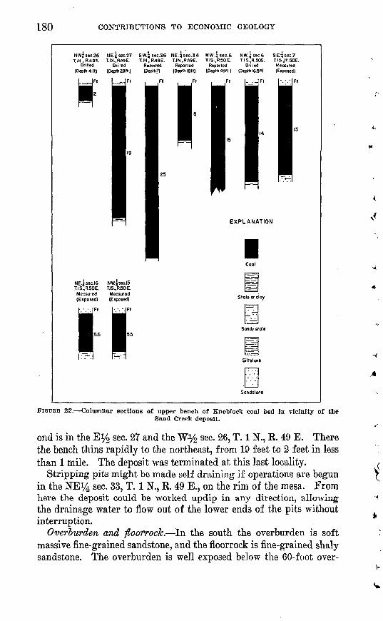
SAND CHEEK DEPOSIT
The Sand Creek deposit (pi. 22) is in sees. 26, 27, 28, 33, 34, and 35, T. 1 N., R. 49 E.; sees. 1, 2, and 12, T. 1 S., R, 49 E.; and sees. 5, 6,7, 8, 9,15,16,17, and 18, T. I S., R. 50 E., Ouster and Powder River Coun ties, Mont. It is 53 miles south of Miles City by way of U. S. Highway 212, and it is connected with that highway by 2 miles of clinker-sur faced county road that joins U. S. Highway 212 about 4 miles south of Volborg. It is a mesa-type deposit (fig. 16) having a relatively flat land surface that is particularly well suited for stripping. The strip- pable coal, the upper bench of the Knoblock bed, averages 12 feet thick, but is fairly lenticular. The northern part of the deposit is in the Mizpah coal field (Parker and Andrews, 1939, p. 115). The south ern part of the area is in the Coalwood coal field (Bryson, 1952).
Topography and land use. The deposit underlies the top of a high mesa which stands about 375 feet above U. S. Highway 212. The sides of the mesa nearest the highway are extremely steep. They are much dissected, however, and there are several practicable routes to the top. Most of the top of the mesa is flat or gently rolling, but a few hills, all less than 100 feet high, project above the general level. About three-fourths of the top of the mesa is cultivated, the re mainder is grazing land.
Upper "bench of the Knoblock coal bed. The Sand Creek deposit is in the upper bench of the Knoblock coal bed. No analyses of the coal in this deposit were available, but analyses of coal from the surround- ing region are given in table 3. Measurements of the thickness of the upper bench of the Knoblock bed in 3 exposures and 3 auger holes, supplemented by reports of coal in 2 water wells (fig. 22), indicate that the thickness of the deposit ranges from 19 feet in the northwest to 5.5 feet in the southeast and probably averages 12 feet. A report from 'a third water well indicates that the coal may attain a thickness of 25 feet in the SW*4 sec. 26, T. 1 N., R. 49 E.
In general the deposit thins gradually toward the east. At two places north of the county line, however, the deposit is somewhat thinner than.would be anticipated from the normal gradation. The first is in a locality for which the rate of general thinning would cause one to predict a thickness of 13 feet, but only 8 feet was reported by a rancher who measured the Knoblock upper bench there while digging the water well in the SE^NE^ sec. 34, T. 1 N., R. 49 E.2 The sec-
2 P. S. Parker and D. A. Andrews (1939, p. 115). state that 28 feet was reported to them as the thickness of coal In this well. However, the rancher contacted by the writers testifies that he, himself, dug through the coal into the underlying blue clay, and that 28 feet is the total depth of the well, IP which the coal is only 8 feet thick.
265154 54 3
180 CONTRIBUTIONS TO ECONOMIC GEOLOGY
NWjsec.26 NE.? sec.27 SW.Jsec.26 NE.3sec.34 NW.Jsec.6 NW.isec.6 SE.^sec.TTIN., R.49E. T.IN.,R.49E. T.IN.. R/»9E. T.IN..R.49E. T.IS..R50E. T.IS..R.50E. T.IS..R.50E.
Drilled Drilled Reported Reported Reported Drilled Meosured(Depth 4 It) (Depth 28(1) (Depth?) (DeplhlSfl) (Depth 45(1) (Depth 16.5ft) (Exposed)
NE.i sec.16 NW.isec.15T.IS..R.50E. T.IS.,R50E.Measured Measured(Exposed) (Exposed) Shale or do/
Sandy shale
FIGURE 22. Columnar sections of upper bench of Enoblock coal bed in vicinity of theSand Creek deposit.
ond is in the Ey2 sec. 27 and the Wy2 sec. 26, T. 1 N., R 49 E. There the bench thins rapidly to the northeast, from 19 feet to 2 feet in less than 1 mile. The deposit was terminated at this last locality.
Stripping pits might be made self draining if operations are begun in the NEi/4 sec. 33, T. 1 N., E. 49 E., on the rim of the mesa. From here the deposit could be worked updip in any direction, allowing the drainage water to flow out of the lower ends of the pits without interruption.
Overburden and ftoorrock. In the south the overburden is soft massive fine-grained sandstone, and the floorrock is fine-grained shaly sandstone. The overburden is well exposed below the 60-foot over-
STRIPPABLE COAL, CUSTER AND POWDER RIVER COUNTIES, MONT. 181
burden level and poorly exposed above this level. In the north the overburden is sandy shale or clay and the floor rock is blue clay. The only good exposures here Tire in cuttings from shallow auger holes. Gravel deposits that are probably less than 30 feet thick cap the higher land in the center of the area.
Reserves. The original reserves of strippable coal in the Sand Creek deposit total 68.9 million short tons. (See table 1.) More than half, 39.6 million tons, lies under less than 60 feet of overburden, and more than 90 percent, or 62.5 million tons, is under less than 90 feet of overburden.
FOSTER CREEK DEPOSITS
The Foster Creek deposits (pi. 23) are a group of five closely ad joining or overlapping deposits, so compactly located that they can be enclosed within a circle of 7 miles radius. These deposits are in the Terret, Flowers-Goodale, and Knoblock coal beds. Although the Ter- ret and Flowers-Goodale beds are relatively thin, they contain a large amount of strippable coal under less than 60 feet of overburden. A large part of the strippable area is nearly flat and is thus favorable for stripping operations.
The deposits are in Tps. 1 S., 1 and 2 N., Ks. 47 and 48 E., and T. 1 N., R. 46 E., Custer and Powder River Counties, Mont. The northern part of the area is 48 miles from Miles City by way of U. S. Highway 212 and is readily accessible from this highway over 5 miles of clinker- surfaced county road. The rest of the area can be reached from the Pumpkin Creek road or the Stacey road by way of several unimproved dirt roads, which in the western part of the area are very poor. The West deposit is also accessible by way of the Tongue River road and 10 miles of improved dirt road. The geology of this area has been described as part of the Ashland coal field (Bass, 1932, p. 83-86, 90- 94, and 98-102).
Topography and land use. The main surface feature of the area is the high ridge that divides the drainage of Foster Creek, an inter mittent tributary of the Tongue River, from that of Cameron, Lone Tree, and Flat Butte Creeks, intermittent tributaries of Pumpkin and Little Pumpkin Creeks. This divide curves around the head of Foster Creek, trending northward in the northern part of the area and west ward in the southern part. The slopes of the divide are eroded into a series of spurs and valleys, and the bottoms of these valleys, in turn, are cut by steep-sided gullies which range in depth from 5 to 60 feet. Where clinker is present, the ridge and its spurs are high, flat-topped, and intricately dissected; precipitous slopes descend from the clinker to the gentler valley slopes below. Where clinker is absent, the ridge and spurs are more smoothly rounded, although they are surmounted
182 CONTRIBUTIONS TO ECONOMIC GEOLOGY
in some places by small steep-sided peaks. On the gentle southern and eastern slopes of the divide the valleys have wide flat floors and gently rolling slopes that are modified locally by small hills or clinker- capped buttes. On the steeper northern and western slopes of the divide, however, the topography is more varied. The west slope, where it overlies the North deposit, is smooth and gently rolling in its upper part and consists of rounded ridges and shallow valleys in the lower part. On the north slope, where it overlies the West deposit, a north-trending ridge separates the rolling valley slopes of the West Fork of Foster Creek from the dissected uplands and flat valley floor of Widow Creek. This ridge is narrow and steep sided near the main divide, and its slopes are deeply gullied, but northward the ridge widens into a rolling upland surface. Elsewhere, the tributaries of Foster Creek have deeply dissected this side of the divide.
The deposits were terminated wherever they became too narrow to be economically strippable, or wherever the topography became ex tremely rough.
The average altitude of the strippable area is about 3,200 feet above sea level. The'relief of the area is about 500 feet, although locally it seldom exceeds 200 feet. Less than 5 percent of the area is under cul tivation ; the remainder is grazing land. Some of the higher uplands support a sparse growth of pine trees.
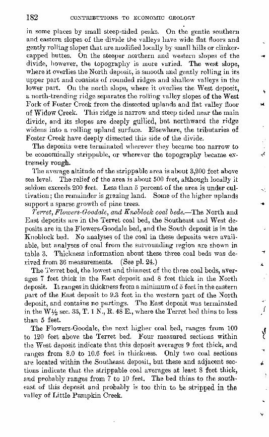
Terret, Flowers-Goodale^ and Knoblock coed beds. The North and East deposits are in the Terret coal bed, the Southeast and West de posits are in the Flowers-Goodale bed, and the South deposit is in the Knoblock bed. No analyses of the coal in these deposits were avail able, but analyses of coal from the surrounding region are shown in table 3. Thickness information about these three coal beds was de rived from 36 measurements. (See pi. 24.)
The Terret bed, the lowest and thinnest of the three coal beds, aver ages 7 feet thick in the East deposit and 8 feet thick in the North deposit. It ranges in thickness from a minimum of 5 feet in the eastern part of the East deposit to 9.3 feet in the western part of the North deposit, and contains no partings. The East deposit was terminated in the Wy2 sec. 33, T. 1 N., E. 48 E., where the Terret bed thins to less than 5 feet.
The Flowers-Goodale, the next higher coal bed, ranges from 100 to 120 feet above the Terret bed. Four measured sections within the West deposit indicate that this deposit averages 9 feet thick, and ranges from 8.0 to 10.6 feet in thickness. Only two coal sections are located within the Southeast deposit, but these and adjacent sec tions indicate that the strippable coal averages at least 8 feet thick, and probably ranges from 7 to 10 feet. The bed thins to the south east of this deposit and probably is too thin to be stripped in the valley of Little Pumpkin Creek.

STRIPPABLE COAL, CUSTER AND POWDER RIVER COUNTIES, MONT. 183
The Knoblock, the highest and thickest coal bed, lies from 80 to 100 feet above the Flowers-Goodale bed in most of the area; in the southern part of the Southeast deposit, however, this interval in creases to 130 feet. The coal bed averages about 13 feet thick through out the South deposit, and thins to the northwest. Although most of this coal is of good quality, four outcrops show thin layers of bone in the coal. Coal sections reported by Bass (1932, p. 92), but not included in this report, show dirty streaks in part of the Knoblock bed underlying the ridge in sees. 17,18,19,20, 29, and 30, T. 1 N., R. 47 E.; therefore that part of the bed is excluded from the deposit.
The coal beds in the Foster Creek area are essentially flat lying, for the dip generally does not exceed 20 feet per mile. The general direction of dip is northwestward, but there are many local variations. For example, a southward dip of about 20 feet per mile occurs in the southern part of the South deposit and in the northern part of the Southeast deposit.
The stripping pits on the northern and western slopes of the main divide can be made self draining; but those on the southern and east ern slopes, where the general dip of the coal is opposed to the slope of the land, will probably require pumping.
Overburden and floorrock. The overburden on the Terret coal bed consists of soft sandstone and shale, in equal amounts, and one thin lenticular bed of limestone. The overburden on the Flowers- Goodale bed is also soft sandstone and shale, but the soft sandstone is predominant, and it contains several thin beds of hard calcareous sandstone. The first 50 feet of the overburden of the Knoblock bed is soft sandstone and a few thin beds of shale. Above 50 feet, the over burden is soft massive sandstone which contains zones of hard cal careous sandstone and a 5-foot local bed of limestone. The floorrock of each of the coal beds is gray clay.
Overburden thicknesses of 0 to 60 feet, 60 to 90 feet, and 90 to 120 feet were mapped for each of the strippable coal beds. Because the interval between the coal beds is generally less than 120 feet, the 90- to 120-foot overburden of a lower bed in some places overlaps the 0 to 60-foot overburden of the next higher bed. (See map, pi. 23.) Thus, in the area of overlap, two coal beds can be uncovered by remov ing less than 120 feet of overburden. Although the total area of over lap is not large, the fact that the deposits do overlap may be useful in planning stripping operations from one to another.
Reserves. The five Foster Creek deposits contain a total of 465.8 million short tons of strippable coal within a radius of 7 miles. (See table 1.) Nearly half of the total reserves, 223.7 million tons, is in the 0 to 60-feet overburden thickness category. In this category, the Southeast deposit contains 18.7 million, the East deposit 30.4 million,
184 CONTRIBUTIONS TO ECONOMIC GEOLOGY
the West deposit 34.3 million, the North deposit 54.1 million, and the South deposit 86.3 million tons of strippable coal. The 2 largest deposits in this group, the south and north, are also the 2d and 3d largest of the 11 described deposits, both in total reserves and in reserves under less than 60 feet of overburden.
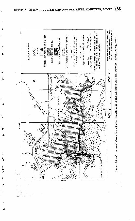
COTTONWOOD CREEK DEPOSIT
The Cotton wood Creek deposit (fig. 23) is in sees. 20, 21, 26, 27, 28, 29, 32, 33, 34, and 35, T. 1 S., R 48 E., Powder Eiver County, Mont. It is 60 miles south of Miles City by way of U. S. Highway 212, the Pumpkin Creek road, and the Stacey road. The deposit lies entirely within the Ashland coal field (Bass, 1932, p. 101-102).
The strippable coal is in the Knoblock bed and averages 14 feet in thickness. This is one of the smallest of the selected deposits, cover ing 1,118 acres, but it ranks third in average thickness of coal.
Topography and land use. The deposit lies at the head of Cotton- wood Creek, a northeastward-flowing intermittent tributary of Little Pumpkin Creek.
Where the deposit is overlain by less than 60 feet of overburden the ground is generally level or gently rolling, but along the southern and southeastern boundaries of the deposit the land rises abruptly to high clinker-capped hills. The southwestern part of the deposit is dissected by steep-walled ravines, one of which is more than 100 feet deep. The deposit is terminated in the NW^ sec. 35 and the NE}4 sec. 29, T. 1 S., R. 48 E., where it is too narrow to be stripped economically.
About 80 percent of the land overlying the deposit is used for pas^ ture, and the remainder is cultivated to raise small grains.
Knoblock coal bed. The Knoblock coal bed is 15 feet thick in the northwestern part of the deposit as measured by the power auger. As the coal in another auger hole 2 miles northwest of this 15-foot section shows a thickness of 14 feet, and as the Knoblock coal bed in this general area is rather persistent, probably the thickness changes little throughout the deposit. This assumption is further corrobo rated by the presence of thick clinkers along much of the coal outcrop. The average thickness of the strippable coal is therefore estimated to be 14 feet. The auger holes, as well as a partial section reported by Bass (1932, p. 102, pi. 37), show no partings in the coal. (See fig; 24.)
The coal bed dips westward at least 15 feet per mile. The overlying beds show local westerly dips of 2 or 3 degrees, but it is not known whether the locally steep dips are present in the coal bed. The slope of the land and the dip of the coal bed is such that the strip pits can probably be made self draining,
Analyses of coal from this deposit are not available, but analyses from the surrounding region are given in table 3.
R.4
8E
.
EX
PL
AN
AT
ION
Clin
ker
K«
NV
\|
Ove
rburd
en
less
th
an
60 f
eet
Ove
rburd
en
60-9
O f
eet
Ove
rbu
rde
n
90-1
20 f
eet
Ove
rburd
en
mo
re th
an
120
feet
Ou
tcro
p o
f ba
se of
coa
l bed,
dash
ed
where
in
ferr
ed
Appro
xim
ate
lim
it
of
clin
ker
« 1
5'D
x*-
6.4
'+R
A
uger
hole
S
urf
ace
exp
osu
re
Num
bers
re
fer
to t
hic
kness i
n fe
et
of
Knoblo
ck
coal
bed
as
measu
red b
v d
rilli
ng
(0),
report
ed (
R)
1000
0
5000
Feet
Bas
e an
d
geo
log
y m
od
ifie
d a
fte
r N
.W. B
os
s,T
he
Ash
lan
d c
oo
l fi
eld
: U
.S.G
eol.
Su
rvey
Bu
ll.8
3l-
B, 1932
S3
FIO
DRB
23.
Cott
onw
ood C
reek
dep
osit
of
stri
ppab
le c
oal
in t
he K
nobl
ock
coal
bed
, P
owde
r R
iver
Cou
nty,
Mon
t.0
0
Cn
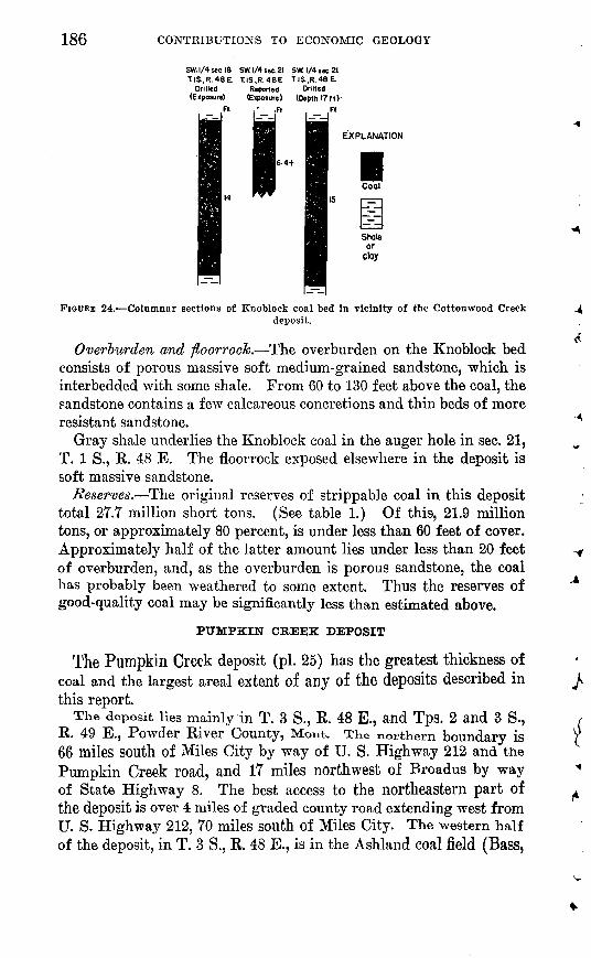
186 CONTRIBUTIONS TO ECONOMIC GEOLOGY
SW. 1/4 sec. 18 SW. 1/4 sec. 21 SW 1/4 sec. 21TIS..R.48E. TIS..R.48E. T.IS..R.48E.
Drilled Reported Drilled(Exposure) (Exposure) (Depth I7MV
,R . Ft
EXPLANATION
Cool
Shale or
cloy
FIGURE 24. Columnar sections of Knoblock coal bed In vicinity of the Cottonwood Creekdeposit.
Overburden and floorrock. The overburden on the Knoblock bed consists of porous massive soft medium-grained sandstone, which is interbedded with some shale. From 60 to 130 feet above the coal, the sandstone contains a few calcareous concretions and thin beds of more resistant sandstone.
Gray shale underlies the Knoblock coal in the auger hole in sec. 21, T. 1 S., R. 48 E. The floorrock exposed elsewhere in the deposit is soft massive sandstone.
Reserves. The original reserves of strippable coal in this deposit total 27.7 million short tons. (See table 1.) Of this, 21.9 million tons, or approximately 80 percent, is under less than 60 feet of cover. Approximately half of the latter amount lies under less than 20 feet of overburden, and, as the overburden is porous sandstone, the coal has probably been weathered to some extent. Thus the reserves of good-quality coal may be significantly less than estimated above.
PUMPKIN CREEK DEPOSIT
The Pumpkin Creek deposit (pi. 25) has the greatest thickness of coal and the largest areal extent of any of the deposits described in this report.
The deposit lies mainly in T. 3 S., R. 48 E., and Tps. 2 and 3 S., R. 49 E., Powder River County, Mont. TKe northern boundary is 66 miles south of Miles City by way of U. S. Highway 212 and the Pumpkin Creek road, and 17 miles northwest of Broadus by way of State Highway 8. The best access to the northeastern part of the deposit is over 4 miles of graded county road extending west from U. S. Highway 212, 70 miles south of Miles City. The western half of the deposit, in T. 3 S., R. 48 E., is in the Ashland coal field (Bass,

STRIPPABLE COAL, CUSTER AND POWDER RIVER COUNTIES, MONT. 187
1932, p. 104-105) and the eastern half, in Tps. 2 and 3 S., R. 49 E., is in the Coalwood coal field (Bryson, 1952).
Topography and land use. The prominent features of the area are the valley formed by the northward-flowing Pumpkin Creek, and, parallel to it on the east, the high divide between Pumpkin Creek and the eastward-flowing tributaries of Mizpah Creek. The larger part of the divide is gently sloping and smoothly rolling, but its slopes are dissected by roughly parallel intermittent streams, which trend southeastward on the east.side of the divide, and northwestward on the west side. The valley profiles of most of these streams are; generally V-shaped in the upper reaches, where some of the streams have cut steep-walled gulches 20 to 60 feet deep; but they are more U-shaped downstream, where the valley floors become wider and gently rolling. The higher central part of the divide in the north eastern corner of sec. 33, T. 2 S., R. 49 E., is dominated by two buttes that rise to slightly more than 300 feet above the rather flat-lying coal bed. Southward, the crest of the divide descends to about 180 feet above the coal. The altitude.of the strippable area averages about 3,400 feet above sea level; the maximum relief is about 400 feet.
The flat valley floor formed by the flood plain of Pumpkin Creek is a quarter- to a half-mile wide. Southeast of this flood plain the land rises to the rolling uplands between Six Mile Creek and Pumpkin Creek, gently at first, then more steeply. West of the flood plain the land rises by steps through a series of four dissected terraces which are 25 to 50 feet apart. From the terraces, the surface rises grad ually for 2 miles to the steeply rising slopes of the uplands to the west. The streams trend southeastward on this side of Pumpkin Creek, and their valley profiles are similar to those elsewhere in the area.
The strippable area is roughly S-shaped and lies on the west side of Pumpkin Creek in T. 3 S., R. 48 E., then swings across the valley of that stream and continues northeastward on the west side of the Pumpkin Creek-Mizpah Creek drainage divide to about the middle of T. 2 S., R. 49 E., and then swings south for about 4 miles on the east side > d: the divide. At the east end, in sec. 3, T. 3 S., R. 49 E., the strippable area narrows to such an extent that economic opera tions would be impossible; it is possible that the area might be ex tended somewhat to the south and northwest, but it is doubtful if conditions would be found as favorable as those in the area covered by the map (pi. 25). In the southern part of T. 2 S., R. 48 E., for example, the terrain is progressively rougher toward the northwest, and in the southwestern part of T. 3 S., R. 49 E., the coal is known to thin southward.
265154 54 4
188 CONTRIBUTIONS TO ECONOMIC GEOLOGY
In parts of sees. 10 and 23, T. 3 S., R. 48 E., and 'sees. 17 and 18, T. 3 S., R. 49 E., the coal bed has been eroded to such an extent that it is too thin for economic stripping.
About 95 percent of the land is used for grazing and the remainder is cultivated.
Sawyer coal bed. The strippable coal is in the Sawyer coal bed. This bed was sampled at the Ash Creek mine in sec. 35, T. 2 S., R. 49 E., by the U. S. Bureau of Mines. The analysis, which is given in table 3 (laboratory no. C-Y5916), shows that on an "as-received" basis, the coal contains 35.2 percent moisture, 30.6 percent volatile matter, 30.2 percent fixed carbon, 10 percent ash, and 0.3 percent siilf ur. The heating value of the coal is 6,930 Btu. The coal is thus lignite in rank.
Auger-hole logs and water-well reports furnished most of the information concerning the coal (fig. 25), as no complete sections of the bed are exposed within the strippable area. Although shale and clay partings are found near the top and bottom of the bed, the main part of the bed generally *is hard, clean coal. Any coal sep arated from this main bench by a parting more than 6 inches thick was not included as part of the deposit. The thickness of the deposit ranges from 15 feet to 33 feet and probably averages 25 feet. The thickest part of the deposit is in the north half of T. 3 S., Rs. 48 and 49 E., and the south half of T. 2 S., R. 49 E.
Reports of thick coal in water wells in the NE'^4 SW*4 sec. 8, the NW% NWi/4 sec. 15, and the NW% SW% sec. 28, T. 3 S., R. 48 E., indicate that the coal may locally attain thicknesses of more than 33 feet in sec. 8, more than 55 feet in sec. 15, and more than 56 feet in sec. 28. However, drilling by power auger in the vicinity of the water well in sec. 15 showed only 28 feet of coal instead of the 55 feet re ported, which casts considerable doubt on the accuracy of the other two reports.
The Sawyer bed dips west or west-northwest from 40 feet per mile in the east to 15 feet per mile in the west, except in the north half of T. 3 S., R. 48 E., where the bed dips to the southwest as much as 30 feet per mile. The dip favors the laying out of self-draining strip pits along the west side of the divide in Tps. 2 and 3 S., R. 49 E. However, pumping may be required to drain the pits on the east side of the divide where the dip is opposed to the direction of surface drainage, and in that part of T. 3 S., R. 48 E. where the coal lies below the level of Pumpkin Creek, the only drainage outlet.
The lower bed encountered in four water wells in the south half T. 3 S., Rs. 48 and 49 E. (fig. 25) is probably the A bed mapped by Bass (1932) in the Ashland coal field. In these wells it ranges in thickness from 8 to 12 feet and is separated from the Sawyer bed by

STRIPPABLE COAL, CUSTER AND POWDER RIVER COUNTIES, MONT. 189
SE.lsec.SS NE.tsec26 SW.|iec.22 SW.l-sec.33 SE.^lic. 6 NW.isec 20 'sw. ^sec.18 SE.jsoc.H SW.J-sec:l4T.2SVR.49E. T.2S.R.49E. T.2S., R.49E. T.2S..R.49E. T.3S..R.49E. T.3S..R.49E. T.3S., R. 49E. T.3S., R.48E. T.3S..R.48E.
Drilled Drilled Drill.d ' Drill,d Drilled Drilled Drilled Drilled . Drilled(Eiposura) (Depth 12ft) (Eipoaure) (Depth 29ft) (Depth 17ft) (Exposure) (Depth 29tt) (Depth 27ft) (Depth 18ft)
NW.is.c. IS Center sec.10 NW.iiec.32 NE.ijec.33 NE.iitc.26 NW.ii.c.36 SW Jiec 30T.3S..R.48E. T.3S..R.48E. T.3S..R. 48E. T.3S..R.48E. T.3S,R.48E. T.3S.,R.48E. T.3S..R.49E.
(DepthlSft) (Exposure) (Depthll5fl) (Depthl37ft) (Depth 42ft) (Depth 22fl) (Depth 43ft)
EXPLANATION
Shale or clay
Sandy shale
FIGUKE 25. Columnar sections of Sawyer and A coal beds in vicinity of Pumpkin Creek deposit. (Sections not marked otherwise are of Sawyer coal bed.)
190 CONTRIBUTIONS TO ECONOMIC GEOLOGY
9 to 35 feet of clay and shale. The A bed was not considered in esti mating the reserves of strippable coal because of the lack of infor mation about probable variations in thickness of both the coal and the interval separating it from the Sawyer bed. It is possible that the A bed and the Sawyer bed coalesce in the south half of T. 2 S., R 49 E. and the north half of T. 3 S., Es. 48 and 49 E. This coales cence would account for the increase in thickness of the Sawyer bed in these areas. ;
Overburden and floorrock- Most of the overburden on the Sawyer bed is soft, gray, silty shale. The remainder consists of yellow- brown poorly cemented fine-grained sandstone, which is locally re sistant due to the presence of calcareous cement, and a few discon tinuous thin beds of limestone less than 3 feet thick. Three thin coal beds are present in the overburden at the northeastern part of the area, but two of them disappear to the south. The terrace gravels on the west side of Pumpkin Creek probably attain a thickness of 15 feet.
The floorrock consists of gray sandy clay, which generally weathers light yellowish gray to form a striking contrast with the drab color of the overburden.
Reserves. The original reserves of strippable coal in the Pumpkin Creek deposit total 839.5 million short tons (table 1), of which 287.9 million tons, about a third, is under less than 60 feet of overburden. Approximately 70 percent of the total, 591.6 million tons, lies under less than 90 feet of overburden.
HOME CREEK DEPOSIT
The Home Creek deposit (fig. 26) is small; it contains a total of but 41.1 million tons of strippable coal in an area of 2,905 acres.
The deposit is in sees. 33, 34, and 35, T. 2 S., R 46 E., and sees. 3,4, 5,6,7, 8, 9,17, and 18, T. 3 S., R. 46 E., Powder Eiver County, Mont. It is 77 miles from Miles City by way of the Stacey road and U. S. Highway 212, and 84 miles by way of Ashland and the Tongue River road. The Stacey route is shorter, but it includes 30 miles of rough, partly unsurfaced, and locally steep county road. Colstrip, the nearest railhead, is about 45 miles northwest over good graveled roads. The area was previously described as part of the Ashland coal field (Bass, 1932, p. 88-89).
Topography and land use. The deposit underlies both the valley
of the East Fork of Otter Creek and the broad divide that trendssouthwest between the East Fork of Otter Creek and Home Creek.
On the north side of the valley the terrain rises so steeply that onlyin a narrow strip is the coal under less than 120 feet of cover and for that reason stripping operations in the area are not feasible. On
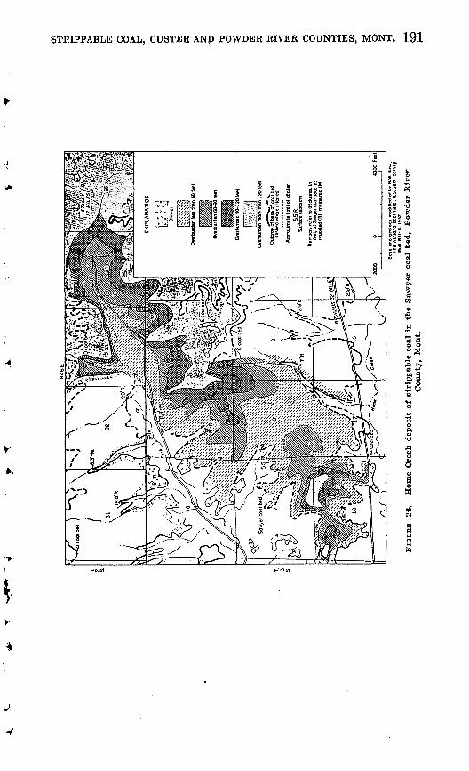
hd J3D g
O
Th
e A
shlo
nd
co
al
fie
ld:
U.S
.Geo
l. S
urv
B
ull
. S
3I-
B.
1932
FIG
UR
E 2&
. H
om
e C
reek
dep
osit
of
strl
ppab
le c
oal
in t
he S
awye
r co
al b
ed,
Pow
der
Riv
erC
ount
y,
Mon
t.
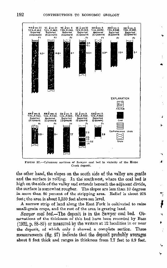
192 CONTRIBUTIONS TO ECONOMIC GEOLOGY
.NW.Jsec.32 SE. isec.3l NE.^sec.6 SE.isec.32 NW.^sec.5 NW.isec.5 SW4sec.5T2S..R46E. T.2S..R.46E. T.3S..R.46E. T.2S..R.46E. T.3S..R46E. T3S..R.46E. T.3S..R.46E.
Reported Reported Reported Reported Measured Reported Reported .(Exposure) (Exposure) (Exposure) (Exposure) (Exposure) (Exposure) (Exposure)
Ft
14.8-t
Ft
75+ I 5 +
EXPLANATION
NW.isec.8 NW.49ec.l8 SW.isec.9 SE.isec.9 NW.^sec.lST3S..R.46E. T.3S..R.46E. T3S..R46E. T.3S.,R.46E. T2S..R.46E
Reported Measured Reported Reported Reported(Exposure) (Exposure) (Exposure) (Exposure) . (Exposure)
FIGDBK 2Y. Columnar sections of Sawyer coal bed in vicinity of the HomeCreek deposit.
the other hand, the slopes on the south side of the valley are gentle and the surface is rolling. In the southwest, where the coal bed is high on the side of the valley and extends beneath the adjacent divide, the surface is somewhat rougher. The slopes are less than 10 degrees in more than 80 percent of the stripping area. Relief is about 275 feet; the area is about 3,350 feet above sea level.
A narrow strip of land along the East Fork is cultivated to raise small-grain crops, and the rest of the area is grazing land.
Sawyer coal ~bed. The deposit is in the Sawyer coal bed. Ob servations of the thickness of this bed have been recorded by Bass (1932, p. 88-89) or measured by the writers at 12 localities in or near the deposit, of which only 5 showed a complete section. Thesemeasurements (fig. 27) indicate that the deposit probably averages about 8 feet thick and ranges in thickness from 7.7 feet to 8.9 feet.
V
V

STRIPPABLE COAL, CUSTER AND POWDER RIVER COUNTIES, MONT. 193
The coal bed thins in a general southeastward direction. Because of this thinning, the deposit was terminated in sees. 4, 9, and 17, T. 3 S., R. 46 E. In sec. 32, T. 2 S., R. 46 E., just outside the strippable deposit, the coal bed thickens from 9.0 feet to a little more than 16.3 feet in a distance of less than a mile. Such a change there suggests that the deposit itself may vary in thickness more widely than was observed.
Partings of carbonaceous shale are locally present in the upper foot of the Sawyer coal bed. The thicknesses given above and on the map (fig. 26) exclude this impure layer and refer to the thickness of minable coal.
The coal bed dips toward the southwest at the rate of about 30 feet per mile. As the dip is nowhere opposed to the slope of the ground, strip pits could easily be so laid out as to drain into the creeks with out interruption over most of the area. In sees. 33 and 34, however, where the coal underlies the East Fork of Otter Creek, the dip is downstream and is less than the gradient of the stream.
Overburden and ftoorrock. The overburden on the Sawyer bed is shale and fine-grained sandstone in the lower 50 feet and grades up ward into siltstone and poorly consolidated sandstone. The sand stone contains local concentrations of calcareous cement and ferrugi nous or calcareous concretions. The floorrock, where observed, is clay.
Reserves. The original reserves of strippable coal in the Home Creek deposit total 41.1 million short tons. (See table 1.) About half of this amount, 19.7 million, lies under less than 60 feet of over burden, and about three-fourths, 31.2 million, lies under less than 90 feet of overburden.
COOK CREEK DEPOSIT
The Cook Creek deposit (fig. 28) is the smallest of the 11 deposits described in this bulletin, both in area and in amount of strippable reserves.
The deposit is in sees. 20, 21, 28, 29, 30. 31, and 32, T. 2 S., R. 45 E., Powder Ijtiver County, Mont. It is 83 miles south of Miles City by way of the Tongue River road and State Route 8, and is connected with that highway by an unimproved dirt road, 4 miles long, which joins State Route 8 about 4 miles east of Ashland. Colstrip, the near est railhead, is about 45 road miles northwest of this deposit over good graveled roads. This area was previously described as part of the Ashland coal field (Bass, 1932, p. 79-81).
Topography and land use. The area lies about 3,375 feet above sea level and is a part of the drainage basin of Cook Creek, an intermit-
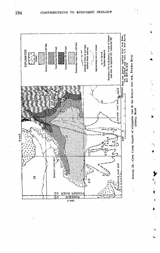
R.4
5E
.co
Num
bers
ref
er t
o th
ickn
ess,
in
feet
, of
Saw
yer
coal
bed
; as
rep
orte
d (R
), m
easu
red
(M)
50
00
F«
et
Bas
e on
<j ge
olog
y m
od
ifie
d
offer
N.W
. B
oss
, J
The
A
shla
nd
co
al
fie
ld:
U.S
. O
eol.
Sur
vey
Bul
l. 8
31
-B, 1
932
28._
Coo
k C
reek
dep
osit
of
stri
ppab
le c
oal
in t
he S
awye
r co
al b
ed,
Pow
der
Riv
er
Cou
nty,
Mon
t.
o o
w
o
f
o
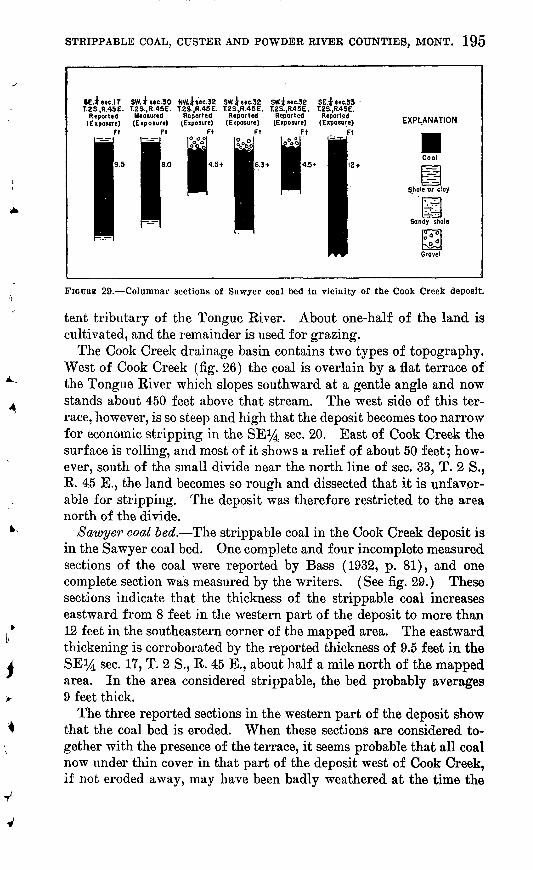
STRIPPABLE COAL, CUSTER AND POWDER RIVER COUNTIES, MONT. 195
SE.itec.17 SW.isec.30 Nwisec.32 SW.isec.32 SWtisec.32T.2S..R.45E. T.2S..R.45E. T.28..R.45E. T2S..R.45E. T.2S..R.4SE.
Reported Meosured - " J ~ ' ' ------(Exposure) (Exposure)
Ft Ft
SE.tsec.33 T.2S..R.45E.
Reported (Exposure)
Ft
EXPLANATION
FIGURE 29. Columnar sections of Sawyer coal bed In vicinity of the Cook Creek deposit.
tent tributary of the Tongue River. About one-half of the land is cultivated, and the remainder is used for grazing.
The Cook Creek drainage basin contains two types of topography. West of Cook Creek (fig. 26) the coal is overlain by a flat terrace of the Tongue River which slopes southward at a gentle angle and now stands about 450 feet above that stream. The west side of this ter race, however, is so steep and high that the deposit becomes too narrow for economic stripping in the SE^ sec. 20. East of Cook Creek the surface is rolling, and most of it shows a relief of about 50 feet; how ever, south of the small divide near the north line of sec. 33, T. 2 S., R. 45 E., the land becomes so rough and dissected that it is unfavor able for stripping. The deposit was therefore restricted to the area north of the divide.
/Sawyer coal bed. The strippable coal in the Cook Creek deposit is in the Sawyer coal bed. One complete and four incomplete measured sections of the coal were reported by Bass (1932, p. 81), and one complete section was measured by the writers. (See fig. 29.) These sections indicate that the thickness of the strippable coal increases eastward from 8 feet in the western part of the deposit to more than 12 feet in the southeastern corner of the mapped area. The eastward thickening is corroborated by the reported thickness of 9.5 feet in the SEi,4 sec. 17, T. 2 S., R. 45 E., about half a mile north of the mapped area. In the area considered strippable, the bed probably averages 9 feet thick.
The three reported sections in the western part of the deposit show that the coal bed is eroded. When these sections are considered to gether with the presence of the terrace, it seems probable that all coal now under thin cover in that part of the deposit west of Cook Creek, if not eroded away, may have been badly weathered at the time the
196 CONTRIBUTIONS TO ECONOMIC GEOLOGY
terrace was deposited. The presumed maximum thickness of the ter race in this area is about 30 feet; therefore all coal under 30 feet or less of cover is excluded from the deposit, though future drilling may possibly show that some, at least, is recoverable.
: The stripping pits could be made self draining because the deposit i;s high above the adjacent streams and dips about 15 feet per mile downslope in a southeastward direction.
No analyses of the coal in this deposit were' available, but analyses of coal from the surrounding region are given in table 3.
Overburden and floorrock. The writers measured a section of the Sawyer coal bed and its overburden at a location 6 miles southeast of the deposit. Clay lies immediately above and below the coal bed j the lower 50 feet of the overburden consists of about two-thirds soft shale and one-third soft fine-grained sandstone; the next 70 feet con sists of a soft, fine- to medium-grained sandstone interbedded with a few thin beds of hard flaggy ferruginous sandstone.
Alluvial gravel, probably ranging from 10 to 30 feet in thickness, occupies the terrace west of Cook Creek.
Reserves. The original reserves of strippable coal in the Cook Creek deposit total 17.6 million short tons. (See table 1.) Nearly 60 percent of this amount, 10.4 million tons, lies under less than 60 feet of overburden in a compact area of about 1 square mile; 15.1 million tons, or 85 percent of the total, lies under less than 90 feet of over burden.

REFERENCES CITED
Andrews, D. A., Lambert, G. S., and Stose, G. W., 1944, Geologic map of Montana,scale 1: 500,000: U. S. Geol. Survey Oil and Gas Inv. Prelim, map 25.
Averitt, Paul, and Berryhill, L. R., 1950, Coal resources of the United States:U. S. Geol. Survey Circ. 94.
Bass, N. W., 1932, The Ashland coal field, Rosebud, Powder River, and OusterCounties, Mont.: U. S. Geol. Survey Bull. 831-B.
Bituminous Coal Institute, 1950, Bituminous coal annual: Washington, D. C. Bowen, C. F., 1912, The Baker lignite field, Ouster County, Mont.: U. S. Geol.
Survey Bull. 471, p. 202-206. Bryson, R. P., 1952, The Coalwood coal field, Powder River County, Mont.: U. S.
Geol. Survey Bull. 973-B, p. 23-106. Collier, A. J., and Smith, C. D., 1909, The Miles City coal field, Mont.: U. S. GeoL
Survey Bull. 341-A, p. 36-61. Combo, J. X., and others, 1949, Coal resources of Montana: U. S. Geol. Survey
Circ. 53. Combo, J. X., Holmes, C. N., and Christner, H. R., 1950, Map showing coal re-
sources of Montana, scale 1: 500,000: U. S. Geol. Survey Coal Inv. map C-2. Koenig, R. P., 1950, Economics and techniques of strip coal mining: Colo.
School Mines Quart., v. 45, no. 28. Parker, F. S., and Andrews, D. A., 1939, The Mizpah coal field, Ouster County,
Mont.: U. S. Geol. Survey Bull. 906-0, p. 85-133. Pierce, W. G., 1936, The Rosebud coal field, Rosebud and Ouster Counties, Mont.:
U. S. Geol. Survey Bull. 847-B, p. 43-120. Tuttle, A. H., and Newell, T. R., 1943, Summary of records of surface waters
of Missouri and St. Mary River Basins in Montana, 1881-1938: U. S. Geol.Survey Water Supply Paper 917.
United States Bureau of Mines, 1932, Analyses of Montana coals: U. S. Bur.Mines Tech. Paper 529.
1951, Mineral Market Report No. 2032. United States Geological Survey, 1940-47, Surface Water Supply of the United
States, pt. 6, Missouri River Basin: Water Supply Papers 896, 926, 956, 976,1006, 1036, 1056, and 1086.
197
Related Documents


