TECHNICAL APPENDIX DRAFT AUGUST 2020 M-NCPPC Montgomery County Planning Department 2425 Reedie Drive Wheaton, MD 20902 MontgomeryPlanning.org

Welcome message from author
This document is posted to help you gain knowledge. Please leave a comment to let me know what you think about it! Share it to your friends and learn new things together.
Transcript
Appendix A: Strengths, Weaknesses, Opportunities and Threats (SWOT)
T E C H N I C A L A P P E N D I X D R A F T
A U G U S T 2 0 2 0
M-NCPPC Montgomery County Planning Depar tment
2425 Reedie Dr ive Wheaton, MD 20902
MontgomeryPlanning.org
Ashton Village Center Sector Plan Technical Appendix Draft – August 2020 v2 1
Table of Contents Appendix A: Strengths, Weaknesses, Opportunities and Threats (SWOT) ................................................................2
Appendix B: Demographic Information ......................................................................................................................5
Appendix C: Employment ........................................................................................................................................ 14
Appendix D: Sandy Spring/Ashton Housing Growth Pattern .................................................................................. 17
Appendix E: Parks, Open Space and Trails .............................................................................................................. 26
Appendix F: Transportation ..................................................................................................................................... 40
Appendix G: Sandy Spring/Ashton Rural Village Overlay Zone Analysis ................................................................. 43
Appendix H: Sandy Spring/Ashton Rural Village Overlay Zone Current and Former Text ...................................... 54
Appendix I: Sandy Spring/Ashton Rural Village (SSA) Overlay Zone Proposed Revision ......................................... 61
Appendix J: County Growth Policy and Its Impact on the Ashton Village Center Sector Plan ................................ 62
Appendix K: Density Calculations ............................................................................................................................ 64
Technical Appendix Draft – August 2020
Ashton Village Center Sector Plan Technical Appendix Draft – August 2020 v2 2
Appendix A: Strengths, Weaknesses, Opportunities and Threats (SWOT)
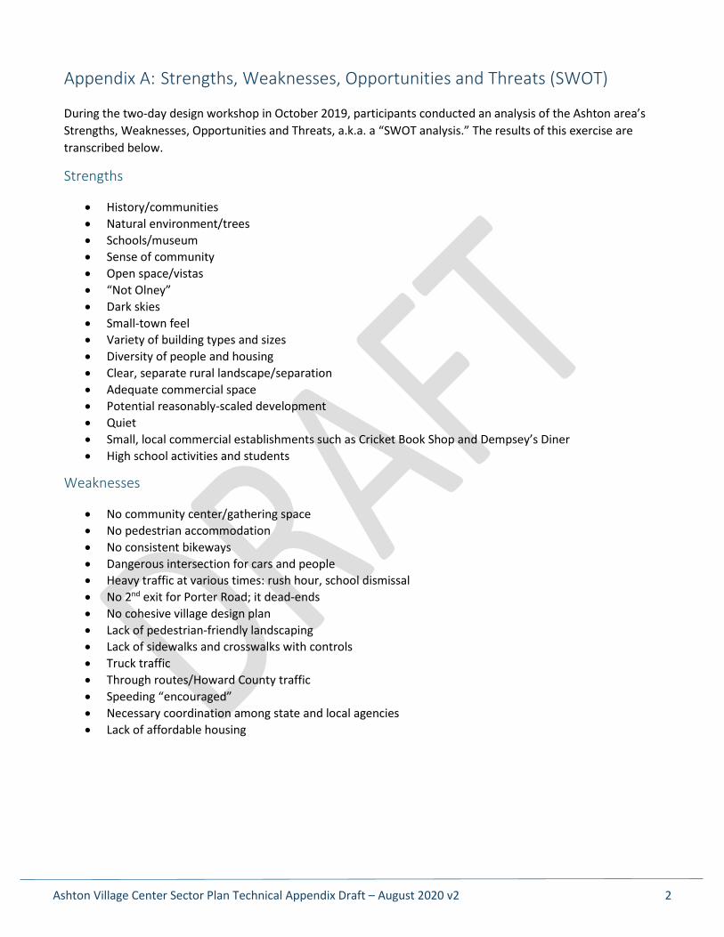
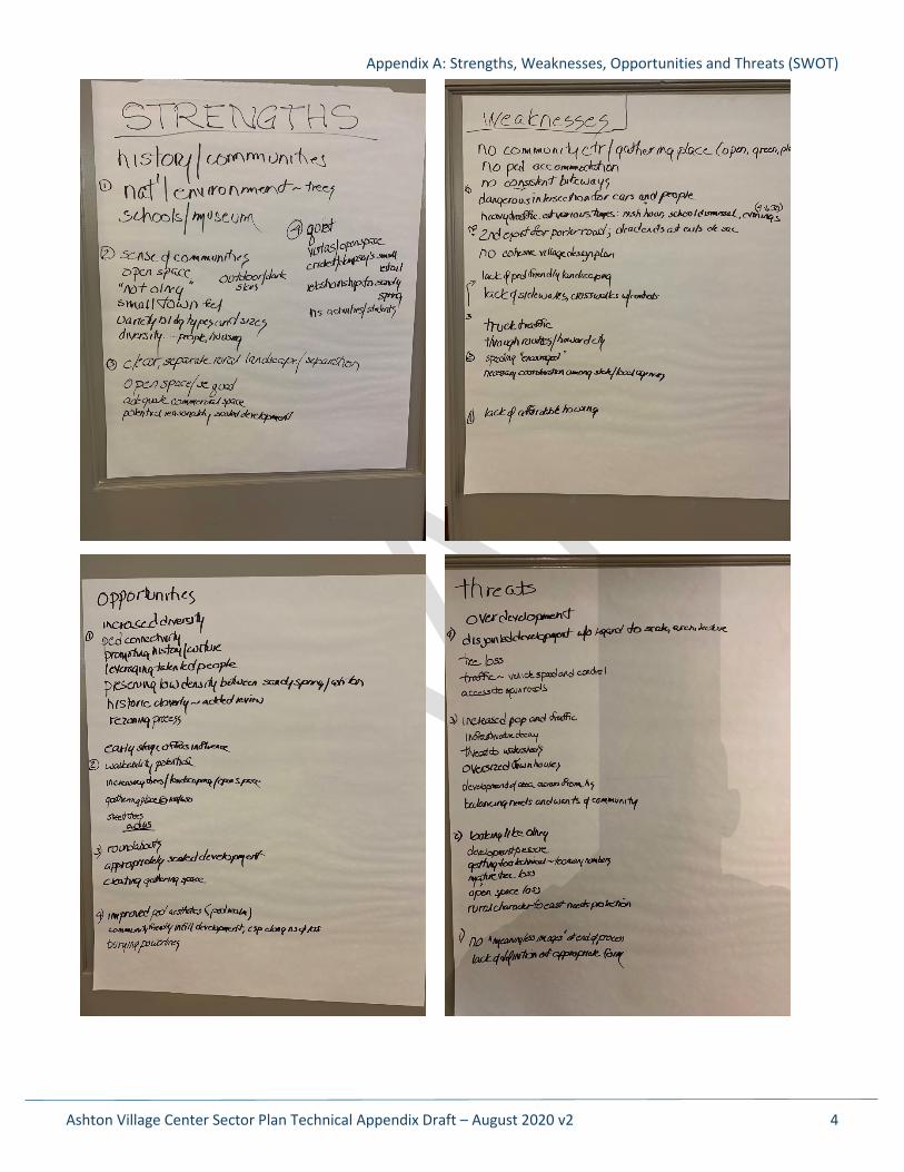
During the two-day design workshop in October 2019, participants conducted an analysis of the Ashton area’s Strengths, Weaknesses, Opportunities and Threats, a.k.a. a “SWOT analysis.” The results of this exercise are transcribed below.
Strengths
• History/communities • Natural environment/trees • Schools/museum • Sense of community • Open space/vistas • “Not Olney” • Dark skies • Small-town feel • Variety of building types and sizes • Diversity of people and housing • Clear, separate rural landscape/separation • Adequate commercial space • Potential reasonably-scaled development • Quiet • Small, local commercial establishments such as Cricket Book Shop and Dempsey’s Diner • High school activities and students
Weaknesses
• No community center/gathering space • No pedestrian accommodation • No consistent bikeways • Dangerous intersection for cars and people • Heavy traffic at various times: rush hour, school dismissal • No 2nd exit for Porter Road; it dead-ends • No cohesive village design plan • Lack of pedestrian-friendly landscaping • Lack of sidewalks and crosswalks with controls • Truck traffic • Through routes/Howard County traffic • Speeding “encouraged” • Necessary coordination among state and local agencies • Lack of affordable housing
Appendix A: Strengths, Weaknesses, Opportunities and Threats (SWOT)
Ashton Village Center Sector Plan Technical Appendix Draft – August 2020 v2 3
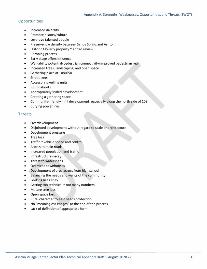
Opportunities
• Increased diversity • Promote history/culture • Leverage talented people • Preserve low density between Sandy Spring and Ashton • Historic Cloverly property ~ added review • Rezoning process • Early stage offers influence • Walkability potential/pedestrian connectivity/improved pedestrian realm • Increased trees, landscaping, and open space • Gathering place at 108/650 • Street trees • Accessory dwelling units • Roundabouts • Appropriately scaled development • Creating a gathering space • Community-friendly infill development, especially along the north side of 108 • Burying powerlines
Threats
• Overdevelopment • Disjointed development without regard to scale or architecture • Development pressure • Tree loss • Traffic ~ vehicle speed and control • Access to main roads • Increased population and traffic • Infrastructure decay • Threat to watersheds • Oversized townhouses • Development of area across from high school • Balancing the needs and wants of the community • Looking like Olney • Getting too technical ~ too many numbers • Mature tree loss • Open space loss • Rural character to east needs protection • No “meaningless images” at the end of the process • Lack of definition of appropriate form
Appendix A: Strengths, Weaknesses, Opportunities and Threats (SWOT)
Ashton Village Center Sector Plan Technical Appendix Draft – August 2020 v2 4
Ashton Village Center Sector Plan Technical Appendix Draft – August 2020 v2 5
Appendix B: Demographic Information
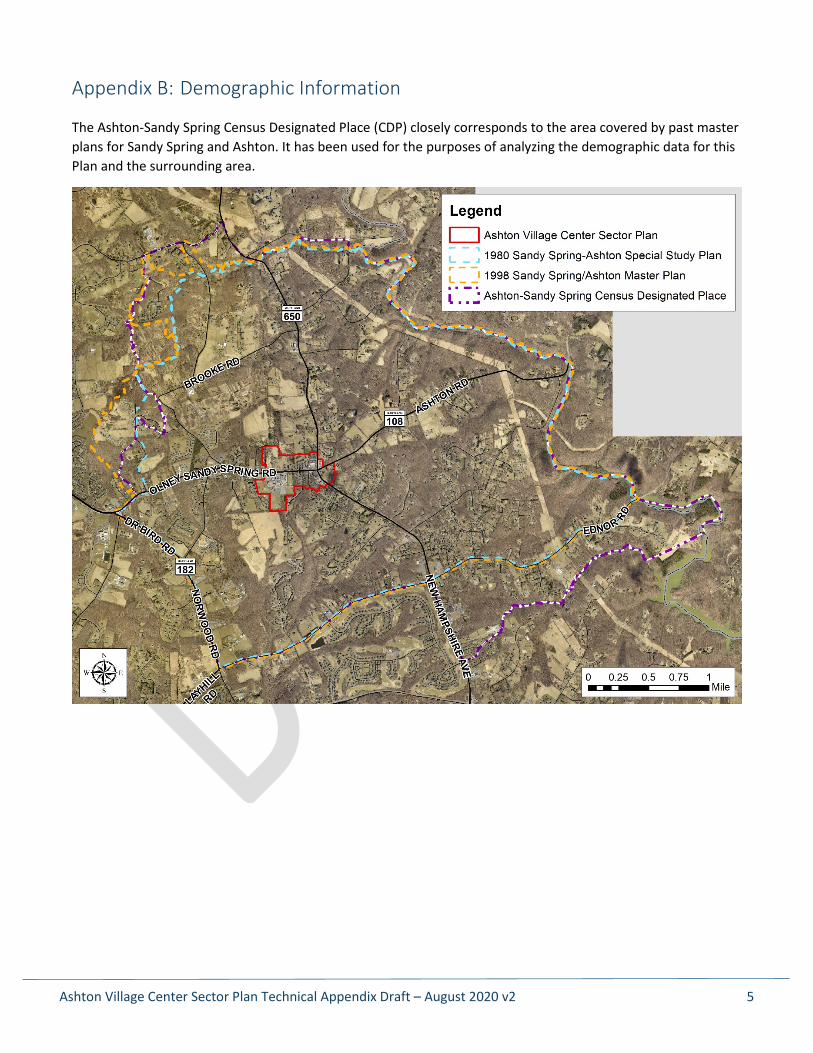
The Ashton-Sandy Spring Census Designated Place (CDP) closely corresponds to the area covered by past master plans for Sandy Spring and Ashton. It has been used for the purposes of analyzing the demographic data for this Plan and the surrounding area.
Appendix B: Demographic Information
Ashton Village Center Sector Plan Technical Appendix Draft – August 2020 v2 6
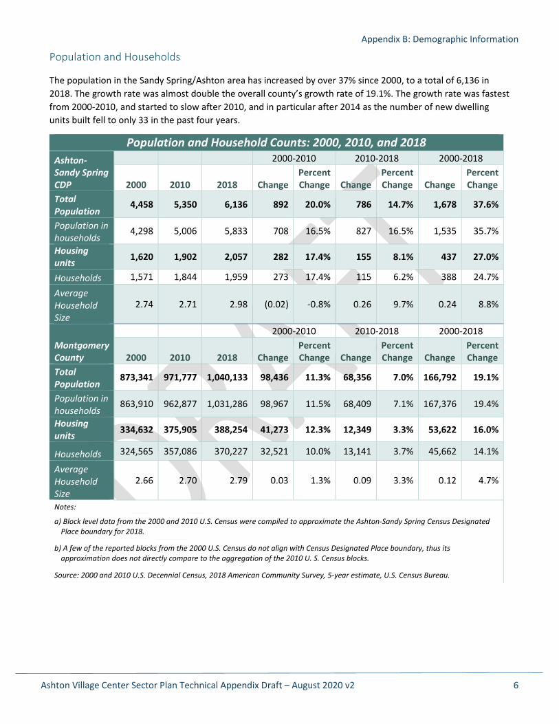
Population and Households
The population in the Sandy Spring/Ashton area has increased by over 37% since 2000, to a total of 6,136 in 2018. The growth rate was almost double the overall county’s growth rate of 19.1%. The growth rate was fastest from 2000-2010, and started to slow after 2010, and in particular after 2014 as the number of new dwelling units built fell to only 33 in the past four years.
Population and Household Counts: 2000, 2010, and 2018 Ashton-Sandy Spring CDP
2000-2010 2010-2018 2000-2018
2000 2010 2018 Change Percent Change Change
Percent Change Change
Percent Change
Total Population
4,458 5,350 6,136 892 20.0% 786 14.7% 1,678 37.6%
Population in households
4,298 5,006 5,833 708 16.5% 827 16.5% 1,535 35.7%
Housing units 1,620 1,902 2,057 282 17.4% 155 8.1% 437 27.0%
Households 1,571 1,844 1,959 273 17.4% 115 6.2% 388 24.7%
Average Household Size
2.74 2.71 2.98 (0.02) -0.8% 0.26 9.7% 0.24 8.8%
Montgomery County
2000-2010 2010-2018 2000-2018
2000 2010 2018 Change Percent Change Change
Percent Change Change
Percent Change
Total Population
873,341 971,777 1,040,133 98,436 11.3% 68,356 7.0% 166,792 19.1%
Population in households
863,910 962,877 1,031,286 98,967 11.5% 68,409 7.1% 167,376 19.4%
Housing units 334,632 375,905 388,254 41,273 12.3% 12,349 3.3% 53,622 16.0%
Households 324,565 357,086 370,227 32,521 10.0% 13,141 3.7% 45,662 14.1%
Average Household Size
2.66 2.70 2.79 0.03 1.3% 0.09 3.3% 0.12 4.7%
Notes:
a) Block level data from the 2000 and 2010 U.S. Census were compiled to approximate the Ashton-Sandy Spring Census Designated Place boundary for 2018.
b) A few of the reported blocks from the 2000 U.S. Census do not align with Census Designated Place boundary, thus its approximation does not directly compare to the aggregation of the 2010 U. S. Census blocks.
Source: 2000 and 2010 U.S. Decennial Census, 2018 American Community Survey, 5-year estimate, U.S. Census Bureau.
Appendix B: Demographic Information
Ashton Village Center Sector Plan Technical Appendix Draft – August 2020 v2 7
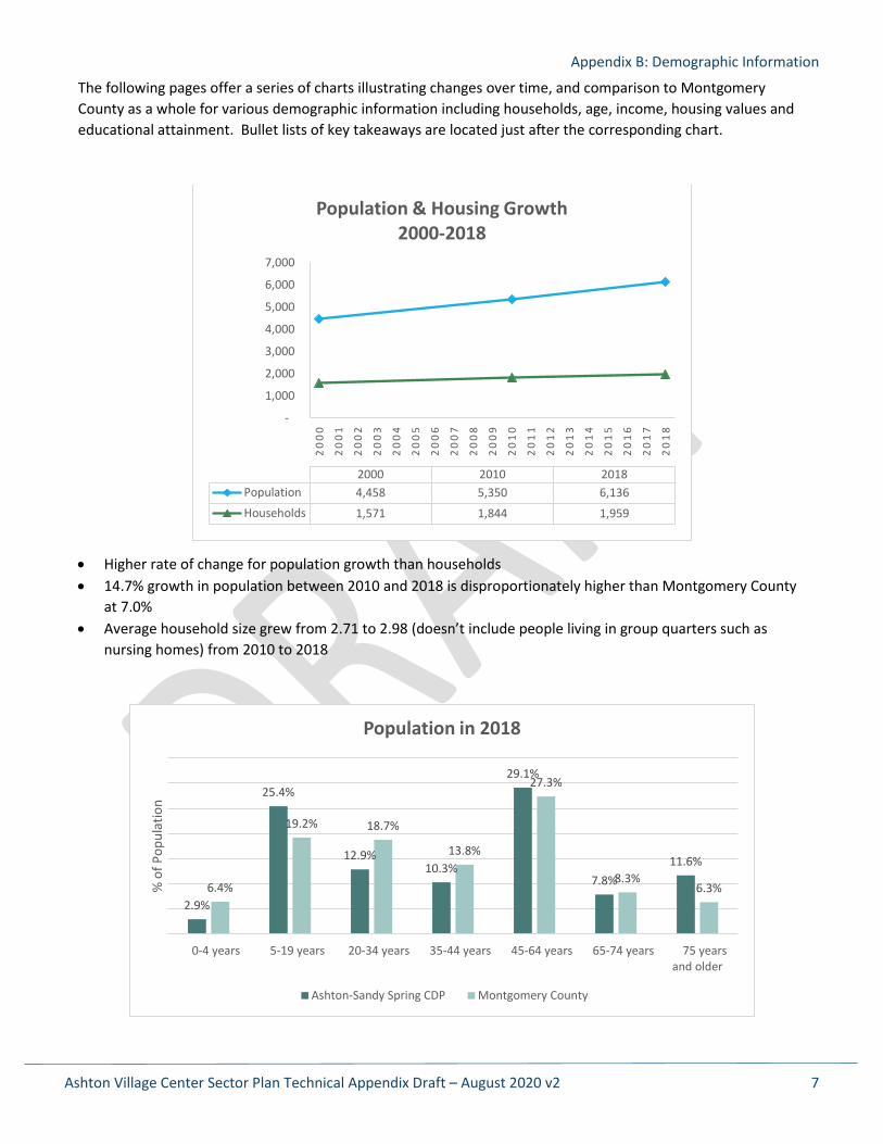
The following pages offer a series of charts illustrating changes over time, and comparison to Montgomery County as a whole for various demographic information including households, age, income, housing values and educational attainment. Bullet lists of key takeaways are located just after the corresponding chart.
• Higher rate of change for population growth than households • 14.7% growth in population between 2010 and 2018 is disproportionately higher than Montgomery County
at 7.0% • Average household size grew from 2.71 to 2.98 (doesn’t include people living in group quarters such as
nursing homes) from 2010 to 2018
-
1,000
2,000
3,000
4,000
5,000
6,000
7,000
20
00
20
01
20
02
20
03
20
04
20
05
20
06
20
07
20
08
20
09
20
10
20
11
20
12
20
13
20
14
20
15
20
16
20
17
20
18
2000 2010 2018Population 4,458 5,350 6,136Households 1,571 1,844 1,959
Population & Housing Growth 2000-2018
2.9%
25.4%
12.9%10.3%
29.1%
7.8%11.6%
6.4%
19.2% 18.7%
13.8%
27.3%
8.3%6.3%
0-4 years 5-19 years 20-34 years 35-44 years 45-64 years 65-74 years 75 yearsand older
% o
f Pop
ulat
ion
Population in 2018
Ashton-Sandy Spring CDP Montgomery County

Appendix B: Demographic Information
Ashton Village Center Sector Plan Technical Appendix Draft – August 2020 v2 8
• The Ashton CDP has a higher percentage of school-age kids (5-19), adults age 45 to 64 and seniors age 75 and above compared to the county. However, it has a lower percentage of pre-school-age kids (0-4) and younger adults (20-44). This pattern suggests that many young couples or families moved into the area around the turn of the century and their children are now making their way through the school system, while younger families have stopped moving into the area.
• The number of housing units increased by 437 between 2000 and 2018, or 27%, while the county rate was 16%. Growth appears to have slowed considerably in recent years, however; county land records indicate only 33 houses were built in the CDP from 2014 through 2019. Of these new homes, 19 are the new townhomes in Sandy Spring; the other 14 are single-family detached houses spread throughout the CDP. This further reinforces the idea that young families have stopped moving into the area in recent years.
• 82.1% of the households own their residence versus a county average of 65.4%. Conversely, the rental rate in Ashton is 17.9%, roughly half the county average of 34.6%.
82.1%
17.9%
65.4%
34.6%
Owner-occupied Renter-occupied
Rate
Home Ownership (2018)
Ashton-Sandy Spring CDP Montgomery County
Montgomery County Less than $50,000
$50,000 to $99,999
$100,000 to $149,999
$150,000 to $199,999
$200,000 to $299,999
$300,000 to $499,999
$500,000 to $999,999
$1,000,000 or more
Ashton-Sandy Spring CDP
Owner-Occupied Housing Values (2018 dollars)
Appendix B: Demographic Information
Ashton Village Center Sector Plan Technical Appendix Draft – August 2020 v2 9
• Housing values are considerably higher in the Ashton-Sandy Spring CDP than in the county overall. Data shows that 66.3% of Ashton homes are valued at more than $500,000 versus 46.1% in the county. The median home value in Montgomery County was $476,500 in 2018, while in the CDP it was $645,900.
• Also notable is the percentage of single-family detached homes in the CDP versus the county in general. In the CDP, 82.6% of the housing units are detached homes, while the county average is 47.4%. Combined with the 11.7% of housing units being single-family attached units in the CDP, over 94% of the homes in the Sandy Spring/Ashton area are single-family homes compared to only about 66% in Montgomery County.
82.6%
11.7%
0.0% 2.0% 0.0% 0.0%3.7%
0.0% 0.0%
47.40%
18.40%0.50% 1.30%
5.10%9.40%
17.70%0.10% 0.00%
1-unit,detached
1-unit,attached
2 units 3 or 4 units 5 to 9 units 10 to 19 units 20 or moreunits
Mobile home Boat, RV, van,etc.
% o
f Uni
ts
Units in Structure 2018
Ashton-Sandy Spring CDP Montgomery County
Appendix B: Demographic Information
Ashton Village Center Sector Plan Technical Appendix Draft – August 2020 v2 10
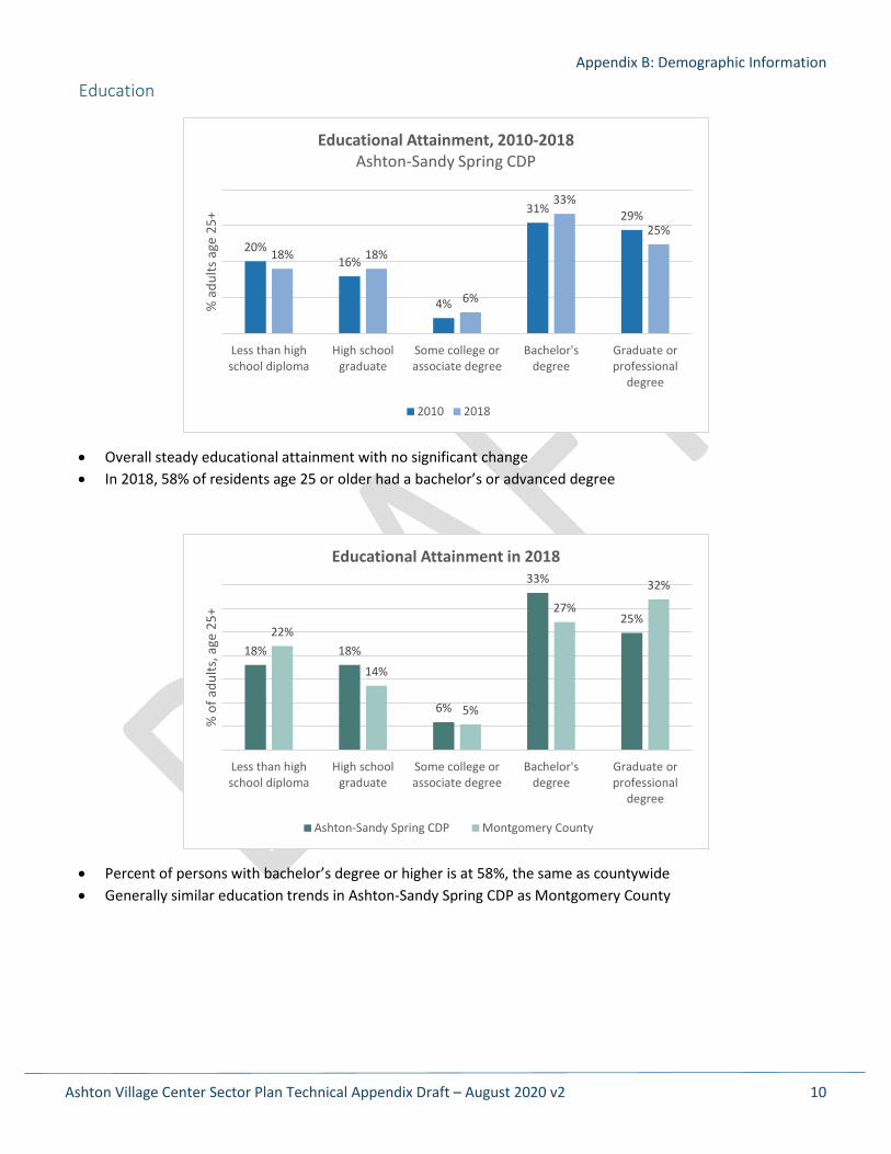
Education
• Overall steady educational attainment with no significant change • In 2018, 58% of residents age 25 or older had a bachelor’s or advanced degree
• Percent of persons with bachelor’s degree or higher is at 58%, the same as countywide • Generally similar education trends in Ashton-Sandy Spring CDP as Montgomery County
20%16%
4%
31% 29%
18% 18%
6%
33%
25%
Less than highschool diploma
High schoolgraduate
Some college orassociate degree
Bachelor'sdegree
Graduate orprofessional
degree
% a
dults
age
25+
Educational Attainment, 2010-2018 Ashton-Sandy Spring CDP
2010 2018
18% 18%
6%
33%
25%22%
14%
5%
27%
32%
Less than highschool diploma
High schoolgraduate
Some college orassociate degree
Bachelor'sdegree
Graduate orprofessional
degree
% o
f adu
lts, a
ge 2
5+
Educational Attainment in 2018
Ashton-Sandy Spring CDP Montgomery County
Appendix B: Demographic Information
Ashton Village Center Sector Plan Technical Appendix Draft – August 2020 v2 11
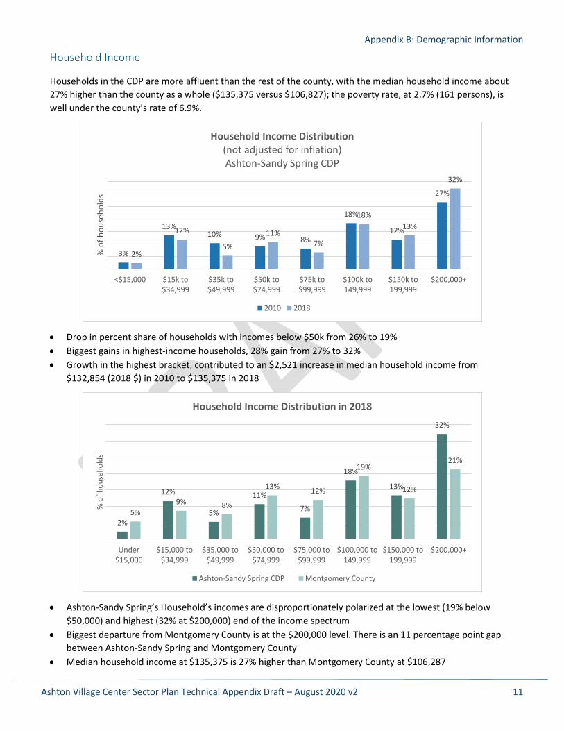
Household Income
Households in the CDP are more affluent than the rest of the county, with the median household income about 27% higher than the county as a whole ($135,375 versus $106,827); the poverty rate, at 2.7% (161 persons), is well under the county’s rate of 6.9%.
• Drop in percent share of households with incomes below $50k from 26% to 19% • Biggest gains in highest-income households, 28% gain from 27% to 32% • Growth in the highest bracket, contributed to an $2,521 increase in median household income from
$132,854 (2018 $) in 2010 to $135,375 in 2018
• Ashton-Sandy Spring’s Household’s incomes are disproportionately polarized at the lowest (19% below $50,000) and highest (32% at $200,000) end of the income spectrum
• Biggest departure from Montgomery County is at the $200,000 level. There is an 11 percentage point gap between Ashton-Sandy Spring and Montgomery County
• Median household income at $135,375 is 27% higher than Montgomery County at $106,287
3%
13%10% 9% 8%
18%
12%
27%
2%
12%
5%
11%7%
18%13%
32%
<$15,000 $15k to$34,999
$35k to$49,999
$50k to$74,999
$75k to$99,999
$100k to149,999
$150k to199,999
$200,000+
% o
f hou
seho
lds
Household Income Distribution (not adjusted for inflation)Ashton-Sandy Spring CDP
2010 2018
2%
12%
5%
11%
7%
18%
13%
32%
5%9% 8%
13% 12%
19%
12%
21%
Under$15,000
$15,000 to$34,999
$35,000 to$49,999
$50,000 to$74,999
$75,000 to$99,999
$100,000 to149,999
$150,000 to199,999
$200,000+
% o
f hou
seho
lds
Household Income Distribution in 2018
Ashton-Sandy Spring CDP Montgomery County
Appendix B: Demographic Information
Ashton Village Center Sector Plan Technical Appendix Draft – August 2020 v2 12
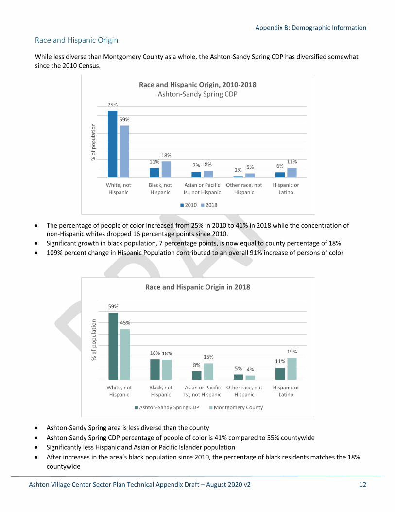
Race and Hispanic Origin
While less diverse than Montgomery County as a whole, the Ashton-Sandy Spring CDP has diversified somewhat since the 2010 Census.
• The percentage of people of color increased from 25% in 2010 to 41% in 2018 while the concentration of non-Hispanic whites dropped 16 percentage points since 2010.
• Significant growth in black population, 7 percentage points, is now equal to county percentage of 18% • 109% percent change in Hispanic Population contributed to an overall 91% increase of persons of color
• Ashton-Sandy Spring area is less diverse than the county • Ashton-Sandy Spring CDP percentage of people of color is 41% compared to 55% countywide • Significantly less Hispanic and Asian or Pacific Islander population • After increases in the area’s black population since 2010, the percentage of black residents matches the 18%
countywide
75%
11% 7%2%
6%
59%
18%
8% 5%11%
White, notHispanic
Black, notHispanic
Asian or PacificIs., not Hispanic
Other race, notHispanic
Hispanic orLatino
% o
f pop
ulat
ion
Race and Hispanic Origin, 2010-2018 Ashton-Sandy Spring CDP
2010 2018
59%
18%
8% 5%11%
45%
18% 15%
4%
19%
White, notHispanic
Black, notHispanic
Asian or PacificIs., not Hispanic
Other race, notHispanic
Hispanic orLatino
% o
f pop
ulat
ion
Race and Hispanic Origin in 2018
Ashton-Sandy Spring CDP Montgomery County
Appendix B: Demographic Information
Ashton Village Center Sector Plan Technical Appendix Draft – August 2020 v2 13
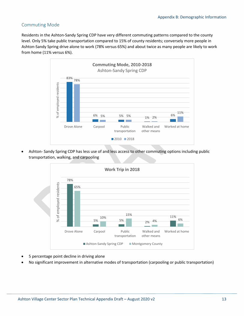
Commuting Mode
Residents in the Ashton-Sandy Spring CDP have very different commuting patterns compared to the county level. Only 5% take public transportation compared to 15% of county residents; conversely more people in Ashton-Sandy Spring drive alone to work (78% versus 65%) and about twice as many people are likely to work from home (11% versus 6%).
• Ashton- Sandy Spring CDP has less use of and less access to other commuting options including public transportation, walking, and carpooling
• 5 percentage point decline in driving alone • No significant improvement in alternative modes of transportation (carpooling or public transportation)
83%
6% 5% 1%6%
78%
5% 5% 2%11%
Drove Alone Carpool Publictransportation
Walked andother means
Worked at home
% o
f em
ploy
ed re
siden
ts
Commuting Mode, 2010-2018 Ashton-Sandy Spring CDP
2010 2018
78%
5% 5% 2%11%
65%
10%15%
4% 6%
Drove Alone Carpool Publictransportation
Walked andother means
Worked at home
% o
f em
ploy
ed re
siden
ts
Work Trip in 2018
Ashton-Sandy Spring CDP Montgomery County
Ashton Village Center Sector Plan Technical Appendix Draft – August 2020 v2 14
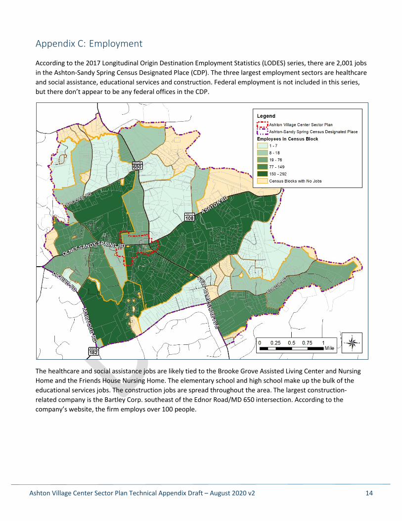
Appendix C: Employment
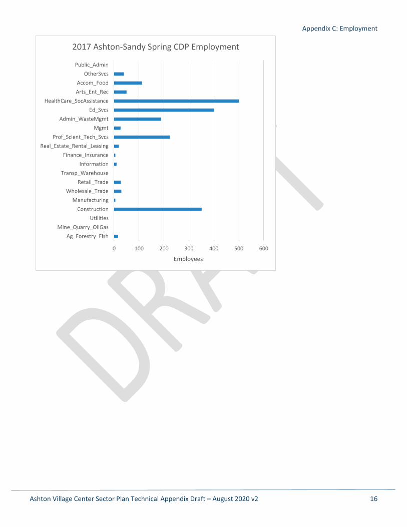
According to the 2017 Longitudinal Origin Destination Employment Statistics (LODES) series, there are 2,001 jobs in the Ashton-Sandy Spring Census Designated Place (CDP). The three largest employment sectors are healthcare and social assistance, educational services and construction. Federal employment is not included in this series, but there don’t appear to be any federal offices in the CDP.
The healthcare and social assistance jobs are likely tied to the Brooke Grove Assisted Living Center and Nursing Home and the Friends House Nursing Home. The elementary school and high school make up the bulk of the educational services jobs. The construction jobs are spread throughout the area. The largest construction-related company is the Bartley Corp. southeast of the Ednor Road/MD 650 intersection. According to the company’s website, the firm employs over 100 people.
Appendix C: Employment
Ashton Village Center Sector Plan Technical Appendix Draft – August 2020 v2 15
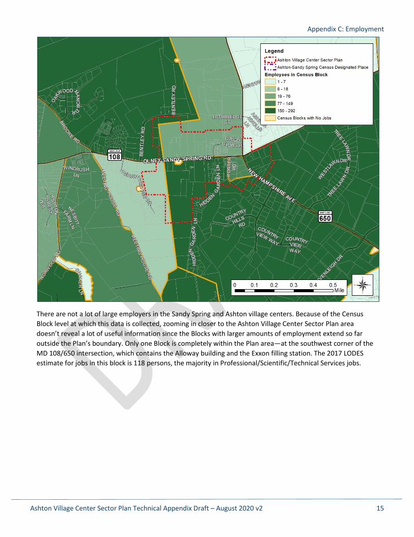
There are not a lot of large employers in the Sandy Spring and Ashton village centers. Because of the Census Block level at which this data is collected, zooming in closer to the Ashton Village Center Sector Plan area doesn’t reveal a lot of useful information since the Blocks with larger amounts of employment extend so far outside the Plan’s boundary. Only one Block is completely within the Plan area—at the southwest corner of the MD 108/650 intersection, which contains the Alloway building and the Exxon filling station. The 2017 LODES estimate for jobs in this block is 118 persons, the majority in Professional/Scientific/Technical Services jobs.
Appendix C: Employment
Ashton Village Center Sector Plan Technical Appendix Draft – August 2020 v2 16
0 100 200 300 400 500 600
Ag_Forestry_FishMine_Quarry_OilGas
UtilitiesConstruction
ManufacturingWholesale_Trade
Retail_TradeTransp_Warehouse
InformationFinance_Insurance
Real_Estate_Rental_LeasingProf_Scient_Tech_Svcs
MgmtAdmin_WasteMgmt
Ed_SvcsHealthCare_SocAssistance
Arts_Ent_RecAccom_Food
OtherSvcsPublic_Admin
Employees
2017 Ashton-Sandy Spring CDP Employment
Ashton Village Center Sector Plan Technical Appendix Draft – August 2020 v2 17
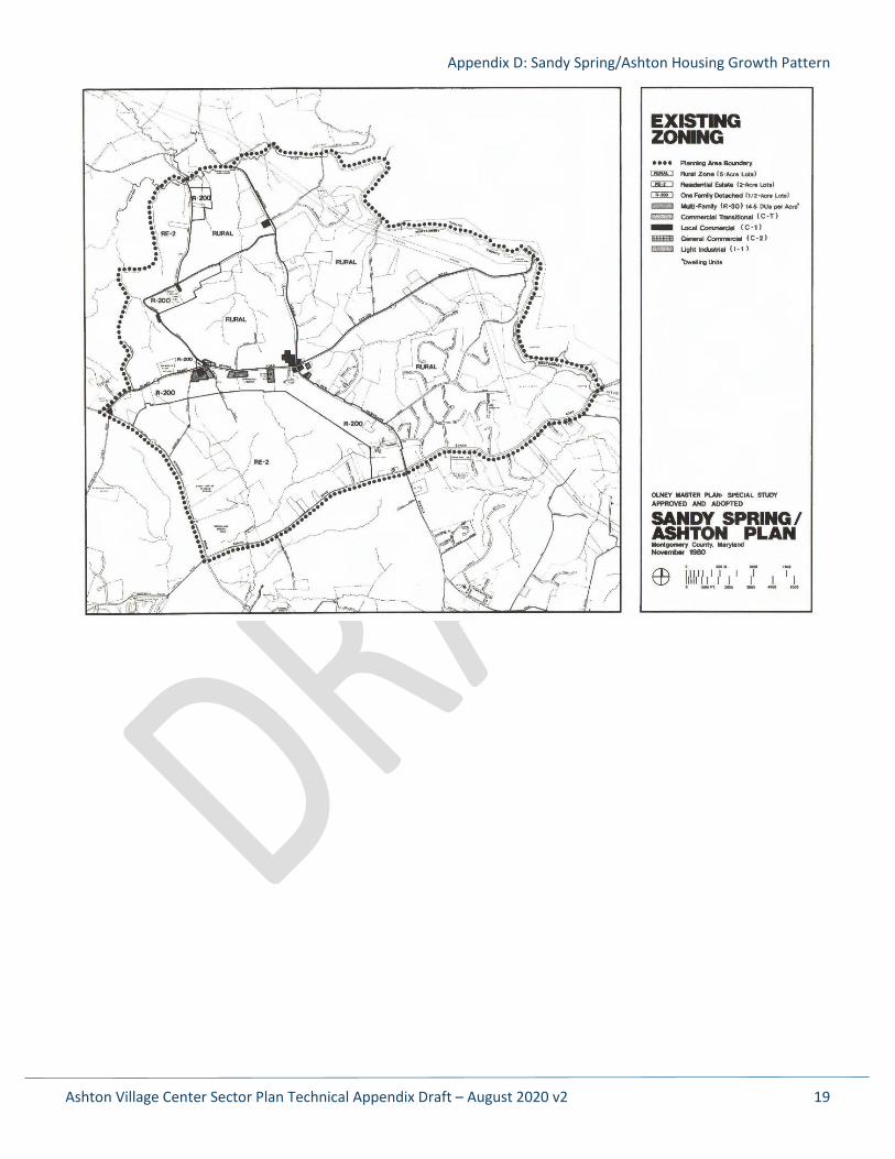
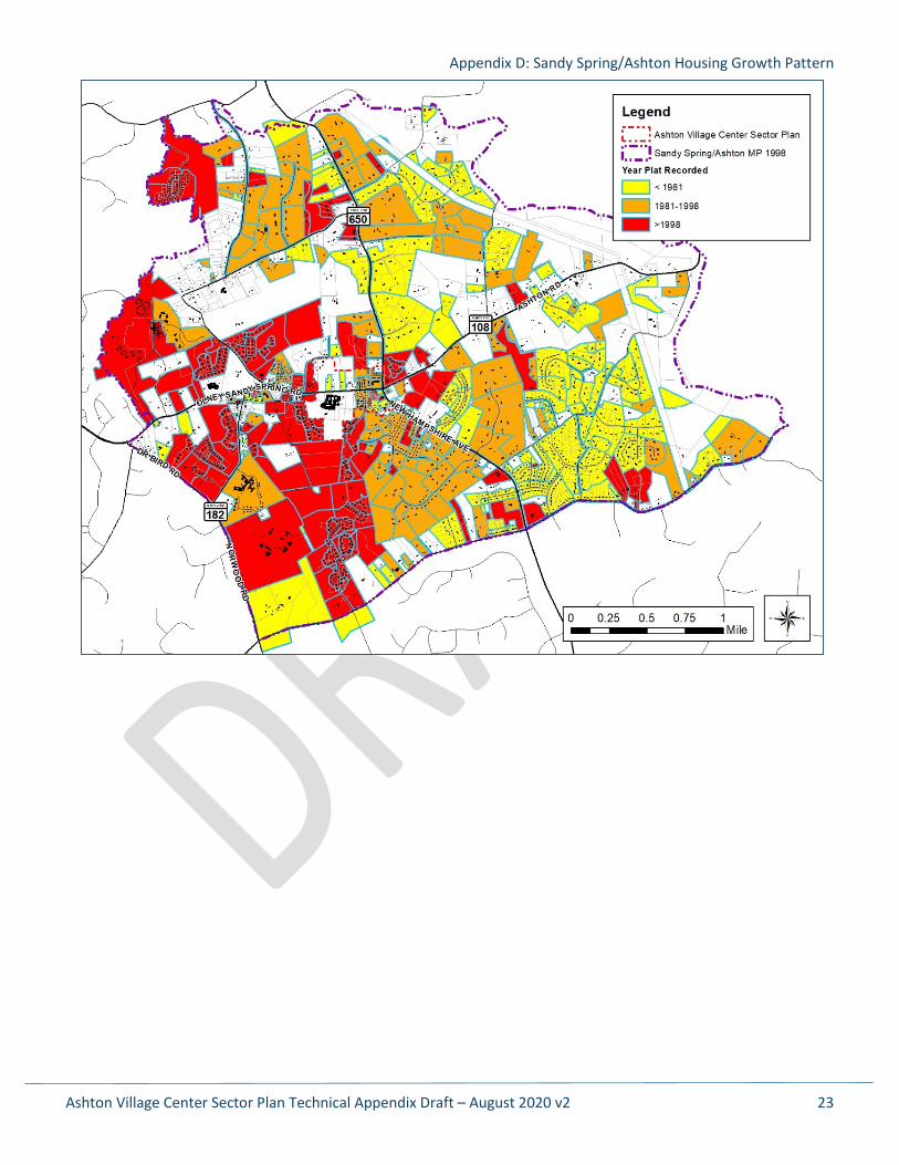
Appendix D: Sandy Spring/Ashton Housing Growth Pattern
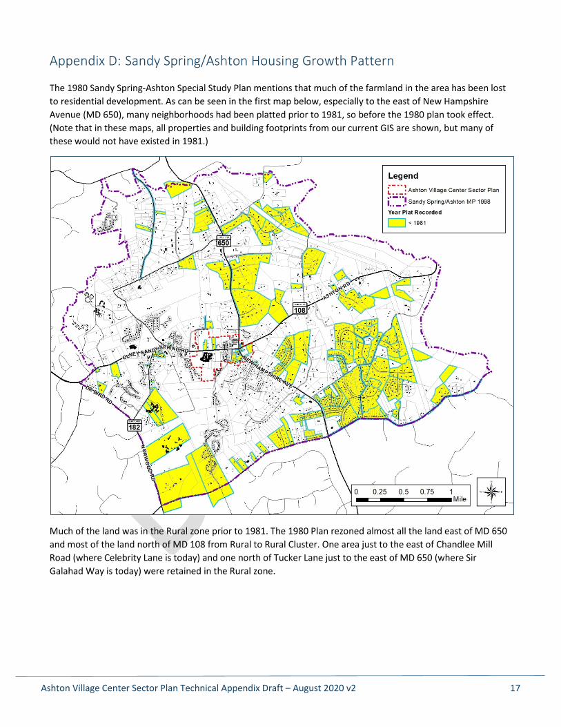
The 1980 Sandy Spring-Ashton Special Study Plan mentions that much of the farmland in the area has been lost to residential development. As can be seen in the first map below, especially to the east of New Hampshire Avenue (MD 650), many neighborhoods had been platted prior to 1981, so before the 1980 plan took effect. (Note that in these maps, all properties and building footprints from our current GIS are shown, but many of these would not have existed in 1981.)
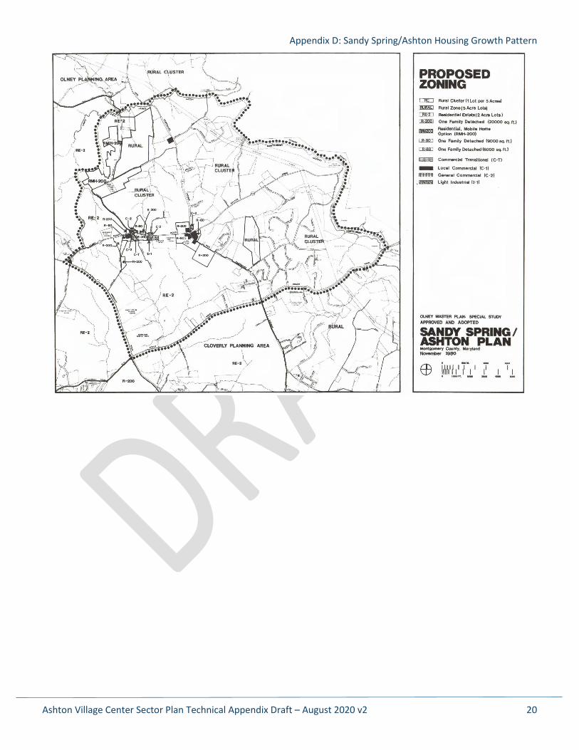
Much of the land was in the Rural zone prior to 1981. The 1980 Plan rezoned almost all the land east of MD 650 and most of the land north of MD 108 from Rural to Rural Cluster. One area just to the east of Chandlee Mill Road (where Celebrity Lane is today) and one north of Tucker Lane just to the east of MD 650 (where Sir Galahad Way is today) were retained in the Rural zone.
Appendix D: Sandy Spring/Ashton Housing Growth Pattern
Ashton Village Center Sector Plan Technical Appendix Draft – August 2020 v2 18
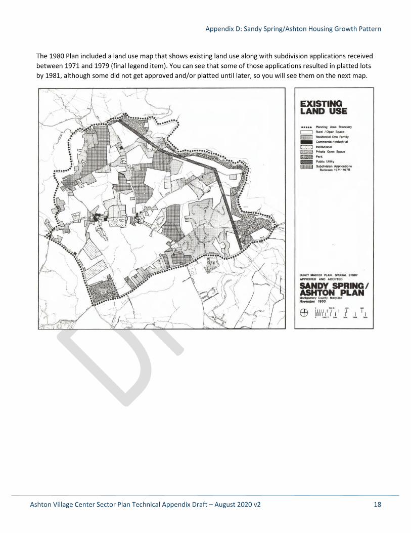
The 1980 Plan included a land use map that shows existing land use along with subdivision applications received between 1971 and 1979 (final legend item). You can see that some of those applications resulted in platted lots by 1981, although some did not get approved and/or platted until later, so you will see them on the next map.
Appendix D: Sandy Spring/Ashton Housing Growth Pattern
Ashton Village Center Sector Plan Technical Appendix Draft – August 2020 v2 19
Appendix D: Sandy Spring/Ashton Housing Growth Pattern
Ashton Village Center Sector Plan Technical Appendix Draft – August 2020 v2 20
Appendix D: Sandy Spring/Ashton Housing Growth Pattern
Ashton Village Center Sector Plan Technical Appendix Draft – August 2020 v2 21
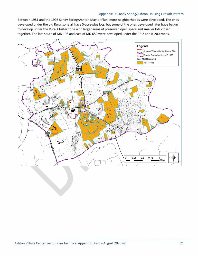
Between 1981 and the 1998 Sandy Spring/Ashton Master Plan, more neighborhoods were developed. The ones developed under the old Rural zone all have 5-acre-plus lots, but some of the ones developed later have begun to develop under the Rural Cluster zone with larger areas of preserved open space and smaller lots closer together. The lots south of MD 108 and east of MD 650 were developed under the RE-2 and R-200 zones.
Appendix D: Sandy Spring/Ashton Housing Growth Pattern
Ashton Village Center Sector Plan Technical Appendix Draft – August 2020 v2 22
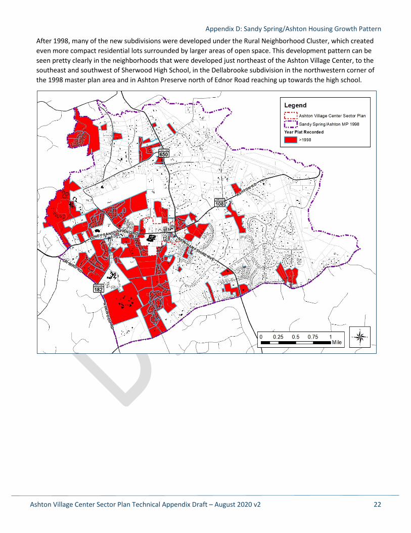
After 1998, many of the new subdivisions were developed under the Rural Neighborhood Cluster, which created even more compact residential lots surrounded by larger areas of open space. This development pattern can be seen pretty clearly in the neighborhoods that were developed just northeast of the Ashton Village Center, to the southeast and southwest of Sherwood High School, in the Dellabrooke subdivision in the northwestern corner of the 1998 master plan area and in Ashton Preserve north of Ednor Road reaching up towards the high school.
Appendix D: Sandy Spring/Ashton Housing Growth Pattern
Ashton Village Center Sector Plan Technical Appendix Draft – August 2020 v2 23
Appendix D: Sandy Spring/Ashton Housing Growth Pattern
Ashton Village Center Sector Plan Technical Appendix Draft – August 2020 v2 24
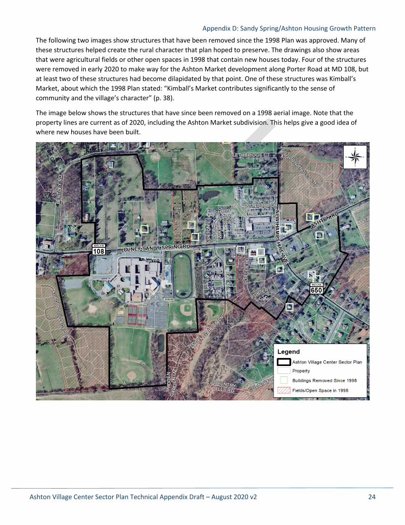
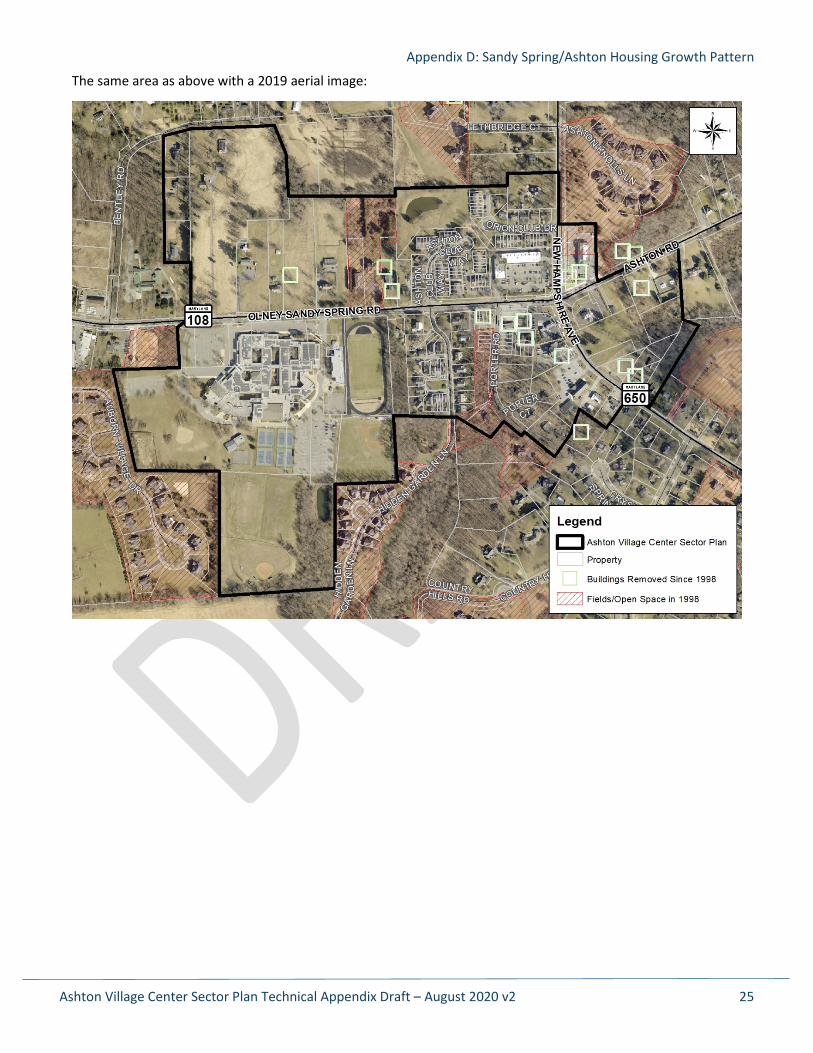
The following two images show structures that have been removed since the 1998 Plan was approved. Many of these structures helped create the rural character that plan hoped to preserve. The drawings also show areas that were agricultural fields or other open spaces in 1998 that contain new houses today. Four of the structures were removed in early 2020 to make way for the Ashton Market development along Porter Road at MD 108, but at least two of these structures had become dilapidated by that point. One of these structures was Kimball’s Market, about which the 1998 Plan stated: “Kimball’s Market contributes significantly to the sense of community and the village’s character” (p. 38).
The image below shows the structures that have since been removed on a 1998 aerial image. Note that the property lines are current as of 2020, including the Ashton Market subdivision. This helps give a good idea of where new houses have been built.
Appendix D: Sandy Spring/Ashton Housing Growth Pattern
Ashton Village Center Sector Plan Technical Appendix Draft – August 2020 v2 25
The same area as above with a 2019 aerial image:
Ashton Village Center Sector Plan Technical Appendix Draft – August 2020 v2 26
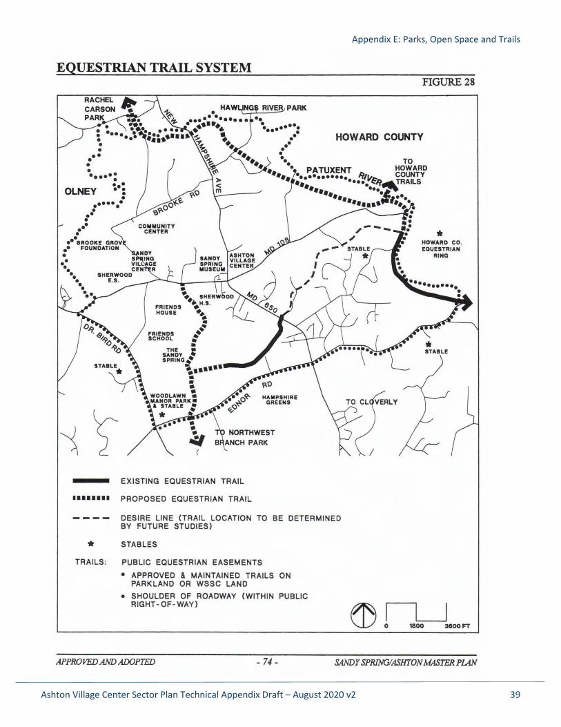
Appendix E: Parks, Open Space and Trails
Parks and Open Spaces
The Ashton Village Center Sector Plan supports the creation of new community open spaces to serve the existing and future population. The community has asked for a new gathering space to be created as part of the plan.
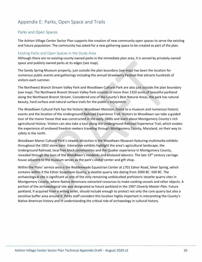
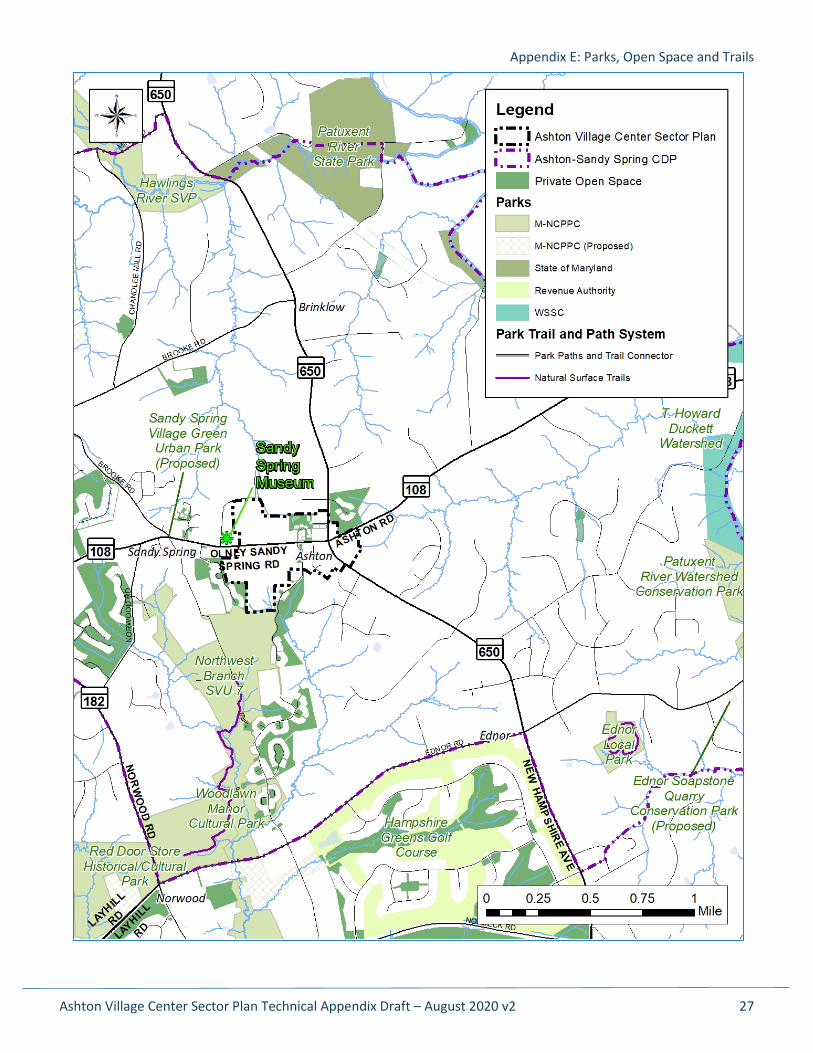
Existing Parks and Open Spaces in the Study Area Although there are no existing county owned parks in the immediate plan area, it is served by privately owned space and publicly owned parks at its edges (see map).
The Sandy Spring Museum property, just outside the plan boundary (see map) has been the location for numerous public events and gatherings including the annual Strawberry Festival that attracts hundreds of visitors each summer.
The Northwest Branch Stream Valley Park and Woodlawn Cultural Park are also just outside the plan boundary (see map). The Northwest Branch Stream Valley Park consists of more than 1320 acres of beautiful parkland along the Northwest Branch Stream. Considered one of the County’s Best Natural Areas, the park has natural beauty, hard surface and natural surface trails for the public’s enjoyment.
The Woodlawn Cultural Park has the historic Woodlawn Mansion, home to a museum and numerous historic events and the location of the Underground Railroad Experience Trail. Visitors to Woodlawn can take a guided tour of the manor house that was constructed in the early 1800s and learn about Montgomery County’s rich agricultural history. Visitors can also take a tour along the Underground Railroad Experience Trail, which evokes the experience of enslaved freedom seekers traveling through Montgomery County, Maryland, on their way to safety in the north.
Woodlawn Manor Cultural Park’s newest attraction is the Woodlawn Museum featuring multimedia exhibits throughout the 1832 stone barn. Interactive exhibits highlight the area’s agricultural landscape, the Underground Railroad, local free black communities and the Quaker experience in Montgomery County, revealed through the lives of the Woodlawn’s residents and enslaved laborers. The late 19th century carriage house adjacent to the museum serves as the park’s visitor center and gift shop.
Within the Plans’ service area is the Reddemeade Equestrian Center at 1701 Ednor Road, Silver Spring, which contains within it the Ednor Soapstone Quarry, a steatite quarry site dating from 2000 BC -500 BC. The archaeological site is significant as one of the only remaining undisturbed prehistoric steatite quarry sites in Montgomery County, where Native Americans extracted resources to make cooking vessels and other objects. A portion of the archaeological site was designated as future parkland in the 1997 Cloverly Master Plan. Future parkland, if acquired from a willing seller, should include enough to protect not only the core quarry but also a sensitive buffer area around it. Parks staff considers this location highly important in interpreting the County’s Native American history and in understanding the critical role of archaeology in cultural history.
Appendix E: Parks, Open Space and Trails
Ashton Village Center Sector Plan Technical Appendix Draft – August 2020 v2 27
Appendix E: Parks, Open Space and Trails
Ashton Village Center Sector Plan Technical Appendix Draft – August 2020 v2 28
Park and Open Spaces Hierarchy The plan supports providing a range of parks and open spaces to serve the variety of needs in the local area and regionally. Each area master plan should include a system of open spaces based on the roles of each type of open space. The amount and size of open spaces may vary from plan to plan and should be directly proportional to the projected density and adjusted to the pattern of existing open space and other factors such as community-specific needs. According to the 2018 Energized Public Spaces (EPS) Functional Master Plan, the Park and Open Space Hierarchy is as follows:
For the Sector Plan Area: • Active recreation destinations located within or near the plan area, including courts, playgrounds, and
lawn areas large enough for pick up soccer, festivals or events, etc. • One or more central “civic green” urban parks, ranging in size from ½ to 2 acres, depending on projected
densities, located in close proximity to a public transit hub, next to activating uses, with a mixture of hard and soft surfaces including a central lawn area for events.
• An interconnected system of sidewalks and trails to connect parks and open spaces. • Wooded areas that will provide a sense of contact with nature.
For each neighborhood • A neighborhood green or community use recreational park.
For each block • An urban square, plaza, or green area.
For each building • An outdoor recreation space.
For each residence • A private outdoor space.
Park and Open Space Goals Policy guidance from previous plans, the 2017 Park, Recreation and Open Space (PROS) Plan, and the Park and Open Space Hierarchy, along with community input during the planning process, led to the development of the goals and recommendations. Although located in a rural part of the county with vast amounts of existing open spaces, residents of Ashton can benefit from new open spaces created to meet their active life-style needs:
• Active recreational opportunities should be provided for all ages, especially the older adult population which is the majority of the demographic in the Ashton community.
• Connections to public spaces and historic programming should be created and strengthened by providing wayfinding signage and trail kiosks.
Recommendations This plan recommends the creation of new open spaces for social gathering, play and active recreation. Amenities that encourage social interaction, such as picnic areas, community gardens and dog parks, should be considered. Active amenities such as a skate park would be appropriate in this area near the high school. Amenities for older adults should also be considered including fitness trails and equipment as part of multigenerational play areas. Specific trail recommendations are in the Trails Section of this plan.
Appendix E: Parks, Open Space and Trails
Ashton Village Center Sector Plan Technical Appendix Draft – August 2020 v2 29
Trail Connections
Background The 1998 Sandy Spring/Ashton Master Plan identified the Sherwood High School property as an important link connecting the sidewalks and sidepaths along the state highways and the park system. This Sector Plan reiterates support for this link to reach the Northwest Branch Stream Valley Park and the Underground Railroad Experience Trail. This Plan also recommends a multiuse natural surface trail connection between the high school and Hidden Garden Lane to the southeast. This link would provide alternative access to the existing hard surface trail connecting Hidden Garden Lane and Hoffman Manor Drive in the Ashton Preserve community, and eventually to an existing sidepath on Ednor Road.
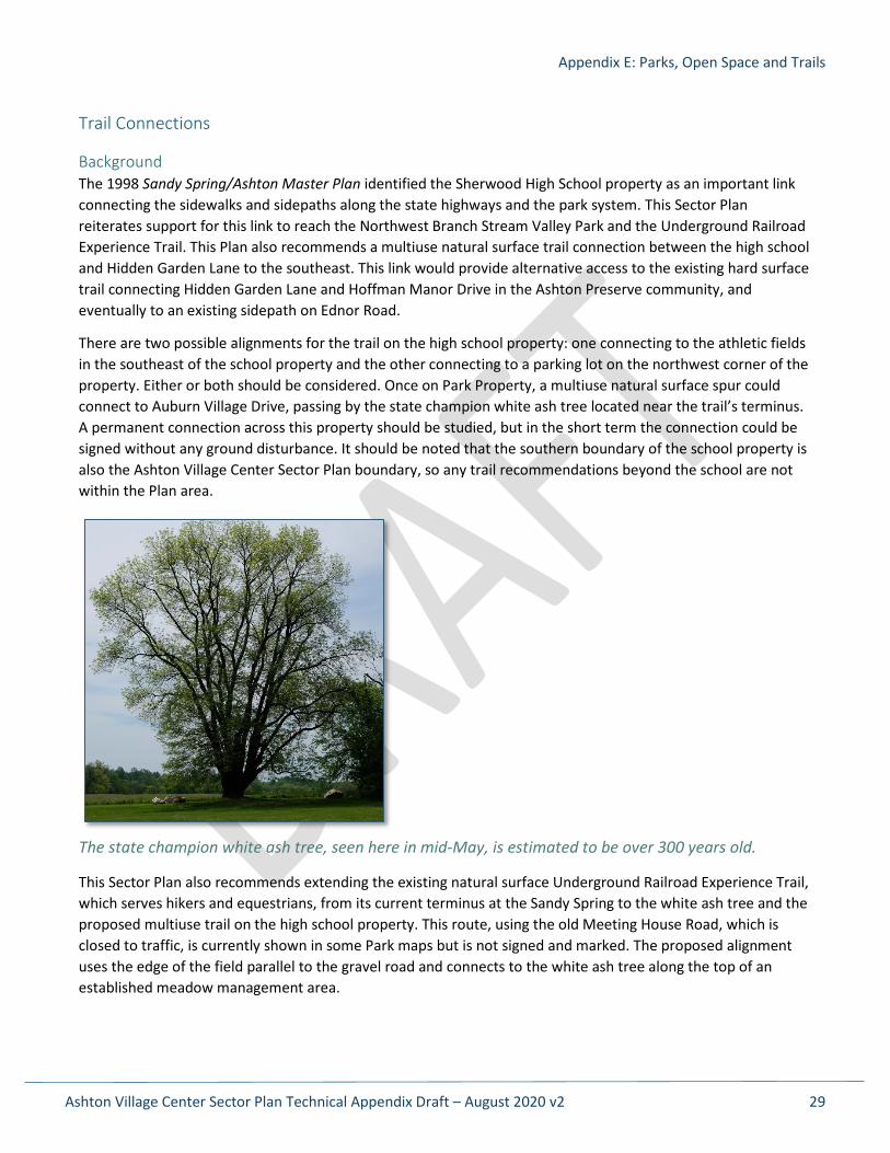
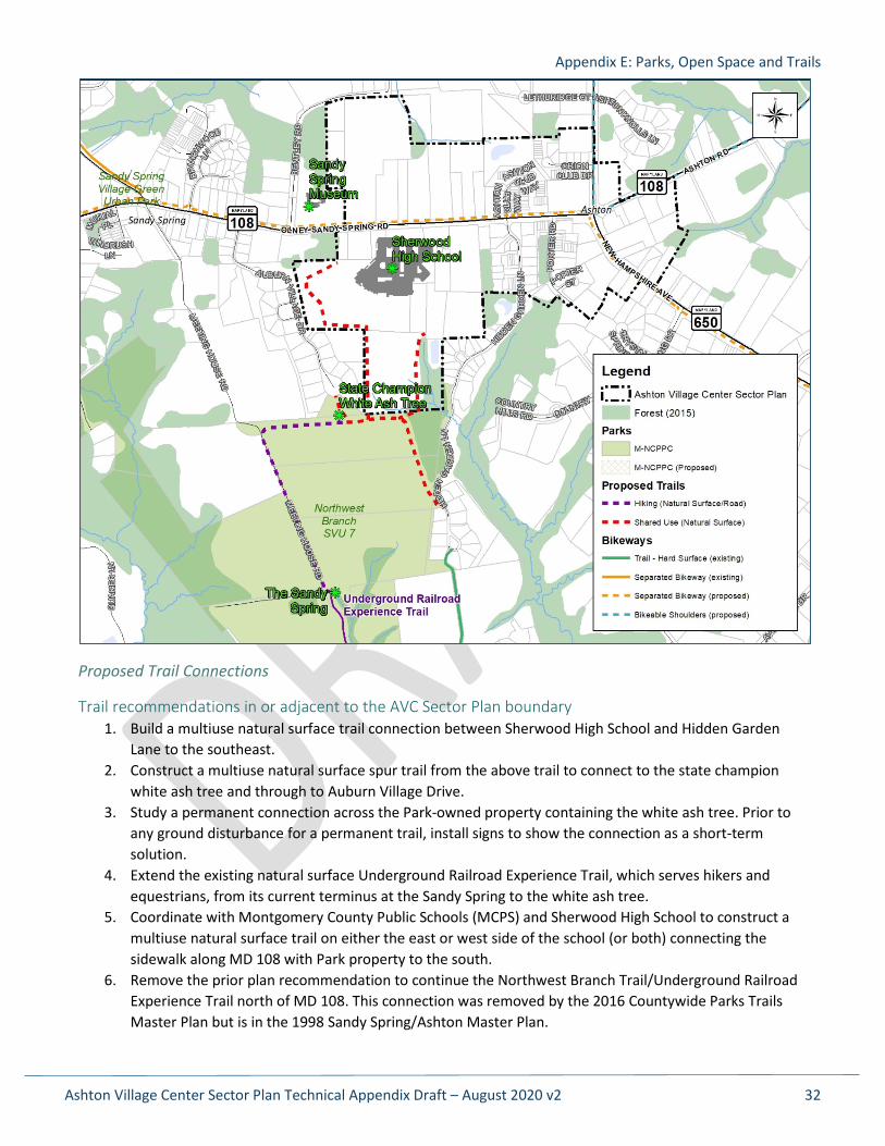
There are two possible alignments for the trail on the high school property: one connecting to the athletic fields in the southeast of the school property and the other connecting to a parking lot on the northwest corner of the property. Either or both should be considered. Once on Park Property, a multiuse natural surface spur could connect to Auburn Village Drive, passing by the state champion white ash tree located near the trail’s terminus. A permanent connection across this property should be studied, but in the short term the connection could be signed without any ground disturbance. It should be noted that the southern boundary of the school property is also the Ashton Village Center Sector Plan boundary, so any trail recommendations beyond the school are not within the Plan area.
The state champion white ash tree, seen here in mid-May, is estimated to be over 300 years old.
This Sector Plan also recommends extending the existing natural surface Underground Railroad Experience Trail, which serves hikers and equestrians, from its current terminus at the Sandy Spring to the white ash tree and the proposed multiuse trail on the high school property. This route, using the old Meeting House Road, which is closed to traffic, is currently shown in some Park maps but is not signed and marked. The proposed alignment uses the edge of the field parallel to the gravel road and connects to the white ash tree along the top of an established meadow management area.
Appendix E: Parks, Open Space and Trails
Ashton Village Center Sector Plan Technical Appendix Draft – August 2020 v2 30
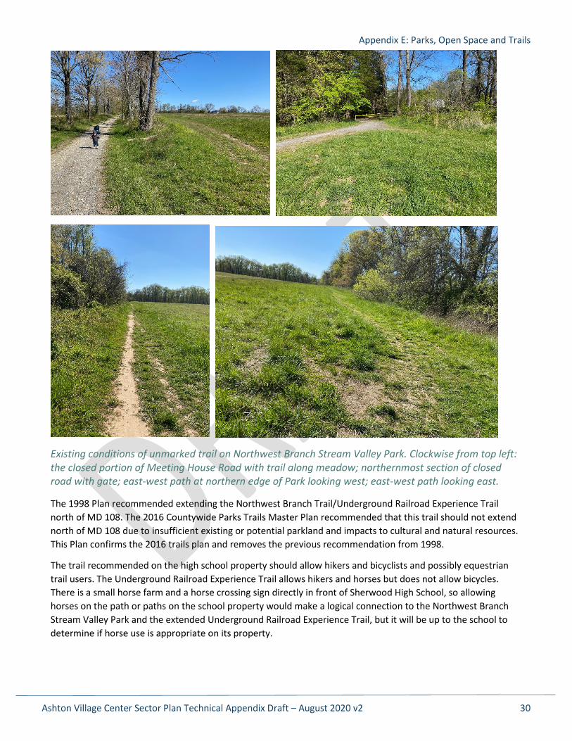
Existing conditions of unmarked trail on Northwest Branch Stream Valley Park. Clockwise from top left: the closed portion of Meeting House Road with trail along meadow; northernmost section of closed road with gate; east-west path at northern edge of Park looking west; east-west path looking east.
The 1998 Plan recommended extending the Northwest Branch Trail/Underground Railroad Experience Trail north of MD 108. The 2016 Countywide Parks Trails Master Plan recommended that this trail should not extend north of MD 108 due to insufficient existing or potential parkland and impacts to cultural and natural resources. This Plan confirms the 2016 trails plan and removes the previous recommendation from 1998.
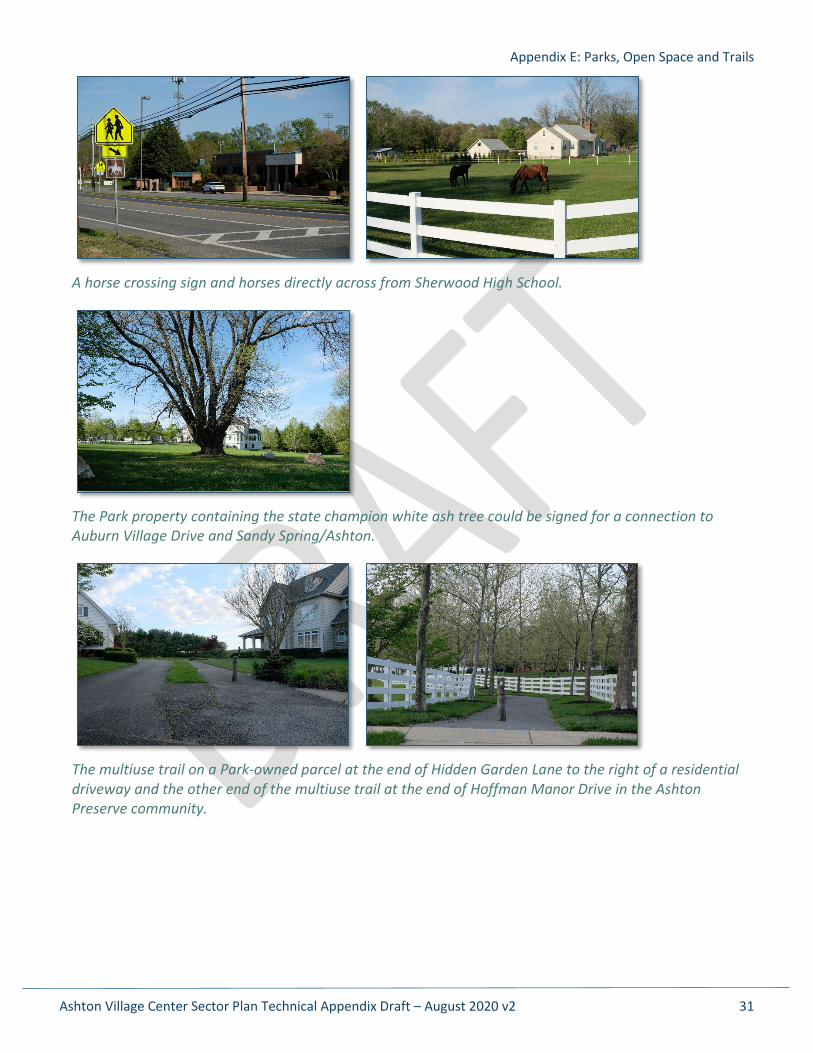
The trail recommended on the high school property should allow hikers and bicyclists and possibly equestrian trail users. The Underground Railroad Experience Trail allows hikers and horses but does not allow bicycles. There is a small horse farm and a horse crossing sign directly in front of Sherwood High School, so allowing horses on the path or paths on the school property would make a logical connection to the Northwest Branch Stream Valley Park and the extended Underground Railroad Experience Trail, but it will be up to the school to determine if horse use is appropriate on its property.
Appendix E: Parks, Open Space and Trails
Ashton Village Center Sector Plan Technical Appendix Draft – August 2020 v2 31
A horse crossing sign and horses directly across from Sherwood High School.
The Park property containing the state champion white ash tree could be signed for a connection to Auburn Village Drive and Sandy Spring/Ashton.
The multiuse trail on a Park-owned parcel at the end of Hidden Garden Lane to the right of a residential driveway and the other end of the multiuse trail at the end of Hoffman Manor Drive in the Ashton Preserve community.
Appendix E: Parks, Open Space and Trails
Ashton Village Center Sector Plan Technical Appendix Draft – August 2020 v2 32
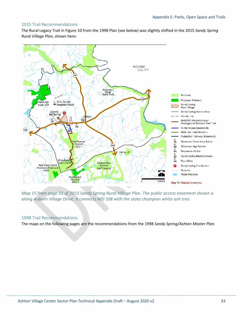
Proposed Trail Connections
Trail recommendations in or adjacent to the AVC Sector Plan boundary 1. Build a multiuse natural surface trail connection between Sherwood High School and Hidden Garden
Lane to the southeast. 2. Construct a multiuse natural surface spur trail from the above trail to connect to the state champion
white ash tree and through to Auburn Village Drive. 3. Study a permanent connection across the Park-owned property containing the white ash tree. Prior to
any ground disturbance for a permanent trail, install signs to show the connection as a short-term solution.
4. Extend the existing natural surface Underground Railroad Experience Trail, which serves hikers and equestrians, from its current terminus at the Sandy Spring to the white ash tree.
5. Coordinate with Montgomery County Public Schools (MCPS) and Sherwood High School to construct a multiuse natural surface trail on either the east or west side of the school (or both) connecting the sidewalk along MD 108 with Park property to the south.
6. Remove the prior plan recommendation to continue the Northwest Branch Trail/Underground Railroad Experience Trail north of MD 108. This connection was removed by the 2016 Countywide Parks Trails Master Plan but is in the 1998 Sandy Spring/Ashton Master Plan.
Appendix E: Parks, Open Space and Trails
Ashton Village Center Sector Plan Technical Appendix Draft – August 2020 v2 33
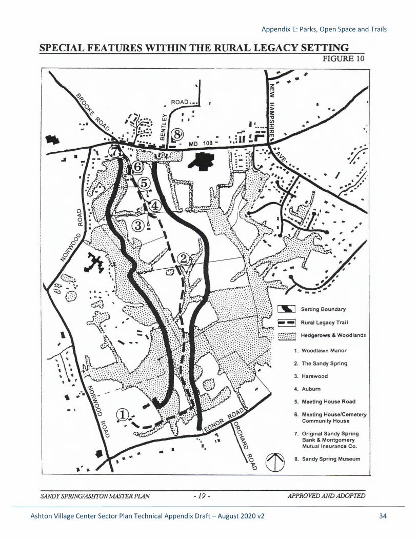
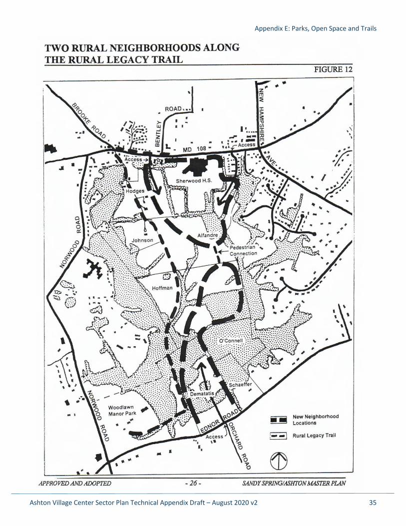
2015 Trail Recommendations The Rural Legacy Trail in Figure 10 from the 1998 Plan (see below) was slightly shifted in the 2015 Sandy Spring Rural Village Plan, shown here:
Map 15 from page 51 of 2015 Sandy Spring Rural Village Plan. The public access easement shown is along Auburn Village Drive; it connects MD 108 with the state champion white ash tree.
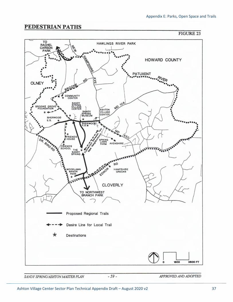
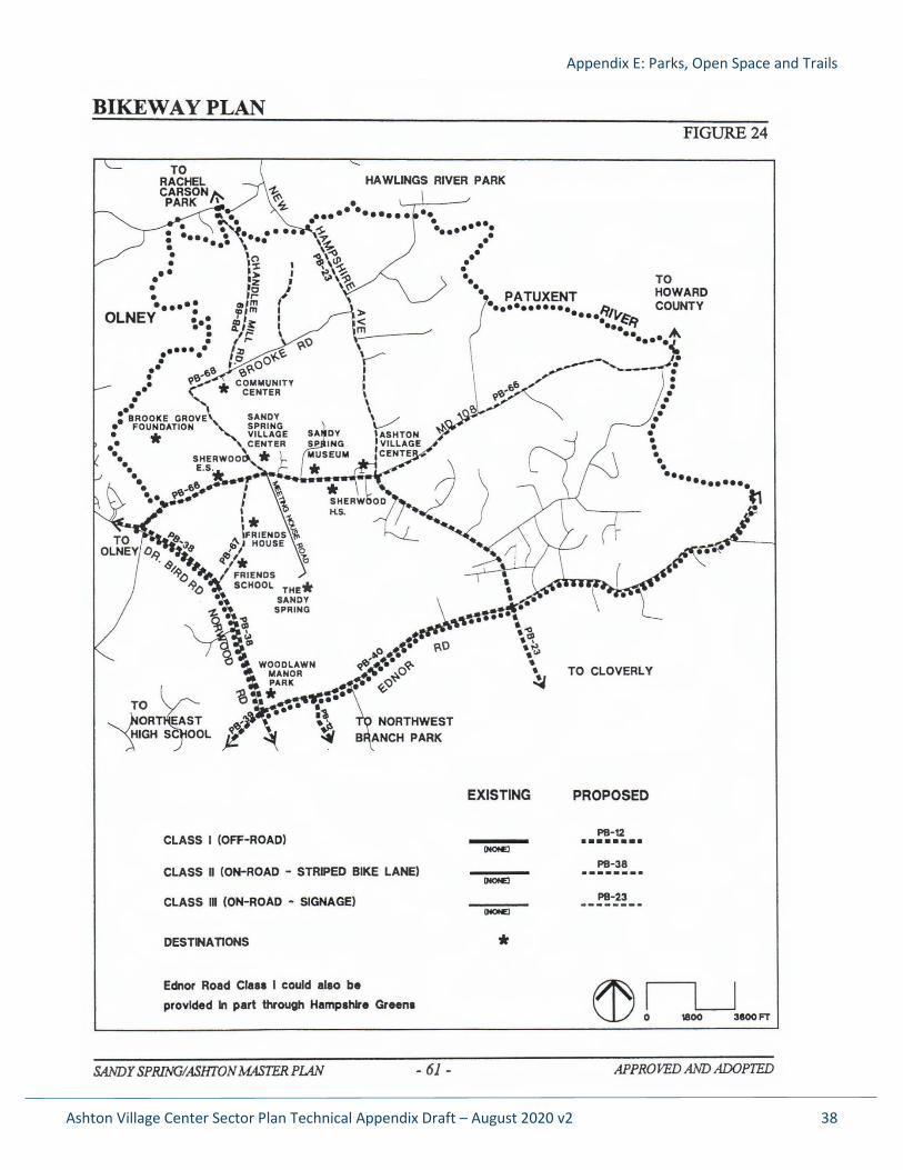
1998 Trail Recommendations The maps on the following pages are the recommendations from the 1998 Sandy Spring/Ashton Master Plan.
Appendix E: Parks, Open Space and Trails
Ashton Village Center Sector Plan Technical Appendix Draft – August 2020 v2 34
Appendix E: Parks, Open Space and Trails
Ashton Village Center Sector Plan Technical Appendix Draft – August 2020 v2 35
Appendix E: Parks, Open Space and Trails
Ashton Village Center Sector Plan Technical Appendix Draft – August 2020 v2 36
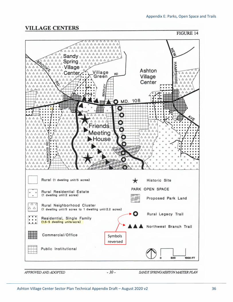
Symbols reversed
Appendix E: Parks, Open Space and Trails
Ashton Village Center Sector Plan Technical Appendix Draft – August 2020 v2 37
Appendix E: Parks, Open Space and Trails
Ashton Village Center Sector Plan Technical Appendix Draft – August 2020 v2 38
Appendix E: Parks, Open Space and Trails
Ashton Village Center Sector Plan Technical Appendix Draft – August 2020 v2 39
Ashton Village Center Sector Plan Technical Appendix Draft – August 2020 v2 40
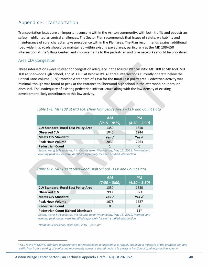
Appendix F: Transportation
Transportation issues are an important concern within the Ashton community, with both traffic and pedestrian safety highlighted as central challenges. The Sector Plan recommends that issues of safety, walkability and maintenance of rural character take precedence within the Plan area. The Plan recommends against additional road widening; roads should be maintained within existing paved area, particularly at the MD 108/650 intersection at the Village Center, and improvements to the pedestrian and bike networks should be prioritized.
Area CLV Congestion
Three intersections were studied for congestion adequacy in the Master Plan vicinity: MD 108 at MD 650, MD 108 at Sherwood High School, and MD 108 at Brooke Rd. All three intersections currently operate below the Critical Lane Volume (CLV)1 threshold standard of 1350 for the Rural East policy area. Pedestrian activity was minimal, though was found to peak at the entrance to Sherwood high school in the afternoon hour around dismissal. The inadequacy of existing pedestrian infrastructure along with the low density of existing development likely contributes to this low activity.
Table D-1. MD 108 at MD 650 (New Hampshire Ave.) – CLV and Count Data
AM (7:15 – 8:15)
PM (4:30 – 5:30)
CLV Standard: Rural East Policy Area 1350 1350 Observed CLV 1046 1244 Meets CLV Standard Yes ✓ Yes ✓ Peak Hour Volume 2030 2263 Pedestrian Count 1 0 Sabra, Wang & Associates, Inc. Counts taken Wednesday, May 15, 2019. Morning and evening peak hours were identified separately for each studied intersection.
Table D-2. MD 108 at Sherwood High School - CLV and Count Data
AM (7:00 – 8:00)
PM (4:30 – 5:30)
CLV Standard: Rural East Policy Area 1350 1350 Observed CLV 990 873 Meets CLV Standard Yes ✓ Yes ✓ Peak Hour Volume 1678 1527 Pedestrian Count 0 4 Pedestrian Count (School Dismissal) -- 11* Sabra, Wang & Associates, Inc. Counts taken Wednesday, May 15, 2019. Morning and evening peak hours were identified separately for each studied intersection.
*Peak hour of School Dismissal, 2:15 – 3:15 pm
1 CLV is the M-NCPPC standard measurement for intersection congestion; it is roughly speaking a measure of the greatest per-lane traffic flow from a pairing of conflicting movements across a shared node; it is always a fraction of total intersection volume
Appendix F: Transportation
Ashton Village Center Sector Plan Technical Appendix Draft – August 2020 v2 41
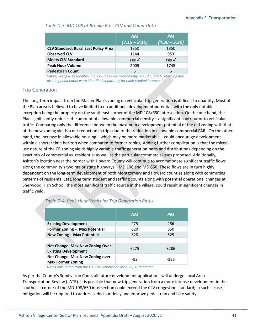
Table D-3. MD 108 at Brooke Rd. - CLV and Count Data
AM (7:15 – 8:15)
PM (4:30 – 5:30)
CLV Standard: Rural East Policy Area 1350 1350 Observed CLV 1144 953 Meets CLV Standard Yes ✓ Yes ✓ Peak Hour Volume 2009 1745 Pedestrian Count 5 5 Sabra, Wang & Associates, Inc. Counts taken Wednesday, May 15, 2019. Morning and evening peak hours were identified separately for each studied intersection.
Trip Generation
The long-term impact from the Master Plan’s zoning on vehicular trip generation is difficult to quantify. Most of the Plan area is believed to have limited to no additional development potential, with the only notable exception being the property on the southeast corner of the MD 108/650 intersection. On the one hand, the Plan significantly reduces the amount of allowable commercial density – a significant contributor to vehicular traffic. Comparing only the difference between the maximum development potential of the old zoning with that of the new zoning yields a net reduction in trips due to the reduction in allowable commercial FAR. On the other hand, the increase in allowable housing – which may be more marketable – could encourage development within a shorter time horizon when compared to former zoning. Adding further complication is that the mixed-use nature of the CR zoning yields highly variable traffic generation rates and distributions depending on the exact mix of commercial vs. residential as well as the particular commercial uses proposed. Additionally, Ashton’s location near the border with Howard County will continue to accommodate significant traffic flows along the community’s two major state highways – MD 108 and MD 650. These flows are in turn highly dependent on the long-term development of both Montgomery and Howard counties along with commuting patterns of residents. Last, long term student and staffing counts along with potential operational changes at Sherwood High School, the most significant traffic source in the village, could result in significant changes in traffic yield.
Table D-4. Peak Hour Vehicular Trip Generation Rates
AM PM
Existing Development 275 286 Former Zoning – Max Potential 620 850 New Zoning – Max Potential 528 525 Net Change: Max New Zoning Over Existing Development +275 +286
Net Change: Max New Zoning over Max Former Zoning -92 -325
Rates calculated from the ITE Trip Generation Manuel, 10th edition
As per the County’s Subdivision Code, all future development applications will undergo Local Area Transportation Review (LATR). It is possible that new trip generation from a more intense development in the southeast corner of the MD 108/650 intersection could exceed the CLV congestion standard; in such a case, mitigation will be required to address vehicular delay and improve pedestrian and bike safety.
Appendix F: Transportation
Ashton Village Center Sector Plan Technical Appendix Draft – August 2020 v2 42
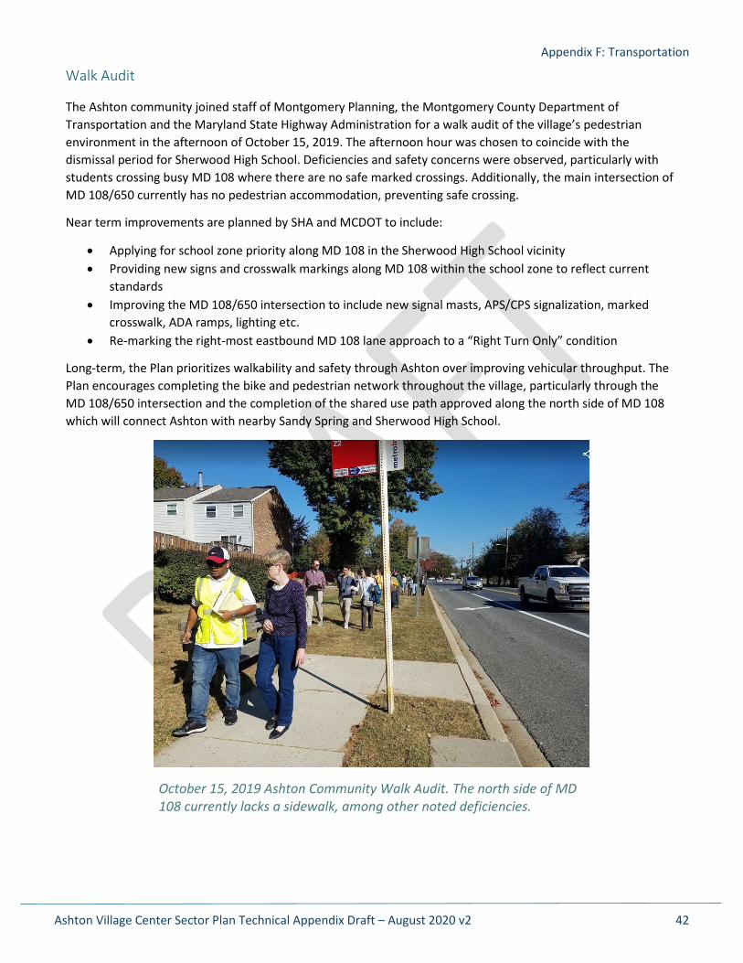
Walk Audit
The Ashton community joined staff of Montgomery Planning, the Montgomery County Department of Transportation and the Maryland State Highway Administration for a walk audit of the village’s pedestrian environment in the afternoon of October 15, 2019. The afternoon hour was chosen to coincide with the dismissal period for Sherwood High School. Deficiencies and safety concerns were observed, particularly with students crossing busy MD 108 where there are no safe marked crossings. Additionally, the main intersection of MD 108/650 currently has no pedestrian accommodation, preventing safe crossing.
Near term improvements are planned by SHA and MCDOT to include:
• Applying for school zone priority along MD 108 in the Sherwood High School vicinity • Providing new signs and crosswalk markings along MD 108 within the school zone to reflect current
standards • Improving the MD 108/650 intersection to include new signal masts, APS/CPS signalization, marked
crosswalk, ADA ramps, lighting etc. • Re-marking the right-most eastbound MD 108 lane approach to a “Right Turn Only” condition
Long-term, the Plan prioritizes walkability and safety through Ashton over improving vehicular throughput. The Plan encourages completing the bike and pedestrian network throughout the village, particularly through the MD 108/650 intersection and the completion of the shared use path approved along the north side of MD 108 which will connect Ashton with nearby Sandy Spring and Sherwood High School.
October 15, 2019 Ashton Community Walk Audit. The north side of MD 108 currently lacks a sidewalk, among other noted deficiencies.
Appendix G: Sandy Spring/Ashton Rural Village Overlay Zone Analysis
Ashton Village Center Sector Plan Technical Appendix Draft – August 2020 v2 43
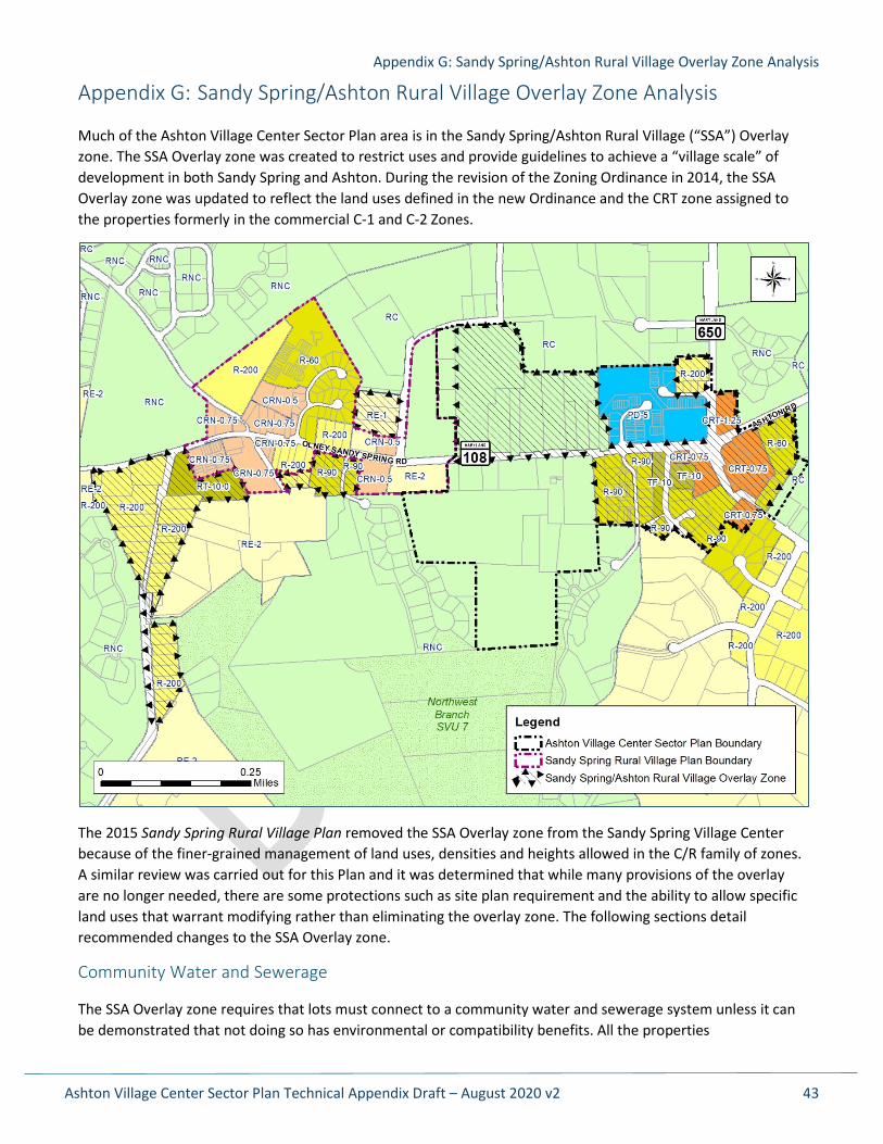
Appendix G: Sandy Spring/Ashton Rural Village Overlay Zone Analysis
Much of the Ashton Village Center Sector Plan area is in the Sandy Spring/Ashton Rural Village (“SSA”) Overlay zone. The SSA Overlay zone was created to restrict uses and provide guidelines to achieve a “village scale” of development in both Sandy Spring and Ashton. During the revision of the Zoning Ordinance in 2014, the SSA Overlay zone was updated to reflect the land uses defined in the new Ordinance and the CRT zone assigned to the properties formerly in the commercial C-1 and C-2 Zones.
The 2015 Sandy Spring Rural Village Plan removed the SSA Overlay zone from the Sandy Spring Village Center because of the finer-grained management of land uses, densities and heights allowed in the C/R family of zones. A similar review was carried out for this Plan and it was determined that while many provisions of the overlay are no longer needed, there are some protections such as site plan requirement and the ability to allow specific land uses that warrant modifying rather than eliminating the overlay zone. The following sections detail recommended changes to the SSA Overlay zone.
Community Water and Sewerage
The SSA Overlay zone requires that lots must connect to a community water and sewerage system unless it can be demonstrated that not doing so has environmental or compatibility benefits. All the properties
Appendix G: Sandy Spring/Ashton Rural Village Overlay Zone Analysis
Ashton Village Center Sector Plan Technical Appendix Draft – August 2020 v2 44
recommended to remain in the SSA Overlay zone are recommended for community water and sewer, so this provision is not necessary and can be removed.
Land Uses
The overlay controls land uses through a combination of the underlying zone and an extensive list of prohibited uses. A comparison (see detailed comparison below) of the land uses prohibited in the SSA Overlay zone and those disallowed in the CRN zone shows that the use limitations in the SSA Overlay zone are largely redundant except that the CRN zone on its own also allows the following service uses up to 5,000 square feet in size:
• Building materials and supplies • Furniture store, carpet, or related furnishing sales or service • Pawnshop
Allowing these few additional uses would not be at odds with a rural village center as long as this Plan’s design recommendations are followed. If the CRT zone were to be replaced by the CRN zone, the land use limitations and development standards in the SSA Overlay zone can be removed.
Conversely, three existing uses in the Plan area are not allowed in the CRN zone: the filling station and auto repair shop in the southwest corner (2 different land uses) and the drive-thru associated with the bank in the southeast corner. All three of these uses are Limited or Conditional uses in the CRT zone but are not permitted in the CRN zone. The SSA Overlay zone generally bans new auto-oriented uses such as filling stations, drive-thrus and vehicle sales and rental businesses unless they were in existence in 1998 when the SSA Overlay zone was put in place. These specific uses are allowed to continue or be altered, repaired or replaced as conforming uses. The overlay prohibits a drive-thru associated with a restaurant but allows it for other uses.
This Plan recommends removing the list of prohibited uses because the CRN Zone disallows most of the uses being limited by the Overlay zone anyway. New language specifically allowing filling stations, automobile repair shops, and drive-thrus not associated with restaurants in existence when the zoning text is amended to be considered conforming and be allowed to continue or be altered, repaired or replaced.
Residential Zone Development Standards in the SSA Overlay Zone
In the residential zones within the SSA Overlay zone, houses are limited to 35 feet but can go as high as 40 feet “if in the site plan approval process the Planning Board finds that additional building height is compatible with the abutting uses and the building height substantially conforms to the intent of the master plan.” Smaller lot sizes than normally allowed in the underlying zone are also possible if supported by a Master Plan.
Existing development standards in the underlying zones already offer similar protections to height and this plan makes no recommendations for small lots in the Residential zones within the Plan area, making the overlay zone unnecessary in the Residential zones within the Plan area. Since the development standards in the overlay zone have no effect on properties in the Rural Residential zones and the overlay is not needed in the Residential zones, properties in these zones can be removed from the overlay.
It may be appropriate to remove all residential development standards in the SSA Overlay zone as part of a Zoning Text Amendment (ZTA). However, several isolated parts of the SSA Overlay zone remain near Sandy Spring because the 2015 SSRVP did not include residential properties outside the immediate village center within its plan boundary, so while the overlay was removed from all properties within the 2015 Plan boundary, some Sandy Spring residential properties retain the overlay. The residential development standards of the overlay zone may have no effect on these remaining properties; further study is needed at the time of any ZTA to determine if all residential development standards should be removed from the overlay. The residential
Appendix G: Sandy Spring/Ashton Rural Village Overlay Zone Analysis
Ashton Village Center Sector Plan Technical Appendix Draft – August 2020 v2 45
properties within the SSA Overlay zone around Sandy Spring are still within the area of the 1998 Sandy Spring/Ashton Master Plan. The 1998 Plan does not indicate the desire to allow flexibility in lot sizes for any of these properties, so at the very least the standard allowing smaller lot sizes if supported by a Master Plan can be removed since no such properties will remain.
C/R and Employment Zone Development Standards in the SSA Overlay Zone
In the C/R and Employment Zones (here referred to as “commercial zones” to distinguish them from the residential zones) within the SSA Overlay zone, building heights are capped at 24 to 30 feet and density is limited to 0.75 FAR. Because height and density limits are designated as part of the CRN zone, these development standards become redundant and can be removed.
Other development standards in these commercial zones:
• Where a minimum area is required for a conditional use, the minimum area may be waived where recommended as appropriate in the master plan.
• In areas recommended in the master plan for mixed use development, development must substantially conform with the recommendations of the master plan. In the residential portions of the mixed-use areas, offstreet parking for commercial uses is allowed without a requirement for approval of a conditional use.
Regarding the minimum area for a conditional use (formerly “special exception”), this standard only applies to the C/R and Employment zones. In the old Zoning Ordinance, this standard applied “where a lot is zoned either partially or totally in a commercial zone.” When the implementation of the Overlay zone was discussed in the 1998 Plan, the recommendation was for “flexibility to allow a waiver of the minimum acreage requirement for special exception uses, such as a nursery in a residential zone” (p. 81). When implemented, this flexibility was only applied to the commercial zones and was not made available in the very residential zones to which it was meant to apply. Combined with the fact that there are no master plan recommendations to waive the minimum lot size for a conditional use, the provision can be removed.
Similarly, with respect to the offstreet parking provision, the mixed-use CRN zone removes the necessity of specifically allowing parking in the residential areas for development in the commercial areas because the CRN allows for both uses within the same area. Therefore, this provision can be removed from the overlay zone.
Site Plan Review
The SSA Overlay zone requires site plan review for all new building projects and additions other than for a detached house built under standard method development. The CRN zone does not generally require a site plan for developments under 10,000 square feet. Many properties in the Village Core would fail to reach this size even with full redevelopment. This Plan recommends keeping the Site Plan Review provision to provide a mechanism so that the associated design guidelines are reviewed as part of any new development.
All retail uses are required to be directly accessible from a sidewalk, plaza or other public space. Since this is already a requirement of the C/R Zones and is also discussed in the Design Guidelines in this Plan; the requirement should be removed.
Parking in a Residential Zone
A final provision of the SSA Overlay zone that is no longer necessary is the specification that “properties in a residential zone that are designated in the master plan as suitable for mixed use or nonresidential use may be
Appendix G: Sandy Spring/Ashton Rural Village Overlay Zone Analysis
Ashton Village Center Sector Plan Technical Appendix Draft – August 2020 v2 46
used for off-street parking in connection with commercial uses.” Since no such properties exist, this can be removed from the SSA Overlay zone.
SSA Overlay Zone Purpose
The combination of changes in the 2014 Zoning Ordinance, the recommended changes above and the design guidelines provided by this Plan requires an update to the purpose of the SSA Overlay zone. This Plan recommends updating the SSA Overlay zone’s purpose to:
Preserve and enhance the rural village character of the Sandy Spring and Ashton village centers using detailed site review and the continuation of community serving businesses within the village center.
Detailed Look at Land Uses in the SSA Overlay Zone
The following land uses are allowed in the CRN zone but prohibited in the Sandy Spring/Ashton Overlay zone. “L”, “C” or “P” after the listed use means Limited, Conditional or Permitted in the CRN zone. Note that virtually all uses allowed in the CRN zone but prohibited in the overlay zone are either Limited or Conditional uses.
• Surface Parking for Use Allowed in the Zone 3.5.9.C (L) o Limited use means the parking setbacks must accommodate the landscaping required under
Section 6.2.9. • Recreation and Entertainment Facility, Indoor (Capacity up to 1,000 Persons) 3.5.10.F (C)
o The conditional use requirement is: The Hearing Examiner may deny the application if it finds the use would be inconsistent with the intent of the zone due to the facility’s size, intensity, level of noise, traffic activity, hours of operation, or lighting.
• Recreation and Entertainment Facility, Outdoor (Capacity up to 1,000 Persons) 3.5.10.G (C) o The conditional use requirements are:
a. In the Commercial/Residential, Employment, and Industrial zones, in addition to screening under Division 6.5, when the use abuts a lot in any Residential zone, a solid wall or solid fence a minimum of 6 feet in height must be constructed and maintained between the use and the lot line.
b. Parking must be sufficient to accommodate the number of people participating in the events.
c. The Hearing Examiner may deny the application if it finds the use would be inconsistent with the intent of the zone due to the facility’s size, intensity, level of noise, traffic activity, hours of operation, or lighting.
• Retail/Service Establishment (Up to 5,000 SF) 3.5.11.B (P) • Retail/Service Establishment (5,001 - 15,000 SF) 3.5.11.B (L) • Retail/Service Establishment (15,001 - 50,000 SF) 3.5.11.B (L)
o For these three uses, the following uses are specifically prohibited in the overlay zone: building materials and supplies furniture store, carpet, or related furnishing sales or service pawnshop
o Limited use in the CRN zone means: a. If the subject lot abuts or confronts a property zoned Agricultural, Rural Residential, or
Residential Detached that is vacant or improved with an agricultural or residential use, site plan approval is required under Section 7.3.4.
Appendix G: Sandy Spring/Ashton Rural Village Overlay Zone Analysis
Ashton Village Center Sector Plan Technical Appendix Draft – August 2020 v2 47
b. A Retail/Service Establishment over 15,000 square feet of gross floor area must be a grocery store.
• Light Manufacturing and Production 3.6.4.C (L) o Specifically prohibited in the overlay zone:
newspaper, printing, and publishing o Limited use means:
If the subject lot abuts or confronts a property zoned Agricultural, Rural Residential, or Residential Detached that is vacant or improved with an agricultural or residential use, site plan approval is required under Section 7.3.4.
The only light manufacturing uses allowed are: a. brewing alcoholic beverages up to 22,500 barrels a year; and b. distilling alcoholic beverages up to 50,000 gallons per year.
• Pipeline (Above Ground) 3.6.7.C (C) o Extra conditional use requirements:
a. The proposed pipeline is necessary for public convenience and service. b. The proposed pipeline will not endanger the health and safety of workers and residents in
the community and will not substantially impair or prove detrimental to neighboring properties.
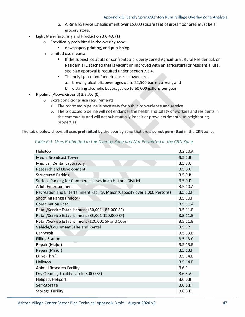
The table below shows all uses prohibited by the overlay zone that are also not permitted in the CRN zone.
Table E-1. Uses Prohibited in the Overlay Zone and Not Permitted in the CRN Zone
Helistop 3.2.10.A Media Broadcast Tower 3.5.2.B Medical, Dental Laboratory 3.5.7.C Research and Development 3.5.8.C Structured Parking 3.5.9.B Surface Parking for Commercial Uses in an Historic District 3.5.9.D Adult Entertainment 3.5.10.A Recreation and Entertainment Facility, Major (Capacity over 1,000 Persons) 3.5.10.H Shooting Range (Indoor) 3.5.10.I Combination Retail 3.5.11.A Retail/Service Establishment (50,001 - 85,000 SF) 3.5.11.B Retail/Service Establishment (85,001-120,000 SF) 3.5.11.B Retail/Service Establishment (120,001 SF and Over) 3.5.11.B Vehicle/Equipment Sales and Rental 3.5.12 Car Wash 3.5.13.B Filling Station 3.5.13.C Repair (Major) 3.5.13.E Repair (Minor) 3.5.13.F Drive-Thru1 3.5.14.E Helistop 3.5.14.F Animal Research Facility 3.6.1 Dry Cleaning Facility (Up to 3,000 SF) 3.6.3.A Helipad, Heliport 3.6.6.B Self-Storage 3.6.8.D Storage Facility 3.6.8.E
Appendix G: Sandy Spring/Ashton Rural Village Overlay Zone Analysis
Ashton Village Center Sector Plan Technical Appendix Draft – August 2020 v2 48
1 Drive-thrus associated with a restaurant are not permitted in the overlay zone, but those associated with other uses, such as a bank, are not prohibited. No drive-thrus are allowed in the CRN zone.
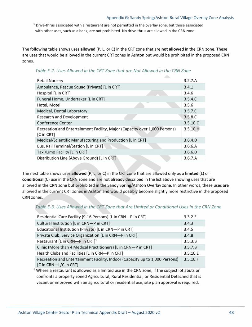
The following table shows uses allowed (P, L, or C) in the CRT zone that are not allowed in the CRN zone. These are uses that would be allowed in the current CRT zones in Ashton but would be prohibited in the proposed CRN zones.
Table E-2. Uses Allowed in the CRT Zone that are Not Allowed in the CRN Zone
Retail Nursery 3.2.7.A Ambulance, Rescue Squad (Private) [L in CRT] 3.4.1 Hospital [L in CRT] 3.4.6 Funeral Home, Undertaker [L in CRT] 3.5.4.C Hotel, Motel 3.5.6 Medical, Dental Laboratory 3.5.7.C Research and Development 3.5.8.C Conference Center 3.5.10.C Recreation and Entertainment Facility, Major (Capacity over 1,000 Persons) [C in CRT]
3.5.10.H
Medical/Scientific Manufacturing and Production [L in CRT] 3.6.4.D Bus, Rail Terminal/Station [L in CRT] 3.6.6.A Taxi/Limo Facility [L in CRT] 3.6.6.D Distribution Line (Above Ground) [L in CRT] 3.6.7.A
The next table shows uses allowed (P, L, or C) in the CRT zone that are allowed only as a limited (L) or conditional (C) use in the CRN zone and are not already described in the list above showing uses that are allowed in the CRN zone but prohibited in the Sandy Spring/Ashton Overlay zone. In other words, these uses are allowed in the current CRT zones in Ashton and would possibly become slightly more restrictive in the proposed CRN zones.
Table E-3. Uses Allowed in the CRT Zone that Are Limited or Conditional Uses in the CRN Zone
Residential Care Facility (9-16 Persons) [L in CRN—P in CRT] 3.3.2.E Cultural Institution [L in CRN—P in CRT] 3.4.3 Educational Institution (Private) [L in CRN—P in CRT] 3.4.5 Private Club, Service Organization [L in CRN—P in CRT] 3.4.8 Restaurant [L in CRN—P in CRT]1 3.5.3.B Clinic (More than 4 Medical Practitioners) [L in CRN—P in CRT] 3.5.7.B Health Clubs and Facilities [L in CRN—P in CRT] 3.5.10.E Recreation and Entertainment Facility, Indoor (Capacity up to 1,000 Persons) [C in CRN—L/C in CRT]
3.5.10.F
1 Where a restaurant is allowed as a limited use in the CRN zone, if the subject lot abuts or confronts a property zoned Agricultural, Rural Residential, or Residential Detached that is vacant or improved with an agricultural or residential use, site plan approval is required.
Appendix G: Sandy Spring/Ashton Rural Village Overlay Zone Analysis
Ashton Village Center Sector Plan Technical Appendix Draft – August 2020 v2 49
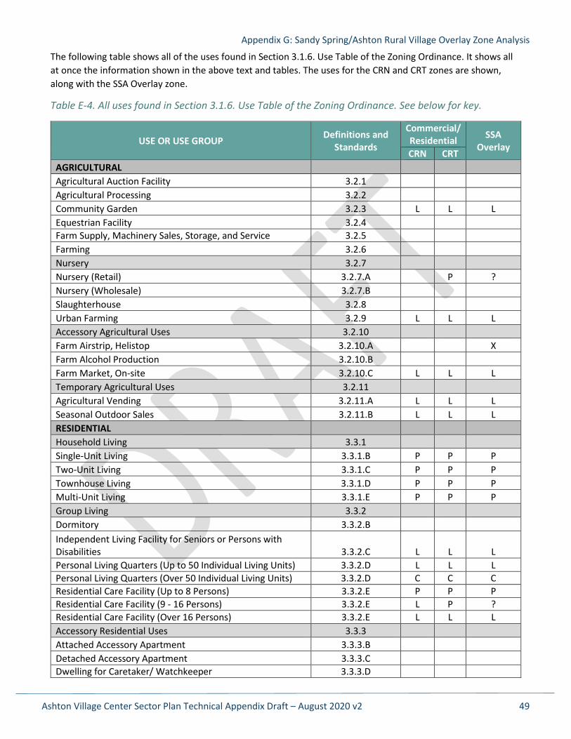
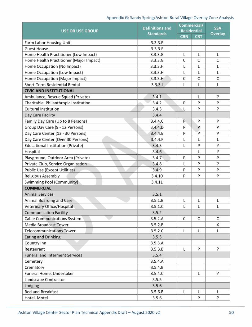
The following table shows all of the uses found in Section 3.1.6. Use Table of the Zoning Ordinance. It shows all at once the information shown in the above text and tables. The uses for the CRN and CRT zones are shown, along with the SSA Overlay zone.
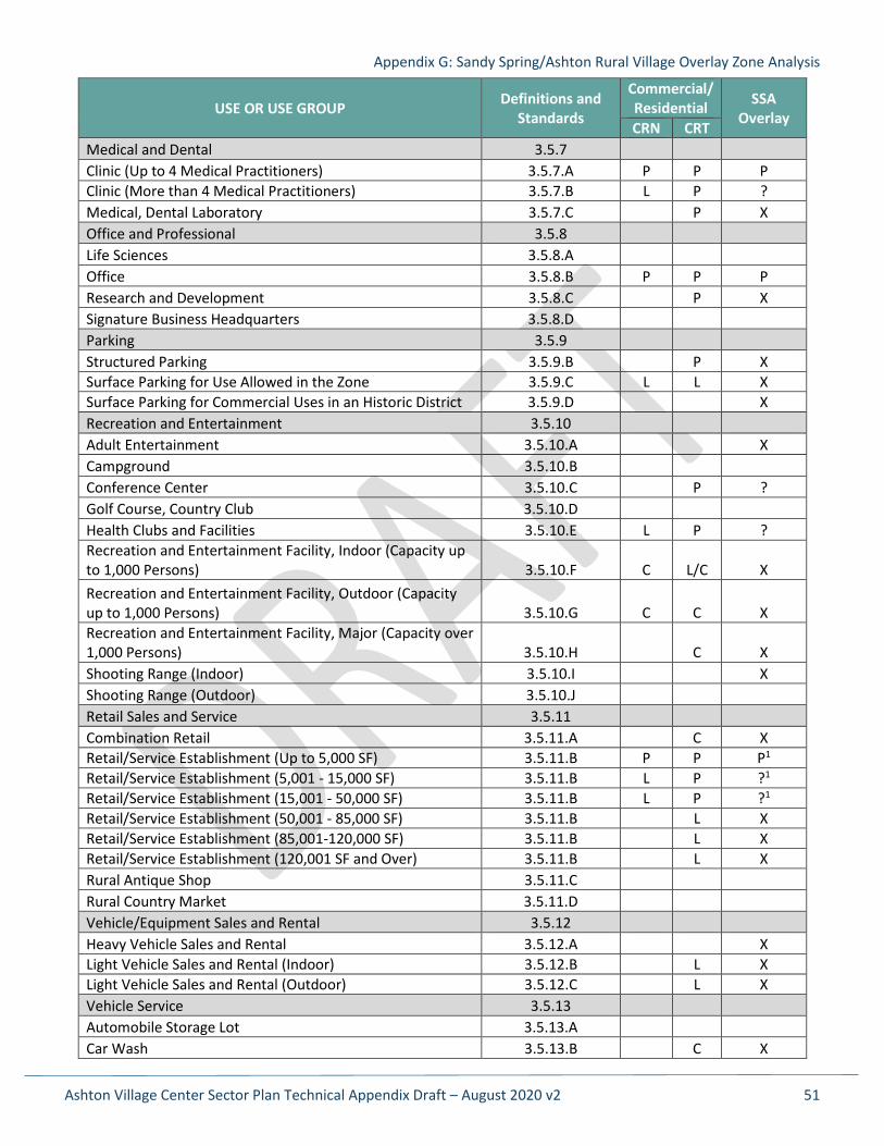
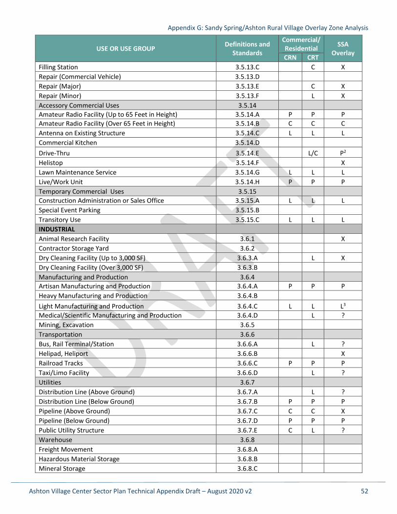
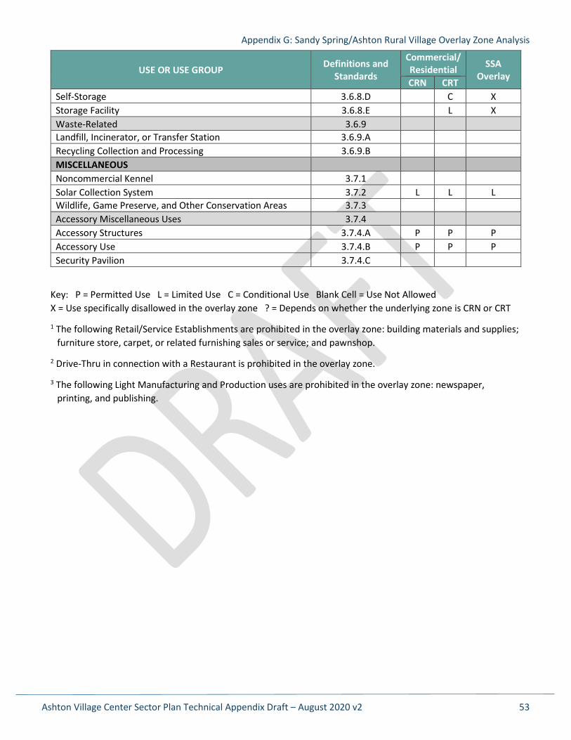
Table E-4. All uses found in Section 3.1.6. Use Table of the Zoning Ordinance. See below for key.
USE OR USE GROUP Definitions and Standards
Commercial/ Residential SSA
Overlay CRN CRT AGRICULTURAL Agricultural Auction Facility 3.2.1 Agricultural Processing 3.2.2 Community Garden 3.2.3 L L L Equestrian Facility 3.2.4 Farm Supply, Machinery Sales, Storage, and Service 3.2.5 Farming 3.2.6 Nursery 3.2.7 Nursery (Retail) 3.2.7.A P ? Nursery (Wholesale) 3.2.7.B Slaughterhouse 3.2.8 Urban Farming 3.2.9 L L L Accessory Agricultural Uses 3.2.10 Farm Airstrip, Helistop 3.2.10.A X Farm Alcohol Production 3.2.10.B Farm Market, On-site 3.2.10.C L L L Temporary Agricultural Uses 3.2.11 Agricultural Vending 3.2.11.A L L L Seasonal Outdoor Sales 3.2.11.B L L L RESIDENTIAL Household Living 3.3.1 Single-Unit Living 3.3.1.B P P P Two-Unit Living 3.3.1.C P P P Townhouse Living 3.3.1.D P P P Multi-Unit Living 3.3.1.E P P P Group Living 3.3.2 Dormitory 3.3.2.B Independent Living Facility for Seniors or Persons with Disabilities 3.3.2.C L L L Personal Living Quarters (Up to 50 Individual Living Units) 3.3.2.D L L L Personal Living Quarters (Over 50 Individual Living Units) 3.3.2.D C C C Residential Care Facility (Up to 8 Persons) 3.3.2.E P P P Residential Care Facility (9 - 16 Persons) 3.3.2.E L P ? Residential Care Facility (Over 16 Persons) 3.3.2.E L L L Accessory Residential Uses 3.3.3 Attached Accessory Apartment 3.3.3.B Detached Accessory Apartment 3.3.3.C Dwelling for Caretaker/ Watchkeeper 3.3.3.D
Appendix G: Sandy Spring/Ashton Rural Village Overlay Zone Analysis
Ashton Village Center Sector Plan Technical Appendix Draft – August 2020 v2 50
USE OR USE GROUP Definitions and Standards
Commercial/ Residential SSA
Overlay CRN CRT Farm Labor Housing Unit 3.3.3.E Guest House 3.3.3.F Home Health Practitioner (Low Impact) 3.3.3.G L L L Home Health Practitioner (Major Impact) 3.3.3.G C C C Home Occupation (No Impact) 3.3.3.H L L L Home Occupation (Low Impact) 3.3.3.H L L L Home Occupation (Major Impact) 3.3.3.H C C C Short-Term Residential Rental 3.3.3.I L L L CIVIC AND INSTITUTIONAL Ambulance, Rescue Squad (Private) 3.4.1 L ? Charitable, Philanthropic Institution 3.4.2 P P P Cultural Institution 3.4.3 L P ? Day Care Facility 3.4.4 Family Day Care (Up to 8 Persons) 3.4.4.C P P P Group Day Care (9 - 12 Persons) 3.4.4.D P P P Day Care Center (13 - 30 Persons) 3.4.4.E P P P Day Care Center (Over 30 Persons) 3.4.4.F L L L Educational Institution (Private) 3.4.5 L P ? Hospital 3.4.6 L ? Playground, Outdoor Area (Private) 3.4.7 P P P Private Club, Service Organization 3.4.8 L P ? Public Use (Except Utilities) 3.4.9 P P P Religious Assembly 3.4.10 P P P Swimming Pool (Community) 3.4.11 COMMERCIAL Animal Services 3.5.1 Animal Boarding and Care 3.5.1.B L L L Veterinary Office/Hospital 3.5.1.C L L L Communication Facility 3.5.2 Cable Communications System 3.5.2.A C C C Media Broadcast Tower 3.5.2.B X Telecommunications Tower 3.5.2.C L L L Eating and Drinking 3.5.3 Country Inn 3.5.3.A Restaurant 3.5.3.B L P ? Funeral and Interment Services 3.5.4 Cemetery 3.5.4.A Crematory 3.5.4.B Funeral Home, Undertaker 3.5.4.C L ? Landscape Contractor 3.5.5 Lodging 3.5.6 Bed and Breakfast 3.5.6.B L L L Hotel, Motel 3.5.6 P ?
Appendix G: Sandy Spring/Ashton Rural Village Overlay Zone Analysis
Ashton Village Center Sector Plan Technical Appendix Draft – August 2020 v2 51
USE OR USE GROUP Definitions and Standards
Commercial/ Residential SSA
Overlay CRN CRT Medical and Dental 3.5.7 Clinic (Up to 4 Medical Practitioners) 3.5.7.A P P P Clinic (More than 4 Medical Practitioners) 3.5.7.B L P ? Medical, Dental Laboratory 3.5.7.C P X Office and Professional 3.5.8 Life Sciences 3.5.8.A Office 3.5.8.B P P P Research and Development 3.5.8.C P X Signature Business Headquarters 3.5.8.D Parking 3.5.9 Structured Parking 3.5.9.B P X Surface Parking for Use Allowed in the Zone 3.5.9.C L L X Surface Parking for Commercial Uses in an Historic District 3.5.9.D X Recreation and Entertainment 3.5.10 Adult Entertainment 3.5.10.A X Campground 3.5.10.B Conference Center 3.5.10.C P ? Golf Course, Country Club 3.5.10.D Health Clubs and Facilities 3.5.10.E L P ? Recreation and Entertainment Facility, Indoor (Capacity up to 1,000 Persons) 3.5.10.F C L/C X Recreation and Entertainment Facility, Outdoor (Capacity up to 1,000 Persons) 3.5.10.G C C X Recreation and Entertainment Facility, Major (Capacity over 1,000 Persons) 3.5.10.H C X Shooting Range (Indoor) 3.5.10.I X Shooting Range (Outdoor) 3.5.10.J Retail Sales and Service 3.5.11 Combination Retail 3.5.11.A C X Retail/Service Establishment (Up to 5,000 SF) 3.5.11.B P P P1 Retail/Service Establishment (5,001 - 15,000 SF) 3.5.11.B L P ?1 Retail/Service Establishment (15,001 - 50,000 SF) 3.5.11.B L P ?1 Retail/Service Establishment (50,001 - 85,000 SF) 3.5.11.B L X Retail/Service Establishment (85,001-120,000 SF) 3.5.11.B L X Retail/Service Establishment (120,001 SF and Over) 3.5.11.B L X Rural Antique Shop 3.5.11.C Rural Country Market 3.5.11.D Vehicle/Equipment Sales and Rental 3.5.12 Heavy Vehicle Sales and Rental 3.5.12.A X Light Vehicle Sales and Rental (Indoor) 3.5.12.B L X Light Vehicle Sales and Rental (Outdoor) 3.5.12.C L X Vehicle Service 3.5.13 Automobile Storage Lot 3.5.13.A Car Wash 3.5.13.B C X
Appendix G: Sandy Spring/Ashton Rural Village Overlay Zone Analysis
Ashton Village Center Sector Plan Technical Appendix Draft – August 2020 v2 52
USE OR USE GROUP Definitions and Standards
Commercial/ Residential SSA
Overlay CRN CRT Filling Station 3.5.13.C C X Repair (Commercial Vehicle) 3.5.13.D Repair (Major) 3.5.13.E C X Repair (Minor) 3.5.13.F L X Accessory Commercial Uses 3.5.14 Amateur Radio Facility (Up to 65 Feet in Height) 3.5.14.A P P P Amateur Radio Facility (Over 65 Feet in Height) 3.5.14.B C C C Antenna on Existing Structure 3.5.14.C L L L Commercial Kitchen 3.5.14.D Drive-Thru 3.5.14.E L/C P2 Helistop 3.5.14.F X Lawn Maintenance Service 3.5.14.G L L L Live/Work Unit 3.5.14.H P P P Temporary Commercial Uses 3.5.15 Construction Administration or Sales Office 3.5.15.A L L L Special Event Parking 3.5.15.B Transitory Use 3.5.15.C L L L INDUSTRIAL Animal Research Facility 3.6.1 X Contractor Storage Yard 3.6.2 Dry Cleaning Facility (Up to 3,000 SF) 3.6.3.A L X Dry Cleaning Facility (Over 3,000 SF) 3.6.3.B Manufacturing and Production 3.6.4 Artisan Manufacturing and Production 3.6.4.A P P P Heavy Manufacturing and Production 3.6.4.B Light Manufacturing and Production 3.6.4.C L L L3 Medical/Scientific Manufacturing and Production 3.6.4.D L ? Mining, Excavation 3.6.5 Transportation 3.6.6 Bus, Rail Terminal/Station 3.6.6.A L ? Helipad, Heliport 3.6.6.B X Railroad Tracks 3.6.6.C P P P Taxi/Limo Facility 3.6.6.D L ? Utilities 3.6.7 Distribution Line (Above Ground) 3.6.7.A L ? Distribution Line (Below Ground) 3.6.7.B P P P Pipeline (Above Ground) 3.6.7.C C C X Pipeline (Below Ground) 3.6.7.D P P P Public Utility Structure 3.6.7.E C L ? Warehouse 3.6.8 Freight Movement 3.6.8.A Hazardous Material Storage 3.6.8.B Mineral Storage 3.6.8.C
Appendix G: Sandy Spring/Ashton Rural Village Overlay Zone Analysis
Ashton Village Center Sector Plan Technical Appendix Draft – August 2020 v2 53
USE OR USE GROUP Definitions and Standards
Commercial/ Residential SSA
Overlay CRN CRT Self-Storage 3.6.8.D C X Storage Facility 3.6.8.E L X Waste-Related 3.6.9 Landfill, Incinerator, or Transfer Station 3.6.9.A Recycling Collection and Processing 3.6.9.B MISCELLANEOUS Noncommercial Kennel 3.7.1 Solar Collection System 3.7.2 L L L Wildlife, Game Preserve, and Other Conservation Areas 3.7.3 Accessory Miscellaneous Uses 3.7.4 Accessory Structures 3.7.4.A P P P Accessory Use 3.7.4.B P P P Security Pavilion 3.7.4.C
Key: P = Permitted Use L = Limited Use C = Conditional Use Blank Cell = Use Not Allowed X = Use specifically disallowed in the overlay zone ? = Depends on whether the underlying zone is CRN or CRT
1 The following Retail/Service Establishments are prohibited in the overlay zone: building materials and supplies; furniture store, carpet, or related furnishing sales or service; and pawnshop.
2 Drive-Thru in connection with a Restaurant is prohibited in the overlay zone.
3 The following Light Manufacturing and Production uses are prohibited in the overlay zone: newspaper, printing, and publishing.
Ashton Village Center Sector Plan Technical Appendix Draft – August 2020 v2 54
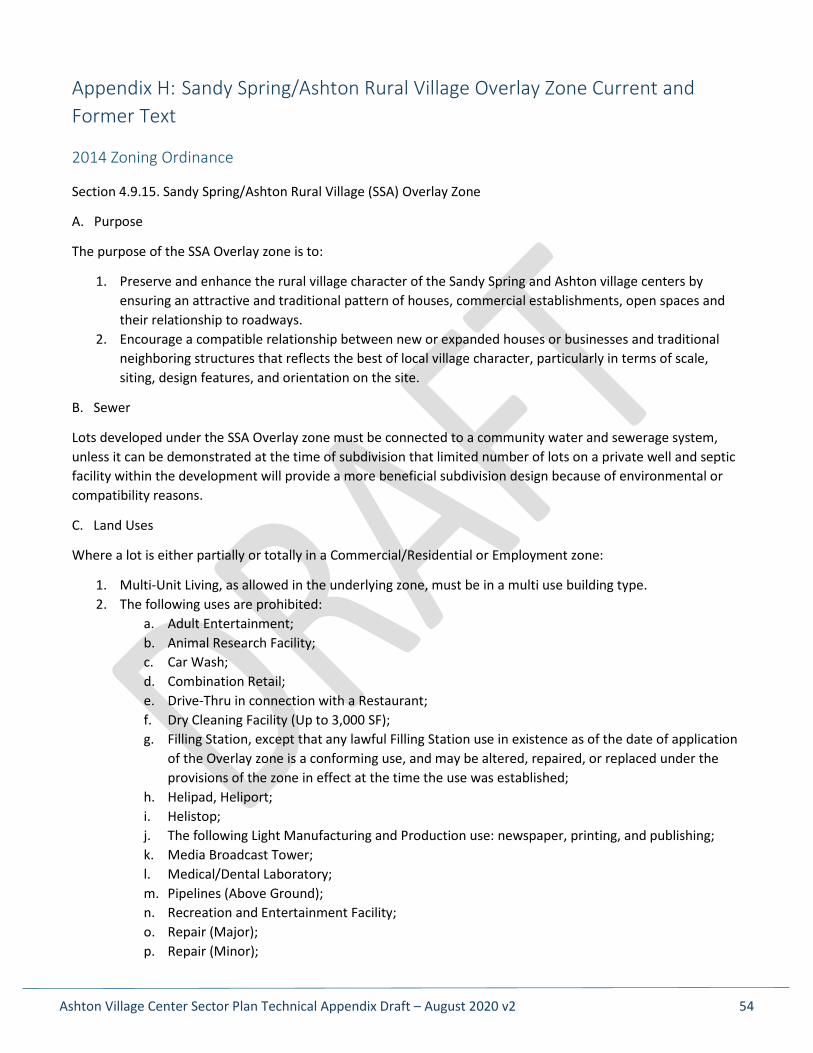
Appendix H: Sandy Spring/Ashton Rural Village Overlay Zone Current and Former Text
2014 Zoning Ordinance
Section 4.9.15. Sandy Spring/Ashton Rural Village (SSA) Overlay Zone
A. Purpose
The purpose of the SSA Overlay zone is to:
1. Preserve and enhance the rural village character of the Sandy Spring and Ashton village centers by ensuring an attractive and traditional pattern of houses, commercial establishments, open spaces and their relationship to roadways.
2. Encourage a compatible relationship between new or expanded houses or businesses and traditional neighboring structures that reflects the best of local village character, particularly in terms of scale, siting, design features, and orientation on the site.
B. Sewer
Lots developed under the SSA Overlay zone must be connected to a community water and sewerage system, unless it can be demonstrated at the time of subdivision that limited number of lots on a private well and septic facility within the development will provide a more beneficial subdivision design because of environmental or compatibility reasons.
C. Land Uses
Where a lot is either partially or totally in a Commercial/Residential or Employment zone:
1. Multi-Unit Living, as allowed in the underlying zone, must be in a multi use building type. 2. The following uses are prohibited:
a. Adult Entertainment; b. Animal Research Facility; c. Car Wash; d. Combination Retail; e. Drive-Thru in connection with a Restaurant; f. Dry Cleaning Facility (Up to 3,000 SF); g. Filling Station, except that any lawful Filling Station use in existence as of the date of application
of the Overlay zone is a conforming use, and may be altered, repaired, or replaced under the provisions of the zone in effect at the time the use was established;
h. Helipad, Heliport; i. Helistop; j. The following Light Manufacturing and Production use: newspaper, printing, and publishing; k. Media Broadcast Tower; l. Medical/Dental Laboratory; m. Pipelines (Above Ground); n. Recreation and Entertainment Facility; o. Repair (Major); p. Repair (Minor);
Appendix H: Sandy Spring/Ashton Rural Village Overlay Zone Current and Former Text
Ashton Village Center Sector Plan Technical Appendix Draft – August 2020 v2 55
q. Research and Development; r. Retail/Service Establishment (50,000 SF and Over); s. The following Retail/Service Establishments: building materials and supplies; furniture store,
carpet, or related furnishing sales or service; and pawnshop; t. Self-Storage; u. Shooting Range (Indoor); v. Storage Facility; w. Structured Parking; x. Surface Parking for Use Allowed in the Zone; y. Surface Parking for Commercial Uses in an Historic District; and z. Vehicle/Equipment Sales and Rental, except any automobile rental business in existence on
October 13, 1998 may continue as a conforming use, and may be altered, repaired, or replaced under the provisions of the zone in effect at the time the use was established.
D. Development Standards
1. Where a lot is in a Commercial/Residential or Employment zone: a. The maximum height for all buildings is 24 feet, except that the Planning Board may allow
additional height up to 30 feet in the site plan approval process, if the Planning Board finds that the additional height is compatible with the abutting uses and substantially conforms with the intent of the master plan.
b. The maximum density for commercial uses is 0.75 FAR, and is computed only on the area of the underlying Commercial/Residential or Employment zoned portion of the site.
c. Where a minimum area is required for a conditional use, the minimum area may be waived where recommended as appropriate in the master plan.
d. In areas recommended in the master plan for mixed use development, development must substantially conform with the recommendations of the master plan. In the residential portions of the mixed-use areas, offstreet parking for commercial uses is allowed without a requirement for approval of a conditional use.
2. Where a lot is in a Residential zone 2: a. The density of development must not exceed the standards for the underlying zone under
optional method Cluster Development. b. The Planning Board may approve lot sizes as small as 900 square feet for a townhouse, 2,000
square feet for a duplex, and 3,000 square feet for any other building type, including a minimum of zero feet for side setbacks on one side, upon a showing that the resulting development will substantially conform with the recommendations of the master plan.
c. The maximum height for all buildings is 35 feet; however, if in the site plan approval process the Planning Board finds that additional building height is compatible with the abutting uses and the building height substantially conforms to the intent of the master plan, the maximum building height is 40 feet.
E. Site Plan
1. Site plan approval under Section 7.3.4 is required for: a. construction of a new building;
2 Section D.2. items b and c were revised via Ordinance No. 18-26 (Zoning Text Amendment No. 16-18) on February 7, 2017 and effective February 27, 2017. Prior to the ZTA, the minimum lot size was 3,000 square feet and there was no provision to build higher than 35 feet in a residential zone.
Appendix H: Sandy Spring/Ashton Rural Village Overlay Zone Current and Former Text
Ashton Village Center Sector Plan Technical Appendix Draft – August 2020 v2 56
b. any addition or other exterior improvement to an existing building that increases the amount of gross floor area on a site; or
c. if required under Section 7.3.4.A.8. 2. Site plan approval is not required for development of a detached house that proceeds under standard
method development. 3. In addition to the site plan findings under Section 7.3.4.E, the Planning Board must find that all retail
uses proposed in new or renovated buildings are directly accessible from a sidewalk, plaza, or other public space.
F. Parking
1. The Planning Board may allow some on-street parking to fulfill the requirement for off-street parking to enhance compatibility, provide additional open space and reduce impervious coverage.
2. Properties in a Residential zone that are designated in the master plan as suitable for mixed use or nonresidential use may be used for off-street parking in connection with commercial uses.
3. The SSA Overlay zone encourages the parking of vehicles behind the front building line. In addition, to reduce access points and thereby enhance safety, abutting parking facilities may be required to provide internal connections. In exceptional circumstances, limited parking may be allowed between the front lot line and the front building line.
(Legislative History: Ord. No. 18-10, § 2; Ord. No. 18-26, § 1; Ord. No. 18-28, §3.)
Old Zoning Ordinance
Sec. 59-C-18.18. Sandy Spring/Ashton Rural Village Overlay Zone.
59-C-18.181. Purpose.
It is the purpose of this overlay zone to:
(a) Preserve and enhance the rural village character of the Sandy Spring and Ashton village centers by ensuring an attractive and traditional pattern of houses, commercial establishments, open spaces and their relationship to roadways.
(b) Encourage a compatible relationship between new or expanded houses or businesses and traditional neighboring structures that reflects the best of local village character, particularly in terms of scale, siting, design features, and orientation on the site.
59-C-18.182. Regulations.
Lots developed under this overlay zone must be connected to a community water and sewerage system, unless it can be demonstrated that at the time of subdivision that limited number of lots on a private well and septic facility within the development will provide a more beneficial subdivision design because of environmental or compatibility reasons.
(a) Development standards residential zones:
(1) Land uses. All uses as allowed in the underlying zone as set forth in Sec. 59-C-1.31.
(2) Development standards. The development standards are the same as those in the underlying zones, except as follows:
Appendix H: Sandy Spring/Ashton Rural Village Overlay Zone Current and Former Text
Ashton Village Center Sector Plan Technical Appendix Draft – August 2020 v2 57
(A) Density of development: The density of development cannot exceed the standards for the underlying zone as set forth in the cluster provisions of Sec. 59-C-1.533.
(B) Minimum net lot area: If development proceeds under the standards of the zone as set forth in Sec. 59-C-1, the standards for the zone apply and site plan review will not be required.
Lot sizes down to 3,000 square feet may be approved by the Planning Board, including zero side yard setbacks on one side, upon a showing that the resulting development will be consistent with the guidelines of the master plan. Site plan review in accordance with the provisions of Sec. 59-C-18.174 is required.
(C) Building height: A main building must not exceed a height of 35 feet.
(b) Commercial development. Where a lot is zoned either partially or totally in a commercial zone the following regulations apply:
(1) Land uses. All permitted or special exception uses allowed in the underlying zones are allowed in the commercial portion of the overlay zone. The following uses are prohibited in the overlay zones:
Adult entertainment business
Automobile filling station1
Automobile fluid maintenance station
Automobile, light truck, and light trailer rentals, outdoor, except any automobile rental business in existence on October 13, 1998 may continue as a conforming use, and may be altered, repaired, or replaced in accordance with provisions of the zone in effect at the time the use was established.
Automobile repair and services
Automobile, truck, and trailer rentals, outdoor
Automobile sales, indoor
Automobile sales, outdoor
Baseball driving range
Building materials and supplies
Car wash
Combination retail store
Department stores
Dry cleaning and laundry establishments, consisting of no more than 3,000 square feet of gross floor area
Eating and drinking establishments, drive-in
Fairgrounds, circuses, and amusement parks
Furniture stores, carpet, or related furnishing sales or service
Golf driving ranges
Heliports
Appendix H: Sandy Spring/Ashton Rural Village Overlay Zone Current and Former Text
Ashton Village Center Sector Plan Technical Appendix Draft – August 2020 v2 58
Helistops
Ice storage
Laboratories
Multi-family dwellings, except when included in a structure containing retail or commercial uses
Newspaper, printing and publishing shops
Parking garages, automobile, for off-site uses
Parking lots, automobile, for off-site uses
Pawnshops
Pipelines, above ground
Radio and television broadcasting stations and towers
Racquet ball, squash, indoor tennis and handball courts, commercial
Rifle or pistol ranges, indoor
Roller and ice skating rinks
Stadiums or arenas
Swimming pools, commercial
Warehousing and storage service including:
(A) Industrial and commercial uses wholly enclosed; or
(B) Self-storage facility
(2) Development standards:
(A) Where the property is in a commercial zone, the setback and green area standards of the underlying zone are the same as set forth in Div. 59-C-4. Building height must not exceed 24 feet, except that at the time of site plan review the Planning Board may allow additional height up to 30 feet if the Board finds that the additional height is compatible with the adjoining uses and is consistent with the intent of the master plan.
(B) Floor area ratio. The floor area ratio for commercial uses is limited to FAR 0.75, and is computed only on the area of the underlying commercial zoned portion of the site.
(C) In the case of special exceptions where a minimum area is otherwise required, the minimum area may be waived where recommended as appropriate in the master plan.
(D) In areas recommended in the Sandy Spring/Ashton Master Plan for mixed use development, development should consistent with the recommendations of the master plan. In the residential portions of the mixed-use areas, off-street parking for commercial uses is allowed without a requirement for approval of a special exception.
1 Any lawful use in existence as of the date of application of the overlay zone is a conforming use, and may be altered, repaired, or replaced in accordance with the provisions of the zone in effect at the time the use was established.

Appendix H: Sandy Spring/Ashton Rural Village Overlay Zone Current and Former Text
Ashton Village Center Sector Plan Technical Appendix Draft – August 2020 v2 59
59-C-18.183. Procedure for application and approval.
A site plan for any development in the Sandy Spring/Ashton Rural Village Overlay Zone must be approved under the provisions of Section 59-C-18.174 except for a one-family detached residential house developed in accordance with the provisions of Division 59-C-1. Development includes the following:
(a) Construction of a new building;
(b) Additions and other exterior improvements to existing buildings that increase the amount of gross floor area on a site; and
(c) Additions of off-street parking spaces or revisions to parking facilities that would otherwise require the approval of a new parking facilities plan under Section 59-E-4.1.
59-C-18.184. Site plan contents and exemptions.
(a) Section 59-D-3.22 and 59-D-3.23 do not apply in the Sandy Spring/Ashton Rural Village Overlay Zone.
(b) A site plan for development in the Sandy Spring/Ashton Rural Village Overlay Zone must include:
(1) A drawing of the site and adjacent area that includes existing buildings and structures, uses, and zoning;
(2) The location, height, ground coverage, roof design, surface finish materials, and use of all structures on the site;
(3) For each mixed-use building, the number and type of dwelling units, classified by the number of bedrooms, and the total floor area, if any, to be used for commercial purposes;
(4) The floor areas of all nonresidential buildings and the proposed use of each;
(5) The location of recreational and green areas and other open spaces;
(6) Calculations of building coverage, density, green area, number of parking spaces and areas of land use;
(7) A grading plan;
(8) The location and dimensions of all roads, streets and driveways, parking facilities, loading areas, points of access to surrounding streets or properties and pedestrian walks;
(9) A landscaping plan (and final forest conservation plan, if required under Chapter 22A), showing all man-made features and the location, height or caliper, and species of all plant materials;
(10) An exterior lighting plan, including all parking areas, driveways and pedestrian ways, and the height, number, and type of fixtures with a diagram showing their light distribution characteristics; and
(11) A development program with the sequence in which all structures, open spaces, vehicular and pedestrian circulation systems, landscaping, and recreational facilities, are to be developed. The applicant must designate the point in the development program sequence when the applicant will ask the Planning Board to inspect for compliance with the approved site plan.
Appendix H: Sandy Spring/Ashton Rural Village Overlay Zone Current and Former Text
Ashton Village Center Sector Plan Technical Appendix Draft – August 2020 v2 60
In the course of site plan approval, the Planning Board must make a finding as to whether or not the proposed development substantially conforms with the design guidelines for new development contained in the approved and adopted Sandy Spring/Ashton Master Plan.
59-C-18.185. Off-street parking and loading.
Parking must be provided in accordance with the provisions of Division 59-E with the following exceptions:
(a) In the course of site plan review, the Planning Board may allow some on-street parking to fulfill the requirement for off-street parking to enhance compatibility, provide additional green space and reduce impervious coverage.
(b) Properties in a residential zone that are designated in the Sandy Spring/Ashton Master Plan as suitable for mixed use or non-residential use may be utilized for off-street parking in connection with commercial uses without the necessity for approval of a special exception under Sec. 59-G-2.39.
The Sandy Spring/Ashton Rural Village Overlay Zone encourages the parking of vehicles in the side or rear yards. In addition, in order to reduce access points and thereby enhance safety, adjoining parking facilities may be required to provide internal connections. In exceptional circumstances, limited parking may be allowed in the front yard.
59-C-18.186. Planning Board approval.
The procedures for Planning Board approval under Section 59-D-3.4 are modified for this overlay zone to require the following additional findings:
(a) The site plan is consistent with the recommendations in the approved and adopted Sandy Spring/Ashton Master Plan;
(b) The site plan meets all of the requirements of this overlay zone as well as the applicable requirements of the underlying zone; and
(c) Each structure and use is compatible with other uses and other site plans and with existing and proposed adjacent development.
(Legislative History: Ord. No. 13-95, § 1; Ord. No. 14-23; § 1; Ord. No. 16-40, § 1.)
Ashton Village Center Sector Plan Technical Appendix Draft – August 2020 v2 61
Appendix I: Sandy Spring/Ashton Rural Village (SSA) Overlay Zone Proposed Revision
The following is the proposed text for a revised Sandy Spring/Ashton Rural Village Overlay zone. This change requires a Zoning Text Amendment (ZTA) to implement.
A. Purpose
The purpose of the SSA Overlay zone is to preserve and enhance the rural village character of the Sandy Spring and Ashton village centers using detailed site review and the continuation of community serving businesses within the village centers.
B. Land Uses
1. If the underlying zone on the property is CRN:
a. A Drive-Thru may be altered, repaired or replaced under limited use standards and may be continued as a conforming use.
b. A Filling Station may be altered, repaired or replaced as a conditional use under Section 7.3.1 and may be continued as a conforming use.
C. Development Standards
3. Where a lot is in a Residential zone:
a. The maximum height for all buildings is 35 feet; however, if in the site plan approval process the Planning Board finds that additional building height is compatible with the abutting uses and the building height substantially conforms to the intent of the master plan, the maximum building height is 40 feet.
D. Site Plan
4. Site plan approval under Section 7.3.4 is required for:
a. construction of a new building;
b. any addition or other exterior improvement to an existing building that increases the amount of gross floor area on a site; or
c. if required under Section 7.3.4.A.8.
5. Site plan approval is not required for development of a detached house that proceeds under standard method development.

Ashton Village Center Sector Plan Technical Appendix Draft – August 2020 v2 62
Appendix J: County Growth Policy and Its Impact on the Ashton Village Center Sector Plan
The Montgomery County Planning Department is currently revising its Adequate Public Facilities Ordinance to use a new County Growth Policy (CGP) in place of the current Subdivision Staging Policy (SSP). The draft CGP recommends that the Planning Board adopt a set of new Annual School Test guidelines by January 1, 2021. Because this Plan is being written during a transition period between the policies, school adequacy has been reviewed using both policies.
The Planning Board Draft of the 2020 County Growth Policy places Ashton in a “Turnover School Impact Area,” which is defined as an area “with low housing growth where enrollment growth is largely due to turnover of existing single-family units.” The recommended guidelines in the draft CGP remove the cluster-level test for school adequacy but retain the SSP’s individual school test for seat deficits and utilization rates. The main thing that has changed here is the SSP used a five-year projection and the CGP uses a three-year projection.
The current SSP adequacy standards for five years in the future and the proposed CGP adequacy standards for three years in the future are:
• Elementary School Adequacy Standard: Seat Deficit < 110 seats or Percent Utilization ≤ 120% • Middle School Adequacy Standard: Seat Deficit < 180 seats or Percent Utilization ≤ 120% • High School Adequacy Standard: Percent Utilization ≤ 120%
An important difference between the previous SSP and the proposed CGP is that exceeding the seat deficit or utilization rates will not lead to a development moratorium but will instead require Planning Board review and utilization premium payments in the Turnover School Impact Areas. Ashton is served by Sherwood High School, William H. Farquhar Middle School and Sherwood Elementary School. As mentioned above, the new CGP proposes removing the school cluster adequacy test. Under the current SSP, however, a school cluster adequacy test for the Sherwood High School Cluster for the school year beginning in September 2024 showed that at the elementary, middle and high school levels an additional 142, 159 and 222 students, respectively, could be accommodated before exceeding program capacity. (The number of new students it would take to exceed the 120% utilization rate that would trigger moratorium would be much higher at each of these levels.) The individual school adequacy test shows that in September 2024 Sherwood Elementary School will have a surplus of 10 seats and William H. Farquhar Middle School will have a surplus of 58 seats. The elementary school would be deemed adequate until the projected deficit is 110 seats, while the middle school would require a deficit of 180 seats. The number of students required to reach the moratorium threshold in this case would be 120 at the elementary level and 238 at the middle level. Based on these findings and the number of new residential units that could be built based on this Plan’s recommendations, there is sufficient anticipated school capacity to accommodate the number of students this Plan could generate. Using the standards of the proposed new County Growth Policy, Table 1 shows that school capacity is adequate at all school levels.
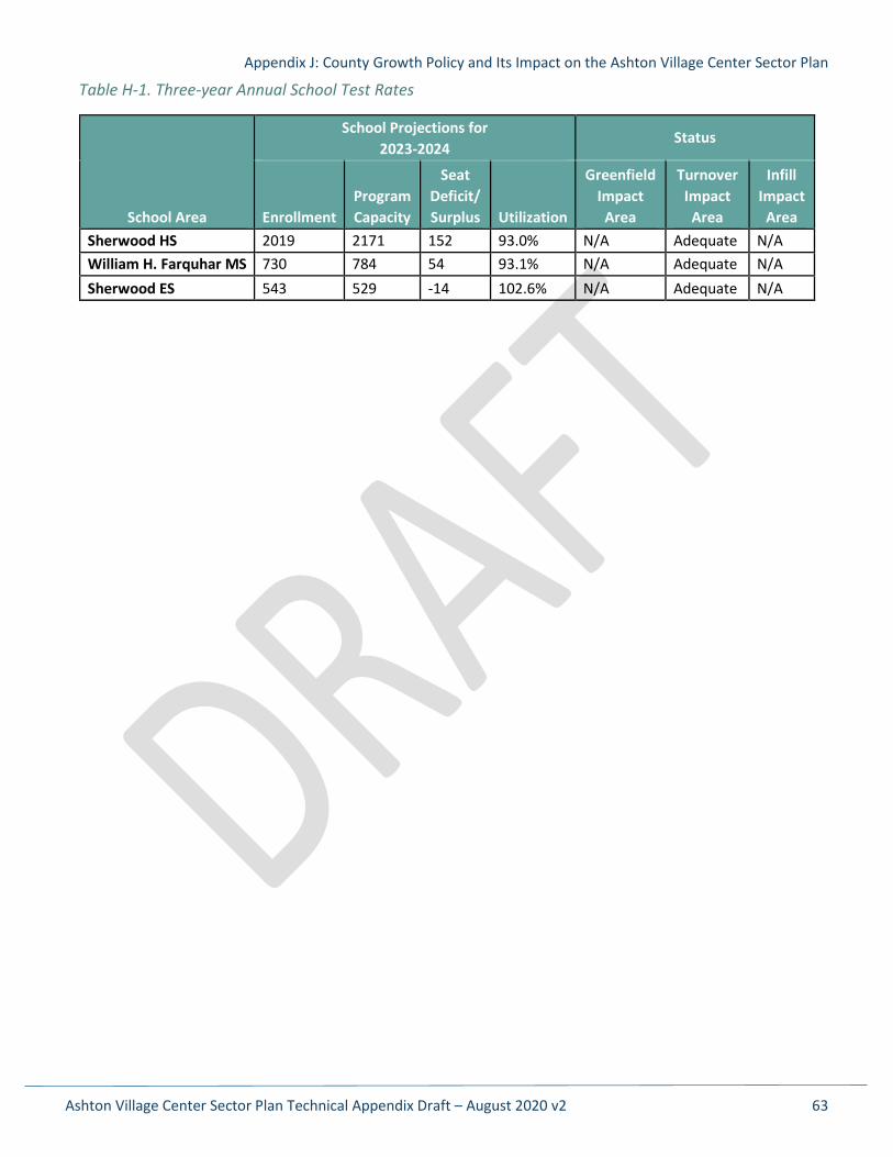
Appendix J: County Growth Policy and Its Impact on the Ashton Village Center Sector Plan
Ashton Village Center Sector Plan Technical Appendix Draft – August 2020 v2 63
Table H-1. Three-year Annual School Test Rates
School Area
School Projections for 2023-2024
Status
Enrollment Program Capacity
Seat Deficit/ Surplus Utilization
Greenfield Impact
Area
Turnover Impact
Area
Infill Impact
Area Sherwood HS 2019 2171 152 93.0% N/A Adequate N/A William H. Farquhar MS 730 784 54 93.1% N/A Adequate N/A Sherwood ES 543 529 -14 102.6% N/A Adequate N/A
Ashton Village Center Sector Plan Technical Appendix Draft – August 2020 v2 64
Appendix K: Density Calculations
The following tables were used to analyze the potential development yields of properties in the Sector Plan’s Village Core neighborhood. First, we used the existing zones and on-the-ground development to see how much development could be added to a site if the existing development were to remain, and then calculated the full potential development that could theoretically be possible under FARs of 0.25, 0.5 and 0.75. Where possible, previous land dedication was included in the tract area. This analysis did not consider site layout, parking, circulation, open space, environmental buffers, building heights, frontage requirements, lot widths, etc., all of which would reduce the amount of development that could happen on a property.
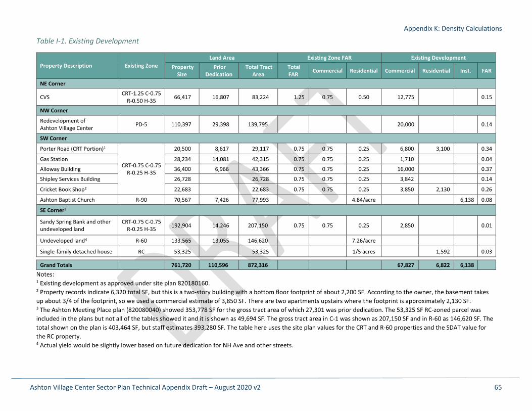
Appendix K: Density Calculations
Ashton Village Center Sector Plan Technical Appendix Draft – August 2020 v2 65
Table I-1. Existing Development
Property Description Existing Zone Land Area Existing Zone FAR Existing Development
Property Size
Prior Dedication
Total Tract Area
Total FAR Commercial Residential Commercial Residential Inst. FAR
NE Corner
CVS CRT-1.25 C-0.75 R-0.50 H-35 66,417 16,807 83,224 1.25 0.75 0.50 12,775 0.15
NW Corner
Redevelopment of Ashton Village Center PD-5 110,397 29,398 139,795 20,000 0.14
SW Corner
Porter Road (CRT Portion)1
CRT-0.75 C-0.75 R-0.25 H-35
20,500 8,617 29,117 0.75 0.75 0.25 6,800 3,100 0.34
Gas Station 28,234 14,081 42,315 0.75 0.75 0.25 1,710 0.04
Alloway Building 36,400 6,966 43,366 0.75 0.75 0.25 16,000 0.37
Shipley Services Building 26,728 26,728 0.75 0.75 0.25 3,842 0.14
Cricket Book Shop2 22,683 22,683 0.75 0.75 0.25 3,850 2,130 0.26
Ashton Baptist Church R-90 70,567 7,426 77,993 4.84/acre 6,138 0.08
SE Corner3
Sandy Spring Bank and other undeveloped land
CRT-0.75 C-0.75 R-0.25 H-35 192,904 14,246 207,150 0.75 0.75 0.25 2,850 0.01
Undeveloped land4 R-60 133,565 13,055 146,620 7.26/acre
Single-family detached house RC 53,325 53,325 1/5 acres 1,592 0.03
Grand Totals 761,720 110,596 872,316 67,827 6,822 6,138 Notes: 1 Existing development as approved under site plan 820180160. 2 Property records indicate 6,320 total SF, but this is a two-story building with a bottom floor footprint of about 2,200 SF. According to the owner, the basement takes up about 3/4 of the footprint, so we used a commercial estimate of 3,850 SF. There are two apartments upstairs where the footprint is approximately 2,130 SF. 3 The Ashton Meeting Place plan (820080040) showed 353,778 SF for the gross tract area of which 27,301 was prior dedication. The 53,325 SF RC-zoned parcel was included in the plans but not all of the tables showed it and it is shown as 49,694 SF. The gross tract area in C-1 was shown as 207,150 SF and in R-60 as 146,620 SF. The total shown on the plan is 403,464 SF, but staff estimates 393,280 SF. The table here uses the site plan values for the CRT and R-60 properties and the SDAT value for the RC property. 4 Actual yield would be slightly lower based on future dedication for NH Ave and other streets.
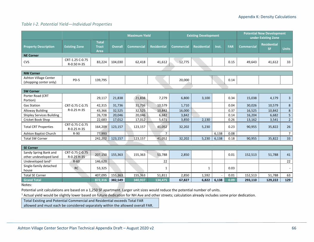
Appendix K: Density Calculations
Ashton Village Center Sector Plan Technical Appendix Draft – August 2020 v2 66
Table I-2. Potential Yield—Individual Properties
Maximum Yield Existing Development Potential New Development under Existing Zone
Property Description Existing Zone Total Tract Area
Overall Commercial Residential Commercial Residential Inst. FAR Commercial Residential SF
Units
NE Corner
CVS CRT-1.25 C-0.75 R-0.50 H-35 83,224 104,030 62,418 41,612 12,775 0.15 49,643 41,612 33
NW Corner Ashton Village Center (shopping center only) PD-5 139,795 20,000 0.14
SW Corner Porter Road (CRT Portion)
CRT-0.75 C-0.75 R-0.25 H-35
29,117 21,838 21,838 7,279 6,800 3,100 0.34 15,038 4,179 3
Gas Station 42,315 31,736 31,736 10,579 1,710 0.04 30,026 10,579 8 Alloway Building 43,366 32,525 32,525 10,842 16,000 0.37 16,525 10,842 8 Shipley Services Building 26,728 20,046 20,046 6,682 3,842 0.14 16,204 6,682 5 Cricket Book Shop 22,683 17,012 17,012 5,671 3,850 2,130 0.26 13,162 3,541 2
Total CRT Properties CRT-0.75 C-0.75 R-0.25 H-35 164,209 123,157 123,157 41,052 32,202 5,230 0.23 90,955 35,822 26
Ashton Baptist Church R-90 77,993 7 6,138 0.08 7 Total SW Corner 242,202 123,157 123,157 41,052 32,202 5,230 6,138 0.18 90,955 35,822 33
SE Corner Sandy Spring Bank and other undeveloped land
CRT-0.75 C-0.75 R-0.25 H-35 207,150 155,363 155,363 51,788 2,850 0.01 152,513 51,788 41
Undeveloped land1 R-60 146,620 22 22 Single-family detached house RC 53,325 1 1 0.03 -
Total SE Corner 407,095 155,363 155,363 51,811 2,850 1,592 - 0.01 152,513 51,788 63 Grand Total 872,316 382,549 340,937 134,475 67,827 6,822 6,138 0.09 293,110 129,222 129
Notes: Potential unit calculations are based on a 1,250 SF apartment. Larger unit sizes would reduce the potential number of units. 1 Actual yield would be slightly lower based on future dedication for NH Ave and other streets; calculation already includes some prior dedication.
Total Existing and Potential Commercial and Residential exceeds Total FAR allowed and must each be considered separately within the allowed overall FAR.
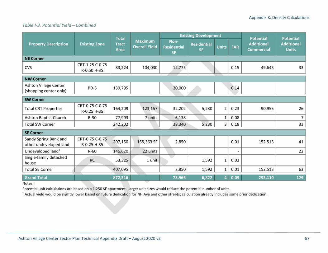
Appendix K: Density Calculations
Ashton Village Center Sector Plan Technical Appendix Draft – August 2020 v2 67
Table I-3. Potential Yield—Combined
Property Description Existing Zone Total Tract Area
Maximum Overall Yield
Existing Development Potential Additional
Commercial
Potential Additional
Units
Non-Residential
SF
Residential SF Units FAR
NE Corner
CVS CRT-1.25 C-0.75 R-0.50 H-35 83,224 104,030 12,775 0.15 49,643 33
NW Corner Ashton Village Center (shopping center only) PD-5 139,795 20,000 0.14
SW Corner
Total CRT Properties CRT-0.75 C-0.75 R-0.25 H-35 164,209 123,157 32,202 5,230 2 0.23 90,955 26
Ashton Baptist Church R-90 77,993 7 units 6,138 1 0.08 7 Total SW Corner 242,202 38,340 5,230 3 0.18 33 SE Corner Sandy Spring Bank and other undeveloped land
CRT-0.75 C-0.75 R-0.25 H-35 207,150 155,363 SF 2,850 0.01 152,513 41
Undeveloped land1 R-60 146,620 22 units - 22 Single-family detached house RC 53,325 1 unit 1,592 1 0.03
Total SE Corner 407,095 2,850 1,592 1 0.01 152,513 63 Grand Total 872,316 73,965 6,822 4 0.09 293,110 129
Notes: Potential unit calculations are based on a 1,250 SF apartment. Larger unit sizes would reduce the potential number of units. 1 Actual yield would be slightly lower based on future dedication for NH Ave and other streets; calculation already includes some prior dedication.
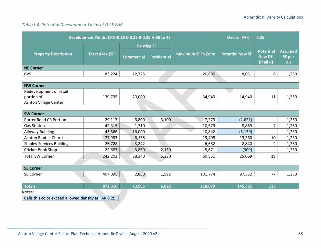
Appendix K: Density Calculations
Ashton Village Center Sector Plan Technical Appendix Draft – August 2020 v2 68
Table I-4. Potential Development Yields at 0.25 FAR
Development Yields: CRN-0.25 C-0.25 R-0.25 H-35 to 45 Overall FAR = 0.25
Property Description Tract Area (SF)
Existing SF
Maximum SF in Zone Potential New SF Potential New DU (if all R)
Assumed
SF per DU
Commercial Residential
NE Corner CVS 83,224 12,775 20,806 8,031 6 1,250 NW Corner Redevelopment of retail portion of Ashton Village Center
139,795 20,000 34,949 14,949 11 1,250
SW Corner Porter Road CR Portion 29,117 6,800 3,100 7,279 (2,621) - 1,250 Gas Station 42,315 1,710 10,579 8,869 7 1,250 Alloway Building 43,366 16,000 10,842 (5,159) - 1,250 Ashton Baptist Church 77,993 6,138 19,498 13,360 10 1,250 Shipley Services Building 26,728 3,842 6,682 2,840 2 1,250 Cricket Book Shop 22,683 3,850 2,130 5,671 (309) - 1,250 Total SW Corner 242,202 38,340 5,230 60,551 25,069 19
SE Corner SE Corner 407,095 2,850 1,592 101,774 97,332 77 1,250
Totals: 872,316 73,965 6,822 218,079 145,381 113
Notes: Cells this color exceed allowed density at FAR 0.25

Appendix K: Density Calculations
Ashton Village Center Sector Plan Technical Appendix Draft – August 2020 v2 69
Table I-5. Potential Development Yields at 0.5 FAR
Development Yields: CRN-0.5 C-0.5 R-0.5 H-35 to 45 Overall FAR = 0.5
Property Description Tract Area (SF)
Existing SF
Maximum SF in Zone Potential New SF Potential New DU (if all R)
Assumed
SF per DU
Commercial Residential
NE Corner CVS 83,224 12,775 41,612 28,837 23 1,250 NW Corner Redevelopment of retail portion of Ashton Village Center
139,795 20,000 69,898 49,898 39 1,250
SW Corner Porter Road CR Portion 29,117 6,800 3,100 14,559 4,659 3 1,250 Gas Station 42,315 1,710 21,158 19,448 15 1,250 Alloway Building 43,366 16,000 21,683 5,683 4 1,250 Ashton Baptist Church 77,993 6,138 38,997 32,859 26 1,250 Shipley Services Building 26,728 3,842 13,364 9,522 7 1,250 Cricket Book Shop 22,683 3,850 2,130 11,342 5,362 4 1,250 Total SW Corner 242,202 38,340 5,230 121,101 77,531 59
SE Corner SE Corner 407,095 2,850 1,592 203,548 199,106 159 1,250 Totals: 872,316 73,965 6,822 436,158 355,371 280
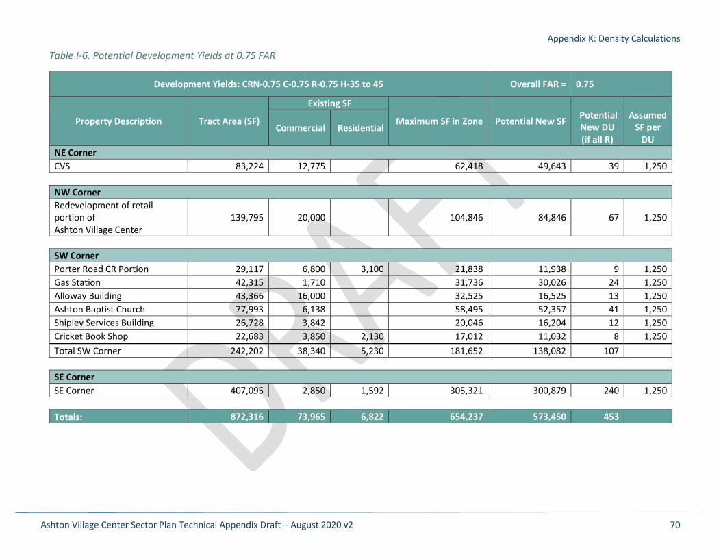
Appendix K: Density Calculations
Ashton Village Center Sector Plan Technical Appendix Draft – August 2020 v2 70
Table I-6. Potential Development Yields at 0.75 FAR
Development Yields: CRN-0.75 C-0.75 R-0.75 H-35 to 45 Overall FAR = 0.75
Property Description Tract Area (SF)
Existing SF
Maximum SF in Zone Potential New SF Potential New DU (if all R)
Assumed
SF per DU
Commercial Residential
NE Corner CVS 83,224 12,775 62,418 49,643 39 1,250 NW Corner Redevelopment of retail portion of Ashton Village Center
139,795 20,000 104,846 84,846 67 1,250
SW Corner Porter Road CR Portion 29,117 6,800 3,100 21,838 11,938 9 1,250 Gas Station 42,315 1,710 31,736 30,026 24 1,250 Alloway Building 43,366 16,000 32,525 16,525 13 1,250 Ashton Baptist Church 77,993 6,138 58,495 52,357 41 1,250 Shipley Services Building 26,728 3,842 20,046 16,204 12 1,250 Cricket Book Shop 22,683 3,850 2,130 17,012 11,032 8 1,250 Total SW Corner 242,202 38,340 5,230 181,652 138,082 107
SE Corner SE Corner 407,095 2,850 1,592 305,321 300,879 240 1,250 Totals: 872,316 73,965 6,822 654,237 573,450 453
Related Documents