Copyright by Sylvia N. Leon Guerrero 2007

Welcome message from author
This document is posted to help you gain knowledge. Please leave a comment to let me know what you think about it! Share it to your friends and learn new things together.
Transcript
Copyright
by
Sylvia N. Leon Guerrero
2007
Planning Policy and Landscape Architecture:
Street Design in Theory and Practice
by
Sylvia Nieves Leon Guerrero, BA, BSE, MLA
Report
Presented to the Faculty of the Graduate School of
The University of Texas at Austin
in Partial Fulfillment
of the Requirements
for the Degree of
Master of Science in Community and Regional Planning
The University of Texas at Austin
May 2007

Planning Policy and Landscape Architecture:
Street Design in Theory and Practice
Approved by Supervising Committee: Anne Beamish Lynn Osgood
iv
Abstract
Planning Policy and Landscape Architecture:
Street Design in Theory and Practice
Sylvia Nieves Leon Guerrero, MSCRP
The University of Texas at Austin, 2007
Supervisor: Anne Beamish
Recent trends in planning and landscape architecture are moving the two
disciplines closer together, yet there persists a lack of awareness of each discipline to the
other. Planning’s roots in street design and landscape architecture’s new theory of
landscape urbanism, which focuses on infrastructure, provide common ground for a
fruitful dialogue between the two – a dialogue that could have particular significance
given the historical influence of design theory on streets and urban form. To investigate
these relationships, this report considers the history of street design, landscape urbanism,
the planning framework, and the implementation of street design in two cities, Colorado
Springs and Austin. This report explores how planning and the new ideas of landscape
urbanism in landscape architecture can mutually inform each other to address street
design.

v
Table of Contents
Introduction......................................................................................................................... 1 Chapter One: History of Street Design ............................................................................... 4
Origins......................................................................................................................... 4 Public Meets Private ................................................................................................... 5 Communal Reflections................................................................................................ 6 Street Design Regulation ............................................................................................ 6 Theatre of the Street.................................................................................................... 7 Street and the Ideal State............................................................................................. 8 Baroque and the French Pleasure Park ....................................................................... 9 Tree-Lined Boulevards ............................................................................................. 10 Medical Metaphors ................................................................................................... 10 Return to the Countryside and Utopian Structures ................................................... 11 Revolt in the Streets .................................................................................................. 13 Haussmann’s Boulevards.......................................................................................... 13 Haussmann’s American Counterpart: The City Beautiful Movement..................... 15 The Garden City Movement and Modernism ........................................................... 16 Standardization ......................................................................................................... 19 New Urbanism .......................................................................................................... 19 Green Streets............................................................................................................. 20
Chapter Two: Landscape Urbanism.................................................................................. 22 History of theory ....................................................................................................... 26 Ecology and Landscape Urbanism............................................................................ 26 Ecology and culture .................................................................................................. 27 Infrastructure in Landscape Urbanism...................................................................... 28 Bridging the Divide................................................................................................... 30 Room to grow ........................................................................................................... 31
Chapter Three: Planning Framework................................................................................ 35 Planning History ....................................................................................................... 37 Street Design and Planning History.......................................................................... 38 Tensions and Constraints in Planning....................................................................... 39 New Directions ......................................................................................................... 41 Sustainability Framework ......................................................................................... 44 Planning and Landscape Urbanism........................................................................... 46
Chapter Four: Street design elements ............................................................................... 49 Chapter Five: Colorado Springs Case Study .................................................................... 53
Introduction............................................................................................................... 53 Comprehensive Plan ................................................................................................. 55 Traditional Neighborhood Development Ordinance ................................................ 56 Small-lot PUD Ordinance ......................................................................................... 58

vi
Mixed-Use Development Design Manual ................................................................ 60 Urban Renewal and Designated Redevelopment Corridor Areas............................. 63 Intermodal Transportation Plan and Complete Streets ............................................. 65 Downtown Streetscape Program............................................................................... 66 Comprehensive Plan Implementation ....................................................................... 70 Analysis..................................................................................................................... 71
Chapter Six: Austin Case Study........................................................................................ 77 Introduction............................................................................................................... 77 Design Standards and Mixed Use Ordinance ........................................................... 78 Transit Oriented Development Ordinance ................................................................ 83 Traditional Neighborhood Development Ordinance ................................................ 84 Corridor Planning...................................................................................................... 86 2222 Corridor Study ................................................................................................. 89 Great Streets and Downtown Projects ...................................................................... 90 Analysis..................................................................................................................... 96
Chapter Seven: Conclusion – theory and practice .......................................................... 102 References....................................................................................................................... 110 Vita.................................................................................................................................. 117

1
Introduction
As a student of landscape architecture, I was often struck by the overlap between
landscape architecture and planning and, perhaps even more so, by the lack of awareness
of the two disciplines to each other, something I found particularly surprising as both are
involved in shaping urban form. There is, however, increasing collaboration among
practitioners, and emerging trends in both disciplines, may bring them closer together.
Landscape architecture, previously focused primarily on site and form, is increasingly
concerned with the process of city building, especially in the emerging trend of landscape
urbanism. Meanwhile, planning, sometimes characterized as focused on issues of
process, has developed a renewed interest in urban form, particularly one of the basic
elements of urban form – the street.
Both disciplines, in fact, have particular relevancy to street design. Planning
began as a discipline centered on streets, using street design to address issues of public
health, social equity, and economic development. In current practice, planning
regulations establish the basic spatial structure of the street by setting requirements for
width, building setback, building height and so on. Meanwhile, landscape urbanism
specifically addresses infrastructure as a critical area of activity. As an emerging design
theory, it has the potential to greatly influence urban form, just as design theories and
cultural ideas have historically shaped urban form. How, then, can planning and the new
ideas of landscape urbanism in landscape architecture mutually inform each other to
address street design?
Why is it important to consider street design in the context of planning and
landscape architecture? Streets provide the basic structure of urban form, and their
design through history narrates the story of the city. Streets and street patterns speak not
only of technological changes in transportation, but also of notions of social equity, the
environment, and the role of economic development. The street is at the intersection of
ideas of public and private, of infrastructure and public space, of urban form and ecology.

2
All of these concepts are also embedded in planning and landscape urbanism. Planning
objectives center on issues of the economy, the environment, and social equity, and
landscape urbanism also focuses on these same issues in the concepts of infrastructure,
ecology, and culture. Street design is then a way to focus the dialogue between landscape
architecture and planning, while also highlighting their importance because of their
potential impact on urban form.
To better understand how landscape urbanism and planning can come to together
to inform street design, two case studies will be presented. These case studies consider
the planning tools that have been developed to improve street design, their
implementation, and how landscape urbanism and planning together might apply in two
diverse planning situations. The two cities studied exemplify two different planning
environments which, in general terms, balance the public and private spheres differently;
toward the private sector in the case of Colorado Springs and toward the public in the
case of Austin. While both cities are trying to improve street design and have developed
differing tools, they also demonstrate the constraints within which a design theory, such
as landscape urbanism, must operate.
To explore the how landscape urbanism and planning can inform each other and
street design, this report is organized into several chapters. To understand the potential
importance of an emerging design theory, the first chapter considers the importance of
street design and the role that cultural ideas and theories have played in shaping the street
and urban form in general. Moving to the present, the next chapter considers a current
theory in landscape architecture, where landscape urbanism’s focus on infrastructure may
be particularly relevant to street design. The planning framework in which landscape
urbanism must operate is then discussed. To understand how street design is actually
implemented, two case studies are presented: Colorado Springs, Colorado and Austin,
Texas. Within each case study, the content and implementation of recently developed
planning tools and programs with street design objectives are described. Finally, the
lessons from these case studies are explored in the context of landscape urbanism and
planning practice. By examining these case studies and considering the emerging trends

3
in landscape architecture and planning, this report hopes to consider how these two
disciplines may together write the next chapter in the history of street design and urban
form.
Chapter One: History of Street Design
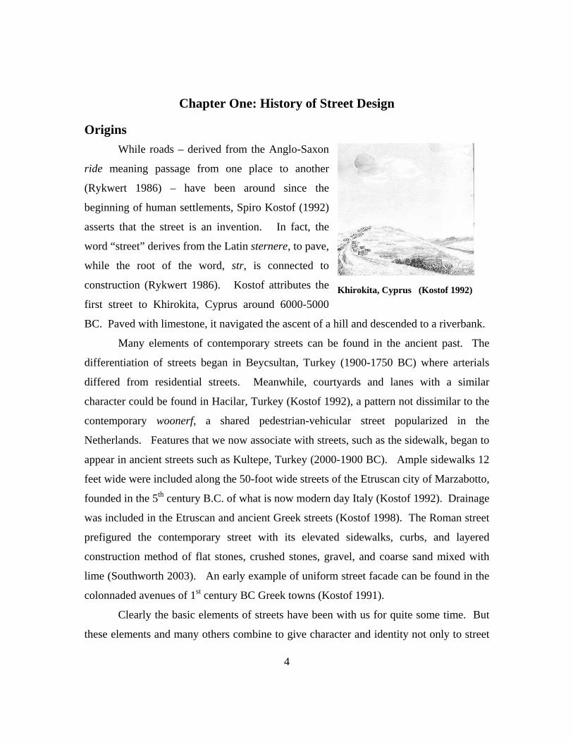
Origins While roads – derived from the Anglo-Saxon
ride meaning passage from one place to another
(Rykwert 1986) – have been around since the
beginning of human settlements, Spiro Kostof (1992)
asserts that the street is an invention. In fact, the
word “street” derives from the Latin sternere, to pave,
while the root of the word, str, is connected to
construction (Rykwert 1986). Kostof attributes the
first street to Khirokita, Cyprus around 6000-5000
BC. Paved with limestone, it navigated the ascent of a hill and descended to a riverbank.
Khirokita, Cyprus (Kostof 1992)
Many elements of contemporary streets can be found in the ancient past. The
differentiation of streets began in Beycsultan, Turkey (1900-1750 BC) where arterials
differed from residential streets. Meanwhile, courtyards and lanes with a similar
character could be found in Hacilar, Turkey (Kostof 1992), a pattern not dissimilar to the
contemporary woonerf, a shared pedestrian-vehicular street popularized in the
Netherlands. Features that we now associate with streets, such as the sidewalk, began to
appear in ancient streets such as Kultepe, Turkey (2000-1900 BC). Ample sidewalks 12
feet wide were included along the 50-foot wide streets of the Etruscan city of Marzabotto,
founded in the 5th century B.C. of what is now modern day Italy (Kostof 1992). Drainage
was included in the Etruscan and ancient Greek streets (Kostof 1998). The Roman street
prefigured the contemporary street with its elevated sidewalks, curbs, and layered
construction method of flat stones, crushed stones, gravel, and coarse sand mixed with
lime (Southworth 2003). An early example of uniform street facade can be found in the
colonnaded avenues of 1st century BC Greek towns (Kostof 1991).
Clearly the basic elements of streets have been with us for quite some time. But
these elements and many others combine to give character and identity not only to street
4

5
itself but to a city. In the words of Jane Jacobs, “Think of a city and what comes to
mind? Its streets” (Fyfe 1998, 1). This is not surprising when considering that streets
comprise 30-35% of the city surface (Wolf 1986) While Roman streets may have been a
prototype of the contemporary street, we know intuitively that its character differs
dramatically from many modern cities. The difference lies in its physical dimensions,
geometry, adjoining facades, use, and its overall role in the urban fabric. These
differences are not accidental and stem not only from obvious changes in transportation
technology but also from different attitudes of the role of the street as a junction between
the public and the private, ranging from the public interest in designing winding medieval
streets as a defense against an invading enemy to designing broad modern streets as an
efficient machine for the movement of private vehicles.
Public Meets Private Indeed the development of the street itself has been linked to the evolution of the
concepts of public and private. Levias (1986) notes that streets did not exist in the
hunter/gatherer community where there were no strong boundaries between public and
private, and villages were generally circular and worked as a unit for resources.
Rectangular homes and the accompanying streets appear when the family and not the
village becomes the unit of production. Religious and political leadership also develop
and some linear streets may have historically indicated social organization and status
according to placement along the street. “The emergence of the street seems to
symbolize or express a gradual awareness of the separation of private and public, family
and larger community… [it] is vital to the emergence of the city and of civilization”
(Levias 1986, 230-232).
A medieval city wall in turn would indicate the unity of the larger community and
the blending of public and private on the street where there was less division between the
workplace and the home and between the workplace and the street. At the same time,
streets began to become specialized, at first according to guild, while still retaining a mix
of home and work, and later according to separated land use – residential, commercial,
and entertainment (Levias 1986).

6
Communal Reflections Streets and their larger patterns have historically reflected the larger communal
framework. In Assyrian cities they became the object of planning as main streets were
laid out in tandem with the formal arrangement of public complexes. Street patterns
would indicate political and social order in the Roman grid, typically reserved for
colonies and capitals and not for small provincial towns. The power of the empire can be
seen in the construction practice of Roman towns in Gaul, which were built as tabula
rasa, literally leveling the ground (Kostof 1991, 125). Other expressions of the public
can be found in the recommendations of Vitruvius in the first century A.D., which
advised for public health reasons that climatic conditions be considered when laying out
streets and homes, orienting them to counter and not accentuate prevailing winds (Spirn
1984).
Street Design Regulation Perhaps the most emblematic form of the negotiation between public and private
is street design regulation. There is a long history of street design ordinances in various
cultures. Muslim laws declared such street edicts as minimum widths and clearance of
10.5 feet, jointly owned cul-de-sacs, and no trees in right-of-way (Kostof 1991). Kostof
(1992, 200) cites the “celebrated building codes of city states in medieval Tuscany” and
describes the reclamation of streets and public places that had been appropriated by noble
families for defensive wards as one of the principal tests of nascent self-governing city-
states (1991). This new public focus reordered the Roman grid that had been lost by
private encroachments (Kostof 1991). Since 1349, elected officials in Florence were
responsible for keeping streets clear, ordering demolitions and enforcing design criteria.
Streets once again became the basic unit of urban form, and “the primary requirement of
a beautiful street was regularity – a smooth paved surface, a consistent slope, and linear
clarity. Straightness was a virtue” (Kostof 1992, 213). Aesthetics, however, differed,
and were codified accordingly: wide and straight in Florence, while curving in gothic
Sienna (Kostof 1991).
Regulations in the 18th and 19th centuries
considered street elements that are commonly
regulated today, but also others that have only
recently come into focus in contemporary
discussions of street design ordinances. There
were regulations on signage in 1834 London,
and in 1845 Paris, sidewalks became mandatory.
In 1835 and 1855, Dusseldorf set minimum
height requirements of two stories, contrasting
with the contemporary focus on maximum
height. Maximum height restrictions appeared
in London but were associated with street
dimensions: two stories on by-lanes and four
stories on principal streets. Nuremberg set strict
limits on ornamentation and required an
undeviating building line. Continuous building
lines requirements were are also made in 1714
St Petersburg by Peter the Great, infractions of
which were punishable by the rod; in 1683
Philadelphia by William Penn; and in colonial
Williamsburg, Virginia (Kostof 1992).
Tragic Scene (Vidler 1986)
Comic Scene (Vidler 1986)
7
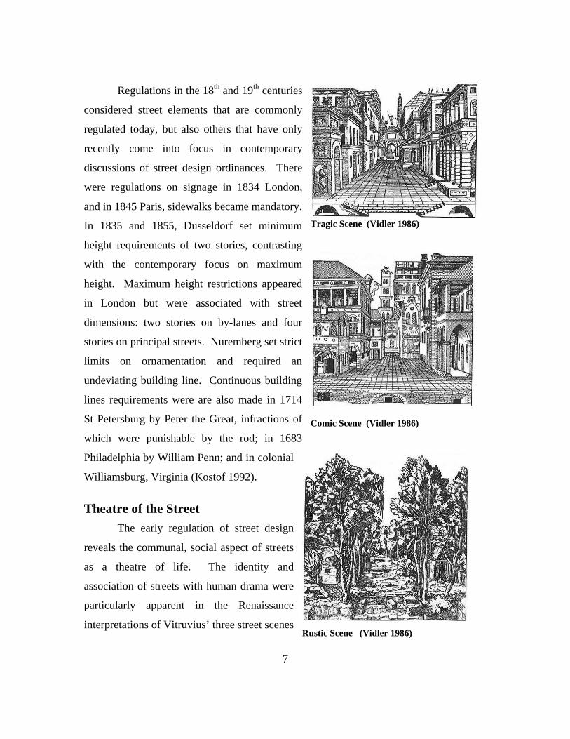
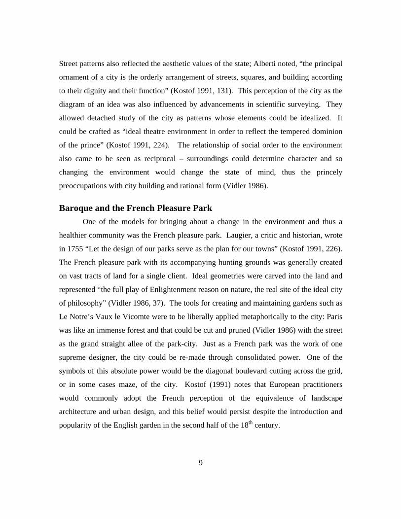
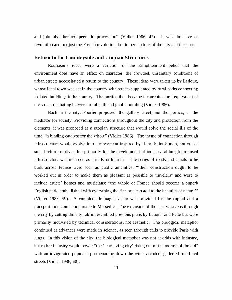
Theatre of the Street The early regulation of street design
reveals the communal, social aspect of streets
as a theatre of life. The identity and
association of streets with human drama were
particularly apparent in the Renaissance
interpretations of Vitruvius’ three street scenes Rustic Scene (Vidler 1986)

by Sebastiano Serlio, described as the tragic street, public buildings in the classical style;
the comic street, residential buildings in a less formal and gothic style; and the satiric
street, a rural path through the woods. Streets were seen as the stages for social life.
Palladio literally transcribes Serlio’s images 25 years later in the Teatro Olimpico in
Vicenza: the stage is comprised of three streets through a combination of set and
backdrop in a perspective tour de force – the street as theatre of life (Vidler 1986).
Accompanying this recognition of the social aspect of streets was an interest in
designing the “set,” the theatrical backdrop that a street provided for everyday drama.
Alberti classified streets inside and outside of town, recommending that city streets have
uniform doorways and building heights with arcades or arches at crossing points and
porticoes along major streets. Palladio repeated Alberti’s classification and
recommended that major rural roads be lined with trees, that streets be broad in the city
for better ventilation and views, and that porticoes be provided for shelter. In essence,
the tragic street was becoming specified (Vidler 1986). Vidler notes that the tragic street
would become the preoccupation of planners and architects for the next three hundred
years as a manifestation of the state, while the comic scene
would be contained or transformed by planning. The rustic scene would emerge as the
critique of the city in eighteenth century, the rallying stage for the transformation of the
state during the Enlightenment through such figures as Rousseau, who would link the
bucolic ideal to governing.
Tragic Scene (Vidler 1986)
Street and the Ideal State The urban environment and urban form have often been considered
manifestations of the ideal state. Alberti “mirrored the perfection of the social state in the
perfection of his architecture” (Vidler 1986, 35) through ordered geometric plans
intended to reflect ordered perfect governance. Thomas Aquinas stated that “building
cities is the duty of kings… communal existence makes it possible to extend help to one
another, and to share mental tasks, with one person making discoveries in medicine and
other in other things. But above all city living leads to virtuous living; cities are
necessary for the virtuous life, which means the knowledge of God” (Kostof 1991, 110). 8
9
Street patterns also reflected the aesthetic values of the state; Alberti noted, “the principal
ornament of a city is the orderly arrangement of streets, squares, and building according
to their dignity and their function” (Kostof 1991, 131). This perception of the city as the
diagram of an idea was also influenced by advancements in scientific surveying. They
allowed detached study of the city as patterns whose elements could be idealized. It
could be crafted as “ideal theatre environment in order to reflect the tempered dominion
of the prince” (Kostof 1991, 224). The relationship of social order to the environment
also came to be seen as reciprocal – surroundings could determine character and so
changing the environment would change the state of mind, thus the princely
preoccupations with city building and rational form (Vidler 1986).
Baroque and the French Pleasure Park One of the models for bringing about a change in the environment and thus a
healthier community was the French pleasure park. Laugier, a critic and historian, wrote
in 1755 “Let the design of our parks serve as the plan for our towns” (Kostof 1991, 226).
The French pleasure park with its accompanying hunting grounds was generally created
on vast tracts of land for a single client. Ideal geometries were carved into the land and
represented “the full play of Enlightenment reason on nature, the real site of the ideal city
of philosophy” (Vidler 1986, 37). The tools for creating and maintaining gardens such as
Le Notre’s Vaux le Vicomte were to be liberally applied metaphorically to the city: Paris
was like an immense forest and that could be cut and pruned (Vidler 1986) with the street
as the grand straight allee of the park-city. Just as a French park was the work of one
supreme designer, the city could be re-made through consolidated power. One of the
symbols of this absolute power would be the diagonal boulevard cutting across the grid,
or in some cases maze, of the city. Kostof (1991) notes that European practitioners
would commonly adopt the French perception of the equivalence of landscape
architecture and urban design, and this belief would persist despite the introduction and
popularity of the English garden in the second half of the 18th century.

10
Tree-Lined Boulevards The transformation of the city from wild land into well-pruned and well-groomed
park included a literal representative of the park – the tree. The tree-lined boulevard,
however, is also a descendent of the tree lined city rampart, where trees were used to hide
the precise edge of the city. A school of landscape designers specialized in the greening
of ramparts during 19th century Netherlands. The boulevard’s close cousin, the avenue,
originated in the country where roads were lined with tall trees “to distinguish them from
the surrounding landscape of leafy forests, low hedges, and field of crops” (Kostof 1991,
249). When the medieval city wall of Paris was leveled, the tree-lined ramparts became
public promenades, just as garden allees become the domain of pleasure carriages.
Indeed, some allees literally extended out into the city, as did the predecessor of the
Avenue des Champs-Elysees, the Avenue des Tuileries of the 1670s. While trees had
been advocated by Palladio along major rural roads, the urban tree-lined avenue would
become a standard of French urban design. By 1870 Paris would have 80,000 street trees
provided by its own nurseries (Kostof 1991, 229).
Medical Metaphors Pierre Patte developed a plan for Paris in 1765 that corresponded to the formal
idea of the city as park in every detail, but it also introduced another metaphor – the
ailing body and the surgeon. The Renaissance principles of design were based on the
image of man in harmony with the universe; now the city was to be rebuilt in the image
of man but one that was ailing and needed to be diagnosed and treated. In Patte’s plan
this treatment would include the ideal street, complete with pedestrian and vehicular
movement, sewage disposal, drainage, shelter, fresh water, and public amenities such as
public conveniences and benches (Vidler 1986). The medicinal metaphor would become
one of the city as both patient and cure for socials ills transmuted to the scale of the
citizen. “The city would then take on its rightful role as the site of health and its
sustenance, and the street, the public room par excellence, would retrieve the civic and
festive functions of a more natural age. The citizen would rise from his private sickbed
11
and join his liberated peers in procession” (Vidler 1986, 42). It was the eave of
revolution and not just the French revolution, but in perceptions of the city and the street.
Return to the Countryside and Utopian Structures Rousseau’s ideas were a variation of the Enlightenment belief that the
environment does have an effect on character: the crowded, unsanitary conditions of
urban streets necessitated a return to the country. These ideas were taken up by Ledoux,
whose ideal town was set in the country with streets supplanted by rural paths connecting
isolated buildings it the country. The portico then became the architectural equivalent of
the street, mediating between rural path and public building (Vidler 1986).
Back in the city, Fourier proposed, the gallery street, not the portico, as the
mediator for society. Providing connections throughout the city and protection from the
elements, it was proposed as a utopian structure that would solve the social ills of the
time, “a binding catalyst for the whole” (Vidler 1986). The theme of connection through
infrastructure would evolve into a movement inspired by Henri Saint-Simon, not out of
social reform motives, but primarily for the development of industry, although proposed
infrastructure was not seen as strictly utilitarian. The series of roads and canals to be
built across France were seen as public amenities: “‘their construction ought to be
worked out in order to make them as pleasant as possible to travelers” and were to
include artists’ homes and musicians: “the whole of France should become a superb
English park, embellished with everything the fine arts can add to the beauties of nature’”
(Vidler 1986, 59). A complete drainage system was provided for the capital and a
transportation connection made to Marseilles. The extension of the east-west axis through
the city by cutting the city fabric resembled previous plans by Laugier and Patte but were
primarily motivated by technical considerations, not aesthetic. The biological metaphor
continued as advances were made in science, as seen through calls to provide Paris with
lungs. In this vision of the city, the biological metaphor was not at odds with industry,
but rather industry would power “the ‘new living city’ rising out of the morass of the old”
with an invigorated populace promenading down the wide, arcaded, galleried tree-lined
streets (Vidler 1986, 60).
12
Meanwhile in Great Britain, as early as the 1830s other design features were
popularized with the introduction of avenues and boulevards with storm drains and
sewers, paving, house numbering, mail boxes, and sidewalks (Kostof 1991). The link
between the environment and moral character was drawn very closely with the work of
Robert Owen, theorist, reformer, and industrialist. His proposals for model towns
eliminated streets as well as alleyways and courtyards as a means of eliminating the vices
associated with these places. Instead, the monastic precinct and college courts were the
models for communities (Vidler 1986).
Conversely, James Silk Buckingham, another reformist and a member of the
British Parliament, considered the street, in its idea form, in the context of a model town.
His comprehensive proposal for Victoria included not only a detailed physical plan, but
codes of behavior and municipal and cultural institutions that would all come together to
treat social and personal ills. The most essential component consisted of nested streets
that corresponded to class and use and were linked by diagonal avenues that lead to the
public square. With no blind alleys or winding streets, there would be no place for
criminal activity. The Victoria plan of 1849 played “a critical role in the formulation of
Victorian urban ideals and the practice of reform” by bringing forth the ideal of a model,
“a systematically conceived and synthetically designed structure for the sustenance of
morality” (Vidler 1986, 67).
These utopian proposals were made against the backdrop of unsanitary urban
conditions, which lead to cholera outbreaks and epidemics. Precincts and streets, indeed
a particularly street type – narrow, dark streets – were linked to not only disease and
illness but to a social class and eventually revolution. Were the streets the symptom or
the cause of social ills? The myth that social ills could be cured by a rational plan and a
reshaped environment was challenged by Engels, who put the blame squarely on the
economics of the industrial system in his writings of 1845. His was “the first systematic
attack on the Enlightenment vision of progress” and revealed that the environment alone
was ineffectual at transforming the social order (Vidler 1986).
13
Revolt in the Streets The street as a political space is perhaps most epitomized by the barricades used
during the upheavals in Paris from the late 18th century to the mid 19th century and by the
later work of Haussmann in the 1860s. The street was a symbol of control, thus the
eruption of control over the street. Among the first acts of the French Revolution in 1789
was the sacking of the recently erected toll gates at the city walls. After first appearing
during in the French Revolution in 1789, barricades blocked public streets in Paris in
1827 in celebration of the fall of Villele, a royalist active during the Bourbon Restoration,
and again in 1830 were they were formed part of the theatre of protest. By 1832, the
barricades were clearly used as a fortress, defining a boundary around almost a third of
Paris where the residents that knew the labyrinth of streets could defend and ambush. In
the revolution of 1848, the construction of barricades had become specialized as a small
group of men skillfully designed and built even larger barricades that divided Paris in half
along class lines (Vidler 1986).
Haussmann’s Boulevards Under Napoleon III, the many Enlightenment plans for a new Paris were taken in
hand by Baron Haussmann. Haussmann advocated boulevards for public health,
aesthetic, monumental, and above all strategic reasons, specifically the fear that the
revolution that had barricaded the streets and brought the emperor to power could also
unseat him. Urbanism would be the hope against revolution and poverty with the new
boulevard as its agent, “the most urban product of the nineteenth century, and its final
apotheosis; a tool of social, moral, and governmental progress; a monument to the ideal
of a city as well as the site and provocation of its febrile economic life; a vista, a path of
movement, a defense of order, a home for the alien crows of the urban landscape; the
very epitome of social life as well as its implied critique” (Vidler 1986, 87).
This transformation was effected through new developments of photography and
cartography that allowed for the visualization and mapping of the entire city (Vidler
1986), not unlike the influence of technological developments during the Renaissance.
These technical accomplishments combined with the persuasiveness of the biological

14
metaphor of the surgeon – the need to remediate the areas of insurrection by cutting a
large swath through areas of insurrection – to reshape the capital of an empire that
required efficient service and infrastructure for commerce, industry, finance, and
employment.
Paved with new macadam, lit with the latest design of gas light, carefully planned to separate pedestrian, stroller, loiterer, ambling service vehicle, and rushing carriage, planted with rows of trees to ensure shade in summer, provided with underground piping for rain water, sewage, and gas, cleaned with the aid of scientifically designed gutters, faced by the uniform height of the residences and stores of the nouveau bourgeoisie, and carefully sited to point toward a monument or vista as the object of civic pride or aesthetic pleasure, the boulevard of Haussmann was in effect the epitome and the condenser of Second Empire daily life: the modern artifact par excellence. (Vidler 1986, 94-95)
Standardized street detailing – benches, lamps, railings, paving drains – reinforced the
city’s identity as uniformly governed. Considered from both the small and the large
scales, the boulevard was conceptualized as an aesthetic entity that culminated visually in
a monument or beautiful perspective. Boulevards cut through the city leading to
redesigned picturesque parks and gardens, providing cultivated respite from the once wild
forest called Paris (Vidler 1986).
While these changes had become codified as boulevard design in 1859 (Kostof
1991), by the 1870s they were not universally praised. Zola saw the surgeon’s cut as
leaving Paris bleeding and prey to speculation that “tore asunder the entrails of the
enormous city” (Vidler 1986, 97). Boudelaire lamented the loss of the street with its
picturesque curves, supplanted by long, straight, wide, and cold boulevards – the “grand
arteries.” While some found comfort in the anonymity of the new urbanity characterized
by the boulevards, others decried its isolation, and a new metaphor would appear in
portrayals of the boulevard – the desert. Zola lamented, “the avenue seemed unending.
Hundreds of leagues of nothingness; the end of the road eluded him. The lanterns, lined
up regularly spaced, with their short yellow flames, were the only life in this desert of
death” (Vidler 1986, 100).

15
Despite Haussmann’s wide boulevards, workers once again erected barricades
across Paris during the brief government of the Commune in 1871. Most, however, did
not equal the scale or solidity of 1848, and without a comprehensive strategy of defense,
the embryonic barricades were ineffectual. Many thousands were put to death after this
revolt, and every destroyed building was replaced with one in the same style. The
fragments of urban utopianism and communitarian idealism disintegrated, and hopes for a
new society returned to the countryside. William Morris and others repeated the call of
Rousseau to return to nature, to abandon the city, and to fulfill the “dream where the great
divides of mechanical civilization were closed, the inhuman isolation and fragmentation
bound up in a world of natural unity” (Vidler 1986, 106). If cites were retained, at most
they would be reserved as a place of work. This call would echo throughout the 20th
century, but first a brief look at urban design developments in the US in the late 19th
century.
Haussmann’s American Counterpart: The City Beautiful Movement Charles Mulford Robinson, the author of Improvement of Towns and Cities
published in 1902, greatly influenced the City Beautiful movement of the 1890s and early
1900s. As its name indicates, the movement promoted the beautification of cities,
particularly as a source of civic pride, through monumental construction of public
buildings, civic centers, parks and boulevard systems, but it also advocated ordinary
street improvements, paving, street furnishings and plantings (Southworth 2003). Its
design images of classical buildings were widely disseminated through the Colombia
Exposition in Chicago in 1893 (Campbell 2003), while Daniel Burnham’s plan for
Chicago demonstrated the scale at which physical planning could occur. While the
movement has often been perceived as taking a purely aesthetic approach, Robinson also
focused on the importance of neighborhood and practical considerations, particularly the
impact of streets. He advocated the greening of cities through street planting in addition
to parks and natural scenic areas. He wrote a comprehensive book on city street design,
from platting to curbs and gutters, and expounded on the importance of the
“consideration of the width and arrangement of streets…all currents of life, all the grades

16
of society, are intimately affected by the problems it includes. The joy and pain of urban
existence, the comfort or hardship of it, its efficiency or failure are influenced by the
wisdom or the thoughtlessness with which streets are platted” (Southworth 2003, 57-58).
The Garden City Movement and Modernism The tendency toward specialization wrought by the industrial revolution would
deepen, but the dreams of a rural utopia would also persist, at least at the level of private
individual or residence. These two strains – that of embracing the machine age and of
escaping the city to pastoral life – would run through much of 20th century city building.
Modernism would embrace the machine and specialization while the Garden City
Movement would advocate healthful living in a garden setting. Both, however, would
have elements of the other and each would lead to a particular street type.
The Garden City movement can be viewed as a continuation of social responses
to urban disorder. In England, narrow lots that had originally allowed garden and animal
space in the back of street frontage, known as burgage plots, were converted into hidden
slums in the 19th century as tenements were built on garden plots behind fashionable
residences. In New York City, the Tenement Housing Act of 1879, requiring minimal
light and air, did not meet its intended purposes and instead resulted in 80% coverage of
the narrow, deep lots with shafts allowing little ventilation and natural light (Kostof
1991). With such conditions, there was great interest in finding a new model, and
Ebenezer Howard widely disseminated ideas of balancing the town with the country in
his 1902 publication Garden Cities of To-morrow. These ideas would be championed by
influential planners such as Raymond Unwin, who designed the Hampstead Garden
suburb, an early example of the 20th century suburb. Unwin was also influenced by the
work of Camillo Sitte, author of City Planning According to Artistic Principles 1889,
which praised the architectural characteristics of medieval streets and discussed the need
to consider the aesthetic and psychological aspects of the street and not only functional
requirements (Lillebye 2001). He criticized the emerging standardization and formal,
geometric urban patterns, considering informal, irregular patterns to be more in tune with
human aspirations (Southworth 2003). Unwin noted the need for spatial enclosure and
visual variety (Kostof 1992) and detailed the typological significance of a variety of
streets (Lillebye 2001).
The trend in typologies and specialization, accentuated by the industrial age,
would find one expression in cities through the distinction and separation of residential
and commercial/ manufacturing uses. As one New York City planner noted in 1870, the
first was governed by topography while the latter was made straight for efficiency
(Kostof 1991). If industry was a necessary evil, then cities were considered as reserves
for work while the common man could receive the salutary benefits of a rural residence.
With the focus on residential areas, certain elements that had been considered urban were
employed. In the 1900s, boulevards connected parks in the periphery and became
associated with genteel residential areas as part of boulevard/parkway systems.
Correspondingly, street trees were considered features of residential areas rather than
town centers (Kostof 1991). Specialization according to function, a hallmark of
modernism, had found its way into the Garden City movement.
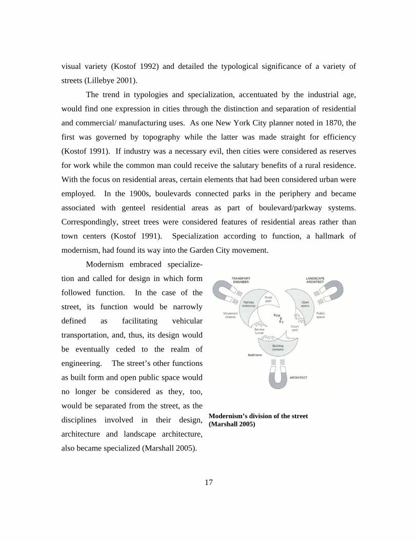
Modernism embraced specialize-
tion and called for design in which form
followed function. In the case of the
street, its function would be narrowly
defined as facilitating vehicular
transportation, and, thus, its design would
be eventually ceded to the realm of
engineering. The street’s other functions
as built form and open public space would
no longer be considered as they, too,
would be separated from the street, as the
disciplines involved in their design,
architecture and landscape architecture,
also became specialized (Marshall 2005).
Modernism’s division of the street (Marshall 2005)
17
18
One of the most outspoken critics against the very concept of streets was the
architect Le Corbusier (1887-1965). “It is the street of the pedestrian of a thousand years
ago, it is a relic of the centuries: it is a non-functioning, an obsolete organ. The street
wears us out. It is altogether disgusting! Why, then, does it still exist? …[The street] is
in reality a sort of factory for producing speed traffic…We must create a type of street
which shall be as well equipped in its way as a factory” (Gold 1998, 48). As in other
eras, ideas about design reflected societal changes and advances in the sciences.
Advances in the biological sciences that figured prominently in the public mind during
the Enlightenment had given way to a fascination with mechanistic and engineering
marvels – the street as a biological system had become the street as a machine for
movement and speed.
Le Corbusier’s proposal for a new type of street was in essence a proposal to
deconstruct the street into its functional components, isolating them into their own
individual systems. The street would function as transportation corridors that facilitated
high-speed travel. The building would no longer be tied to the street but could be
divorced from the traditional building line and treated independently as an object.
Pedestrians would circulate among these object/buildings in a garden setting separate
from any vehicular traffic. This particular aspect, the transformation of urban places into
tranquil precincts, oddly echoed the return to the country made by early theorists. Le
Corbusier’s intent was in fact to transform “the city into a green park in which the
inhabitants would live in a natural and healthful setting that at the same time would
accommodate the automobile” (Ellis 1986, 117).
Many US cities exhibit qualities of both the garden city and modernism:
specialized, high speed highways, buildings that sit as objects in the landscape, the
suburban equivalent of the idyllic countryside, winding suburban streets that are distant
cousins of picturesque lanes. With the focus on the automobile, with rare exception, the
separate pedestrian circulation was lost. The proliferation of this model was encouraged
through national standards and guidelines.
19
Standardization The first impetus of standards in the US was actually to control speculative
developers. The 1932 President’s Conference proposed detailed regulations for street
design that specified such items as the right-of-way (60 feet even then), road width (only
24 feet), sidewalks (4-6 feet), setbacks, block length, and even tree species. The Federal
Housing Administration, established in 1934, had an enormous influence in perpetuating
standards as it provided financial assistance and mortgage insurance for millions of
homes. It was also run by real estate and banking representatives sympathetic to the
development community. Establishing standards supported established builders and
enabled them to construct on a large scale. Initial guidelines and principles gained in
specificity, and while some statements read as recommendations only, the reach and
financial power of the FHA would make them standards. By 1946, curvilinear, cul-de-
sac, and court streets were strongly favored, while gridiron patterns were discouraged.
When localities were given the power to write their own subdivision rules, many opted to
adopt FHA standards (Southworth 2003).
Other organizations would influence street standards over the years. The Urban
Land Institute, a nonprofit research group for the building and real estate community,
advocated narrower streets, primarily for cost considerations. The National Association
of Home Builders questioned the need to design all streets to the same standards and
recommended a street typology. A flawed but influential study by the Institute of
Transportation Engineers (ITE) would advance this cause by citing higher accident rates
for grids patterns over cul-de-sac, T-section patterns. The 1965 ITE standards listed
quantifiable standards but also stated the importance of variety and improvement.
Despite this provision, the standards have been widely used by local agencies and public
works departments (Southworth 2003).
New Urbanism Criticism of the singular functional approach to streets has come from many
corners over the years. Jane Jacobs’ influential book, The Life and Death of Great
American Cities, eloquently described the multifunctional role of the neighborhood street.

20
Numerous studies and articles have been published that link the singular, functional
approach to streets and land use to a sprawling development pattern with its attendant
environmental problems, increased transportation demands, and deterioration in quality
of life. One response to these issues has been the development of New Urbanism. New
Urbanism first espoused a return to traditional street and building patterns, which
included such features as narrower streets, a mix of uses, a pedestrian orientation, and
harmonious design of building and spaces. Originally associated stylistically to
traditional forms, it has since broadened to include a variety of architectural forms. The
multi-functional role of the street, particularly as public space, is central to New
Urbanism, and its precepts have been translated into mixed use development and
traditional neighborhood development zoning ordinances in many communities
throughout the country.
Green Streets The increase in awareness of the relationship between ecological systems and
urban patterns has also prompted the emergence of Green Streets. These streets generally
place particular emphasis on the ecological functions of the street. Stormwater quality
and quantity are addressed not through engineered systems, such as curb and gutter
configurations and concrete detention filtration systems, but through bioswales, wet
ponds, and pervious paving. By grounding streets in the local landscape, Green Street
concepts also improve habitat, provide unique street identity, and offer an aesthetic
experience of the street. By becoming more localized, Green Streets are also inherently
more connected to the larger ecosystem and landscape. One of the innovators in Green
Streets has been Portland, Oregon, which has published a design manual detailing
principles and construction guidelines for green street features (Green Streets 2002).
~

21
Spiro Kostof (1992) remarks that the balance between public and private is
culturally defined and changes over time, and corresponding the street, as the intersection
between public and private has also changed over time. As a fundamental element of
urban form, the street has shaped cities, and its design has expressed military, political,
economic, social, technological, and environmental beliefs. It has tacked between
singular, utilitarian approaches and multi-functional, aesthetic treatments. At the
beginning of a new millennium, what beliefs and theories will shape the design of the
street?

22
Chapter Two: Landscape Urbanism
As cities consider the role of streets in shaping the overall life of the city, one
question that might be posed is why look to current landscape architecture theory. An
obvious reply is that landscape architects are frequently involved in not only designing
streetscapes but also developing plans for new streets in new developments. Landscape
architects are trained in the practical matters of topography, drainage, road construction,
detailing for street tree planting, and so on, but not necessarily the overall impact of a
new development on a city’s transportation network, watershed health, service levels, and
so on. Planners are trained to consider the impacts of a development proposal and the
long term, general welfare of a community. But this is changing. The impact of design,
whether in reinvigorating a downtown or moving toward sustainability, has become a
standard topic of discussion among planners. As planners consider design standards,
landscape architects are looking at the larger impact of their work on a community and
the environment and are particularly influenced by scientific developments in landscape
ecology. Ever more frequently, these efforts by both planners and landscape architects
are made in a collaborative environment.
The principles of landscape design have been used in city planning in the past,
particularly in the employment of streets as a tool for shaping the urban form. As
previously mentioned, during 18th century France the city was regarded as a garden or
hunting park, with Paris figuring as the wild forest that needed to be tamed by cutting
wide boulevards and providing order, reflecting the formality and considerable control
exercised over nature to create the French pleasure park. Here the garden or park is seen
as metaphor for the city, just as many other metaphors have been employed since, though
this comparison did contribute to the literal greening of Paris through street trees. While
some critics have remarked that some of current landscape theory rises only to the level
of metaphor in application, there have been more literal unions of city planning and
landscape architecture.
23
In the not so distant past, landscape architecture and modern city planning were
synonymous in the figure of Frederick Law Olmsted. Practicing in the mid to late 19th
century, Olmsted is considered a father figure in both disciplines. Perhaps his most
celebrated work is New York City’s Central Park, but his other very well-known projects
include Chicago’s Riverside suburb, Brooklyn’s Prospect Park, and the Back Bay Fens in
Boston, as well as many others. His firm continued under the direction of his son and
nephew, proposing and designing parks, parkway systems, and developments for many
cities across the US. The Back Bay Fens project in Boston, in particular, has been a very
influential project and continues as a model for landscape architecture, exemplifying
some of the principles of landscape urbanism. The project was designed to function as
infrastructure, addressing drainage and sewage issues; as ecological intervention,
working with the natural system of tidal flats; and as recreational area, incorporating
multi-modal trails that tied into a greenway system.
Ian McHarg is another figure studied in both landscape architecture and planning
history. His advocacy of the environment in the 1960s and 70s – articulated in many
television appearances and in his popular book, Design with Nature – was very influential
in both disciplines and in the development of the environmental movement. His system
of overlaying representations of various ecological systems is still in use today in both
disciplines through its modern incarnation as Geographic Information Systems.
Planning and landscape architecture have intertwined before, and one of the most
prominent theories, or perhaps trend, currently in landscape architecture that may follow
in that direction is landscape urbanism. Clearly, the name alone alludes to a union of
both landscape architecture and city planning. Landscape urbanism focuses on the urban
spaces frequently forgotten by the design community: the interstitial spaces between
buildings, vacant and abandoned areas, and infrastructure – streets. Charles Waldheim,
who first coined the term landscape urbanism, notes, “Contemporary landscape urbanism
practices recommend the use of infrastructural systems and the public landscapes they
engender as the very ordering mechanisms of the urban field itself, shaping and shifting
the organization of urban settlement and its inevitably indeterminate economic, political,

24
and social futures” (Waldheim 2006, 39). This statement refers to several ideas threading
through discussions of the theory: a focus on process and correspondingly, the ever-
shifting nature of urban form and use, a recognition of the many players involved in
determining urban form, a focus on the temporal aspect always present in any landscape
architecture project, and the vital role of infrastructure. These ideas parallel and correlate
to others in planning: a focus on good process when establishing policy, particularly as
policy shifts with changing populations and goals; a focus on participatory planning that
includes all stakeholders; the long-range focus of planning; and the very definitive role
infrastructure plays in growth and quality of life.
Several issues frequently rise to the surface in discussions of landscape urbanism:
ecological processes, social and cultural needs, and infrastructure. Many writers on the
topic discuss the relationships between these areas and achieving, ideally, a hybridization
that responds and adapts over space and time. Folded into the discussions of ecology is
its inherent capacity to localize (Weller 2006) and provide identity, while recognizing its
functional capacity can potentially provide the structure of urban form. This strategy is
an “an attempt to make the necessities of dealing with human impact a part of the making
and generation of urban landscapes” (Mossop 2006, p. 171).
Before continuing, a few notes on the position of landscape urbanism may be
useful. While landscape urbanism is frequently referred to as an emerging and even
prominent theory in landscape architecture, some see it, not as a theory, but as a tool for
innovation in design practice (Shannon 2006, 145), and others refer to it as an emerging
discipline (Shane 2006, 59). This is particularly the case with Charles Waldheim, who
established a graduate option in landscape urbanism at the University of Illinois at
Chicago (Shane 2003, 4). Landscape urbanism in this respect is seen as discipline that
can remedy the oversights of both planning and landscape architecture.
No doubt there is gap between the two professions of landscape architecture and
planning, as planners with no training in design try to provide design guidance to
neighborhoods developing neighborhood design guidelines and landscape architects with
no training in planning plan major additions to municipalities. Richard Weller (2006, 71)

25
has remarked on the differences in scale and attitude between environmental planning, or
landscape planning, and landscape design, “terms which stereotypically signify science
and art, respectively. In common parlance, planning concerns infrastructure (both
mechanical systems and land-use designation…design is perceived and practiced as the
rarefied production of highly wrought objects… design sacrifices the scale and
instrumentality of its agency, whereas that which planning gains in scale and efficacy it
inversely loses in artful intent.” Elizabeth Mossop (2006, 169) also points to the schism
in scale at which environmental planning and design typically operate, regional and
individual site respectively, as leading to a failure to engage urbanism. Weller notes,
“landscape urbanism warrants serious discussion because it alone seems theoretically
prepared and practically capable of collapsing the divide between planning and design”
(Weller 2006, 71).
Charles Reed (2006) looks at the changes in the economic and political conditions
that affect both sides of the divide when realizing public works. Noting changes that are
very well known to the planning community but which affect design as well –
decentralization, deregulation, privatization, mobility, and flexibility – he describes the
dynamic, adaptive, and tactical nature of projects networks, infrastructural frameworks,
and management structures. This new context and the complexity of public works “move
beyond a capacity for disciplinary distinction and isolation” (Reed 2006, 270) and
necessitate new modes of practice.
Within the literature of landscape urbanism are calls for greater interdisciplinary
collaboration, but occasionally, a certain competitive self-importance seeps through from
some authors: “[there is the] potential for landscape architecture to supplant architecture,
urban design, and urban planning as design disciplines responsible for reordering post-
industrial urban sites” (Waldheim 2006, 46). Waldheim (2006, 39) also lambastes
planning in particular on occasion, decrying its “ineffectual enclaves of policy,
procedure, and public therapy,” and betraying a certain level of misunderstanding of the
goals and framework of planning, ironically in areas that landscape urbanism has
incorporated into its general approach. Nevertheless, Waldheim (2006, 51), later
26
commenting on recent large scale projects, notes that their “scale and significance
demand professional expertise at the intersections of ecology and engineering, social
policy and political process.” Landscape architects, planners, and other professionals will
undoubtedly continue to work and collaborate with greater frequency and intensity as
interdisciplinary work becomes increasingly the norm in almost all fields of a postmodern
world.
History of theory “The origins of landscape urbanism can be traced to postmodern critiques of
modernist architecture and planning” (Waldheim 2006, 37). As the problems with urban
sprawl became increasingly manifest and cities grappled with deserted urban cores in a
post-industrial economy, one question posed was “how should once mighty cities shrink
and recede back into the landscape?” (Shane 2006, 58).
One response came in the form of a conference and exhibition in 1997, organized
by Charles Waldheim, entitled “landscape urbanism.” Referring to the changes in urban
form, from the vertical to the horizontal (Waldheim 2006, 37) and from architectural
form to landscape, the term would also be used to describe the leftover voids of the
decentralizing city – the interstitial spaces. This conceptualization of city making was
influenced by James Corner, Waldheim’s professor at the University of Pennsylvania.
Corner emphasizes the processes that shape urban form and views the “voids as
‘constructions’ produced by an industrial logic and as reserves of ‘indeterminancy,’
places of potential action” (Shane 2003, 3). This view emphasizes strategy, an open-
ended system rather than a particular form, and design for adaptability.
Ecology and Landscape Urbanism Not unlike urban theories in other eras, landscape urbanism reflects changes in
scientific understanding in particular landscape ecology. Landscape ecology was first
coined in Germany in 1939 by Carl Troll and was an established discipline by 1980. It is
the study of relationships, particularly the spatial and temporal aspects, between
landscape and ecological processes, including those caused or influenced by man,

27
whether landscape or process. Landscape urbanism’s focus on process and open-
endedness can readily be traced to ecology’s study of process and its shift to an open-
ended system model. Thriving systems exhibit qualities of adaptation, appropriation,
and flexibility (Reed 2006) – terms and concepts also gaining coinage in landscape
urbanism. Tools used in landscape ecology, such as aerial photography and GIS, have
also been adopted by landscape urbanists such as James Corner (Shane 2003) and are
now regularly used by landscape architecture students.
Ecology and culture Landscape ecology not only provides a scientific basis for landscape architecture,
but also leads to discussions of culture, providing a new conceptual image of landscape.
Landscape ecology considers temporal and spatial relationships across a landscape,
regardless of agency. This necessarily includes natural and cultural systems, which in
landscape urbanism means the possibility to conflate “culture and nature into a hybrid
weave” (Weller 2006, 77). Because ecology is grounded in the local and the specific –
the geology, the topography, the rivers and lakes, the climate – it is also aligned with
issues of cultural identity and authenticity. Ecological and cultural histories for many
cities are often deeply intertwined. Landscape becomes a source for local authenticity,
but not merely as an aesthetic source. By rooting landscape urbanism in landscape
ecology, it reveals the structural force of landscape in cultural identity. The issue of
aesthetics then naturally grows out of the conjunction of culture and science in landscape
ecology as it “implicitly leads to questions of meaning and value, questions of art…
[creating] an association of ecology with creativity…long overdue” (Weller 2006, 74-5).
Culture and nature are unified in ecology, offering a philosophical and practical
framework for addressing the city (Weller 2006).
The framework of landscape urbanism also addresses the multi-culturalism of the
post-modern era. Pollak (2006) notes that landscape urbanism’s focus on process and
change over time, which emerges from landscape ecology, also leads to a consideration
of different groups. She remarks on recent projects that are simultaneously “natural” and
social that form public spaces that allow differences among users to exist.

28
Infrastructure in Landscape Urbanism The question of scale, an important concept in landscape ecology, continues to be
discussed in landscape urbanism. Linda Pollak (2006, 129) remarks, “scale is an issue
inherent in all urban landscapes that is barely addressed in design theory or practice.” As
previously mentioned, the scalar differences at which, stereotypically, planning and
landscape architecture have operated have provided the fertile ground in which landscape
urbanism has developed. However, at the 2002 conference on landscape urbanism at the
University of Pennsylvania, the interstitial and small-scale strategies of the participants
were questioned (Shane 2006). Infrastructure is one response to the criticism of small-
scale focus, according to Stan Allen; “he outlines an ‘infrastructural urbanism’ that is
strategic, operates at large scales, and is made physical/material when it encounters the
local” (Reed 2006, 281). Large scale, infrastructure projects, such as the redevelopment
of a Barcelona highway system into a multi-functional public space serving cultural and
transportation needs, have broadened the scalar range of landscape urbanism (Shane
2003).
The shift toward infrastructure as a major focus of design intention in landscape
architecture is significant but not completely unprecedented. There is a history of
parkway design in landscape architecture, beginning with Olmsted. Additionally,
landscape architects have often been hired to essentially hide mechanical infrastructure or
indicate where it should not be altogether. (Weller 2006) Ideas, however, of what
constitutes infrastructure are changing, as Reed notes (2006) in the new climate of
decentralization, with one definition specifying it as anything that is an “engineer of
change…, every aspect of the technology of rational administration that routinizes life,
action, and property within larger… organizations.” As definitions open up, landscape
urbanism is primed to also lend its interpretation of infrastructure as landscape.
Infrastructure and its integration into public space has now become a key strategy of
landscape urbanism (Waldheim 2006, 45). Several articles in the recently published The
Landscape Urbanism Reader explicitly refer to infrastructure and its components,
ranging from highways to asphalt. While designers have engaged the driver’s point of

29
view, with many examples of scenic drives and parkways in landscape architecture’s
portfolio, Mossop (2006, 174) encourages designers to more comprehensively understand
the scalar range of roads across the landscape and as an integral element of the urban
fabric. This means considering “mundane parking facilities, difficult spaces under
elevated roads, complex transit interchanges, and landscapes generated by waste
processes” (Mossop 2006, 171).
Jacqueline Tatom (2006, 181) narrows in on highways and once again the
potential for integration among disciplines through landscape urbanism, naming civil
engineering and architecture as well. She reiterates the familiar calls to move beyond the
singular functionalism of modernism to the multi-functional, emphasizing public space
possibilities and citing several historical examples that once again demonstrate the union
of design and planning and of natural and man-made. The Parisian boulevard, a
precursor to the highway as a high-speed/high volume traffic channel, was “conceived
three-dimensionally as public places,” emphasizing continuity with the urban fabric.
Olmsted’s system of parkways and parks in Boston, known as the Emerald Necklace,
achieved scalar modality through its range of local identity as well as regional
comprehensiveness, containing diverse urban and natural elements. She notes that these
and other examples were part of urban renovation programs in which there was a broad
public mandate to address urban ills (Tatom 2006, 184).
Pierre Belanger points out the potential of considering in a new light the dominant
infrastructure material – asphalt. Like streets themselves, its ubiquity has made it
invisible, escaping the designer’s attention. He remarks, “The contemporary discourse on
landscape urbanism suggests that ongoing attention to the seemingly banal surfaces of
urban operation is a crucial cultural task” (Belanger 2006, 260).
Weller notes that within landscape urbanism is a willingness to reconsider the
banal. He cites the design work of West 8 whose most important threads are “such
apparently uninteresting things as traffic laws and the civil code” (Weller 2006, 81). He
traces this to datascapes, “the visual representations of all the measurable forces that may
influence the work of the architect or even steer or regulate it,” as explained by Bart

30
Lootsma. Early examples of representing forces at work on a site can be found in the
work of Ian McHarg, who popularized techniques for visualizing and overlaying the
various ecological systems (geologic, hydrologic, and son on) at work at a site, and the all
inclusive nature of landscape ecology, which considers cultural forces at work in a
system. This reveals yet another commonality between the current practices in landscape
architecture and planning – comprehensive initial conditions analysis. Weller (2006, 81)
describes, “datascaping actively embraces restrictions and regulations.”
Bridging the Divide Perhaps one of the most intriguing and rich ideas of landscape urbanism is the
union of infrastructure and ecology into a culturally significant framework that responds
to changing conditions over time. The potential to go beyond metaphor, where earlier
analogies between the city and nature stopped, opens up many possibilities for the
backbone of urban form, the street, and correspondingly for future urban form. It is “one
of the implicit advantages of landscape urbanism: the conflation, integration, and fluid
exchange between (natural) environmental and (engineered) infrastructural system”
(Waldheim 2006, 43). Weller (2006, 73) goes one step further, noting “landscape itself is
a medium through which all ecological transactions must pass: it is the infrastructure of
the future and therefore of structural rather than (or as well as) scenic significance.”
Redefining landscape as infrastructure also has the potential to completely change how
structures in general are built at many scales, from buildings to sewers – green roofs and
wetland sewage treatment preview the possibilities. “If we think of landscape as an
infrastructure which underlies other urban systems, rather than equating it with nature or
ecology we have a much more workable conceptual framework for designing urban
systems” (Mossop 2006, 176).
Landscape urbanism’s formulation of landscape infrastructure can define the basis
for urban development, preserving natural systems and regional cultures. Many
examples at various scales have been cited as examples of ecology, culture, and
infrastructure simultaneously at work in urban landscapes. Victoria Park in Sydney uses
swales in the road system for stormwater treatment. Smaller scale projects include

31
establishing street trees and wetland areas in neighborhood parks, and daylighting
streams. The Emerald Necklace, an early example, intertwines infrastructure, water
engineering, scenic landscapes, and urban planning. Canberra, Australia demonstrates a
strong relationship between city form and the natural landscape structure (Mossop 2006).
The Cinturon in Barcelona has a distinct formal identity in which the scaling up and
programming of interchanges includes parks and other public services and spaces (Tatom
2006). At the other end of the street scale are the woonerfs in the Netherlands (Mossop
2006, 174), residential streets designed not with the transportation channel as the primary
and only function, but as public spaces first that also happen to accommodate traffic flow
and parking.
Room to grow As an evolving theory/trend, landscape urbanism is certainly subject to criticism –
whether in areas not yet fully considered or in its application. Shane points out that there
is not yet enough understanding of the urbanism in landscape urbanism, noting that it
“does not yet begin to address the issue of urban morphologies or the emergence of
settlement patterns over time,” linking this deficiency to its inception as a solution to
urban shrinkage in cities such as Detroit rather than growth (Shane 2006, 63). There
have also been questions about the role of landscape urbanism in the context of the
growing appeal of higher density and new urbanism, despite dismissals on the basis of
form by Corner and others (Shane 2006).
The imprecision about process in the discussions of indeterminancy may also be
problematic. Mossop notes, “One of the characteristics of systems that are trying to work
with natural processes is the ideas of their development over time, and the formal
outcomes of projects that rely on process are difficult to predict, in a way that is often
unacceptable to public agencies and other clients” (Mossop 2006, 171). The public’s
hesitation may be overcome, particularly with the growing awareness of ecological
processes acting over time as in the case of global warming. However, imprecision about
process may lead to a disregard of the framework in which processes act and its
consequences. While the outcome of a public meeting may be unknown, the framework

32
in which the process takes place can significantly affect the results. So in landscape
urbanism, what does process actually mean? Some have critiqued the reliance on
description of ecological processes in some landscape urbanists’ proposals – description
appears to amount to projected realization without enough consideration of the
parameters of those processes and the management that may be required.
One of the dangers of the imprecision in discussions of process, lumping all
processes together into a biological format, is the reduction of ecology into a metaphor.
Alan Berger’s (2006) characterizes the unused, leftover areas of cities as inherent to the
organism of the city. While it is useful to call attention to the inherent waste generation
of any city, it seems almost irresponsible to call brownfields and other areas inevitable
because of an inherent, “genetically” coded process, thereby hiding the real decisions and
policies, or lack thereof, that lead to their creation. Kevin Lynch noted that the city is not
an organism, but is created by people for people (Kostof 1991). People can change their
minds and their behavior.
The imprecision about process may also bleed into general analysis. Weller
(2006, 82) notes, “Much landscape architecture, while paying lip service to site analysis
data, does not in fact work with the data carefully enough and allow it to come forcefully
to the surface.” This may be masked with through the visualization of data through
datascaping and a tendency to lean on graphic representation, a tendency that Weller
ascribes to Corner. Weller’s suggestion is to utilize McHarg’s data-driven yet
deterministic approach and Corner’s understanding of the power of representation and
“conjoin McHarg and Corner and ground both” (Weller 2006, 77).
The process of visioning in planning may provide some clues to teasing out
particulars of process and indeterminancy. The focus on visioning in planning,
particularly as applied to master plans also has a corollary in landscape urbanism.
Referring to previous approaches to master planning, Weller (2006, 83) remarks, “Instead
of master plans, which guide the arrow of time to a fixed point, landscape urbanists,
while cognizant of the whole, make partial interventions, strategic moves which might
incite loops of non-linear change throughout a system. Perhaps then here is a clue for
33
how planning’s pretences to the whole and design’s preoccupation with parts can come
together in a more finely tuned and instrumental landscape architecture.” Visioning
provides a structure that allows a master plan to adapt to new conditions. As landscape
urbanism looks to build in adaptability, to allow indeterminancy, one question might be
what is the underlying structure or mechanisms that allow adaptability, whether
ecologically or culturally. Correspondingly, what are the relationships of these
underlying structures and mechanisms to form?
Perhaps some of the most interesting design projects are actually tied to very
determinant forms. Gas Works Park is an old gasification plant transformed into a public
park. Duisburg Nord creates a fascinating juxtaposition of industrial and natural
processes through the re-use of industrial areas as park areas. Even the appeal of the
New York City High-Line project, headed by James Corner’s firm, lies in the
repurposing of an old rail line. Other common examples include the transformation of
warehouses into residential lofts and restaurants, old residences into professional offices
and restaurants. In all of these cases, the form can very much be identified with the
previous function, a very modernist concept. One question for landscape urbanism might
be is what permitted the adaptation of these sites if it was not the form? And what does
this mean for infrastructure? A simple case in point is a parking lot: utilities placed
under the drive aisles increase the likelihood that the parking areas can later be
developed. If indeterminancy means adaptability, then perhaps more structure is actually
needed. In the case of streets, wide right-of-ways are typically mandated precisely
because of indeterminancy – the potential need to someday widen the road. But the
spatial form of the street may then be sacrificed. Perhaps the question of indeterminancy
then must also be cast in terms of multi-functionalism as well.
While there are still many questions under discussion in landscape urbanism, it
continues to evolve with significant potential to provide a framework for collaboration
among many urban professionals, most notably planning and landscape architecture.
Reed (2006, 282-283) outlines four trends in current context of city building: 1) blurring
of distinctions between traditional fields of practice, 2) appropriation of infrastructural

34
strategies and ecological tactics for new civic programs, 3) activation of multiple,
overlapping networks and dynamic coalitions of constituencies, and 4) catalytic and
responsive operations, referring to open-ended nature of systems. “Landscape urbanism
– as a set of ideas and frameworks – lays new ground for design and urbanistic practices:
performance-based, research-oriented, logistics-focused, networked. Here, the design
practitioner is re-cast as urbanistic system-builder, whose interests now encompass the
research, framing, design, and implementation of expansive new public works and civic
infrastructures... these emergent conditions are poised to transform traditional design
practices and the roles of those working in the public realm” (Reed 2006, 283).
35
Chapter Three: Planning Framework
Both planning and landscape urbanism consider the open-ended and the
adaptable. How then does planning and landscape architecture, under the framework of
landscape urbanism, relate to streets? Streets deal with the myriad intersections of public
and private, infrastructure and public space, urban form and ecology. Street patterns
speak not only of transportation networks, but the skeleton of urban form and
accompanying forms of equity. History demonstrates that streets are directly tied to
issues of public health and social equity, and planning as a discipline grew out of efforts
to address these issues using street design as a primary tool. Planning and street design
have both changed over the last century, responding to new theories and cultural
concepts. Considering the objectives of planning and current directions in planning may
help to understand how landscape urbanism and planning might produce a fruitful
dialogue that improves street design. Just as landscape architecture has begun to
incorporate many conditions and concepts present in planning, such as participatory
methods, planning has also seen a resurgence in the consideration of design and urban
form. As interdisciplinary work increases among professionals involved in shaping urban
form, the planning framework provides the context for implementation of the emerging
ideas of landscape urbanism.
A consideration of the basic objectives of planning can reveal how planning and
landscape urbanism can relate and potentially complement each other. Campbell and
Fainstein (2003) describe planners as essentially working in the negotiated territory
between democracy and capitalism, between the tensions of the public and the private.
This description has a familiar ring; the street has been described as balance between the
public and the private (Levias 1986; Kostof 1992). This tension can be traced to the
“property contradiction” in which the private ownership and control of land is at odds
with the social aspect of land. The private sector resists government intrusion but at the
same time needs the government to socialize control of the land – for example, building
and coordinating infrastructure, helping to provide affordable housing, and coping with
36
externalities (Campbell & Feinstein 2003, 84). These examples reveal three major goals
of planning: economic development, social justice, and environmental protection.
(Interestingly, echoes of these objectives can be heard in landscape urbanism with its
focus on infrastructure, a driver for economic development; culture, a component of
equity issues; and ecology, a lens for dealing with environmental externalities.)
Capitalism and democracy have separate agendas for land, “and the role of planning is to
maintain the balance between the two” (Campbell & Feinstein 2003, 84). Planning can
be described as moving between capitalism and democracy, promoting capitalism
through economic development and growth and intervening when the marketplace does
not provide democratic goals of equity or consider the effects on the environment, which
must support both. Infrastructure becomes a key function of planning and it demonstrates
the dominant tension of the capitalist-democratic society. As Kostof (1992) notes, streets
directly manifest this tension between public and private interests, between access and
control.
In this balancing act of planning, both at the level of the city and the street, the
most important principle is a belief in the public interest. In fact, the American Planning
Association (APA) lists the first of 13 Ethical Principles of Planning as, “Serve the public
interest. The primary obligation of planners and public planning officials is to serve the
public interest” (Lucy 2003, 416). This principle manifests itself as several important
concerns for planners: “equal protection and equal opportunity, public space, and a sense
of civic community and social responsibility” (Campbell & Fainstein 2003, 13). The
following twelve principles include several common codes of professional conduct, but
also reflect some of the changes that have occurred in the discipline over the last hundred
years. Questions over the meaning of the public interest would also be instrumental in
major shifts in the profession, and streets, as both an object and a tool for reaching
planning objectives, would be scrutinized according to how the public interest was served
through their design. Planning’s central focus on the public interest provides a different
lens from landscape urbanism from which street design is evaluated.
37
Planning History Planning as discipline has its roots in street design initiatives. The formative
years of modern city planning are traditionally considered to have begun in the late 1800s
-1910 with the garden city movement, the City Beautiful movement, and public health
reforms. As previously noted, these movements all considered the urban form, including
the street, as a basis for urban reform. Planning emerged “as the 20th century response to
19th century industrial city… an eclectic blend of design, civil engineering, local politics,
community organization, and social justice” (Campbell & Fainstein 2003, 5). From
1910-1945, the practice of planning was to consider itself a discipline through
institutionalization and professionalization. During this period, the rational model of
planning emerges, characterized by the comprehensive plan and an unswerving
confidence in the role of science – a hallmark of modernism. The era from 1945 on is
generally characterized as a period of standardization, crisis, and diversification. The
efficacy of comprehensive planning and the nature of the public interest were questioned.
Did comprehensive planning presuppose one common public interest, and was the public
interest actually addressed or were only powerful interests really served? These
questions arising from such debacles as urban revitalization, in which entire
neighborhoods were torn down, led to the development of incremental planning,
advocacy planning, equity planning, and strategic planning (Campbell & Fainstein 2003).
As will be discussed, the case studies presented in this report demonstrate elements of
these planning types in the development and implementation of street design planning
tools.
The relationship between the history of planning and the history of street design
are inter-related, and streets and infrastructure show up throughout planning history.
Perry (2003) describes the early years of planning as centered on the master plan,
responsive to corporate capitalism but also challenging the excess of privatism (145-146).
In the 1920s, master planning was replaced by highway and subdivision planning. As
modernist planning evolved, it was focused on the production of commodities and the
accompanying importance of infrastructure. A singular view of the public interest left
38
“little leeway for chaos and indeterminancy” (Beauregard 2003, 113), and similarly the
transportation function of streets was held paramount. Beauregard notes that with the
tendency to favor economic growth over welfare, by the 1960s, physical planning was
challenged by diversification into social planning. Planning became more managerial;
transformed from “highly visible vision and reform to relatively invisible and
institutional tactics and regulation” (Perry 147). As modernist planning began to come
apart, Beauregard notes a “peculiar form of nonplanning in which planners participate in
individual projects, often attempting to temper the most egregious negative externalities,
while failing to place these projects into any broader framework of urban development”
(115). As the effects of individual projects have combined to produce the consequences
of sprawl, planners have returned to physical planning as well as comprehensive planning
but with a new appreciation of role of democratic processes and the multiplicity of the
public interest. This has translated into a renewed focus on streets and its multifunctional
role in the city.
Street Design and Planning History The history of planning contains all the elements of the history of street design;
this is no surprise as streets are an integral part and the formative structure of the urban
phenomena. Streets were first the principal tool to effect urban reforms. The
standardization of the street is just one of standardizations to take place in planning
during modernism. The singular functional view of the street parallels the unitary view
of the public interest in the heyday of comprehensive planning. Elements of the street
form became unhooked from one another, resembling a similar process in which the
different goals of planning becoming separated into different kinds of planning –
environmental, equity, economic development. With the resurgence of efforts to unify
and reconstitute the street form, there have also emerged a variety of planning projects
and proposals that seek to satisfy multiple goals in planning. These similarities in the
history of street design and planning point out the general sweep of historical attitudes
manifesting in different arenas. As will be discussed, ideas that now thread through

39
discussions of new directions in planning are also present in landscape urbanism and
have the potential to become manifest in street design.
Tensions and Constraints in Planning The preceding retrospective on planning reveals several tensions and questions of
how to ground planning. While planning is historically tied to place, another alternative
to the place-based model is one based on flows and processes in which the city/region is a
phenomenon and planning is a human activity (Campbell & Fainstein 2003).
Correspondingly, Perry (2003) defines planning as the act of making space, not only
physical space but social space where planning exists in the tension between “the lived
space and the abstract space of society”. Defining place as process and process as space
may bridge the two foci of planning – the divide between object, land-use and
environment, and process, decision-making. The roles of site and process are also
similarly discussed in landscape urbanism in which landscape is considered in terms of
process.
Changes in process were effected in planning to reflect post modernism’s
emphasis on the multiplicity of the public interest as voiced by a heterogeneous public
(Campbell & Fainstein 2003). Communicative planning positioned the planning
professional as a mediator between these many voices, with participatory planning
providing the forum. This role has been absorbed into the field, becoming the APA’s
second ethical principle, “support citizen participation in planning” (Lucy 2003, 416). In
some instances, the design community also addresses participatory design, though citizen
participation does not play the central role it does in planning. As some critics have
noted (Lucy 2003; Fainstein 2003), the dispassionate impartial role in participatory
planning can sometimes be at odds with another ethical principle, that of advocating for
disadvantaged persons. Juggling these two concerns also appears in the two case studies
presented in this report.
To move toward an ideal social-spatial arrangement, planners must navigate,
manage, and balance these tensions within political and economic constraints. While
planners may have a vision they do necessarily have the power to effectuate it, not unlike

40
designers, and generally require the backing of private investment and political
leadership. Concerns with project phasing, funding availability, and long-term
maintenance in design projects also indicate similar implementation issues in landscape
architecture. Indeed, these same concerns are regularly addressed in planning.
There is a need for both comprehensive and incremental planning in that they
consider different scales of time. A planning commission often acts one rezoning case at
a time, and without a guiding policy, a comprehensive plan, to guide these incremental
decisions, there can be unintended consequences for decisions that seem appropriate at
the time by satisfying all the parties present. The two sides of the property contradiction
are, after all, mutually connected and point to the need for a unifying set of principles.
Comprehensive planning, with its new pluralistic sense, has returned, but its effectiveness
is very much dependent on other mechanisms supporting it, specifically legal. This
leaves the question of how a plan and planning can be pluralistic and adaptable but also
far-seeing and unequivocal about rights. While landscape urbanism also considers
adaptability and even plurality of use, the issue of legal rights does not need to be directly
addressed, but it is a fundamental concern for planning and one that any street design
initiative must consider.
One of the laments of planning from the design community has been that through
industrialization a belief has developed “that standardization is the ultimate expression of
democracy” (Mossop 2006, 171). As Marshall has noted, standardization has offered a
screen from legal liability, but it is also a tool for equity. Planners must work within a
legal framework, indeed there is whole body of planning law. Some basic precepts
include the differentiation between legislative and administrative decisions. Elected
officials must act on the public’s behalf and perform a legislative function. In carrying
out policy set by legislators, administrators, as un-elected officials, must have guidelines
for making their decisions. This is a legal requirement for what are termed quasi-judicial
decisions. A measurable standard makes policy clear and avoids the pitfalls of
ambiguous legislation haphazardly applied by administrators. This may mean that a
design standard which calls for façade articulation is transformed into a requirement that

41
the façade changes every so many feet by so many feet. A sidewalk requirement
generally does not state that there should be enough room for pedestrian traffic, but that
sidewalks measure so many feet wide. This is not to say that every standard must be
quantifiable, but it is a concern for cities, particularly with recent legal decisions that
increasingly require cities to quantify the basis for requests made of the private sector for
the public interest, particularly if they are made in an ad hoc manner.
As planners assist in formulating policy that clearly defines equitable
administration, there continually arises the tension between the long-term nature of
planning work and responding to the changing desires of the electorate. A plan has no
legal force unless it is adopted by elected officials, and once adopted, it cannot exclude
the possibility of change by future elected officials. There is always the tension between
envisioning the future, ever mindful of the accumulated effects of incremental decisions,
and remaining adaptable and responsive to an ever changing public. Landscape
urbanism’s focus on adaptability and strategic moves is in tune with planning’s mandate,
revealing a potentially productive ground for dialogue.
New Directions How can the myriad of tensions found in planning be navigated within the
constraints of planning practice? Several authors have proposed new directions that
concern both the object – land use and environment – and the process – decision-making
– of the phenomenon known as the city. Many of these suggestions have already been
embraced by the planning community.
John Friedman suggests several changes in process and disposition: from valuing
efficiency to being normative, that is to be focused on democracy, inclusion, diversity,
and other values; from allocating resources to innovating creative, focused solutions by
mobilizing social, physical, and environmental resources; from maintaining a neutral
stance to becoming political, that is understanding power and that change requires
politics; from relying on expert knowledge to employing transactive methods,
participatory processes that bring together expert and experiential understanding; and
finally from perpetuating a closed, bureaucratic system to fostering one of social learning,

42
which requires openness, critical feedback, and adaptability and builds strong
institutional memory. Many of these changes have already been integrated into current
planning practice and are certainly echoed by other authors. Beauregard (2003) similarly
advocates not only for greater participation and an abandonment of neutrality but
specifies that planning’s mediating role between capital, labor, and state should act as a
countervailing power to capital. His recommendations on process also include its
reintegration around the product of city-building, the built environment, but without the
modernist ideas of a unitary plan and a city of property capital. This suggests that streets
then, as the core element of the built environment, can be the focal point for addressing
economic, environmental, and equity objectives comprehensively.
This renewed interest in the object of planning, the urban form, also emerges with
Perry’s proposed conceptual framework and similarly contains a more inclusive stance of
process than the rational, modernist model of planning. He conceptualizes planning as
space-making, both physical and abstract, as a social event that is both “the product and a
producer of (social) space” (2003, 152) This open-ended, recursive nature posits all the
multiple threads of planning – comprehensive, equity-oriented, regulatory, and so on – as
acting simultaneously. Perry posits planning as “a spatial practice that ensures
continuity and some form of cohesion but, because of its dialectical and contradictory
nature, not coherence” (152). As a spatial practice, familiar concerns arise: context,
connection, scale, and travel, in this case between the “lived” and the “abstract practice of
design, strategy, policy, and regulation” (152). Planning then must always move between
practical implementation and future projections. This particular formulation of planning
as spatial opens planning to the language of design, creating space for a dialogue with
landscape urbanism.
Complementing the concept of abstract and social space and its ties to physical
space, Sandercock (2003) points out the importance of broadening the language of
planning. She discusses the city of memory, urban landscapes as the repository of
individual and collective memories; the city of desire, public space that offers
opportunities to see and be seen; and the city of spirit, sites linked to identity and that

43
foster spontaneous creativity and festival. These are all topics that the language of design
also addresses.
Perhaps the most familiar call for a renewed focus on urban form is New
Urbanism. It, too, proposes that form become the locus for planning objectives,
addressing environmental and social issues through a compact, pedestrian-friendly,
diverse urban form that fosters community among its heterogeneous inhabitants. It has
tremendous popular appeal and arguable has been more influential than communicative
planning (Campbell & Fainstein 2003). Fainstein describes New Urbanism as a reaction
to “market-driven development that destroys the spatial basis for community” (2003,
175). While praising its emphasis on public space, the work/living relationship, and
environmental quality, she also critiques its unrealistic environmental determinism,
warning that it runs the risk of modernism’s “persistent habit of privileging spatial forms
over social processes” (183). While New Urbanist proposals generally include diverse
housing types, this physical diversity does not necessarily translate into social diversity.
Iris Young (2003) critiques the desire to promote community as a panacea for anti-urban
growth. Discussing its philosophical underpinnings in liberalism and communitarianism,
she remarks on the exclusionary tendencies of community as well as the problem of
communities relating to each other. Reminiscent of Jane Jacobs, she describes city life
as “the being together of strangers” and that the goal should be the affirmation of
differences and not a unitary vision of community. Despite these critiques, Campbell and
Fainstein remark, “If New Urbanism continues to head in the direction of being a big,
tolerant movement that embraces ideas of regionalism, sustainable development,
affordable housing, environmental justice, communitarianism, and anti-sprawl – and thus
builds alliances with both environmental and community and social justice groups – then
it could emerge as a flexible, dynamic planning idea of substance and endurance” (2003,
11). The question for landscape urbanism is how it can also comment on some of these
issues, a question raised at the conference for landscape urbanism in 2002 (Shane, 2006).

44
Sustainability Framework One concept that does not propose a particular urban form, but instead offers an
overarching framework around which both planning process and product can be
negotiated and evaluated is sustainability. Scott Campbell (2003) describes mediating the
seemingly conflicting goals of planning by using sustainability as a measure for
evaluating proposals and outcomes. He characterizes the tensions inherent in planning as
three primary conflicts that arise from planning’s three major and conflicting goals –
environmental stewardship, economic development, and social equity. The conflicts
between these three goals – the resource conflict, the property conflict, and the
development conflict – can be graphically considered as the sides of a triangle with
sustainability as the difficult balance in the middle.
Campbell (2003) describes the view of the city produced by the goals of
economy, environment, and equity and their spatial correlations: highways, market areas,
and commuter zones as economic space; greenways, river basins and ecological niches as
ecological space; and communities, neighborhood organizations, and spaces of access
and segregation as social space. He also details the interdependent relationships of these
conflicts and goals. The property conflict arises from the pursuit of economic growth
and social equity and is seated in the property contradiction previously discussed. This
conflict defines the boundary between private interest and public good. The resource
conflict develops from the economic growth and environmental protection goals in which
reproduction and regeneration capacity is debated on both sides, be it natural or labor.
This conflict figuratively, and occasionally literally, defines the boundary between the
developed city and undeveloped wilderness. The development conflict results from the
goals of environmental protection and social equity and is largely a product of the
difficulties in resolving the property and resource conflicts. A typical example is the
false choice between jobs or the environment, and it manifests the direct link to the
environment that many jobs at the low end of the economic scale have. Landscape
urbanism also echoes the planning goals of economy, environment, and equity through its
focus on infrastructure, ecology, and culture. These elements, however, are not generally

45
discussed in terms of conflict but as acting simultaneously or in layers – not unlike the
multifunctional role of streets, suggesting one way of potentially reframing the question
of how to achieve the balance of sustainability.
Campbell (2003) points out that advocates for each of the three goals all have an
“interactive relationship with nature” and that their differences lie in their conceptions of
nature (441). He suggests that the solution is not choosing between anthropocentric and
ecocentric views but recognizing the social evolution of ideas about nature.
Sustainability becomes a unifying concept, which “defines a set of social priorities and
articulates how society values the economy, the environment, and equity” (443).
Campbell warns against using a romanticized view of sustainability in the pre-
industrial past. He notes that in past cultures sustainability was a necessity in the near
term and does not necessarily inform contemporary choices of sustainability in the long
term. Such views generally posit a closed cycle and neglect to consider past social
inequity. Instead, sustainability becomes a goal and measure in an iterative, open-ended
process that is conscious that sustainability in one area of the triangle does not ensure
sustainability in another area. Sustainability also offers landscape urbanism a framework
for balancing and evaluating its various concerns.
The planner’s role in the sustainability framework is “(1) to manage and resolve
conflict and (2) to promote creative technical, architectural, and institutional solutions”
(448). Addressing the first task includes employing conflict negotiation, popularized by
communicative planning, and addressing the obstacle of language by acting as a
translator for the various groups pursuing each of the three goals. The interdisciplinary
nature of planning positions the planner well as translator. This translation activity
should also address the need to integrate the spatial scales of social and natural
phenomena. The second task can be addressed through a greater understanding of how
cities, economies, and ecologies interact and by employing such tools as land-use design
and control, the conceptual framework of bioregionalism, and technological
improvement. Moving toward sustainability will require savvy use of both procedural
and substantive tools, particularly in addressing NIMBYism and those who have no
46
interest in the resolution of a conflict. Campbell (2003) notes that planning’s greatest
area of influence is likely to be in the resolution of the development conflict, particularly
through alliances between community development and environmental planners. This
also positions landscape architecture, with its emphasis on the environment, to potentially
contribute to the sustainability framework and landscape urbanism, in particular, through
its equation of infrastructure with the environment. He remarks that sustainability is still
a rather nebulous concept with much yet to be considered, but it does provide a promising
framework for navigating the tensions and objectives of planning.
Planning and Landscape Urbanism The boundaries of the planning practice frequently overlap with other related
professionals. Planning theory is difficult to define in part because planning is generally
a part of larger discussion on “the role of state in social and spatial transformation”
(Campbell & Fainstein 2003, 2). Planning also borrows from multiple fields in both
theory and practice – ranging from social and economic theories to conflict resolution
techniques, statistical analysis, and geographic information system tools. In this,
planning certainly resembles landscape architecture, which also assimilates tools and
ideas of other fields, ranging from landscape ecology, geography, the arts, and, yes, also
planning. Other professions concerned with the urban environment also borrow from
other professions. Perhaps one of the distinguishing characteristics of planning is its
central role of supporting the public interest. While it can be controversial and difficult
to define, the encompassing and pluralistic nature of the term “the public interest” impels
planning to consider the three major arenas at the intersection between democracy and
capitalism – equity, environment, and economy. These three arenas exist in both physical
and abstract space and addressing all three requires a focus on process and place, people
and locality.
Sustainability offers one framework for balancing the sometimes competing and
sometimes complimentary goals of social equity, environmental protection, and
economic health. All three have relationships to nature and refocusing on place is one
way to ground both the process and product of city building. New urbanism has certainly
47
demonstrated the galvanizing power of urban form as a focal point for planning issues.
Such an outlook resonates with landscape ecology, which demonstrates that both flows
and materials, process and location, combine to create place. Landscape urbanism, with
its foundation in landscape ecology, offers a framework for using landscape ecology’s
insights in the urban interventions known as planning and landscape architecture.
Landscape urbanism’s relationship to ecology, culture and infrastructure directly
relate to the planning arenas of environment, equity, and economy. The ecology of
landscape urbanism and the environmental protection of planning are intuitively related.
The spatial arena for social equity is synonymous with that of culture: public space and
neighborhoods. And infrastructure is a primary tool and driver of economic health and
growth. The reconceptualization of landscape as infrastructure can be viewed as an act of
translation that Campbell sees as a necessary move toward sustainability as well as a
reframing of the concept of nature. Landscape ecology’s inclusion of culture provides a
bridge to unify the themes of creativity and ecology in landscape architecture and
parallels similar calls for more holistic planning that recognizes the city of memory,
desire, and spirit through a return to “questions of values, of meaning, and of the arts
(rather than science) of city-building”(Sandercock 2003, 401).
Planning could be characterized as having focused on equity and economy and is
now moving toward environment, while landscape architecture has its home in
environment but is moving toward embracing issues of equity and economy, specifically
culture and infrastructure. Similarly as planning focuses on form, landscape urbanism is
focusing on process. In both disciplines, each concern informs the other, just as the two
disciplines can inform one another. Both planning and landscape urbanism consider the
open-ended and the adaptable.
Streets are the expressions of both the concerns of planning and landscape
architecture. The street itself is negotiation of the public and the private and with it come
the intersections of infrastructure and public space and of urban form and ecology. Street
patterns establish the transportation network that provides the underlying structure for
urban form and accompanying patterns of equity. Issues of public health and social

48
equity are historically linked to streets. Modern fragmented patterns not only have
environmental costs but impact a city’s ability to serve the underprivileged as well as
hamper an awareness of others through physical isolation – a phenomena highlighted by
the gated streets of closed communities within the city. Streets manifest abstract
concepts in landscape urbanism and planning: those of economy and infrastructure,
environment and ecology, and equity and culture.

49
Chapter Four: Street Design Elements
To investigate how practice aligns with theory and where landscape urbanism and
planning practice can mutually inform each other to further street design, two case studies
will be presented. They will consider the planning tools developed to create better street
design and their implementation. These planning tools address some, and sometimes
many, elements of street design, so a brief overview of these elements will first be given.
All of these elements relate to issues of the public/private balance and elements of
landscape urbanism and planning objectives of equity, economy, and ecology.
Street Dimensions: The width of the street establishes its basic spatial structure.
A very wide street, no more what kind of traffic, vehicular or other wise, will feel quite
different from narrow street. Street standards generally establish the paving width within
a right-of-way width. As public land, any encroachments on the right-of-way are usually
regulated or prohibited.
Build-to line/zone: A build-to line or zone provides the vertical component of
the street’s spatial structure. By requiring buildings to be placed along a specified line or
zone, the wall of the street is established, creating an outdoor room. This dimension is
typically specified from the edge of the right-of-way.
Building height: Building height puts a dimension on the street’s vertical
component, particularly if its accompanied by a build-to line, and establishes the height
of the street wall. Particular combinations of street width and building height can greatly
vary the spatial experience, and accordingly building height is sometimes tied to street
width in street design standards. Frequently maximum heights are cited, which may or
may not produce the desired spatial quality, depending on the market conditions and
other factors.
Façade: Enlivening the street wall can be achieved through façade requirements,
including façade articulation, glazing, and entrance requirements. Façade articulation
creates visual variety, while glazing and entrances mediate between the outdoor and the
indoor, while also creating visual variety.
50
Sidewalk: Sidewalk width will often vary according to design intent and
expected pedestrian traffic. Wider sidewalks allow for street furniture, outdoor cafes, and
other uses.
Bicycle facilities: To encourage multi-modal traffic, bicycle facilities may be
specified as dimensioned bicycle lanes, a permitted use of the street, and as parking
facilities. On-street lanes are preferred over separated trails as they keep cyclists within
view of automobile drivers, thereby reducing surprise encounters at intersections.
Transit: Transit can be accommodated through pull out lanes, and street
furniture and protective structures for waiting passengers. Dedicated infrastructure, such
as rail tracks, can also be integrated into the street.
Street Furniture: Furnishing the street with benches, chairs, waste receptacles
and so on allow this outdoor room to be occupied. These furnishings may sometimes
come in the form of outdoor cafes, but providing additional public accommodations
encourages use by all groups, and not just café goers.
Trees and Landscaping: Trees provide not only shade but also enliven the street
through the play of light and shadow, the rustling of leaves, and the smell of organic,
living things. They can also provide spatial definition as trunks and canopies form living
columns and roofs. They are frequently used to separate pedestrian and vehicular traffic
through specification of tree lawn widths.
Art: A work of art can provide a focal point for a room, outdoor or indoor. Art on
the street speaks to the social nature of this public space. Art can also enliven the street,
perhaps referring to local culture, civic identity, or provocative commentary.
Incorporation of art into the streetscape also entertains the tantalizing possibility of the
street itself as a functioning work of art.
Wayfinding/signage: Signage can become an opportunity to add aesthetic appeal
to necessary functional items. Creative treatment, such as incorporation into light
fixtures, can also reinforce a street’s identity as well as provide necessary information.
Land Use: Activity on a street is crucially linked to land use. A mix of land uses
stimulates a mix of people and encourages greater use of the street at more times of the
51
day. Strictly single-family residential use makes it more likely that the street will by
active only during morning and evening rush hours, if at all.
Connectivity: Closely linked to land use is connectivity. Both vehicular and
pedestrian connectivity are addressed by block length. Shorter block lengths allow more
opportunities to connect with other streets. Just as building entrances on the street
provide access points from indoor spaces, intersections provide access to the street from
other outdoor rooms. Intersections also provide spatial variety. The hierarchy of street
network also dictates the amount of connectivity, not only for vehicles, but particularly
for pedestrian and transit mobility. Please refer to Stephen Marshall’s Streets & Patterns
for an in-depth discussion of this issue.
Ties to other programs/systems: A holistic approach to street design in which
many elements of street design are considered offers an opportunity to tie streets to other
planning goals, including equity. When land use is addressed, affordable housing can be
incorporated, whether as a requirement or an incentive. Because streets also typically
carry other infrastructure, they also offer the opportunity to address other environmental
goals, as in the case of Green Streets.
Ideally, these street design elements come together to produce a public space that
serves both public and private needs. Almost all are elements are literally public, that is
they fall within the public right-of-way. The build-to line, building height, and façade are
typically in the private realm, but are also key to providing the spatial structure of the
street. Similarly, most land uses are privately conducted, but this element has a long
tradition of public regulation. Connectivity also straddles both realms by addressing
access to private properties through public infrastructure. However, these distinctions of
private and public are often not clear cut. For example, sidewalks and street trees may be
public property but are frequently provided and sometimes maintained by the private
sector. Indeed, the right-of-way itself is generally a requirement for the development of
private property.
Similarly, all of these elements can be considered through the lens of particular
planning objectives and landscape urbanism elements. The provision of multi-modal
52
facilities such as sidewalks, bicycle lanes, and transit addresses issues of equity,
particularly for those without access to automobiles. Public street furniture also invites
occupation of the street space by all and not just café goers. These elements touch upon
questions of social interaction and culture – the equity-culture interface. Art is linked to
culture, while trees clearly relate to issues of urban ecology. Land use and connectivity
tie into economic, equity, and environmental planning objectives by defining types of
economic activity, residential types, access between these types, and overall patterns of
urban form that affect the natural environment. These distinctions are not exclusive and
all street design elements can be discussed in terms of planning objectives.
53
Chapter Five: Colorado Springs Case Study
Colorado Springs has developed a number of planning tools to improve street
design. In investigating the development and implementation of these tools, the private
sector emerges as playing a crucial role. The city demonstrates a particular environment,
described by some residents as one of “limited government and developer run,” in which
planning and, correspondingly, improved street design initiatives must navigate.
Planning tools to improve street design have had a mixed focus on both infill and
greenfield development, but with most development occurring on greenfield sites. Both
comprehensive and incremental planning have been employed with some mention of
sustainability and a distinctly renewed interest in physical planning. The city’s
experience with these planning models highlights the private element of the public-
private intersection of the street and indicates one environment that landscape urbanism
must consider in discussions of process and cultural and political space. It also illustrates
opportunities for dialogue between planning and landscape architecture that focuses on
street design.
Introduction Colorado Springs is a growing city located along the scenic eastern foothills of
the Rocky Mountains. In 2006, the population was estimated at 392,000 in a county
numbering 576,000. The physical layout of the city varies from a grid network in the
historic center to typical curvilinear suburbs that sprawl out to encompass a total area of
121,157 acres, of which 44,703 acres were vacant in 2006 (Comprehensive Report). Its
economic base includes several military installations, including the Air Force Academy,
high-tech companies, and a number of non-profit organizations with religious affiliations.
The University of Colorado has an expanding campus at the northern end, while the small
liberal arts Colorado College is located in a historic neighborhood north of downtown.
The political climate leans conservative with some residents advocating limited
government and others characterizing the city as developer-run.

54
The initial street pattern established by the town founders can be directly linked to
the City Beautiful movement. Following the exhortations for wide avenues common in
the late 19th century, avenues were platted at 100-140 feet wide. The landscaped medians
are particularly identified for their historical value in an extensive on-line report,
Evolution of Historic Medians. They predate the paving of the original streets, and both
medians and eventual paving was controversial for reasons of funding and appearance.
The initial paving costs were to be born by property owners and medians considered by
some as interfering with business. Ultimately, both the paving and the medians were put
in place to control dust and beautify the city. Costs for most of the paving was eventually
split between property owners and tax payers through bonds, but not before a taxpayers
association called for the failed repeal of the city’s power to create improvement districts
and the successful petition to require voter approval of bonds (Evolution of Historic).
Robinson, an influential figure in City Beautiful movement previously mentioned
in this report, consulted with the city several times, including the submission of a
“General Plan for the Improvement of Colorado Springs.” He advocated landscaped
medians not only for beautification but for cost savings in paving and maintenance. He
also linked improvements to the image of the city as a travel destination. Strains of the
rhetoric of the City Beautiful movement and modernism can be heard in the editorials and
the position of the Civic League:
Paving… is but one of the many things which must be done if Colorado Springs is to keep up with the general march of municipal progress and make of itself a city beautiful. Intelligent civic improvement contemplates the city as a unit; lays out a scientific comprehensive plan, regardful of both present and future need and harmonizing beauty and utility. (Evolution of Historic)
Interestingly, the need for a Comprehensive Plan was directly linked to street
improvements. Leaping ahead to the 21st century, this appeal would resonate with
planning efforts begun in 1997 that culminated with a new comprehensive plan adopted
in 2001.
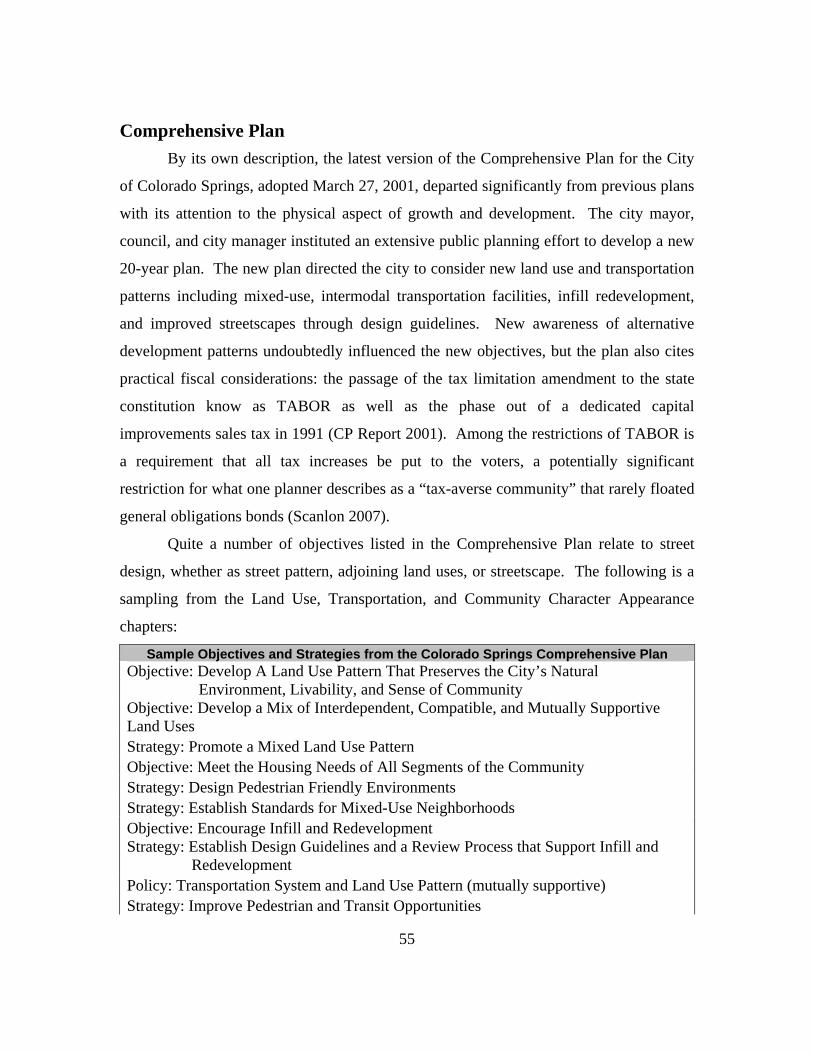
55
Comprehensive Plan By its own description, the latest version of the Comprehensive Plan for the City
of Colorado Springs, adopted March 27, 2001, departed significantly from previous plans
with its attention to the physical aspect of growth and development. The city mayor,
council, and city manager instituted an extensive public planning effort to develop a new
20-year plan. The new plan directed the city to consider new land use and transportation
patterns including mixed-use, intermodal transportation facilities, infill redevelopment,
and improved streetscapes through design guidelines. New awareness of alternative
development patterns undoubtedly influenced the new objectives, but the plan also cites
practical fiscal considerations: the passage of the tax limitation amendment to the state
constitution know as TABOR as well as the phase out of a dedicated capital
improvements sales tax in 1991 (CP Report 2001). Among the restrictions of TABOR is
a requirement that all tax increases be put to the voters, a potentially significant
restriction for what one planner describes as a “tax-averse community” that rarely floated
general obligations bonds (Scanlon 2007).
Quite a number of objectives listed in the Comprehensive Plan relate to street
design, whether as street pattern, adjoining land uses, or streetscape. The following is a
sampling from the Land Use, Transportation, and Community Character Appearance
chapters:
Sample Objectives and Strategies from the Colorado Springs Comprehensive Plan Objective: Develop A Land Use Pattern That Preserves the City’s Natural
Environment, Livability, and Sense of Community Objective: Develop a Mix of Interdependent, Compatible, and Mutually Supportive Land Uses Strategy: Promote a Mixed Land Use Pattern Objective: Meet the Housing Needs of All Segments of the Community Strategy: Design Pedestrian Friendly Environments Strategy: Establish Standards for Mixed-Use Neighborhoods Objective: Encourage Infill and Redevelopment Strategy: Establish Design Guidelines and a Review Process that Support Infill and
Redevelopment Policy: Transportation System and Land Use Pattern (mutually supportive) Strategy: Improve Pedestrian and Transit Opportunities
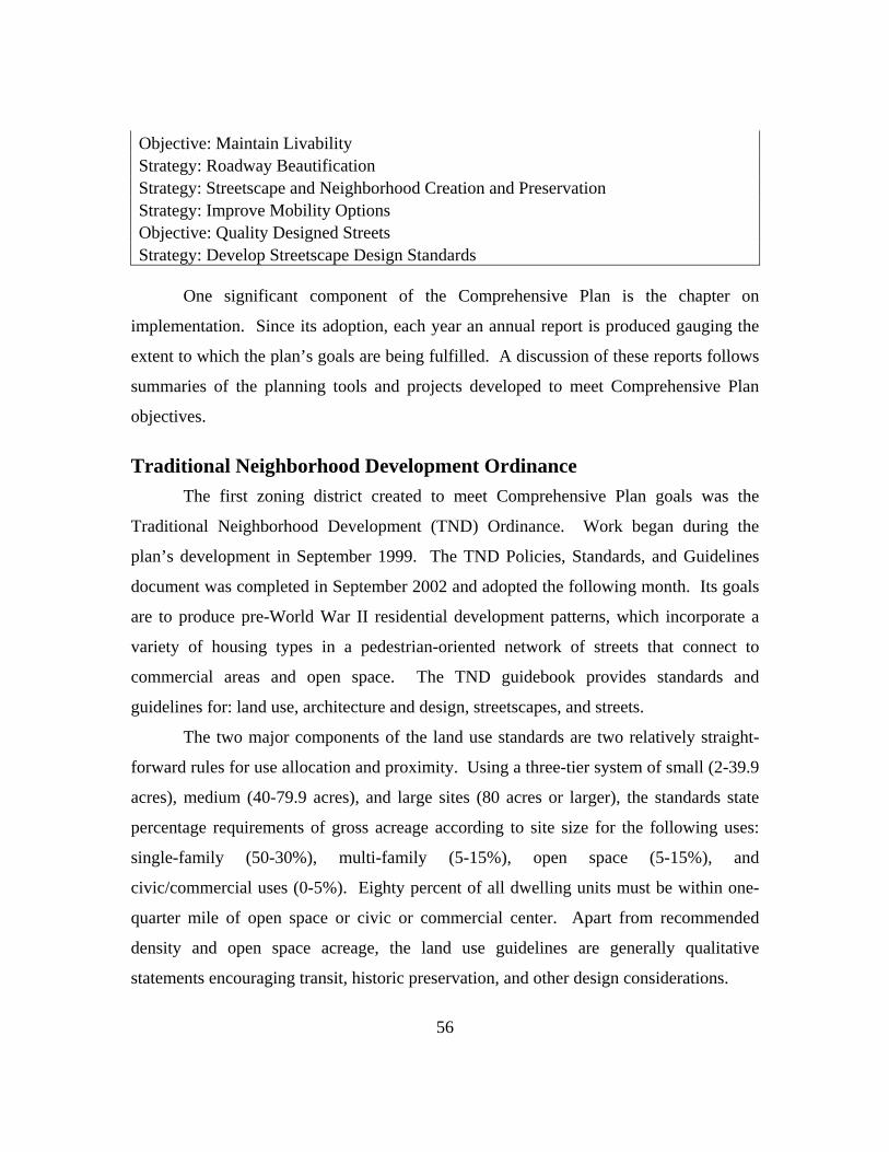
56
Objective: Maintain Livability Strategy: Roadway Beautification Strategy: Streetscape and Neighborhood Creation and Preservation Strategy: Improve Mobility Options Objective: Quality Designed Streets Strategy: Develop Streetscape Design Standards
One significant component of the Comprehensive Plan is the chapter on
implementation. Since its adoption, each year an annual report is produced gauging the
extent to which the plan’s goals are being fulfilled. A discussion of these reports follows
summaries of the planning tools and projects developed to meet Comprehensive Plan
objectives.
Traditional Neighborhood Development Ordinance The first zoning district created to meet Comprehensive Plan goals was the
Traditional Neighborhood Development (TND) Ordinance. Work began during the
plan’s development in September 1999. The TND Policies, Standards, and Guidelines
document was completed in September 2002 and adopted the following month. Its goals
are to produce pre-World War II residential development patterns, which incorporate a
variety of housing types in a pedestrian-oriented network of streets that connect to
commercial areas and open space. The TND guidebook provides standards and
guidelines for: land use, architecture and design, streetscapes, and streets.
The two major components of the land use standards are two relatively straight-
forward rules for use allocation and proximity. Using a three-tier system of small (2-39.9
acres), medium (40-79.9 acres), and large sites (80 acres or larger), the standards state
percentage requirements of gross acreage according to site size for the following uses:
single-family (50-30%), multi-family (5-15%), open space (5-15%), and
civic/commercial uses (0-5%). Eighty percent of all dwelling units must be within one-
quarter mile of open space or civic or commercial center. Apart from recommended
density and open space acreage, the land use guidelines are generally qualitative
statements encouraging transit, historic preservation, and other design considerations.

57
Architectural standards for single-family address lighting (fully shielded), lot
coverage (60%), the inclusion of porches, and other design details. Architectural
standards for all other uses require street-orientation for entrances, commercial/civic uses
on the first floor of parking structures, 50% transparency for first floor commercial uses,
and other design details. The guidelines address such issues as façade articulation,
parking requirements, and material use.
There are eight streetscape standards, including required build-to lines or zones
and six-foot wide tree lawns along all streets, planted with trees at a maximum of 30 feet
on center. Streetscape guidelines recommend street furniture, transit accommodations,
and external pedestrian and bicycle connectivity.
The TND street standards are the most extensive standards in the ordinance. The
typology of TND streets consists of a parkway, boulevard, avenue, main street,
neighborhood street, lane, non-residential alley, and residential alley. The comprehensive
standards vary according to street type and regulate the following: building height, build-
to zones, right-of-way, paving width, median width, tree lawn widths, sidewalk width,
block length, parking allowances, and allowable connections with other TND street types.
Street sections and streetscape plans are included for each type. Alleys are required in a
neighborhood center and pedestrian and vehicular connectivity throughout the
development must be provided. The paving width of a TND lane or street, from 22-26
feet, is significantly less than the paving width required for a typical residential street, 34
feet.
Implementation To date only one development has the TND zoning designation, the Gold Hills
Mesa Urban Renewal project. Gold Hills is currently in the development phase with pre-
sales already underway. Tim Scanlon, a planner that helped develop the TND standards,
did note that another development, Spring Creek, for the most part follows the TND
standards but is officially designated a PUD. Spring Creek’s developer worked with the
city to develop the TND standards (Scanlon 2007).

58
ves that the limited use of TND is related to the availability of
another
Small-lot PUD Ordinance ance was approved in 2005, two and half years after the
adoptio
mall-lot PUD (SLP) allows the creation of single-family lots averaging less than
6,000 s
Another project instrumental to
the formation of the TND standards is
the Lowell Redevelopment Project, an
urban renewal area. The Lowell
project centered on the restoration of
the historic Lowell Elementary School,
built in 1891 (Urban Redevelopment).
The project preceded the TND
standards and Scanlon (2007)
describes it as a test case for TND. It
incorporates residential, retail, office and other commercial uses. The pre-existing streets
were laid out according to City Beautiful movement standards, that is very wide but with
wide landscaped medians. Additional streets approximated the TND standards (Scanlon).
Scanlon belie
(Lowell Redevelopment project)
zoning ordinance, the small-lot PUD, which also allows skinny streets and small
lots. No mixed housing types or mixed uses are required and there are generally fewer
standards. A discussion of this zoning district follows.
The Small-lot PUD ordin
n of the TND ordinance. The impetus for its development, city planner Tim
Scanlon believes, was developer pressure for an easier and cheaper alternative to TND.
Rick O’Connor (2007), another city planner involved in the development of TND zoning,
notes that several projects that approximate the Small-lot PUD were submitted prior to
the zoning’s adoption and that the developer community requested a process that would
not require the negotiation of typical standards such as narrower streets, smaller lots, and
so on.
S
quare feet, which may have a greenway or street orientation. Accordingly, there
are two street types, access streets for use with greenway-oriented units and the standard

59
itional five-foot
utility e
Implementation to Rick O’Connor (2007), the Small-lot PUD designation has been
used pe
residential street for street-oriented units with a recommended six-foot tree lawn and one
tree per unit. The Small-lot PUD criteria do not contain many of the requirements found
in TND. There are no mixed-use or mixed-housing type requirements; however,
common open space is required and greenways may count toward that requirement.
Additionally, there are some criteria addressing pedestrian connectivity.
Access streets should have a 30-foot right-of-way with an add
asement on either side and a paving width of 22 feet. Sidewalks are not required
if direct sidewalk access is provided from each unit to the greenway sidewalk. Block
lengths should be limited to 800 feet with a loop configuration encouraged. Tim Scanlon
(2007) noted that intersection requirements and turning radii were initially based on TND
standards but the fire department pushed for changes to allow access for larger fire-
fighting equipment. Garage setbacks should be a minimum of 20 feet to allow for
additional parking. If alternate parking is provided, this setback may be reduced to eight
to ten feet. No parking is permitted on access streets, requiring separate visitor parking
bays within 200 feet of the units they serve. Dead-end streets are discouraged but
permitted. Please refer to Table 1 for the SLP street standards.
According
rhaps twice since its adoption in 2005, noting that there were four to five projects
that roughly approximated the SLP criteria prior to its adoption. Theses developments
have principally used street-oriented units primarily because the builder (principally
Richmond Homes/MDC) was familiar with this type. Classic Homes has also built some
greenway units that O’Connor thought were of good quality, and they are considering
another project with a mix of greenway/street oriented units. Overall, O’Connor is
disappointed with the Small-lot PUDs built to date, which is perhaps not surprising given
the promise of TND zoning, which he had assisted in formulating.

60
Mixed-Use Development Design Manual The Mixed Use Development Design Manual was adopted in September of 2003,
a year after TND had been adopted. Work began on its formulation in 2001 at the same
time that the new Comprehensive Plan, from which it sprang, was adopted. In fact, the
introduction to the manual states, “mixed use development emerged as one of the
foundations of the City’s new 2001 Comprehensive Plan.” The thrust of the manual is a
pedestrian orientation with more emphasis on commercial activities than in TND. The
standards in the manual are generally organized into land use, design standards, and
street/infrastructure standards. To encourage the use of Mixed Use, incentives include
longer vesting rights, a fast-track review process, and a longer term of approval for
concept plans.
The land use standards vary according to the type of mixed use district, of which
there are three that vary according to size and intent: Mixed Use Neighborhood Center
(MU-NC, maximum 10 acres), Mixed Use Commercial Center (MU-CC, minimum10
acres), and Mixed Use Regional/Employment Center (MU-R/EC, minimum 50 acres).
Neighborhood centers must include two principle use types – residential, retail, office,
and other commercial – while commercial and regional centers must include at least
three. All centers must include residential.
The majority of design standards apply to all mixed use development, while only
three vary according to center type: minimum FAR (0-0.25), minimum residential
density (0-8 units per acre), maximum bldg height (35-65 feet with exceptions for centers
in older areas). General design standards are fairly comprehensive with additional
guidelines provided for each element. Build-to line requirements vary, ranging from 0-25
feet, according to street type and in some cases ground floor use, with the higher
maximums for residential ground floor use and for higher traffic flow streets. Block
length is generally limited to 600 feet maximum with additional requirements for
pedestrian passthroughs for block faces longer than 400 feet. At least one building
entrance must be oriented toward the street. There are specific standards for building
placement in order to create spatially defined streets and open areas as well as standards

61
for façade articulation. Standards address vehicular and pedestrian connectivity both
externally and within a development. Centers must have at least two on-site amenities,
defined generally as a plaza, park, arcade, water feature, public art, or other focal feature.
Also delimited are maximum off-street parking limits and surface parking placement with
accompanying landscaping requirements. Bicycle facilities must be included, and transit,
lighting, and signage considerations are also required. Street trees must be placed at
least one every 30 feet, and transition standards address adjacency to existing land uses of
varying density and intensity.
Similar to TND, the mixed use standards establish a typology of streets: six-lane
parkway, four-lane parkway, entry spine, collector, local street, and alley. Not only
traffic studies must be conducted, but pedestrian assessments as well. Sidewalks are
required, varying in minimum width from six to eight feet. Right-of-way dimensions do
not appear to be appreciably different from the typical street standards; however, paving
widths do appear to be reduced and tree lawns are required, ranging from eight to twelve
feet. Please refer to Table 1 for a summary of the mixed use street standards.
Implementation Since the Mixed Use Development Design Manual was adopted in 2003, no
project has yet utilized its zoning designation. Tim Scanlon (2007), a contributing
planner to the standards, attributes this to the availability of PUD zoning. Shortly before
the mixed use zoning standards were completed, the assistant city manager directed the
team to create a PUD ordinance that would allow mixed use. It was adopted in
November 2003 and appears to require that the mixed use design standards be followed
for any proposed PUD with mixed use. As for the incentives, Scanlon explained that a
Rapid Response Team responded to requests for quick development review if certain
criteria were met, but he felt that these criteria were routinely waived.
Currently there is one PUD undergoing development review that utilizes mixed
use and indeed is advertised as a mixed use project. The Colorado Crossing project has
long been in the works and will be located at the intersection of two major arterials at the
northern edge of the city, an area experiencing dramatic growth, particularly in the up-
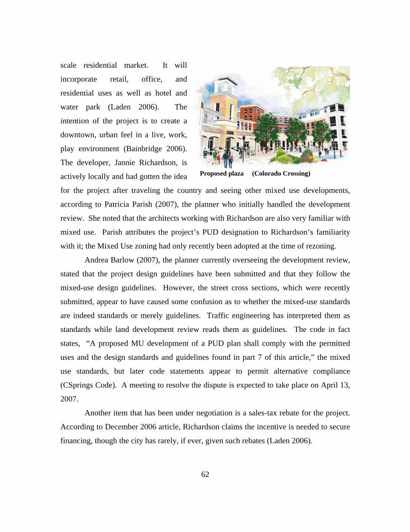
scale residential market. It will
incorporate retail, office, and
residential uses as well as hotel and
water park (Laden 2006). The
intention of the project is to create a
downtown, urban feel in a live, work,
play environment (Bainbridge 2006).
The developer, Jannie Richardson, is
actively locally and had gotten the idea
for the project after traveling the country and seeing other mixed use developments,
according to Patricia Parish (2007), the planner who initially handled the development
review. She noted that the architects working with Richardson are also very familiar with
mixed use. Parish attributes the project’s PUD designation to Richardson’s familiarity
with it; the Mixed Use zoning had only recently been adopted at the time of rezoning.
Proposed plaza (Colorado Crossing)
Andrea Barlow (2007), the planner currently overseeing the development review,
stated that the project design guidelines have been submitted and that they follow the
mixed-use design guidelines. However, the street cross sections, which were recently
submitted, appear to have caused some confusion as to whether the mixed-use standards
are indeed standards or merely guidelines. Traffic engineering has interpreted them as
standards while land development review reads them as guidelines. The code in fact
states, “A proposed MU development of a PUD plan shall comply with the permitted
uses and the design standards and guidelines found in part 7 of this article,” the mixed
use standards, but later code statements appear to permit alternative compliance
(CSprings Code). A meeting to resolve the dispute is expected to take place on April 13,
2007.
Another item that has been under negotiation is a sales-tax rebate for the project.
According to December 2006 article, Richardson claims the incentive is needed to secure
financing, though the city has rarely, if ever, given such rebates (Laden 2006).
62

Richardson does appear to be dedicated to mixed-use principles, noting the
novelty of such a development for Colorado Springs in news articles (Laden,
Bainbridge). Indeed, there appears to great market reception to mixed use projects, as
noted by Colorado Crossings designer. A survey conducted by the real estate community
reported that 28% of respondents have developed mixed-use projects in 2006 with 52%
expecting to develop such projects this year, though not necessarily with a residential
component. A Houston designer working on the Austin Triangle project remarked,
“Mixed use is hot hot hot right now” (Cassidy 2007).
As for other mixed use projects in Colorado Springs, Tim Scanlon (2007) believes
that some projects along the developing north-south arterial, Powers Boulevard, may
incorporate mixed-use principles if not the actual zoning designation.
Urban Renewal and Designated Redevelopment Corridor Areas The 2001 Comprehensive Plan
states that infill and redevelopment
should be encouraged, and
accompanying design guidelines and a
review process that supports such
projects should be established. To
achieve these objectives, several urban
renewal areas have been declared
through the Colorado Springs Urban
Renewal Authority: Gold Hills Mesa, the
Lowell neighborhood, Southwest
Downtown, and North Nevada. Gold
Hills Mesa is former gold mill that is being redeveloped as a TND, as previously
discussed. Similarly, the Lowell Redevelopment project has been completed using TND
principles. The Southwest Downtown Project concept plan calls for a mixed use
development that strongly ties into the recently completed Confluence Park (also called
America the Beautiful park), located along Monument Creek and tying into an evolving
(Southwest Downtown Project)
63

64
greenbelt system. The North Nevada project is adjacent to a major highway as well as a
local campus of the University of Colorado. The concept plan submitted as part of the
Urban Renewal Plan indicates several districts of mixed-used neighborhood retail; a
civic, cultural, arts and entertainment district, a commercial retail and lifestyle center, a
research and development district; and a primarily landscaped gateway district. The
Urban Renewal Plan also cites a number of objectives listed in the 2001 Comprehensive
Plan.
Designated Redevelopment Corridor and Area (DRCA) is another tool used to
fulfill the comprehensive plan’s stated objectives of infill and redevelopment. These
corridors are targeted for public investment and building permits along the corridor are
tracked annually. Eight areas have been identified, including North Nevada Avenue,
which extends farther south beyond the urban renewal area. The North Nevada Corridor
Improvement Plan, published in February 2006, calls for widening in some sections, the
addition of medians, an on-street bicycle lane, and sidewalks in the many areas that do
not have them. Recommendations for street furniture, lighting, signage, landscaping, and
public art were also included. The city plans to incorporate these and other elements into
a design manual.
Implementation Of the Urban Renewal areas listed, only the Gold Hills Mesa project appears to be
progressing as planned, apart form the already completed Lowell project. The Southwest
Downtown project is stalled and Tim Scanlon (2007) does not believe that the
development community will take advantage to the tax-increment financing until several
years from now. Its initial failed efforts, which included a convention center that was
turned down by the voters, appears to be linked to perceptions that long-time local
businesses were being pushed out to make room for high-income residents. It is unclear
at this point how the area will be redeveloped. According to James Mayerl (2007), a
planner involved in the North Nevada Urban Renewal project, the current development
plans are essentially for a shopping center and nothing more. Costco and Lowes are
planning to locate there in a typical big box configuration, and the Urban Renewal
65
Authority, in general, is not interested in doing a mixed use project. Scanlon (2007)
remarked that an opportunity was lost when the city council did not require that all urban
renewal areas incorporate TND or Mixed Use designations.
The North Nevada Corridor Improvement Plan, as of its early 2006 publication,
stated that there was no funding currently to pursue the plan. Building permits in DRCAs
are issued each year, but no accompanying design guidelines have been developed
(Scanlon 2007). The lack of design standards and guidelines is noted in most of the
annual Comprehensive Plan Reports. However, Patricia Parish (2007), a planner
involved with the reports, remarked that design standards for townhome projects will
likely be developed this year and that meetings with stakeholders have begun.
Intermodal Transportation Plan and Complete Streets The Intermodal Transportation Plan (ITP) compiles several transportation plans
under a set of common goals, including supporting the objectives of the Comprehensive
Plan. It was developed from October 1996 to April 1999 and adopted in June 1999 with
several adjustments made as a result of the 2001 Comprehensive Plan. Its primary
planning goals are: mobility, livability, intermodalism, and implementation – listing
specific recommendations for transit, bicycle, and pedestrian elements. These include
establishing a regional transit system, adding more bicycle facilities, and reviewing
sidewalk standards as well as funding a pedestrian mobility and access study.
The 2006 Comprehensive Plan Report noted that in December 2005 the city
council approved a Complete Streets policy, “which directs the construction or
reconstruction of roadways to include appropriate improvements for walking, bicycling,
and transit use” (49). The Report’s evaluation of the Comprehensive Plan stated a move
away from major initiatives, such as the Mixed Use zoning district, to more modest
measures, such as updates to the subdivision and traffic engineering design manuals, to
achieve plan objectives. A discussion of the annual reports follows later.

66
Implementation Progress is being made toward ITP objectives. The city transit authority has been
reorganized as the Pikes Peak Regional Transportation Authority with funding from 1%
sales tax approved by voters. Additional bicycle lane miles are tracked each year and are
“keeping pace with the population” (CP Report 2006). (This might suggest, however,
that overall levels of service are not actually increasing).
The Pedestrian Assessment is underway, and a GIS-based inventory of pedestrian
facilities is being finalized, according to Kristin Bennett (2007), a planner involved in the
project. She also notes that a draft of the updated Street Design Standards has also been
produced and proposes significant changes for pedestrian facilities. Sidewalk width is
proposed to increase to five or six feet from the current standard of four feet. Tree lawn
width may also be adjusted, primarily to accommodate utilities underneath, but this
change should also allow for a larger clear zone on sidewalks. Sidewalks, generally
detached from the roadway, will be required on all streets, apart from freeways and
expressways, where previously they were not required on some streets, such as industrial
collector streets. Major street reconstructions add sidewalks if they were not previously
included, but general road improvement projects do not have the funding to include
sidewalk construction, a situation that is expected to be addressed by the forthcoming
pedestrian plan. Bennett noted that sidewalk construction has been tied to parcel
development, which results in gaps when a parcel is left undeveloped. The city does
have the ability to compel property owners of undeveloped lots to install sidewalks for
safety reasons, a provision the city has used on occasion. As of 2005, capital
maintenance of sidewalks is the responsibility of the city (Bennett 2007). One significant
proposed requirement that will enhance connectivity is a maximum block length of 600
feet (Willcher 2007).
Downtown Streetscape Program The Downtown Streetscape program is a collaboration between the City of
Colorado Springs and the Downtown Partnership, an advocacy group for downtown
businesses. The program has it roots in the Downtown Action Plan, produced through a
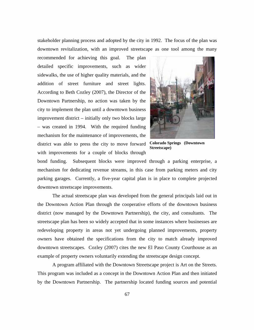
stakeholder planning process and adopted by the city in 1992. The focus of the plan was
downtown revitalization, with an improved streetscape as one tool among the many
recommended for achieving this goal. The plan
detailed specific improvements, such as wider
sidewalks, the use of higher quality materials, and the
addition of street furniture and street lights.
According to Beth Cozley (2007), the Director of the
Downtown Partnership, no action was taken by the
city to implement the plan until a downtown business
improvement district – initially only two blocks large
– was created in 1994. With the required funding
mechanism for the maintenance of improvements, the
district was able to press the city to move forward
with improvements for a couple of blocks through
bond funding. Subsequent blocks were improved through a parking enterprise, a
mechanism for dedicating revenue streams, in this case from parking meters and city
parking garages. Currently, a five-year capital plan is in place to complete projected
downtown streetscape improvements.
Colorado Springs (Downtown Streetscape)
The actual streetscape plan was developed from the general principals laid out in
the Downtown Action Plan through the cooperative efforts of the downtown business
district (now managed by the Downtown Partnership), the city, and consultants. The
streetscape plan has been so widely accepted that in some instances where businesses are
redeveloping property in areas not yet undergoing planned improvements, property
owners have obtained the specifications from the city to match already improved
downtown streetscapes. Cozley (2007) cites the new El Paso County Courthouse as an
example of property owners voluntarily extending the streetscape design concept.
A program affiliated with the Downtown Streetscape project is Art on the Streets.
This program was included as a concept in the Downtown Action Plan and then initiated
by the Downtown Partnership. The partnership located funding sources and potential
67

68
downtown display locations for art works installed on an annual basis. A few pieces each
year are purchased by the Downtown Partnership and then donated to the city. The city’s
Art Commission was involved in the initial determination of display locations and must
also annually approve works selected by the Downtown Partnership. The work(s)
selected for purchase must also be approved by the commission. Cozley characterizes the
relationship between the two groups as sometimes antagonistic in which threatened
vetoes of art work by the commission are countered with proposed appeals to the city
council, with whom the Downtown Partnership has far better a relationship, Cozley
notes. She believes the Downtown Partnership would gladly turn over the administration
of Art on the Streets to the Art Commission if it were under different leadership. The Art
Commission did predate the formation of the Downtown Partnership but did not have the
relationships to potential funders to initiate such a program, according to Cozley. Since a
reorganization of the commission, they have expanded their purview and administer
programs beyond the downtown to include the airport and other sites, a much needed
service Cozley remarked.
Implementation The streetscape plan for downtown may change as more redevelopment takes
place in and around the downtown. At least one private developer who is constructing a
LEED certified building, designed by a well known “green” architect, has suggested that
the current streetscape plan could be improved. The property is just outside the core
business district but is intended to tie into the current streetscape plan. Cozley describes
this as a potential test case that will establish the streetscape plan as a standard, with other
improvements that go beyond the minimum permitted upon approval by the Downtown
Partnership.
While the Art on the Streets program continues to produce annual shows, the
history of the program reflects the complicated relationship between business groups,
individual city officials, and the city as a governing body. The Downtown Action Plan is
currently being considered for revision as a response to planning initiatives carried out by
the Downtown Partnership after a hard-fought but failed effort to create a downtown

69
convention center. The organization refocused their efforts two years ago by conducting
a workshop, with the assistance of best-practices consultants, that included city staff and
officials and the private sector. Several key ideas emerged from the workshop: the need
for downtown residential uses, the utility of a downtown development authority for
public-private projects, and the need to create a new downtown plan, which was offered
by the vice-mayor.
The Downtown Partnership began to pursue these ideas and formed a committee
to develop what would become the Imagine Downtown plan. It should be noted that
several key city officials are members of the Downtown Partnership; the head of the
transportation committee is also the director of the city’s parking enterprise, while the
head of the street character committee is also the city’s planning director, Bill Healy. He
assisted the Imagine Downtown committee, headed by the president of Colorado College
and the vice mayor, to develop a planning process for the new plan. The Imagine
Downtown plan is now the governing document for the Downtown Partnership and has
been adopted by the city as the plan of development for the newly created Downtown
Development Authority. However, it is not, as Cozley noted, the new master plan for
downtown and has not yet replaced the Downtown Action Plan. It must go through what
Cozley describes as a rigorous process to be adopted as such, despite careful attention to
follow public meeting requirements, such as advertising meetings, posting public notices,
documenting meeting attendees, and so on. Cozley remarked that this process has
rankled some city planners, but believes the participation of key city officials in the
process and the assistance of the Bill Healy will shepherd it through a process in which it
will be melded with the previous Downtown Action Plan. She admits that the Imagine
Downtown plan is not a land use plan but probably does resemble Healy’s
characterization of it as a visioning document. She noted that it does contain street
design concepts that could be translated into design standards. Healy’s committee has
been characterizing downtown streets and blocks (Imagine Downtown) as preparation for
the formulation of form-based code – one of the recommendations of the 2006
Comprehensive Plan review.

70
Comprehensive Plan Implementation As previously noted, Comprehensive Plan Reports measure to what degree the
plan’s objectives are met each year. Each years report is itself increasingly more
comprehensive. The 2003 report primarily listed quantitative indicators associated with
objectives and evaluated the usefulness of those indicators. The 2004 report also
included qualitative information and specifically linked the Comprehensive Plan
objectives to those in the Strategic Plan, the city’s five-year implementation document. It
also specifically noted which objectives were being met and which were not and
observed that the same single-use, auto-oriented land use pattern had remained largely
unchanged. The 2005 report included for the first time a lengthy notice of the advisory
nature of the Comprehensive Plan, but also remarked that it is “the only officially
adopted planning document that strives to coordinate the characteristics and
consequences of land development within the city” (5). Once again remarking on the
persistence of the same land use pattern, it attributed the rare use of TND and mixed use
to the lack of their promotion in annexation and master planning processes and the shear
amount of available land, roughly a third of the city’s acreage. Several recommendations
made have as yet remained only recommendations: the development of design standards
for big-box, infill redevelopment, and downtown; a revision of subdivision code for
connectivity requirements; and the incorporation of affordable housing with TND and
mixed-use. The 2006 report reiterated the advisory notice of the 2005 report. As
previously discussed, it suggested that more modest efforts be made to achieve
Comprehensive Plan objectives, including revision of the Subdivision Policy and Traffic
Engineering Manual. This project is, in fact, underway with draft proposals in the review
process.
In reviewing the annual Comprehensive Plan Reports, there is a sense that the
Comprehensive Plan no longer has the guiding force it initially had. Tim Scanlon (2007)
confirmed this observation and attributed it to the change in city manager, mayor, and
city council members who had all been involved in its development. He explained that
the mayor had reached term limitations, and several city council members ran for the
71
mayor’s post, requiring them to relinquish their positions on city council and resulting in
a significant turnover on the council. According to Scanlon, the new council members
are not invested in the Comprehensive Plan, not having participated in its development,
while the current city manager is not as skilled as the previous one. He remarked that
they are generally focused on other infrastructure issues, specifically the city’s new
stormwater enterprise and the development of infrastructure to transport water some 40
miles from the Pueblo Reservoir where the city has water rights. Despite the extensive
public involvement and the task force’s insistence on concrete implementation measures,
there does not appear to be a culture of regarding the Comprehensive Plan as a guiding
document, particularly when considering that the Comprehensive Planning department
was dissolved in the mid 1990s by the assistant city manager.
Analysis Recent planning in Colorado Springs illustrates a variety of approaches to both
street design and planning in general. These range from a focus on specific street
elements to a holistic approach and from incremental to comprehensive planning, with
each having a varying range of success. The most comprehensive treatment of street
design elements are the TND and Mixed Use zoning ordinances. They consider many of
the elements of street design elements and establish the basic spatial structure of the street
through standards for street width, build-to lines and zones, and building heights. The
TND standards establish both minimum and maximum building heights and associate
them with street width. While the Mixed Use standards only establish maximum heights,
given the greater use intensity and density, maximum standards may be sufficient. Both
the TND and Mixed Use criteria address building façade elements. The TND standards
are fairly minimal, requiring principally that one entrance is oriented to the street and that
glazing occupy 50% of the façade, while façade articulation and other design details
remain only guidelines. The Mixed Use standards specifically require façade articulation
every 30 feet, but only recommend transparency along with a fairly detailed list of
guidelines.
72
Both sets of standards address multi-modal facilities and connectivity. While
sidewalks are not particularly wide, ranging from five to eight feet, the connectivity
requirements do promote a pedestrian-orientation, particularly the TND requirement that
varying land uses be placed within a quarter mile of each other and the Mixed Use
requirement for pedestrian passthroughs for long block faces. Connectivity is further
enhanced by limited block sizes. While bicycle and transit facilities are only addressed
as TND guidelines, Mixed Use addresses them as standards. Street furniture is only
recommended and not required, but street trees are standard. Public art is optional in
Mixed Use, but this issue has the potential to be addressed through the city’s Art on the
Streets program. Land use requirements are relatively straightforward for both zoning
designations, with TND decidedly oriented toward residential use, required for roughly
half a site, and Mixed Use favoring office and commercial, demanding only 10%
residential. The street typologies all recognize the differing street character associated
with hierarchical functional classification.
So with most street design elements addressed in the TND and Mixed Use
standards, the questions remains why have them been used so infrequently? While this
author has not made an exhaustive review of TND tools, the TND criteria, particularly
the standards, do not appear to be overly complicated. The Mixed Use standards are
certainly more detailed, but considering their orientation toward revenue generating uses,
this is perhaps justified. The city does not seem to have put them in the context of the
larger land development review scheme. With the availability of other more lenient
zoning categories, particularly the Small-lot PUD, the cost savings of narrower streets are
gained without the complications of other requirements, although there are perhaps some
gains in pedestrian connectivity. But even here, disassociating the sidewalk to a
greenway reduces the street to vehicular corridor. The incentives offered do not appear
to be meaningful. Perhaps the most discouraging aspect is the lack of support from city
officials. The unintended consequences of term-limits have translated into a lack of
continuity, despite public involvement in formulating the initial impetus for the TND and
Mixed Use tools. It appears that the private sector may be in a position to make more
73
headway, and if Colorado Crossing is a financial success, than mixed use developments
are likely to become more common. The city should be careful in how it decides to
interpret its own ordinances; otherwise, the Mixed Used design standards may go the way
of the Small-Lot PUD, the story of which appears to confirm characterizations of the city
as developer-run. This is not to say that developer initiatives are necessarily negative.
Tim Scanlon (2007) remarked that the improved streetscapes of the Briargate area, a
moderately priced newer subdivision, were voluntarily built by developer – because street
design has economic value.
Certainly the history of the Downtown Streetscape program demonstrates the
catalyzing power of the business community. It seems clear that the business community
spearheaded the program and enlisted the city in its efforts, or more precisely key city
officials. This story, too, lends credence to the perception that the approach to
government in Colorado Springs is one of limited government. It does seem troubling
that key planning activities are assumed by private organizations and not in a consultant
capacity; lobbyists writing legislation comes to mind. But this is perhaps too harsh a
characterization as city staff and elected officials were involved in the development of the
plans and programs. The subtext may be that the funding for planning activities was not
available from the city, while an outside organization valued such efforts. Clearly
improved streetscapes were important and valuable and were achieved through a public-
private partnership.
The current efforts to update the city’s general street standards demonstrate the
utility of both a comprehensive and incremental approach. The impetus for the project
derives from the Comprehensive Plan, while the incremental approach will more likely
address at least some elements of improved street design city-wide, particularly in
developing areas, of which there are many. While these changes will not address
important land use issues or even establish a three dimensional spatial structure, they do
begin to establish a structure for multi-modal connectivity.
Colorado Springs’ recent history with street design initiatives illustrates several of
the recent trends in planning. Its embracement of comprehensive planning coincides with

74
a focus on urban form to achieve planning objectives, as suggested by Beauregard
(2003). Developed with significant public participation, as recommended by Lucy’s
(2003), its 2001 Comprehensive Plan noted that the central role of urban form was a
significant departure from previous plans. This focus on physical planning translated into
a more comprehensive treatment of the street in its early efforts to develop new zoning
districts such as Traditional Neighborhood Development, a New Urbanist approach.
These initiatives, however, have not yet had the hoped for success because there did not
appear to be a comprehensive appraisal of the political and administrative context in
which these tools could be used. Other zoning classifications were made available with
the “all the benefits but not the costs,” as Tim Scanlon noted (2007). Incentives were
ineffectual because of an inaccurate appraisal of their value and of the tension between
public and private interests. Perry’s characterization of planning as producing both
abstract, social space and physical space would be useful for Colorado Springs,
suggesting a mapping of the political space that’s needed to support new infrastructure
and new street design. The downtown streetscape program is a case in point in which the
private sector provides agency. A sustainability framework would bring a perspective
that balances economic, environmental, and equity objectives and focuses some of the
issues that have hampered wider success; for example, the downtown renewal efforts in
which equity issues did not appear to have been sufficiently addressed. Steps in this
direction appear in the latest Comprehensive Plan Report (2006), which recommends that
links to affordable housing be considered for TND and Mixed Use zoning.
For Colorado Springs, incremental and comprehensive approaches seem to have
an inverse relationship to scale. The most comprehensive approach to street design, TND
and Mixed Use, are at the most limited scale, while the more incremental approach in
which only a few elements are addressed, the current revision of the street standards,
appears will have the widest applicability across the city. Landscape urbanism grapples
with the question of scale and the role of strategic moves to establish a framework for
adaptability. One question for Colorado Springs from a landscape urbanism point of
view might be when streets are considered as an entire landscape, what are the strategic

75
street design elements needed in an incremental approach and where are the most
strategic areas in the landscape of the city that a comprehensive treatment would have the
most value.
There are also opportunities for landscape urbanism to address some of the city’s
current concerns. Landscape urbanism’s equation of infrastructure with landscape could
mean prospects to develop multifunctional streets that address its current issues with
stormwater drainage. Funding issues have led to the current development of a
stormwater enterprise. These issues illustrates the property conflict between economy and
equity; newer subdivisions use special district financing for infrastructure construction
and maintenance, requiring this funding to remain within the district while older
infrastructure predating the creation of special districts does not have a revenue stream.
Ultimately all of this infrastructure must tie together. A more comprehensive approach
with a landscape urbanist point of view might suggest that stormwater could be
considered at one of its origins, the street. Streets could be designed to minimize
traditional engineered stormwater infrastructure using the green streets concepts.
Landscape and infrastructure become synonymous and the environment becomes a tool
for alleviating an economy/equity conflict. Even the city’s concern with future water
sources could be addressed from a landscape urbanist approach to infrastructure.
Implementing such approaches would likely require both incremental and comprehensive
planning with some drainage issues addressed through a reappraisal of curb and gutter
design while more ambitious water collection and delivery infrastructure require a wider
scope, each potentially applied at different scales with incremental and comprehensive
results.
The case of Colorado Springs highlights the role of the private sector in the
implementation of improved street design, particularly if there is not sustained support
from public planning efforts and elected officials. Process is key to the production of
space, as landscape urbanism and new planning directions point out, and Colorado
Springs illustrates one variation of the public-private interface in which public process
provided the seed for improved street design, but private initiatives have been the key

76
cultivators. Improved street design is on its way, even in a “limited government,
developer-run” city; the key to increasing the pace may be greater public-private
partnering, not unlike a key characteristic of the street – a space defined by the public-
private intersection.
77
Chapter Six: Austin Case Study
Like Colorado Springs, Austin has developed and implemented a number of
planning tools to improve street design. The planning environment is considerably
different, however, with many civic organizations involved in initiatives that involve
street design. The city has been particularly focused on infill development with several
projects underway that have significant public participation. Its experience with
comprehensive and incremental planning has also differed from Colorado Springs, and
sustainability appears to play a larger role in its most recently developed street design
planning tools. The degree of public involvement in Austin represents a greater emphasis
on the public component of the metaphorical public-private model of the street, and
correspondingly, the city, represents a different environment to be considered by
landscape urbanism and ideas of process and of cultural and political space. Despite
differences in planning environment, the city’s street design initiatives also illustrate
current planning trends and opportunities for planning and landscape urbanism to inform
each other and street design.
Introduction Austin has a number of streets that figure in the city’s popular imagination as
destinations: “the Drag,” the retail strip on Guadalupe Street across from the University
of Texas; 6th Street, the stretch of entertainment venues from Congress to I-35; South
Congress, an eclectic mix of restaurants, vintage shops, bars and other uses south of
Riverside Drive. These streets are a part of the grid system that began with the original
1839 plat of a 14-block grid (Kearl). Like other US cities, this grid system is surrounded
in many areas by the curvilinear hierarchical streets of post-WWII suburbs.
Unlike Colorado Springs, Austin does not have a recent comprehensive plan; it
has actually eclipsed the twenty-year planning horizon of its last comprehensive plan, the
Austin Tomorrow Plan adopted in 1979. A new plan with extensive public outreach was
formulated in 1985 but was never adopted by the city council. This has been attributed to
turnover in the city council at the time and heavy developer lobbying against the plan.
78
As a response to the failed comprehensive plan effort, the Citizens’ Planning Committee
was formed in 1996 (Audit report 2006) and its recommendations are cited as the source
for several planning efforts, including corridor planning. Without an officially adopted
comprehensive plan, the public basis for new policies comes from a variety of sources
such as the regional planning effort, Envision Central Texas; the Smart Growth initiative,
a response in part to public concern for air and water quality and the need to redirect
growth patterns; redevelopment projects such as the Robert Mueller Municipal Airport
(RMMA) and the Triangle, whose current form were essentially spearheaded by
neighborhoods; the success of mixed-use, downtown redevelopment; voter approval of
commuter rail; and the active participation of local groups and individuals in planning
related efforts. Many of the new planning initiatives directly address street design, either
components of it or in its entirety.
The planning tools used to effect improved street design that are discussed in this
case study can generally be grouped into two categories: zoning districts/general design
standards and specific corridor planning/streetscaping programs. Those in the first group
include three ordinances: Design Standards and Mixed Use, Transit Oriented
Development, and Traditional Neighborhood Development. Those in the second group
include three initiatives: corridor planning, the 2222 Corridor Study, and the Great Streets
program with some discussion of affiliated programs.
Design Standards and Mixed Use Ordinance Perhaps the most wide-reaching street-design planning tool developed to date is
the recently adopted Design Standards- Vertical Mixed Use Ordinance. It went into
effect January 13, 2007 with the Vertical Mixed Use portion currently undergoing an opt-
in/opt-out phase covered later in this report. It began as a resolution in February 2004
with the authorization to establish a task force for its development as a result of “issues
raised in land development cases involving large retail establishments” (General
Questions, 1). The resolution also stated that Austin “had among the lowest design
standards of communities in the Central Texas region, and that national retailers routinely
construct elsewhere (oftentimes in response to more rigorous design standards) stores
79
with higher design standards than the stores they construct in Austin” (General
Questions, 1). Adopted in August 2006, the resulting ordinance principally applies to
commercial and mixed use properties according to roadway classification. Areas with
separate planning efforts that consider design guidelines appear to be exempted,
including downtown where the Great Streets program applies, the university area overlay,
the RMMA project, current and future transit station planning areas, and traditional
neighborhood districts.
The roadway classification used in the Design Standards is not based on
functional classification, traffic flow rates, but primarily according to geographic
location. These road types are:
• Core Transit Corridors – including current and future transit lines
• Internal Circulation Routes – streets within a development
• Highways – freeways, parkways, expressways, and frontage roads as designated
by the Metropolitan Transportation Plan
• Urban Roadways – all roadways inside the urban roadway boundary except Core
Transit and Highways.
• Hill Country Roadway – determined according to the Hill Country Roadway
Ordinance (enacted primarily to preserve the rural nature of these roadways (2222
Report)), and include RM 2222, and Southwest Parkway
• Suburban Roadways – roads outside the urban roadway boundary and not Core
Transit, Hill Country Roadway, or Highway.
Ordinance requirements are grouped into three categories: site development
standards, building design standards, and mixed use with each standard indicating
application according to 1) roadway type and 2) zoning district, use, parcel size or other
condition. (Please see Table 2 for summary.) The site development standards contain
perhaps the most significant requirements affecting overall street appearance by setting
standards for sidewalks, building placement and frontage, block length, vehicular and
pedestrian connectivity, and street trees. It also discusses parking reductions, exterior
lighting, screening of equipment and utilities, and open space and pedestrian amenities.

80
The intent of the standards in fact is to develop a pedestrian friendly environment
(Questions, Article 2). The building design standards further enhance street design
through façade requirements. The mixed use section focuses on mixed use within one
building, clarifying use requirements as well as offering affordable housing incentives
through density bonuses and other perks. The standards range from the most to the least
demanding according to roadway type, moving from Core Transit to Suburban to Hill
Country and Highway respectively.
Site standards require at minimum fifteen-foot sidewalks for core transit corridors
and twelve-foot sidewalks for urban and suburban roadways. These requirements apply
whether or not there is enough available right-of-way. Required clear zones, areas
reserved for pedestrian traffic, vary from five to seven feet minimum width according to
overall width of the sidewalks and are generally adjacent to the building. The remaining
area is reserved for street trees, furniture, lights, hydrants, and other similar elements.
Supplemental zones for outdoor seating are also available with some restrictions,
including a maximum width of 20 feet with some allowances up to 30 feet. Internal
circulation routes must also include sidewalks on both sides, but no width is specified,
which likely means they must follow previous standards. Sidewalks are generally
required for almost all new streets according to the Transportation Criteria Manual and
vary in width according to functional classification, four for local streets up to six feet for
major arterials. Street trees are required every 30 feet on center at the most for Core
Transit and Internal roadways; otherwise, they are optional.
Buildings frontage requirements address the minimum amount of a building that
must be built up to the clear zone, or supplemental zone if used, and vary from 40% for
Urban Roadways to 75% for Core Transit. The longer side of a building must be along
Internal roads. Surface parking lots are prohibited from fronting the street along Core
Transit and Internal roads, while they are permitted along urban roadways if the buildings
are Vertical Mixed Use or have at least 60% frontage along the clear zone. In such cases,
they require a landscape buffer along the street as well as shading from the sidewalk to
the principal entrance. Surface parking lots fronting streets are discouraged but not

81
prohibited along Suburban Roadways. All roadways require at least one customer
entrance be located along the street with some exceptions that have additional
requirements.
The Connectivity section requires that block dimensions be limited to 660 feet by
330 feet on sites five acres or larger in all zoning districts for Core Transit and Urban
Roadways and non-residential district when fronting a Suburban, Highway, or Hill
Country. Vehicular connectivity – that is streets must connect to adjacent public or
private streets – and pedestrian and bicycle connections to adjacent public sidewalks and
streets are required for sites three acres or larger and in the case of sites with surface
parking fronting the road (Suburban, Hill Country, and Highway) regardless of acreage.
These same developments must also choose two options – or three options when surface
parking amounts to more than 125% of the parking requirements – from a palette of
eight. These options include: pedestrian and bicycle connections to parkland, solar power
shading devices in surface parking lots, pedestrian connections to residential
developments, placement of internal utility lines under drive aisles (as opposed to parking
spaces), curb cuts not more than every 330 feet, concrete or pervious paving on at least
50% of surface parking, shower facilities, and sidewalk shading over 100% of building
façades.
The Site standards also discuss parking reductions and screening of equipment
and utilities. Lighting requirements include the use of fully shielded and full cut-off light
fixtures. For sites five acres or larger regardless of zoning, two percent of the net site
area must be set aside as open space, which may include playgrounds and plazas.
Building Design standards are generally comprised of glazing requirements and a
choice of building design elements. For the most part, glazing with a visible
transmittance of 0.6 or more (it can be seen through) is required on the first and second
floors for 40% and 25% of the surface area, respectively. One design option must also be
incorporated from a list of fourteen options, or in case of trademarked building designs or
other design criteria, more options must be included. The design options generally refer
to green building, linear stores, façade articulation, primary entrance design, roof design,
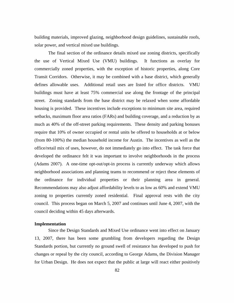
82
building materials, improved glazing, neighborhood design guidelines, sustainable roofs,
solar power, and vertical mixed use buildings.
The final section of the ordinance details mixed use zoning districts, specifically
the use of Vertical Mixed Use (VMU) buildings. It functions as overlay for
commercially zoned properties, with the exception of historic properties, along Core
Transit Corridors. Otherwise, it may be combined with a base district, which generally
defines allowable uses. Additional retail uses are listed for office districts. VMU
buildings must have at least 75% commercial use along the frontage of the principal
street. Zoning standards from the base district may be relaxed when some affordable
housing is provided. These incentives include exceptions to minimum site area, required
setbacks, maximum floor area ratios (FARs) and building coverage, and a reduction by as
much as 40% of the off-street parking requirements. These density and parking bonuses
require that 10% of owner occupied or rental units be offered to households at or below
(from 80-100%) the median household income for Austin. The incentives as well as the
office/retail mix of uses, however, do not immediately go into effect. The task force that
developed the ordinance felt it was important to involve neighborhoods in the process
(Adams 2007). A one-time opt-out/opt-in process is currently underway which allows
neighborhood associations and planning teams to recommend or reject these elements of
the ordinance for individual properties or their planning area in general.
Recommendations may also adjust affordability levels to as low as 60% and extend VMU
zoning to properties currently zoned residential. Final approval rests with the city
council. This process began on March 5, 2007 and continues until June 4, 2007, with the
council deciding within 45 days afterwards.
Implementation Since the Design Standards and Mixed Use ordinance went into effect on January
13, 2007, there has been some grumbling from developers regarding the Design
Standards portion, but currently no ground swell of resistance has developed to push for
changes or repeal by the city council, according to George Adams, the Division Manager
for Urban Design. He does not expect that the public at large will react either positively

83
or negatively until projects are actually built. The VMU portion is likely to be a mixed
bag with some neighborhoods being very receptive to the density and parking bonuses
and the office-retail mix and others electing to not adopt those aspects at all. Given that
mixed use buildings that roughly approximate the standards laid out in the ordinance are
already in development or have been built, Adams expects that VMU buildings will
likely continue to be built even without these incentives but will be depend on the
specific location and the financial makeup of a project. In some cases, the bonuses may
make or break a project.
Transit Oriented Development Ordinance In November 2004, Austin voters approved commuter rail service from Austin to
Leander. Capital Metro, the transit authority, will run the 32 miles of rail that is
scheduled to begin service in late 2008. A resolution to form a task force to develop the
Transit Oriented Development (TOD) Ordinance was passed in July 2004 and the
resulting ordinance was adopted in May 2005. Its primary objective is to plan for the
integration of land use with transit, including pedestrian and street connectivity as well as
general street design considerations. The TOD Guidebook developed by the city lists
many of the plans and initiatives that provide the public basis for more compact, mixed-
use, and pedestrian friendly development as exemplified by TOD. These mirror the plans
previously discussed in this case study.
The TOD plan consists of two phases. The first phase, already completed,
consisted of determining the districts and the district types around, initially, five future
rail stations and one rapid bus station. Two additional bus station districts and a
commuter rail station were added in 2006. Phase I also identified the zone typology that
governs the intensity and scale of development within a district, created the current TOD
overlay zoning district and the future base district, and established the planning process.
Four TOD district typologies were developed, each with increasing densities:
neighborhood center, town center, regional center, and downtown. Each TOD district is
comprised of three zones that also progressively vary in density: gateway within 300-500
feet of the station platform; midway with predominately residential but some office and
84
retail; and transition, which, as it name suggests, transitions development to be
compatible with surrounding development.
Phase II is currently underway and is essentially the development of specific TOD
district plans through planning processes with the respective stakeholders. Once Station
Area Plans are adopted they become the base zoning district and replace the interim
overlay. Station Area Plans will include design standards, development goals, housing
affordability analysis, and feasibility review. The current interim overlay regulates
allowable uses within each zone and includes maximum front and street side yard
setbacks of 15 feet and minimum setbacks of 10 feet unless the underlying zoning
setback requirements are less. No surface parking areas are allowed between the building
and lot line.
Implementation As previously noted, Phase I of the TOD planning effort has been completed. The
primary planning consultant chosen to head the Station Area Planning processes is
Parsons Brinckerhoff and Douglas, Inc. Market assessments will be conducted by
Economic Research Associates, while the affordable housing analyses will be created by
Diana McIver & Associates. Station Area Plans for the first group were to begin in
January of 2007 and should be completed by the fall. All plans for the current designated
TOD districts are slated for completion by late 2008 when commuter rail service in
expected to begin (Station Area Planning).
Traditional Neighborhood Development Ordinance The Traditional Neighborhood Development (TND) Ordinance was approved by
the city council in 1997. Its focus is also compact, mixed use, pedestrian-oriented
development, primarily through combinations of designated area types consisting of
mixed residential with a range of housing types, higher density residential and retail
termed neighborhood center, workshop area and employment center, and a transitional
residential area called neighborhood edge. A TND must include at least one
neighborhood center and one mixed residential area. Unlike the Design Standards and

85
VMU ordinance and the current interim regulations for TOD, the TND ordinance also
defines specific street cross-sections that differ from Austin’s standard functional street
sections. There are also significant requirements on the location of each area to promote
pedestrian accessibility.
Design standards are established by each area type: neighborhood center, mixed
residential, neighborhood edge, and workshop area and employment center. With regard
to street profile, the maximum setbacks in the neighborhood center are five feet with
mixed residential varying from 10-15 feet for maximum setback. Road standards
generally do not allow dead ends. Block dimensions are set at a maximum of 600 by 300
feet with exceptions for topography that allow up to 1000 by 400 feet with additional
pedestrian access requirement. Street standards are made according to functional
classification, ranging from Neighborhood Center Alley to Neighborhood Center
Boulevard and Mixed Residential Alley to Mixed Residential Boulevards. The right-of-
way and paving standards are all less than the usual standards used outside of TND.
Sidewalk widths in mixed residential does not essentially differ, 4 feet, while in the
neighborhood center they are significantly wider, eight to nine feet compared to six feet
in non TND standards (though this appears to have been increased along some roadway
types according to the recently adopted Design Standards and VMU ordinance). Please
refer to Tables 2 for specific roadway dimensional standards.
Twenty percent of the gross area of a development must be set aside as open
space with at least one public square in the neighborhood center. Greenbelts are not
permitted behind dwellings with exceptions for topography and other circumstances.
Ninety percent of the lots within a mixed residential area must be within 600 feet of open
space. Similarly 90% of mixed residential lots must be within 2,000 feet of a
neighborhood center boundary.
Landscaping standards specify that street trees are placed at the most 30 feet on
center with grouping allowed in areas of concentrated retail. Median trees, required only
along boulevards, must be placed 20 feet on center. No more than 40% of street trees can
be comprised of a single species.

86
Architectural guidelines include consistent cornice line for attached buildings,
pitched or gabled roof in mixed residential areas and articulated stories and facades.
Fifty percent of the façade on the ground floor in commercial uses must meet
transparency requirements. Buildings must generally have a street orientation and height
and massing requirements are relative, that is no more than twice that of building
adjacent or across the street. While maximum height requirements are established in all
area types, the only minimum requirement appears to be around a neighborhood square,
set at two stories.
Implementation To date only one development has used the TND zoning designation since its
adoption in 1997, Pioneer Hill in northeast Austin. It consists of a mix of housing types,
offices, a shopping center, and general industrial. The city is described has having “tried
for more than four years to persuade a developer to build a TND” (270-acre project 2003)
when Millburn Homes proposed a 270-acre development at Dessau Road, south of
Parmer and North of Rundberg in August of 2002. Millburn has already built two TNDs,
the Cedar Park Town Center and Highland Park in Plugerville. In December of 2003 the
development was approved but not without 37 variances, including on the site limitation
of 250 acres, $5 million in incentives, and annexation of a portion of the property in
2005, which allowed for the extension of city services. Since its approval, the project did
win a merit award in 2005 from the Texas chapter of American Society of Landscape
Architecture. While Millburn Homes admits that TNDs can be more expensive to build
than the typical subdivision, “TND’s appeal to consumers can make up for the added
expense” (270-acre project 2003). Austin does not plan to offer incentives for future
TNDs (270-acre project 2003).
Corridor Planning The Citizens’ Planning Committee, composed of city residents and city staff,
recommended corridor planning in 1997 as a tool to connect transportation and land use
(Corridor Planning Guidebook). The Transportation, Planning, and Sustainability

87
department, now reorganized, initiated a corridor planning process for commercial
corridors in particular, focusing on their integration with the surrounding neighborhoods
and city. They identified 35 candidate corridors and developed a planning process with
an accompanying guidebook in the first phase. The second phase consisted of a pilot
corridor, East 7th Street from I-35 to 183.
The Corridor Planning Guidebook (2001) details the background for the initiative,
specifically listing it as a tool against sprawl through the considerations of mixed use and
transit friendly characteristics. Intended for corridors between one and two and a half
miles long, the guidebook provides a framework for the planning process and includes
discussions on: team organization; stakeholder input; plan components, including urban
design concepts, environmental impact, rezoning and design standards, and funding
strategy; multi-modal transportation analysis; interpretation of data; visioning;
redevelopment strategy; integration with neighborhood planning; and plan adoption. It
also lists the five corridor typologies – town center, main street, neighborhood village,
gateway, and new urban corridors in newly developing areas – initially used in
categorizing candidate corridors.
The guidebook describes the intended integration of corridor planning with other
planning efforts, specifying the selection of corridors to undergo the planning process as
a combination of ongoing neighborhood planning and capital improvement capacity.
Corridor planning was to be coordinated with neighborhood planning, an officially
adopted city policy. Ultimately, if specific recommendation in corridor plans were not
supported by the neighborhood planning team, then the corridor plan would need to be
revised. In the case of an existing neighborhood plan, it would be amended according to
the corridor plan as long as it was supported by the neighborhood planning team. The
Utility Coordination Committee would facilitate discussions with city staff regarding
infrastructure facilities early in the planning process. Similar to neighborhood plans,
approved corridor plans would be amended to the Austin Tomorrow plan.
The East 7th Street Corridor Planning Team was formed in 2001 and produced a
plan in 2002 that proposed improvements that included continuous sidewalks, street trees,
88
medians, and organized signage and way finding. The plan goals centered on safety,
appearance, code compliance, and revitalization. Most recommendations focused on
streetscaping to meet multiple goals, i.e., the addition of tall trees to change the spatial
perception of the width of the road, thereby reducing traffic speeds, and similarly
landscaped medians that would improve both the street’s aesthetic appeal and safety. It
also recommended that design should focus on the history and culture of the area,
particularly in the historic residential portion of the street.
Implementation The East 7th Street Corridor Improvement Project appears to be underway. A
February 2004 newsletter informed stakeholders that the engineering design phase had
been initiated. However, this newsletter appears to be the only one produced out of an
intended four issues. Later in 2004, voters approved the commuter rail project, which
resulted in the inclusion of East 7th Street at the boundary of the TOD planning area for
the Saltillo Plaza station. Funding for streetscaping design services appears to have
moved forward according to an August 10, 2006 council agenda item approving the
disbursement of funds to the Urban Design Group. George Adams (2007) commented
that the East 7th Corridor Plan essentially only considered the right-of-way and did not
make recommendations for land use or the development of design standards.
Since this pilot plan, the city council has yet to officially adopt corridor planning
as a policy tool. However, an RFQ (Request for Quote) has been made for a planning
team to lead efforts to reshape East Riverside at the request of the neighborhood planning
team. The RFQ roughly approximates the Corridor Planning Guidebook but is not as
detailed, and the actual planning process used will depend on the selection among the
proposals submitted. Adams (2007) noted that there does appear to be interest in corridor
planning among council members, but the future of corridor planning will likely depend
on the process and outcome of the East Riverside effort.
89
2222 Corridor Study Prior to the Corridor Planning effort, the 2222 Corridor Study was conducted by
the Land Design Studio for the city of Austin and the results published in June 2002. It
analyzed the build out potential along FM 2222 under current regulations, particularly in
the hill country, and proposed changes to current ordinances as well as new tools to
manage growth. The process used to produce the study appears to have included general
public participation as one component but was not a stakeholder driven project from
beginning to end, from analysis to recommendations. The results of an internet survey in
November 2001, entitled “Community Vision Survey Results,” are included as a chapter
in the study and present demographic data as well as preferences for development
patterns as chosen by participants from a visual palette of development styles. The
results of the survey do appear to support one of the primary recommendations of the
study – the development of town center zoning district.
The analysis of the corridor describes the increasing traffic congestion along 2222
and cites the development pattern of low density, single use, and street hierarchy as the
major culprits. It also considers the effects of previous improvements, principally
widening the corridor, as having only intensified the problem. Local traffic statistics are
contextualized with nationwide sprawl statistics and with the need to respond to Clean
Air Act violations by the city, which put federal transportation funding at risk. Citing
other growth management efforts such as the Smart Growth program, it points out the
need to manage corridor development given the numerous large tracts privately held and
with grandfathered development entitlements. Analogizing development and traffic flow
to watersheds, the study points to programs that capture stormwater on site before it
enters waterways as a model for similarly “capturing” traffic demands within a
development in the form of mixed-use town centers.
The study delves into the regulatory environment that promotes the current land
use pattern along the corridor. It specifically names the Comprehensive Watershed
Ordinance, the Hill Country Ordinance, and the Balcones Canyonlands Conservation
Plan as encouraging growth patterns by setting impervious cover limits across the board,

90
setting FAR and building height limitations, and prohibiting connectivity between
relatively adjacent developments. Concentrating development in specific areas while
preserving habitat and recharge zones becomes virtually impossible because of the near
impossibility of reaching the critical mass needed to support a town center. To solve this
dilemma the study proposes that effective impervious cover be considered across several
tracts rather than tract by tract. It also suggests that a system to trade development rights
and a conservation fund be implemented to more coherently create habitat areas. Finally,
it details the specifics of proposed Town Center Planned Unit Development Ordinance
that uses “the traditional street as the unifying element” (4.5). The characteristics of such
a zoning ordinance include: integrated mixed use, compact density, street and block
development patterns, public urban space, building edges that define the street space, on-
street parking that acts as a pedestrian buffer with off-street parking structures, a network
of connecting streets, and narrow streets with wide sidewalks. Density bonuses are
proposed as possible incentives with the need to provide specific objectives and
performance-based criteria in order to evaluate proposals.
Implementation Despite periodic discussion at city council regarding the town center
development, George Adams (2007) reports that no action has been taken thus far to
develop the zoning ordinance or pursue the other recommendations of the report. He
verified that the thrust of urban design, street design, and development initiatives has
been primarily in the urban core.
Great Streets and Downtown Projects In 1996 the Downtown Austin Alliance, a coalition of business owners proposing
downtown revitalization, adopted the concept of Great Streets as a framework for
transforming “the public right-of-ways into great spaces” (Downtown Great). This lend
to voter approval of $5 million in bonds for the Great Streets program later that year. The
city council’s 1997 Design Initiative called for the drafting of downtown design
guidelines by the Austin Design Commission, which were adopted by the city council in

91
2000. The Downtown Design Guidelines lay out visioning principles for the downtown
as well as detailed guidelines for area, streetscapes, plazas and open areas, and buildings.
A team was selected to develop the Great Streets Master Plan, which uses as a basis the
values enumerated in the Downtown Design Guidelines – sense of history, unique
character, authenticity, safety, diversity, humane character, density, economic vitality,
and civic art.
The Great Streets project coordinated public involvement, several advising
consultants, and parallel transportation and parking studies. The project team developed
six design principles for the master plan: manage congestion, balanced/active streets,
streets as places, interactive streets, pride of place, and public art. These principles were
used to address the various elements of a streetscape, from multi-modal facilities to street
trees and furniture, as well as lighting, signage, and public art. Various combinations of
these elements form the street typology identified in the master plan: pedestrian
dominant, mixed mode, rapid transit, bicycle and local access, commuter street, and
commuter boulevard. The Great Streets Master Plan provides sections and plans of each
street type and identifies a proposed network of these typologies in the downtown area.
The plan was presented in 2002 and the street standards produced are now part of the
Great Streets Development Program.
Typically, required sidewalk improvements must be made at the property owner’s
expense. The Great Streets Development Program is an incentive program that provides
financial assistance to both public and private developers that go beyond standard
requirements and meet the Great Streets standards. Funding is in the form of
reimbursement for streetscape improvements with funding levels dependent on priority
level as determined by a list of criteria that includes proximity to transit, bike routes, high
pedestrian activity, as well as other considerations. Each priority level has a dollar cap of
reimbursement per square foot of sidewalk, ranging from a low priority rate of $10 per
square foot of sidewalk to $18 per square foot for high priority projects. The Great
Streets Parking Meter Revenue Fund was established in 1996 and is the dedicated
revenue stream for the program, averaging about $400,000 per year. Only projects within

92
the Central Business District are eligible for the program and must present a streetscape
plan.
It should be noted that uses such as an outdoor café are subject to an annual fee
for the use of public right-of-way. While an outdoor café may increase the priority level
funding, the right-of-way fee is mandated by the Sidewalk Ordinance. Temporary
seating with six tables or less is subject to a nominal annual fee of $200. Larger cafes
and any permanent structure are subject to a fee schedule based on square footage and a
percentage of the appraised property value: 10% for surface use, 5% for below surface
use, and 7.5% for above surface use. Permanent structures include stairs, trench drains
for roof drainage, pedestrian walkways between buildings, private electrical conduits,
underground tunnel, fence, and balconies that encroach on right-of-way. Landscaping,
including above-grade planters, however, are exempted and are only charged an
application fee (§ 14-11-43 ANNUAL FEE). Fees collected go into the city’s general
fund. The Sidewalk Ordinance and its fee schedule are commiserate with similar
ordinances in San Antonio and Dallas (Halm 2007).
Art in Public Places is an affiliated program that addresses the art component of
the Great Streets Master Plan. The program predates Great Streets, beginning in 1985,
and established a 1% appropriation of construction budgets. In 2002, the $200,000 cap
was removed, the rate was increased to 2%, and street and streetscape projects were
added to the list of possible public art locations, which ranged from parks to civic
buildings. An outgrowth of the program is the Downtown Arts Master Plan, which is
currently under staff review. It will provide “a framework, guidelines, and an action plan
for cultural vitality and public art” (Downtown Report 2007).
Other street related efforts in the downtown include the 11th and 12th Streets
Community Redevelopment Project, the East Sixth Street Improvement District, and the
Lance Armstrong Bikeway. The 11th and 12th Streets Community Redevelopment Project
is an urban renewal project that envisions these streets as destinations with 11th Street
oriented toward visitors from throughout the metro area as well as local residents through
entertainment and office uses and 12th Street defined as a mixed-use, small scale, live-

93
work environment. The East Sixth Street Public Improvement District will assess a tax
on businesses along the street to fund proposed services that include physical
improvements such as sidewalks, signage, and gateway features as well marketing and
other services. Finally, the Lance Armstrong Bikeway is a planned six-mile bike route
that will run from 183 through downtown to the Deep Eddy pool, connecting trail and
street and including an Art in Public Places component (Downtown Report 2007).
Implementation The Great Street program is considered a semi-core activity for the Urban Design
Division of the Neighborhood Planning and Zoning Department. Data on the number of
block faces with Great Streets improvements planned and implemented is tracked and
posted each year as an e-performance measure available to the public. Humberto Rey
(2007), the Great Streets Development Program coordinator, characterizes the program as
very successful. He remarked that the reimbursement rate is usually not sufficient to
cover all streetscape improvements made, but that the amount can roughly total $100,000
per block face and when combined with the economic benefits of an attractive streetscape
is generally a sufficient incentive to attract the major developers. In fact, he wasn’t
aware of any major developer that wasn’t participating in the program, though he noted
that of late many have not gone through the reimbursement process but rather have
included Great Streets standards as part of the requirements for increased density
allowances. Some smaller developers may not be participating in the program because
they are not aware of the program or because of their focus on interior design. Rey didn’t
consider this a problem as the majority of streetscapes were being captured through the
major developers.
Business on streets which are part of a Capital Improvement Project, such as the
Second Street District and the Cesar Chavez Two-Way Conversion Project, need not
participate in the program as the city basically funds the Great Streets improvements.
These streets are selected generally because of their importance in the Great Streets
Master Plan, as pedestrian spine in the case of Second Street and or as gateway commuter
boulevard with its accompanying esplanade in the case of Cesar Chavez (Rey 2007).

94
For participating developers, there has not been any discussion of increasing the
reimbursement rates, which would require other funding sources, or any discussion
around changing the Great Streets standards. Developers who participate in the program
also “buy into” the standards, and Rey has not yet come across a case in which there was
a request to change the standards. The only issues with the standards that Rey was aware
of were the occasional conflicts with underground street utilities that affect the placement
of landscaping and light poles. He remarked any above ground planters downtown
probably resulted from a conflict with underground utilities, but noted that these utilities
may eventually be moved as part of upgrade projects. Ultimately, Rey also gauged the
success of the program by the countless number of requests to participate from
developers outside the program boundaries, varying from east of I-35 to west of Lamar.
He was not aware of any efforts to expand the program.
Each approved streetscape plan must also be accompanied by a license agreement
with the city for use of the right-of-way. This may entail an agreement to maintain street
trees or in the case of an outdoor café, an additional annual fee as previously noted.
Andy Halm (2007) of the Right-of-Way Management Office remarked that he was not
aware of any cases in which the annual fee was prohibitive to streetscape proposals, but
also noted that he generally disseminated information on right-of-way requirements,
including the fee schedule, early on in project formulation and that he probably wouldn’t
be notified of changes to streetscape proposals due to fee requirements. No fee
exceptions are made for private use of permanent public right-of-ways.
There may be some changes to the sidewalk ordinance pending action by the state
on changes to the TABC rules. Currently alcohol must be served in a closed space,
which means an outdoor café space may not be interrupted by a pedestrian traffic aisle,
prohibiting a configuration of tables under a tree lawn separated from tables near a
building. There is current state legislation which may change this rule. Other changes
under consideration include raising the number of tables constituting temporary use of the
right-of-way from the currently allowed six and changing permit duration from one year

to every two or three years in order to reduce the paperwork load. Halm (2007) was not
aware of proposals to change the fee structure.
95
e quarterly Downtown Report and a webpage assimilating the current
downtown projects, Downtown Redevelopment, keep stakeholders and the public at large
Two current Capital Improve-
ment Projects (CIP) downtown
incorporate the Great Streets standards
and Art in Public Places (AIPP).
Phase I, the CIP portion, of the Second
Street District Streetscape Improve-
ment Project has been completed and
Phase II will include the addition of
paving patterns that evoke a
meandering dry stream bed.
Paving installations at the
corners of the “river” streets
as well as two water features
that evoke springs will
celebrate the role of
individual rivers and springs
that have shaped the history
and culture of Austin. An
artist has also been chosen to
incorporate work into the Cesar Chavez Two-Way Conversion Project, a project that
includes a 32’ wide esplanade along the southern edge of the street along Town Lake, a
double row of trees, and access points to the Town Lake trail and the new Town Lake
Park under construction. Other AIPP projects include a South Congress Streetscape
Improvement Project and the Lance Armstrong Bikeway. In fact, the current focus of the
program is implementation through street and streetscape improvement projects.
Th
2nd Street paving installation (Downtown Report)
2nd Street Spring Installation (Downtown Report)

96
abreast
Similar to Colorado Springs, Austin has also developed a number of planning
gn, ranging from new zoning districts to design standards,
both re
first use of corridor planning, initiated by the planning department,
produc
of ongoing efforts. One effort currently underway which may tie the various
programs and plans for downtown together is the Downtown Austin Plan. ROMA
Design Group was selected in October 2006 as the consultant assisting in the
development of a 20-year plan that integrates the Downtown Neighborhood Plan and
TOD Convention Center Station area planning, FAR standards, height standards with
procedures for modification, transit considerations, affordable housing, and a program for
the sale and development of government-owed land. The scope of work is currently
under negotiation (Downtown Redevelopment).
Analysis
tools to improve street desi
quired and voluntary. The public basis for these tools has not come from one
overarching plan, but rather many participatory processes that have reiterated the public’s
interest in improving the city’s streets. This in turn appears to be enabling Austin to
institute stricter standards with broader applicability as compared to those of Colorado
Springs. However, without a comprehensive plan, the city’s multiple efforts may result
in conflicting recommendations or even exhaust public enthusiasm for planning
processes. Promising tools like corridor planning are also not given the force of an
adopted plan.
Cultural and political process shape the tools used for creating the space of the
street, and the
ed street design that focused on the public component of the street, the right-of-
way. A more comprehensive use of corridor planning currently underway on Riverside
was initiated by neighborhood planning, which does have the force of council adoption
behind it and represents a stronger public-private collaboration. This would indicate that
a more comprehensive process allows more comprehensive design. Process in landscape
urbanism has typically centered on ecological and sometimes planning processes. The
language of landscape urbanism might suggest that placing corridor planning in a spatial
97
stin employs appear to consider the street as a spatial whole
with a
lanning tools mentioned here foster a pedestrian
orienta
nts of street design, specifically
the Lan
context that is analogized to strategic ecological processes may bolster its position as a
strategic planning process.
Many of the tools Au
particular character and identity. This perhaps is related to an already existing
culture of identifying certain streets as destinations. The Design Standards ordinance, the
Great Streets Master Plan, and the TND standards all address street typology, while
Corridor Planning allows stakeholders to develop a street’s character. Because Austin’s
street design efforts concentrate on remaking existing streets, there are fewer
opportunities to specify overall street dimensions. However, the Design Standards and
Mixed Use ordinance, like the TND standards and the TOD overlay, does specify the
vertical component of the street space through build-to line requirements and façade
specifications. While no minimum requirements for building heights appear to be given,
maximum requirements may establish the spatial proportions of streets given market
demands for density. Considerable attention is paid to façade details in the Vertical
Mixed Use and the TND standards.
Virtually all of the Austin p
tion in some manner or another, from the spacious and spatially differentiated
sidewalks in the Design Standards to the requirements for walkable distances between
land uses in TND. Multi-modal connectivity is also promoted through maximum TND
and Design Standard block sizes, TOD zone typologies, and Corridor Planning processes.
No doubt the greatest stride toward multi-modal streets was voter approval of commuter
rail, and Austin appears to be following up on this opportunity through design standards
for Core Transit Corridors and Station Area planning.
Several of Austin’s programs target specific eleme
ce Armstrong Bikeway and Art in Public Places. The coordination of these
programs, however, with other street design efforts can potentially leverage what they
have to offer. By incorporating Art in Public Places as a component of a capital
improvement project that re-envisions a street as a space, the street has the tantalizing
possibility of become itself a work of art. Similarly, the incorporation of the Lance
98
Use ordinance applies across zoning
district
ion between
two ob
Armstrong Bikeway, which also has an Art in Public Places component, into a Great
Streets typology could potentially provide one thread that brings a part of Great Streets to
another part of Austin while conveying other Austin characteristics into the downtown,
weaving the disparate areas of the city together.
Because the Design Standards and Mixed
s to address commercial uses, it can potentially have a significant impact on land
use mix, although this will depend on the results of the opt-in/opt-out process. The
standards directly address economic considerations and environmental issues tangentially
through the promotion of density and the options to include to green building, green
roofs, and solar power. Economic and equity concerns are linked through the affordable
housing incentives, but this link is weakened by the opportunity for neighborhoods opt-
out, thus, demonstrating the regular comprise planning must make between a
communicative role and an advocacy role. These elements in the Design Standards and
Mixed Use ordinance illustrate the sustainability triangle in which a design proposition
that addresses environmental issues such as sprawl also addresses equity issues that must
be balanced against economic issues. This balancing occurs through incentives and
choice and indicates the balance that must be struck between the public and private, both
in the physical layout of the street and in process of creating that street.
The implementation of Vertical Mixed Use also exemplifies the tens
jectives of planning: supporting public participation and advocating for the
disadvantaged. While the ordinance provides incentives to include affordable housing,
the opt-in/opt-out process currently underway allows neighborhoods to recommend
prohibitions, alterations, or allowances for the use of these incentives. These constraints
and tensions are considerations for landscape urbanism’s developing ideas of process and
culture. Equally, the framework of landscape ecology provided by landscape urbanism
can reframe the spatial implications of the opt-in/opt-out process, posing in landscape
ecological terms the question of how might the patches and islands of affordable housing
interact with the street “ecology.” This kind of application of an ecological framework to
99
the urban phenomenon has already occurred with the investigation of such concepts as
the resiliency of cities.
The Design Standards and Mixed Use ordinance also demonstrate an interesting
mix of requirements and incentives that indicate a different balance in the relationship
between the city and the development community, the public and the private sector as it
were, than the one found in Colorado Springs. The Great Streets program also
demonstrates this mix of incentives and requirements, with the required right-of-way fees
illustrating the legal framework of planning. The no exceptions rule to private use of
public right-of-way, despite Austin’s promotion of active and visually interesting streets
(encouraging sidewalk cafes and façade articulation through balconies), reveal the
constraints of planning and the balance that must be made between providing equal
treatment and promoting objectives in the public interest.
In the balance between infill development and greenfield development, Austin has
clearly chosen to way in on the infill side. Certainly the amount of downtown
development underway demonstrates the success of this approach, but it has not
precluded the continuation of sprawling patterns as discussed in the 2222 Corridor Study.
The availability of TND zoning has had some success in addressing these development
patterns, at least for 270 acres, and the market may yet drive continued use of this zoning
classification. However, the 2222 Corridor Study does reveal the problems of an
incremental approach when specific goals are targeted without contextualizing them in
the larger picture of planning goals. Current and future streets in Austin’s greenfield
areas will eventually become infill areas, and there is a smaller arsenal of tools to
improve street design once the infrastructure is built. No doubt the new Design
Standards will mitigate these effects to some extent.
Landscape urbanism’s view of landscape as infrastructure would also emphasize
the connected nature of Austin’s greenfield and infill areas and highlight the need for a
comprehensive approach with strategic planning. As the 2222 study pointed out,
ordinances with singular, specific goals have not accounted for combined consequences.
A mapping of the forces acting on an area according to landscape urbanism principles
100
might reveal not just crucial ecological processes but political and cultural processes as
well. Austin’s focus on infill and street design through neighborhood planning leaves
those areas with no existing neighborhoods prone to typical single-use development that
are blind to its multiple adverse consequences, including air and water quality that affect
all of the Austin area. A landscape urbanism approach reveals the need for a strategic
intervention, such as town center zoning, in both the physical and abstract space of
planning. Without it, the future of outer Austin appears predetermined with little room
for adaptability.
Austin’s Design Standards, however, do establish a framework for adaptability.
While they specify more requirements for streets than previous standards, they actually
establish a structure that allows streets to be adapted to variety of uses and particularly
transportation modes. Greater structure means the streets can adapt from vehicular
transportation modes to a pedestrian orientation, thereby enlarging the arena of possible
land uses. Similarly, the option to place utilities under the drive aisles in parking lots,
rather than the parking spaces, provides the structure for future redevelopment of the
parking lot, creating greater adaptability. These examples of structure leading to
adaptability can be instructive to landscape urbanism in its discussions of what it means
to design for indeterminancy.
After many years of working toward improved street design, Austin appears to
have reached the critical mass needed to implement plans. Looking back, the efforts of
downtown planning appear to have incubated street design programs. With the tangible,
physical reality of commuter rail, street design planning is now extending out into the rest
of Austin, perhaps not unlike the way in which the promise of physical changes in the
environment, in the guise of New Urbanism, has galvanized the planning field in recent
years. Austin has tacked back and forth between incremental and comprehensive
planning; the proposed Downtown plan strikes a move toward cohesion and
comprehensiveness, a move that warrants replication on a city-wide level.
Planning tools, such as comprehensive planning, and landscape urbanism’s
ecological point of view can both potentially further street design in Austin. Already, a
101
more holistic approach is evident in the new Design Standards, in which the array of
planning objectives – economy, environment, and equity – are addressed by specific
provisions such as affordable housing and green building. Thus far, however, these
provisions are only optional, and landscape urbanism offers another perspective and the
language and framework of landscape ecology to reframe how the questions of equity
and environment may play out in the current planning process. Landscape urbanism can
also offer another perspective that can bolster the position of corridor planning.
Likewise, Austin’s planning tools are instructive for landscape urbanism, demonstrating
the constraints within which planning must operate, as in the standard schedule for
assessing fees for use of the right-of-way. Planning also offers clues to landscape
urbanism’s unresolved issues of indeterminancy and infrastructure, as exemplified in the
Design Standards treatment of utility placement under drive aisles in parking lots to allow
for future development, thereby creating greater adaptability.
102
Chapter Seven: Conclusion – theory and practice
Landscape architecture and planning both considerably overlap each other and
each has much to offer the other discipline. The emerging theory of landscape urbanism
and its ideas on infrastructure, ecology, and culture specifically relate to planning
concerns in economy, environment, and equity. While landscape urbanism is moving
toward issues of process in city building, planning is moving toward issues of form.
Because both substantially address infrastructure and because streets are a critical
element of the urban form, street design provides a significant focal point for a fruitful
dialogue between the two disciplines.
Planning has its roots in street design. It addressed concerns for public health, the
environment, social equity, and economic development by reshaping streets and
consequently urban form. Planning’s use of streets as a tool to remake the city were
influenced by cultural ideas and design theories, which was in keeping with a long
history of theory manifesting itself in the built environment. The history of street design
illustrates how cultural ideas and design theories inform the built environment, from
ideas of the ideal state shaping a Renaissance town to modernism’s legacy of
disassociated elements structuring twentieth century cities. The street grew out of a
differentiation between the public and the private, and its history charts the culturally
defined balance between public and private. It negotiates the intersections of
infrastructure and public space and of urban form and ecology.
Given the influence of design theory on street design and urban form and
planning’s critical role in shaping the street, new theories from the design community,
such as landscape urbanism, may significantly influence street design and planning.
Additionally, as landscape urbanism begins to consider planning related issues, planning
can also speak to concerns in this developing theory. Landscape urbanism’s origins in
landscape ecology offer a rich framework for considering urban issues. Because
landscape ecology comprehensively considers the roles and processes of natural and
man-made forces when studying a landscape, natural or urban, it offers a seamless view

103
point between elements of the urban form that sometimes appear to be in conflict.
Landscape ecology’s focus on processes at work in a landscape has also informed
landscape urbanism’s similar focus on processes, ecological or otherwise, that shape
urban form. Because landscape ecology includes human elements and forces in its study
of landscape, landscape urbanism brings together questions of science and culture,
questions which then address a renewed focus on infrastructure. Landscape urbanism is
positioned to impact street design through its focus on infrastructure, ecology, and
culture, especially as graduates of landscape architecture programs, schooled in the
precepts of landscape urbanism, collaborate with planners and others involved city-
making.
As landscape urbanism moves to issues of process, planning has moved
increasingly toward issues of form. It is fundamentally concerned with serving the public
interest from which flow three general planning objectives: economy, environment, and
equity. While planning has moved between comprehensive and incremental planning
within ever present political and legal constraints, new trends in planning call for these
objectives to be served by centering on the built form. The effectiveness of such a
strategy has already been demonstrated by the widespread appeal of New Urbanism,
which directly addresses street design. Other new directions in planning suggest that
planning should be conceptualized as a spatial practice, addressing both physical and
abstract space. This opens up planning to the language of design, creating an opportunity
for increased dialogue with landscape architecture and the ideas and language of
landscape urbanism. Similarly, suggestions that planning should more directly address
cultural issues – the cities of memory, desire, and spirit – align with landscape urbanism’s
focus on culture. The concept of sustainability addresses the relationships and conflicts
between planning’s three objectives of economy, environment, and ecology, proposing
that sustainability can provide a framework for balancing these objectives. This concept
also provides interesting groundwork for a dialogue between planning and landscape
architecture as landscape urbanism formulates similar areas of concern that are often in
synonymy rather than in conflict.
104
The trends in planning and landscape architecture leave a fertile ground for cross
fertilization between the two disciplines, which can produce a fruitful conversation
centered on street design. The two case studies of street design demonstrate planning
trends already at work: both cities have focused planning objectives around the street and
built form, as found in New Urbanism planning tools, and have incorporated cultural
concerns through the incorporation of art in public places. Austin and Colorado Springs
also present opportunities for landscape urbanism and new directions in planning to
inform each other and jointly enhance efforts to improve street design and urban form.
These opportunities include combining landscape urbanism with the conceptualization of
planning as a spatial practice, joining landscape urbanism with the concept of
sustainability, using landscape urbanism’s approach to mapping and scale to flesh out
strategic planning tools, and in general bringing landscape urbanism’s expertise with
form and the environment to planning’s triad of objectives (economy, environment, and
equity) and renewed interest in form. Conversely, planning also can inform the still
evolving theory of landscape urbanism by bringing its expertise in process and its focus
on equity and economic issues to landscape urbanism’s own expanding discussions of,
not only ecological processes, but social and urban processes and its focus on
infrastructure and culture. The two case studies also demonstrate some of the constraints
of planning that landscape urbanism will need to consider as it moves toward planning
related issues.
As previously discussed, the two case studies illustrate new directions in planning
already at work in differing planning environments. Colorado Springs exemplifies a
planning environment weighted toward the private sector, which has played a crucial role
in improvements to street design. Austin illustrates a greater degree of public
involvement and support of street design. Each city also illustrates differing approaches
to incremental and comprehensive planning with varying results, while both demonstrate
the call by planning theorists to focus planning objectives around urban form, particularly
street design. One new planning framework, sustainability, is alluded to in Colorado
Springs’ plans but is most evident in Austin’s most recent planning tools for improved
105
street design, particularly the recently passed Design Standards and Mixed Use
ordinance. Both Colorado Springs and Austin illustrate variations in cultural and
political space and variations in process – variations that must be considered by
landscape urbanism as it expands its focus from not only ecological processes but to
cultural and political processes.
Also previously remarked upon, one opportunity presented by the case studies for
landscape urbanism and planning is to jointly address street design is the union of
landscape urbanism concepts with the conceptualization of planning as a spatial practice.
This formulation of planning opens the discipline to the language of design, with
considerations for scale and context for example. Such a conceptualization of planning
highlights the possibility for landscape urbanism to offer another viewpoint and
framework for mapping cultural and political space, teasing out the differences between
such planning environments as Colorado Springs and Austin. Landscape urbanism’s
emphasis on process and open-endedness leads it to consider the processes and realities
of urban space-making that planning regularly contends with. It offers the reciprocal
possibility of ecological concepts to reframe planning tools and concepts. This may lead
to such questions as what is the infrastructure supporting political space and how does it
relate to physical urban space? In the case of Colorado Springs, the state establishes
certain avenues for funding within which the city must operate, directly affecting
relationships with the private sector, an ecology as it were, within which different
cultures must interact to ultimate produce, say, a downtown streetscape.
Another significant opportunity presented by the case studies is the combination
of sustainability and landscape urbanism. Landscape urbanism can provide a particular
lens for viewing the three points of the sustainability triangle: environmental goals as
seen through landscape ecology, economic objectives fulfilled through an infrastructure
perspective, and equity ambitions informed by culture. Correspondingly, sustainability
offers landscape urbanism a conceptual device for balancing the ideas of ecology,
infrastructure, and culture. In the context of the case studies, Austin’s Design Standards
and Mixed Use standards address all the three points of the sustainability triangle, and a
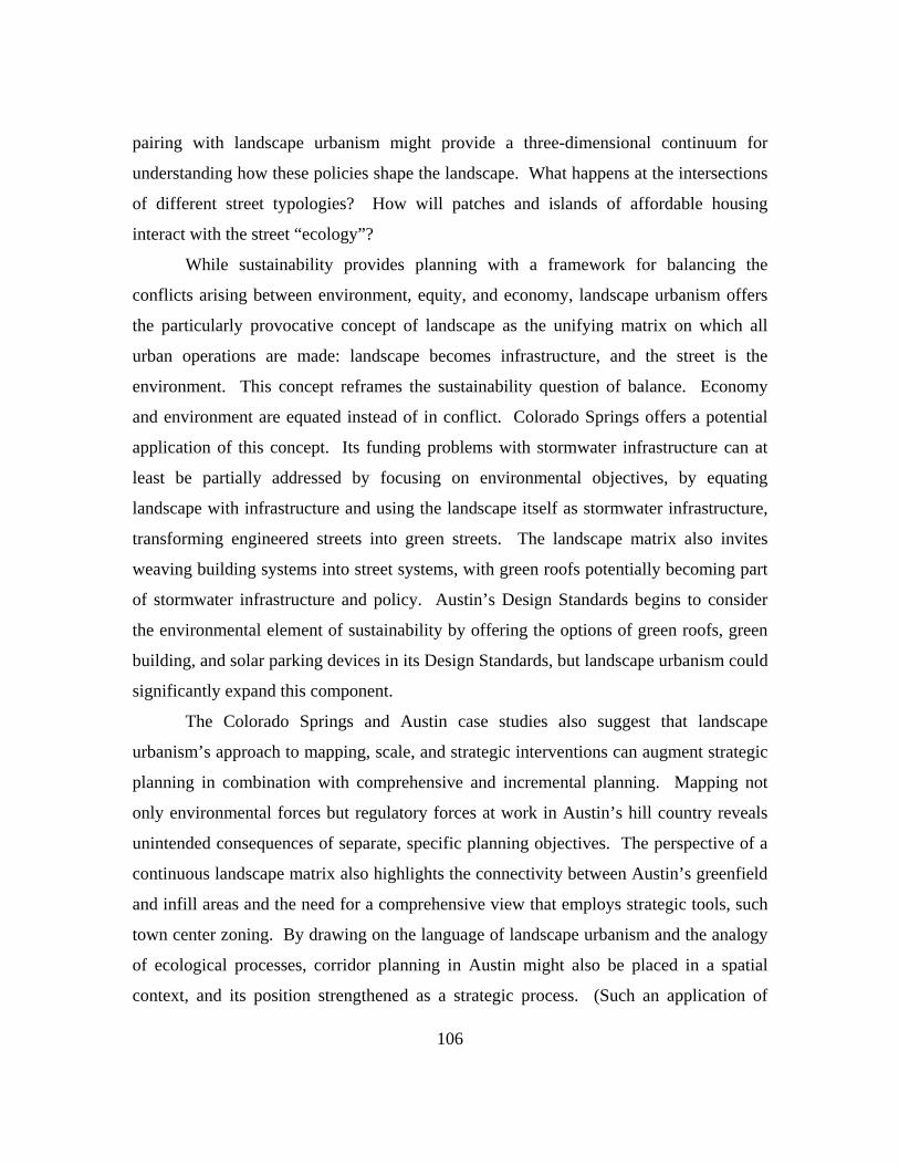
106
pairing with landscape urbanism might provide a three-dimensional continuum for
understanding how these policies shape the landscape. What happens at the intersections
of different street typologies? How will patches and islands of affordable housing
interact with the street “ecology”?
While sustainability provides planning with a framework for balancing the
conflicts arising between environment, equity, and economy, landscape urbanism offers
the particularly provocative concept of landscape as the unifying matrix on which all
urban operations are made: landscape becomes infrastructure, and the street is the
environment. This concept reframes the sustainability question of balance. Economy
and environment are equated instead of in conflict. Colorado Springs offers a potential
application of this concept. Its funding problems with stormwater infrastructure can at
least be partially addressed by focusing on environmental objectives, by equating
landscape with infrastructure and using the landscape itself as stormwater infrastructure,
transforming engineered streets into green streets. The landscape matrix also invites
weaving building systems into street systems, with green roofs potentially becoming part
of stormwater infrastructure and policy. Austin’s Design Standards begins to consider
the environmental element of sustainability by offering the options of green roofs, green
building, and solar parking devices in its Design Standards, but landscape urbanism could
significantly expand this component.
The Colorado Springs and Austin case studies also suggest that landscape
urbanism’s approach to mapping, scale, and strategic interventions can augment strategic
planning in combination with comprehensive and incremental planning. Mapping not
only environmental forces but regulatory forces at work in Austin’s hill country reveals
unintended consequences of separate, specific planning objectives. The perspective of a
continuous landscape matrix also highlights the connectivity between Austin’s greenfield
and infill areas and the need for a comprehensive view that employs strategic tools, such
town center zoning. By drawing on the language of landscape urbanism and the analogy
of ecological processes, corridor planning in Austin might also be placed in a spatial
context, and its position strengthened as a strategic process. (Such an application of

107
landscape ecology to the urban phenomena is not unprecedented; the discussion of the
resiliency of cities is one example of a landscape ecology concept applied to an urban
context.) Colorado Springs’ recent turn to incrementally addressing street design by
considering a limited number of street design elements at a large scale could potentially
benefit from landscape urbanism’s point of view on questions of scale and strategic
moves that inform adaptability, suggesting the strategic design elements needed in an
incremental approach and the most strategic areas to apply the city’s more comprehensive
street design tools.
In both case studies, planning tools and programs envision streets as places –
despite differences in their origin, make-up, and application – and landscape
architecture’s long experience with form and the environment can further enhance this
renewed focus on urban form. The success of New Urbanism demonstrates the
advantages of focusing on physical form, and as these and other cities focus revitalization
efforts on streets, they become a method of fleshing out the goals of sustainability and
landscape urbanism. Revitalization efforts have also been centering on environmental
features: Town Lake, an early example, and recently Waller Creek in Austin and
Monument Creek and Confluence Park in Colorado Springs. These environmental
features provided the early infrastructure for these cities, just as many cities developed
around similar landscape elements, substantiating landscape urbanism’s definition of
landscape as infrastructure. The revitalization of both streets and environmental features
offer a potential synergy to unify infrastructure and ecology, just as prescribed by
landscape urbanism, while the prism of sustainability can call out the equity-culture
component.
The two case studies demonstrate the constraints of planning that landscape
urbanism will need to consider as it begins to consider planning related issues. Austin’s
opt-in/opt-out process for its Mixed Use standards – which allows neighborhoods to
participate in the application of street design standards that may result in an uneven
distribution of affordable housing – illustrates the compromises between communicative
planning and equity planning. Despite the objectives of the Great Streets program and
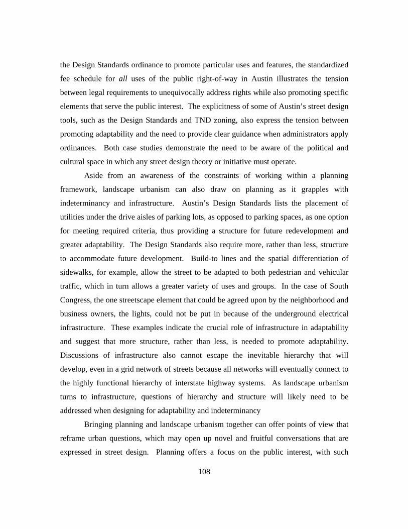
108
the Design Standards ordinance to promote particular uses and features, the standardized
fee schedule for all uses of the public right-of-way in Austin illustrates the tension
between legal requirements to unequivocally address rights while also promoting specific
elements that serve the public interest. The explicitness of some of Austin’s street design
tools, such as the Design Standards and TND zoning, also express the tension between
promoting adaptability and the need to provide clear guidance when administrators apply
ordinances. Both case studies demonstrate the need to be aware of the political and
cultural space in which any street design theory or initiative must operate.
Aside from an awareness of the constraints of working within a planning
framework, landscape urbanism can also draw on planning as it grapples with
indeterminancy and infrastructure. Austin’s Design Standards lists the placement of
utilities under the drive aisles of parking lots, as opposed to parking spaces, as one option
for meeting required criteria, thus providing a structure for future redevelopment and
greater adaptability. The Design Standards also require more, rather than less, structure
to accommodate future development. Build-to lines and the spatial differentiation of
sidewalks, for example, allow the street to be adapted to both pedestrian and vehicular
traffic, which in turn allows a greater variety of uses and groups. In the case of South
Congress, the one streetscape element that could be agreed upon by the neighborhood and
business owners, the lights, could not be put in because of the underground electrical
infrastructure. These examples indicate the crucial role of infrastructure in adaptability
and suggest that more structure, rather than less, is needed to promote adaptability.
Discussions of infrastructure also cannot escape the inevitable hierarchy that will
develop, even in a grid network of streets because all networks will eventually connect to
the highly functional hierarchy of interstate highway systems. As landscape urbanism
turns to infrastructure, questions of hierarchy and structure will likely need to be
addressed when designing for adaptability and indeterminancy
Bringing planning and landscape urbanism together can offer points of view that
reframe urban questions, which may open up novel and fruitful conversations that are
expressed in street design. Planning offers a focus on the public interest, with such

109
frameworks as sustainability balancing the various objectives that define public interest.
Landscape urbanism offers a point of view that reframes the conflicts between those
planning objectives; landscape is infrastructure, thereby moving economy and
environment into harmony rather than conflict. As landscape architecture moves to
questions of process beyond the ecological, planning offers lessons in public process and
addresses issues of cultural and political space. Correspondingly, landscape urbanism
offers ecological frameworks for mapping cultural and political space. As planning
moves to questions of form, landscape urbanism offers new ways to conceptualize the
built environment and the street, a basic element of urban form, in which the built form
encompasses the natural environment. Both landscape urbanism and planning respond
to needs for adaptability and must negotiate how strategy and underlying frameworks
allow for that adaptability. Planning, through its development of participatory processes
as well as several planning tools that consider the requirements for adaptability, can
inform landscape urbanism’s discussions of indeterminancy. Streets – as the object of
landscapes concepts of ecology, infrastructure, and culture and as the physical focal point
for economic, environmental, and equity objectives in planning – become the expression
of the dialogue between landscape architecture and planning, just as streets have
historically expressed design theory and planning practice.
As the elements of street design are put back together again after their
disassociation by modernism, the various disciplines that focused on these elements are
also coming back together to collaboratively build the city. Ecology now teaches us that
the city is also no longer separate from its environment and never was, nor are the ideas
and theories that guide the urban phenomena separate. Given the historical influence of
planning and design theory on street form, a dialogue between landscape architecture and
planning is more than warranted. These case studies illustrate just a few ways in which
street design is implemented and the opportunities for planning and landscape
architecture to mutually inform each other and jointly address street design in the
unfolding phenomena of urban form. Together planning and landscape architecture can
write an innovative and exciting chapter in the ongoing history of streets and urban form.

110
References
270-acre project set for NE Austin. 2003 July 25. Austin Business Journal. Retrieved March 20, 2007 from http://www.bizjournals.com/austin/stories/2003/07/28/story5.html?page=2
About the Downtown Partnership. Downtown Partnership. Retrieved April 4, 2007
from http://www.downtowncs.com/about.htm Adams, George. 2007 April 9. Personal interview. Audit report: City of Austin long long-term planning. 2006 May 16. City of Austin.
Retrieved March 30, 2007 from http://www.ci.austin.tx.us/auditor/au05101.htm Austin City Council agenda, item no. 28. 2006 August 10. City of Austin. Retrieved
March 30, 2007 from http://www.ci.austin.tx.us/council_meetings/item_attachments.cfm?meetingid=52&itemid=1809&item=28
Austin East 7th Street corridor concept plan. 2002 October. City of Austin. Retrieved
March 30, 2007 from ftp://coageoid01.ci.austin.tx.us/GIS-Data/planning/trans/corridorplan/east7thcorridor.zip
Bainbridge, Jim. 2006 June 3. Uptown going downtown. The Colorado Springs Gazette.
Retrieved April 4, 2007 from http://findarticles.com/p/articles/mi_qn4191/is_20060603/ai_n16482937
Barlow, Andrea. 2007 April 9. RE: questions regarding comp plan reviews. E-mail to the
author. Beauregard, Robert A. 2003. Between modernity and postmodernity: the ambiguous
position of US planning. In S. Campbell & S. Fainstein (Eds), Readings in Planning History. Malden, MA: Blackwell Publishing.
Belanger, Pierre. 2006. Synthetic Surfaces. In C. Waldheim (Ed.), The Landscape
Urbanism Reader. New York: Princeton Architectural Press. Bennett, Kristin. 2007 April 11. RE: Pedestrian assessment and plan information. E-mail
to the author. Campbell, Scott. 2003. Green cities, growing cities, just cities? urban planning and the
contradictions of sustainable development. In S. Campbell & S. Fainstein (Eds), Readings in Planning History. Malden, MA: Blackwell Publishing.
111
Campbell, Scott & Susan S. Fainstein. 2003. Introduction: the structure and debates of planning theory. In S. Campbell & S. Fainstein (Eds), Readings in Planning History. Malden, MA: Blackwell Publishing.
Cassidy, Robert. 2007 January 1. Timing it right in mixed-use and TODs. Building
Design and Construction. Retrieved April 3, 2007 from http://www.bdcnetwork.com/article/CA6410053.html
City of Austin Design Commission. 2000 May. Downtown Austin Design Guidelines.
Retrieved March 30, 2007 from http://www.ci.austin.tx.us/downtown/designguidelines.htm
City of Austin Neighborhood Planning and Zoning Department. 2006 November. TOD
Guidebook. Retrieved March 30, 2007 from ftp://coageoid01.ci.austin.tx.us/GIS-Data/planning/TOD/TODGuidebook.pdf
City of Austin Transportation Planning and Sustainability Department. 2002 June 5. The
2222 corridor study. Retrieved March 30, 2007 from ftp://coageoid01.ci.austin.tx.us/GIS-Data/planning/trans/corridorstudy2222/
City of Colorado Springs Comprehensive Plan. 2001 March 27. City of Colorado
Springs. Retrieved March 30, 2007 from http://www.springsgov.com/Page.asp?NavID=812
Colorado Crossing. Sunshine Development. Retrieved March 30, 2007 from
http://www.colorado-crossing.com/?fuseaction=home.main Comprehensive Plan Annual Report 2005-2006. City of Colorado Springs. Retrieved
March 30, 2007 from http://www.springsgov.com/Page.asp?NavID=6527 Comprehensive Plan Annual Report 2004-2005. City of Colorado Springs. Retrieved
March 30, 2007 from http://www.springsgov.com/Page.asp?NavID=6075 Comprehensive Plan Annual Report 2003-2004. 2004 December. City of Colorado
Springs. Retrieved March 30, 2007 from http://www.springsgov.com/Page.asp?NavID=5501
Comprehensive Plan Annual Report 2003-2004. 2003 December. City of Colorado
Springs. Retrieved March 30, 2007 from http://www.springsgov.com/Page.asp?NavID=4105
Comprehensive Plan Annual Report 2002-2003. 2002 October. City of Colorado
Springs Comprehensive Planning. Retrieved March 30, 2007 from http://www.springsgov.com/Page.asp?NavID=3035

112
Corridor Planning Guidebook. 2003 January. City of Austin. Retrieved March 30, 2007
from ftp://coageoid01.ci.austin.tx.us/GIS-Data/planning/trans/corridorplan/corridorguide.zip
Cozley, Beth. 2007 April 5. Personal interview. Design Standards and Mixed Use. 2006 August 31. City of Austin. Retrieved March 30,
2007 from http://www.ci.austin.tx.us/development/downloads/final.pdf Downtown Great Streets Master Plan. 2001. City of Austin. Retrieved March 30, 2007
from http://www.ci.austin.tx.us/greatstreets/default.htm Downtown redevelopment. City of Austin. Retrieved March 30, 2007 from
http://www.ci.austin.tx.us/downtown/default.htm Downtown report. 2007 January 30. City of Austin. Retrieved March 30, 2007 from
http://www.springsgov.com/Page.asp?NavID=3656 Downtown streetscape. City of Colorado Springs, Retrieved March 30, 2007 from
http://www.springsgov.com/Page.asp?NavID=3158 E-performance measures: urban design. City of Austin. Retrieved April 4, 2007 from
http://www.ci.austin.tx.us/budget/eperf/index.cfm?fuseaction=home.Activity&DEPT=680&PROGRAM=4DAP&ACTIVITY=4DU4
East 7th St. corridor improvement project, vol 1, issue 1. 2004 February. City of Austin.
Retrieved March 30, 2007 from ftp://coageoid01.ci.austin.tx.us/GIS-Data/planning/trans/corridorplan/finalE7thNewletter1.pdf
Evolution of historic medians. City of Colorado Springs Comprehensive Planning.
Retrieved March 30, 2007 from http://www.springsgov.com/Page.asp?NavID=867
Ellis, William C. 1986. The spatial structure of streets. In S. Anderson (Ed.), On streets.
Cambridge, MA: MIT Press. Fainstein, Susan S. 2003. New directions in planning theory. In S. Campbell & S.
Fainstein (Eds), Readings in Planning History. Malden, MA: Blackwell Publishing.
Friedman, John. 2003. Toward a non-euclidian mode of planning. In S. Campbell & S.
Fainstein (Eds), Readings in Planning History. Malden, MA: Blackwell Publishing.
113
Fyfe, Nicholas R. 1998. Introduction: reading the street. Images of the street: planning,
identity, and control in public space. Routledge, New York. General questions about the design standards and mixed use ordinance (DSMU). Design
Standards and vertical mixed use. Retrieved March 30, 2007 from ftp://coageoid01.ci.austin.tx.us/GIS-Data/planning/CommercialDesign/designstandards_questions.pdf
Gold, John R. 1998. The death of the boulevard. Images of the street: planning, identity
and control in public space edited by Nicholas R. Fyfe. Gold Hills Mesa project. Colorado Springs Urban Redevelopment. Retrieved October
11, 2006 from http://www.springsgov.com/Page.asp?NavID=4320 Green streets: innovative solutions for stormwater and stream crossings. 2002 June.
Metro: Portland, Oregon. Halm, Andy. 2007 April 9. Personal interview. Imagine Downtown Update. 2006 June. Downtown Partnership news. Retrieved April 4,
2007 from http://www.downtowncs.com/about.htm Kearl, Biruta Celmins. Brief History of Austin. Austin History Center. City of Austin.
Retrieved March 30, 2007 from http://www.ci.austin.tx.us/library/ahc/briefhistory.htm
Kostof, Spiro. 1991. The city shaped: urban patterns and meanings through history.
Little, Brown, Boston. Kostof, Spiro. 1992. The city assembled: the elements of urban form through history.
Thames and Hudson, London. Laden, Rich. 2006 December 21. Retail anchors ready to drop on north side. The
Colorado Springs Gazette. Retrieved April 4, 2007 from http://www.gazette.com/common/printer/view.php?db=colgazette&id=5420
Landscape architecture award winner archive: Pioneer Hill. Texas Chapter American
Society of Landscape Architects. Retrieved April 2, 2007 from http://archone.tamu.edu/aslatx/projects/05/05ph/05ph.asp
Levias, Gloria. 1986. Anthropology and sociology of streets. In S. Anderson (Ed.), On
streets. Cambridge, MA: MIT Press.

114
Lillebye, Einar. 2001. The architectural significance of the street as a functional and social arena. The sustainable street: the environmental, human and economic aspects of street design and management. WIT Press.
Lowell redevelopment project. Colorado Springs Urban Redevelopment. Retrieved
October 11, 2006 from http://www.springsgov.com/Page.asp?NavID=3656 Lucy, William H. 2003. APA’s ethical principles include simplistic planning theories. In
S. Campbell & S. Fainstein (Eds), Readings in Planning History. Malden, MA: Blackwell Publishing.
Marshall, Stephen. 2005. Streets and patterns. Spon Press, New York. Mayerl, James. 2007 April 9. RE: Small-lot PUDS information. E-mail to the author. Mixed Use Development Design Manual. City of Colorado Springs Planning and
Community Development Department. Retrieved March 30, 2007 from http://www.springsgov.com/Page.asp?NavID=4107
O’Connor, Rick. 2007 April 6. RE: Small-lot PUDs information. E-mail to the author. Parrish, Patricia. 2007 April 5. Personal interview. Perry, David C. 2003. Making space: planning as a mode of thought. In S. Campbell & S.
Fainstein (Eds), Readings in Planning History. Malden, MA: Blackwell Publishing.
Pollak, Linda. 2006. Constructed ground: questions of scale. In C. Waldheim (Ed.), The
Landscape Urbanism Reader. New York: Princeton Architectural Press. Reed, Chris. 2006. Public works practice. In C. Waldheim (Ed.), The Landscape
Urbanism Reader. New York: Princeton Architectural Press.Rey, Humberto. 2007 April 6. Personal interview.
Rykwert, Joseph. 1986. The street: the use of its history. In S. Anderson (Ed.), On
streets. Cambridge, MA: MIT Press. Sandercock, Leonie. 2003. Towards cosmopolis: utopia as construction site. In S.
Campbell & S. Fainstein (Eds), Readings in Planning History. Malden, MA: Blackwell Publishing.
Scanlon, Tim. 2007 March 20. Personal Interview.

115
Shane, Grahame. 2006. The emergence of landscape urbanism. In C. Waldheim (Ed.), The Landscape Urbanism Reader. New York: Princeton Architectural Press.
Shane, Grahame, 2003. The emergence of “landscape urbanism”. Harvard Design
Magazine. Shannon, Kelly. 2006. From theory to resistance: landscape urbanism in Europe. In C.
Waldheim (Ed.), The Landscape Urbanism Reader. New York: Princeton Architectural Press.
Small lot Planned Unit Developments: Review Criteria and Guidelines. 2005 April 22.
City of Colorado Springs Planning and Community Development Department. Retrieved March 30, 2007 from http://www.springsgov.com/units/planning/currentproj/sls/sl-pud-dg_4-05.pdf
Southwest Downtown Project. City of Colorado Springs. Retrieved March 30, 2007 from
http://www.springsgov.com/Page.asp?NavID=3657 Southworth, Michael and Eran Ben-Joseph. 2003. Streets and the shaping of towns and
cities. Island Press. Spirn, A.W. 1984. The granite garden. Basic Books, Inc., New York. Station Area Planning. City of Austin. Retrieved March 30, 2007 from
http://www.ci.austin.tx.us/planning/tod/station_area_planning.htm Tatom, Jacqueline. 2006. Urban highways and the reluctant public realm. In C.
Waldheim (Ed.), The Landscape Urbanism Reader. New York: Princeton Architectural Press.
Traditional Neighborhood Development: policies, standards and guidelines. 2005
August 9. City of Colorado Springs. Retrieved March 30, 2007 from http://www.springsgov.com/Page.asp?NavID=3344
Traditional Neighborhood District criteria manual. 1997 August 1. City of Austin.
Retrieved March 30, 2007 from http://www.ci.austin.tx.us/tnd/ Vidler, Anthony. 1986. The scenes of the street: transformations in ideal and reality,
1750-1871. On Streets edited by Stanford Anderson. Waldheim, Charles. 2006. Landscape as urbanism. In C. Waldheim (Ed.), The
Landscape Urbanism Reader. New York: Princeton Architectural Press.
116
Weller, Richard. 2006. An art of instrumentality: thinking through landscape urbanism. In C. Waldheim (Ed.), The Landscape Urbanism Reader. New York: Princeton Architectural Press.
Willcher, Jude. 2007 April 6. RE: Complete streets policy/subdivision street standards.
E-mail to the author. Wolf, Peter. 1986. Rethinking the urban street: its economic context. In S. Anderson
(Ed.), On streets. Cambridge, MA: MIT Press. Young, Iris. 2003. City life and difference. In S. Campbell & S. Fainstein (Eds),
Readings in Planning History. Malden, MA: Blackwell Publishing.
Vita
Sylvia Nieves Leon Guerrero was born in Landstuhl, Germany on September 13,
1967, the daughter of Franca Leon Guerrero and Vincente Leon Guerrero. After
receiving a diploma from Widefield High School in Colorado Springs, Colorado, she
attended the University of Pennsylvania in Philadelphia in 1985 and graduated in 1990
with a Bachelor of Engineering in Mechanical Engineering and Applied Mechanics and a
Bachelor of Arts in Fine Arts. She was employed in the high technology industry for
several years in various positions, working as a database application developer before
beginning graduate studies at The University of Texas at Austin in 2002. In 2006, she
received a Master of Landscape Architecture from the University of Texas at Austin.
Permanent address: 1560 Pleier Drive
Colorado Springs, Colorado 80921
This report was typed by the author.
Related Documents