Kurdistan Region – Iraq Ministry of Higher Education and Scientific Research Soran University Stratigraphy, Microfacies Analysis and Depositional Environment of the Upper Jurassic Naokelekan Formation from Selected Sections in Kurdistan Region, NE Iraq A Research Submitted to the Facullty of Science- Soran University in Partial Fulfillment of the Requirements for the Degree of Bachelor of Science in Petroleum Geosciences. By Arkan Osman Hussein Sharezwri Under the Supervision of Mr. Sadi Nourmuhammadi M. Sc in Geology (2011) 2015 May 2215 Jozerdan

Welcome message from author
This document is posted to help you gain knowledge. Please leave a comment to let me know what you think about it! Share it to your friends and learn new things together.
Transcript
Kurdistan Region – Iraq
Ministry of Higher Education and Scientific Research
Soran University
Stratigraphy, Microfacies Analysis and Depositional Environment of the Upper Jurassic Naokelekan Formation
from Selected Sections in Kurdistan Region, NE Iraq
A Research
Submitted to the Facullty of Science- Soran University in Partial
Fulfillment of the Requirements for the Degree of Bachelor of
Science in Petroleum Geosciences.
By
Arkan Osman Hussein Sharezwri
Under the Supervision of
Mr. Sadi Nourmuhammadi
M. Sc in Geology (2011)
2015 May 2215 Jozerdan


Acknowledgment
I thank God for always being with me and for everything done for me. I am deeply
indebted to Mr. Sadi Nourmohammadi for undertaking the task of supervising this
research.
Special thanks to Dr. Sardar Balaky and Dr. Ali Ismail Al-Juboury for offering many
suggestions and corrections during all stages of the work in the field and lab.
My best thanks to the presidency of university and dean of the Facullty of Science for
their generous support including financial and equipments facilities that offered to this
work.
I would like to express my gratitude to my best friend Choman Mustafa for his help
during field works.
Also a word of thank is extended to Mr. Rezgar Muhammad & Edris Muhammad for their
assistance in field works.

SUPERVISOR CERTIFICATION
I certify this thesis was prepared under my supervision at Soran University, Faculty of Science,
Department of Petroleum Geosciences as a partial reqirement for the degree of bachelor of
science in Petroleum Geosciences.
Signature:
Supervisor: Mohammad Sadi Nourmohammadi
Scientific title: Lecturer
Adress: Faculty of Science, Soran University
Date:
Certification of the Department
In view of the available recommendation, I forward this thesis for debate by the examining
committee.
Signature:
Head of Department: Dr. Sardar M. Balaky
Scientific title: Assistante Professor
Adress: Faculty of Science, Soran University
Date:

CERTIFICATION OF EXAMINING COMMITTE
We certify that we have read this research and examinig committee examined the student in its
contents and whatever relevant to it and that in our opinion it is adequate research for the
degree of bachelor in Petroleum Geosciences.
Signature:
Name:
Scientific title:
Adress:
Date:
(Chairman)
Signature:
Name:
Scientific title:
Adress:
Date:
(Member)
Signature:
Name:
Scientific title:
Adress:
Date:
(Member)
i
Abstract
The lithological study of the Naokelekan Formation shows that this formation is mainly
composed of organic carbonaceous calcareous mudrocks with some carbonates including
limestone and dolomite. The exact describtion of the lithological composition of
Naokelekan Formation in two selected studied sections from bottom to top is (a) black, soft,
sheety, fetid, highly bituminous, calcareous shale, dark brown, fetid, thin-medium bedded
bituminous limestone and dolomitic limestone, (b) dark grey, hard, fine-grained, fossiliferous,
highly mottled and stylolitic, medium-thick bedded limestone and dolomitic limestone, (c) black,
calcareous, sheety, soft, fetid shale and dark grey, medium-grained, hard, dolomitic and
argillaceous limestone. Depending on the lithology and microfacies analysis, its indicated
that the formation was deposited in two different sedimentary environments including
lagoon (subtidal) environment for both lower and upper units of the formation and shallow
open marine environment for middle unit of the formation. It was inferred that in all
sections, the upper contact with the Barsarin Formation and lower contact with Sargelu
Formation is somewhat controversial but mainly agreed by many researchers to be
conformable and gradational.

ii
Contents
Subject Page
Abstract……………….……..……………………………………………….........
List of Contents………………….………………………………………….….….
List of Tables………………….…….………………………………….….………
List of Figures………………………..……………………………….…….……..
List of Pictures………………………………………………………………….....
List of Plates……………………………..………………………………….….....
Chapter one: Introduction .
1.1 Preface……………………………………………………….……..………..1
1.2 Locations of the study…….….……………………………..………….…...1
1.3 Previous works………………………………………………………...…… 3
1.4 Aims of the study………………………………………………….…………4
1.5 Methodology………………….…………………………….……..…..……...5
1.5.1 Field Work……………………………….………………….…..……….5
1.5.2 Labortatory Work…………………………………………….…..…......5
1.6 Geological and Structural Setting……...………………………..……….....6
1.7 Topography and Geomorphology………………………………….….……8
1.7.1 The elevated (mountainous) parts…………………………………….8
1.7.2 The flat and undulatory parts…………………………………….…….9

iii
Chapter two: Stratigraphy .
2.1 Preface…….…………………………………………………….…………...10
2.2 Naokelekan Formation…………………………………….…………….….12
2.2.1 Section-I (Zewa section)……………………………………………….12
2.2.2 Section-II (Dwawa section)…………………………………………....16
2.3 Contacts of the formation.……………………………………….………....19
2.3.1 Lower Contact……………………………………………………….…19
2.3.2 Upper Contact………………………………………………………….20
2.4 Aerial Distribution……………………………………………………………20
2.5 Age……………………………………………………………………………22
2.6 Thickness…………………………………………………………………….23
2.7 Lithology…………………………………………………………………..….24
Chapter three: Microfacies Analysis and Sedimentary Environment .
3.1 Preface ……………………………………………………………..……….27
3.2 Microfacies Analysis………………………………………………..………28
Limestone Microfacies………….…………...……………..……………….28
3.2.1 Lime Mudstone Microfacies……………………………….….....28
3.2.2 Lime Wackestone Microfacies……………………………..……29
3.2.3 Lime Packestone Microfacies……………………………….…..29
3.3 Groundmass………………………………………………………………...30
3.3.1 Micrite……………………………………………………..……………30
3.3.2 Sparite……………………………………………………..…………...30
3.4 Grains………………………………………………………………………..30
3.4.1 Skeletal Grains…………………………………………………………30
iv
Fossils………………………………………………………………………….30
Ammonites……………………………………………………………………31
Planktonic (Globuligerina) and Benthic (Miliolids) foraminifers…………31
Ostracods……………………………………………………………………..32
Pelecypods……………………………………………………………….......32
Gastropods………………………………………………………….………..32
Calsisphere………………………………………………………….………..33
Microbial structure…………………………………………………………...33
3.4.2 Non-Skeletal Grains…………………………………………………...34
Peloids……………………………………………………………..….............34
3.5 Diagenesis…………………………………………………………………..35
Classification of Diagenetic Processes………………………………….….35
3.5.1 Mechanical Diagenesis………………………………………………...36
3.5.1.1 Compactio………………………………………………......36
3.5.1.2 Fracturing..……………………………………………….....38
3.5.2 Chemical Diagenesis………………...…………………………….…..38
3.5.2.1 Cementation…………………..……………………….…....38
Granular Cement……………………………………….....39
Drusy Cement……………………….…………………..39
Blocky Cement………………………………………….....39
3.5.2.2 Neomorphism……………………………………………....39
3.5.2.3 Dolomitization……………………………….………...........40
3.5.2.4 Micritization……………………………..…….…………….41
3.5.2.5 Dissolution ………………………………………………....42
3.6 Sedimentary Environment of the Naokelekan Formation……………...43
3.7 Paleogegraphy………………………………………………………...…....45
v
Chapter four: Conclusions, Recommendations and References
. 4.1 Conclusion……………………………………………………….………....55
4.2 Recommendation…….…….………………………………………...........56
4.3 References……………………………………………………………........57
List of Tables
Subject Page
Table 3.1 Classification of Diagenesis (after Engelhard, 1997) and its………………..36
presence in the Naokelekan Formation
List of Figures
Subject Page
Fig. 1.1 Location of the studied sections and the structural provinces of Iraq…………..2
(after Buday and Jassim 1987)
Fig.1.2 Satellite Image (Flash Earth) of both sections around Betwata town,……….....3
Northeast Iraq
Fig. 1.3 Location Map of the studied area (from Joint Humanitarian…………………….4 Information Center; Erbil, March 2004)
Fig. 1.4 Geological, Structural and Topographical map of the studied area,…………...6
vi
Northeast Iraq (State establishment of geological survey and mining, Sheets NJ-38-14 and NJ-
38-15, Compiled by Varoujan K. Sissakian, 2001
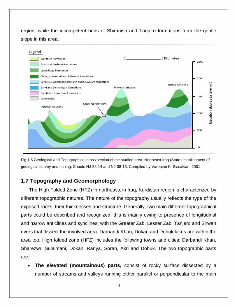
Fig.1.5 Geological and Topographical cross section of the studied area,………………8
Northeast Iraq (State establishment of geological survey and mining, Sheets NJ-38-14 and NJ-
38-15, Compiled by Varoujan K. Sissakian, 2001
Fig. 2.1 Chronostratigraphy of the Middle –Late Jurassic in Iraq……………………..11
The line of section run from Jordan and Western Desert through Central Iraq and Baghdad,
toward the Iranian Zagros (edited after Aqrawe et al., 2010)
Fig.2.2 Gotnia, Arabian, and Southern Arabian Gulf basin in which………………….12
Jurassic hydrocarbon source rocks accumulated; After Fox and Ahlbrandt (2002) and modified
from Al-Sharhan and Kendail (1986).
Fig.2.3 Location map of the studied setion-I (Zewa section), Zewa Village,………….13
Betwata town, Raniya area, Kurdistan region, NE Iraq.
Fig. 2.4 Panoramic field photo of the studied section-I (Zewa section)………………14
and surrounding areas.
Fig. 2.5 Stratigraphic column of the Naokelekan Formation in the……………………14
studied section-I (Zewa section), Betwata town, Raniya area, Kurdistan, NE Iraq.
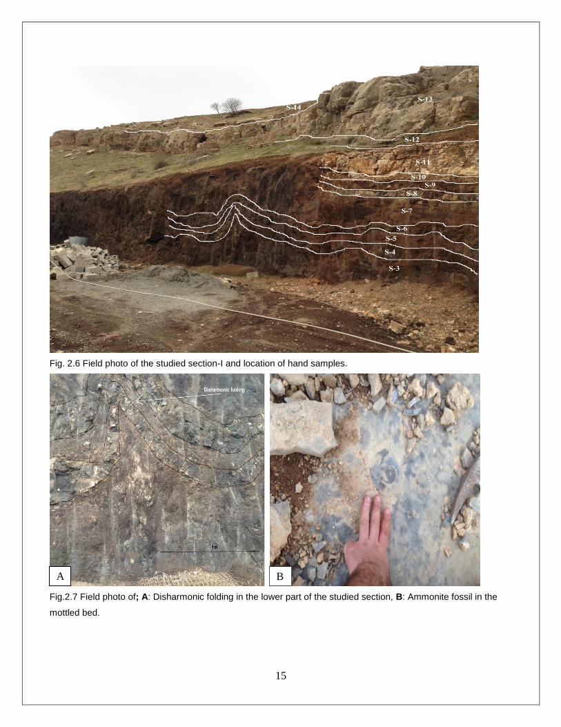
Fig. 2.6 Field photo of the studied section-I and location of hand samples…………..15
Fig.2.7 Field photo of; A: Disharmonic folding in the lower part of the………………..15
studied section, B: Ammonite fossil in the mottled bed.
Fig.2.8 Location map of the studied section-II (Dwawa section), Dwawa village,……16
Betwata town, Raniya area, Kurdistan region, NE Iraq.
vii
Fig.2.9 Outcrop of Naokelekan Formation in section-II (Dwawa) in Raniya area,…..17
Kurdistan region, NE Iraq).
Fig. 2.10 Stratigraphic column of the Naokelekan Formation in the…………………..17
studied section-II (Dwawa section), Betwata town, Raniya area, Kurdistan, NE Iraq.
Fig.2.11 Field photo of: A: Stylolitic, dolomitic limestone B: highly……………………18
ammoniferous dolomitic limestone in the middle unit of the formation (Mottled bed).
Fig.2.12 Field photo of: A: Slumping structure in the lower part of the……………….18
formation. B: Some small pillow structures in the upper unit of the formation.
Fig 2.13 The conformable and gradational contact of lower boundary of the……….19
Naokelekan Formation with sargelu Formation.
Fig.2.14 The upper contact of the Naokelekan formation with………………………..20
Barsarin Formation, at A. Zewa section and B. Dwawa section.
Fig. 2.15 Middle-Late Jurassic stratigraphy in Iraq in relation to other………………21 Middle East countries ( Al-Husseini, 2008)
Fig. 2.16 Stratigraphic columns for some studied sections in the……………………22
Gotnia basin. Adapted from Goff, 2005.
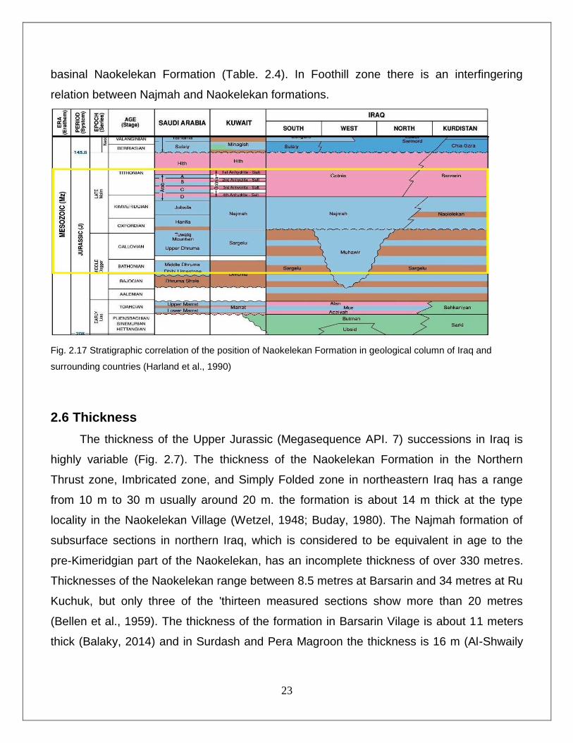
Fig. 2.17 Stratigraphic correlation of the position of Naokelekan Formation……….23
in geological column of Iraq and surrounding countries (Harland et al., 1990)
Fig. 2.18 Isopach-facies map of Upper Jurassic rocks (Dunnington, 2005)……….24
Fig.2.19 Lithological correlation chart between Zewa and Dwawa sections………26
Fig.3.1 Classification of Dunham, (1962) for carbonate rocks………………………29
viii
Fig.3.2 Styles of pressure solution and stylolization (Flugel, 1982)…………………37
Fig. 3.3 Stratigraphic column of the Naokelekan Formation including their………..43
rock fabric textures and diagenetic processes
Fig.3.4 Depositional model of Naokelekan Formation………………………………..44
Fig.3.5 Stages of deposition of Naokelekan Formation………………………………45
Fig.3.6 Paleogeography of Late Jurassic time (Oxfordian- Early Tithonian)……….46
(Edited after Jassim and Goff., 2006)
List of Plates
Subject Page
Plate-1: Zewa Section (Section-I) ………………………………………………………………………47
Plate-2: Zewa Section (Section-I) ………………………………………………………………………49
Plate-3: Dwawa Section (Section-II) ……………………………………………..................................51
Plate-4: Dwawa Section (Section-II) ……………………………………………..................................53
1
CHAPTER ONE INTRODUCTION
1.1 Preface
The Middle Jurassic contains very renownable and significant source rocks over all
southern, northeastern, and northern Iraq due to the high total organic carbon (TOC)
content of the Sargelu and Naokelekan formations that were deposited throughout the
Jurassic basin that exists in these areas (Jassim and Al-Gailani, 2006). Bellen et al, (1959)
mentioned that the Naokelekan Formation was first described by Wetzel and Morton 1950
in unpublished report. It consists of about 10-30 meters of thin- to medium-bedded, black,
bituminous limestones, and dolomitic limestone, intercalated with thin, black, calcareous
shale in lower and upper parts. Some authors mentioned that in the very early reports of
the Iraqi Petroleum Company, the Naokelekan Formation was called the Najmah
Formation due to the deposition in the same time of the Najmah Formation of upper
Oxfordian to early Kimmerdgian time, in central and southern part of Iraq. The name of
Naokelekan Formation is derived from the name of Naokelekan village, which is located in
the Imbricated zone directly to the southeast of the type locality, about 25 Km southeast of
Soran Town which is located in the High Folded Zone. According to (Buday, 1980), the
Naokelekan Formations have been renamed Najmah Formation, respectively in the middle
and southern part of Iraq. In Iran, the correlative formation is Surmeh Formation of the East
Zagros Mountains. In most of the Arabian countries Tuwaiq Mountain, Hanifa, Jubaila and
Najmah formations are equivalent formations for Naokelekan Formation.
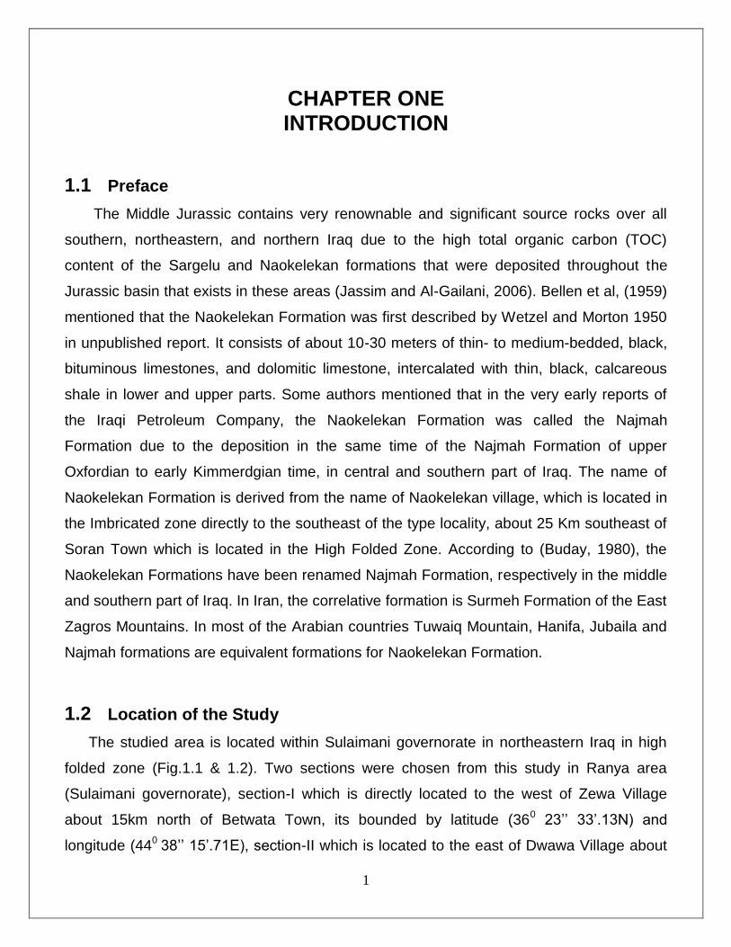
1.2 Location of the Study
The studied area is located within Sulaimani governorate in northeastern Iraq in high
folded zone (Fig.1.1 & 1.2). Two sections were chosen from this study in Ranya area
(Sulaimani governorate), section-I which is directly located to the west of Zewa Village
about 15km north of Betwata Town, its bounded by latitude (360 23’’ 33’.13N) and
longitude (440
38’’ 15’.71E), section-II which is located to the east of Dwawa Village about
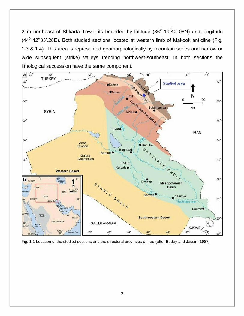
2
2km northeast of Shkarta Town, its bounded by latitude (360 19
’’40’.08N) and longitude
(440 42’’33’.28E). Both studied sections located at western limb of Makook anticline (Fig.
1.3 & 1.4). This area is represented geomorphologically by mountain series and narrow or
wide subsequent (strike) valleys trending northwest-southeast. In both sections the
lithological succession have the same component.
Fig. 1.1 Location of the studied sections and the structural provinces of Iraq (after Buday and Jassim 1987)

3
Fig.1.2 Satellite Image (Flash Earth) of both sections around Betwata town, Northeast Iraq
1.3 Previous works
Generally, there are some detailed studies for Upper Jurassic succession of Northern
Iraq, and most of them deal with sedimentologic, paleontologic, and organic source rock
evaluation. Wetzel and Morton (1950, in Bellen et al. 1959) recognized and described the
Naokelekan Formation from the Naokelekan village, in the imbricated zone of Northern
Iraq. (Bellen et al. 1959) identified the age of the formation as Late Oxfordian–Early
Kimmeridgian Based on the fossils that exist in the formation. Buday (1980) also described
the Naokelekan Formation and interpreted the depositional environment as euxinic, in a
slow subsiding basin. This interpretation was also accepted by (Al-Sayyab et al. 1982) in a
study of the type section. Qusay Abeed (2013) described The Upper Jurassic–Cretaceous
petroleum system of southern Iraq: A 3-D basin modelling study. Othman (1990) identified
the organic matter present in various horizons within Naokelekan Formation to be type II
and III kerogin. Ahmed (1997) proposed the age of Naokelekan to be Oxfordian–
Kimmeridgian. In addition, (Ahmed 2007) has evaluated geochemistry of the Naokelekan
and Barsarin Formations in the Kurdistan region, Northern Iraq. Salae (2001) concluded
that the depositional environment of Naokelekan as brackish lagoon and shallow open
marine. Al-Badry (2005) studied Stratigraphy and Geochemistry of Jurassic Formations in

4
Geli Derash and Banik sections- North Iraq. Balaky (2008) divided the formation into two
lithofacies associations: subtidal and open marine. Balaky (2013) also determined that the
Middle–Late Jurassic succession of Northeastern Iraq consists of one second-order
sequence which consists of two third-order sequence, separated by sequence boundary
(SB) of type 2. Lately, Al-Ameri and Zumberge (2012) presented an evaluation of source
rocks of Middle–Upper Jurassic in Northern Iraq, and they concluded that the Naokelekan
Formation can be regarded as a potential, thermally mature source rocks.
Fig. 1.3 Location Map of the studied area (from Joint Humanitarian Information Center; Erbil, March 2004) 1.4 Aims of the study
• The main aim of this study is to interpret the Stratigraphy, Microfacies and
Sedimentary environment during deposition of Upper Jurassic Naokelekan
Formation. This is based on the available and the inferred. The study included the
following:
• 1. Defining and analyzing of different constituents and lithofacies of the Naokelekan
Formation in order to establish the depositional environment, to interpret different
depositional processes with stratigraphy and Microfacies of these sediments.
• 2. To establish the relationship between Naokelekan Formation with both underlying
and overlying formations, in addition to laterally facies changes.
5
1.5 Methodology
The Naokelekan Formation from two different surface sections was studied (Figs. 2.4 &
2.9), samples were collected along both sections. Then thin sections made and studied
under polarizing microscope. The research works subdivided into two stages: 1- stage of
the field work 2-stage of the laboratory work. Below a review for each stage:
1.5.1 Field Work
Field work was carried out in the studied area. This was arranged in the following steps:
Choosing the appropriate localities for the present study.
Description and measurements of selected sections, and drawing columnar
sections.
Sampling: Samples were usually collected at every change in lithology, and
/or color (random sampling). The total number of collected samples from all
sections is (28) samples(14 samples for each section). Some samples within
these 28 samples have taken from across the underlying and overlying
contacts to check the position of the boundaries in the studied sections.
1.5.2 Laboratory Work
The laboratory work include the following analysis types:
Detailed petrographic study and microfacies analysis were performed. The
petrographic description was handled by polarizing binocular microscope in
Department of Petroleum Geosciences, Soran University.
A total of 22 thin sections have been prepared and examined, 8 slides belong to the
section-I, and 14 slides are related to the section-II.
Collecting information about the subject from books, articles, thesis and maps.
6
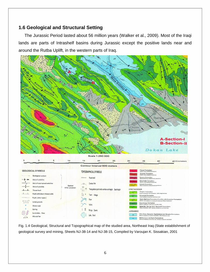
1.6 Geological and Structural Setting
The Jurassic Period lasted about 56 million years (Walker et al., 2009). Most of the Iraqi
lands are parts of Intrashelf basins during Jurassic except the positive lands near and
around the Rutba Uplift, in the western parts of Iraq.
Fig. 1.4 Geological, Structural and Topographical map of the studied area, Northeast Iraq (State establishment of
geological survey and mining, Sheets NJ-38-14 and NJ-38-15, Compiled by Varoujan K. Sissakian, 2001

7
In Iraq, the Complex Crystalline Basement was suffered from several tectonic
activities during the Phanerozoic Eon, and fractured by several fault systems to form many
active blocks, which moved vertically relative to each other. The vertical block movements
controlled by two types of forces; I- gravitational equilibrium subsidence, II- horizontal plate
movement, these two forces play important role in the forming and developing of most
geological structures in Iraq. Some structures usually have regional dimensions and
extensions, such as depressions and intra-shelf basins, others are considered as local
features. In the north and northeast parts of Iraq, most of the folds have one of two main
axial fold direction; northwest – southeast or east – west direction, parallel to the collision
line between Arabian and Iranian –Laurasian plates after the closing of Neo-Tethys which
started in late Cretaceous and the uplifting and folded deformation during Alpine Orogeny.
Both sections are located within Iraqi folded-thrust belt previously known as High Folded
Zone especially in Qamchuqa-Ranya sub zone, in the western limb of Makook
asymmetrical anticline According to Jassim and Goff, (2006).
Structurally, Makook anticline (Fig. 1.4 & 1.5) can be considered as a part of
Qamchuqa-Ranya subzone located in the northwestern side of Ranya city, and may
represent the continuations of the trend of Peris anticlinorium disrupted by intense thrust
fault. Makook anticline makes an en-echelon pattern with Pelewan anticline in the SW and
Ranya anticline in NE-SE trend according to Makook anticline, these two anticlines are
separated from Makook anticline by Balisan and Sarkapkan Valleys or synclines
respectively.
The most prominent erosional geomorphologic features that characterized the
studied sections are the karsts feature of the Cretaceous carbonates especially within the
massive carbonates of Qamchuqa Formation and in some places Bekhme Formation,
which are also forming deep gorges and steep cliffs. Generally, Depositional
geomorphologic features are alluvial fans and rock falls and rocks slides somewhere within
Shiranish Formation. Qamchuqa Formation is characterized by high topographic feature
and forming most of the highly elevated mountains in Kurdistan region, Makook anticline is
also comprises of carbonate rocks of Qamchuqa and Bekhme formation at the top of the
mountain, so that, it can be considered as one of the highest mountains in Iraqi Kurdistan
8
region, while the incompetent beds of Shiranish and Tanjero formations form the gentle
slope in this area.
Fig.1.5 Geological and Topographical cross section of the studied area, Northeast Iraq (State establishment of
geological survey and mining, Sheets NJ-38-14 and NJ-38-15, Compiled by Varoujan K. Sissakian, 2001
1.7 Topography and Geomorphology
The High Folded Zone (HFZ) in northeastern Iraq, Kurdistan region is characterized by
different topographic natures. The nature of the topography usually reflects the type of the
exposed rocks, their thicknesses and structure. Generally, two main different topographical
parts could be described and recognized, this is mainly owing to presence of longitudinal
and narrow anticlines and synclines, with the Greater Zab, Lesser Zab, Tanjero and Sirwan
rivers that dissect the involved area. Darbandi Khan, Dokan and Dohuk lakes are within the
area too. High folded zone (HFZ) includes the following towns and cities; Darbandi Khan,
Sharezwr, Sulaimani, Dokan, Ranya, Soran, Akri and Dohuk. The two topographic parts
are:
The elevated (mountainous) parts, consist of rocky surface dissected by a
number of streams and valleys running either parallel or perpendicular to the main
9
strike of the anticlines or synclines. This part covers the major areas that form the
High Folded Zone.
The flat and undulatory parts, this part cover small and restricted areas
commonly forming main plains, which are covered by clastic rocks of different
formations and Quaternary sediments. They are usually dissected by axial valleys
and/ or streams, which are perpendicular to them. These areas are usually used for
agriculture, like Sharezwr Plain, which is directly located at the southeastern side of
Sulaimaniyah city.
The geomorphological setting of the study area is controlled by the regional tectonic
patterns and features of rock composition of the northeastern Iraq as well as other factors
such as climate may also plays its role. Also most of the drainage system patterns in the
study area (Dwawa and Zewa Villages) are controlled by structural features and variations
in the rock resistance. The most important structural landforms in the studied area are
anticlinal ridges caused by high resistance rocks of the Qamchuqa and Bekhme
formations, synclinal valleys caused by low resistance rocks of Tanjero Formation, and
fault scarps. The cores of the anticlines are composed of carbonate and clastic rocks of
Jurassic and cretaceous periods, the core of Makook anticline is composed of Jurassic
rocks. Differential weathering and erosion caused in removing the weaker overlying rocks
and exposing the resistant carbonate rock (Bekhme and Qamchuqa at the top of the
mountains) consequently resulted in the formation of anticlinal ridges.
10
CHAPTER TWO STRATIGRAPHY
2.1 Preface
During the Late Mesozoic and Early Cenozoic, sedimentation in the area of the present
Mesopotamian Basin and Zagros Fold Belt was controlled by local tectonics, eustatic sea-
level changes, and climate variations. From Jurassic through Late Cretaceous, sea-level
fluctuations in conjunction with slow subsidence, led to formation of large, but shallow
intrashelf basins on the passive margins of the Neo-Tethys Ocean and the Arabian Plate
(Murris,1980; Alsharhan and Nairn,1997). The paleogeography of the late Jurassic
succession was controlled by the effects of the late Jurassic tectonic activity along the
Arabian plate margin prior to the opening of the Southern Noe-Tethys. Differential
subsidence led to periodic isolation of the intra-shelf basin from the Neo-Tethys
(Murris,1980). Many authors such as(e.g. Ditmar et al., 1971 in Jassim and Buday, 2006d;
Jaber, 1975; Roychoudhury and Handoo, 1980; Roychoudhury and Nahar, 1980) have
recognized a major three-fold geographical divisions of the Middle-Upper Jurassic
succession in Iraq (Fig. 2.1):
(i) A western "clastic-carbonate inner shelf' succession, with thin Muhaiwir and
Najmah Formations;
(ii) A central platform / platform-margin succession, comprising Alan Formation
overlain by thick Sargelu and thick Najmah formations, overlain but only in
southern Iraq by thin Gotnia Formation; and
(iii) An eastern basin-centre succession characterised by either Alan Formation then
thin Sargelu/basinal Najmah/thick Gotnia and/or Barsarin Formations; or in the
Kurdistan region, by the uppermost Sehkaniyan Formation overlian by thin
(condensed) Sargelu, Naokelekan and Barsarin formations.

11
This stratigraphic succession (partly represented in Fig. 2.1) shows the structural
configuration of the Gotnia Basin. The relative thicknesses of the formations show the
progression of the basin infill and changes in basin geometry (Aqrawe et al., 2010).
The Naokelekan Formation was deposited in Late Jurassic (Oxfordian- Early
Kimmeridgian) within euxinic intra-Platform basin of the Arabian Plate Margins called
Gotnia basin (Fig. 2.2). Euxinic marine source rocks and evaporites were deposited in the
Gotnia and other intra shelf basins due to continued but subtle subsidence of extensional
origin (Goff, 2005). The formation consists of, black, bituminous limestone, fossiliferous,
dolomitic and argillaceous limestone, black, calcareous shale and bituminous shale (Coal).

12
Fig.2.2 Gotnia, Arabian, and Southern Arabian Gulf basin in which Jurassic hydrocarbon source rocks
accumulated; After Fox and Ahlbrandt (2002) and modified from Al-Sharhan and Kendail (1986).
2.2 Naokelekan Formation
A brief description of each section is sited below:
Section-I (Zewa section): The Naokelekan Formation in this section (Fig. 2.4, Pics.
2.1, 2.2 & 2.3, Table. 2.1) is unfortunately artificially cropped out where the hill is cut to
build the house and led to appear. In this section the upper part of the Naokelekan
Formation is covered by recent sedients. However, the formation from lower to upper

13
part (Table. 2.1) comprises of dark brown, black, bituminous, calcareous shale
interbedded with thin to medium bedded bituminous limestones and dolomitic limestone
with the existence of disharmonic folding (Pic. 2.3-A) of black bituminous limestone, the
middle part is composed of medium-thick bedded limestone and dolomitic limestones
rich in ammonite fossil (Pic. 2.3-B) and stylolite phenomena, and the upper part is
totally covered with soil. The contact is conformable and graditional with the underlying
Sargelu Formation, while the upper contact with Barsarin Formation is covered. The
thickness of the formation where measured is about 15.3 meters.
Fig.2.3 Location map of the studied setion-I (Zewa section), Zewa Village, Betwata town, Raniya area, Kurdistan
region, NE Iraq.

14
Fig. 2.4 Panoramic field photo of the studied section-I (Zewa section) and surrounding areas.
Fig. 2.5 Stratigraphic column of the Naokelekan Formation in the studied section-I (Zewa section), Betwata town,
Raniya area, Kurdistan, NE Iraq.
15
Fig. 2.6 Field photo of the studied section-I and location of hand samples.
Fig.2.7 Field photo of; A: Disharmonic folding in the lower part of the studied section, B: Ammonite fossil in the
mottled bed.
A B
16
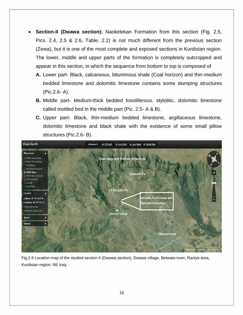
Section-II (Dwawa section): Naokelekan Formation from this section (Fig. 2.5,
Pics. 2.4, 2.5 & 2.6, Table. 2.2) is not much different from the previous section
(Zewa), but it is one of the most complete and exposed sections in Kurdistan region.
The lower, middle and upper parts of the formation is completely outcropped and
appear in this section, in which the sequence from bottom to top is composed of
A. Lower part- Black, calcareous, bituminous shale (Coal horizon) and thin-medium
bedded limestone and dolomitic limestone contains some slumping structures
(Pic.2.6- A).
B. Middle part- Medium-thick bedded fossiliferous, stylolitic, dolomitic limestone
called mottled bed in the middle part (Pic. 2.5- A & B).
C. Upper part- Black, thin-medium bedded limestone, argillaceous limestone,
dolomitic limestone and black shale with the existence of some small pillow
structures (Pic.2.6- B).
Fig.2.8 Location map of the studied section-II (Dwawa section), Dwawa village, Betwata town, Raniya area,
Kurdistan region, NE Iraq.

17
Fig.2.9 Outcrop of Naokelekan Formation in section-II (Dwawa) in Raniya area, Kurdistan region, NE Iraq).
Fig. 2.10 Stratigraphic column of the Naokelekan Formation in the studied section-II (Dwawa section), Betwata
town, Raniya area, Kurdistan, NE Iraq.
18
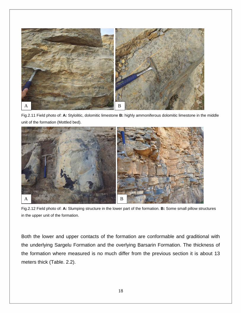
Fig.2.11 Field photo of: A: Stylolitic, dolomitic limestone B: highly ammoniferous dolomitic limestone in the middle
unit of the formation (Mottled bed).
Fig.2.12 Field photo of: A: Slumping structure in the lower part of the formation. B: Some small pillow structures
in the upper unit of the formation.
Both the lower and upper contacts of the formation are conformable and graditional with
the underlying Sargelu Formation and the overlying Barsarin Formation. The thickness of
the formation where measured is no much differ from the previous section it is about 13
meters thick (Table. 2.2).
A B
A B

19
2.3 Contacts of the formation
In both outcrop sites, the Naokelekan Formation is underlain by the Sargelu Formation
and Overlaid by Barsarin Formation.
2.3.1 Lower contact
The lack of chert and abundant Posidonia ornati Quenstedt, and ammonites distinguishes
the Sargelu Formation from the overlying Naokelekan Formation (Wetzel, 1948; Salae,
2001; Balaky, 2004). At the type section in Imbricated Zone of northeastern Iraq, near
Rowanduz the Naokelekan Formation is underlying conformably and gradationally by
Sargelu Formation.In both sections (Zewa and Dwawa), the contact between Naokelekan
and Sargelu formations is also conformable and graditional. The black, calcareous,
bituminous shales of Naokelekan Formation in both outcrops (Zewa and Dwawa ) is
underlain conformable and graditional by The black shales and chert layers of the Sargelu
Formation (Pic 2.7).
Fig 2.13 The conformable and gradational contact of lower boundary of the Naokelekan Formation with sargelu
Formation.
The contact between Naokelekan and Sargelu formations considered where exactly the
chert layers of top sargelu formation is disappeared.
A B
20
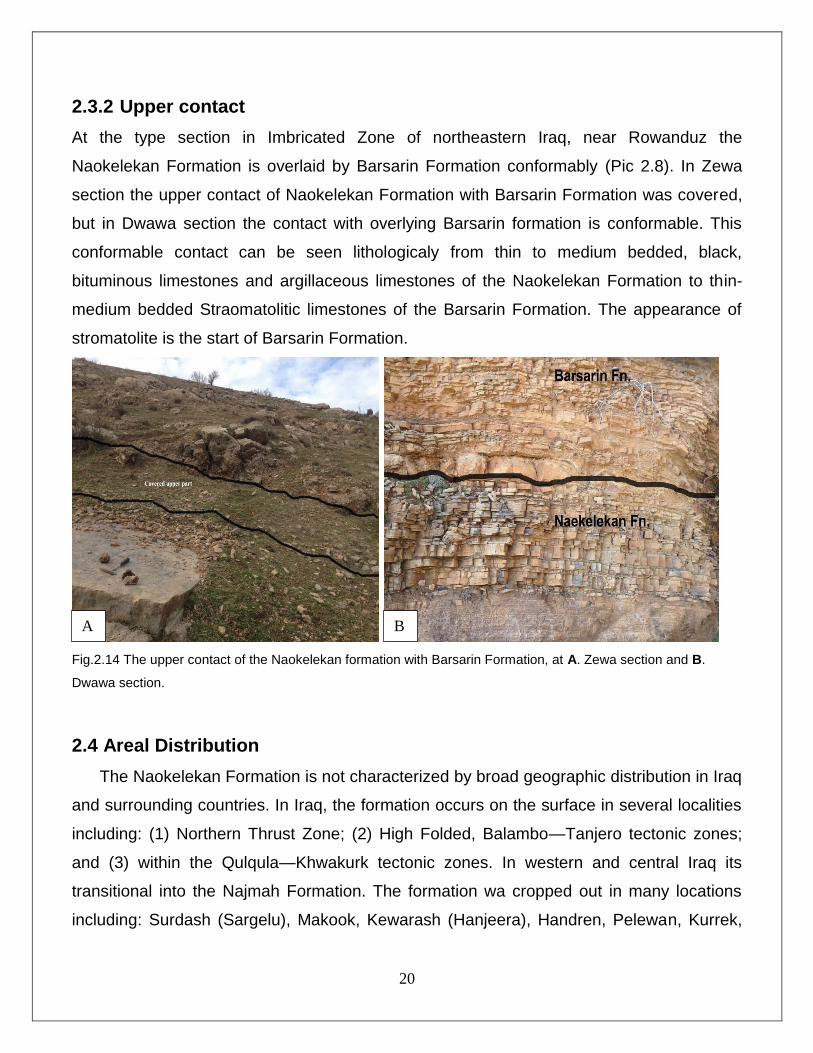
2.3.2 Upper contact
At the type section in Imbricated Zone of northeastern Iraq, near Rowanduz the
Naokelekan Formation is overlaid by Barsarin Formation conformably (Pic 2.8). In Zewa
section the upper contact of Naokelekan Formation with Barsarin Formation was covered,
but in Dwawa section the contact with overlying Barsarin formation is conformable. This
conformable contact can be seen lithologicaly from thin to medium bedded, black,
bituminous limestones and argillaceous limestones of the Naokelekan Formation to thin-
medium bedded Straomatolitic limestones of the Barsarin Formation. The appearance of
stromatolite is the start of Barsarin Formation.
Fig.2.14 The upper contact of the Naokelekan formation with Barsarin Formation, at A. Zewa section and B.
Dwawa section.
2.4 Areal Distribution
The Naokelekan Formation is not characterized by broad geographic distribution in Iraq
and surrounding countries. In Iraq, the formation occurs on the surface in several localities
including: (1) Northern Thrust Zone; (2) High Folded, Balambo—Tanjero tectonic zones;
and (3) within the Qulqula—Khwakurk tectonic zones. In western and central Iraq its
transitional into the Najmah Formation. The formation wa cropped out in many locations
including: Surdash (Sargelu), Makook, Kewarash (Hanjeera), Handren, Pelewan, Kurrek,
A B

21
Bradost, Peris, Chinara, Tanun, Gara, Sirwan, Sehkaniyan, Qal’Gah, Naokelekan,
Rawanduz, Ru Kuchuk, Isumaran, Ser Amadia, Ora, Chalki, Shiranish, Banik and also
occurs in many subsurface wells (Wetzel, 1948). (Table. 2.3)
Fig. 2.15 Middle-Late Jurassic stratigraphy in Iraq in relation to other Middle East countries ( Al-Husseini, 2008)
The Naokelekan Formation according to its age is comparable to some stratigraphic units
in surrounding countries. These units are: the Hanifa Formation in Bahrain and Saudi
Arabia; the Diyab Formation in Qatar; the Najmah Formation in Kuwait; the Qamchuqa
Formation in Syria; the Tuwaiq mountain limestone and Hanifa Formation in Oman; and
the lower part of the Surmeh Formation of southwestern Iran (Al-Husseini, 2008, James
and Wynd, 1965; Buday, 1980; Jassim and Buday, 2006). (Fig. 2.6)
22
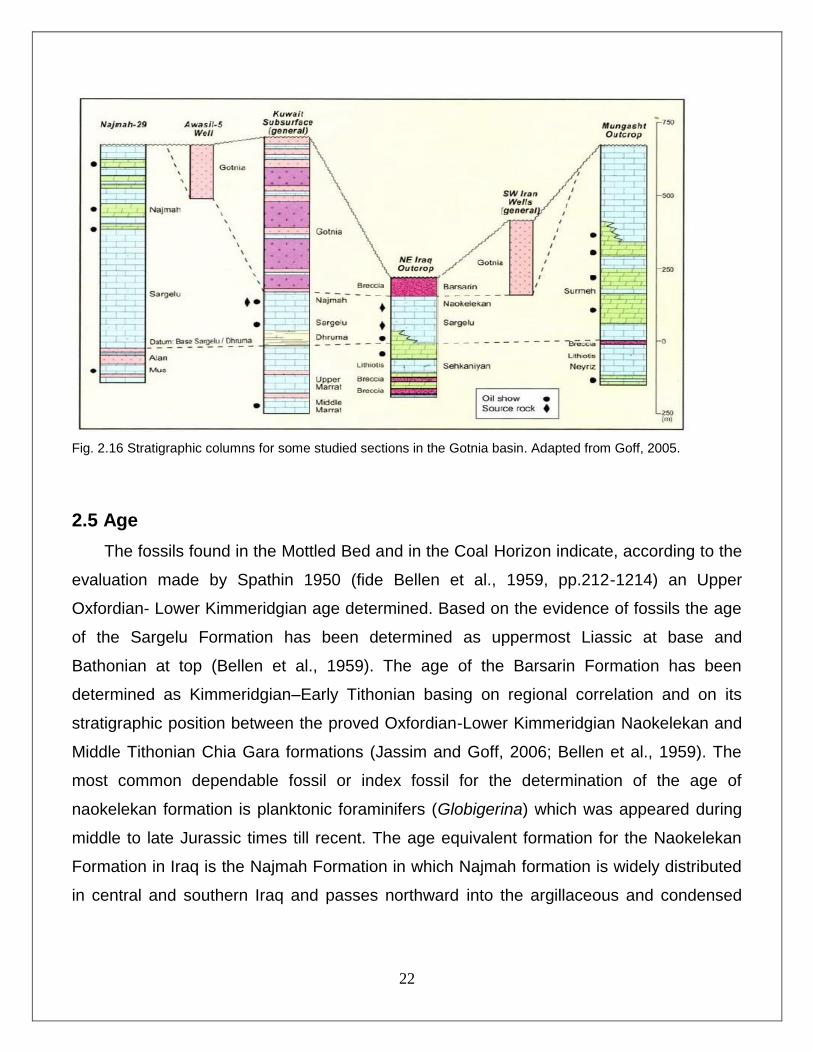
Fig. 2.16 Stratigraphic columns for some studied sections in the Gotnia basin. Adapted from Goff, 2005.
2.5 Age
The fossils found in the Mottled Bed and in the Coal Horizon indicate, according to the
evaluation made by Spathin 1950 (fide Bellen et al., 1959, pp.212-1214) an Upper
Oxfordian- Lower Kimmeridgian age determined. Based on the evidence of fossils the age
of the Sargelu Formation has been determined as uppermost Liassic at base and
Bathonian at top (Bellen et al., 1959). The age of the Barsarin Formation has been
determined as Kimmeridgian–Early Tithonian basing on regional correlation and on its
stratigraphic position between the proved Oxfordian-Lower Kimmeridgian Naokelekan and
Middle Tithonian Chia Gara formations (Jassim and Goff, 2006; Bellen et al., 1959). The
most common dependable fossil or index fossil for the determination of the age of
naokelekan formation is planktonic foraminifers (Globigerina) which was appeared during
middle to late Jurassic times till recent. The age equivalent formation for the Naokelekan
Formation in Iraq is the Najmah Formation in which Najmah formation is widely distributed
in central and southern Iraq and passes northward into the argillaceous and condensed
23
basinal Naokelekan Formation (Table. 2.4). In Foothill zone there is an interfingering
relation between Najmah and Naokelekan formations.
Fig. 2.17 Stratigraphic correlation of the position of Naokelekan Formation in geological column of Iraq and
surrounding countries (Harland et al., 1990)
2.6 Thickness
The thickness of the Upper Jurassic (Megasequence API. 7) successions in Iraq is
highly variable (Fig. 2.7). The thickness of the Naokelekan Formation in the Northern
Thrust zone, Imbricated zone, and Simply Folded zone in northeastern Iraq has a range
from 10 m to 30 m usually around 20 m. the formation is about 14 m thick at the type
locality in the Naokelekan Village (Wetzel, 1948; Buday, 1980). The Najmah formation of
subsurface sections in northern Iraq, which is considered to be equivalent in age to the
pre-Kimeridgian part of the Naokelekan, has an incomplete thickness of over 330 metres.
Thicknesses of the Naokelekan range between 8.5 metres at Barsarin and 34 metres at Ru
Kuchuk, but only three of the 'thirteen measured sections show more than 20 metres
(Bellen et al., 1959). The thickness of the formation in Barsarin Vilage is about 11 meters
thick (Balaky, 2014) and in Surdash and Pera Magroon the thickness is 16 m (Al-Shwaily
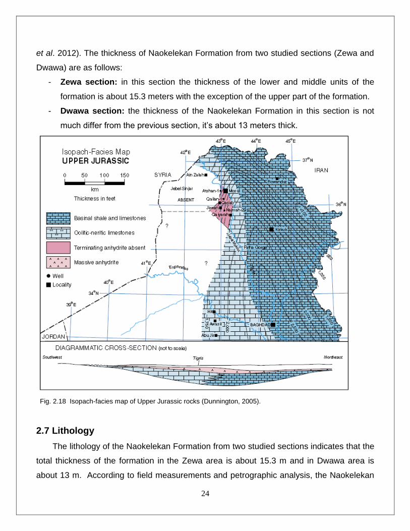
24
et al. 2012). The thickness of Naokelekan Formation from two studied sections (Zewa and
Dwawa) are as follows:
- Zewa section: in this section the thickness of the lower and middle units of the
formation is about 15.3 meters with the exception of the upper part of the formation.
- Dwawa section: the thickness of the Naokelekan Formation in this section is not
much differ from the previous section, it’s about 13 meters thick.
Fig. 2.18 Isopach-facies map of Upper Jurassic rocks (Dunnington, 2005).
2.7 Lithology
The lithology of the Naokelekan Formation from two studied sections indicates that the
total thickness of the formation in the Zewa area is about 15.3 m and in Dwawa area is
about 13 m. According to field measurements and petrographic analysis, the Naokelekan
25
Formation from both studied sections (Zewa and Dwawa) approximately have the same
stratigraphic sequences and can be divided into three units(Fig 2.8) :
Lower unit
The thickness of this unit is about 6.8 meters in Zewa and 4.5 meters in Dwawa section.in
both sections the lower part is composed of thin-medium bedded, dark brown, fetid,
bituminous limestone and dolomitic limestone, intercalated with soft, black, calcareous,
bituminous shale. Disharmonic fold and some slump structures can be seen in this part in
Zewa and Dwawa sections respectively.
Middle unit (Mottled unit)
The thickness of this part is about 6.55 meters in Zewa and 5.3 meters in Dwawa
section.The lower part of this unit about (2.5 meters) is composed of hard, grey, thin-
medium bedded, limestone and bituminous limestones and the remaining upper part is
thick bedded, blue grey, hard limestone and dolomitic limestones, with stylolite and
ammonite fossils.
Upper unit
The upper part of the formation in Zewa section is covered but in Dwawa section is about
3.2 m thick. The lower 1.7 m is dark brown, laminated fetid, very soft shales and the
remaining upeer part consists of dark grey, thin-medium bedded, hard, limestone,
argillaceous limestone and dolomitic limestones. Some pillow structures are seen in the
upper parts.
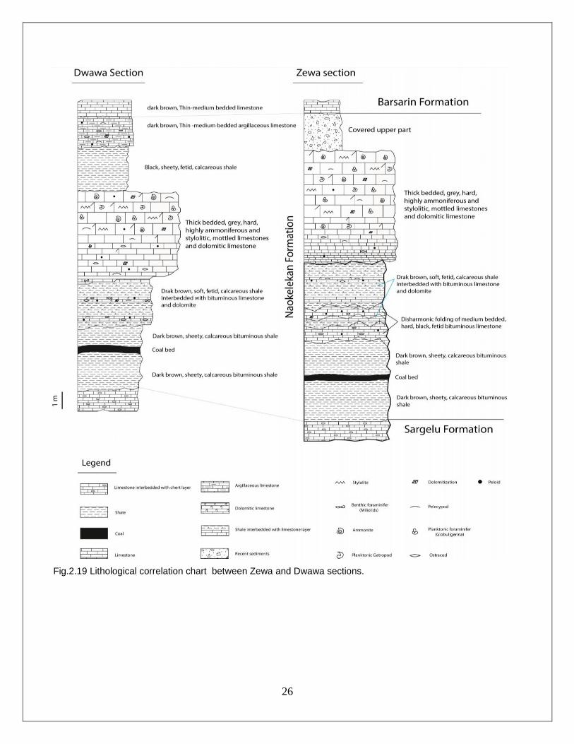
26
Fig.2.19 Lithological correlation chart between Zewa and Dwawa sections.
27
CHAPTER THREE MICROFACIES ANALYSIS AND DEPOSITIONAL
ENVIRONMENT 3.1 Preface
As originally defined by Brown (1943) and again independently by Cuvillier (1952)
the term ‘microfacies’ referred only to petrographic and paleontological criteria studied in
thin-sections. Today, however, microfacies is regarded as "the total of all sedimentological
and paleontological data which can be described and classified from thin sections, peels,
polished slabs or rock samples" (Flugel, 2010). Field geology, including mapping and
profiling, is a prerequisite for successful microfacies analysis (Amani, 2013). The facies
was defined by Gressely (1838, in Boggs, 2006), as a body of rock with specified
characteristics that reflect the condition under which it was formed. It is characterized by a
particular combination of lithology , physical and biological structures that give an aspect
(facies) different from the bodies of rock above, below and laterally adjacent. The
identification of environmental condition and depositional history of a basin is dependent
upon the microfacies analysis and explaining variation in stratigraphic units. The present
study has utilized the classification of Dunham, (1962) and its modified version by Embry
and Klovan, (1971) for studying the carbonate rocks of the formation and its facies
analyses. This is because this classification gives good indications on genetic of the rocks
than other classifications (Fig.3.1). Dunham classification has presented different types of
carbonate that can be used as facies. The derived name from this classification, gives
information on the depositional texture and energy of the environment.
As we mentioned it before the petrographic study is one of the important means for
detecting depositional Environments of limestones based on microfacies analysis.
The lithologic composition of Naokelekan Formation is basically consists of limestone, and
shale. Thin sections of limestone samples were examined to demonstrate the petrographic
constituents.
28
3.2 Microfacies Analysis
It is very hard and difficult to identify grains in the rocks of Naokelekan Formation due
to intensive diagenetic process that affected them. The sizes of skeletal grains are vary
from ˃mm to several centimeters (2cm) in the rocks of the Naokelekan formation. The
types, sizes, shapes, and distributions of skeletal grains are good indicators of the
depositional environment (Flugel, 2009). Microfacies are considered as one of the main
methods utilized for interpretation of depositional environments of Naokelekan Formations.
In the Naokelekan Formation, three main microfacies types are identified (Fig.3.5). Based
on the relationship between the Grains and groundmass type each of these main facies is
subdivided into several submicrofacies. The main microfacies of Naokelekan Formation,
with their detailed components, that were recognized in thin sections upon the petrographic
study are as below:
Limestone Microfacies
Limestones are important rock units in both studied sections, although most of them
are affected by micritization and neomorphism. The petrographic study of limestones,
bituminous limestone, dolomitic limestone and argillaceous limestone of Naokelekan
Formation is performed through 22 thin sections prepared from the both studied sections.
The microscopic description of both studied sections include: lime mudstone, lime
wackestone and lime packestone which was contain pelagic (micro and macro) fossils.
Pelagic microfossils include planktonic foraminifers (Globigerina), small planktonic
gastropod and pelagic ostracod, while pelagic macrofossils include ammonites with
pelecypods. The limestones of the middle unit was mottled, dolomitized and bioturbated. It
was also contain sorted and rounded peloids. Ammonite, ostracod, fractures and stylolites
were filled by calcite and aragonite cement. This microfacies could be subdivided into the
following two submicrofacies:
3.2.1 Lime Mudstone Microfacies
This facies is the second major facies after the wackestone facies and constituents more
than 40% of the limestone units and about 30% of the total thickness of the formation, its

29
found in the whole formation units. The percent of grains in these units are less than %10.
It contains ostracods, pelecypods, benthonic and planktonic forams such as Miliolids and
Globigerina. This facies consists mainly of micrite, which is slightly effected by
recrystallization processes.
3.2.2 Lime Wackestone Microfacies
This facies is most common facies constituents more than %50 of the whole formation’s
thickness. In this facies, grains of wackestone usually range between 10 and 15 percent in
a micritic matrix. Skeletal grains include; Ammonites, foraminifers, gastropods, pelecypods,
calcispheres and ostracods. Non-skeletal grains include pelloids.
3.2.3 Lime Packstone Microfacies
This facies is characterized by predominant fossils and skeletal components (%20-30) that
dominate the framework of these rocks up to 10% leaving minor micrite between grain-
supported limestones. The dominance of grains over micrite refers to high agitation level.
The skeletal grains include; ostracods, pelecypods and calcispheres.
The Dunham’s classification divide facies into Groundmass and Grains as mentioned
below:
30
3.3 Groundmass
3.3.1 Micrite
Micrite is microcrystalline calcite with a grain size generally less than 4μm. They have a
greyish to brownish, sub-translucent appearance under the microscope, and they are
easily distinguished from carbonate grains and sparry calcite crystals by their extremely
small crystal size (Folk, 1959).
3.3.2 Sparite
Sparry calcite cement or sparite is the coarse crystalline calcite cement which fills pore
spaces in many limestones after deposition, formed by the precipitation of calcite from
carbonate-rich solutions passing through the pore spaces in the sediment
3.4 Grains
3.4.1 Skeletal Grains
Due to the intensive diagenetic process that affected skeletal grains of the rocks of
Naokelekan Formation, these grains became very poor, sometimes absent and difficult to
identify. The effects of diagenesis are varied among the study sections, being intensive in
both outcrop sections (Zewa and Dwawa) (Pls 2.1 & 2.3, 3.5, 4.4 & 4.6). This may be due
to the proximity to tectonically active areas, as well as the rocks are exposed now at
ground surface, or they might have been buried deeper than they were observed in some
wells in Kirkuk and Erbil area. Skeletal grains are derived directly from organisms or their
activities, comprise complete and fragmented fossils. Their sizes vary from ˃mm to several
centimeters (Flugel, 2009). The types, sizes, shapes, and distributions of skeletal grains
are good indicators of the depositional environment and the hydraulic systems for the
deposition's media.
Fossils
Fossils are the main skeletal grains in Naokelekan Formation, but as they belong to two
varied subtidal and deep marine environments under Oxic and anoxic/euxinic condition
31
with intensive diagenesis. However, the main fossils recognized, were similar in both
studied sections and they belong to the following types:
1. Ammonites
Ammonites usually have a planispirally coiled shell. The shape is often large size
(Benton and Harper, 1997). They were wholly marine (open marine) animals with a
dominantly nektonic or nekto-planktonic mode of life (Tucker, 2001). Ammonites are
common in pelagic, often relatively deep water deposits (Wilson, 1975; Tucker,
2001). All modern and ancient forms are interpreted as fully marine. Although
cephalopods are found washed into marginal marine settings, they are most
common in open shelf and deeper-water deposits. Ammonites were observed in all
studied sections, in Zewa and Dwawa sections large ammonite molds are clear and
well preserved (Pls 1.3-arrow, 2.3-arrow). Ammonites in the formation are generally
gives an evidence of shallow open marine environments.
2. Planktonic (Globigerina) and Benthic (Miliolid) foraminifers
Foraminifera are small, predominantly marine heterotrophic protists that construct
chambered shells (tests). The two major groups of foraminifera are benthic, living in
or on sediments on the sea floor, and planktonic, living in the upper 100 m of the
oceans (Flugel, 2004). They are the most important group of microfossils for two
main reasons; first, they are abundant in rocks; second, they provide valuable
information in dating of strata and the reconstruction of sedimentary environments
(Bignton, 1985). Most planktonic foraminifers live in the upper 300 m of the water
column, although after death, their tests fall to deeper seafloor (Scholle and Ulmer-
Scholle, 2003). Petrography displayed that planktonic foraminifera (Globigerina)
present in the rocks of Naokelekan Formation (Pls 1.2-B, 1.3-B, E), although they
are little, possibly due to removal by intensive diagenesis. Most planktonic
foraminifera were found in middle part of the formation and give an evidence of open
marine environment of the middle unit, while other benthics like miliolids (Pl 2.1 &
2.2) were found in the lower and upper parts of the formation that are the evidences
of lagoonal (subtidal) marine environments
32
3. Ostracods
Ostracods are bivalved mm- to cm-sized crustacean arthropods, known since the
Late Cambrian to occur in nearly all types of aquatic environments (Flugel, 2004).
Ostracods genera commonly have short stratigraphic range and wide geographic
distribution making them valuable for stratigraphic studies, especially in brackish-
water and non-marine settings (Scholle and Ulmer-Scholle, 2003). Ostracods are
inhabitants of several environments; marine, transitional, and fresh water at the
various depths. In both sections of current study, the Ostracods were observed in
whole formation especially in the lower and upper units with their articulated filled
with spary calcite, (Pls 1.3-A & 4A, 2.4, 3.3, 4.4). Ostracods are mainly indicate
lagoonal marine environments of both (lower and upper) units of the formation.
4. Pelecypods
Bivalves (also called pelecypods or lamellibranchs) have a layered shell consisting
of two valves. The valves may be either equal or unequal in shape and size (Flugel,
2004). Bivalve skeletons vary in composition, most of them are purely aragonite;
some have interlayered calcite and aragonite (Scholle and Ulmer-Scholle, 2003).
They are common in the studied formation, this may be due to sea level change
condition in Naokelekan`s environment. The existing pelecypods of Naokelekan
Formation (Pls. 1.2-A , 1.3-C and 4.1-A) may be of allochthonous nature. The
presence of pelecypods in the formation especially in the middle unit indicates fresh
to brackish water and open marine environment.
5. Gastropods
Gastropods are the second groups of mollusks of major importance in limestone.
Like the bivalves, they occur throughout the Phanerozoic, but are most abundant in
Mesozoic and Cenozoic sediments. Gastropod shells are nearly all made wholly of
aragonite, although there are a few with mixed mineralogy, comprising an outer
layer of calcite and an inner layer of aragonite (Scholle and Ulmer-Scholle, 2003).
The most common gastropod shell structure is a crossed-lamellar structure like that
33
of some bivalves. Most gastropods are preserved as moulds and casts. Gastropods
are the largest class of both living and fossil mollusks (with nearly 8,000 genera),
although they are rarely major rock-forming organisms. Gastropods (snails) are a
remarkably wide-ranging group of organisms. They are found at all latitudes and in
normal marine, brackish, hypersaline, and fresh water as well as subaerial
environments. They rarely are major sediment formers, however, except in stressed
(especially hypersaline or freshwater) settings. Warm-water forms generally are
thicker shelled than cold-water forms. Pteropods are open-marine, predominantly
warm-water (Scholle and Ulmer-Scholle, 2003).. In the present study, Planktonic
gastropods are present in the middle unit of the formation (Pls 1.2-arrow, 2.3-A, 3.5-
arrow) which gives an evidence of the shallow open marine environment of the
middle unit.
6. Calcisphere
Calcisphere are spherical objects, up to 0.5 mm in diameter, composed of calcite
(usually sparite), often with a micritic wall (Tucker, 2001). Paleozoic calcispheres
occur in shallow-marine platform and ramp carbonates, while those of Jurassic and
Cretaceous are predominantly found in pelagic limestones (Flugel, 2004).
Calcispheres are problematic grains that have in most instances, no certain origin.
Several types of calcispheres exist and most are attributed to algal sources. Scholle
(1978) stated that sometimes, unwalled calcispheres in micritic matrix might be
formed by alteration of radiolarians (Pl. 1.3-D & 1.4 , 4.1-arrow). In two sections
(Zewa and Dwawa) calcispheres were common, possibly due to intensive
diagenesis. All the observed calcispheres were filled by granular crystals of spary
calcite.
7. Microbial structures
Micro-organisms, including bacteria and fungi, play an important role in the
generation of fine-grained carbonate sediments. Some organisms become calcified
and can thus be preserved as fossils, but mostly leave evidence of their presence in

34
the overall structure of the rock. Structures believed to be formed by micro-
organisms of this type are classed as microbial structures. The outer surface of
bioclastic grains sometime altered partially or completely by the endolithic algae,
fungi, and bacteria on seafloor or just below, in different intensities. When the outer
margin of skeletal grain is completely altered, and the micrite fills the cavities around
grain's body, the Micritic Envelope will be formed. The origin of micritized grain is
often difficult to determine (Tucker and Wright, 1990). Calcified cyanobacteria,
formerly classed as blue–green algae, have been given generic names although
many different microbial organisms may have given rise to similar calcified
structures. Small, simple tubes without partitions or branching are reffered to
Girvanella. The more irregularly shaped clumps present in the current study in the
lower part of the formation can be seen in Plate two, image six. This is reffered to
Renalcis sp.
3.4.2 Non-Skeletal Grains
In the current study, non-skeletal grains (ooids, oncoids, intraclasts, extraclasts) were
absent in limestones of Naokelekan Formation. This indicates that Naokelekan Formation
was dominantly deposited in shallow open marine setting (Tucker, 2001).
Peloids
A sand-sized grain with an average size of 100 – 500 μm composed of microcrystalline
carbonate. They are generally rounded or subrounded, spherical, ellipsoidal to irregular in
their shapes and are entirely structureless. Most Peloids are of fecal origin and so can be
referred to as pellets. Peloidal carbonate sediments, in general, are sediments of shallow,
low-energy, restricted marine environments (Tucker, 1985; Tucker and Wright, 1990). It is
a comprehensive descriptive term for polygenetic grains composed of cryptocrystalline
carbonate or microcrystalline calcium carbonate with no restrictions on the size or origin of
the grains. Peloids are common in shallow-marine tidal and subtidal shelf carbonates and
in reef and mud mounds, but are also abundant in deep-water carbonates. By contrast to
the abundance of peloids in tropical shallow-marine carbonate, peloids are rare or absent
35
in non-tropical cool water carbonates (Flugl,2010). Peloids have varied origins and
environmental associations. Algal or fungal boring and micritization of grains are common
in a variety of open marine to restricted or coastal settings with relatively slow or
intermittent sedimentation rates. In particular, areas subject to occasional storms that move
grains from active areas of formation to quiet sites of destruction are especially prone to
peloid formation. Such sites include backbarrier or back-bar grass flats, lagoons, and
protected deeper shelf settings. In the studied carbonate rocks of the Naokelekan
Formation only one type of peloids (coarse) were common in the middle unit of the
formation (Pl 3.2-arrow) which was deposited in shallow open marine environment, but it
can be seen also in both lower and upper units of the formation which were deposited in
lagoonal (subtidal) environment.
3.5 Diagenesis
Diagenesis is defined as the sum of all chemical, physical, and biological processes
that are endured by rocks during interval between deposition and metamorphism (Tucker,
1982). Diagenesis of carbonate encompasses all the chemical, physical, and biological
processes which affect the carbonate sediments after their initial deposition and following
lithification, exclusive weathering and metamorphism. Diagenesis includes six major
processes: Cementation, Microbial Micritization, Neomorphism, Dissolution, Compaction,
and Dolomitization (Tucker and Wright, 1990). All those changes that take place in
sediment near the earth's surface at low temperature and pressure are studied without
crustal movement being directly involved (Taylar, 1964 in Land, 1967). Diagenesis of
carbonate sediments and rocks includes all the processes that act on these materials after
their initial deposition, but before the elevated temperatures and pressures that create
minerals and structures which normally considered within the realm of metamorphism.
Classification of Diagenetic Processes
Several diagenetic processes (Table.3.1) had affected the Naokelekan Formation in both
sections, through three main stages; early, middle and late diagenesis stages. According to
Flugel (2010) the diagenetic processes and their effect will be discussed in the following:

36
3.5.1 Mechanical Diagenesis
3.5.1.1 Compaction
The decrease in the bulk of the rocks by any process is called compaction (Flugel,
1982). Compaction tends to lose voids and squeeze fluid out to bring the mineral
particles close together, especially the finer-grained sedimentary rocks (Tiab and
Donaldson, 2004). Tucker (2001) subdivided compaction into two categories:
i- Mechanical compaction.
ii- Chemical compaction.
In the present study, it is observed that the Naokelekan Formation was commonly
affected by chemical compaction.
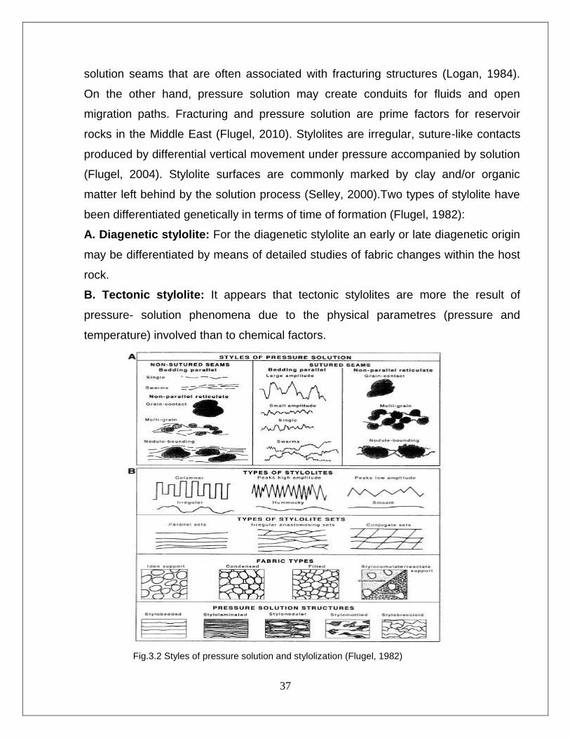
Chemical Compaction: Pressure Solution and Stylolitization
Following mechanical compaction, many types of sediment are subject to chemical
compaction, expressed by pressure solution and the formation of stylolites and
37
solution seams that are often associated with fracturing structures (Logan, 1984).
On the other hand, pressure solution may create conduits for fluids and open
migration paths. Fracturing and pressure solution are prime factors for reservoir
rocks in the Middle East (Flugel, 2010). Stylolites are irregular, suture-like contacts
produced by differential vertical movement under pressure accompanied by solution
(Flugel, 2004). Stylolite surfaces are commonly marked by clay and/or organic
matter left behind by the solution process (Selley, 2000).Two types of stylolite have
been differentiated genetically in terms of time of formation (Flugel, 1982):
A. Diagenetic stylolite: For the diagenetic stylolite an early or late diagenetic origin
may be differentiated by means of detailed studies of fabric changes within the host
rock.
B. Tectonic stylolite: It appears that tectonic stylolites are more the result of
pressure- solution phenomena due to the physical parametres (pressure and
temperature) involved than to chemical factors.
Fig.3.2 Styles of pressure solution and stylolization (Flugel, 1982)
38
Stylolites are the most common phenomenon that was observd in the Naokelekan
rocks (Pl 1.4 &1.5). Both types of stylolite are observed in the present study. First
one is diagenetic origin because it is generally parallel to the bedding plane. The
second one is more probably exist in the formation from both studied sections due to
the intense burial, compaction and heating effects. In other hand, the Stylolite of
Naokelekan Formation was mainly of sutured type and parallel to the bedding
planes of the limestone and dolomitic limestone layers, but non-sutured was also
observed. Compaction resulted in the formation of fractures which was filled with
sparry calcite cement especially in the middle unit of the formation (Pl 1.1 & 1.5).
3.5.1.2 Fracturing
Most tectonic deformation, both brittle and ductile, takes place within the
temperature range of late diagenesis. The late carbonate fracture fills commonly
have associated hydrocarbons as stains, fluid inclusions, or solid bitumen, partial
fracture fills (Moore and Druckman, 1981 in Flugel, 2004). Naokelekan Formation is
moderately fractured (Macrofractures and Microfractures) as shown in plate 1.
Image 1 and plate 3. Images 1&6 and this may be due to overpressure of burial.
3.5.2 Chemical Diagenesis
3.5.2.1 Cementation
Cementation is an important process in all diagenetic realms. Cement is a chemical
precipitation from solution; it grows in primary and secondary pores, and requires
supersaturation of the pore fluid with respect to the cement mineral. Cement is
distinct from neomorphic spar. This is an in situ represent of calcium carbonate in
the solid state. Cementation process was extensively affected the studied
formations, and represent the commonest one among the other isochemical
diagenetic processes. However, several types of cement are recognized including
the following:

39
Granular Cement
Granular cement consists of crystals of subhedral type, generally greater than 10-
60 μm, that are formed post lithification and composition of sediments, and after
formation of cement (A) (Bathurst, 1975). Granular cement is formed in subaerial
and also in deep marine environments (Flugel, 1982). This type of cement
dominantly fills the mold of fossils, pores, fractures, and calcispheres (Pls1.3 & 1.5,
2.3, 3.1 & 3.6).
Drusy Cement
Drusy cement consists of anhedral to subhedral crystals, usually >10μm crystal size
that increases from pore walls to center of cavities (Flugel, 1982). This type is found
in shallow and deep marine environments, and also in Vadose and Phreatic Zones
(Graf and Lamar, 1950 in Flugel, 1982). Bathurst (1975) believed this type refers to
cement filling primary or secondary voids. Drusy cement was found in Naokelekan
Formation but less common as compared to granular cements, this type filling the
fractures and mold of fossils (Pls 2.4, 4.4, 4.6).
Blocky Cement
Blocky cement refers to a mosaic of crystals in which the individuals have roughly
the same diameter in all direction (Blatt et al., 1980). This type of cement is large
euhedral-subhedral crystals that fill the vugs or cracks. Blocky cement is formed in
late diagenetic stage after dissolution process or lithification in subaerial and fresh
water environments (Flugel, 1982). Blocky cement was observed in Naokelekan
rocks, commonly filling fractures and veins.
3.5.2.2 Neomorphism
Carbonate sediments and carbonate rocks are affected by diagenetic processes that
alter mineralogical composition and/or crystals and crystal fabrics (Flugel, 2010). The
term neomorphism (Folk 1965) relates to transformations of minerals taking place in the
presence of water and includes processes of replacement (the dissolution of one
mineral and simultaneous formation of another mineral, e.g. silicification of carbonates),
inversion (the replacement of a mineral by its polymorph; e.g. aragonite –> calcite
40
(calcitization); opal-A –> opal-CT –> The quartz), and recrystallization (changes in
crystal size, shape and crystal lattice without a change in mineralogy). The Present
study shows that carbonate of the Naokelekan formations is highly neomorphosed. In
some cases such as in mud-dominated facies, gastropodal lime- wackestone and
ostracodal lime-wackestones, the micritic groundmasses are neomorphosed to coarse
crystals of calcite (Pls 2.6, 4.4). Many of the fossils are originally composed of unstable
aragonite mineral but by time these grains become inverted to more stable calcite
mineral as in other parts of the formation.
3.5.2.3 Dolomitization
Dolomitization is one of the diagenetic processes in the Naokelekan Formation that
were observed from both studied sections (Pls 2.6, 3.4). This fabric is found within
the calcareous matrix of lime mudstone and wackestone facies. It could be formed
by concentration of (Mg ++
) ions within the sediment grain (Mathews, 1974). The
conversion of CaCO3 minerals into dolomite CaMg (CO3)2 may take place soon
after the sediments have been deposited i.e. pen- contemporaneously and during
early diagenesis (syngenetic diagenesis), or along time after deposition, usually after
cementation, during the late stages of diagenesis (epigenetic dolomitization)
(Tucker, 1982). According to Flugel, (1982) dolomitization can be divided into two
types: early diagenetic dolomitization and late diagenetic dolomitization. The most
important effect of dolomitization particularly in the late diagenetic stage is
increasing of porosity. Dolomites have a crystal system packing more than calcite.
Accordingly, dolomitization can cause increasing in porosity up to %13 (Boggs,
2006). Early dolomitization is of less importance because it is often obliterated by
other subsequent processes. In both studied sections of the Naokelekan Formation,
the intensive dolomitization leds to the disappearance of the main skeletal and non-
skeletal grains in all units of the formation. Unfortunately, because of these intensive
dolomitization, only we can differentiate betwwen afew main skeletal and non-
skeletal grains such as planktonic gastropods, planktonic forams and peloids. The

41
floating crystal of dolomite (Pl 4.3) show late burial diagenesis in Naokelekan
Formation. The main types of dolomitization that occurred on the Naokelekan rocks
are scattered and fine-grained dolomite (subhedral and anhedral) crystal shapes.
The fine-grian sizes of dolomites indicate early diagenetic stage origin rather than
late diagenetic stage which cause an increasing of the grain-sizes of dolomites.
3.5.2.4 Micritization
Micritzation is represented by micrite envelope surrounding the skeletal whole
organisms or the skeletal bioclasts. Micritization can be considered as a primary
diagenetic process in origin shortly after deposition and its occurrence is associated
with algae and the fungi which are responsible for forming the voids that become
micritized later (Bathurst 1972). Micrites are susceptible to diagenetic alteration and
may be replaced by coarse mosaic of microspar (5-15 μm) through aggrading
neomorphism. They occur in the shallow subtidal, less-agitated central parts of the
platforms and in lagoons (Tucker, 1982).
Numerous studies of modem sediments have shown that lime mud (micrite) can be
originated by variety of processes (Tucker, 1982; and Flugel, 1982), and these
processes can be summarized as:
1- Physico-chemical process leding to the precipitation of most mud size aragonite.
2- Bacterial activity and decomposition of organic substances leading to the production
micrite in deep basin.
3- Biochemical precipitation, through algal photosynthesis.
4- Bioerosion, where organisms such as boring algae, fungi, sponges attack carbonate
grains and substances.
5- Abrasion of calcareous shells and skeletons by wave and current action, can
produce a micrite,which winnows into adjacent low energy environments.
The microscopic studies of Nokelekan Formation in both studied sections have shown
that, origin of the micrites is most probably due to Bacterial activity and biochemical
precipitation. Many microfacies in these sections that are composed originally of
micrites, are now neomorphosed either partially or completely or dolomitized. Hence,
42
there are no origin in these microfacies. These processes was affected on the skeletal
grains of the formation like pelecypods, ostracods and miliolids (Pls 2.2, 4.4).
3.5.2.5 Dissolution
Dissolution may occur at any point in the burial history of the carbonate sequence,
after mineral stabilization, will generally be characterized by non-fabric-selective
dissolution, where the resulting pores cut across all fabric elements such as grains,
cement, and matrix (Moore, 1989). These pore types are commonly called vugs,
channels, and caverns, depending on size (Choquette and Pray, 1970). The
dissolution processes is controlled by the porosity zones (secondary porosity). The
minerals which compose the carbonate rocks can be dissolved in different degrees
of intensities. The dissolution of minerals will occur under several factors which
control this process, such as the saturation degree of pore-fluids with respect to
carbonate mineralogy. The stability of a given mineral, degree of fluid's saturation
with intended mineral, fluid's pressure and temperature are the controlling factors of
dissolutions (Tucker and Wright,1990; Flugel, 2010). Moldic pores are formed if
some grains dissolve completely to leave pores with forms similar to the dissolved
grains. Vuggy pores are those that have irregular shapes, and formed by dissolution
process which affects the components of the texture (Pls 1.1, 4.2). This processes
(early diagenetic) was occurred on the rocks of the Naokelekan Formation and
affected on them resulted in the formation of moldic and vuggy pores as unstable
grains were dissolved (Pl 2.1 & 2.3).
43
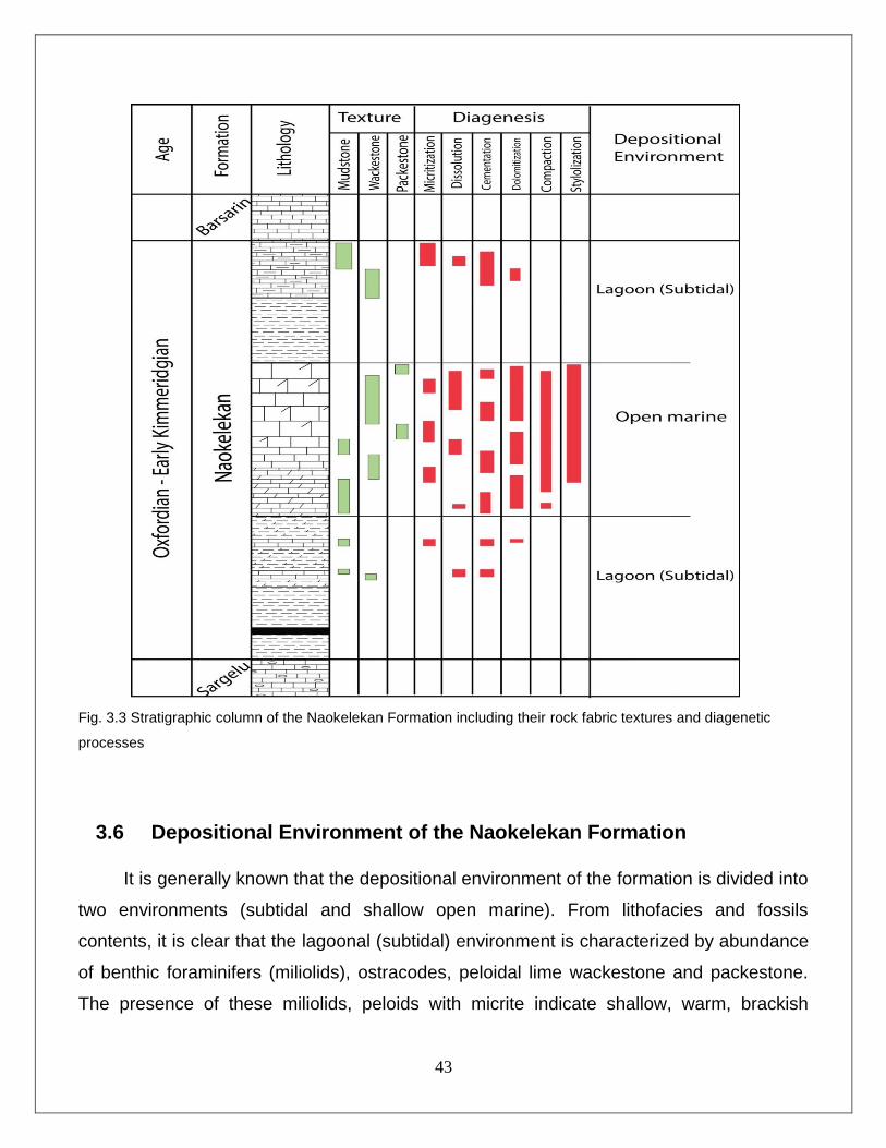
Fig. 3.3 Stratigraphic column of the Naokelekan Formation including their rock fabric textures and diagenetic
processes
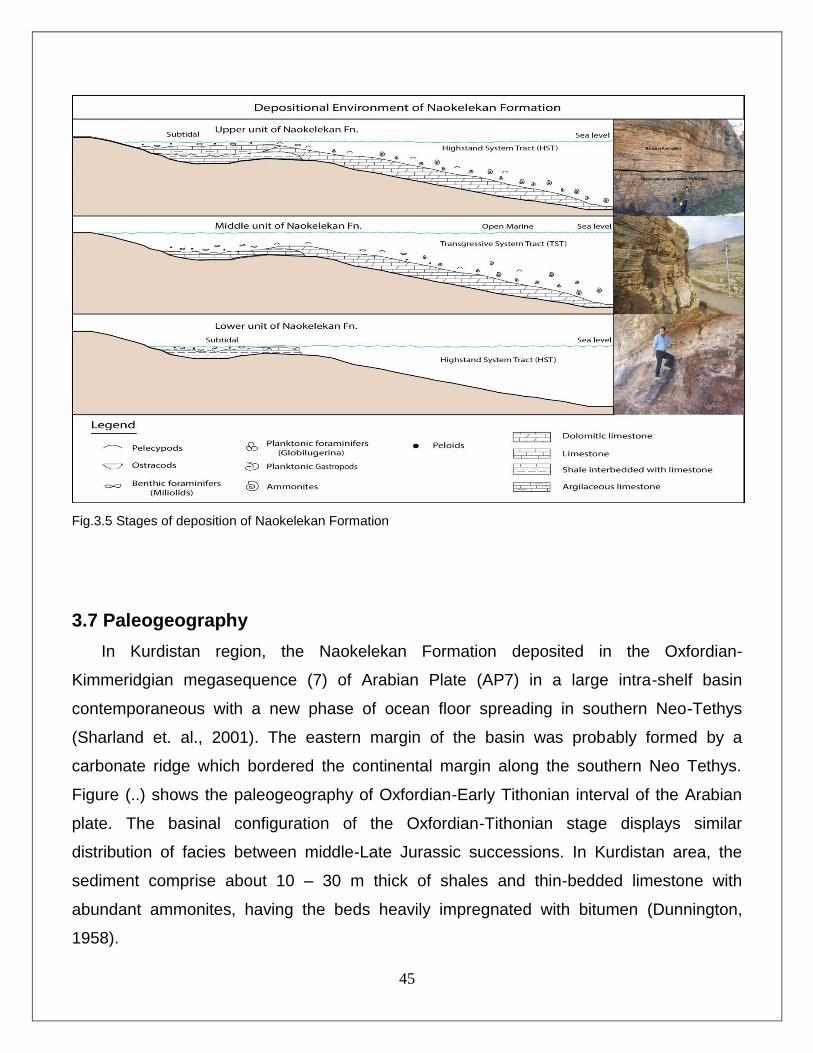
3.6 Depositional Environment of the Naokelekan Formation
It is generally known that the depositional environment of the formation is divided into
two environments (subtidal and shallow open marine). From lithofacies and fossils
contents, it is clear that the lagoonal (subtidal) environment is characterized by abundance
of benthic foraminifers (miliolids), ostracodes, peloidal lime wackestone and packestone.
The presence of these miliolids, peloids with micrite indicate shallow, warm, brackish
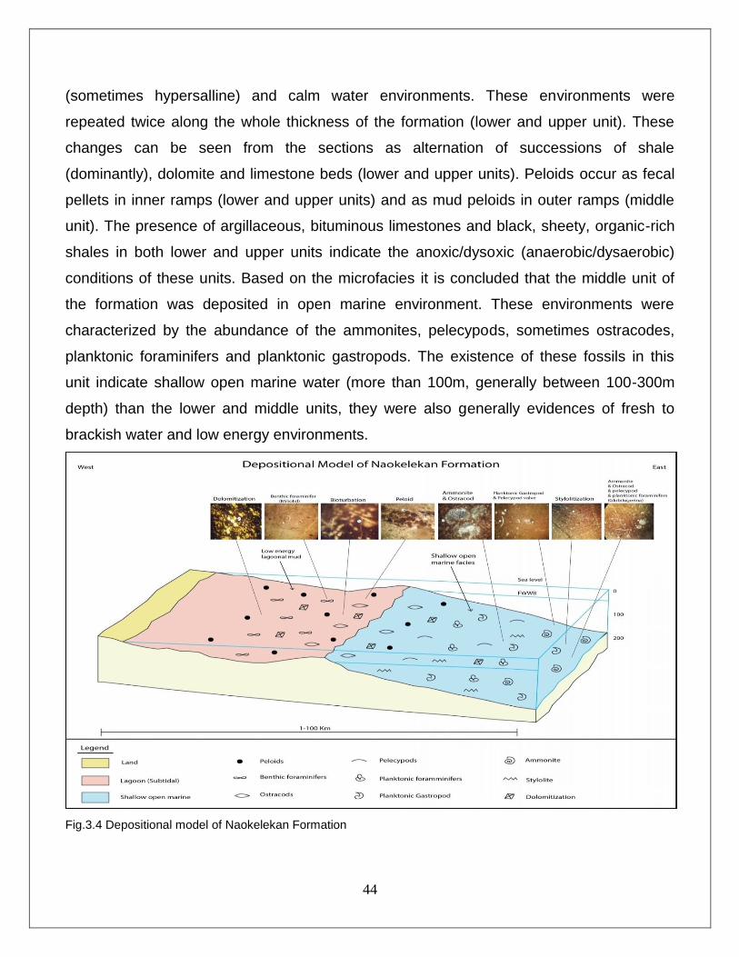
44
(sometimes hypersalline) and calm water environments. These environments were
repeated twice along the whole thickness of the formation (lower and upper unit). These
changes can be seen from the sections as alternation of successions of shale
(dominantly), dolomite and limestone beds (lower and upper units). Peloids occur as fecal
pellets in inner ramps (lower and upper units) and as mud peloids in outer ramps (middle
unit). The presence of argillaceous, bituminous limestones and black, sheety, organic-rich
shales in both lower and upper units indicate the anoxic/dysoxic (anaerobic/dysaerobic)
conditions of these units. Based on the microfacies it is concluded that the middle unit of
the formation was deposited in open marine environment. These environments were
characterized by the abundance of the ammonites, pelecypods, sometimes ostracodes,
planktonic foraminifers and planktonic gastropods. The existence of these fossils in this
unit indicate shallow open marine water (more than 100m, generally between 100-300m
depth) than the lower and middle units, they were also generally evidences of fresh to
brackish water and low energy environments.
Fig.3.4 Depositional model of Naokelekan Formation
45
Fig.3.5 Stages of deposition of Naokelekan Formation
3.7 Paleogeography
In Kurdistan region, the Naokelekan Formation deposited in the Oxfordian-
Kimmeridgian megasequence (7) of Arabian Plate (AP7) in a large intra-shelf basin
contemporaneous with a new phase of ocean floor spreading in southern Neo-Tethys
(Sharland et. al., 2001). The eastern margin of the basin was probably formed by a
carbonate ridge which bordered the continental margin along the southern Neo Tethys.
Figure (..) shows the paleogeography of Oxfordian-Early Tithonian interval of the Arabian
plate. The basinal configuration of the Oxfordian-Tithonian stage displays similar
distribution of facies between middle-Late Jurassic successions. In Kurdistan area, the
sediment comprise about 10 – 30 m thick of shales and thin-bedded limestone with
abundant ammonites, having the beds heavily impregnated with bitumen (Dunnington,
1958).

46
Fig.3.6 Paleogeography of Late Jurassic time (Oxfordian- Early Tithonian) (Edited after Jassim and Goff., 2006).
47
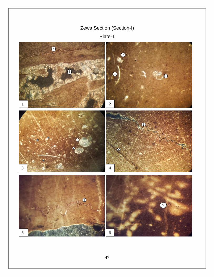
Zewa Section (Section-I)
Plate-1
1 2
3 4
5 6
48
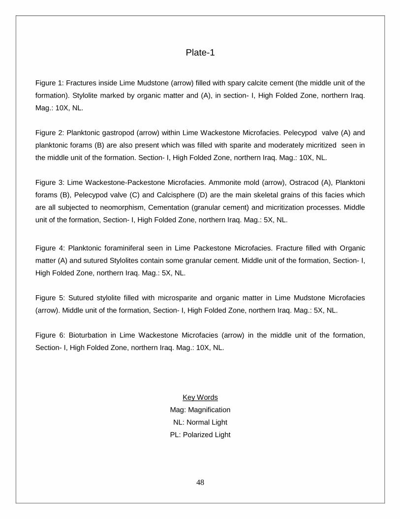
Plate-1
Figure 1: Fractures inside Lime Mudstone (arrow) filled with spary calcite cement (the middle unit of the
formation). Stylolite marked by organic matter and (A), in section- I, High Folded Zone, northern Iraq.
Mag.: 10X, NL.
Figure 2: Planktonic gastropod (arrow) within Lime Wackestone Microfacies. Pelecypod valve (A) and
planktonic forams (B) are also present which was filled with sparite and moderately micritized seen in
the middle unit of the formation. Section- I, High Folded Zone, northern Iraq. Mag.: 10X, NL.
Figure 3: Lime Wackestone-Packestone Microfacies. Ammonite mold (arrow), Ostracod (A), Planktoni
forams (B), Pelecypod valve (C) and Calcisphere (D) are the main skeletal grains of this facies which
are all subjected to neomorphism, Cementation (granular cement) and micritization processes. Middle
unit of the formation, Section- I, High Folded Zone, northern Iraq. Mag.: 5X, NL.
Figure 4: Planktonic foraminiferal seen in Lime Packestone Microfacies. Fracture filled with Organic
matter (A) and sutured Stylolites contain some granular cement. Middle unit of the formation, Section- I,
High Folded Zone, northern Iraq. Mag.: 5X, NL.
Figure 5: Sutured stylolite filled with microsparite and organic matter in Lime Mudstone Microfacies
(arrow). Middle unit of the formation, Section- I, High Folded Zone, northern Iraq. Mag.: 5X, NL.
Figure 6: Bioturbation in Lime Wackestone Microfacies (arrow) in the middle unit of the formation,
Section- I, High Folded Zone, northern Iraq. Mag.: 10X, NL.
Key Words
Mag: Magnification
NL: Normal Light
PL: Polarized Light
49
Zewa Section (Section-I)
Plate-2
1 2
3 4
5 6
50
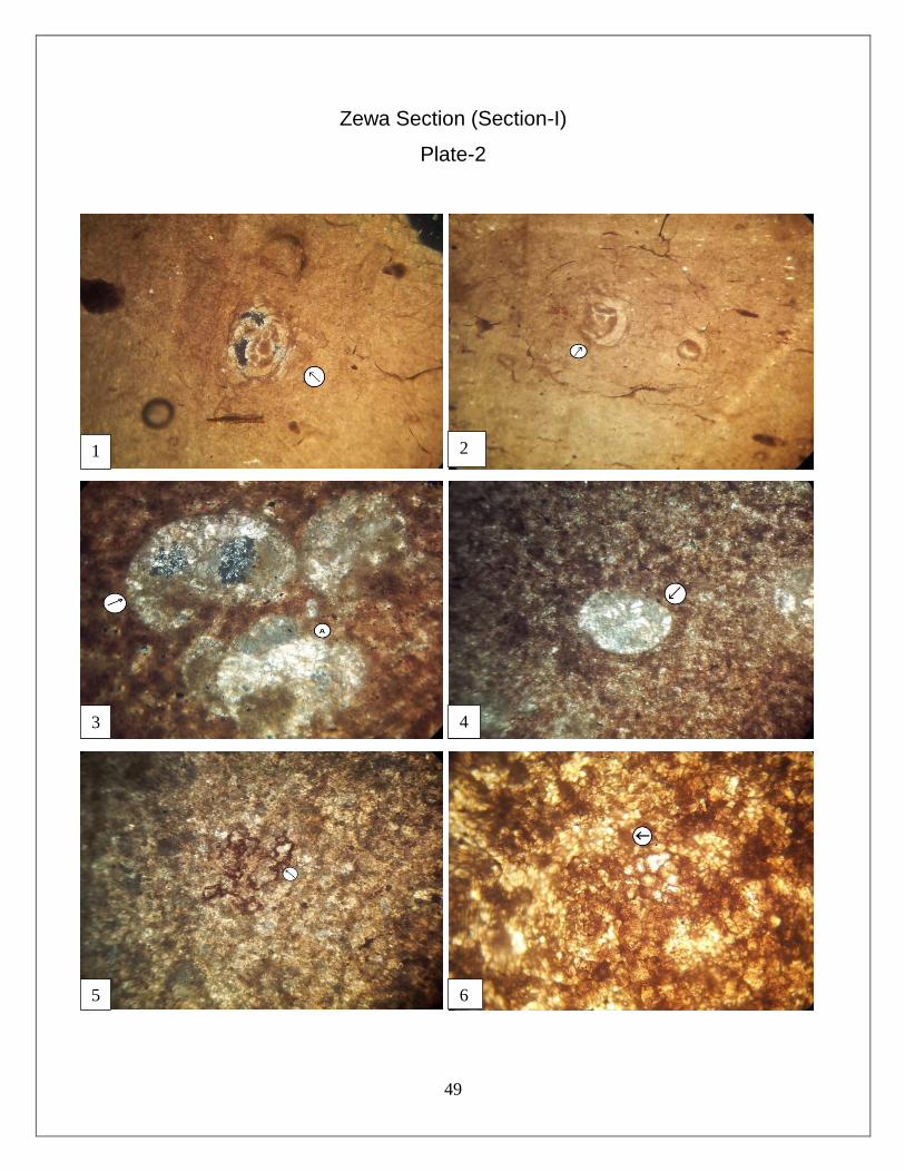
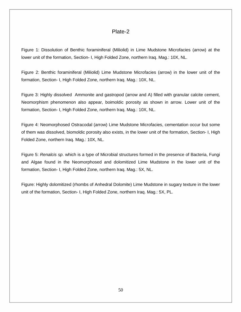
Plate-2
Figure 1: Dissolution of Benthic foraminiferal (Miliolid) in Lime Mudstone Microfacies (arrow) at the
lower unit of the formation, Section- I, High Folded Zone, northern Iraq. Mag.: 10X, NL.
Figure 2: Benthic foraminiferal (Miliolid) Lime Mudstone Microfacies (arrow) in the lower unit of the
formation, Section- I, High Folded Zone, northern Iraq. Mag.: 10X, NL.
Figure 3: Highly dissolved Ammonite and gastropod (arrow and A) filled with granular calcite cement,
Neomorphism phenomenon also appear, boimoldic porosity as shown in arrow. Lower unit of the
formation, Section- I, High Folded Zone, northern Iraq. Mag.: 10X, NL.
Figure 4: Neomorphosed Ostracodal (arrow) Lime Mudstone Microfacies, cementation occur but some
of them was dissolved, biomoldic porosity also exists, in the lower unit of the formation, Section- I, High
Folded Zone, northern Iraq. Mag.: 10X, NL.
Figure 5: Renalcis sp. which is a type of Microbial structures formed in the presence of Bacteria, Fungi
and Algae found in the Neomorphosed and dolomitized Lime Mudstone in the lower unit of the
formation, Section- I, High Folded Zone, northern Iraq. Mag.: 5X, NL.
Figure: Highly dolomitized (rhombs of Anhedral Dolomite) Lime Mudstone in sugary texture in the lower
unit of the formation, Section- I, High Folded Zone, northern Iraq. Mag.: 5X, PL.
51
Dwawa Section (Section-II)
Plate-3
1 2
3 4
5 6
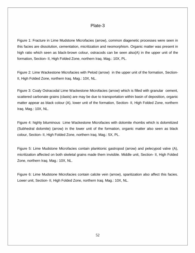
52
Plate-3
Figure 1: Fracture in Lime Mudstone Microfacies (arrow), common diagenetic processes were seen in
this facies are dissolution, cementation, micritization and neomorphism. Organic matter was present in
high ratio which seen as black-brown colour, ostracods can be seen also(A) in the upper unit of the
formation, Section- II, High Folded Zone, northern Iraq. Mag.: 10X, PL.
Figure 2: Lime Wackestone Microfacies with Peloid (arrow) in the upper unit of the formation, Section-
II, High Folded Zone, northern Iraq. Mag.: 10X, NL.
Figure 3: Coaly Ostracodal Lime Wackestone Microfacies (arrow) which is filled with granular cement,
scattered carbonate grains (clasts) are may be due to transportation within basin of deposition, organic
matter appear as black colour (A), lower unit of the formation, Section- II, High Folded Zone, northern
Iraq. Mag.: 10X, NL.
Figure 4: highly bituminous Lime Wackestone Microfacies with dolomite rhombs which is dolomitized
(Subhedral dolomite) (arrow) in the lower unit of the formation, organic matter also seen as black
colour, Section- II, High Folded Zone, northern Iraq. Mag.: 5X, PL.
Figure 5: Lime Mudstone Microfacies contain planktonic gastropod (arrow) and pelecypod valve (A),
micritization affected on both skeletal grains made them invisible. Middle unit, Section- II, High Folded
Zone, northern Iraq. Mag.: 10X, NL.
Figure 6: Lime Mudstone Microfacies contain calcite vein (arrow), sparitization also affect this facies.
Lower unit, Section- II, High Folded Zone, northern Iraq. Mag.: 10X, NL.
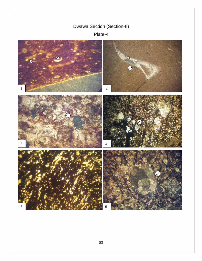
53
Dwawa Section (Section-II)
Plate-4
1 2
3 4
5 6
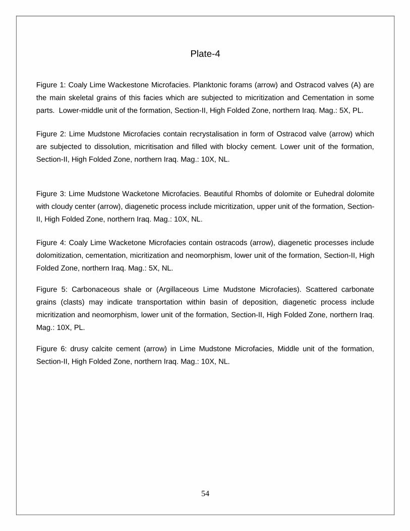
54
Plate-4
Figure 1: Coaly Lime Wackestone Microfacies. Planktonic forams (arrow) and Ostracod valves (A) are
the main skeletal grains of this facies which are subjected to micritization and Cementation in some
parts. Lower-middle unit of the formation, Section-II, High Folded Zone, northern Iraq. Mag.: 5X, PL.
Figure 2: Lime Mudstone Microfacies contain recrystalisation in form of Ostracod valve (arrow) which
are subjected to dissolution, micritisation and filled with blocky cement. Lower unit of the formation,
Section-II, High Folded Zone, northern Iraq. Mag.: 10X, NL.
Figure 3: Lime Mudstone Wacketone Microfacies. Beautiful Rhombs of dolomite or Euhedral dolomite
with cloudy center (arrow), diagenetic process include micritization, upper unit of the formation, Section-
II, High Folded Zone, northern Iraq. Mag.: 10X, NL.
Figure 4: Coaly Lime Wacketone Microfacies contain ostracods (arrow), diagenetic processes include
dolomitization, cementation, micritization and neomorphism, lower unit of the formation, Section-II, High
Folded Zone, northern Iraq. Mag.: 5X, NL.
Figure 5: Carbonaceous shale or (Argillaceous Lime Mudstone Microfacies). Scattered carbonate
grains (clasts) may indicate transportation within basin of deposition, diagenetic process include
micritization and neomorphism, lower unit of the formation, Section-II, High Folded Zone, northern Iraq.
Mag.: 10X, PL.
Figure 6: drusy calcite cement (arrow) in Lime Mudstone Microfacies, Middle unit of the formation,
Section-II, High Folded Zone, northern Iraq. Mag.: 10X, NL.

55
CHAPTER FOUR
CONCLUSIONS, RECOMMENDATIONS AND REFERENCES 4.1 Conclusion
The following is a summary of the conclusions that can be drawn from the results of the
optical and analytical studies done in this study:
1. The Jurassic succession in the studied area is formed of four formations, which are:
Sargelu, Naokelekan, Barsarin and Chia Gara formations from older to younger.
2. The Naokelekan Formation is divided into three units, based on the lithology and
fossils content. The lower and upper units are composed of dark grey, thin-medium
bedded, bituminous limestone, argillaceous limestone and dolomitic limestones with
the black, fissile, fetid, calcareous, bituminous shale dominantly. The middle unit
consist of dark grey, bluish, medium-thick bedded limestones and dolomitic
limestones highly mottled and ammoniferous.
3. The most prevailing microfacies, using Dunham’s(1962) Classification, are lime
mudstones, wackstones and packestones whereas grainstone is absent. Many new
facies that are found in the formation such as peliodal lime packestone,
Neomorphosed and Ostracodal lime mudstone, Gastropodal and Ammoniferous
lime wackestone, and pelagic lime wackestone and packestones.
4. Various diagenetic processes had influenced limestones of Naokelekan Formation,
these are Micritisation, Neomorphism, Dolomitization, Dissolution, Fracturing,
Compaction and Cementation.
5. Base on petrographic study and microfacies analysis middle unit of Naokelekan
Formation was mainly deposited in shallow open marine and lower and upper units
were deposited in lagoonal environment. These environments are characterized by
relatively low energy, which was of lagoonal shallow marine water during Middle
Oxfordian and deep marine water during Late Oxfordian, while in Early
Kimmeridgian it is shallowed again to be lagoonal water environment.
56
6. The age of the formation was determined as the late Oxfordian- early Kimmeridgian
based on the biofacies content.
7. Contact between Sargelu and Naokelekan Formations is re-studied in both outcrops
sections. Lower contact is gradational and conformable and upper contact is also
conformable and sharp. In both lower and upper contacts in field work and
petrographic studies we did not see any evidence for unconformity and erosional
contact between them.
4.2 Recommendation
Present study focused on some aspects of Naokelekan Formation, and
unintentionally confirmed some previously available information about this Formation.
Though some extra studies are here recommended for researchers and graduate students:
1. A Biostratigraphic approach stands as necessary tool to study Naokelekan rocks
(which are composed of mixed limestone and shale units).
2. Clay minerals, found in lower and upper units, are another suggested parts to study.
It is believed that clay minerals with vitrinite reflectance (Ro) would be additional tool
for assessment of maturity of source rock (OM in rocks).
3. Expanding researches, in Iraq as well as in Kurdistan Region, to enrich the data
base on source rocks belonging to Jurassic Period. Those would create better
understanding of geologic factors related to oil generation and accumulation in the
area. It is crucial that these studies be performed with no limitation of sampling size
or cost restrictions.
4. Studying the geological and structural setting of the formation in the studied area
and the surrounding regions.
5. Comparison between the Naokelekan Formation in both surface and subsurface
sections (wells in Kirkuk and Erbil area) to correlate them and achieve the final idea
about the depositional environment in the whole Iraq.
57
6. Studying of the upper contact of the formation with Barsarin Formation in order to
identify the exact boundary and reveal the probable occurrence of a detrital
ferruginous horizon, which is observed in some localities of Northern Thrust Zone.
4.3 References
• Abdula, R. (2010). Petroleum Source Rock Analysis of the Jurassic Sargelu Formation.
Colorado: Faculty and the Board of Trustees of the Colorado School of Mining, 126p.
• Adams, A. E., and Mackenzie, W. S., 1998. A Colour Atlas of Carbonate Sediments and
Rocks Under the Microscope. Manson Publishing Ltd, London, Great Britain.,182 p.
• AL-Badry, A. M. (2005). Stratigraphy and Geochemistry of Jurassic Formations in
Selected Sections- North Iraq. Baghdad: department of geology, College of Science,
University, 210p.
• Al-Kubaisy, B. F. L., 2001. Analysis of depositional basin and petroleum evaluation of
Middle – Upper Jurassic succession, Northern Iraq. PhD. Thesis (unpub.), University of
Baghdad, 189 p., (in Arabic).
• Ameen, B. M. (2008). Sedimentology and Lithostratigraphy of Qamchuqa Formation
from Kurdistan Region, NE−Iraq. Sulaimani: Univ. of Sulaimani, dept of Geology, 156p.
• Aqrawi, A.A.M., J.C. Goff, A.D. Horbury, and F.N. Sadooni, 2010, The Petroleum
Geology of Iraq: Scientific Press, 604p.
• Balaky, S. M. (2008). Facies Association and Depositional Environments of Naokelekan
Formation (Late Jurassic) - Kurdistan Region, Northeastern Iraq. Salahaddin university,
Erbil., (Zanco) Journal of Pure and Applied Sciences.,Vol. 20 , No. 5 , 9 p.
• Balaky, S. M. (2014). Sequence stratigraphic analyses of Naokelekan Formation (Late
Jurassic). Arabian Journal of Geosciences, 12 P.
• Bathurst, R. G. C., 1975. Carbonate sediments and their diagenesis. 2nd ed., Elsevier,
Amsterdam, 658 p.
• Bellen, R. C. Van, Dunnington, H. V., Wetzel, R. and Morton, D., 1959. Lexique
Stratigraphique Interntional. Asie, Iraq, vol. 3c. 10a, 260 p.
58
• Bignton, G., 1985. Elements of micropaleontology, microfossils – their geological and
paleobiological applications. Graham and Trotman Ltd Sterling, 217 p.
• Blatt, D. A., 1980. Sedimentary Petrology. Freeman, San Francisco, 564 p.
• Bolton C.M.G. (1958) Geological map- Kurdistan series scale 1: 100,000, sheet K4.
Ranya. Manuscript report no. 277, GEOSURV, Baghdad.
• Brown, J. S., 1943. Suggested use of the word microfacies. Economic Geology, 38, 325
p.
• Buday, T., 1980. The Regional Geology of Iraq. Vol.1: Stratigraphy and
Palaeogeography. Publications of GEOSURV, Baghdad. 336p.
• Choquette, P. W., and Pray, L.C., 1970. Geologic nomenclature and classification of
porosity in sedimentary carbonates. AAPG. Bull., Vol. 54, pp. 207- 250
• Cuvillier J. (1952) Le notion de "microfacies" ET SES applications. VIII Congreso
Nazionale di Metano e Petroleo, sect. I, 1-7.
• Dunham, R.H., 1962. Classification of carbonate rocks according to depositional
texture. In : Ham, W. E., ed., Classification of carbonate rocks, AAPG , Memoir 1,
pp.108-121 .
• Dunnington, H. V, 1958. Generation, accumulation, and dissipation of oil in Northern
Iraq. In Weeks, L. G. (ed). Habitat of Oil, AAPG, Tulsa, Oklahoma, USA, p. 1194-1251.
• Edilbi, A. N. (2010). Stratigraphy and Petroleum Potential of Chia Gara Formation
(Tithonian- Berriasian) in Selected Sections in North Iraq. Erbil: Department of Geology,
College of Science, Salahaddin University – Erbil, 150p.
• Flugel E. (2010) microfacies of carbonate rocks, Springer, Verlag, Berlin, Heidelberg.
976p.
• Flugel, E., 1982. Microfacies analysis of limestones, Springer –Verlag, Berlin, 633 p.
• Flugel, E., 2004. Microfacies of carbonate rocks: Analysis, interpretation and
application. Springer-Verlag, Berlin , 976 p .
• Folk, R. L., 1962. Spectral subdivision of limestone types. In: Ham, W.E. (ed.),
Classification of carbonate rocks – a symposium, AAPG, pp. 62-83.
• Folk, R. L., 1965. Some aspects of recrystallization in ancient limestones. In : Pray, L.C.
and Murray, R.C., eds., Dolomitization and limestone diagenesis. A symposium, SEPM,
Spec. Pub.No. 13, pp. 14-48. 102

59
• Folk, R. L., 1980. Petrology of Sedimentary Rocks. Hemphill, Texas, 182 p.
• Jassim, S. Z. and Goff, J. C., 2006. Geology of Iraq. Published by Dolin, Prague and
Moravian Museum, Srno. 356p.
• Logan, B. W., 1984. Pressure Responses (deformation) in Carbonate Sediments and
Rocks – Analysis and Application, Canning Basin – In: Purcell, P. G. (ed.): The Canning
Basin, W. A. Proceedings of the Geological Society of Western Australia / Petroleum
Exploration Society of Australia, pp. 235 – 251, Perth .
• M.AL-Jiburi, V. K. (2014). Stratigraphy of the High Folded Zone. Iraqi Bull and Geol.
Min., no 6 (Special Issue), 89 P.
• Mackenzie, F. T., 2005. Sediments, diagenesis, sedimentary rocks. Elsevier,
Amsterdam, 424p.
• Mohyaldin, I. M. (2008). Source rock appraisal and oil/source correlation for the Chia
gara Formation, Kurdistan - North iraq. Sulaimani: College of Science, University of
Sulaimani, 235p.
• Moore, C.H. (1989): Carbonate diagenesis and porosity.-Developments in
Sedimentology, 46, 338 p.
• Murris R.J. (1980) Middle East: Stratigraphic Evolution and Oil Habitat. AAPG Bulletin:
v.64, p.597-618.
• Ranyayi, K. S. (2009). Source Rock Evaluation of Lower Tertiary Formations in
Noertheast Iraq. Sulaimani: College of Science, Univ of Sulaimani, 198p.
• Salae A.T.S. (2001) stratigraphy and sedimentology of the upper Jurassic succession,
NE Iraq. Unpublished M.Sc. thesis, Baghdad University. 95p.
• Scholle, P.A., and Ulmer – Scholle, D.S., 2003. A Color Guide to Petrography of the
Carbonate Rocks: Grains, Texture, Porosity, and Digenesis Tulsa, Oklahoma, USA:
AAPG Memoir 77, 474p.
• Selley R.C. (1998) Elements of petroleum geology, 2nd edition, Academic press, San
Diego – London, UK, 470p.
• Selley, R.C.,(2000) : Applied sedimentology, 2nd ed, academic press , 523 p.
• Tucker M.E., Wright V.P. (1990) Carbonate Sedimentology; Black well, Oxford, UK,
reprinted 2002, 482p.

60
• Tucker, M. E., 2001. Sedimentary petrology: An Introduction to the Origin of
Sedimentary Rocks. 3rd ed. ,. Blackwell Publishing Co. 262 p.
• Walker J.D., Geissman J.W., compilers (2009) Geological Time Scale: geological
Society of America, doi: 10.1130/2009.CTS004R2C. ©2009 The Geological Society of
America.
• Wetzel R. (1950) stratigraphy of the Amadia Region. MPC report No.IR/RW 12.
Manuscript report, GEOSURV, Baghdad
61
هەرێمی کوردستانی عێراق
وەزارەتی خوێندنی بااڵ و توێژینەوەی زانستی
زانکۆی سۆران
چینزانی، شیکردنەوەی شێوەکان و ژینگەی نیشتەنی
سەرەوە( لە بڕگە هەڵبژیردراوەکانپێکهاتووی ناوکێلەکان )جوراسیکی
لەهەرێمی کوردستان، باکوری رۆژهەاڵتی عێراق
ی زانست لە زانکۆی سۆران وەک بەشێک لە پێداویستیەکانیفاکەڵتتوێژینەوەیەکە پێشکەشکراوە بە
پلەی بەکالۆریۆس لە زانستی جیۆلۆجی
لەالیەن
حسێن شارەزووری ئەرکان عوسمان
بەسەرپەرشتی
ورمحەمەدیوسەعدی نم.
(٣١٢٢ماستەر لە جیۆلۆجی )
ک ٥١٠٢ز جۆزەردان ٥١٠٢ مای
Related Documents