Stratigraphy and ductile structure of the Presidential Range, New Hampshire: Tectonic implications for the Acadian orogeny J. Dykstra Eusden Jr. } Department of Geology, Bates College, Lewiston, Maine 04240 John M. Garesche Aaron H. Johnson Jenna-Marie Maconochie Steven P. Peters Jonathan B. O’Brien Beth L. Widmann ABSTRACT The Presidential Range of New Hamp- shire with its unique high relief contains ex- ceptionally well exposed rocks of the Aca- dian orogenic hinterland. These rocks are within the Central Maine terrane, a belt of complexly metamorphosed and deformed Silurian and Devonian metasedimentary rocks. The Presidential Range lies between regions to the south dominated by refolded nappes and synkinematic high-grade re- gional metamorphism and regions to the northeast dominated by overlapping multi- ple deformation and contact metamorphism produced by late- and post-Acadian plu- tons. To better understand these complex tectonic variations and, in particular, to clearly and accurately determine the effects of the Devonian Acadian orogeny in a well- exposed region, the bedrock geology in the alpine zone of the Presidential Range was mapped in great detail. The results of the stratigraphic and ductile structural analy- ses are presented here. Five metasedimentary formations have been recognized and constitute a conform- able stratigraphy, which, from oldest to youngest, are the Silurian (?) Rangeley, Perry Mountain, Smalls Falls, and Madrid Formations, and the Devonian (?) Littleton Formation. The Littleton Formation has been subdivided into fifteen different mem- bers and three submembers based on vari- ations in bedding style of the schists and quartzites and other lithologic peculiarities. The Madrid, Smalls Falls, and Perry Moun- tains Formations are extremely thin, con- sistent with their deposition near the Silurian tectonic hinge. The Rangeley For- mation is interpreted as an olistostromal melange and has been subdivided into three different members and six submembers on the basis of lithologic variations in the gneiss and subordinate units. The Presidential Range preserves three phases of ductile folding (F1, F2, and F3) and a single phase of thrust faulting (T1). Well-constrained southeast-, east- or north- east-facing directions and consistent asym- metry of F1 nappe limbs suggest that nappe vergence was easterly. Severe refolding of some nappes resulted during F2 collapse of the nappe pile. The west-vergent (?) Greenough Spring thrust fault truncated F1 and F2 structures and juxtaposed nonmig- matized and migmatized rocks. F3 east-ver- gent folding dominates the alpine zone and represents the final tightening of Acadian structures, which occurred after early gra- nitic plutonism and prior to the emplace- ment of postkinematic granitic sheets. The structural and sedimentological evi- dence supports the existence of a subduc- tion system that was active beginning in the early Silurian on the east flank of the Bron- son Hill Anticlinorium with a west-dipping subducting slab geometry. This system per- sisted throughout the Acadian. INTRODUCTION This paper details the results of a five-year project to map the bedrock geology in the alpine zone of the Presidential Range, New Hampshire. The Presidential Range is an important region for geologic study as it contains Silurian and Devonian metasedi- mentary cover rocks that postdate the Tac- onic orogeny and have been significantly af- fected by the Early Devonian Acadian orogeny. These rocks are extremely well ex- posed, thus offering a rare opportunity to accurately and clearly describe the complex stratigraphic and structural features in this part of the northern Appalachians. Though the Acadian orogeny has been comprehen- sively studied by numerous geologists, Aca- dian tectonic models remain controversial due to the lack of distinctive lithotectonic assemblages. Notably absent from the Acadian orogen is obducted ocean crust, accretionary melange, or unequivocal arc volcanics. Additionally, effects of the Aca- dian orogeny vary considerably along the length of the orogen. For example, the Pres- idential Range lies between regions to the south dominated by refolded nappes and synkinematic high-grade regional metamor- phism and regions to the northeast domi- nated by overlapping multiple deformation and contact metamorphism produced by late- and post-Acadian plutons. Our ap- proach toward a better understanding of the Acadian orogeny is a combined analysis of the stratigraphy and ductile deformation and the relationship of these geologic ele- ments to possible tectonic models. We have done this at a detailed scale to reveal with clarity the nature of deformation in the Ap- palachian hinterland. The Presidential Range is located near the axis of the Central Maine Terrane (Fig. 1; Zen et al., 1986; Rankin, 1994; Thompson et al., 1993; Stewart et al., 1993) and is near the center of the large area of Acadian high-grade metamorphism. To the south and east, the Central Maine Ter- rane is bounded by the Massabesic Gneiss Complex, an outlier of late Precambrian GSA Bulletin; April 1996; v. 108; no. 4; p. 417– 436; 17 figures; 2 inserts. 417

Welcome message from author
This document is posted to help you gain knowledge. Please leave a comment to let me know what you think about it! Share it to your friends and learn new things together.
Transcript

Stratigraphy and ductile structure of the Presidential Range, NewHampshire: Tectonic implications for the Acadian orogeny
J. Dykstra Eusden Jr.
} Department of Geology, Bates College, Lewiston, Maine 04240John M. GarescheAaron H. JohnsonJenna-Marie MaconochieSteven P. PetersJonathan B. O’BrienBeth L. Widmann
ABSTRACT
The Presidential Range of New Hamp-shire with its unique high relief contains ex-ceptionally well exposed rocks of the Aca-dian orogenic hinterland. These rocks arewithin the Central Maine terrane, a belt ofcomplexly metamorphosed and deformedSilurian and Devonian metasedimentaryrocks. The Presidential Range lies betweenregions to the south dominated by refoldednappes and synkinematic high-grade re-gional metamorphism and regions to thenortheast dominated by overlapping multi-ple deformation and contact metamorphismproduced by late- and post-Acadian plu-tons. To better understand these complextectonic variations and, in particular, toclearly and accurately determine the effectsof the Devonian Acadian orogeny in a well-exposed region, the bedrock geology in thealpine zone of the Presidential Range wasmapped in great detail. The results of thestratigraphic and ductile structural analy-ses are presented here.Five metasedimentary formations have
been recognized and constitute a conform-able stratigraphy, which, from oldest toyoungest, are the Silurian (?) Rangeley,Perry Mountain, Smalls Falls, and MadridFormations, and the Devonian (?) LittletonFormation. The Littleton Formation hasbeen subdivided into fifteen different mem-bers and three submembers based on vari-ations in bedding style of the schists andquartzites and other lithologic peculiarities.TheMadrid, Smalls Falls, and Perry Moun-tains Formations are extremely thin, con-sistent with their deposition near theSilurian tectonic hinge. The Rangeley For-
mation is interpreted as an olistostromalmelange and has been subdivided into threedifferent members and six submembers onthe basis of lithologic variations in thegneiss and subordinate units.The Presidential Range preserves three
phases of ductile folding (F1, F2, and F3)and a single phase of thrust faulting (T1).Well-constrained southeast-, east- or north-east-facing directions and consistent asym-metry of F1 nappe limbs suggest that nappevergence was easterly. Severe refolding ofsome nappes resulted during F2 collapseof the nappe pile. The west-vergent (?)Greenough Spring thrust fault truncated F1and F2 structures and juxtaposed nonmig-matized and migmatized rocks. F3 east-ver-gent folding dominates the alpine zone andrepresents the final tightening of Acadianstructures, which occurred after early gra-nitic plutonism and prior to the emplace-ment of postkinematic granitic sheets.The structural and sedimentological evi-
dence supports the existence of a subduc-tion system that was active beginning in theearly Silurian on the east flank of the Bron-son Hill Anticlinorium with a west-dippingsubducting slab geometry. This system per-sisted throughout the Acadian.
INTRODUCTION
This paper details the results of a five-yearproject to map the bedrock geology in thealpine zone of the Presidential Range, NewHampshire. The Presidential Range is animportant region for geologic study as itcontains Silurian and Devonian metasedi-mentary cover rocks that postdate the Tac-onic orogeny and have been significantly af-
fected by the Early Devonian Acadianorogeny. These rocks are extremely well ex-posed, thus offering a rare opportunity toaccurately and clearly describe the complexstratigraphic and structural features in thispart of the northern Appalachians. Thoughthe Acadian orogeny has been comprehen-sively studied by numerous geologists, Aca-dian tectonic models remain controversialdue to the lack of distinctive lithotectonicassemblages. Notably absent from theAcadian orogen is obducted ocean crust,accretionary melange, or unequivocal arcvolcanics. Additionally, effects of the Aca-dian orogeny vary considerably along thelength of the orogen. For example, the Pres-idential Range lies between regions to thesouth dominated by refolded nappes andsynkinematic high-grade regional metamor-phism and regions to the northeast domi-nated by overlapping multiple deformationand contact metamorphism produced bylate- and post-Acadian plutons. Our ap-proach toward a better understanding of theAcadian orogeny is a combined analysis ofthe stratigraphy and ductile deformationand the relationship of these geologic ele-ments to possible tectonic models. We havedone this at a detailed scale to reveal withclarity the nature of deformation in the Ap-palachian hinterland.The Presidential Range is located near
the axis of the Central Maine Terrane(Fig. 1; Zen et al., 1986; Rankin, 1994;Thompson et al., 1993; Stewart et al., 1993)and is near the center of the large area ofAcadian high-grade metamorphism. To thesouth and east, the Central Maine Ter-rane is bounded by the Massabesic GneissComplex, an outlier of late Precambrian
GSA Bulletin; April 1996; v. 108; no. 4; p. 417–436; 17 figures; 2 inserts.
417
Figure 1. Simplified structural map of New Hampshire showing the location of the study area.
418 Geological Society of America Bulletin, April 1996
Avalonian (?) basement, and the Merri-mack-Harpswell terrane, composed of meta-sedimentary rocks of uncertain age (possiblySilurian to Precambrian) (Rankin, 1994;Thompson et al., 1993; Stewart et al., 1993).To the west and northwest, the CentralMaine Terrane abuts the Bronson Hill An-ticlinorium, which represents a magmaticarc of Ordovician age, with a cover of thinSilurian and somewhat thicker Devoniansediments. The CentralMaine Terrane is re-garded as an eastward-thickening successionof deep-water turbidites, adjacent to theBronson Hill Anticlinorium, filled with Si-lurian shales and conglomerates (RangeleyFormation), quartzose turbidites (PerryMountain Formation), anoxic shales (SmallsFalls Formation), and calcareous turbidites(Madrid Formation), and topped by earlyDevonian turbidites and minor volcanicsfrom an eastern source (Littleton Forma-tion) (Moench and Pankiwskyj, 1988; Han-son and Bradley, 1989). This basin, togetherwith the Bronson Hill Anticlinorium, wasmultiply deformed and metamorphosedduring the large-scale crustal shortening andthickening of the Acadian orogeny.
THE PRESIDENTIAL RANGE
The Presidential Range of New Hamp-shire is one of the most popular recreationalareas in the Northeast. Culminating withMount Washington, elevation 1916.5 m(6288 ft; the highest peak in the Northeast),the Range has an extensive alpine zonewhich is criss-crossed by miles of hikingtrails, an automobile road, and a cog rail-road. The main ridge of the PresidentialRange extends 22.5 km (14 mi) from thenortheast to the southwest and containseleven major peaks. Timberline occurs any-where from 1219 to 1585m (4000 to 5200 ft),depending on exposure, and marks the be-ginning of the largest alpine zone in the east-ern United States, extending 14 km (8.5 mi)along the ridge from Mount Madison toMount Eisenhower (Fig. 3,1 below).The climate of the Range is similar to that
of northern Labrador. The summits arecloudy 305 days of the year and socked in byfog 55% of the time (AMC, 1988). As anexample of the severe weather, hail and nearfreezing temperatures were not uncommonthroughout the summer field seasons duringthis research. On April 12, 1934, atop
Mount Washington, the highest wind speedever recorded in the world gusted at 231mph. Gusts of over 100 mph have been re-corded every month of the year (AMC,1988) and were frequent throughout thefield seasons.The Presidential Range, with its unique
natural environment, has always been a ha-ven for scientific exploration. Many topo-graphical features have been named afterscientific researchers. Jackson, Huntington,Hitchcock, and Agassiz were among the re-searchers who worked in the PresidentialRange during the 1800s. Many geologistshave since studied various aspects of the ge-ology, and research continues today.We dis-cuss more recent studies done during thiscentury, including the classic works of Bill-ings and Fowler-Billings.
Previous Work
Stratigraphy. Billings (1941) originallycorrelated the metamorphic rocks of theMount Washington to Silurian and Devo-nian formations 40.2 km (25 mi) to the westin the Littleton–Mount Moosilauke area ofNew Hampshire. Billings et al. (1946), Bill-ings and Fowler-Billings (1975), and Billingset al. (1979) subsequently reassigned all ofthese metamorphic rocks to the DevonianLittleton Formation, by introducing theBoott member and splitting the LittletonFormation into upper and lower members.Hatch et al. (1983) correlated the meta-
sedimentary rocks in the Pinkham Notcharea with a stratigraphic section describedby Moench (1971) in the Rangeley, Mainearea, along strike, 80.5 km (50 mi) north-east. Hatch et al. (1983) extended the use ofthe Silurian formational names, Rangeley,Perry Mountain, Smalls Falls, and Madrid,southwest into New Hampshire. The Devo-nian Littleton Formation was retained inNew Hampshire and is approximately cor-relative to the Devonian Carrabassett, Hil-dreth, and Seboomook Formations of Maine(Hatch and Moench, 1984). Minor modifi-cations to this correlation have subsequentlybeen made by Hatch and Moench (1984),Hatch and Wall (1986), Wall (1988), Lyonset al. (1992), and Allen (1992).The Silurian and Devonian formations of
the stratigraphic section mapped in Range-ley, Maine, have been mapped continuously,except where interrupted by plutons, fromMaine through New Hampshire, Massachu-setts, and into Connecticut (Hatch et al.,1983) and represent the cover sequencestratigraphy for the Central Maine Terrane.
These stratigraphic correlations are used onthe bedrock geologic map of New Hamp-shire by Lyons et al. (1992).The Silurian metasedimentary rocks of
the Presidential Range represent the middleto distal portion (Moench and Pankiwskyj,1988) of a depositional basin, the KronosOcean (Berry and Osberg, 1989), that wasflanked by the Bronson Hill Volcanic Arc onthe west and the microcontinent, Avalon, onthe east (Berry and Osberg, 1989; Bradley,1983). Within the deepest portions of thebasin, Silurian deposition accounted for upto 3.5 km of siliciclastic and lesser carbonateturbidites, which are covered by up to 2.5 kmof Devonian turbidites (Hatch et al., 1983;Hatch and Moench, 1984; Moench andPankiwskyj, 1988).The Silurian Rangeley, Perry Mountain,
and Smalls Falls Formations are believed tohave a southeast sediment transport direc-tion, shed from the eroding Bronson Hill arc(Hanson and Bradley, 1989). The sedimentsof the Madrid Formation were transportedalong the axis of the basin, toward the south-west (Hanson and Bradley, 1989). The De-vonian Littleton sediments had an overallnorthwesterly transport direction, towardthe margin of the pre-Acadian North Amer-ican continent (Hanson and Bradley, 1993).The basin discussed above essentially de-
scribes an extensional or passive tectonicsetting throughout the deposition of the Si-lurian and Devonian sediments. Althoughthis model has been widely accepted, it isoften difficult to rationalize tectonically, asthe Acadian orogeny occurred immediatelyafter the deposition of the Littleton (Naylor,1971), suggesting that an active convergentplate tectonic setting was most likely inplace prior to the main collision and duringdeposition. In fact, recent studies by Bradleyand Hanson (1989) and Hanson and Brad-ley (1989) have suggested that the upperMadrid and the Carrabassett Formations incentral Maine were deposited in an activetrench system where these formations brokeup into fragments enveloped by a finer-grained matrix. Bradley and Hanson (1989)have termed the broken formations me-langes and/or olistostromes.Structural Geology. Since Marland Bill-
ings’s (1956) first detailed analysis of thestructural geology in much of New Hamp-shire, including the Presidential Range,there has been a significant amount of workdone to devise a structural model that wouldexplain Acadian structures observed in en-tire Central Maine Terrane. However, for-mulating a single structural model has
1Loose insert: Figure 3 is on a separate sheetaccompanying this issue.
STRATIGRAPHY AND STRUCTURE OF THE PRESIDENTIAL RANGE
419Geological Society of America Bulletin, April 1996

proved to be a difficult task. As an illustra-tion of the difficulty in reaching consensuson the regional sequence of deformations,the reader is referred to four significantlydifferent models that have been proposedfor the Central Maine Terrane of NewHampshire and Maine, all purported to beapplicable to the rocks exposed in the Pres-idential Range (Moench and Pankiwskyj,1988; Robinson et al., 1991; Osberg et al.,1989; and Eusden and Lyons, 1993). Gen-erally, these models consist of sequences ofsuperposed folding and faulting associatedintimately with syn- and/or postkinematicmetamorphism. There appears to be signif-icant across- and along-strike variations inthese sequences.Billings (1941) and Billings et al. (1979)
described the structure of the PresidentialRange as being the product of a single phaseof both major and minor asymmetrical,plunging, en echelon folding (Fig. 2). In Bill-ings’s (1941) model, MountWashington cul-
minates in a major asymmetric anticline,without any large-scale overturning ornappe-like recumbent structures (Fig. 2).Hatch and Moench (1984) and Hatch and
Wall (1986) recognized multiple phases ofdeformation in the metasedimentary rocksexposed in the Presidential Range. A per-vasive schistosity, in many cases axial planarto early isoclines, is characteristically re-folded by open folds with north-striking,steeply dipping, axial plane cleavage sur-faces (Hatch and Moench, 1984).In a regional compilation for the state of
New Hampshire’s bedrock geologic map,Lyons et al. (1992) further modified themaps of Hatch and Moench (1984) and Bill-ings (1941). The contact between the SmallsFalls/Madrid and Rangeley Formations isshown as a normal fault with the Littleton/Smalls Falls/Madrid stratigraphy in the up-per plate. Figure 2 shows the evolution ofthe various geologic maps made of the Pres-idential Range.
Allen (1992) working in the PinkhamNotch area suggested that the original struc-ture of the metasedimentary rocks, nowmigmatized, appears to have been one oflarge-scale, east-vergent isoclinal foldnappes (F1), refolded by tight, upright an-ticlinal and synclinal folds (F2), with axesplunging shallowly alternately to the north-east and to the southwest. Within the mig-matites, however, this earlier structure isdisrupted, skewing F1 fold axes.As the focus of this paper is on the stratig-
raphy and structural geology of the Acadianorogeny, no detailed summary of the meta-morphic and plutonic history is given here.The reader is referred to summaries by Os-berg et al. (1989), Rankin (1994), Thompsonet al. (1993), Guidotti (1989), Lux et al.(1986), De Yoreo et al. (1989), Tracy andRobinson (1980), Robinson et al. (1989),Chamberlain and Robinson (1989), andCarmichael (1978). In the PresidentialRange, Allen (1992), Billings (1941), Bill-
Figure 2. Evolution of geologic maps in the Presidential Range. (A) Billings (1941), Billings et al. (1946), and Henderson et al. (1977).(B) Lyons et al. (1992). (C) This study. Abbreviations: big, binary granite; D1g, Littleton gneiss; D1s, Littleton schist; D1b, Littleton Boottmember; Smsf, Madrid and Smalls Falls. Other symbols and abbreviations explained in Figures 3 and 4 on the loose inserts.
EUSDEN ET AL.
420 Geological Society of America Bulletin, April 1996

ings et al. (1979), Fowler-Billings (1944),Henderson (1949), and Wall (1988) have allexamined various aspects of the metamor-phism and plutonism.
METHODS
Mapping of the alpine zone in the Presi-dential Range took place during the monthsof July and August from 1989 to 1993. Atotal of ten months were spent in the field.Mapping was done at a scale of 1:3048 usingthe maps of Washburn (1988). Approxi-mately 85% of the exposed bedrock was sur-veyed in the alpine zone. The remaining15% was either only accessible throughtechnical climbing (which was not at-tempted) or essentially ‘‘guarded’’ by steepslopes covered by virtually impenetrablekrumholtz.Standard equal area stereographic projec-
tions of the field measurements were gen-erated for all data using the program Ste-reonet (see Acknowledgments). The finalmap, Figure 3,1 was digitally drawn overWashburn’s topographic map at a scale of1:15 000. The reduction in size was done tomake the map more manageable for publi-cation. During the transfer of scale from1:3048 to 1:15 000, approximately 35% ofthe data collected had to be omitted, as itwould otherwise be too crowded. All of thestructural data are, however, incorporatedin the stereographic projections.Five cross sections were constructed (see
Fig. 4).2 All sections not perpendicular tothe strike have been corrected for apparentdip. Stations not on the sections were pro-jected parallel to strike until they inter-sected the section line. Shapes of folds,drawn using field observations as a guide,are based on similar fold theory. There is novertical exaggeration to the sections. Tofully assess the effects of the multiple phasesof deformation in the range, separate mapswere constructed for the D1 (Fig. 52) andD3 (Fig. 62) phases of deformation. As inthe case for the bedding and foliation dataplotted in Figure 3, not all of the collecteddata related to D1 and D3 could be plottedon the reduced scale.
RESULTS
The reader is encouraged to have Fig-ures 3, 4, 5, and 6 (on loose inserts) at hand
when reading the subsequent sections of thispaper. The geologic map (Fig. 3), cross sec-tions (Fig. 4), and structural maps (Figs. 5and 6) are the essence of the results of thisproject.The mapping done in the alpine zone de-
lineated four different geographic domains,each with distinctive stratigraphy, structure,and petrology. From north to south the do-mains are (1) the northern PresidentialRange, (2) the Clay klippe, (3) the MountWashington area, and (4) the southern Pres-idential Range. We present the stratigraphyand structural geology of the area first,followed by a discussion of possiblecorrelations.
Stratigraphy
General Statement. Five metasedimen-tary formations have been recognized in thealpine zone. They constitute a conformablestratigraphy, which, from oldest to youngest,consists of the Silurian (?) Rangeley, PerryMountain, Smalls Falls, and Madrid Forma-tions, and the Devonian (?) Littleton For-mation. The stratigraphy is unfossiliferous,and assigned ages are based on lithologiccorrelations; thus, queries are given afterthe age assignments. Within the northernPresidential Range and Clay klippe, onlypartial sections of the stratigraphy are pre-served. The missing sections are cut out by adiscontinuity interpreted to be a thrust fault.The Mount Washington area and southernPresidential Range are stratigraphicallycontiguous. A description of the five forma-tions and stratigraphic columns for each do-main is given below (Fig. 7).Littleton Formation. The Littleton For-
mation consists of dark gray schists com-monly with interbedded, fine-grained, lightgray, and granoblastic quartzite layers ofvarying thickness and abundance. Andalu-site, generally completely pseudomorphedby muscovite, sillimanite, and sericite, iscommon in the schists forming lumps,;1–3cm in diameter, and elongate aggregates,from 1 to 15 cm in length, with rare relictcores of fresh pink andalusite and/or chias-tolite crosses. Schistosity is well developedand is usually parallel to bedding. In F1 foldhinges, bedding and schistosity becomeoblique to each other. Graded beds, re-versed in grain size by high-grade metamor-phism, are common throughout theformation.The Littleton Formation has been subdi-
vided into fifteen different members andthree submembers based on variations in
bedding style of the schists and quartzitesand any other lithologic peculiarities (seeFigs. 7 and 4). Representative, typical litho-logic types used to subdivide the Littletonare, in no particular order, (1) massiveschist; (2) rhythmically bedded, thin-beddedschist and quartzite, the couplet being;3–10 cm in thickness; (3) well-beddedschist and quartzite with graded beddingpreserved, and quartzites generally between10 and 50 cm in thickness; (4) well-beddedschist and quartzite with graded beddingpreserved, and quartzites generally between50 and 100 cm in thickness; and (5) massivequartzites at least 1 m, and up to severalmeters, in thickness, with thin, up to 10 cmthick, interbeds of schist and occasionalgraded bedding. Outcrop photographs ofthese lithologic units and examples ofgraded beds are shown in Figure 8. Otherunique, generally rare lithologic types foundin the Littleton Formation throughout thealpine zone are (6) 1- to 5-cm-thick, discon-tinuous stringers and lenses, up to a meterlong, of pink garnet and quartz layers, re-ferred to hereafter as garnet coticules; (7)moderately rusty brown weathering lenses inthe massive quartzites; (8) very rare calc-silicate lenses; and (9) an extremely rarequartz pebble conglomerate horizon. Allcontacts between the members and sub-members of the Littleton shown in Figure 3are gradational. Stratigraphic order of theLittleton members is exceptionally well con-trolled by the graded bedding.Madrid Formation. The Madrid Forma-
tion is a fine-grained, thinly laminated,granofels with well-defined alternating lay-ers of biotite-rich, schistose granofels andcalc-silicate-rich granofels. The individuallayers of granofels are from 1 to 5 cm thick.No graded beds were found. The formationweathers to a dark greenish-gray and is char-acteristically broken into platy fragments,giving it a flaggy appearance. Total thicknessof the formation varies between 10 and 50m. The contact between the Littleton andMadrid is abrupt and marked by the firstappearance of the granofels. Within thegranofels are one or two predominatelyschistose horizons, up to 2 m thick, that re-semble the Littleton.Smalls Falls Formation. The Smalls Falls
Formation is a well-foliated schist with dis-tinct red-brown rusty weathering. The for-mation has a dark gray to black fresh sur-face, is highly susceptible to weathering, as aresult is often poorly exposed, and breaksinto platy fragments generally smaller thenthose of the Madrid. Quartzite makes up
1Loose inserts: Figures 3, 4, 5, and 6 are on twoseparate sheets accompanying this issue.2Loose insert: Figures 4, 5, and 6 are on sepa-
rate sheets accompanying this issue.
STRATIGRAPHY AND STRUCTURE OF THE PRESIDENTIAL RANGE
421Geological Society of America Bulletin, April 1996
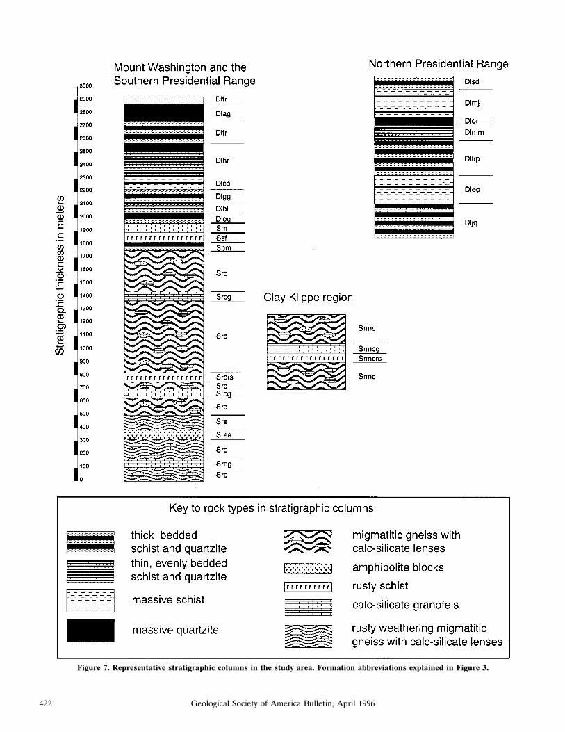
Figure 7. Representative stratigraphic columns in the study area. Formation abbreviations explained in Figure 3.
422 Geological Society of America Bulletin, April 1996

,5% of the unit, with layers up to 5 cm inthickness. These beds are generally weaklymagnetic due to the presence of pyrrhotite.No graded beds are found. Total thicknessof the formation varies between 10 and 50m. The contact between the Smalls Falls andMadrid Formations is gradational over
about 10 m: the rusty schist giving way toprogressively less rusty weathering, schis-tose granofels, and then ultimately to non-rusty granofels of the Madrid.Perry Mountain Formation. The Perry
Mountain Formation is a dark gray schistwith interbedded light gray to white
quartzites that are commonly 4–10 cm inthickness. Quartzites make up 30% to40% of the unit and can be up to 60 cmthick. The contact between the SmallsFalls and Perry Mountain is abrupt. Theunit is discontinuous ranging between 0and 75 m in thickness. It is only exposed in
A
C
Figure 8. Photographs of the principal lithologic variationsin the Littleton Formation. A. Massive pseudo-andalusiteschist, L1 and S1 well developed. B. Thin, rhythmically beddedschist and quartzite. C. Well-bedded, poorly graded schist andquartzite. D. Thickly bedded schist and quartzite showing aninverted graded bed. E. Thick, massive quartzites with thinschist beds showing an inverted graded bed.
B
D
E
STRATIGRAPHY AND STRUCTURE OF THE PRESIDENTIAL RANGE
423Geological Society of America Bulletin, April 1996

the Tuckerman Ravine and Boott Spurregion.Rangeley Formation. The Rangeley For-
mation is a gray migmatitic paragneiss withabundant calc-silicate lenses. Angular tosubrounded quartz and/or feldspar segrega-tions (clasts?) between 2 and 8 cm in diam-eter are common. Elongate, rectangular
lenses (clasts?), 0.5–2 m–long, of well-bed-ded calc-silicate granofels, and ellipsoidallenses (clasts?), 10–50 cm long, of concen-trically mineralogically zoned calc-silicategranofels without bedding are commonthroughout the Rangeley. A few beds ofschist and quartzite are sometimes pre-served, having escaped migmatization, and
in these rare locations no graded bedding isfound. In places, the gneiss is extensively in-jected by pegmatites, aplites, and granite.The calc-silicate lenses are most oftenaligned parallel to schistosity, but some areat slight angles or, in the extreme, perpen-dicular to schistosity. Figures 9A and 9Bshow two examples of calc-silicate lenses in
A
C
Figure 9. Photographs of olistostromal facies in the Range-ley Formation. A. Rectangular, well-bedded calc-silicategranofels lens in migmatite. B. Ellipsoidal, concentrically zonedcalc-silicate lens in migmatite. C. Nonmigmatized olistostromalfacies. D. Complete disaggregation in nonmigmatized facies;pelitic clasts in psammitic matrix. E. Complete disaggregationin nonmigmatized facies; psammitic clasts in pelitic matrix.
B
D
E
EUSDEN ET AL.
424 Geological Society of America Bulletin, April 1996

outcrop. The Rangeley Formation has beensubdivided into three different members andsix submembers based on lithologic varia-tions in the gneiss and subordinate units ofrusty gneiss, rusty schist, calc-silicate grano-fels, and amphibolite. Because the Rangeleyis devoid of graded beds throughout thePresidential Range, stratigraphic order isbased on the uninterrupted juxtaposition ofthe younger Smalls Falls, Madrid, andLittleton Formations. Where this juxtaposi-tion is not available, as is the case for theClay klippe, the internal stratigraphic orderof the Rangeley is indeterminate. The con-tact with the Perry Mountain is gradational,marked by the first appearance of calc-sili-cate lenses. The contact with the SmallsFalls, when the Perry Mountain is missing, isabrupt.The southeast-facing, unnamed cirque be-
tween Mounts Franklin and Monroe has ex-posures of nonmigmatized Crawford Mem-ber of the Rangeley Formation. It is shownin Figure 3 enclosed by a dashed line withgray teeth on the migmatized side. Thisboundary represents amigmatite front, with-in which are nonmigmatized, intact beds ofschist, quartzite, and calc-silicate of theCrawford Member that gradually disaggre-gate and become separated into isolatedblocks within a pelitic matrix. Some areasalso show a psammitic matrix with peliticblocks. Figures 9C, 9D, and 9E show out-crop photographs of the broken formation.The blocks within the nonmigmatized zonehave sharp, angular edges. Bedding in thecalc-silicates is truncated by the matrix.Stratigraphic Summary. The northern
Presidential Range consists entirely of theLittleton Formation and has been subdi-vided into seven members and two submem-bers (Fig. 7). The total minimum thickness is;1250 m. The Clay klippe consists entirelyof the Rangeley Formation. The total min-imum thickness is ;550 m. One memberand two submembers are recognized in thisdomain. The stratigraphic order is uncertaindue to lack of graded beds. Figure 7 showsthe stratigraphic column of this domain ar-ranged from the structurally highest to low-est. The Mount Washington area and thesouthern Presidential Range are stratigraph-ically connected (Fig. 7) and consist of theLittleton Formation (subdivided into eightmembers and one submember), the MadridFormation, the Smalls Falls Formation, thePerry Mountain Formation, and the Range-ley Formation (subdivided into two mem-bers and four submembers). The total min-imum thickness is ;2900 m. Because the
Northern Presidential Range is separatedfrom the Mount Washington area by theClay klippe, it is impossible to correlatethese two sections of the LittletonFormation.
Structural Geology
General Statement. The alpine zone ofthe Presidential Range preserves threephases of ductile folding (F1, F2, and F3)and a single phase of thrust faulting (T1).An analysis of the brittle structures, consist-ing of abundant joints and rare, brittle, nor-mal faults with negligible offset, was notdone for this study. The phases of foldingand the thrust faulting are treated as dis-crete, distinct phases of deformation, eachwith a unique set of fabrics or geometriccharacteristics. This method of data presen-tation does not rule out the possibility thatthe phases of folding and faulting may rep-resent a continuum of deformation that wastime transgressive. The sequence of defor-mations will be discussed from oldest toyoungest.D1 Deformation. According to field ob-
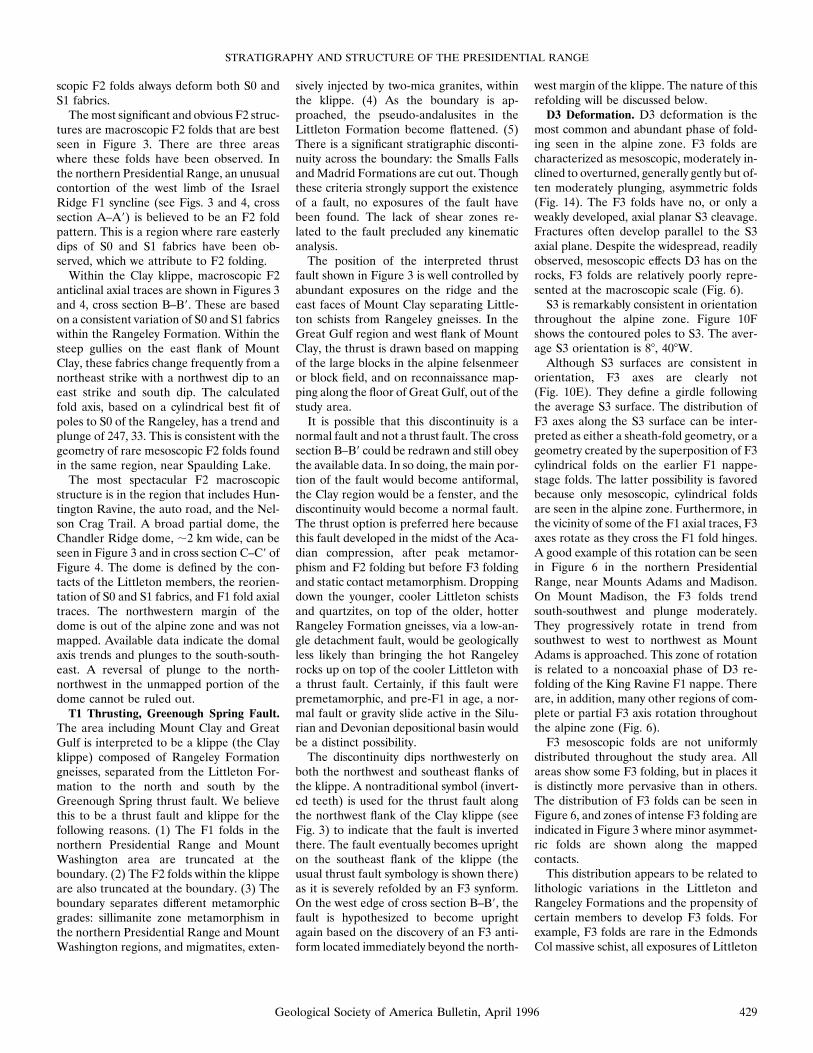
servations, the first phase of deformation ischaracterized by reclined to recumbent, iso-clinal, similar, cylindrical F1 folds. Meso-scopic F1 folds have amplitudes of up to sev-eral meters and wavelengths of up to 10 m.Macroscopic F1 folds have amplitudes of;1 km, and wavelengths of up to 3 km (es-timates based on cross sections of Fig. 4).Five F1 anticlines or nappes have beenmapped: (1) the King Ravine nappe, (2) theEdmonds Col nappe, (3) the Mount Wash-ington nappe, (4) The Horn nappe, and (5)the Raymond Cataract nappe. Four F1 syn-clines have also been mapped: (1) theMount Madison syncline, (2) the IsraelRidge syncline, (3) the Mount Jefferson syn-cline, and (4) the Tuckerman Ravine syn-cline. These folds deform bedding, SO. Noearlier fabric (schistosity or cleavage) hasbeen observed to be folded by the F1 struc-tures. As a result, we are confident that theF1 folds represent the earliest phase of duc-tile deformation in the study area.The distribution of the F1 folds in each of
the geographic domains is unique. In thenorthern Presidential Range the five mac-roscopic F1 folds are shown as discrete axialtraces in Figure 3. An examination of crosssection A–A9 shows minor refolding of thesestructures without severe reorientation. NoF1 folds have been recognized in the Clayklippe. In the Mount Washington area, theTuckerman Ravine syncline has been se-
verely refolded. This is seen clearly in Fig-ure 3 and especially cross section C–C9. Thisfold is further complicated by a bifurcationin the vicinity of the Alpine Garden (Fig. 3).The main branch of the syncline trendssouth and a subsidiary branch trends east.At the bifurcation, the Raymond Cataractnappe intervenes and trends southeast. Thisunusual geometry represents one possiblesolution to the available data, which includefold facing directions, the locations of F1hinge zones, and topping indicators. Thesouthern Presidential Range is dominatedby the Mount Washington nappe. The axialtrace of this F1 nappe is drawn onthe basis of stratigraphic repetition with-in the migmatized Rangeley Formation andis the F1 fold with the least control.Bedding, as shown on the equal-area con-
toured poles to S0 of Figure 10A, has anaverage orientation of 1788, 348W. A cylin-drical best fit of the data yields a calculatedfold axis of 272, 29. This fold axis is similarto the orientations of many of the F1 and F3folds measured in the study area, suggestingthat S0 was considerably reoriented by bothD1 and D3.The axial surface schistosity of the F1
folds, S1, is defined by aligned muscovite,biotite, and sillimanite in the pelitic schistsand gneisses and by aligned biotite and ac-tinolite in the calc-silicates. S1 has an aver-age orientation of 1858, 368W (Fig. 10B).The similarity of this orientation to the av-erage orientation of S0 is evidence for theisoclinal nature of the F1 folds; S1 is parallelto S0 in the vast majority of outcrops mea-sured. A cylindrical best fit of the data yieldsa fold axis of 220, 23. This fold axis is similarto the orientations of the majority of F3hinges measured in the study area. It ap-pears that F3 folding is responsible for thepresent distribution of the S1 data.The locations of the F1 axial traces
(Fig. 3) are well constrained by multiple ex-posures of the F1 hinge zones. The only ex-ception to this is the Mount Washingtonnappe in the southern Presidential Range.All of the remaining F1 folds have a remark-ably consistent fabric geometry in the hingezones; the bedding, SO, is perpendicular, orat least, nonparallel to the axial planar schis-tosity, S1, of the folds. In these regions,joined strike and dip symbols (for S1 folia-tion and S0 bedding), indicative of outcropscontaining two nonparallel fabrics, are seen(Fig. 3). Figure 11 shows several outcropphotographs of F1 hinge zones. Within theF1 fold limbs, bedding, SO, is consistentlyparallel to the axial planar schistosity, S1,
STRATIGRAPHY AND STRUCTURE OF THE PRESIDENTIAL RANGE
425Geological Society of America Bulletin, April 1996

Figure 10. Equal area stereographic projections. (A) Contoured poles to bedding, S0. (B) Contoured poles to schistosity, S1. (C) L1pseudo-andalusite lineations. (D) F1 fold axes. (E) F3 fold axes. (F) Contoured poles to S3 axial plane cleavage. C.I., contour interval;n, number of samples.
426 Geological Society of America Bulletin, April 1996

Figure 11. Photographs of F1hinge zones in the Littleton For-mation showing the relationshipsbetween bedding (S0), foliation(S1), and facing direction (TOPS).A. The Horn nappe hinge zone. B.The Horn nappe closer to the F1limb. C. Tuckerman Ravine syn-cline hinge zone.
427Geological Society of America Bulletin, April 1996

and upright on the upright limb, and in-verted on the inverted limb.Mesoscopic F1 folds are only found in the
macroscopic F1 hinge zones, and, even inthese localities, mesoscopic folds are rare. InFigure 5 the few localities where they arefound are shown by double-lined arrow sym-bols. Figure 12 shows one of the rare F1mesoscopic folds in outcrop. There are nomesoscopic F1 folds in the F1 limbs. Theseobservations suggest that the ductility of theD1 phase of deformation was not greatenough for minor folds to develop within theF1 limbs and also not sufficient for abundantmesoscopic folds to develop in the macro-scopic hinges. This is in apparent contrast tothe majority of F1 recumbent nappe struc-tures in the Central Maine Terrane whereminor F1 folds are not restricted to the foldhinges.When the appropriate well-bedded schist
and quartzite lithologic units with gradedbedding are exposed in the hinge zones ofthe macroscopic F1 folds, facing directionsof the folds can be established. The facingdirection of the beds in these hinge zones isconsistently northeast, east, or southeast.Only in the region between the four-milepost on the Mount Washington Auto Roadand the Nelson Crag Trail at treeline arethere west- and southwest-facing F1 hingezones in the Tuckerman Ravine syncline.The asymmetry of the F1 folds, as typified
by the northern Presidential Range crosssection, A–A9, shows long, gently to moder-ately west-dipping upright limbs, and short,
moderately to steeply west-dipping invertedlimbs. This asymmetry, when linked with thepredominant easterly facing direction of theF1 hinge zone, strongly suggests that thevergence of these F1 structures was towardthe east. More specifically, F1 folds havenortheast, east, or southeast vergence. Weinterpret the west- and southwest-facing F1portions of the Tuckerman Ravine synclineto have been reoriented by the second phaseof folding, D2, which is discussed in moredetail below.Another fabric associated with F1 folds is
abundant L1 pseudo-andalusite lineations(Fig. 5). L1 lineations are restricted to the
Littleton Formation, and within the Little-ton Formation there exist members whereL1 is well developed and other memberswhere only lumpy, unaligned, pseudo-anda-lusites are found. Figure 13 shows a typicaloutcrop photograph of the L1 lineation.Most of the lineations are large, up to 10 cmlong, 0.5–1 cm in diameter, chiastolitic an-dalusite, replacedby sericite,muscovite, and/or sillimanite. A minority of lineations, prin-cipally in the Bigelow Lawn member of theLittleton in the vicinity of Lakes of theClouds Hut, are composed of smaller, 1–5cm long, no greater than 0.5 cm in diameter,aggregates of sericite, muscovite, and/or sil-limanite, replacing former andalusite. As norelict chiastolite crosses are seen in thesesmaller lineations, it is possible that theywere once sillimanite and not andalusite.The lineations define a girdle or lineation
plane that has an orientation of 88, 348W(Fig. 10C). The maximum along this linea-tion plane is oriented 231, 2; we interpretthis to be the average orientation of L1 inthe alpine zone. Whenever L1 lineations areobserved together with F1 fold axes, the twofabrics are parallel (see Figs. 5 and 10D). Assuch, the lineations are best classified as b-type lineations.D2 Deformation. The second phase of
folding is based on the map pattern (Fig. 3)and systematic variations in the attitude ofS0 and S1 fabrics. Only three mesoscopic F2fold hinges have been observed in the studyarea. The general style of folding is charac-terized by open, moderately to gently south-west- or south-plunging, moderately tosteeply inclined folds, without an axial pla-nar foliation. The mesoscopic and macro-
Figure 12. Photograph of recumbent F1 mesoscopic fold hinge in The Horn nappe hingezone, showing bedding (S0), foliation (S1), and facing direction (TOPS).
Figure 13. Photograph of L1 pseudo-andalusite coarse-grained lineations within massiveschist block.
EUSDEN ET AL.
428 Geological Society of America Bulletin, April 1996
scopic F2 folds always deform both S0 andS1 fabrics.Themost significant and obvious F2 struc-
tures are macroscopic F2 folds that are bestseen in Figure 3. There are three areaswhere these folds have been observed. Inthe northern Presidential Range, an unusualcontortion of the west limb of the IsraelRidge F1 syncline (see Figs. 3 and 4, crosssection A–A9) is believed to be an F2 foldpattern. This is a region where rare easterlydips of S0 and S1 fabrics have been ob-served, which we attribute to F2 folding.Within the Clay klippe, macroscopic F2
anticlinal axial traces are shown in Figures 3and 4, cross section B–B9. These are basedon a consistent variation of S0 and S1 fabricswithin the Rangeley Formation. Within thesteep gullies on the east flank of MountClay, these fabrics change frequently from anortheast strike with a northwest dip to aneast strike and south dip. The calculatedfold axis, based on a cylindrical best fit ofpoles to S0 of the Rangeley, has a trend andplunge of 247, 33. This is consistent with thegeometry of rare mesoscopic F2 folds foundin the same region, near Spaulding Lake.The most spectacular F2 macroscopic
structure is in the region that includes Hun-tington Ravine, the auto road, and the Nel-son Crag Trail. A broad partial dome, theChandler Ridge dome, ;2 km wide, can beseen in Figure 3 and in cross section C–C9 ofFigure 4. The dome is defined by the con-tacts of the Littleton members, the reorien-tation of S0 and S1 fabrics, and F1 fold axialtraces. The northwestern margin of thedome is out of the alpine zone and was notmapped. Available data indicate the domalaxis trends and plunges to the south-south-east. A reversal of plunge to the north-northwest in the unmapped portion of thedome cannot be ruled out.T1 Thrusting, Greenough Spring Fault.
The area including Mount Clay and GreatGulf is interpreted to be a klippe (the Clayklippe) composed of Rangeley Formationgneisses, separated from the Littleton For-mation to the north and south by theGreenough Spring thrust fault. We believethis to be a thrust fault and klippe for thefollowing reasons. (1) The F1 folds in thenorthern Presidential Range and MountWashington area are truncated at theboundary. (2) The F2 folds within the klippeare also truncated at the boundary. (3) Theboundary separates different metamorphicgrades: sillimanite zone metamorphism inthe northern Presidential Range and MountWashington regions, and migmatites, exten-
sively injected by two-mica granites, withinthe klippe. (4) As the boundary is ap-proached, the pseudo-andalusites in theLittleton Formation become flattened. (5)There is a significant stratigraphic disconti-nuity across the boundary: the Smalls FallsandMadrid Formations are cut out. Thoughthese criteria strongly support the existenceof a fault, no exposures of the fault havebeen found. The lack of shear zones re-lated to the fault precluded any kinematicanalysis.The position of the interpreted thrust
fault shown in Figure 3 is well controlled byabundant exposures on the ridge and theeast faces of Mount Clay separating Little-ton schists from Rangeley gneisses. In theGreat Gulf region and west flank of MountClay, the thrust is drawn based on mappingof the large blocks in the alpine felsenmeeror block field, and on reconnaissance map-ping along the floor of Great Gulf, out of thestudy area.It is possible that this discontinuity is a
normal fault and not a thrust fault. The crosssection B–B9 could be redrawn and still obeythe available data. In so doing, the main por-tion of the fault would become antiformal,the Clay region would be a fenster, and thediscontinuity would become a normal fault.The thrust option is preferred here becausethis fault developed in the midst of the Aca-dian compression, after peak metamor-phism and F2 folding but before F3 foldingand static contact metamorphism. Droppingdown the younger, cooler Littleton schistsand quartzites, on top of the older, hotterRangeley Formation gneisses, via a low-an-gle detachment fault, would be geologicallyless likely than bringing the hot Rangeleyrocks up on top of the cooler Littleton witha thrust fault. Certainly, if this fault werepremetamorphic, and pre-F1 in age, a nor-mal fault or gravity slide active in the Silu-rian and Devonian depositional basin wouldbe a distinct possibility.The discontinuity dips northwesterly on
both the northwest and southeast flanks ofthe klippe. A nontraditional symbol (invert-ed teeth) is used for the thrust fault alongthe northwest flank of the Clay klippe (seeFig. 3) to indicate that the fault is invertedthere. The fault eventually becomes uprighton the southeast flank of the klippe (theusual thrust fault symbology is shown there)as it is severely refolded by an F3 synform.On the west edge of cross section B–B9, thefault is hypothesized to become uprightagain based on the discovery of an F3 anti-form located immediately beyond the north-
west margin of the klippe. The nature of thisrefolding will be discussed below.D3 Deformation. D3 deformation is the
most common and abundant phase of fold-ing seen in the alpine zone. F3 folds arecharacterized as mesoscopic, moderately in-clined to overturned, generally gently but of-ten moderately plunging, asymmetric folds(Fig. 14). The F3 folds have no, or only aweakly developed, axial planar S3 cleavage.Fractures often develop parallel to the S3axial plane. Despite the widespread, readilyobserved, mesoscopic effects D3 has on therocks, F3 folds are relatively poorly repre-sented at the macroscopic scale (Fig. 6).S3 is remarkably consistent in orientation
throughout the alpine zone. Figure 10Fshows the contoured poles to S3. The aver-age S3 orientation is 88, 408W.Although S3 surfaces are consistent in
orientation, F3 axes are clearly not(Fig. 10E). They define a girdle followingthe average S3 surface. The distribution ofF3 axes along the S3 surface can be inter-preted as either a sheath-fold geometry, or ageometry created by the superposition of F3cylindrical folds on the earlier F1 nappe-stage folds. The latter possibility is favoredbecause only mesoscopic, cylindrical foldsare seen in the alpine zone. Furthermore, inthe vicinity of some of the F1 axial traces, F3axes rotate as they cross the F1 fold hinges.A good example of this rotation can be seenin Figure 6 in the northern PresidentialRange, near Mounts Adams and Madison.On Mount Madison, the F3 folds trendsouth-southwest and plunge moderately.They progressively rotate in trend fromsouthwest to west to northwest as MountAdams is approached. This zone of rotationis related to a noncoaxial phase of D3 re-folding of the King Ravine F1 nappe. Thereare, in addition, many other regions of com-plete or partial F3 axis rotation throughoutthe alpine zone (Fig. 6).F3 mesoscopic folds are not uniformly
distributed throughout the study area. Allareas show some F3 folding, but in places itis distinctly more pervasive than in others.The distribution of F3 folds can be seen inFigure 6, and zones of intense F3 folding areindicated in Figure 3 where minor asymmet-ric folds are shown along the mappedcontacts.This distribution appears to be related to
lithologic variations in the Littleton andRangeley Formations and the propensity ofcertain members to develop F3 folds. Forexample, F3 folds are rare in the EdmondsCol massive schist, all exposures of Littleton
STRATIGRAPHY AND STRUCTURE OF THE PRESIDENTIAL RANGE
429Geological Society of America Bulletin, April 1996

Formation massive quartzites, and theMounts Clay, Crawford, and Eisenhowermember migmatites. On the other hand, F3folds are superbly developed in the thinlybedded Mount Madison member, the pri-marily schistose Bigelow Lawn member thathas thin interbeds of quartzite, and thethinly laminated Crawford and Eisenhowercalc-silicate granofels members of theRangeley. It is interesting to note that theareas with well-developed F3 folds also havewell-developed L1 lineations. Though thesetwo fabrics developed at different times inthe structural sequence, the rheological na-ture of the bedrock where F3 folds and L1lineations are well developed must havebeen roughly the same.F3 folds typically have long, moderately
dipping west limbs and short, steeply dip-ping east limbs. In some instances, the eastlimbs are overturned. This asymmetry givesa west-over-east sense of rotation, a patternthat is seen in all F3 folds in the alpine zone.We interpret this rotation sense to be re-lated to the tectonic vergence of these folds.
Thus, D3 deformation, and the F3 folds cre-ated by it, is east vergent throughout the al-pine zone.Pegmatite and alpite veins, dikes, and sills
seen throughout the alpine zone are foldedby F3 (Fig. 14C). These small plutonicapophyses are presumably related to thelarger plutons mapped in the alpine zone.Therefore, these granitic rocks must havebeen emplaced prior to D3 deformation.There is a nonuniform distribution of
macroscopic F3 folds in the alpine zone. F3macroscopic folds are largely absent in thenorthern and southern Presidential Range,significantly affect the Clay klippe, and mod-erately affect the Chandler Ridge dome andTuckerman Ravine syncline in the MountWashington area (see Figs. 3 and 4).In the Clay klippe, an F3 synform folds
the Greenough Spring thrust fault and theklippe. The position of this axial trace is onlyloosely delimited, based entirely on themapped pattern of the fault and the inter-pretation that the fault is folded. The posi-tion of the macroscopic F3 antiform imme-
diately northwest of the klippe is onlyslightly better controlled. In this region(Sphinx Col, see Fig. 4) S1 fabrics show re-orientation that is consistent with folding byF3. Topping direction of graded beds is alsoconsistent with the refolding of the Ed-monds Col nappe as shown in cross sectionB–B9.In the Chandler Ridge dome, as seen in
cross section C–C9, an F3 antiform and syn-form wrinkle the crest of the dome. The lo-cations of the axial traces of these folds areentirely based on the mapped contact andconsistent variation in attitude of S0 and S1fabrics. The timing relationship between D3and the formation of the dome can bereadily observed in Figure 4. The D2 domepattern is clearly folded by the F3 folds.In the Bigelow Lawn region, some of the
mappattern (Fig. 3) is controlledbyF3meso-scopic folding. The isolated patches ofSmalls Falls andMadrid Formations and theGreat Gulf member occupy the core of anF3 synform and antiform respectively (seecross section D–D9).
A
Figure 14. Photographs of mesoscopic F3 folds. A. F3 foldin well-bedded schist and quartzite of the Littleton Formationon J. Q. Adams south face; isolated patch of snow on steep faceis about 10 3 10 m. B. F3 folds with characteristic west-over-east asymmetry, folding both bedding (S0) and foliation (S1);Cragway Spring on the Auto Road. C. F3 folds of an aplite sillinjected into Littleton Formation schists, below CragwaySpring.
B
C
EUSDEN ET AL.
430 Geological Society of America Bulletin, April 1996

Anomalous F3 folds with east-dipping ax-ial surfaces were found on the south side ofthe Mount Washington summit cone (seeFig. 4). The reason for the peculiar orien-tation of these F3 folds is not clear. Thoughthey have the same fold form as most F3folds, they record opposite asymmetry (eastover west). It is possible these are F3 foldsthat have been reoriented by a later phase ofdeformation. Alternatively these folds maydefine a region of relatively minor antitheticF3 folding. The latter interpretation isfavored.
DISCUSSION
Stratigraphic Correlationsand Implications
The metasedimentary rocks of the Presi-dential Range have been correlated to theSilurian and Devonian Central Maine Ter-rane cover sequence. Based on estimatesfrom the cross sections (Fig. 4), the maxi-mum total thickness of the highly strainedSilurian and Devonian metasedimentaryrocks in the alpine zone is in the range of3500 6 500 m (see also Fig. 7). The Range-ley is the thickest formation at;2000 m, butit must be even thicker, as the base is notobserved. Because bedding is only rarelypreserved in the Rangeley, this thickness isa structural not a stratigraphic thickness.The estimated total thickness of the PerryMountain, Smalls Falls, and Madrid Forma-tions is 175 m. The Littleton Formation is;1500 m thick, but it also must be thicker,as the top is not seen. Based on estimates ofthe Silurian marine basin geometry byMoench and Pankiwskyj (1988), the thick-nesses reported above would place the strat-igraphic section of the Presidential Rangeslightly seaward of the Silurian tectonichinge, the paleo-shelf-slope break.The depositional model of Moench and
Pankiwskyj (1988) would predict that Silu-rian conglomerates of the Rangeley Forma-tion would be at this position. No such rockshave been found in the Silurian of the Pres-idential Range. The discrepancy is probablydue to either overestimation of the Siluriansedimentary basin thickness by Moench andPankiwskyj (1988), underestimation by us,or regional facies variations in Siluriansedimentation.
Littleton Formation
On the basis of the differing lithologictypes, bedding characteristics, and facies
variations exhibited by the members of theLittleton Formation in the alpine zone, weinterpret these rocks to have formed as ma-rine turbidites in a slope/rise environment.Because turbidite facies transitions are rou-tinely documented in most marine sedimen-tary successions, it is extremely difficult tomake anything but ambiguous correlationsbetween the Littleton members that arephysically separated by the Clay klippe. His-torically, the Littleton has been divided intoa lower (massive schist) and upper (well-bedded schist and quartzite) members(Lyons et al., 1992). However, such a simplesubdivision is clearly not the case in thePresidential Range. As seen in Figure 7,abundant quartzites and well-bedded unitsare generally well distributed throughoutthe stratigraphic column.
Madrid, Smalls Falls, and PerryMountain Formations
The relatively thin 20–100 m total thick-ness of Madrid and Smalls Falls Formationsin the alpine zone is likely due to the prox-imity of this region to the Silurian tectonichinge. The depositional setting for these twoformations has been well described byMoench and Pankiwskyj (1988). They envi-sion a euxinic basin with a reducing envi-ronment as the site of Smalls Falls deposi-tion. This was followed by an abrupt changemarked by the arrival of the calc-silicategranofels (more oxygenated, ‘‘energetic’’clastic rocks) of the Madrid Formation. Inthe Presidential Range only the lower, thinlybedded, calcareous clastic rocks were depos-ited; an upper, thick-bedded, slightly calcar-eous sandstone member is identified byMoench and Pankiwskyj (1988) in westernMaine. The thin or absent section of thePerry Mountain Formation in the Presiden-tial Range suggests incomplete depositionof this formation in the study area, consist-ent with the location near the tectonic hinge.
Rangeley Formation
The calc-silicate lenses in the Rangeleycan be broadly characterized as mappableunits of rock fragments enveloped by a mud-stone-rich rock which has been metamor-phosed into a gneiss. The lithologic descrip-tion of the Rangeley corresponds with theType I melange defined by Cowan (1985),what Hsu (1968) terms a broken formation,and which are analogous to Rast and Hor-ton’s (1989) olistostromal melange. Thistype of rock-stratigraphic unit displays lay-
er-parallel extension with progressive frag-mentation of intact sandstone turbiditebeds. In the southeast-facing, unnamed cir-que between Mounts Franklin and Monroe(Fig. 3), exposures of nonmigmatized Craw-ford member show the beginning stages ofdisruption where intact schist, quartzite, andcalc-silicate layers are preserved. The stifflayers gradually become fragmented andthen completely broken and isolated (seeFigs. 9C–9E). The same process can be in-voked for the migmatized Rangeley, whereevidence for severe disruption is manifest byisolated calc-silicate lenses, containing well-preserved bedding, surrounded by gneisses(see Fig. 9A).The Eisenhower member amphibolites of
the Rangeley Formation consist of exoticblocks incorporated into the gneisses, per-haps by one of the following mechanisms:(1) a diapiric melange (Orange, 1990) bring-ing the blocks up through the stratigraphyfrom the underlying Ordovician Ammo-noosuc volcanics; (2) the intrusion of a smallbasalt flow or sill through the gneisses andits subsequent breakup; or (3) the incorpo-ration of Ammonoosuc volcanics from chan-nel walls during rapid turbidite deposition.Regardless of the mechanism invoked, thepresence of exotic blocks is consistent withthe interpretation that the Rangeley Forma-tion is an olistostromal melange (Cowan,1985; Hsu, 1968; Orange, 1980; Lash, 1987).We also believe that the wispy biotite-rich
schist layers and quartz- and feldspar-richlayers of the gneisses are the migmatizedequivalent of the olistostromal, nonmigma-tized outcrops shown in Figures 9D and 9E.With the exception of the rare outcropswhere intact bedding is preserved in theRangeley, we interpret all of the Rangeleymapped in the Presidential Range to be ametamorphosed, variably migmatized, olis-tostromal melange.One possible tectonic process responsible
for the Rangeley olistostromal melange issubduction related to the closure of the Kro-nos ocean. The sediments were deposited ona shelf/slope transition of an accretionarycomplex. The slope became unstable due tothrusting, earthquakes, and/or other dis-turbing mass movements associated withplatemovements acting as a triggeringmech-anism. Alternatively, the Rangeley olisto-stromal melange may be a result of regionalextension in the Early Silurian as the Cen-tral Maine Terrane basin developed. Mar-vinney et al. (1992) suggested that the meta-sedimentary and volcanic rocks of northernNew Hampshire in the Second Lake rift,
STRATIGRAPHY AND STRUCTURE OF THE PRESIDENTIAL RANGE
431Geological Society of America Bulletin, April 1996

which include the Silurian Rangeley throughMadrid and Frontenac Formations, weredeposited in an extensional sub-basin (theSecond Lake rift) northwest of the BronsonHill Anticlinorium. It could be argued thatthe Rangeley Formation olistostromes inthe Presidential Range were formed simi-larly. However, we propose that the exten-sion in the Second Lake rift was in a back-arc basin to the Bronson Hill arc and thatthe Rangeley Formation olistostromes inthe Presidential Range, southeast of theBronson Hill, were part of a fore-arc/accre-tionary wedge sequence associated with awest-dipping subducting slab.
The interpretation of the Rangeley For-mation as an olistostromal melange may ex-tend well beyond the Presidential Range.Figure 15 shows areas in New Hampshireand a small portion of Maine within whichmigmatized Rangeley Formation with calc-silicate lenses has been mapped. The areashown is the broadest possible outline ofwhat may be a regionally significant zoneof highly metamorphosed olistostromalmelange.The existence of a region of large-scale
stratal disruption, possibly linked to an ac-tively subducting margin, provides criticaltectonic constraints for the Acadian oroge-
ny. Though we cannot rule out the possibil-ity that these olistostromal facies wereformed in an extensional setting, we suggestthey were formed in a west-dipping subduc-tion system located against the east marginof the Bronson Hill Anticlinorium. Further-more, we contend that the lack of olistostro-mal facies in the remaining Silurian Forma-tions and all of the Littleton Formation inNew Hampshire suggests that this subduc-tion system became less active as the enor-mous volume of clastic sediment derivedfrom the Avalon continent overwhelmed it.This model is considerably different fromthat proposed by Hanson and Bradley
Figure 15. Region within which migmatitic Rangeley Formation with calc-silicate lenses is found in New Hampshire and Maine. Thisregion is interpreted to be a highly metamorphosed olistostrome. Sources of information: Eusden and Lyons, 1993; Lyons et al., 1993;Moench and Pankiwskyj, 1988; and J. D. Eusden and J. B. Lyons, unpub. mapping.
EUSDEN ET AL.
432 Geological Society of America Bulletin, April 1996

(1989) for the late Silurian to early Devo-nian in Maine, in which much of the Madridand Carrabassett (correlative to the lowerLittleton in New Hampshire) consist of dis-rupted strata that they relate to an accre-tionary complex in front of Avalon.
Structural Geology
The sequence of ductile structures ob-served in the Presidential Range moreclosely matches the structural models ofEusden and Lyons (1993) and Robinson etal. (1991) in New Hampshire and Massa-chusetts than the structural model ofMoench and Pankiwskyj (1988) in westernMaine. Apparently structures related to theemplacement of Devonian plutons (Moenchand Pankiwskyj, 1988) do not extend westinto the Presidential Range. The transitionbetween the regime of nappe-dominated de-formation and that of deformation causedby plutons must be east of the PresidentialRange in the vicinity of the Maine–NewHampshire border.
D1
The interpreted east vergence of D1nappes suggests several things: (1) the dor-sal zone model (Eusden and Lyons, 1993)should be restricted to central New Hamp-shire, and the Central New Hampshire an-ticlinorium dies out south of the WhiteMountain batholith; (2) the model callingfor west-directed thrust nappes that arebackfolded and domed adjacent to theBronson Hill Anticlinorium (Robinson etal., 1991) should be restricted to the south-western portion of the Central Maine Ter-rane; and (3) a revised regional model forAcadian deformations is needed to accountfor the D1 deformation in the PresidentialRange as well the structural transitionsalong the length of the Central MaineTerrane.It appears likely that the D1 nappes along
the length of the Bronson Hill Anticlino-rium recorded both east and west vergence.In such a geometry, the Massachusetts andsouthern New Hampshire portion of theCentral Maine Terrane would record westvergence of D1 nappes, whereas the CentralMaine Terrane in northern New Hampshirerecords east vergence of the same genera-tion of structures.This hypothetical transition in structural
vergence along the Bronson Hill east flankmay be associated with the variation incrustal depths throughout the Central
Maine Terrane with deeper levels exposedin southern New England and shallower lev-els in the north (Tracy and Robinson, 1980;Robinson et al., 1989). The west-vergingnappes may be structurally below the east-verging ones as previously speculated byBradley (1983).Another possibility is that the change in
strike of the Bronson Hill Anticlinoriumfrom N108E in southern and central NewHampshire to N508E in northern NewHampshire may have controlled the direc-tions of nappe vergence. The Bronson Hillprobably acted as a rigid buttress during thecollision of the North American and Avalo-nian plates. Nappe vergence was likely de-pendent on the complex interactions be-tween the directions of plate movementsand the orientation of the buttress.On the basis of the premise that primary
fold-thrust vergence in collisional zones isgenerally opposite that of the dip of the sub-ducting slab, we speculate that the easterlyvergence of F1 nappes indicates that thesubduction system along the western edge ofthe Central Maine Terrane was dipping tothe west under the Bronson Hill Anticlino-rium. One could alternatively argue thatthese nappes are east-verging backfolds an-tithetic to the principal west direction of ver-gence that was linked to an east-dipping sub-duction zone under the Avalon margin (seediscussions by Osberg et al., 1989). How-ever, the point is moot because one couldargue equally well that the west-vergingnappes are antithetic to the principal eastdirection of vergence. Because of both struc-tural and sedimentological evidence, we fa-vor the interpretation that the Acadian tec-tonic architecture involved a west-dippingsubducting system on the east flank of theBronson Hill Anticlinorium.
D2
In comparison to the regional models ofdeformation in the Central Maine Terrane,the second phase of deformation in thePresidential Range is quite unusual. It ispoorly represented mesoscopically, yet itsignificantly affects the macroscopic mappattern, but only in the Clay klippe andChandler Ridge dome. Furthermore, thereare no D2 fabrics, lineations, or foliationsdeveloped in the rocks. We can only spec-ulate that these structures may be related toa collapse of the nappe pile after D1 defor-mation and peak metamorphism.
T1
Because the Greenough Spring thrustfault developed after D1 and D2 deforma-tion and after peak metamorphism, it isunlike any other faults identified in theCentral Maine Terrane. Generally thefaults fall into two categories. There arepremetamorphic faults chiefly recognizedin western Maine, for example, the Plum-bago Mountain and Hill 2808 faults(Moench and Pankiwskyj, 1988) and theFoster Hill sole fault of the Piermont al-lochthon (Moench, 1990). There are alsosynmetamorphic faults chiefly recognizedin southern New Hampshire that devel-oped during nappe-stage folding, for ex-ample, the Chesham Pond and BrennanHill thrusts of Robinson et al. (1991).Transport direction of the Greenough
Spring thrust is equivocal. In cross sectionB–B9 it is shown with northwest-directedtransport. This is based on the presence ofmigmatized Rangeley Formation in Pink-ham Notch, immediately to the east of theklippe. Allen (1992) has mapped a thrustfault there that cuts F1 and F2 fold struc-tures and is controlled by the migmatites. Asthe timing of this faulting is essentially thesame as that for the Greenough Springthrust, these may be of the same generation.We speculate that the Greenough Springfault represents a phase of backthrusting inthe west-dipping subduction system alongthe Bronson Hill Anticlinorium followingthe collapse of the nappe pile.
D3
The final phase of ductile folding in thePresidential Range, D3, is similar to mostfinal phases of folding described for theCentral Maine Terrane. There is agreementin style of folding, orientation, and vergencewith the last phases of deformation pro-posed by Robinson et al. (1991), Eusden andLyons (1993), and us. These folds developedduring the waning stages of regional meta-morphism when P-T conditions were suchthat only a weak axial planar cleavage de-veloped. Because these folds also deformtwo-mica granite sills in the PresidentialRange, they postdate the earliest phases ofgranite plutonism.We interpret the east ver-gence of D3 to be representative of the finalpulse of Acadian convergence as Avalon un-derplated North America.
STRATIGRAPHY AND STRUCTURE OF THE PRESIDENTIAL RANGE
433Geological Society of America Bulletin, April 1996

SUMMARY
Geologic mapping of the PresidentialRange, perhaps the most well exposed
mountain range in the Appalachian orogen-ic belt, has revealed a complex stratigraphicsection and a complex sequence of ductilestructural events. These observations pro-
vide for new insights into Acadian tectonismin a critical region between well-studied re-gions in southern New Hampshire and west-ern Maine. Figures 16 and 17 present the
Figure 16. Schematic portrayal of the sequence of tectonic events in the alpine zone of Presidential Range. (A) Rangeley deposition;(B) Rangeley disruption; (C) Perry Mountain, Smalls Falls, Madrid, and Littleton deposition; (D) D1 nappe stage folding; (E) D2 collapseof nappe pile; (F) T1 Greenough Spring thrust fault; (G) D3 final pulse of Acadian folding. Patterns: random dashes, Bronson Hillbasement; crosses, Avalonian basement; black, Kronos crust; dot with radial dashes in B, triggering seismic event to disrupt Rangeley.All sections are oriented west (left) to east (right).
EUSDEN ET AL.
434 Geological Society of America Bulletin, April 1996

proposed sequence of sedimentation, struc-tural events, and metamorphic and plutonicevents in the alpine zone of the PresidentialRange. Estimates for the timing of peakmet-amorphism range from 390 to 360 Ma asdelimited by geochronology done in NewHampshire and Maine by Eusden and Bar-reiro (1989) and Smith and Barreiro (1990),respectively. The ages of middle to late Aca-dian two-mica granites, part of the ConcordGroup, are between 380 and 320 Ma (Lyonset al., 1982; Harrison et al., 1987; Lyons etal., 1992; Osberg et al., 1989).The sedimentology gleaned from these
highly metamorphosed rocks and the pre-served ductile structures suggest tectonismin a convergent plate setting with a west-dipping subduction zone beneath the eastflank of the Bronson Hill Anticlinorium.The absence of critical lithotectonic facies,missing perhaps because of the natural va-garies of tectonic processes and preserva-tion in the rock record, motivated us to re-construct the Acadian through an analysis ofthe sedimentation and ductile deformation.Muchmore work is needed to continue piec-ing the Acadian tectonic puzzle together.Our stratigraphic and structural approachwould be improved by fully incorporating ig-neous and metamorphic petrology and de-tailed geochronology.
ACKNOWLEDGMENTS
We thank Bradford Washburn, HowardWeans, Kenneth Kimball, Walter Graff,Bruce Hill, and the hut crews and caretakersof Appalachian Mountain Club and Ran-dolph Mountain Club huts for offering in-sight, advice, and/or assistance during theproject. We thank Edward C. Beutner, Wal-lace A. Bothner, Dwight C. Bradley, John B.Lyons, and an anonymous reviewer for pro-viding critical reviews of the manuscript.Supported by American Chemical Society–Petroleum Research Fund grant 24269-B2,National Science Foundation grant EAR-9105390, and various Bates College grantsto Eusden. Many thanks to Rick Allmendin-ger for creating and distributing Stereonetversion 4.7.
REFERENCES CITED
Allen, T., 1992, Migmatite systematics and geology, CarterDome—Wild River region, White Mountains, New Hamp-shire [Ph.D. thesis]: Hanover, New Hampshire, DartmouthCollege, 249 p.
AMC, 1988, AMC guide to Mount Washington and the Presiden-tial Range (fourth edition): Boston, Massachusetts, Appa-lachian Mountain Club, 219 p.
Barreiro, B., and Aleinikoff, J. N., 1985, Sm-Nd and U-Pb isotopicrelationships in the Kinsman quartz monzonite, NewHamp-shire: Geological Society of America Abstracts with Pro-grams, v. 17, no. 1, p. 3.
Berry, H. N., IV, and Osberg, P. H., 1989, A stratigraphic synthesisof eastern Maine and western New Brunswick, in Tucker,R. D., andMarvinney, R. G., eds., Studies in Maine geology:Maine Geological Survey, v. 2, p. 1–32.
Billings, M. P., 1941, Structure and metamorphism in the Mount
Washington area, New Hampshire: Geological Society ofAmerica Bulletin, v. 52, p. 863–936.
Billings, M. P., 1956, Bedrock geology: Geology of New Hamp-shire, Part 2: Concord, New Hampshire State Planning andDevelopment Commission, 203 p.
Billings, M. P., and Fowler-Billings, K., 1975, The geology of theGorham quadrangle, New Hampshire and Maine: Concord,State of New Hampshire Department of Resources andEconomic Development, Bulletin 6, 120 p.
Billings, M. P., Chapman, C. A., Chapman, R. W., Fowler-Billings,K., and Loomis, F. B., 1946, Geology of the Mount Wash-ington quadrangle, New Hampshire: Geological Society ofAmerica Bulletin, v. 57, p. 261–273.
Billings, M. P., Fowler-Billings, K., Chapman, C. A., Chapman,R. W., and Goldthwait, R. P., 1979, The geology of theMount Washington quadrangle, New Hampshire: Concord,State of New Hampshire Department of Resources andEconomic Development, 56 p.
Bothner, W. A., Gaudette, H. E., Fargo, T. G., Bowring, S. A., andIsachsen, C. E., 1993, Zircon and sphene U/Pb ages of theExeter Pluton: Constraints on the Merrimack Group andpart of the Avalon Composite Terrane: Geological Societyof America Abstracts with Program, v. 25, no. 6, p. A-485.
Bradley, D. C., 1983, Tectonics of the Acadian orogeny in NewEngland and adjacent Canada: Journal of Geology, v. 91,p. 381–400.
Bradley, D. C., and Hanson, L. S., 1989, Turbidites and melangesof the Madrid Formation, central Maine, in Berry, A. W.,Jr., ed., New England Intercollegiate Geological Confer-ence guidebook for field trips in southern and west-centralMaine: Farmington, University of Maine, p. 183–199.
Carmichael, D. M., 1978, Metamorphic bathozones and batho-grads: A measure of the depth of post-metamorphic upliftand erosion on the regional scale: American Journal of Sci-ence, v. 278, p. 769–797.
Chamberlain, C. P., and England, P. C., 1985, The Acadian ther-mal history of the Merrimack Synclinorium in New Hamp-shire: Journal of Geology, v. 93, p. 593–602.
Chamberlain, C. P., and Lyons, J. B., 1983, Pressure, temperatureand metamorphic zonation studies of pelitic schists in theMerrimack Synclinorium, south central New Hampshire:American Mineralogist, v. 68, p. 530–540.
Chamberlain, C. P., and Robinson, P., eds., 1989, Styles of met-amorphism with depth in the Central Acadian High, NewEngland: Amherst, University of Massachusetts, Depart-ment of Geology and Geography, Contribution Number 63,82 p.
Chamberlain, C. P., and Rumble, D., 1988, Thermal anomalies ina regional metamorphic terrane: An isotopic study of therole of fluids: Journal of Petrology, v. 29, p. 1215–1232.
Chamberlain, C. P., and Sonder, L. J., 1990, Heat producing ele-
Figure 17. Sequence of depositional, deformational, metamorphic, and plutonic events in the Presidential Range.
STRATIGRAPHY AND STRUCTURE OF THE PRESIDENTIAL RANGE
435Geological Society of America Bulletin, April 1996

ments and the thermal and baric patterns of metamorphicbelts: Science, v. 250, p. 763–769.
Clark, R. G., and Lyons, J. B., 1986, Petrogenesis of the Kinsmanintrusive suite peraluminous granitoids of western NewHampshire: Journal of Petrology, v. 27, p. 1365–1393.
Cowan, D. S., 1985, Structural styles in Mesozoic and Cenozoicmelanges in the western Cordillera of North America: Ge-ological Society of America Bulletin, v. 96, p. 451–462.
DeYoreo, J. J., Lux, D. R., Guidotti, C. V., Decker, E. R., andOsberg, P. H., 1989, The Acadian thermal history of westernMaine: Journal of Metamorphic Geology, v. 7, p. 169–190.
Duke, E. F., 1978, Petrology of the Spaulding Group tonalites,Penacook quadrangle, New Hampshire [Master’s thesis]:Hanover, New Hampshire, Dartmouth College, 117 p.
Eusden, J. D., Jr., 1988, Stratigraphy, structure andmetamorphismof the ‘‘dorsal zone,’’ central New Hampshire, in Bothner,W. A., ed., New England Intercollegiate Geological Con-ference, 80th Annual Meeting; Guidebook for field trips insouthwestern New Hampshire, southeastern Vermont, andnorth-central Massachusetts: Durham, University of NewHampshire, p. 40–59.
Eusden, J. D., Jr., and Barreiro, B. A., 1988, The timing of peakhigh-grade metamorphism in central-eastern New England:Maritime Sediments and Atlantic Geology, v. 24, p. 241–255.
Eusden, J. D., Jr., and Lyons, J. B., 1993, The sequence of Acadiandeformations in central New Hampshire, in Roy, D. C., andSkehan, J. W., eds., The Acadian orogeny: Recent studies inNew England, Maritime Canada and the autochthonousforeland: Geological Society of America Special Paper 275,p. 51–66.
Eusden, J. D., Jr., Bothner, W. A., and Hussey, A. M., 1987, TheKearsarge–Central Maine Synclinorium of southeasternNewHampshire and southwesternMaine: Stratigraphic andstructural relations of an inverted section: American Journalof Science, v. 287, p. 242–264.
Fowler-Billings, K., 1944, Igneous and metasedimentary dikes ofthe Mt. Washington area: Geological Society of AmericaBulletin, v. 55, p. 1255–1278.
Guidotti, C. V., 1989, Metamorphism in Maine: An overview, inTucker, R. D., and Marvinney, R. G., eds., Igneous andmetamorphic geology: Augusta, Maine Geological Survey,Studies in Maine Geology, v. 3, p. 1–17.
Guthrie, G. D., and Burnham, C. W., 1985, Petrology and originof calc-silicate bodies from the Rangeley Formation, NewHampshire: Geological Society of America Abstracts withPrograms, v. 17, no. 1, p. A-22.
Hanson, L. S., and Bradley, D. C., 1989, Sedimentary facies andtectonic interpretation of the Lower Devonian CarrabassettFormation, North-Central Maine, in Tucker, R. D., andMarvinney, R. G., eds., Studies in Maine geology: Augusta,Maine Geological Survey, v. 2, p. 101–126.
Hanson, L. S., and Bradley, D. C., 1993, Late Silurian to EarlyDevonian paleogeography of the Kearsarge–Central MaineBasin revealed by paleocurrents and sedimentary facies: Ge-ological Society of America Abstracts with Programs, v. 25,no. 6, p. A-360.
Harrison, T. M., Aleinikoff, J. N., and Compston, W., 1987, Ob-servations and controls on the occurrence of inherited zir-con in Concord-type granitoids, New Hampshire: Geo-chimica et Cosmochimica Acta, v. 51, p. 2549–2558.
Hatch, N. L., Jr., and Moench, R. H., 1984, Bedrock geologic mapof the wilderness and roadless areas of the White MountainNational Forest, Coos, Carroll, and Grafton Counties, NewHampshire: U.S. Geological Survey Miscellaneous FieldStudies Map 1594-a, scale 1: 250 000.
Hatch, N. L., Jr., and Wall, E. R., 1986, Stratigraphy and meta-morphism of the Silurian and Lower Devonian rocks of thewestern part of the Merrimack synclinorium, PinkhamNotch area, east-central New Hampshire, in Newberg,D. W., ed., New England Intercollegiate Geological Con-ference, 78th Annual Meeting; Guidebook for field trips insouthwestern Maine: Durham, University of New Hamp-shire, p. 138–163.
Hatch, N. L., Moench, R. H., and Lyons, J. B., 1983, Silurian–Lower Devonian stratigraphy of eastern and south central
New Hampshire: American Journal of Science, v. 283,p. 739–761.
Henderson, D. M., 1949, Geology and petrology of the easternpart of the Crawford Notch Quadrangle, Hew Hampshire[Ph.D. thesis]: Cambridge, Massachusetts, Harvard Univer-sity, 128 p.
Henderson, D. M., Billings, M. P., Creasy, J., and Wood, S. A.,1977, Geology of the Crawford Notch quadrangle, NewHampshire: Concord, State of New Hampshire Departmentof Resources and Economic Development, 29 p.
Hitchcock, C. H., 1874–1878, Geology of New Hampshire: Vol-ume 1, 1874; Volume 2, 1877; Volume 3, 1878; atlas 1878,Concord, New Hampshire.
Hsu, K. J., 1968, Principles of melanges and their bearing on theFranciscan-Knoxville paradox: Geological Society of Amer-ica Bulletin, v. 79, p. 1063–1074.
Kilbourne, F. W., 1978, Chronicles of the White Mountains:Bowie, Maryland, Heritage Books, 437 p.
Lash, G. G., 1987, Diverse melanges of an ancient subductioncomplex: Geology, v. 15, p. 652–655.
Lathrop, A. S., Blum, J. D., and Chamberlain, C. P., 1993, Nd-Srisotopic study of Acadian metasediments and granitoidsfrom New England: Provenance and evidence for anatexis:Geological Society of America Abstracts with Programs,v. 25, no. 6, p. A-42.
Lux, D. R., DeYoreo, J. J., Guidotti, C. V., and Decker, E. R.,1986, The role of plutonism in low-pressure metamorphicbelt formation: Nature, v. 323, p. 794–797.
Lyons, J. B., and Livingston, D. E., 1977, Rb-Sr age of New Hamp-shire Plutonic Series: Geological Society of America Bulle-tin, v. 88, p. 1808–1812.
Lyons, J. B., Boudette, E. L., and Aleinikoff, J. N., 1982, TheAvalonian and Gander zones in central eastern New En-gland, in St. Julien, P., and Beland, J., ed., Major structuralzones and faults of the northern Appalachians: GeologicalAssociation of Canada Special Paper 24, p. 44–66.
Lyons, J. B., Bothner, W. A., Moench, R. H., and Thompson, J. B.,1992, Bedrock geologic map of New Hampshire: Concord,State of New Hampshire Department of EnvironmentalServices Open-File Report.
Marvinney, R. G., Bothner, W. A., Moench, R. H., and Pollack,S. G., 1994, Silurian stratigraphic succession of northern NHand western ME: Evidence for extensional sub-basin devel-opment: Geological Society of America Abstracts with Pro-grams, v. 26, p. 59.
Moench, R. H., 1971, Geologic maps of the Rangeley and Phillipsquadrangles, Franklin and Oxford Counties, Maine: U.S.Geological Survey Miscellaneous Geologic InvestigationsMap I-605, scale 1:62 500.
Moench, R. H., 1990, The Piermont allochthon, northern Con-necticut valley area, New England—Preliminary descriptionand resource implications, in Slack, J. F., ed., Summary re-sults of the Glens Falls CUSMAP Project, New York, Ver-mont, and New Hampshire: U.S. Geological Survey Bulle-tin 1887, p. J1–J23.
Moench, R. H., and Pankiwskyj, K. A., 1988, Geologic map ofwestern interior Maine: U.S. Geological Survey Miscella-neous Investigations Map I-1692, scale 1:250 000.
Naylor, R. S., 1971, The Acadian orogeny: An abrupt and briefevent: Science, v. 172, p. 558–560.
Nielson, D. L., Clark, R. G., Lyons, J. B., Englund, E. J., andBorns, D. J., 1976, Gravity models and mode of emplace-ment of the New Hampshire Plutonic Series: GeologicalSociety of America Memoir 146, p. 301–318.
Orange, D. L., 1990, Criteria helpful in recognizing shear-zone anddiapiric melanges: Examples from the Hoh accretionarycomplex, Olympic Peninsula, Washington: Geological Soci-ety of America Bulletin, v. 102, no. 7, p. 935–951.
Osberg, P. H., Hussey, A. M., and Boone, G. M., 1985, Bedrockgeologic map of Maine: Augusta, Maine Geological Survey,scale 1:500 000.
Osberg, P. H., Tull, J. F., Robinson, P., Hon, R., and Butler, J. R.,1989, The Acadian orogen, in Hatcher, R. D., Jr., Thomas,W. A., and Viele, G. W., eds., The Appalachian-Ouachitaorogen in the United States: Boulder, Colorado, Geological
Society of America, Geology of North America, v. F-2,p. 179–232.
Rankin, D. W., 1994, Continental margin of the eastern UnitedStates: Past and present, in Speed, R. C., ed., Phanerozoicevolution of the North American continent-ocean transi-tions: Boulder, Colorado, Geological Society of America,Summary Volume to Accompany DNAG Continent-OceanTransect Series, p. 129–218.
Rast, N. R., and Horton, J. W., Jr., 1989, Melanges and olisto-stromes in the Appalachians of the United States and main-land Canada; An assessment, inHorton, J. W., Jr., and Rast,N. R., eds., Melanges and olistostromes of the U.S. Appa-lachians: Geological Society of America Special Paper 228,p. 1–15.
Robinson, P., 1993, Acadian magmatism and metamorphism inNew England: A product of mantle-lithosphere delamina-tion in front of an east-dipping subduction zone?: Geolog-ical Society of America Abstracts with Programs, v. 25,p. A-179.
Robinson, P., Tracy, R. J., Hollocher, K., Berry, H. N., and Thom-son, J. A., 1989, Basement and cover in the Acadian met-amorphic high of central Massachusetts, in Chamberlain,C. P., and Robinson, P., eds., Styles of Acadian metamor-phism with depth in the central Acadian high, New England:Amherst, Department of Geology and Geography, Univer-sity of Massachusetts, Contribution Number 63, p. 69–140.
Robinson, P., Thompson, P. T., and Elbert, D. C., 1991, The nappetheory in the Connecticut Valley region: Thirty-five yearssince Jim Thompson’s first proposal: American Mineralo-gist, v. 76, p. 689–712.
Smith, H. A., and Barreiro, B., 1990, Monazite U-Pb dating ofstaurolite grade metamorphism in pelitic schists: Contribu-tions to Mineralogy and Petrology, v. 105, p. 602–615.
Stewart, D. B., Wright, B. E., Unger, J. D., Philips, J. D., andHutchinson, D. R., compilers, 1993, Global geosciencetransect 8, Quebec–Gulf of Maine Transect, southeasternCanada, northeastern United States of America: U.S. Ge-ological Survey Miscellaneous Investigations Map I-2329,scale 1:1 000 000.
Thompson, J. B., 1954, Structural geology of the SkitchewaugMountain area, Claremont quadrangle, Vermont–NewHampshire: New England Intercollegiate Geological Con-ference, 46th Annual Meeting, Hanover, New Hampshire,Guidebook, p. 93–174.
Thompson, J. B., Robinson, P., Clifford, T., and Trask, N., 1968,Nappes and gneiss domes in west-central New England, inZen, E., White, G., Hadley, J., and Thompson, J. B., eds.,Studies of Appalachian geology: Northern and Maritime:New York, John Wiley and Sons, p. 203–218.
Thompson, J. B., Bothner, W. A., Robinson, P., Isachsen, Y. W.,and Klitgord, K. D., 1993, E-1, Adirondacks to GeorgesBank: Boulder, Colorado, Geological Society of America,Centennial Continent-Ocean Transect, no. 17, 55 p., 2sheets, scale 1:500 000.
Tracy, R. J., and Robinson, P., 1980, Evolution of metamorphicbelts: Information from detailed petrologic studies, in Ske-han, J. W., and Osberg, P. H., eds., The Caledonides in theUSA—Geological excursions in the northeast Appalachi-ans: Weston, Massachusetts, Weston Observatory, p. 189–193.
Wall, E. R., 1988, The occurrence of staurolite and its implicationsfor polymetamorphism in the Mt. Washington area, NH[Master’s thesis]: Orono, Maine, University of Maine, 124 p.
Washburn, B., 1988, Mt. Washington and the heart of the Presi-dential Range, NewHampshire: Boston,Massachusetts, Ap-palachian Mountain Club, scale 1:20 000.
Zen, E-an, Stewart, D. B., and Fyffe, L. R., 1986, Paleozoic tectono-stratigraphic terranes and their boundaries in the mainlandNorthern Appalachians: Geological Society of America Ab-stracts with Programs, v. 18, p. 800.
MANUSCRIPT RECEIVED BY THE SOCIETY FEBRUARY 21, 1995REVISED MANUSCRIPT RECEIVED AUGUST 25, 1995MANUSCRIPT ACCEPTED SEPTEMBER 25, 1995
EUSDEN ET AL.
436 Geological Society of America Bulletin, April 1996
Printed in U.S.A.


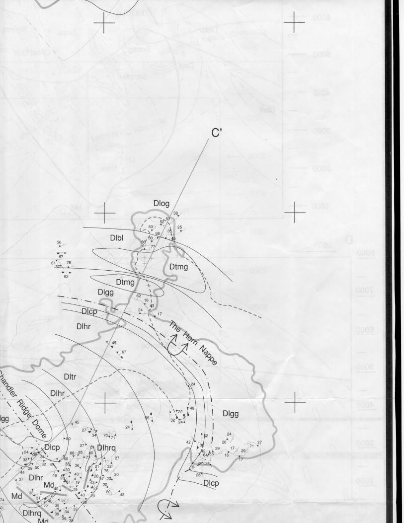
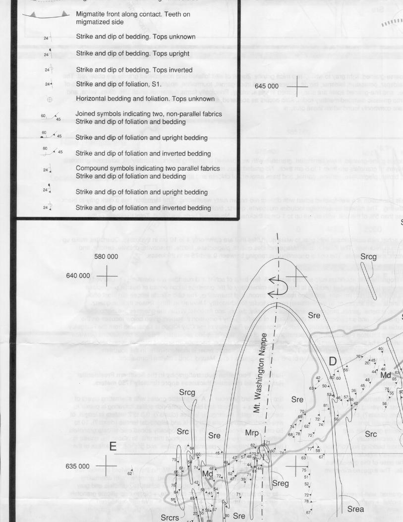


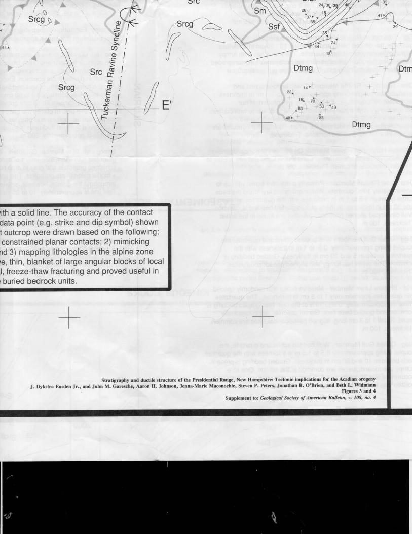


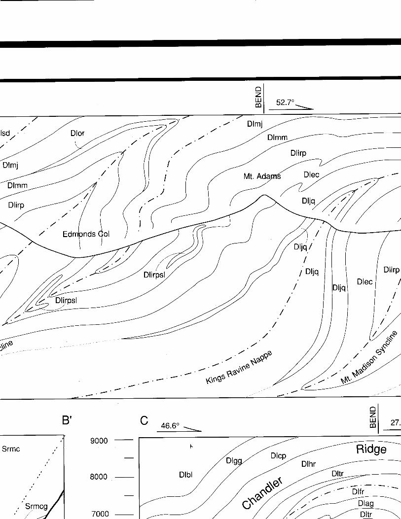


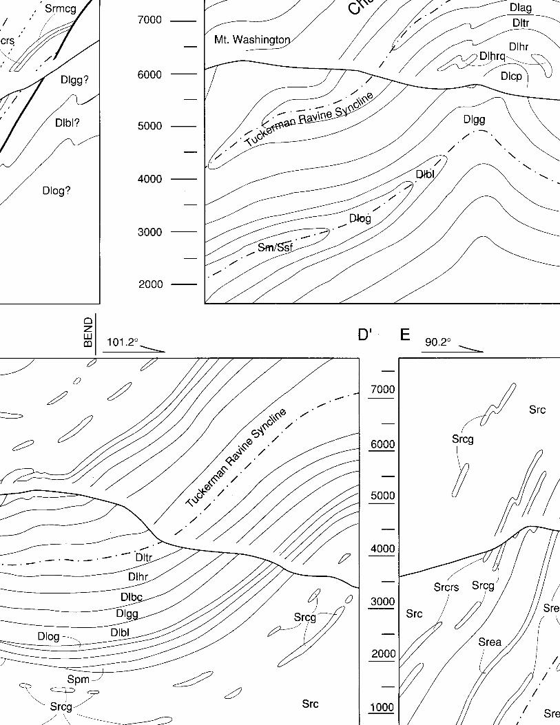


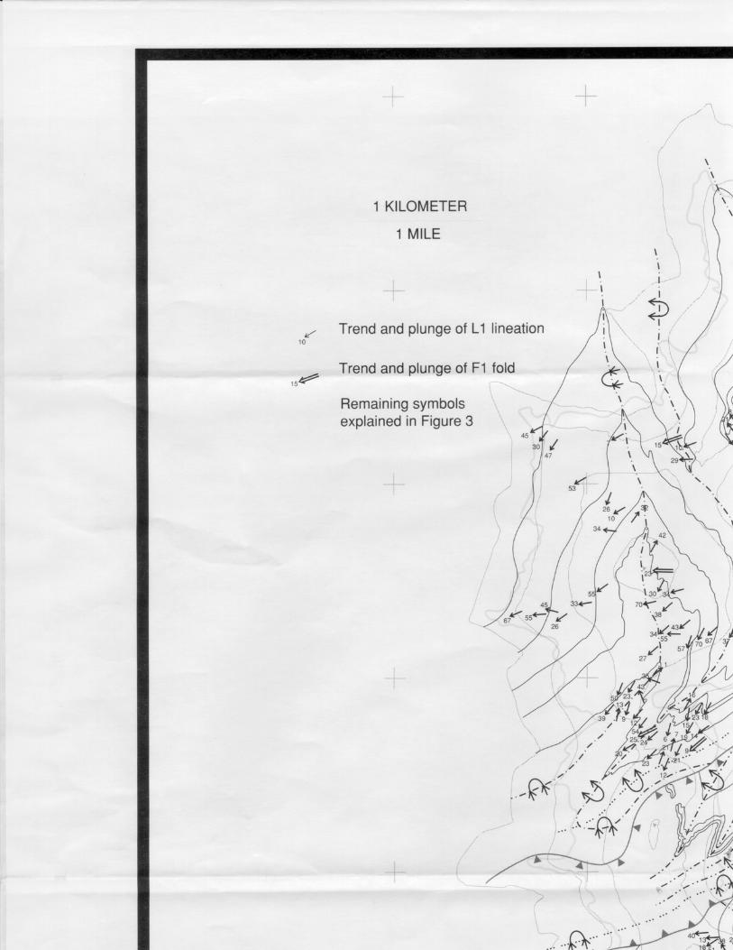

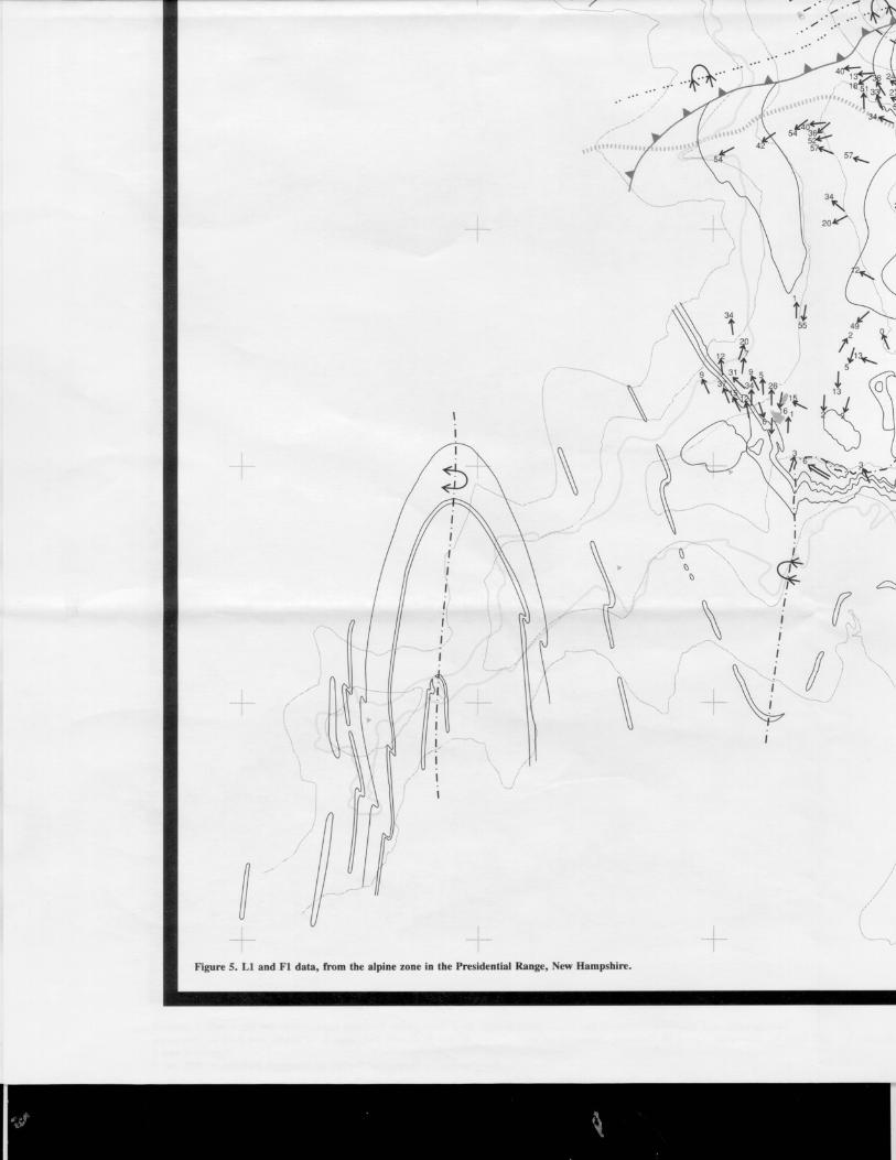
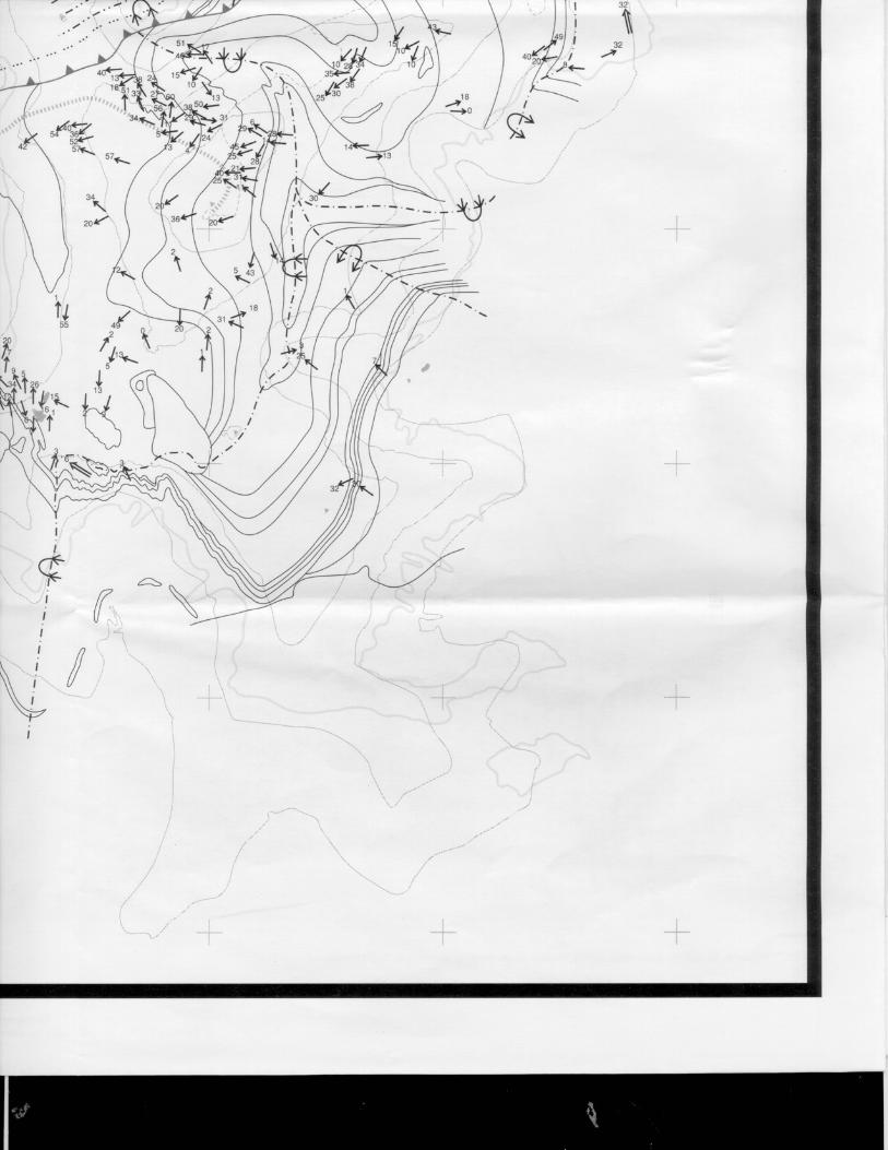
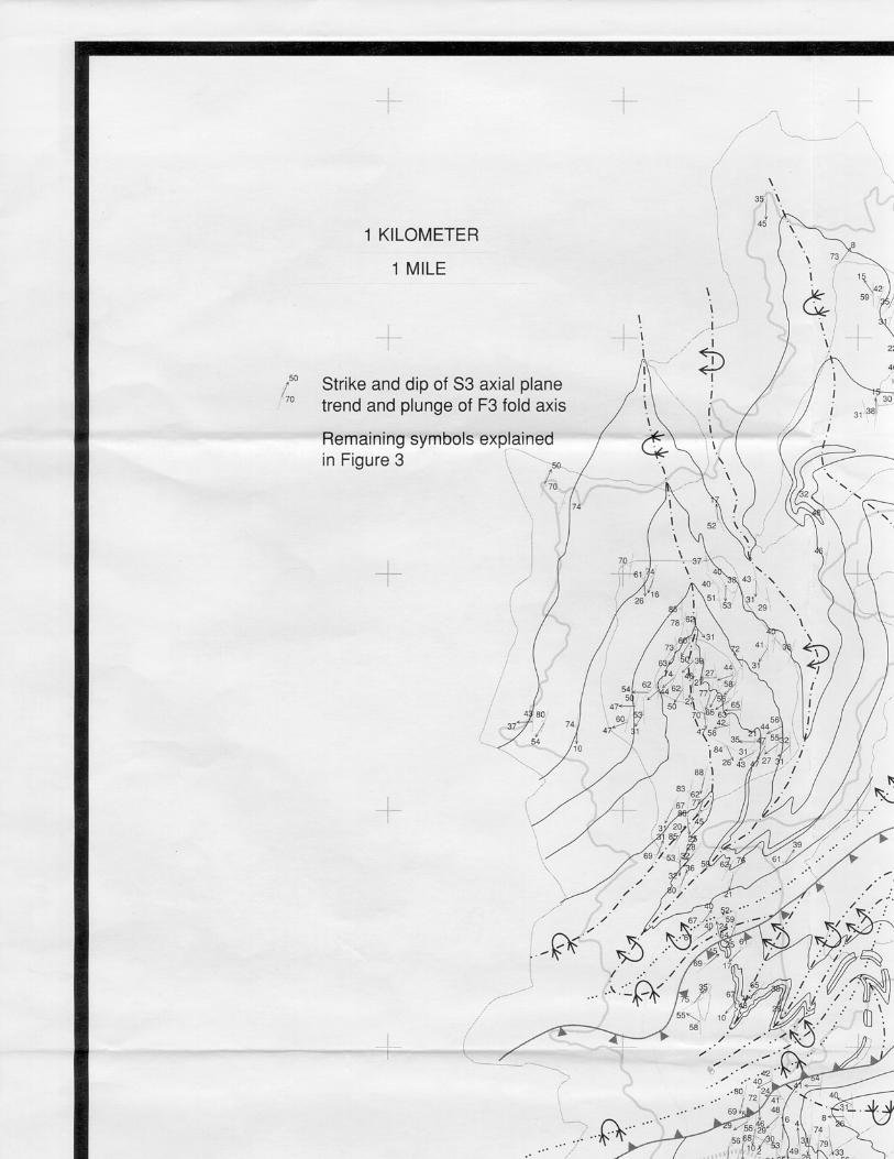


Related Documents