\ \ \ \\ \ \ \ \ \ \ \ \ \ \ \\\ \ \ \ \ \ \ \\ \ \ \ \\ \ \ \ \ \ \ \ \ \ \ \ \ \ \ \ \ \ \ \ \ \ \ \ \ \ \ \ \ \ \ \ \ \ \\ \ 6 4 1 2 3 5 10 11 7 8 9 Note: HS2 DfT internet maps, January 2012, PDF Plans: hs2arp00drrw 05022 issue 4 and 05020 issue 3. ´ 1:10,000 © Crown Copyright and database right 2012. Ordnance Survey 100019520. Produced by the WCC Corporate GIS Team, 31 August, 2012. 0 0.5 1 0.25 Kilometers HS2 Line Route - Mitigation Details: At Grade Viaduct Cutting Embankment Tunnel Mitigation Area - (Line Lowered along this whole section) 11 High Speed Rail (HS2): Action Groups Mitigation Long Itchington Wood and Southam Tunnel - To remove impact on Long Itchington Wood and road. Approx Length of Line Section: Line Section Detail: Due to the early and successful mitigation proposal agreed by Rex Sharples and Dr .Dan Mitchell to put the line into a tunnel, the only issue yet to be agreed is the use of the surplus spoil which it is suggested should be used at the eastern end of map 20 to protect Southam from dust and noise. * * Map is for illustrative purposes only. Warwickshire County Council has reproduced this map on behalf of the community to illustrate their mitigation proposal. Tunnel Entrance 6.6km - 5 4 3 2 1 - - - - - Green Tunnel - preserves A425 and Lower Farm. 6 7 - - 8 9 10 At Grade. At Grade. Cutting. Embankment. Viaduct - over River Itchen and flood plain. Embankment. Embankment. - - - Cutting. At Grade. 401m 173m 33m 34m 122m 278m 222m 930m 177m 30m Stratford-on-Avon District Warwickshire Note: HS2 DfT internet maps, January 2012, PDF Plans: hs2arp00drrw 05022 issue 4 and 05020 issue 3. ´ 1:10,000 © Crown Copyright and database right 2012. Ordnance Survey 100019520. Produced by the WCC Corporate GIS Team, 31 August, 2012. 0 0.5 1 0.25 Kilometers 11 Tunnel - To remove impact on Long Itchington Wood and road. Due to the early and successful mitigation proposal agreed by Rex Sharples and Dr .Dan Mitchell to put the line into a tunnel, the only issue yet to be agreed is the use of the surplus spoil which it is suggested should be used at the eastern end of map 20 to protect Southam from dust and noise. * * Map is for illustrative purposes only. Warwickshire County Council has reproduced this map on behalf of the community to illustrate their mitigation proposal. 6.6km 5 4 3 2 1 - Green Tunnel - preserves A425 and Lower Farm. 6 7 8 9 10 At Grade. At Grade. Cutting. Embankment. Viaduct - over River Itchen and flood plain. Embankment. Embankment. Cutting. At Grade. 278m \\\\\\\ Noise Barrier

Welcome message from author
This document is posted to help you gain knowledge. Please leave a comment to let me know what you think about it! Share it to your friends and learn new things together.
Transcript
\\\\\\\\\\\\\\\
\\\\\\\\\\\\\\
\\\\\\\\\\\\\\\\\\
\\\\\\\\\\\\\\\\\\\\
64
1
2
3 5
1011
78
9
Note:
HS2 DfT internet maps, January 2012, PDF Plans: hs2arp00drrw 05022 issue 4 and 05020 issue 3.
´1:10,000
© Crown Copyright and database right 2012. Ordnance Survey 100019520.
Produced by the WCC Corporate GIS Team,
31 August, 2012.
0 0.5 10.25Kilometers
HS2 Line Route - Mitigation Details:At Grade ViaductCutting EmbankmentTunnel
Mitigation Area - (Line Lowered along this whole section)
11
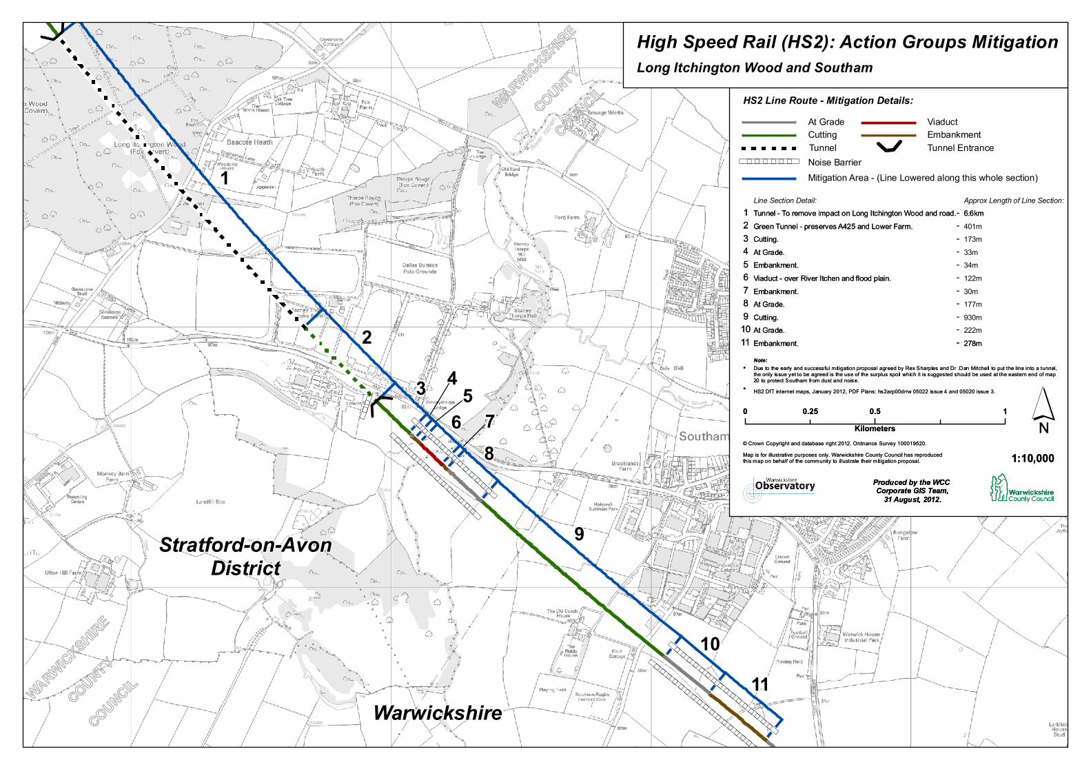
High Speed Rail (HS2): Action Groups MitigationLong Itchington Wood and Southam
Tunnel - To remove impact on Long Itchington Wood and road.Approx Length of Line Section:Line Section Detail:
Due to the early and successful mitigation proposal agreed by Rex Sharples and Dr .Dan Mitchell to put the line into a tunnel, the only issue yet to be agreed is the use of the surplus spoil which it is suggested should be used at the eastern end of map 20 to protect Southam from dust and noise.
*
*
Map is for illustrative purposes only. Warwickshire County Council has reproducedthis map on behalf of the community to illustrate their mitigation proposal.
Tunnel Entrance
6.6km-
54321
----
-
Green Tunnel - preserves A425 and Lower Farm.
67
--
89
10 At Grade.
At Grade.Cutting.
Embankment.
Viaduct - over River Itchen and flood plain.Embankment.
Embankment.
---
Cutting.At Grade.
401m173m33m34m122m
278m222m930m177m30m
Stratford-on-AvonDistrict
Warwickshire
Note:
HS2 DfT internet maps, January 2012, PDF Plans: hs2arp00drrw 05022 issue 4 and 05020 issue 3.
´1:10,000
© Crown Copyright and database right 2012. Ordnance Survey 100019520.
Produced by the WCC Corporate GIS Team,
31 August, 2012.
0 0.5 10.25Kilometers
11
Tunnel - To remove impact on Long Itchington Wood and road.
Due to the early and successful mitigation proposal agreed by Rex Sharples and Dr .Dan Mitchell to put the line into a tunnel, the only issue yet to be agreed is the use of the surplus spoil which it is suggested should be used at the eastern end of map 20 to protect Southam from dust and noise.
*
*
Map is for illustrative purposes only. Warwickshire County Council has reproducedthis map on behalf of the community to illustrate their mitigation proposal.
6.6km
54321
-
Green Tunnel - preserves A425 and Lower Farm.
6789
10 At Grade.
At Grade.Cutting.
Embankment.
Viaduct - over River Itchen and flood plain.Embankment.
Embankment.
Cutting.At Grade.
278m
\\\\\\\ Noise Barrier
Related Documents