Strategies and Implications for Strategies and Implications for Integrating GeoSpatial Technologies Integrating GeoSpatial Technologies in Emergency Management Education in Emergency Management Education Programs – New Directions and Programs – New Directions and Possibilities Possibilities National Emergency Management National Emergency Management Institute Institute Higher Education Conference Higher Education Conference June 8, 2010 June 8, 2010 Dr. Jamie D. Mitchem Dr. Jamie D. Mitchem Associate Professor of Geography/GIS Associate Professor of Geography/GIS Institute for Environmental and Spatial Analysis, Institute for Environmental and Spatial Analysis, Gainesville State College, Gainesville, GA Gainesville State College, Gainesville, GA 678-717-3927 678-717-3927 [email protected]

Strategies and Implications for Integrating GeoSpatial Technologies in Emergency Management Education Programs – New Directions and Possibilities National.
Dec 25, 2015
Welcome message from author
This document is posted to help you gain knowledge. Please leave a comment to let me know what you think about it! Share it to your friends and learn new things together.
Transcript

Strategies and Implications for Strategies and Implications for Integrating GeoSpatial Technologies in Integrating GeoSpatial Technologies in
Emergency Management Education Emergency Management Education Programs – New Directions and Programs – New Directions and
PossibilitiesPossibilities
National Emergency Management National Emergency Management Institute Institute
Higher Education ConferenceHigher Education ConferenceJune 8, 2010June 8, 2010
Dr. Jamie D. MitchemDr. Jamie D. MitchemAssociate Professor of Geography/GISAssociate Professor of Geography/GIS
Institute for Environmental and Spatial Analysis, Gainesville Institute for Environmental and Spatial Analysis, Gainesville State College, Gainesville, GAState College, Gainesville, GA
678-717-3927678-717-3927
Service and Teaching Service and Teaching Opportunities and Opportunities and
StrategiesStrategies

► The Institute for Environmental and Spatial Analysis (IESA), founded in 2001, is a teaching, The Institute for Environmental and Spatial Analysis (IESA), founded in 2001, is a teaching, research, and public service resource whose focus is the characterization and management of research, and public service resource whose focus is the characterization and management of environmental concerns in Northeast Georgia.environmental concerns in Northeast Georgia.
► Certificate Program and B.S. Degree in Applied Environmental Spatial Analysis Certificate Program and B.S. Degree in Applied Environmental Spatial Analysis
► Information Technology, Environmental Science, and Environmental Studies tracksInformation Technology, Environmental Science, and Environmental Studies tracks

CertificateCertificate
► Required Courses (15 hours) Required Courses (15 hours) GISC 2011 Introduction to Geographic Information Science w/ Lab GISC 2011 Introduction to Geographic Information Science w/ Lab
GISC 4470K Spatial Analysis in GIS with LabGISC 4470K Spatial Analysis in GIS with Lab
GISC 3011K Fundamentals of Cartography and Earth MeasurementGISC 3011K Fundamentals of Cartography and Earth Measurement
GISC 4011K Data Acquisition and Conversion in GISGISC 4011K Data Acquisition and Conversion in GIS
GISC 4350K Fundamentals of Remote SensingGISC 4350K Fundamentals of Remote Sensing
► Select 3 hours from the following courses: Select 3 hours from the following courses: GISC 2903 Special Topics in GISGISC 2903 Special Topics in GIS
GISC 2963 Service Learning in GISGISC 2963 Service Learning in GIS
GISC 2983 Internship in GISGISC 2983 Internship in GIS

GeoTech Center (NSF) GeoTech Center (NSF) ► PartnersPartners
Del Mar College (TX)Del Mar College (TX) Southwestern College (CA)Southwestern College (CA) KY Community Technical College SystemKY Community Technical College System Lake Land College (IL)Lake Land College (IL) Gainesville State College (GA)Gainesville State College (GA) Central Piedmont Community College (NC)Central Piedmont Community College (NC) Pennsylvania State UniversityPennsylvania State University South Carolina Advanced Technology Center of ExcellenceSouth Carolina Advanced Technology Center of Excellence Central New Mexico CollegeCentral New Mexico College National Geospatial Technology Center and C3GIS (CA)National Geospatial Technology Center and C3GIS (CA) San Diego State University (CA)San Diego State University (CA) Cayuga Community College (NY)Cayuga Community College (NY) Century College (MN)Century College (MN)

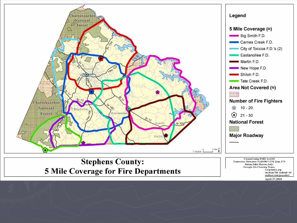
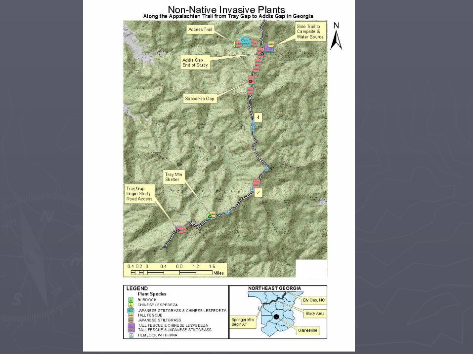
Student Map Examples –Student Map Examples –UndergraduatesUndergraduates


Georgia Bay Georgia Bay Complex Complex WildfireWildfire


Shockwave Flash Object


E911 E911 MapMap

SuggestionsSuggestions
►Partner with GIS professional Partner with GIS professional
►Check with Geography, Biology, Geology, Check with Geography, Biology, Geology, Engineering, Computer Science, or Engineering, Computer Science, or Business departments to see if they offer Business departments to see if they offer GISGIS
►Service Learning – K-12, local/county/state Service Learning – K-12, local/county/state government, private sector (e.g. utilities), government, private sector (e.g. utilities), non-profits (e.g. environmental groups)non-profits (e.g. environmental groups)
► InternshipsInternships
Related Documents