Welcome message from author
This document is posted to help you gain knowledge. Please leave a comment to let me know what you think about it! Share it to your friends and learn new things together.
Transcript


FIRE HISTORY AT' MT. RAINIER 39
AGE CLASS IN YEARS
[7 0 to 100
AGE CLASS IN YEARS
301 to 400
AGE CLASS IN YEARS
601 to 700
101 to 200 401 to 500 701 to 1000
201 to 300 501 to 600 1000+
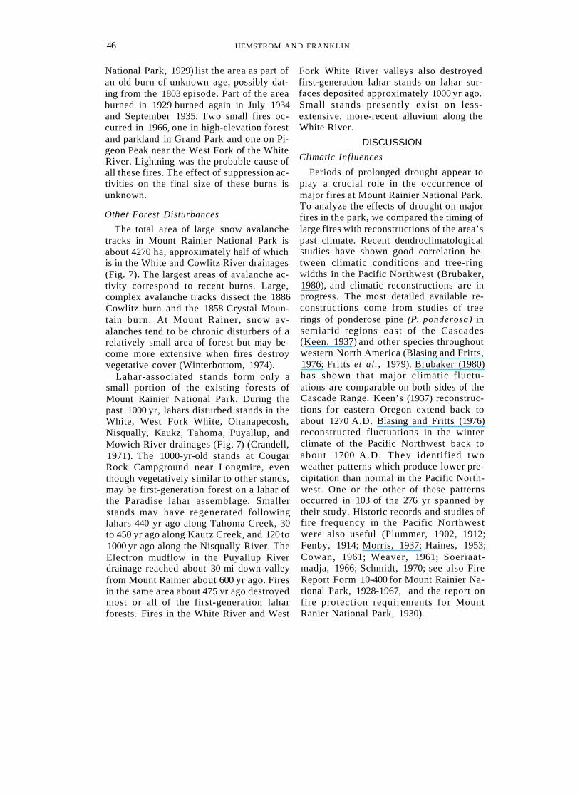
FIG. 4. Present stand ages, Mount Rainier National Park.
Forests at several locations around the have been free of major disturbance for park show no evidence of disturbance for over 1280 yr as indicated by conservative over 1000 yr (Fig. 4). The oldest trees grow age estimates of large Alaska cedar.3 in protected valley bottoms throughout the park and on slopes in the Ipsut and Cataract Many Cupressaceae make extra rings in arid cli- Creek drainages, tributaries of the Carbon mates, but we believe Alaska cedar does not in this River. Except for avalanches on steeper, favorable climate. Alaska cedar can survive fires, but
these trees have no identified fire scars. This fact, plus higher slopes and a small burn Over 6oo yr the absence of any long-lived, highly intolerant old in the upper reaches of the valley, the species, such as Douglas fir, supports our interpreta- forests of Ipsut Creek valley apparently tion of a very long, fire-free period for this drainage.
40 HEMSTROM AND FRANKLIN
20 I I I
I
0
z n z s
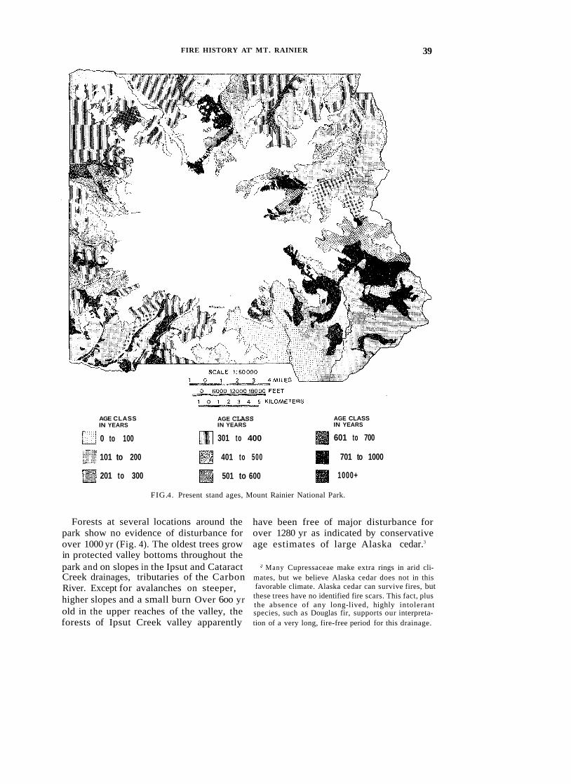
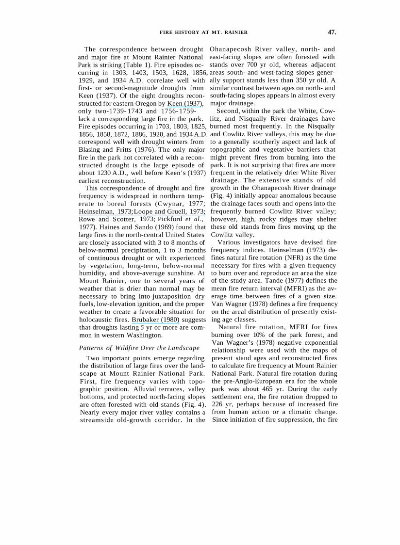
FIG. 5 .
Age class
Distribution of ages from trees sampled in the Ohanapecosh River (top) and Cowlitz River (bottom) drainages.
Forests along Cataract Creek, a tributary to the Carbon River, lack large Alaska cedar but are otherwise similar to those along Ipsut Creek. No early sera1 trees exist, and there is no evidence of catastrophic distur- bance in the lower valley for well over 1000 yr. Both drainages are short, north-facing hanging valleys, bounded on three sides by high, rocky ridges. Other very old stands in the park occupy protected topographic lo- cations. Stands occupying north-facing slopes and alluvial flats along the Ohanape- cosh River above its confluence with Chinook Creek have not experienced catastrophic disturbance for over 1000 yr. Many individuals of the 1000-yr-old cohort of Douglas fir have died in the past several centuries, leaving the forest floor littered with logs nearly 3 m in diameter.
The 1000-yr-old stand in the Nisqually River drainage near Cougar Rock Camp- ground has a unique origin compared to other very old stands. Crandell (1971) mapped the landform as part of the Paradise lahar assemblage. The surface of this as- semblage is radiocarbon dated at just over 1000 yr old, very close to the maximum age of the Douglas fir growing on it. These trees grew very slowly; many specimens 50- to 100-cm dbh are about 1000 yr old, based on ring counts of stumps. The forest seems to be a first generation stand on nutrient-poor, laharic material. Like other very old stands, the old-growth stand at Cougar Rock is in a protected valley bottom.
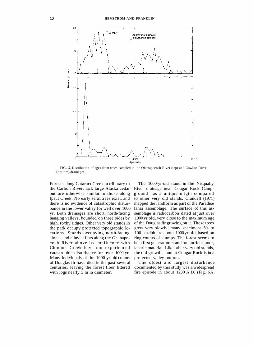
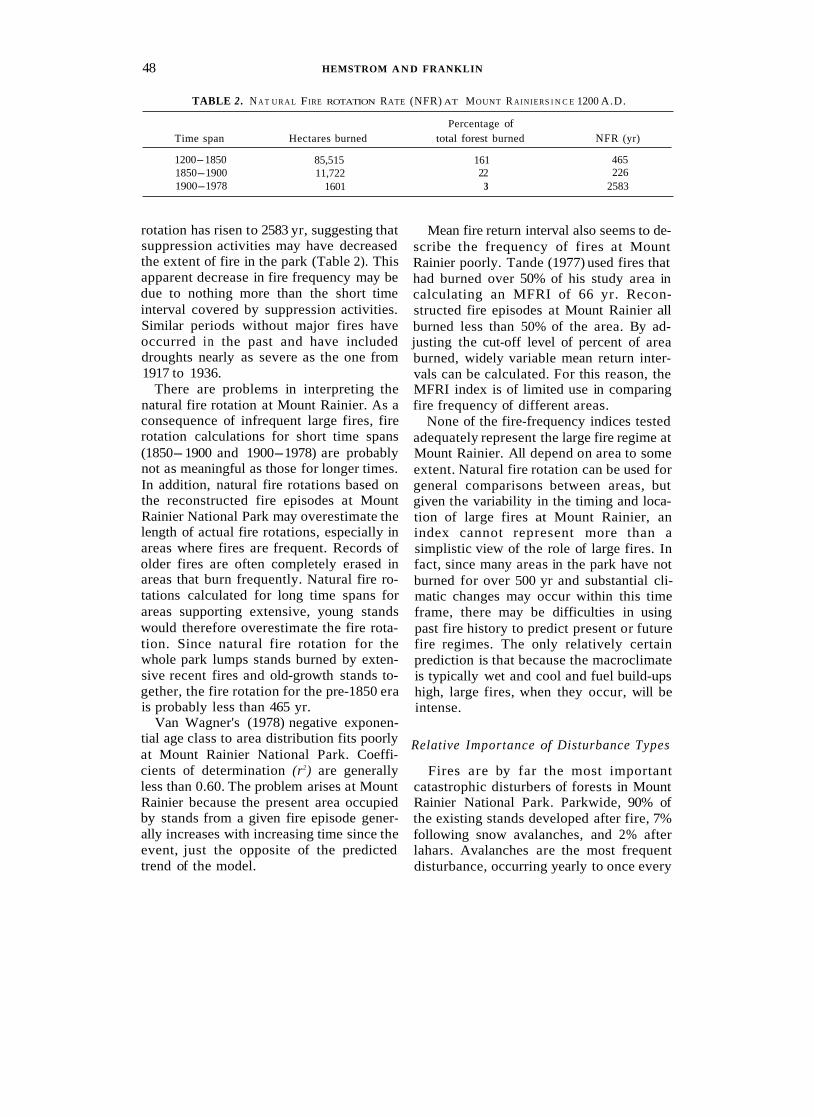
The oldest and largest disturbance documented by this study was a widespread fire episode in about 1230 A.D. (Fig. 6A,
FIRE HISTORY A T MT. RAINIER 41
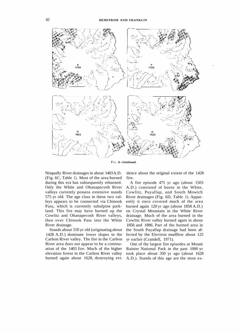
FIG. 6. Reconstructed fire episodes, with shaded areas representing the approximate original extent of the burns. Dates of episodes: (A) is approximately 1230 A.D.; (B) is approximately 1303 A.D.; ( C ) is approximately 1403 A.D.; (D) is approximately 1503 A.D.; (E) is approximately 1628 A.D. with a small area in the White River burned around 1658 A.D. included; (F) is approximately 1703 A.D.; ( G ) is approximately 1803 A.D.; and (H) shows areas burned since 1820 A.D.
Table 1). Much of the original extent of this episode has been obscured by subsequent fires. Stands in well-protected spots, since unburned, were destroyed in the 1230 episode, suggesting conditions unusually favorable for large fires. Stands of 750-yr- old trees, usually Douglas fir, still dominate much of the Ohanapecosh River drainage and portions of the White, Nisqually, Cow- litz, West Fork White, and Puyallup River drainages.
The next major disturbance dates from about 1303 A.D. when parts of the Mowich River and nearby Chenuis Creek drainages burned (Fig. 6B, Table 1). The Carbon Riv- er valley, which lies between the Mowich
River and Chenuis Creek, contains no evi- dence of a fire in 1303. Scattered individ- ual trees about 675 yr old are mixed with younger and older trees in the alluvial flats of the West Fork of the White River. The lack of charcoal at the mineral soil surface and the bouldery , gravelly surface suggest that these pockets of trees may have been established after floods or small lahars. Stands of 675-yr-old Douglas fir in the Huckleberry Creek drainage, east of the West Fork White River, appear to have re- generated after this fire episode.
A fire episode almost as extensive as the one in 1230 A.D. burned large areas of forest in the White, Ohanapecosh, Cowlitz, and
42 HEMSTROM AND FRANKLIN
FIG. 6.--Continued.
Nisqually River drainages in about 1403 A.D. (Fig. 6C, Table 1). Most of the area burned during this era has subsequently reburned. Only the White and Ohanapecosh River valleys currently possess extensive stands 575 yr old. The age class in these two val- leys appears to be connected via Chinook Pass, which is currently subalpine park- land. This fire may have burned up the Cowlitz and Ohanapecosh River valleys, then over Chinook Pass into the White River drainage.
Stands about 550 yr old (originating about 1428 A.D.) dominate lower slopes in the Carbon River valley. The fire in the Carbon River area does not appear to be a continu- ation of the 1403 fire. Much of the higher elevation forest in the Carbon River valley burned again about 1628, destroying evi-
dence about the original extent of the 1428 fire.
A fire episode 475 yr ago (about 1503 A.D.) consisted of burns in the White, Cowlitz, Puyallup, and South Mowich River drainages (Fig. 6D, Table 1). Appar- ently it once covered much of the area burned again 120 yr ago (about 1858 A.D.) on Crystal Mountain in the White River drainage. Much of the area burned in the Cowlitz River valley burned again in about 1856 and 1886. Part of the burned area in the South Puyallup drainage had been af- fected by the Electron mudflow about 125 yr earlier (Crandell, 1971).
One of the largest fire episodes at Mount Rainier National Park in the past 1000 yr took place about 350 yr ago (about 1628 A.D.). Stands of this age are the most ex-
FIRE HISTORY AT MT. RAINIER 43
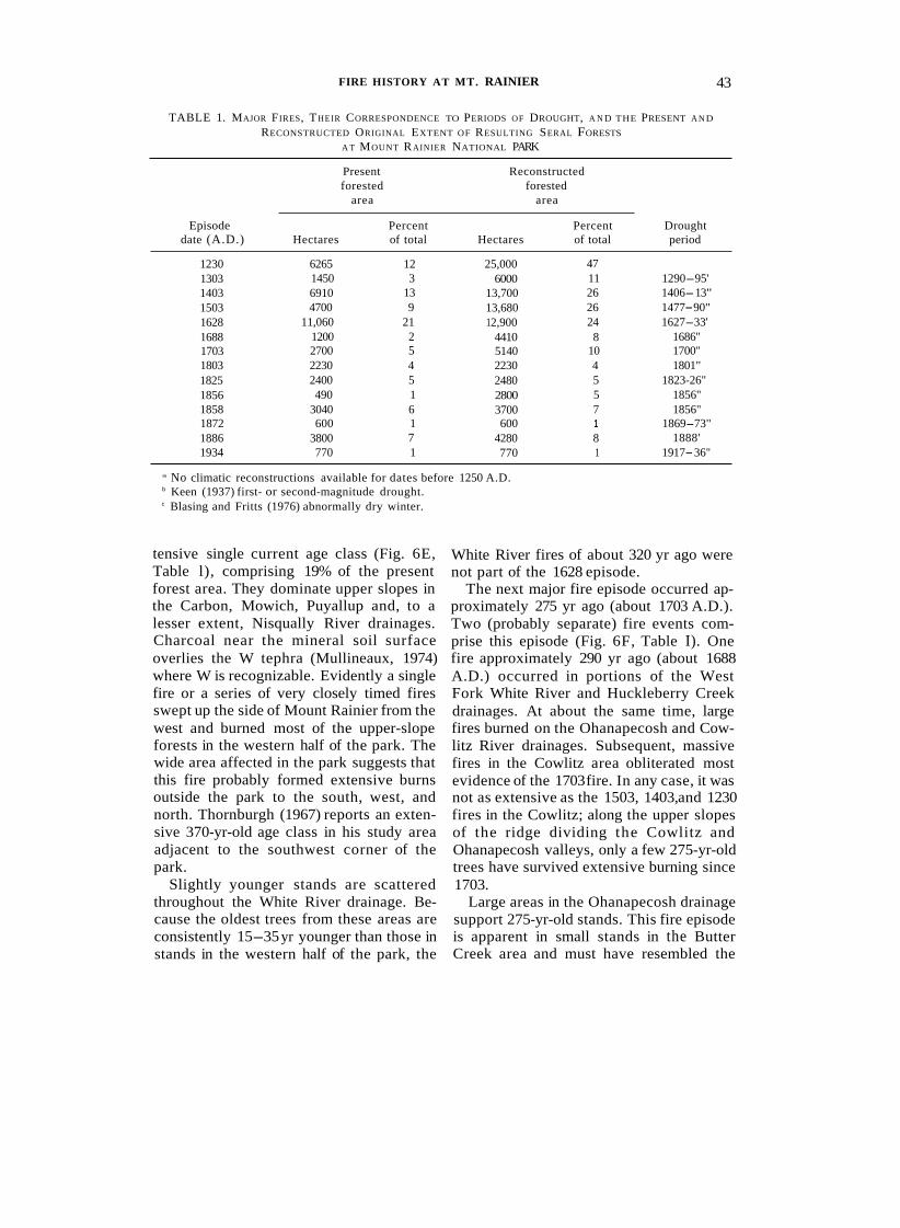
TABLE 1. MAJOR FIRES, T HEIR CORRESPONDENCE TO PERIODS OF DROUGHT, A N D THE PRESENT A N D
RECONSTRUCTED ORIGINAL EXTENT OF RESULTING SERAL FORESTS
A T MOUNT RAINIER NATIONAL PARK
Present Reconstructed forested forested
area area
Episode Percent Percent Drought date (A.D.) Hectares of total Hectares of total period
1230 1303 1403 1503 1628 1688 1703 1803 1825 1856 1858 1872 1886 1934
6265 1450 6910 4700
11,060 1200 2700 2230 2400 490
3040 600
3800 770
12 3
13 9
21 2 5 4 5 1 6 1 7 1
25,000 6000
13,700 13,680 1 2,900
4410 5140 2230 2480 2800 3700 600
4280 770
47 11 26 26 24
8 10 4 5 5 7 1 8 1
1290-95' 1406- 13" 1477 - 90" 1627-33'
1686" 1700" 1801"
1823-26" 1856" 1856"
1869-73" 1888'
19 17 - 36"
a No climatic reconstructions available for dates before 1250 A.D. b Keen (1937) first- or second-magnitude drought. c Blasing and Fritts (1976) abnormally dry winter.
tensive single current age class (Fig. 6E, Table l), comprising 19% of the present forest area. They dominate upper slopes in the Carbon, Mowich, Puyallup and, to a lesser extent, Nisqually River drainages. Charcoal near the mineral soil surface overlies the W tephra (Mullineaux, 1974) where W is recognizable. Evidently a single fire or a series of very closely timed fires swept up the side of Mount Rainier from the west and burned most of the upper-slope forests in the western half of the park. The wide area affected in the park suggests that this fire probably formed extensive burns outside the park to the south, west, and north. Thornburgh (1967) reports an exten- sive 370-yr-old age class in his study area adjacent to the southwest corner of the park.
Slightly younger stands are scattered throughout the White River drainage. Be- cause the oldest trees from these areas are consistently 15-35 yr younger than those in stands in the western half of the park, the
White River fires of about 320 yr ago were not part of the 1628 episode.
The next major fire episode occurred ap- proximately 275 yr ago (about 1703 A.D.). Two (probably separate) fire events com- prise this episode (Fig. 6F, Table I). One fire approximately 290 yr ago (about 1688 A.D.) occurred in portions of the West Fork White River and Huckleberry Creek drainages. At about the same time, large fires burned on the Ohanapecosh and Cow- litz River drainages. Subsequent, massive fires in the Cowlitz area obliterated most evidence of the 1703 fire. In any case, it was not as extensive as the 1503, 1403, and 1230 fires in the Cowlitz; along the upper slopes of the ridge dividing the Cowlitz and Ohanapecosh valleys, only a few 275-yr-old trees have survived extensive burning since 1703.
Large areas in the Ohanapecosh drainage support 275-yr-old stands. This fire episode is apparent in small stands in the Butter Creek area and must have resembled the
44 HEMSTROM A N D FRANKLIN
fire 575 yr ago in burning up the Cowlitz River valley from outside the park and into the tributary Ohanapecosh River and But- ter Creek drainages. Ages of trees south of the park adjacent to the Ohanapecosh val- ley match the 275-yr-old ages in the park (Fig. 6F, Table 1).
Many areas in the Ohanapecosh valley burned again nearly 100 years later, about 1803 A.D. Extensive contemporary stands occur outside the park south of the Ohanapecosh valley and in adjacent high elevation areas inside the park southeast of the Ohanapecosh River (Fig. 6G, Table I). Much of the area burned was steep, rela- tively open subalpine parkland and Pacific silver fir forest.
The next major fire occurred about the time settlers of European extraction arrived in the area, although no evidence links the fire to carly settlers or explorers. Extensive stands in the Nisqually River drainage indi- cate a fire about 1825 A.D. (Fig. 6H, Table 1). The 1825 fire generally did not burn onto alluvial flats forested by stands from the 1230 episode. Maines (1953) mentions an 1835 fire in the park covering about 4000 ha: since no other large fires occurred in the park around that date, his information may have been several years in error.
Large fires were recorded in Oregon and Washington in 1856 (Plummer, 1900; Mor- ris, 1937). Plummer (1900) wrote that the hills north of the Cowlitz River burned in 1841 and 1856. Although we found no stands dating from 1841, remnants of a once-extensive age class dating from 1856 occur in parts of the Cowlitz River drainage (Fig. 6H, Table 1).
Shortly after the Cowlitz fire in 1856, large areas on the slopes above the White River burned (Fig. 6H, Table 1). Relict trees 475 yr old are common in parts of the 1858 burn. Large areas of this burn at high elevation remain poorly stocked to the present. Avalanche tracks frequently dis- sect the 120-yr-old stands and extend nearly to the river in places. Loss of anchoring tree cover on steep slopes has probably
contributed to more extensive and frequent snow avalanches on the steep slopes east of the White River. Plummer (1900) reported that sheepherders often burned forests to improve grazing. Although no firm evi- dence links sheepherders to the 1858 White River fires, the name “Sheepherder Burn” persists.
The steep, high-elevation slopes between Huckleberry Creek and the West Fork White River burned in 1872 (Fig. 6H, Table 1). Restocking is not yet complete, presum- ably because of the severe, high-elevation environment. Frequent avalanches dissect these stands.
Young forests which had regenerated after the 1856 burn in the Cowlitz River valley again burned extensively in 1885 (Fig. 6H, Table 1). This fire burned nearly all of the upper Cowlitz River drainage. Large areas at moderate to high elevation are still poorly stocked. Widespread av- alanches, dense stands of vine maple (Acer circinatum) and Sitka alder (Alnus sinuata),and rigorous site conditions have virtually halted regeneration of conifers in many places. Plummer (1900) lists large fires in the Cowlitz drainage in 1885 which, he said, were repeated burns of areas burned in 1841 and 1856.
Two fires since the 1890s are linked to human activities. A fire believed to have been set by Longmire in 1894 to destroy hornets (Haines, 1953) eventually spread upslope, burning sizable areas of the upper Nisqually River valley. An escaped slash fire burned extensive a reas of high- elevation forest and subalpine parkland near the north Puyallup River in November of 1930. Some portions of the area have yet to restock. Fire suppression efforts by the National Park Service may have reduced the size of the fire (Mount Rainier National Park Fire Reports, Form 10-400, 1930).
Three other significant fires occurred after 1900. An area east of the Ohanapecosh River was burned by fires that began out- side the park on August 1, 1929 (Fig. 6H, Table 1). Fire report forms (Mount Rainier
FIRE HISTORY AT MT. RAINIER 45
46 HEMSTROM A N D FRANKLIN
National Park, 1929) list the area as part of an old burn of unknown age, possibly dat- ing from the 1803 episode. Part of the area burned in 1929 burned again in July 1934 and September 1935. Two small fires oc- curred in 1966, one in high-elevation forest and parkland in Grand Park and one on Pi- geon Peak near the West Fork of the White River. Lightning was the probable cause of all these fires. The effect of suppression ac- tivities on the final size of these burns is unknown.
Other Forest Disturbances The total area of large snow avalanche
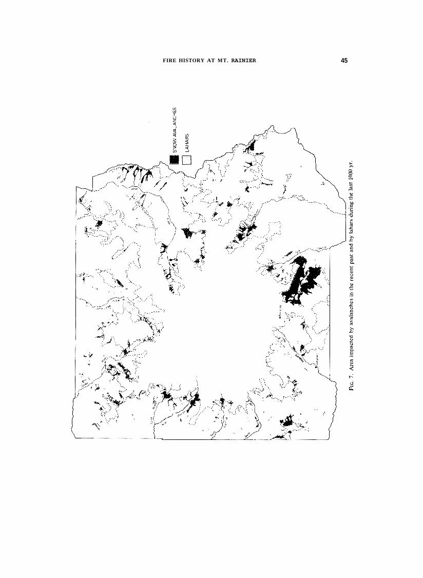
tracks in Mount Rainier National Park is about 4270 ha, approximately half of which is in the White and Cowlitz River drainages (Fig. 7). The largest areas of avalanche ac- tivity correspond to recent burns. Large, complex avalanche tracks dissect the 1886 Cowlitz burn and the 1858 Crystal Moun- tain burn. At Mount Rainer, snow av- alanches tend to be chronic disturbers of a relatively small area of forest but may be- come more extensive when fires destroy vegetative cover (Winterbottom, 1974).
Lahar-associated stands form only a small portion of the existing forests of Mount Rainier National Park. During the past 1000 yr, lahars disturbed stands in the White, West Fork White, Ohanapecosh, Nisqually, Kaukz, Tahoma, Puyallup, and Mowich River drainages (Fig. 7) (Crandell, 1971). The 1000-yr-old stands at Cougar Rock Campground near Longmire, even though vegetatively similar to other stands, may be first-generation forest on a lahar of the Paradise lahar assemblage. Smaller stands may have regenerated following lahars 440 yr ago along Tahoma Creek, 30 to 450 yr ago along Kautz Creek, and 120 to 1000 yr ago along the Nisqually River. The Electron mudflow in the Puyallup River drainage reached about 30 mi down-valley from Mount Rainier about 600 yr ago. Fires in the same area about 475 yr ago destroyed most or all of the first-generation lahar forests. Fires in the White River and West
Fork White River valleys also destroyed first-generation lahar stands on lahar sur- faces deposited approximately 1000 yr ago. Small s tands presently exist on less- extensive, more-recent alluvium along the White River.
DISCUSSION Climatic Influences
Periods of prolonged drought appear to play a crucial role in the occurrence of major fires at Mount Rainier National Park. To analyze the effects of drought on major fires in the park, we compared the timing of large fires with reconstructions of the area’s past climate. Recent dendroclimatological studies have shown good correlation be- tween climatic conditions and tree-ring widths in the Pacific Northwest (Brubaker, 1980), and climatic reconstructions are in progress. The most detailed available re- constructions come from studies of tree rings of ponderose pine (P. ponderosa) in semiarid regions east of the Cascades (Keen, 1937) and other species throughout western North America (Blasing and Fritts, 1976; Fritts et al . , 1979). Brubaker (1980) has shown that major climatic fluctu- ations are comparable on both sides of the Cascade Range. Keen’s (1937) reconstruc- tions for eastern Oregon extend back to about 1270 A.D. Blasing and Fritts (1976) reconstructed fluctuations in the winter climate of the Pacific Northwest back to about 1700 A.D. They identified two weather patterns which produce lower pre- cipitation than normal in the Pacific North- west. One or the other of these patterns occurred in 103 of the 276 yr spanned by their study. Historic records and studies of fire frequency in the Pacific Northwest were also useful (Plummer, 1902, 1912; Fenby, 1914; Morris, 1937; Haines, 1953; Cowan, 1961; Weaver, 1961; Soeriaat- madja, 1966; Schmidt, 1970; see also Fire Report Form 10-400 for Mount Rainier Na- tional Park, 1928-1967, and the report on fire protection requirements for Mount Ranier National Park, 1930).
FIRE HISTORY AT MT. RAINIER 47.
The correspondence between drought and major fire at Mount Rainier National Park is striking (Table 1). Fire episodes oc- curring in 1303, 1403, 1503, 1628, 1856, 1929, and 1934 A.D. correlate well with first- or second-magnitude droughts from Keen (1937). Of the eight droughts recon- structed for eastern Oregon by Keen (1937), only two-1739- 1743 and 1756- 1759- lack a corresponding large fire in the park. Fire episodes occurring in 1703, 1803, 1825, 1856, 1858, 1872, 1886, 1920, and 1934 A.D. correspond well with drought winters from Blasing and Fritts (1976). The only major fire in the park not correlated with a recon- structed drought is the large episode of about 1230 A.D., well before Keen’s (1937) earliest reconstruction.
This correspondence of drought and fire frequency is widespread in northern temp- erate to boreal forests (Cwynar, 1977; Heinselman, 1973; Loope and Gruell, 1973; Rowe and Scotter, 1973; Pickford et al., 1977). Haines and Sando (1969) found that large fires in the north-central United States are closely associated with 3 to 8 months of below-normal precipitation, 1 to 3 months of continuous drought or wilt experienced by vegetation, long-term, below-normal humidity, and above-average sunshine. At Mount Rainier, one to several years of weather that is drier than normal may be necessary to bring into juxtaposition dry fuels, low-elevation ignition, and the proper weather to create a favorable situation for holocaustic fires. Brubaker (1980) suggests that droughts lasting 5 yr or more are com- mon in western Washington.
Patterns of Wildfire Over the Landscape Two important points emerge regarding
the distribution of large fires over the land- scape at Mount Rainier National Park. First, fire frequency varies with topo- graphic position. Alluvial terraces, valley bottoms, and protected north-facing slopes are often forested with old stands (Fig. 4). Nearly every major river valley contains a streamside old-growth corridor. In the
Ohanapecosh River valley, north- and east-facing slopes are often forested with stands over 700 yr old, whereas adjacent areas south- and west-facing slopes gener- ally support stands less than 350 yr old. A similar contrast between ages on north- and south-facing slopes appears in almost every major drainage.
Second, within the park the White, Cow- litz, and Nisqually River drainages have burned most frequently. In the Nisqually and Cowlitz River valleys, this may be due to a generally southerly aspect and lack of topographic and vegetative barriers that might prevent fires from burning into the park. It is not surprising that fires are more frequent in the relatively drier White River drainage. The extensive stands of old growth in the Ohanapecosh River drainage (Fig. 4) initially appear anomalous because the drainage faces south and opens into the frequently burned Cowlitz River valley; however, high, rocky ridges may shelter these old stands from fires moving up the Cowlitz valley.
Various investigators have devised fire frequency indices. Heinselman (1973) de- fines natural fire rotation (NFR) as the time necessary for fires with a given frequency to burn over and reproduce an area the size of the study area. Tande (1977) defines the mean fire return interval (MFRI) as the av- erage time between fires of a given size. Van Wagner (1978) defines a fire frequency on the areal distribution of presently exist- ing age classes.
Natural fire rotation, MFRI for fires burning over 10% of the park forest, and Van Wagner’s (1978) negative exponential relationship were used with the maps of present stand ages and reconstructed fires to calculate fire frequency at Mount Rainier National Park. Natural fire rotation during the pre-Anglo-European era for the whole park was about 465 yr. During the early settlement era, the fire rotation dropped to 226 yr, perhaps because of increased fire from human action or a climatic change. Since initiation of fire suppression, the fire
48 HEMSTROM A N D FRANKLIN
TABLE 2 . N A T U R A L FIRE ROTATION RATE (NFR) AT MOUNT R A I N I E R S l N C E 1200 A.D.
Percentage of Time span Hectares burned total forest burned NFR (yr)
1200- 1850 1850- 1900 1900- 1978
85,515 11,722
1601
161 22
3
465 226
2583
rotation has risen to 2583 yr, suggesting that suppression activities may have decreased the extent of fire in the park (Table 2). This apparent decrease in fire frequency may be due to nothing more than the short time interval covered by suppression activities. Similar periods without major fires have occurred in the past and have included droughts nearly as severe as the one from 1917 to 1936.
There are problems in interpreting the natural fire rotation at Mount Rainier. As a consequence of infrequent large fires, fire rotation calculations for short time spans (1850- 1900 and 1900- 1978) are probably not as meaningful as those for longer times. In addition, natural fire rotations based on the reconstructed fire episodes at Mount Rainier National Park may overestimate the length of actual fire rotations, especially in areas where fires are frequent. Records of older fires are often completely erased in areas that burn frequently. Natural fire ro- tations calculated for long time spans for areas supporting extensive, young stands would therefore overestimate the fire rota- tion. Since natural fire rotation for the whole park lumps stands burned by exten- sive recent fires and old-growth stands to- gether, the fire rotation for the pre-1850 era is probably less than 465 yr.
Van Wagner's (1978) negative exponen- tial age class to area distribution fits poorly at Mount Rainier National Park. Coeffi- cients of determination (r2) are generally less than 0.60. The problem arises at Mount Rainier because the present area occupied by stands from a given fire episode gener- ally increases with increasing time since the event, just the opposite of the predicted trend of the model.
Mean fire return interval also seems to de- scribe the frequency of fires at Mount Rainier poorly. Tande (1977) used fires that had burned over 50% of his study area in calculating an MFRI of 66 yr. Recon- structed fire episodes at Mount Rainier all burned less than 50% of the area. By ad- justing the cut-off level of percent of area burned, widely variable mean return inter- vals can be calculated. For this reason, the MFRI index is of limited use in comparing fire frequency of different areas.
None of the fire-frequency indices tested adequately represent the large fire regime at Mount Rainier. All depend on area to some extent. Natural fire rotation can be used for general comparisons between areas, but given the variability in the timing and loca- tion of large fires at Mount Rainier, an index cannot represent more than a simplistic view of the role of large fires. In fact, since many areas in the park have not burned for over 500 yr and substantial cli- matic changes may occur within this time frame, there may be difficulties in using past fire history to predict present or future fire regimes. The only relatively certain prediction is that because the macroclimate is typically wet and cool and fuel build-ups high, large fires, when they occur, will be intense.
Relative Importance of Disturbance Types
Fires are by far the most important catastrophic disturbers of forests in Mount Rainier National Park. Parkwide, 90% of the existing stands developed after fire, 7% following snow avalanches, and 2% after lahars. Avalanches are the most frequent disturbance, occurring yearly to once every
FIRE HISTORY AT MT. RAINIER 49
decade; large fires occur once every cen- tury or so, and major lahars even less often.
Other forest disturbances are important, especially wind and pathogens (insects, root-rot). Wind has been a major forest disturber in the Coast Range, Olympic Mountains, and Cascade Range (Lynott and Cramer, 19663. Although the Columbus Day storm of 1962 blew down more than 11 billion board feet of timber in Oregon and Washington, only small disturbances at Mount Rainier definitely date from this storm. After 50 to 100 yr, documentation of wind as a stand disturbance can be difficult without a detailed stem-by-stem scar analysis (as was done by Henry and Swan, 1974). No large stands were identified that were believed to have developed after dis- turbances caused by either wind or patho- gens.
Implications for Managers
The fire regime at Mount Rainier Na- tional Park bears little resemblance to that encountered elsewhere. Fires east of the crest of the Cascade Range tend to be less intense and more frequent (Soeriaatmadja, 1966). In the mixed conifer forests of the Sierra Nevada, fires are more frequent, about every 8 yr (Kilgore, 1973), and less intense. The fire regime in the central and northern Rocky Mountains varies with fire frequency, ranging from less than 10 yr to over 400 yr (Arno, 1980). In the northern Great Lake States, Heinselman (1973) cal- culated an NFR of up to 100 yr.
Where there are naturally long intervals between fires, fire suppression would alter the composition and structure of the forest only after several centuries. Without large burns, the forested landscape at Mount Rainier would change from a mosaic of age classes to old growth. Eventually, even the long-lived sera1 species would lose their present prominence. The problem of fuel build-up with fire suppression followed by holocaustic fires does not apply at Mount Rainier. Forests in the park have naturally developed large fuel loads, and these have
probably not increased under present man- agement programs. It is, however, entirely possible that the holocaustic fires of the past would not be amenable to present sup- pression technology.
CONCLUSIONS This study of recent forest disturbance at
Mount Rainier National Park revealed the following.
(1) Catastrophic disturbances played an important role in shaping the existing forest mosaic of the park. The most important disturbing agent is fire, followed by av- alanches and lahars.
(2) Fire occurrence is related to topogra- phy. Extensive old stands are found in stream-side corridors and protected north- facing slopes. Stands at higher elevations and with southerly exposures burn more often.
(3) Episodes of major fire appear to cor- respond to periods of prolonged drought.
(4) Complete regeneration of forests after a catastrophic disturbance often re- quires more than 75 yr.
(5) Modern human influences on the natural fire regime at Mount Rainier have probably been negligible, although suppres- sion may have limited the size of fires dur- ing the 1917 to 1934 drought.
(6) As a result of the infrequency of large fires and the topographic diversity of Mount Rainier National Park, calculations of natural fire rotation (Heinselman, 1973), Van Wagner’s (1978) index, and mean fire return interval (Tande, 1977) are not partic- ularly useful.
(7) Wildfire has been very important in the recent history of the park forests and, as a result, must be reviewed as an important agent in the ecosystems if they are to be maintained in a natural state.
ACKNOWLEDG M ENTS This study was jointly supported by the U.S. De-
partment of the Interior National Park Service, under contract to Oregon State University, and the U.S. De- partment of Agriculture Forest Service, Pacific North- west Forest and Range Experiment Station. Field
50 HEMSTROM A N D FRANKLIN
assistance was provided by W. H. Moir, S. Greene, K. Luchessa, and T. Thomas. F. Swanson, W. Moir, G. Fahnestock, and J. Agee provided suggestions and critical comment. The National Park Service staff at Mount Rainier, particularly S. Schlegel and L. Hen- derson, provided support for the study.
REFERENCES Arno, S. F. (1976). The historical role of fire on the
Bitterroot National Forest. U S D A Forest Service Research Paper INT-187.
Arno, S. F. (1980). Forest fire history in the Northern Rockies. Journul of Forestry 78, 460-465.
Blasing, T. J., and Fritts, H. C. (1976). Reconstructing past climatic anomalies in the North Pacific and western North America from tree-ring data. Quater- nury Research 1, 563-579.
Brockman, C. F. (1931). Forests and timber types of Mount Rainier National Park. M. S. Thesis, Univer- sity of Washington, Seattle.
Brubaker, L. C. (1980). Spatial patterns of tree growth anomalies in the Pacific Northwest. Eco1ogy 61,
Burke, C. J . (1980). Historic fires in the central west- ern Cascades, Oregon. M.S. Thesis, Oregon State University, Corvallis.
Cowan, C. S. (1961). “The Enemy is Fire.” Superior, Seattle.
Crandell,D. R. (1971). Postglacial lahars from Mount Rainier volcano, Washington. U.S. Geologicnl Sur- v e y Professional Paper 677.
Crandell, D. R., and Miller, R. D. (1974). Quaternary stratigraphy and extent of glaciation in the Mount Rainier region, Washington. U . S . Geological Survey Professiona1 Paper 848.
Cushman, M. J. (1976). Vegetation composition as a predictor of major avalanche cycles, North Cas- cades, Washington. M.S. Thesis, University of Washington, Seattle.
Cwynar, L. C. (1977). The recent fire history of Bar- ron Township, Algonquin Park. Canadian Journal
Dryden, C. (1968). “Dryden’s History of Wash- ington.” Binfords and Mort, Portland, Oregon.
Fenby, E. J. (1914). The Cispus burn. Forest Qunr- terly 12, 193-200.
Franklin, J . F. (1966). Vegetation and soils in the sub- alpine forests of the southern Washington Cascade Range. Ph.D. Thesis, Washington State University, Pullman.
Franklin, J. F., and Dyrness, C. T. (1973). Natural vegetation of Oregon and Washington. U S D A Forest Service General Technicul Report PN W-8.
Franklin, J. F., and Mitchell, R. G. (1967). Succes- sional status of subalpine fir in the Cascade Range. USDA Forest Service Research Paper PNW-46.
Franklin, J. F., McKee, A, Swanson, F. J., Means, J . , and Brown, A. (1979a). Age structure analysis of old-growth Douglas-fir stands: data versus conven-
798- 807.
O,f Botany 5 5 , 1524-1538.
tional wisdom. Bulletin of the Ecological Society of America 60, 102.
Franklin, J . F., Moir, W. H., Hemstrom, M. A., and Greene, S . (1979b). Forest ecosystems of Mount Rainier National Park. Unpublished report on file at Forestry Sciences Laboratory, Corvallis, Oregon.
Frissell, S. S., Jr. (1973). The importance of fire as a natural ecological factor in Itasca State Park, Min- nesota. Quuternary Research 3, 397-407.
Fritts, H. C., Lobgren, R. G., and Gordon, G. A. (1979). Variations in climate since 1602 as recon- structed from tree rings. Quternary Research 12,
Haines, A. L. (1953). Fire weather analysis. Chief Ranger’s Office, Mount Rainier National Park, Longmire, Washington.
Haines, D. A . , and Sando, R. W., (1969). Climatic conditions preceding historically great fires in the North Central Region. USDA Forest Service Re- search Paper NC-34.
Heinselman, M. L. (1973). Fire in the virgin forests of the Boundary Waters Canoe Area, Minnesota. Quaternnry Research 3 , 329-382.
Hemstrom, M. A. (1979). A recent disturbance history of forest ecosystems at Mount Rainier National Park. Ph.D. Thesis, Oregon State University, Cor- vallis.
Henry, J . D., and Swan, J . M. A. (1974). Recon- structing forest history from live and dead material-an approach to the study of forest succes- sion in southwest New Hampshire. Ecology 55,
Hobson, F. D. (1976). Classification system for the soils of Mount Rainier National Park. M.S. Thesis, Washington State University, Pullman.
Keen, F . P. (1937). Climatic cycles in eastern Oregon as indicated by tree rings. Monthly Weather Review
Kilgore, B. M. (1973). The ecological role of fire in Sierran conifer forests, its application to national park management. Quaternary R e s e a r c h 3 ,
Loope, L. L., and Gruell, G. E. (1973). The ecological role of fire in the Jackson Hole area, northwestern Wyoming. Quternary Reseurch 3, 425-443.
Luckman, B. H. (1978). Geomorphic work of snow avalanches in the Canadian Rocky Mountains. Arc- tic and Alpine Research 10, 261-276.
Lutz, H. J. (1956). Ecological effects of forest fires in the interior of Alaska. U S D A Forest Service Tech- nical Bulletin No. 1133.
Lynott, R. E., and Cramer, 0. P. (1966). Detailed analysis of the 1962 Columbus Day windstorm in Oregon and Washington. Monthly Weather Review
Morris, W. G. (1937). Forest fires in western Oregon and western Washington. Oregon Historical Quar- terly 35, 313-339.
Mullineaux, D. R. (1974). Pumice and other pyroclas-
18-46.
772-783.
65, 175-188.
496-513.
94, 105-117.
Related Documents