City of Cape Town Development Service Transport, Roads & Stormwater Directorate Catchment, Stormwater and River Management Branch Stormwater Management Planning and Design Guidelines for New Developments Version 1.0 July 2002

Welcome message from author
This document is posted to help you gain knowledge. Please leave a comment to let me know what you think about it! Share it to your friends and learn new things together.
Transcript
ii
City of Cape TownDevelopment Service
Transport, Roads & Stormwater Directorate
Catchment, Stormwater and River Management Branch
Stormwater Management Planningand Design Guidelines for New
Developments
Version 1.0
July 2002

iii
Executive Summary
This document provides guidelines for the planning and design of stormwatermanagement systems with particular emphasis on new developments. It is however,equally applicable to stormwater management upgrading and rehabilitation projects.
The document has been structured into 5 broad sections, which cover the process fromthe initial concept design of stormwater systems through to the operational stage, asfollows:
Section (1) – Preparation and Approach
It is widely recognised that developments impact negatively on drainage systems. Bytaking greater cognisance of natural hydrological patterns and processes it is possible, todevelop stormwater management systems in manner that reduces these potentiallynegative impacts and mimic nature.
Cognisance should be taken of the following stormwater management objectives:
! Minimise threat of flooding! Protect receiving water bodies! Promote multi-functional use of stormwater management systems! Develop sustainable stormwater systems
Section (2) - Planning
It is crucial to the successful implementation of an effective stormwater managementsystem, to assemble consultants with the required multi-disciplinary expertise from theoutset of the project and that they be briefed to operate as a team. The core members ofthe group would provide expertise in civil engineering, town planning and environmentalconsulting. Closely allied disciplines of freshwater ecology and landscape architectureshould be added, if required, on the advice of the other professionals.
Various service delivery units with an interest or impact on the management of thedrainage systems must be consulted by the design team at an early stage. This willensure that the systems constructed meet their approval and address community needs.
The implications a number of legal and policy considerations on the development must beconsidered at an early planning stage.
A site analysis plan should be prepared in which the physical features of the site as wellas ownership and spatial constraints, including adjacent and downstream areas, areassembled and evaluated. A conceptual layout together and a conceptual stormwater planwould then be prepared based on this information.
Section (3) - Design
In the design phase, various stormwater management facilities and techniques useful inachieving required design objectives are presented and grouped by generic function asfollows:
! Conveyance! Ponding

iv
! Infiltration! Filtration and Treatment
A number of examples with diagrams and additional design information, data sources andreferences are provided.
Section (4) - Construction
Construction of the stormwater management system should be carried out subject to theprovisions of an environmental management programme (EMP).
Section (5) – Operation and Maintenance
It is of prime importance that the stormwater management system is well maintained andoperated in accordance with the intentions of the design. The developer must consider theavailable maintenance resources and responsibilities when formulating designs.
This chapter furthermore, provides guidance regarding the allocation of responsibilitieswithin the local authority. In addition, co-operation of the public and in particular localresidents will ensure the success and optimal use of the system. Education programmes,projects in association with groups such as schools (e.g. “adopt-a-wetland”) and Friendsgroups should be encouraged.
Effective monitoring based on the requirements of the operation management plan (OMP)is stressed.
In general, the aim should be to provide a stormwater managementsystem which mimics nature, utilises natural features in the
stormwater cycle, will be an asset to the community and will functionefficiently with relatively little maintenance.

v
Acknowledgements
This document has been prepared by SAWE Multi-disciplinary Engineers in associationwith the following specialist consultancy’s:
! Freshwater Consulting Group! Megan Anderson Landscape Architect! de Villiers Brownlie Associates Environmental Consultants! First Plan Town and Regional Planners
Review, minor editing and re-formatting for publication was undertaken by Mr B. Wood ofthe Catchment, Stormwater and River Management Branch.
This project, by it’s very nature required input from a number of business units within thecity administration. Contributions and advice of the various officials is gratefullyacknowledged.
Contact Details
Kindly address any queries or comments to:
City of Cape TownTransport, Roads and Stormwater DirectorateCatchment, Stormwater and River Management BranchP.O. Box 16548Vlaeberg 8018South AfricaAttention: Mr B. Wood
Tel: 487-2206Fax: 487-2441E. Mail: [email protected]: www.capetown.gov.za
Indemnity
This guideline document shall not create liability on the part of the City of Cape Town orany officer or employee thereof for any damage that may result from reliance thereon.
Copyright
All rights reserved by the City of Cape Town, South Africa. No part of this document maybe reproduced in any form without the written permission of the City of Cape Town, withthe exception of photocopying for educational purposes.
vi
Table of Contents
Executive Summary................................................................................................ iiiAcknowledgements.................................................................................................. vContact Details ........................................................................................................ vIndemnity ................................................................................................................. vCopyright ................................................................................................................. vTable of Contents ................................................................................................... viPreface .................................................................................................................... x
Document Overview and Purpose ............................................................................................ x
Applicability and Status of Document ....................................................................................... x
Other Applicable Guidelines...................................................................................................... x
Document Structure................................................................................................. xGlossary of Terms .................................................................................................. xiAbbreviations.........................................................................................................xiii
1. Preparation and Approach .........................................................21.1 The Stormwater Management Service ............................................................21.2 Managing the Impact of Development on Natural Drainage Systems .............21.3 Stormwater Management Objectives ..............................................................4
1.3.1 Minimise the Threat of Flooding ..................................................................................... 4
1.3.2 Protection of Receiving Water Bodies ............................................................................ 4
1.3.3 Promote Multi-Functional Use of Stormwater Management Systems............................ 4
1.3.4 Development of Sustainable Environments.................................................................... 5
2. Stormwater Planning ..................................................................62.1 The Need for Multi-disciplinary Expertise ........................................................62.2 Interface with Municipal Service Delivery Units...............................................62.3 Legal and Policy Considerations .....................................................................7
2.3.1 National level .................................................................................................................. 8
2.3.2 Provincial level ................................................................................................................ 8
2.3.3 Municipal (City of Cape Town)........................................................................................ 8
2.3.4 International Conventions ............................................................................................... 8
2.4 Incorporation of Existing Information into Planning Stage ...............................82.5 Site Analysis....................................................................................................9
2.5.1 Topography..................................................................................................................... 9
vii
2.5.2 Geology, Soils and Groundwater.................................................................................... 9
2.5.3 Climate.......................................................................................................................... 10
2.5.4 Hydrology...................................................................................................................... 10
2.5.5 Natural Ecosystems, Flora and Fauna ......................................................................... 11
2.5.6 Ecological Characteristics of Freshwater Ecosystems................................................. 11
2.5.7 Cultural and Historical Landscapes and Archaeological Sites ..................................... 12
2.5.8 Development Requirements ......................................................................................... 12
2.5.9 Ownership Opportunities and Constraints .................................................................... 12
2.5.10Spatial Opportunities and Constraints .......................................................................... 13
2.5.11Surrounding Developments .......................................................................................... 13
2.6 Maintenance Capacity...................................................................................132.7 Site Planning .................................................................................................14
2.7.1 Site Analysis ................................................................................................................. 14
2.7.2 Conceptual Layout ........................................................................................................ 14
2.7.3 Conceptual Stormwater Planning ................................................................................. 14
3. Design........................................................................................193.1 System Design Objectives ............................................................................193.2 Appropriate Stormwater Management Facilities and Techniques .................21
3.2.1 Conveyance .................................................................................................................. 22
3.2.2 Ponding......................................................................................................................... 27
3.2.3 Infiltration ...................................................................................................................... 28
3.2.4 Filtration and Treatment................................................................................................ 32
3.3 Design Reports .............................................................................................353.4 Minimum Engineering Design Standards ......................................................35
3.4.1 Flood Escape Routes.................................................................................................... 35
4. Construction .............................................................................364.1 Standard Civil Engineering Specifications.....................................................364.2 Environmental Management Programmes....................................................364.3 As-Built Information.......................................................................................364.4 Protection of Stormwater Systems during Construction ................................364.5 Vegetation and Stabilisation..........................................................................374.6 Enhancing Ecological Function .....................................................................37
5. Operation and Maintenance .....................................................395.1 Allocation of Responsibilities.........................................................................39
viii
5.2 Education ......................................................................................................395.3 Maintenance..................................................................................................39
5.3.1 Operation Management Plan........................................................................................ 39
5.3.2 Recognition of maintenance capacity........................................................................... 40
5.3.3 Training of Maintenance Staff....................................................................................... 40
5.3.4 Maintenance Period ...................................................................................................... 40
5.4 Monitoring Performance................................................................................415.4.1 Use of Community “Watch Dogs” ................................................................................. 41
5.4.2 Monitoring and modification.......................................................................................... 42
5.4.3 Ongoing assessment and refinement of stormwater design ........................................ 42
5.5 Resources .....................................................................................................42
References ............................................................................................................43Bibliography...........................................................................................................45
Annexure A - Acts, Regulations, Policies and other Relevant Documents ...........46Annexure B - River And Wetland Buffer Widths ....................................................52Annexure C - Significance of Wetlands in Stormwater Planning ...........................54Annexure D - Hydrological and Water Quality Data Sources.................................56Annexure E - Modeling Tools, Techniques And Parameters .................................74
Basis for Design ...................................................................................................................... 75
Storm Rainfall.......................................................................................................................... 75
Stormwater Modeling .............................................................................................................. 76
Annexure F - Stormwater Management Facilities and Techniques .......................78Conveyance ............................................................................................................................ 79
Pipes and Culverts .................................................................................................................. 79
Lined Artificial Channels (Concrete Or Rock) ......................................................................... 80
Unlined Artificial Channels ...................................................................................................... 83
Unlined Sheet Flow ................................................................................................................. 84
Natural Channels .................................................................................................................... 85
Gabion Baskets And Mattresses............................................................................................. 87
Energy Dissipaters .................................................................................................................. 88
Planting ................................................................................................................................... 90
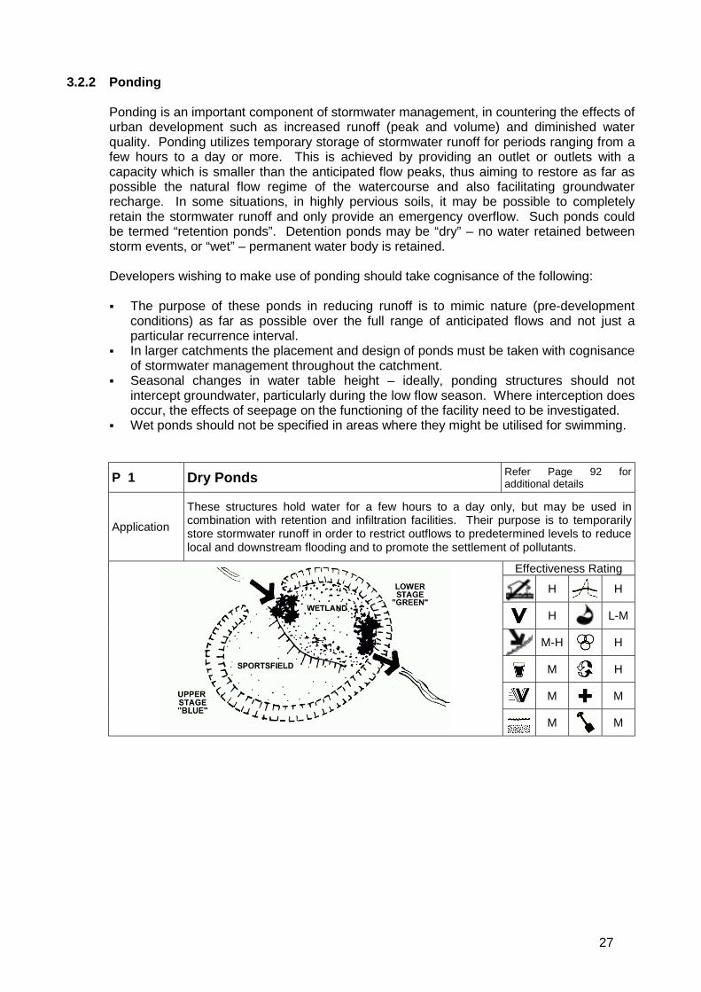
Ponding ................................................................................................................................... 92
Dry Ponds................................................................................................................................ 92
Wet Ponds............................................................................................................................... 94
Rooftop Runoff Management.................................................................................................. 97
Infiltration................................................................................................................................. 99
French Drain ........................................................................................................................... 99
ix
Hard Porous Surfaces - Asphalt / Concrete.......................................................................... 100
Hard Porous Surfaces-Paving Blocks................................................................................... 101
Infiltration Trenches............................................................................................................... 102
Infiltration Basins................................................................................................................... 103
Swales................................................................................................................................... 105
Check Dams.......................................................................................................................... 106
Filtration and Treatment ........................................................................................................ 108
Vegetated Filter Strips........................................................................................................... 108
Natural And Artificial Wetlands ............................................................................................. 109
Litter Traps ............................................................................................................................ 111
Sediment Traps..................................................................................................................... 112
Oil Separator ......................................................................................................................... 114
Annexure G - Planting Schedules........................................................................115Annexure H - City of Cape Town Stormwater Land Identification Database........119Annexure I - Minimum Design Standards for Underground Stormwater Reticulation
and Associated Intakes ..................................................................121Pipes Joints .......................................................................................................................... 122
Bedding ................................................................................................................................ 122
Gradients .............................................................................................................................. 122
Catchpits / Gullies................................................................................................................. 122
Manholes .............................................................................................................................. 123
Junction Boxes/Non Accessible Junctions........................................................................... 123
Annexure J - GIS Protocols for Stormwater As-Built Drawings and Data CaptureProjects ........................................................................................124

x
Preface
Document Overview and Purpose
This guideline document, prepared in terms of Council’s Catchment, Stormwater andRiver Management Strategy: 2002 – 2007 (May 2002) is intended to facilitate thedevelopment and extension of stormwater management systems on a rational andcoherent basis within the Cape Town metropolitan area.
The Guidelines are provided to assist in the planning and design for stormwatermanagement systems. Particular emphasis is placed on the development of innovativesolutions that are cost effective, sustainable in terms of future maintenance requirements,environmentally sensitive and maximise, within these constraints, social as well asamenity value.
Applicability and Status of Document
Whilst the guidelines are focussed on new developments, they are equally applicable toother stormwater management upgrading and rehabilitation projects. They are intended toassist decision-making and should not be construed as standards or specifications.
These guidelines are intended to assist developers and their consulting teams in theplanning and design of stormwater management systems as well as municipal officialsinvolved in the approval and operation thereof.
Other Applicable Guidelines
This document is to be read and interpreted in conjunction with the Guidelines for HumanSettlement Planning and Design (Red Book) prepared by the CSIR – Building andConstruction Technology Division. In the event of conflict, this guideline will prevail.
Document Structure
Pertinent information and issues to be considered during the various phases of astormwater management project, from project identification through to planning, design,construction and maintenance have been grouped under separate sections.
xi
Glossary of Terms
Aquifer: A geological formation, which has structures or textures that hold water orpermit appreciable water movement through them.
Base Flow: Flow occurring in a watercourse not attributable to a storm rainfall event, butto groundwater flow where the water table intersects the stream channels of a catchment.
Catchment: (in relation to a watercourse or watercourses or part of a watercourse) meansthe area from which any rainfall will drain into the watercourse or watercourses or part of awatercourse, through surface flow to a common point or common points
Catchment Management: simultaneously a philosophy, a process and animplementation strategy to achieve a balance between utilisation and protection ofenvironmental resources in a particular catchment area
Council: means the municipal council of the City of Cape Town.
Detention facility: A structure, which temporarily stores excess stormwater for a length oftime. The outlet of the structure is designed to release the stored water into thedownstream watercourse at a rate less than the flow rate into the facility during stormevents.
Development: means a man-made change to property, including but not limited tobuildings or other structures, mining, dredging, filling, grading, paving, excavation ordrilling operations or storage of equipment or materials.
Environmental Impact Assessment: means a study of the likely effect on theenvironment of proposed activities or development.
Flood or Flood Waters: means a temporary rise in water level including ground water oroverflow of water onto land not normally covered by water.
Flood Plain: The flood plain of a river is the valley floor adjacent to the incised channel,which may be inundated during high water.
Habitat Integrity: Habitat Integrity (Southern Waters 2001) is the degree of naturalness ofa system, calculated as a percentage, and reported as one of six broad Habitat Integritycategories, ranging from Category A (unmodified) to Category F (critically modified).Habitat Integrity data allow the calculation of River Priority Rank – a measure of theconservation importance of a river, relative to that of other similar rivers. In terms ofplanning, the River Priority Rank of a system, influences the recommended buffer widthbetween the riverbank and the development line.
Interception: Precipitation stored on vegetation as opposed to rain in surfacedepressions (termed depression storage).
Major drainage system: A stormwater drainage system, which caters for severe,infrequent storm events. Supported by the minor drainage system.
Management Plan: A document including, as appropriate, both written and diagrammaticinformation describing how a particular area of land is to be used and managed to achievedefined objectives. It may also include description and discussion of various issues,problems, special features and values of the area, the specific management measureswhich are to apply and the means and timing by which the plan will be implemented.
xii
Minor drainage system: A stormwater drainage system, which caters for frequent stormsof a minor nature.
Pollution: means the direct or indirect alteration of the physical, chemical or biologicalproperties of a water resource so as to make it less fit for any beneficial purpose for whichit may reasonably be expected to be used; or harmful or potentially harmful to:! the welfare, health or safety of human beings! any aquatic or non-aquatic organisms! soils and vegetation! the resource quality! property
Recurrence interval: Recurrence interval or return period is the average interval betweenevents. The recurrence interval is usually expressed in years and is the reciprocal of theannual probability. That is, the event having an annual probability of occurrence of 2%(0,02) has a recurrence interval of 50 Years. This does not imply that such an event willoccur after every 50 years, or even that there will necessarily be one such event in every50 years. This does not imply that such an event will occur after every 50 years, but ratherthat over a much longer period (like a 1 000 year period) there will very likely be 20 eventsof equal or greater magnitude.
Retention Facility: A structure which retains runoff indefinitely should the capacity of thestructure be sufficient to contain such runoff. Excess flow into the structure will bedischarged via a spillway.
Riparian Habitat: includes the physical structure and associated vegetation of the areasassociated with a watercourse which are commonly characterised by alluvial soils, andwhich are inundated or flooded to an extent and with a frequency sufficient to supportvegetation of species with a composition and physical structure distinct from those ofadjacent land areas
Runoff: Water, which flows over surfaces.
Sheet flow: Overland stormwater runoff which is not confined to a channel but has arelatively shallow and wide flow pattern.
Stormwater: means water resultant from natural precipitation and/or accumulation andincludes rainwater, groundwater and spring water.
Stormwater Management: involves both the quantitative and qualitative management ofstormwater and the functions associated with planning, designing, constructing, operating,maintaining and financing stormwater management systems.
Stormwater Management Systems: means both constructed and natural facilities thatcollect, convey, store, control, treat, use and dispose of stormwater.
Sustainable development: Development that meets the needs of the present withoutcompromising the ability of future generations to meet their own needs.
Watercourse: Lake, river, channel or other topographic feature in which water flowsregularly or intermittently.
Water Resource: includes a watercourse, surface water, estuary or aquifer (NationalWater Act 1998)

xiii
Wetland: Land which is transitional between terrestrial and aquatic systems where thewater table is usually at or near the surface, or the land is periodically covered withshallow water, and which land in normal circumstances supports or would supportvegetation typically adapted to life in saturated soil. Wetlands include lakes, salt marshes,coastal lakes, artificial impoundments, marshes, swamps, vleis, pools, ponds and pans.
Abbreviations
CMA Cape Metropolitan Area
CCT City of Cape Town
DECAS Department of Environmental and Cultural Affairs and Sport
DWAF Department of Water Affairs and Forestry
EIA Environmental Impact Assessment
EMP Environmental Management Programme
GIS Geographical Information Systems
HEC Hydrologic Engineering Centre
IMEP City of Cape Town - Integrated Metropolitan Environmental Policy
OMP Operation Management Plan
PAWC Provincial Administration of the Western Cape
SCS US Soil Conservation Service
USEPA United States Environmental Protection Agency

2
1. Preparation and Approach1.1 The Stormwater Management Service
Cape Town's stormwater management system comprises a complex mix of constructedinfrastructure (underground pipes and culverts, lined and unlined canals, etc) and"natural" features (rivers, vleis, wetlands, groundwater reservoirs etc) with various diversefunctions (stormwater drainage, recreation, nature conservation, wastewater effluentconveyance, water supply, etc). The stormwater service provided within the metropolitanarea involves the management of urban catchments in respect of their hydrologicalfunctioning for drainage, flood control, ecological and social needs and as an importanturban water resource.
1.2 Managing the Impact of Development on Natural Drainage Systems
It is widely recognised that developments impact negatively on natural drainage systemsin several ways, including:
! Reduced permeability of catchment areas by introduction of impervious surfaces suchas streets and buildings. This results in increased catchment runoff volumes.
! The introduction of efficient stormwater drainage results in reduced catchmentresponse times with concomitant increased downstream flow peaks.
! Manipulation of groundwater tables, which can have severe effects on wetlandfunctioning and the survival of many terrestrial plant communities.
! Alteration to the natural flow regimes in river systems resulting in both geomorphologic(e.g. channel / bank erosion) and aquatic ecosystem changes over time.
! Deteriorating water quality as a result of industrial fallout, fertilisers and otherpollutants that are conveyed by stormwater systems directly to receiving water bodies,without any attempt to ameliorate en route.
These guidelines require greater cognisance to be taken of natural hydrological patternsand systems in the development of stormwater management systems and that thepotential negative impacts highlighted above are reduced as far as is practically possible.This is illustrated by means of Figures 1 to 3 below, depicting both the traditional andrecommended approaches to stormwater management within the urban context.
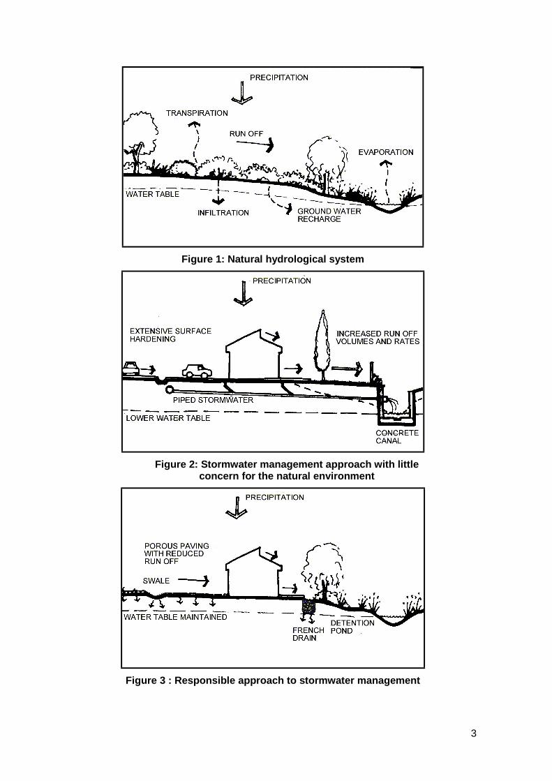
3
Figure 1: Natural hydrological system
Figure 2: Stormwater management approach with littleconcern for the natural environment
Figure 3 : Responsible approach to stormwater management
4
1.3 Stormwater Management Objectives
1.3.1 Minimise the Threat of Flooding
This remains a key objective of any stormwater management system. However thechallenge when contemplating design of stormwater management systems is to considerthe following:! To mimic pre-development responses to storms! To reduce the volume of runoff by promoting infiltration! To reduce the peak flows and increase the time-to-peak through detaining the runoff
and releasing it at a gradual rate! Where necessary, to construct means to contain flood waters and safely convey them
out of the urban area
1.3.2 Protection of Receiving Water Bodies
Receiving water bodies include the following:
! Rivers / streams! Groundwater! Wetlands which include vleis, lakes, seasonal marshes, and pans)! The sea
It should be noted that the “receiving water body” is not necessarily the system into whichstormwater is discharged directly, but can also be a natural system located furtherdownstream in the catchment. Every endeavour should be made to achieve the followingas far as possible:
! Maintain natural flow regimes and seasonality! Prevent deterioration in water quality! Prevent erosion or sedimentation of natural wetlands or rivers! Preserve natural river channels, wetlands and vegetation, and preclude engineering
interventions that may alter their physical and ecological characteristics.
The need to design appropriate stormwater management systems for new developmentsshould be seen as an opportunity to preserve or, if possible, improve natural freshwaterecosystems that have suffered degradation as a result of past activities, and in somecases, to create additional freshwater habitats that will contribute to the availability ofappropriate, high quality river and wetland habitat that mimics the natural condition.
1.3.3 Promote Multi-Functional Use of Stormwater Management Systems
Resources such as land and water are becoming increasingly scarce and multiple use ofthese must be strived for. Stormwater systems provide a wide range of opportunities formulti-functionality. These can have significant implications on:
! The initial and long term costs of development. Eg. Instead of constructing a detentionpond and a sportsfield, these uses could be combined.
! The quality of the natural and urban environment. Eg. The pressure of privatedevelopment requirements on land for public land use, conservation, etc can bealleviated by combining compatible land uses such as conservation, recreation andstormwater systems (including wetlands, vleis, dams and rivers) enabling an improvednatural and urban environment.
! Maintenance efficiency. Eg. Instead of meeting the maintenance requirements ofstormwater systems and public open space separately, they could be combined andcould include walking/bicycle trails and parks.

5
1.3.4 Development of Sustainable Environments
Developers should think beyond their short-term involvement with the project andconsider the sustainability of the stormwater management system that is to beimplemented. All relevant factors that will impact on future operation and maintenanceshould be taken into account. Maintenance requirements should be minimised as far aspossible in order to maximise the available local authority funding, personnel andequipment. Responsibilities for maintenance must be resolved with the relevant localauthority department at an early stage of the design.
The possibility of developing public/private partnerships should be explored with localauthorities (e.g. division of funding of capital versus maintenance costs between publicand private sectors).
Environmental policies such as promoting the use of locally indigenous vegetation inplanting programmes will also reduce the long-term maintenance requirements of thedevelopment.
6
2. Stormwater PlanningAdequate planning is crucial to the success of the project as a whole. This sectionendeavors to sketch out the areas where relevant information should be assembled andhow this information may be integrated into a stormwater management plan, which willassist the design process, which follows.
2.1 The Need for Multi-disciplinary Expertise
In order to meet these objectives in designing an effective stormwater managementsystem, the developer is urged to adopt a multi-disciplinary approach to the project frominception through to completion and acceptance by the City. This will enable thedeveloper to maximise opportunities.
The roles that such a team could fulfil are set out in Table 2-1.
Table 2-1 : Recommended composition of multi-disciplinary design team
Team Member Role
Town PlannerThe town planner should plan the development layout to locate thestormwater system – attenuation dams, channels, and overlandescape routes – to functionally blend with the development.
Civil Engineer
An engineer skilled in the design of stormwater systems shoulddetermine runoff flows for the required recurrence intervals andproposed land uses and design appropriate measures to attenuatepeak flows and safely convey the runoff.
EnvironmentalConsultant
The environmental consultant should alert the engineer and townplanner at the conceptual stage of the development to crucialaspects of the environment, which are fulfilling an important role withrespect to stormwater and should be taken into consideration, aswell as opportunities for enhancement or rehabilitation of existingnatural features.
FreshwaterEcologist
The freshwater ecologist should provide specialist insight regardingthe functioning of natural rivers, streams and wetlands and adviseregarding the ecological aspects of the design of the components ofthe system, including water quality enhancement and the landneeded for the system to function.
If
requ
ired
LandscapeArchitect
The landscape architect should provide a holistic site analysis of theexisting natural and man-made landscape and advise on theopportunities, constraints and implications of the site on thedevelopment planning and design.
2.2 Interface with Municipal Service Delivery Units
Provision of stormwater management services within the City of Cape Town requires amulti-sectional approach dependent on the co-operation of various service delivery unitsas illustrated in Table 2-2 below.

7
Table 2-2 : City service delivery units with an interest and / or impact in themanagement of drainage systems
Service Delivery Unit Interest / ImpactRoads Roadways form part of the drainage system.Water Services Discharge of wastewater effluents into river systems. Also possible
future abstraction of water from rivers and aquifers to augmentwater supply to the metropolitan area.
Waste Management Effective street sweeping and area cleansing reduces pollution ofwatercourses, the marine environment and reduces flood risk.
Planning andEnvironment
Responsible for urban planning and environmental auditing.
Open Space, Nature andCoastal Management
Management of amenity and nature conservation aspects ofriverine corridors, wetlands, vleis and beaches.
Health Human health implications of poor water quality.Housing Responsible for informal settlementsDisaster Management Management of flood disasters and pollution incidents
In addition, the certain external stakeholders also have an interest and / or impact on theservice as illustrated in Table 2-3 below.
Table 2-3 : External stakeholders with an interest and / or impact in the managementof drainage systems
Organisation Interest / ImpactDepartment of WaterAffairs and Forestry(DWAF)
Management and control of water resources in terms of NationalWater Act (Regulatory function)
Provincial Administrationof the Western Cape(PAWC)
Control of activities that may have a detrimental effect on theenvironment in terms of Environmental Conservation Act(Regulatory function)
Academic and ResearchInstitutions
Related research and education
Non GovernmentalOrganisations andCatchment Forums
Advise and monitor activities of service
2.3 Legal and Policy Considerations
Although not exhaustive, the statutes, ordinances, regulations, by-laws, policies andguidelines listed in this section (Refer to Annexure A for details) have relevance, andshould be considered by the developer at the planning stage. They should not however beseen as exhaustive as they are subject to ongoing amendments, revisions and additions.
Legal Status of DocumentsIt is essential that the developer ensure that he is aware of any
amendments to the relevant acts as these can have substantial impact ona development project.

8
2.3.1 National level
! Constitution of the Republic of South Africa, 1996 (Act 108 of 1996)! Local Government: Municipal Systems Bill (B27B-2000)! National Water Act, 1998 (Act 36 of 1998)! DWAF Water Quality Guidelines, 1996! National Environmental Management Act, 1998 (Act 107 of 1998)! Environmental Conservation Act, 1989 (Act 73 of 1989)! Environmental Impact Assessment (EIA) Regulations (No.R1182 and R1183 –
September 1997)! Protected Natural Environments! Conservation of Agricultural Resources Act, 1983 (Act 43 of 1983)! Development Facilitation Act, 1995 (Act 67 of 1995)! National Building Regulations and Building Standards Act, 1997 (Act 103 of 1977)
2.3.2 Provincial level
! Western Cape Planning and Development Act, 1999 (Act 7 of 1999)! Land Use Planning Ordinance, 1985 (Ordinance 15 of 1985)
2.3.3 Municipal (City of Cape Town)
! Proposed by-law for Stormwater Management and Related Matters (In preparation)! Policy for Control of Development Near Watercourses (City of Cape Town, 2002)! Stormwater Land Identification Project (SLIP): a set of GIS plans covering the entire
CMA which identifies all erven impacted by stormwater issues! Integrated Metropolitan Environmental Policy (2001)! Zoning Schemes
2.3.4 International Conventions
! Ramsar Convention on Wetlands, 1975
2.4 Incorporation of Existing Information into Planning Stage
The following information should be collated for each site, during the planning stage andused to feed into the more detailed site assessment:
! Catchment area in which site is located! Catchment or river management plans - The overall management objectives and
recommend key management actions with respect to runoff quantity, quality and otherassociated environmental and social issues, where such plans exist for the catchmentin question, must be met in the design stage.
! Stormwater management master plan - This plan Identifies bulk infrastructure,including stormwater flow routes, required within developing areas and may identifyparticular issues such as pollution which must be addressed at a local level. Theexistence of a stormwater management master plan, which covers the area, to bedeveloped should be established and its recommendations applied to the design.
! Existing reports relating to the sensitivity of known wetlands / rivers / other naturalecosystems on or associated with the study area.
Cognisance must be taken of the interdependencies that exist between the various waterrelated services such as water supply, sanitation and stormwater management. Thisincludes consideration of the impact of effluent discharges into or water abstraction fromstormwater management systems.
9
If the developer is considering the implementation of educational type programmes, heshould first consult with the Catchment, Stormwater and River Management Branch onthe nature and status of their own current or planned educational programmes intended topromote basic awareness and appreciation of stormwater systems and the functioningand value of rivers, wetlands, vleis and the receiving coastal waters.
A useful resource which may be consulted is the library of Catchment, Stormwater andRiver Management Division of the City of Cape Town.
2.5 Site Analysis
The physical characteristics of the site reflect the existing course of runoff andstormwater. Working with the natural environment and processes has been found to besafer, more sustainable and easier to maintain in the long term than more traditionalengineering approaches aimed at controlling these processes.
On sites that have been substantially disturbed, consideration should be made of what thenatural drainage and runoff conditions would have been, as well as the existing situation.This will enable potential problems, and opportunities, to be identified.
The following are some of the main features that should be considered and collated in theform of a site analysis plan that should be used to inform the design process.
2.5.1 Topography
The following topographical factors should be considered:
! Gradients dictate the direction of flow and runoff/drainage routes can be plotted overland, identifying areas of ponding and concentration of loads.
! In some areas which are very flat, earthworks may be required to provide sufficientgrade for drainage.
! Topography influences the potential for erosion to occur.! Topography informs the feasibility of different locations for stormwater routes, outlets
and treatment areas. The main stormwater routes should be located along naturaldrainage routes.
! In ecological terms, different habitats, some of higher conservation value than others,are frequently associated with changes in topography.
! From an environmental and stormwater management perspective, as the slopeincreases, erf sizes should also increase to prevent excessive run-off and potentialerosion. Road and planning layouts should also reflect the topography of an area, toenable integrated stormwater design and management.
! The commercial (and aesthetic) value of different sections of a development area isalso frequently derived from different topographical characteristics.
2.5.2 Geology, Soils and Groundwater
A good understanding of the geology, soil and groundwater conditions is an importantfactor in assessing the infiltration potential of the site. The following factors should beconsidered:
! Soil types affect surface permeability and hence rate of runoff.! The mapping of geology and soils will indicate areas of potential groundwater
recharge.! Geology and soils influence the potential for erosion to occur.
10
! Soil types should be identified, along with the characteristics of the different soils, suchas levels of infiltration, permeability and their water-bearing capacity.
! The presence of contaminated soils, which may pose a threat to surface andgroundwater quality should be identified and plotted.
! Areas of high groundwater levels can limit the possibilities and/or desirability ofgroundwater recharge and filtration methods. It should be noted that large-scaleremoval of certain vegetation types, such as Port Jackson (Acacia saligna) andBluegums (Eucalyptus sp.), that consume large volumes of water, might significantlyraise groundwater levels.
! Need to determine seasonal and longer term trends in groundwater level fluctuation(City of Cape Town, 2002 (in draft))
! Groundwater information available in the CMA! Soil types indicate the likely occurrence of particular plant communities, some of which
may play a role in the stormwater management plan.! Assessing soils can also indicate the presence of both existing and even historic
wetlands.! Seasonal variation of groundwater levels should be taken into account.! The geology and soils of a site will inform the feasibility of different locations for
stormwater treatment areas and the potential for groundwater recharge.! Different habitats (some with high conservation value) are associated with specific
geological features and soils.
2.5.3 Climate
The following climatic factors should be considered:
! Storm rainfall parameters are major design factors and must be carefully determined(Refer to Annexure E - Modeling Tools, Techniques And Parameters)
! The general climatic characteristics of an area will also impact on the site andstormwater systems implemented, ie whether the site is generally waterlogged or dryand if evaporation levels are high or low.
! Microclimate conditions can inform the spatial layout of water treatment andattenuation, particularly those associated with specific planting and multifunctionaluses.
2.5.4 Hydrology
It is essential, for successful, sustainable and integrated stormwater management, thatthe existing and/or natural hydrological response and functions of the site are understood.The following factors should be considered:
! The natural drainage that was characteristic of the development area, to the extentthat this is possible, should be determined and both the irreversible as well as lesspermanent changes that have taken place should be identified.
! The hydrology of the development area is a function of much of the other data, whichis described under the Site Analysis section.
Tools for quantifying storm runoff quantity and quality are dealt with in Annexure E -Modeling Tools, Techniques And Parameters on page 74.
Determining Groundwater LevelsIn the absence of sufficient documented groundwater information, theseasonal and long-term ground water fluctuations should be projected,based on the hydrological, geological and climatic information available.
11
2.5.5 Natural Ecosystems, Flora and Fauna
The site should be assessed in terms of the natural ecosystems and habitat types that itsupports. The following factors should be considered:
! Conservation (or improvement) of bio-diversity and ecosystem function must be one ofthe objectives of a management plan, as required by policies such as IMEP.
! Some habitats are afforded protection by existing legislation and guideline (e.g.wetlands; buffers around rivers and wetlands)
! Where the site intercepts natural corridors of movement between ecologicallyimportant areas, stormwater management should seek to retain or recreate suchcorridors.
! Endangered or threatened vegetation, animals and/or habitats should be identifiedand their opportunities and constraints for stormwater management assessed.
! Vegetation and animals that have roles or functions that can improve water quality,amelioration and/or infiltration should be identified, and their natural status andintegrity determined.
! Healthy, diverse and/or relatively undisturbed natural systems should be identified andassessed in terms of their habitat integrity and importance (environmentally, sociallyand culturally), and, wherever possible, be accommodated within the future planningand development of the site.
! The presence of invasive alien animals (e.g. fish, birds) or plants should bediscouraged from any developments. Alien flora or fauna associated with habitatscreated or maintained for the management of stormwater from a site should not beallowed to pass into any downstream or associated water bodies.
2.5.6 Ecological Characteristics of Freshwater Ecosystems
The occurrence of rivers, streams or other watercourses on the site should be identified.And the habitat integrity of each should be determined. The following ecological andecosystem factors should be considered:
! The floodplains and ecological buffers (Annexure B) that relate to the site should bedetermined at an early stage in order to establish the broad development planning,and specific stormwater, implications they have for the site.
! The presence of wetlands within the development site should be red flagged, due totheir global and nationally threatened status. Protection is accorded by certain policiesand legislation. They also may play a useful role in natural hydrological functioning,with potential for integration in an integrated stormwater management plan (ReferAnnexure C - Significance of Wetlands in Stormwater Planning on Page 54).
! The stormwater discharge and receiving capacity of rivers, channels and drainagecourses should be determined to establish the levels of integration of the natural andproposed stormwater management systems.
! The use of these linear elements should form part of an integrated public open spaceand stormwater system, and promote the multifunctional use of space.
! Floodplains and ecological buffers provide open space systems within which the morespace-consuming “soft technologies” of stormwater management can beaccommodated, without posing a conflict with development pressures on land.
! Development sites that do not have floodplains and ecological buffers within the areashould consider integrating a public open space system with an overland escape routefor an extreme storm event, to maximise the opportunity for habitat corridors.
! Where ecologically important wetlands or rivers are recipients of stormwaterdischarge, the quality and quantity of stormwater discharges into such systems shouldbe regulated to minimise downstream impacts. Cognisance should be taken ofcumulative impacts to water bodies occurring, as a result of discharge from several

12
sources. (Refer to the DWAF Water Quality Guidelines listed in Annexure A - Acts,Regulations, Policies and other Relevant Documents on Page 47)
2.5.7 Cultural and Historical Landscapes and Archaeological Sites
Areas, routes, vegetation and landmarks that have a cultural and/or historical use orsignificance should be identified. Development and stormwater planning should avoiddisturbing these areas where possible. Where possible they should generally beincorporated within the public open space of a development. This contributes a furtherfunction to the public open space system, and should be integrated into a network ofpublic open space.
2.5.8 Development Requirements
The public open space and pedestrian access requirements of a development should beincorporated into the stormwater management planning of the site. The integration ofpublic open space and access requirements with the spatial requirements of stormwatermanagement not only reduces the conflict of pressure on land, but also enables theamalgamation of maintenance requirements, and maximises the use of resources.
The following factors should be considered:
! Land use planning should be done in relation to the natural context and characteristicsof the site. The appropriate placement of land uses will enhance the multi-functionalityof the stormwater systems and their use as an amenity by residents in the area.
! Innovative opportunities exist for future the stormwater management system to link-upand add value to educational initiatives (outdoor classroom), ownership (friendsgroups adopting the system), and water saving (re-use of stormwater/treated effluentfor irrigation). These opportunities are also area specific need to be identified upfront, rather than as nice to have after thought.
! The need for a safe environment must be taken into account (e.g. avoid of potentialhiding places for criminal elements; do not create unnecessary hazards in theselection of stormwater management options).
! The cost of stormwater implementation, management and maintenance, as well asflood risk, can be greatly reduced by identifying, retaining and enhancing the naturalareas along which runoff and natural habitat retain ecological integrity. Theadvantages of this approach are not limited to stormwater, but can increase the visual,amenity and ecological value of a development.
2.5.9 Ownership Opportunities and Constraints
A clear distinction should be made between public and privately owned land. Thefollowing factors should be considered:
! As a principle, stormwater should as far as possible be accommodated within publicopen areas or spaces under common ownership.
! Servitudes should always be registered in the favour of the controlling authority toensure effective management and access at all times.
! Public open space used in the stormwater systems should be clearly demarcated toensure that the stormwater functions are apparent and to enable monitoring andpolicing.
! Early identification of land ownership in potential stormwater treatment or conveyanceareas outside of the development area will assist in identifying constraints, in somecases, as well as opportunities to provide additional space for stormwatermanagement, through inter alia land swaps, use of public open space and localauthority land.

13
! Servitudes and public rights of way can also be incorporated into the stormwatersystems, for example use of road reserves for conveyance and/or infiltration, but theseelements should not be critical to performance, as they may be relinquished for laterdevelopment purposes (road widening, etc.). The servitudes may not however berelinquished if they are embodied in the title deeds, without legally altering or deletingthe servitude which would require the local authority consent.
2.5.10 Spatial Opportunities and Constraints
The amount of appropriate public space that is available for stormwater managementshould be identified at an early stage in project planning, since this will largely dictate theextent to which different stormwater design elements are feasible in a development.
Where site analyses show that spatial constraints are likely to dictate stormwater design,attention should focus on identification of spatial opportunities outside of thedevelopment area (e.g. areas of public open space, local authority land; schools and otherareas of open space), that might lend themselves, through negotiation, to moreecologically desirable stormwater design options.
2.5.11 Surrounding Developments
Stormwater management design options should take cognisance of developments in theupstream catchment that are likely to impact on the timing, quality or quantity ofstormwater generated upstream of the development area. Identification of these issueswill highlight potential problem areas in stormwater management. The following factorsshould be considered:
! It is important that site planning be done in context with the adjacent properties toensure effective stormwater systems and integrated stormwater corridors. Sufficientretention facilities should therefore be planned and provided on site as part of anintegrated open space system.
! Clarity on the stormwater management principles employed in upstreamdevelopments should also be obtained so that anticipated stormwater runoff fromthese areas can be quantified.
! The rate of growth and anticipated land-use of surrounding developments and areasthat discharge onto the development site should also be taken into account todetermine the future pressures on the stormwater systems.
! The general capacity of the stormwater systems of surrounding developments that liedownstream of the site, and the current rate of growth and pressure on these systemsshould be taken into account during site planning and design. Failure of systemsdownstream can cause failure and flooding upstream. As a principle, the postdevelopment runoff should not exceed the predevelopment runoff.
2.6 Maintenance Capacity
Before stormwater design options are considered in any detail, it is vital that the developerhas a clear indication of the practical maintenance capacity, in terms of time, personneland finance, of the final managing authority for the stormwater system. Aesthetically orecologically complex designs that owe their sustainability to regular maintenance inputson a permanent basis will fail in the medium to long term, if there is no capacity forongoing and adequate maintenance.
Similarly, where public expectations centre on aesthetically pleasing design, adequateallowance must be made for basic maintenance activities, such as removal of litter or alienclearing. If this is neglected, the project as a whole may be deemed a failure in the eyes
14
of the public. This may have ramifications for the rest of the project in question, as well asfuture projects requiring public buy-in and support.
2.7 Site Planning
2.7.1 Site Analysis
As part of the site analysis process, it is suggested that the developer prepare thefollowing items to guide in the formulation of a stormwater management plan:
a) A checklist for easy identification of aspects to be considered as they emerge from thesite analysis (Section 2.5 above)
! Topography! Geology and Soils! Groundwater! Climate! Hydrology! Natural Ecosystems (flora and fauna)! Cultural and Historical Landscapes and Archaeological Sites! Development Requirements! Ownership Opportunities and Constraints! Spatial Opportunities and Constraints! Surrounding Developments! Maintenance Capacity
b) A Site Analysis Plan that maps out the informants that have implications forstormwater management.
2.7.2 Conceptual Layout
A general concept plan for the site layout should be developed, taking into account thelegal and physical aspects of the site as developed through the site analysis process.This plan should indicate the location of different land-uses. This will influence thestormwater management conditions, and reflect some of the spatial requirements of thesystem.
2.7.3 Conceptual Stormwater Planning
The information gathered concerning the site and relevant legislation and policydocuments as summarised in the Site Analysis Plan and Conceptual Layout Plan will thenbe used to draw up a Conceptual Stormwater Plan. This plan will indicate the major flowroutes, natural features that will form a part of the stormwater system and areas, whichare to be set aside for elements of the stormwater system such as attenuation ponds. Itwill then be modified and refined in the design phase.
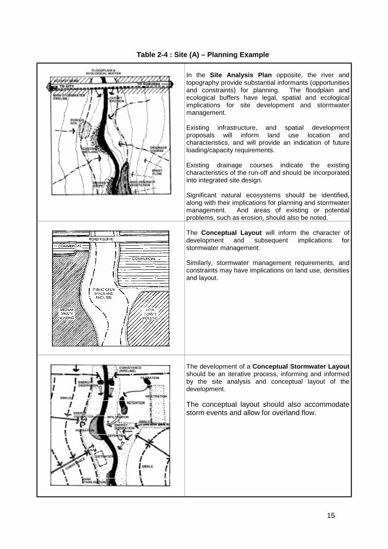
Two examples of this process are presented in Table 2-4 and Figure 4 as well as Table2-5 and Figure 5 on the following pages.
15
Table 2-4 : Site (A) – Planning Example
In the Site Analysis Plan opposite, the river andtopography provide substantial informants (opportunitiesand constraints) for planning. The floodplain andecological buffers have legal, spatial and ecologicalimplications for site development and stormwatermanagement.
Existing infrastructure, and spatial developmentproposals will inform land use location andcharacteristics, and will provide an indication of futureloading/capacity requirements.
Existing drainage courses indicate the existingcharacteristics of the run-off and should be incorporatedinto integrated site design.
Significant natural ecosystems should be identified,along with their implications for planning and stormwatermanagement. And areas of existing or potentialproblems, such as erosion, should also be noted.
The Conceptual Layout will inform the character ofdevelopment and subsequent implications forstormwater management.
Similarly, stormwater management requirements, andconstraints may have implications on land use, densitiesand layout.
The development of a Conceptual Stormwater Layoutshould be an iterative process, informing and informedby the site analysis and conceptual layout of thedevelopment.
The conceptual layout should also accommodatestorm events and allow for overland flow.
16
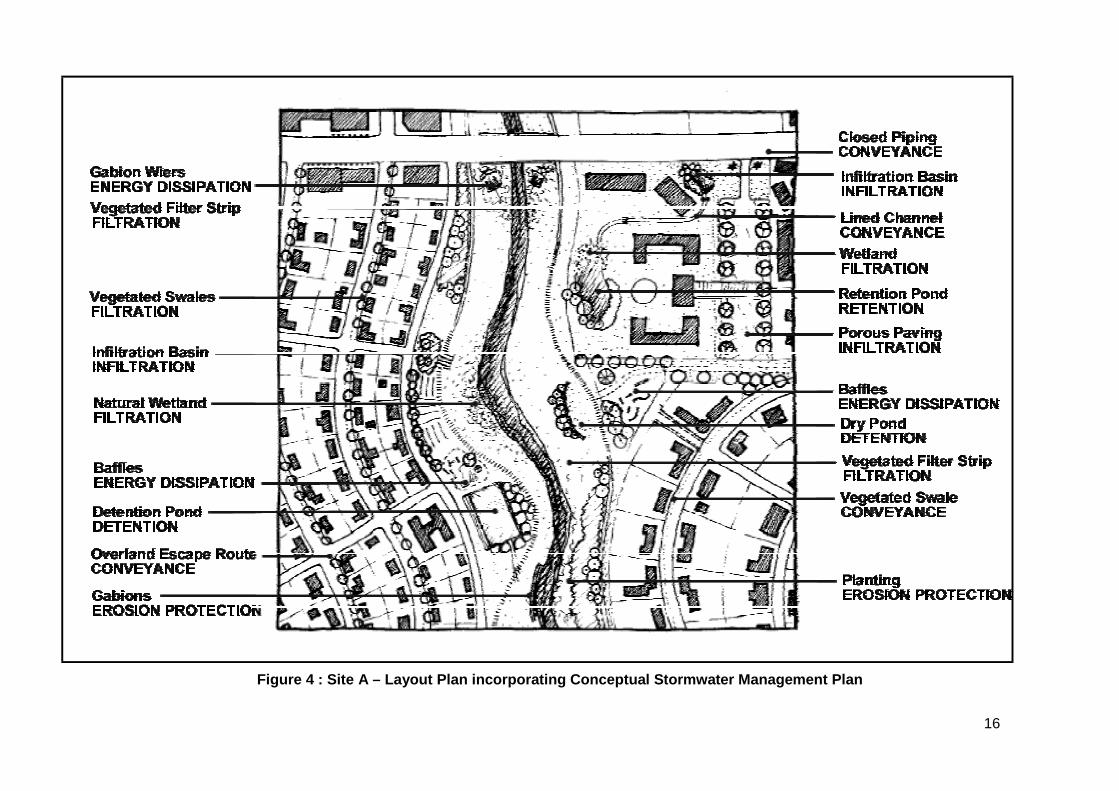
Figure 4 : Site A – Layout Plan incorporating Conceptual Stormwater Management Plan
17
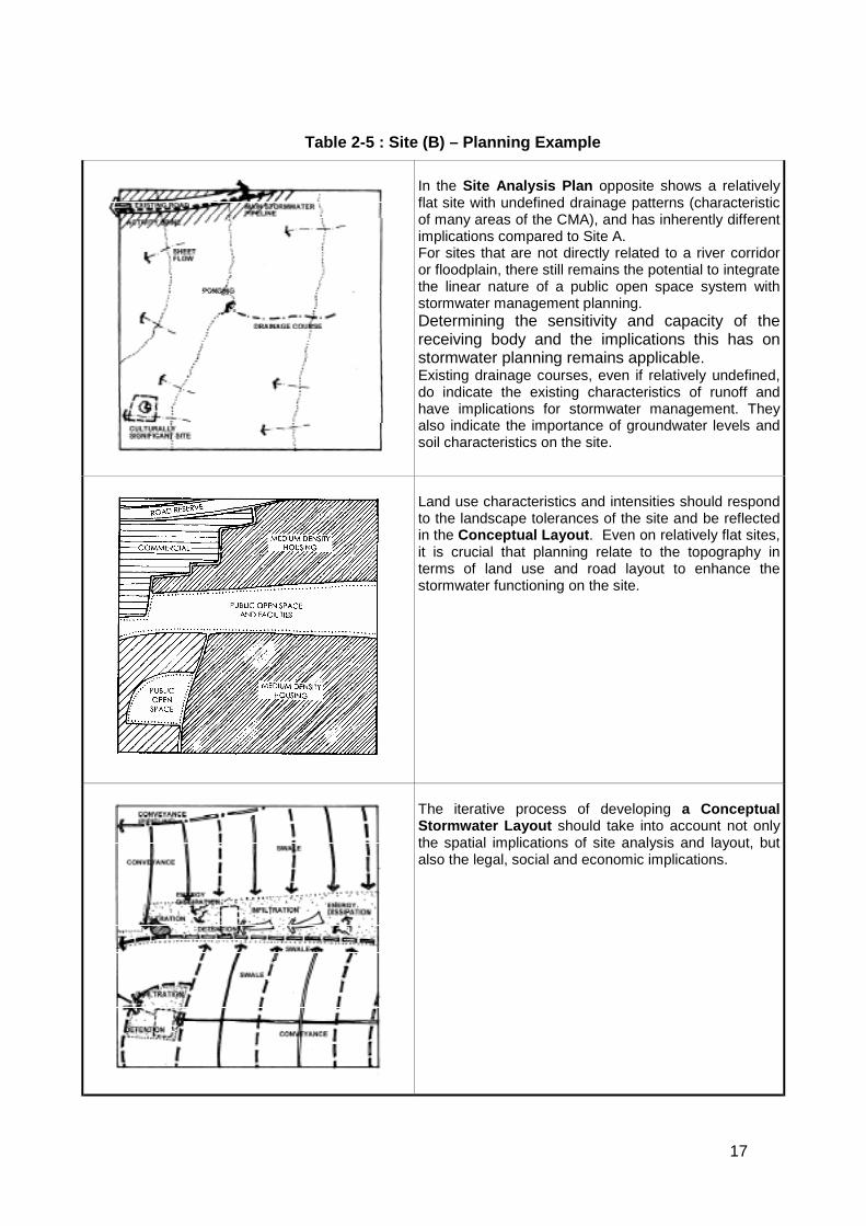
Table 2-5 : Site (B) – Planning Example
In the Site Analysis Plan opposite shows a relativelyflat site with undefined drainage patterns (characteristicof many areas of the CMA), and has inherently differentimplications compared to Site A.For sites that are not directly related to a river corridoror floodplain, there still remains the potential to integratethe linear nature of a public open space system withstormwater management planning.Determining the sensitivity and capacity of thereceiving body and the implications this has onstormwater planning remains applicable.Existing drainage courses, even if relatively undefined,do indicate the existing characteristics of runoff andhave implications for stormwater management. Theyalso indicate the importance of groundwater levels andsoil characteristics on the site.
Land use characteristics and intensities should respondto the landscape tolerances of the site and be reflectedin the Conceptual Layout. Even on relatively flat sites,it is crucial that planning relate to the topography interms of land use and road layout to enhance thestormwater functioning on the site.
The iterative process of developing a ConceptualStormwater Layout should take into account not onlythe spatial implications of site analysis and layout, butalso the legal, social and economic implications.
18
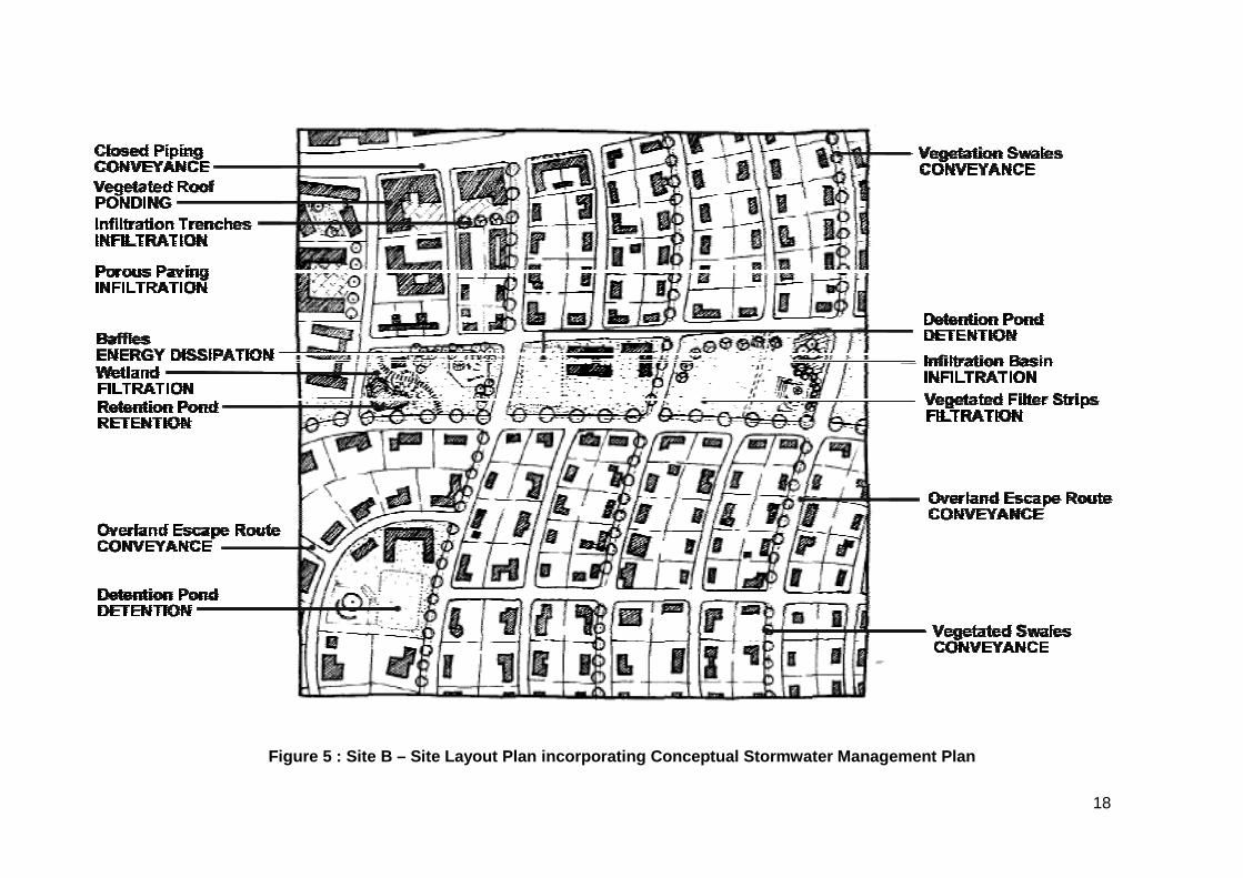
Figure 5 : Site B – Site Layout Plan incorporating Conceptual Stormwater Management Plan

19
3. DesignOnce the planning phase process has developed a conceptual stormwater plan for the site,there is need for a design phase that develops site and context specific design of thestormwater management system. This section provides design guidelines to informappropriate stormwater design for a development.
The key variables to be evaluated and managed are water quantity (volume and peak flow)and water quality. Suggested calculation methods and parameters are described inAnnexure E - Modeling Tools, Techniques And Parameters on Page 74. Construction,operation and maintenance implications are dealt with in Sections 4 and 5.
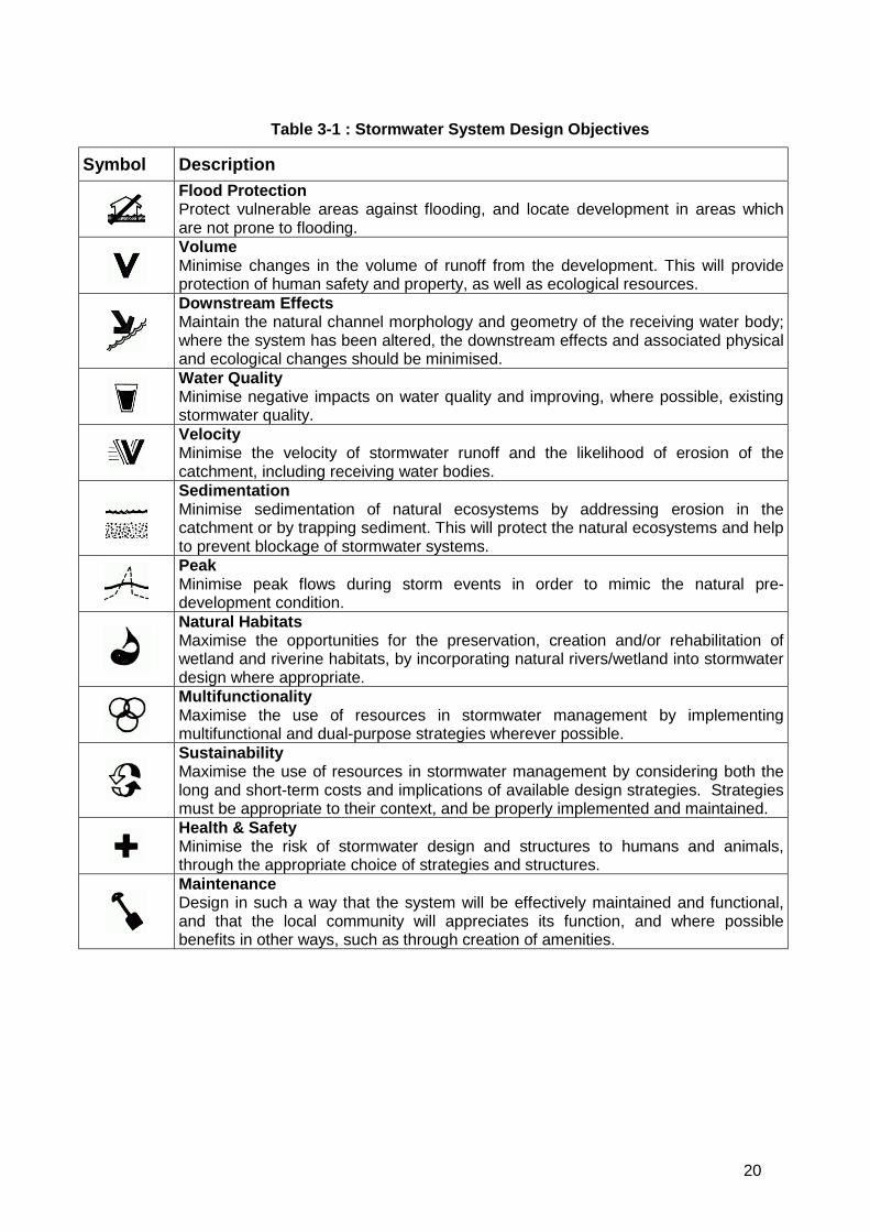
3.1 System Design Objectives
Various stormwater management facilities and techniques are presented and evaluated interms of engineering, ecological, health, safety, aesthetic, social, construction andmaintenance design objectives. The system design objectives listed in Table 3-1 below,should form the basis for the selection of appropriate design options.
Important
The developer would need to demonstrate, through submission ofappropriate stormwater designs, the extent to which the proposed
development would meet these system design objectives.
Monitoring requirements may be imposed on the development tomeasure long term performance and compliance.
20
Table 3-1 : Stormwater System Design Objectives
Symbol DescriptionFlood ProtectionProtect vulnerable areas against flooding, and locate development in areas whichare not prone to flooding.VolumeMinimise changes in the volume of runoff from the development. This will provideprotection of human safety and property, as well as ecological resources.Downstream EffectsMaintain the natural channel morphology and geometry of the receiving water body;where the system has been altered, the downstream effects and associated physicaland ecological changes should be minimised.Water QualityMinimise negative impacts on water quality and improving, where possible, existingstormwater quality.VelocityMinimise the velocity of stormwater runoff and the likelihood of erosion of thecatchment, including receiving water bodies.SedimentationMinimise sedimentation of natural ecosystems by addressing erosion in thecatchment or by trapping sediment. This will protect the natural ecosystems and helpto prevent blockage of stormwater systems.PeakMinimise peak flows during storm events in order to mimic the natural pre-development condition.Natural HabitatsMaximise the opportunities for the preservation, creation and/or rehabilitation ofwetland and riverine habitats, by incorporating natural rivers/wetland into stormwaterdesign where appropriate.MultifunctionalityMaximise the use of resources in stormwater management by implementingmultifunctional and dual-purpose strategies wherever possible.SustainabilityMaximise the use of resources in stormwater management by considering both thelong and short-term costs and implications of available design strategies. Strategiesmust be appropriate to their context, and be properly implemented and maintained.Health & SafetyMinimise the risk of stormwater design and structures to humans and animals,through the appropriate choice of strategies and structures.MaintenanceDesign in such a way that the system will be effectively maintained and functional,and that the local community will appreciates its function, and where possiblebenefits in other ways, such as through creation of amenities.
21
3.2 Appropriate Stormwater Management Facilities and Techniques
Various facilities and techniques that may be utilised to manage stormwater runoff from thedevelopment have been grouped by generic function as follows:
a) Conveyance
Use of natural or artificial channels, natural or artificial wetlands or pipes and culvertsfor stormwater conveyance as well as the prevention of erosion.
b) Ponding
A form of flow rate control, this term usually refers to methods of infiltrating runoff intothe ground or otherwise holding it back for a period, reducing peak runoff, contributingto extended base-flows, improving water quality and creating natural habitats.
c) Infiltration
Reduces runoff volume and contributes to groundwater recharge.
d) Filtration and Treatment
Water quality may be improved by a number of means including ponding and filtrationand to a lesser extent conveyance facilities and techniques. By carrying out thisfunction as close to source as possible impact on stormwater systems and habitatfunctioning may be minimised.
Table 3-2 below provides a quick reference index to locating possible facility optionsand techniques within the document. The tabulations that follow provide a briefdescription and appropriate application of the stormwater management option with adiagram depicting an example of its use. More in-depth information to assist in design isprovided in Annexure F - Stormwater Management Facilities and Techniques oncommencing on Page 78.
The effectiveness of various facility options and techniques presented in the followingsections have been rated as follows:
H - HighM - ModerateL - Low
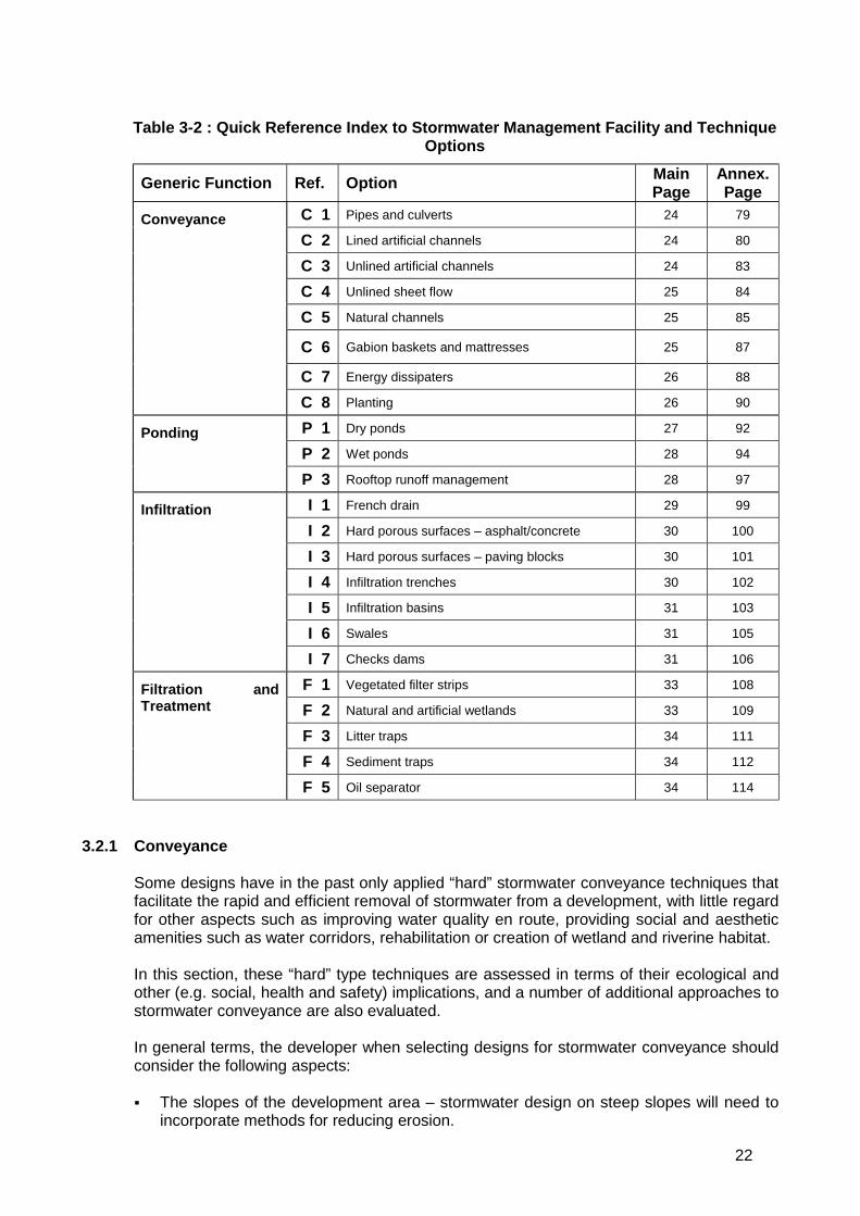
22
Table 3-2 : Quick Reference Index to Stormwater Management Facility and TechniqueOptions
Generic Function Ref. Option MainPage
Annex.Page
C 1 Pipes and culverts 24 79
C 2 Lined artificial channels 24 80
C 3 Unlined artificial channels 24 83
C 4 Unlined sheet flow 25 84
C 5 Natural channels 25 85
C 6 Gabion baskets and mattresses 25 87
C 7 Energy dissipaters 26 88
Conveyance
C 8 Planting 26 90
P 1 Dry ponds 27 92
P 2 Wet ponds 28 94Ponding
P 3 Rooftop runoff management 28 97
I 1 French drain 29 99
I 2 Hard porous surfaces – asphalt/concrete 30 100
I 3 Hard porous surfaces – paving blocks 30 101
I 4 Infiltration trenches 30 102
I 5 Infiltration basins 31 103
I 6 Swales 31 105
Infiltration
I 7 Checks dams 31 106
F 1 Vegetated filter strips 33 108
F 2 Natural and artificial wetlands 33 109
F 3 Litter traps 34 111
F 4 Sediment traps 34 112
Filtration andTreatment
F 5 Oil separator 34 114
3.2.1 Conveyance
Some designs have in the past only applied “hard” stormwater conveyance techniques thatfacilitate the rapid and efficient removal of stormwater from a development, with little regardfor other aspects such as improving water quality en route, providing social and aestheticamenities such as water corridors, rehabilitation or creation of wetland and riverine habitat.
In this section, these “hard” type techniques are assessed in terms of their ecological andother (e.g. social, health and safety) implications, and a number of additional approaches tostormwater conveyance are also evaluated.
In general terms, the developer when selecting designs for stormwater conveyance shouldconsider the following aspects:
! The slopes of the development area – stormwater design on steep slopes will need toincorporate methods for reducing erosion.
23
! Soil type and stability in the development area – the former will affect infiltration rates,as well as the potential for establishment of different kinds of plant communities inunlined conveyance structures; the latter will affect the degree of stabilisation that maybe necessary.
! Seasonal changes in water table height – groundwater should not be exposed byunlined conveyance structures during summer, as this will promote drainage of thegroundwater resource; infiltration capacity will be reduced if the water table is above anunlined channel base during winter.
! The cost of land – where land is at a premium, use of large areas for stormwaterconveyance may be prohibitively expensive. Nevertheless, the increase in aestheticand other forms of amenity value that may be gained from sensitive and imaginativestormwater designs may make the use of such space more economically feasible.
! The anticipated quality of stormwater runoff – severely polluted water may constitute ahealth hazard to downstream residents and an ecological hazard to downstreamaquatic ecosystems. Consideration should be given to the conveyance of such wateroff-site, and directly to water purification works, at least during low-flow periods whenwater quality is likely to be most impacted.
! Presence of natural water bodies that would lend themselves to the conveyance ofstormwater - habitat integrity, priority ranking and/or ecological importance andsensitivity of the system should be considered – sensitive systems should be protectedfrom, rather than incorporated into stormwater conveyance design.
! The volume of expected stormwater runoff, during within-year flood events, and duringlarger storm events.
! The availability of open space for stormwater conveyance – large areas of open publicor private space often lend themselves to the creation of wide, artificial waterways,which may also have ecological, recreational and aesthetic value in addition toproviding a stormwater function.
! The presence of litter and sediment which would result in blockages.
Erosion is unfortunately often associated with development as areas become disturbed oras stormwater runoff is concentrated at outlets. In order avoid these problems, options suchas stabilisation, energy dissipation and the design of stormwater management systems,which do not concentrate flows, are recommended. A number of structures incorporatedinto stormwater design play a role in the dissipation of energy required to prevent erosion atoutlet and inlet points, and at various points in different conveyance structures. This sectionprovides brief commentary on the ecological, engineering and aesthetic function of each ofthese.
Soil which has been disturbed or from which the vegetation has been removed, should bestabilised to prevent erosion due to wind or runoff. Such erosion could cause thestormwater system to block, thereby resulting in the flooding of properties. Stabilisationwould be short term, for the duration of the construction phase, followed by long term oncompletion of construction. Particular care should be taken of areas where development willnot take place immediately on completion of the construction phase, e.g. wide verges in theroad reserve which have been acquired to accommodate future road widening, or ervenreserved for unspecified local authority use.
24
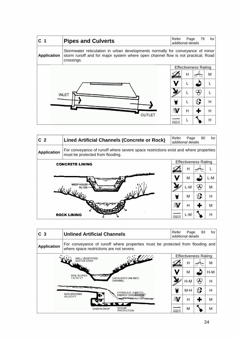
C 1 Pipes and Culverts Refer Page 79 foradditional details
ApplicationStormwater reticulation in urban developments normally for conveyance of minorstorm runoff and for major system where open channel flow is not practical; Roadcrossings.
Effectiveness Rating
H M
L L
L L
L H
H H
L H
C 2 Lined Artificial Channels (Concrete or Rock) Refer Page 80 foradditional details
Application For conveyance of runoff where severe space restrictions exist and where propertiesmust be protected from flooding.
Effectiveness Rating
H L
M L-M
L-M M
M H
H M
L-M H
C 3 Unlined Artificial Channels Refer Page 83 foradditional details
Application For conveyance of runoff where properties must be protected from flooding andwhere space restrictions are not severe.
Effectiveness Rating
H M
M H-M
H-M H
M-H H
H M
M M
25
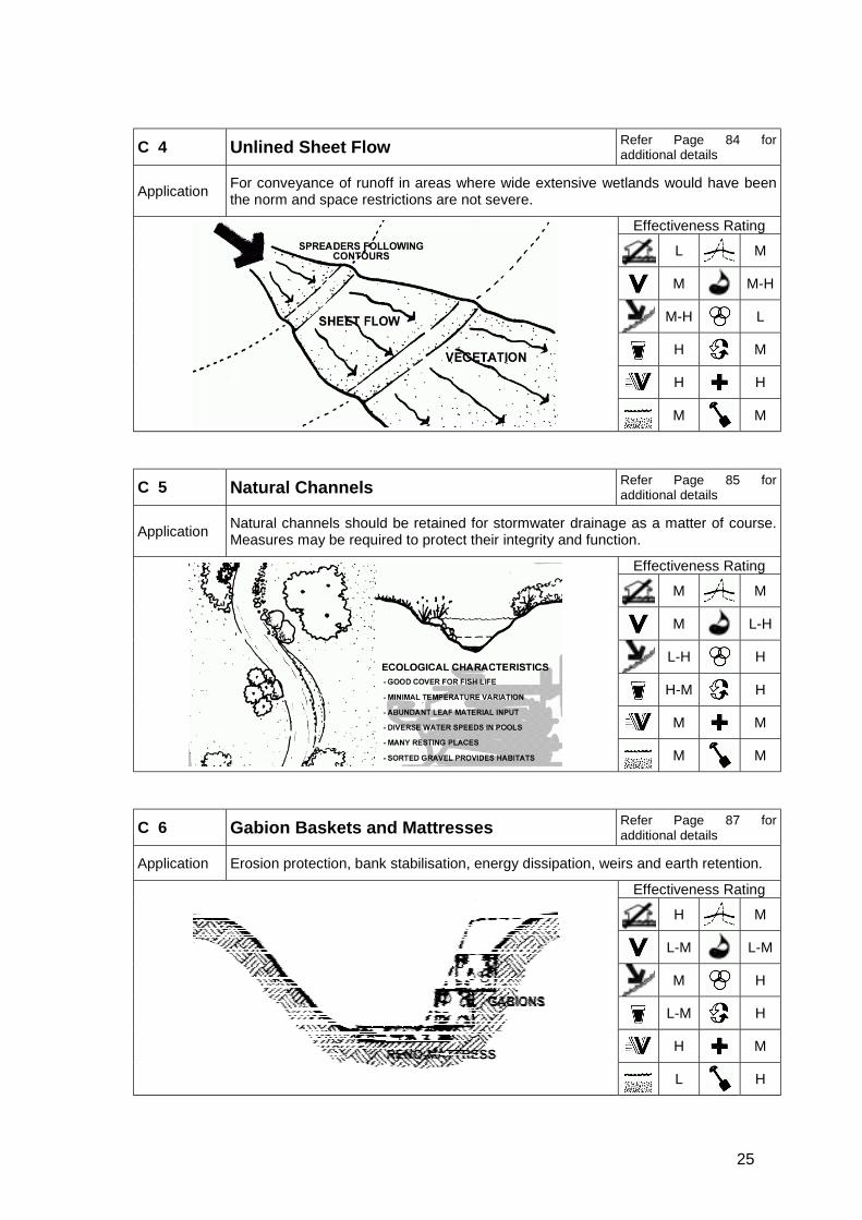
C 4 Unlined Sheet Flow Refer Page 84 foradditional details
Application For conveyance of runoff in areas where wide extensive wetlands would have beenthe norm and space restrictions are not severe.
Effectiveness Rating
L M
M M-H
M-H L
H M
H H
M M
C 5 Natural Channels Refer Page 85 foradditional details
Application Natural channels should be retained for stormwater drainage as a matter of course.Measures may be required to protect their integrity and function.
Effectiveness Rating
M M
M L-H
L-H H
H-M H
M M
M M
C 6 Gabion Baskets and Mattresses Refer Page 87 foradditional details
Application Erosion protection, bank stabilisation, energy dissipation, weirs and earth retention.
Effectiveness Rating
H M
L-M L-M
M H
L-M H
H M
L H
26
C 7 Energy Dissipaters Refer Page 88 foradditional details
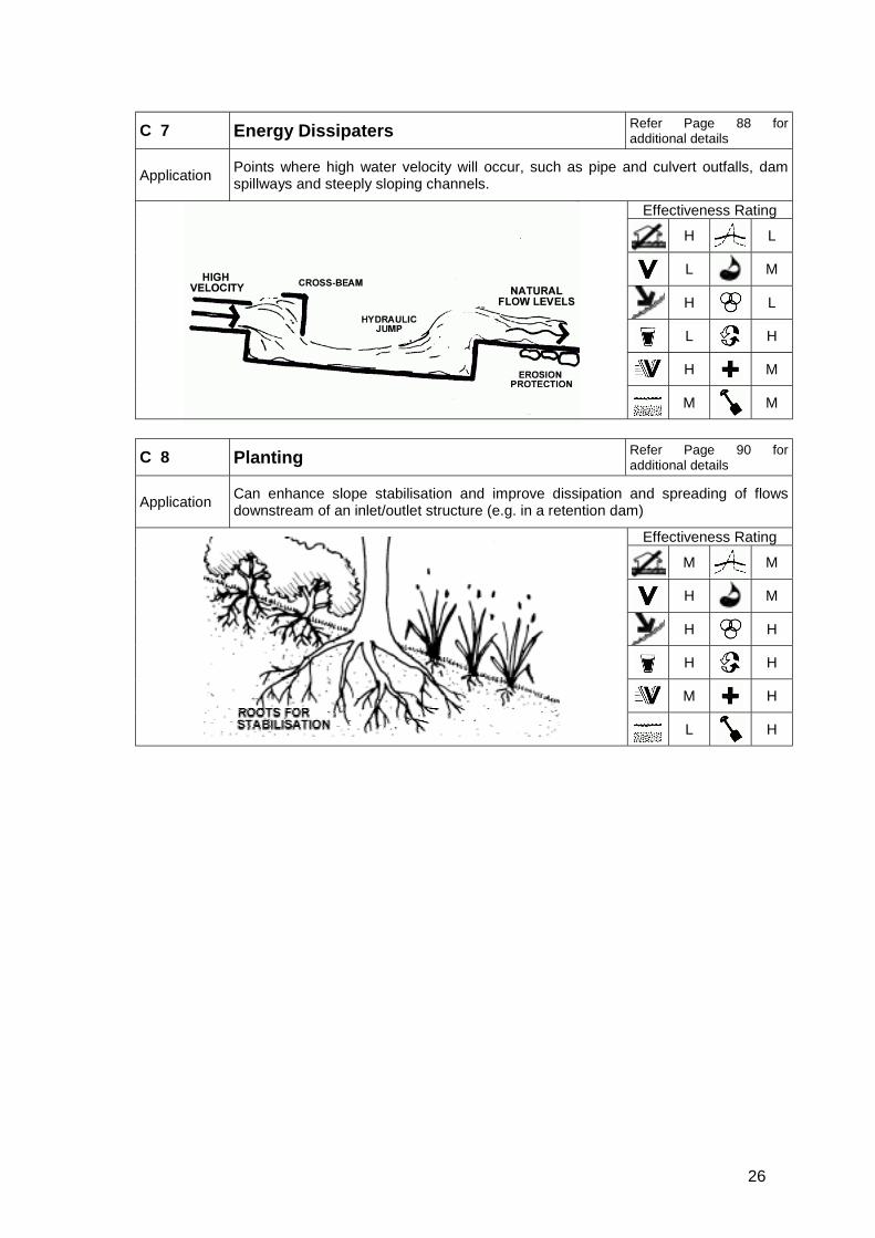
Application Points where high water velocity will occur, such as pipe and culvert outfalls, damspillways and steeply sloping channels.
Effectiveness Rating
H L
L M
H L
L H
H M
M M
C 8 Planting Refer Page 90 foradditional details
Application Can enhance slope stabilisation and improve dissipation and spreading of flowsdownstream of an inlet/outlet structure (e.g. in a retention dam)
Effectiveness Rating
M M
H M
H H
H H
M H
L H
27
3.2.2 Ponding
Ponding is an important component of stormwater management, in countering the effects ofurban development such as increased runoff (peak and volume) and diminished waterquality. Ponding utilizes temporary storage of stormwater runoff for periods ranging from afew hours to a day or more. This is achieved by providing an outlet or outlets with acapacity which is smaller than the anticipated flow peaks, thus aiming to restore as far aspossible the natural flow regime of the watercourse and also facilitating groundwaterrecharge. In some situations, in highly pervious soils, it may be possible to completelyretain the stormwater runoff and only provide an emergency overflow. Such ponds couldbe termed “retention ponds”. Detention ponds may be “dry” – no water retained betweenstorm events, or “wet” – permanent water body is retained.
Developers wishing to make use of ponding should take cognisance of the following:
! The purpose of these ponds in reducing runoff is to mimic nature (pre-developmentconditions) as far as possible over the full range of anticipated flows and not just aparticular recurrence interval.
! In larger catchments the placement and design of ponds must be taken with cognisanceof stormwater management throughout the catchment.
! Seasonal changes in water table height – ideally, ponding structures should notintercept groundwater, particularly during the low flow season. Where interception doesoccur, the effects of seepage on the functioning of the facility need to be investigated.
! Wet ponds should not be specified in areas where they might be utilised for swimming.
P 1 Dry Ponds Refer Page 92 foradditional details
Application
These structures hold water for a few hours to a day only, but may be used incombination with retention and infiltration facilities. Their purpose is to temporarilystore stormwater runoff in order to restrict outflows to predetermined levels to reducelocal and downstream flooding and to promote the settlement of pollutants.
Effectiveness Rating
H H
H L-M
M-H H
M H
M M
M M
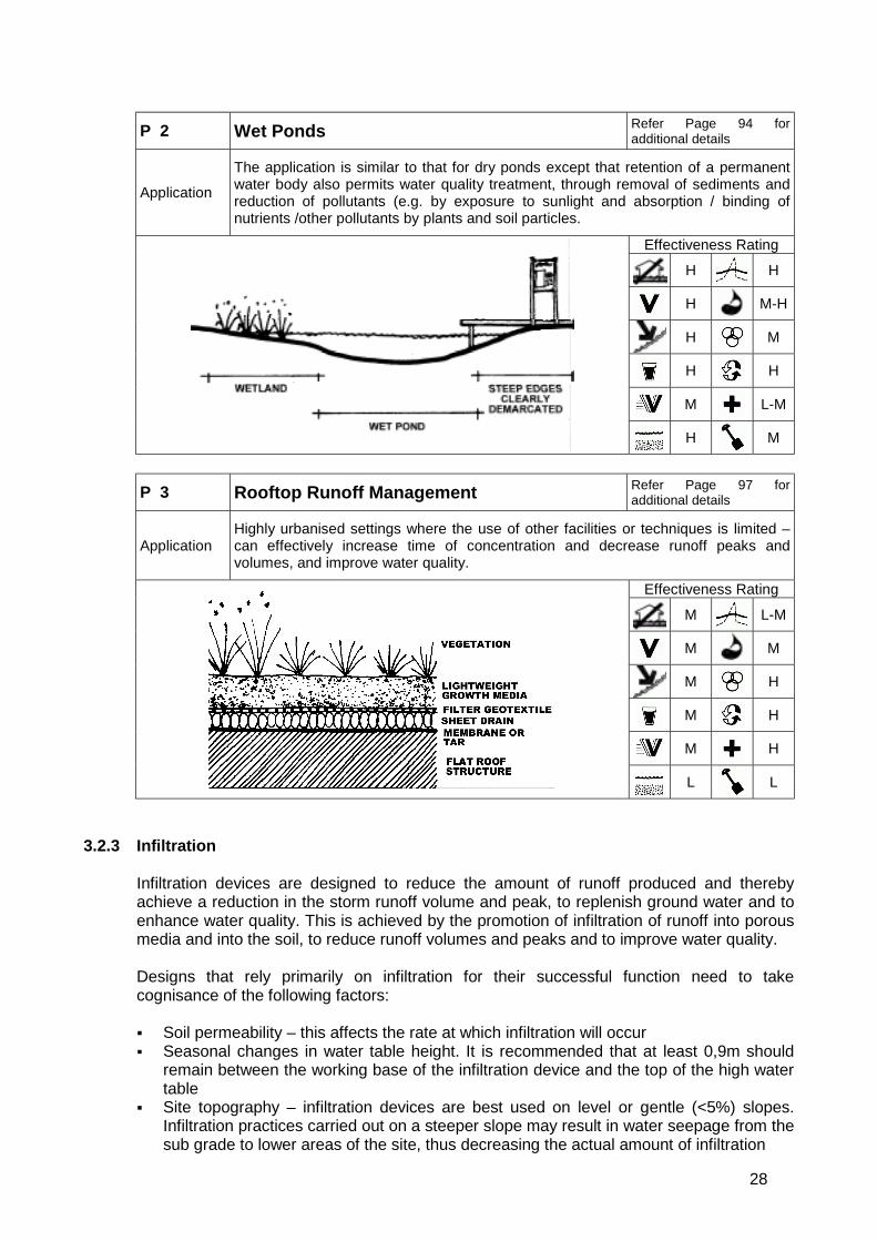
28
P 2 Wet Ponds Refer Page 94 foradditional details
Application
The application is similar to that for dry ponds except that retention of a permanentwater body also permits water quality treatment, through removal of sediments andreduction of pollutants (e.g. by exposure to sunlight and absorption / binding ofnutrients /other pollutants by plants and soil particles.
Effectiveness Rating
H H
H M-H
H M
H H
M L-M
H M
P 3 Rooftop Runoff Management Refer Page 97 foradditional details
ApplicationHighly urbanised settings where the use of other facilities or techniques is limited –can effectively increase time of concentration and decrease runoff peaks andvolumes, and improve water quality.
Effectiveness Rating
M L-M
M M
M H
M H
M H
L L
3.2.3 Infiltration
Infiltration devices are designed to reduce the amount of runoff produced and therebyachieve a reduction in the storm runoff volume and peak, to replenish ground water and toenhance water quality. This is achieved by the promotion of infiltration of runoff into porousmedia and into the soil, to reduce runoff volumes and peaks and to improve water quality.
Designs that rely primarily on infiltration for their successful function need to takecognisance of the following factors:
! Soil permeability – this affects the rate at which infiltration will occur! Seasonal changes in water table height. It is recommended that at least 0,9m should
remain between the working base of the infiltration device and the top of the high watertable
! Site topography – infiltration devices are best used on level or gentle (<5%) slopes.Infiltration practices carried out on a steeper slope may result in water seepage from thesub grade to lower areas of the site, thus decreasing the actual amount of infiltration
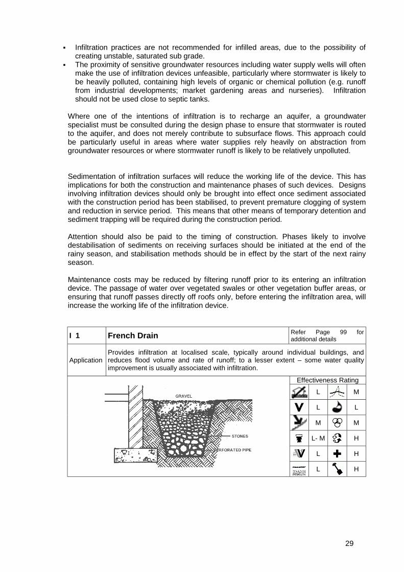
29
! Infiltration practices are not recommended for infilled areas, due to the possibility ofcreating unstable, saturated sub grade.
! The proximity of sensitive groundwater resources including water supply wells will oftenmake the use of infiltration devices unfeasible, particularly where stormwater is likely tobe heavily polluted, containing high levels of organic or chemical pollution (e.g. runofffrom industrial developments; market gardening areas and nurseries). Infiltrationshould not be used close to septic tanks.
Where one of the intentions of infiltration is to recharge an aquifer, a groundwaterspecialist must be consulted during the design phase to ensure that stormwater is routedto the aquifer, and does not merely contribute to subsurface flows. This approach couldbe particularly useful in areas where water supplies rely heavily on abstraction fromgroundwater resources or where stormwater runoff is likely to be relatively unpolluted.
Sedimentation of infiltration surfaces will reduce the working life of the device. This hasimplications for both the construction and maintenance phases of such devices. Designsinvolving infiltration devices should only be brought into effect once sediment associatedwith the construction period has been stabilised, to prevent premature clogging of systemand reduction in service period. This means that other means of temporary detention andsediment trapping will be required during the construction period.
Attention should also be paid to the timing of construction. Phases likely to involvedestabilisation of sediments on receiving surfaces should be initiated at the end of therainy season, and stabilisation methods should be in effect by the start of the next rainyseason.
Maintenance costs may be reduced by filtering runoff prior to its entering an infiltrationdevice. The passage of water over vegetated swales or other vegetation buffer areas, orensuring that runoff passes directly off roofs only, before entering the infiltration area, willincrease the working life of the infiltration device.
I 1 French Drain Refer Page 99 foradditional details
ApplicationProvides infiltration at localised scale, typically around individual buildings, andreduces flood volume and rate of runoff; to a lesser extent – some water qualityimprovement is usually associated with infiltration.
Effectiveness Rating
L M
L L
M M
L- M H
L H
L H
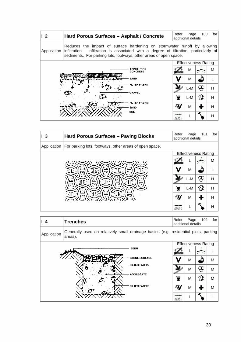
30
I 2 Hard Porous Surfaces – Asphalt / Concrete Refer Page 100 foradditional details
ApplicationReduces the impact of surface hardening on stormwater runoff by allowinginfiltration. Infiltration is associated with a degree of filtration, particularly ofsediments. For parking lots, footways, other areas of open space.
Effectiveness Rating
M M
M L
L-M H
L-M H
M H
L H
I 3 Hard Porous Surfaces – Paving Blocks Refer Page 101 foradditional details
Application For parking lots, footways, other areas of open space.
Effectiveness Rating
L M
M L
L-M H
L-M H
M H
L H
I 4 Trenches Refer Page 102 foradditional details
Application Generally used on relatively small drainage basins (e.g. residential plots; parkingareas).
Effectiveness Rating
L L
M M
M M
M M
M M
L L
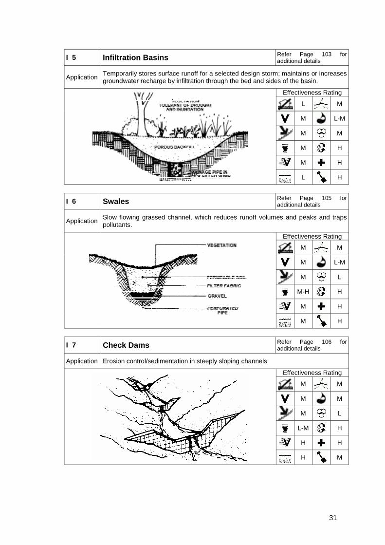
31
I 5 Infiltration Basins Refer Page 103 foradditional details
Application Temporarily stores surface runoff for a selected design storm; maintains or increasesgroundwater recharge by infiltration through the bed and sides of the basin.
Effectiveness Rating
L M
M L-M
M M
M H
M H
L H
I 6 Swales Refer Page 105 foradditional details
Application Slow flowing grassed channel, which reduces runoff volumes and peaks and trapspollutants.
Effectiveness Rating
M M
M L-M
M L
M-H H
M H
M H
I 7 Check Dams Refer Page 106 foradditional details
Application Erosion control/sedimentation in steeply sloping channels
Effectiveness Rating
M M
M M
M L
L-M H
H H
H M

32
3.2.4 Filtration and Treatment
In addition to structural designs, stormwater management design should also provide formore subtle forms of stormwater control, which allow a reduction in quantity orimprovement in quality of stormwater at source, rather than symptomatic management ofstormwater produced. This approach should include ongoing education of local residentsregarding water demand management principles, the effects of allowing sources of pollutionto enter stormwater systems, and the value of adhering to strategic stormwater guidelinesat the level of the individual property or residence. Examples include, passing water fromgutters onto grassed surfaces, rather than directly into road stormwater drains orminimising areas of impervious surfaces at a development scale.
Residential streets and green open space would ideally be incorporated into stormwaterdesign to enable temporary storage and infiltration, at the same time as providing a visualamenity. Minor streets in a development should be considered as areas for construction ofswales and for detention.
As a general principle litter, silt and other pollutants emanating from a catchment should betrapped as close to source as possible. This is of particular importance when thestormwater discharges into a sensitive environment, and where damage may result if thepollutant is not trapped and removed.
Note that although plastic litter is a highly visible and unsightly pollutant, the problems itposes, unless it is such that blockages occur, are usually aesthetic and social, rather thanecological. Excessive plastic pollution may however have indirect negative ecologicalimpacts, in that it contributes to a perception of freshwater systems as neglected, uselessand unhealthy, which in turn results in a vicious cycle of neglect, where more harmfulpollution of the system (e.g. dumping of organic waste, toxic runoff) is also tolerated.
Filtration of pollutants from stormwater is a vital component of stormwater management,although its prominence in the overall stormwater management plan of a development willdepend on the extent to which water quality is likely to be a problem, either within thedevelopment area, or to freshwater ecosystems and human users in the catchmentdownstream.
Pollutants addressed during filtration include: sediment, nutrients, heavy metals, petrol- andoil-based compounds and numerous other pollutant types, depending on land use withinthe development area and in the upstream catchment. Filtration is best by passage of wateracross vegetated areas. A degree of filtration (particularly of sediments) does howevertake place in infiltration systems. Where plants are used to provide filtration, it should benoted that different plant species have different capacities for absorption or assimilation ofdifferent pollutants.
Designs that rely primarily on filtration for their successful function need to take cognisanceof the following factors:
! Site topography – filtration is best achieved at very gentle gradients! Plant species utilised – different species have different filtering capacities, as well as
aesthetic qualities! Soil type – highly porous soils are often more suited to infiltration than filtration systems,
and do not always retain sufficient moisture to maintain plant growth; different soilshave different
! Stormwater quality and water quality of receiving water body – the degree of filteringthat can be realistically expected from a filtering device of a particular size andconstitution should be calculated. In some circumstances, water quality in surfaceeffluent may be too poor for treatment to acceptable standards to be a realistic option.
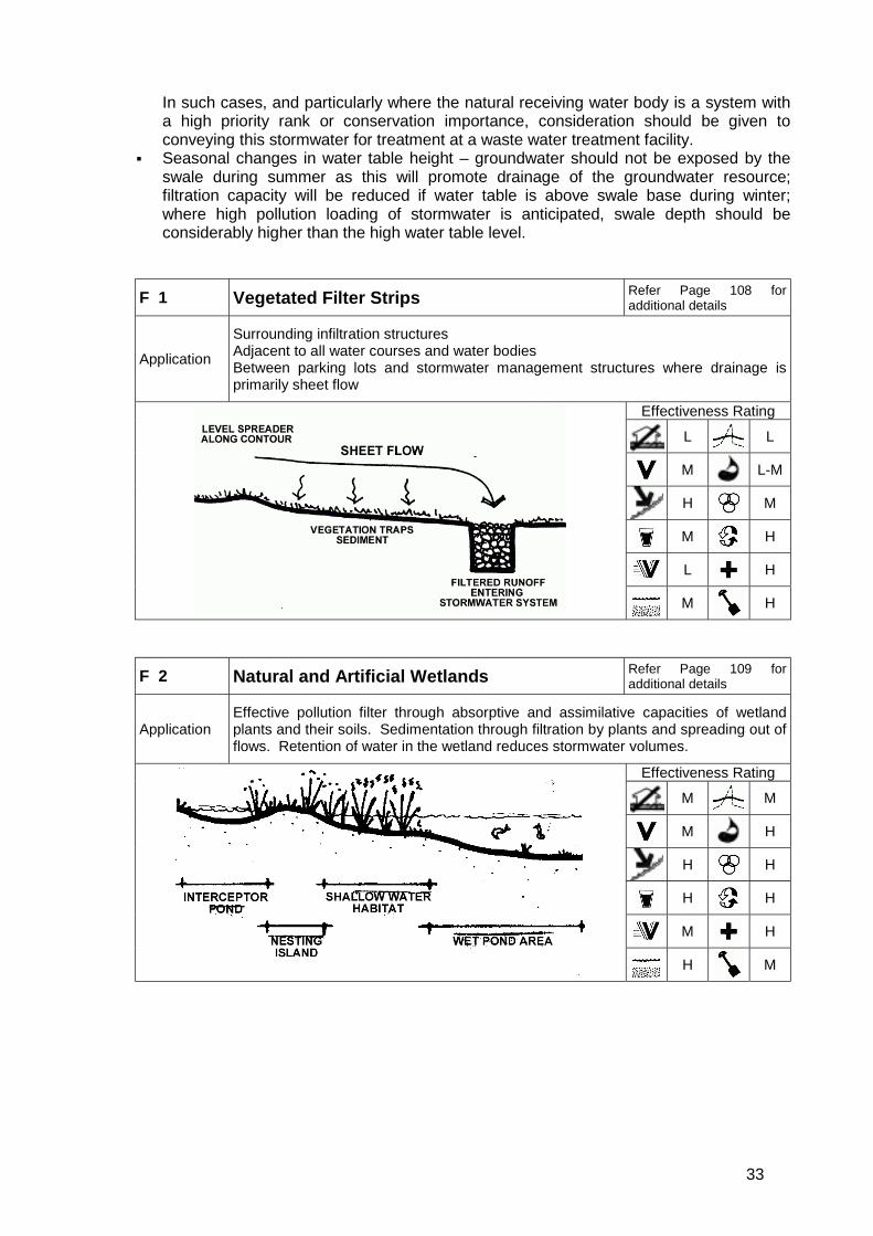
33
In such cases, and particularly where the natural receiving water body is a system witha high priority rank or conservation importance, consideration should be given toconveying this stormwater for treatment at a waste water treatment facility.
! Seasonal changes in water table height – groundwater should not be exposed by theswale during summer as this will promote drainage of the groundwater resource;filtration capacity will be reduced if water table is above swale base during winter;where high pollution loading of stormwater is anticipated, swale depth should beconsiderably higher than the high water table level.
F 1 Vegetated Filter Strips Refer Page 108 foradditional details
Application
Surrounding infiltration structuresAdjacent to all water courses and water bodiesBetween parking lots and stormwater management structures where drainage isprimarily sheet flow
Effectiveness Rating
L L
M L-M
H M
M H
L H
M H
F 2 Natural and Artificial Wetlands Refer Page 109 foradditional details
ApplicationEffective pollution filter through absorptive and assimilative capacities of wetlandplants and their soils. Sedimentation through filtration by plants and spreading out offlows. Retention of water in the wetland reduces stormwater volumes.
Effectiveness Rating
M M
M H
H H
H H
M H
H M
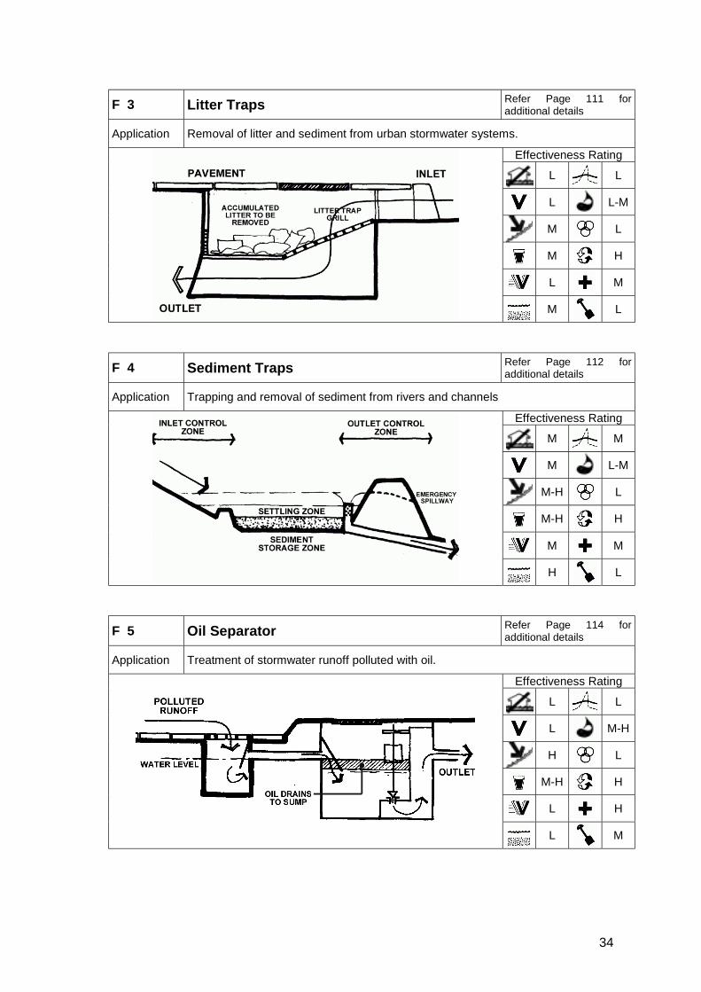
34
F 3 Litter Traps Refer Page 111 foradditional details
Application Removal of litter and sediment from urban stormwater systems.
Effectiveness Rating
L L
L L-M
M L
M H
L M
M L
F 4 Sediment Traps Refer Page 112 foradditional details
Application Trapping and removal of sediment from rivers and channels
Effectiveness Rating
M M
M L-M
M-H L
M-H H
M M
H L
F 5 Oil Separator Refer Page 114 foradditional details
Application Treatment of stormwater runoff polluted with oil.
Effectiveness Rating
L L
L M-H
H L
M-H H
L H
L M

35
3.3 Design Reports
The City of Cape Town require that a design report, which might include a detailedstormwater management plan, to accompany the final design submission and must includethe following design information:
! A plan of the catchment area showing all sub-catchments, pipe networks and pipedetails where applicable.
! The relevant input data, such as: assumed landuse, runoff coefficients, hydraulic gradelines, catch pit capacities, pipe loadings
! Method of calculating or selecting parameters and assumptions made.! Design hyetographs.! Method of computing attenuation volumes (where applicable).! Basic geohydrology and opportunities to infiltrate stormwater.! Relevant flood levels shown on a topographical plan.! Pre- and post-development stormwater runoff and quality.! Where a computer programme has been used to calculate the various runoff volumes,
sample manual check calculations may be called for.! Other services and their effect on the system to be taken into account.! Description of the major elements of the downstream outfall system for a distance
specified by the local authority (if requested).! Stormwater impact assessment
The design of attenuation facilities/wetlands/open channels and riverine areas must includeinput from planners, environmentalists and others, so that the final design satisfies allrequirements.
3.4 Minimum Engineering Design Standards
Minimum engineering design standards for underground stormwater reticulation arecontained in Annexure I - Minimum Design Standards for Underground StormwaterReticulation and Associated Intakes
3.4.1 Flood Escape Routes
Trapped low points must be avoided at all possible through good layout planning. Wherethe road system cannot serve as the major flood escape route the most appropriate of thefollowing options must be applied:
! Public open spaces provided along drainage route.! Underground system capacities upgraded to cater for 50 year storm events.! Flood escape servitudes must be registered over private properties. Servitudes must
prohibit all surface development, including construction of solid boundary walls. Escaperoutes located within road reserves or public open space are preferable.

36
4. Construction
4.1 Standard Civil Engineering Specifications
All materials and workmanship shall comply with the South African Bureau of StandardsStandardised Specification for Civil Engineering Construction (SABS 1200 Series) asamended.
4.2 Environmental Management Programmes
The City of Cape Town, Environmental Management Department, has prepared a guidelinedocument for Environmental Management Programmes for Private Development Projects.The document is presently in draft format (City of Cape Town 2002b).
This generic EMP will enable the City of Cape Town to ensure that private developmentprojects comply with current environmental regulations and that environmental “bestpractice” procedures and governance are incorporated into the construction phases. It isimportant to note that it is currently a working document aimed specifically at theconstruction phase (earthworks, bulk services & road works, and building and homeconstruction).
The document is divided into five different sections:
! Contextual information! Roles, responsibilities and communication procedures w.r.t. the Developer (and the
Engineer’s Representative), relevant Consultants, the Contractor, the ESO, theEnvironmental Reference Group (ERG) and the ECO from CCT.
! Standard environmental management programme – earthworks, bulk services androadworks, i.e. including the stormwater management system.
! Standard environmental management programme – building and home construction! Long term environmental management of private developments: It is recommended that
an Operational Phase Environmental Management Programme for the development becompiled which will provide a set of guidelines for the managers of the development toensure that general management of the development takes environmental factors intoconsideration.
4.3 As-Built Information
Specific requirements are stated in Annexure J - GIS Protocols for Stormwater As-BuiltDrawings and Data Capture Projects
4.4 Protection of Stormwater Systems during Construction
Sediment-laden stormwater should not be allowed to pass directly off the developmentduring the establishment phase. It should be routed into areas where sediment can settleout and be removed.
In some cases, infiltration structures may be used as temporary sedimentation areas duringthe stabilisation phase, if they are not dug down to their final design depth. Sediment cantherefore accumulate on material that will be excavated at the end of the stabilisationphase, thus exposing the filtration surface.
37
4.5 Vegetation and Stabilisation
Structures that rely on infiltration for their efficacy should not come into operation until theirrunoff areas have been stabilised, following construction. This will prevent the need forearly and costly maintenance of structures.
If stabilisation by planting is envisaged, plants should be established before the onset of thewinter rains. A phased approach to construction should be considered, where the extent ofthe water course is such that planting of the whole area will take too long for stabilisation tobe effective, or where construction activities are likely to take longer than the periodbetween the end of the wet season (early summer) and the end of the dry season(autumn), when planting should take place.
In some cases, delays in the design or tender stages of a project result in delayingconstruction such that plants are unlikely to be established before the start of the rainyseason. Planting during the rainy season is likely to result in the costly loss of plants, dueto washout, as well as the erosion of banks, often resulting in the destruction of carefullandscaping of bank slopes and profiles. In such cases, it is suggested that planting bedelayed until after the end of the rainy season – either until spring, or until the followingautumn. Planting in late spring would allow a longer period for the establishment of plantsbefore the next rainy season. However, for all zones except for permanently wetted zones,frequent irrigation would be necessary to ensure the survival of the plants over summer.
Delays in planting are likely to have cost implications for the project as a whole: survival ofpre-ordered, potted plants is often not good over a whole year; in addition, regrading andshaping of eroded banks may be necessary. Nevertheless, it should also be noted thatthere are advantages to such delays in planting – for one thing, it allows water levels andrates of flow to be observed over one year, and these observations can be used to guideplant zonation.
It is strongly recommended that any planting programmes carried out in stormwatermanagement systems make use of locally indigenous plant species. Indigenous speciestend to require less costly nurturing than do exotics. Moreover, they are often less prone todisease and, from an ecological perspective, can also provide areas of indigenous habitat,potentially linking areas of natural indigenous habitat, across the development area.
Refer to Annexure G - Planting Schedules on page 115 for recommended plants forrevegetation of river courses/water bodies.
4.6 Enhancing Ecological Function
Where enhanced ecological function is one of the objectives of a project, a freshwaterecologist should participate in on-site supervision of landscaping, to maximise theopportunities for habitat creation. The methodologies underlying implementation of designsto enhance ecological functioning of water bodies are in many cases in their infancy in theCape Metropolitan Area (Day and Ractliffe 2002).
Multifunctional PlantingPlanting in a stormwater system should be multifunctional. This influences the
choice of plant itself, such as those with edible fruit or seeds, medicinalproperties or commercial value; and how the plant is used: for shade,
screening, security, bank stabilization, infiltration and habitat. Plants can havehistoric and cultural importance, as well as aesthetic and recreational appeal.

38
Aspects of the above mentioned ecological recommendations should be regarded asexperimental, and a flexible approach should be taken to their practical implementation.However, where changes in design suggested for ecological reasons are required, it isstrongly recommended that alternatives should be discussed with a river ecologist prior toimplementation, so that the objective, where relevant, of optimising opportunities forecological enhancement can be maintained in future versions of the design.

39
5. Operation and Maintenance5.1 Allocation of Responsibilities
Responsibility for the operation and maintenance of the stormwater system normally restswith the local authority. These duties are allocated to a number of different departments asdescribed in Table 5-1 below.
Table 5-1 : Co-operative operation and maintenance of stormwater managementsystems
Department ActivityCatchment Stormwater and RiverManagement
Operation and repair of stormwater systems,watercourses
Open Spaces and NatureConservation
Maintenance of public open space includingwetlands and conservation areas, within whichstormwater system is located
Sport and Recreation Maintenance of sportsfields which form part of dryponds
Solid Waste Services Cleaning of certain litter traps; removal of dumpedmaterial
Health Monitoring health and safety risks posed bystormwater systems
Responsibility for maintenance of a particular area could also be carried out in cooperationwith residents and businesses in the form of a public-private partnership. Local residentsand/or businesses could take responsibility for maintenance of their stormwater systemthrough a funding mechanism such as a surcharge on rates to the benefit of the wholecommunity. It is recommended that incorporation of the above measures be consideredwhen planning the long-term operation of a stormwater management system.
5.2 Education
It is important for the local community to “take ownership” of their local river system in thesense of becoming aware of its purpose and benefits and the way in which it is intended tofunction. An awareness of the benefits of an environmentally friendly system will hopefullystart to reverse the pressures exerted at present to introduce greater amounts ofimpervious paving, drain wet ponds, provide culverts for river etc. The formation of Friendsof Rivers groups should be encouraged.
It is also important that education programmes are put in place to train staff with theappropriate skills to carry out the correct operation and maintenance of each different area.It is imperative that the specific functions and objectives of the stormwater systemcomponents are understood, along with the implications and requirements of each.Maintenance personnel, for example, should not mow areas where natural habitat is to beestablished.
5.3 Maintenance
5.3.1 Operation Management Plan
The developer of each new development should be required to submit an approvedOperation Management Plan (OMP) for the stormwater system. The OMP manual shouldinclude “as-built” drawings of the stormwater system and clearly set out the detailedfunctions, objectives, actions and responsibilities required for the maintenance of the
40
stormwater system and associated habitats. It should also provide specific guidelines formonitoring maintenance and performance. The local authority may require an annual auditin selected areas.
It should also be noted that the information supplied in the Operational Management Planwill be captured in the Catchment, Stormwater and River Management Department's RiverMaintenance Database.
5.3.2 Recognition of maintenance capacity
It is critically important that the ongoing maintenance needs of a project should match thecapacity of the maintaining authority. Where this does not occur, structures may, as aresult, lose part or all of their intended functions, amounting to wastage of the capital costsof installing the structure in the first place. For example, where planting takes place, butshort-term maintenance through irrigation and weeding does not occur, costly plantspecimens may be lost, and areas intended to be aesthetic amenities may becomedegraded, eroding and regarded by local communities as eyesores. During the designphase of a project, the maintenance needs of each structure should be assessed. Wherethese are unlikely to be met, it is recommended that alternative treatment methods besought.
It should also be noted that well designed ecological alternatives can be less costly tomaintain than the “hard” solutions. As part of the assessment of maintenance needs, theshort-term costs of vandalism and threats to structures, and particularly to planted areas,should not be underestimated (Day and Ractliffe 2002). Costs of replacement of plants andstructures such as wooden railings, platforms, poles should be built into the maintenancebudget of a project.
Measures should be introduced during the design stage of the project to reduce the impactof theft and vandalism. For example, the purchase of fewer, large trees, rather than manysmall specimens, should be encouraged, since these are harder to steal and less readilyvandalised by uprooting.
5.3.3 Training of Maintenance Staff
Training of maintenance workers needs to recognise that too much maintenance may be ascounter-productive as too little. For example, dredging of planted wetlands, resulting inchannelisation and drainage; and continued dredging of rivers, to remove aquatic weeds,resulting in bank destabilisation and increased channelisation and deepening of the system(Day and Ractliffe 2002). Manual removal of invasive vegetation from water courses isrecommended, and comparisons of the relative costs of mechanical versus manual removalof plants should take into account the long-term costs in terms of bank destabilisation, lossof habitat and general disturbance caused by mechanical removal.
5.3.4 Maintenance Period
A period of intensive, short-term establishment maintenance should be agreed uponbetween the developer and the final controlling authority. This should involve both a timecomponent and parameters such as plant cover. The time component should allow for amimimum of one year, preferably for maintenance over two summers (when irrigation is
Operation Management PlanA Plan, which organises and coordinates maintenance and monitoring
measures in order to guide the operation of the stormwater managementsystem and associated natural habitats.

41
critical). The parameters would relate to the planting material to be maintained, asindicated in Table 5-2 below.
Table 5-2 : Plant Establishment ParametersPlant Material RequirementsIndigenous Seed A minimum of 60% cover (with acceptable plants)
No bare patches with a maximum dimension greater than800mm (except where rocks and boulders are present)
Commercial Grass Seed A minimum of 75% cover (with acceptable plants)No bare patches with a maximum dimension greater than500mm (except where rocks and boulders are present)
Grass Sodding Full area covered with live grass after 3 monthsPlanting A minimum of 90% cover (with acceptable plants)
The developer must ensure that the works contract includes and ensures the following:
! The landscape subcontractor (lsc) visits the site often enough to ensure thatmaintenance is sufficiently undertaken.
! The maintenance team of the landscape subcontractor is sufficient to undertake andcomplete the maintenance required. This would depend on the specific site, particularlywith regard to the size of the area to be maintained, and whether irrigation is manual orautomatic. In general, a 2ha site requires a team of 3 labourers full time with 1supervisor making daily inspections.
! The maintenance requirements and tasks should be clearly specified and understood,along with other site specific requirements, and would generally include watering,weeding, litter control, erosion control and replanting.
! The maintenance time period and establishment requirements are sufficientlyunderstood and defined.
! The budget is allowed for and that payment agreement is put in place to provide thelandscape subcontractor with an incentive to complete the works. For example, the lsccould be paid monthly, with a retention held back until the end of the maintenanceperiod and that this is released if the cover aspects have been achieved.
Where a project is to be phased, there is the opportunity to extend the maintenance periodof the contract, to run concurrently with the following phases, so that the contractor ismaintaining one phase of a project, whilst present on the site implementing subsequentphases.
Best management practices for river maintenance are summarised in the document City ofCape Town, 2002a.
5.4 Monitoring Performance
Monitoring of performance of the stormwater management system should be carried out bythe body responsible for the functioning of the stormwater system, or by delegation.Effective monitoring will be based on the operation management plan as described above.
The local authority may then use the reports from the monitoring body to enforcecompliance with its requirements.
5.4.1 Use of Community “Watch Dogs”
The services of local residents / local communities as community “watch dogs” should beencouraged. Reporting of ecological or problems associated with poor maintenance oremployment of stormwater structures (e.g. blocked drains or channels; erosion; evidence of

42
polluted runoff, sewers leaking into the stormwater system, etc) should be encouraged, andlocal communities informed of where to lodge reports of such incidents.
5.4.2 Monitoring and modification
Where stormwater structures have been set in place specifically to address particularenvironmental (or human health) requirements (e.g. improvement in stormwater quality;reduction of erosion), monitoring of the effectiveness of such structures should be carriedout on a regular basis. Where they are found not to have met their design objectives,modifications to their structure, or to the stormwater management plan, should take place.
5.4.3 Ongoing assessment and refinement of stormwater design
Day and Ractliffe (2002) recommended that assessment of the ecological impact, anddegree to which structures meet their stated objectives, should form an integral part of allprojects carried out in the CMA, and which involve wetlands and rivers. Thisrecommendation, currently being considered by CMCA, would apply equally to stormwatermanagement structures – their efficacy, ecological impact, strengths and weaknesses,should all form the basis of assessments, carried out immediately after implementation, andagain after the elapse of up to 2 years. This would assist in the dissemination of knowledgeof different design applicability to other practitioners, improving the overall quality ofstormwater design being carried out in the CMA.
5.5 Resources
There is clearly a limit on the financial resources available for the adequate maintenance ofstormwater systems due to pressing demands from a wide range of needs in thecommunity. It is therefore essential to make the best long-term use of the available funds.This set of guidelines strives to promote the development of stormwater systems in such amanner as to provide the best value for money. Care of the environment is a keycomponent together with well-planned multi-use of facilities and effective maintenance ofstructures.
43
References1. Atsuschi Ichiki, Kiyoshi Yamada, 1999: “Effect of watershed characteristics on pollutant runoff
from urban areas during storm events”2. Agostini R, et al, 1985: “Flexible linings in Reno Mattress and gabions for canals and canalised
water courses”, Officine Maccaferri S.P.A. – Bologna, Italy3. Agostini R, et al, 1987: “Flexible gabion structures in earth retaining works”, Officine Maccaferri
S.P.A. – Bologna, Italy4. American Society of Civil Engineers (ASCE) and Water Environment Federation, 1993: “Design
and construction of urban stormwater management systems”, ASCE Manuals and reports ofengineering practice no 77.
5. Argue JR, 1999: “An Exploration of some myths about infiltration systems in source controltechnology”.
6. Armitage N., Rooseboom A., Nel C., Townshend P., 1998: “The removal of urban litter fromstormwater conduits and streams”, WRC Rep. TT 95/98.
7. Berg R, Braune M, van Rensburg J, Howard G, Görgens A, Shand M, 2000, ‘Salt RiverHydrological Study - Phase 1”, CMC project number: WR 3/99; NS project number: 8453; NSreport number: 3004/8453
8. Bond P.C., Pratt CJ, Newman AP, 1999: “A review of stormwater quantity and qualityperformance of permeable pavements in the UK”, 8th Int. Conf. Urban Storm Drainage,Sydney, Australia
9. “Catalog of Stormwater Best Management Practices (Idaho)” www2.state.id.us10. City of Cape Town, 2002a: “Policy for Control of Development Near Watercourses” Report to
the Cape Metropolitan Council by VKE Consulting Engineers.11. City of Cape Town, 2002b: “Environmental management programme for private development
projects within the City of Cape Town”, Working document. Draft One. EnvironmentalManagement Department.
12. City of Cape Town, 2002c: “Review of groundwater monitoring in the Cape Metropolitan Area”by Parsons, Conrad and van Heerden for Catchment Stormwater and River Management.
13. City of Cape Town, 2002d, "Minimum Standards for Stormwater Reticulation Systems in NewDevelopments”, Document prepared by D Austin.
14. Cowan, G.I., 1995 (ed.) “Wetlands of South Africa” SA Wetlands Conservation ProgrammeSeries. Department of Environment Affairs and Tourism, Pretoria
15. CSIR Building and Construction Technology, 2000: “Guidelines for Human Settlement Planningand Design”, compiled under patronage of Dept of Housing
16. Davies, B.R. & Day J.A., 1998: “Vanishing Waters”, University of Cape Town Press, CapeTown.
17. Day, E. and Ractliffe, G.R., 2002: “Assessment of river and wetland engineering andrehabilitation activities within the City of Cape Town: Realisation of project goals and theirecological implications. Volume One. Assessment process and major outcomes”. Report toCatchment Management, CMC Administration.
18. Department of Water Affairs and Forestry, 1996: “South African Water Quality Guidelines”:Volume 1: South African Water Quality Guidelines – Domestic Water Use; Volume 2: SouthAfrican Water Quality Guidelines – Recreational Water Use; Volume 3: South African WaterQuality Guidelines – Industrial Water Use; Volume 4: South African Water Quality Guidelines –Agricultural Water Use: Irrigation; Volume 5: South African Water Quality Guidelines –Agricultural Water Use: Livestock Watering; Volume 6: South African Water Quality Guidelines– Agricultural Water Use: Aquaculture; Volume 7: South African Water Quality Guidelines –Aquatic Ecosystems; Volume 8: South African Water Quality Guidelines – Field Guide
19. Ecobe, 2001: “Pollution abatement strategy for the Great and Little Lotus River catchments:Phase 1 Environmental Hazard Ranking Report”, EMS Report 022-004a. Prepared for:Stormwater Management Department, City of Cape Town, by Ecobe EMS in association withEarthdata International and the Freshwater Consulting Group.
20. Environmental Protection Authority, 1999: “Urban Stormwater Best Practice EnvironmentalManagement Guidelines”, CSIRO Publishing, Australia
44
21. Hall, D.J., 1993: “The ecology and control of Typha capensis in the wetlands of the Cape Flats,South Africa”, Unpublished PhD Thesis, Freshwater Research Unit, Zoology Department,University of Cape Town. 249 pp.
22. Harding, 2001: “Urban wetland buffer zones – setting of buffer widths”, Draft protocol preparedby Southern Waters for South Peninsula Administration.
23. James, W., 1992: “Stormwater management modelling conceptual workbook”, ComputationalHydraulics International.
24. Ractliffe, G.R and Day, E., 2002: “Assessment of river and wetland engineering andrehabilitation activities within the City of Cape Town: Realisation of project goals and theirecological implications. Volume Two. Case Studies”, Report to Catchment Management, CMCAdministration
25. New Jersey Departments of Environmental Protection “2nd Draft Guidance Manual Appendix1” http://www.state.nj.us/dep/watershedmgt/DOCS/pdfs/
26. New Jersey Departments of Environmental Protection, 2000: “Revised Manual for New Jersey:Best Management Practices for Control of Nonpoint Source Pollution from Stormwater”, 5thdraft 2000-05-03 http://www.state.nj.us/dep/watershedmgt/bmpmanual.htm
27. Rooseboom A et al (editors), 1993: “Road Drainage Manual”, Dept of Transport, RSA.28. Russell, Z 2000: “Rain Gardens An environmentally friendly alternative to ugly detention
basins” Landscape Architecture p.2429. Schmidt, E.J., Schulze, R.E. 1987a: “Flood volume and peak discharge from small catchments
in Southern Africa, based on the SCS technique”, Agricultural Catchments Research Unit rep.No. 24, WRC project no. 155, rep. no. TT31/87, Water Research Commission, Pretoria, RSA
30. Schmidt, E.J., Schulze, R.E. 1987b: “User manual for SCS-based design runoff estimation inSouthern Africa”, Agricultural Catchments Research Unit rep. No. 25, WRC project no. 155,rep. no. TT33/87, Water Research Commission, Pretoria, RSA
31. Schmidt, E.J., Schulze, R.E., Dent, M.C. 1987: “Flood volume and peak discharge from smallcatchments in Southern Africa, based on the SCS technique: Appendices”, AgriculturalCatchments Research Unit rep. No. 26, WRC project no.155, Rep. no. TT32/87, WaterResearch Commission, Pretoria, RSA
32. Schueler, T.R., 1987: “Controlling urban runoff: A practical manual for planning and designingurban BMPs”, Dept of Env. Prog., Met. Washington Council of Governments, for WashingtonMetropolitan Water Resources Planning Board.
33. Smithers, J.C., Schulze, R.E. 2000: “Long duration rainfall estimates for South Africa”, WRCRep. no. 811/1/100, Water Research Commission, Pretoria, RSA
34. Southern Waters, 2001, Habitat Integrity35. Ven te Chow, 1985: “Open-channel Flow”, McGraw-Hill Int. Book Co.
45
Bibliography1. Anon., “Moddergat River now a community asset”, Civil Engineering January 2002 Pg 72. Bishop, A and Oberholzer B., (April 1983) “Stormwater Management Concepts and their
Application to Town Planning”, Town and Regional Planning Journal No. 153. CHI Internet Community Links, //www.chi.on.ca/links.html4. City Of Cape Town, Design Standards For The Management Of The Stormwater System5. Cohen GJ, 1995: “Wetlands of South Africa”6. Copas, R and Scott, R 1999: “SUDS (Sustainable Urban Drainage Systems) law…”
Landscape Design 279, p. 54-577. Davies B.R, Freshwater Research Unit, UCT. Guiding principles for stormwater management in
the Blaauwberg/Tableview Area.8. Debo Thomas N and Reece Andrew J, 1995: “Municipal Storm Water Management”,
Lewis Publishers; 1995-01-029. Development Directorate, Transport, Roads and Stormwater Department, “Stormwater
Management Strategy (incorporating catchment and river management) 2001 – 2006”. City ofCape Town, 1st Draft 2001-11-0. www.capetown.gov.za/policies
10. Dramstad, WE 1996: “Landscape Ecology Principles in Landscape Architecture and Land-UsePlanning”
11. Environmental Protection Authority 1999: “Urban Stormwater Best Practice EnvironmentalManagement Guidelines”, CSIRO Publishing, Australia
12. Freeman MJ, Howard MR, Wiechers HNS, WRC Report: The Management of UrbanImpoundments in South Africa, - Guideline Manual, TT 119/00 Volume 2
13. Lord DA and Mackay M, The Effects Of Urban Runoff On The Water Quality Of The SwartkopsEstuary, WRC Report No 324/1/93 December 1991
14. Ministry of the Environment (Ontario) Stormwater Management Planning and DesignManual. Draft Final Report November 1999
15. NSW EPA Catchment Management, //www.epa.nsw.gov.au/mao/catchment.htm16. NSW Environmental Protection Authority, Managing Urban Stormwater: Council Handbook
November 199717. Ontario, Ministry of the Environment. //www.ene.gov.on.ca18. Oberholzer, B …..: “Constantia Valley River Study Appendix: Guidelines”19. Stormceptor Technical Manual Jul-0120. The Fresh Water Consulting group, “Assessment of activities affecting rivers and wetlands in
the CMS”, Volume 1 and Volume 2 January 200221. Western Washington, Dept of Ecology, “Stormwater Management Manual for Western
Washington”: -- Minimum Technical Requirements and Site Planning, Volume I, ConstructionStormwater Pollution Prevention, Volume II, Hydrologic Analysis and Flow ControlDesign/BMPs, Volume III, Source Control BMPs, Volume IV, -- Runoff Treatment BMPs
Volume V, //www.epa.nsw.gov.au/mao/catchment.htm22. Wiechers HNS Freeman MJ Howard MR, WRC Report: “The management of urban
impoundments in South Africa”: Status Quo Report TT 77/96, Volume 1, 1996,23. Wright A Kloppers W Fricke A Group, 1993: “A hydrological investigation of the stormwater
runoff from the Khayelitsha urban catchment in the False Bay area, South Western Cape”,no.1993323/1/93, WRC Report No.323/1/93
24. //www.stormwatercentre.net

46
Annexure A - Acts, Regulations, Policies and other RelevantDocuments
47
National Water Act 1998 (No36 of 1998)
The National Water Act controls water use. The enforcing authority is the Department of WaterAffairs And Forestry (DWAF). The local municipal authority generally controls the provision ofwater. The act recognises that water is a scarce resource in South Africa and its provisions areaimed at achieving sustainable use of water to the benefit of all users. The provisions of the Actare thus aimed at discouraging pollution and waste of water resources.The Act focuses on the protection of water resources. Pollution prevention is covered in part 4(section 19). Any person who owns, controls, occupies or uses land is deemed responsible fortaking measures to prevent pollution of water resources.The Act defines water use as the abstraction, consumption and discharge of water. Use of waterincludes the discharge of water containing waste into a water resource and the disposal of watercontaining waste from an industrial process in any manner. (section 39).
Sections 117 to 123 deal with the safety of dams with a safety risk. If such dams fall on theproperty then cognisance should be taken of the potential impact of the development on the dam.
Section 144 specifies the requirement to indicate the 1:100 year flood levels.
Section 145 deals with flood risk information which the local water management institution mustmake available to the public.
The National Water Act can be viewed at: http://www.dwaf.gov.za
Department of water Affairs and Forestry: Water Quality Guidelines - 1996
While the National Water Act legislates a set of water quality standards that must be met bydischarged water, a second set of standards, or target water quality guidelines also exist. Theseare recommended by the Department of Water Affairs and Forestry (DWAF), and aim at minimisingnegative impacts of poor water quality on aquatic ecosystems in South Africa, by setting targetranges for a series of different water quality constituents, including various heavy metals (DWAF1996). Unlike the General Authorisations for discharge of effluent, specified in the National WaterAct, the DWAF guidelines apply to the quality of water occurring in rivers, rather than to the qualityof water found in the final effluent. The guidelines also include estimates of “acute effect values”and “chronic effect values” for different variables.
The Water Quality Guidelines can be viewed at: http://www.dwaf.gov.za
National Environmental Management Act (Act 107 OF 1998)
The National Environmental Management Act (NEMA) provides for co-operative environmentalgovernance by establishing principles for decision-making on matters affecting the environment,institutions that will promote co-operative governance and procedures for co-ordinatingenvironmental functions exercised by organs of the state/ and to provide for matters connectedtherewith.The following Sections of the Act have relevance:Section 2 of the Act establishes a set of principles that apply to the activities of all organs of statethat may significantly affect the environment. These include the following:
! development must be sustainable! pollution must be avoided or minimised and remedied! waste must be avoided or minimised, reused or recycled! negative impacts must be minimised
48
Responsibility for the environmental health and safety consequences of a policy, project, productor service exists throughout its life cycle.The above principles are taken into consideration when a government department exercises itspowers, for example, during the granting of permits and the enforcement of existing legislation orconditions of approval.Section 23 identifies the general objective of Integrated Environmental Management.Section 24(1) provides that the “potential impact …… of activities that require authorisation orpermission by law and which may significantly affect the environment must be considered,investigated, and assessed prior to their implementation and reported to the organ of state chargedby law with authorising, permitting, or otherwise allowing the implementation of an activity”.Section 24(7) provides that procedures for the investigation, assessment and communication of thepotential impact of activities meet certain minimum requirements.Section 24 provides that all activities that may significantly affect the environment and requireauthorisation by law must be assessed prior to approval. In addition, it provides for the minister ofenvironmental affairs and tourism or the relevant MEC’s to identify:! New activities that require approval! Areas within which activities require approval! Existing activities that should be assessed and reported on
The Act also provides for the minister to make regulations with respect to the manner in whichinvestigations should occur. No regulations have been issued under section 24 as yet.
Section 28(1) states that “every person who causes, has caused or may cause significant pollutionor degradation of the environment must take reasonable measures to prevent such pollution ordegradation from occurring, continuing or recurring”. If such pollution cannot be prevented thenappropriate measures must be taken to minimise or rectify such pollution. These measures mayinclude:
! assessing the impact on the environment! informing and educating employees about the environmental risks of their work! and ways of minimising these risks! ceasing, modifying or controlling actions which cause pollution/degradation! containing pollutants or preventing movement of pollutants! eliminating the source of pollution; and! remedying the effects of the pollution
The authorities may direct an industry to rectify or remedy a potential or actual pollution problem. Ifsuch a directive is not complied with, the authorities may undertake the work and recover the costsfrom the responsible industry.
The National Environmental Management Act can be viewed at:http://www.polity.org.za/govdocs/legislation/1998/act98-107.html
Environment Conservation Act 1989 (Act 73 Of 1989)
The following Sections of the Act have relevance:
! Section 21(1) makes provision for the identification of activities that may have a substantialdetrimental effect on the environment.
! Section 26 makes provision for regulations to be promulgated regarding any activity identifiedin terms of Section 21(1).
These provisions of the Act culminated in the promulgation of the so-called EIA Regulations (referto insert below).
49
The Environment Conservation Act can be viewed at: http://www.acts.co.za/enviro/
Environmental Impact Assessment (EIA) Regulations (GN No R1182 AndR1183 Of 5 September 1997)
In terms of Section 1(i) of Schedule 1 of R1182, the “construction or upgrading of canals andchannels” is a listed activity which may have a substantial detrimental effect on the environment,and it is therefore necessary to apply for authorisation of such an activity in terms of the provisionsof R1183.
Protected Natural Environments
Watercourses may be given Protected Natural Environment (PNE) status in terms of theEnvironment Conservation Act 73 of 1989 (there are currently only five in existence in SouthAfrica). The declaration of a watercourse as a PNE affords it one of the highest forms of legalprotection available to a natural environment.
Nature Reserves
Nature reserves, under the jurisdiction of the provincial or local authority or private reserves, maybe impacted by urban stormwater and special cognisance should taken of these.
Conservation Of Agricultural Resources Act 1983 (Act 43 Of 1983)
Key aspects include legislation that allows for:
! Protection of land against water erosion: 4 (1) suitable soil conservation work is required todivert/restrict runoff water and to prevent excessive soil loss
! Protection of land against wind erosion: 5 (1) land should be protected against excessiveerosion by wind
! Utilisation and protection of vleis, marshes, water sponges and water courses: 7 (1) subject tothe Water Act of 1956 (since amended to the Water Act 36 of 1998), no land user shall utilisethe vegetation of a vlei, marsh or water sponge or within the flood area of a water course orwithin 10m horizontally outside such flood area in a manner that causes or may cause thedeterioration of or damage to the natural agricultural resources. (3) and (4) unless writtenpermission is obtained, no land user may drain or cultivate any vlei, marsh or water sponge orcultivate any land within the flood area or 10m outside this area (unless already undercultivation)
! Regulating flow patterns: No user shall divert run-off water away from a water course exceptwith written permission, or may effect an obstruction which will disturb the natural flow patternof run-off water on his farm, unless such obstruction will not cause excessive soil loss due toaction of water or restoration of the natural agricultural resources.
Land Use Planning Ordinance 1985 (Ordinance 15 Of 1985) And AssociatedPlanning Policies, Zoning Schemes And Scheme Regulations
No specific reference is made to stormwater management in the Ordinance. The purpose of theOrdinance is however to provide a legal framework for future planning policy (e.g. structure plansand spatial development frameworks) as well as for the evaluation and approval of futuredevelopment applications.

50
In terms of the requirements of the Ordinance a development application can only be consideredon the grounds of:
! desirability as far as guideline proposals in terms of a relevant structure plan! the effect of an application on existing rights concerned! the safety and welfare of the members of the community as well as! on the potential impact of an application on the natural and developed environment
Section 42 of the Ordinance provides an authority with the right to impose conditions of approvalthat will ensure that the abovementioned criteria are met. These conditions are however usuallyimposed as a result of comment received from the various engineering and environmentaldepartments involved in the evaluation of an application. Existing procedures therefore allow forstormwater planning and management to be dictated by the engineering and environmentaldepartments at the relevant authority.
Proposed By-Law For Stormwater Management And Related Matter (InPreparation)
In terms of the Constitution of South Africa, Act 108 of 1996, municipalities have the executiveauthority and the right to administer listed local government matters, including stormwatermanagement systems in built-up areas. The City of Cape Town is currently in the process ofadopting a by-law covering stormwater management and related matters. Once approved, alldevelopments will have to comply to this by-law.
Integrated Metropolitan Environmental Policy 2001
The City of Cape Town’s Integrated Metropolitan Environmental Policy (IMEP) forms the basis of aseries of strategies and programmes to ensure that the fundamental principles of, and approachesto, sustainable development are adhered to.
IMEP is a statement of intent, a commitment to certain principles and ethics and to thedevelopment of sectoral strategies, which will detail goals, targets, programmes and actionsneeded to ensure sustainable resource use and management of the city’s unique environment forall communities.Section 4.2 Water Resources of IMEP deals with the City’s commitment to ensuring that the qualityof coastal, marine and inland waters is suitable for the maintenance of biodiversity and theprotection of human health.
IMEP can be viewed at: http://www.capetown.gov.za/imep
Integrated Environmental Management Guidelines Series 1992
The following basic principles underpinning IEM have relevance:! A broad meaning to the term environment (i.e. one that includes physical, biological, social,
economic, cultural, historical and political components)! An open, participatory approach in the planning of proposals! Due consideration of alternatives options! Mitigation of negative impacts and enhancement positive aspects of proposals! Ensuring that the social costs of development proposals are outweighed by the social benefits

51
The RAMSAR Convention On Wetlands 1975
South Africa became a signatory of the Convention on Wetlands in December 1975. Theobligations of each signatory of the convention include the following:
! to promote the conservation of listed wetlands, and as far as possible the wise use of wetlandsin their territory (South Africa presently has 17 listed sites; none of these fall within the CMAarea, although Rietvlei Nature Reserve is in the process of being proclaimed a listed site)
! to promote the conservation of wetlands and waterfowl by establishing nature reserves onwetlands, whether they are listed or not.
Wetlands are one of the most threatened habitats in South Africa, where nearly half of naturalwetlands have already been destroyed (Cowan 1995). As such, they are accorded a highconservation status, and even degraded wetlands are viewed as important systems, warrantingconservation (REF: Working for Wetlands)

52
Annexure B - River And Wetland Buffer Widths
53
Recommended Buffer Widths between Rivers and Developments
A range of different minimum buffer widths have been recommended for rivers within the CMA,depending on the river zone (sub region) and relative importance of the river (referred to as theriver priority ranking) City of Cape Town (2002a). These widths are outlined in the following table –calculated buffer widths are available for a number of assessed rivers in the CMA, and are listed inCity of Cape Town (2002a).
River zone/ sub region ImportanceCategory
No-go zone(on either side
of the river)Special sanction buffer width (on each side ofthe river)
1 & 2 10 m 10 m per 1 m of mean bankfull width, no less than10 m and up to a maximum of 40 m.
3 10 m 10 m per 1 m of mean bankfull width, no less than10 m and up to a maximum of 30 m.
4 10 m 10 m per 2 m of mean bankfull width, no less than10 m and up to a maximum of 20 m.
Mountain stream
5 10 m 10 m per 3 m of mean bankfull width, no less than10 m and up to a maximum of 20 m.
1 & 2 10 m 10 m per 2 m of mean bankfull width, no less than10 m and up to a maximum of 40 m
3 10 m 10 m per 2 m of mean bankfull width, no less than10 m and up to a maximum of 30 m
4 10 m 10 m per 2 m of mean bankfull width, no less than10 m and up to a maximum of 20 m
Foothill
5 10 m 10 m
1 & 2 10 m 10 m per 2 m of mean bankfull width, no less than10 m and up to a maximum of 40 m
3 10 m 10 m per 2 m of mean bankfull width, no less than10 m and up to a maximum of 30 m
4 10 m 10 m per 3 m of mean bankfull width, no less than10 m and up to a maximum of 25 m
Wetland transitional
5 10 m 10 m
1 & 2 10 m 10 m per 2 m of mean bankfull width, no less than10 m and up to a maximum of 40 m
3 10 m 10 m per 2 m of mean bankfull width, no less than10 m and up to a maximum of 30 m
4 10 m 10 m per 3 m of mean bankfull width, no less than10 m and up to a maximum of 25 m
Lower
5 10 m 10 mNote that these parameters are subject to on-going revision.
Buffer Widths Between Wetlands And Developments
A draft protocol for assigning buffer widths to urban wetlands has also been formulated (SouthernWaters 2001). The protocol suggests buffer widths of between 25 and 75m width, except wherethere is an identified need to provide wider zones. Buffer widths are determined based onassessments of a number of criteria, particularly the Ecological Importance and Sensitivity of thewetland.
54
Annexure C - Significance of Wetlands in Stormwater Planning
55
Significance of Wetlands in Stormwater Planning
The following aspects of wetlands should be considered:
! Consideration of wetlands at an early stage of a project could lessen conflict betweenenvironmental and developmental priorities at a later stage in the project, and enable a farmore integrated planning solution.
! Wetlands can play a significant and diverse role in stormwater management, includinginfiltration, water quality improvement, and amelioration of flood events.
! Not all wetlands lend themselves to the receipt of stormwater, and sensitive wetland areasshould be protected from contaminated flows, while changes (even increases) in the naturalflow regimes of some wetlands can result in severe ecological degradation. This is particularlytrue for the seasonal wetlands that once characterised the area now included in the CapeMetropolitan Area but which today are threatened, and accorded a high conservationimportance.
! Although not able to form part of an integrated stormwater management system, anenvironmentally sensitive wetland would continue to play an important role in the naturalhydrological functioning of the site.
Why Are Wetlands Important?
Wetlands can perform a number of important functions:
! absorption of nutrients! buffering of riverine ecosystems! prevention of erosion! flood attenuation! retention of water, and hence
− improvement in soil structure− reduction in drying and subsequent erosion of soil− maintenance of most habitats
! provision of habitat – including to juveniles of insect pollinators ofother conservation-worthy ecosystems ( e.g. fynbos)
! provision of longitudinal corridors, linking patches of relativelynatural terrestrial habitat.

56
Annexure D - Hydrological and Water Quality Data Sources
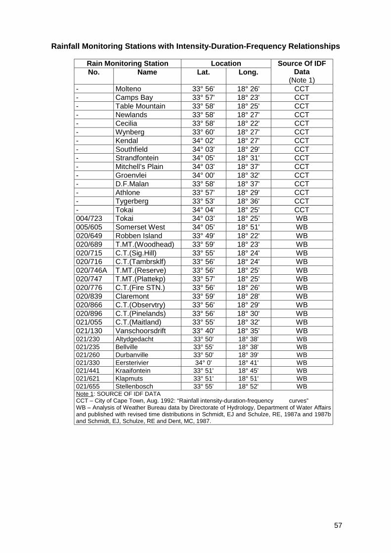
57
Rainfall Monitoring Stations with Intensity-Duration-Frequency Relationships
Rain Monitoring Station LocationNo. Name Lat. Long.
Source Of IDFData
(Note 1)- Molteno 33° 56' 18° 26' CCT- Camps Bay 33° 57' 18° 23' CCT- Table Mountain 33° 58' 18° 25' CCT- Newlands 33° 58' 18° 27' CCT- Cecilia 33° 58' 18° 22' CCT- Wynberg 33° 60' 18° 27' CCT- Kendal 34° 02' 18° 27' CCT- Southfield 34° 03' 18° 29' CCT- Strandfontein 34° 05' 18° 31' CCT- Mitchell’s Plain 34° 03' 18° 37' CCT- Groenvlei 34° 00' 18° 32' CCT- D.F.Malan 33° 58' 18° 37' CCT- Athlone 33° 57' 18° 29' CCT- Tygerberg 33° 53' 18° 36' CCT- Tokai 34° 04' 18° 25' CCT004/723 Tokai 34° 03’ 18° 25’ WB005/605 Somerset West 34° 05' 18° 51' WB020/649 Robben Island 33° 49' 18° 22' WB020/689 T.MT.(Woodhead) 33° 59' 18° 23' WB020/715 C.T.(Sig.Hill) 33° 55' 18° 24' WB020/716 C.T.(Tambrsklf) 33° 56' 18° 24' WB020/746A T.MT.(Reserve) 33° 56' 18° 25' WB020/747 T.MT.(Plattekp) 33° 57' 18° 25' WB020/776 C.T.(Fire STN.) 33° 56' 18° 26' WB020/839 Claremont 33° 59' 18° 28' WB020/866 C.T.(Observtry) 33° 56' 18° 29' WB020/896 C.T.(Pinelands) 33° 56' 18° 30' WB021/055 C.T.(Maitland) 33° 55' 18° 32' WB021/130 Vanschoorsdrift 33° 40' 18° 35' WB021/230 Altydgedacht 33° 50' 18° 38' WB021/235 Bellville 33° 55' 18° 38' WB021/260 Durbanville 33° 50' 18° 39' WB021/330 Eersterivier 34° 0' 18° 41' WB021/441 Kraaifontein 33° 51' 18° 45' WB021/621 Klapmuts 33° 51' 18° 51' WB021/655 Stellenbosch 33° 55' 18° 52' WBNote 1: SOURCE OF IDF DATACCT – City of Cape Town, Aug. 1992: “Rainfall intensity-duration-frequency curves”WB – Analysis of Weather Bureau data by Directorate of Hydrology, Department of Water Affairsand published with revised time distributions in Schmidt, EJ and Schulze, RE, 1987a and 1987band Schmidt, EJ, Schulze, RE and Dent, MC, 1987.
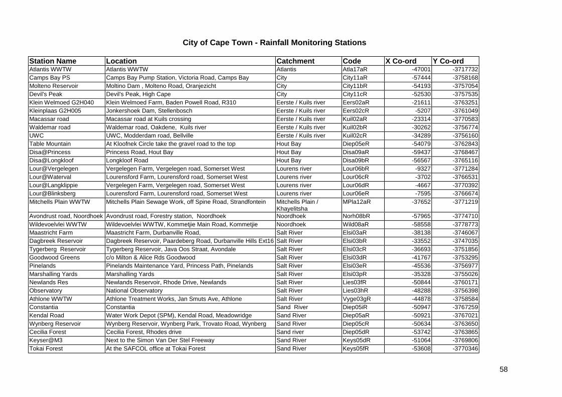
58
City of Cape Town - Rainfall Monitoring Stations
Station Name Location Catchment Code X Co-ord Y Co-ordAtlantis WWTW Atlantis WWTW Atlantis Atla17aR -47001 -3717732Camps Bay PS Camps Bay Pump Station, Victoria Road, Camps Bay City City11aR -57444 -3758168Molteno Reservoir Moltino Dam , Molteno Road, Oranjezicht City City11bR -54193 -3757054Devil's Peak Devil's Peak, High Cape City City11cR -52530 -3757535Klein Welmoed G2H040 Klein Welmoed Farm, Baden Powell Road, R310 Eerste / Kuils river Eers02aR -21611 -3763251Kleinplaas G2H005 Jonkershoek Dam, Stellenbosch Eerste / Kuils river Eers02cR -5207 -3761049Macassar road Macassar road at Kuils crossing Eerste / Kuils river Kuil02aR -23314 -3770583Waldemar road Waldemar road, Oakdene, Kuils river Eerste / Kuils river Kuil02bR -30262 -3756774UWC UWC, Modderdam road, Bellville Eerste / Kuils river Kuil02cR -34289 -3756160Table Mountain At Kloofnek Circle take the gravel road to the top Hout Bay Diep05eR -54079 -3762843Disa@Princess Princess Road, Hout Bay Hout Bay Disa09aR -59437 -3768467Disa@Longkloof Longkloof Road Hout Bay Disa09bR -56567 -3765116Lour@Vergelegen Vergelegen Farm, Vergelegen road, Somerset West Lourens river Lour06bR -9327 -3771284Lour@Waterval Lourensford Farm, Lourensford road, Somerset West Lourens river Lour06cR -3702 -3766531Lour@Langklippie Vergelegen Farm, Vergelegen road, Somerset West Lourens river Lour06dR -4667 -3770392Lour@Blinksberg Lourensford Farm, Lourensford road, Somerset West Lourens river Lour06eR -7595 -3766674Mitchells Plain WWTW Mitchells Plain Sewage Work, off Spine Road, Strandfontein Mitchells Plain /
KhayelitshaMPla12aR -37652 -3771219
Avondrust road, Noordhoek Avondrust road, Forestry station, Noordhoek Noordhoek Norh08bR -57965 -3774710Wildevoelvlei WWTW Wildevoelvlei WWTW, Kommetjie Main Road, Kommetjie Noordhoek Wild08aR -58558 -3778773Maastricht Farm Maastricht Farm, Durbanville Road, Salt River Elsi03aR -38138 -3746067Dagbreek Reservoir Dagbreek Reservoir, Paardeberg Road, Durbanville Hills Ext16 Salt River Elsi03bR -33552 -3747035Tygerberg Reservoir Tygerberg Reservoir, Java Oos Straat, Avondale Salt River Elsi03cR -36693 -3751856Goodwood Greens c/o Milton & Alice Rds Goodwood Salt River Elsi03dR -41767 -3753295Pinelands Pinelands Maintenance Yard, Princess Path, Pinelands Salt River Elsi03eR -45536 -3756977Marshalling Yards Marshalling Yards Salt River Elsi03pR -35328 -3755026Newlands Res Newlands Reservoir, Rhode Drive, Newlands Salt River Lies03fR -50844 -3760171Observatory National Observatory Salt River Lies03hR -48288 -3756398Athlone WWTW Athlone Treatment Works, Jan Smuts Ave, Athlone Salt River Vyge03gR -44878 -3758584Constantia Constantia Sand River Diep05iR -50947 -3767259Kendal Road Water Work Depot (SPM), Kendal Road, Meadowridge Sand River Diep05aR -50921 -3767021Wynberg Reservoir Wynberg Reservoir, Wynberg Park, Trovato Road, Wynberg Sand River Diep05cR -50634 -3763650Cecilia Forest Cecilia Forest, Rhodes drive Sand river Diep05dR -53742 -3763865Keyser@M3 Next to the Simon Van Der Stel Freeway Sand River Keys05dR -51064 -3769806Tokai Forest At the SAFCOL office at Tokai Forest Sand River Keys05fR -53608 -3770346

59
Silvermine@Dam Silvermine Nature Reserve, Ou Kaapse Weg, Silvermine Silvermine Silv16cR -55520 -3772163Simonstown Brooklyn Water Treatment Plant, Red Hill, Simonstown South Peninsula SPen13aR -55392 -3782344Southfield Southlfield Depot, Alduwa Road, Southfield Zeekoe Diep05bR -47965 -3767536Groenvlei / Hanover Park Cleansing Department, Downberg Road, Hanover Park Zeekoe Lotu04aR -43528 -3763757Cape Flats WWTW Cape Flats Treatment Plant, off Strandfontein Road Zeekoe MPla12bR -44622 -3772432
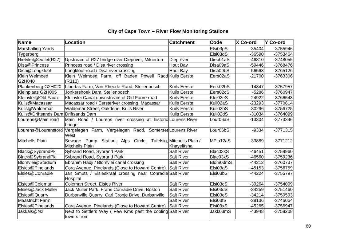
60
City of Cape Town – River Flow Monitoring Stations
Name Location Catchment Code X Co-ord Y Co-ordMarshalling Yards Elsi03pS -35404 -3755946Tygerberg Elsi03qS -36590 -3753464Rietvlei@Outlet(R27) Upstream of R27 bridge over Diepriver, Milnerton Diep river Diep01aS -46310 -3748055Disa@Princess Princess road / Disa river crossing Hout Bay Disa09aS -59446 -3768476Disa@Longkloof Longkloof road / Disa river crossing Hout Bay Disa09bS -56568 -3765126Klein WelmoedG2H040
Klein Welmoed Farm, off Baden Powell Raod(R310)
Kuils Eerste Eers02aS -21700 -3763306
Plankenberg G2H020 Libertas Farm, Van Rheede Raod, Stellenbosch Kuils Eerste Eers02bS -14847 -3757957Kleinplaas G2H005 Jonkershoek Dam, Stellenbosch Kuils Eerste Eers02cS -5286 -3760947Kleinvlei@Old Faure Kleinvlei Canal downstream of Old Faure road Kuils Eerste Klei02eS -24922 -3766543Kuils@Macassar Macassar road / Eersteriver crossing, Macassar Kuils Eerste Kuil02aS -23293 -3770614Kuils@Waldemar Waldemar Street, Oakdene, Kuils River Kuils Eerste Kuil02bS -30296 -3756725Kuils@Driftsands Dam Driftsands Dam Kuils Eerste Kuil02dS -31034 -3764099Lourens@Main road Main Road / Lourens river crossing at historic
bridgeLourens River Lour06aS -13304 -3773346
Lourens@Lourensford Vergelegen Farm, Vergelegen Raod, SomersetWest
Lourens River Lour06bS -9334 -3771315
Mitchells Plain Sewage Pump Station, Alps Circle, Tafelsig,Mitchells Plain
Mitchells Plain /Khayelitsha
MPla12aS -33889 -3771212
Black@SybrandPk Sybrand Road, Sybrand Park Salt River Blac03kS -46451 -3758960Black@SybrandPk Sybrand Road, Sybrand Park Salt River Blac03xS -46560 -3759236Blomvlei@Stadium Ebrahim Hadji / Blomvlei canal crossing Salt River Blom03mS -44212 -3760737Elsies@Pinelands Cora Avenue, Pinelands (Close to Howard Centre) Salt River Elsi03aS -45153 -3756759Elsies@Conradie Jan Smuts / Elsieskraal crossing near Conradie
HospitalSalt River Elsi03bS -44224 -3755797
Elsies@Coleman Coleman Street, Elsies River Salt River Elsi03cS -39264 -3754009Elsies@Jack Muller Jack Muller Park, Frans Conradie Drive, Boston Salt River Elsi03dS -34259 -3751460Elsies@Quarry Durbanville Quarry, Carl Cronje Drive, Durbanville Salt River Elsi03eS -34214 -3750593Maastricht Farm Salt River Elsi03fS -38136 -3746064Elsies@Pinelands Cora Avenue, Pinelands (Close to Howard Centre) Salt River Elsi03xS -45265 -3756947Jakkals@N2 Next to Settlers Way ( Few Kms past the cooling
towers fromSalt River Jakk03mS -43948 -3758208

61
Liesbeek@Paradise At the Paradise Road intersection Salt River Lies03gS -50603 -3761757Liesbeek@Durban Next to Liesbeeck Parkway, Mobray Salt River Lies03hS -48291 -3758093Salt@Glamis Close Next to M5 Black River Parkway, Maitland Salt River Salt03iS -48214 -3755001Vygekraal@Athlone Vygekraal opposite ATWWTW Salt River Vyge03jS -45190 -3758296Diep@Doordrift Doordrift Road, Plumstead Sand River Diep05cS -49903 -3766070Keyser@M3 Next to the Simon Van Der Stel Freeway Sand River Keys05dS -51063 -3769813Little Princess Vlei Consort Road, Retreat Sand River Lpvl05aS -48478 -3769327Diep@Maynardville Maynardville Park c/o Wolfe & Church Street,
WynbergSand River Wynb05bS -49515 -3764298
Zandvlei@railway Under the railway bridge at the inlet to the vlei Sand River Zvin05eS -49582 -3773159Zandvlei@Thesens Thessen Bridge, Sandvlei Sand River Zvou05fS -48560 -3775170Silvermine Golf Club Clovelly Golf Club, Clovelly raod, Clovelly Silvermine Silv16bS -52895 -3777729Silvermine@Dam Silvermine Nature Reserve, Ou Kaapse Weg,
SilvermineSlivermine Silv16cS -55490 -3772171
Lotus@Springfieldroad
Springfield road / Lotus river crossing Zeekoe Lotu04aS -44085 -3764932
Lotus@Sixth Ave Sixth Avenue / Lotusriver crossing, Lotus river Zeekoe Lotu04cS -44559 -3768433Zeekoe@yachtclub Zeekoevlei Yacht Club, Peninsula Road, Zekoevlei Zeekoe Zeek04dS -45149 -3770736
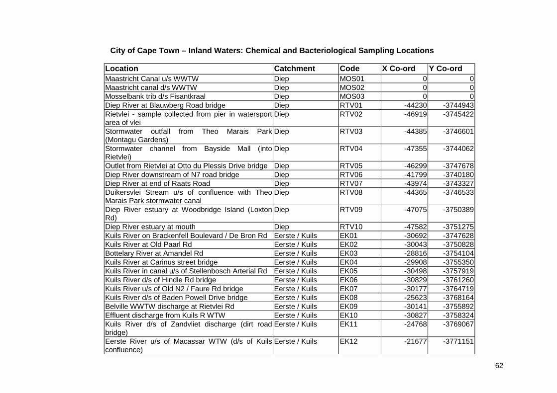
62
City of Cape Town – Inland Waters: Chemical and Bacteriological Sampling Locations
Location Catchment Code X Co-ord Y Co-ordMaastricht Canal u/s WWTW Diep MOS01 0 0Maastricht canal d/s WWTW Diep MOS02 0 0Mosselbank trib d/s Fisantkraal Diep MOS03 0 0Diep River at Blauwberg Road bridge Diep RTV01 -44230 -3744943Rietvlei - sample collected from pier in watersportarea of vlei
Diep RTV02 -46919 -3745422
Stormwater outfall from Theo Marais Park(Montagu Gardens)
Diep RTV03 -44385 -3746601
Stormwater channel from Bayside Mall (intoRietvlei)
Diep RTV04 -47355 -3744062
Outlet from Rietvlei at Otto du Plessis Drive bridge Diep RTV05 -46299 -3747678Diep River downstream of N7 road bridge Diep RTV06 -41799 -3740180Diep River at end of Raats Road Diep RTV07 -43974 -3743327Duikersvlei Stream u/s of confluence with TheoMarais Park stormwater canal
Diep RTV08 -44365 -3746533
Diep River estuary at Woodbridge Island (LoxtonRd)
Diep RTV09 -47075 -3750389
Diep River estuary at mouth Diep RTV10 -47582 -3751275Kuils River on Brackenfell Boulevard / De Bron Rd Eerste / Kuils EK01 -30692 -3747628Kuils River at Old Paarl Rd Eerste / Kuils EK02 -30043 -3750828Bottelary River at Amandel Rd Eerste / Kuils EK03 -28816 -3754104Kuils River at Carinus street bridge Eerste / Kuils EK04 -29908 -3755350Kuils River in canal u/s of Stellenbosch Arterial Rd Eerste / Kuils EK05 -30498 -3757919Kuils River d/s of Hindle Rd bridge Eerste / Kuils EK06 -30829 -3761260Kuils River u/s of Old N2 / Faure Rd bridge Eerste / Kuils EK07 -30177 -3764719Kuils River d/s of Baden Powell Drive bridge Eerste / Kuils EK08 -25623 -3768164Belville WWTW discharge at Rietvlei Rd Eerste / Kuils EK09 -30141 -3755892Effluent discharge from Kuils R WTW Eerste / Kuils EK10 -30827 -3758324Kuils River d/s of Zandvliet discharge (dirt roadbridge)
Eerste / Kuils EK11 -24768 -3769067
Eerste River u/s of Macassar WTW (d/s of Kuilsconfluence)
Eerste / Kuils EK12 -21677 -3771151
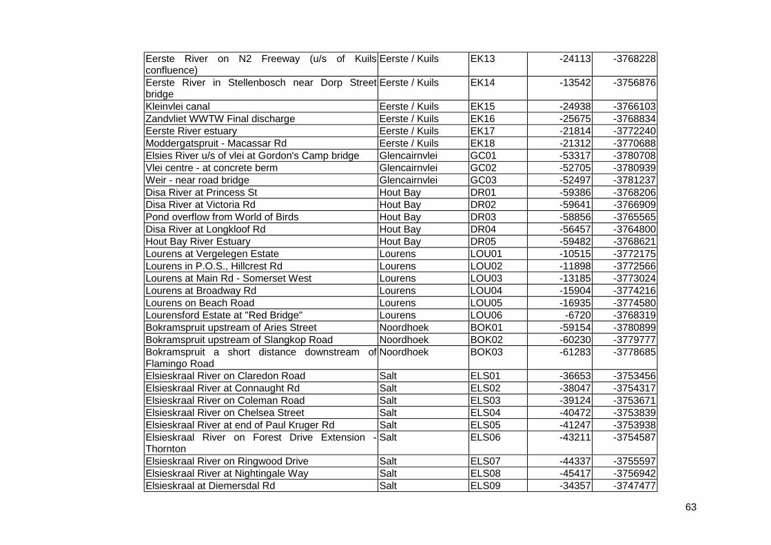
63
Eerste River on N2 Freeway (u/s of Kuilsconfluence)
Eerste / Kuils EK13 -24113 -3768228
Eerste River in Stellenbosch near Dorp Streetbridge
Eerste / Kuils EK14 -13542 -3756876
Kleinvlei canal Eerste / Kuils EK15 -24938 -3766103Zandvliet WWTW Final discharge Eerste / Kuils EK16 -25675 -3768834Eerste River estuary Eerste / Kuils EK17 -21814 -3772240Moddergatspruit - Macassar Rd Eerste / Kuils EK18 -21312 -3770688Elsies River u/s of vlei at Gordon's Camp bridge Glencairnvlei GC01 -53317 -3780708Vlei centre - at concrete berm Glencairnvlei GC02 -52705 -3780939Weir - near road bridge Glencairnvlei GC03 -52497 -3781237Disa River at Princess St Hout Bay DR01 -59386 -3768206Disa River at Victoria Rd Hout Bay DR02 -59641 -3766909Pond overflow from World of Birds Hout Bay DR03 -58856 -3765565Disa River at Longkloof Rd Hout Bay DR04 -56457 -3764800Hout Bay River Estuary Hout Bay DR05 -59482 -3768621Lourens at Vergelegen Estate Lourens LOU01 -10515 -3772175Lourens in P.O.S., Hillcrest Rd Lourens LOU02 -11898 -3772566Lourens at Main Rd - Somerset West Lourens LOU03 -13185 -3773024Lourens at Broadway Rd Lourens LOU04 -15904 -3774216Lourens on Beach Road Lourens LOU05 -16935 -3774580Lourensford Estate at "Red Bridge" Lourens LOU06 -6720 -3768319Bokramspruit upstream of Aries Street Noordhoek BOK01 -59154 -3780899Bokramspruit upstream of Slangkop Road Noordhoek BOK02 -60230 -3779777Bokramspruit a short distance downstream ofFlamingo Road
Noordhoek BOK03 -61283 -3778685
Elsieskraal River on Claredon Road Salt ELS01 -36653 -3753456Elsieskraal River at Connaught Rd Salt ELS02 -38047 -3754317Elsieskraal River on Coleman Road Salt ELS03 -39124 -3753671Elsieskraal River on Chelsea Street Salt ELS04 -40472 -3753839Elsieskraal River at end of Paul Kruger Rd Salt ELS05 -41247 -3753938Elsieskraal River on Forest Drive Extension -Thornton
Salt ELS06 -43211 -3754587
Elsieskraal River on Ringwood Drive Salt ELS07 -44337 -3755597Elsieskraal River at Nightingale Way Salt ELS08 -45417 -3756942Elsieskraal at Diemersdal Rd Salt ELS09 -34357 -3747477

64
Elsieskraal at Carl Cronje Rd Salt ELS10 -34178 -3750690Blomvlei Canal at Koodoo Street u/s of VygekraalRiver confluence
Salt NR01 -44426 -3758694
Vygekraal River at Cornflower Street u/s ofBlomvlei Canal conflunence
Salt NR02 -43960 -3758801
Vygekraal River u/s of Athlone WTW Salt NR03 -44845 -3758012Vygekraal River d/s Athlone WTW Salt NR04 -45940 -3758013Black River at Raapenberg Road bridge Salt NR06 -47429 -3757564Black River on Footbridge to Alexandra Institute Salt NR07 -47841 -3756376Liesbeek River downstream of Lake weir opp.Hartleyvale
Salt NR08 -48353 -3756424
Salt River Canal at Voortrekker Road bridge Salt NR09 -48365 -3755148Salt River Canal at Marine Drive Bridge - PaardenEiland
Salt NR10 -48669 -3753342
Black River in Rdbosch Golf Course Salt NR11 -46523 -3758334Liesbeek River on Sans Souci Rd Salt NR12 -49596 -3760571Liesbeek River - old canal next to River Club Salt NR13 -48680 -3756025Jakkalsvlei Canal at N2 Salt NR15 -43945 -3757918Langa Canal on N2 Salt NR16 -44489 -3757909Kalksteenfontein canal nr Netreg Stn Salt NR17 -40231 -3758224Nyanga Canal at Duinefontein Road outside GFJooste Hospital
Salt NR18 -40584 -3761926
Downstream of Elsieskraal but upstream of BlackRiver confluences
Salt NR19 -46474 -3758303
Near Borcherd's Quarry outfall Salt NR21 -39047 -3759849Liesbeek River on Paradise Rd Salt NR22 -50462 -3761369Liesbeek River on Winchester Rd - Kirstenbosch Salt NR23 -51996 -3762219Westlake River cnr Main and Chenel Roads Sand CR01 -50168 -3772526Westlake River at Orange St - Kirstenhof Sand CR02 -50679 -3771841Westlake River Altenburg Rd - Kirstenhof Sand CR03 -50961 -3771734Westlake River in Pollsmoor Prison grounds Sand CR04 -51637 -3771667Westlake River at Steenberg Rd Sand CR05 -52597 -3771889Prinskasteel River in greenbelt off Lismore Rd(close to M3)
Sand CR06 -51121 -3769517
Tributary of Prinskasteel River (just u/s of CR06) Sand CR07 -51182 -3769524Prinskasteel at Orpen Rd Sand CR08 -52907 -3769381
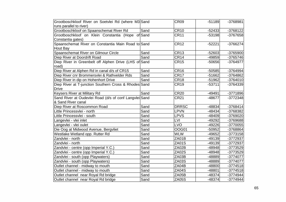
65
Grootboschkloof River on Soetvlei Rd (where M3runs parallel to river)
Sand CR09 -51189 -3768981
Grootboschkloof on Spaanschemat River Rd Sand CR10 -52433 -3768122Grootboschkloof on Klein Constantia (Hope ofConstantia gates)
Sand CR11 -53198 -3767658
Spaanschemat River on Constantia Main Road toHout Bay
Sand CR12 -52221 -3766274
Spaanschemat River on Gilmour Circle Sand CR13 -52603 -3765900Diep River at Doordrift Road Sand CR14 -49859 -3765746Diep River in Greenbelt off Alphen Drive (LHS ofroad)
Sand CR15 -50656 -3764977
Diep River at Alphen Rd in canal d/s of CR15 Sand CR16 -50585 -3764994Diep River cnr Brommersvlei & Rathvelder Rds Sand CR17 -51662 -3764862Diep River in dip on Hohenhort Drive Sand CR18 -51962 -3764010Diep River at T-junction Southern Cross & RhodesDrive
Sand CR19 -53711 -3764339
Keysers River at Military Rd Sand CR20 -49491 -3771896Sand River at Oudevlei Road (d/s of conf Langvlei& Sand River canal
Sand CR21 -48677 -3772348
Diep River at Roscommon Road Sand DRRSC -48834 -3768414Little Princessvlei - north Sand LPVN -48434 -3768382Little Princessvlei - south Sand LPVS -48409 -3769020Langevlei - vlei inlet Sand LVI -49292 -3769688Langevlei - vlei oulet Sand LVO -49226 -3770055Die Oog at Midwood Avenue, Bergvliet Sand OOG01 -50952 -3768864Westlake Wetland opp. Rutter Rd Sand WLW -49652 -3773158Zandvlei - north Sand ZA01B -49139 -3772937Zandvlei - north Sand ZA01S -49139 -3772937Zandvlei - centre (opp Imperial Y.C.) Sand ZA02B -48948 -3773529Zandvlei - centre (opp Imperial Y.C.) Sand ZA02S -48948 -3773529Zandvlei - south (opp Playwaters) Sand ZA03B -48889 -3774077Zandvlei - south (opp Playwaters) Sand ZA03S -48889 -3774077Outlet channel - midway to mouth Sand ZA04B -48800 -3774518Outlet channel - midway to mouth Sand ZA04S -48801 -3774518Outlet channel near Royal Rd bridge Sand ZA05B -48374 -3774944Outlet channel near Royal Rd bridge Sand ZA05S -48374 -3774944
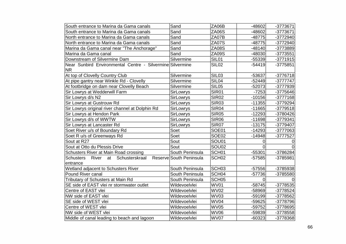
66
South entrance to Marina da Gama canals Sand ZA06B -48602 -3773671South entrance to Marina da Gama canals Sand ZA06S -48602 -3773671North entrance to Marina da Gama canals Sand ZA07B -48775 -3772940North entrance to Marina da Gama canals Sand ZA07S -48775 -3772940Marina da Gama canal near "The Anchorage" Sand ZA08S -48140 -3773889Marina da Gama canal Sand ZA09S -48030 -3773551Downstream of Silvermine Dam Silvermine SIL01 -55339 -3771915Near Sunbird Environmental Centre - SilvermineNR
Silvermine SIL02 -54419 -3775851
At top of Clovelly Country Club Silvermine SIL03 -53637 -3776718At pipe gantry near Winkle Rd - Clovelly Silvermine SIL04 -52449 -3777747At footbridge on dam near Clovelly Beach Silvermine SIL05 -52073 -3777939Sir Lowrys at Wedderwill Farm SirLowrys SIR01 -7253 -3775646Sir Lowrys d/s N2 SirLowrys SIR02 -10156 -3777168Sir Lowrys at Gustrouw Rd SirLowrys SIR03 -11355 -3779294Sir Lowrys original river channel at Dolphin Rd SirLowrys SIR04 -11665 -3779518Sir Lowrys at Hendon Park SirLowrys SIR05 -12293 -3780426Sir Lowrys d/s of WWTW SirLowrys SIR06 -11698 -3779341Sir Lowrys at Lancaster Rd SirLowrys SIR07 -13175 -3779407Soet River u/s of Boundary Rd Soet SOE01 -14293 -3777063Soet R u/s of Greenways Rd Soet SOE02 -14948 -3777527Sout at R27 Sout SOU01 0 0Sout at Otto du Plessis Drive Sout SOU02 0 0Schusters River at Main Road crossing South Peninsula SCH01 -55301 -3786284Schusters River at Schusterskraal Reserveentrance
South Peninsula SCH02 -57585 -3785981
Wetland adjacent to Schusters River South Peninsula SCH03 -57556 -3785938Pound River canal South Peninsula SCH04 -57736 -3785580Tributary of Schusters at Main Rd South Peninsula SCH05 0 0SE side of EAST vlei nr stormwater outlet Wildevoelvlei WV01 -58745 -3778535Centre of EAST vlei Wildevoelvlei WV02 -58969 -3778524NW side of EAST vlei Wildevoelvlei WV03 -59199 -3778562SE side of WEST vlei Wildevoelvlei WV04 -59625 -3778796Centre of WEST vlei Wildevoelvlei WV05 -59752 -3778695NW side of WEST vlei Wildevoelvlei WV06 -59839 -3778558Middle of canal leading to beach and lagoon Wildevoelvlei WV07 -60323 -3778368
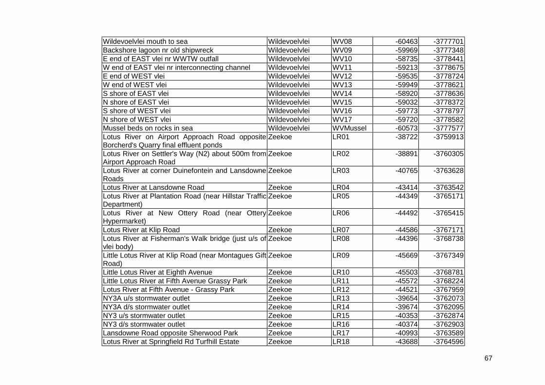
67
Wildevoelvlei mouth to sea Wildevoelvlei WV08 -60463 -3777701Backshore lagoon nr old shipwreck Wildevoelvlei WV09 -59969 -3777348E end of EAST vlei nr WWTW outfall Wildevoelvlei WV10 -58735 -3778441W end of EAST vlei nr interconnecting channel Wildevoelvlei WV11 -59213 -3778675E end of WEST vlei Wildevoelvlei WV12 -59535 -3778724W end of WEST vlei Wildevoelvlei WV13 -59949 -3778621S shore of EAST vlei Wildevoelvlei WV14 -58920 -3778636N shore of EAST vlei Wildevoelvlei WV15 -59032 -3778372S shore of WEST vlei Wildevoelvlei WV16 -59773 -3778797N shore of WEST vlei Wildevoelvlei WV17 -59720 -3778582Mussel beds on rocks in sea Wildevoelvlei WVMussel -60573 -3777577Lotus River on Airport Approach Road oppositeBorcherd's Quarry final effluent ponds
Zeekoe LR01 -38722 -3759913
Lotus River on Settler's Way (N2) about 500m fromAirport Approach Road
Zeekoe LR02 -38891 -3760305
Lotus River at corner Duinefontein and LansdowneRoads
Zeekoe LR03 -40765 -3763628
Lotus River at Lansdowne Road Zeekoe LR04 -43414 -3763542Lotus River at Plantation Road (near Hillstar TrafficDepartment)
Zeekoe LR05 -44349 -3765171
Lotus River at New Ottery Road (near OtteryHypermarket)
Zeekoe LR06 -44492 -3765415
Lotus River at Klip Road Zeekoe LR07 -44586 -3767171Lotus River at Fisherman's Walk bridge (just u/s ofvlei body)
Zeekoe LR08 -44396 -3768738
Little Lotus River at Klip Road (near Montagues GiftRoad)
Zeekoe LR09 -45669 -3767349
Little Lotus River at Eighth Avenue Zeekoe LR10 -45503 -3768781Little Lotus River at Fifth Avenue Grassy Park Zeekoe LR11 -45572 -3768224Lotus River at Fifth Avenue - Grassy Park Zeekoe LR12 -44521 -3767959NY3A u/s stormwater outlet Zeekoe LR13 -39654 -3762073NY3A d/s stormwater outlet Zeekoe LR14 -39674 -3762095NY3 u/s stormwater outlet Zeekoe LR15 -40353 -3762874NY3 d/s stormwater outlet Zeekoe LR16 -40374 -3762903Lansdowne Road opposite Sherwood Park Zeekoe LR17 -40993 -3763589Lotus River at Springfield Rd Turfhill Estate Zeekoe LR18 -43688 -3764596
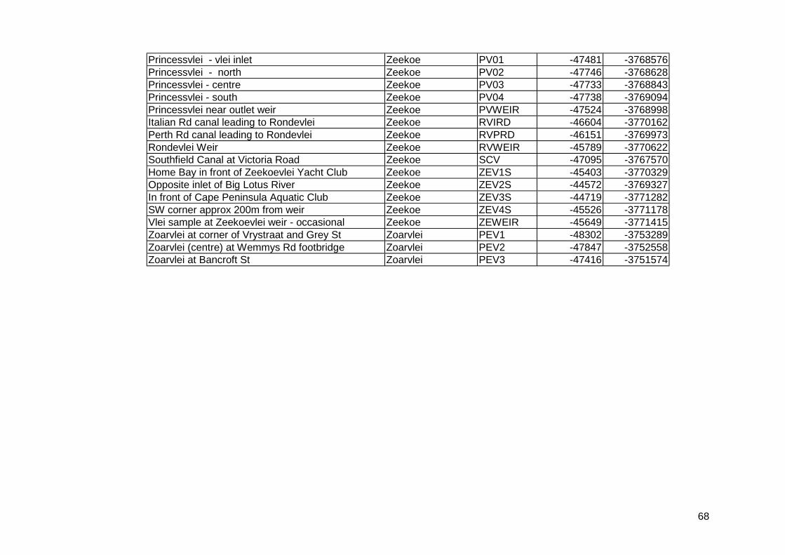
68
Princessvlei - vlei inlet Zeekoe PV01 -47481 -3768576Princessvlei - north Zeekoe PV02 -47746 -3768628Princessvlei - centre Zeekoe PV03 -47733 -3768843Princessvlei - south Zeekoe PV04 -47738 -3769094Princessvlei near outlet weir Zeekoe PVWEIR -47524 -3768998Italian Rd canal leading to Rondevlei Zeekoe RVIRD -46604 -3770162Perth Rd canal leading to Rondevlei Zeekoe RVPRD -46151 -3769973Rondevlei Weir Zeekoe RVWEIR -45789 -3770622Southfield Canal at Victoria Road Zeekoe SCV -47095 -3767570Home Bay in front of Zeekoevlei Yacht Club Zeekoe ZEV1S -45403 -3770329Opposite inlet of Big Lotus River Zeekoe ZEV2S -44572 -3769327In front of Cape Peninsula Aquatic Club Zeekoe ZEV3S -44719 -3771282SW corner approx 200m from weir Zeekoe ZEV4S -45526 -3771178Vlei sample at Zeekoevlei weir - occasional Zeekoe ZEWEIR -45649 -3771415Zoarvlei at corner of Vrystraat and Grey St Zoarvlei PEV1 -48302 -3753289Zoarvlei (centre) at Wemmys Rd footbridge Zoarvlei PEV2 -47847 -3752558Zoarvlei at Bancroft St Zoarvlei PEV3 -47416 -3751574
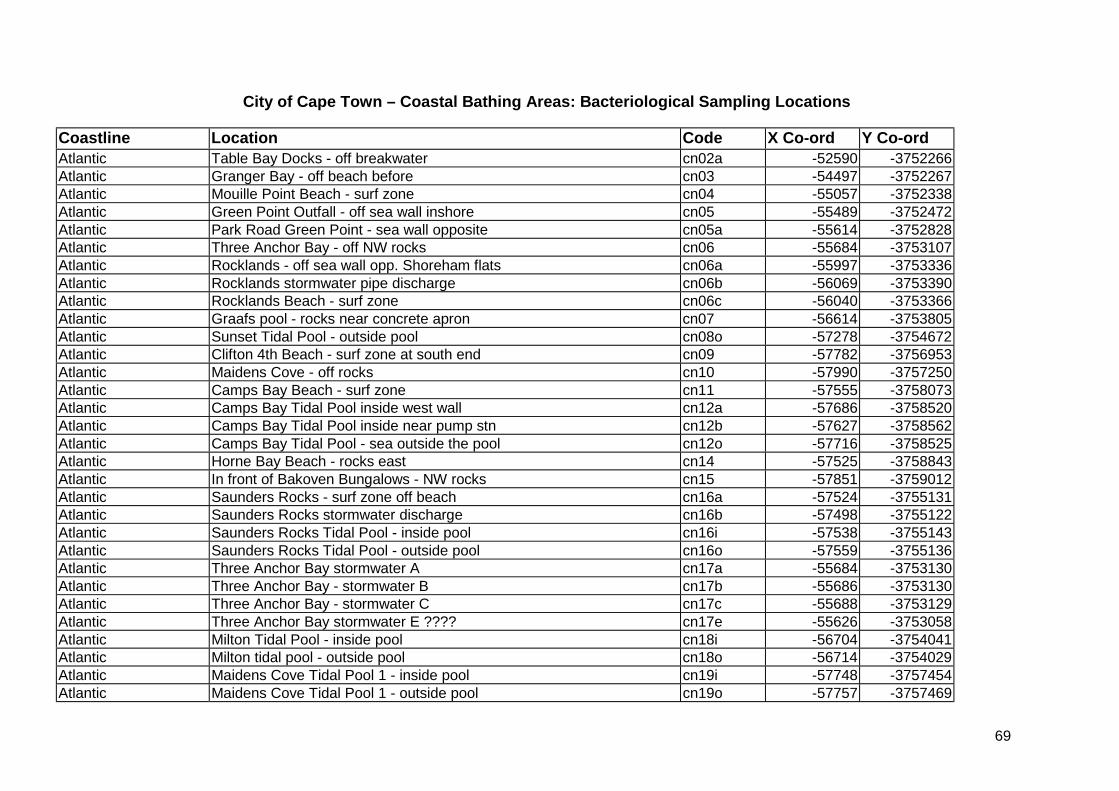
69
City of Cape Town – Coastal Bathing Areas: Bacteriological Sampling Locations
Coastline Location Code X Co-ord Y Co-ordAtlantic Table Bay Docks - off breakwater cn02a -52590 -3752266Atlantic Granger Bay - off beach before cn03 -54497 -3752267Atlantic Mouille Point Beach - surf zone cn04 -55057 -3752338Atlantic Green Point Outfall - off sea wall inshore cn05 -55489 -3752472Atlantic Park Road Green Point - sea wall opposite cn05a -55614 -3752828Atlantic Three Anchor Bay - off NW rocks cn06 -55684 -3753107Atlantic Rocklands - off sea wall opp. Shoreham flats cn06a -55997 -3753336Atlantic Rocklands stormwater pipe discharge cn06b -56069 -3753390Atlantic Rocklands Beach - surf zone cn06c -56040 -3753366Atlantic Graafs pool - rocks near concrete apron cn07 -56614 -3753805Atlantic Sunset Tidal Pool - outside pool cn08o -57278 -3754672Atlantic Clifton 4th Beach - surf zone at south end cn09 -57782 -3756953Atlantic Maidens Cove - off rocks cn10 -57990 -3757250Atlantic Camps Bay Beach - surf zone cn11 -57555 -3758073Atlantic Camps Bay Tidal Pool inside west wall cn12a -57686 -3758520Atlantic Camps Bay Tidal Pool inside near pump stn cn12b -57627 -3758562Atlantic Camps Bay Tidal Pool - sea outside the pool cn12o -57716 -3758525Atlantic Horne Bay Beach - rocks east cn14 -57525 -3758843Atlantic In front of Bakoven Bungalows - NW rocks cn15 -57851 -3759012Atlantic Saunders Rocks - surf zone off beach cn16a -57524 -3755131Atlantic Saunders Rocks stormwater discharge cn16b -57498 -3755122Atlantic Saunders Rocks Tidal Pool - inside pool cn16i -57538 -3755143Atlantic Saunders Rocks Tidal Pool - outside pool cn16o -57559 -3755136Atlantic Three Anchor Bay stormwater A cn17a -55684 -3753130Atlantic Three Anchor Bay - stormwater B cn17b -55686 -3753130Atlantic Three Anchor Bay - stormwater C cn17c -55688 -3753129Atlantic Three Anchor Bay stormwater E ???? cn17e -55626 -3753058Atlantic Milton Tidal Pool - inside pool cn18i -56704 -3754041Atlantic Milton tidal pool - outside pool cn18o -56714 -3754029Atlantic Maidens Cove Tidal Pool 1 - inside pool cn19i -57748 -3757454Atlantic Maidens Cove Tidal Pool 1 - outside pool cn19o -57757 -3757469

70
Atlantic Maidens Cove Tidal Pool 2 - inside pool cn20i -57849 -3757420Atlantic Maidens Cove Tidal Pool 2 - outside pool cn20o -57840 -3757446Atlantic Beach in front of Bakoven Pump Station cn21 -57884 -3759151Atlantic Near Rietvlei Outlet - +/- 50m south of cn22 -47933 -3751525Atlantic Horne Bay stormwater discharge on beach cn23 -57562 -3759019Atlantic Graafs Pool stormwater 1 discharge cn24 -56641 -3753978Atlantic Graafs Pool stormwater 2 discharge cn25 -56574 -3753905Atlantic Graafs Pool stormwater 3 discharge cn26 -56524 -3753788Atlantic Bakoven stormwater discharge cn27 -57873 -3759106Atlantic Camps Bay stormwater discharge cn28 -57712 -3758399Atlantic The Kom, Kommetjie xcn01 -62389 -3779293Atlantic Long Beach Kommetjie xcn02 -61876 -3778695Atlantic Llandudno Beach xcn03 -60875 -3764492Atlantic Milnerton Lighthouse xcn04 -47464 -3750300Atlantic Blouberg, small bay xcn05 -50124 -3741026Atlantic Tableview xcn06 -48511 -3743647Atlantic Melkbosstrand xcn07 -51575 -3732660Atlantic Silwerstroom Tidal Pool xcn08 -59376 -3718209Atlantic Oudekraal Resort xcn09 -60019 -3762138Atlantic Hout Bay Beach xcn10 -59043 -3768831Atlantic Scarborough Beach xcn11 -57839 -3785634False Bay Kalk Bay cs01 -50646 -3777532False Bay Kalk Bay Harbour Beach cs01a -50819 -3777762False Bay Kalk Bay Tidal Pool cs02 -50629 -3777504False Bay Dalebrook Tidal Pool cs03 -50391 -3777229False Bay St James Tidal Pool cs04 -49798 -3776680False Bay ex Sandown Hotel site cs05 -49025 -3775775False Bay Muizenberg Station cs06 -48956 -3775647False Bay Sunrise Beach cs07 -47710 -3775101False Bay Opposite lifebox 21 cs08 -46733 -3774715False Bay Opposite lifebox 23 cs09 -45905 -3774381False Bay Sonwabe cs10 -45109 -3774174False Bay Ribbon Parking area cs11 -44454 -3773994False Bay Lifebox 30 cs12 -42758 -3773546False Bay Strandfontein Point cs13 -41710 -3773357
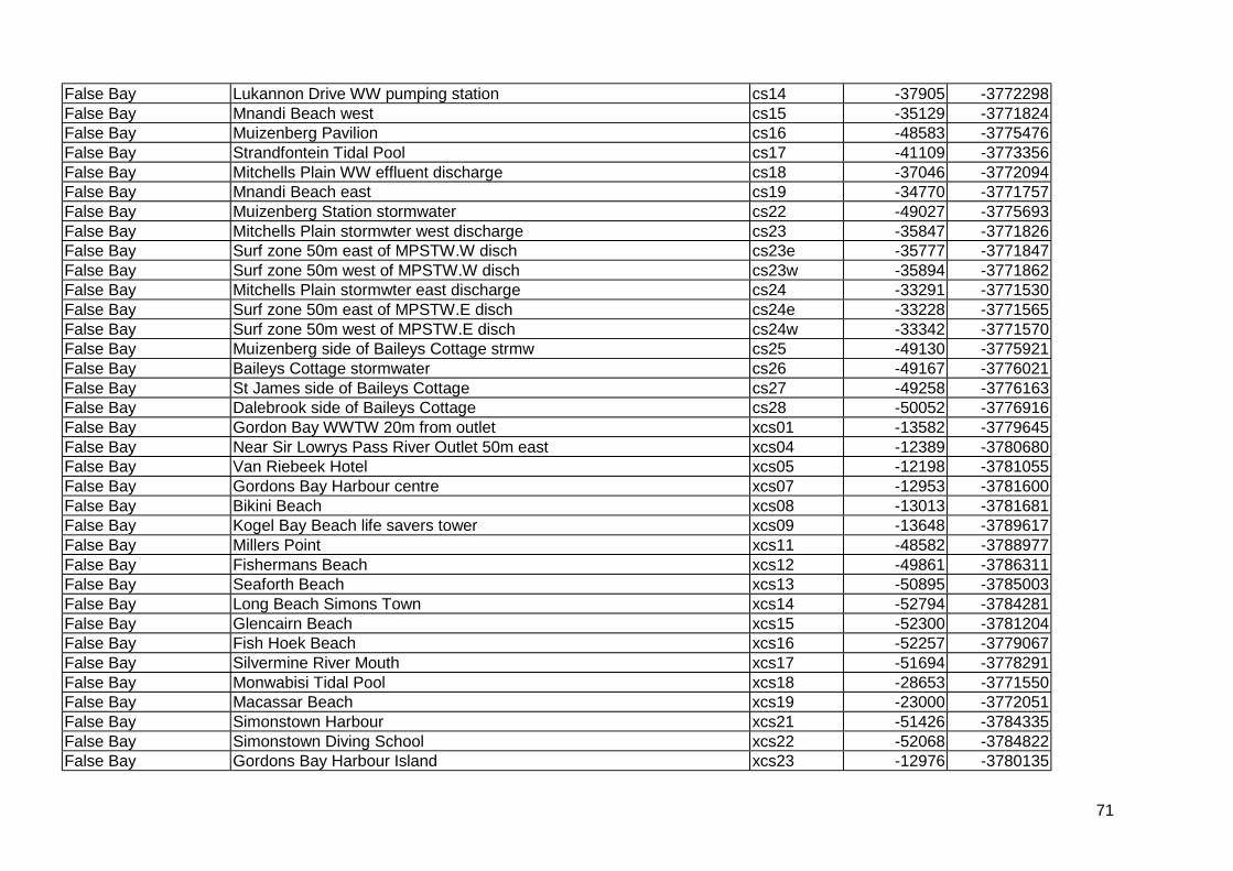
71
False Bay Lukannon Drive WW pumping station cs14 -37905 -3772298False Bay Mnandi Beach west cs15 -35129 -3771824False Bay Muizenberg Pavilion cs16 -48583 -3775476False Bay Strandfontein Tidal Pool cs17 -41109 -3773356False Bay Mitchells Plain WW effluent discharge cs18 -37046 -3772094False Bay Mnandi Beach east cs19 -34770 -3771757False Bay Muizenberg Station stormwater cs22 -49027 -3775693False Bay Mitchells Plain stormwter west discharge cs23 -35847 -3771826False Bay Surf zone 50m east of MPSTW.W disch cs23e -35777 -3771847False Bay Surf zone 50m west of MPSTW.W disch cs23w -35894 -3771862False Bay Mitchells Plain stormwter east discharge cs24 -33291 -3771530False Bay Surf zone 50m east of MPSTW.E disch cs24e -33228 -3771565False Bay Surf zone 50m west of MPSTW.E disch cs24w -33342 -3771570False Bay Muizenberg side of Baileys Cottage strmw cs25 -49130 -3775921False Bay Baileys Cottage stormwater cs26 -49167 -3776021False Bay St James side of Baileys Cottage cs27 -49258 -3776163False Bay Dalebrook side of Baileys Cottage cs28 -50052 -3776916False Bay Gordon Bay WWTW 20m from outlet xcs01 -13582 -3779645False Bay Near Sir Lowrys Pass River Outlet 50m east xcs04 -12389 -3780680False Bay Van Riebeek Hotel xcs05 -12198 -3781055False Bay Gordons Bay Harbour centre xcs07 -12953 -3781600False Bay Bikini Beach xcs08 -13013 -3781681False Bay Kogel Bay Beach life savers tower xcs09 -13648 -3789617False Bay Millers Point xcs11 -48582 -3788977False Bay Fishermans Beach xcs12 -49861 -3786311False Bay Seaforth Beach xcs13 -50895 -3785003False Bay Long Beach Simons Town xcs14 -52794 -3784281False Bay Glencairn Beach xcs15 -52300 -3781204False Bay Fish Hoek Beach xcs16 -52257 -3779067False Bay Silvermine River Mouth xcs17 -51694 -3778291False Bay Monwabisi Tidal Pool xcs18 -28653 -3771550False Bay Macassar Beach xcs19 -23000 -3772051False Bay Simonstown Harbour xcs21 -51426 -3784335False Bay Simonstown Diving School xcs22 -52068 -3784822False Bay Gordons Bay Harbour Island xcs23 -12976 -3780135
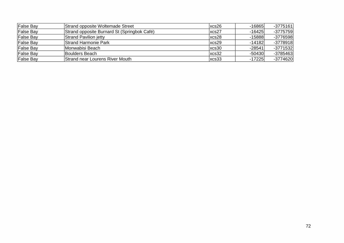
72
False Bay Strand opposite Woltemade Street xcs26 -16865 -3775161False Bay Strand opposite Burnard St (Springbok Café) xcs27 -16425 -3775759False Bay Strand Pavilion jetty xcs28 -15888 -3776598False Bay Strand Harmonie Park xcs29 -14182 -3778918False Bay Monwabisi Beach xcs30 -28541 -3771532False Bay Boulders Beach xcs32 -50430 -3785463False Bay Strand near Lourens River Mouth xcs33 -17225 -3774620
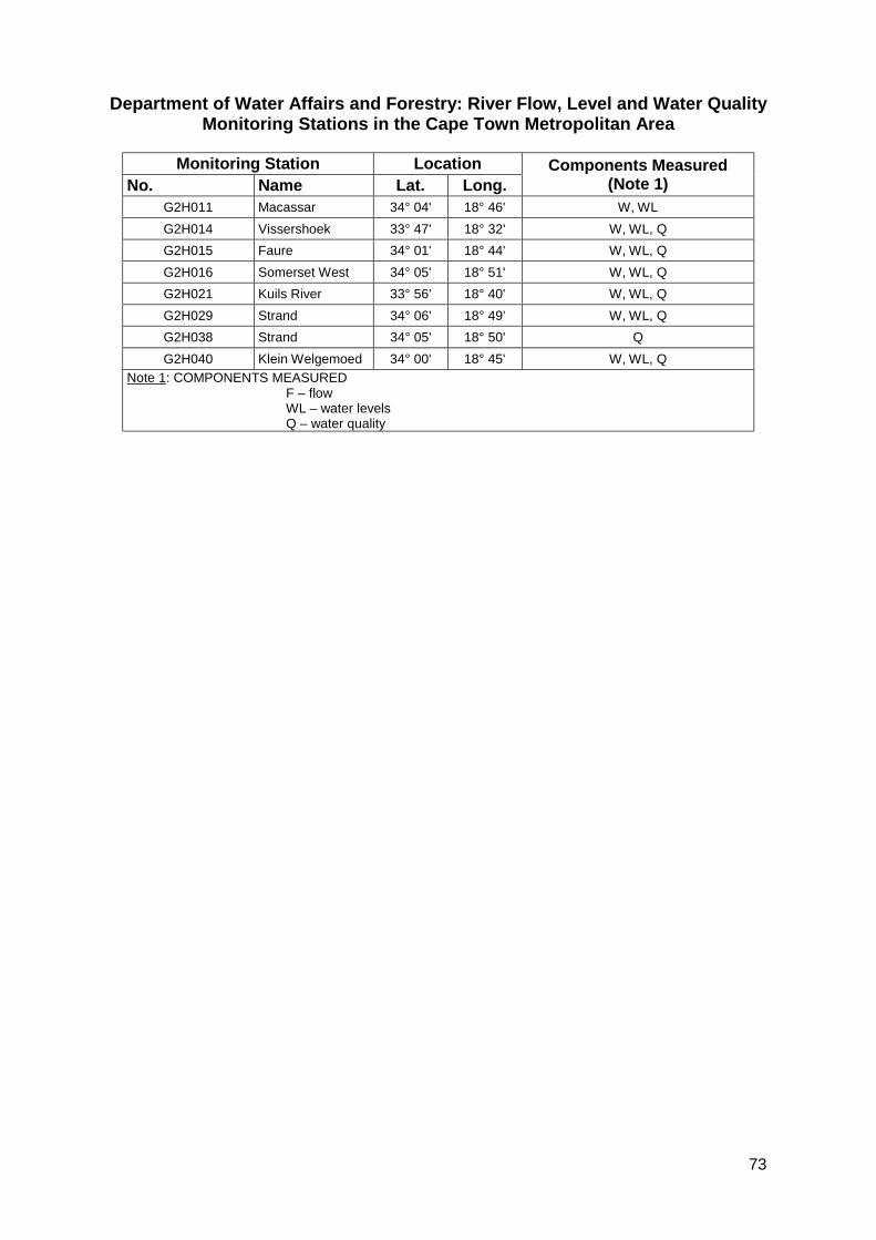
73
Department of Water Affairs and Forestry: River Flow, Level and Water QualityMonitoring Stations in the Cape Town Metropolitan Area
Monitoring Station LocationNo. Name Lat. Long.
Components Measured(Note 1)
G2H011 Macassar 34° 04' 18° 46' W, WLG2H014 Vissershoek 33° 47' 18° 32' W, WL, QG2H015 Faure 34° 01' 18° 44' W, WL, QG2H016 Somerset West 34° 05' 18° 51' W, WL, QG2H021 Kuils River 33° 56' 18° 40' W, WL, QG2H029 Strand 34° 06' 18° 49' W, WL, QG2H038 Strand 34° 05' 18° 50' QG2H040 Klein Welgemoed 34° 00' 18° 45' W, WL, Q
Note 1: COMPONENTS MEASUREDF – flowWL – water levelsQ – water quality

74
Annexure E - Modeling Tools, Techniques And Parameters

75
Basis for Design
a) Acceptable Flood Risk
One of the primary objectives of stormwater management planning is to achieve an acceptableflood risk within the developed area and to avoid increasing the downstream flood risk. Theflood risk may be addressed within two main components of the stormwater managementsystem: the major system and the minor system. The major system addresses conditionsduring large infrequent events and the minor system provides a means of handling the runofffrom the smaller more frequent storms.
b) Major System
Major floods relate to the less frequent events, with a recurrence interval of 1:20 years andgreater. The stormwater management system for all new developments should be designed tosafely contain floods up to the 1:50 year flood without the flooding of properties. Conditionsshould also be checked for the 1:100 year event to ensure that floor levels will not beinundated. In terms of the National Water Act (Act 36 of 1998) the 1:100 year floodline must beindicated on the layout of all new townships.
The location of new developments within floodplain areas is described in the Guidelines forDevelopment Control in Floodprone Areas. (City of Cape Town (2002a)), and is summarised inthe tabulation below.
Flood Zone Permissible Development1:100 year flood level Floor levels not permitted below 1:100 year flood level1:50 year flood level New development not permitted below the 1:50 year flood level1:20 year flood level The area below this level is known as the floodway and should
remain unobstructed to permit the passage of floods.
c) Minor System
This system is to be designed to accommodate the more frequent events so as to eliminateinconvenience to pedestrian and vehicular traffic. Guidelines for the design frequencies for theminor system are given in the tabulation below. The minor system should therefore bedesigned with sufficient capacity to accommodate flows of this magnitude.
Land-Use Design Flood Recurrence IntervalResidential 1:2 – 1:5 yearsInstitutional (e.g. schools) 1:2 – 1:5 yearsGeneral commercial and industrial 1:5 yearsHigh value central business districts 1:5 – 1:10 years
Storm Rainfall
a) IDF Curves
For design purposes, storm rainfall is defined i.t.o. an intensity-duration-frequency relationship(IDF) and time distribution. IDF relationships have been determined for a number of rainmonitoring stations in the Cape Town Municipal Area by the City of Cape Town and theDepartment of Water Affairs and Forestry (Weather Bureau monitoring stations) as modifiedand published by Schmidt, E.J., Schulze, R.E. and Dent, M.C. (1987) and Smithers andSchulze (2000). The rain stations in the CMA are listed in Table D.1 (Annexure D). In selecting

76
an appropriate monitoring station to represent the catchment to be analysed both stationproximity to the catchment and location relative to nearby hills or mountains should be takeninto account.
Smithers and Schulze (2000) recommend the use of the Type 2 storm distribution while thetriangular storm shape or the Chicago storm shape (based on nested critical depths forincreasing durations all at the same recurrence interval) is favoured by many local engineers.In a study by Berg et al (2000) a number of recorded storms were analysed and it wasconcluded that the use of the Type 1 storm distribution is most appropriate for the CMA.Designers should exercise judgement in this regard.
b) Time Distribution
When stormwater runoff modelling is carried out it is also required to define the shape of thestorm hyetograph, i.e. a time distribution of the storm rainfall. Two main distribution types areused in the CMA, viz. a triangular shaped storm and the more conservative Chicago type stormwith a centrally placed peak.
The Chicago type storm is derived directly from the IDF relationship and requires the selectionof a minimum time increment (typically 5 –15 minutes) and a storm duration (typically 24hours). The average intensity over any period of time centred on the peak equals the intensityfrom the IDF relationship for that particular duration.
c) Areal Reduction Factor
It is recommended that the Alexander (1991) area reduction factors (ARFs) be used.
d) Autographic Rain Monitoring Stations
A number of other autographic rain monitoring stations are operated in the Cape Townmetropolitan area and are listed in Annexure D - Hydrological and Water Quality Data Sources.
Stormwater Modeling
a) Modeling Tools and Techniques
Storm peak flow runoff may be conveniently computed for small catchments (up to 8 km2) bymeans of the Rational or the SCS methods (Rooseboom et al (1993), and Schmidt, E.J. andSchulze, R.E. (1987a and b). For larger catchments the area should be discretised into sub-catchments and the peaks lagged and summed. A simple time lag method may be employedbased on estimated flow velocities in the river channels.
These methods are open to criticism of being over-simplistic and for assuming that storm eventprobability equals runoff event probability, e.g. James (1992). If calibration data (rainfall withcorresponding flow data) is available and the proposed development is large and mustaccommodate runoff from upstream and/or may have consequences downstream, then amodelling approach is justified.
Statistical methods based on recorded flow data (Alexander (1991)) are normally notappropriate because of the lack of specific long flow records.
Simple methods to compute pollutant export from a developing community have been derivede.g. Schueler (1987), however applicability to local conditions has not been tested.

77
Flow, water level and water quality data is collected at a number of points in the Cape Townmetropolitan area and these data should be taken into account at every opportunity. A list ofmeasuring points is listed in Table D.2 (Annexure D).
b) Stormwater Modeling
A number of models are available for modeling stormwater runoff in urban areas. The mostcommonly in use in South Africa are listed in Table 5.
Various processes may be modeled and these can be categorised as follows:
! Hydrological! Hydraulic! Water quality
The City of Cape Town recently commissioned a study to evaluate a wide range of models formore complex stormwater modeling, both quantity and quality. The SWMM model wasrecommended in the form of either the Visual Hydro or PCSWMM packages.
Comparison Of Selected Stormwater Models In Use In South AfricaModeling CapabilityModel NameHydrological Hydraulic Water Quality
Normal Application
Stormwater Time-area Routing (channel andreservoir); Manning(normal flow)
- Design or analysis ofstormwater system
HEC-HMS SCS method,Unit hydrograph
Routing (channel andreservoir); pumping;diversion
- Master planning; modelingof attenuation ponds
HEC-RAS - Calculates watersurface profiles forsteady and unsteadygradually varied flowin network ofchannels, dendriticsystem or single riverreach
SedimentTransport
Floodlines; hydraulicanalysis
PCSWMM2000 USEPA SWMMmethod
Models steady andunsteady flows,pressure flows and fullhydrodynamic routing
Multipleconstituents
Design or detailed analysisof stormwater system withoption of modeling waterquality
VISUALHYDRO
USEPA SWMM,SCS, Unithydrographmethods
Models steady andunsteady flows,pressure flows and fullhydrodynamic routing
Multipleconstituents
Design or detailed analysisof stormwater system withoption of modeling waterquality
PONDPACK SCS, Rational,Unit hydrographmethods
Routing (channel andreservoir); pumping;diversion
- Master planning; modelingof attenuation ponds.
78
Annexure F - Stormwater Management Facilities andTechniques

79
Conveyance
C 1 Pipes and Culverts Illustration: Page 24
Application
For conveyance of storm runoff where open channel flow is not practical, as well as for roadcrossings.
Engineering Design Considerations
Pipes and culverts are the primary components of any stormwater management system. Theyefficiently and quickly collect surface runoff and convey it away from areas where it may causeflooding or inconvenience. They significantly reduce catchment response time and increase runoffpeak and volume compared to natural conditions.
Normally designed to flow full at design discharge, however surcharge in manholes may be takeninto account if depth of pipe/culvert permits.
In special cases it may be required to calculate the water surface profile and allow for all potentialhydraulic head losses, e.g. at hydraulic jumps, expansions, contractions, sharp changes ofdirection, etc.
Special measures may be required at outfalls to dissipate energy or protect against erosion.
Volume reduction can be achieved to a certain extent if storage pipes are used. Pipe storageschemes would only be useful on small developments, and where costs of land are very high, dueto the expense of installing larger pipes.
Safety objectives as well as protection of downstream resources would arguably be met ifextremely poor quality water is piped off-site and directed to a treatment facility.
Ecological Implications
Piped conveyance provides ecologically sterile habitat and, where stormwater would normally feedinto surface drainage routes, effectively deprives these systems of their natural flow regimes andwater supply. Natural water cleansing (e.g. through exposure to sunlight) cannot occur in pipedsystems.
Concentration of stormwater flow into pipes may also result in erosion downstream of their releaseinto other conveyance channels, either natural or artificial and inlet and outlet details should becarefully considered in this regard.
This option presents little opportunity for improving ecological function. Piping of water to atreatment facility should be considered in cases where extremely severe water quality impairmentexists, and is realistically likely to remain a long-term problem of the area.
Effectiveness
Effective in conveyance of stormwater runoff and prevention of erosion. Low effectiveness w.r.t.ecological and water quality improvement.
80
Health and Safety Implications
Only a positive aspect when water quality degradation is such that it constitutes a severe humanhealth risk, such that on-site treatment through measures such as wetlands or other filtrationdevices are unlikely to work. In such cases, positive benefits are only achieved if water is conveyedto a treatment facility – its release from closed pipes further downstream is likely to result in healthrisks to natural and human communities downstream.
Closed pipes are less hazardous in terms of drowning than many open canals. Inlet and outletdetails should be carefully considered in this regard and designed for safety and visual impact
Aesthetic or Social Implications or Additional Functions
In certain degraded areas, closed pipes are more aesthetically pleasing than open watercourses,since litter and other waste cannot be dumped in them.
Construction Implications
None
Maintenance Implications
Closed pipes will not attract windblown litter from the surrounding catchment as readily as opensystems; however, where blockages do occur, they will be more serious and location of blockedareas will be more difficult. Small pipes are prone to blocking by paper, rags, debris etc.
Regular emptying of catchpits is required in order to minimize blockages caused by debris orsediment.
Additional Resources
Ven te Chow (1985); Rooseboom et al, (1993)
C 2 Lined Artificial Channels (Concrete Or Rock) Illustration: Page 24
Application
For conveyance of runoff where severe space restrictions exist and where properties must beprotected from flooding.
Engineering Design Considerations
May have uniform concrete lining or composite linings, e.g. concrete low-flow channel withvegetated high-flow section.
The most efficient hydraulic shape is parabolic but for stormwater canals the most common wouldbe trapezoidal or rectangular because of ease of construction.
Normally design velocities are such that some form of erosion resistant lining is required. Variousexamples are illustrated above. Those with a concrete base are often favored because of ease ofmaintenance, but have negative ecological implications. Alternative pervious linings are normallyrougher and result in slower, deeper flow - these can be used to dissipate water energy andimprove quality.
81
For safety reasons, designs resulting in high velocities should be avoided.
Ecological Implications
Smooth Impervious liningsChannels with concrete or similar linings are ecologically sterile, providing little or no habitatdiversity, no protection to living organisms during periods of strong flow and, since few if anyorganisms are able to survive such conditions, natural cleansing functions performed by manyriverine ecosystems do not occur.
Rough, pervious liningsRock-lined channels for stormwater conveyance provide a far better option, although they too haveproblems. The rocky bed formed might not necessarily be the kind of habitat that would occur innatural rivers in the area, and the ecosystem thus created would not therefore mimic naturalconditions. Nevertheless, such a substratum can provide a far more diverse range of habitats thana concrete canal and, if flood velocities are not too high to prevent sedimentation, is likely tosupport in-channel vegetation growth, creating, in time, in-stream habitats such as islands andsand bars.
As far as possible, variation of the basic trapezoidal shape should be incorporated to maximise thediversity of in-stream habitats (e.g.- varying the widths of the low flow section, the height and slopeof the low flow section sides, and the high flow section, where non-concrete lined options areselected.)
Riparian fringeAdditional ecological benefits may be obtained by creating a wide riparian fringe and sloped sidesalong the edges of the channel, such as buffering of surface water entering the channel from thesurrounding area, creation of a corridor of riparian vegetation, providing shelter and habitat (whereappropriate indigenous vegetation is established, and where the fringe is wide enough – a width ofat least 10m on either side of the channel is recommended).
Habitat qualityHabitat quality can be further enhanced along the channel through landscaping details designed toincrease habitat heterogeneity. These include the provision of meanders, varied bank slopes,ranging from 1:4 to 1:7, provision of high flow and low flow sections, and creation of off-channeland in-channel wetland areas. Even where space is severely constrained, “nodes” can be createdin the river corridor, where slightly more space is available.
Effectiveness
Effective in conveying large flows at higher velocities, small width requirements and relatively lowmaintenance.
Low effectiveness w.r.t. water quality improvement and ecological benefit, unless substantialmodifications to structure (e.g. rock-lined channels with vegetated margins).
A negative aspect associated with rock-lined channels is the potential for growth of invasivevegetation.
Health and Safety Implications
Concrete canals are usually trapezoidal or rectangular, can be deep, and are often fast flowingduring flood periods. They thus constitute safety risks to humans and animals – exit from thecanals once fallen into is also often difficult.
82
Velocities and depths should be kept as low as possible. Special measures should be taken toprevent humans and animals that have fallen into the canal, from being carried into long culverts.Such measures could include sloped gratings over entrances of such culvert and protuberances onthe sides of the canal to assist an exit.
Graded, rock-lined channels (as outlined above) by contrast permit ease of exit, provided thatvegetation growth is not excessive.
In non-concrete lined channels, water quality improvements should be associated with theincorporation of wide riparian buffer strips and on-channel wetlands.
Growth of Typha capensis along non-concrete lined channels the river channel can be associatedwith the production of seeds, associated with respiratory problems and clogging of curtains etc. Ifresidential areas are set well back from the channel area, these are unlikely to be seriousproblems. Cutting of T. capensis seems to prevent seeding over at least one season.
Aesthetic or Social Implications or Additional Functions
Rock-lined channels, or composite channels (small concrete lined low-flow section and vegetatedflood-flow section), landscaped and planted appropriately can be used to enhance the character ofthe development and incorporated into the useable open space of a development.
Potential uses include, informal sports activities in high flow sections (this use may however be inconflict with the creation of a substantially vegetated indigenous buffer strip) or adjacent to theriparian fringes; walkways; hiking trails; picnic areas; bird watching areas; educational resources.
The use and design of concrete channels must be appropriate to the context and location.Concrete channels frequently become little more than sewers, associated with pollution, litterloading and criminal elements. Conversely, in some areas they can form an important part of localmovement networks and/or recreational systems, or act as deterrents to criminals, by forming thebarriers to movement between sections of a community or between communities.
Construction Implications
Construction should not take place during the rainy season. If stabilisation by planting isenvisaged, plants should be established before the onset of the winter rains and a phasedapproach to construction should be considered.
Where enhanced ecological function is an objective, a freshwater ecologist should participate inon-site supervision of landscaping, to maximise opportunities for habitat creation.
Maintenance Implications
Where extensive planting is envisaged, for aesthetic, bank stabilisation or ecological purposes,provision should be made for irrigation over at least one full year, as well as for weeding andreplacement of plants lost to vandalism, drought, flooding.
Cutting of Typha capensis seems to prevent seeding over at least one season.
In rock-lined channel regular maintenance would be required to remove invasive vegetation.
Additional Resources
Ven te Chow (1985) Rooseboom et al (1993); Davies and Day (1998)
83
C 3 Unlined Artificial Channels Illustration: Page 24
Application
For conveyance of runoff where properties must be protected from flooding and where spacerestrictions are not severe.
Engineering Design Considerations
Channels should be designed to achieve non-eroding velocities by appropriate selection of cross-sectional shape and longitudinal gradient.
Side slopes should be 1:4 to 1:7. Non-uniform edges may be used provided hydraulic capacity ismaintained.
Utilising steps, e.g. gabions, may reduce gradients. Local erosion protection may be required atthese points.
The channel base could be flat or have a depressed central section. A low-flow channel could beformed with rock protection, however it is likely to quickly silt up.
Vehicular access points should be provided for maintenance purposes.
Ecological Implications
Where steps (drops) are included in channel design, these should be <1m in height and/ or tied into graded channel sides to allow for longitudinal migration of fish. The specific requirements for fishpassage should be established where pertinent to that environment.
Where channels are lined, this should be covered by at least 300mm of soil to encourageestablishment of vegetation. Planting should allow the establishment of a range of plants, adaptedto seasonal or permanent inundation. At least some of these should be efficient at nutrient andother pollutant absorption, so that filtration is also enhanced. Vegetated buffer areas aroundplanted channels will contribute to improving surface runoff quality from the surrounding areas
Channels may support unsightly blooms of algae at times (particularly in standing water areas) aswell as invasion by T. capensis. The latter is effective in filtration, and it should be controlled,rather than eradicated from an area.
Effectiveness
Effective in conveying small or large flows at low velocities where sufficient width can be provided.Effective w.r.t. attenuation because of wider slower flow regime. Effective in sedimentation,groundwater recharge and provision of natural habitats.
Health and Safety Implications
Invasion by T. capensis may be associated with respiratory problems in some adjacent residentialareas – this can be controlled by annual cutting or burning of the bulrush, to reduce seeding.Improved water quality will have positive safety implications for downstream users.
Open channels may constitute safety threats to children and some adults. Warning signs shouldbe posted, and local residents educated regarding potential dangers associated with these andother water bodies.

84
Aesthetic or Social Implications or Additional Functions
May be incorporated into P.O.S. to provide a focus point; could include walking, cycling, runningtracks.
Construction Implications
Construction should be carried out during periods of anticipated low flow and special precautionsshould be taken to prevent sediment being washed downstream.
Maintenance Implications
Regular maintenance would include removal of sediment and vegetation, which reduces thehydraulic capacity below the design requirement, and removal of alien vegetation and litter.Irrigation may be required initially in order to establish vegetation.
C 4 Unlined Sheet Flow Illustration: Page 25
Application
For conveyance of runoff in areas where wide extensive wetlands would have been the norm andspace restrictions are not severe.
Engineering Design Considerations
Area to be shaped to achieve ecological objectives while maintaining hydraulic capacity. Thesedesign options provide opportunities for the creation of seasonal wetland habitat. Many sheet flowwetlands have been lost from development areas by changes in drainage and infilling. They aremore vulnerable to development than discrete river channels, since during the dry season, theirfunction as seasonal wetlands is often not obvious. It is only during the wet season that they areassociated with broad seepage areas and surface shallow, surface flows after rainfall. Theircreation in appropriate areas of new developments, would therefore be very positive from anecological perspective.
Depending on the choice of design, landscaping and planting should be structured to createsystems that are as diverse as possible. Attention should be paid to wetland shapes, which shouldmeander longitudinally, and have side slopes that range between 1:4 and 1:7. Shallow irregulardepressions on the base of wetlands will provide patches of differentially wetted habitat; shallowwetland areas will enhance water quality improvements through filtration.
Ecological Implications
Planting should ideally allow the establishment of a range of plants, adapted to seasonal orpermanent inundation. At least some of these should be efficient at nutrient and other pollutantabsorption, so that filtration is also enhanced.
Vegetated buffer areas around wetlands will contribute to improving surface runoff from thesurrounding areas.
Wetlands may support unsightly blooms of algae at times (particularly in standing water areas) aswell as invasion by T. capensis. The latter is however effective in increasing filtration and it shouldbe controlled, rather than annihilated from an area.
85
Effectiveness
Effective in conveying small flows at low velocities where sufficient width can be provided. Effectivein sedimentation, groundwater recharge and provision of natural habitats.
Health and Safety Implications
Invasion by T. capensis may be associated with respiratory problems in some adjacent residentialareas – annual cutting of the bulrush, to reduce seeding, can control this.
Improved water quality will have positive safety implications for downstream users.
Areas of shallow standing water may constitute safety threats to children and some adults.Warning signs should be posted, and local residents educated regarding potential dangersassociated with these and other water bodies.
Aesthetic or Social Implications or Additional Functions
Litter carried by stormwater tends to catch on plants, making wetland areas unsightly. Thisproblem can be addressed by incorporation of litter traps into stormwater outlets (provided thatmaintenance of such traps occurs at appropriate intervals); alternatively, local ratepayers or bodycorporate should consider funding cleansing programmes.
Wetlands such as these lend themselves to use as community amenities, providing aestheticallypleasing natural areas in urban settings; providing bird watching areas and walking trails.
Construction Implications
Construction should not take place during the rainy season; plants should be established beforethe onset of the winter rains and a phased approach to construction should be considered. Whereenhanced ecological function is an objective (e.g. as outlined in ecological section above), afreshwater ecologist should participate in on-site supervision of landscaping, to maximiseopportunities for habitat creation.
Maintenance Implications
Where extensive planting is envisaged, provision should be made for irrigation over at least one fullyear, as well as for weeding and replacement of plants lost to vandalism, drought, flooding.
Erosion nicks between berm overflow areas in sheet wetland designs should be attended to –planting may be more effective than hard engineering designs, although the latter might includegrass blocks and gabion -mattresses.
C 5 Natural Channels Illustration: Page 25
Application
Natural channels should be retained for stormwater drainage as a matter of course. Measures maybe required to protect their integrity and function.
Engineering Design Considerations
Developments tend to alter runoff behavior by reducing infiltration and increasing volume, rate ofrunoff and pollution. The sediment transport regime is also altered.
86
These consequences may all negatively impact on natural channels. Care should therefore betaken to address these effects before the runoff enters the natural channel.
Certain in-stream measures may be necessary if this cannot be fully achieved prior to runoffentering the channel. Such measures could include erosion protection, planting, introduction ofwetlands, sediment, oil or litter traps.
Ecological Implications
The impacts of incorporating natural channels into a stormwater system need to be carefullydetermined and analysed. Substantial changes in the hydrological regime of the channel will havenegative impacts ecologically and functionally, and inappropriate use may lead to severeundercutting erosion, undercutting, increased flood risk and eventual canalisation of courses.
The use of natural channels should be part of an integrated stormwater management plan thataims to ameliorate development impacts close to source. For example, vegetated buffer areasaround planted channels/wetlands will contribute to improving surface runoff quality from thesurrounding areas
Wetlands and channels may support unsightly blooms of algae at times (particularly in standingwater areas) as well as invasion by T. capensis. The latter is however effective in filtration, and itshould be controlled, rather than eradicated from an area. Measures to prevent erosion at inletareas should be put in place.
Natural river ecosystems should be protected from the influence of the poor stormwater quality bycreation of substantial wetland areas at inlet points. Where natural channels have high ecologicalimportance, or are likely to be negatively impacted by receipt of stormwater, their use asstormwater conduits should not automatically be assumed, without incorporation of substantialmitigatory measures.
Effectiveness
Most effective in achieving all design objectives, provided the system is regularly monitored andnot over-stressed.
Health and Safety Implications
Invasion by T. capensis may be associated with respiratory problems in some adjacent residentialareas – this can be controlled by annual cutting or burning of the bulrush, to reduce seeding.
Improved water quality will have positive safety implications for downstream users.
Areas of shallow standing water and open channels may constitute safety threats to children andsome adults. Warning signs should be posted, and local residents educated regarding potentialdangers associated with these and other water bodies.
Aesthetic or Social Implications or Additional Functions
Litter carried by stormwater tends to catch on plants, making planted channels and wetland areasunsightly. This problem can be addressed by incorporation of litter traps into stormwater outlets(provided that maintenance of such traps occurs at appropriate intervals); alternatively, localratepayers or body corporate should consider funding cleansing programmes.
87
Wetland and channel systems such as these lend themselves to use as community amenities,providing aesthetically pleasing natural areas in urban settings; providing bird watching areas andwalking trails.
Construction Implications
Limited erosion protection may be required from time to time.
Maintenance Implications
Annual cutting of the bulrush, to reduce seeding, may control invasion by T. capensis.If possible mechanical dredging of sediment invasive vegetation from channels should not becarried out, as this leads to the creation of unstable steep-sided, deep channels, with reducedecological function. Manual weed/ other vegetation clearing should take place, where such clearingis necessary.
Litter carried by stormwater tends to catch on plants, making planted channels and wetland areasunsightly. A cleansing programme will be required.
C 6 Gabion Baskets And Mattresses Illustration: Page 25
Application
Erosion protection, bank stabilisation, energy dissipation, weirs and earth retention.
Engineering Design Considerations
Erosion protectionGabion mattresses suitable for erosion protection where water has high velocity or impact e.g.channel lining, downstream of weirs, culvert or pipe outlets. Suitable thickness mattress should beselected for the anticipated velocity or measures taken to first reduce the velocity.
WeirsGabions may be stacked to form weirs of various heights. Although flexible, measures must betaken to prevent undermining of structure.
Ecological Implications
Gabions and mattresses may be covered with topsoil on completion and vegetated. Whereappropriate larger openings may be retained between gabions baskets to provide space forvegetation with larger root system.
Gabion weirs can be effective structures in terms of dissipating energy and thus preventingerosion. However, like gabion channel linings, they are ecologically barren, supporting little qualityvegetation and, in low-income areas, serving as traps for the collection of unsightly litter.
Where gabion weirs are necessary, consideration should be given to packing soil in spacesbetween stones along the length of the gabion, other than at the overflow lip of the structure.Planting is possible in such areas, albeit little but camouflaging vegetation, rather than hangingvegetation capable of providing marginal vegetation or other cover, is likely to be established here.
Where the natural template of a channel would actually be closer to a wide shallow wetland than aflowing channel, construction of a wide, shallow gabion weir would allow spreading of flowsupstream of the weir, and the creation of a swathe of wetland, rather than a defined channel in this
88
area. Such a wetland would probably have a more substantial effect on water quality improvementthrough filtration.
Gabion baskets and mattresses are often installed in the short reaches immediately downstream ofinlet and outlet points. These play an important engineering role, by preventing erosion and scour,however fast flows prevent the accumulation of sediment necessary for the establishment ofscreening vegetation. The use of such structures should be minimised.
Where gabions are used on channel sides, stepped gabions, with the lowest step set at bed level,may allow planting to be carried out behind the gabion, or even in sediment that accumulates onthe edge of the gabion, outside of the main flow. Such planting, if successful and sensitivelycarried out, using appropriate, indigenous riverine species, both screens gabion structures, andprovides a degree of sheltered marginal vegetation habitat at wetted bank level.
Where sporadic flows only discharge from a structure, establishment of plants other than hardyweeds is often difficult.
Effectiveness
Effective if baskets are correctly designed and filled.
Health and Safety Implications
Aesthetic or Social Implications or Additional Functions
Direct benefits through the prevention of scour. These structures do however tend to accumulatelitter.
Construction Implications
Important that good controls are maintained during construction. Careful selection and placementof stones in the front face can result in an attractive product.
Maintenance Implications
Damaged wires and subsequent loss of fill stone must be promptly repaired to prevent total loss ofstructure.
Additional Resources
Stephenson; Manufacturers’ handbooks
C 7 Energy Dissipaters Illustration: Page 26
Application
Points where high water velocity will occur, such as pipe and culvert outfalls, dam spillways andsteeply sloping channels.
Engineering Design Considerations
Normally energy dissipation is required when supercritical flow has occurred and the associatedhigh velocities are likely to result in scour damage or create unsafe conditions. Various means may

89
then be employed to force a hydraulic jump to occur at a predetermined location where erosionprotection may be provided. Excess energy is dissipated in the hydraulic jump and the flow regimechanges to sub-critical flow in which the velocity is slower and less likely to cause erosion.Downstream conditions should be evaluated to ensure that sub-critical flow would be maintained.
Examples of energy dissipaters are:
! Rip rap basins! Stilling basins! In-channel weirs! Impact basins
Energy dissipaters, which rely on high velocities to scour out accumulated sediment in order tofunction, should be avoided.
The concentration of flows with high energy should ideally be avoided by the distribution of stormrunoff among multiple outlets, each discharging relatively small flows.
Ecological Implications
Positive in that velocities and resultant scour of natural habitat is reduced but in themselves oftenecologically sterile and should be kept to a minimum.
Effectiveness
Effective in preventing high velocities and scour if appropriately designed and maintained.Sediment and debris tends to accumulate at energy dissipators because of the sudden reduction invelocities. This should be regularly removed in order to maintain function.
Health and Safety Implications
High velocity flows can be dangerous and should therefore be reduced through the use of energydissipators or eliminated by avoiding the concentration of runoff (refer to Engineering designconsiderations).
Aesthetic or Social Implications or Additional Functions
Construction Implications
As construction may take place within a river, special precautions to prevent the discharge oferoded material downstream. Construction during the dry season is advised.
Maintenance Implications
Sediment and debris will tend to accumulate at energy dissipators and should be regularlyremoved.
Additional Resources
ASCE, (1992); Rooseboom, (1993); Ven te Chow, (1985), Environmental Protection Authority 1999
90
C 8 Planting Illustration: Page 26
Application
Can enhance slope stabilisation and improve dissipation and spreading of flows downstream of aninlet/outlet structure (e.g. in a retention dam)
Engineering Design Considerations
Vegetation may be an effective means of erosion control in channels and where sheet flow occurs.
The relative erosion resistance depends on the type and density of vegetation cover, the erodibilityof the soil and the silt content of the water.
Fine sands are more erodible for example than clayey soils or gravel. Depending on conditionsvelocities of up to 2 m/s may be permitted.
Vegetation also fulfils a role of improving water quality through the uptake of nutrients and thedeposition of sediment.
Ecological Implications
Where slopes and discharge rates permit, stabilisation of slopes by planting with indigenousvegetation, in the case of permanently or seasonally flowing channels, with riparian/wetlandvegetation is an ecologically preferred option to the use of hard stabilising structures.
Plants, if selected carefully, provide a quality, sheltered habitat, with additional properties such asmoisture retention, pollution filtration and soil binding.
Plants also play a role in the vicinity of inlet and outlet structures. Most inlets and outlets need tobe designed to withstand fast, often concentrated flows. These sections of the structure canappear stark and unsightly. However, they are also often adjacent to areas that can be prone tosedimentation, e.g. immediately downstream of inlet structures and upstream of outlets.Sedimentation can, if maintenance is not carried out, result in blockages of structures. It alsoencourages the growth of vegetation.
Whilst excessive vegetation across inlet and outlet points can be problematic, in that it blocksflows, it can also provide a useful ecological function, by filtering sediment, and absorbingnutrients.
In retention ponds for example, clusters of dense reed growth in the vicinity of inlets are to beencouraged in that they can play a positive role in filtering stormwater discharge as it enters thewater body. This can potentially reduce the likelihood of algal blooms and other problems in thewater body associated with poor water quality. Reeds are, however, unlikely to have anynoticeable impact on stormwater quality in severely impacted stormwater discharges.
Effectiveness
Most effective provided the flow conditions and the quality of the vegetation remain within thecapacity of the design.
Health and Safety Implications

91
Aesthetic or Social Implications or Additional Functions
The use of planting can form part of the green open space system, both visually and physically.
Planting is often more aesthetically pleasing than ‘hard’ engineering solutions, and the benefits of aplanted system are greater than purely stormwater function.
Construction Implications
Protective measures during the initial growing period may be required, e.g. various types ofbiodegradable netting, stakes, horizontally secured logs etc. Planning should take place such thatplants have established themselves before the rainy season starts. Allowance should be made forirrigation over short hot, dry periods, and during summer, if planting occurs early.
Maintenance Implications
Where the objectives of planting have included provision of a functioning riparian buffer and naturalhabitat corridor, the maintenance needs of the area must be carefully defined and controlled. Thisshould prevent impacts such as routine mowing of indigenous planted areas, or alternatively, lackof watering / weeding during establishment phases, with the result that plant densities areinsufficient to meet any of their required objectives.

92
Ponding
P 1 Dry Ponds Illustration: Page 27
Application
These structures hold water for a few hours to a day only, but may be used in combination withretention and infiltration facilities. Their purpose is to temporarily store stormwater runoff in orderto restrict outflows to predetermined levels to reduce local and downstream flooding and topromote the settlement of pollutants.
Engineering Design Considerations
The pond will be most effective in reducing flood peaks by being placed off-channel, i.e. themaximum permissible flow is designed to bypass the pond, and only the excess flow enters thepond and is temporarily stored. The inlet and outlet would be placed in close proximity as opposedto a low flow channel, which crosses the pond.
To achieve effective reduction in peak rates of runoff, pond must be located so as to intercept amajor proportion of the site runoff.
Suggested two stage design to achieve greater water quality benefits - Lower stage (incorporatinga small permanent wetland) to be sized to accommodate mean annual storm so that the uppersection normally remains dry. Upper stage to accommodate the design storm, and have anemergency overflow to accommodate storms which exceed this. This recommendation hasimplications for the size and depth of the facility.
One of the main purposes is to achieve attenuation of storm runoff and anticipated hydrographsshould be routed through the pond to confirm its effectiveness. The length of time that the pondtakes to drain and the required storage volume are determined by the outlet capacity. Multiplestorms with different durations or a Chicago type storm (Annexure E) should be used to determinemaximum required storage. Maximum ponding duration should be determined after evaluating theprimary purpose of pond e.g. if the dry portion of the pond is used for sport then ponding durationshould be minimised. However, water quality benefits may be achieved if ponding can be extendedto at least 24 hours.
The purpose of the outlet control is to significantly reduce downstream flows, ideally to those,which occurred prior to development. The outlet should be configured to achieve this for a rangeof frequencies and not only for the major less frequent events. Outlets should be protected withgrids or other means for safety and to trap debris. Special measures should be taken to ensurethat debris will not cause the pond to malfunction or fail.
Side slopes should ideally be 1:7 but no steeper than 1:4. This to promote safety and ease ofmaintenance. Overall cost savings may be achieved in an area by having fewer larger ponds asopposed to numerous smaller ponds. This may however have reduced effectiveness of waterquality treatment.
Embankments and base should be made irregular to provide diverse habitat and maintainecological integrity.
93
Ecological Implications
Positive, in terms of design objectives addressed, but less so than in the case of wet ponds.
Tendency for the location of the structure within natural drainage systems means that inundationperiods are often associated with “drowning” of natural river or wetland habitats.
Effectiveness
One of the most effective means of attenuating peak flows if designed correctly. Not highlyeffective in addressing water quality, ecosystem functioning, bio diversity etc
Health and Safety Implications
Flat side slopes (1:7 – 1:4) and protected outlet to guard against danger of drowning.
Aesthetic or Social Implications or Additional Functions
Aesthetically pleasing vegetation of dry ponds is often difficult to achieve, since conditions in themrange from brief periods of inundation, to long periods of dryness.
Dry ponds often have recreational/ public amenity value, as they are dry for most of the year, andthus lend themselves to use as sports fields, other forms of public open space. However, sincetheir primary flood control function is often not obvious, they also lend themselves to invasion byinformal settlements, or inappropriate use/maintenance.
The safety implications of human settlements in flood-control areas, and reduced functioning of anessential component of a major stormwater system are very serious. There is a need either forcostly policing and evictions from such areas and/or alternative means of clear demarcation,education, awareness and signage.
Construction Implications
The basin may be constructed and used before the development area has been stabilised, butallowance should be made to remove the additional sediment load, which may be trapped.
Maintenance Implications
Maintenance responsibilities must be confirmed up-front with the local authority.
Wet-weather inspections annually, with as-built plans in hand. Performance of outlet control deviceand condition of wetland to be noted. Outlet structures require regular clearing. Dry-weatherinspections annually, with as-built plans in hand.
A site access road should be stabilised to withstand heavy equipment.
Dry sections to be mowed 3-4 times per year.
Sediment to be cleared out of wetland section approximately every 5 years depending oncatchment. Maintenance costs can be reduced by filtering inflows to the facility, (e.g. by passage ofstormwater through swales or filter strips).
Address adequate drainage of dry portion of pond, vegetation should not become overgrown, anydumped material to be removed.

94
Additional Resources
ASCE 1993; Scheuler, 1987, Environmental Protection Authority 1999, “Catalog of StormwaterBest Management Practices (Idaho)”, http://www2.state.id.us, New Jersey Departments ofEnvironmental Protection 2000
P 2 Wet Ponds Illustration: Page 27
Application
The application is similar to that for dry ponds except that retention of a permanent water body alsopermits water quality treatment, through removal of sediments and reduction of pollutants (e.g. byexposure to sunlight and absorption / binding of nutrients /other pollutants by plants and soilparticles.
Engineering Design Considerations
A permanent water body is usually achieved by either excavating a pond below natural groundlevel or by raising the outlet in a dam wall. The permanent water body is formed by excavatingbelow the seasonal water table level or by retaining runoff or both.
In view of maintenance requirements it is preferred by the local authority that a single largedetention in a development is preferable to a number of smaller ones. For the sake of safety it ispreferable not to place the wet pond in a location where children are likely to have easyunsupervised access.
Short-circuiting should be prevented by increasing the length to width ratio (say 3:1 or greater) andplacing the inlet and outlet as far apart as possible.
Depths of approximately 1,2 - 1,5m are recommended. This is to make provision for sediment andalso to act as a safety measure. This also allows more successful establishment of vegetationaround the fringes only.
Appropriate aquatic vegetation should be established in the shallower perimeter of the pond. Thiswill enhance pollutant removal, provide an attractive habitat for birds and other wildlife, act aserosion protection, and trap incoming sediment if situated at the inlet. Shrubs should be placed onthe buffer around the pond in order to enhance the wildlife habitat. However caution should beexercised so that hiding places for criminal elements are not created.
Side slopes should ideally be 1:7 or flatter but no steeper than 1:4. This to promote safety andease of maintenance.
Inlet pipes should be approximately 300mm below the permanent water level. Outlets should beprotected against erosion.
Variable side slopes and base, both in terms of steepness as well as roughness will facilitate amore diverse plant community and increase habitat diversity for wetland fauna.
Ecological Implications
Potentially very positive ecological implications associated with the use of this option. Wettedponds can provide substantial filtration/water purification if designed carefully, at the same time asaffording valuable wetland habitat. Bias in design towards a filtration/purification function, versus adiverse wetland habitat, would be determined by the anticipated quality of stormwater runoff intothe structure.

95
Shallow systems, with high length: width ratios will be most efficient at filtration (although thesehave greater spatial requirements to achieve the same storage capacity). The type of plantsestablished in the system will also affect the function of the wetland as a filtration device. Refer toplant list in Annexure G.
Where water quality improvements are not accorded over-riding significance, habitat quality anddiversity should be maximised. Choice of wetland plants so as to create a variety of habitatpatches, of plants with different size structures and densities, contributes to physical diversitywithin the wetland. Attention should also be paid to the creation of areas of seasonal wetlandareas – a threatened wetland type in the metropolitan area. Islands and sandbars, while reducingstorage capacity of the wetland, do provide sheltered roosting, nesting and feeding areas forwetland birds and other animals.
Side slopes should be varied, and range between 1:4 and 1:7 – again, to maximise habitatdiversity and mirror natural systems; the overall shape of the wetland should be irregular, ratherthan geometrical, and should provide a diversity of sheltered inlets and exposed areas, includingseasonally inundated fringes in permanent wetted ponds. Note that such considerations haveimplications for the spatial requirements of these ponds.
As a general rule, locally indigenous plants should be utilised and the use of invasive alien plantsshould be strictly discouraged, even in artificial wetlands, as the likelihood of contamination ofother water bodies from these source areas is great.
In the metropolitan area, nutrient-enriched runoff from many developments, coupled with the highavailability of wind blown seed, means that many wetted ponds are prone to invasion by Typhacapensis. While it is efficient in terms of nutrient absorption and is able to bind many pollutants intoits root system, it is also perceived as a pest plant, choking shallow waterways and producingmany fine seeds that clog curtains and can cause respiratory problems. Creation of deeper areasof standing water (ca 1.5m depth) is recommended as a way of reducing invasion by T. capensis(Hall 1993). Alternatively, manual control by cutting or burning.
Other potential nuisance species associated with the creation of wetted ponds include provision ofhabitat for midge larvae (chironomids) and mosquitoes, and the proliferation of floating and rootedcomplex plants and/or algae, including potentially toxic blooms of cyanobacteria, or blue-greenalgae. Nutrient enrichment in the pond encourages proliferation of nuisance species, particularlyunsightly algal blooms.
Establishment of stands of plant species that are particularly efficient at nutrient uptake (e.g. T.capensis) should be considered in the vicinity of inlets into the pond; prior passage of incomingstormwater through vegetated swales / across vegetated filter strips would also improve incomingwater quality.
Effectiveness
Wet ponds are one of the most effective stormwater management tools to achieve peak flow rateattenuation and water quality improvement. More effective way of attenuating floods andsimultaneously addressing ecological issues. Recommended where this may be adjacent toexisting remnant patches of natural wetland or linked to watercourses.
Health and Safety Implications
Wet ponds may be associated with, or are perceived by local communities, to be associated withparticular health and safety risks. These include the danger of drowning to small children and non-swimming adults that is associated with the proximity of an open body of water. This problem canbe reduced through careful location of play areas away from retention facilities; use of sign
96
boarding to warn of dangers; attention to predominance of gently sloped wetland side slopes (1:7to 1:4) to facilitate ease of access and egress, as well as be designing larger, shallower ponds.
Health risks are associated with wetted ponds where they give rise to algal blooms, particularlypotentially toxic blue-green algal or cyanobacterial blooms in open water habitat.
Aesthetic or Social Implications or Additional Functions
Device lends itself to multiple (but sometimes mutually exclusive) uses, including recreationalwater sports; attraction of birds and other wetland animals; fishing; supply of irrigation water.
Unlike in the case of dry ponds, the function of wet ponds is obvious, and they do not lendthemselves to purposes such as informal settlements.
Construction Implications
Provision should be made for on-site input from a wetland ecologist during the landscaping phaseof construction.
Although use of the basin for treatment should be deferred until the development area has beenstabilised, the partially excavated basin can be used as a temporary sediment trap / detentionfacility during construction.
Construction should take place during the dry season, and allow for planting of wetlands duringlate autumn, so that they are established before the onset of winter rains; irrigation is usuallynecessary during the first year of establishment.
Maintenance Implications
Maintenance responsibilities must be confirmed upfront with the local authority.
Site access - access road should be stabilised to withstand heavy equipment.
Wetland section - sediment to be cleared out approximately every 5 years depending oncatchment. Pond should not be constructed until upstream catchment has stabilised.
Wet-weather inspections annually, with as-built plans in hand. Performance of outlet control deviceand condition of wetland to be noted.
Dry-weather inspections annually, with as-built plans in hand. Address the following: vegetation notovergrown, removal of any dumped material, debris and litter, ensure that the outlet has not beenblocked by debris. Design should include sediment trap portion that can be cleared out- otherwisemaintenance will undermine the ecological benefits of this option
Additional Resources
Environmental Protection Authority 1999, “Catalog of Stormwater Best Management Practices(Idaho)” ” http://www2.state.id.us , New Jersey Departments of Environmental Protection 2000
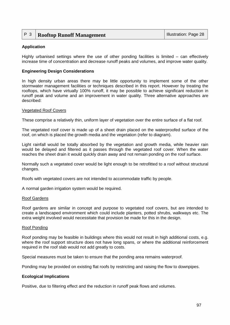
97
P 3 Rooftop Runoff Management Illustration: Page 28
Application
Highly urbanised settings where the use of other ponding facilities is limited – can effectivelyincrease time of concentration and decrease runoff peaks and volumes, and improve water quality.
Engineering Design Considerations
In high density urban areas there may be little opportunity to implement some of the otherstormwater management facilities or techniques described in this report. However by treating therooftops, which have virtually 100% runoff, it may be possible to achieve significant reduction inrunoff peak and volume and an improvement in water quality. Three alternative approaches aredescribed:
Vegetated Roof Covers
These comprise a relatively thin, uniform layer of vegetation over the entire surface of a flat roof.
The vegetated roof cover is made up of a sheet drain placed on the waterproofed surface of theroof, on which is placed the growth media and the vegetation (refer to diagram).
Light rainfall would be totally absorbed by the vegetation and growth media, while heavier rainwould be delayed and filtered as it passes through the vegetated roof cover. When the waterreaches the sheet drain it would quickly drain away and not remain ponding on the roof surface.
Normally such a vegetated cover would be light enough to be retrofitted to a roof without structuralchanges.
Roofs with vegetated covers are not intended to accommodate traffic by people.
A normal garden irrigation system would be required.
Roof Gardens
Roof gardens are similar in concept and purpose to vegetated roof covers, but are intended tocreate a landscaped environment which could include planters, potted shrubs, walkways etc. Theextra weight involved would necessitate that provision be made for this in the design.
Roof Ponding
Roof ponding may be feasible in buildings where this would not result in high additional costs, e.g.where the roof support structure does not have long spans, or where the additional reinforcementrequired in the roof slab would not add greatly to costs.
Special measures must be taken to ensure that the ponding area remains waterproof.
Ponding may be provided on existing flat roofs by restricting and raising the flow to downpipes.
Ecological Implications
Positive, due to filtering effect and the reduction in runoff peak flows and volumes.
98
Effectiveness
These practices could be highly effective in achieving the objectives of reduction of rate andvolume of discharge and improving water quality, depending on how widely they are implemented.
Health and Safety Implications
N/A
Aesthetic or Social Implications or Additional Functions
Very positive implications in a high density urban environment. Vegetated roof covers may beattractive if well maintained and roof gardens provide entertainment/recreational areas.
Construction Implications
Roofs that are retrofitted with rooftop gardens or ponds may require modification/strengthening.
Maintenance Implications
Vegetated roof covers/gardens: Relatively low maintenance if hardy indigenous plants areselected; will require periodic irrigation, fertilisation and weeding.
Vegetated roof covers protect roofs from UV rays and wide variations in temperature and couldthereby prolong the life of the roof.
Ponding: Regular inspection required.
Additional Resources
New Jersey Departments of Environmental Protectionhttp://www.state.nj.us/dep/watershedmgt/bmpmanual.htm

99
Infiltration
I 1 French Drain Illustration: Page 29
Application
Provides infiltration at localised scale, typically around individual buildings, and reduces floodvolume and rate of runoff; to a lesser extent – some water quality improvement is usuallyassociated with infiltration.
Engineering Design Considerations
"French Drain" is a term used as a synonym for a subsurface drain. A subsurface drain is gravelfilled trench with a perforated pipe installed in the bottom. (A true French Drain is the same gravelfilled trench, but without the perforated pipe installed in the trench bottom.)
A geotechnical investigation is required to determine relative soil characteristics such as porosity,heave potential and tendency to collapse. It should be established that the level of the winter (rainyseason) water table is low enough to permit infiltration, as this will not occur if the surroundingground is saturated.
A subsurface drain is usually placed at the same elevation as the bottom of the item to beprotected. For example, if we are to intercept and divert water away from a basement, theperforated pipe should be placed no higher than the top of the basement floor. Ideally it shall beplaced slightly below the floor to intercept all water and allow for some slope on the pipe.
Ecological Implications
Positive, insofar as it reduces stormwater volume and flow rate and thus reduces effects ondownstream freshwater systems; it may also contribute to groundwater recharge, although in somecases this may be at the expense of natural areas of recharge for other groundwater resources.
May be associated with problems in establishing vegetation cover above the drain area, due toover-drying of surface soil during non-rainfall periods. Drought-tolerant vegetation should be used.
Effectiveness
Effective in handling small flows where soil conditions are favourable.
Health and Safety Implications
If the French drain is used to discharge poor quality stormwater to the groundwater then care mustbe taken that pollution of the groundwater will not occur, particularly if it is a potable water source.
Aesthetic or Social Implications or Additional Functions
Groundwater replenished.
Construction Implications
See general notes. Guard against ingress of sediment.
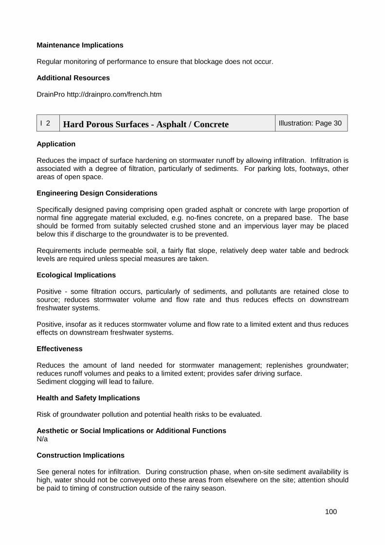
100
Maintenance Implications
Regular monitoring of performance to ensure that blockage does not occur.
Additional Resources
DrainPro http://drainpro.com/french.htm
I 2 Hard Porous Surfaces - Asphalt / Concrete Illustration: Page 30
Application
Reduces the impact of surface hardening on stormwater runoff by allowing infiltration. Infiltration isassociated with a degree of filtration, particularly of sediments. For parking lots, footways, otherareas of open space.
Engineering Design Considerations
Specifically designed paving comprising open graded asphalt or concrete with large proportion ofnormal fine aggregate material excluded, e.g. no-fines concrete, on a prepared base. The baseshould be formed from suitably selected crushed stone and an impervious layer may be placedbelow this if discharge to the groundwater is to be prevented.
Requirements include permeable soil, a fairly flat slope, relatively deep water table and bedrocklevels are required unless special measures are taken.
Ecological Implications
Positive - some filtration occurs, particularly of sediments, and pollutants are retained close tosource; reduces stormwater volume and flow rate and thus reduces effects on downstreamfreshwater systems.
Positive, insofar as it reduces stormwater volume and flow rate to a limited extent and thus reduceseffects on downstream freshwater systems.
Effectiveness
Reduces the amount of land needed for stormwater management; replenishes groundwater;reduces runoff volumes and peaks to a limited extent; provides safer driving surface.Sediment clogging will lead to failure.
Health and Safety Implications
Risk of groundwater pollution and potential health risks to be evaluated.
Aesthetic or Social Implications or Additional FunctionsN/a
Construction Implications
See general notes for infiltration. During construction phase, when on-site sediment availability ishigh, water should not be conveyed onto these areas from elsewhere on the site; attention shouldbe paid to timing of construction outside of the rainy season.
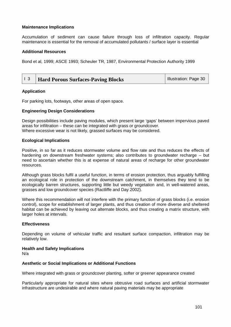
101
Maintenance Implications
Accumulation of sediment can cause failure through loss of infiltration capacity. Regularmaintenance is essential for the removal of accumulated pollutants / surface layer is essential
Additional Resources
Bond et al, 1999; ASCE 1993; Scheuler TR, 1987, Environmental Protection Authority 1999
I 3 Hard Porous Surfaces-Paving Blocks Illustration: Page 30
Application
For parking lots, footways, other areas of open space.
Engineering Design Considerations
Design possibilities include paving modules, which present large ‘gaps’ between impervious pavedareas for infiltration – these can be integrated with grass or groundcover.Where excessive wear is not likely, grassed surfaces may be considered.
Ecological Implications
Positive, in so far as it reduces stormwater volume and flow rate and thus reduces the effects ofhardening on downstream freshwater systems; also contributes to groundwater recharge – butneed to ascertain whether this is at expense of natural areas of recharge for other groundwaterresources.
Although grass blocks fulfil a useful function, in terms of erosion protection, thus arguably fulfillingan ecological role in protection of the downstream catchment, in themselves they tend to beecologically barren structures, supporting little but weedy vegetation and, in well-watered areas,grasses and low groundcover species (Ractliffe and Day 2002).
Where this recommendation will not interfere with the primary function of grass blocks (i.e. erosioncontrol), scope for establishment of larger plants, and thus creation of more diverse and shelteredhabitat can be achieved by leaving out alternate blocks, and thus creating a matrix structure, withlarger holes at intervals.
Effectiveness
Depending on volume of vehicular traffic and resultant surface compaction, infiltration may berelatively low.
Health and Safety ImplicationsN/a
Aesthetic or Social Implications or Additional Functions
Where integrated with grass or groundcover planting, softer or greener appearance created
Particularly appropriate for natural sites where obtrusive road surfaces and artificial stormwaterinfrastructure are undesirable and where natural paving materials may be appropriate
102
Establishment of larger plants in grass block structures improves screening, and allows creation ofa less barren, weedy structure.
Construction Implications
During construction phase, when on-site sediment availability is high, water should not beconveyed onto these areas from elsewhere on the site.
Maintenance Implications
Regular mowing of vegetation and prompt replacement of damaged blocks required. Irrigationoften necessary to maintain grass cover.Irrigation is usually necessary to establish plants and grasses in grass blocks that are abovepermanently wetted or moistened areas.
Additional Resources
Environmental Protection Authority 1999
I 4 Infiltration Trenches Illustration: Page 30
Application
Generally used on relatively small drainage basins (e.g. residential plots; parking areas).
Engineering Design Considerations
This structure comprises a shallow excavated trench, backfilled with coarse stone aggregate, andwhich allows for temporary storage of runoff in the voids between the aggregate. A filter fabricshould enclose the stone. Water percolates from here into the surrounding soil. The design canincorporate a surface that is either covered in gabion, stone or sand, or comprises a grass coveredarea with a surface inlet – in this case, inflow into the trench is only by means of the pipe.
Its use in combination with wide (at least 4m width recommended) vegetated swale strips betweena hardened receiving surface and the trench allows trapping of sediment, and thus contributes toextending the working life of the structure, reducing maintenance requirements and increasingstorage capacity.
Not suitable in areas with high, uncontrolled sediment yields, best suited for urban areas.
Ecological Implications
Ecological implications of the structure are positive, in so far as it reduces stormwater volume andflow rate and thus reduces effects on downstream freshwater systems; this option does nothowever contribute to wetland/ riverine habitat creation or rehabilitation (compare to retentionponds and “natural” vegetated conveyance channels.
May improve stormwater quality through provision of temporary storage of typically highly pollutedrunoff associated with the first storms of the rainy season.
103
Effectiveness
Effective as long as permeability is retained. Should be protected from siltation by surroundinggrassed areas, which are well maintained.
Health and Safety Implications
If the infiltration trench is used to discharge poor quality stormwater to the groundwater then caremust be taken that pollution of the groundwater will not occur, particularly if it is a potable watersource.
Aesthetic or Social Implications or Additional Functions
Location of infiltration trenches close to built structures might result in seepage into foundationareas.
Construction Implications
The area should be well marked during surveying and protected during construction. Heavyequipment, vehicles and sediment-laden runoff should be kept out of infiltration areas to preventcompaction and loss of infiltration capacity.
Maintenance Implications
Sedimentation of the trench will result in gradual loss of function. Installation of observation wellsat intervals along the trench will allow observation of rate of dewatering of the trench after a storm,as well as how rapidly the trench fills up with sediment. This will allow predictions of the frequencyof maintenance activities to be made.
If sedimentation can be prevented maintenance requirements will be relatively low.
Additional Resources
ASCE 1993, Scheuler TR 1987, Environmental Protection Authority 1999, New JerseyDepartments of Environmental Protection 2000
I 5 Infiltration Basins Illustration: Page 31
Application
Temporarily stores surface runoff for a selected design storm; maintains or increases groundwaterrecharge by infiltration through the bed and sides of the basin.
Engineering Design Considerations
The underground basins temporarily store runoff and slowly release it. Infiltration basins may beeither on-line or off-line with respect to the natural drainage route. Off-line basins are moreeffective both in attenuating the peak flow but also in capturing, detaining and treating the mostpolluted first flush of runoff.
These basins may be incorporated into landscaped areas, or islands in parking areas. Long-narrow (length: width ration =2:1 – 3:1), shallow structures are most effective; structures with

104
sections for sedimentation, or which allow for sedimentation prior to entry into the basin, havelonger working lives.
Energy dissipators are required at inlets, to increase sedimentation and decrease resuspension ofsediment in the basin itself.
Ecological Implications
Positive, in so far as it reduces stormwater volume and flow rate and thus reduces effects ondownstream freshwater systems; also contributes to groundwater recharge – but need to ascertainwhether this is at expense of natural areas of recharge for other groundwater resources; this optiondoes not however contribute to wetland/ riverine habitat creation or rehabilitation (compare toretention ponds and “natural” vegetated conveyance channels.
May improve stormwater quality through provision of temporary storage of typically highly pollutedrunoff associated with the first storms of the rainy season. Not suitable where stormwater likely tobe highly polluted and contamination of sensitive/ important groundwater resources is likely.
Effectiveness
Effective as long as permeability is retained. Should be protected from siltation by surroundinggrassed areas, which are well maintained.
Health and Safety Implications
If the infiltration basin is used to discharge poor quality stormwater to the groundwater then caremust be taken that pollution of the groundwater will not occur, particularly if it is a potable watersource.
Aesthetic or Social Implications or Additional Functions
The visual appeal of the structure can be enhanced by shaping and contouring to reflect thenatural topography – a curvilinear basin edge is preferable to a geometric edge, and may beplanted with appropriate vegetation, capable of withstanding occasional inundation and longperiods of exposure/dry conditions. Establishment of dense vegetation on the base of thestructure will reduce potential for erosion and contribute to maintaining high infiltration rates
Construction Implications
Although use of the basin for infiltration should be deferred until the development area has beenstabilised, the partially excavated basin can be used as a temporary sediment trap / detentionfacility during construction.
Maintenance Implications
Filtration of grease, oil, solid organic material and sediment from stormwater prior to entry into thebasin will reduce clogging and thus extend the working life of the infiltration system and lessenmaintenance requirements.
Maintenance requirements depend on whether the system is vegetated or not; unvegetatedstructures may be tilled and re-excavated; vegetated systems require little maintenance: grassedsurfaces for example grow up through sediment deposits, forming a porous turf and preventing theformation of an impermeable layer.
105
Additional Resources
Environmental Protection Authority 1999, Russell, Z 2000
I 6 Swales Illustration: Page 31
Application
Slow flowing grassed channel, which reduces runoff volumes and peaks and traps pollutants.
Engineering Design Considerations
A swale, or grassed waterway, is a shallow trench which has the following characteristics:
! side slopes 1:3 or flatter; the cross-section should normally be trapezoidal with as wide a baseas possible, so as to maximise contact of the water with the vegetation
! contains areas of standing or flowing water only after rainfall! contains vegetation suitable for soil stabilisation, stormwater treatment and nutrient uptake.
It performs a dual role of conveying stormwater runoff, which is in excess of that flowing in theunderground system, and improving water quality through the uptake of nutrients and the trappingof sediments. It should normally be used in conjunction with an underground stormwater system.
Swales should be designed to achieve shallow depths and slow flow to maximise efficiency. Checkdams will improve efficiency. These may be created at driveway crossings by raising the culverts atthese points.
Ecological Implications
Positive implications – water quality improvements likely through passage of water acrossvegetated area; may function as buffer between stormwater source areas and natural receivingbodies; may also be used to trap sediment upstream of infiltration devices;
Where space is available, the ecological value of swales can be vastly improved if efforts are madeto mimic natural stream channels, for example by varying side slopes and channel shape, so as tocreate a meandering system, with a variety of hydraulic habitats.
Side slopes should vary between 1:4 and 1:7, with the latter effectively forming gently gradedriparian wetlands.
Use of indigenous wetland and riparian vegetation further contributes to habitat quality anddiversity, and allows the swale to function as a habitat corridor, providing shelter and aquatic andriparian habitat through the development, potentially linking upstream and downstream areas. Thelatter would be an important factor in developments that potentially segment drainage corridors.
Attention must be paid to the seasonality of flows in the system – where the catchment area issmall, runoff may be limited to short periods following rainfall events and creation of a ripariancorridor might not be feasible. In such cases, simple grassed swales would be more appropriate.
Stormwater quality would also influence the extent to which a high quality habitat might be created.In the CMA, nutrient-enriched runoff from many developments, coupled with the high availability ofaerially-carried seed, means that many drainage channels are prone to invasion by the bulrush(Typha capensis). While this species is efficient in terms of nutrient absorption and is able to bind

106
many pollutants into its root system, it is also perceived as a pest plant, choking shallow waterwaysand producing many fine seeds that clog curtains and can cause respiratory problems.
Effectiveness
Effective in increasing infiltration, reducing runoff and improving water quality.
Health and Safety Implications
See ecological implicationsRoadside swales keep flow away from street surfaces during rainstorms, reducing the potential forcar hydroplaning.
Aesthetic or Social Implications or Additional Functions
Can be used as softer, more environmental and aesthetic alternative to kerbs.
Provides green linkages through an area, along roads, but less compatible with sidewalk systems,except where space not limited.
Roadside swales become less feasible as the number of driveway and other entrances requiringculverts increases.
Construction Implications
Relatively inexpensive (cheaper than kerbs and drains).
Swale outlets (often into another open channel) must be constructed and stabilised beforeoperation of the swale commences.
Maintenance Implications
Vegetation requires regular maintenance to maintain swale capacity. This may vary from cutting, toburning or dredging, depending on vegetation type and degree to which filtration capacity of soilhas been exceeded; where large amounts of sediment are carried by stormwater and deposited inthe swale. Dredging of sediment may be required, resulting in short-term reduction in filteringcapacity.
Swales subject to damage by off-road parking and precautions should be taken to discourage this.
Additional Resources
Environmental Protection Authority 1999, “Catalog of Stormwater Best Management Practices(Idaho)” www2.state.id.us
I 7 Check Dams Illustration: Page 31
Application
Erosion control/sedimentation in steeply sloping channels
107
Engineering Design Considerations
May be designed to be porous or impervious: Constructed from rock or gabions (pervious) or earthwith core or concrete (impervious).
Serve as dissipaters of flow energy.
Can be used as filters and impoundments that trap sediments
Frequently constructed in series to stabilise riverbed and promote aggradatiion instead of erosion.
Size distribution of inflow sediment required in order to determine dam size.
Ecological Implications
Creation of series of dams can have a major impact on natural stream function. Needs to takeaccount of River Priority Rank of system and its incorporates into natural systems should beundertaken with caution. Effective in artificial conveyance channels.
Effectiveness
Effective in decreasing channel erosion. Associated channel shallowing and sedimentation canresult in creation of more diverse in stream habitat in previously channelised areas. In areas wherenatural situation would have been broad sheet flow wetlands, check dams at expense of recreatingnatural habitat.
Health and Safety Implications
For safety reasons check dams should be constructed with relatively low wall height.Pervious check dams will fill more slowly than impervious dams – this is important where flashfloods may occur.
Aesthetic or Social Implications or Additional Functions
The nature of the channel with the check dams may result in a varied habitat for fauna and floraand if well maintained can form attractive recreational area.
Construction Implications
Construction of check dams from downstream in an upstream direction may help to minimizetransport of sediment downstream.
Maintenance Implications
Ongoing dredging of channels, wetland areas created by sedimentation of channels should nottake place, save in demarcated areas.
If the check dams are to act primarily as a sediment trap, then regular dredging will be required.The frequency is dependant on the basin sizes, the flow regime and the sediment size distributionand loading. If however the check dams are to stabilise against further erosion then relatively littlemaintenance will be required.
Additional Resources
ASCE, (1993); Agostini, (1985)
108
Filtration and Treatment
F 1 Vegetated Filter Strips Illustration: Page 33
Application
Surrounding infiltration structures. Adjacent to all water courses and water bodies. Betweenparking lots and stormwater management structures where drainage is primarily sheet flow.
Engineering Design Considerations
During its passage across the filter strip, water may lose sediment and other pollutants by filtration,infiltration, absorption and gravity sedimentation, associated with reduction in flow velocity.
Vegetation also reduces rate of erosion as a result of rainfall impact.
Where filter strips exposed to concentrated flows (e.g. low points in parking lots) then levelspreaders should be used to establish sheet flow.
Effectiveness in terms of water quality control limited by slope – not effective at slopes > 17% -preferred slope <5%; not considered effective in terms of water quality control where waterdischarged onto the strip from a pipe, rather than as sheet flow.
Positive implications may be enhanced where space is available, through use of indigenous plantspecies to create riparian corridors associated with drainage corridors.
Ecological Implications
Traps sediment, promotes infiltration, some pollutants removed, protects downstreamwetlands/streams from sedimentation.
Effectiveness
Effective in removing pollutants particularly sediment and in prolonging the effectiveness ofstormwater management devices such as infiltration trenches and basins and porous paving.
Health and Safety Implications
Positive in both respects
Aesthetic or Social Implications or Additional Functions
Vegetated areas may serve an important stormwater management function if correctly locatedw.r.t. receiving bodies.
Construction Implications
Area must be stabilised and vegetated before being exposed to stormwater flows; irrigation willprobably be necessary.
Maintenance Implications
109
Provision should be made for mowing of grassed areas. The presence of alien annual grassesshould be kept to a minimum.
Additional Resources
Scheuler TR, (1987); ASCE, (1993)
F 2 Natural And Artificial Wetlands Illustration: Page 33
Application
Effective pollution filter through absorptive and assimilative capacities of wetland plants and theirsoils. Sedimentation through filtration by plants and spreading out of flows. Retention of water inthe wetland reduces stormwater volumes.
Engineering Design Considerations
An artificial wetland should be designed according to specifications of a freshwater ecologist.
Artificial wetlands may be established around the perimeter of a wet pond, the lower stage of a“dry” pond, or off-channel. The wetland must then be suitably landscaped and planted.
Ecological Implications
Positive implications, in that water purification should occur. The degree of water purification willdepend on wetland design – e.g. shallow systems, with high length: width ratios will be efficient atfiltration; retention time should be maximised, to allow uptake of pollutants, and expose pathogens(e.g. Escherichia coli bacteria) to sunlight, which destroys them.
The type of plants established in the system will also affect the function of the wetland as afiltration device. However, in ecological terms, a compromise can often be considered betweendesign of a wetland exclusively for use in water purification, and incorporation of other ecologicalfunctions, such as provision of diverse wetland habitat. Where this is seen as an additionalobjective, choice of wetland plants might focus more on establishment of a diverse range ofspecies, with different size structures and densities, to maximise diversity within the wetland.
Attention should also be paid to the creation of areas of seasonal wetlands – a threatened wetlandtype in the CMA. Islands and sandbars, while reducing storage capacity of the wetland, providesheltered roosting, nesting and feeding areas for wetland birds and other animals. Side slopesshould be varied, and range between 1:4 and 1:7 – again, to maximise habitat diversity and mirrornatural systems. A wetland ecologist should participate in the landscaping phase of projectconstruction, to ensure that habitat diversity is optimised.
The use of natural wetlands for the discharge of stormwater should not be at the expense ofnatural habitat diversity or biodiversity. Many wetlands support sensitive plants and animals, whichare lost once the system is impacted. Impacts resulting from stormwater inflows are as likely torevolve around changes in flow regime (e.g. seasonal wetlands becoming perennial) as in waterquality (e.g. many fynbos wetlands are naturally low in nutrients with a high pH; additions ofnutrient-enriched water, of lower pH, and potentially bearing other toxins, could have devastatingimpacts on the natural wetland flora and fauna.
As a general rule, locally indigenous plants should be utilised and the use of invasive alien plantsshould be strictly discouraged, even in artificial wetlands, as the likelihood of contamination ofother water bodies from these source areas are great. Anticipated stormwater quality would also
110
influence the extent to which a high quality habitat might be created – stormwater with high levelsof toxins such as heavy metals may create a system in which levels of these toxins are too high forsurvival of any but the most pollution-tolerant species; by contrast, in the CMA, nutrient-enrichedrunoff from many developments, coupled with the high availability of aerially-carried seed, meansthat many drainage channels are prone to invasion by the bulrush (Typha capensis). While thisspecies is efficient in terms of nutrient absorption and is able to bind many pollutants into its rootsystem, it is also perceived as a pest plant, choking shallow waterways and producing many fineseeds that clog curtains and can cause respiratory problems. Creation of deeper areas of standingwater (ca 1.5m depth) is recommended as a way of reducing invasion by T. capensis (Hall 1993).
Effectiveness
Highly effective in improving water quality – refer to Ecological implications. Depending on storagecapacity, runoff volumes and peaks may also be significantly reduced.
Health and Safety Implications
Positive in that water quality purification will occur, lessening health risks in downstream receivingwater bodies (e.g. as a result of toxic algal blooms thriving in nutrient-enriched open water bodies)
Wetlands, particularly if they incorporate areas of deep standing water may be perceived as safetyrisks – these risks may be reduced by education and sign boarding of potentially dangerous areas;ensuring that slopes out of wetlands are gentle, to facilitate exit;
Aesthetic or Social Implications or Additional Functions
Multiple-function wetlands may also provide valuable recreational amenities – e.g. picnic or birdwatching sites; water sport facilities (where water quality and water depth permit). However, anybody of water, even relatively shallow systems, can constitute a safety hazard to small children.Play areas should not therefore be located in the vicinity of such wetlands.
Litter is often associated with stormwater, and tends to accumulate on wetland plants, creating ahighly visible, unsightly structure. Installation and maintenance of a litter trap upstream of thewetland, or at the inlet structure, would reduce this problem.
Construction Implications
Provision should be made for the appointment of a freshwater ecologist to the site duringlandscaping, to ensure optimisation of habitat.
Construction should take place during the dry season, and allow for planting of wetlands duringlate autumn, so that they are established before the onset of winter rains; irrigation is usuallynecessary during the first year of establishment.
Maintenance Implications
Maintenance requirements centre on controlling invasive plant species (preferably by manualrather than more destructive mechanical means) and the need for periodic removal of wetlandplants and soil as the absorptive and retentive capacity of the wetland is used up. Note that mostnutrients and other pollutants are bound in sediment and root material, rather than in surface plantmaterial, and although cutting back of plants is likely to promote plant growth, it is not usually aneffective way of increasing the filtration capacity of a wetland.
Sedimentation of a filtration wetland reduces its capacity and in the long-term results in a change instate from wetland towards terrestrial ecosystems. Maintenance requirements in terms of
111
sediment removal might be lessened by passage of stormwater through vegetated swales, orthrough a sediment trap, prior to entry into the wetland area.
Additional Resources
Environmental Protection Authority 1999, “Catalog of Stormwater Best Management Practices(Idaho)” ” http://www2.state.id.us , New Jersey Departments of Environmental Protection 2000
F 3 Litter Traps Illustration: Page 34
Application
Removal of litter and sediment from urban stormwater systems.
Engineering Design Considerations
Litter traps should be strategically selected and located within urban catchments in order toeffective. Normally this basic criterion for the litter trapping system would be established as a partof the overall catchment management plan. A basic best management practice is to trap pollutantsas close to source as possible.
Various trapping devices have been developed and may be categorised as follows (Armitage,1998):
! Low flow, low head structures− Small - side-entry catchpit traps (SECTs)− Medium - In-line Litter Separator (ILLS)− Large - Continuous Deflective Separation (CDS)
! Low flow, high head structures− Medium - North Sydney Litter Control Device (LCD)− Large - Baramy Gross Pollutant Trap (BGPT)
! High flow, low head structures− Small - fences, nets, booms or baffles installed across slow flowing streams or ponds− Large – CDS, Urban Water Environmental Management (UWEM)
! High flow, high head structures− Medium - BGPT− Large – side channel spillway option (SCS)
Trap efficiency is typically 70% and therefore a combination of the trapping points listed aboveshould be implemented.
Care should be taken that flooding of properties will not result if trap becomes overloaded withlitter, i.e. if a trap becomes blocked with litter, the required rate of flow must be able to bypass orovertop without flooding properties.
The use of grids over catchpit inlets is to be encouraged (except in very leafy areas) as it is in linewith the policy of trapping litter as close to its source as possible. The use of these grids alsoplaces a responsibility on the street cleaning services and on residents to regularly clean thesegrids.
112
Ecological Implications
If litter is not efficiently removed by traps then it tends to accumulate on vegetation, e.g. inwetlands where removal is more costly. The removal of litter upstream ponds and wetlands makesthe functioning of these devices more effective.
Effectiveness
The litter traps listed above are all reasonably effective provided that the litter is regularly removed.Different communities tend to generate different types and quantities of litter and specific localconditions should therefore be taken into account.
Health and Safety Implications
Certain litter is hazardous to health if handled and can also result in water pollution. Items such asplastic bags could pose a threat to animals and birds.
In channel litter traps can result in blockages, leading to raised water levels and increasedflooding/drowning hazards.
Aesthetic or Social Implications or Additional Functions
Litter removal improves the aesthetics of an area and can increase a community’s pride in theirtownship. Presence of litter in a multi-functional stormwater management facility such as an openchannel in a green belt would diminish its value as a recreational amenity.
Construction Implications
Construction should take place in the dry season.
Maintenance Implications
Ease and safety of maintenance required.
Effectiveness in trapping debris, particularly that which could cause blockages downstream. Localexperience indicates that grid openings should not be smaller than 70mm in order to prevent gridsfrom clogging up to rapidly.
Additional Resources
Armitage 1998, Environmental Protection Authority 1999
F 4 Sediment Traps Illustration: Page 34
Application
Trapping and removal of sediment from rivers and channels
Engineering Design Considerations
Typically a basin is created along a flow path in which the sediment-laden water is caused to flowat a slow uniformly distributed velocity at a predetermined depth and for a sufficient length of timeto settle out a large proportion of the sediment. Alternative designs, which require relatively lessarea, utilise artificial bends within the basin
113
Typical data requirements needed for design would include the particle size distribution of inflowsediment and the flood hydrograph frequency distribution.
Means of efficient sediment removal and areas for temporary or permanent stockpiling must beprovided.
Ecological Implications
Where space permits, the ecological benefits of sediment traps can be increased, through theprovision of wetland habitat adjacent to the “working” surface of a large sediment trap. This wouldbe achieved by grading of gentle (and varied) slopes, ranging between 1:4 and 1:7; planted withappropriate indigenous wetland and terrestrial vegetation. Islands and sand bars can also becreated within the sediment collection area. These areas should be demarcated (e.g. by bollardsor raised concrete sills, so that dredging machinery does not disturb them.
Growth of wetland plants on accumulated sediment within the “working” area of the sediment trapwill add a filtration / water purification function to the structure.
Effectiveness
Effective if designed according to accurate and appropriate data.
Health and Safety Implications
Flat side slopes (1:7 to 1:4) and protected outlet to guard against danger of drowning.
Aesthetic or Social Implications or Additional Functions
Frequent maintenance of sediment traps may result in unsightly, disturbed and largely barestructures.
Litter is often associated with stormwater, and tends to accumulate on wetland plants, creating ahighly visible, unsightly structure. Installation and maintenance of a litter trap upstream of thesediment trap would reduce this problem.
Construction Implications
As construction may take place within a river, special precautions to prevent the discharge oferoded material downstream.
Maintenance Implications
Regular maintenance required, removing accumulated sediment and maintaining capacity.Maintenance is usually destructive and results in a temporarily unsightly structure.
Additional Resources
ASCE 1993, Environmental Protection Authority 1999

114
F 5 Oil Separator Illustration: Page 34
Application
Treatment of stormwater runoff polluted with oil
Engineering Design Considerations
Anticipated maximum flows should be determined and the unit sized accordingly.Provision should be made for an adequately sized sump to which the oil drains prior to removal.
A high proportion of the oil in runoff may be removed provided the unit is regularly maintained andthat the flow remains below the maximum flow capacity.
Ecological Implications
It is vital to remove oil and grease at source; facilities which generate polluted runoff should becompelled to treat it prior to discharge to the stormwater system.
Health And Safety Implications
The removal of oil polluting runoff is has positive health implications for humans as well as faunaand flora. Prevention of pollution is far better than having to clean it up at a later stage.
Maintenance Implications
Regular removal of oil from sump and periodic checking that the mechanism is functioningcorrectly.

115
Annexure G - Planting Schedules
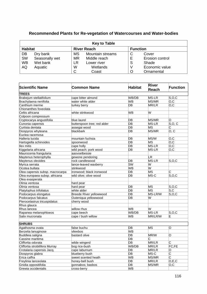
116
Recommended Plants for Re-vegetation of Watercourses and Water-bodies
Key to TableHabitat River Reach FunctionDB Dry bankSW Seasonally wetWB Wet bankAQ Aquatic
MS Mountain streamsMR Middle reachLR Lower riverW WetlandsC Coast
C CoverE Erosion controlS ShadeV Economic valueO Ornamental
Scientific Name Common Name Habitat RiverReach Function
TREESBrabejum stellatifolium cape bitter almond WB/DB MS-LR S,O,CBrachylaena neriifolia water white alder WB MS/MR O,CCanthium inerme turkey berry DB MR/LR O,CChionanthes foveolataCeltis africana white stinkwood WB WColpoon compressumCryptocarya angustifolia blue laurel DB MS/MR OCunonia capensis butterspoon tree; red alder DB MS-LR S,O, CCurtisia dentata assegai wood DB MS CDiospyros whyteana blackbark DB MS/MR O, CEuclea racemosaHalleria lucida mountain fuchsia DB MS/W O,CHartogiella schinoides spoonwood DB MS O,CIlex mitis cape holly DB MS-LR O,CKiggelaria africana wild peach; pork wood DB MS-LR O,CMaurocenia frangularia aasvoelbessieMaytenus heterophylla gewone pendoring LRMaytenus oleoides rock candlewood DB MS-LR S,O,CMyrica serrata lance-leaved waxberry SW WOcotea bullata stinkwood WB WOlea capensis subsp. macrocarpa ironwood; black ironwood DB MS COlea europaea subsp. africana wild olive; olive wood DB MS-C S,O,COlea exasperataOlinia ventosa hard pearOlinia ventosa hard pear DB MS S,O,CPlatylophus trifoliatus white alder DB MS S,CPodocarpus elongatus Breede River yellowwood DB MS-LR/W S,O,CPodocarpus falcatus Outeniqua yellowwood DB WPterocelasirus tricuspidatus cherry woodRhus glaucaRhus lancea willow rhus WB WRapanea melanophloeos cape beech WB/DB MS-LR S,O,CSalix mucronata cape / bush willow WB MR/LR/W E
SHRUBSAgathosma ovata false buchu DB MS OBerzelia lanuginose vlieebos WBBuddleia saligna bastard olive DB MR/W OCassine maritima DB CCliffortia odorata wilde wingerd DB MR/LR CCliffortia strobilifera Murray bog rice-bush WB/DB MR/LR FC,FECrotalaria capensis Jacq. cape laburnum DB MR/LR ODiospyros glabra blueberry bush DB MS-C CErica caffra sweet scented heath WB MS/MR CFreylinia lanceolata honey-bell bush DB MR/LR O,E,CGnidia oppositifolia gonnabos; basbos DB MS/MR O,CGrewia occidentalis cross-berry WB
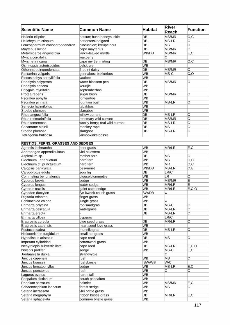
117
Scientific Name Common Name Habitat RiverReach Function
Halleria elliptica notsun; bush honeysuckle DB MS/MR O,CHelichrysum crispum hottentotskooigoed DB MS-LR CLeucospermum conocarpodendron pincushion; kreupelhout DB MS OMaytenus lucida. cape maytenus DB MS/MR CMetrosideros angustifolia lance-leaved myrtle WB/DB MS/MR E,CMyrica cordifolia waxberry CMyrsine africana cape myrtle; mirting DB MS/MR O,COsmitopsis asteriscoides belskruie WBOthonna quinquedentata 5-point daisy DB MS/MR CPasserina vulgaris gonnabos; bakkerbos WB MS-C C,OPlecostachys serpyllifolia vaaltee WBPodalyria calyptrata water blossom pea DB MS/MR OPodalyria sericea keurtjie WBPolygala myrtifolia septemberbos WBProtea repens sugar bush DB MS/MR OPsoralea aphylla fonteinbos WBPsoralea pinnata fountain bush WB MS-LR OSenecio halimifolius tabakbos WBStoebe plumose slangbos WBRhus angustifolia willow currant DB MS-LR CRhus rosmarinifolia rosemary wild currant DB MS/MR CRhus tomentosa woolly berry; real wild currant DB MS-LR CSecamone alpinii monkey rope DB MS CStoebe plumosa slangbos DB MS-LR CTetragonia fruticosa klimopkinkelbossie
RESTIOS, FERNS, GRASSES AND SEDGESAgrostis lachnantha bent grass WB MR/LR E,CAndropogon appendiculatus vlei bluestem WBAsplenium sp. mother fern DB MS CBlechnum . attenuatum hard fern WB MS O,CBlechnum cf. punctulatum hard fern WB MR O,CCalopsis paniculata besemriet WB/DB MS-LR O,ECarpobrotus edulis sour fig DB LR/CCommelina benghalensis blouselblommetjie WB LR CCyperus brevis sedge WB MS/MR ECyperus longus water sedge WB MR/LR ECyperus textilis gaint cape sedge WB MR/LR E,C,OCynodon dactylon fyn kweek couch grass SW/DB wDigitaria eriantha finger grass WBEchinochloa colona jungle grass WB wEhrharta calycina rooisaadgras DB MS-C CEhrharta delicatula watergrass DB MS-LR CEhrharta erecta - DB MS-LR CEhrharta villosa pypgras LR/CEragrostis curvula blue seed grass DB MR/LR CEragrostis capensis heart seed love grass WBFestuca scabra munniksgras DB MS-LR CHelictotrichon turgidulum small oat grass WBHypodiscus aristatus cape reed DB MS CImperata cylindrical cottonwool grass WBIschyrolepis subverticillata cape reed DB MS-LR E,C,OIsolepis prolifer sedge WB MS-C E,CJordaaniella dubia strandvygie CJuncus capensis rush WB MS CJuncus kraussii rush/biesie SW/WB W/CJuncus lomatophyllus sedge WB MS-LR E,CJuncus punctorius rush WB C CLagurus ovatus hares tail WBPaspalum distichum couch paspalum WBPrionium serratum palmiet WB MS/MR E,CSchoenoxiphium lanceum forest sedge WB MS CSetaria incrassata vlei brittle grass WBSetaria megaphylla ribbon bristle grass DB MR/LR E,CSetaria sphacelata common bristle grass WB
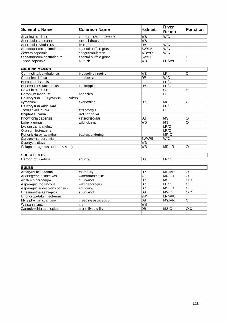
118
Scientific Name Common Name Habitat RiverReach Function
Spartina maritime cord grass/strandkweek WB W/CSporobolus africanus ratstail dropseed WBSporobolus virginicus brakgras DB W/CStenotaphrum secundatum coastal buffalo grass SW/DB W/CZostera capensis seegras/eelgrass WB/AQ W/CStenotaphrum secundatum coastal buffalo grass SW/DB ETypha capensis bulrush WB LR/W/C E
GROUNDCOVERSCommelina benghalensis blouselblommetjie WB LR CChenolea diffusa soutbossie DB W/CErica chamissonis LR/CEriocephalus racemosus kapkoppie DB LR/CGazania maritime C EGeranium incanum horlosies CHelichrysum cymosum subsp.cymosum everlasting DB MS CHelichrysum orbiculare LR/CJordaaniella dubia strandvygie CKniphofia uvaria red hot pokerKnowltonia capensis katjiedrieblaar DB MS OLobelia erinus wild lobelia WB MS OLycium campanulatum LR/COrphium frutescens LR/CPutterlickia pyracantha basterpendoring MR-CSarcocornia perennis SW/WB W/CScuroys bidisys WBSelago sp. (genus under revision) - WB MR/LR O
SUCCULENTSCarpobrotus edulis sour fig DB LR/C
BULBSAmaryllis belladonna march lily DB MS/MR OAponogeton distachyos waterblommetjie AQ MR/LR OAristea macrocarpa suurkanol DB MS O,CAsparagus racemosus wild asparagus DB LR/C CAsparagus suaveolens sensus katdoring DB MS-LR CChasmanthe aethiopica suurkanol DB MS-C O,CChondropetalum tectorum SW LR/W/CMyrsiphyllum scandens creeping asparagus DB MS/MR CWatsonia spp. iris WBZantedeschia aethiopica arum lily; pig lily DB MS-C O,C
119
Annexure H - City of Cape Town Stormwater LandIdentification Database

120
Stormwater Land Identification Database
The Catchment, River and Stormwater Branch has prepared a set of GIS plans covering the entireCMA which identifies all erven impacted by stormwater issues. The aim is to alert planners,developers, development control officers and anyone else involved in land use management to thestormwater implications of erven.
The plans indicate the following stormwater features:
! Known flood prone areas demarcated by a flood line! Flood prone rivers and canals! Existing stormwater detention ponds, vleis and open water bodies! Planned detention ponds
These plans, which are as yet are only available from the Catchment, River and StormwaterBranch, should be referred to prior to any planning so that potential major stormwater drainageproblems can be quickly identified and the consequences for the proposed development canevaluated.

121
Annexure I - Minimum Design Standards for UndergroundStormwater Reticulation and Associated Intakes
122
Pipes
The minimum pipe diameter shall be 300mm for catchpit connections and 375mm for longitudinallines.
Pipes are to be in accordance with SABS (1200) loading criteria, while the minimum class ofstormwater pipe shall be 100D for 300mm pipes.
Cutting of pipes - pipes must be clean cut with any exposed reinforcing adequately treated.
Pipes Joints
Pipes with spigot and socket ( and rubber ring seal) joints must be used, while interlocking (ogee)joints may only be used in public open space. Where interlocking pipes are used the joints must bewrapped with a 400mm width of a suitable non-polyester geotextile with a 300mm overlap securedwith nylon straps.
Where stormwater pipes cross sewers or watermains, the minimum clearance is to be 150mm.
Bedding
Bedding shall be Class B (SABS 1200).
Gradients
Minimum pipe gradients are to ensure a self-cleaning velocity of at least 0,9 m/s. Increasedgradients must be used near the head of the system prior to the development of full flows.
The gradient of catchpit connections should not be less than 1:60.
Where possible design velocities should not exceed 3,5 m/s.
Where pipes of 375mm diameter to 450mm diameter exceed grades of 1:6, they must be anchoredat alternate collars.
Where the pipe diameter exceeds 450mm and the grade exceeds 1:8 anchor blocks must beprovided as above.
Anchor blocks must be 300mm long, protrude 150mm from either side of the socket and mustextend 200mm below the bottom of the socket.
Where pipes enter canals, rivers or ponds the following criteria shall apply:
! The invert level must be above the normal wet season water level.! The soffit must be above water level achieved during minor storms.
Catchpits / Gullies
Catchpit depths should not be less than 750mm and not greater than 1,0m less specialcircumstances exist.
Benching to be in accordance with the standard drawings.
123
Catchpit to catchpit connections are not acceptable.
The distance between catchpits shall not exceed 90,0m unless hydraulic calculations indicate thatan alternative distance should be accommodated.
The percentage flow past a catchpit should not exceed 20% of the total approach channel flow.
The apron slope adjacent to the catchpit should be increased for greater efficiency and theupstream channel kicked where required.
Catchpit grids and frames are to be cast iron but other approved material for grids will beconsidered provided that SABS standard are complied with.
Skew kerb inlets/catchpits are to be used where road gradients exceed 8% (1:12,5).
Catchpit connection lengths may not exceed 15,0m.
Kerb inlet opening to be 100mm in height.
Catchpits may not be positioned on intersection radii as these are prone to damage by heavyvehicles.
Where Watereco grids are considered at planing stage, consideration should be given toincreasing the length of the inlet.
Manholes
Manholes shall be provided at all horizontal and vertical changes in direction.
The distance between manholes shall not exceed 90m.
Manholes must be located in the roadway unless the verge is sufficiently wide to allow for repairsto the stormwater system to be undertaken without interference to cable and /or the kerb andchannel.
SABS Type 2A cast iron covers and frames are to used. Covers of alternative materials may beused in high theft risk areas, providing the loading as specified in SABS 558-1973 can be met.
Only crown to crown pipe connections will be accepted.
Manhole access shafts are to be located in such a manner as to permit the cable for a bucketcleaning machine direct free access to the machine.
Widening must be provided on outside curves (benching) to allow for bucket cleaning.
Junction Boxes/Non Accessible Junctions
Junction boxes/non accessable junctions are not permitted unless the main line is larger than600mm in diameter (man entry).
The end of the connecting pipe must be cut to follow the wall of the larger pipe and the connectionprotrusion must be kept to a minimum.
124
Annexure J - GIS Protocols for Stormwater As-Built Drawingsand Data Capture Projects

125
Required Data Formats
All as-built information must be provided both on paper / film as well as in electronic format inaccordance with the formats specified in the GIS Protocols for Sewer and Stormwater DataCapture and Data Management (City of Cape Town – September 1999) as amended.
Related Documents