Status paper on Asian Highway (Indonesia) 1. Introduction Brief description of the AH network (number of routes, length, if part of any development corridor, traffic growth and similar information of general interest) : Asian highway routes in Indonesia divided into two routes: AH-2 and AH-25. AH-2 laid on northern part of Java Island from Merak-Jakarta-CIkampek- Semarang, then down to middle trunk road of Java and continue to Denpasar trough Surakarta-Surabaya-Banyuwangi (Ketapang). Total length of non toll road is 1,128km, toll road 409 km and ferry connection for 5 miles distance serviced by 15 ro-ro vessel and 3 LCT vessel. AH-25 laid on eastern coast of Sumatera Island from Banda Aceh-Medan-Dumai- Pekanbaru-Jambi-Palembang-Bakauheni with total length of 2,586 km non-toll road, then connected to Java island by ferry as long 15 miles to Merak serviced by 25 ro-ro vessel for 24 hour Condition: In General, Road Condition of AH Route are relatively good. More than 93 % are in stable condition which means there shouldn’t be any obstacle using the road any time, any weather. The driver may run up to 60 km/hr in flat terrain on uncongested traffic. The Fewer bad condition laid on north Sumatera and Pemalang-Tegal, while the other poor laid on Jambi, Southern Sumatera and Cirebon-Brebes. Width of Carriageway: The most advanced route by the capacity point of view is AH Route No.2 that laid from Merak to Semarang which almost all the road already meets 14 m. The Java Island itself, all the road already has minimum width 7 m. In order to meet government policy where the eastern trunk road of Sumatera a should have minimum width 7 m, there are still several homework which scattered along the route, but the most are Riau and Lampung. Government policy on development, operation and maintenance of AH routes: Mid-Term National Development Plan Capacity Expansion of Eastern Trunk Road of Sumatera (where the majority of AH-25 laid on) with minimum width 7 m. Capacity Expansion of North Coast Trunk Road of Java (where AH-2 laid on from Jakarta to Semarang) with minimum width 14 m. Capacity Expansion of Middle Trunk Road of Java (where AH-2 laid on from Surakarta to Surabaya) and continue to Banyuwangi via North Coast Trunk Road with minimum width 7m. Capacity Expansion of Southern Trunk Road of Bali (where AH-2 laid on from Gilimanuk to Denpasar) with minimum width 6 m. New Policies Stipulation of eastern trunk road of Sumatera, some parts of North Coast Trunk road of Java and all parts of Southern Trunk Road of Bali as part of Six Economic Corridor Master plan of Economic Development Acceleration in Indonesia (MP3EI) Strategy The optimization of existing road network and its operation Widening the links to reach the minimum standard Quality improvement of the links to desirable service level The priority will be according to the following order: crossing border, provision of

Welcome message from author
This document is posted to help you gain knowledge. Please leave a comment to let me know what you think about it! Share it to your friends and learn new things together.
Transcript

Status paper on Asian Highway (Indonesia)
1. Introduction
Brief description of the AH network (number of routes, length, if part of any development corridor, traffic growth and similar information of general interest) :
Asian highway routes in Indonesia divided into two routes: AH-2 and AH-25. AH-2 laid on northern part of Java Island from Merak-Jakarta-CIkampek-Semarang, then down to middle trunk road of Java and continue to Denpasar trough Surakarta-Surabaya-Banyuwangi (Ketapang). Total length of non toll road is 1,128km, toll road 409 km and ferry connection for 5 miles distance serviced by 15 ro-ro vessel and 3 LCT vessel. AH-25 laid on eastern coast of Sumatera Island from Banda Aceh-Medan-Dumai-Pekanbaru-Jambi-Palembang-Bakauheni with total length of 2,586 km non-toll road, then connected to Java island by ferry as long 15 miles to Merak serviced by 25 ro-ro vessel for 24 hour
Condition: In General, Road Condition of AH Route are relatively good. More than 93 % are in stable condition which means there shouldn’t be any obstacle using the road any time, any weather. The driver may run up to 60 km/hr in flat terrain on uncongested traffic. The Fewer bad condition laid on north Sumatera and Pemalang-Tegal, while the other poor laid on Jambi, Southern Sumatera and Cirebon-Brebes.
Width of Carriageway: The most advanced route by the capacity point of view is AH Route No.2 that laid from Merak to Semarang which almost all the road already meets 14 m. The Java Island itself, all the road already has minimum width 7 m. In order to meet government policy where the eastern trunk road of Sumatera a should have minimum width 7 m, there are still several homework which scattered along the route, but the most are Riau and Lampung.
Government policy on development, operation and maintenance of AH routes: Mid-Term National Development Plan
Capacity Expansion of Eastern Trunk Road of Sumatera (where the majority of AH-25 laid on) with minimum width 7 m.
Capacity Expansion of North Coast Trunk Road of Java (where AH-2 laid on from Jakarta to Semarang) with minimum width 14 m. Capacity Expansion of Middle Trunk Road of Java (where AH-2 laid on from Surakarta to Surabaya) and continue to Banyuwangi via North Coast Trunk Road with minimum width 7m.
Capacity Expansion of Southern Trunk Road of Bali (where AH-2 laid on from Gilimanuk to Denpasar) with minimum width 6 m.
New Policies Stipulation of eastern trunk road of Sumatera, some parts of North Coast Trunk road of Java and all parts of Southern Trunk Road of Bali as part of Six Economic Corridor
Master plan of Economic Development Acceleration in Indonesia (MP3EI) Strategy
The optimization of existing road network and its operation Widening the links to reach the minimum standard Quality improvement of the links to desirable service level
The priority will be according to the following order: crossing border, provision of
proper road signs and road marking, technical standard adjustment, road safety and the development of missing links.
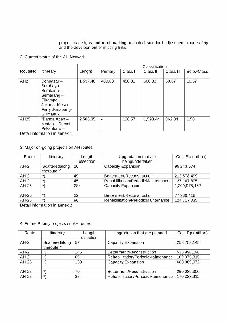
2. Current status of the AH Network
Classification RouteNo.
Itinerary
Lenght Primary Class l Class ll Class lll BelowClass
lll AH2 Denpasar –
Surabaya –Surakarta –Semarang –Cikampek – Jakarta–Merak. Ferry :Ketapang-Gilimanuk
1,537.48 409.00 458.01 600.83 59.07 10.57
AH25 "Banda Aceh –Medan – Dumai –Pekanbaru –
2,586.35 - 128.57 1,593.44 862.84 1.50
Detail information in annex 1
3. Major on-going projects on AH routes
Route Itinerary Length ofsection
Upgradation that are beingundertaken
Cost Rp (million)
AH-2 Scatteredalong theroute *)
10 Capacity Expansion
95,243,674
AH-2 *) 49 Betterment/Reconstruction 212,578,499 AH-2 *) 45 Rehabiliitation/PeriodicMaintenance 127,167,805 AH-25 *) 284 Capacity Expansion
1,209,975,462
AH-25 *) 22 Betterment/Reconstruction 77,980,418 AH-25 *) 96 Rehabiliitation/PeriodicMaintenance 124,717,035 Detail information in annex 2
4. Future Priority projects on AH routes
Route Itinerary Length ofsection
Upgradation that are planned Cost Rp (million)
AH-2 Scatteredalong theroute *)
57 Capacity Expansion
258,753,145
AH-2 *) 145 Betterment/Reconstruction 535,996,196 AH-2 *) 69 Rehabiliitation/PeriodicMaintenance 109,375,315 AH-25 *) 163 Capacity Expansion
683,989,972
AH-25 *) 70 Betterment/Reconstruction 250,089,300 AH-25 *) 85 Rehabiliitation/PeriodicMaintenance 170,388,912
Detail information in annex 3
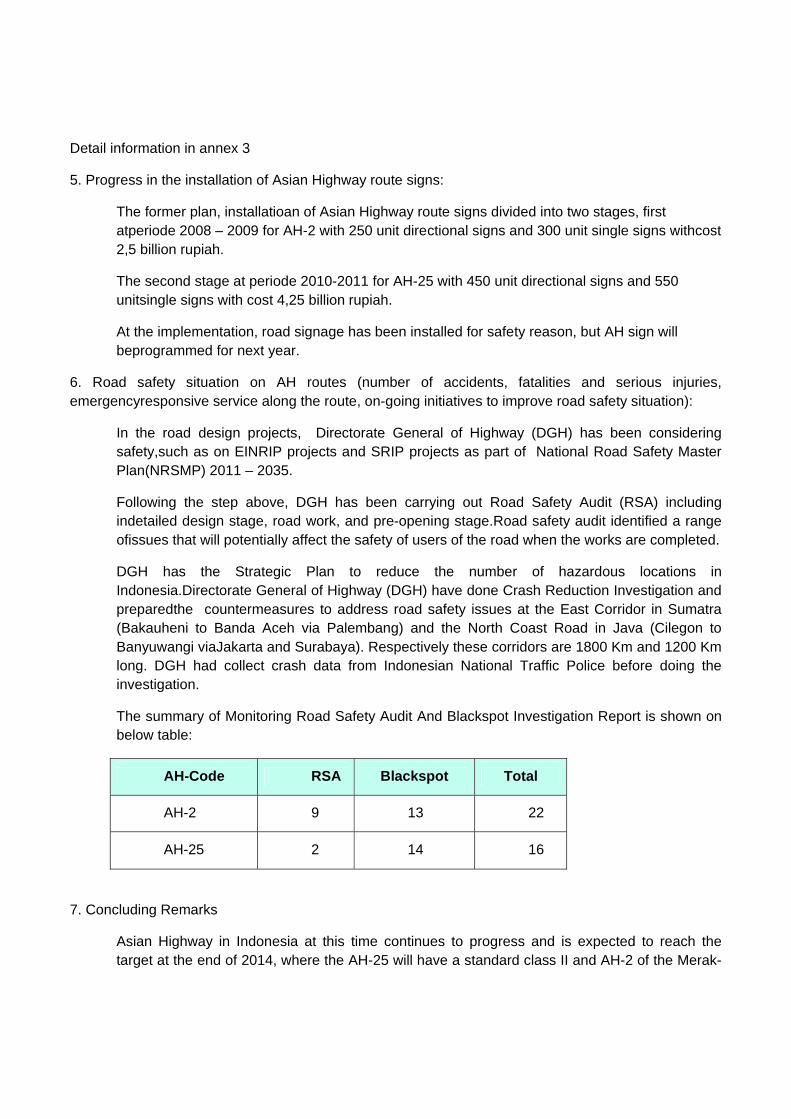
5. Progress in the installation of Asian Highway route signs:
The former plan, installatioan of Asian Highway route signs divided into two stages, first atperiode 2008 – 2009 for AH-2 with 250 unit directional signs and 300 unit single signs withcost 2,5 billion rupiah.
The second stage at periode 2010-2011 for AH-25 with 450 unit directional signs and 550 unitsingle signs with cost 4,25 billion rupiah.
At the implementation, road signage has been installed for safety reason, but AH sign will beprogrammed for next year.
6. Road safety situation on AH routes (number of accidents, fatalities and serious injuries, emergencyresponsive service along the route, on-going initiatives to improve road safety situation):
In the road design projects, Directorate General of Highway (DGH) has been considering safety,such as on EINRIP projects and SRIP projects as part of National Road Safety Master Plan(NRSMP) 2011 – 2035.
Following the step above, DGH has been carrying out Road Safety Audit (RSA) including indetailed design stage, road work, and pre-opening stage.Road safety audit identified a range ofissues that will potentially affect the safety of users of the road when the works are completed.
DGH has the Strategic Plan to reduce the number of hazardous locations in Indonesia.Directorate General of Highway (DGH) have done Crash Reduction Investigation and preparedthe countermeasures to address road safety issues at the East Corridor in Sumatra (Bakauheni to Banda Aceh via Palembang) and the North Coast Road in Java (Cilegon to Banyuwangi viaJakarta and Surabaya). Respectively these corridors are 1800 Km and 1200 Km long. DGH had collect crash data from Indonesian National Traffic Police before doing the investigation.
The summary of Monitoring Road Safety Audit And Blackspot Investigation Report is shown on below table:
AH-Code RSA Blackspot Total
AH-2 9 13 22
AH-25 2 14 16
7. Concluding Remarks
Asian Highway in Indonesia at this time continues to progress and is expected to reach the target at the end of 2014, where the AH-25 will have a standard class II and AH-2 of the Merak-

Cikampek already be Primary class, Cikampek-Semarang as Class I and Semarang-Surabaya-Banyuwangi as Class II and Gilimanuk Denpasar as Class III.
Various development cooperation and the improvement of road infrastructure needs to be done to accelerate the achievement of standards
Asian highway network availability is less meaningful without being followed by various facilitiesin co-operation of traffic and inter-modal transportation.

Annex I
Classification RouteNo. Itinerary Length
Primary Clas I Clas II Clas IIIBelow Clas III
AH2 Tuban (Denpasar Airport) - Denpasar 11.16 - - 7.16 4.00 -
AH2 Denpasar – Tabanan 14.70 - - 10.29 4.41 -AH2 Tabanan – Negara 76.16 - 1.02 46.04 28.10 1.00
AH2 Negara - Gilimanuk (Ferry Terminal) 32.19 - - 32.19 - -
AH2 Gilimanuk (Ferry Terminal) - Banyuwangi(Ferry Terminal) - - - - - -
AH2 Banyuwangi (Ferry Terminal) - Panarukan 95.69 - 2.66 93.03 - -
AH2 Panarukan – Probolinggo 87.29 - 3.40 83.89 - -AH2 Probolinggo – Pasuruan 39.79 - 4.01 35.78 - -AH2 Pasuruan – Gempol 41.55 - 4.20 37.35 - -AH2 Gempol – Waru 25.00 25.00 - - - -AH2 Waru – Mojokerto 25.61 - 10.19 15.42 - -AH2 Waru – Surabaya 17.00 17.00 - - - -AH2 Mojokerto – Jombang 22.50 - 20.70 1.80 - -AH2 Jombang – Nganjuk 38.73 - 3.79 34.94 - -AH2 Nganjuk – Ngawi 64.12 - 3.83 60.29 - -AH2 Ngawi – Sragen 47.18 - 1.20 45.98 - -AH2 Sragen – Surakarta 34.14 - 13.05 11.52 - 9.57AH2 Surakarta – Kartasura 20.42 - 8.93 11.49 - -AH2 Kartasura – Boyolali 15.39 - 1.24 14.15 - -AH2 Boyolali – Salatiga 27.91 - 0.99 15.59 11.32 -AH2 Salatiga - Semarang (Srondol) 42.71 - 13.40 29.31 - -
AH2 Semarang (Srondol) - Semarang (Krapyak) 15.00 15.00 - - - -
AH2 Semarang (Krapyak) - Kendal 29.06 - 29.06 - - -AH2 Kendal – Batang 67.39 - 67.39 - - -AH2 Batang – Pekalongan 7.89 - 7.89 - - -AH2 Pekalongan – Pemalang 33.16 - 33.16 - - -AH2 Pemalang – Tegal 30.80 - 30.80 - - -AH2 Tegal – Brebes 15.15 - 15.15 - - -AH2 Brebes - Cirebon (Kanci) 59.18 - 59.18 - - -AH2 Cirebon (Kanci) - Palimanan 29.00 29.00 - - - -AH2 Palimanan – Lohbener 37.00 - 26.08 3.02 7.91 -AH2 Lohbener – Pamanukan 54.11 - 54.11 - - -AH2 Pamanukan – Cikampek 49.04 - 41.59 7.45 - -AH2 Cikampek – Padalarang 58.00 58.00 - - - -AH2 Padalarang – Bandung 43.00 43.00 - - - -

AH2 Cikampek - Cibitung 48.00 48.00 - - - -AH2 Cibitung - Bekasi 5.00 5.00 - - - -AH2 Bekasi - Cawang 19.00 19.00 - - - -
AH2 Cawang - Jakarta (Tanjung Priok Sea Port) 16.00 16.00 - - - -
AH2 Jakarta (Tanjung Priok Sea Port) - Tomang 19.00 19.00 - - - -
AH2 Cawang - Tomang 16.00 16.00 - - - -AH2 Tomang - Tangerang Barat 27.00 27.00 - - - -
AH2 Tangerang Barat - Tanjung Gerem 72.00 72.00 - - - -
AH2 Tanjung Gerem - Merak (Ferry Terminal) 8.50 - 1.00 4.16 3.34 -
Classification RouteNo. Itinerary Length
Primary Clas I Clas II Clas IIIBelow Clas III
AH25 Banda Aceh - Sigli 108.92 - 6.11 85.38 17.44 -AH25 Sigli - Beureunun 12.10 - - 2.74 9.36 -AH25 Beureunun - Bireuen 94.74 - - 36.40 58.35 -AH25 Bireuen - Lhok Sumawe 55.03 - 2.03 25.67 27.34 -
AH25 Lhok Sumawe - Peureulak (km392) - -
119.45 1.33 91.77 26.35 AH25 Peureulak (km392) - Langsa 54.24 - 5.22 44.34 4.68 -AH25 Langsa - Sp. Pangkalan Susu 79.35 - 2.50 28.76 48.09 -
AH25 Sp. Pangkalan Susu - Tanjungpura 30.12 - - 30.12 - -
AH25 Tanjungpura - Binjai 35.14 - 1.00 34.14 - -AH25 Binjai - Medan 17.09 - 14.51 2.58 - -AH25 Medan - Lubuk Pakam 23.08 - 23.08 - - -AH25 Lubuk Pakam - Tebing Tinggi 59.23 - 15.58 43.65 - -AH25 Tebing Tinggi - Indrapura 31.92 - 3.04 24.46 4.43 -AH25 Indrapura - Kisaran 53.07 - 1.02 19.24 32.81 -AH25 Kisaran - Sp. Kawat 15.60 - - 1.96 13.64 -AH25 Sp. Kawat - Rantau Prapat 122.07 - 2.53 109.30 9.45 0.80
AH25 Rantau Prapat - Sp. Kota Pinang 55.65 - - 38.45 17.20 -
AH25 Sp. Kota Pinang - Sp. Balam 105.28 - - 63.71 41.58 -AH25 Sp. Balam - Dumai 89.63 - - 5.54 84.09 -AH25 Dumai - Duri 76.03 - 2.79 40.70 32.54 -

AH25 Duri - Kandis 59.06 - - 11.94 47.12 -AH25 Kandis - Pakanbaru 77.97 - - 20.53 57.44 -AH25 Pakanbaru - Sp. Lago 61.01 - - 47.39 13.62 -AH25 Sp. Lago - Sp. Japura 113.14 - 1.85 38.06 73.23 -AH25 Sp. Japura - Pematang Reba 16.81 - - 4.00 12.81 -AH25 Pematang Reba - Siberida 51.13 - - 16.44 33.99 0.70AH25 Siberida - Merlung 109.53 - - 48.42 61.11 -AH25 Merlung - Sp. Tuan 70.89 - - 70.89 - -AH25 Sp. Tuan - Jambi 28.36 - 3.04 25.32 - -AH25 Jambi - Tempino 61.55 - 0.87 24.74 35.94 -AH25 Tempino - Betung 182.50 - - 182.50 - -AH25 Betung - Palembang 69.77 - 13.60 56.17 - -AH25 Palembang - Sp. Indralaya 22.10 - 5.83 16.26 - -AH25 Sp. Indralaya - Kayu Agung - - -
35.34 15.15 20.19 AH25 Kayu Agung - Bujung Tenuk 188.85 - - 157.57 31.28 -
AH25 Bujung Tenuk - Terbanggi Besar 48.08 - - - 48.08 -
AH25 Terbanggi Besar - Tegineneng 36.87 - - 36.87 - -
AH25 Tegineneng - Sp. Tanjungkarang 20.64 - 20.64 - - -
AH25 Sp. Tanjungkarang - Sp. Tiga 23.22 - - 23.22 - -AH25 Sp. Tiga - Sp. Kalianda 44.42 - 2.00 41.72 0.70 -
AH25 Sp. Kalianda - Bakauheni (Ferry Terminal) 27.38 - - 27.38 - -
AH25 Bakauheni (Ferry Terminal) - Merak (FerryTerminal) - - - - - -

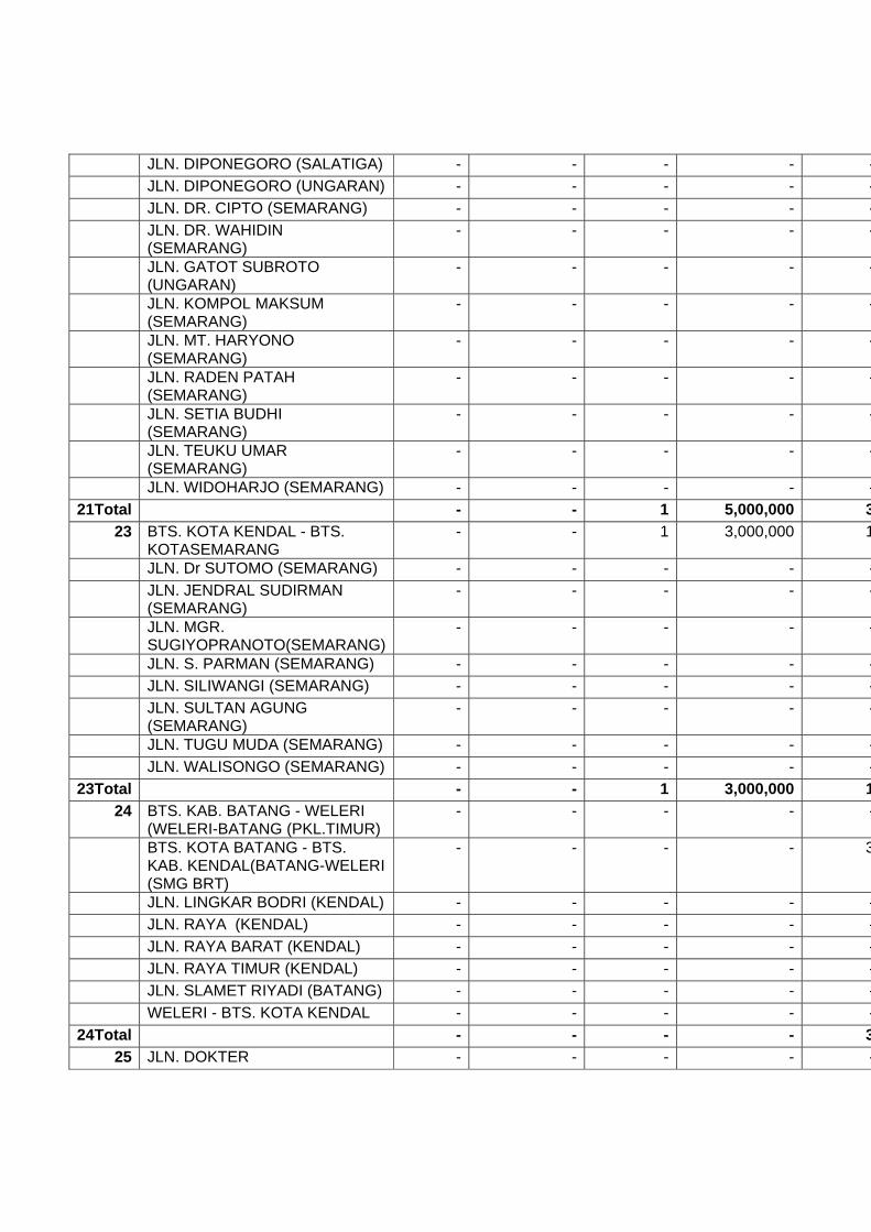
Annex II
Capacity Expansion Betterment/Reconstruction RehabillAH-Code/
AH-No. Itinireary
Vol(Km) Cost (mil. Rp) Vol(Km) Cost (mil. Rp) Vol(Km)
AH-2 10 95,243,674 49 212,578,499 451 DENPASAR - TUBAN - - - - 4 JLN. THAMRIN (DPS) - - - - -
1Total - - - - 42 BTS. KOTA TABANAN -
MENGWITANI - - - - -
JLN. A. YANI (TABANAN) - - - - - JLN. COKROAMINOTO (DPS) - - - - - MENGWITANI - BTS. KOTA
DENPASAR - - - - 6
BTS. KOTA NEGARA - PEKUTATAN
- - - - -
JLN. SUDIRMAN, GAJAHMADA(NEGARA)
- - - - -
PEKUTATAN - ANTOSARI - - - - 4 SIMP. KEDIRI - PESIAPAN
(TABANAN) - - - - -
3Total - - - - 74 CEKIK - BTS. KOTA NEGARA - - - - 3 GILIMANUK - CEKIK - - - - - JLN. A. YANI - JLN.
UDAYANA(NEGARA) - - - - -
4Total - - - - 36 BAJULMATI (BTS.KAB.
SITUBONDO) -KETAPANG - - - - -
BTS. KOTA SITUBONDO - BAJULMATI(BTS. KAB. BANYUWANGI)
- 4,190,000 - - -
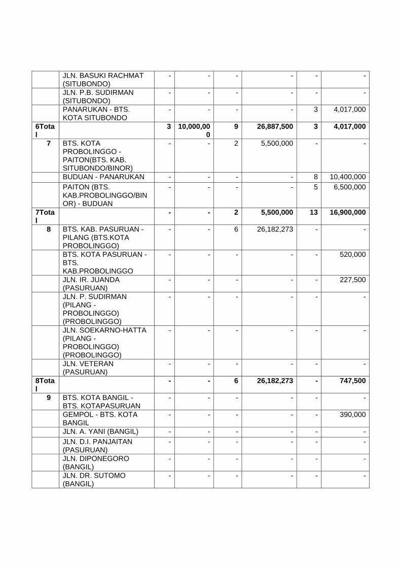
JLN. A. YANI (SITUBONDO) - - - - - JLN. BASUKI RACHMAT
(SITUBONDO) - - - - -
JLN. P.B. SUDIRMAN (SITUBONDO)
- - - - -
PANARUKAN - BTS. KOTA
SITUBONDO - - - - -
6Total - 4,190,000 - - -7 BTS. KOTA PROBOLINGGO -
PAITON(BTS. KAB. SITUBONDO/BINOR)
- - - - -

BUDUAN - PANARUKAN - - - - - PAITON (BTS.
KAB.PROBOLINGGO/BINOR) - BUDUAN
- - - - -
7Total - - - - -8 BTS. KAB. PASURUAN - PILANG
(BTS.KOTA PROBOLINGGO) - - 12 50,178,535 -
BTS. KOTA PASURUAN - BTS. KAB.PROBOLINGGO
- 8,860,000 - - -
JLN. IR. JUANDA (PASURUAN) - - - - - JLN. P. SUDIRMAN (PILANG -
PROBOLINGGO) (PROBOLINGGO)
- - - - -
JLN. SOEKARNO-HATTA (PILANG -PROBOLINGGO) (PROBOLINGGO)
- - - - -
JLN. VETERAN (PASURUAN) - - - - -8Total - 8,860,000 12 50,178,535 -
9 BTS. KOTA BANGIL - BTS. KOTAPASURUAN
- - - - 4
GEMPOL - BTS. KOTA BANGIL 2 6,000,000 - - - JLN. A. YANI (BANGIL) - - - - - JLN. D.I. PANJAITAN
(PASURUAN) - - - - -
JLN. DIPONEGORO (BANGIL) - - - - - JLN. DR. SUTOMO (BANGIL) - - - - - JLN. GAJAH MADA (BANGIL) - - - - - JLN. JAKSA AGUNG
SUPRAPTO(BANGIL) - - - - -
JLN. KARTINI (BANGIL) - - - - - JLN. PATTIMURA (BANGIL) - - - - - JLN. SOEKARNO-HATTA
(PASURUAN) - - - - -
JLN. UNTUNG SUROPATI (BANGIL)
- - - - -
JLN. UNTUNG SUROPATI (PASURUAN)
- - - - -
JLN. URIP SUMOHARJO (PASURUAN)
- - - - -9Total 2 6,000,000 - - 4
11 KRIAN - TAMAN (BY PASS KRIAN -TAMAN)
- - - - -
MLIRIP - KRIAN (MLIRIP - BY PASSKRIAN)
- - - - 7

TAMAN - WARU - - - - -11Total - - - - 7
13 BTS. KAB. JOMBANG - GEMEKAN
- - - - -
BTS. KOTA JOMBANG - BTS. KAB.MOJOKERTO
- - - - -
GEMEKAN - JAMPIROGO (MOJOKERTO)
- - - - -
JLN. SOEKARNO-HATTA (JOMBANG)
- - - - -
13Total - - - - -14 BTS. KAB. KEDIRI - BTS.
KOTAJOMBANG - - - - -
BTS. KOTA NGANJUK - KERTOSONO
- - - - -
JLN. P. SUDIRMAN (JOMBANG) - - - - - JLN. PANGLIMA SUDIRMAN
(NGANJUK) - - - - -
JLN. YOS SUDARSO (JOMBANG)
- - - - -
KERTOSONO - BTS. KAB. JOMBANG
- - - - -
14Total - - - - -15 BTS. KAB. MADIUN - BTS.
KOTANGANJUK - - - - -
BTS. KAB. NGAWI - BTS. KOTACARUBAN
- - - - -
BTS. KOTA CARUBAN - BTS. KAB.NGANJUK
1 4,000,000 - - 6
BTS. KOTA NGAWI - BTS. KAB. MADIUN
- - - 2
JLN. A. YANI (CARUBAN) - - - - - JLN. BASUKI RAKHMAT
(NGAWI) - - - - -
JLN. GATOT SUBROTO (NGANJUK)
- - - - -
JLN. PANGLIMA SUDIRMAN (CARUBAN)
- - - - -
JLN. SUKOWATI (NGAWI) - - - - -15Total 1 4,000,000 - - 8
16 BTS. KOTA SRAGEN - MANTINGAN (BTS.PROV. JATIM)
- - - - -
JLN. GUBERNUR SURYO (NGAWI)
- - - - -
JLN. P.B. SUDIRMAN (NGAWI) - - - - - MANTINGAN (BTS. PROV.
JATENG) -BTS. KOTA NGAWI - - - - -

16Total - - - - -17 BTS. KOTA SURAKARTA -
PALUR - - - - -
JLN. KALIBARU / JLN. SUTARTO(SURAKARTA)
- - - - -
JLN. LINGKAR UTARA BARAT (SRAGEN)
- - - - -
JLN. LINGKAR UTARA TIMUR (SRAGEN)
- - - - -
JLN. S. PARMAN (SRAGEN) - - - - - JLN. SUTAMI (SURAKARTA) - - - - - PALUR - BTS. KOTA SRAGEN - - - - -
17Total - - - - -18 BTS. KOTA KARTOSURO - BTS.
KOTASURAKARTA - - - - -
JLN. A YANI (SURAKARTA) - - - - - JLN. ADI SUCIPTO
(SURAKARTA) - - - - -
JLN. SLAMET RIYADI (SURAKARTA)
- - - - -
JLN. TENTARA PELAJAR (SURAKARTA)
- - - - -
18Total - - - - -19 BTS. KOTA BOYOLALI - BTS.
KOTAKARTOSURO 6 51,023,674 - - -
JLN. PANDANARAN (BOYOLALI) - - - - -19Total 6 51,023,674 - - -
20 BTS. KOTA SALATIGA - BTS. SEMARANGBRT/SKA BRT (SALATIGA - BOYOLALI(SMG BRT)
2 4,200,000 - - -
BTS. SEMARANG BRT/SKA BRT - BTS.
KOTA BOYOLALI (BOYOLALI - SALATIGA(SKA BRT)
- - - - -
JLN. JEND. SUDIRMAN (SALATIGA)
- - - - -
JLN. OSA MALIKI (SALATIGA) - - - - - JLN. PANDANARAN (BOYOLALI) - - - - - JLN. VETERAN (SALATIGA) - - - - - JLN. WAHID HASYIM
(SALATIGA) - - - - -
20Total 2 4,200,000 - - -21 BAWEN - BTS. KOTA SALATIGA - - - - 3
BTS. KOTA SEMARANG/UNGARAN -BAWEN
- - 1 5,000,000 -
JLN. DIPONEGORO (SALATIGA) - - - - - JLN. DIPONEGORO (UNGARAN) - - - - - JLN. DR. CIPTO (SEMARANG) - - - - - JLN. DR. WAHIDIN
(SEMARANG) - - - - -
JLN. GATOT SUBROTO (UNGARAN)
- - - - -
JLN. KOMPOL MAKSUM (SEMARANG)
- - - - -
JLN. MT. HARYONO (SEMARANG)
- - - - -
JLN. RADEN PATAH (SEMARANG)
- - - - -
JLN. SETIA BUDHI (SEMARANG)
- - - - -
JLN. TEUKU UMAR (SEMARANG)
- - - - -
JLN. WIDOHARJO (SEMARANG) - - - - -21Total - - 1 5,000,000 3
23 BTS. KOTA KENDAL - BTS. KOTASEMARANG
- - 1 3,000,000 1
JLN. Dr SUTOMO (SEMARANG) - - - - - JLN. JENDRAL SUDIRMAN
(SEMARANG) - - - - -
JLN. MGR. SUGIYOPRANOTO(SEMARANG)
- - - - -
JLN. S. PARMAN (SEMARANG) - - - - - JLN. SILIWANGI (SEMARANG) - - - - - JLN. SULTAN AGUNG
(SEMARANG) - - - - -
JLN. TUGU MUDA (SEMARANG) - - - - - JLN. WALISONGO (SEMARANG) - - - - -
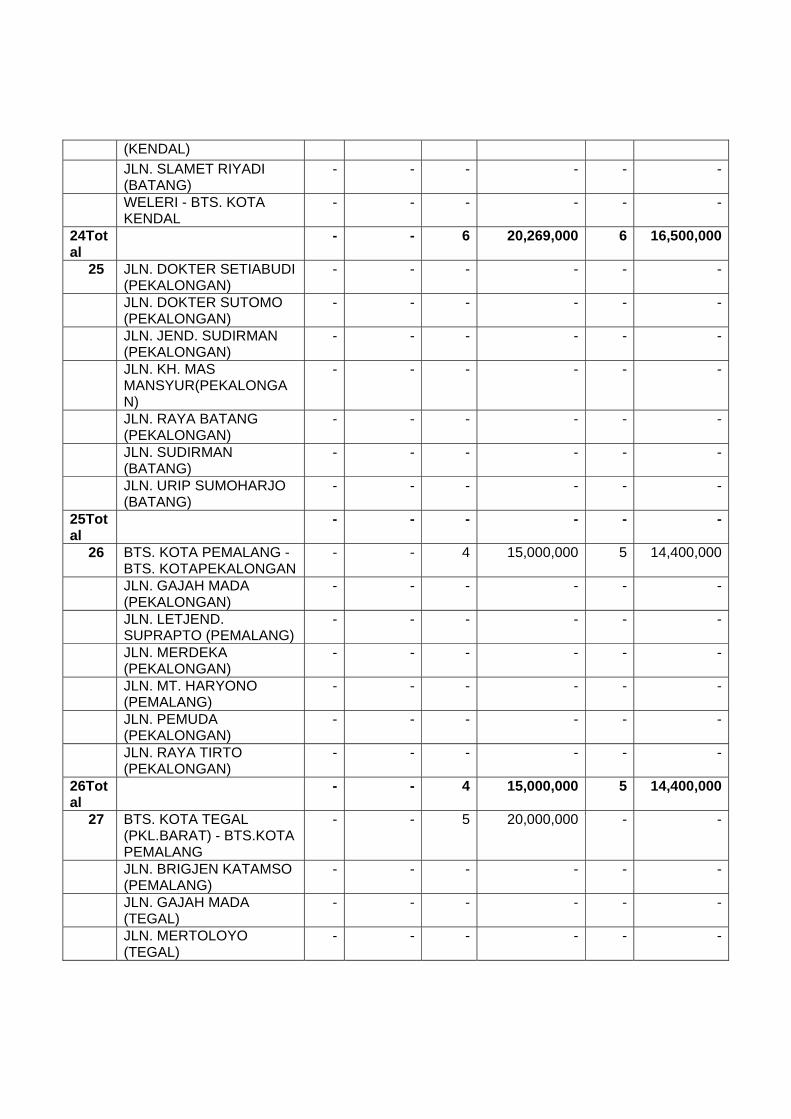
23Total - - 1 3,000,000 124 BTS. KAB. BATANG - WELERI
(WELERI-BATANG (PKL.TIMUR) - - - - -
BTS. KOTA BATANG - BTS. KAB. KENDAL(BATANG-WELERI (SMG BRT)
- - - - 3
JLN. LINGKAR BODRI (KENDAL) - - - - - JLN. RAYA (KENDAL) - - - - - JLN. RAYA BARAT (KENDAL) - - - - - JLN. RAYA TIMUR (KENDAL) - - - - - JLN. SLAMET RIYADI (BATANG) - - - - - WELERI - BTS. KOTA KENDAL - - - - -
24Total - - - - 325 JLN. DOKTER - - - - -
SETIABUDI(PEKALONGAN) JLN. DOKTER SUTOMO
(PEKALONGAN) - - - - -
JLN. JEND. SUDIRMAN (PEKALONGAN)
- - - - -
JLN. KH. MAS MANSYUR(PEKALONGAN)
- - - - -
JLN. RAYA BATANG (PEKALONGAN)
- - - - -
JLN. SUDIRMAN (BATANG) - - - - - JLN. URIP SUMOHARJO
(BATANG) - - - - -
25Total - - - - -26 BTS. KOTA PEMALANG - BTS.
KOTAPEKALONGAN - - - - -
JLN. GAJAH MADA (PEKALONGAN)
- - - - -
JLN. LETJEND. SUPRAPTO (PEMALANG)
- - - - -
JLN. MERDEKA (PEKALONGAN) - - - - - JLN. MT. HARYONO
(PEMALANG) - - - - -
JLN. PEMUDA (PEKALONGAN) - - - - - JLN. RAYA TIRTO
(PEKALONGAN) - - - - -
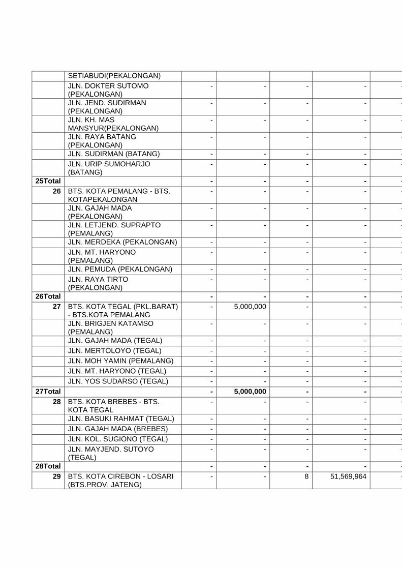
26Total - - - - -27 BTS. KOTA TEGAL (PKL.BARAT)
- BTS.KOTA PEMALANG - 5,000,000 - - -
JLN. BRIGJEN KATAMSO (PEMALANG)
- - - - -
JLN. GAJAH MADA (TEGAL) - - - - - JLN. MERTOLOYO (TEGAL) - - - - - JLN. MOH YAMIN (PEMALANG) - - - - - JLN. MT. HARYONO (TEGAL) - - - - - JLN. YOS SUDARSO (TEGAL) - - - - -
27Total - 5,000,000 - - -28 BTS. KOTA BREBES - BTS.
KOTA TEGAL - - - - -
JLN. BASUKI RAHMAT (TEGAL) - - - - - JLN. GAJAH MADA (BREBES) - - - - - JLN. KOL. SUGIONO (TEGAL) - - - - - JLN. MAYJEND. SUTOYO
(TEGAL) - - - - -
28Total - - - - -29 BTS. KOTA CIREBON - LOSARI
(BTS.PROV. JATENG) - - 8 51,569,964 -

JLN. A. YANI (BREBES) - - - - - JLN. DIPONEGORO (BREBES) - - - - - JLN. KALIJAGA (CIREBON) - - - - - JLN. KASUNEAN (CIREBON) - - - - - JLN. PEMUDA (BREBES) - - - - - LOSARI (BTS. PROV. JABAR) -
PEJAGAN - - - - -
PEJAGAN - BTS. KOTA BREBES - - 3 14,000,000 -29Total - - 11 65,569,964 -
31 BTS. KAB. INDRAMAYU/CRB (CADANGPINGGAN) - BTS. KOTA PALIMANAN
- - 7 18,000,000 -
JATIBARANG - BTS. KAB.CIREBON/INDRAMAYU (CADANGPINGGAN)
- - 8 32,000,000 -
JLN. RAYA PALIMANAN 2 (PALIMANAN)
- - - - -
LOHBENER - JATIBARANG - 9,870,000 - - -31Total - 9,870,000 15 50,000,000 -
32 BTS. KOTA PAMANUKAN - SEWO
- 1,700,000 - - -
JLN. H. SYAHBANA (PAMANUKAN)
- - - - -
SEWO - LOHBENER - - 7 26,330,000 -32Total - 1,700,000 7 26,330,000 -
33 BTS. KAB. SUBANG/KARAWANG - BTS.KOTA PAMANUKAN
- 400,000 - - -
BTS. KOTA CIKAMPEK - BTS. KAB.SUBANG/KARAWANG
- - 1 12,500,000 -
JLN. BY PASS JOMIN (CIKAMPEK)
- - - - -
JLN. EYANG TIRTAYASA (PAMANUKAN)
- - - - -
JLN. IR.H.JUANDA (CIKAMPEK) - - - - - JLN. JEND. SUDIRMAN
(CIKAMPEK) - - - - -
JLN. RAYA JATISARI (CIKAMPEK)
- - - - -
33Total - 400,000 1 12,500,000 -
AH-25 284 1,209,975,462 22 77,980,418 961 BTS. BANDA ACEH - LAMBARO
(BANDAACEH) - - - - -
BTS. KOTA BANDA ACEH - KM.77(BATAS PIDIE)
8 30,000,000 - - -
JLN. CIKDITIRO (SIGLI) - - - - -

JLN. TENGKU CIKDITIRO (BANDA ACEH)
- - - - -
KM.77 (BATAS PIDIE) - BTS. KOTA SIGLI
13 53,346,888 - - -
1Total 20 83,346,888 - - -2 BTS. KOTA SIGLI -
BEUREUNUN - - - - -
JLN. AM. IBRAHIM (SIGLI) - - - - -2Total - - - - -
3 BEUREUNUN - BTS. ACEH UTARA
- - - - -
BTS. PIDIE - BIREUEN - - - - -3Total - - - - -
4 BIREUEN - BTS. KOTA LHOKSEUMAWE
- - - - -
JLN. RAYA BANDA ACEH (LHOK SEUMAWE) - - - - -4Total - - - - -
5 BTS. KOTA LHOKSEUMAWE - PANTONLABU/SIMPANG (KM 328)
12 45,000,000 - - -
JLN. RAYA MEDAN (LHOK SEUMAWE)
- - - - -
PANTON LABU/SIMPANG (KM 328) -PEUREULAK (KM 392)
- - - - -
5Total 12 45,000,000 - - -6 JLN. AHMAD YANI (LANGSA) - - - - - JLN. AM. IBRAHIM (LANGSA) - - - - - PEUREULAK (KM 392) - BTS.
KOTALANGSA - - - - -
6Total - - - - -7 BTS. KOTA LANGSA - BTS.
PROV.SUMUT 11 45,000,000 - - -
BTS. PROV. NAD - SIMPANGPANGKALAN SUSU
- - - - 4
JLN. AGUS SALIM (LANGSA) - - - - -7Total 11 45,000,000 - - 4
8 SIMPANG PANGKALAN SUSU -TANJUNG PURA
- - - - 3
8Total - - - - 39 JLN. AMIR HAMZAH (BINJAI) - - - - - TANJUNG PURA - BTS. KOTA
STABAT - - - - -
9Total - - - - -10 BTS. KOTA BINJAI - BTS. KOTA
MEDAN - - - - -

JLN. BINJAI RAYA (MEDAN) - - - - - JLN. GATOT SUBROTO
(MEDAN) - - - - -
JLN. SOEKARNO-HATTA (BINJAI)
- - - - -
10Total - - - - -11 BTS. KOTA MEDAN - BTS. KOTA
LUBUKPAKAM - 31,630,000 - - -
JLN. SISINGAMANGARAJA (MEDAN)
- - - - -
11 Total - 31,630,000 - - -
12 BTS. DELI SERDANG/SEI BULUH - SEIRAMPAH
- - - - 3
BTS. KEB. DELI SERDANG -PERBAUNGAN
- - - - -
JLN. AHMAD YANI (TEBING TINGGI)
- - - - -
JLN. JEND. SUDIRMAN (TEBING TINGGI)
- - - - -
JLN. MEDAN (LUBUK PAKAM) - - - - - JLN. SIANTAR (LUBUK PAKAM) - - - - - JLN. YOS SUDARSO (TEBING
TINGGI) - - - - -
PERBAUNGAN - BTS. DELISERDANG/SEI BULUH
- - - - 3
SEI RAMPAH - BTS. KOTA TEBINGTINGGI
- - - - 4
12Total - - - - 913 BTS. KAB. DELI SERDANG II -
TANJUNGKASAU 2 7,200,000 - - -
BTS. KOTA TEBING TINGGI - KP. BINJAI
- - - - -
JLN. DIPONEGORO (TEBNG TINGGI)
- - - - -
JLN. IMAM BONJOL (TEBING TINGGI)
- - - - -
JLN. SISINGAMANGARAJA (TEBINGTINGGI)
- - - - -
JLN. SOEKARNO-HATTA (TEBINGTINGGI)
- - - - -
JLN. SUTOYO (TEBING TINGGI) - - - - - KP. BINJAI - BTS. KAB. ASAHAN - - - - - TANJUNG KASAU - INDRAPURA 8 32,800,000 - - -
13Total 10 40,000,000 - - -14 INDRAPURA - LIMAPULUH 9 36,005,820 - - -
JLN. SUDIRMAN (KISARAN) - - - - -
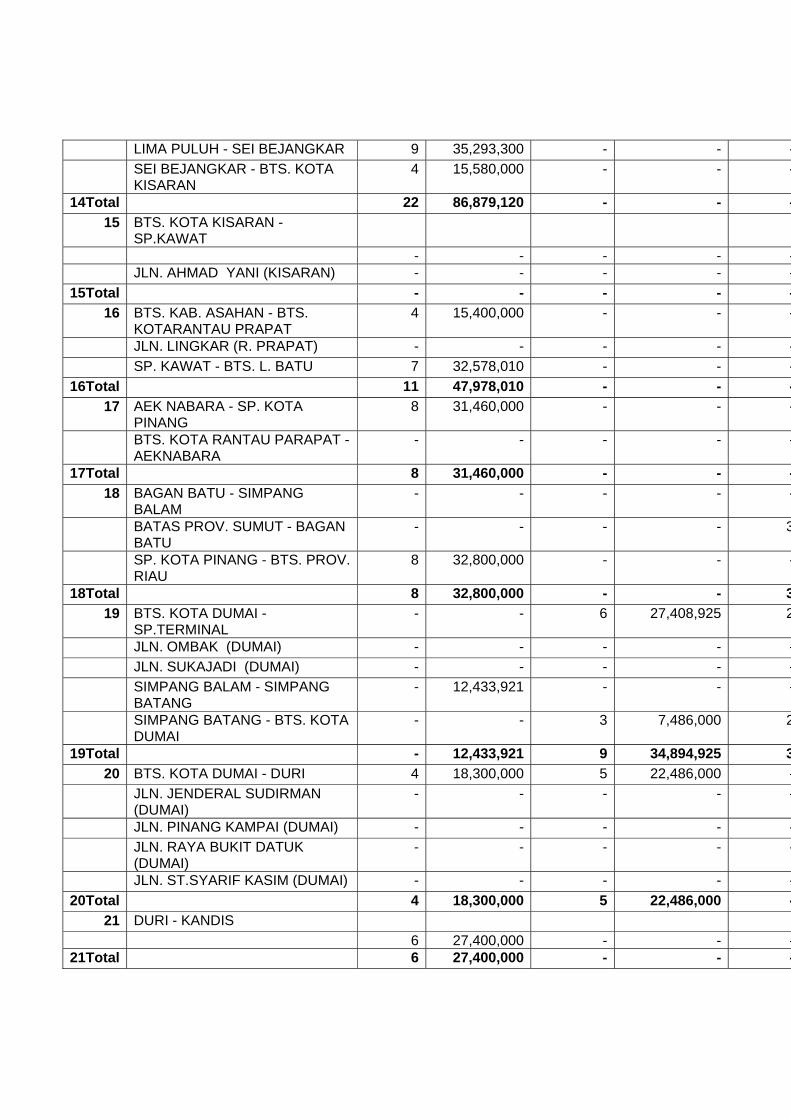
LIMA PULUH - SEI BEJANGKAR 9 35,293,300 - - - SEI BEJANGKAR - BTS. KOTA
KISARAN 4 15,580,000 - - -
14Total 22 86,879,120 - - -15 BTS. KOTA KISARAN -
SP.KAWAT
- - - - - JLN. AHMAD YANI (KISARAN) - - - - -
15Total - - - - -16 BTS. KAB. ASAHAN - BTS.
KOTARANTAU PRAPAT 4 15,400,000 - - -
JLN. LINGKAR (R. PRAPAT) - - - - - SP. KAWAT - BTS. L. BATU 7 32,578,010 - - -
16Total 11 47,978,010 - - -17 AEK NABARA - SP. KOTA
PINANG 8 31,460,000 - - -
BTS. KOTA RANTAU PARAPAT - AEKNABARA
- - - - -
17Total 8 31,460,000 - - -18 BAGAN BATU - SIMPANG
BALAM - - - - -
BATAS PROV. SUMUT - BAGAN BATU
- - - - 3
SP. KOTA PINANG - BTS. PROV. RIAU
8 32,800,000 - - -
18Total 8 32,800,000 - - 319 BTS. KOTA DUMAI -
SP.TERMINAL - - 6 27,408,925 2
JLN. OMBAK (DUMAI) - - - - - JLN. SUKAJADI (DUMAI) - - - - - SIMPANG BALAM - SIMPANG
BATANG - 12,433,921 - - -
SIMPANG BATANG - BTS. KOTA DUMAI
- - 3 7,486,000 2
19Total - 12,433,921 9 34,894,925 320 BTS. KOTA DUMAI - DURI 4 18,300,000 5 22,486,000 -
JLN. JENDERAL SUDIRMAN (DUMAI)
- - - - -
JLN. PINANG KAMPAI (DUMAI) - - - - - JLN. RAYA BUKIT DATUK
(DUMAI) - - - - -
JLN. ST.SYARIF KASIM (DUMAI) - - - - -20Total 4 18,300,000 5 22,486,000 -
21 DURI - KANDIS 6 27,400,000 - - -21Total 6 27,400,000 - - -

22 JLN. SIAK II (PEKANBARU) - - - - - KANDIS - BTS. KAB.
BENGKALIS - - 2 4,041,900 3
SP. PALAS - BTS. KAB. / BTS. KOTA(PEKANBARU)
- - - - -
22Total - - 2 4,041,900 323 BTS. KAB. KAMPAR - SIKIJANG
MATI 1 3,410,000 - - -
JLN IR. H. JUANDA (PEKANBARU)
- - - - -
JLN. HARAPAN RAYA (PEKANBARU)
- - - - -
JLN. RIAU (PEKANBARU) - - - - - JLN.SUDIRMAN (PEKANBARU) - - - - - SIKIJANG MATI - SIMPANG
LAGO - - 1 1,351,000 2
23Total 1 3,410,000 1 1,351,000 224 BTS. KAB. INHU - SIMPANG
JAPURA 5 18,894,380 2 2,992,159 1
SIMPANG LAGO - SOREK I 1 6,200,000 - - - SOREK I - BTS. KAB. INHU 4 18,600,000 - - -
24Total 11 43,694,380 2 2,992,159 125 SIMPANG JAPURA -
PEMATANG REBA - - 1 2,500,000 1
25Total - - 1 2,500,000 126 PEMATANG REBA - SIBERIDA 7 27,450,000 2 4,021,109 3
26Total 7 27,450,000 2 4,021,109 327 BTS. PROV. RIAU - MERLUNG 53 200,000,000 - - -
SIBERIDA - BTS. PROV. JAMBI 8 37,987,300 - - 927Total 61 237,987,300 - - 9
28 BTS. KAB. TANJAB - SP. TUAN - - - - 3 MERLUNG - BTS. KAB. TANJAB - - - - 2
28 Total - - - - 5
29 BTS. KOTA JAMBI KM 15,90 -MENDALO DARAT (SP. TIGA)
- - - - 3
29Total - - - - 330 BTS. KOTA JAMBI - TEMPINO - - - - 1
BTS. KOTA JAMBI / SP. RIMBO - SP.KENALI ATAS (JAMBI)
- - - - -
BTS. KOTA MA. BULIAN - BTS. KAB.MUARO JAMBI/KAB. BATANGHARI
- - 1 3,168,000 8
SP. MANDALO DARAT - BTS. KOTAJAMBI / SP. RIMBO
- - - - -

30Total - - 1 3,168,000 931 BTS. PROV. JAMBI -
PENINGGALAN 10 35,182,863 - - -
PENINGGALAN - SEI LILIN - - - - 10 SEI LILIN - BETUNG - - - - - TEMPINO - BTS. PROV.
SUMSEL - - - - 1
31Total 10 35,182,863 - - 1132 BETUNG - BTS. KOTA
PALEMBANG 3 12,250,000 - - 7
JLN. JENDERAL SUDIRMAN(PALEMBANG)
- - - - -
JLN. KOLONEL H. BURLIAN(PALEMBANG)
- - - - -
JLN. KOLONEL NUR AMIN(PALEMBANG)
- - - - -
JLN. PERINTIS KEMERDEKAAN(PALEMBANG)
- - - - -
JLN. VETERAN (PALEMBANG) - - - - -32Total 3 12,250,000 - - 7
33 BTS. KOTA PALEMBANG - SIMPANGINDRALAYA
- - - - 11
JLN. KI MEROGAN (PALEMBANG)
- - - - -
JLN. KI WAHID HASYIM (PALEMBANG)
- - - - -
33Total - - - - 1134 JLN. MUCHTAR SALEH (KAYU
AGUNG) - - - - -
MERANJAT - BTS. KOTA KAYU AGUNG
9 60,630,000 - - -
SIMPANG INDRALAYA - MERANJAT
2 7,890,000 - - -34Total 11 68,520,000 - - -
35 BTS. KOTA KAYU AGUNG - SP.PENYANDINGAN
- - - - 5
JLN. MAKAM PAHLAWAN (KAYUAGUNG)
- - - - -
JLN. SULAIMAN RADEN ANOM (KAYUAGUNG)
- - - - -
PEMATANG PANGGANG - SP.PEMATANG
18 77,866,443 - - -
SP. BUJUNG TENUK - BUJUNG TENUK
- - - - -
SP. PENYANDINGAN - BTS. PROV.LAMPUNG
15 52,067,321 - - -
35Total 34 129,933,764 - - 5
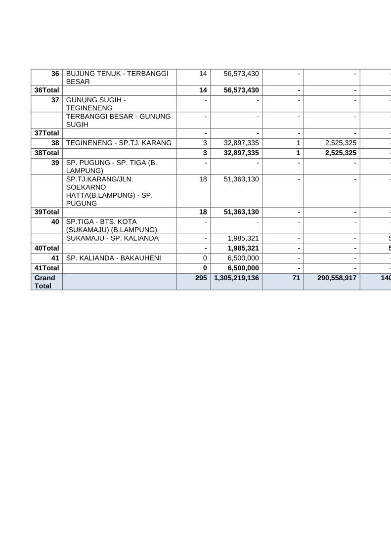
36 BUJUNG TENUK - TERBANGGI BESAR
14 56,573,430 - - -
36Total 14 56,573,430 - - -37 GUNUNG SUGIH -
TEGINENENG - - - - -
TERBANGGI BESAR - GUNUNG SUGIH
- - - - -
37Total - - - - -38 TEGINENENG - SP.TJ. KARANG 3 32,897,335 1 2,525,325 -
38Total 3 32,897,335 1 2,525,325 -39 SP. PUGUNG - SP. TIGA (B.
LAMPUNG) - - - - -
SP.TJ.KARANG/JLN. SOEKARNO HATTA(B.LAMPUNG) - SP. PUGUNG
18 51,363,130 - - -
39Total 18 51,363,130 - - -40 SP.TIGA - BTS. KOTA
(SUKAMAJU) (B.LAMPUNG) - - - - -
SUKAMAJU - SP. KALIANDA - 1,985,321 - - 540Total - 1,985,321 - - 5
41 SP. KALIANDA - BAKAUHENI 0 6,500,000 - - -41Total 0 6,500,000 - - -Grand Total
295 1,305,219,136 71 290,558,917 140

Annex III
Capacity Expansion
Betterment/Reconstruction
Rehabillitation/Periodic Maint.
AH-Code / AH-No.
Itinerary
Vol (Km)
Cost (mil. Rp)
Vol (Km)
Cost (mil. Rp) Vol (Km)
Cost (mil.Rp)
AH-2 57 258,723,145
145 535,996,196 69 109,375,315
1 DENPASAR - TUBAN 7 14,386,000
- - 1 3,241,800
JLN. THAMRIN (DPS) - 1,026,000 - - - 678,0801Total
7 15,412,000
- - 1 3,919,880
2 BTS. KOTA TABANAN - MENGWITANI
- - - - - -
JLN. A. YANI (TABANAN) - - - - - - JLN. COKROAMINOTO
(DPS) 2 4,401,000 - - - -
MENGWITANI - BTS. KOTA DENPASAR
1 4,023,000 - - - -
2Total
3 8,424,000 - - - -
3 ANTOSARI - BTS. KOTA TABANAN
- - - - 1 2,790,000
BTS. KOTA NEGARA - PEKUTATAN
- - - - 8 7,760,000
JLN. SUDIRMAN, GAJAHMADA(NEGARA)
- - - - - -
PEKUTATAN - ANTOSARI - - 1 2,208,000 3 6,517,780 SIMP. KEDIRI -
PESIAPAN (TABANAN) - - - - - -
3Total
- - 1 2,208,000 12 17,067,780
4 CEKIK - BTS. KOTA NEGARA
- - - - 4 6,005,000
GILIMANUK - CEKIK - - 1 2,208,000 1 1,530,000 JLN. A. YANI - JLN.
UDAYANA (NEGARA) - - - - 2 5,369,000
4Total
- - 1 2,208,000 7 12,904,000
6 BAJULMATI (BTS.KAB. SITUBONDO) -KETAPANG
3 10,000,000
5 15,750,000 - -
BTS. KOTA SITUBONDO - BAJULMATI(BTS. KAB. BANYUWANGI)
- - 4 11,137,500 - -
JLN. A. YANI (SITUBONDO)
- - - - - -
JLN. BASUKI RACHMAT (SITUBONDO)
- - - - - -
JLN. P.B. SUDIRMAN (SITUBONDO)
- - - - - -
PANARUKAN - BTS. KOTA SITUBONDO
- - - - 3 4,017,000
6Total
3 10,000,000
9 26,887,500 3 4,017,000
7 BTS. KOTA PROBOLINGGO - PAITON(BTS. KAB. SITUBONDO/BINOR)
- - 2 5,500,000 - -
BUDUAN - PANARUKAN - - - - 8 10,400,000 PAITON (BTS.
KAB.PROBOLINGGO/BINOR) - BUDUAN
- - - - 5 6,500,000
7Total
- - 2 5,500,000 13 16,900,000
8 BTS. KAB. PASURUAN - PILANG (BTS.KOTA PROBOLINGGO)
- - 6 26,182,273 - -
BTS. KOTA PASURUAN - BTS. KAB.PROBOLINGGO
- - - - - 520,000
JLN. IR. JUANDA (PASURUAN)
- - - - - 227,500
JLN. P. SUDIRMAN (PILANG -PROBOLINGGO) (PROBOLINGGO)
- - - - - -
JLN. SOEKARNO-HATTA (PILANG -PROBOLINGGO) (PROBOLINGGO)
- - - - - -
JLN. VETERAN (PASURUAN)
- - - - - -
8Total
- - 6 26,182,273 - 747,500
9 BTS. KOTA BANGIL - BTS. KOTAPASURUAN
- - - - - -
GEMPOL - BTS. KOTA BANGIL
- - - - - 390,000
JLN. A. YANI (BANGIL) - - - - - - JLN. D.I. PANJAITAN
(PASURUAN) - - - - - -
JLN. DIPONEGORO (BANGIL)
- - - - - -
JLN. DR. SUTOMO (BANGIL)
- - - - - -

JLN. GAJAH MADA (BANGIL)
- - - - - -
JLN. JAKSA AGUNG SUPRAPTO (BANGIL)
- - - - - -
JLN. KARTINI (BANGIL) - - - - - - JLN. PATTIMURA
(BANGIL) - - - - - -
JLN. SOEKARNO-HATTA (PASURUAN)
- - - - - -
JLN. UNTUNG SUROPATI (BANGIL)
- - - - - -
JLN. UNTUNG SUROPATI (PASURUAN)
- - - - - -
JLN. URIP SUMOHARJO (PASURUAN)
- - - - - -
9 - - - - - 390,000Total
11 KRIAN - TAMAN (BY PASS KRIAN -TAMAN)
- - - - - -
MLIRIP - KRIAN (MLIRIP - BY PASSKRIAN)
- - - - 4 5,005,000
TAMAN - WARU - - - - - -11Total
- - - - 4 5,005,000
13 BTS. KAB. JOMBANG - GEMEKAN
- - 4 15,000,000 - 260,000
BTS. KOTA JOMBANG - BTS. KAB.MOJOKERTO
- - 10 40,000,000 1 1,287,000
GEMEKAN - JAMPIROGO (MOJOKERTO )
- - - - - 156,000
JLN. SOEKARNO-HATTA (JOMBANG)
- - - - - 117,000
13Total
- - 14 55,000,000 1 1,820,000
14 BTS. KAB. KEDIRI - BTS. KOTA JOMBANG
- - - - - -
BTS. KOTA NGANJUK - KERTOSONO
- - - - - -
JLN. P. SUDIRMAN (JOMBANG)
- - - - - -
JLN. PANGLIMA SUDIRMAN (NGANJUK)
- - - - - -
JLN. YOS SUDARSO (JOMBANG)
- - - - - -
KERTOSONO - BTS. KAB. JOMBANG
- - - - - 351,000
14Total
- - - - - 351,000
15 BTS. KAB. MADIUN - BTS. - - - - - -
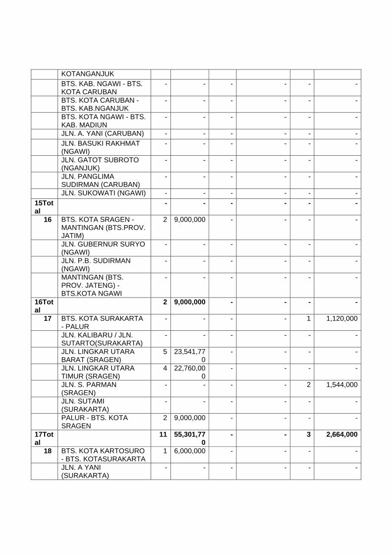
KOTANGANJUK BTS. KAB. NGAWI - BTS.
KOTA CARUBAN - - - - - -
BTS. KOTA CARUBAN - BTS. KAB.NGANJUK
- - - - - -
BTS. KOTA NGAWI - BTS. KAB. MADIUN
- - - - - -
JLN. A. YANI (CARUBAN) - - - - - - JLN. BASUKI RAKHMAT
(NGAWI) - - - - - -
JLN. GATOT SUBROTO (NGANJUK)
- - - - - -
JLN. PANGLIMA SUDIRMAN (CARUBAN)
- - - - - -
JLN. SUKOWATI (NGAWI) - - - - - -15Total
- - - - - -
16 BTS. KOTA SRAGEN - MANTINGAN (BTS.PROV. JATIM)
2 9,000,000 - - - -
JLN. GUBERNUR SURYO (NGAWI)
- - - - - -
JLN. P.B. SUDIRMAN (NGAWI)
- - - - - -
MANTINGAN (BTS. PROV. JATENG) - BTS.KOTA NGAWI
- - - - - -
16Total
2 9,000,000 - - - -
17 BTS. KOTA SURAKARTA - PALUR
- - - - 1 1,120,000
JLN. KALIBARU / JLN. SUTARTO(SURAKARTA)
- - - - - -
JLN. LINGKAR UTARA BARAT (SRAGEN)
5 23,541,770
- - - -
JLN. LINGKAR UTARA TIMUR (SRAGEN)
4 22,760,000
- - - -
JLN. S. PARMAN (SRAGEN)
- - - - 2 1,544,000
JLN. SUTAMI (SURAKARTA)
- - - - - -
PALUR - BTS. KOTA SRAGEN
2 9,000,000 - - - -
17Total
11 55,301,770
- - 3 2,664,000
18 BTS. KOTA KARTOSURO - BTS. KOTASURAKARTA
1 6,000,000 - - - -
JLN. A YANI (SURAKARTA)
- - - - - -

JLN. ADI SUCIPTO (SURAKARTA)
- - - - 2 2,666,660
JLN. SLAMET RIYADI (SURAKARTA)
- - - - - -
JLN. TENTARA PELAJAR (SURAKARTA)
- - - - - -
18Total
1 6,000,000 - - 2 2,666,660
19 BTS. KOTA BOYOLALI - BTS. KOTAKARTOSURO
9 68,005,620
- - - -
JLN. PANDANARAN (BOYOLALI)
- - - - - -
19Total
9 68,005,620
- - - -
20 BTS. KOTA SALATIGA - BTS. SEMARANGBRT/SKA BRT (SALATIGA - BOYOLALI(SMG BRT)
4 25,000,000
- - - -
BTS. SEMARANG BRT/SKA BRT - BTS.KOTA BOYOLALI (BOYOLALI - SALATIGA(SKA BRT)
2 9,000,000 - - - -
JLN. JEND. SUDIRMAN (SALATIGA)
- - - - - -
JLN. OSA MALIKI (SALATIGA)
- - - - - -
JLN. PANDANARAN (BOYOLALI)
- - - - - -
JLN. VETERAN (SALATIGA)
- - - - - -
JLN. WAHID HASYIM (SALATIGA)
- - - - - -
20Total
6 34,000,000
- - - -
21 BAWEN - BTS. KOTA SALATIGA
1 6,000,000 1 3,000,000 - -
BTS. KOTA SEMARANG/UNGARAN -BAWEN
- - 3 12,000,000 1 1,500,000
JLN. DIPONEGORO (SALATIGA)
- - - - - -
JLN. DIPONEGORO (UNGARAN)
- - 60 236,236,000 - -
JLN. DR. CIPTO (SEMARANG)
- - - - - -
JLN. DR. WAHIDIN (SEMARANG)
- - - - - -
JLN. GATOT SUBROTO - - - - 1 1,500,000

(UNGARAN) JLN. KOMPOL MAKSUM
(SEMARANG) - - - - - -
JLN. MT. HARYONO (SEMARANG)
- - - - - -
JLN. RADEN PATAH (SEMARANG)
- - - - - -
JLN. SETIA BUDHI (SEMARANG)
- - - 1,800,000 - -
JLN. TEUKU UMAR (SEMARANG)
- - - - - -
JLN. WIDOHARJO (SEMARANG)
- - - - - -
21Total
1 6,000,000 64 253,036,000 2 3,000,000
23 BTS. KOTA KENDAL - BTS. KOTASEMARANG
- - 2 6,000,000 - -
JLN. Dr SUTOMO (SEMARANG)
- - - - - -
JLN. JENDRAL SUDIRMAN (SEMARANG)
- - - - - -
JLN. MGR. SUGIYOPRANOTO(SEMARANG)
- - - - - -
JLN. S. PARMAN (SEMARANG)
- - - - - -
JLN. SILIWANGI (SEMARANG)
- - - - 1 1,500,000
JLN. SULTAN AGUNG (SEMARANG)
- - - 1,500,000 - -
JLN. TUGU MUDA (SEMARANG)
- - - - - -
JLN. WALISONGO (SEMARANG)
- - 2 6,000,000 1 1,500,000
23Total
- - 4 13,500,000 2 3,000,000
24 BTS. KAB. BATANG - WELERI (WELERI-BATANG (PKL.TIMUR)
- - - - 5 15,000,000
BTS. KOTA BATANG - BTS. KAB. KENDAL(BATANG-WELERI (SMG BRT)
- - 5 17,269,000 - -
JLN. LINGKAR BODRI (KENDAL)
- - - - 1 1,500,000
JLN. RAYA (KENDAL) - - - - - - JLN. RAYA BARAT
(KENDAL) - - 1 3,000,000 - -
JLN. RAYA TIMUR - - - - - -
(KENDAL) JLN. SLAMET RIYADI
(BATANG) - - - - - -
WELERI - BTS. KOTA KENDAL
- - - - - -
24Total
- - 6 20,269,000 6 16,500,000
25 JLN. DOKTER SETIABUDI (PEKALONGAN)
- - - - - -
JLN. DOKTER SUTOMO (PEKALONGAN)
- - - - - -
JLN. JEND. SUDIRMAN (PEKALONGAN)
- - - - - -
JLN. KH. MAS MANSYUR(PEKALONGAN)
- - - - - -
JLN. RAYA BATANG (PEKALONGAN)
- - - - - -
JLN. SUDIRMAN (BATANG)
- - - - - -
JLN. URIP SUMOHARJO (BATANG)
- - - - - -
25Total
- - - - - -
26 BTS. KOTA PEMALANG - BTS. KOTAPEKALONGAN
- - 4 15,000,000 5 14,400,000
JLN. GAJAH MADA (PEKALONGAN)
- - - - - -
JLN. LETJEND. SUPRAPTO (PEMALANG)
- - - - - -
JLN. MERDEKA (PEKALONGAN)
- - - - - -
JLN. MT. HARYONO (PEMALANG)
- - - - - -
JLN. PEMUDA (PEKALONGAN)
- - - - - -
JLN. RAYA TIRTO (PEKALONGAN)
- - - - - -
26Total
- - 4 15,000,000 5 14,400,000
27 BTS. KOTA TEGAL (PKL.BARAT) - BTS.KOTA PEMALANG
- - 5 20,000,000 - -
JLN. BRIGJEN KATAMSO (PEMALANG)
- - - - - -
JLN. GAJAH MADA (TEGAL)
- - - - - -
JLN. MERTOLOYO (TEGAL)
- - - - - -

JLN. MOH YAMIN (PEMALANG)
- - - - - -
JLN. MT. HARYONO (TEGAL)
- - - - - -
JLN. YOS SUDARSO (TEGAL)
- - - - - -
27Total
- - 5 20,000,000 - -
28 BTS. KOTA BREBES - BTS. KOTA TEGAL
- - - - - -
JLN. BASUKI RAHMAT (TEGAL)
- - - - - -
JLN. GAJAH MADA (BREBES)
- - - - - -
JLN. KOL. SUGIONO (TEGAL)
- - - - - -
JLN. MAYJEND. SUTOYO (TEGAL)
- - - - - -
28Total
- - - - - -
29 BTS. KOTA CIREBON - LOSARI (BTS.PROV. JATENG)
- - - - - -
JLN. A. YANI (BREBES) - - - - - - JLN. DIPONEGORO
(BREBES) - - - - - -
JLN. KALIJAGA (CIREBON)
- - 2 12,780,886 - -
JLN. KASUNEAN (CIREBON)
- - 1 3,628,744 - -
JLN. PEMUDA (BREBES) - - - - - - LOSARI (BTS. PROV.
JABAR) - PEJAGAN - - 8 8,896,212 - -
PEJAGAN - BTS. KOTA BREBES
- - 10 39,027,000 - -
29Total
- - 21 64,332,842 - -
31 BTS. KAB. INDRAMAYU/CRB (CADANGPINGGAN) - BTS. KOTA PALIMANAN
1 1,494,223 - - - -
JATIBARANG - BTS. KAB.CIREBON/INDRAMAYU (CADANGPINGGAN)
1 2,708,514 - - - -
JLN. RAYA PALIMANAN 2 (PALIMANAN)
1 4,739,900 - - - -
LOHBENER - JATIBARANG
8 34,533,556
- - - -
31Tot 11 43,476,19 - - - -

al 332 BTS. KOTA PAMANUKAN
- SEWO - - 8 31,872,581 8 4,022,495
JLN. H. SYAHBANA (PAMANUKAN)
- - - - - -
SEWO - LOHBENER - - - - - -32Total
- - 8 31,872,581 8 4,022,495
33 BTS. KAB. SUBANG/KARAWANG - BTS.KOTA PAMANUKAN
- - - - - -
BTS. KOTA CIKAMPEK - BTS. KAB. -
- - - - -
SUBANG/KARAWANG JLN. BY PASS JOMIN
(CIKAMPEK) - - - - - -
JLN. EYANG TIRTAYASA (PAMANUKAN)
- - - - - -
JLN. IR.H.JUANDA (CIKAMPEK)
- - - - - -
JLN. JEND. SUDIRMAN (CIKAMPEK)
- - - - - -
JLN. RAYA JATISARI (CIKAMPEK)
3 3,103,562 - - - -
33Total
3 3,103,562 - - - -
AH-25
163 683,989,972
70 250,089,300 85 170,388,912
1 BTS. BANDA ACEH - LAMBARO (BANDAACEH)
- - - - - -
BTS. KOTA BANDA ACEH - KM.77(BATAS PIDIE)
- - - - 2 5,000,000
JLN. CIKDITIRO (SIGLI) - - - - - - JLN. TENGKU CIKDITIRO
(BANDA ACEH) - - - - - -
KM.77 (BATAS PIDIE) - BTS. KOTA SIGLI
- - 4 13,500,000 - -
1Total
- - 4 13,500,000 2 5,000,000
2 BTS. KOTA SIGLI - BEUREUNUN
4 18,000,000
- - - 250,000
JLN. AM. IBRAHIM (SIGLI) - - - - - -2Total
4 18,000,000
- - - 250,000
3 BEUREUNUN - BTS. ACEH UTARA
4 20,000,000
1 5,000,000 - -
BTS. PIDIE - BIREUEN 3 15,000,000
- - - -

3Total
7 35,000,000
1 5,000,000 - -
4 BIREUEN - BTS. KOTA LHOKSEUMAWE
3 13,500,000
- - - -
JLN. RAYA BANDA ACEH (LHOKSEUMAWE)
- - - - - -
4Total
3 13,500,000
- - - -
5 BTS. KOTA LHOKSEUMAWE - PANTONLABU/SIMPANG (KM 328)
- - - - - -
JLN. RAYA MEDAN (LHOK SEUMAWE)
- - - - - -
PANTON LABU/SIMPANG (KM 328) -PEUREULAK (KM 392)
5 25,000,000
6 25,000,000 - -
5Total
5 25,000,000
6 25,000,000 - -
6 JLN. AHMAD YANI (LANGSA)
- - - - - -
JLN. AM. IBRAHIM (LANGSA)
- - - - - -
PEUREULAK (KM 392) - BTS. KOTALANGSA
- - - - - -
6Total
- - - - - -
7 BTS. KOTA LANGSA - BTS. PROV. SUMUT
13 51,188,000
3 - - -
BTS. PROV. NAD - SIMPANGPANGKALAN SUSU
7 29,250,000
- - - -
JLN. AGUS SALIM (LANGSA)
- - - - - -
7Total
20 80,438,000
3 - - -
8 SIMPANG PANGKALAN SUSU -TANJUNG PURA
5 22,320,000
- - - -
8Total
5 22,320,000
- - - -
9 JLN. AMIR HAMZAH (BINJAI)
2 9,080,972 2 30,000,000 - -
TANJUNG PURA - BTS. KOTA STABAT
9 10,000,000
- - - -
9Total
11 19,080,972
2 30,000,000 - -
10 BTS. KOTA BINJAI - BTS. KOTA MEDAN
4 30,000,000
8 30,000,000 - -
JLN. BINJAI RAYA (MEDAN)
- - - - - -

JLN. GATOT SUBROTO (MEDAN)
- - - - - -
JLN. SOEKARNO-HATTA (BINJAI)
- - - - - -
10Total
4 30,000,000
8 30,000,000 - -
11 BTS. KOTA MEDAN - BTS. KOTA LUBUKPAKAM
- - - - - -
JLN. SISINGAMANGARAJA (MEDAN)
- - - - - -
11Total
- - - - - -
12 BTS. DELI SERDANG/SEI BULUH - SEIRAMPAH
- - - - 3 4,500,000
BTS. KEB. DELI SERDANG -PERBAUNGAN
- - - - 3 4,500,000
JLN. AHMAD YANI (TEBING TINGGI)
- - - - - -
JLN. JEND. SUDIRMAN (TEBING TINGGI)
- - - - - -
JLN. MEDAN (LUBUK PAKAM)
- - 3 30,000,000 - -
JLN. SIANTAR (LUBUK PAKAM)
- - - - - -
JLN. YOS SUDARSO (TEBING TINGGI)
- - - - - -
PERBAUNGAN - BTS. DELI SERDANG/SEIBULUH
- - - - 3 4,500,000
SEI RAMPAH - BTS. KOTA TEBINGTINGGI
- - - - 3 4,500,000
12Total
- - 3 30,000,000 12 18,000,000
13 BTS. KAB. DELI SERDANG II - TANJUNGKASAU
- - - - - -
BTS. KOTA TEBING TINGGI - KP. BINJAI
- - - - 3 4,500,000
JLN. DIPONEGORO (TEBNG TINGGI)
- - - - - -
JLN. IMAM BONJOL (TEBING TINGGI)
- - - - - -
JLN. SISINGAMANGARAJA (TEBINGTINGGI)
- - - - - -
JLN. SOEKARNO-HATTA (TEBINGTINGGI)
- - - - 2 3,000,000
JLN. SUTOYO (TEBING TINGGI)
- - - - - -
KP. BINJAI - BTS. KAB. ASAHAN
- - - - 3 4,500,000
TANJUNG KASAU - INDRAPURA
- - - - - -
13Total
- - - - 8 12,000,000
14 INDRAPURA - LIMAPULUH
8 36,000,000
- - - -
JLN. SUDIRMAN (KISARAN)
1 4,500,000 - - - -
LIMA PULUH - SEI BEJANGKAR
8 36,000,000
- - - -
SEI BEJANGKAR - BTS. KOTA KISARAN
7 31,500,000
- - - -
14Total
24 108,000,000
- - - -
15 BTS. KOTA KISARAN - SP.KAWAT
- - - - 3 4,500,000
JLN. AHMAD YANI (KISARAN)
1 4,500,000 - - - -
15Total
1 4,500,000 - - 3 4,500,000
16 BTS. KAB. ASAHAN - BTS. KOTA RANTAUPRAPAT
- - - - - -
JLN. LINGKAR (R. PRAPAT)
- - - - - -
SP. KAWAT - BTS. L. BATU
- - - - - -
16Total
- - - - - -
17 AEK NABARA - SP. KOTA PINANG
7 31,500,000
- - - -
BTS. KOTA RANTAU PARAPAT - AEKNABARA
- - - - - -
17Total
7 31,500,000
- - - -
18 BAGAN BATU - SIMPANG BALAM
- - - - - -
BATAS PROV. SUMUT - BAGAN BATU
- - - - 2 3,000,000
SP. KOTA PINANG - BTS. PROV. RIAU
10 45,000,000
- - - -
18Total
10 45,000,000
- - 2 3,000,000
19 BTS. KOTA DUMAI - SP.TERMINAL
- - - - - -
JLN. OMBAK (DUMAI) - 630,000 - - - -

JLN. SUKAJADI (DUMAI) - - - - - - SIMPANG BALAM -
SIMPANG BATANG - - - - - -
SIMPANG BATANG - BTS. KOTA DUMAI
- - 2 6,500,000 2 3,000,000
19Total
- 630,000 2 6,500,000 2 3,000,000
20 BTS. KOTA DUMAI - DURI 7 28,000,000
- - - -
JLN. JENDERAL SUDIRMAN (DUMAI)
- - - - - -
JLN. PINANG KAMPAI (DUMAI)
- - - - - -
JLN. RAYA BUKIT DATUK (DUMAI)
- - - - - -
JLN. ST.SYARIF KASIM (DUMAI)
- - - - - -
20Total
7 28,000,000
- - - -
21 DURI - KANDIS 7 31,075,000
3 9,750,000 2 3,000,000
21Total
7 31,075,000
3 9,750,000 2 3,000,000
22 JLN. SIAK II (PEKANBARU)
- - - - - -
KANDIS - BTS. KAB. BENGKALIS
- - 3 9,750,000 - -
SP. PALAS - BTS. KAB. / BTS. KOTA(PEKANBARU)
- - - - 2 3,000,000
22Total
- - 3 9,750,000 2 3,000,000
23 BTS. KAB. KAMPAR - SIKIJANG MATI
2 7,000,000 - - - -
JLN IR. H. JUANDA (PEKANBARU)
- - - - - -
JLN. HARAPAN RAYA (PEKANBARU)
2 6,300,000 - - - -
JLN. RIAU (PEKANBARU) - - - - - - JLN.SUDIRMAN
(PEKANBARU) - - - - 2 3,000,000
SIKIJANG MATI - SIMPANG LAGO
4 14,000,000
2 6,500,000 - -
23Total
8 27,300,000
2 6,500,000 2 3,000,000
24 BTS. KAB. INHU - SIMPANG JAPURA
5 24,586,000
2 6,500,000 1 1,500,000
SIMPANG LAGO - SOREK I
2 8,400,000 2 5,500,000 1 1,500,000
SOREK I - BTS. KAB. 4 14,000,00 2 5,500,000 1 1,500,000

INHU 024Total
11 46,986,000
6 17,500,000 3 4,500,000
25 SIMPANG JAPURA - PEMATANG REBA
4 14,000,000
- - - -
25Total
4 14,000,000
- - - -
26 PEMATANG REBA - SIBERIDA
7 30,000,000
- - - -
26Total
7 30,000,000
- - - -
27 BTS. PROV. RIAU - MERLUNG
- - - - - -
SIBERIDA - BTS. PROV. JAMBI
5 18,400,000
- - - -
27Total
5 18,400,000
- - - -
28 BTS. KAB. TANJAB - SP. TUAN
- - - - - -
MERLUNG - BTS. KAB. TANJAB
- - - - - -
28Total
- - - - - -
29 BTS. KOTA JAMBI KM 15,90 - MENDALODARAT (SP. TIGA)
- - - - 3 4,500,000
29Total
- - - - 3 4,500,000
30 BTS. KOTA JAMBI - TEMPINO
- - - - - -
BTS. KOTA JAMBI / SP. RIMBO - SP.KENALI ATAS (JAMBI)
- - - - - -
BTS. KOTA MA. BULIAN - BTS. KAB.MUARO JAMBI/KAB. BATANGHARI
6 30,000,000
9 22,500,000 6 8,901,912
SP. MANDALO DARAT - BTS. KOTAJAMBI / SP. RIMBO
- - - - - -
30Total
6 30,000,000
9 22,500,000 6 8,901,912
31 BTS. PROV. JAMBI - PENINGGALAN
2 6,420,000 - - 3 8,190,000
PENINGGALAN - SEI LILIN
- - - - 3 8,190,000
SEI LILIN - BETUNG - - - - 3 8,190,000 TEMPINO - BTS. PROV.
SUMSEL - - - - - -

31Total
2 6,420,000 - - 9 24,570,000
32 BETUNG - BTS. KOTA PALEMBANG
2 6,420,000 - - 3 8,190,000
JLN. JENDERAL SUDIRMAN(PALEMBANG)
- - - - 2 6,000,000
JLN. KOLONEL H. BURLIAN(PALEMBANG)
- - - - 2 5,500,000
JLN. KOLONEL NUR AMIN(PALEMBANG)
- - - - - -
JLN. PERINTIS KEMERDEKAAN(PALEMBANG)
- - - - - -
JLN. VETERAN (PALEMBANG)
- - - - 1 2,750,000
32Total
2 6,420,000 - - 8 22,440,000
33 BTS. KOTA PALEMBANG - SIMPANGINDRALAYA
- - - - 3 8,190,000
JLN. KI MEROGAN (PALEMBANG)
- - - - 1 2,751,000
JLN. KI WAHID HASYIM (PALEMBANG)
- - - - 2 4,986,000
33Total
- - - - 6 15,927,000
34 JLN. MUCHTAR SALEH (KAYU AGUNG)
- - - - - -
MERANJAT - BTS. KOTA KAYU AGUNG
- - - - - -
SIMPANG INDRALAYA - MERANJAT
- - - - 3 8,190,000
34Total
- - - - 3 8,190,000
35 BTS. KOTA KAYU AGUNG - SP.PENYANDINGAN
- - - - 3 8,190,000
JLN. MAKAM PAHLAWAN (KAYUAGUNG)
- - - - - -
JLN. SULAIMAN RADEN ANOM (KAYUAGUNG)
- - - - - -
PEMATANG PANGGANG - SP.PEMATANG
- - - - - -
SP. BUJUNG TENUK - BUJUNG TENUK
- - - - - -
SP. PENYANDINGAN - BTS. PROV.LAMPUNG
2 6,420,000 - - 4 10,920,000
35Total
2 6,420,000 - - 7 19,110,000
36 BUJUNG TENUK - TERBANGGI BESAR
- - 4 9,089,300 5 7,500,000

36Total
- - 4 9,089,300 5 7,500,000
37 GUNUNG SUGIH - TEGINENENG
- - - - - -
TERBANGGI BESAR - GUNUNG SUGIH
- - - - - -
37Total
- - - - - -
38 TEGINENENG - SP.TJ. KARANG
1 6,000,000 - - - -
38Total
1 6,000,000 - - - -
39 SP. PUGUNG - SP. TIGA (B. LAMPUNG)
- - 2 5,000,000 - -
SP.TJ.KARANG/JLN. SOEKARNO HATTA(B.LAMPUNG) - SP. PUGUNG
- - - - - -
39Total
- - 2 5,000,000 - -
40 SP.TIGA - BTS. KOTA (SUKAMAJU) (B.LAMPUNG)
- - - - - -
SUKAMAJU - SP. KALIANDA
- - 6 15,000,000 - -
40Total
- - 6 15,000,000 - -
41 SP. KALIANDA - BAKAUHENI
- - 6 15,000,000 - -
41Total
- - 6 15,000,000 - -
Grand
Total
220 942,713,117
215 786,085,496 154 279,764,227
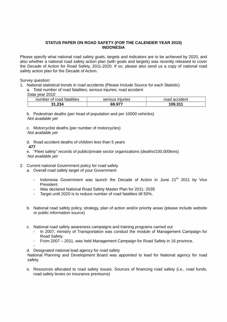
STATUS PAPER ON ROAD SAFETY (FOR THE CALENDER YEAR 2010) INDONESIA
Please specify what national road safety goals, targets and indicators are to be achieved by 2020, and also whether a national road safety action plan (with goals and targets) was recently released to cover the Decade of Action for Road Safety, 2011-2020. If so, please also send us a copy of national road safety action plan for the Decade of Action. Survey question: 1. National statistical trends in road accidents (Please Include Source for each Statistic)
a. Total number of road fatalities; serious injuries; road accident Data year 2010
number of road fatalities serious injuries road accident 31.234 69.977 109.311
b. Pedestrian deaths (per head of population and per 10000 vehicles) Not available yet c. Motorcyclist deaths (per number of motorcycles) Not available yet d. Road accident deaths of children less than 5 years 477 e. “Fleet safety” records of public/private sector organizations (deaths/100,000kms) Not available yet
2. Current national Government policy for road safety a. Overall road safety target of your Government
- Indonesia Government was launch the Decade of Action in June 21th 2011 by Vice
President. - Was declared National Road Safety Master Plan for 2011- 2035 - Target until 2020 is to reduce number of road fatalities till 50%.
b. National road safety policy, strategy, plan of action and/or priority areas (please include website
or public information source) c. National road safety awareness campaigns and training programs carried out
- In 2007, ministry of Transportation was conduct the module of Management Campaign for Road Safety.
- From 2007 – 2011, was held Management Campaign for Road Safety in 16 province. -
d. Designated national lead agency for road safety National Planning and Development Board was appointed to lead for National agency for road safety. e. Resources allocated to road safety issues. Sources of financing road safety (i.e., road funds,
road safety levies on insurance premiums)

f. National road safety report or impact evaluation report of government programs published (please include website or public information source) - Indonesia Wearing Helmet study was publicize in 2010 - Road Safety Master Plan was launched in 2011 in according to Decade of Action.
g. Involvement of the private 9 sector (include scope and funding)
- GRSP of Indonesia was promote the road safety issues to some organization and sector - Private sector such Motor cycle industries (Honda and Yamaha) and others companies was
involved in road safety campaign in school and public by its self funding
3. National road safety indicators a. Road User
i. Laws on seat-belt wearing and “compliance” - Act No 14 1992 on Road Transport and Traffic - Government regulation No 44 / 1993 on Driver and Vehicles - Ministry of Transportation Regulation No. 37 / 2002 on Technical Requirement for Seat belt. - Act No. 22 / 2009 Road Transport and Traffic
ii. Motorcycle daytime head light – is it mandatory and how prevalent?
Act No. 22 / 2009 Road Transport and Traffic article 107 point 2 “ all motor cycle rider have to turn on headlight on all day time”
iii. Use, and minimum quality standard, of motorcycle helmets
Motor cycle helmet Indonesia National standard No. SNI1811-2007 as adoption of E/ECE/324 and E/ECE/TRANS/505 Regulation No.22, uniform provision concerning the approval of protective helmets and visors for drivers and passengers of motor cycles and mopeds,
• BS 6658:1985, Protective Helmet for Motorcyclists, dan • JIS T 8133:2000, Protective Helmet for Drivers and Passengers of Motor Cycle and
Mopeds.
iv. Use of child seat restraints in cars and child helmet for motorcycles
In 2007, Indonesia was launch “helmet for kids”. It’s really the size “S” of helmet standard.
v. Road safety education in schools In 2010, government RoI was programmed the curriculum for road safety for Elementary school. This is cooperation between National Police and Ministry of Education.
vi. Drinking and driving (information from surveys, not prosecutions) This activities temporarily was done. Especially in Idul fitri Holiday and Natal / end year holiday, the driver of public transportation especially for long distance was check his health about blood pressure, blood glucose, alcohol and drug contain in blood.
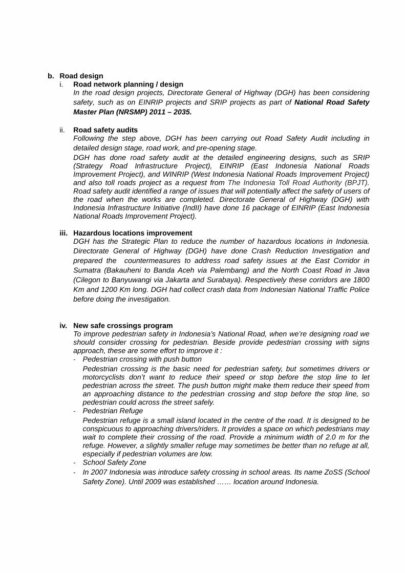
b. Road design i. Road network planning / design
In the road design projects, Directorate General of Highway (DGH) has been considering safety, such as on EINRIP projects and SRIP projects as part of National Road Safety Master Plan (NRSMP) 2011 – 2035.
ii. Road safety audits
Following the step above, DGH has been carrying out Road Safety Audit including in detailed design stage, road work, and pre-opening stage. DGH has done road safety audit at the detailed engineering designs, such as SRIP (Strategy Road Infrastructure Project), EINRIP (East Indonesia National Roads Improvement Project), and WINRIP (West Indonesia National Roads Improvement Project) and also toll roads project as a request from The Indonesia Toll Road Authority (BPJT). Road safety audit identified a range of issues that will potentially affect the safety of users of the road when the works are completed. Directorate General of Highway (DGH) with Indonesia Infrastructure Initiative (IndII) have done 16 package of EINRIP (East Indonesia National Roads Improvement Project).
iii. Hazardous locations improvement
DGH has the Strategic Plan to reduce the number of hazardous locations in Indonesia. Directorate General of Highway (DGH) have done Crash Reduction Investigation and prepared the countermeasures to address road safety issues at the East Corridor in Sumatra (Bakauheni to Banda Aceh via Palembang) and the North Coast Road in Java (Cilegon to Banyuwangi via Jakarta and Surabaya). Respectively these corridors are 1800 Km and 1200 Km long. DGH had collect crash data from Indonesian National Traffic Police before doing the investigation.
iv. New safe crossings program
To improve pedestrian safety in Indonesia’s National Road, when we’re designing road we should consider crossing for pedestrian. Beside provide pedestrian crossing with signs approach, these are some effort to improve it : ‐ Pedestrian crossing with push button
Pedestrian crossing is the basic need for pedestrian safety, but sometimes drivers or motorcyclists don’t want to reduce their speed or stop before the stop line to let pedestrian across the street. The push button might make them reduce their speed from an approaching distance to the pedestrian crossing and stop before the stop line, so pedestrian could across the street safely.
‐ Pedestrian Refuge Pedestrian refuge is a small island located in the centre of the road. It is designed to be conspicuous to approaching drivers/riders. It provides a space on which pedestrians may wait to complete their crossing of the road. Provide a minimum width of 2.0 m for the refuge. However, a slightly smaller refuge may sometimes be better than no refuge at all, especially if pedestrian volumes are low.
‐ School Safety Zone ‐ In 2007 Indonesia was introduce safety crossing in school areas. Its name ZoSS (School
Safety Zone). Until 2009 was established …… location around Indonesia.

v. Motorcycle lanes and bicycle and pedestrian lanes
Motorcycle lane had introduced in Jakarta, Surabaya, Bandung, Jogjakarta and National Road in East Java (near Lamongan). The programmes of motorcycle lanes will be extended to reduce the number of crashes involving motorcycles are quit high (about 70% of crashes). Now, Jakarta already have bicycle lane at Blok M, Bandung also in Yogyakarta. In some campus such in University of Indonesia at Depok and University of Gajah Mada also have built the bicycle lanes for their students. Pedestrian lanes have been considering too. In many cities in Indonesia have been built the pedestrian lanes, such as in Surabaya, Jakarta, and all big cities in Indonesia.
vi. National or local programs to make roads “forgiving” by removing or cushioning
roadside obstacles such as trees, poles etc. To make forgiving road, we should provide clear zone at the National Road approximately 3 – 9 metres from the road (depend on traffic volumes and speed) and make sure the clear zone is free from the roadside hazard such as trees and poles. If it’s not possible to remove the roadside hazard, we will install safety barriers. To provide effective shielding of a hazard, a safety barrier must commence a sufficient distance in advance of the hazard so that a vehicle which runs off the road is not likely to pass behind the barrier and strike or encounter the hazard. Similarly, the limit of the trailing end of the barrier must be established by considering the likely path of errant vehicles. In the case of undivided roads, both directions of travel have to be considered when locating the end point of a barrier.
c. Vehicles
i. Statistics 1. Number of cars 2. Number of buses and trucks 3. Number of motorcycle 4. Number of 3-wheelers
Cars Bus Truck Motorcycle 8.148.330 1.095.554 3.296.315 60.152.265
Note: 3 wheelers in Indonesia are classified into motor cycle
ii. Technical safety requirements for new vehicles All New vehicles must be compliance with technical requirement on type approval testing. The performance of motor vehicle such brake, lamp, sound etc must be compliance with the government regulation that adoption from ECE regulation.
iii. Frequency of periodic inspection of Vehicles (and is it mandatory ?) Base of Act 22 2009 years Inspection of vehicle is mandatory. The Frequency of periodic inspection of Vehicles is every 6 months to comply of Roadworthiness For Now it’s mandatory for bus, truck, articulated vehicle and public transport. For the next time all motor vehicle have to inspect for periodically.
d. Road safety database (is it national, computerized, does it provide information on the location of accidents?)
Not available Yet e. Emergency response systems
i. Extent of geographical coverage No available
ii. Average response time No available
f. Alcohol and drugs tests i. Type of tests and when / how administered
Temporarily, especially on peak season or holiday such idul fitri, Christmas and end year, school holiday.
ii. Is it part of road safety legislation? Yes.
g. Speed limits and “compliance” – please provide details of laws on speeding and speed limits
and brief details on enforcement.
Maximum speed in primary road network for: i. Road class l, ll and lll A are : ‐ For car, bus and truck 100 km/h ‐ For Articulated vehicle 80 km/h
ii. Road class lll B For car, bus and truck 80 km/h iii. Road Class lll C For car, bus and truck 60 km/h
Maximum speed in Secondary road network for i. Road class ll and lllA ‐ For car, bus and truck 70 km/h ‐ For Articulated vehicle 60 km/h
ii. Road class lllB for car, bus and truck 50 km/h iii. Road class lllC for car, bus and truck 40 km/h
4. Asian Highway road safety status and trends a. Road safety action specifically targeting the Asian Highway or trunk roads in general
In the road design projects, Directorate General of Highway (DGH) has been considering safety, such as on EINRIP projects and SRIP projects as part of National Road Safety Master Plan (NRSMP) 2011 – 2035. Following the step above, DGH has been carrying out Road Safety Audit (RSA) including in detailed design stage, road work, and pre-opening stage. Road safety audit identified a range of issues that will potentially affect the safety of users of the road when the works are completed. DGH has the Strategic Plan to reduce the number of hazardous locations in Indonesia. Directorate General of Highway (DGH) have done Crash Reduction Investigation and prepared the countermeasures to address road safety issues at the East Corridor in Sumatra (Bakauheni to Banda Aceh via Palembang) and the North Coast Road in Java (Cilegon to Banyuwangi via Jakarta and Surabaya). Respectively these corridors are 1800 Km and 1200 Km long. DGH had collect crash data from Indonesian National Traffic Police before doing the investigation.
AH-Code RSA Blackspot Total
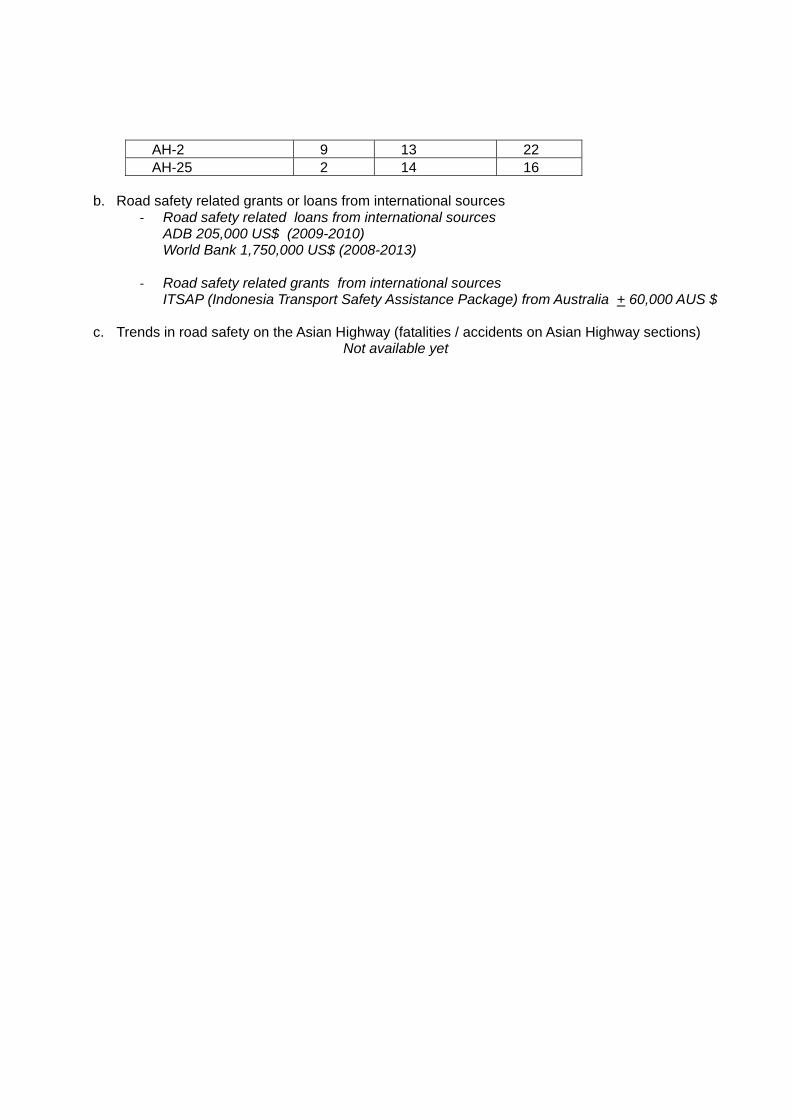
AH-2 9 13 22 AH-25 2 14 16
b. Road safety related grants or loans from international sources
‐ Road safety related loans from international sources ADB 205,000 US$ (2009-2010) World Bank 1,750,000 US$ (2008-2013)
‐ Road safety related grants from international sources ITSAP (Indonesia Transport Safety Assistance Package) from Australia + 60,000 AUS $
c. Trends in road safety on the Asian Highway (fatalities / accidents on Asian Highway sections)
Not available yet
Related Documents