Status and Plans at CDAAC for Providing Near Real-time Ionospheric Data Products from COSMIC Stig Syndergaard William S. Schreiner Christian Rocken Douglas C. Hunt COSMIC Project Office University Corporation for Atmospheric Research Second GPS RO Data Users’ Workshop, 22–24 August 2005, Lansdowne, VA

Welcome message from author
This document is posted to help you gain knowledge. Please leave a comment to let me know what you think about it! Share it to your friends and learn new things together.
Transcript

Status and Plans at CDAAC for ProvidingNear Real-time Ionospheric Data Products
from COSMIC
Stig Syndergaard
William S. Schreiner
Christian Rocken
Douglas C. Hunt
COSMIC Project Office
University Corporation for Atmospheric Research
Second GPS RO Data Users’ Workshop, 22–24 August 2005, Lansdowne, VA
COSMIC Ionospheric Measurements
GPS receiver:{
Total Electron Content (TEC) to all GPS satellites in viewIonospheric radio occultations (profiles) & scintillations
Tiny Ionospheric Photometer (TIP): Ultra-violet emission from ionosphere
Tri-Band Beacon (TBB): TEC & scintillations on satellite-to-ground links

COSMIC Ionospheric Measurements
Total Electron Content measurements:
• High-resolution (1 Hz) TEC to all GPS satellites in view at all times
• Can track up to 12 GPS satellites at the same time (9 aft + 4 fore)
• Useful for global ionospheric tomography and data assimilation

COSMIC Ionospheric Measurements
Ionospheric GPS occultation measurements:
• High-resolution (1 Hz) occultation TEC below orbit altitude
• Ionospheric electron density profiles from orbit altitude and down
• Ionospheric scintillations using the two limb antennas (50 Hz)
COSMIC Ionospheric Measurements
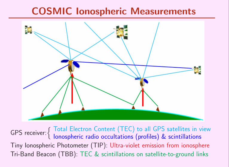
Tiny Ionospheric Photometer measurements:
• Emission (1356 A) due to recombination of oxygen ions and electrons
• Nadir intensity along sub-satellite track – proportional to∫
N 2e dz
• High quality data on night-side – uncertainty about day-side quality

COSMIC Ionospheric Measurements
Tri-Band Beacon measurements:
• Radio signals transmitted from COSMIC at 150, 400, and 1067 MHz
• TEC between the COSMIC satellites and chains of ground receivers
• Amplitude and phase scintillations on the satellite-to-ground links
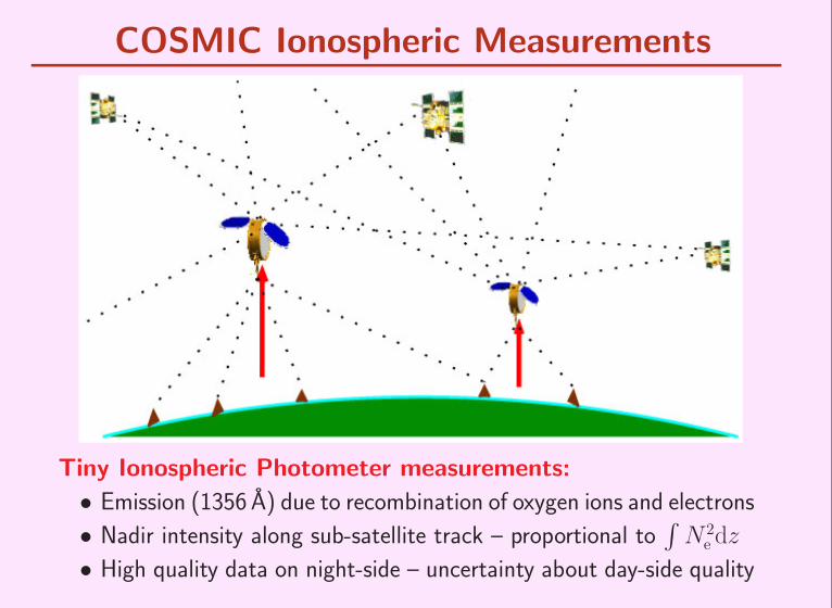
Ionospheric Data from CHAMP, Oct 29 2003
0
50
100
150
200
250
Ele
vatio
n an
gle
(deg
)
TECU
0:00 UT 1:00 UT 2:00 UT 3:00 UT 4:00 UT 5:00 UT 6:00 UT 7:00 UT 8:00 UT 9:00 UT 10:00 UT 11:00 UT 12:00 UT
20
30
40
50
60
70
80
90
0
0.5
1
1.5
2
2.5
3
3.5
4
0:00 UT 1:00 UT 2:00 UT 3:00 UT 4:00 UT 5:00 UT 6:00 UT 7:00 UT 8:00 UT 9:00 UT 10:00 UT 11:00 UT 12:00 UT 0
0.5
1
1.5
2
2.5
3
3.5
4
Ele
ctro
n de
nsity
(106 cm
-3)
Ele
ctro
n de
nsity
(106 cm
-3)
CHAMP Langmuir ProbeCHAMP Occultation data
0
50
100
150
200
250
300
350
400
450
0 1 2 3
Alti
tude
(km
)
Electron density. (106cm-3)
00:39 UT00:45 UT01:05 UT01:20 UT01:35 UT02:33 UT
0 1 2 3Electron density
. (106cm-3)
02:44 UT02:56 UT03:33 UT03:41 UT03:51 UT04:01 UT
0 1 2 3Electron density
. (106cm-3)
04:22 UT04:27 UT04:40 UT05:04 UT05:14 UT05:33 UT
0 1 2 3Electron density
. (106cm-3)
05:49 UT06:06 UT06:22 UT06:34 UT06:42 UT06:58 UT
0 1 2 3Electron density
. (106cm-3)
07:24 UT07:35 UT07:50 UT08:27 UT08:37 UT09:17 UT
0 1 2 3 0
50
100
150
200
250
300
350
400
450
Alti
tude
(km
)
Electron density. (106cm-3)
10:09 UT10:31 UT11:33 UT11:38 UT12:02 UT12:28 UT

16 Months of Data – 44 000 Comparisons
1000
10000
100000
1e+06
1e+07
1000 10000 100000 1e+06 1e+07
Ele
ctro
n de
nsity
(cm
-3) -
Occ
ulta
tion
data
Electron density (cm-3) - Langmuir Probe
RMS = 1.3•105 cm-3
Correlation = 0.95

CHAMP Differential Code Bias
-21
-20.5
-20
-19.5
-19
-18.5
-18
-17.5
-17
280 290 300 310 320 330
CH
AM
P D
CB
(TE
CU
)
Day of year, 2003
next day prediction
• Based on simple assumptions (e.g., azimuthal symmetry above LEO)
• Single day estimates based on 24 hr average – next day prediction(for near real-time processing) based on smoothing over 50 days
• For COSMIC there will be 6×2 DCBs to solve for

CHAMP Ionospheric Scintillation Map
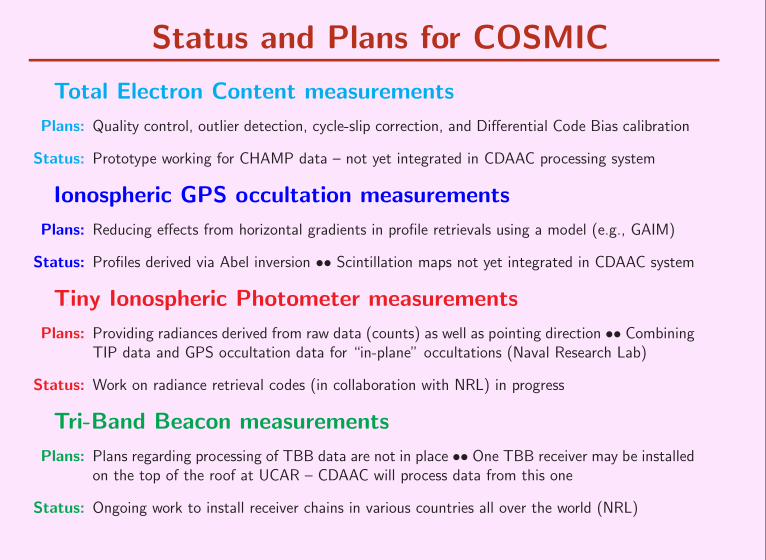
Status and Plans for COSMIC
Total Electron Content measurements
Plans: Quality control, outlier detection, cycle-slip correction, and Differential Code Bias calibration
Status: Prototype working for CHAMP data – not yet integrated in CDAAC processing system
Ionospheric GPS occultation measurements
Plans: Reducing effects from horizontal gradients in profile retrievals using a model (e.g., GAIM)
Status: Profiles derived via Abel inversion •• Scintillation maps not yet integrated in CDAAC system
Tiny Ionospheric Photometer measurements
Plans: Providing radiances derived from raw data (counts) as well as pointing direction •• CombiningTIP data and GPS occultation data for “in-plane” occultations (Naval Research Lab)
Status: Work on radiance retrieval codes (in collaboration with NRL) in progress
Tri-Band Beacon measurements
Plans: Plans regarding processing of TBB data are not in place •• One TBB receiver may be installedon the top of the roof at UCAR – CDAAC will process data from this one
Status: Ongoing work to install receiver chains in various countries all over the world (NRL)

COSMIC Data Products and Formats
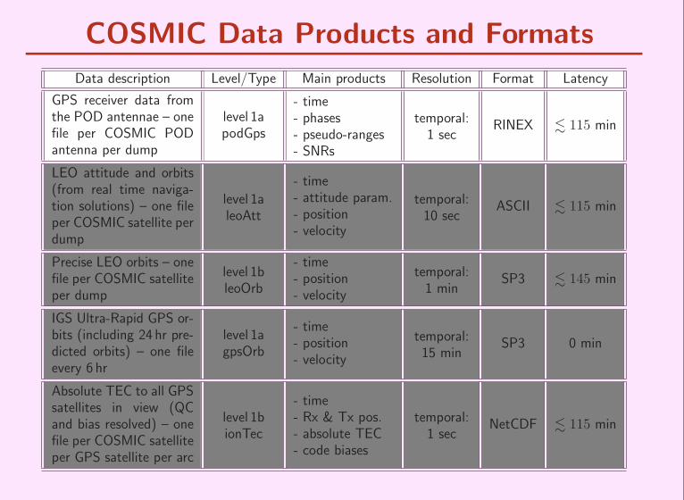
COSMIC Data Products and Formats
Data description Level/Type Main products Resolution Format Latency
GPS receiver data fromthe POD antennae – onefile per COSMIC PODantenna per dump
level 1apodGps
- time- phases- pseudo-ranges- SNRs
temporal:1 sec
RINEX . 115 min
LEO attitude and orbits(from real time naviga-tion solutions) – one fileper COSMIC satellite perdump
level 1aleoAtt
- time- attitude param.- position- velocity
temporal:10 sec
ASCII . 115 min
Precise LEO orbits – onefile per COSMIC satelliteper dump
level 1bleoOrb
- time- position- velocity
temporal:1 min
SP3 . 145 min
IGS Ultra-Rapid GPS or-bits (including 24 hr pre-dicted orbits) – one fileevery 6 hr
level 1agpsOrb
- time- position- velocity
temporal:15 min
SP3 0 min
Absolute TEC to all GPSsatellites in view (QCand bias resolved) – onefile per COSMIC satelliteper GPS satellite per arc
level 1bionTec
- time- Rx & Tx pos.- absolute TEC- code biases
temporal:1 sec
NetCDF . 115 min
COSMIC Data Products and Formats
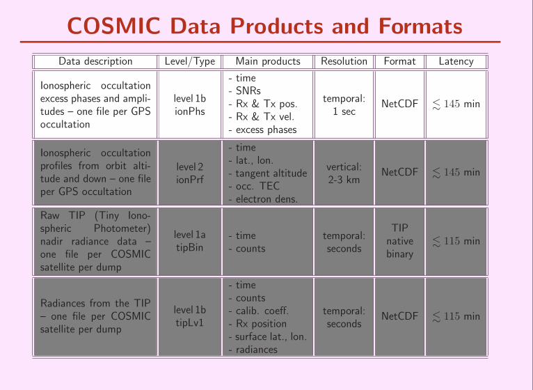
Data description Level/Type Main products Resolution Format Latency
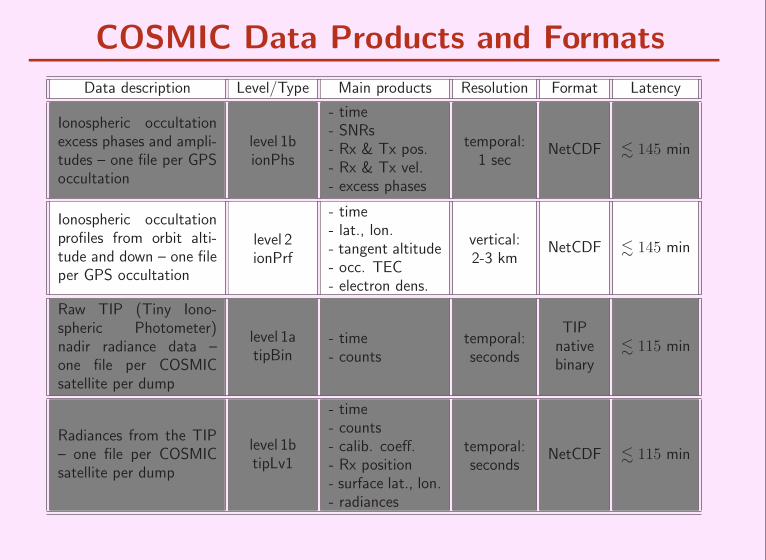
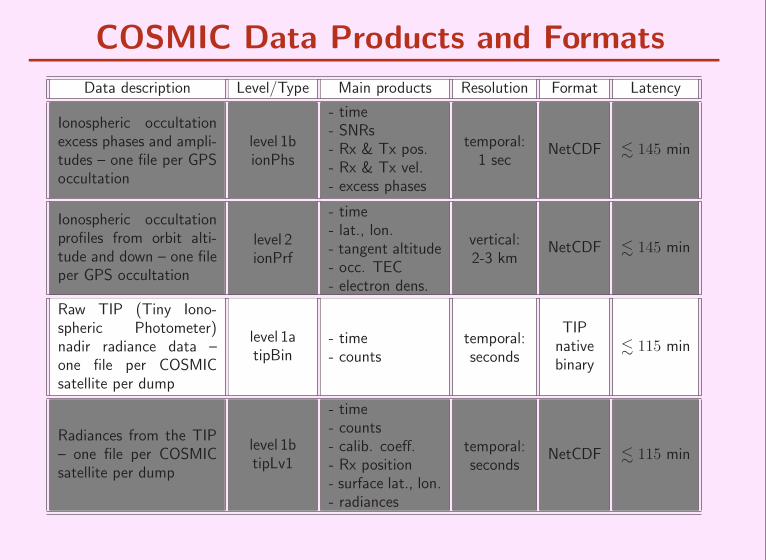
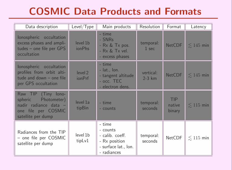
Ionospheric occultationexcess phases and ampli-tudes – one file per GPSoccultation
level 1bionPhs
- time- SNRs- Rx & Tx pos.- Rx & Tx vel.- excess phases
temporal:1 sec
NetCDF . 145 min
Ionospheric occultationprofiles from orbit alti-tude and down – one fileper GPS occultation
level 2ionPrf
- time- lat., lon.- tangent altitude- occ. TEC- electron dens.
vertical:2-3 km
NetCDF . 145 min
Raw TIP (Tiny Iono-spheric Photometer)nadir radiance data –one file per COSMICsatellite per dump
level 1atipBin
- time- counts
temporal:seconds
TIPnativebinary
. 115 min
Radiances from the TIP– one file per COSMICsatellite per dump
level 1btipLv1
- time- counts- calib. coeff.- Rx position- surface lat., lon.- radiances
temporal:seconds
NetCDF . 115 min
COSMIC Data Products and Formats
Data description Level/Type Main products Resolution Format Latency
Ionospheric occultationexcess phases and ampli-tudes – one file per GPSoccultation
level 1bionPhs
- time- SNRs- Rx & Tx pos.- Rx & Tx vel.- excess phases
temporal:1 sec
NetCDF . 145 min
Ionospheric occultationprofiles from orbit alti-tude and down – one fileper GPS occultation
level 2ionPrf
- time- lat., lon.- tangent altitude- occ. TEC- electron dens.
vertical:2-3 km
NetCDF . 145 min
Raw TIP (Tiny Iono-spheric Photometer)nadir radiance data –one file per COSMICsatellite per dump
level 1atipBin
- time- counts
temporal:seconds
TIPnativebinary
. 115 min
Radiances from the TIP– one file per COSMICsatellite per dump
level 1btipLv1
- time- counts- calib. coeff.- Rx position- surface lat., lon.- radiances
temporal:seconds
NetCDF . 115 min

Summary
• Three instruments on board each COSMIC satellite will provide iono-
spheric data:
– GPS receiver: TEC, electron density profiles, and scintillations
– TIP: Nadir intensity from radiative recombination emission along
the sub-satellite track
– TBB: TEC and scintillations on satellite-to-ground links
• COSMIC will provide an unprecedented large amount of ionospheric
data useful for data assimilation into space weather models and
ionospheric research in general
• Feedback very welcome on planed near real-time ionospheric data
products and formats
• We also need to discuss ionospheric data distribution. . .
Related Documents