Page 1 of 83 KINGDOM OF CAMBODIA Nation Religion King MRC-Water Quality Monitoring Station Network Review Station Profiles of Water Quality Monitoring Network in Cambodia Consultancy Report By Ms. Nhim Sophea Water Quality Monitoring Specialist Phnom Penh September – 2003

Welcome message from author
This document is posted to help you gain knowledge. Please leave a comment to let me know what you think about it! Share it to your friends and learn new things together.
Transcript
Page 1 of 83
KINGDOM OF CAMBODIA
Nation Religion King
MRC-Water Quality Monitoring Station Network Review
Station Profiles of Water Quality Monitoring Network in Cambodia
Consultancy Report
By
Ms. Nhim Sophea Water Quality Monitoring Specialist
Phnom Penh September – 2003
Page 2 of 83
TABLE OF CONTENTS ACRONYMS AND ABBREVATION I. INTRODUCTION II. OBJECTIVE REVIEW III. REVIEW METHODOLOGY IV CURRENT SITUATION OF WATER QUALITY MONITORING SYSTEM
4.1. Monitoring Station Network 4.2. Laboratory Facilities 4.3. Database and Analysis 4.4. Institutional Arrangement for Water Quality Monitoring
V. EVALUATION OF THE EXSITING NETWORK AND PROPOSED STATIONS
5.1. Exiting Station Network 5.2. Proposed Station Network 5.3. Conclusion and Recommendation
REFERENCES LIST OF TABLES
Table 1 Existing Water Quality Monitoring Station Network in Cambodia Table 2 Water Quality Parameters and Corresponding Testing Methods Table 3 Data Files Format Reported to MRCS Table 4 Summaries of Agencies Likely Related to Water Quality Monitoring Table 5 Proposed Stations for the Primary Network Table 6 Proposed Stations for the Secondary Network
ANNEXES
Annex 1. Term of Reference for MRC-WQM Station Network Review – Cambodia National Activity
Annex 2. List of People and Agencies Consulted Annex 3. Summary of the Existing and Proposed Stations for the Water Quality Monitoring
Network in Cambodia Annex 4. Profiles of the New Proposed Stations for the Primary Network Annex 5. Profiles of the New Proposed Stations for the Secondary Network
Page 3 of 83
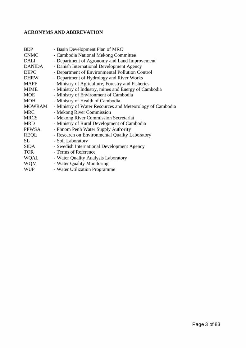
ACRONYMS AND ABBREVATION
BDP - Basin Development Plan of MRC CNMC - Cambodia National Mekong Committee DALI - Department of Agronomy and Land Improvement DANIDA - Danish International Development Agency DEPC - Department of Environmental Pollution Control DHRW - Department of Hydrology and River Works MAFF - Ministry of Agriculture, Forestry and Fisheries MIME - Ministry of Industry, mines and Energy of Cambodia MOE - Ministry of Environment of Cambodia MOH - Ministry of Health of Cambodia MOWRAM - Ministry of Water Resources and Meteorology of Cambodia MRC - Mekong River Commission MRCS - Mekong River Commission Secretariat MRD - Ministry of Rural Development of Cambodia PPWSA - Phnom Penh Water Supply Authority REQL - Research on Environmental Quality Laboratory SL - Soil Laboratory SIDA - Swedish International Development Agency TOR - Terms of Reference WQAL - Water Quality Analysis Laboratory WQM - Water Quality Monitoring WUP - Water Utilization Programme
Page 4 of 83
I. INTRODUCTION The water quality monitoring station network in Cambodia was mainly established and implemented in 1993 in streamlining with the implementation and as the integral part of the MRC Water Quality Monitoring Programme in the Lower Mekong Basin. It should be noted that the MRC Water Quality Monitoring Programme had started its implementation in another three member countries (Lao PDR, Thailand and Vietnam) since 1985, i.e. eight years earlier than in Cambodia. The rational that was used for station selection at that time was to include the most important locations on the Mekong, Tonle Sap and Bassac Rivers (for trans-boundary issues) and tributary locations that represented areas of potentially greatest impact from upstream land use and economic developments. Specific criteria were not established for each station however the network was developed for the following purposes:
• Developing trans-boundary loadings of various chemicals, • Developing chemical loadings into Mekong from various major tributaries, • Representing locations of significant local impacts from land use, and • Sediment transport and loadings.
Even there was a series of reviews to the water quality monitoring programme of MRC in years later on it seems that there has not been a systematic and comprehensive technical review of the station network since it was originally established. The result of the review of the water quality programme, including related laboratory activities in 1997 by MRC has presented at a regional workshop in Loung Prabang. It was recommended that the network needed to be reviewed in light of current conditions and in light of the new MRC mandate to focus on basin-wide and trans-boundary issues. The review expressed doubt of the ability of the existing programme to adequately characterize trans-boundary water quality issues and there seemed to be no rational for many of the stations of the current network. According to the contract No. 504/2002 dated April 2002 and signed between MRCS and CNMC to conduct the inventory and to review of the existing station profiles of Lower Mekong water quality monitoring network part in Cambodia including the recommendation for the primary and secondary networks. The Cambodian experts have been sub-contracted by the Cambodia National Mekong Committee as the local consultants to assess and review the existing water quality monitoring station network in Cambodia. National consultants provide a review of the current network and recommended a group of stations, according to criteria provided by MRC, to the CNMC. Based on the review and analysis of the current status of the existing water quality monitoring network in Cambodia a number of recommendations would be proposed as baseline information on which stations the primary and secondary networks should be for Cambodia. MRC will organize a regional workshop to discuss the final basin-wide selection of Primary Stations. Annex 1 shows the TOR for MRC – WQM station network review as Cambodian national activity. This report describes the current status of the existing water quality monitoring stations in Cambodia as integral part of the Lower Mekong Water Quality Monitoring Network. It provides also the information on procedures and protocols for sampling activities and the recommended stations for Primary and Secondary Networks.
Page 5 of 83
II. OBJECTIVES OF THE REVIEW After many years of operation of the water quality-monitoring network, there has been many institutional changes, significant changes in national and regional development activities, and great improvements in knowledge and technologies about water quality issues. Therefore, it is prudent to review the station network to determine which stations meet specific trans-boundary or local/regional needs for water quality information; whether new stations can be eliminated from or added to the network, and if there are more cost-effective ways of obtaining water quality data and information. The three principal attributes to be kept in mind in the review process are:
• Relevancy of data to some identified management purposes, • Efficiency in obtaining and utilizing data, and • Sustainability in the longer term run.
The objectives of this review are: - To review the existing water quality monitoring stations in Cambodia including station profiles, and - To develop a set of recommended WQM stations for Cambodia for each of the primary and secondary networks based on the existing network as a starting point. III. REVIEW METHODOLOGY In order to ensure that the final observations and recommendations reflected all of the views of the stakeholders, the following activities were taken into considerations during the review process:
• Several field visits were made to the existing and proposed stations. The field visits included the observation of water level, survey of immediate land use and human development activities nearby and surrounding the sampling sites, rechecking the positional coordinates of the stations by using field GPS, measuring the cross sections profile and taking photographs of the sites,
• Meeting with local and provincial people and concerned competent authorities. It included the discussion with personnel in provincial departments and authorities who are involved in and are responsible for related data collection and management, and
• Reviewing of all findings and recommendations with CNMC. As part of the review process, the data collection programme of other national agencies was considered, as there may be good reasons to economize by using existing data generated by programme of other agencies. The List of people and agencies consulted is shown in Annex 2.
Page 6 of 83
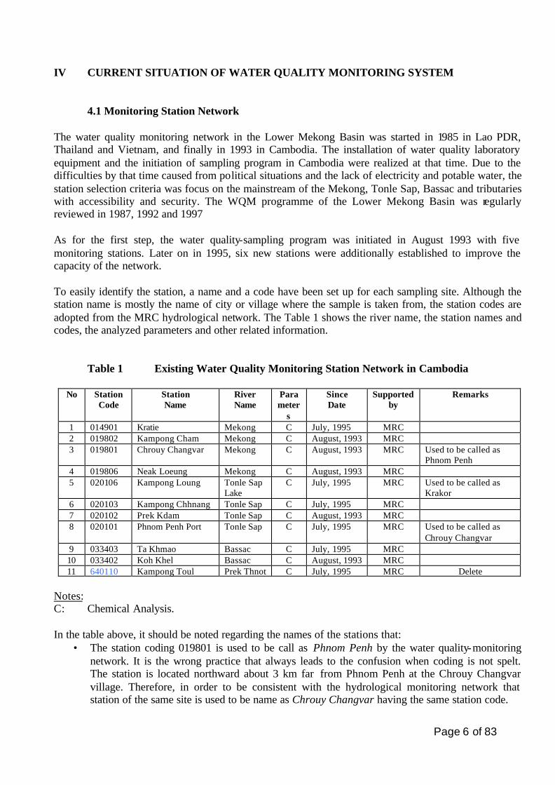
IV CURRENT SITUATION OF WATER QUALITY MONITORING SYSTEM 4.1 Monitoring Station Network
The water quality monitoring network in the Lower Mekong Basin was started in 1985 in Lao PDR, Thailand and Vietnam, and finally in 1993 in Cambodia. The installation of water quality laboratory equipment and the initiation of sampling program in Cambodia were realized at that time. Due to the difficulties by that time caused from political situations and the lack of electricity and potable water, the station selection criteria was focus on the mainstream of the Mekong, Tonle Sap, Bassac and tributaries with accessibility and security. The WQM programme of the Lower Mekong Basin was regularly reviewed in 1987, 1992 and 1997 As for the first step, the water quality-sampling program was initiated in August 1993 with five monitoring stations. Later on in 1995, six new stations were additionally established to improve the capacity of the network. To easily identify the station, a name and a code have been set up for each sampling site. Although the station name is mostly the name of city or village where the sample is taken from, the station codes are adopted from the MRC hydrological network. The Table 1 shows the river name, the station names and codes, the analyzed parameters and other related information.
Table 1 Existing Water Quality Monitoring Station Network in Cambodia
No Station Code
Station Name
River Name
Parameter
s
Since Date
Supported by
Remarks
1 014901 Kratie Mekong C July, 1995 MRC 2 019802 Kampong Cham Mekong C August, 1993 MRC 3 019801 Chrouy Changvar Mekong C August, 1993 MRC Used to be called as
Phnom Penh 4 019806 Neak Loeung Mekong C August, 1993 MRC 5 020106 Kampong Loung Tonle Sap
Lake C July, 1995 MRC Used to be called as
Krakor 6 020103 Kampong Chhnang Tonle Sap C July, 1995 MRC 7 020102 Prek Kdam Tonle Sap C August, 1993 MRC 8 020101 Phnom Penh Port Tonle Sap C July, 1995 MRC Used to be called as
Chrouy Changvar 9 033403 Ta Khmao Bassac C July, 1995 MRC 10 033402 Koh Khel Bassac C August, 1993 MRC 11 640110 Kampong Toul Prek Thnot C July, 1995 MRC Delete
Notes: C: Chemical Analysis. In the table above, it should be noted regarding the names of the stations that:
• The station coding 019801 is used to be call as Phnom Penh by the water quality-monitoring network. It is the wrong practice that always leads to the confusion when coding is not spelt. The station is located northward about 3 km far from Phnom Penh at the Chrouy Changvar village. Therefore, in order to be consistent with the hydrological monitoring network that station of the same site is used to be name as Chrouy Changvar having the same station code.
Page 7 of 83
• Similarly, the station coding 020106 used to be named as Krakor a small town on the National Road No. 5 to Pursat. To be consistent with the hydrological monitoring network it should be recorded as Kampong Loung with the same station code the name of a floating village in the Tonle Sap Lake where exactly the location of the station is.
• Finally, the station called Chrouy Changvar having code 020101 is incorrect. This name may come after the bridge to Chrouy Changvar village was built in the past. To be consistent with the hydrological network it is recommended to name that station which having the same code and location as Phnom Penh Port.
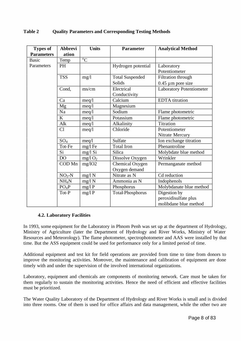
Samples are collected at the stations for on-site testing and/or for transportation to MOWRAM laboratory in Phnom Penh. For the Phnom Penh destination samples are preserved carefully according to the technical prescriptions. The frequency of collection of samples is once a month for each station. The samples are for general analysis, for Ions, Chemical Oxygen Demand (COD) and Dissolved Oxygen (DO) determination. The samples for DO are taken to the laboratory when the on-site analysis could not be performed properly, which is caused from some technical problem. The water quality parameters are chosen according to the importance of the monitoring objectives. Nineteen water quality parameters are accepted for the routine WQM analysis. The Table 2 shows the water quality analysis parameters performed by the laboratory. Although, some parameters include temperature, pH and conductivity are determined on site. The other sixteen parameters, which are mainly ions content and nutrients parameters, are carried out in the laboratory in Phnom Penh. However, the microbiological determination was performed for a short period of time in 1997. The reasons left behind were not the technical capabilities but the difficulties and hardness of getting the chemical reagents and the financial assistant for these activities. Moreover, since the installation of an Atomic Absorption Spectrometer in the laboratory in 2001, no heavy metal could be analyzed. This was because of the lacking of spare parts and chemicals supplies. To determine pesticides by using the gas chromatography (GC) could be considered. Hence the MOWRAM has the intention to include them into the parameters list for the WQM programme in the future. The methods used for sampling, sample preservation and analyzing are adopted from the Standard Method for the Examination of Water and Wastewater and the Water Quality Sampling Manuals.
Page 8 of 83
Table 2 Quality Parameters and Corresponding Testing Methods
Types of Parameters
Abbreviation
Units Parameter Analytical Method
Temp oC PH Hydrogen potential Laboratory
Potentiometer TSS mg/l Total Suspended
Solids Filtration through 0.45 µm pore size
Cond, ms/cm Electrical Conductivity
Laboratory Potentiometer
Ca meq/l Calcium EDTA titration Mg meq/l Magnesium Na meq/l Sodium Flame photometric K meq/l Potassium Flame photometric Alk meq/l Alkalinity Titration Cl meq/l Chloride Potentiometer
Nitrate Mercury SO4 meq/l Sulfate Ion exchange titration Tot-Fe mg/l Fe Total Iron Phenantroline Si mg/l Si Silica Molybdate blue method DO mg/l O2 Dissolve Oxygen Wrinkler COD Mn mg/lO2 Chemical Oxygen
Oxygen demand Permanganate method
NO3-N mg/l N Nitrate as N Cd reduction NH4N mg/l N Ammonia as N Indophenols PO4P mg/l P Phosphorus Molybdanate blue method
Basic Parameters
Tot-P mg/l P Total-Phosphorus Digestion by peroxidisulfate plus molibdane blue method
4.2. Laboratory Facilities
In 1993, some equipment for the Laboratory in Phnom Penh was set up at the department of Hydrology, Ministry of Agriculture (later the Department of Hydrology and River Works, Ministry of Water Resources and Meteorology). The flame photometer, spectrophotometer and AAS were installed by that time. But the ASS equipment could be used for performance only for a limited period of time. Additional equipment and test kit for field operations are provided from time to time from donors to improve the monitoring activities. Moreover, the maintenance and calibration of equipment are done timely with and under the supervision of the involved international organizations. Laboratory, equipment and chemicals are components of monitoring network. Care must be taken for them regularly to sustain the monitoring activities. Hence the need of efficient and effective facilities must be prioritized. The Water Quality Laboratory of the Department of Hydrology and River Works is small and is divided into three rooms. One of them is used for office affairs and data management, while the other two are
Page 9 of 83
used for performing the analysis. The two analysis rooms cover an area of around 30 m2 and are for the installation of equipment for performing the analysis. Following an MOU between CNMC and MRCS on water quality laboratory, MOWRAM with a fund from the Government is now constructing a new laboratory at the new location. The new building is located near Bassac River. It is the annex of the DHRW. The new laboratory, with a space of 24 m x 24 m, will be ready by the end of year 2003. According to the above mentioning MOU, MRC as part of its Environment Programme and within its budget capacity will provide appropriate equipment for water quality monitoring and training to enhance technical and managerial capacity of the laboratory personnel as well as will develop and implement a programme of quality assurance in order to ensure that data provided by the laboratory will meet the basic standards of data reliability. The supply of chemicals and reagent for running the analysis are very limited even MRCS is running its Environment Programme with huge amount of money. Some analysis could not be done because the chemicals and reagents were used up and/or could not be used because of the expired date. A missing period of about 143 stations/months routine sampling from July 1998 to August 1999 indicates clearly of this situation. The important fund founders for the water quality monitoring works are the MRC, SIDA, DANIDA, etc.
4.3. Database and Analysis
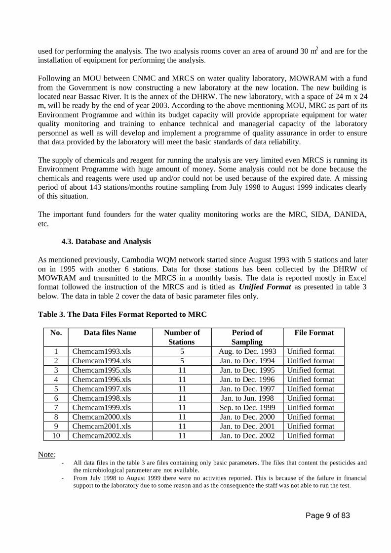
As mentioned previously, Cambodia WQM network started since August 1993 with 5 stations and later on in 1995 with another 6 stations. Data for those stations has been collected by the DHRW of MOWRAM and transmitted to the MRCS in a monthly basis. The data is reported mostly in Excel format followed the instruction of the MRCS and is titled as Unified Format as presented in table 3 below. The data in table 2 cover the data of basic parameter files only. Table 3. The Data Files Format Reported to MRC
No. Data files Name Number of Stations
Period of Sampling
File Format
1 Chemcam1993.xls 5 Aug. to Dec. 1993 Unified format 2 Chemcam1994.xls 5 Jan. to Dec. 1994 Unified format 3 Chemcam1995.xls 11 Jan. to Dec. 1995 Unified format 4 Chemcam1996.xls 11 Jan. to Dec. 1996 Unified format 5 Chemcam1997.xls 11 Jan. to Dec. 1997 Unified format 6 Chemcam1998.xls 11 Jan. to Jun. 1998 Unified format 7 Chemcam1999.xls 11 Sep. to Dec. 1999 Unified format 8 Chemcam2000.xls 11 Jan. to Dec. 2000 Unified format 9 Chemcam2001.xls 11 Jan. to Dec. 2001 Unified format 10 Chemcam2002.xls 11 Jan. to Dec. 2002 Unified format
Note:
- All data files in the table 3 are files containing only basic parameters. The files that content the pesticides and the microbiological parameter are not available.
- From July 1998 to August 1999 there were no activities reported. This is because of the failure in financial support to the laboratory due to some reason and as the consequence the staff was not able to run the test.
Page 10 of 83
4.4. Institutional Arrangement for Water Quality Monitoring
• The Ministry of Water Resources and Meteorology is the key central agency acting through its six technical departments towards water resources development and management throughout the country such as research and investigations of water resources, prepare plans for water resources development and conservation, gather and manage data and information about surface water, groundwater, administer international collaboration, including that within the Mekong River basin. Among them, the Department of Hydrology and River Works is nation-wide responsible for water quality monitoring and management, hydrological monitoring network management and development, flood forecasting, flood management and mitigation and other water-related investigations, etc. The Water Quality Analysis Office and its Laboratory has a specific responsibility for water quality monitoring and management nationwide. This laboratory has been working with the collaboration, technical and financial supports from MRC since 1993 till now and continues in the future. The Water Quality Laboratory of the MOWRAM is a designated institution for MRC through its environment Programme. Meanwhile the specific responsibilities are located with a range of government agencies.
• The Ministry of Environment is responsible for protection of natural resources and environmental quality from degradation. Through the Research of Environmental Quality Laboratory of the Department of Environment Pollution Control, it implements the environmental quality programme. The objective of this Laboratory is to research and investigate the environment quality, especially on air pollution and wastewater from point source and non-point source pollution. The point source pollution is such as from factories, hospitals, and other specific pollution sources. Nine wastewater quality stations have been set up and controlled by this laboratory since 1999 through the supports by JICA. • The Ministry of Industrial Mines and Energy is responsible for planning industrial water uses and hydropower, provision of water supply to provincial towns, preparation of policy on water supply and sanitation. Through the foods and drinks laboratory under the Industrial Techniques Department it analyses the quality of foods and drinks. The laboratory’s objectives are to control the industrial effluent, water used for industries and handicrafts purposes and water supply both in the cities and towns. • Phnom Penh Water Supply Authority: Through the laboratory of the Design Office of the Technical Planning Department it is responsible for drinking water supply in Phnom Penh.
Page 11 of 83
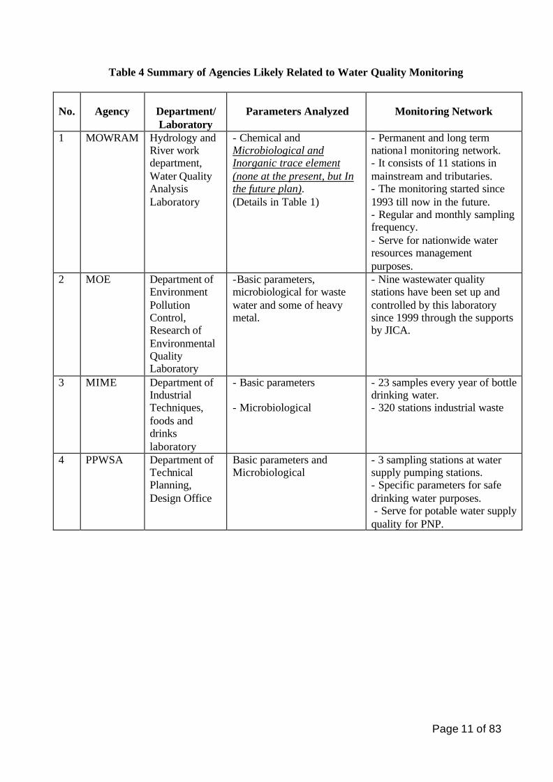
Table 4 Summary of Agencies Likely Related to Water Quality Monitoring
No.
Agency
Department/ Laboratory
Parameters Analyzed
Monitoring Network
1 MOWRAM Hydrology and River work department, Water Quality Analysis Laboratory
- Chemical and Microbiological and Inorganic trace element (none at the present, but In the future plan). (Details in Table 1)
- Permanent and long term national monitoring network. - It consists of 11 stations in mainstream and tributaries. - The monitoring started since 1993 till now in the future. - Regular and monthly sampling frequency. - Serve for nationwide water resources management purposes.
2 MOE Department of Environment Pollution Control, Research of Environmental Quality Laboratory
-Basic parameters, microbiological for waste water and some of heavy metal.
- Nine wastewater quality stations have been set up and controlled by this laboratory since 1999 through the supports by JICA.
3 MIME Department of Industrial Techniques, foods and drinks laboratory
- Basic parameters - Microbiological
- 23 samples every year of bottle drinking water. - 320 stations industrial waste
4 PPWSA Department of Technical Planning, Design Office
Basic parameters and Microbiological
- 3 sampling stations at water supply pumping stations. - Specific parameters for safe drinking water purposes. - Serve for potable water supply quality for PNP.
Page 12 of 83
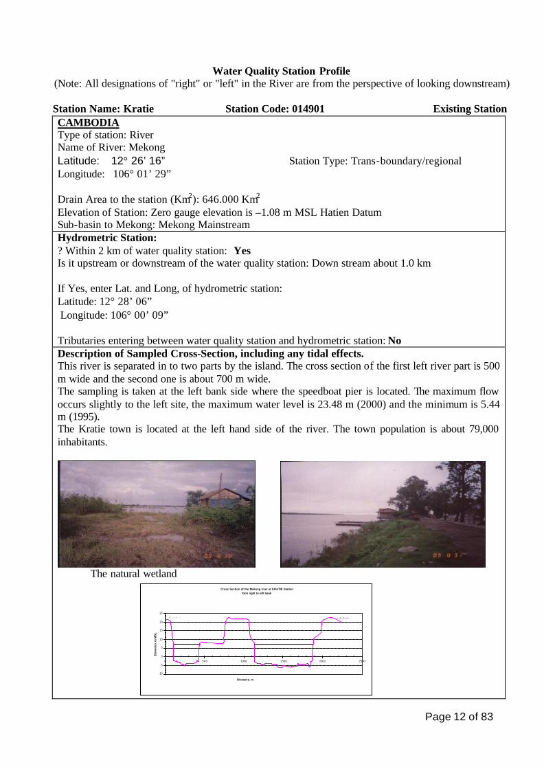
Water Quality Station Profile (Note: All designations of "right" or "left" in the River are from the perspective of looking downstream)
Station Name: Kratie Station Code: 014901 Existing Station CAMBODIA Type of station: River Name of River: Mekong Latitude: 12° 26’ 16” Station Type: Trans-boundary/regional Longitude: 106° 01’ 29” Drain Area to the station (Km2): 646.000 Km2
Elevation of Station: Zero gauge elevation is –1.08 m MSL Hatien Datum Sub-basin to Mekong: Mekong Mainstream Hydrometric Station: ? Within 2 km of water quality station: Yes Is it upstream or downstream of the water quality station: Down stream about 1.0 km If Yes, enter Lat. and Long, of hydrometric station: Latitude: 12° 28’ 06” Longitude: 106° 00’ 09” Tributaries entering between water quality station and hydrometric station: No Description of Sampled Cross-Section, including any tidal effects. This river is separated in to two parts by the island. The cross section of the first left river part is 500 m wide and the second one is about 700 m wide. The sampling is taken at the left bank side where the speedboat pier is located. The maximum flow occurs slightly to the left site, the maximum water level is 23.48 m (2000) and the minimum is 5.44 m (1995). The Kratie town is located at the left hand side of the river. The town population is about 79,000 inhabitants.
The natural wetland
Cross Section of the Mekong river at KRATIE Stationform right to left bank
-10
-5
0
5
10
15
20
25
0 500 1000 1500 2000 2500
Distance, m
Ele
vati
on
, m M
SL
Right Bank Left Bank
Page 13 of 83
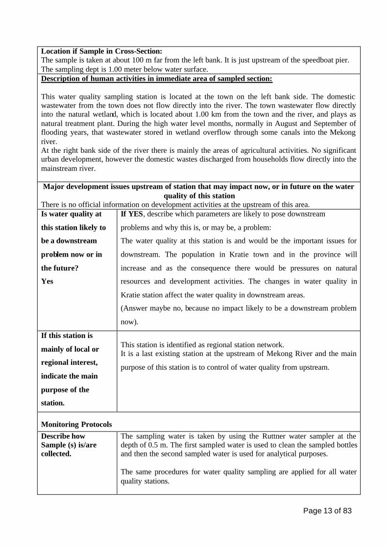
Location if Sample in Cross-Section: The sample is taken at about 100 m far from the left bank. It is just upstream of the speedboat pier. The sampling dept is 1.00 meter below water surface. Description of human activities in immediate area of sampled section: This water quality sampling station is located at the town on the left bank side. The domestic wastewater from the town does not flow directly into the river. The town wastewater flow directly into the natural wetland, which is located about 1.00 km from the town and the river, and plays as natural treatment plant. During the high water level months, normally in August and September of flooding years, that wastewater stored in wetland overflow through some canals into the Mekong river. At the right bank side of the river there is mainly the areas of agricultural activities. No significant urban development, however the domestic wastes discharged from households flow directly into the mainstream river. Major development issues upstream of station that may impact now, or in future on the water
quality of this station There is no official information on development activities at the upstream of this area. Is water quality at
this station likely to
be a downstream
problem now or in
the future?
Yes
If YES, describe which parameters are likely to pose downstream
problems and why this is, or may be, a problem:
The water quality at this station is and would be the important issues for
downstream. The population in Kratie town and in the province will
increase and as the consequence there would be pressures on natural
resources and development activities. The changes in water quality in
Kratie station affect the water quality in downstream areas.
(Answer maybe no, because no impact likely to be a downstream problem
now).
If this station is
mainly of local or
regional interest,
indicate the main
purpose of the
station.
This station is identified as regional station network. It is a last existing station at the upstream of Mekong River and the main
purpose of this station is to control of water quality from upstream.
Monitoring Protocols Describe how Sample (s) is/are collected.
The sampling water is taken by using the Ruttner water sampler at the depth of 0.5 m. The first sampled water is used to clean the sampled bottles and then the second sampled water is used for analytical purposes. The same procedures for water quality sampling are applied for all water quality stations.
Page 14 of 83
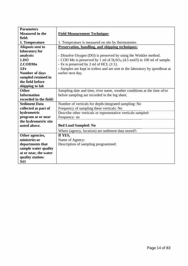
Parameters Measured in the field: 1. Temperature
Field Measurement Technique: 1. Temperature is measured on site by thermometer.
Aliquots sent to laboratory for analysis: 1.DO 2.CODMn 3.Fe Number of days sampled retained in the field before shipping to lab
Preservation, handling, and shipping techniques: - Dissolve Oxygen (DO) is preserved by using the Winkler method. - COD Mn is preserved by 1 ml of H2SO4 (4.5 mol/l) in 100 ml of sample. - Fe is preserved by 2 ml of HCL (1:1). - Samples are kept in icebox and are sent to the laboratory by speedboat at earlier next day.
Other Information recorded in the field:
Sampling date and time, river name, weather conditions at the time of/or before sampling are recorded in the log sheet.
Number of verticals for depth- integrated sampling: No Frequency of sampling these verticals: No Describe other verticals or representative verticals sampled: Frequency: no
Bed Load Sampled: No
Sediment Data collected as part of hydrometric program at or near the hydrometric site noted above.
Where (agency, location) are sediment data stored?: Other agencies, ministries or departments that sample water quality at or near, the water quality station: NO
If YES, Name of Agency: Description of sampling programmed:
Page 15 of 83
Water Quality Station Profile (Note: All designations of "right" or "left" in the River are from the perspective of looking downstream)
Station Name: Kampong Cham Station Code: 019802 Existing Station CAMBODIA Type of station: River Name of River: Mekong mainstream Latitude: 11º 59.65’ N Station Type: Trans-boundary/Regional Longitude: 105º 28.13’ E Drain Area to the station (Km2): 660,000 Km2
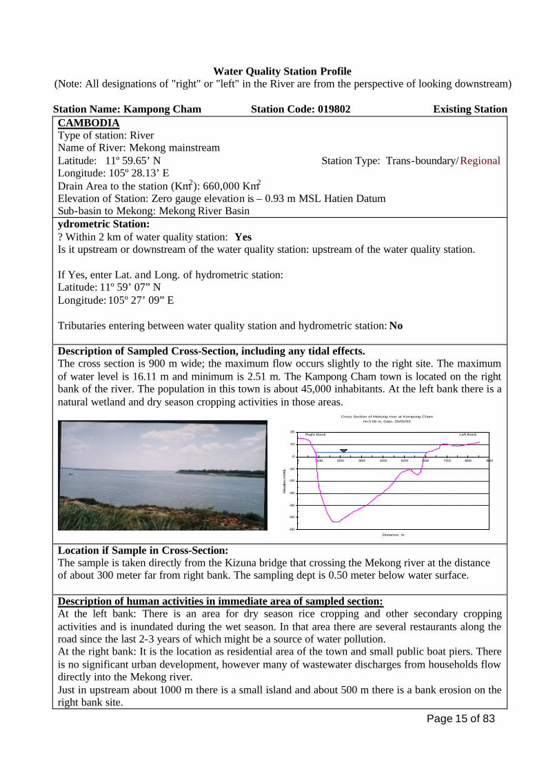
Elevation of Station: Zero gauge elevation is – 0.93 m MSL Hatien Datum Sub-basin to Mekong: Mekong River Basin ydrometric Station: ? Within 2 km of water quality station: Yes Is it upstream or downstream of the water quality station: upstream of the water quality station. If Yes, enter Lat. and Long. of hydrometric station: Latitude: 11º 59’ 07” N Longitude: 105º 27’ 09” E Tributaries entering between water quality station and hydrometric station: No Description of Sampled Cross-Section, including any tidal effects. The cross section is 900 m wide; the maximum flow occurs slightly to the right site. The maximum of water level is 16.11 m and minimum is 2.51 m. The Kampong Cham town is located on the right bank of the river. The population in this town is about 45,000 inhabitants. At the left bank there is a natural wetland and dry season cropping activities in those areas.
Location if Sample in Cross-Section: The sample is taken directly from the Kizuna bridge that crossing the Mekong river at the distance of about 300 meter far from right bank. The sampling dept is 0.50 meter below water surface. Description of human activities in immediate area of sampled section: At the left bank: There is an area for dry season rice cropping and other secondary cropping activities and is inundated during the wet season. In that area there are several restaurants along the road since the last 2-3 years of which might be a source of water pollution. At the right bank: It is the location as residential area of the town and small public boat piers. There is no significant urban development, however many of wastewater discharges from households flow directly into the Mekong river. Just in upstream about 1000 m there is a small island and about 500 m there is a bank erosion on the right bank site.
Cross Section of Mekong river at Kompong ChamH=3.56 m, Date: 20/02/03
-60
-50
-40
-30
-20
-10
0
10
20
0 100 200 300 400 500 600 700 800 900
Distance, m
Eleva
tion,
m M
SL
Right Bank Left Bank
Page 16 of 83
Major development issues upstream of station that may impact now, or in future on the water quality of this station
There is no official information on the development activities at upstream areas and there is only a lowland agriculture and the second cropping activities.
Is water quality
at this station
likely to be a
downstream
problem now or
in the future?
Yes
If YES, describe which parameters are likely to pose downstream problems
and why this is, or may be, a problem:
The water quality at this station might become the important issues for
downstream, because of increasing of population in Kampong Cham town as
well as the overuse of fertilizers in agricultural lands. There is no data on
pesticide and other agricultural chemical agents that would affect to water
quality of the downstream, and this area is high yields of sediment loading, it
needs to be further assessed.
(Answer maybe no, because no impact likely to be a downstream problem now).
If this station is
mainly of local
or regional
interest, indicate
the main
purpose of the
station.
It is identified as regional station network.
The main purpose for this station is to control the fertilizers or nutrients from
agriculture, sedimentation and Microbiological parameters.
Monitoring Protocols Describe how Sample (s) is/are collected.
The sampling water is taken by using the Ruttner water sampler at the depth of 0.5 m. The first sampled water is used to clean the sampled bottles and then the second sampled water is used for analytical purposes. The same procedures for water quality sampling are applied for all water quality stations.
Page 17 of 83
Parameters Measured in the field: 1. Temperature 2. Conductivity
Field Measurement Technique: 1. Temperature is measured on site by thermometer. 2. Conductivity is measured by WTW (Multi- lines P4)
Aliquots sent to laboratory for analysis: 1.DO 2.CODMn 3.Fe Number of days sampled retained in the field before shipping to lab
Preservation, handling, and shipping techniques: - Dissolve Oxygen (DO) has been preserved, by using the Winkler method. - COD Mn has been preserved by 1 ml of H2SO4 (4.5 mol/l) in 100 ml of sample. - Fe is preserved by 2 ml of HCL (1:1) Samples are kept in icebox and are sent to the Lab within the same day.
Other Information recorded in the field:
Sampling date and time, river name, weather conditions at the time of/or before sampling are recorded.
Number of verticals for depth- integrated sampling: No Frequency of sampling these verticals: No Describe other verticals or representative verticals sampled: Frequency: no
Bed Load Sampled: No
Sediment Data collected as part of hydrometric program at or near the hydrometric site noted above.
Where (agency, location) are sediment data stored?:
Other agencies, ministries or departments that sample water quality at or near, the water quality station: NO
If YES, Name of Agency: Description of sampling programmed:
Page 18 of 83
Water Quality Station Profile (Note: All designations of "right" or "left" in the River are from the perspective of looking downstream)
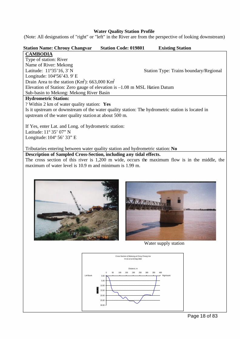
Station Name: Chrouy Changvar Station Code: 019801 Existing Station CAMBODIA Type of station: River Name of River: Mekong Latitude: 11º35’16, 3' N Station Type: Trains boundary/Regional Longitude: 104º56’43. 9' E Drain Area to the station (Km2): 663,000 Km2
Elevation of Station: Zero gauge of elevation is –1.08 m MSL Hatien Datum Sub-basin to Mekong: Mekong River Basin Hydrometric Station: ? Within 2 km of water quality station: Yes Is it upstream or downstream of the water quality station: The hydrometric station is located in upstream of the water quality station at about 500 m. If Yes, enter Lat. and Long. of hydrometric station: Latitude: 11º 35’ 07” N Longitude: 104º 56’ 33” E Tributaries entering between water quality station and hydrometric station: No Description of Sampled Cross-Section, including any tidal effects. The cross section of this river is 1,200 m wide, occurs the maximum flow is in the middle, the maximum of water level is 10.9 m and minimum is 1.99 m.
Water supply station
Cross Section of Mekong at Chroy Chang Var H=10.12 on 03 Sep 2002
0.00
5.00
10.00
15.00
20.00
25.00
30.00
0 50 100 150 200 250 300 350 400
Distance, m
Left Bank Right bank

Page 19 of 83
Location if Sample in Cross-Section: The sample is taken by using boat at zone of maximum flow in the middle of river. The sample dept is 0.5 meters. Description of human activities in immediate area of sampled section: This station is located in Chroy Chanvar district. On the right side about 200 meter from sampling point is Chroy Chanvar’s pumping station for water supply. At upstream of this station, there are many restaurants and houses are located along the river. Just about 1.5 km from this station there is small cattle of cow and sand, gravel exploitation. On the left side is permanent of agriculture and second cropping are practice on both seasons. At the right hand side, has been constructing of concrete bank along the river, which supported by Phnom Penh’s Municipality.
Major development issues upstream of station that may impact now, or in future on the water quality of this station
There are no official information development activities at upstream. But the wastewater from the household, restaurants and chemicals from agriculture are flow directly into this river. Is water quality at
this station likely to
be a downstream
problem now or in
the future?
Yes
If YES, describe which parameters are likely to pose downstream
problems and why this is, or may be, a problem:
Might become important issues of Microbiological, heavy metal and Nutrient
but needs to be future assessed.
(Answer maybe no, because no impact likely to be a downstream problem
now).
If this station is
mainly of local or
regional interest,
indicate the main
purpose of the
station.
The purpose of this station is to provide informations of the development and
to be monitored on parameters that related to agriculture expansion and
domestic waste from the upstream.
This station is identifying as regional interest.
Monitoring Protocols Describe how Sample (s) is/are collected.
The sampling water is taken by using the Ruttner water sampler at the depth of 0.5 m. The first sampled water is used to clean the sampled bottles and then the second sampled water is used for analytical purposes. The same procedures for water quality sampling are applied for all water quality stations.
Parameters Measured in the field: 1. Temperature 2. Conductivity
Field Measurement Technique: 1. Temperature is measured on site by thermometer. 2. Conductivity is measured by WTW (Multi- lines P4)
Page 20 of 83
Aliquots sent to laboratory for analysis: 1.DO 2.CODMn 3.Fe Number of days sampled retained in the field before shipping to lab
Preservation, handling, and shipping techniques: - Dissolve Oxygen (DO) has been preserved, by using the Winkler method. - COD Mn has been preserved by 1 ml of H2SO4 (4.5 mol/l) in 100 ml of sample. - Fe is preserved by 2 ml of HCL (1:1) Samples are kept in icebox and are sent to the Lab within the same day.
Other Information recorded in the field:
Sampling date and time, river name, weather conditions at the time of/or before sampling are recorded.
Number of verticals for depth- integrated sampling: No Frequency of sampling these verticals: No Describe other verticals or representative verticals sampled: Frequency: no
Bed Load Sampled: No
Sediment Data collected as part of hydrometric program at or near the hydrometric site noted above.
Where (agency, location) are sediment data stored?: Other agencies, ministries or departments that sample water quality at or near, the water quality station: No
If YES, Name of Agency: Description of sampling programmed:
Page 21 of 83
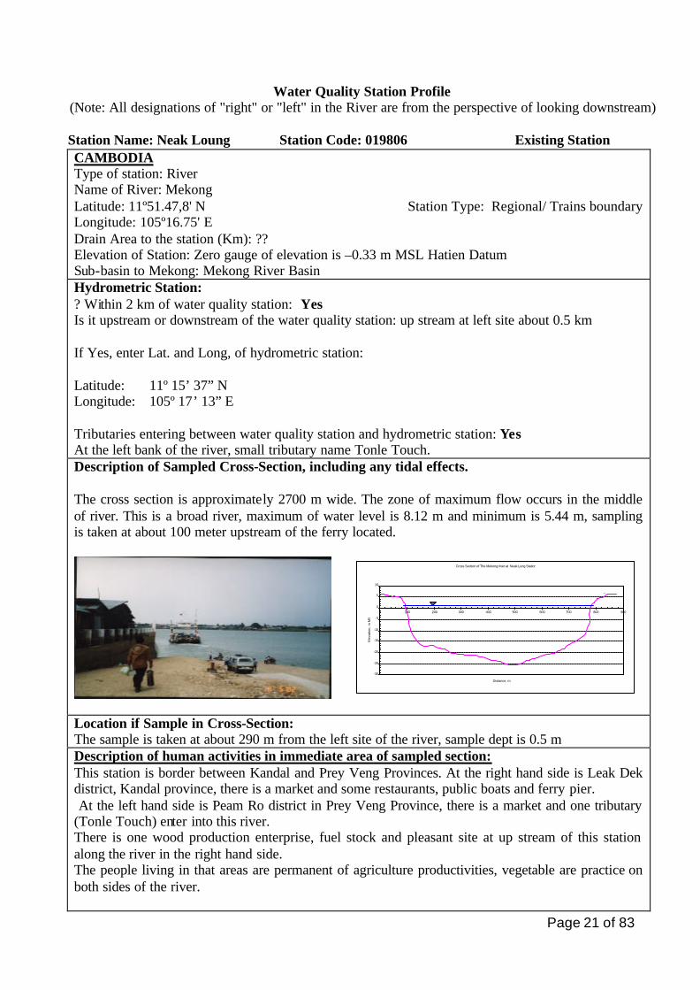
Water Quality Station Profile (Note: All designations of "right" or "left" in the River are from the perspective of looking downstream)
Station Name: Neak Loung Station Code: 019806 Existing Station CAMBODIA Type of station: River Name of River: Mekong Latitude: 11º51.47,8' N Station Type: Regional/ Trains boundary Longitude: 105º16.75' E Drain Area to the station (Km): ?? Elevation of Station: Zero gauge of elevation is –0.33 m MSL Hatien Datum Sub-basin to Mekong: Mekong River Basin Hydrometric Station: ? Within 2 km of water quality station: Yes Is it upstream or downstream of the water quality station: up stream at left site about 0.5 km If Yes, enter Lat. and Long, of hydrometric station: Latitude: 11º 15’ 37” N Longitude: 105º 17’ 13” E Tributaries entering between water quality station and hydrometric station: Yes At the left bank of the river, small tributary name Tonle Touch. Description of Sampled Cross-Section, including any tidal effects. The cross section is approximately 2700 m wide. The zone of maximum flow occurs in the middle of river. This is a broad river, maximum of water level is 8.12 m and minimum is 5.44 m, sampling is taken at about 100 meter upstream of the ferry located.
Cross Section of The Mekong river at Neak Lung Station
-30
-25
-20
-15
-10
- 5
0
5
10
0 100 200 300 400 500 600 700 800 900
Distance, m
Ele
vatio
n, m
MS
L
Le RiH =
Location if Sample in Cross-Section: The sample is taken at about 290 m from the left site of the river, sample dept is 0.5 m Description of human activities in immediate area of sampled section: This station is border between Kandal and Prey Veng Provinces. At the right hand side is Leak Dek district, Kandal province, there is a market and some restaurants, public boats and ferry pier. At the left hand side is Peam Ro district in Prey Veng Province, there is a market and one tributary (Tonle Touch) enter into this river. There is one wood production enterprise, fuel stock and pleasant site at up stream of this station along the river in the right hand side. The people living in that areas are permanent of agriculture productivities, vegetable are practice on both sides of the river.
Page 22 of 83
It is the last of existing station on the Mekong River for control on trains boundary’s water quality between Cambodia and Viet Nam. Major development issues upstream of station that may impact now, or in future on the water
quality of this station
The major development at near future on this side is a national bridge and the road will be constructing. More information is only expansion agriculture of second cropping with irrigation systems has been developed. Is water quality at
this station likely to
be a downstream
problem now or in
the future? Yes
If YES, describe which parameters are likely to pose downstream
problems and why this is, or may be, a problem:
During the bridge construction might be the water will turbid, oils spill for
sort time. But the fertilizer or pesticides are needs along term to monitor
and assessed.
(Answer maybe no, because no impact likely to be a downstream problem
now).
If this station is
mainly of local or
regional interest,
indicate the main
purpose of the
station.
The purpose of this station is control the domestic waste and water quality
from factories, agricultures, at up stream of the river. This station should
indicate of water management in the future, it identified as regional/trains
boundary interest.
Monitoring Protocols Describe how Sample (s) is/are collected.
The sampling water is taken by using the Ruttner water sampler at the depth of 0.5 m. The first sampled water is used to clean the sampled bottles and then the second sampled water is used for analytical purposes. The same procedures for water quality sampling are applied for all water quality stations.
Parameters Measured in the field: 1. Temperature 2. Conductivity
Field Measurement Technique: 1. Temperature is measured on site by thermometer. 2. Conductivity is measured by WTW (Multi- lines P4)
Aliquots sent to laboratory for analysis: 1.DO 2.CODMn 3.Fe Number of days sampled retained in the field before shipping to lab
Preservation, handling, and shipping techniques: - Dissolve Oxygen (DO) has been preserved, by using the Winkler method. - COD Mn has been preserved by 1 ml of H2SO4 (4.5 mol/l) in 100 ml of sample. - Fe is preserved by 2 ml of HCL (1:1) Samples are kept in icebox and are sent to the Lab within the same day.
Page 23 of 83
Other Information recorded in the field:
Sampling date and time, river name, weather conditions at the time of/or before sampling are recorded.
Number of verticals for depth- integrated sampling: No Frequency of sampling these verticals: No Describe other verticals or representative verticals sampled: Frequency: no
Bed Load Sampled: No
Sediment Data collected as part of hydrometric program at or near the hydrometric site noted above.
Where (agency, location) are sediment data stored?: Other agencies, ministries or departments that sample water quality at or near, the water quality station: NO
If YES, Name of Agency: Description of sampling programmed:
Page 24 of 83
Water Quality Station Profile (Note: All designations of "right" or "left" in the River are from the perspective of looking downstream)
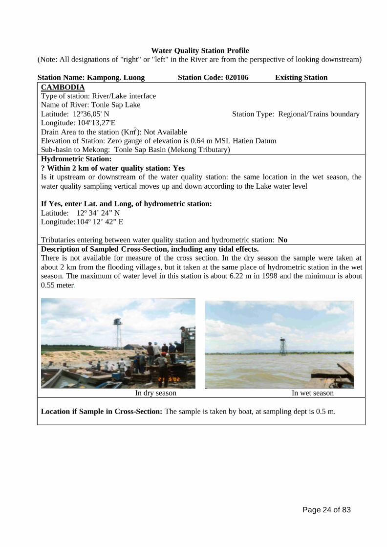
Station Name: Kampong. Luong Station Code: 020106 Existing Station CAMBODIA Type of station: River/Lake interface Name of River: Tonle Sap Lake Latitude: 12º36,05' N Station Type: Regional/Trains boundary Longitude: 104º13,27'E Drain Area to the station (Km2): Not Available Elevation of Station: Zero gauge of elevation is 0.64 m MSL Hatien Datum Sub-basin to Mekong: Tonle Sap Basin (Mekong Tributary) Hydrometric Station: ? Within 2 km of water quality station: Yes Is it upstream or downstream of the water quality station: the same location in the wet season, the water quality sampling vertical moves up and down according to the Lake water level If Yes, enter Lat. and Long, of hydrometric station: Latitude: 12º 34’ 24” N Longitude: 104º 12’ 42” E Tributaries entering between water quality station and hydrometric station: No Description of Sampled Cross-Section, including any tidal effects. There is not available for measure of the cross section. In the dry season the sample were taken at about 2 km from the flooding villages, but it taken at the same place of hydrometric station in the wet season. The maximum of water level in this station is about 6.22 m in 1998 and the minimum is about 0.55 meter.
In dry season In wet season
Location if Sample in Cross-Section: The sample is taken by boat, at sampling dept is 0.5 m.
Page 25 of 83
Description of human activities in immediate area of sampled section: This stations is located in the river/Great lake interface, it just about 2 km from the flooding villages. This village will be move according to the water level of the great lake and the numbers of house hold are about 1,000. There are many fishing and tourism boats pier are permanent in that area including school, pagoda, restaurants and some of the fuel stations. The water level of this station is change very much between wet and dry seasons, In the wet season it cover all the villages, agricultures and second cropping lands that located in the great lake. The people are living in that area are permanently occupied with fisheries and agricultures on the wetland areas.
Major development issues upstream of station that may impact now, or in future on the water quality of this station
There is no official information on development activities in this area. But domestic waste and oil leakage from fishing and tourism boats are flow directly into the great lake. Is water quality at
this station likely to
be a downstream
problem now or in
the future?
Yes
If YES, describe which parameters are likely to pose downstream
problems and why this is, or may be, a problem: this station will be future
water quality likely problems, because in the try season this area is intensive
agricultural lands and there is no control of activities on agriculture chemical
agents, it specially during period of flooding the waste water from Villages,
oil leakages from fuel station and boats are flow directly into the great lake
that would be affect to water quality or became an eutrophication such as
increasing of nutrients, microbiological hazards and heavy metals . Also this
station is very high of sediment concentration.
If this station is
mainly of local or
regional interest,
indicate the main
purpose of the
station.
The purpose of the station are mainly to control the water quality which
parameters are related to the waste water and over used of fertilizers from
agriculture lands that might be indicate of lake eutrophication.
This station is identifying as regional interest.
Monitoring Protocols
Page 26 of 83
Describe how Sample (s) is/are collected.
The sampling water is taken by using the Ruttner water sampler at the depth of 0.5 m. The first sampled water is used to clean the sampled bottles and then the second sampled water is used for analytical purposes. The same procedures for water quality sampling are applied for all water quality stations.
Parameters Measured in the field: 1. Temperature 2. Conductivity
Field Measurement Technique: 1. Temperature is measured on site by thermometer. 2. Conductivity is measured by WTW (Multi- lines P4)
Aliquots sent to laboratory for analysis: 1.DO 2.CODMn 3.Fe Number of days sampled retained in the field before shipping to lab
Preservation, handling, and shipping techniques: - Dissolve Oxygen (DO) has been preserved, by using the Winkler method. - COD Mn has been preserved by 1 ml of H2SO4 (4.5 mol/l) in 100 ml of sample. - Fe is preserved by 2 ml of HCL (1:1) Samples are kept in icebox and are sent to the Lab within the same day.
Other Information recorded in the field:
Sampling date and time, river name, weather conditions at the time of/or before sampling are recorded.
Number of verticals for depth- integrated sampling: No Frequency of sampling these verticals: No Describe other verticals or representative verticals sampled: Frequency: no
Bed Load Sampled: No
Sediment Data collected as part of hydrometric program at or near the hydrometric site noted above.
Where (agency, location) are sediment data stored?: Other agencies, ministries or departments that sample water quality at or near, the water quality station: NO
If YES, Name of Agency: Description of sampling programmed:
Page 27 of 83
Water Quality Station Profile
(Note: All designations of "right" or "left" in the River are from the perspective of looking downstream)
Station Name: Kampong Chhnang Station Code: 020103 Existing Station CAMBODIA Type of station: River Name of River: Tonle Sap Latitude: 12º16.17' N Station Type: Regional/Trains boundary Longitude: 104º. 40.93' E Drain Area to the station (Km): Elevation of Station: Zero gauge of elevation is –2.62 m MSL Hatien Datum Sub-basin to Mekong: Tonle Sap (Mekong Tributary) Hydrometric Station: ? Within 2 km of water quality station: Yes Is it upstream or downstream of the water quality station: At the right bank of river If Yes, enter Lat. and Long, of hydrometric station: Latitude: 12º 15’ 59” N Longitude: 104º 41’ 06” E Tributaries entering between water quality station and hydrometric station: No Description of Sampled Cross-Section, including any tidal effects. The cross section is about 600 m wide, the deepest zone is near to the left bank side of the river, the maximum of water level is 11.61 m (in 2000) and minimum is about 2.37 m.
This mountain is located at the right site Kampong Chhang City at the left site
Cross Section of Tonle sap River at Kg.ChhangH=8.55 m on 30 August 2003
-1
1
3
5
7
9
11
13
-10 40 90 140 190 240 290 340 390 440
Distance, m
Dep
th, m
Right bankLeft bank
Page 28 of 83
Location if Sample in Cross-Section: The sample is taken by boat it about 200 m from the right bank. The sampling dept is 0.5 meter from surface water. Description of human activities in immediate area of sampled section: This station is located in kampong Chhang town, the population in this town is about 42,000 inhabitants, and there is a market, public boats pier on the right side and rice paddy field in dry season. At left side of river is located of the flooding villages, mountain with cover by forests. The people living in that areas are permanently occupied with agricultures and fisheries and making Prahok. Major development issues upstream of station that may impact now, or in future on the water quality of this station No official information on development activities in these areas, but agricultures pattern along the river are quite important. Which no constructing of the wastewater treatment system in town, during run off it will be flow directly to the river. Is water quality at
this station likely
to be a
downstream
problem now or in
the future?
Yes
If YES, describe which parameters are likely to pose downstream
problems and why this is, or may be, a problem:
In the future might by come problems with the Microbiological hazards or
eutrophication in the river because of the over used of fertilizers, pesticides
for agricultures. The wastewater will be more pollute by increasing of the
population in the town and oil leakage from boats.
(Answer maybe no, because no impact likely to be a downstream problem
now).
If this station is
mainly of local or
regional interest,
indicate the main
purpose of the
station.
This station type is identified as regional interest. The purpose of this station
is to control the fertilizers or nutrients from point sources and non-point
source.
Monitoring Protocols Describe how Sample (s) is/are collected.
The sampling water is taken by using the Ruttner water sampler at the depth of 0.5 m. The first sampled water is used to clean the sampled bottles and then the second sampled water is used for analytical purposes. The same procedures for water quality sampling are applied for all water quality stations.
Parameters Measured in the field: 1. Temperature 2. Conductivity
Field Measurement Technique: 1. Temperature is measured on site by thermometer. 2. Conductivity is measured by WTW (Multi- lines P4)
Page 29 of 83
Aliquots sent to laboratory for analysis: 1.DO 2.CODMn 3.Fe Number of days sampled retained in the field before shipping to lab
Preservation, handling, and shipping techniques: - Dissolve Oxygen (DO) has been preserved, by using the Winkler method. - COD Mn has been preserved by 1 ml of H2SO4 (4.5 mol/l) in 100 ml of sample. - Fe is preserved by 2 ml of HCL (1:1) Samples are kept in icebox and are sent to the Lab within the same day.
Other Information recorded in the field:
Sampling date and time, river name, weather conditions at the time of/or before sampling are recorded.
Number of verticals for depth- integrated sampling: No Frequency of sampling these verticals: No Describe other verticals or representative verticals sampled: Frequency: no
Bed Load Sampled: No
Sediment Data collected as part of hydrometric program at or near the hydrometric site noted above.
Where (agency, location) are sediment data stored?: Other agencies, ministries or departments that sample water quality at or near, the water quality station: NO
If YES, Name of Agency: Description of sampling programmed:
Page 30 of 83
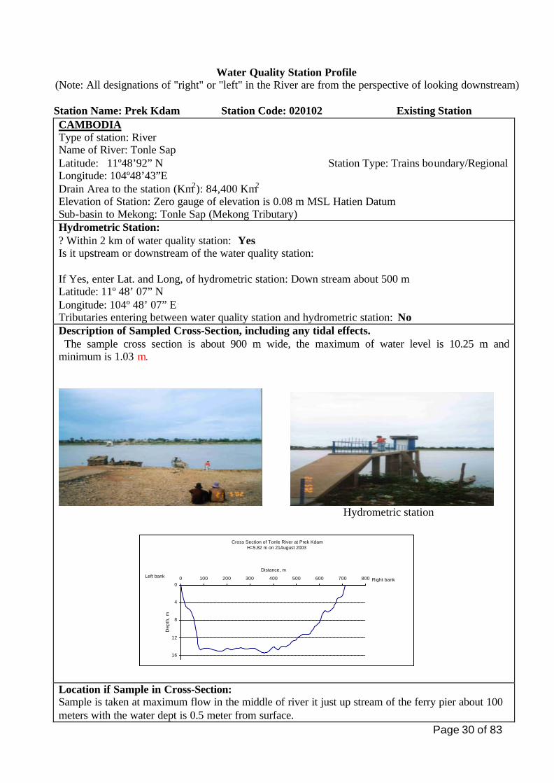
Water Quality Station Profile (Note: All designations of "right" or "left" in the River are from the perspective of looking downstream)
Station Name: Prek Kdam Station Code: 020102 Existing Station CAMBODIA Type of station: River Name of River: Tonle Sap Latitude: 11º48’92” N Station Type: Trains boundary/Regional Longitude: 104º48’43”E Drain Area to the station (Km2): 84,400 Km2
Elevation of Station: Zero gauge of elevation is 0.08 m MSL Hatien Datum Sub-basin to Mekong: Tonle Sap (Mekong Tributary) Hydrometric Station: ? Within 2 km of water quality station: Yes Is it upstream or downstream of the water quality station: If Yes, enter Lat. and Long, of hydrometric station: Down stream about 500 m Latitude: 11º 48’ 07” N Longitude: 104º 48’ 07” E Tributaries entering between water quality station and hydrometric station: No Description of Sampled Cross-Section, including any tidal effects. The sample cross section is about 900 m wide, the maximum of water level is 10.25 m and minimum is 1.03 m.
Hydrometric station
Cross Section of Tonle River at Prek KdamH=5.82 m on 21August 2003
0
4
8
12
16
0 100 200 300 400 500 600 700 800
Distance, m
Dep
th,
m
Right bankLeft bank
Location if Sample in Cross-Section: Sample is taken at maximum flow in the middle of river it just up stream of the ferry pier about 100 meters with the water dept is 0.5 meter from surface.
Page 31 of 83
Description of human activities in immediate area of sampled section: The right hand side is village located, usually no industrial allocated, but there are small restaurants and household along both sides and the people livings in these areas are permanently in agricultures production, fisheries and marking Prahok. Preak Kdam is station to control of the wastewater that flows from Beong Sayab wetland. The waste water is flow directly into the Tonle Sap river by a small canal in Prek Phnaot commune. Major development issues upstream of station that may impact now, or in future on the water
quality of this station
There is no information on development activities at upstream, only reconstructing of the road along river and agriculturals are quite important. Is water quality at
this station likely to
be a downstream
problem now or in
the future?
Yes
If YES, describe which parameters are likely to pose downstream
problems and why this is, or may be, a problem:
Very high yields of sediment load in these catchments.
From up to down stream of this station is permanent for agriculture
productions with irrigation systems development. The over used of
fertilizer in agriculture lands, it may effect to the water quality down
stream, but it need to be further assessed.
(Answer maybe no, because no impact likely to be a downstream problem
now).
If this station is
mainly of local or
regional interest,
indicate the main
purpose of the
station.
The main purposes for this station are to control the parameters that
content with fertilizers or nutrient, Microbiological from household and
agriculture lads.
It is identified for regional station network.
Monitoring Protocols Describe how Sample (s) is/are collected.
The sampling water is taken by using the Ruttner water sampler at the depth of 0.5 m. The first sampled water is used to clean the sampled bottles and then the second sampled water is used for analytical purposes. The same procedures for water quality sampling are applied for all water quality stations.
Parameters Measured in the field: 1. Temperature 2. Conductivity
Field Measurement Technique: 1. Temperature is measured on site by thermometer. 2. Conductivity is measured by WTW (Multi- lines P4)
Page 32 of 83
Aliquots sent to laboratory for analysis: 1.DO 2.CODMn 3.Fe Number of days sampled retained in the field before shipping to lab
Preservation, handling, and shipping techniques: - Dissolve Oxygen (DO) has been preserved, by using the Winkler method. - COD Mn has been preserved by 1 ml of H2SO4 (4.5 mol/l) in 100 ml of sample. - Fe is preserved by 2 ml of HCL (1:1) Samples are kept in icebox and are sent to the Lab within the same day.
Other Information recorded in the field:
Sampling date and time, river name, weather conditions at the time of/or before sampling are recorded.
Number of verticals for depth- integrated sampling: No Frequency of sampling these verticals: No Describe other verticals or representative verticals sampled: Frequency: no
Bed Load Sampled: No
Sediment Data collected as part of hydrometric program at or near the hydrometric site noted above.
Where (agency, location) are sediment data stored?: Other agencies, ministries or departments that sample water quality at or near, the water quality station: YES
If YES, Name of Agency: Ministry of Environment Description of sampling programmed: This sample is taken at the right band to control wastewater from Brahok production at upstream of this station.
Page 33 of 83
Water Quality Station Profile (Note: All designations of "right" or "left" in the River are from the perspective of looking downstream)
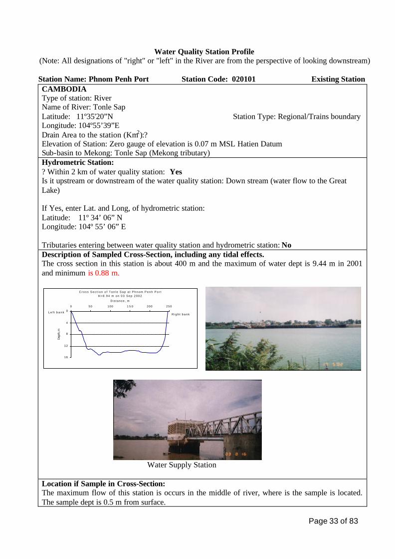
Station Name: Phnom Penh Port Station Code: 020101 Existing Station CAMBODIA Type of station: River Name of River: Tonle Sap Latitude: 11º35'20”N Station Type: Regional/Trains boundary Longitude: 104º55’39”E Drain Area to the station (Km2):? Elevation of Station: Zero gauge of elevation is 0.07 m MSL Hatien Datum Sub-basin to Mekong: Tonle Sap (Mekong tributary) Hydrometric Station: ? Within 2 km of water quality station: Yes Is it upstream or downstream of the water quality station: Down stream (water flow to the Great Lake) If Yes, enter Lat. and Long, of hydrometric station: Latitude: 11º 34’ 06” N Longitude: 104º 55’ 06” E Tributaries entering between water quality station and hydrometric station: No Description of Sampled Cross-Section, including any tidal effects. The cross section in this station is about 400 m and the maximum of water dept is 9.44 m in 2001 and minimum is 0.88 m.
C r o s s S e c t i o n o f T o n l e S a p a t P h n o m P e n h P o r tH = 8 . 9 4 m o n 0 3 S e p 2 0 0 2
0
4
8
12
16
0 50 100 1 5 0 200 250
D is tance , m
Dep
th, m
R i g h t b a n kL e f t b a n k
Water Supply Station Location if Sample in Cross-Section: The maximum flow of this station is occurs in the middle of river, where is the sample is located. The sample dept is 0.5 m from surface.
Page 34 of 83
Description of human activities in immediate area of sampled section: Sample is taken just down stream of Chroy Chanvar bridge where the maximum flow. The right site of this river is located of Phnom Penh city, at down stream: about 100 meter from water quality station there is Phnom Penh’s pumping station of water supply and Phnom Penh port are located, there is one outlet of sewage flow directly into the river, but it just a small pipe and about 2 km is located of Royal Palace and gardens. At the left side of this river is located of Chroy Chanvar District, at upstream of sampling point: there is small of cow’s cattle and household along riverbank. In wet season this place will be inundated (wetland), and the people living in these areas are occupied with agricultures, vegetables in the dry season and fisheries. At down stream on left site of this river is Chroy Cahnvar’s development area that supported by Phnom Penh Municipal to building the concrete’s bank and gardens. Major development issues upstream of station that may impact now, or in future on the water
quality of this station
The increasing of the population and development in the city might be creating a sewage and waste water. Is water quality at
this station likely to
be a downstream
problem now or in
the future?
Yes
If YES, describe which parameters are likely to pose downstream
problems and why this is, or may be, a problem:
The water quality likely to be downstream problems, because in capital
city usually the socioeconomic bloom when the marketing is open,
especially rather high concentration of COD, Nutrients, and
Microbiological.
(The answer maybe No, because no impact likely to be downstream
problems now).
If this station is
mainly of local or
regional interest,
indicate the main
purpose of the
station.
The main purpose of this station is to provide the important information of
water quality management for Phnom Penh city, and will be information
from point source and non point source pollution, Nutrient rich and
microbiological hazards. This station is identified as regional interest.
Monitoring Protocols Describe how Sample (s) is/are collected.
The sampling water is taken by using the Ruttner water sampler at the depth of 0.5 m. The first sampled water is used to clean the sampled bottles and then the second sampled water is used for analytical purposes. The same procedures for water quality sampling are applied for all water quality stations.
Page 35 of 83
Parameters Measured in the field: 1. Temperature 2. Conductivity
Field Measurement Technique: 1. Temperature is measured on site by thermometer. 2. Conductivity is measured by WTW (Multi- lines P4)
Aliquots sent to laboratory for analysis: 1.DO 2.CODMn 3.Fe Number of days sampled retained in the field before shipping to lab
Preservation, handling, and shipping techniques: - Dissolve Oxygen (DO) has been preserved, by using the Winkler method. - COD Mn has been preserved by 1 ml of H2SO4 (4.5 mol/l) in 100 ml of sample. - Fe is preserved by 2 ml of HCL (1:1) Samples are kept in icebox and are sent to the Lab within the same day.
Other Information recorded in the field:
Sampling date and time, river name, weather conditions at the time of/or before sampling are recorded.
Number of verticals for depth- integrated sampling: No Frequency of sampling these verticals: No Describe other verticals or representative verticals sampled: Frequency: no
Bed Load Sampled: No
Sediment Data collected as part of hydrometric program at or near the hydrometric site noted above.
Where (agency, location) are sediment data stored?: Other agencies, ministries or departments that sample water quality at or near, the water quality station: YES
If YES, Name of Agency: Ministry of Environment Description of sampling programmed: Sample is taken at the right bank of the river on where the outlet of sewage.
Page 36 of 83
Water Quality Station Profile
(Note: All designations of "right" or "left" in the River are from the perspective of looking downstream)
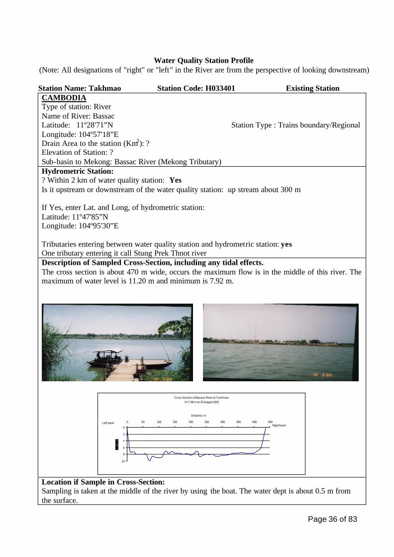
Station Name: Takhmao Station Code: H033401 Existing Station CAMBODIA Type of station: River Name of River: Bassac Latitude: 11º28'71”N Station Type : Trains boundary/Regional Longitude: 104º57'18”E Drain Area to the station (Km2): ? Elevation of Station: ? Sub-basin to Mekong: Bassac River (Mekong Tributary) Hydrometric Station: ? Within 2 km of water quality station: Yes Is it upstream or downstream of the water quality station: up stream about 300 m If Yes, enter Lat. and Long, of hydrometric station: Latitude: 11º47'85”N Longitude: 104º95'30”E Tributaries entering between water quality station and hydrometric station: yes One tributary entering it call Stung Prek Thnot river Description of Sampled Cross-Section, including any tidal effects. The cross section is about 470 m wide, occurs the maximum flow is in the middle of this river. The maximum of water level is 11.20 m and minimum is 7.92 m.
Cross Section of Bassac River at Ta khmaoH=7.38 m on 25 August 2003
0
2
4
6
8
10
0 50 100 150 200 250 300 350 400 450
Distance, m
Right bankLeft bank
Location if Sample in Cross-Section: Sampling is taken at the middle of the river by using the boat. The water dept is about 0.5 m from the surface.
Page 37 of 83
Description of human activities in immediate area of sampled section: This station is located in Ta Khmao Town. Sample is taken by boat, at downstream about 300 m from the place that Prek Thnot river enter to the Bassac river. along the Prek Thont river, there are many of households and one market at right side, public boats pier and one outlet of the sewage from natural treatment it call Beong Chorpon wetland that waste water are discharging from Phnom Penh City. The left side is a village located. the most people are permanent with agriculture, vegetables and fisheries occupation. Major development issues upstream of station that may impact now, or in future on the water
quality of this station
No official information on development activities at upstream, only reconstructing of road along the river and expand of the agriculture lands and second cropping with irrigation systems development. Is water quality at
this station likely
to be a
downstream
problem now or in
the future?
Yes
If YES, describe which parameters are likely to pose downstream
problems and why this is, or may be, a problem:
The waste water from households and over used of fertilizer, pesticide are
might became important issues for downstream, but need to be future
assessment.
(The answer maybe No, because no impact likely to be downstream problems
now.
If this station is
mainly of local or
regional interest,
indicate the main
purpose of the
station.
The mainly of this stations is to control water quality from Phnom Penh and
Takhmao City and the waste water that flow from natural treatment plant in
to the Bassac River. This station is identified as regional interest.
Monitoring Protocols Describe how Sample (s) is/are collected.
The sampling water is taken by using the Ruttner water sampler at the depth of 0.5 m. The first sampled water is used to clean the sampled bottles and then the second sampled water is used for analytical purposes. The same procedures for water quality sampling are applied for all water quality stations.
Parameters Measured in the field: 1. Temperature 2. Conductivity
Field Measurement Technique: 1. Temperature is measured on site by thermometer. 2. Conductivity is measured by WTW (Multi- lines P4)
Page 38 of 83
Aliquots sent to laboratory for analysis: 1.DO 2.CODMn 3.Fe Number of days sampled retained in the field before shipping to lab
Preservation, handling, and shipping techniques: - Dissolve Oxygen (DO) has been preserved, by using the Winkler method. - COD Mn has been preserved by 1 ml of H2SO4 (4.5 mol/l) in 100 ml of sample. - Fe is preserved by 2 ml of HCL (1:1) Samples are kept in icebox and are sent to the Lab within the same day.
Other Information recorded in the field:
Sampling date and time, river name, weather conditions at the time of/or before sampling are recorded.
Number of verticals for depth- integrated sampling: No Frequency of sampling these verticals: No Describe other verticals or representative verticals sampled: Frequency: no
Bed Load Sampled: No
Sediment Data collected as part of hydrometric program at or near the hydrometric site noted above.
Where (agency, location) are sediment data stored?: Other agencies, ministries or departments that sample water quality at or near, the water quality station: YES
If YES, Name of Agency: Ministry of Environment Description of sampling programmed: Waste water sampling
Page 39 of 83
Water Quality Station Profile (Note: All designations of "right" or "left" in the River are from the perspective of looking downstream)
Station Name: Khos Khel Station Code: H033402 Existing Station CAMBODIA Type of station: River Name of River: Bassac Latitude: 11º16'06"N Station Type: Regional: Trains boundary/Regional Longitude: 105º01'75"E Drain Area to the station (Km): ? Elevation of Station: Zero gauge of elevation is –1.00 m MSL Hatien Datum Sub-basin to Mekong: Bassac River (Mekong Tributary) Hydrometric Station: ? Within 2 km of water quality station: Yes Is it upstream or downstream of the water quality station: Up stream about 1 Km If Yes, enter Lat. and Long, of hydrometric station: Latitude: 11º16'39"N Longitude: 105º01'70"E Tributaries entering between water quality station and hydrometric station: yes On the right site of the river:
1. Preak Wat Khos Khel 2. Prel Takeo 3. Prek Taok
Description of Sampled Cross-Section, including any tidal effects. The cross section is about 500 m wide. occurs the maximum flow is in the middle of this river. The maximum of water level is 7.94 m and minimum is 6.45 m.
Cross Section of Bassac River at Khos KhelH=6.41 m on 25 August 2003
-1
3
7
11
15
0 50 100 150 200 250 300 350
Distance, m
Dep
th,
m
Right bankLeft bank
Location if Sample in Cross-Section: The sampling were taken at the middle by boat, the water dept of 0.5 m. Description of human activities in immediate area of sampled section: the both site of this river are villages located, agriculture lands, second cropping, and several boat piers. The people living in this area are permanently occupied with agricultures and fisheries. This station is the last one to control the water quality before enter into Viet Nam by Bassac river.
Page 40 of 83
Major development issues upstream of station that may impact now, or in future on the water quality of this station
Agriculture expansion with Irrigations development. Is water quality at
this station likely
to be a
downstream
problem now or in
the future?
Yes
If YES, describe which parameters are likely to pose downstream
problems and why this is, or may be, a problem:
It might be came an important, because of the over used fertilizers in
agriculture lands, but needs to be further assessed.
(Answer maybe no, because no impact likely to be a downstream problem
now).
If this station is
mainly of local or
regional interest,
indicate the main
purpose of the
station.
This station it is identified as regional station network. The main purpose is to
control the fertilizers or nutrients from point sources and none point sources.
Monitoring Protocols Describe how Sample (s) is/are collected.
The sampling water is taken by using the Rut tner water sampler at the depth of 0.5 m. The first sampled water is used to clean the sampled bottles and then the second sampled water is used for analytical purposes. The same procedures for water quality sampling are applied for all water quality stations.
Parameters Measured in the field: 1. Temperature 2. Conductivity
Field Measurement Technique: 1. Temperature is measured on site by thermometer. 2. Conductivity is measured by WTW (Multi- lines P4)
Aliquots sent to laboratory for analysis: 1.DO 2.CODMn 3.Fe Number of days sampled retained
Preservation, handling, and shipping techniques: - Dissolve Oxygen (DO) has been preserved, by using the Winkler method. - COD Mn has been preserved by 1 ml of H2SO4 (4.5 mol/l) in 100 ml of sample. - Fe is preserved by 2 ml of HCL (1:1) Samples are kept in icebox and are sent to the Lab within the same day.
Page 41 of 83
in the field before shipping to lab Other Information recorded in the field:
Sampling date and time, river name, weather conditions at the time of/or before sampling are recorded.
Number of verticals for depth- integrated sampling: No Frequency of sampling these verticals: No Describe other verticals or representative verticals sampled: Frequency: no
Bed Load Sampled: No
Sediment Data collected as part of hydrometric program at or near the hydrometric site noted above.
Where (agency, location) are sediment data stored?: Other agencies, ministries or departments that sample water quality at or near, the water quality station: NO
If YES, Name of Agency: Description of sampling programmed:
Page 42 of 83
Water Quality Station Profile (Note: All designations of "right" or "left" in the River are from the perspective of looking
downstream)
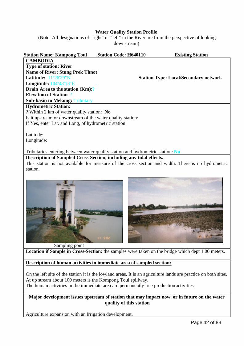
Station Name: Kampong Toul Station Code: H640110 Existing Station CAMBODIA Type of station: River Name of River: Stung Prek Thnot Latitude: 11º26'29"N Station Type: Local/Secondary network Longitude: 104º48'13"E Drain Area to the station (Km):? Elevation of Station: ? Sub-basin to Mekong: Tributary Hydrometric Station: ? Within 2 km of water quality station: No Is it upstream or downstream of the water quality station: If Yes, enter Lat. and Long, of hydrometric station: Latitude: Longitude: Tributaries entering between water quality station and hydrometric station: No Description of Sampled Cross-Section, including any tidal effects. This station is not available for measure of the cross section and width. There is no hydrometric station.
Sampling point Location if Sample in Cross-Section: the samples were taken on the bridge which dept 1.00 meters. Description of human activities in immediate area of sampled section: On the left site of the station it is the lowland areas. It is an agriculture lands are practice on both sites. At up stream about 100 meters is the Kompong Toul spillway. The human activities in the immediate area are permanently rice production activities.
Major development issues upstream of station that may impact now, or in future on the water quality of this station
Agriculture expansion with an Irrigation development.
Page 43 of 83
Is water quality at
this station likely to
be a downstream
problem now or in
the future
No
If YES, describe which parameters are likely to pose downstream
problems and why this is, or may be, a problem:
If this station is
mainly of local or
regional interest,
indicate the main
purpose of the
station.
This station is identified as local interest, secondary network.
Monitoring Protocols Describe how Sample (s) is/are collected.
Using the Ruttner water sampler collects sample. The sampling water is taken at the depth of 1.00 m. The first sample water is used to clean the sampled bottle, and then the second sampled water is used for analytical purposes. The same procedure for water quality sampling is applied for all water quality stations.
Parameters Measured in the field: 1. Temperature 2. Conductivity
Field Measurement Technique: 1. Temperature is measured on site by thermometer. 2. Conductivity is measured by WTW (Multi- lines P4)
Aliquots sent to laboratory for analysis: 1.DO 2.CODMn 3.Fe Number of days sampled retained in the field before shipping to lab
Preservation, handling, and shipping techniques: - Dissolve Oxygen (DO) has been preserved, by using the Winkler method. - COD Mn has been preserved by 1 ml of H2SO4 (4.5 mol/l) in 100 ml of sample. - Fe is preserved by 2 ml of HCL (1:1) Samples are kept in icebox and are sent to the Lab within the same day.
Other Information recorded in the field:
Sampling date and time, river name, weather conditions at the time of/or before sampling are recorded.
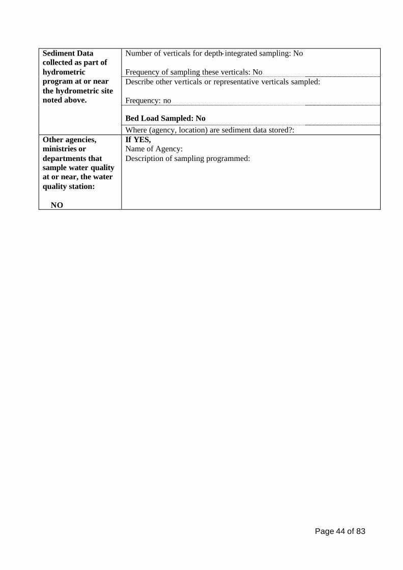
Page 44 of 83
Number of verticals for depth- integrated sampling: No Frequency of sampling these verticals: No Describe other verticals or representative verticals sampled: Frequency: no
Bed Load Sampled: No
Sediment Data collected as part of hydrometric program at or near the hydrometric site noted above.
Where (agency, location) are sediment data stored?: Other agencies, ministries or departments that sample water quality at or near, the water quality station: NO
If YES, Name of Agency: Description of sampling programmed:

Page 45 of 83
V. Evaluation of the Existing Network and Proposed Stations
5.1 Existing Station Network - When established Based on the 11 existing water quality monitoring stations, it is observed that the most stations
were established since 1993 and 1995 and no additional new proposal after that. The selected criteria at that time was to join the Lower Mekong water quality monitoring as Cambodia reactivate with the new mandate of MRC, and the stations should be on the mainstream at the accessible and safe place, and at the same sites of hydrological monitoring stations.
- How many stations
Samples from those stations are regularly taken in a monthly interval and are sent to and analyzed at the Water Quality Analysis Laboratory of the Department of Hydrology and River Works, Ministry of Water Resources and Meteorology in Phnom Penh.
- Which parameters, store data where?
The same parameters are analyzed for all 11 monitoring stations. As described earlier those parameters include Temperature, pH, TSS, Conductivity, DO, Ca, Mg, Na, K, Alkalinity, Sulfate, Chloride, (NO2+NO3)-N, NH4-N, PO4-P, Total-P, Si, CODMN. The analyzed data is stored in the database of the lab in Phnom Penh then the regularly send to Environment Division of MRCS. The lab verifies data, and so far there is no data evaluation on its reliability or interpretation, as annual report on water quality is made available to the public information. The MRC has not had any annual report produced on the state of water quality of the Mekong river system. However based on the data analyzed and stored in Lab in Phnom Penh, it is indicate that, over the period of 20 years of records, there is no significant change in water quality for all stations recorded. Water quality is considerably in the safe side in terms the values of DO.
- Sampling frequency - Where analysis take place - How data are used?
Budget supports for 11 existing stations are from the MRCS that sub-contract with Cambodia National Mekong Committee (CNMC).
- Why established - Who take sampling - Where analyze - Data useful and interpreted - Budget supports - Parameter analyzed - How to get from the sites
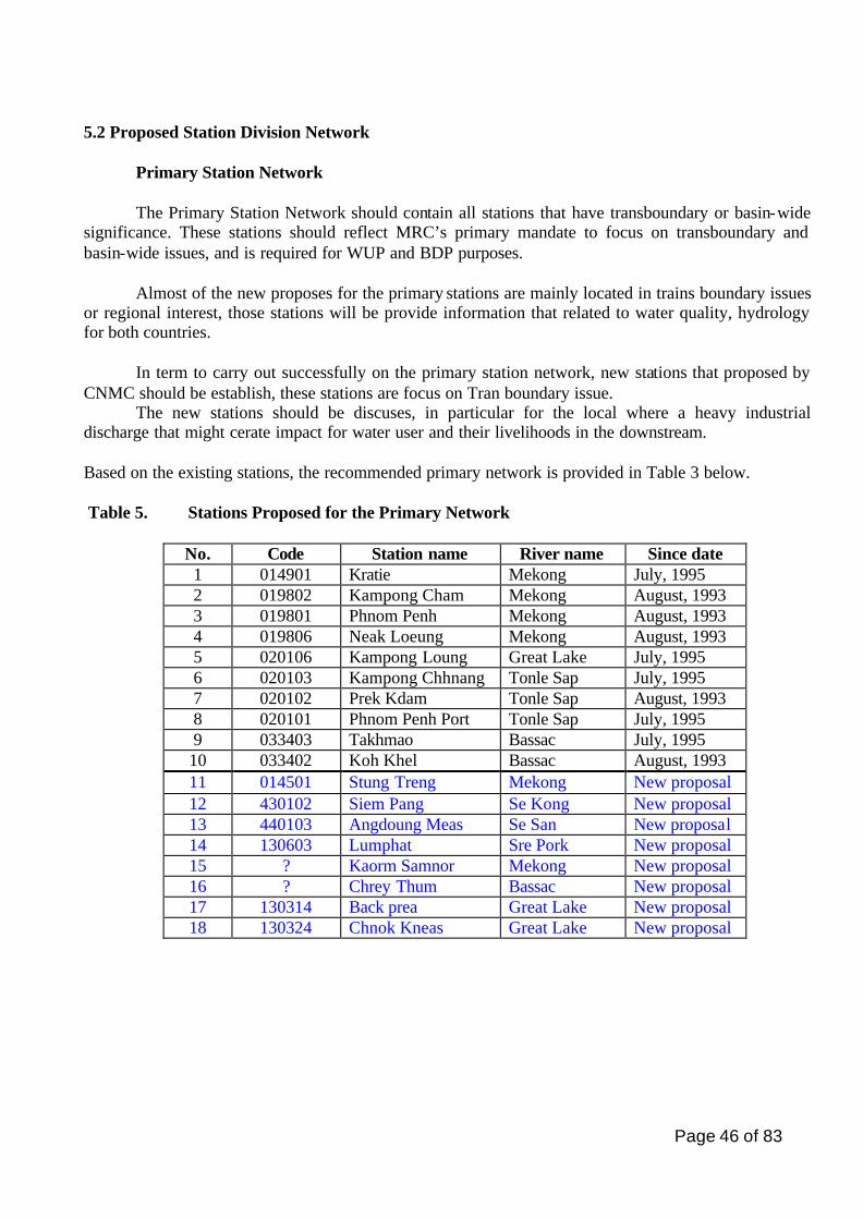
Page 46 of 83
5.2 Proposed Station Division Network
Primary Station Network The Primary Station Network should contain all stations that have transboundary or basin-wide
significance. These stations should reflect MRC’s primary mandate to focus on transboundary and basin-wide issues, and is required for WUP and BDP purposes.
Almost of the new proposes for the primary stations are mainly located in trains boundary issues
or regional interest, those stations will be provide information that related to water quality, hydrology for both countries.
In term to carry out successfully on the primary station network, new stations that proposed by
CNMC should be establish, these stations are focus on Tran boundary issue. The new stations should be discuses, in particular for the local where a heavy industrial
discharge that might cerate impact for water user and their livelihoods in the downstream.
Based on the existing stations, the recommended primary network is provided in Table 3 below.
Table 5. Stations Proposed for the Primary Network
No. Code Station name River name Since date 1 014901 Kratie Mekong July, 1995 2 019802 Kampong Cham Mekong August, 1993 3 019801 Phnom Penh Mekong August, 1993 4 019806 Neak Loeung Mekong August, 1993 5 020106 Kampong Loung Great Lake July, 1995 6 020103 Kampong Chhnang Tonle Sap July, 1995 7 020102 Prek Kdam Tonle Sap August, 1993 8 020101 Phnom Penh Port Tonle Sap July, 1995 9 033403 Takhmao Bassac July, 1995 10 033402 Koh Khel Bassac August, 1993 11 014501 Stung Treng Mekong New proposal 12 430102 Siem Pang Se Kong New proposal 13 440103 Angdoung Meas Se San New proposal 14 130603 Lumphat Sre Pork New proposal 15 ? Kaorm Samnor Mekong New proposal 16 ? Chrey Thum Bassac New proposal 17 130314 Back prea Great Lake New proposal 18 130324 Chnok Kneas Great Lake New proposal

Page 47 of 83
Secondary Station Network The network is mainly on national or local interest. All stations are located in tributaries or
rivers that originate around Great Lake (Tonle Sap Lake), where the Hydrometric are located. The object of new stations is to control and comparison between water qualities at up and downstream of that river before enters to the Great Lake. The frequency of sampling, parameters for analysis could discuss station by station as need for the specific problems. Table 6 Stations Proposed for the Secondary Network
No. Code Station name River name Since date 1 620101 Kampong Thmar Stung Chinit New proposal 2 120404 Kampong Thom Stung Sen New proposal
5.3 Conclusion and Recommendation
Integrating existing water quality station with hydrological station, hydrological stations in order to have the data fixed at the same point for save resource of monitoring and management. The secondary network will be support by the government, but for the primary network including existing stations would be establish temporary for specific purpose. The primary network is containing all station that has transboundary or basin wide. In addiction to the new propose of the primary network, the sample for checking point at upstream of Se San river is should be located near the boundary between Cambodia and Viet Nam in Phum Pi village it is better than Andoung Meas village. But according to the road situation in Cambodia, that place cannot take the sample in the raining season. The distance between Andoung Meas and Phum Pi is about 75 kilometers but there is not so many people are living in that catchments and not so much polluted into the water quality in this river, so we comment to take monthly sample in Andoung Meas station and in Phum Pi station is practice only in the dry season. In order to collect and monitor water quality parameters that might be effect from the wastewater discharges from household, industries, oils cargo tank or vessels and some other dangerous of chemical agent the water quality stations along the Mekong mainstream and its major tributaries needs to be establish as temporary monitoring station.
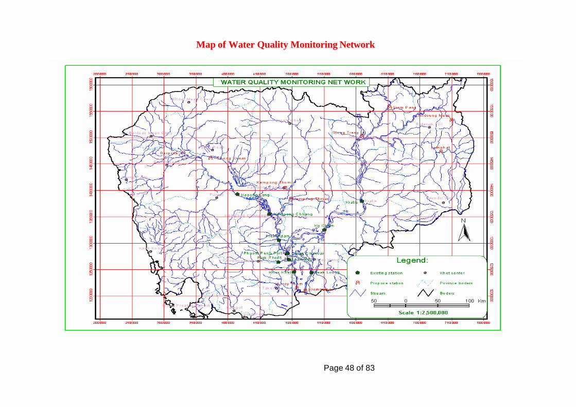
Page 48 of 83
Map of Water Quality Monitoring Network
Page 49 of 83
REFERENCES
(1) MRC: Strategic Master Scheme for Hydro-Meteorological Network in the Mekong River Basin, March 2001.
(2) MRC-KOICA: Final Report, Flood Control Planning for Development of the Mekong Delta (basin wide), Volume September 3, 2000.
(3) MOWRAM, ADB, National Water Sector Profile of the Kingdom of Cambodia, Project Report No. 7, July 2001.
(4) CNMC, National Consultation Workshop on Environment, Socio-economic and Tran boundary Issues, Workshop proceedings, 2002.
(5) MRC, Environment Programme, Proceedings of the Regional Water Quality Workshop, Loung Prabang, Lao PDR, November, 2001
(6) Consolidation of hydro-Meteorological Data and Multi-Functional Hydrologic Roles of Tonle Sap Lake and its vicinities (basin wide)
(7) Social Atlas of the Lower Mekong Basin (8) National water sector profile kingdom of Cambodia, July 2001
Page 50 of 83
Annex 1
Terms of Reference For
MRC-WQM Station Network Review-Cambodian National Activity
Note 1 the Network Review Concept Paper (revised) form part of this TOR and must be consulted before commencing work on this TOR.
2. The consultant should work closely with the National Water Resources Advisor.
1. Title: MRC-WQM Network Review-Cambodia
2. Duty Station: Phnom Penh
3. Duration: 6 weeks
4. Background and Rationale:
The MRC water quality monitoring programmed was implemented in 1985 in Thailand, Laos, and Vietnam, and in 1993 in Cambodia. The network of monitoring stations was mainly established at that time. The rationale that used for station selection at that time was to include the most important locations on the Mekong and Bassac Rivers (for Tran boundary issues) and tributary locations that represented areas of potentially greatest impact from upstream land use and economic developments. Specific criteria were not established for each station however the network was developed for the following purposes:
� Developing Tran boundary loadings of various chemicals
� Developing chemical loadings into the Mekong from various major tributaries
� Representing locations of significant local impacts from land use
� Sediment transport and loadings
The programmed was reviewed in very general terms in 1987; this mainly was an assessment of program implementation relative to the original objectives established in the early 1980´s
And was not a full technical evaluation or review of station. A review of the data in1992, although not a full technical review, resulted in a number of excellent recommendations, which for the most part, were not implemented. It seems that there has not been a systematic and comprehensive technical review of the station network since it was originally established. This is very pertinent now since, in 1996, the mandate of MRC shifted to a greater focus on Tran boundary and basin-wide issues with less attention to local issues. Also, since 1996, the Water Utilization Project (WUP) and the BDP have particular requirements for water quality data.
In 1997, MRC contracted three international experts to carry out a review of the water quality programme, including related laboratory activities. The results of that review were presented at regional workshop in Louang Phrabang in 1997. It was recommended that the network needed to be reviewed in
Page 51 of 83
light of current conditions and in light of the new MRC mandate of focus on basin-wide and Tran boundary issues. That review expressed doubt of the ability of the existing programme to adequately characterize Tran boundary water quality issues. The review also noted that there seemed to be no rationale for many of the stations of the current network. With certain exceptions such as the data station in Vietnam, the lack of ongoing and regular data interpretation by national laboratories or by MRC was also noted as a serious deficiency, as was the fact that the data were not used for any real water quality management purpose by three of the four countries. Substantial parts of the programme appeared to be focused only on data collection but without any identified management purpose or application.
Now, after fifteen years of operation, there have been many institutional changes, significant changes in national development activities, and great improvements in knowledge about water quality issues. Therefore, prudent to review the station network to determine which stations meet specific Tran boundary or local/regional needs for water quality information; whether new stations are now needs; if some current stations can be eliminated, and if there are more cost-effective ways of obtaining water quality data.
In this redesign process, it is essential to keep in mind three principal attributes of any modern monitoring programme: (these are more fully explained in the Concept Paper)
� Relevancy of data to some identified management purpose
� Efficiency in obtaining and utilizing data
� Sustainability in the longer term especially those countries with heavy reliance on donor support through MRC.
The intention is to divide the present network into two parts:
1. Primary Network: This network will contain all stations that have Tran boundary or basin-wide significance. These stations reflect MRC’s primary mandate to focus on Tran boundary and basin-wide issues, and is required for WUP and BDP purposes. At this time the WUP (national) consultative process has noted a wide variety of general issues of concern for water quality however these are not sufficiently specific at this time to permit the development of a monitoring network therefore the consultant should consider the following:
a) “National Consultation Workshop on Environmental, Socio-Economic and Tran boundary Issues” that has been completed under the WUP in Cambodia.
b) The WUP process is not yet complete, therefore the consultant should consider the following types of issues that have been identified in the various riparian countries are which many have transbondary or basin-wide relevance in the future.
• Salinity (natural, man- induced)
• Nutrients (eutrophication)
• Microbiological hazards (human health)
• Contaminants (point source--urban and industrial discharges)
• Contaminants (non-point source--pesticides from agricultural activities)
Page 52 of 83
• Spills (intentional, accidents)
• Others (e.g. arsenic, acidity, etc)
In this analysis it is important to consider thread to the country from upstream sources as well as thread to downstream countries. When the network has been selected, and objective is to have a standardized set of parameters at all stations of this network so that chemical concentration, long term trends, transported chemical loads, and (when regional station communication systems are establish) emergency spill management criteria can be determined and reported, basin-wide, in the standardized format to all government. I is anticipated that monitoring for Tran boundary stations will continue on a monthly basis and will be the primary focus of MRC’s water quality monitoring programme over the longer term. Monitoring parameters and sampling frequency will be reviewed after the station network has been decided and after the nature of Tran boundary issues has been more precisely defined under the WUP process. 2. Secondary Network: this group of stations is those that have mainly national or local interest this
network may consist of any number of stations, however NMCs should bear in mind that donor requirements and MRC’s mandate will, in future, restrict MRC support of this network over the longer term. This means that the principle of sustainability needs to keep in focus during the development of this network1.
Selection of stations in the secondary Network should reflect national priorities for water quality data for specific management purposes. Parameters maybe customized according to the specific data needs of each station. Also, sampling frequency may not be required on a monthly basis and may move to a less frequent basis such as quarterly sampling (4x per year). Parameters and sampling frequency for the Secondary Network will be discussed at a later date.
5. Objectives: To develop a set of recommended station in Cambodia for each of primary and secondary networks, are using the existing network as starting point. 6. Responsibilities: a) Existing Stations Profiles:
Using the list of stations provided by MRC, and using the template provide, for each station complete a profile containing the following characteristics (see work ed example):
- Basic station information - Complete description of the cross section at the point of sampling - Description of the immediate surrounding area - Main land –use activities upstream that may affect water quality at the sampled site - Sample protocol - Other related data (hydrometric, suspended sediment, etc.) - Institutional Information.
It is anticipated that consultant will visit most or all of the stations in the field.
Page 53 of 83
Review the completed temples with NMC and other officials responsible for the monitoring programme. b) Recommend Stations to be Included in the Primary Network. Note: The Primary Network will include stations at each of the MRC hydrometric stations on the Mekong River main sterm2, and near the mouth of any major tributary as well as other stations within the basin that are indicative of water quality that is caused by a condition that is common to two or more countries (e.g. basin-wide issue such as eutrophication). The consultant will collect data and information from all pertinent departments and Ministries, and consultation with NMC staff responsible for national inputs into the WUP and the BDP including outputs from the national WUP consultation, and with inputs from the National Water Resource Advisor, carry out an assessment of water quality issues that will have, or may in future have, Tran boundary implications. This will include impacts on the national territory from upstream sources, and impacts from the country that will impact downstream national territories. Assess these in terms of priorities of these issues, types of impacts, and extent of impact (spatial, intensity, economic [if appropriate]). On the basis of this assessment, and after visitation to proposed sites in the field, recommend stations that will reflect these Tran boundary issues. Where possible, these recommend stations should be located near hydrometric stations. It is expected that there will be a station, at minimum, near the mouth of all significant tributaries to the Mekong/ Bassac main stems. Assess the extent to which local issues (e.g. eutrophication) are believed to have basin-wide significance. Here, “basin-wide” means that the same issues may be important in the Mekong basin in at least one other riparian country. Recommend stations that will reflect the magnitude and extent of these issues that have basin-wide significance. For each recommended station (where these are not included in activity 6a), complete a station profile using the attached station profile temple. Indicate if proposed station is one of the existing WQMN stations (do not fill out the template twice for the same station). In the part of the template that refers to parameters, indicate which parameters are proposed for the recommended station. This recommendation should be accompanied by detailed information of the type of station, location, important parameters, availability of hydrometric information, etc… c) Recommended Stations for the secondary Network. Upon advice from the NMC, the consultant will collect and assess information from local sources, including data and information from various departments and official, and will identify water quality issues that have significant local or regional impacts within the country. These will be impacts that are not included in #6b above. Relative to identifies issues above, review the stations of the existing MRC water quality monitoring network (those that are not included as stations of the Primary Network), and recommend which stations should be retained. Relative to the identified issues above, identify additional stations that should be added to the Secondary Network.
Page 54 of 83
In consideration of the types of data that are already included in various national monitoring programmes, recommend a minimum set of station that should be included in the Secondary Network. These stations should be representative of important local water quality management issues.
For each recommended stations, complete a station profile using the attached station profile template. In decade if the proposed station is one of the existing stations (do not fill out the template twice for the same station). In that part of the template that refers to parameters, indicate which parameters are proposed for the recommended station.
This recommendation should be accompanied by detailed information of the type of station, location, important parameters, sampling frequency, availability of hydrometric information, etc…
Note: In some cases recommended stations may have national and international significance. This should be identified on the Profile template. For such stations, priority is given to the Primary Network however the type of the requirement for the station should also be noted on the Template.
d) Sustainability
Note: As part of the review process, it is essential that data programmes of other national agencies be considered as there may be good reasons to economize by using existing data generated by programs of other agencies. Recall that sampling frequency may change significantly from that now carried out under the MRC programme; therefore, sampling programmes of other agencies may be useful and cost-effective.
Evaluate the availability of the data from various national monitoring programmes of the pavement. Indicate which agencies are involved in data collection, parameters that could be obtained, frequency of sampling, etc…
e) Consult with MRC.
Review all findings and recommendations with the NMC, so that their views are reflected in the final observations and recommendations and of the consultant.
f) Prepare Report.
Prepare a final report that contains the observations and conclusions of the consultant, and which reflects the opinions of the NMC. The report should contain maps that indicate stations selection, together with lat/long coordinate information for stations proposed.
g) Attend consultation of MRC with NMC to discuss the final report and to review the proposed station network in the country and, if required, visit selected station sites with MRC and national staff.
7. Outputs
The outputs will consist of a final report containing
� Completed station profiles all existing stations in the MRC WQMN using the supplied template. This will be accompanied by jpg format photos of the stations3.
Page 55 of 83
� List of stations recommended for the Primary Network. This will be supported;
- Station profiles;
- A document containing all other observations, conclusions and recommendations that support the station recommendations of the consultant.
- A list of all agencies consulted.
� List of stations recommended for the Secondary Network. This will be supported;
- Station profiles;
- A document containing all other observations, conclusions and recommendations that support the station recommendations of the consultant.
- A list of all agencies consulted.
• An accompanying letter from the NMC including that they have reviewed the consultant’s work and are in agreement with the recommended stations.
The report will be submitted to MRC in hard copy and as an MSWord fill (Word 97 or higher).
The report will contain an electronic file consisting of the station profiles completed according to the standard template. 8. Tentative Work Schedule 6 weeks 9. Qualifications of the Consultant The consultant will have postgraduate education in the field of physical or natural sciences, and will have at least 10 years of professional experience in environmental sciences. the consultant must have demonstrated experience in water resource issues and water quality. Ability to communicate and write in English is essential. Ability to work with MS Word, Excel and other standard software products is essential. Consultant must have own computer and related equipment for this work and for production of the report. 10. Other Considerations A standard template for use by the consultant in completing station profiles is attached to this document. This completed template will be submitted in electronic form as part of the final report. Ten days are budgeted for field travel to visit sites. This is within the 6 weeks allocated for the network review. The consultant will be expected to attend up to three days of meetings, at the end of the contract, with NMC and MRCS staff to discuss the report and the recommendations.
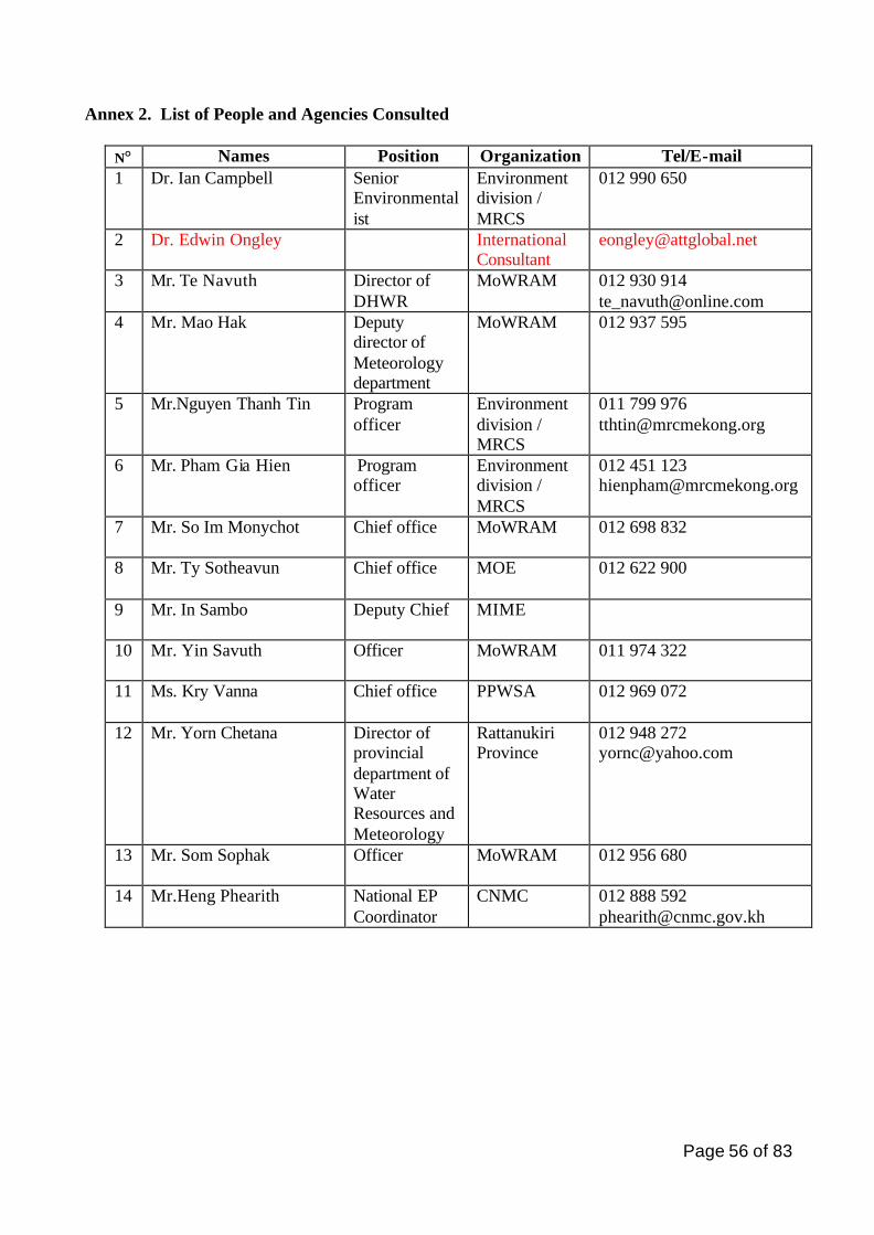
Page 56 of 83
Annex 2. List of People and Agencies Consulted
N° Names Position Organization Tel/E-mail 1 Dr. Ian Campbell Senior
Environmentalist
Environment division / MRCS
012 990 650
2 Dr. Edwin Ongley International Consultant
3 Mr. Te Navuth Director of DHWR
MoWRAM 012 930 914 [email protected]
4 Mr. Mao Hak Deputy director of Meteorology department
MoWRAM 012 937 595
5 Mr.Nguyen Thanh Tin Program officer
Environment division / MRCS
011 799 976 [email protected]
6 Mr. Pham Gia Hien Program officer
Environment division / MRCS
012 451 123 [email protected]
7 Mr. So Im Monychot Chief office MoWRAM 012 698 832
8 Mr. Ty Sotheavun
Chief office MOE 012 622 900
9 Mr. In Sambo Deputy Chief MIME
10 Mr. Yin Savuth Officer MoWRAM 011 974 322
11 Ms. Kry Vanna Chief office PPWSA 012 969 072
12 Mr. Yorn Chetana Director of provincial department of Water Resources and Meteorology
Rattanukiri Province
012 948 272 [email protected]
13 Mr. Som Sophak Officer MoWRAM 012 956 680
14 Mr.Heng Phearith National EP Coordinator
CNMC 012 888 592 [email protected]
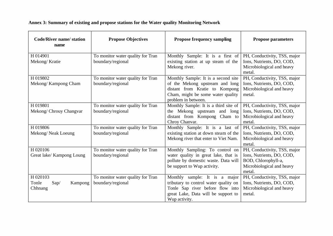
Annex 3: Summary of existing and propose stations for the Water quality Monitoring Network
Code/River name/ station
name
Propose Objectives
Propose frequency sampling
Propose parameters
H 014901 Mekong/ Kratie
To monitor water quality for Tran boundary/regional
Monthly Sample: It is a first of existing station at up steam of the Mekong river.
PH, Conductivity, TSS, major Ions, Nutrients, DO, COD, Microbiological and heavy metal.
H 019802 Mekong/ Kampong Cham
To monitor water quality for Tran boundary/regional
Monthly Sample: It is a second site of the Mekong upstream and long distant from Kratie to Kompong Cham, might be some water quality problem in between.
PH, Conductivity, TSS, major Ions, Nutrients, DO, COD, Microbiological and heavy metal.
H 019801 Mekong/ Chrouy Changvar
To monitor water quality for Tran boundary/regional
Monthly Sample: It is a third site of the Mekong upstream and long distant from Kompong Cham to Chroy Chanvar.
PH, Conductivity, TSS, major Ions, Nutrients, DO, COD, Microbiological and heavy metal.
H 019806 Mekong/ Neak Loeung
To monitor water quality for Tran boundary/regional
Monthly Sample: It is a last of existing station at down steam of the Mekong river that enter to Viet Nam.
PH, Conductivity, TSS, major Ions, Nutrients, DO, COD, Microbiological and heavy metal.
H 020106 Great lake/ Kampong Loung
To monitor water quality for Tran boundary/regional
Monthly Sampling: To control on water quality in great lake, that is pollute by domestic waste. Data will be support to Wup activity.
PH, Conductivity, TSS, major Ions, Nutrients, DO, COD, BOD, Chlorophyll-a, Microbiological and heavy metal.
H 020103 Tonle Sap/ Kampong Chhnang
To monitor water quality for Tran boundary/regional
Monthly sample: It is a major tributary to control water quality on Tonle Sap river before flow into great Lake, Data will be support to Wup activity.
PH, Conductivity, TSS, major Ions, Nutrients, DO, COD, Microbiological and heavy metal.
Page 50 of 83
H 020102 Tonle Sap/ Prek Kdam
To monitor water quality for Tran boundary/regional
Monthly sample: It is a second station to control water quality on Tonle Sap river before flow into great Lake, Data will be support to Wup activity.
PH, Conductivity, TSS, major Ions, Nutrients, DO, COD, Microbiological and heavy metal.
H 020101 Tonle Sap/ Phnom Penh Port
To monitor water quality for Tran boundary/regional
Monthly sample: Monthly sample: It is a third station to control water quality on Tonle Sap river before flow into great Lake, which the population density quite high and more development in this areas.
PH, Conductivity, TSS, major Ions, Nutrients, DO, COD, Microbiological and heavy metal.
H 033403
Bassac/ Ta Khmao
To monitor water quality for Tran
boundary/regional
Monthly sample: It is a first
station on bassac river to control
on water quality that flows from
Phnom Penh and Takmao City.
PH, Conductivity, TSS, major
Ions, Nutrients, DO, COD,
Microbiological and heavy
metal.
H 033402
Bassac/ Koh Khel
To monitor water quality for Tran
boundary/regional
Monthly sample: It is a last of
existing station to control on water
quality on Bassac River and long
distance between Takmao to Khos
Khel.
PH, Conductivity, TSS, major
Ions, Nutrients, DO, COD,
Microbiological and heavy
metal.
H014501
Mekong/ Stung Treng
To monitor water quality for Tran
boundary
Monthly sample: It is checking
point of the Mekong River
upstream before entering into
Cambodia from Loa.
PH, Conductivity, TSS, major
Ions, Nutrients, DO, COD,
Microbiological and heavy
metal.
H430102
Se Kong/ Siem Pang
To monitor water quality for Tran
boundary
Monthly sample: It is checking
point of water quality on Sekong
River that flows from Lao before
enter to Cambodia.
PH, Conductivity, TSS, major Ions,
Nutrients, DO, COD,
Microbiological and heavy metal.
H440103
Se San/ Angdoung Meas
To monitor water quality for Tran
boundary
Monthly sample: It is checking
point of water quality on Se San
River that flows from Viet Nam.
PH, Conductivity, TSS, major Ions,
Nutrients, DO, COD,
Microbiological and heavy metal.
H130603
Sre Pork/ Lumphat
To monitor water quality for Tran
boundary
Monthly sample: It is checking
point of water quality on Sre Pork
River that flows from Viet Nam
before enter to Cambodia.
PH, Conductivity, TSS, major Ions,
Nutrients, DO, COD,
Microbiological and heavy metal.
???
Mekong/ Kaorm Samnor
To monitor water quality for Tran
boundary
Monthly sample: It is the last
checking point to control on water
quality at Mekong downstream
before entering to Viet Nam
PH, Conductivity, TSS, major Ions,
Nutrients, DO, COD,
Microbiological and heavy metal.
???
Bassac/ Chrey Thum
To monitor water quality for Tran
boundary
Monthly sample: It is the last
checking point to control on water
quality at Bassac river before
entering to Viet Nam
PH, Conductivity, TSS, major Ions,
Nutrients, DO, COD,
Microbiological and heavy metal.
H130314
Great Lake/ Back prea
To monitor water quality for at up
stream of Sangkeo river before
Monthly Sampling: it is a major
tributary, where has intensive
PH, Conductivity, TSS, major Ions,
Nutrients, DO, COD, BOD,
Page 49 of 83
enter to the Great Lake (Train-
boundary)
agriculture practice. Data will be
support to Wup activity.
Chlorophyll-a, Microbiological and
heavy metal.
H130324
Great Lake/ Chnok Kneas
To monitor water quality for water
quality on Siem Reap before
entering to the Great Lake (Train –
boundary/regional)
.
Monthly Sampling: it is a major
tributary, where intensive
agriculture practice has and
domestic waste. Data will be
support to Wup activity.
PH, Conductivity, TSS, major Ions,
Nutrients, DO, COD, BOD,
Chlorophyll-a, Microbiological and
heavy metal.
H620101
Chinit / Kampong Thmar
To monitor water quality of stung
Chinit, where the water used for
agricultures from that catchments
before enter to great lake, regional
monitoring.
Quarterly: It is a small tributary.
The seasonal variation might good
enough the information for
support to downstream..
PH, Conductivity, TSS, major Ions,
Nutrients, DO, COD,
Microbiological.
H120404
Sen/ Kampong Thom
To monitor water quality of stung
Chinit, where the water used for
agricultures from that catchments
before enter to great lake, regional
monitoring.
Quarterly: It is a small tributary.
The seasonal variation might good
enough the information for
support to downstream..
PH, Conductivity, TSS, major Ions,
Nutrients, DO, COD,
Microbiological.
H 640110 Prek Thnot/ Kampong Toul
To monitor water quality from that
catchments, regional monitoring.
Quarterly: It is a small tributary.
The seasonal variation might good
enough the information for
support to downstream.
PH, Conductivity, TSS, major Ions,
Nutrients, DO, COD,
Microbiological.
Page 50 of 83
Annex 4: Profiles of the new stations for primary network
Water Quality Station Profile
(Note: All designations of "right" or "left" in the River are from the perspective of looking downstream)
Station Name: Chnok Kneas Station Code: ?? Proposed Station CAMBODIA Type of station: Great Lake Name of River: Tonle Sap Great Lake Latitude: Station Type: Trans boundary /Regional Longitude: Drain Area to the station (Km2): Elevation of Station:? Sub-basin to Mekong: Tributary Hydrometric Station: ? within 2 km of water quality station: Yes Is a lake hydrometric station measuring lake level. If Yes, enter Lat. and Long, of hydrometric station: Latitude: 13º13’069” Longitude: 103º49’701” Tributaries entering between water quality station and hydrometric station: No Description of Sampled Cross-Section, including any tidal effects. Location if Sample in Cross-Section: This station is located in the margin of the Great Lake, at the location of the hydrometric tower. During high and low water, the station is part of the Lake. There is no cross section at this location because it is located in the lake. Description of human activities in immediate area of sampled section: It is thought that this station is representative of lake impacts due, mainly, from pollutants transported down the Stung Siem Reap River that flows from the city of Siem Reap. The Siem Reap Town is known to deliver a large pollutant loading from sewage discharged into the Stung Siem Reap River. The population in this town is about 120,000 habitats it is located only 23 km upstream from the boundary of the Great Lake. Raw sewage is discharged into the Stung Siem Reap River which is a sewage canal entering into the Great Lake at the point of measurement. The people that living in that place are occupies with fisheries, agriculture and second cropping.
Major development issues upstream of station that may impact now, or in future on the water quality of this station
There is no official information development activity at up stream of this station, but the domestic waste and discharge from Siem Reap River are flow directly into the Great Lake.
Page 51 of 83
Is water quality at
this station likely to
be a downstream
problem now or in
the future? Yes
If YES, describe which parameters are likely to pose downstream problems and
why this is, or may be, a problem:
Might be became important issues for the down stream. During the dry season
the water is not very good quality, especially high concentration of Nutrients,
BOD, COD, and Microbiological. Additionally, upstream erosion due to
agriculture and forestry practices is likely to be a problem for water quality.
If this station is
mainly of local or
regional interest,
indicate the main
purpose of the
station.
This station is identifying as regional interest. The Tran boundary is a
downstream concern due to the potential of pollution of the Great Lake from
Siem Reap and downstream transport of pollution into the Mekong River
during outflow from the Great Lake.
Monitoring Protocols Describe how Sample (s) is/are collected.
Parameters measured in the field:
Field Measurement Technique:
Aliquots sent to laboratory for analysis:
Preservation, handling, and shipping techniques:
Other Information recorded in the field:
Number of verticals for depth- integrated sampling: Frequency of sampling these verticals: Describe other verticals or representative verticals sampled: Frequency:
Bed Load Sampled: Yes No
Sediment Data collected as part of hydrometric program at or near the hydrometric site noted above.
Where (agency, location) are sediment data stored?: Other agencies, ministries or departments that sample water quality at or near, the water quality station: NO
If YES, Name of Agency: Description of sampling programmed:
Digital photo (s) of station include: Yes No
Page 52 of 83
Template for Water Quality Station Profile
(Note: All designations of "right" or "left" in the River are from the perspective of looking downstream)
Station Name: Stung Trieng Station Code: 014501 Proposed Station CAMBODIA Type of station: River Name of River: Mekong Latitude: Station Type: Tran boundary Longitude: Drain Area to the station (Km2): 635,000 Km2
Elevation of Station: Zero gauge of elevation is 36.79 m MSL Hatien Datum Sub-basin to Mekong: Mekong mainstream Hydrometric Station: ? within 2 km of water quality station: Yes Is it upstream or downstream of the water quality station: _____________ If Yes, enter Lat. and Long, of hydrometric station: Latitude: 13°32’00” Longitude: 105°56’07” Tributaries entering between water quality station and hydrometric station: Yes No Description of Sampled Cross-Section, including any tidal effects. Location if Sample in Cross-Section: This station will be located at upstream, where the Se San river flow into the Mekong mainstream. Description of human activities in immediate area of sampled section: Along the riverbanks both side are Villages located. The most people living in that place are permanent in agriculture, second cropping and fisheries occupation.
Major development issues upstream of station that may impact now, or in future on the water quality of this station
The activities along the mainstream to improve navigation and tourism development in upstream countries will create more frequent vessel traffic along the Mekong that will be the cause of bank erosion, aquatic habitat, etc. Is water quality at
this station likely to
be a downstream
problem now or in
the future?
Yes
If YES, describe which parameters are likely to pose downstream problems and
why this is, or may be, a problem:
The development in the upstream of the Mekong will be problems for the water
quality at the downstream, especially the contamination from point sources and
non point sources, Microbiological Hazards and heavy metal. And then
Mekong will cause a transboundary water quality issues.

Page 53 of 83
If this station is
mainly of local or
regional interest,
indicate the main
purpose of the
station.
This station is a last checking point at the upstream of Mekong river, where the
water entering into Cambodia. It is identify as trans boundary issues.
Monitoring Protocols Describe how Sample (s) is/are collected.
Parameters measured in the field:
Field Measurement Technique:
Aliquots sent to laboratory for analysis:
Preservation, handling, and shipping techniques:
Other information recorded in the field:
Number of verticals for depth- integrated sampling: Frequency of sampling these verticals: Describe other verticals or representative verticals sampled: Frequency:
Bed Load Sampled: Yes No
Sediment Data collected as part of hydrometric program at or near the hydrometric site noted above.
Where (agency, location) are sediment data stored?: Other agencies, ministries or departments that sample water quality at or near, the water quality station: NO
If YES, Name of Agency: Description of sampling programmed:
Digital photo (s) of station include: Yes No
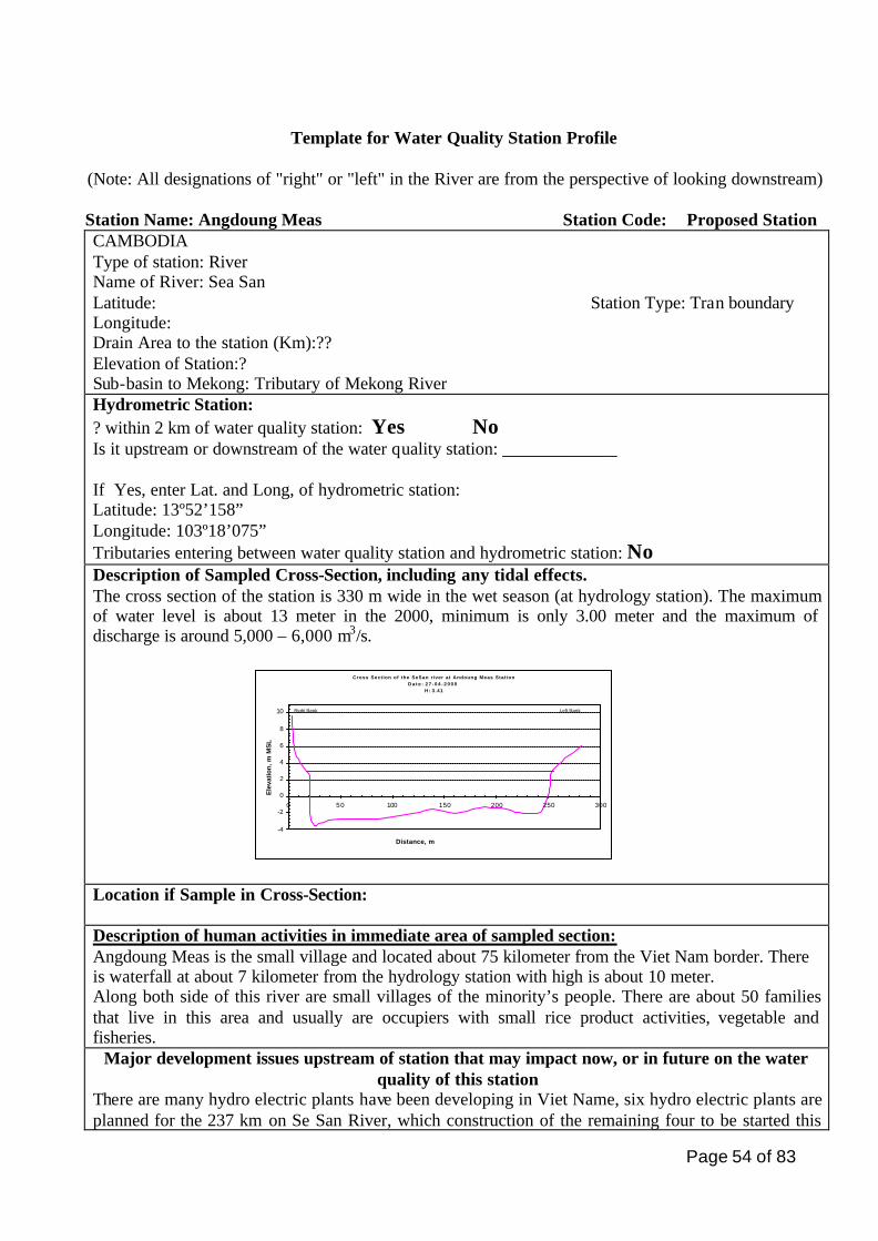
Page 54 of 83
Template for Water Quality Station Profile
(Note: All designations of "right" or "left" in the River are from the perspective of looking downstream)
Station Name: Angdoung Meas Station Code: Proposed Station CAMBODIA Type of station: River Name of River: Sea San Latitude: Station Type: Tran boundary Longitude: Drain Area to the station (Km):?? Elevation of Station:? Sub-basin to Mekong: Tributary of Mekong River Hydrometric Station: ? within 2 km of water quality station: Yes No Is it upstream or downstream of the water quality station: _____________ If Yes, enter Lat. and Long, of hydrometric station: Latitude: 13º52’158” Longitude: 103º18’075” Tributaries entering between water quality station and hydrometric station: No Description of Sampled Cross-Section, including any tidal effects. The cross section of the station is 330 m wide in the wet season (at hydrology station). The maximum of water level is about 13 meter in the 2000, minimum is only 3.00 meter and the maximum of discharge is around 5,000 – 6,000 m3/s.
Cross Section of the SeSan river at Andoung Meas StationD a t e : 2 7 - 0 4 - 2 0 0 0
H: 3.41
-4
-2
0
2
4
6
8
10
0 50 100 150 200 250 300
Distance, m
Ele
vati
on
, m
MS
L
Right Bank Left Bank
Location if Sample in Cross-Section: Description of human activities in immediate area of sampled section: Angdoung Meas is the small village and located about 75 kilometer from the Viet Nam border. There is waterfall at about 7 kilometer from the hydrology station with high is about 10 meter. Along both side of this river are small villages of the minority’s people. There are about 50 families that live in this area and usually are occupiers with small rice product activities, vegetable and fisheries.
Major development issues upstream of station that may impact now, or in future on the water quality of this station
There are many hydro electric plants have been developing in Viet Name, six hydro electric plants are planned for the 237 km on Se San River, which construction of the remaining four to be started this
Page 55 of 83
decade such as: - Se San -3 hydroelectric plants, the output will be 1,127 million KWh and the capacity is 720 MW. - Se San 3A hydro electric plant it below the Ialy hydro electric, it will have two turbine groups with a combined capacity of 108 MW, supplying 479 million KWh. - A 110 megawatt power station on the Se San river between Gia Lai and Kontum Provinces is expected to begin next year and last six years. This station will be supplying 452 million KWh, of power every year. - Another hydropower plant on this river, while feasibility studies for the Se San 4 plant. Is water quality at
this station likely
to be a
downstream
problem now or in
the future? Yes
If YES, describe which parameters are likely to pose downstream problems and
why this is, or may be, a problem:
The developing of the hydropower at upstream of the river, it cause a lot of
effect to the livelihood and environment downstream such as flooding, drying
threaten to the people life, and impact to the biota and ecosystem of the river.
If this station is
mainly of local or
regional interest,
indicate the main
purpose of the
station.
This station is a checking point of the water quality that flows from Viet Nam
before enter into Cambodia.
Monitoring Protocols Describe how Sample (s) is/are collected.
Parameters measured in the field:
Field Measurement Technique:
Aliquots sent to laboratory for analysis:
Preservation, handling, and shipping techniques:
Other information recorded in the field:
Number of verticals for depth- integrated sampling: Frequency of sampling these verticals:
Sediment Data collected as part of hydrometric program at or near
Describe other verticals or representative verticals sampled: Frequency:
Page 56 of 83
Bed Load Sampled: Yes No the hydrometric site noted above.
Where (agency, location) are sediment data stored?: Other agencies, ministries or departments that sample water quality at or near, the water quality station: YES NO
If YES, Name of Agency: Description of sampling programmed:
Digital photo (s) of station include: Yes No
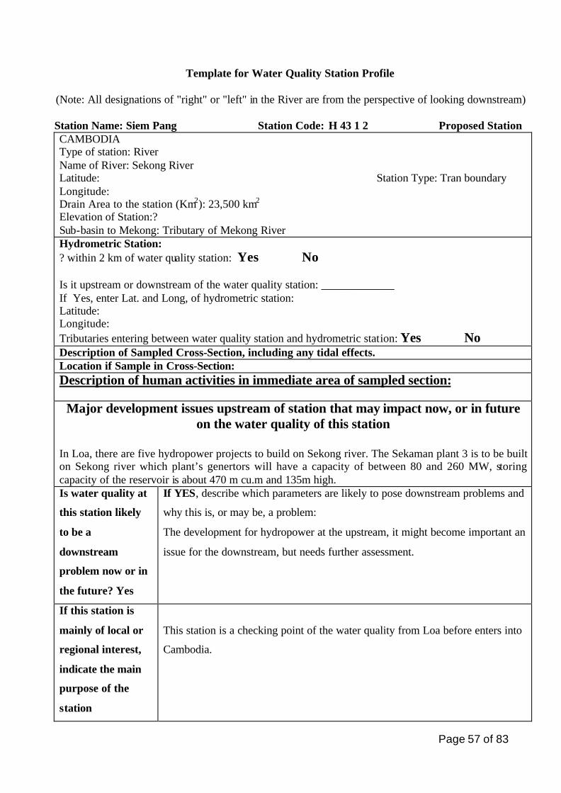
Page 57 of 83
Template for Water Quality Station Profile
(Note: All designations of "right" or "left" in the River are from the perspective of looking downstream)
Station Name: Siem Pang Station Code: H 43 1 2 Proposed Station CAMBODIA Type of station: River Name of River: Sekong River Latitude: Station Type: Tran boundary Longitude: Drain Area to the station (Km2): 23,500 km2
Elevation of Station:? Sub-basin to Mekong: Tributary of Mekong River Hydrometric Station: ? within 2 km of water quality station: Yes No Is it upstream or downstream of the water quality station: _____________ If Yes, enter Lat. and Long, of hydrometric station: Latitude: Longitude: Tributaries entering between water quality station and hydrometric station: Yes No Description of Sampled Cross-Section, including any tidal effects. Location if Sample in Cross-Section: Description of human activities in immediate area of sampled section:
Major development issues upstream of station that may impact now, or in future on the water quality of this station
In Loa, there are five hydropower projects to build on Sekong river. The Sekaman plant 3 is to be built on Sekong river which plant’s genertors will have a capacity of between 80 and 260 MW, storing capacity of the reservoir is about 470 m cu.m and 135m high. Is water quality at
this station likely
to be a
downstream
problem now or in
the future? Yes
If YES, describe which parameters are likely to pose downstream problems and
why this is, or may be, a problem:
The development for hydropower at the upstream, it might become important an
issue for the downstream, but needs further assessment.
If this station is
mainly of local or
regional interest,
indicate the main
purpose of the
station
This station is a checking point of the water quality from Loa before enters into
Cambodia.
Page 58 of 83
Monitoring Protocols Describe how Sample (s) is/are collected.
Parameters measured in the field:
Field Measurement Technique:
Aliquots sent to laboratory for analysis:
Preservation, handling, and shipping techniques:
Other information recorded in the field:
Number of verticals for depth- integrated sampling: Frequency of sampling these vertical Describe other verticals or representative verticals sampled: Frequency:
Bed Load Sampled: No
Sediment Data collected as part of hydrometric program at or near the hydrometric site noted above.
Where (agency, location) are sediment data stored?: Other agencies, ministries or departments that sample water quality at or near, the water quality station: NO
If YES, Name of Agency: Description of sampling programmed:
Digital photo (s) of station include: Yes No
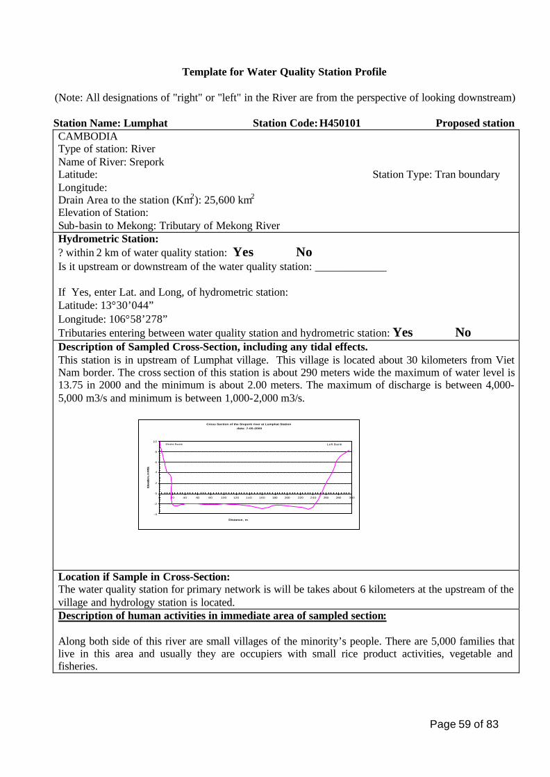
Page 59 of 83
Template for Water Quality Station Profile
(Note: All designations of "right" or "left" in the River are from the perspective of looking downstream)
Station Name: Lumphat Station Code: H450101 Proposed station CAMBODIA Type of station: River Name of River: Srepork Latitude: Station Type: Tran boundary Longitude: Drain Area to the station (Km2): 25,600 km2
Elevation of Station: Sub-basin to Mekong: Tributary of Mekong River Hydrometric Station: ? within 2 km of water quality station: Yes No Is it upstream or downstream of the water quality station: _____________ If Yes, enter Lat. and Long, of hydrometric station: Latitude: 13°30’044” Longitude: 106°58’278” Tributaries entering between water quality station and hydrometric station: Yes No Description of Sampled Cross-Section, including any tidal effects. This station is in upstream of Lumphat village. This village is located about 30 kilometers from Viet Nam border. The cross section of this station is about 290 meters wide the maximum of water level is 13.75 in 2000 and the minimum is about 2.00 meters. The maximum of discharge is between 4,000-5,000 m3/s and minimum is between 1,000-2,000 m3/s.
Cross Section of the Srepork river at Lumphat Station
date: 7-05-2000
-4
-2
0
2
4
6
8
10
0 20 40 60 80 100 120 140 160 180 200 220 240 260 280 300
Distance, m
Ele
vatio
n, m
MS
L
Right Bank Left Bank
Location if Sample in Cross-Section: The water quality station for primary network is will be takes about 6 kilometers at the upstream of the village and hydrology station is located. Description of human activities in immediate area of sampled section: Along both side of this river are small villages of the minority’s people. There are 5,000 families that live in this area and usually they are occupiers with small rice product activities, vegetable and fisheries.
Page 60 of 83
Major development issues upstream of station that may impact now, or in future on the water
quality of this station
Development on hydropower plant in Viet Nam, there are planning to build six more hydropower plants on the Srepork river to power local economic development, adding to two already built or under construction. The first two plats, know as Srepork 3 and Srepork 4, which have a capacity of 137 MW and 33 MW respectively. Four plants are to be built at Duc Xuyen, Buon Tua Sra, Buon Kuop and Chu Phong Krong, located in the district of Krong N-, Cu Jut, Buon Dom and Krong Ana. The Srepork river tributary of Mekong rises in the Chu Yang mountains and passes through the provinces of Lam Dong, Gia Lia and Dac Lac before entering into Cambodia. Is water quality at
this station likely
to be a
downstream
problem now or in
the future?
Yes
If YES, describe which parameters are likely to pose downstream problems and
why this is, or may be, a problem:
The development for hydropower at the upstream, it might become important
an issue for the downstream, but needs further assessment.
If this station is
mainly of local or
regional interest,
indicate the main
purpose of the
station.
This station is a checking point of the water quality from Viet Nam enters into
Cambodia.
Monitoring Protocols Describe how Sample (s) is/are collected.
Parameters measured in the field:
Field Measurement Technique:
Aliquots sent to laboratory for analysis
Preservation, handling, and shipping techniques:
Other information recorded in the field:
Page 61 of 83
Number of verticals for depth- integrated sampling: Frequency of sampling these verticals: Describe other verticals or representative verticals sampled: Frequency:
Bed Load Sampled: Yes No
Sediment Data collected as part of hydrometric program at or near the hydrometric site noted above.
Where (agency, location) are sediment data stored?: Other agencies, ministries or departments that sample water quality at or near, the water quality station: NO
If YES, Name of Agency: Description of sampling programmed:
Page 62 of 83
Template for Water Quality Station Profile
(Note: All designations of "right" or "left" in the River are from the perspective of looking downstream)
Station Name: Krom Samnor Station Code: ? Proposed Station CAMBODIA Type of station: River Name of River: Mekong Latitude: Station Type: Tran boundary Longitude: Drain Area to the station (Km):? Elevation of Station:? Sub-basin to Mekong: Mekong Main stream Hydrometric Station: ? within 2 km of water quality station: No Is it upstream or downstream of the water quality station: _____________ If Yes, enter Lat. and Long, of hydrometric station: Latitude: Longitude: Tributaries entering between water quality station and hydrometric station: Yes No Description of Sampled Cross-Section, including any tidal effects. Location if Sample in Cross-Section: Description of human activities in immediate area of sampled section: The human activities both sides of the river are occup ied with agricultures, second cropping and fisheries. Major development issues upstream of station that may impact now, or in future
on the water quality of this station
There is no official information development activity in upstream only reconstructing of the road and expansion of agricultural, vege table will be lead to the high sedimentation to the river. Is water quality at
this station likely
to be a
downstream
problem now or in
the future? Yes
If YES, describe which parameters are likely to pose downstream problems and
why this is, or may be, a problem:
The water in this station it might become important issues for the downstream,
because have expand on agriculture and the second cropping along Mekong
river with no management on over used of fertilizer and pesticide.
(An answer might be no, because no impact likely to be a downstream problem
now)
Page 63 of 83
If this station is
mainly of local or
regional interest,
indicate the main
purpose of the
station.
It is identify This station is as Trains-boundary issues, because it is a last point
to cheek of the water quality before entering into Viet Nam by the Mekong
River and the data will be provide for both countries.
Monitoring Protocols Describe how Sample (s) is/are collected.
Parameters measured in the field:
Field Measurement Technique:
Aliquots sent to laboratory for analysis:
Preservation, handling, and shipping techniques:
Other information recorded in the field:
Number of verticals for depth- integrated sampling: Frequency of sampling these verticals: Describe other verticals or representative verticals sampled: Frequency:
Bed Load Sampled: Yes No
Sediment Data collected as part of hydrometric program at or near the hydrometric site noted above.
Where (agency, location) are sediment data stored?: Other agencies, ministries or departments that sample water quality at or near, the water quality station: No
If YES, Name of Agency: Description of sampling programmed:
Digital photo (s) of station include: Yes No
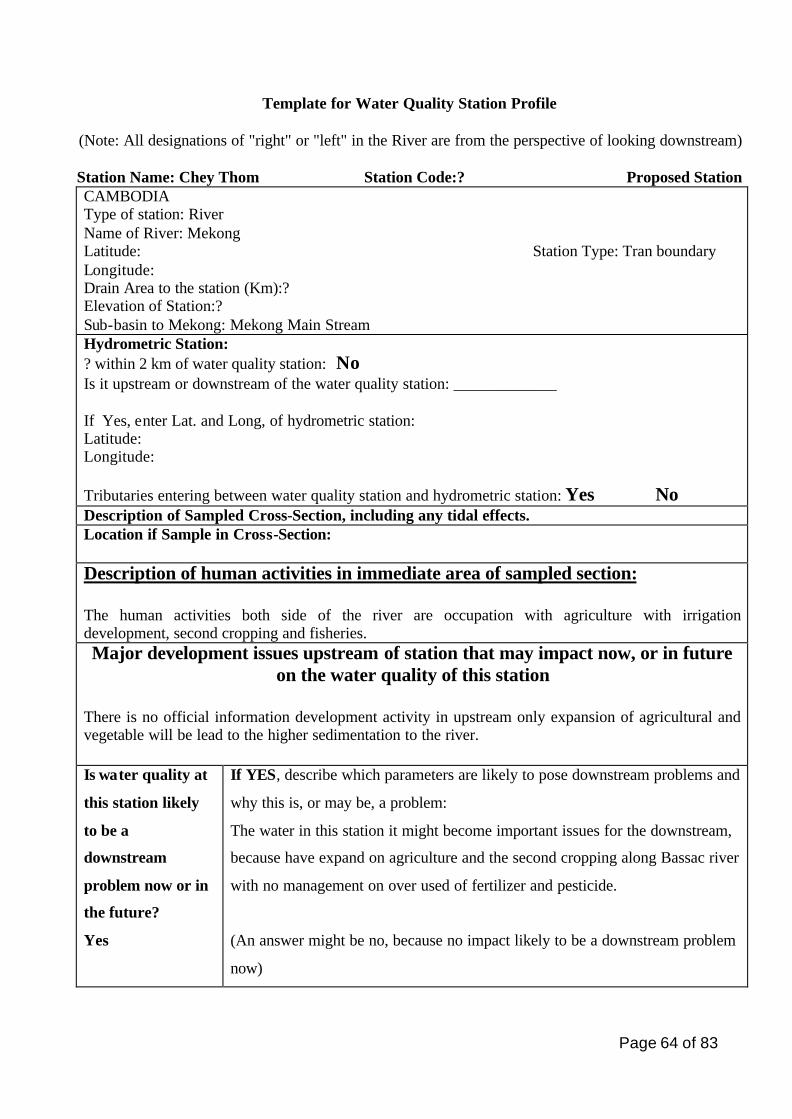
Page 64 of 83
Template for Water Quality Station Profile
(Note: All designations of "right" or "left" in the River are from the perspective of looking downstream)
Station Name: Chey Thom Station Code:? Proposed Station CAMBODIA Type of station: River Name of River: Mekong Latitude: Station Type: Tran boundary Longitude: Drain Area to the station (Km):? Elevation of Station:? Sub-basin to Mekong: Mekong Main Stream Hydrometric Station: ? within 2 km of water quality station: No Is it upstream or downstream of the water quality station: _____________ If Yes, enter Lat. and Long, of hydrometric station: Latitude: Longitude: Tributaries entering between water quality station and hydrometric station: Yes No Description of Sampled Cross-Section, including any tidal effects. Location if Sample in Cross-Section: Description of human activities in immediate area of sampled section: The human activities both side of the river are occupation with agriculture with irrigation development, second cropping and fisheries. Major development issues upstream of station that may impact now, or in future
on the water quality of this station There is no official information development activity in upstream only expansion of agricultural and vegetable will be lead to the higher sedimentation to the river. Is water quality at
this station likely
to be a
downstream
problem now or in
the future?
Yes
If YES, describe which parameters are likely to pose downstream problems and
why this is, or may be, a problem:
The water in this station it might become important issues for the downstream,
because have expand on agriculture and the second cropping along Bassac river
with no management on over used of fertilizer and pesticide.
(An answer might be no, because no impact likely to be a downstream problem
now)
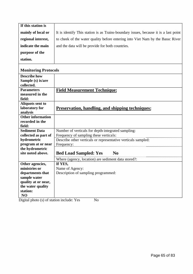
Page 65 of 83
If this station is
mainly of local or
regional interest,
indicate the main
purpose of the
station.
It is identify This station is as Trains-boundary issues, because it is a last point
to cheek of the water quality before entering into Viet Nam by the Bassc River
and the data will be provide for both countries.
Monitoring Protocols Describe how Sample (s) is/are collected.
Parameters measured in the field:
Field Measurement Technique:
Aliquots sent to laboratory for analysis
Preservation, handling, and shipping techniques:
Other information recorded in the field:
Number of verticals for depth- integrated sampling: Frequency of sampling these verticals: Describe other verticals or representative verticals sampled: Frequency:
Bed Load Sampled: Yes No
Sediment Data collected as part of hydrometric program at or near the hydrometric site noted above.
Where (agency, location) are sediment data stored?: Other agencies, ministries or departments that sample water quality at or near, the water quality station: NO
If YES, Name of Agency: Description of sampling programmed:
Digital photo (s) of station include: Yes No
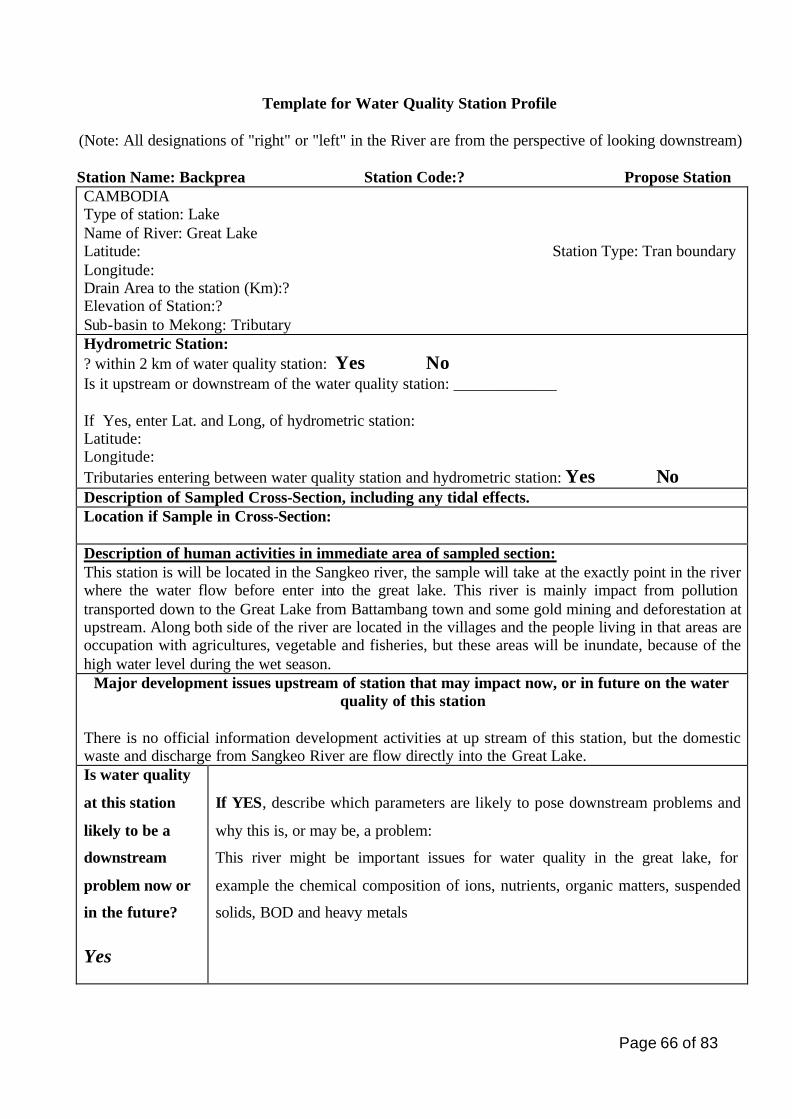
Page 66 of 83
Template for Water Quality Station Profile
(Note: All designations of "right" or "left" in the River are from the perspective of looking downstream) Station Name: Backprea Station Code:? Propose Station CAMBODIA Type of station: Lake Name of River: Great Lake Latitude: Station Type: Tran boundary Longitude: Drain Area to the station (Km):? Elevation of Station:? Sub-basin to Mekong: Tributary Hydrometric Station: ? within 2 km of water quality station: Yes No Is it upstream or downstream of the water quality station: _____________ If Yes, enter Lat. and Long, of hydrometric station: Latitude: Longitude: Tributaries entering between water quality station and hydrometric station: Yes No Description of Sampled Cross-Section, including any tidal effects. Location if Sample in Cross-Section: Description of human activities in immediate area of sampled section: This station is will be located in the Sangkeo river, the sample will take at the exactly point in the river where the water flow before enter into the great lake. This river is mainly impact from pollution transported down to the Great Lake from Battambang town and some gold mining and deforestation at upstream. Along both side of the river are located in the villages and the people living in that areas are occupation with agricultures, vegetable and fisheries, but these areas will be inundate, because of the high water level during the wet season.
Major development issues upstream of station that may impact now, or in future on the water quality of this station
There is no official information development activities at up stream of this station, but the domestic waste and discharge from Sangkeo River are flow directly into the Great Lake. Is water quality
at this station
likely to be a
downstream
problem now or
in the future?
Yes
If YES, describe which parameters are likely to pose downstream problems and
why this is, or may be, a problem:
This river might be important issues for water quality in the great lake, for
example the chemical composition of ions, nutrients, organic matters, suspended
solids, BOD and heavy metals
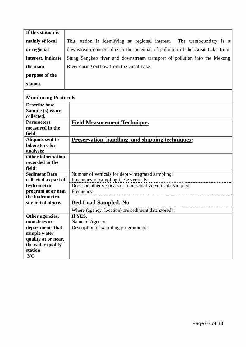
Page 67 of 83
If this station is
mainly of local
or regional
interest, indicate
the main
purpose of the
station.
This station is identifying as regional interest. The transboundary is a
downstream concern due to the potential of pollution of the Great Lake from
Stung Sangkeo river and downstream transport of pollution into the Mekong
River during outflow from the Great Lake.
Monitoring Protocols Describe how Sample (s) is/are collected.
Parameters measured in the field:
Field Measurement Technique:
Aliquots sent to laboratory for analysis:
Preservation, handling, and shipping techniques:
Other information recorded in the field:
Number of verticals for depth- integrated sampling: Frequency of sampling these verticals: Describe other verticals or representative verticals sampled: Frequency:
Bed Load Sampled: No
Sediment Data collected as part of hydrometric program at or near the hydrometric site noted above.
Where (agency, location) are sediment data stored?: Other agencies, ministries or departments that sample water quality at or near, the water quality station: NO
If YES, Name of Agency: Description of sampling programmed:
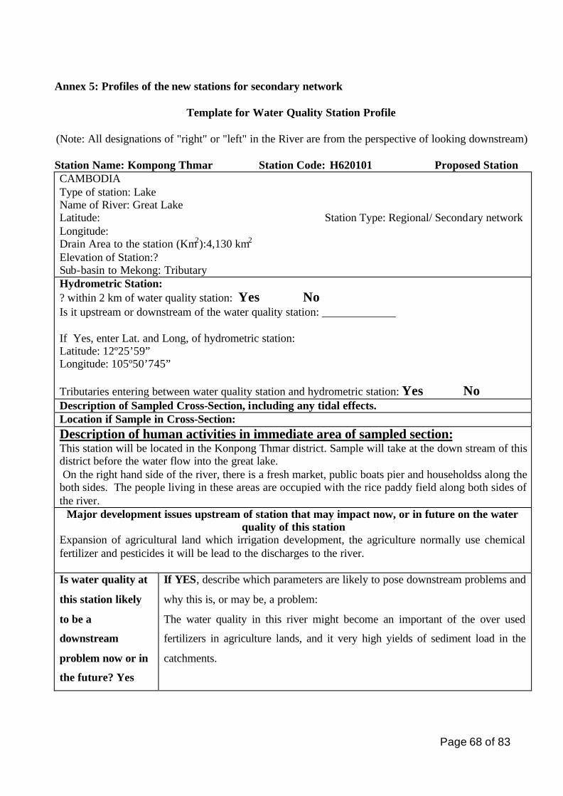
Page 68 of 83
Annex 5: Profiles of the new stations for secondary network
Template for Water Quality Station Profile
(Note: All designations of "right" or "left" in the River are from the perspective of looking downstream)
Station Name: Kompong Thmar Station Code: H620101 Proposed Station CAMBODIA Type of station: Lake Name of River: Great Lake Latitude: Station Type: Regional/ Secondary network Longitude: Drain Area to the station (Km2):4,130 km2 Elevation of Station:? Sub-basin to Mekong: Tributary Hydrometric Station: ? within 2 km of water quality station: Yes No Is it upstream or downstream of the water quality station: _____________ If Yes, enter Lat. and Long, of hydrometric station: Latitude: 12º25’59” Longitude: 105º50’745” Tributaries entering between water quality station and hydrometric station: Yes No Description of Sampled Cross-Section, including any tidal effects. Location if Sample in Cross-Section: Description of human activities in immediate area of sampled section: This station will be located in the Konpong Thmar district. Sample will take at the down stream of this district before the water flow into the great lake. On the right hand side of the river, there is a fresh market, public boats pier and householdss along the both sides. The people living in these areas are occupied with the rice paddy field along both sides of the river.
Major development issues upstream of station that may impact now, or in future on the water quality of this station
Expansion of agricultural land which irrigation development, the agriculture normally use chemical fertilizer and pesticides it will be lead to the discharges to the river. Is water quality at
this station likely
to be a
downstream
problem now or in
the future? Yes
If YES, describe which parameters are likely to pose downstream problems and
why this is, or may be, a problem:
The water quality in this river might become an important of the over used
fertilizers in agriculture lands, and it very high yields of sediment load in the
catchments.
Page 69 of 83
If this station is
mainly of local or
regional interest,
indicate the main
purpose of the
station.
This station is identified as local interest/secondary network. The main purpose
of this station is to control on water quality that flow from upstream of the
Stung Chinit river before entering into the great lake.
Monitoring Protocols Describe how Sample (s) is/are collected.
Parameters measured in the field:
Field Measurement Technique:
Aliquots sent to laboratory for analysis:
Preservation, handling, and shipping techniques:
Other information recorded in the field:
Number of verticals for depth- integrated sampling: Frequency of sampling these verticals: Describe other verticals or representative verticals sampled: Frequency:
Bed Load Sampled: Yes No
Sediment Data collected as part of hydrometric program at or near the hydrometric site noted above.
Where (agency, location) are sediment data stored?: Other agencies, ministries or departments that sample water quality at or near, the water quality station: NO
If YES, Name of Agency: Description of sampling programmed:
Digital photo (s) of station include: Yes No
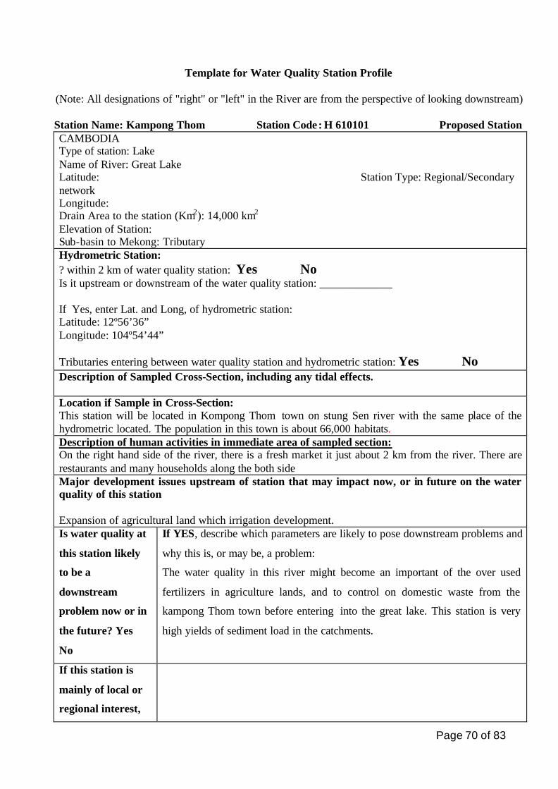
Page 70 of 83
Template for Water Quality Station Profile
(Note: All designations of "right" or "left" in the River are from the perspective of looking downstream)
Station Name: Kampong Thom Station Code: H 610101 Proposed Station CAMBODIA Type of station: Lake Name of River: Great Lake Latitude: Station Type: Regional/Secondary network Longitude: Drain Area to the station (Km2): 14,000 km2
Elevation of Station: Sub-basin to Mekong: Tributary Hydrometric Station: ? within 2 km of water quality station: Yes No Is it upstream or downstream of the water quality station: _____________ If Yes, enter Lat. and Long, of hydrometric station: Latitude: 12º56’36” Longitude: 104º54’44” Tributaries entering between water quality station and hydrometric station: Yes No Description of Sampled Cross-Section, including any tidal effects. Location if Sample in Cross-Section: This station will be located in Kompong Thom town on stung Sen river with the same place of the hydrometric located. The population in this town is about 66,000 habitats. Description of human activities in immediate area of sampled section: On the right hand side of the river, there is a fresh market it just about 2 km from the river. There are restaurants and many households along the both side Major development issues upstream of station that may impact now, or in future on the water quality of this station Expansion of agricultural land which irrigation development. Is water quality at
this station likely
to be a
downstream
problem now or in
the future? Yes
No
If YES, describe which parameters are likely to pose downstream problems and
why this is, or may be, a problem:
The water quality in this river might become an important of the over used
fertilizers in agriculture lands, and to control on domestic waste from the
kampong Thom town before entering into the great lake. This station is very
high yields of sediment load in the catchments.
If this station is
mainly of local or
regional interest,
Page 71 of 83
indicate the main
purpose of the
station.
Monitoring Protocols Describe how Sample (s) is/are collected.
Parameters measured in the field:
Field Measurement Technique:
Aliquots sent to laboratory for analysis:
Preservation, handling, and shipping techniques:
Other information recorded in the field:
Number of verticals for depth- integrated sampling: Frequency of sampling these verticals: Describe other verticals or representative verticals sampled: Frequency:
Bed Load Sampled: Yes No
Sediment Data collected as part of hydrometric program at or near the hydrometric site noted above.
Where (agency, location) are sediment data stored?: Other agencies, ministries or departments that sample water quality at or near, the water quality station: NO
If YES, Name of Agency: Description of sampling programmed:
Digital photo (s) of station include: Yes No

Page 72 of 83
Related Documents