Laird’s Corner Roundabout At the intersection of State Route 190 and Road 152 (Bliss Lane) east of Tipton in Tulare County 06-FRE-190-PM 4.0/5.0 Project ID: 06-12000182 (EA 06-0P5900) SCH: 2014041025 Initial Study with Negative Declaration Prepared by the State of California Department of Transportation August 2014

Welcome message from author
This document is posted to help you gain knowledge. Please leave a comment to let me know what you think about it! Share it to your friends and learn new things together.
Transcript
Laird’s Corner Roundabout
At the intersection of State Route 190 and Road 152 (Bliss Lane)
east of Tipton in Tulare County
06-FRE-190-PM 4.0/5.0
Project ID: 06-12000182 (EA 06-0P5900)
SCH: 2014041025
Initial Study
with Negative Declaration
Prepared by the
State of California Department of Transportation
August 2014

General Information About This Document Appendix E (Comments and Responses) has been added to the document since the draft
document was circulated for review and comment. Elsewhere, a line in the margin
indicates where an addition or change has been made since the draft document was
circulated.
Printing this document: To save paper, this document has been set up for two-sided
printing (to print the front and back of a page). Blank pages occur where needed
throughout the document to maintain proper layout of the sections.
For individuals with sensory disabilities, this document is available in Braille, in large print, on audiocassette, or on computer disk. To obtain a copy in one of these alternate formats, please call or write to Caltrans, Attn: Michelle Ray, Senior Environmental Planner, Sierra Pacific Environmental Analysis Branch, 855 M Street, Suite 200, Fresno, CA 93721; (559) 445-5286, or 711.
Laird’s Corner Roundabout i
06-TUL-190-PM4.0/5.0 06-1200-0182
State Clearinghouse Number 2014041025
Improve the intersection at State Route 190 and Road 152 (Bliss Lane) east of Tipton in Tulare County
INITIAL STUDY with Negative Declaration
Submitted Pursuant to: (State) Division 13, California Public Resources Code
THE STATE OF CALIFORNIA Department of Transportation
The following person may be contacted for additional information concerning this document: Michelle Ray, Senior Environmental Planner 855 M Street, Suite 200 Fresno, CA 93721 (559) 445-5286

Laird’s Corner Roundabout iii
Negative Declaration Pursuant to: Division 13, Public Resources Code
Project Description
The California Department of Transportation (Caltrans) proposes to improve the intersection
of State Route 190 and Road 152 (Bliss Lane) in Tulare County east of the Tipton (post miles
4.0 to 5.0) by constructing a roundabout on the existing alignment of State Route 190.
Determination
Caltrans has prepared an Initial Study for this project, and following public review, has
determined from this study that the proposed project will not have a significant effect on the
environment for the following reasons:
The project will have no effect on aesthetics, air quality, cultural resources,
geology/soils, hazardous waste and hazardous materials, hydrology/water quality,
land use/planning, mineral resources, population/housing/public services, recreation,
transportation/traffic, and utilities/service systems.
The project will have less than a significant effect on threatened and endangered
species, farmland, and noise.


Laird’s Corner Roundabout v
Table of Contents Negative Declaration ........................................................................................................... iii Table of Contents ................................................................................................................. v List of Figures ...................................................................................................................... vi List of Tables ....................................................................................................................... vi Chapter 1 Proposed Project ......................................................................................... 1
1.1 Introduction ............................................................................................................ 1 1.2 Purpose and Need .................................................................................................. 4
1.2.1 Purpose ........................................................................................................... 4 1.2.2 Need ................................................................................................................ 4
1.3 Project Description ................................................................................................ 5 1.4 Project Alternatives ................................................................................................ 5
1.4.1 Build Alternative ............................................................................................ 5 1.4.2 No-Build (No-Action) Alternative ................................................................. 6
1.5 Comparison of Alternatives ................................................................................... 6 1.5.1 Identification of the Preferred Alternative ..................................................... 6 1.5.2 Alternatives Considered but Eliminated from Further Discussion ................. 7
1.6 Permits and Approvals Needed .............................................................................. 7 Chapter 2 Affected Environment, Environmental Consequences, and Avoidance, Minimization, and/or Mitigation Measures ........................................................................ 11
2.1 Human Environment ............................................................................................ 13 2.1.1 Farmland ....................................................................................................... 13 2.1.2 Community Impacts ..................................................................................... 15
2.1.2.1 Community Character and Cohesion .................................................... 15 2.1.2.2 Relocations and Real Property Acquisitions ......................................... 16 2.1.2.3 Utilities/Emergency Services ................................................................ 17 2.1.2.4 Traffic and Transportation/Pedestrian and Bicycle Facilities ............... 18
2.2 Physical Environment .......................................................................................... 20 2.2.1 Hydrology and Floodplain ............................................................................ 20 2.2.2 Water Quality and Storm Water Runoff ....................................................... 21 2.2.3 Hazardous Waste or Materials ...................................................................... 28 2.2.4 Noise and Vibration ...................................................................................... 30
2.3 Biological Environment ....................................................................................... 34 2.3.1 Threatened and Endangered Species ............................................................ 34
2.4 Climate Change .................................................................................................... 37 Chapter 3 Comments and Coordination .................................................................... 53
Chapter 4 List of Preparers ........................................................................................ 55
Appendix A California Environmental Quality Act Checklist .................................. 57
Appendix B Title VI Policy Statement ...................................................................... 67
Appendix C Minimization and/or Mitigation Summary ........................................... 69
Appendix D NRCS Farmland Conversion Impact Rating Form ............................... 73
Appendix E Comments and Responses ..................................................................... 75

Laird’s Corner Roundabout vi
List of Figures
Figure 1-1 Project Vicinity Map ............................................................................... 2 Figure 1-2 Project Location Map .............................................................................. 3 Figure 1-3 Build Alternative: Single-lane Roundabout Intersection ........................ 9 Figure 2-1 Noise Levels of Common Activities ..................................................... 32 Figure 2-2 California Greenhouse Gas Forecast .................................................... 42 Figure 2-3 Possible Effect of Traffic Operation Strategies in Reducing On-Road Carbon Dioxide (CO2) Emission ................................................................................. 43 Figure 2-4 Mobility Pyramid .................................................................................. 46
List of Tables
Table 1.1 Accident Rates at State Route 190 and Road 152 (Bliss Lane) .............. 4 Table 1.2 Comparison of Alternatives .................................................................... 6 Table 2.1 Farmland Conversion ............................................................................ 14 Table 2.2 Utilities Affected ................................................................................... 17 Table 2.3 Noise Abatement Criteria ..................................................................... 31 Table 2.4 Climate Change Strategies .................................................................... 48
List of Abbreviated Terms Caltrans California Department of Transportation CDFG California Department of Fish and Game CEQA California Environmental Quality Act FHWA Federal Highway Administration NEPA National Environmental Policy Act PM post mile USFWS United States Fish and Wildlife Service

Laird’s Corner Roundabout 1
Chapter 1 Proposed Project
1.1 Introduction
The California Department of Transportation (Caltrans) proposes to improve the
intersection of State Route 190 and Road 152 (Bliss Lane), post miles 4.0 to 5.0, east
of Tipton in Tulare County, California (see Figure 1-1 and Figure 1-2). The project
has two alternatives under consideration—a No-Build Alternative and a Build
Alternative. The Build Alternative will construct a single-lane roundabout that will
require all traffic to make right-hand turns creating a traffic pattern that promotes a
safer intersection by slowing down traffic from all directions on a high-speed
roadway.
The project is located about 4.5 miles east of Tipton at the intersection of State Route
190 and Road 152 (Bliss Lane), once known as Laird’s Corner. The area is primarily
farmland to the north and residential or farmland/commercial to the south. The posted
speed limit is 55 miles per hour, and flashing beacon lights are placed on State Route
190 and on Road 152 (Bliss Lane) notifying drivers of the upcoming intersection.
Traffic on Road 152 (Bliss Lane) is currently controlled by stop signs, but traffic on
State Route 190 does not have to stop.
State Route 190 is an east-west corridor that originates from State Route 99 near the
community of Tipton and heads east toward the Sierra Nevada Mountain Range. State
Route 190 serves the communities of Tipton, Poplar, Porterville, and Springville.
Most of State Route 190 is a two-lane conventional highway but, within the City of
Porterville, the route becomes a divided four-lane expressway. Travelers use the route
to gain direct access to Success Lake, Camp Nelson, Sequoia National Forest, and
other recreational areas to the east of the project area. The route also provides access
to the Tule River Indian Reservation, Eagle Mountain Casino, Walmart Distribution
Center, Porterville Community College and Porterville State Hospital.
The route intersects with State Route 65 near Porterville and provides access for
agricultural goods movement as well as the movement of other products
manufactured in Tulare County.
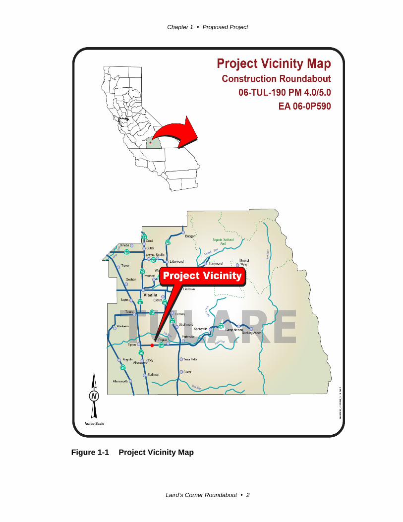
Chapter 1 Proposed Project
Laird’s Corner Roundabout 2
Figure 1-1 Project Vicinity Map

Chapter 1 Proposed Project
Laird’s Corner Roundabout 3
Figure 1-2 Project Location Map
Chapter 1 Proposed Project
Laird’s Corner Roundabout 4
The estimated capital cost is $3.34 million, and the project is programmed in the 2014
State Highway Operation and Protection Program (SHOPP). The route is part of the
Tulare County Regional Road System and is currently not a bicycle route.
Caltrans is the lead agency under the California Environmental Quality Act (CEQA).
Because funding for the proposed project includes federal funds and there are no
environmental impacts, a National Environmental Policy Act Categorical Exclusion
(NEPA-CE) will be prepared after circulation and public comment of this document.
1.2 Purpose and Need
1.2.1 Purpose
The purpose of the project is to improve safety at the intersection of State Route 190
and Road 152 (Bliss Lane).
1.2.2 Need
The project is needed because the accident rate at this intersection is higher than the
statewide average for similar intersections within the state. It is expected that the
Roundabout Alternative will provide greater safety and more efficient traffic
operation with higher benefit to cost ratio than other improvements.
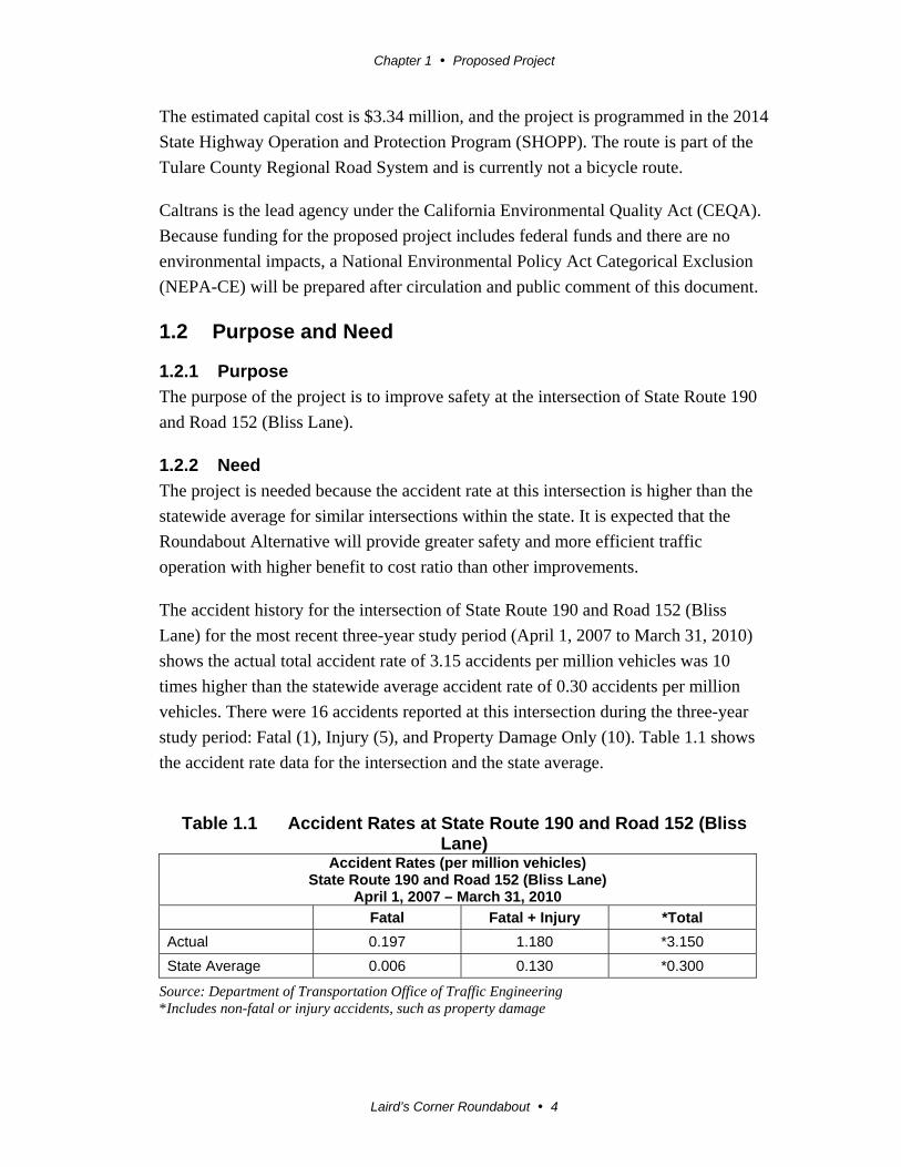
The accident history for the intersection of State Route 190 and Road 152 (Bliss
Lane) for the most recent three-year study period (April 1, 2007 to March 31, 2010)
shows the actual total accident rate of 3.15 accidents per million vehicles was 10
times higher than the statewide average accident rate of 0.30 accidents per million
vehicles. There were 16 accidents reported at this intersection during the three-year
study period: Fatal (1), Injury (5), and Property Damage Only (10). Table 1.1 shows
the accident rate data for the intersection and the state average.
Table 1.1 Accident Rates at State Route 190 and Road 152 (Bliss Lane)
Accident Rates (per million vehicles)State Route 190 and Road 152 (Bliss Lane)
April 1, 2007 – March 31, 2010
Fatal Fatal + Injury *Total
Actual 0.197 1.180 *3.150
State Average 0.006 0.130 *0.300
Source: Department of Transportation Office of Traffic Engineering *Includes non-fatal or injury accidents, such as property damage

Chapter 1 Proposed Project
Laird’s Corner Roundabout 5
State Route 190 at this location is designated as a terminal access route under the
National Network for larger trucks allowed by the Surface Transportation Assistance
Act (STAA) of 1982. Trucks account for about 24 percent of the average daily traffic
(ADT) count, which for this segment of the highway was 5,800 vehicles in 2013.
The Traffic Investigation conducted for this intersection determined the intersection
did not meet the warrant for a traffic signal (Caltrans District 6 Office of Traffic
Investigation).
1.3 Project Description
This section describes the proposed action and the project alternatives that were
developed to meet the identified purpose and need of the project while avoiding or
minimizing environmental impacts. The project is proposing to construct a single-
lane roundabout that will require all traffic to make right-hand turns creating a traffic
pattern that promotes a safer intersection by slowing down traffic from all directions
on a high-speed roadway.
1.4 Project Alternatives
The project has two alternatives under consideration—a Build Alternative and a No-
Build Alternative.
1.4.1 Build Alternative
The Build Alternative will construct a single-lane roundabout intersection that
requires all traffic to make right-hand turns creating a traffic pattern that promotes a
safer intersection by slowing down traffic from all directions on a high-speed
roadway (see Figure 1-3). The roundabout design will accommodate agricultural
equipment, buses, and oversized trucks.
Design Features of the Build Alternative
The Build Alternative will include the following:
A central island in the intersection
Outside shoulders in all directions
A truck apron
Four splitter islands (to separate traffic) with a pedestrian refuge
Sidewalks and curb ramps on each corner of the intersection
Improvement to about 0.5 mile of State Route 190 east and west of Road 152
(Bliss Lane)

Chapter 1 Proposed Project
Laird’s Corner Roundabout 6
Improvement to about 600 feet of Road 152 (Bliss Lane) north and south of
State Route 190
A storm water drainage basin on the east side of Road 152 (Bliss Lane)
1.4.2 No-Build (No-Action) Alternative
Consideration of a No-Build Alternative is required by the National Environmental
Policy Act. The No-Build Alternative will leave the intersection as it is, and as a
result, the high number of collisions will continue and the purpose and need will not
be met.
1.5 Comparison of Alternatives
Criteria to evaluate alternatives include purpose and need objectives and potential
environmental effects of the proposed project. Table 1.2 compares the alternatives
using the evaluation criteria.
Table 1.2 Comparison of Alternatives
Evaluation Criteria Build Alternative—
Single-lane Roundabout Intersection No-Build Alternative
Meets Purpose and Need
Will lower traffic speed and create a traffic pattern of right-hand turns that promotes a safer intersection by slowing down traffic from all directions on a high-speed roadway
Does not meet purpose and need
Estimated Cost $3.34 million Cost for maintenance of existing intersection
Environmental Impacts: Land Use
Consistent with local, state, and regional land use Improvements will not be made
Right-of-way Needed Acquires about 7 acres of right-of-way from both sides of State Route 190
No right-of-way will be necessary
Relocation Relocates several non-residential structures and some utility poles
No relocations will be necessary
Farmland Converts 7 acres of prime and unique farmland No farmland will be converted
Traffic Circulation A two-way left-turn lane (about 300 feet long) will provide access to residents in close proximity to the intersection on the south side of State Route 190
No change in circulation
Threatened and Endangered Species
“may effect, not likely to adversely affect” for the impacts to the San Joaquin kit fox (kit fox)
No change to resource
1.5.1 Identification of the Preferred Alternative
After the public circulation and review period, Caltrans selected the Build Alternative
as the preferred alternative because the Build Alternative has the greatest project
benefits with regard to any associated impacts, and meets the purpose and need of the
project.
Chapter 1 Proposed Project
Laird’s Corner Roundabout 7
1.5.2 Alternatives Considered but Eliminated from Further Discussion
Three other alternatives were considered during the draft project report/draft
environmental document phase:
Alternative 1B considered a single-lane roundabout intersection 100 feet north
of the existing alignment of State Route 190. This alternative was rejected
because the cost was above the limit allowed by the Caltrans Safety Index (SI)
for transportation facilities.
Alternative 2 considered an intersection with traffic signals. This alternative
was rejected because it did not satisfy the signal warrants requirement from
Caltrans District 6 Traffic Operations.
Alternative 3 considered an all-way-stop (a four-way stop) intersection but
was rejected because it did not meet the purpose and need for the project.
Plus, as traffic volumes increase over time, the level of service would
decrease, causing significant traffic delays and congestion.
1.6 Permits and Approvals Needed
No permits are required for this project, but Caltrans obtained a Letter of Concurrence
from the U.S. Fish and Wildlife Service on a determination of “may affect, not likely
to adversely affect” for the impacts to the San Joaquin kit fox.
Agency Permit/Approval Status
U.S. Fish and Wildlife Service (USFWS)
Section 7 Letter of Concurrence for Threatened and Endangered Species
Received on April 11, 2014


Chapter 1 Proposed Project
Laird’s Corner Roundabout 9
Figure 1-3 Build Alternative: Single-lane Roundabout Intersection


Laird’s Corner Roundabout 11
Chapter 2 Affected Environment, Environmental Consequences, and Avoidance, Minimization, and/or Mitigation Measures
This chapter explains the impacts that the project will have on the human, physical,
and biological environments in the project area. It describes the existing environment
that could be affected by the project, potential impacts from each of the alternatives,
and proposed avoidance, minimization, and/or mitigation measures. Any indirect
impacts are included in the general impacts analysis and discussions that follow.
As part of the scoping and environmental analysis conducted for the project, the
following environmental issues were considered, but no adverse impacts were
identified. Consequently, there is no further discussion regarding these issues in this
document.
Land Use - The project is consistent with existing and future land use and with
state, regional, and local plans (Tulare County General Plan 2008, SHOPP Safety
Improvement Program in 2012/2013, Regional Transportation Plan 2012, Federal
Transportation Improvement Program 2008).
Coastal Zone - The project is not located within a coastal zone (Field Review,
October 2013).
Wild and Scenic Rivers - There are no wild or scenic rivers within the project
limits (Field Review, October 2013).
Parks and Recreation - There are no parks or recreational facilities within the
project limits (Field Review, October 2013).
Growth - The project will not promote growth because it is a safety project that
upgrades an existing intersection (Field Review, October 2013).
Farmland/Timberlands - No timberland is located within the project limits (Field
Review, October 2013). Farmland is discussed in Section 2.2.1 of this document.
Environmental Justice - The alternatives will not cause disproportionately high
and adverse effects on any minority or low-income populations as per Executive

Chapter 2 Affected Environment, Environmental Consequences, and Avoidance, Minimization, and/or Mitigation Measures
Laird’s Corner Roundabout 12
Order 12898 regarding environmental justice (Field Review and Scoping
Meeting, October 2013).
Visual/Aesthetics - No qualifying scenic resources, as defined in the enactment of
Section 1530(c) of the State Environmental Impact Report (EIR) Guidelines, will
be affected by the project, and no residual or cumulative adverse visual impact
will result from the project (Scenic Resource Evaluation (SRE), October 2013).
Cultural Resources - No archaeological or historical resources were identified
within the project area (Historic Property Survey Report, October 2013).
Geology/Soils/Seismic/Topography - The project will not result in substantial soil
erosion or landslides. The project is not located on a geologic unit or soil that is
unstable or that will become unstable as a result of the project (U.S. Geological
Survey Earthquake Hazards Program, December 2011).
Paleontology - Excavation associated with the proposed project is unlikely to
encounter scientifically important paleontological resources (Paleontological
Identification Report, May 2013).
Air Quality - Caltrans completed a PM2.5 and PM10 Hot-spot Conformity
Assessment for the project in July 2013 and determined the project met the
criteria for “not a project of air quality concern.” On July 24, 2013, the
Environmental Protection Agency (EPA) and Caltrans’ interagency consultation
partners concurred with the determination the project is not a project of air quality
concern. During construction, according the Caltrans’ Standard Specifications, the
contractor must comply with all local Air Pollution Control District's (APCD)
rules, ordinances, and regulations for air quality restrictions.
Natural Communities - No known natural communities were identified in the
project area (Natural Environmental Study-Minimal Impacts, December 2013).
Wetlands and other Waters - No wetlands or other waters were identified in the
project area (Natural Environmental Study-Minimal Impacts, December 2013).
Plant Species - No plant species of concern were found within the project area
(Natural Environmental Study-Minimal Impacts, December 2013).
Animal Species - One special-status species has the potential to occur in the
proposed project area—the federally endangered San Joaquin kit fox (Vulpes
macrotis mutica) (Natural Environmental Study-Minimal Impacts, December
2013).
Chapter 2 Affected Environment, Environmental Consequences, and Avoidance, Minimization, and/or Mitigation Measures
Laird’s Corner Roundabout 13
Invasive Species - The spread of invasive species during construction will be
prevented with the use of best management practices (Natural Environmental
Study-Minimal Impacts, December 2013).
2.1 Human Environment
2.1.1 Farmland
Regulatory Setting
The National Environmental Policy Act (NEPA) and the Farmland Protection Policy
Act (FPPA, 7 U.S. Code [USC] 4201-4209; and its regulations, 7 Code of Federal
Regulations [CFR] Part 658) require federal agencies, such as the Federal Highway
Administration (FHWA), to coordinate with the Natural Resources Conservation
Service (NRCS) if their activities may irreversibly convert farmland (directly or
indirectly) to nonagricultural use. For purposes of the Farmland Protection Policy
Act, farmland includes prime farmland, unique farmland, and land of statewide or
local importance.
The California Environmental Quality Act (CEQA) requires the review of projects
that will convert Williamson Act contract land to non-agricultural uses. The main
purposes of the Williamson Act are to preserve agricultural land and to encourage
open space preservation and efficient urban growth. The Williamson Act provides
incentives to landowners through reduced property taxes to discourage the early
conversion of agricultural and open space lands to other uses.
Affected Environment
Tulare County ranks as the second-largest agricultural-producing county in the entire
nation, second only to Fresno County. Tulare County leads the nation in dairy
production, and milk was the first agricultural commodity worth more than $1 billion
ever recorded in any California county. In 2012, total gross production value for
Tulare County was $6,210,693,000. The county has more than 46 crops worth more
than $1 million each in farm gate gross value (http:///www.agcomm.co.tulare.ca.us/).
The north side of this 1-mile segment of State Route 190 is used for growing crops
and has no structures. A few dairies sit along the south side of State Route 190 along
with residential and non-residential structures and commercial businesses all with
driveways connecting to the existing State Route 190.
Chapter 2 Affected Environment, Environmental Consequences, and Avoidance, Minimization, and/or Mitigation Measures
Laird’s Corner Roundabout 14
The project is primarily located within soils identified as Akers-Akers, but toward the
eastern end of the project these soils are mixed with Colpien loam and Tagus loam
(http://websoilsurvey.nrcs.usda.gov/app/WebSoilSurvey.aspx).
Environmental Consequences
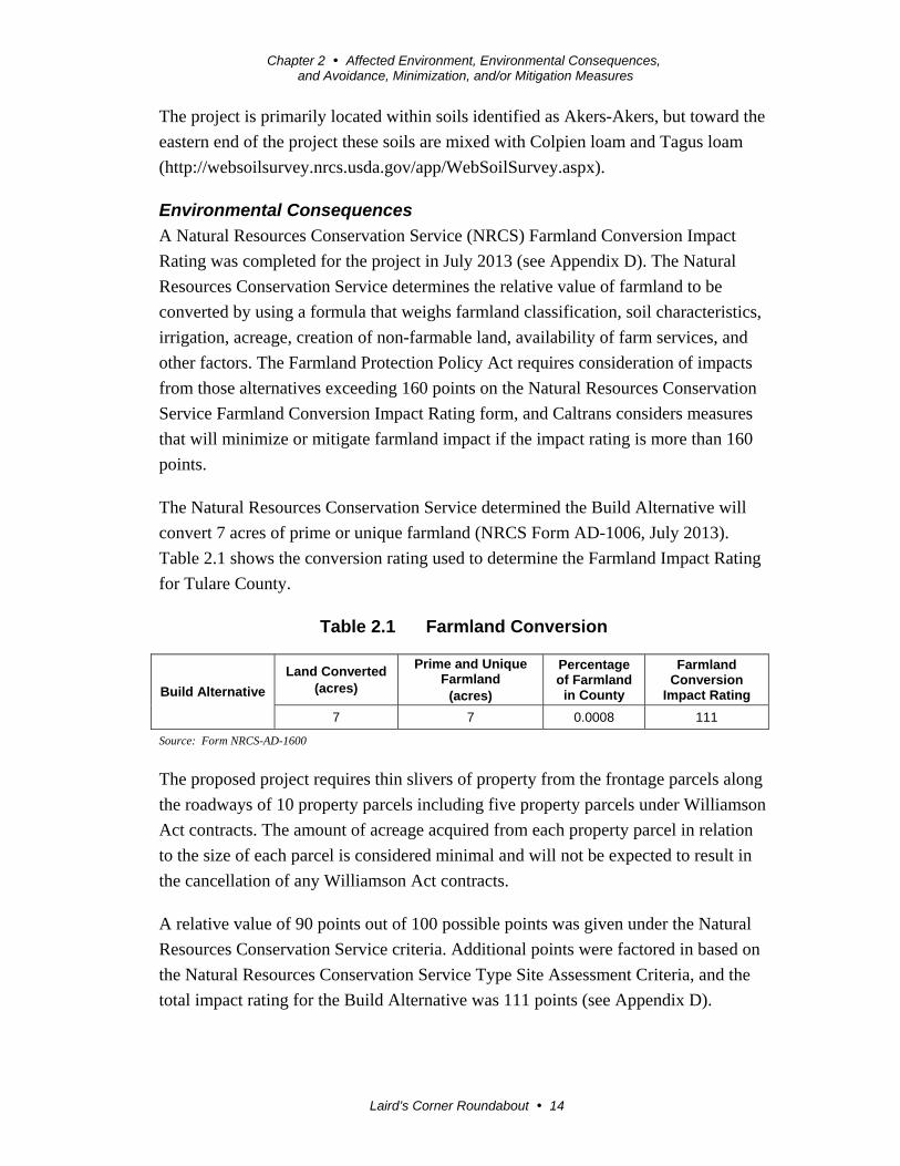
A Natural Resources Conservation Service (NRCS) Farmland Conversion Impact
Rating was completed for the project in July 2013 (see Appendix D). The Natural
Resources Conservation Service determines the relative value of farmland to be
converted by using a formula that weighs farmland classification, soil characteristics,
irrigation, acreage, creation of non-farmable land, availability of farm services, and
other factors. The Farmland Protection Policy Act requires consideration of impacts
from those alternatives exceeding 160 points on the Natural Resources Conservation
Service Farmland Conversion Impact Rating form, and Caltrans considers measures
that will minimize or mitigate farmland impact if the impact rating is more than 160
points.
The Natural Resources Conservation Service determined the Build Alternative will
convert 7 acres of prime or unique farmland (NRCS Form AD-1006, July 2013).
Table 2.1 shows the conversion rating used to determine the Farmland Impact Rating
for Tulare County.
Table 2.1 Farmland Conversion
Build Alternative
Land Converted (acres)
Prime and Unique Farmland
(acres)
Percentage of Farmland
in County
Farmland Conversion
Impact Rating
7 7 0.0008 111
Source: Form NRCS-AD-1600
The proposed project requires thin slivers of property from the frontage parcels along
the roadways of 10 property parcels including five property parcels under Williamson
Act contracts. The amount of acreage acquired from each property parcel in relation
to the size of each parcel is considered minimal and will not be expected to result in
the cancellation of any Williamson Act contracts.
A relative value of 90 points out of 100 possible points was given under the Natural
Resources Conservation Service criteria. Additional points were factored in based on
the Natural Resources Conservation Service Type Site Assessment Criteria, and the
total impact rating for the Build Alternative was 111 points (see Appendix D).

Chapter 2 Affected Environment, Environmental Consequences, and Avoidance, Minimization, and/or Mitigation Measures
Laird’s Corner Roundabout 15
Avoidance, Minimization, and/or Mitigation Measures
Because the impact rating for the Build Alternative was less than 160 points, no
further minimization or mitigation measures are required other than payment for the
property acquired.
2.1.2 Community Impacts
2.1.2.1 Community Character and Cohesion
Regulatory Setting
The National Environmental Policy Act of 1969 (NEPA), as amended, established
that the federal government use all practicable means to ensure that all Americans
have safe, healthful, productive, and aesthetically and culturally pleasing
surroundings (42 U.S. Code [USC] 4331[b][2]). The Federal Highway Administration
in its implementation of the National Environmental Policy Act (23 U.S. Code [USC]
109[h]) directs that final decisions on projects are to be made in the best overall
public interest. This requires taking into account adverse environmental impacts, such
as destruction or disruption of human-made resources, community cohesion, and the
availability of public facilities and services.
Under the California Environmental Quality Act (CEQA), an economic or social
change by itself is not to be considered a significant effect on the environment.
However, if a social or economic change is related to a physical change, then social
or economic change may be considered in determining whether the physical change is
significant. Since this project will result in physical change to the environment, it is
appropriate to consider changes to community character and cohesion in assessing the
significance of the project’s effects.
Affected Environment
No residential housing is located on the north side of State Route 190 in the location
of the project. On the southwest corner of the intersection is a parcel with a single-
family residence with non-residential structures (fencing and an out-building or
storage structure) next to State Route 190.
Environmental Consequences
The Build Alternative will require right-of-way from both sides of State Route 190.
On the north side of State Route 190, right-of-way will be acquired from farmland.
On the south side of State Route 190, right-of-way will be acquired from the two
parcels east and west of Road 152 (Bliss Lane). The right-of-way acquisition from the
parcel on the southwest will result in the demolition of non-residential structures (a
Chapter 2 Affected Environment, Environmental Consequences, and Avoidance, Minimization, and/or Mitigation Measures
Laird’s Corner Roundabout 16
cement fence and an out-building) or relocation of the structures elsewhere on the
property.
During the Scoping Meeting held in October 2013, property owners expressed
concern for their neighbors stating they did not want the proposed project to force
anyone from their home.
Avoidance, Minimization, and/or Mitigation Measures
The Build Alternative cannot avoid acquiring new right-of-way. A Caltrans appraiser
will determine just compensation for property acquired, as well as compensation for
any damages caused to the remainder of the property parcel, such as the relocation of
fencing or utilities.
2.1.2.2 Relocations and Real Property Acquisitions
Regulatory Setting
Caltrans’s Relocation Assistance Program (RAP) is based on the Federal Uniform
Relocation Assistance and Real Property Acquisition Policies Act of 1970 (as
amended) and Title 49 Code of Federal Regulations (CFR) Part 24. The purpose of
the Relocation Assistance Program is to ensure that persons displaced as a result of a
transportation project are treated fairly, consistently, and equitably so that such
persons will not suffer disproportionate injuries as a result of projects designed for the
benefit of the public as a whole.
All relocation services and benefits are administered without regard to race, color,
national origin, or sex in compliance with Title VI of the Civil Rights Act (42 U.S.
Code 2000d, et seq.). Please see Appendix B for a copy of Caltrans’s Title VI Policy
Statement.
Affected Environment
The north side of this 1-mile segment of State Route 190 is used for growing crops
and has no structures. The south side of State Route 190, however, has a couple of
dairies, residential and non-residential structures, and commercial businesses, all with
driveways connecting to existing State Route 190.
Environmental Consequences
The Build Alternative will acquire 7 acres of right-of-way from both sides of State
Route 190. The right-of-way acquired will include farmland and residential properties
located along State Route 190.
Chapter 2 Affected Environment, Environmental Consequences, and Avoidance, Minimization, and/or Mitigation Measures
Laird’s Corner Roundabout 17
Avoidance, Minimization, and/or Mitigation Measures
The proposed project cannot avoid acquiring right-of-way. During the design phase of
the project, a more detailed study will be conducted to determine the necessary right-
of way needed. Caltrans Right of Way personnel will work with the property owners
of the parcels to be partially acquired using standard relocation provisions for
compensation.
2.1.2.3 Utilities/Emergency Services
Affected Environment
Overhead utility lines are located throughout the proposed project area. The utility
poles carry electrical power lines, fiber-optic cable, and telephone lines. The utility
ownership identified by field inspection includes AT&T and Southern California
Edison (SCE).
The Tulare County Fire Department provides fire protection for the rural area
surrounding the proposed project and has stations in Tipton and Porterville.
Law enforcement is provided by the Tulare County Sheriff’s Department and has sub-
stations in Pixley and Porterville.
Ambulance services are dispatched and provided by the Tulare County Consolidated
Ambulance Dispatch in the City of Tulare.
Environmental Consequences
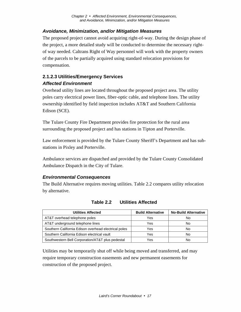
The Build Alternative requires moving utilities. Table 2.2 compares utility relocation
by alternative.
Table 2.2 Utilities Affected
Utilities Affected Build Alternative No-Build Alternative
AT&T overhead telephone poles Yes No
AT&T underground telephone lines Yes No
Southern California Edison overhead electrical poles Yes No
Southern California Edison electrical vault Yes No
Southwestern Bell Corporation/AT&T plus pedestal Yes No
Utilities may be temporarily shut off while being moved and transferred, and may
require temporary construction easements and new permanent easements for
construction of the proposed project.

Chapter 2 Affected Environment, Environmental Consequences, and Avoidance, Minimization, and/or Mitigation Measures
Laird’s Corner Roundabout 18
During construction, fire protection, law enforcement, emergency, and other public
services may be delayed but will be given priority access. The project is expected to
have a beneficial impact on emergency response times and services by improving
safety at the intersection.
Avoidance, Minimization, and Mitigation Measures
During the design phase of the project, a more detailed study will be conducted to
determine the necessary relocation of utilities. Caltrans will meet with the affected
utilities to coordinate the details for relocations and easements to avoid or minimize
any interruption in service.
2.1.2.4 Traffic and Transportation/Pedestrian and Bicycle Facilities
Regulatory Setting
Caltrans, as assigned by the Federal Highway Administration, directs that full
consideration should be given to the safe accommodation of pedestrians and
bicyclists during the development of federal-aid highway projects (see 23 Code of
Federal Regulations 652). It further directs that the special needs of the elderly and
the disabled must be considered in all federal-aid projects that include pedestrian
facilities. When current or anticipated pedestrian and/or bicycle traffic presents a
potential conflict with motor vehicle traffic, every effort must be made to minimize
the detrimental effects on all highway users who share the facility.
Caltrans is committed to carrying out the 1990 Americans with Disabilities Act by
building transportation facilities that provide equal access for all persons. The same
degree of convenience, accessibility, and safety available to the general public will be
provided to persons with disabilities.
Affected Environment
Operational deficiencies have been identified within the project limits by Caltrans
District 6 Traffic Operations and are discussed in Chapter 1 Section 1.2 Purpose and
Need.
Traffic Circulation - Currently, State Route 190 is a two-lane conventional highway
that allows residents and businesses located along State Route 190 direct access to
enter westbound or eastbound traffic.
Pedestrian Facilities - No pedestrian facilities such as sidewalks or pedestrian
crossings were identified during field reviews for the project.

Chapter 2 Affected Environment, Environmental Consequences, and Avoidance, Minimization, and/or Mitigation Measures
Laird’s Corner Roundabout 19
Bicycle Facilities - No bicycle facilities such as bicycle lanes were identified during
field reviews for the project.
Environmental Consequences
Traffic Circulation - The Build Alternative will construct a roundabout on the
existing alignment of State Route 190 and water drainage basins on the west and east
side of Road 152 (Bliss Lane) south of State Route 190. Residents on the south side
of State Route 190 should be able to make left-in and left-out turns from their
driveways to access State Route 190 because the roundabout design provides a two-
way left-turn lane (about 300-feet long) for their access. There are no residents on the
north side of State Route 190 in close proximity to the intersection.
Pedestrian Facilities - The proposed project will install pedestrian crossings and
ramps that will be in compliance with the 1990 Americans with Disabilities Act
(ADA) that will provide equal access for all persons. In addition, the four splitter
islands separating traffic will provide pedestrian refuge.
Bicycle Facilities - No bicycle facilities are planned for the proposed project.
However, the shoulders will be widened and provide extra room for bicyclists. In
addition, Tulare County has developed a Regional Bicycle Transportation Plan that
includes a Class II Bikeway (Bike Lane) on Olive Avenue (Avenue 152) parallel to
State Route 190 linking the cities of Tipton and Porterville (2010 Tulare County
Regional Bicycle Transportation Plan). A Class II bikeway or bike lane provides a
striped lane for one-way bike travel on a street or highway (Highway Design Manual
Definitions 1001.4).
Avoidance, Minimization, and Mitigation Measures
Traffic Circulation - During construction, a Transportation Management Plan will be
developed to handle local traffic patterns and reduce delay, congestion, and the
likelihood of accidents during construction. The Transportation Management Plan
includes notifying the public of construction activities via media outlets, using
changeable message signs, using construction strategies, and using the Central Valley
Traffic Management Center, which reduces congestion by monitoring traffic and
informing the public via media outlets such as radio and television.
Pedestrian and Bicycle Facilities - No minimization or mitigation measures are
required.

Chapter 2 Affected Environment, Environmental Consequences, and Avoidance, Minimization, and/or Mitigation Measures
Laird’s Corner Roundabout 20
2.2 Physical Environment
2.2.1 Hydrology and Floodplain
Regulatory Setting
Executive Order 11988 (Floodplain Management) directs all federal agencies to
refrain from conducting, supporting, or allowing actions in floodplains unless it is the
only practicable alternative. The Federal Highway Administration requirements for
compliance are outlined in 23 Code of Federal Regulations (CFR) 650 Subpart A.
To comply, the following must be analyzed:
Practicability of alternatives to any longitudinal encroachments
Risks of the action
Impacts on natural and beneficial floodplain values
Support of incompatible floodplain development
Measures to minimize floodplain impacts and to preserve/restore any
beneficial floodplain values affected by the project
The base floodplain is defined as “the area subject to flooding by the flood or tide
having a one percent chance of being exceeded in any given year.” An encroachment
is defined as “an action within the limits of the base floodplain.”
Affected Environment
This project is in the Flood Insurance Rate Map (FIRM) designation Zone X within
classification Other Areas, defined as “Areas determined to be outside the 0.2%
annual chance flood” (Hydraulics Memorandum April 24, 2012).
Both State Route 190 and Road 152 (Bliss Lane) are crowned (higher at the center of
the road), but the agricultural property on the northeast corner of the intersection
appears to be slightly higher than the existing pavement of State Route 190. There are
side ditches on both sides of State Route 190 to convey the water flow and a
corrugated metal pipe (CMP) under State Route 190 that transfers water from the
northeast corner of the intersection to the southeast corner of the intersection.
Environmental Consequences
No water appeared to pond on the southwest corner of the intersection, but there was
open land on the southeast corner of the intersection where water ponds and minor
ponding was identified on the northwest and northeast corners of the intersection. The
ponding water on the northeast corner was considered more significant and was
encroaching on the northbound travel lane of Road 152 (Bliss Lane). Pavement water

Chapter 2 Affected Environment, Environmental Consequences, and Avoidance, Minimization, and/or Mitigation Measures
Laird’s Corner Roundabout 21
from the north side of Road 152 (Bliss Lane), for about 500 feet, flows south to the
intersection.
Avoidance, Minimization and/or Mitigation Measures
To handle minor ponding, a shallow water drainage basin will be placed east of Road
152 (Bliss Lane) and south of State Route 190, requiring additional right-of-way.
The proposed project cannot avoid acquiring right-of-way for the water drainage
basins. During the design phase of the project, a more detailed study will be
conducted to determine the necessary right-of-way needed, and Caltrans Right of
Way personnel will work with the property owners of the parcels to be partially
acquired using standard relocation provisions for compensation.
2.2.2 Water Quality and Storm Water Runoff
Regulatory Setting
Federal Requirements: Clean Water Act
In 1972, Congress amended the Federal Water Pollution Control Act, making the
addition of pollutants to the waters of the U.S. from any point source1 unlawful unless
the discharge is in compliance with a National Pollutant Discharge Elimination
System (NPDES) permit. This act and its amendments are known today as the Clean
Water Act (CWA). Congress has amended the act several times. In the 1987
amendments, Congress directed dischargers of storm water from municipal and
industrial/construction point sources to comply with the National Pollutant Discharge
Elimination System permit scheme.
The following are important Clean Water Act sections:
Sections 303 and 304 require states to issue water quality standards, criteria and
guidelines.
Section 401 requires an applicant for a federal license or permits to conduct any
activity that may result in a discharge to waters of the U.S. to obtain certification
from the state that the discharge will comply with other provisions of the act. This
is most frequently required in tandem with a Section 404 permit request (see
below).
Section 402 establishes the National Pollutant Discharge Elimination System, a
permitting system for the discharges (except for dredge or fill material) of any
pollutant into waters of the U.S. Regional Water Quality Control Boards 1 A point source is any discrete conveyance such as a pipe or a human-made ditch.
Chapter 2 Affected Environment, Environmental Consequences, and Avoidance, Minimization, and/or Mitigation Measures
Laird’s Corner Roundabout 22
(RWQCB) administer this permitting program in California. Section 402(p)
requires permits for discharges of storm water from industrial/construction and
municipal separate storm sewer systems (MS4s).
Section 404 establishes a permit program for the discharge of dredge or fill
materials into waters of the United States. This permit program is administered by
the U.S. Army Corps of Engineers.
The goal of the Clean Water Act is “to restore and maintain the chemical, physical,
and biological integrity of the Nation’s waters.”
The U.S. Army Corps of Engineers issues two types of 404 permits: General and
Standard permits. There are two types of General permits: Regional permits and
Nationwide permits. Regional permits are issued for a general category of activities
when they are similar in nature and cause minimal environmental effect. Nationwide
permits are issued to allow a variety of minor project activities with no more than
minimal effects.
Ordinarily, projects that do not meet the criteria for a Nationwide Permit may be
permitted under one of the U.S. Army Corps of Engineers’ Standard permits. There
are two types of Standard permits: Individual permits and Letters of Permission.
For Standard permits, the U.S. Army Corps of Engineers’ decision to approve is
based on compliance with U.S. Environmental Protection Agency’s Section 404
(b)(1) Guidelines (U.S. Environmental Protection Agency Code of Federal
Regulations [CFR] 40 Part 230), and whether the permit approval is in the public
interest. The Section 404(b)(1) Guidelines were developed by the U.S. Environmental
Protection Agency in conjunction with the U.S. Army Corps of Engineers and allow
the discharge of dredged or fill material into the aquatic system (waters of the U.S.)
only if there is no practicable alternative that will have less adverse effects. The
guidelines state that the U.S. Army Corps of Engineers may not issue a permit if there
is a least environmentally damaging practicable alternative (LEDPA) to the proposed
discharge that will have lesser effects on waters of the U.S. and not have any other
significant adverse environmental consequences.
According to the Guidelines, documentation is needed that a sequence of avoidance,
minimization, and compensation measures has been followed, in that order. The
Guidelines also restrict permitting activities that violate water quality or toxic
Chapter 2 Affected Environment, Environmental Consequences, and Avoidance, Minimization, and/or Mitigation Measures
Laird’s Corner Roundabout 23
effluent2 standards, jeopardize the continued existence of listed species, violate
marine sanctuary protections, or cause “significant degradation” to waters of the U.S.
In addition, every permit from the U.S. Army Corps of Engineers, even if not subject
to the Section 404(b)(1) Guidelines, must meet general requirements. See 33 Code of
Federal Regulations 320.4. A discussion of the least environmentally damaging
practicable alternative (LEDPA) determination, if any, for the document is included
in the Wetlands and Other Waters section.
State Requirements: Porter-Cologne Water Quality Control Act
California’s Porter-Cologne Act, enacted in 1969, provides the legal basis for water
quality regulation within California. This act requires a “Report of Waste Discharge”
for any discharge of waste (liquid, solid, or gaseous) to land or surface waters that
may impair beneficial uses for surface and/or groundwater of the state. It predates the
Clean Water Act and regulates discharges to waters of the state. Waters of the state
include more than just waters of the U.S., like groundwater and surface waters not
considered waters of the U.S. Additionally, it prohibits discharges of “waste” as
defined, and this definition is broader than the Clean Water Act definition of
“pollutant.” Discharges under the Porter-Cologne Act are permitted by Waste
Discharge Requirements (WDRs) and may be required even when the discharge is
already permitted or exempt under the Clean Water Act.
The State Water Resources Control Board and Regional Water Quality Control
Boards are responsible for establishing the water quality standards (objectives and
beneficial uses) required by the Clean Water Act and regulating discharges to ensure
compliance with the water quality standards. Details about water quality standards in
a project area are included in the applicable Regional Water Quality Control Board
Basin Plan. In California, Regional Boards designate beneficial uses for all water
body segments in their jurisdictions and then set criteria necessary to protect these
uses. As a result, the water quality standards developed for particular water segments
are based on the designated use and vary depending on that use. In addition, the State
Water Resources Control Board identifies waters failing to meet standards for
specific pollutants. These waters are then state-listed in accordance with Clean Water
Act Section 303(d).
2 The U.S. Environmental Protection Agency defines “effluent” as “wastewater, treated or untreated, that flows out of a treatment plant, sewer, or industrial outfall.”
Chapter 2 Affected Environment, Environmental Consequences, and Avoidance, Minimization, and/or Mitigation Measures
Laird’s Corner Roundabout 24
If a state determines that waters are impaired for one or more constituents and the
standards cannot be met through point source or non-point source controls
(“wastewater, treated or untreated, that flows out of a treatment plant, sewer, or
industrial outfall”), National Pollutant Discharge Elimination System permits or
Water Discharge Requirements, the Clean Water Act requires the establishment of
Total Maximum Daily Loads (TMDLs). Total Maximum Daily Loads specify
allowable pollutant loads from all sources (point, non-point, and natural) for a given
watershed.
State Water Resources Control Board and Regional Water Quality Control
Boards
The State Water Resources Control Board administers water rights, sets water
pollution control policy, and issues water board orders on matters of statewide
application, and oversees water quality functions throughout the state by approving
Basin Plans, Total Maximum Daily Loads, and National Pollutant Discharge
Elimination permits. Regional Water Control Quality Boards are responsible for
protecting beneficial uses of water resources within their regional jurisdiction using
planning, permitting, and enforcement authorities to meet this responsibility.
National Pollutant Discharge Elimination System Program
Municipal Separate Storm Sewer Systems (MS4)
Section 402(p) of the Clean Water Act requires the issuance of National Pollutant
Discharge Elimination permits for five categories of storm water discharges,
including Municipal Separate Storm Sewer Systems (MS4s). An Municipal Separate
Storm Sewer Systems is defined as “any conveyance or system of conveyances (roads
with drainage systems, municipal streets, catch basins, curbs, gutters, ditches, human-
made channels, and storm drains) owned or operated by a state, city, town, county, or
other public body having jurisdiction over storm water, that is designed or used for
collecting or conveying storm water.” The State Water Resources Control Board has
identified the Department as an owner/operator of and Municipal Separate Storm
Sewer Systems under federal regulations. The Department’s Municipal Separate
Storm Sewer Systems permit covers all Department rights-of-way, properties,
facilities, and activities in the state. The State Water Resources Control Board or the
Regional Water Quality Control Board issues National Pollutant Discharge
Elimination System permits for five years, and permit requirements remain active
until a new permit has been adopted.

Chapter 2 Affected Environment, Environmental Consequences, and Avoidance, Minimization, and/or Mitigation Measures
Laird’s Corner Roundabout 25
The Department’s Municipal Separate Storm Sewer Systems Permit (Order No. 2012-
0011-Department of Water Quality) was adopted on September 19, 2012 and became
effective on July 1, 2013. The permit has three basic requirements:
1. The Department must comply with the requirements of the Construction
General Permit (see below);
2. The Department must implement a year-round program in all parts of the State
to effectively control storm water and non-storm water discharges; and
3. The Department storm water discharges must meet water quality standards
through implementation of permanent and temporary (construction) Best
Management Practices (BMPs), to the Maximum Extent Practicable, and other
measures as the State Water Resources Control Board determines to be
necessary to meet the water quality standards.
To comply with the permit, the Department developed the Statewide Storm Water
Management Plan (SWMP) to address storm water pollution controls related to
highway planning, design, construction, and maintenance activities throughout
California. The Statewide Storm Water Management Plan assigns responsibilities
within the Department for implementing storm water management procedures and
practices as well as training, public education and participation, monitoring and
research, program evaluation, and reporting activities. The Statewide Storm Water
Management Plan describes the minimum procedures and practices the Department
uses to reduce pollutants in storm water and non-storm water discharges. It outlines
procedures and responsibilities for protecting water quality, including the selection
and implementation of best management practices (BMPs). The proposed project will
be programmed to follow the guidelines and procedures outlined in the latest State
Storm Water Management Plan to address storm water runoff.
Construction General Permit
Construction General Permit (Order No. 2009-009-DWQ), adopted on September 2,
2009, became effective on July 1, 2010. The permit regulates storm water discharges
from construction sites that result in a Disturbed Soil Area (DSA) of one acre or
greater, and/or are smaller sites that are part of a larger common plan of development.
By law, all storm water discharges associated with construction activity where
clearing, grading, and excavation result in soil disturbance of at least one acre must
comply with the provisions of the General Construction Permit. Construction activity
that results in soil disturbances of less than one acre is subject to this Construction
General Permit if there is potential for significant water quality impairment resulting
Chapter 2 Affected Environment, Environmental Consequences, and Avoidance, Minimization, and/or Mitigation Measures
Laird’s Corner Roundabout 26
from the activity as determined by the Regional Water Quality Control Board.
Operators of regulated construction sites are required to develop storm water
pollution prevention plans; to implement sediment, erosion, and pollution prevention
control measures; and to obtain coverage under the Construction General Permit.
The 2009 Construction General Permit separates projects into Risk Levels 1, 2, or 3.
Risk levels are determined during the planning and design phases, and are based on
potential erosion and transport to receiving waters. Requirements apply according to
the Risk Level determined. For example, a Risk Level 3 (highest risk) project will
require compulsory storm water runoff pH and turbidity monitoring, and before
construction and after construction aquatic biological assessments during specified
seasonal windows. For all projects subject to the permit, applicants are required to
develop and implement an effective Storm Water Pollution Prevention Plan
(SWPPP). In accordance with the Department’s Standard Specifications, a Water
Pollution Control Plan (WPCP) is necessary for projects with disturbed soil area
(DSA) less than one acre.
Section 401 Permitting
Under Section 401 of the Clean Water Act, any project requiring a federal license or
permit that may result in a discharge to a water of the U.S. must obtain a 401
Certification, which certifies that the project will be in compliance with state water
quality standards. The most common federal permits triggering 401 Certification are
Clean Water Act Section 404 permits issued by the U.S. Army Corps of Engineers.
The 401 permit certifications are obtained from the appropriate Regional Water
Quality Control Board, dependent on the project location, and are required before the
U.S. Army Corps of Engineers issues a 404 permit.
In some cases, the Regional Water Quality Control Board may have specific concerns
with discharges associated with a project. As a result, the Regional Water Quality
Control Board may issue a set of requirements known as Waste Discharge
Requirements (WDRs) under the State Water Code (Porter-Cologne Act) that define
activities, such as the inclusion of specific features, effluent limitations, monitoring,
and plan submittals that are to be implemented for protecting or benefiting water
quality. Waste discharge requirements can be issued to address both permanent and
temporary discharges of a project.

Chapter 2 Affected Environment, Environmental Consequences, and Avoidance, Minimization, and/or Mitigation Measures
Laird’s Corner Roundabout 27
Affected Environment
Caltrans conducted a water compliance study for the project in November 2013. The
project is located within the South Valley Floor, Tule Delta Hydrologic Unit 558.20.
There are no water bodies within the project limits.
Environmental Consequences
The project will have no long-term water quality impacts, but has potential to impact
short-term surface and groundwater quality in the area. If the potential water quality
impacts are correctly identified and minimized by best management practices
(BMPs), it is unlikely that the project will have any adverse effect on surface or
groundwater quality.
Avoidance, Minimization, and/or Mitigation Measures
All short-term water quality impacts need to be addressed in the Design and
Construction phase of the project by selecting and implementing best management
practices (BMPS) in accordance with the Project Planning and Design Guide. Any
potential impact (erosion, accidental spills of hazardous material and disruption of
natural drainage patterns) must be addressed, eliminated or minimized to the
maximum extent practicable during the design and construction by incorporating the
appropriate permanent and temporary best management practices (BMPs) into the
project.
The following measures are recommended:
1. The contractor, as required in Caltrans Standard Specification (SSP) Section
13-1, must address all potential water quality impacts that may occur during
construction.
2. Before project initiation, the Caltrans’ Stormwater Unit should be consulted to
identify the appropriate management practices for all storm water concerns.
3. Because the project will disturb one acre or more of soil, the following is
required:
A notification of Intention (NOI) is to be submitted to the appropriate
Regional Water Quality Control Board at least 30 days prior to the start of
construction.
A Stormwater Pollution Prevention Plan (SWPPP) is to be prepared and
implemented during construction to the satisfaction of the Resident
Engineer.
Chapter 2 Affected Environment, Environmental Consequences, and Avoidance, Minimization, and/or Mitigation Measures
Laird’s Corner Roundabout 28
A Notice of Termination (NOT) shall be submitted to the Regional Board
upon completion of construction and site stabilization. A project will be
considered complete when the criteria for final stabilization in the
Construction General permits are met.
2.2.3 Hazardous Waste or Materials
Regulatory Setting
Hazardous materials, including hazardous substances and wastes, are regulated by
many state and federal laws. Statutes govern the generation, treatment, storage and
disposal of hazardous materials, substances, and waste, and also the investigation and
mitigation of waste releases, air and water quality, human health and land use.
The primary federal laws regulating hazardous wastes/materials are the
Comprehensive Environmental Response, Compensation and Liability Act of 1980
(CERCLA) and the Resource Conservation and Recovery Act of 1976 (RCRA). The
purpose of the Comprehensive Environmental Response, Compensation and Liability
Act often referred to as “Superfund,” is to identify and clean up abandoned
contaminated sites so that public health and welfare are not compromised. The
Resource Conservation and Recovery Act provides for “cradle to grave” regulation of
hazardous waste generated by operating entities. Other federal laws include:
Community Environmental Response Facilitation Act (CERFA) of 1992
Clean Water Act
Clean Air Act
Safe Drinking Water Act
Occupational Safety and Health Act (OSHA)
Atomic Energy Act
Toxic Substances Control Act (TSCA)
Federal Insecticide, Fungicide, and Rodenticide Act (FIFRA)
In addition to the acts listed above, Executive Order 12088, Federal Compliance with
Pollution Control Standards, mandates that necessary actions be taken to prevent and
control environmental pollution when federal activities or federal facilities are
involved.
California regulates hazardous materials, waste, and substances under the authority of
the California Health and Safety Code and is also authorized by the federal
government to implement the Resource Conservation and Recovery Act in the state.
California law also addresses specific handling, storage, transportation, disposal,

Chapter 2 Affected Environment, Environmental Consequences, and Avoidance, Minimization, and/or Mitigation Measures
Laird’s Corner Roundabout 29
treatment, reduction, cleanup and emergency planning of hazardous waste. The
Porter-Cologne Water Quality Control Act also restricts disposal of wastes and
requires clean up of wastes that are below hazardous waste concentrations but could
impact ground and surface water quality. California regulations that address waste
management and prevention and clean up contamination include Title 22 Division 4.5
Environmental Health Standards for the Management of Hazardous Waste, Title 23
Waters, and Title 27 Environmental Protection.
Worker and public health and safety are key issues when addressing hazardous
materials that may affect human health and the environment. Proper management and
disposal of hazardous material is vital if it is found, disturbed, or generated during
project construction.
Affected Environment
Caltrans completed a Hazardous Waste Compliance Memorandum in June 2013.
Environmental Consequences
There are no known hazardous waste deposits or spills in the project area. Caltrans
recommends the implementation of a lead compliance plan, as well as dust control
measures, for the health and safety of workers during construction of the project.
Avoidance, Minimization and/or Mitigation Measures
Caltrans recommends the following Caltrans Standard Special Provisions (SSPs) for
the health and safety of workers during construction:
Caltrans Standard Special Provision (SSP) 7-1.02K(6)(j)(iii) Earth Material
Containing Lead
Caltrans Standard Special Provision (SSP) 14-11.07 Remove Yellow Traffic
Stripe and Pavement Markings (Hazardous Waste)
If construction includes grinding the entire pavement surface and the project does not
require removal of the paint or thermoplastic before grinding begins, Caltrans
recommends:
Caltrans Standard Special Provision (SSP) 15-1.03B – Residue Containing
Lead from Paint and Thermoplastic – Requires a lead compliance plan when
high lead concentration paints are on the surface to be ground or cold planed
but residue will be non-hazardous. The estimated cost to include the lead
compliance plan is $3,000.
Chapter 2 Affected Environment, Environmental Consequences, and Avoidance, Minimization, and/or Mitigation Measures
Laird’s Corner Roundabout 30
2.2.4 Noise and Vibration
Regulatory Setting
The National Environmental Policy Act (NEPA) of 1969 and the California
Environmental Quality Act (CEQA) provide the broad basis for analyzing and
abating highway traffic noise effects. The intent of these laws is to promote the
general welfare and to foster a healthy environment. The requirements for noise
analysis and consideration of noise abatement and/or mitigation, however, differ
between the National Environmental Policy Act and the California Environmental
Quality Act.
California Environmental Quality Act
The California Environmental Quality Act requires a strictly baseline versus build
analysis to assess whether a proposed project will have a noise impact. If a proposed
project is determined to have a significant noise impact under the California
Environmental Quality Act, then the California Environmental Quality Act dictates
that mitigation measures must be incorporated into the project unless those measures
are not feasible. The California Environmental Quality Act noise analysis is included
at the end of this section.
National Environmental Policy Act and 23 CFR 772
For highway transportation projects with the Federal Highway Administration (and
Caltrans, as assigned) involvement, the Federal-Aid Highway Act of 1970 and the
associated implementing regulations (23 Code of Federal Regulations 772) govern the
analysis and abatement of traffic noise impacts. The regulations require that potential
noise impacts in areas of frequent human use be identified during the planning and
design of a highway project. The regulations include noise abatement criteria (NAC)
that are used to determine when a noise impact will occur. The noise abatement
criteria differ depending on the type of land use under analysis. For example, the
noise abatement criteria for residences (67 decibels) are lower than the noise
abatement criteria for commercial areas (72 decibels). The following table lists the
noise abatement criteria for use in the National Environmental Policy Act 23 CFR
772 analysis.
Chapter 2 Affected Environment, Environmental Consequences, and Avoidance, Minimization, and/or Mitigation Measures
Laird’s Corner Roundabout 31
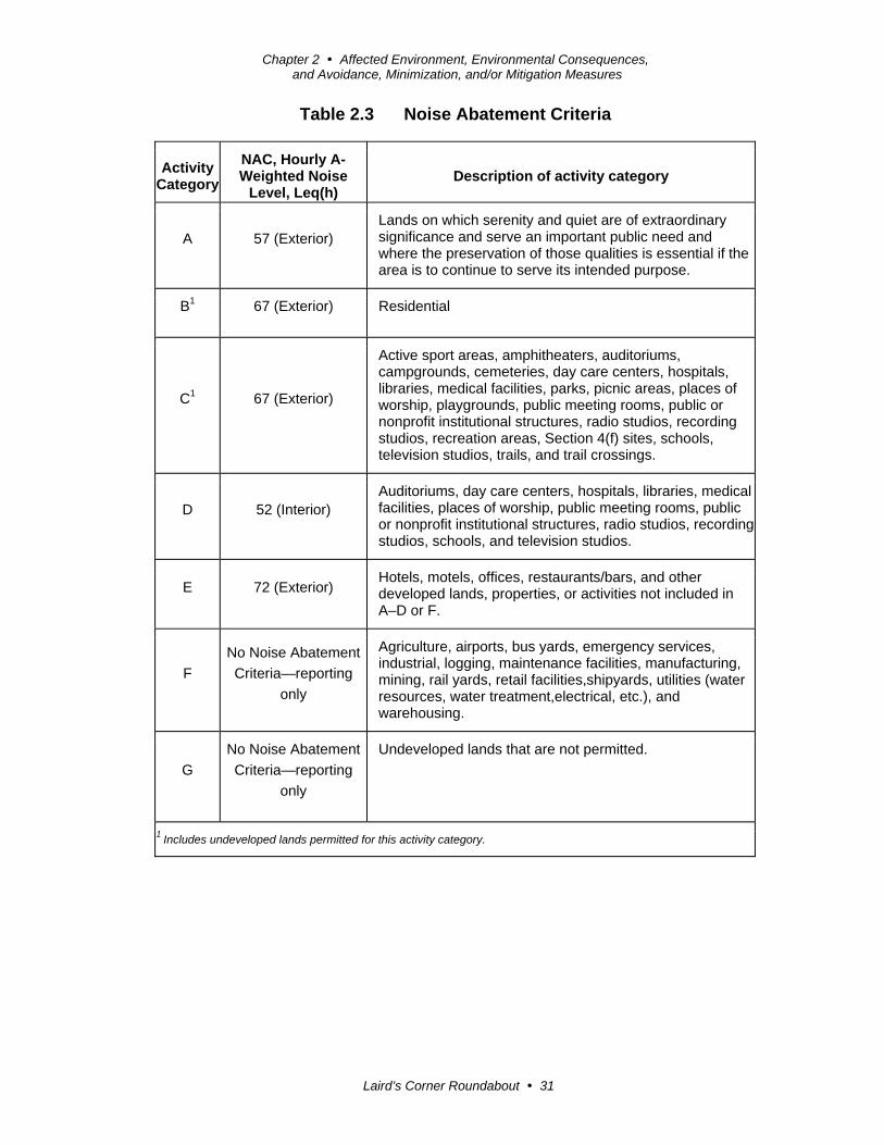
Table 2.3 Noise Abatement Criteria
Activity Category
NAC, Hourly A- Weighted Noise
Level, Leq(h) Description of activity category
A 57 (Exterior) Lands on which serenity and quiet are of extraordinary significance and serve an important public need and where the preservation of those qualities is essential if the area is to continue to serve its intended purpose.
B1 67 (Exterior) Residential
C1 67 (Exterior)
Active sport areas, amphitheaters, auditoriums, campgrounds, cemeteries, day care centers, hospitals, libraries, medical facilities, parks, picnic areas, places of worship, playgrounds, public meeting rooms, public or nonprofit institutional structures, radio studios, recording studios, recreation areas, Section 4(f) sites, schools, television studios, trails, and trail crossings.
D 52 (Interior) Auditoriums, day care centers, hospitals, libraries, medical facilities, places of worship, public meeting rooms, public or nonprofit institutional structures, radio studios, recording studios, schools, and television studios.
E 72 (Exterior) Hotels, motels, offices, restaurants/bars, and other developed lands, properties, or activities not included in A–D or F.
F
No Noise Abatement
Criteria—reporting
only
Agriculture, airports, bus yards, emergency services, industrial, logging, maintenance facilities, manufacturing, mining, rail yards, retail facilities,shipyards, utilities (water resources, water treatment,electrical, etc.), and warehousing.
G
No Noise Abatement
Criteria—reporting
only
Undeveloped lands that are not permitted.
1 Includes undeveloped lands permitted for this activity category.

Chapter 2 Affected Environment, Environmental Consequences, and Avoidance, Minimization, and/or Mitigation Measures
Laird’s Corner Roundabout 32
Figure 2-1 Noise Levels of Common Activities
According to the Department’s Traffic Noise Analysis Protocol for New Highway
Construction and Reconstruction Projects, May 2011, a noise impact occurs when the
predicted future noise level with the project substantially exceeds the existing noise
level (defined as a 12 decibels or more increase) or when the future noise level with
the project approaches or exceeds the noise abatement criteria. Approaching the noise
Chapter 2 Affected Environment, Environmental Consequences, and Avoidance, Minimization, and/or Mitigation Measures
Laird’s Corner Roundabout 33
abatement criteria is defined as coming within 1 decibel of the noise abatement
criteria.
If it is determined that the project will have noise impacts, then potential abatement
measures must be considered. Noise abatement measures that are determined to be
reasonable and feasible at the time of final design are incorporated into the project
plans and specifications. This document discusses noise abatement measures that will
likely be incorporated in the project.
The Department’s Traffic Noise Analysis Protocol sets forth the criteria for
determining when an abatement measure is reasonable and feasible. Feasibility of
noise abatement is basically an engineering concern. A minimum 7 decibel reduction
in the future noise level must be achieved for an abatement measure to be considered
feasible. Other considerations include topography, access requirements, other noise
sources, and safety considerations. The reasonableness determination is basically a
cost-benefit analysis. Factors used in determining whether a proposed noise
abatement measure is reasonable include the residents’ acceptance and the cost per
benefited residence.
Affected Environment
Caltrans completed a Noise Study Memorandum for the project on August 22, 2013.
The study described the project area as rural with a few scattered residences near the
project area.
Environmental Consequences
The study determined the project was not a Type I project, which is subject to
Caltrans’ Traffic Noise Analysis Protocol and is defined in Section 23 Code of
Federal Regulations 772 as: “A proposed federal or federal-aid highway project for
the construction of a highway on new location, or the physical alternation of an
existing highway which significantly changes either the horizontal or vertical
alignment, or increase the number of through-traffic lanes.”
The study determined the construction of the project will take about 6 months and the
construction noise will intermittently dominate the noise environment in the
immediate area of construction. However, no adverse noise impacts from construction
activities are anticipated because construction will be temporary and will be
conducted in accordance with Caltrans Standard Specifications Section 14-8.02 and
the Tulare County Noise Ordinance.

Chapter 2 Affected Environment, Environmental Consequences, and Avoidance, Minimization, and/or Mitigation Measures
Laird’s Corner Roundabout 34
Avoidance, Minimization, and/or Noise Abatement Measures
In addition to adherence to Standard Specifications Section 14-8.02 and the Tulare
County Noise Ordinance, the project would implement the following measures to
minimize the temporary noise impacts from construction:
All equipment will have sound-control devices that are no less effective than
those provided on the original equipment.
No equipment will have an unmuffled exhaust.
2.3 Biological Environment
2.3.1 Threatened and Endangered Species
Regulatory Setting
The primary federal law protecting threatened and endangered species is the Federal
Endangered Species Act (FESA): 16 U.S. Code (USC) Section 1531, et seq. See also
50 Code of Federal Regulations (CFR) Part 402. This act and later amendments
provide for the conservation of endangered and threatened species and the ecosystems
upon which they depend. Under Section 7 of this act, federal agencies, such as the
Federal Highway Administration (FHWA), are required to consult with the U.S. Fish
and Wildlife Service (USFWS) and the National Oceanic and Atmospheric
Administration’s National Marine Fisheries Service (NOAA Fisheries Service) to
ensure that they are not undertaking, funding, permitting, or authorizing actions likely
to jeopardize the continued existence of listed species or destroy or adversely modify
designated critical habitat. Critical habitat is defined as geographic locations critical
to the existence of a threatened or endangered species. The outcome of consultation
under Section 7 may include a Biological Opinion with an Incidental Take statement,
a Letter of Concurrence and/or documentation of a No Effect finding. Section 3 of
the Federal Endangered Species Act defines take as “harass, harm, pursue, hunt,
shoot, wound, kill, trap, capture or collect or any attempt at such conduct.”
California has enacted a similar law at the state level, the California Endangered
Species Act (CESA), California Fish and Game Code Section 2050, et seq. The
California Endangered Species Act emphasizes early consultation to avoid potential
impacts to rare, endangered, and threatened species and to develop appropriate
planning to offset project-caused losses of listed species populations and their
essential habitats. The California Department of Fish and Wildlife is the agency
responsible for implementing the California Endangered Species Act. Section 2081 of
Chapter 2 Affected Environment, Environmental Consequences, and Avoidance, Minimization, and/or Mitigation Measures
Laird’s Corner Roundabout 35
the Fish and Game Code prohibits “take” of any species determined to be an
endangered species or a threatened species. Take is defined in Section 86 of the Fish
and Game Code as “hunt, pursue, catch, capture, or kill, or attempt to hunt, pursue,
catch, capture, or kill.” The California Endangered Species Act allows for take
incidental to otherwise lawful development projects; for these actions, an incidental
take permit is issued by the California Department of Fish and Wildlife. For species
listed under both the Federal Endangered Species Act and the California Endangered
Species Act requiring a Biological Opinion under Section 7 of the Federal
Endangered Species Act, the California Department of Fish and Wildlife may also
authorize impacts to the California Endangered Species Act species by issuing a
Consistency Determination under Section 2080.1 of the California Fish and Game
Code.
Another federal law, the Magnuson-Stevens Fishery Conservation and Management
Act of 1976, was established to conserve and manage fishery resources found off the
coast, as well as anadromous species and Continental Shelf fishery resources of the
United States, by exercising (A) sovereign rights for the purposes of exploring,
exploiting, conserving, and managing all fish within the exclusive economic zone
established by Presidential Proclamation 5030, dated March 10, 1983, and (B)
exclusive fishery management authority beyond the exclusive economic zone over
such anadromous species, Continental Shelf fishery resources, and fishery resources
in special areas.
Affected Environment
Caltrans completed a Natural Environment Study (Minimal Impacts) on December 2,
2013, and a Biological Assessment was submitted to the U.S. Fish and Wildlife on
December 9, 2013. It was determined that no U.S. Fish and Wildlife-designated
critical habitat occurs within the biological study area and only one special-status
species—the federally endangered San Joaquin kit fox (Vulpes macrotis mutica)—has
the potential to occur in the proposed project area.
Environmental Consequences
The project will not result in any temporary or permanent effect to any U.S. Fish and
Wildlife-designated critical habitat, although marginal San Joaquin kit fox foraging
habitat will be affected by construction of the project.
Chapter 2 Affected Environment, Environmental Consequences, and Avoidance, Minimization, and/or Mitigation Measures
Laird’s Corner Roundabout 36
On April 11, 2014, Caltrans obtained a Letter of Concurrence from the U.S. Fish and
Wildlife Service on a determination of “may affect, not likely to adversely affect” for
impacts to the San Joaquin kit fox.
Avoidance, Minimization, and/or Mitigation Measures
Only marginal San Joaquin kit fox foraging habitat will be impacted by construction
of the proposed project. The project is located within the project impact area of
another Caltrans project—the State Route 190 Rehabilitation project on State Route
190 that runs from just west of State Route 99 to east of Road 180 (post miles 0.0 to
8.0). Caltrans will be purchasing mitigation bank credits for impacts to the San
Joaquin kit fox foraging habitat for the State Route 190 Rehabilitation project;
therefore, Caltrans is not proposing any additional mitigation for the Laird’s Corner
Roundabout project but will include the following avoidance and minimization
measures as recommended in the Letter of Concurrence from the U.S. Fish and
Wildlife Service:
The Service’s most recent guidelines will be followed; currently, this is the January
2011 U.S. Fish and Wildlife Service Standardized Recommendations for Protection of
the Endangered San Joaquin Kit Fox Prior to or During Ground Disturbance
(Recommendations). Caltrans will conduct preconstruction surveys, as described on
page two of the Recommendations; set up exclusion zones around any dens that are
identified during preconstruction surveys, as described beginning on page three; and
implement the construction and ongoing operational requirements described
beginning on page five. Provision 1 below is a modification to an existing measure in
the Recommendations. Provisions 2, 3, and 4 are in addition to the
Recommendations:
1. All food-related trash items, such as wrappers, cans, bottles, and food scraps
will be disposed of in closed containers and removed daily from the entire
project site in order to reduce the potential for attracting predator species.
2. Caltrans will include Species Protection Standard Special Provisions for the
San Joaquin kit fox and migratory birds when soliciting contractor bid
packages.
3. Though night work is not anticipated to take place during the course of the
project, in the event that it becomes necessary for safety reasons, Caltrans
proposes to have a Service-approved biologist onsite to monitor for the San
Joaquin kit fox during these activities.
Chapter 2 Affected Environment, Environmental Consequences, and Avoidance, Minimization, and/or Mitigation Measures
Laird’s Corner Roundabout 37
4. If a dead, injured, or entrapped San Joaquin kit fox is found onsite, the
contractor will stop all construction activities within 150 feet of the animal
and immediately notify the Resident Engineer (RE) and Caltrans project
biologist. If a potential or known San Joaquin kit fox den is discovered, the
contractor also will stop all construction activities within 150 feet of the den
and notify the Resident Engineer and Caltrans project biologist.
2.4 Climate Change
Climate change refers to long-term changes in temperature, precipitation, wind
patterns, and other elements of the earth's climate system. An ever-increasing body of
scientific research attributes these climatological changes to greenhouse gas
emissions, particularly those generated from the production and use of fossil fuels.
While climate change has been a concern for several decades, the establishment of the
Intergovernmental Panel on Climate Change (IPCC) by the United Nations and
World Meteorological Organization in 1988 has led to increased efforts devoted to
greenhouse gas emissions reduction and climate change research and policy. These
efforts are primarily concerned with the emissions of greenhouse gases generated by
human activity including carbon dioxide (CO2), methane (CH4), nitrous oxide (N2O),
tetrafluoromethane, hexafluoroethane, sulfur hexafluoride (SF6), HFC-23
(fluoroform), HFC-134a (s, s, s, 2-tetrafluoroethane), and HFC-152a (difluoroethane).
In the U.S., the main source of greenhouse gas emissions is electricity generation,
followed by transportation. In California, however, transportation sources (including
passenger cars, light-duty trucks, other trucks, buses, and motorcycles) make up the
largest source of greenhouse gas-emitting sources. The dominant greenhouse gas
emitted is carbon dioxide (CO2), mostly from fossil fuel combustion.
There are typically two terms used when discussing the impacts of climate change.
“Greenhouse Gas Mitigation” is a term for reducing greenhouse gas emissions in
order to reduce or “mitigate” the impacts of climate change. “Adaptation” refers to
the effort of planning for and adapting to impacts resulting from climate change (such
as adjusting transportation design standards to withstand more intense storms and
higher sea levels)3.
There are four primary strategies for reducing greenhouse gas emissions from
transportation sources: 1) improving the transportation system and operational
3 http://climatechange.transportation.org/ghg_mitigation/

Chapter 2 Affected Environment, Environmental Consequences, and Avoidance, Minimization, and/or Mitigation Measures
Laird’s Corner Roundabout 38
efficiencies, 2) reducing travel activity, 3) transitioning to lower greenhouse gas-
emitting fuels, and 4) improving vehicle technologies/efficiency. To be most
effective, all four strategies should be pursued cooperatively.4
Regulatory Setting
This section outlines state and federal efforts to comprehensively reduce greenhouse
emissions from transportation sources.
State
With the passage of several pieces of legislation, including State Senate and
Assembly Bills and Executive Orders, California launched an innovative and
proactive approach to dealing with greenhouse gas emissions and climate.
Assembly Bill 1493 (AB 1493), Pavley, Vehicular Emissions: Greenhouse Gases,
2002: This bill requires the California Air Resources Board (ARB) to develop and
implement regulations to reduce automobile and light truck greenhouse gas
emissions. These stricter emissions standards were designed to apply to automobiles
and light trucks beginning with the 2009-model year.
Executive Order (EO) S-3-05 (June 1, 2005): The goal of this executive order is to
reduce California’s greenhouse gas emissions to 1) year 2000 levels by 2010, 2) year
1990 levels by the 2020, and 3) 80 percent below the year 1990 levels by 2050. In
2006, this goal was further reinforced with the passage of Assembly Bill 32.
Assembly Bill 32 (AB 32), Núñez and Pavley, The Global Warming Solutions Act of
2006: Assembly Bill 32 sets the same overall greenhouse gas emissions reduction
goals as outlined in Executive Order S-3-05, while further mandating that the
California Air Resources Board create a scoping plan and implement rules to achieve
“real, quantifiable, cost-effective reductions of greenhouse gases.”
Executive Order S-20-06 (October 18, 2006): This executive order establishes the
responsibilities and roles of the Secretary of the California Environmental Protection
Agency (Cal/EPA) and state agencies with regard to climate change.
Executive Order S-01-07 (January 18, 2007): This executive order set forth the low
carbon fuel standard for California. Under this executive order, the carbon intensity of
California’s transportation fuels is to be reduced by at least 10 percent by 2020.
4 http://www.fhwa.dot.gov/environment/climate_change/mitigation/
Chapter 2 Affected Environment, Environmental Consequences, and Avoidance, Minimization, and/or Mitigation Measures
Laird’s Corner Roundabout 39
Senate Bill 97 (SB 97), Chapter 185, 2007, Greenhouse Gas Emissions: This bill
required the Governor’s Office of Planning and Research (OPR) to develop
recommended amendments to the California Environmental Quality Act (CEQA)
Guidelines for addressing greenhouse gas emissions. The amendments became
effective on March 18, 2010.
Senate Bill 375 (SB 375), Chapter 728, 2008, Sustainable Communities and Climate
Protection: This bill requires the California Air Resources Board (CARB) to set
regional emissions reduction targets from passenger vehicles. The Metropolitan
Planning Organization (MPO) for each region must then develop a “Sustainable
Communities Strategy” (SCS) that integrates transportation, land-use, and housing
policies to plan for the achievement of the emissions target for their region.
Senate Bill 391 (SB 391) Chapter 585, 2009 California Transportation Plan: This bill
requires the State’s long-range transportation plan to meet California’s climate
change goals under Assembly Bill 32.
Federal
Although climate change and greenhouse gas reduction are a concern at the federal
level, currently no regulations or legislation have been enacted specifically addressing
greenhouse gas emissions reductions and climate change at the project level. Neither
the U.S. Environmental Protection Agency (U.S. EPA) nor the Federal Highway
Administration (FHWA) has issued explicit guidance or methods to conduct project-
level greenhouse gas analysis.5 The Federal Highway Administration supports the
approach that climate change considerations should be integrated throughout the
transportation decision-making process, from planning through project development
and delivery. Addressing climate change mitigation and adaptation up front in the
planning process will assist in decision-making and improve efficiency at the
program level, and will inform the analysis and stewardship needs of project-level
decision-making. Climate change considerations can be integrated into many
planning factors, such as supporting economic vitality and global efficiency,
increasing safety and mobility, enhancing the environment, promoting energy
conservation, and improving the quality of life.
The four strategies outlined by the Federal Highway Administration to lessen climate
change impacts correlate with efforts that the state is undertaking to deal with
5To date, no national standards have been established regarding mobile source greenhouse gases, nor has U.S. EPA established any ambient standards, criteria or thresholds for greenhouse gases resulting from mobile sources.

Chapter 2 Affected Environment, Environmental Consequences, and Avoidance, Minimization, and/or Mitigation Measures
Laird’s Corner Roundabout 40
transportation and climate change; these strategies include improved transportation
system efficiency, cleaner fuels, cleaner vehicles, and a reduction in travel activity.
Climate change and its associated effects are being addressed through various efforts
at the federal level to improve fuel economy and energy efficiency, such as the
“National Clean Car Program” and Executive Order 13514 - Federal Leadership in
Environmental, Energy and Economic Performance.
Executive Order 13514 (October 5, 2009): This executive order is focused on
reducing greenhouse gases internally in federal agency missions, programs and
operations, but also directs federal agencies to participate in the Interagency Climate
Change Adaptation Task Force, which is engaged in developing a national strategy
for adaptation to climate change.
The U.S. Environmental Protection Agency’s authority to regulate greenhouse gas
emissions stems from the U.S. Supreme Court decision in Massachusetts v.
Environmental Protection Agency (2007). The Supreme Court ruled that greenhouse
gases meet the definition of air pollutants under the existing Clean Air Act and must
be regulated if these gases could be reasonably anticipated to endanger public health
or welfare. Responding to the Supreme Court’s ruling, the U.S. Environmental
Protection Agency finalized an endangerment finding in December 2009. Based on
scientific evidence, it found that six greenhouse gases constitute a threat to public
health and welfare. Thus, it is the Supreme Court’s interpretation of the existing act
and the Environmental Protection Agency’s assessment of the scientific evidence that
form the basis for the Environmental Protection Agency’s regulatory actions. The
U.S. Environmental Protection Agency in conjunction with the National Highway
Traffic Safety Administration (NHTSA) issued the first of a series of greenhouse
emission standards for new cars and light-duty vehicles in April 2010.6
The U.S. Environmental Protection Agency and the National Highway Traffic Safety
Administration are taking coordinated steps to enable the production of a new
generation of clean vehicles with reduced greenhouse gas emissions and improved
fuel efficiency from on-road vehicles and engines. These next steps include
developing the first-ever greenhouse gas regulations for heavy-duty engines and
vehicles, as well as additional light-duty vehicle greenhouse gas regulations.
6 http://www.c2es.org/federal/executive/epa/greenhouse-gas-regulation-faq

Chapter 2 Affected Environment, Environmental Consequences, and Avoidance, Minimization, and/or Mitigation Measures
Laird’s Corner Roundabout 41
The final combined standards that made up the first phase of this national program
apply to passenger cars, light-duty trucks, and medium-duty passenger vehicles,
covering model years 2012 through 2016. The standards implemented by this
program are expected to reduce greenhouse gas emissions by an estimated 960
million metric tons and 1.8 billion barrels of oil over the lifetime of the vehicles sold
under the program (model years 2012-2016).
On August 28, 2012, the U.S. Environmental Protection Agency and the National
Highway Traffic Safety Administration issued a joint Final Rulemaking to extend the
National Program for fuel economy standards to model year 2017 through 2025
passenger vehicles. Over the lifetime of the model year 2017-2025 standards, this
program is projected to save approximately four billion barrels of oil and two billion
metric tons of greenhouse gas emissions.
The complementary U.S. Environmental Protection Agency and National Highway
Traffic Safety Administration standards that make up the Heavy-Duty National
Program apply to combination tractors (semi trucks), heavy-duty pickup trucks and
vans, and vocational vehicles (including buses and refuse or utility trucks). Together,
these standards will cut greenhouse gas emissions and domestic oil use significantly.
This program responds to President Barack Obama’s 2010 request to jointly establish
greenhouse gas emissions and fuel efficiency standards for the medium- and heavy-
duty highway vehicle sector. The agencies estimate that the combined standards will
reduce carbon dioxide (CO2) emissions by about 270 million metric tons and save
about 530 million barrels of oil over the life of model year 2014 to 2018 heavy-duty
vehicles.
Project Analysis
An individual project does not generate enough greenhouse gas emissions to
significantly influence global climate change. Rather, global climate change is a
cumulative impact. This means that a project may contribute to a potential impact
through its incremental change in emissions when combined with the contributions of
all other sources of greenhouse gas.7 In assessing cumulative impacts, it must be
determined if a project’s incremental effect is “cumulatively considerable”
(California Environmental Quality Act Guidelines Sections 15064(h)(1) and 15130).
7 This approach is supported by the AEP: Recommendations by the Association of Environmental Professionals on How to Analyze GHG Emissions and Global Climate Change in CEQA Documents (March 5, 2007), as well as the South Coast Air Quality Management District (Chapter 6: The CEQA Guide, April 2011) and the US Forest Service (Climate Change Considerations in Project Level NEPA Analysis, July 13, 2009).
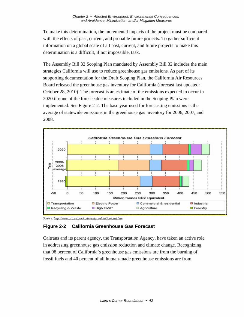
Chapter 2 Affected Environment, Environmental Consequences, and Avoidance, Minimization, and/or Mitigation Measures
Laird’s Corner Roundabout 42
To make this determination, the incremental impacts of the project must be compared
with the effects of past, current, and probable future projects. To gather sufficient
information on a global scale of all past, current, and future projects to make this
determination is a difficult, if not impossible, task.
The Assembly Bill 32 Scoping Plan mandated by Assembly Bill 32 includes the main
strategies California will use to reduce greenhouse gas emissions. As part of its
supporting documentation for the Draft Scoping Plan, the California Air Resources
Board released the greenhouse gas inventory for California (forecast last updated:
October 28, 2010). The forecast is an estimate of the emissions expected to occur in
2020 if none of the foreseeable measures included in the Scoping Plan were
implemented. See Figure 2-2. The base year used for forecasting emissions is the
average of statewide emissions in the greenhouse gas inventory for 2006, 2007, and
2008.
Source: http://www.arb.ca.gov/cc/inventory/data/forecast.htm
Figure 2-2 California Greenhouse Gas Forecast
Caltrans and its parent agency, the Transportation Agency, have taken an active role
in addressing greenhouse gas emission reduction and climate change. Recognizing
that 98 percent of California’s greenhouse gas emissions are from the burning of
fossil fuels and 40 percent of all human-made greenhouse emissions are from

Chapter 2 Affected Environment, Environmental Consequences, and Avoidance, Minimization, and/or Mitigation Measures
Laird’s Corner Roundabout 43
transportation, Caltrans has created and is implementing the Climate Action Program
at Caltrans that was published in December 2006.8
One of the main strategies in Caltrans’s Climate Action Program to reduce
greenhouse emissions is to make California’s transportation system more efficient.
The highest levels of carbon dioxide (CO2) from mobile sources, such as automobiles,
occur at stop-and-go speeds (0-25 miles per hour) and speeds over 55 miles per hour;
the most severe emissions occur from 0-25 miles per hour (see Figure 2-3). To the
extent that a project relieves congestion by enhancing operations and improving
travel times in high congestion travel corridors greenhouse gas emissions, particularly
carbon dioxide (CO2), may be reduced.
Figure 2-3 Possible Effect of Traffic Operation Strategies in Reducing
On-Road Carbon Dioxide (CO2) Emission9
Caltrans proposes to construct a single-lane roundabout at the intersection of State
Route 190 and Road 152 (Bliss Lane) in Tulare County, California. The Build
Alternative and the No-Build Alternative are under consideration. Construction and
implementation of the project will not increase capacity. The features of the project
are designed to make the traffic flow more smoothly in the project area.
8 Caltrans Climate Action Program is located at the following web address: http://www.dot.ca.gov/hq/tpp/offices/ogm/key_reports_files/State_Wide_Strategy/Caltrans_Climate_Action_Program.pdf 9 Traffic Congestion and Greenhouse Gases: Matthew Barth and Kanok Boriboonsomsin (TR News 268 May-June 2010)<http://onlinepubs.trb.org/onlinepubs/trnews/trnews268.pdf>

Chapter 2 Affected Environment, Environmental Consequences, and Avoidance, Minimization, and/or Mitigation Measures
Laird’s Corner Roundabout 44
Implementation of the Build Alternative is likely to reduce emissions when the future
build conditions are compared to the future no-build conditions. For the proposed
single-lane roundabout, vehicles will not idle as long because drivers are not required
to stop while passing though a roundabout. This helps reduce fuel consumption and
vehicle emissions.
A literature review by the Insurance Institute for Highway Safety found that
roundabouts can reduce fuel consumption by 23 to 34 percent and carbon dioxide
(CO2) emissions by approximately 23 to 37 percent.10 Although there will likely be
long-term greenhouse gas benefits associated with improved operation through
smoother pavement surfaces and reduced queuing, construction emissions will be
unavoidable.
In addition, the Tulare County Association of Governments 2011 Regional
Transportation Plan adopted on July 189, 2010 addresses the role of efficient roadway
circulation in reducing vehicle miles traveled (VMT) as well as the need to reduce
greenhouse gases and incorporate the latest scientific information on planning
efforts.11 The 2011 Regional Transportation Plan policies addressing circulation
include developing projects that are valuable to the regional road and circulation
system that reduce vehicle miles traveled, reduce level of service, and create safe
travel corridors within the region.
The Environmental Impact Report (EIR) for the 2011 Regional Transportation Plan
included potential mitigation measures to reduce greenhouse gas emissions. These
include support for land use plans that accommodate transit connectivity and other
intermodal transportation as well as support for alternative fuel vehicle use in
municipal operations to reduce vehicles miles traveled and greenhouse gas
emissions.12 The Regional Transportation Plan Environmental Impact Report also
called for greater efforts in analysis of greenhouse gas emissions from goods
movement and from the entire region. However, the Regional Transportation Plan
Environmental Impact Report concluded it is unlikely that the suggested mitigation
measures will reduce greenhouse gas emissions below existing conditions due to
anticipated population growth. The Regional Transportation Plan Environmental
Impact Report and 2011 Regional Transportation Plan did not conduct a quantitative
analysis.
10 http://www.iihs.org/iihs/topics/t/roundabouts/qanda#cute-text-0-19 11 http://www.tularecog.org/DocumentCenter/View/41 12 http://www.tularecog.org/DocumentCenter/View/39
Chapter 2 Affected Environment, Environmental Consequences, and Avoidance, Minimization, and/or Mitigation Measures
Laird’s Corner Roundabout 45
Construction Emissions
Greenhouse gas emissions for transportation projects can be divided into those
produced during construction and those produced during operations. Construction
greenhouse gas emissions include emissions produced as a result of material
processing, emissions produced by onsite construction equipment, and emissions
arising from traffic delays due to construction. These emissions will be produced at
different levels throughout the construction phase; their frequency and occurrence can
be reduced through innovations in plans and specifications and by implementing
better traffic management during construction phases.
In addition, with innovations such as longer pavement lives, improved traffic
management plans, and changes in materials, the greenhouse gas emissions produced
during construction can be mitigated to some degree by longer intervals between
maintenance and rehabilitation events.
CEQA Conclusion
While the project will result in a slight increase in greenhouse gas emissions during
construction, it is anticipated that the project will not result in any increase in
operational greenhouse gas emissions. While it is Caltrans’ determination that in the
absence of further regulatory or scientific information related to greenhouse gas
emissions and California Environmental Quality Act significance, it is too speculative
to make a significance determination regarding the project’s direct impact and its
contribution on the cumulative scale to climate change. Caltrans is firmly committed
to implementing measures to help reduce greenhouse gas emissions. These measures
are outlined in the following section.
Greenhouse Gas Reduction Strategies
Caltrans continues to be involved on the Governor’s Climate Action Team as the
California Air Resources Board works to implement Executive Orders S-3-05 and S-
01-07 and help achieve the targets set forth in Assembly Bill 32. Many of the
strategies Caltrans is using to help meet the targets in Assembly Bill 32 come from
former Governor Arnold Schwarzenegger’s Strategic Growth Plan for California. The
Strategic Growth Plan targeted a significant decrease in traffic congestion below 2008
levels and a corresponding reduction in greenhouse emissions, while accommodating
growth in population and the economy. The Strategic Growth Plan relies on a
complete systems approach to attain carbon dioxide (CO2) reduction goals: system
monitoring and evaluation, maintenance and preservation, smart land use and demand
management, and operational improvements as shown in Figure 2-4.

Chapter 2 Affected Environment, Environmental Consequences, and Avoidance, Minimization, and/or Mitigation Measures
Laird’s Corner Roundabout 46
Figure 2-4 Mobility Pyramid
Caltrans is supporting efforts to reduce vehicle miles traveled by planning and
implementing smart land use strategies: job/housing proximity, developing transit-
oriented communities, and high-density housing along transit corridors. Caltrans
works closely with local jurisdictions on planning activities, but does not have local
land use planning authority. Caltrans also assists efforts to improve the energy
efficiency of the transportation sector by increasing vehicle fuel economy in new
cars, light and heavy-duty trucks; Caltrans is doing this by supporting ongoing
research efforts at universities, by supporting legislative efforts to increase fuel
economy, and by participating on the Climate Action Team. It is important to note,
however, that control of fuel economy standards is held by the U.S. Environmental
Protection Agency and Air Resources Board.
Caltrans is also working toward enhancing the State’s transportation planning process
to respond to future challenges. Similar to requirements for regional transportation
plans under Senate Bill 375 (Steinberg 2008), Senate Bill 391(Liu 2009) requires the
State’s long-range transportation plan to meet California’s climate change goals under
Assembly Bill 32.

Chapter 2 Affected Environment, Environmental Consequences, and Avoidance, Minimization, and/or Mitigation Measures
Laird’s Corner Roundabout 47
The California Transportation Plan (CTP) is a statewide, long-range transportation
plan to meet our future mobility needs and reduce greenhouse gas emissions. The
California Transportation Plan defines performance-based goals, policies, and
strategies to achieve our collective vision for California’s future, statewide,
integrated, multimodal transportation system.
The purpose of the California Transportation Plan is to provide a common policy
framework that will guide transportation investments and decisions by all levels of
government, the private sector, and other transportation stakeholders. Through this
policy framework, the California Transportation Plan 2040 will identify the statewide
transportation system needed to achieve maximum feasible greenhouse gas emission
reductions while meeting the State’s transportation needs.
Table 2.4 summarizes Caltrans’ and statewide efforts that it is implementing to
reduce greenhouse emissions. More detailed information about each strategy is
included in the Climate Action Program at Caltrans (December 2006).
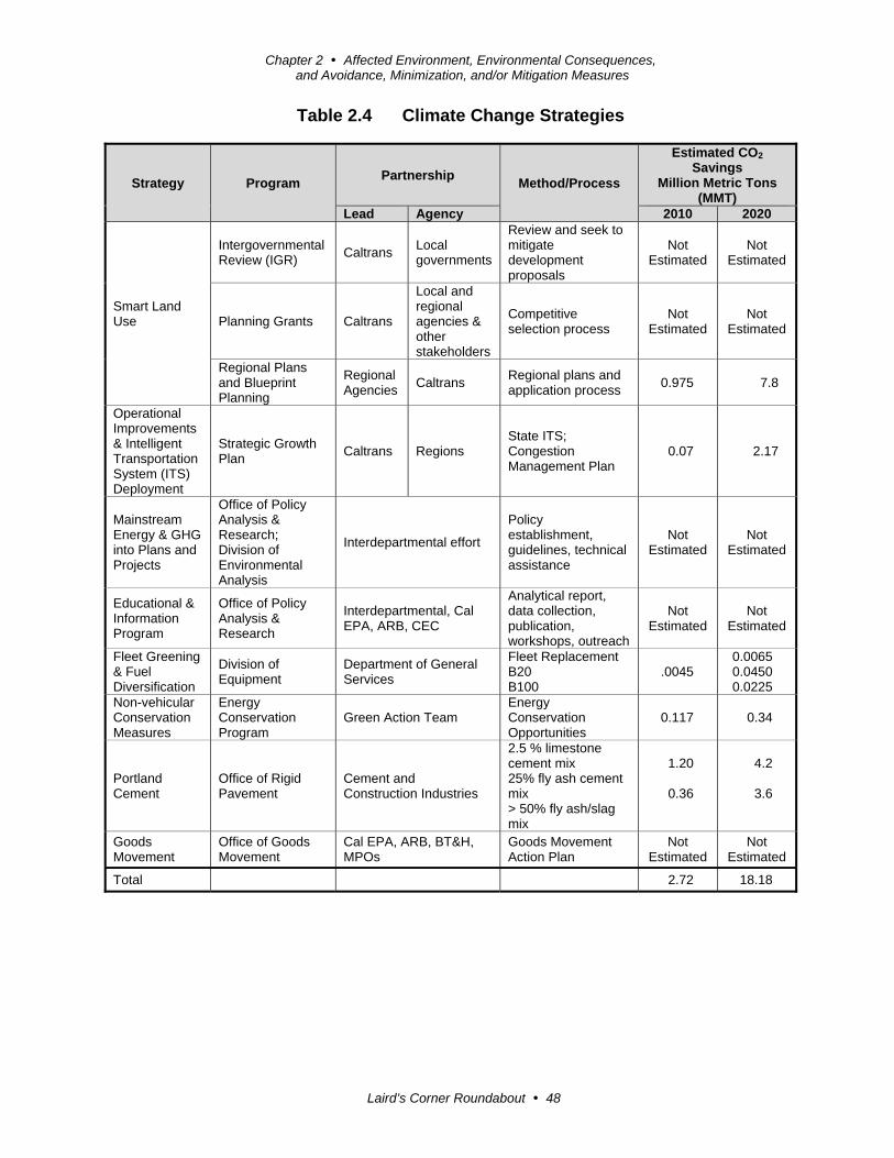
Chapter 2 Affected Environment, Environmental Consequences, and Avoidance, Minimization, and/or Mitigation Measures
Laird’s Corner Roundabout 48
Table 2.4 Climate Change Strategies
Strategy Program Partnership
Method/Process
Estimated CO2
Savings Million Metric Tons
(MMT) Lead Agency 2010 2020
Smart Land Use
Intergovernmental Review (IGR)
Caltrans Local governments
Review and seek to mitigate development proposals
Not Estimated
Not Estimated
Planning Grants Caltrans
Local and regional agencies & other stakeholders
Competitive selection process
Not Estimated
Not Estimated
Regional Plans and Blueprint Planning
Regional Agencies
Caltrans Regional plans and application process
0.975 7.8
Operational Improvements & Intelligent Transportation System (ITS) Deployment
Strategic Growth Plan
Caltrans Regions State ITS; Congestion Management Plan
0.07 2.17
Mainstream Energy & GHG into Plans and Projects
Office of Policy Analysis & Research; Division of Environmental Analysis
Interdepartmental effort
Policy establishment, guidelines, technical assistance
Not Estimated
Not Estimated
Educational & Information Program
Office of Policy Analysis & Research
Interdepartmental, Cal EPA, ARB, CEC
Analytical report, data collection, publication, workshops, outreach
Not Estimated
Not Estimated
Fleet Greening & Fuel Diversification
Division of Equipment
Department of General Services
Fleet Replacement B20 B100
.0045 0.0065 0.0450 0.0225
Non-vehicular Conservation Measures
Energy Conservation Program
Green Action Team Energy Conservation Opportunities
0.117 0.34
Portland Cement
Office of Rigid Pavement
Cement and Construction Industries
2.5 % limestone cement mix 25% fly ash cement mix > 50% fly ash/slag mix
1.20
0.36
4.2
3.6
Goods Movement
Office of Goods Movement
Cal EPA, ARB, BT&H, MPOs
Goods Movement Action Plan
Not Estimated
Not Estimated
Total 2.72 18.18

Chapter 2 Affected Environment, Environmental Consequences, and Avoidance, Minimization, and/or Mitigation Measures
Laird’s Corner Roundabout 49
Caltrans Director’s Policy 30 (DP-30) Climate Change (June 22, 2012) is intended to
establish a Department policy that will ensure coordinated efforts to incorporate
climate change into Departmental decisions and activities.
Caltrans Activities to Address Climate Change (April 2013)13 provides a
comprehensive overview of activities undertaken by Caltrans statewide to reduce
greenhouse gas emissions resulting from agency operations.
The following measures will also be included in the project to reduce the greenhouse
gas emissions and potential climate change impacts from the project:
1. According to Caltrans Standard Specifications, the contractor must comply
with all local Air Pollution Control District's (APCD) rules, ordinances, and
regulations for air quality restrictions.
2. In 2008, the Air Resources Board (ARB) adopted a regulation for In-Use Off-
Road Diesel Vehicles, which restricts idling time during construction to 5
consecutive minutes (Advisory Number 377, June 2008 California
Environmental Protection Agency, Air Resources Board).
3. To the extent that it is feasible for the project, the use of reclaimed water may
be used to reduce greenhouse gas emissions produced during construction.
Currently, 30 percent of the electricity used in California is used for the
treatment and delivery of water. Use of reclaimed water helps conserve this
energy, which reduces greenhouse gas emissions from electricity production.
Adaptation Strategies
“Adaptation strategies” refer to how Caltrans and others can plan for the effects of
climate change on the state’s transportation infrastructure and strengthen or protect
the facilities from damage. Climate change is expected to produce increased
variability in precipitation, rising temperatures, rising sea levels, variability in storm
surges and intensity, and the frequency and intensity of wildfires. These changes may
affect the transportation infrastructure in various ways, such as damage to roadbeds
from longer periods of intense heat; increasing storm damage from flooding and
erosion; and inundation from rising sea levels. These effects will vary by location and
may, in the most extreme cases, require that a facility be relocated or redesigned.
There may also be economic and strategic ramifications as a result of these types of
impacts to the transportation infrastructure.
13 http://www.whitehouse.gov/administration/eop/ceq/initiatives/adaptation

Chapter 2 Affected Environment, Environmental Consequences, and Avoidance, Minimization, and/or Mitigation Measures
Laird’s Corner Roundabout 50
At the federal level, the Climate Change Adaptation Task Force, co-chaired by the
Council on Environmental Quality (CEQ), the Office of Science and Technology
Policy (OSTP), and the National Oceanic and Atmospheric Administration (NOAA),
released its interagency task force progress report on October 28, 201114, outlining
the federal government’s progress in expanding and strengthening the nation’s
capacity to better understand, prepare for, and respond to extreme events and other
climate change impacts. The report provides an update on actions in key areas of
federal adaptation, including building resilience in local communities, safeguarding
critical natural resources such as freshwater, and providing accessible climate
information and tools to help decision-makers manage climate risks.
Climate change adaptation must also involve the natural environment as well. Efforts
are underway on a statewide-level to develop strategies to cope with impacts to
habitat and biodiversity through planning and conservation. The results of these
efforts will help California agencies plan and implement mitigation strategies for
programs and projects.
On November 14, 2008, then-Governor Arnold Schwarzenegger signed Executive
Order S-13-08, which directed a number of state agencies to address California’s
vulnerability to sea level rise caused by climate change. This executive order set in
motion several agencies and actions to address the concern of sea level rise.
In addition to addressing projected sea level rise, the California Natural Resources
Agency (Resources Agency) was directed to coordinate with local, regional, state and
federal public and private entities to develop The California Climate Adaptation
Strategy (Dec 2009)15, which summarizes the best-known science on climate change
impacts to California, assesses California’s vulnerability to the identified impacts, and
then outlines solutions that can be implemented within and across state agencies to
promote resiliency.
The strategy outline is in direct response to Executive Order S-13-08 that specifically
asked the Resources Agency to identify how state agencies can respond to rising
temperatures, changing precipitation patterns, sea level rise, and extreme natural
events. Numerous other state agencies were involved in the creation of the Adaptation
Strategy document, including the California Environmental Protection Agency;
Business, Transportation and Housing; Health and Human Services; and the
14 http://www.whitehouse.gov/administration/eop/ceq/initiatives/adaptation 15 http://www.energy.ca.gov/2009publications/CNRA-1000-2009-027/CNRA-1000-2009-027-F.PDF
Chapter 2 Affected Environment, Environmental Consequences, and Avoidance, Minimization, and/or Mitigation Measures
Laird’s Corner Roundabout 51
Department of Agriculture. The document is broken down into strategies for different
sectors that include: Public Health; Biodiversity and Habitat; Ocean and Coastal
Resources; Water Management; Agriculture; Forestry; and Transportation and Energy
Infrastructure. As data continues to be developed and collected, the State’s adaptation
strategy will be updated to reflect current findings. The National Academy of Science
was directed to prepare a Sea Level Rise Assessment Report16 to recommend how
California should plan for future sea level rise. The report was released in June 2012
and included:
Relative sea level rise projections for California, Oregon, and Washington taking
into account coastal erosion rates, tidal impacts, El Niño and La Niña events,
storm surge and land subsidence rates.
The range of uncertainty in selected sea level rise projections.
A synthesis of existing information on projected sea level rise impacts to state
infrastructure (such as roads, public facilities and beaches), natural areas, and
coastal and marine ecosystems.
A discussion of future research needs regarding sea level rise.
In 2010, interim guidance was released by the Coastal Ocean Climate Action Team
(CO-CAT) as well as Caltrans as a method to initiate action and discussion of
potential risks to the State’s infrastructure due to projected sea level rise.
Subsequently, Coastal Ocean Climate Action Team updated the Sea Level Rise
guidance to include information presented in the National Academy’s study.
All State agencies that are planning to construct projects in areas vulnerable to future
sea level rise are directed to consider a range of sea level rise scenarios for the years
2050 and 2100 to assess project vulnerability and, to the extent feasible, reduce
expected risks and increase resiliency to sea level rise. Sea level rise estimates should
also be used in conjunction with information on local uplift and subsidence, coastal
erosion rates, predicted higher high water levels, storm surge and storm wave data.
All projects that have filed a Notice of Preparation (NOP) as of the date of Executive
Order S-13-08, and/or are programmed for construction funding through 2013, or are
routine maintenance projects may, but are not required to, consider these planning
guidelines.
16 Sea Level Rise for the Coasts of California, Oregon, and Washington: Past, Present, and Future (2012) is available at: http://www.nap.edu/catalog.php?record_id=13389.
Chapter 2 Affected Environment, Environmental Consequences, and Avoidance, Minimization, and/or Mitigation Measures
Laird’s Corner Roundabout 52
The proposed project is outside the coastal zone and direct impacts to transportation
facilities due to projected sea level rise are not expected.
Executive Order S-13-08 also directed the Business, Transportation, and Housing
Agency to prepare a report to assess vulnerability of transportation systems to sea
level rise affecting safety, maintenance and operational improvements of the system,
and economy of the state. Caltrans continues to work on assessing the transportation
system vulnerability to climate change, including the effect of sea level rise.
Currently, Caltrans is working to assess which transportation facilities are at greatest
risk from climate change effects. However, without statewide planning scenarios for
relative sea level rise and other climate change effects, Caltrans has not been able to
determine what change, if any, may be made to its design standards for its
transportation facilities. Once statewide planning scenarios become available,
Caltrans will be able review its current design standards to determine what changes, if
any, may be needed to protect the transportation system from sea level rise.
Climate change adaptation for transportation infrastructure involves long-term
planning and risk management to address vulnerabilities in the transportation system
from increased precipitation and flooding; the increased frequency and intensity of
storms and wildfires; rising temperatures; and rising sea levels. Caltrans is an active
participant in the efforts being conducted in response to Executive Order S-13-08 and
is mobilizing to be able to respond to the National Academy of Science Sea Level
Rise Assessment.

Laird’s Corner Roundabout 53
Chapter 3 Comments and Coordination
Early and continuing coordination with the general public and appropriate public
agencies is an essential part of the environmental process to determine the scope of
environmental documentation, the level of analysis, potential impacts and mitigation
measures, and related environmental requirements. Agency consultation and public
participation for this project have been accomplished through a variety of formal and
informal methods, including project development team meetings and interagency
coordination meetings. This chapter summarizes the results of Caltrans’ efforts to
identify, address, and resolve project-related issues through early and continuing
coordination.
This chapter summarizes the results of Caltrans’ efforts to identify, address, and
resolve project-related issues through early and continuing coordination.
Scoping Meeting
Caltrans held a public scoping meeting for the project on October 22, 2013 at
Pleasant View Elementary School at 1800 Avenue 145 in Poplar from 4:30 p.m. to
7:00 p.m. The elementary school is about 2 miles from the project area at State Route
190 and Road 152 (Bliss Lane) but was the closest available public meeting facility.
Two public advertisements of the scoping meeting were published in the Visalia
Delta Times, and notices were posted in public places in Tipton and Poplar. Notices
were also provided to the reception staff of the Pleasant View Elementary School, but
distribution via the student population was not arranged. Notices of the scoping
meeting were mailed to federal, state, tribal, and local elected officials, and to school
officials in Tulare County. Local businesses, emergency services, and public agencies
in neighboring Tipton, Visalia, Tulare, and Porterville were notified by mail.
The meeting planned for formal presentations at 5:00 p.m. and 6:00 p.m., but only
one presentation was needed because all attendees were present for the first
presentation and the question and answer session that followed. The presentation
included a video showing how the roundabout would be used by oversized trucks,
busses, and agriculture equipment. Large (2-foot by 4-foot) aerial maps of the two
build alternatives were displayed on a table so attendees could view them easily.
Attendees were able to ask questions directly to the Caltrans personnel available,
which included the District 6 Deputy District Director of Maintenance and Traffic

Chapter 3 Comments and Coordination
Laird’s Corner Roundabout 54
Operations as well as project managers, project engineers, and environmental
planners.
The meeting was attended by 11 people, 8 of which were property owners with land
adjacent to the project area. One comment card was submitted with the preference for
Build Alternative 1B, the northern alignment. None of the attendees wanted their
neighbor on the southwest corner to move and stated they will prefer the northern
alignment because it will avoid relocating any structures. Some attendees stated they
preferred the northern alignment because it provided a frontage road to their
driveways.
U.S. Fish and Wildlife Service
On December 12, 2013, the Caltrans biologist initiated informal consultation with the
U.S. Fish and Wildlife Service under Section 7 of the Endangered Species Act for
concurrence of effect determination for the San Joaquin kit fox. Caltrans obtained a
Letter of Concurrence from the U.S. Fish and Wildlife Service on April 11, 2014.
Native American Coordination
Native American consultation with regard to the proposed project occurred during
circulation of the environmental document. Changes or modifications to the project
limits resulted in additional studies or impacts that required additional consultation
with tribal representatives and interested individuals.
In regard to cultural resources, Caltrans initiated consultation and coordination on
May 13, 2010 with the submission of a letter to the Native American Heritage
Commission (NAHC) requesting a search of the commission’s files to determine if
any sacred sites, traditional cultural properties, or native plant gathering locations
were known to exist within or near the project study area. The letter also requested
the names of Native American individuals and group representatives who may be
interested in or able to supply information relevant to the proposed project.
An additional list of individuals who could be interested in the proposed undertaking
was compiled by the District 6 Native American Coordinator and combined with the
parties provided by the Native American Heritage Commission. All parties were
provided a copy of the Historic Property Survey Report conducted for the proposed
project. No written responses were received concerning cultural resources at the time
of the writing of this document.

Laird’s Corner Roundabout 55
Chapter 4 List of Preparers
This document was prepared by the following Caltrans Central Region staff:
Allam Alhabaly, Transportation Engineer. B.S., California State University, Fresno,
School of Engineering; 12 years of experience in environmental technical
studies; emphasis on noise studies. Contribution: Noise Study Memorandum.
Yeshi Amente, Transportation Engineer. B.S., Civil Engineering, California State
University, Los Angeles; 14 years of experience. Contribution: Project
Engineer.
Louis L. Birdwell, Associate Right of Way Agent. B.A., Business Administration,
Texas Tech University; 25 years of Caltrans Right of Way experience; 5 years
experience with the U.S. Department of Agriculture, Agriculture Stabilization
and Conservation Service. Contribution: Relocation Impact Statement.
Julie Dick Tex, Associate Environmental Planner. M.A., Social Work, California
State University, Fresno; B.A., Anthropology, California State University,
Fresno; 14 years environmental coordinator experience. Contribution: Draft
Environmental Document.
Rajeev Dwivedi, Associate Engineering Geologist. Ph D., Environmental
Engineering, Oklahoma State University, Stillwater; 21 years of
environmental technical studies experience. Contribution: Water Compliance
Study.
Angela Gallardo, Senior Biologist, Parsons Corporation, Staff Augmentation. M.S.,
Environmental Policy and Management, University of Denver; B.S., Biology,
California State University, Humboldt, Arcata; 6 years of biological
experience. Contribution: Natural Environmental Study and Biological
Assessment.
Marie (Terry) Goewert, Associate Environmental Planner (Air Quality Specialist).
B.S., Foods and Nutrition, Colorado State University; 13 years of
environmental compliance and 8 years of environmental planning experience.
Contribution: Hot-spot Conformity Assessment.
Richard Kuan, Transportation Engineer. Registered Civil Engineer. B.S., Civil
Engineering, California State University, Fresno; 25 years of design
experience. Contribution: Project Engineer.

Chapter 4 List of Preparers
Laird’s Corner Roundabout 56
David Lanner, Associate Environmental Planner. B.F.A., Art, Utah State University;
20 years of cultural resources experience. Contribution: Historic Property
Survey Report with attached Archaeological Survey Report.
Mandy Marine, Associate Environmental Planner/Native American Coordinator,
Archaeologist. B.A., Anthropology, California State University, Fresno; more
than 20 years of California archaeology experience. Contribution: Native
American coordination.
Steven Milton, Senior Transportation Engineer. Registered Civil Engineer and
Certified Project Management Professional (PMP). B.S., Civil Engineering,
Cal Poly San Luis Obispo; 16 years of design experience and 7 years of
project management experience. Contribution: Project Manager.
Shawn Ogletree, Associate Environmental Planner. MPH, California State University,
Fresno; B.S., Environmental Conservation of Natural Resources, Texas Tech
University; 11 years of environmental health and environmental technical
studies experience; 10 years of biology experience. Contribution: Preliminary
Site Assessment.
Raymond Segura, Transportation Engineer. B.S., Construction Management,
California State University, Fresno; 12 years of landscape design and
transportation experience. Contribution: Scenic Resource Evaluation.
Richard C. Stewart, Engineering Geologist. P.G. B.S., Geology, California State
University, Fresno; 21 years of hazardous waste and water quality experience;
5 years of paleontology and geology experience. Contribution:
Paleontological Identification Report.
Philip Vallejo, Associate Environmental Planner. B.A., History, California State
University, Fresno; 8 years of cultural resource compliance experience.
Contribution: Historic Resource Evaluation Report.
Powell Yang, Transportation Engineer, P.E., Civil. B.S., Mechanical Engineering,
California State University, Fresno; 10 years of hydraulic experience.
Contribution: Hydraulics Memorandum.

Laird’s Corner Roundabout 57
Appendix A California Environmental Quality Act Checklist
This checklist identifies physical, biological, social and economic factors that might
be affected by the proposed project. In many cases, background studies performed in
connection with the projects indicate no impacts. A NO IMPACT answer in the last
column reflects this determination. Where a clarifying discussion is needed, the
discussion either follows the applicable section in the checklist or is placed within the
body of the environmental document itself. The words “significant” and
“significance” used throughout the following checklist are related to CEQA—not
NEPA—impacts. The questions in this form are intended to encourage the thoughtful
assessment of impacts and do not represent thresholds of significance.
Potentially Significant Impact
Less Than Significant with Mitigation
Less Than Significant Impact
No Impact
I. AESTHETICS: Would the project:
a) Have a substantial adverse effect on a scenic vista
b) Substantially damage scenic resources, including, but not limited to, trees, rock outcroppings, and historic buildings within a state scenic highway
c) Substantially degrade the existing visual character or quality of the site and its surroundings?
d) Create a new source of substantial light or glare which would adversely affect day or nighttime views in the area?
II. AGRICULTURE AND FOREST RESOURCES: Would the project:
a) Convert Prime Farmland, Unique Farmland, or Farmland of Statewide Importance (Farmland), as shown on the maps prepared pursuant to the Farmland Mapping and Monitoring Program of the California Resources Agency, to non-agricultural use?
b) Conflict with existing zoning for agricultural use, or a Williamson Act contract?
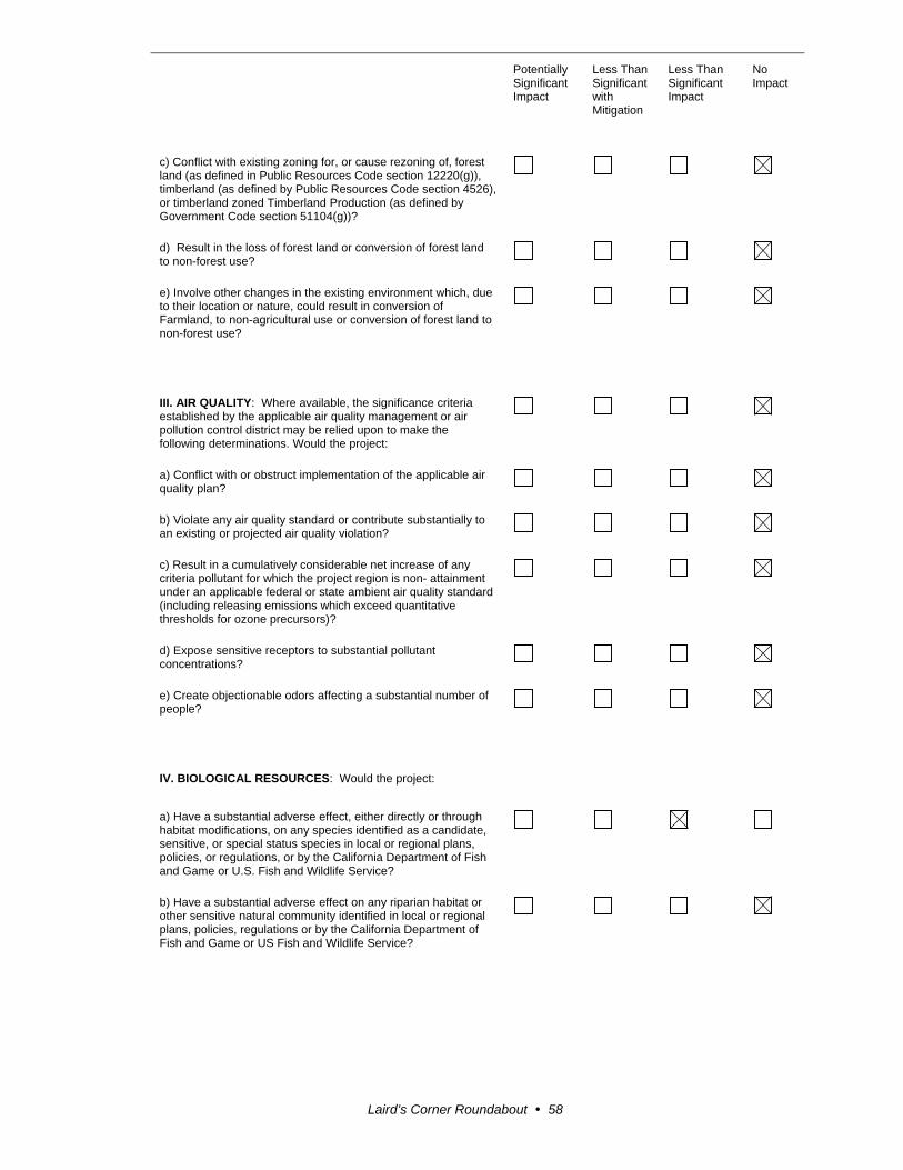
Potentially Significant Impact
Less Than Significant with Mitigation
Less Than Significant Impact
No Impact
Laird’s Corner Roundabout 58
c) Conflict with existing zoning for, or cause rezoning of, forest land (as defined in Public Resources Code section 12220(g)), timberland (as defined by Public Resources Code section 4526), or timberland zoned Timberland Production (as defined by Government Code section 51104(g))?
d) Result in the loss of forest land or conversion of forest land to non-forest use?
e) Involve other changes in the existing environment which, due to their location or nature, could result in conversion of Farmland, to non-agricultural use or conversion of forest land to non-forest use?
III. AIR QUALITY: Where available, the significance criteria established by the applicable air quality management or air pollution control district may be relied upon to make the following determinations. Would the project:
a) Conflict with or obstruct implementation of the applicable air quality plan?
b) Violate any air quality standard or contribute substantially to an existing or projected air quality violation?
c) Result in a cumulatively considerable net increase of any criteria pollutant for which the project region is non- attainment under an applicable federal or state ambient air quality standard (including releasing emissions which exceed quantitative thresholds for ozone precursors)?
d) Expose sensitive receptors to substantial pollutant concentrations?
e) Create objectionable odors affecting a substantial number of people?
IV. BIOLOGICAL RESOURCES: Would the project:
a) Have a substantial adverse effect, either directly or through habitat modifications, on any species identified as a candidate, sensitive, or special status species in local or regional plans, policies, or regulations, or by the California Department of Fish and Game or U.S. Fish and Wildlife Service?
b) Have a substantial adverse effect on any riparian habitat or other sensitive natural community identified in local or regional plans, policies, regulations or by the California Department of Fish and Game or US Fish and Wildlife Service?
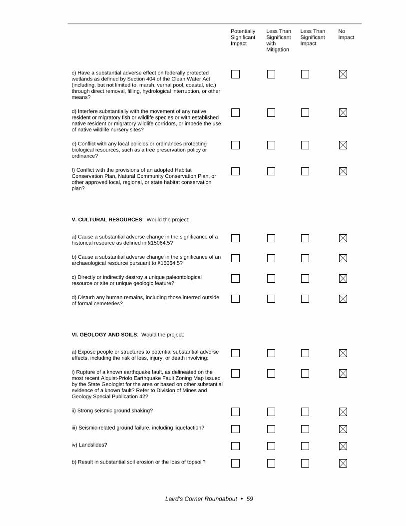
Potentially Significant Impact
Less Than Significant with Mitigation
Less Than Significant Impact
No Impact
Laird’s Corner Roundabout 59
c) Have a substantial adverse effect on federally protected wetlands as defined by Section 404 of the Clean Water Act (including, but not limited to, marsh, vernal pool, coastal, etc.) through direct removal, filling, hydrological interruption, or other means?
d) Interfere substantially with the movement of any native resident or migratory fish or wildlife species or with established native resident or migratory wildlife corridors, or impede the use of native wildlife nursery sites?
e) Conflict with any local policies or ordinances protecting biological resources, such as a tree preservation policy or ordinance?
f) Conflict with the provisions of an adopted Habitat Conservation Plan, Natural Community Conservation Plan, or other approved local, regional, or state habitat conservation plan?
V. CULTURAL RESOURCES: Would the project:
a) Cause a substantial adverse change in the significance of a historical resource as defined in §15064.5?
b) Cause a substantial adverse change in the significance of an archaeological resource pursuant to §15064.5?
c) Directly or indirectly destroy a unique paleontological resource or site or unique geologic feature?
d) Disturb any human remains, including those interred outside of formal cemeteries?
VI. GEOLOGY AND SOILS: Would the project:
a) Expose people or structures to potential substantial adverse effects, including the risk of loss, injury, or death involving:
i) Rupture of a known earthquake fault, as delineated on the most recent Alquist-Priolo Earthquake Fault Zoning Map issued by the State Geologist for the area or based on other substantial evidence of a known fault? Refer to Division of Mines and Geology Special Publication 42?
ii) Strong seismic ground shaking?
iii) Seismic-related ground failure, including liquefaction?
iv) Landslides?
b) Result in substantial soil erosion or the loss of topsoil?

Potentially Significant Impact
Less Than Significant with Mitigation
Less Than Significant Impact
No Impact
Laird’s Corner Roundabout 60
c) Be located on a geologic unit or soil that is unstable, or that would become unstable as a result of the project, and potentially result in on- or off-site landslide, lateral spreading, subsidence, liquefaction or collapse?
d) Be located on expansive soil, as defined in Table 18-1-B of the Uniform Building Code (1994), creating substantial risks to life or property?
e) Have soils incapable of adequately supporting the use of septic tanks or alternative waste water disposal systems where sewers are not available for the disposal of waste water?
VII. GREENHOUSE GAS EMISSIONS: Would the project:
a) Generate greenhouse gas emissions, either directly or indirectly, that may have a significant impact on the environment?
An assessment of the greenhouse gas emissions and climate change is included in the body of environmental document. While Caltrans has included this good faith effort in order to provide the public and decision-makers as much information as possible about the project, it is Caltrans determination that in the absence of further regulatory or scientific information related to GHG emissions and CEQA significance, it is too speculative to make a significance determination regarding the project’s direct and indirect impact with respect to climate change. Caltrans does remain firmly committed to implementing measures to help reduce the potential effects of the project. Additional information is located in Technical Studies Bound Separately (Volume II) of this document.
b) Conflict with an applicable plan, policy or regulation adopted for the purpose of reducing the emissions of greenhouse gases?
VIII. HAZARDS AND HAZARDOUS MATERIALS: Would the project:
a) Create a significant hazard to the public or the environment through the routine transport, use, or disposal of hazardous materials?
b) Create a significant hazard to the public or the environment through reasonably foreseeable upset and accident conditions involving the release of hazardous materials into the environment?
c) Emit hazardous emissions or handle hazardous or acutely hazardous materials, substances, or waste within one-quarter mile of an existing or proposed school?
d) Be located on a site which is included on a list of hazardous materials sites compiled pursuant to Government Code Section 65962.5 and, as a result, would it create a significant hazard to the public or the environment?

Potentially Significant Impact
Less Than Significant with Mitigation
Less Than Significant Impact
No Impact
Laird’s Corner Roundabout 61
e) For a project located within an airport land use plan or, where such a plan has not been adopted, within two miles of a public airport or public use airport, would the project result in a safety hazard for people residing or working in the project area?
f) For a project within the vicinity of a private airstrip, would the project result in a safety hazard for people residing or working in the project area?
g) Impair implementation of or physically interfere with an adopted emergency response plan or emergency evacuation plan?
h) Expose people or structures to a significant risk of loss, injury or death involving wildland fires, including where wildlands are adjacent to urbanized areas or where residences are intermixed with wildlands?
IX. HYDROLOGY AND WATER QUALITY: Would the project:
a) Violate any water quality standards or waste discharge requirements?
b) Substantially deplete groundwater supplies or interfere substantially with groundwater recharge such that there would be a net deficit in aquifer volume or a lowering of the local groundwater table level (e.g., the production rate of pre-existing nearby wells would drop to a level which would not support existing land uses or planned uses for which permits have been granted)?
c) Substantially alter the existing drainage pattern of the site or area, including through the alteration of the course of a stream or river, in a manner which would result in substantial erosion or siltation on- or off-site?
d) Substantially alter the existing drainage pattern of the site or area, including through the alteration of the course of a stream or river, or substantially increase the rate or amount of surface runoff in a manner which would result in flooding on- or off-site?
e) Create or contribute runoff water which would exceed the capacity of existing or planned storm water drainage systems or provide substantial additional sources of polluted runoff?
f) Otherwise substantially degrade water quality?
g) Place housing within a 100-year flood hazard area as mapped on a federal Flood Hazard Boundary or Flood Insurance Rate Map or other flood hazard delineation map?
h) Place within a 100-year flood hazard area structures which would impede or redirect flood flows?
i) Expose people or structures to a significant risk of loss, injury or death involving flooding, including flooding as a result of the failure of a levee or dam?

Potentially Significant Impact
Less Than Significant with Mitigation
Less Than Significant Impact
No Impact
Laird’s Corner Roundabout 62
j) Inundation by seiche, tsunami, or mudflow?
X. LAND USE AND PLANNING: Would the project:
a) Physically divide an established community?
b)Conflict with any applicable land use plan, policy, or regulation of an agency with jurisdiction over the project (including, but not limited to the general plan, specific plan, local coastal program, or zoning ordinance) adopted for the purpose of avoiding or mitigating an environmental effect?
c) Conflict with any applicable habitat conservation plan or natural community conservation plan?
XI. MINERAL RESOURCES: Would the project:
a) Result in the loss of availability of a known mineral resource that would be of value to the region and the residents of the state?
b) Result in the loss of availability of a locally-important mineral resource recovery site delineated on a local general plan, specific plan or other land use plan?
XII. NOISE: Would the project result in:
a) Exposure of persons to or generation of noise levels in excess of standards established in the local general plan or noise ordinance, or applicable standards of other agencies?
b) Exposure of persons to or generation of excessive groundborne vibration or groundborne noise levels?
c) A substantial permanent increase in ambient noise levels in the project vicinity above levels existing without the project?
d) A substantial temporary or periodic increase in ambient noise levels in the project vicinity above levels existing without the project?
e) For a project located within an airport land use plan or, where such a plan has not been adopted, within two miles of a public airport or public use airport, would the project expose people residing or working in the project area to excessive noise levels?
(f) For a project within the vicinity of a private airstrip, would the project expose people residing or working in the project area to excessive noise levels?

Potentially Significant Impact
Less Than Significant with Mitigation
Less Than Significant Impact
No Impact
Laird’s Corner Roundabout 63
XIII. POPULATION AND HOUSING: Would the project:
a) Induce substantial population growth in an area, either directly (for example, by proposing new homes and businesses) or indirectly (for example, through extension of roads or other infrastructure)?
b) Displace substantial numbers of existing housing, necessitating the construction of replacement housing elsewhere?
c) Displace substantial numbers of people, necessitating the construction of replacement housing elsewhere?
XIV. PUBLIC SERVICES:
a) Would the project result in substantial adverse physical impacts associated with the provision of new or physically altered governmental facilities, need for new or physically altered governmental facilities, the construction of which could cause significant environmental impacts, in order to maintain acceptable service ratios, response times or other performance objectives for any of the public services:
Fire protection?
Police protection?
Schools?
Parks?
Other public facilities?
XV. RECREATION:
a) Would the project increase the use of existing neighborhood and regional parks or other recreational facilities such that substantial physical deterioration of the facility would occur or be accelerated?
b) Does the project include recreational facilities or require the construction or expansion of recreational facilities which might have an adverse physical effect on the environment?
XVI. TRANSPORTATION/TRAFFIC: Would the project:
a) Conflict with an applicable plan, ordinance or policy establishing measures of effectiveness for the performance of the circulation system, taking into account all modes of transportation including mass transit and non-motorized travel and relevant components of the circulation system, including but not limited to intersections, streets, highways and freeways, pedestrian and bicycle paths, and mass transit?

Potentially Significant Impact
Less Than Significant with Mitigation
Less Than Significant Impact
No Impact
Laird’s Corner Roundabout 64
b) Conflict with an applicable congestion management program, including, but not limited to level of service standards and travel demand measures, or other standards established by the county congestion management agency for designated roads or highways?
c) Result in a change in air traffic patterns, including either an increase in traffic levels or a change in location that results in substantial safety risks?
d) Substantially increase hazards due to a design feature (e.g., sharp curves or dangerous intersections) or incompatible uses (e.g., farm equipment)?
e) Result in inadequate emergency access?
f) Conflict with adopted policies, plans or programs regarding public transit, bicycle, or pedestrian facilities, or otherwise decrease the performance or safety of such facilities?
XVII. UTILITIES AND SERVICE SYSTEMS: Would the project:
a) Exceed wastewater treatment requirements of the applicable Regional Water Quality Control Board?
b) Require or result in the construction of new water or wastewater treatment facilities or expansion of existing facilities, the construction of which could cause significant environmental effects?
c) Require or result in the construction of new storm water drainage facilities or expansion of existing facilities, the construction of which could cause significant environmental effects?
d) Have sufficient water supplies available to serve the project from existing entitlements and resources, or are new or expanded entitlements needed?
e) Result in a determination by the wastewater treatment provider which serves or may serve the project that it has adequate capacity to serve the project’s projected demand in addition to the provider’s existing commitments?
f) Be served by a landfill with sufficient permitted capacity to accommodate the project’s solid waste disposal needs?
g) Comply with federal, state, and local statutes and regulations related to solid waste?
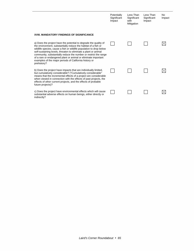
Potentially Significant Impact
Less Than Significant with Mitigation
Less Than Significant Impact
No Impact
Laird’s Corner Roundabout 65
XVIII. MANDATORY FINDINGS OF SIGNIFICANCE
a) Does the project have the potential to degrade the quality of the environment, substantially reduce the habitat of a fish or wildlife species, cause a fish or wildlife population to drop below self-sustaining levels, threaten to eliminate a plant or animal community, substantially reduce the number or restrict the range of a rare or endangered plant or animal or eliminate important examples of the major periods of California history or prehistory?
b) Does the project have impacts that are individually limited, but cumulatively considerable? ("Cumulatively considerable" means that the incremental effects of a project are considerable when viewed in connection with the effects of past projects, the effects of other current projects, and the effects of probable future projects)?
c) Does the project have environmental effects which will cause substantial adverse effects on human beings, either directly or indirectly?


Laird’s Corner Roundabout 67
Appendix B Title VI Policy Statement

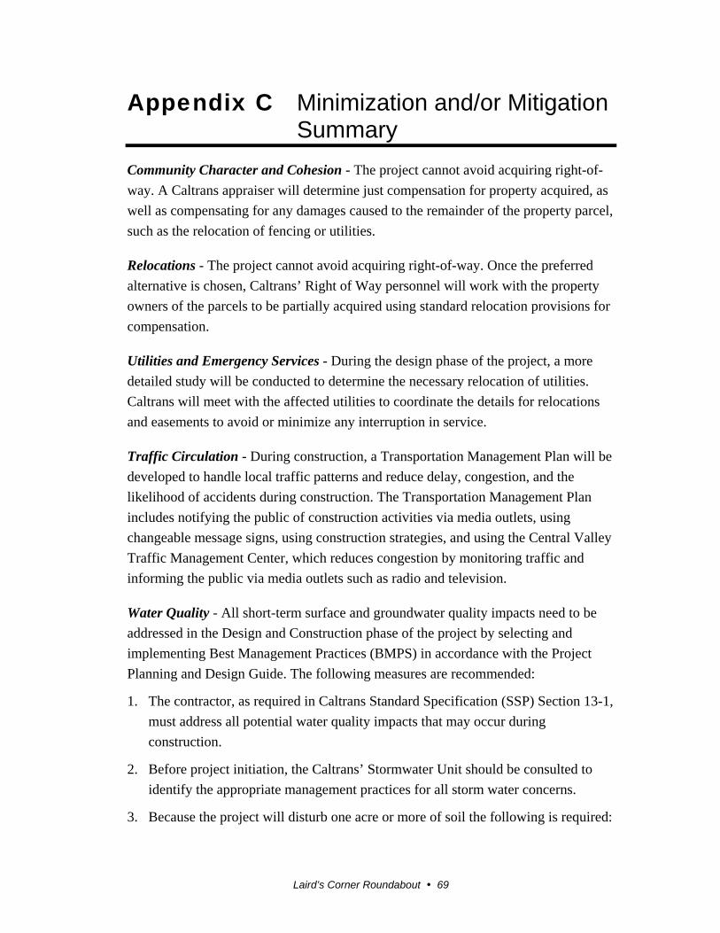
Laird’s Corner Roundabout 69
Appendix C Minimization and/or Mitigation Summary
Community Character and Cohesion - The project cannot avoid acquiring right-of-
way. A Caltrans appraiser will determine just compensation for property acquired, as
well as compensating for any damages caused to the remainder of the property parcel,
such as the relocation of fencing or utilities.
Relocations - The project cannot avoid acquiring right-of-way. Once the preferred
alternative is chosen, Caltrans’ Right of Way personnel will work with the property
owners of the parcels to be partially acquired using standard relocation provisions for
compensation.
Utilities and Emergency Services - During the design phase of the project, a more
detailed study will be conducted to determine the necessary relocation of utilities.
Caltrans will meet with the affected utilities to coordinate the details for relocations
and easements to avoid or minimize any interruption in service.
Traffic Circulation - During construction, a Transportation Management Plan will be
developed to handle local traffic patterns and reduce delay, congestion, and the
likelihood of accidents during construction. The Transportation Management Plan
includes notifying the public of construction activities via media outlets, using
changeable message signs, using construction strategies, and using the Central Valley
Traffic Management Center, which reduces congestion by monitoring traffic and
informing the public via media outlets such as radio and television.
Water Quality - All short-term surface and groundwater quality impacts need to be
addressed in the Design and Construction phase of the project by selecting and
implementing Best Management Practices (BMPS) in accordance with the Project
Planning and Design Guide. The following measures are recommended:
1. The contractor, as required in Caltrans Standard Specification (SSP) Section 13-1,
must address all potential water quality impacts that may occur during
construction.
2. Before project initiation, the Caltrans’ Stormwater Unit should be consulted to
identify the appropriate management practices for all storm water concerns.
3. Because the project will disturb one acre or more of soil the following is required:

Appendix C Minimization and/or Mitigation Summary
Laird’s Corner Roundabout 70
A notification of Intention (NOI) is to be submitted to the appropriate
Regional Water Quality Control Board at least 30 days prior to the start of
construction.
A Stormwater Pollution Prevention Plan (SWPPP) is to be prepared and
implemented during construction to the satisfaction of the Resident Engineer.
A Notice of Termination (NOT) shall be submitted to the Regional Board
upon completion of construction and site stabilization. A project will be
considered complete when the criteria for final stabilization in the
Construction General permits are met.
Hazardous Waste - Caltrans recommends the following Caltrans Standard Special
Provisions (SSPs) for the health and safety of workers during construction:
Caltrans Standard Special Provision (SSP) 7-1.02K(6)(j)(iii) Earth Material
Containing Lead
Caltrans Standard Special Provision (SSP) 14-11.07 Remove Yellow Traffic
Stripe and Pavement Markings (Hazardous Waste)
If construction includes grinding the entire pavement surface and the project does not
require the paint or thermoplastic be removed before grinding begins, Caltrans
recommends:
Caltrans Standard Special Provision (SSP) 15-1.03B – Residue Containing Lead
from Paint and Thermoplastic – Requires a lead compliance plan when high lead
concentration paints are on the surface to be ground or cold planed but residue
will be non-hazardous. The estimated cost to include the lead compliance plan is
$3,000.
Noise - As directed by Caltrans, the contractor will adhere to Standard Specifications
Section (SSP) 14-8.02 and the Tulare County Noise Ordinance. Implementing the
following measures will minimize the temporary noise impacts from construction:
All equipment will have sound-control devices that are no less effective than
those provided on the original equipment.
No equipment will have an unmuffled exhaust.
Biology - Caltrans will be purchasing mitigation bank credits for impacts to the San
Joaquin kit fox foraging habitat for the State Route 190 Rehabilitation project
(SR190-06-416500, post miles 0.0 to 8.0); therefore, Caltrans is not proposing any

Appendix C Minimization and/or Mitigation Summary
Laird’s Corner Roundabout 71
additional mitigation for the Laird’s Corner Roundabout project, but will include the
following avoidance and minimization measures recommended in the Letter of
Concurrence from the U.S. Fish and Wildlife Service:
The Service’s most recent guidelines will be followed; currently, this is the January
2011 U.S. Fish and Wildlife Service Standardized Recommendations for Protection of
the Endangered San Joaquin Kit Fox Prior to or During Ground Disturbance
(Recommendations). Caltrans will conduct preconstruction surveys, as described on
page two of the Recommendations; set up exclusion zones around any dens that are
identified during preconstruction surveys, as described beginning on page three; and
implement the construction and on-going operational requirements described
beginning on page five. Provision 1 below is a modification to an existing measure in
the Recommendations. Provisions 2, 3, and 4 are in addition to the
Recommendations:
1. All food-related trash items, such as wrappers, cans, bottles, and food scraps
will be disposed of in closed containers and removed daily from the entire
project site in order to reduce the potential for attracting predator species.
2. Caltrans will include Species Protection Standard Special Provisions for the
San Joaquin kit fox and migratory birds when soliciting contractor bid
packages.
3. Though night work is not anticipated to take place during the course of the
project, in the event that it becomes necessary for safety reasons, Caltrans
proposes to have a Service-approved biologist onsite to monitor for the San
Joaquin kit fox during these activities.
4. If a dead, injured, or entrapped San Joaquin kit fox is found onsite, the
contractor will stop all construction activities within 150 feet of the animal
and immediately notify the Resident Engineer (RE) and Caltrans project
biologist. If a potential or known San Joaquin kit fox den is discovered, the
contractor also will stop all construction activities within 150 feet of the den
and notify the Resident Engineer and Caltrans project biologist.


Laird’s Corner Roundabout 73
Appendix D NRCS Farmland Conversion Impact Rating Form


Laird’s Corner Roundabout 75
Appendix E Comments and Responses
The Laird’s Corner Roundabout Initial Study with Proposed Negative Declaration
was circulated for public and agency review and comment from April 9, 2014 to May
9, 2014.
Caltrans sent letters to federal, state, and local officials and to affected property
owners announcing the availability of the draft environmental document for public
review and comment. The letter also provided information on how to submit
comments about the project and request a public hearing.
Two property owners contacted Caltrans to discuss the proposed storm water
drainage basins. On June 3, 2014, Caltrans staff from Design, Environmental
Analysis, and Project Management met with two property owners at the project site to
discuss the location of the storm water drainage basin(s). One property owner stated
that he did not like the project but that it was needed. The other property owner as
asked whether the basin could be reduced in length so that there would be some space
between the basin and the house on his property for private access. As a result of the
discussion, only one storm water drainage basin is proposed on the southeast side of
State Route 190 and Road 152 (Bliss Lane). The size of the basin will be reduced to
provide a 20-foot path between the property owner’s existing fence and the right-of-
way fence for the basin. However, there will not be access to State Route 190 from
the path.
On April 21, 2014, a letter was received from the California Department of
Conservation. This agency monitors farmland conversion on a statewide basis and
administers the California Land Conservation (Williamson) Act and other agricultural
land conservation programs. The Land Conservation Act (LCA) of 1965 statute states
that public agencies shall notify the Director of the Department before making a
decision to acquire property located in an agricultural preserve. The letter stated that
their department has not received the required notification from Caltrans.
On May 8, 2014, a letter was received from the State Clearinghouse stating no state
agency submitted comments on the project. The letter also stated that Caltrans had
complied with the State Clearinghouse review requirements pursuant to the California
Environmental Quality Act.
No other public or agency comments were received on the circulated draft document.
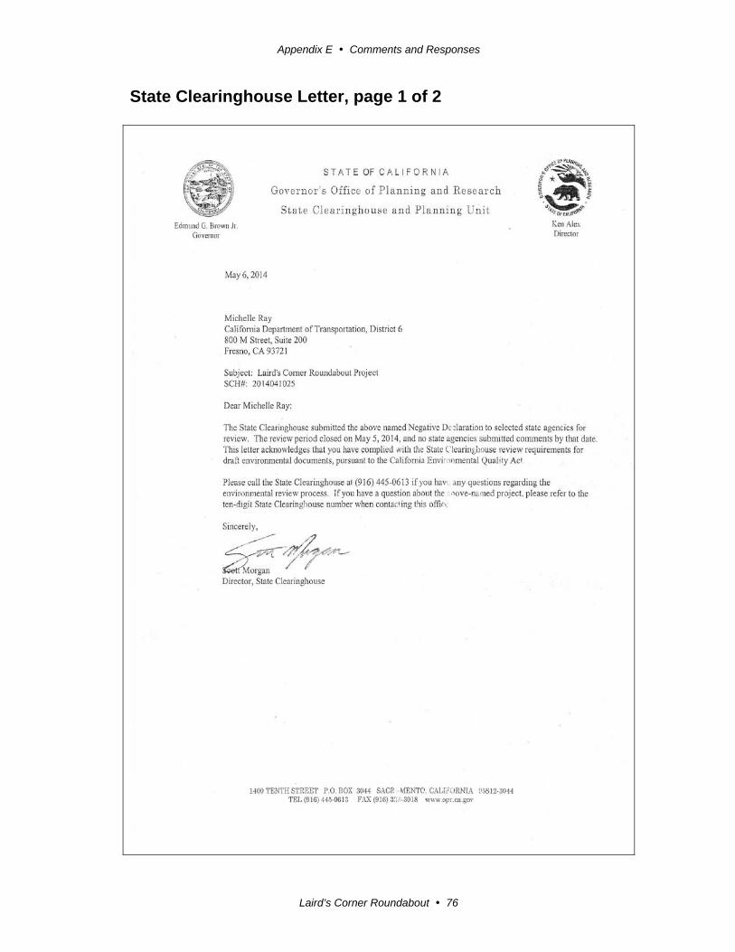
Appendix E Comments and Responses
Laird’s Corner Roundabout 76
State Clearinghouse Letter, page 1 of 2
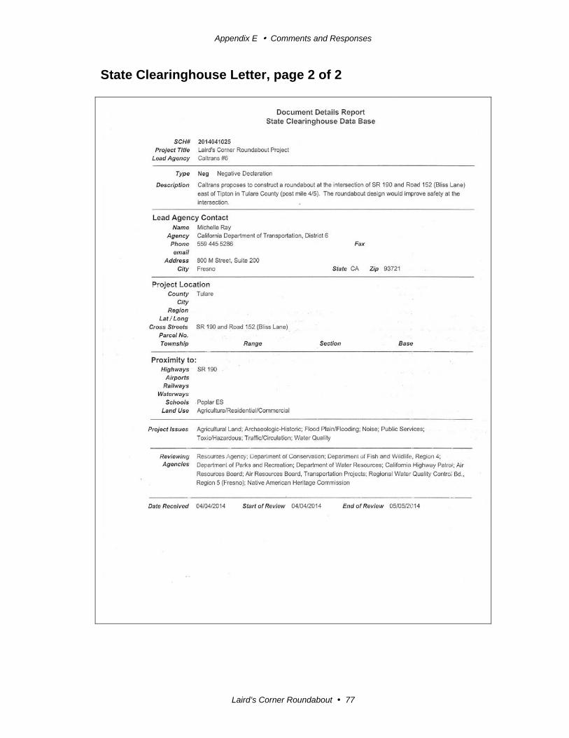
Appendix E Comments and Responses
Laird’s Corner Roundabout 77
State Clearinghouse Letter, page 2 of 2

Appendix E Comments and Responses
Laird’s Corner Roundabout 78
Response to State Clearinghouse
No response was necessary.
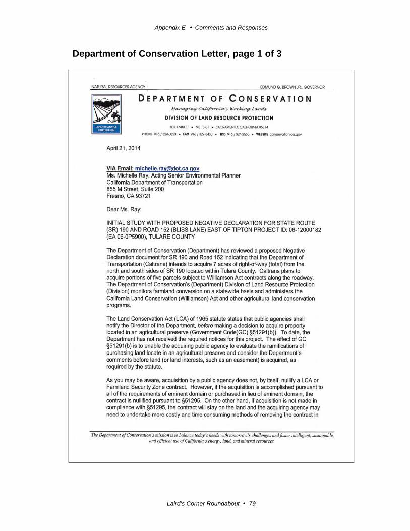
Appendix E Comments and Responses
Laird’s Corner Roundabout 79
Department of Conservation Letter, page 1 of 3
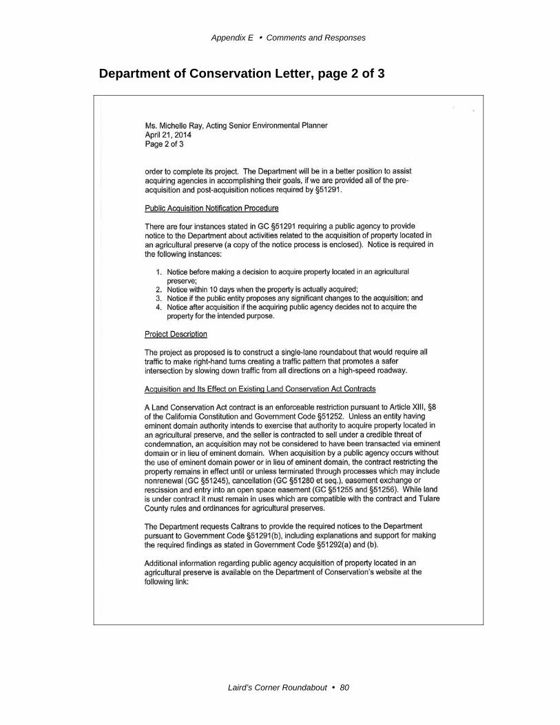
Appendix E Comments and Responses
Laird’s Corner Roundabout 80
Department of Conservation Letter, page 2 of 3
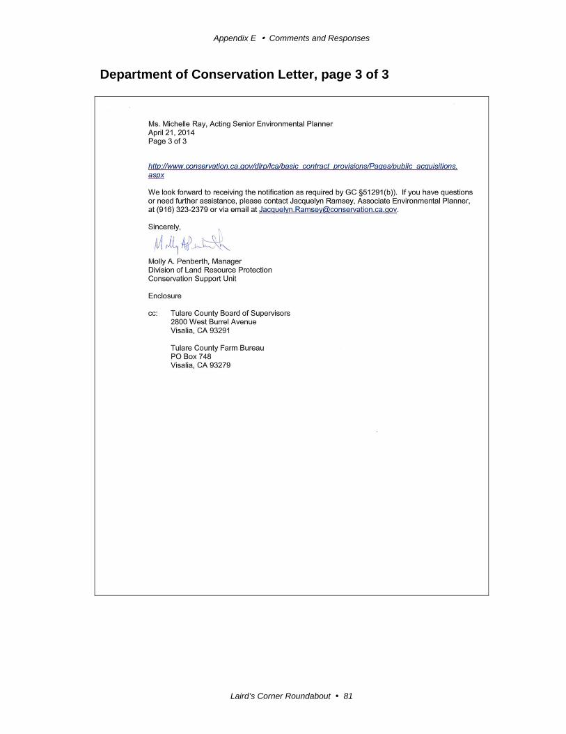
Appendix E Comments and Responses
Laird’s Corner Roundabout 81
Department of Conservation Letter, page 3 of 3
Appendix E Comments and Responses
Laird’s Corner Roundabout 82
Reponse to the Department of Conservation
Thank you for your notice. Caltrans did not send the first notice of the proposed
acquisition of property restricted by Williamson Act contracts to the Director of the
Department of Conservation, the Tulare County Board of Supervisors and the Tulare
County Farm Bureau because the decision to acquire property has not been made.
At this time, during the Project Approval and Environmental Document (PA&ED)
phase of the project, the project scope (design) is established in only enough detail to
identify all effects and impacts, including proposed right-of-way needs. During the
next phase of project development, which is called Plans, Specifications, Estimate
(PS&E), refinement of the design and actual right-of-way needs will be determined.
List of Technical Studies
Relocation Impact Statement
Hot-Spot Conformity Assessment
Noise Study Memorandum
Water Compliance Study
Natural Environment Study (MI)
Biological Assessment
Historical Property Survey Report
Hazardous Compliance Study
Scenic Resource Evaluation
Paleontological Identification Report
Related Documents