STATE OF CALIFORNIA RESOURCES AGENCY BOARD OF FORESTRY CALIFORNIA DEPARTMENT OF FORESTRY AND FIRE PROTECTION REVISED October 6th, 2010 State Responsibility Area Classification System

Welcome message from author
This document is posted to help you gain knowledge. Please leave a comment to let me know what you think about it! Share it to your friends and learn new things together.
Transcript

STATE OF CALIFORNIA RESOURCES AGENCY BOARD OF FORESTRY
CALIFORNIA DEPARTMENT OF FORESTRY AND FIRE PROTECTION
REVISED October 6th, 2010
State Responsibility Area Classification System

i
1234567891011121314151617181920212223242526272829303132333435363738394041424344454647484950
TABLE OF CONTENTS STATE RESPONSIBILITY AREA CLASSIFICATION SYSTEM...................1 INTRODUCTION………………………………………………………………………………………………………………………………1 PURPOSE……………………………………………………………………………………………………………………………………………1 GOALS…………………………………………………………………………………………………………………………………………………1 OVERVIEW…………………………………………………………………………………………………………………………………………2 LEGAL BASIS…………………………………………………………………………………………………………………………………2 REVIEW SCHEDULE………………………………………………………………………………………………………………………3 FIELD EVALUATION……………………………………………………………………………………………………………………………………4 STEP I – DEFINING EXISTING CLASSIFICATION STATION……………………………4 STEP II – IDENTIFYING AREAS FOR FIELD EVALUATION………………………………4 STEP III-CONDUCTING FIELD EVALUATION USING CLASSIFICATION KEY…………………………………………………………………………………………………………6 STEP IV – DOCUMENTATION…………………………………………………………………………………………………7 REGIONAL REVIEW………………………………………………………………………………………………………………………………………9 STATE REVIEW……………………………………………………………………………………………………………………………………………10 MEMBERSHIP…………………………………………………………………………………………………………………………………10 USE OF ADVISORS……………………………………………………………………………………………………………………10 DOCUMENTATION…………………………………………………………………………………………………………………………10 REVIEW PROCESS………………………………………………………………………………………………………………………10 REVIEW CRITERIA……………………………………………………………………………………………………………………11 SPECIAL REVIEW………………………………………………………………………………………………………………………11 REVIEW TEAM’S RECOMMENDATIONS………………………………………………………………………………11 DIRECTOR’S APPROVAL…………………………………………………………………………………………………………………………11 BOARD OF FORESTRY AND FIRE PROTECTION…………………………………………………………………………11 APPENDICES…………………………………………………………………………………………………………………………………………………12 I. FIELD EVALUATION KEY…………………………………………………………………………………………13 II. STATE REVIEW KEY……………………………………………………………………………………………………16 III. REVIEW SCHEDULES……………………………………………………………………………………………………18 IV. FIELD EVALUATION FORM………………………………………………………………………………………20 V. DOCUMENTATION INSTRUCTIONS…………………………………………………………………………21 VI. DOCUMENTATION REQUIREMENTS…………………………………………………………………………23
VII. MATERIALS LIST…………………………………………………………………………………………………………24 VIII. FLOW CHART…………………………………………………………………………………………………………………25 X.RECORDING AUTOMATIC EXCLUSIONS AND INCLUSIONS………………………………26
1
1234567891011121314151617181920212223242526272829303132333435363738394041424344454647484950
STATE RESPONSIBILITY AREA CLASSIFICATION SYSTEM
INTRODUCTION The California Department of Forestry and Fire Protection (CAL FIRE) conducted a statewide review and delineation of State Responsibility Area (SRA) in 1970. Although some subsequent revisions to that delineation have been approved by the Board of Forestry, the classification of SRA has not kept current with land-use changes. There is a need to review and update the delineation of SRA in a formal manner, at the state level. In its supplement to the 1980-81 FY budget, the Joint Legislative Budget committee directed that: “The Board of Forestry shall conduct a comprehensive review of lands receiving direct protection from the department for the purpose of revising state responsibility boundaries to exclude areas which should be the responsibility of local government or federal agencies. As a Legislative Budget Committee by 11/1/80 on its criteria for determining whether lands currently classified as state responsibility conform to the provisions of Sections 4126-4128 of the Public Resources Code.” “The department shall report to the Joint Legislative Budget Committee by 12/1/80 on a schedule and plan for providing support to the Board of Forestry in conducting such a review.” PURPOSE 1. To provide a systematic and uniform process for identifying land-use
changes which cause or may cause a change of the classification of SRA. 2. To review the existing classification of SRA to determine that all such
lands are properly classified. GOALS 1. To provide a procedure which ensures statewide consistency in
classifying SRA. 2. To provide an ongoing procedure that will enable CAL FIRE to respond in
timely manner to land-use changes. 3. To provide local government sufficient time to plan for changes in the
classification of SRA. 4. To involve the public in decisions about the classification of SRA.
2
1234567891011121314151617181920212223242526272829303132333435363738394041424344454647484950
OVERVIEW This classification system has five levels. They are:
1. Field evaluation 2. Regional review 3. State review 4. Director’s approval 5. Board of Forestry and Fire Protection approval.
The field evaluation is accomplished at the Unit or Contract County. This evaluation identifies lands that may warrant reclassification. When a Unit/ Contract County staff proposes a SRA to LRA (Local Responsibility Area) or LRA to SRA change, they should consult with staff from the local fire agencies that will be affected by the change. Following the 2010 SRA map update, local agency consultation shall include contacting both the fire agencies and planning departments. Any area so identified is documented and forwarded for Regional review (second level). The Regional review ensures that the system has been consistently applied at the Unit or Contract County level. After completing the review, the Region SRA Coordinator forwards the areas identified for possible reclassification to the State SRA Coordinator. The State Review Team (third level) reviews the documentation. The State Review Team also conducts on-site inspections as needed. The State Review Team then forwards its recommendations to the Director (fourth level). The Director reviews all proposed changes in classification. Those changes that the Director approves are sent to the Board of Forestry and Fire Protection so that public hearings may be scheduled. At this time the Director notifies all affected local government agencies of the proposed changes and their potential impacts. The Board of Forestry and Fire Protection is fifth level. Under PRC Section 4125, the Board is the final authority for approving changes in classification of SRA. LEGAL BASIS This classification system, which defines land for which the state assumes primary financial responsibility for protecting natural resources from damages from fire, is based on existing law (PRC 4125-4128). It is important to understand that the system is not based on the ability to protect an area from fire, but rather on the vegetative cover and natural resource values enumerated in PRC 4126:
a) Lands covered wholly or in part by forests or by trees producing or capable of producing forest products. Lands covered wholly or in part by timber, brush, undergrowth, or grass, whether of commercial value or not, which protect the soil from excessive erosion, retard runoff of

3
1234567891011121314151617181920212223242526272829303132333435363738394041424344454647484950
water or accelerate water percolation, if such lands are sources of water which is available for irrigation or for domestic or industrial use. b) Lands in areas which are principally used or useful for range or forage purposes, which are contiguous to the lands described in subdivisions (a) and (b).
Lands which do not qualify as SRA are defined in PRC Section 4127: “The Board shall not include within state responsibility areas any of the following lands:
a) “Lands owned or controlled by the federal government or any agency of the federal government.
b) “Lands within the exterior boundaries of any city. c) “Any other lands within the state which do not come within any of
the classes which are described in Section 4126.” In addition, PRC, Section 4128, states that, “The Board may, for purposes of administrative convenience, designate roads, pipelines, streams, or other recognizable landmarks as arbitrary boundaries.” These definitions provide the basis for the field evaluation of SRA. REVIEW SCHEDULE State Review shall occur in 2010 and every five years thereafter. Automatic exclusion and inclusion will be updated as needed by the State GIS coordinator. The State SRA Coordinator will prepare an update and summary for the Board of Forestry and Fire Protection as needed and at a minimum annually. Special Reviews may occur as needed. Adjustments and special reviews may be made at more frequent intervals, if major land-use changes occur or if inconsistencies are discovered in the CAL FIRE corporate SRA GIS data layer. Changes to or from SRA can occur from expanding urbanization or changes to agricultural use. For example, an area previously used for cultivated and irrigated crops may revert to natural vegetation and go from LRA to SRA. Upon notification from the State Board of Equalization, the State SRA Mapping Coordinator will update the corporate SRA GIS data layer with approved incorporations or land-use changes.
4
1234567891011121314151617181920212223242526272829303132333435363738394041424344454647484950
FIELD EVALUTION STEP I – DEFINING EXISTING CLASSIFICATION STATUS A. Download the most current SRA map for your Unit/Contract County from the
designated site and print as many maps as necessary for the SRA review. B. Print as many GIS generated maps as are necessary to be used for the
field evaluation of specific areas in question, using the following guidelines.
1. Include the following GIS Data Layers, which can be found on the
Fire Plan data GIS library, on the map. a. Most current SRA Data Layers for the area being evaluated b. Current road layer c. Current incorporated city layer d. Any other layer you might need (public land survey, hydro, 7.5 quad background, hill shade, etc.)
2. Shade all current (original) SRA polygons light yellow. 3. Use a light gray background for any areas that are “Lands within the
exterior boundaries of incorporated cities” Shade LRA area light gray.
4. Lands owned or controlled by the federal government or any agency of
the federal government (include all federal lands regardless of existing fire protection responsibilities) – shade light green.
NOTE: Incorporated cities and federally owned or controlled lands are automatic exclusions from SRA. Their boundaries must be kept current on the official SRA maps. The procedure for recording these changes is described in Appendix VIII. STEP II – IDENTIFYING AREAS FOR FIELD EVALUATION The working map prepared in Step I describes the current SRA classification. Two basic questions remain to be answered.
1. Are there any lands currently not classified SRA on either side of the SRA/LRA (Local Responsibility Area) boundary line which meets the criteria for SRA in PRC Section 4126?
2. Are there any lands currently classified as SRA which do not meet
the criteria for SRA and would be excluded by PRC Section 4127? The accompanying classification key has been developed to assist in answering these questions. The key is intended to provide standard criteria to evaluate each area. It provides a method of screening many areas rapidly in order to focus quickly on areas that may need change in classification.
5
1234567891011121314151617181920212223242526272829303132333435363738394041424344454647484950
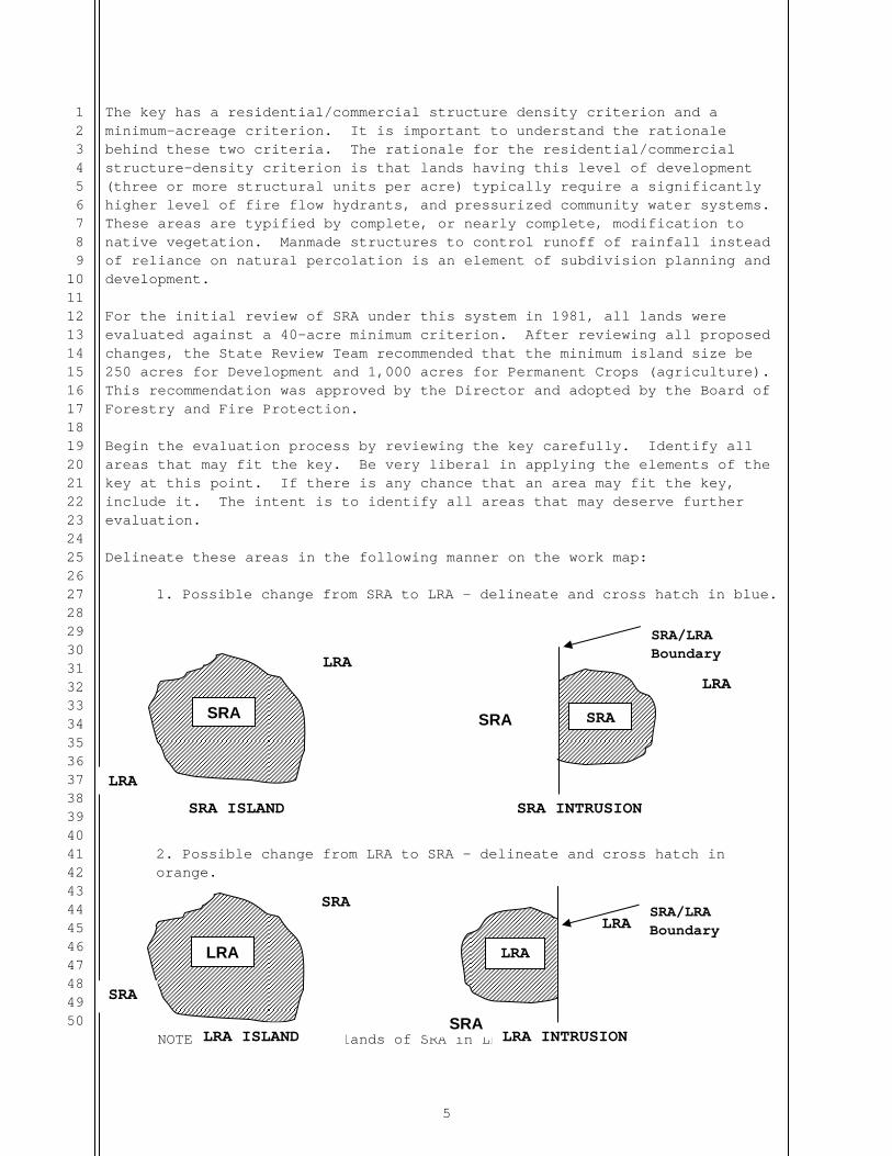
The key has a residential/commercial structure density criterion and a minimum-acreage criterion. It is important to understand the rationale behind these two criteria. The rationale for the residential/commercial structure-density criterion is that lands having this level of development (three or more structural units per acre) typically require a significantly higher level of fire flow hydrants, and pressurized community water systems. These areas are typified by complete, or nearly complete, modification to native vegetation. Manmade structures to control runoff of rainfall instead of reliance on natural percolation is an element of subdivision planning and development. For the initial review of SRA under this system in 1981, all lands were evaluated against a 40-acre minimum criterion. After reviewing all proposed changes, the State Review Team recommended that the minimum island size be 250 acres for Development and 1,000 acres for Permanent Crops (agriculture). This recommendation was approved by the Director and adopted by the Board of Forestry and Fire Protection. Begin the evaluation process by reviewing the key carefully. Identify all areas that may fit the key. Be very liberal in applying the elements of the key at this point. If there is any chance that an area may fit the key, include it. The intent is to identify all areas that may deserve further evaluation. Delineate these areas in the following manner on the work map:
1. Possible change from SRA to LRA – delineate and cross hatch in blue.
2. Possible change from LRA to SRA – delineate and cross hatch in orange.
NOTE: Avoid small islands of SRA in LRA or LRA in SRA.
SRA
LRA
LRA
SRA ISLAND
SRA
LRA
SRA
SRA INTRUSION
LRA
SRA
SRA
LRA ISLAND
LRA
LRA
SRALRA INTRUSION
SRA/LRA Boundary
SRA/LRA Boundary

6
1234567891011121314151617181920212223242526272829303132333435363738394041424344454647484950
Three types of areas should emerge at this point. 1. Islands of SRA that are surrounded by LRA on all sides (exterior
changes). 2. Islands of LRA that are surrounded by SRA on all sides (interior
changes). 3. Intrusions of either SRA or LRA along the existing SRA/LRA boundary line
(boundary line adjustments). STEP III-CONDUCTING FIELD EVALUATION USING CLASSIFICATION KEY The key is designed to ensure that all Units and Contract Counties view all areas in question in a uniform manner. The key also focuses on only those lands that may need reclassification. All areas identified for potential change in classification will be evaluated against the criteria in the key that leads the evaluator through a series of questions/conditions. The answer to the question/condition either leads to a conclusion or another question/condition. Using the key requires some interpretation of the question/condition. Each area identified on the work map will require an inspection. The best way to inspect an area is from the air. An on-the-ground inspection may be required in addition to aerial inspection; however, experience has shown that most areas can be successfully and accurately keyed from the air. CAL FIRE air resources have administrative flight time built into their budget. If digital photos taken from the air are necessary, make arrangements through the appropriate Unit Headquarters for use of CAL FIRE air resources for administrative flights. All Contract Counties will make arrangements through the appropriate region for use of CAL FIRE air resources for administrative flights. Additionally, photographic documentation is necessary for each area. Digital orthophotos viewed in GIS software should be used if possible. Aerial digital photos can be used if the orthophotos do not provide good detail. Adjustments of boundary lines shall be made following these basic rules of thumb. 1. Whenever possible, use parcel boundaries or obvious lines of land-use
change to define the area where the SRA change is recommended. 2. Whenever possible, boundary lines will be identifiable and easily
administered in the field. Roads, pipelines, streams, fences in subdivisions, or other recognizable landmarks can be used. Irregular lines that follow irrigated and cultivated fields and fences are permissible if they are clearly definable. Extended fingers should be avoided.
3. If lines of convenience are used, small areas of LRA may be included in
SRA. However, SRA should not be eliminated by lines of convenience.

7
1234567891011121314151617181920212223242526272829303132333435363738394041424344454647484950
Boundary lines should be located as close as possible to the place of obvious change between LRA and SRA.
4. “Contiguous rangeland” extends only from the toe of the first
significant slope to the first good line of convenience. 5. “Watershed lands” will only be submitted for State Review when, as a
guide, they have ten inches of mean annual rainfall combined with upsloping topography and evidence of water storage and use.
STEP IV – DOCUMENTATION The key will result in one of two conclusions: 1. No change in existing classification is warranted, but future
evaluation should take place. 2. A change is proposed due to the fact that the current classification is
questionable. A. No Change, future evaluation. If the key directs to a conclusion that results in no change in classification the following situation may exist:
"The area is developing, but at this time an overriding state interest still remains. Areas such as this may in the future develop to the extent that no state interest remains."
If this situation exists, check the “No change (Future Evaluation)” box in the field evaluation results section of the "FIELD EVALUATION DOCUMENTATION FORM". This will provide documentation for the Unit/Contract County staff during the next SRA review or during a special review if major land use changes occur prior to the next review. Year of Survey: Resurvey 5 yr ( ) 20 Less than 5 yrs. ( ) 20 Documentation is required for all areas evaluated regardless of the conclusion obtained from the key. If the key directs the evaluator to Conclusion 1 above, the following documentation will be retained in a permanent file at the Unit/Contract County level: 1. GIS generated map containing the boundary of the proposed SRA changes with a digital orthophoto imagery background.
a) Create a GIS data layer to store features of all proposed changes (use map symbols and labels which will clearly identify them on the map). Use parcel data to create SRA change boundaries where possible.
b) If the orthophoto does not clearly display the reason for recommending
the SRA change, provide additional digital photos to provide better detail of the area in question.

8
1234567891011121314151617181920212223242526272829303132333435363738394041424344454647484950
c) Use map symbols and labels that will clearly display the possible SRA boundary change on the map.
2. The Field Evaluation Form including any information which supports the findings. 3. GIS data layer containing features of the area in question. B. Proposed Change
If the key directs to a conclusion, which refers the area for statewide review, the following documentation is necessary: 1. GIS generated map containing the boundary of the proposed SRA change
with a digital orthophoto imagery background.
a) If the orthophoto does not clearly display the reason for recommending the SRA change, provide digital photos to provide better detail of the area in question.
b) Use map symbols and labels that will clearly display the proposed SRA
boundary change on the map.
c) Place ID number (from for each boundary change feature on the map to clearly identify
2. GIS generated map delineating the proposed change and any other
pertinent features to clearly identify the location and area of the proposed change.
a) Use the Unit boundary, Region boundary, road, city boundary, hydro, 7.5’ quad or other GIS data layers as needed on the map.
b) Provide the ID number for each record on each map and in the attribute
table of the GIS data layer which will match the ID number on the Field Evaluation Documentation Form for each proposed SRA change.
3. Create a GIS data layer to store features of all proposed changes (use map symbols and labels which will clearly identify them on the map). Use parcel data to create SRA changes where possible.
4. Field Evaluation Documentation Form describing the area and explaining
why the change should be made. Also list the acres affected by Unit and County. These forms will be signed by the Unit Chief indicating his/her approval for the potential change.

9
1234567891011121314151617181920212223242526272829303132333435363738394041424344454647484950
REGIONAL REVIEW The Region Review Team will evaluate all potential reclassifications identified in the field evaluation process. Units/Contract Counties will upload GIS data layers and documentation forms to the location specified in the SRA Review instructions and send signed copies of all documentation to the Region SRA Coordinator. The Region SRA Coordinator will ensure that the classification process has been correctly applied and that documentation is complete. The Region SRA Coordinator will obtain written approval for each Unit from the Region Chief. The Unit and Region SRA Coordinators will retain a copy of all maps, photos, and documentation for their records. Contract Counties will require approval from their Administrative Unit Chief. Upon completion of all fieldwork and the Regional review, the Region SRA Coordinator will notify the State SRA Coordinator as soon as the Unit maps and documentation have been checked and are ready for the state review. The Region SRA Coordinator will coordinate scheduling the state review and will appoint its representative to the State Review Team.
STATE REVIEW MEMBERSHIP The State Review Team shall consist of the following members:
1. A member of the Fire Plan Staff. 2. A member of the Board of Forestry and Fire Protection. 3. The Region SRA Coordinator where the areas for review are located. 4. A representative for the affected Contract County as needed.
USE OF ADVISORS A Unit level representative will be appointed as an advisor to the team (if needed). The review team may also request technical advice from others in the Department or from any other public agency. DOCUMENTATION The review team will have all documentation from the field evaluation available to it at the review. The team will document the basis for its recommendations.
10
1234567891011121314151617181920212223242526272829303132333435363738394041424344454647484950
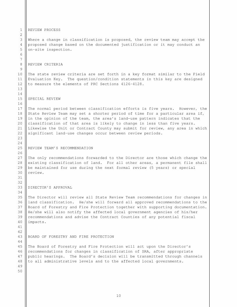
REVIEW PROCESS Where a change in classification is proposed, the review team may accept the proposed change based on the documented justification or it may conduct an on-site inspection. REVIEW CRITERIA The state review criteria are set forth in a key format similar to the Field Evaluation Key. The question/condition statements in this key are designed to measure the elements of PRC Sections 4126-4128. SPECIAL REVIEW The normal period between classification efforts is five years. However, the State Review Team may set a shorter period of time for a particular area if, in the opinion of the team, the area’s land-use pattern indicates that the classification of that area is likely to change in less than five years. Likewise the Unit or Contract County may submit for review, any area in which significant land-use changes occur between review periods. REVIEW TEAM’S RECOMMENDATION The only recommendations forwarded to the Director are those which change the existing classification of land. For all other areas, a permanent file shall be maintained for use during the next formal review (5 years) or special review. DIRECTOR’S APPROVAL The Director will review all State Review Team recommendations for changes in land classification. He/she will forward all approved recommendations to the Board of Forestry and Fire Protection together with supporting documentation. He/she will also notify the affected local government agencies of his/her recommendations and advise the Contract Counties of any potential fiscal impacts. BOARD OF FORESTRY AND FIRE PROTECTION The Board of Forestry and Fire Protection will act upon the Director’s recommendations for changes in classification of SRA, after appropriate public hearings. The Board’s decision will be transmitted through channels to all administrative levels and to the affected local governments.
11
1234567891011121314151617181920212223242526272829303132333435363738394041424344454647484950
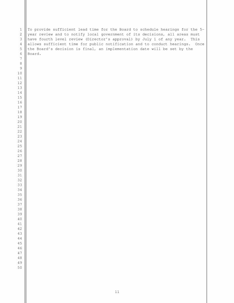
To provide sufficient lead time for the Board to schedule hearings for the 5-year review and to notify local government of its decisions, all areas must have fourth level review (Director’s approval) by July 1 of any year. This allows sufficient time for public notification and to conduct hearings. Once the Board’s decision is final, an implementation date will be set by the Board.

12
1234567891011121314151617181920212223242526272829303132333435363738394041424344454647484950
APPENDICES
APPENDIX I
FIELD EVALUATION KEY This key is to be used by the Unit/Contract County to identify areas to be reviewed for possible change in classification. A. The area being considered is currently classified as: State Responsibility Area. . . . . . . . . . . . Go to B Local Responsibility Area . . . . . . . . . . . . Go to C B. State Responsibility Area:
I. The area has been modified by man to permanent crops or development.
Discussion:
Limiting the scope to man’s modifications eliminates from consideration natural areas such as large rock outcroppings typical to the high Sierra regions. Man’s modifications, must have substantially changed the character of the area so that it no longer produces or is capable of producing forest products, forage, or water for domestic, irrigation, or industrial use.
1. Crops - - Long term non-flammable crops such as orchards and vineyards which are irrigated and cultivated. (Annuals such as row crops and grain, are not, a long-term modification.) 2. Development - - Continuous urbanization averaging more than three residential and/or commercial units per acre over 250 or more acres.
Yes . . . . . . . . . . . . . . . . . . Go to II No . . . . . . . . . . . . . . . . . . . SRA II. The area has definable boundaries. Discussion:
To be identifiable, an area must have clearly definable boundaries; for example: (1) jurisdictional boundaries of public service entities; (2) man-made features such as roads; and (3) natural features such as streams and lakeshores; or (4) assessor’s parcel boundaries.
13
1234567891011121314151617181920212223242526272829303132333435363738394041424344454647484950
Yes . . . . . . . . . . . . . . . . . Go to III No . . . . . . . . . . . . . . . . . . . SRA
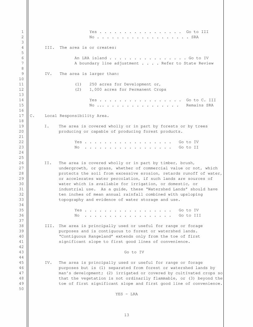
III. The area is or creates: An LRA island . . . . . . . . . . . . . . . . Go to IV A boundary line adjustment . . . . Refer to State Review IV. The area is larger than:
(1) 250 acres for Development or, (2) 1,000 acres for Permanent Crops
Yes . . . . . . . . . . . . . . . . . Go to C. III No ... . . . . . . . . . . . . . . . Remains SRA
C. Local Responsibility Area.
I. The area is covered wholly or in part by forests or by trees producing or capable of producing forest products.
Yes . . . . . . . . . . . . . . . . . . Go to IV No . . . . . . . . . . . . . . . . . . Go to II II. The area is covered wholly or in part by timber, brush,
undergrowth, or grass, whether of commercial value or not, which protects the soil from excessive erosion, retards runoff of water, or accelerates water percolation, if such lands are sources of water which is available for irrigation, or domestic, or industrial use. As a guide, these “Watershed Lands” should have ten inches of mean annual rainfall combined with upsloping topography and evidence of water storage and use.
Yes . . . . . . . . . . . . . . . . . . Go to IV No . . . . . . . . . . . . . . . . . . Go to III
III. The area is principally used or useful for range or forage purposes and is contiguous to forest or watershed lands. “Contiguous Rangeland” extends only from the toe of first significant slope to first good lines of convenience.
Go to IV
IV. The area is principally used or useful for range or forage
purposes but is (1) separated from forest or watershed lands by man’s development; (2) irrigated or covered by cultivated crops so that the vegetation is not ordinarily flammable, or (3) beyond the toe of first significant slope and first good line of convenience.
YES - LRA

14
1234567891011121314151617181920212223242526272829303132333435363738394041424344454647484950
No - Refer for review
V. The area is: An island of LRA in SRA or a boundary line adjustment.
Refer to Review The area creates: An island of SRA in LRA LRA

15
1234567891011121314151617181920212223242526272829303132333435363738394041424344454647484950
APPENDIX II STATE REVIEW
KEY
This key is to be used by the State Review Team to evaluate proposed changes in classification. A “yes” answer to any item in Part A is sufficient to classify the land as SRA. All items in Part A must be addressed and documented. PART A
I. Is there a significant threat of fire originating from within the area and spreading to other SRA (consider configuration, topography, location, past fire history)?
Yes . . . . . . . . . . . . . . . . . SRA (DOCUMENT) No . . . . . . . . . . . . . . . . . Go to II
II. Do substantial values exist for the production of forest products, forage, or water?
Yes . . . . . . . . . . . . . . . . . SRA
(DOCUMENT) No . . . . . . . . . . . . . .. . . . Go to III
III. Does or will the omission from SRA seriously impairs the state’s ability to provide needed protection to adjoining SRA lands?
Yes . . . . . . . . . . . . . . . . . SRA (DOCUMENT) No . . . . . . . . . . . . . . . . . Go to IV
IV. If a fire denudes the area will it initiate a fire/flood sequence?
Yes . . . . . . . . . . . . . . . . . SRA (DOCUMENT) No . . . . . . . . . . . . . . . . . Go to V
V. Will or does removal from SRA cause administrative inefficiency? Yes . . . . . . . . . . . . . . . . . SRA (DOCUMENT) No . . . . . . . . . . . . . . . . . LRA
16
1234567891011121314151617181920212223242526272829303132333435363738394041424344454647484950
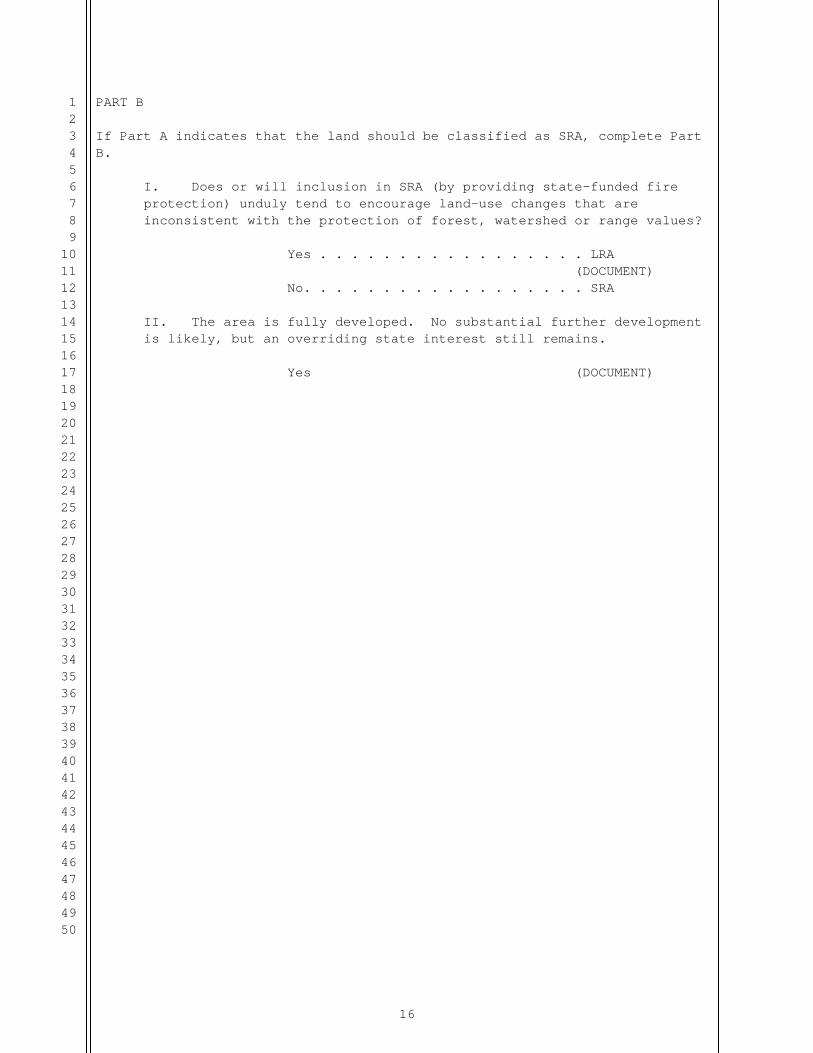
PART B If Part A indicates that the land should be classified as SRA, complete Part B.
I. Does or will inclusion in SRA (by providing state-funded fire protection) unduly tend to encourage land-use changes that are inconsistent with the protection of forest, watershed or range values? Yes . . . . . . . . . . . . . . . . . LRA (DOCUMENT) No. . . . . . . . . . . . . . . . . . SRA II. The area is fully developed. No substantial further development is likely, but an overriding state interest still remains. Yes (DOCUMENT)
17
1234567891011121314151617181920212223242526272829303132333435363738394041424344454647484950
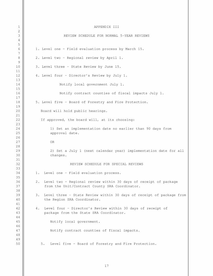
APPENDIX III
REVIEW SCHEDULE FOR NORMAL 5-YEAR REVIEWS
1. Level one – Field evaluation process by March 15.
2. Level two – Regional review by April 1.
3. Level three – State Review by June 15.
4. Level four – Director’s Review by July 1.
Notify local government July 1.
Notify contract counties of fiscal impacts July 1.
5. Level five – Board of Forestry and Fire Protection. Board will hold public hearings. If approved, the board will, at its choosing:
1) Set an implementation date no earlier than 90 days from approval date. OR 2) Set a July 1 (next calendar year) implementation date for all changes.
REVIEW SCHEDULE FOR SPECIAL REVIEWS
1. Level one – Field evaluation process. 2. Level two – Regional review within 30 days of receipt of package
from the Unit/Contract County SRA Coordinator. 3. Level three – State Review within 30 days of receipt of package from
the Region SRA Coordinator. 4. Level four – Director’s Review within 30 days of receipt of
package from the State SRA Coordinator. Notify local government. Notify contract counties of fiscal impacts.
5. Level five – Board of Forestry and Fire Protection.

18
1234567891011121314151617181920212223242526272829303132333435363738394041424344454647484950
Board will hold public hearings.
If approved, the board will, at its choosing:
1) Set an implementation date no earlier than 90 days from approval date. OR 2) Set a July 1 (next calendar year) implementation date for all changes.

19
1234567891011121314151617181920212223242526272829303132333435363738394041424344454647484950
Appendix IV
Page 1 of ______
FIELD EVALUATION DOCUMENTATION FORM I.D. Number: Descriptive name: Year of Survey:________ Type of review: 5 year SRA review ( ) Special Review ( ) Resurvey 5 yr ( ) 20__ Less than 5 yrs. ( ) 20__ Field Evaluation Key Results: No Change ( ) Future Evaluation State Review ( ) Key Item Leading to Conclusion: B-I B-II B-III C-I C-II C-III C-IV Circle one or Leave one (delete all others) Check one: SRA to FRA SRA to LRA FRA to SRA FRA to LRA LRA to SRA LRA to FRA Total acres to be changed ____________ DESCRIPTION OF AREA AND COMMENTS __________________________________________________________________ If appropriate: Local Fire Jurisdiction and Planning Department Name, Signature and Date Unit Chief Approval: ________________________________________________ Signature Date Unit Chief Print
20
1234567891011121314151617181920212223242526272829303132333435363738394041424344454647484950
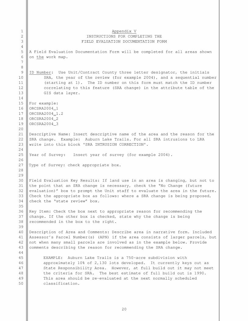
Appendix V INSTRUCTIONS FOR COMPLETING THE
FIELD EVALUATION DOCUMENTATION FORM A Field Evaluation Documentation Form will be completed for all areas shown on the work map. ID Number: Use Unit/Contract County three letter designator, the initials
SRA, the year of the review (for example 2004), and a sequential number (starting at 1). The ID number on this form must match the ID number correlating to this feature (SRA change) in the attribute table of the GIS data layer.
For example: ORCSRA2004_1 ORCSRA2004_1.2 ORCSRA2004_2 ORCSRA2004_3 Descriptive Name: Insert descriptive name of the area and the reason for the SRA change. Example: Auburn Lake Trails. For all SRA intrusions to LRA write into this block "SRA INTRUSION CORRECTION".
Year of Survey: Insert year of survey (for example 2004).
Type of Survey: check appropriate box.
Field Evaluation Key Results: If land use in an area is changing, but not to the point that an SRA change is necessary, check the “No Change (future evaluation)” box to prompt the Unit staff to evaluate the area in the future. Check the appropriate box as follows: where a SRA change is being proposed, check the “state review” box. Key Item: Check the box next to appropriate reason for recommending the change. If the other box is checked, state why the change is being recommended in the box to the right. Description of Area and Comments: Describe area in narrative form. Included Assessor’s Parcel Number(s) (APN) if the area consists of larger parcels, but not when many small parcels are involved as in the example below. Provide comments describing the reason for recommending the SRA change.
EXAMPLE: Auburn Lake Trails is a 750-acre subdivision with approximately 10% of 2,130 lots developed. It currently keys out as State Responsibility Area. However, at full build out it may not meet the criteria for SRA. The best estimate of full build out is 1990. This area should be re-evaluated at the next normally scheduled classification.
21
1234567891011121314151617181920212223242526272829303132333435363738394041424344454647484950
Unit Chief Approval: ________________________________________________ Signature Date
Unit Chief Print
22
1234567891011121314151617181920212223242526272829303132333435363738394041424344454647484950
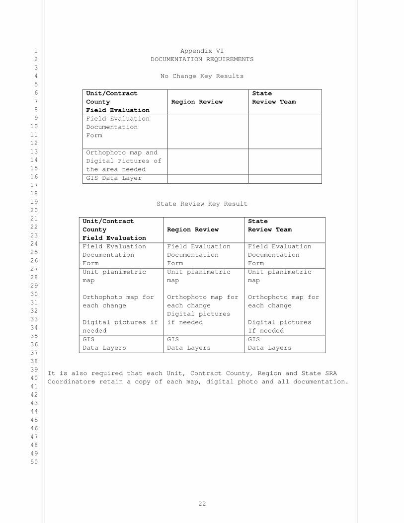
Appendix VI DOCUMENTATION REQUIREMENTS
No Change Key Results
Unit/Contract County Field Evaluation
Region Review
State Review Team
Field Evaluation Documentation Form
Orthophoto map and Digital Pictures of the area needed
GIS Data Layer
State Review Key Result
Unit/Contract County Field Evaluation
Region Review
State Review Team
Field Evaluation Documentation Form
Field Evaluation Documentation Form
Field Evaluation Documentation Form
Unit planimetric map Orthophoto map for each change Digital pictures if needed
Unit planimetric map Orthophoto map for each change Digital pictures if needed
Unit planimetric map Orthophoto map for each change Digital pictures If needed
GIS Data Layers
GIS Data Layers
GIS Data Layers
It is also required that each Unit, Contract County, Region and State SRA Coordinators retain a copy of each map, digital photo and all documentation.

23
1234567891011121314151617181920212223242526272829303132333435363738394041424344454647484950
Appendix VII MATERIALS LIST
ITEM
SOURCE*
Working Map and GIS Data Layers
Fire Plan or FRAP GIS Library
2. Documentation Local photocopies
3. Digital Camera purchase if necessary 4. Aircraft administrative flights Unit, Region, or Sacramento
Headquarters
* Region will provide all local source items to Contract Counties
24
1234567891011121314151617181920212223242526272829303132333435363738394041424344454647484950
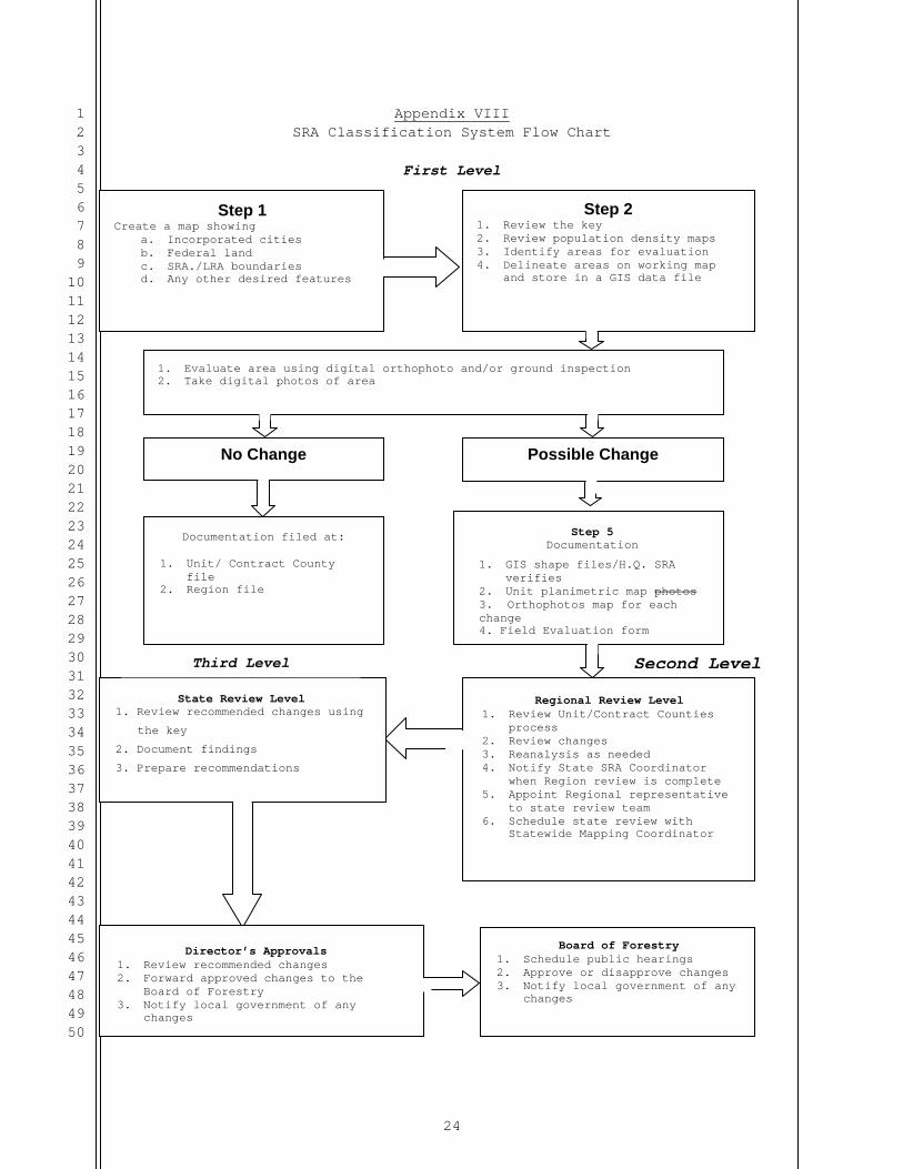
Appendix VIII SRA Classification System Flow Chart
First Level
Step 1 Create a map showing
a. Incorporated cities b. Federal land c. SRA./LRA boundaries d. Any other desired features
Step 2 1. Review the key 2. Review population and
density maps 3. identify areas for
evaluation 4. Delineate areas on working
1. Key areas using aerial and/or ground inspection 2. Take aerial photos
No Change Possible Change
Documentation filed at:
1. Unit/ Contract County file
2. Region file
Step 5 Documentation
1. GIS shape files/H.Q. SRA verifies
2. Unit planimetric map photos 3. Orthophotos map for each change 4. Field Evaluation form
State Review Level 1. Review recommended changes using
the key
2. Document findings
3. Prepare recommendations
Regional Review Level 1. Review Unit/Contract Counties
process 2. Review changes 3. Reanalysis as needed 4. Notify State SRA Coordinator
when Region review is complete 5. Appoint Regional representative
to state review team 6. Schedule state review with
Statewide Mapping Coordinator
Director’s Approvals 1. Review recommended changes 2. Forward approved changes to the
Board of Forestry 3. Notify local government of any
changes
Board of Forestry 1. Schedule public hearings 2. Approve or disapprove changes 3. Notify local government of any
changes
Third Level Second Level
Step 2 1. Review the key 2. Review population density maps 3. Identify areas for evaluation 4. Delineate areas on working map
and store in a GIS data file
1. Evaluate area using digital orthophoto and/or ground inspection 2. Take digital photos of area

25
1234567891011121314151617181920212223242526272829303132333435363738394041424344454647484950
APPENDIX IX RECORDING AUTOMATIC EXCLUSIONS AND INCLUSIONS
Automatic Exclusions – incorporated city or additions to federal lands Change to the status of State Responsibility Area resulting from city incorporation/annexation or transfer of private ownership to federal ownership shall be reported to the State SRA Mapping Coordinator by the Unit, Contract County, local government entity or State Board of Equalization) as they occur. Upon notification, the State SRA Mapping Coordinator will update the corporate SRA GIS data layer with any approved incorporated areas or ownership changes and exclude these areas from SRA. Federal partners may report changes in federal ownership to the State SRA Mapping Coordinator. Update the CAL FIRE corporate SRA GIS data layer with the changes and then post the updated data to the appropriate GIS data layer storage location. Automatic Inclusions – federal land sales or trades to private ownership Automatic inclusions to SRA status may be granted without Board of Forestry and Fire Protection approval for lands which meet the criteria provided in PRC 4126. Upon receipt of notification of a federal land sale or trade to private ownership, the State SRA Mapping Coordinator will notify the Unit/Contract County SRA Coordinator of the ownership change. If the Unit/Contract Counties are notified of a land sale or trade, the State SRA Mapping Coordinator should be notified of the change. The State SRA Mapping Coordinator shall make an initial determination if the land meets the requirements of becoming SRA. The Unit/Contract County SRA Coordinator shall make the final determination as to whether the land meets the requirements of becoming SRA.
Automatic Inclusions or Exclusions– SRA GIS data layer inconsistencies in relation to errors fixes and boundary issues Inconsistencies are occasionally discovered in the SRA corporate GIS data layer. The majority of these findings involve incorrect federal/private ownership or isolated parcels/fragments in the data. These discrepancies may result in improper SRA classification. The intent of this section is to provide a process for the State SRA Mapping Coordinator to follow in order to correct inconsistencies when found. When data inconsistencies are discovered, the same processes for automatic exclusions and inclusions described above are to be followed to make the appropriate determination of change, and document the change. This will often result in an automatic change, but in some cases may require going through the full Board approval process. One common change involves inaccurate boundaries. The State SRA Mapping Coordinator has the ability to move SRA boundaries up to 300 meters, if this change is to improve the accuracy of an SRA boundary and is consistent with the original intent of the boundary. For example, if the shape of an SRA

26
1234567891011121314151617181920212223242526272829303132333435363738394041424344454647484950
boundary clearly indicates it should follow a highway, the SRA boundary may be moved up to 300 meters to align with that highway using a digital aerial photograph. These error changes would qualify as automatic inclusions or exclusions as previously described, not requiring full Board approval.
Related Documents