State of New Mexico Energy, Minerals and Natural Resources Department Susana Martinez Governor David Martin Cabinet Secretary-Designate Brett F. Woods, Ph.D. Deputy Cabinet Secretary New Mexico Oil Conservation Division approval and conditions listed below are made in accordance with OCD Rule 19.15.7.11 and are in addition to the actions approved by BLM on the following 3160-3 APD form. Operator Signature Date: 5/23/13 Well information; Operator ErvcarACX Well Name and Number £-Sor\*o V3 L T -2Ho c i 3H API# 3Q-OH5-35M7S . Section 3H , Township j2H_(g)s, Range _9 E/<© Conditions of Approval: (See the below checked and handwritten conditions) Notify Aztec OCD 24hrs prior to casing & cement. cV Hold C-104 for directional survey & "As Drilled" Plat J Hold C-104 for NSL, NSP, DHC o Spacing rule violation. Operator must follow up with change of status notification on other well to be shut in or abandoned Regarding the use of a pit, closed loop system or below grade tank, the operator must comply with the following as applicable: • A pit requires a complete C-144 be submitted and approved prior to the construction or use of the pit, pursuant to 19.15.17.8.A • A closed loop system requires notification prior to use, pursuant to 19.15.17.9.A • A below grade tank requires a registration be filed prior to the construction or use of the below grade tank, pursuant to 19.15.17.8.C Once the well is spud, to prevent ground water contamination through whole or partial conduits from the surface, the operator shall drill withoyjLinterruption through the fresh water zone or zones and shall immediately set in cement the water protection string o Oil base muds are not to be used until fresh water zones are cased and cemented providing e oil or diesel. This includes synthetic oils . ' •"" / " • : 7-So -Jo/3 : NMOCD Approved by Signature Date 1220 South St. Francis Drive • Santa Fe, New Mexico 87505 Phone (505) 476-3460 • Fax (505) 476-3462 • www.emnrd.state.nm.us/ocd • o

Welcome message from author
This document is posted to help you gain knowledge. Please leave a comment to let me know what you think about it! Share it to your friends and learn new things together.
Transcript

State of New Mexico Energy, Minerals and Natural Resources Department
Susana Martinez Governor
David Martin Cabinet Secretary-Designate
Brett F. Woods, Ph.D. Deputy Cabinet Secretary
New Mexico Oil Conservation Division approval and conditions listed below are made in accordance with OCD Rule 19.15.7.11
and are in addition to the actions approved by BLM on the following 3160-3 APD form.
Operator Signature Date: 5/23/13 Well information; Operator ErvcarACX Well Name and Number £ - S o r \ * o V 3 L
T - 2 H o c i 3 H
API# 3 Q - O H 5 - 3 5 M 7 S . Section 3H , Township j2H_(g)s , Range _ 9 E/<©
Conditions of Approval:
(See the below checked and handwritten conditions)
Notify Aztec OCD 24hrs prior to casing & cement.
cV Hold C-104 for directional survey & "As Drilled" Plat
J Hold C-104 for NSL, NSP, DHC
o Spacing rule violation. Operator must follow up with change of status notification on other well to be shut in or abandoned
Regarding the use of a pit, closed loop system or below grade tank, the operator must comply with the following as applicable:
• A pit requires a complete C-144 be submitted and approved prior to the construction or use of the pit, pursuant to 19.15.17.8.A
• A closed loop system requires notification prior to use, pursuant to 19.15.17.9.A • A below grade tank requires a registration be filed prior to the construction or use of the
below grade tank, pursuant to 19.15.17.8.C Once the well is spud, to prevent ground water contamination through whole or partial conduits from the surface, the operator shall drill withoyjLinterruption through the fresh water zone or zones and shall immediately set in cement the water protection string
o Oil base muds are not to be used until fresh water zones are cased and cemented providing e oil or diesel. This includes synthetic oils
. '•""/" • : 7-So -Jo/3 : NMOCD Approved by Signature Date 1220 South St. Francis Drive • Santa Fe, New Mexico 87505 Phone (505) 476-3460 • Fax (505) 476-3462 • www.emnrd.state.nm.us/ocd
•
o

i'orm3IWI-3 (August 2007)
ei¥E MAY 24 2013
13 RCVDJUL23 OIL CONS. DIM.
DIST.3
UNITED STATES Farmington Field Office DEPARTMENT OP T H E I N T M l O R U Of L a n d M a n a g e m e n t ^ ^asc Serial No
BUREAU OF LAND MANAGEMENT 0 1 2 3 7 4 & 9 0 8 4 3
A P P L I C A T I O N F O R P E R M I T T O D R I L L OR R E E N T E R
FORM APPROVED OMR No. IQ04-0I37
Expires July31, 20IO
6. If Indian, Allutcc or Tribe Name N/A
la. Type of work: LZ]|)RILI. • R E E N T E R
lb. Type of Well: (7]Oil Well QOas Well Qothcr [7]Single Zone |~| Multiple '/.one
7 If llnil or CA Agreement, Name and No.
PENDING
8. Lease Name and Well No. Escrito D34-2409 03H
1 Name of Operator Encana Oil & Gas (USA) Inc. 9. API Well No.
3a. Address 370 17th Street. Suite 1700 Denver, CO 80202
3b. Phone No. (include area code)
720-876-5331
10. I'icld and Pool, or Exploratory
Bisti Lower-Gallup/Basin Mancos
4. Location of Well (Report location clearly and in acconimce with cory State requirements.*)
Ai surfacPl 162' FNL and 536' FWL Section 34, T24N, R9W
At proposed prod, zone ^ 8 7 0 ' FNL and 330' FWL Section 33, T24N, R9W
11. Sec., T. K. M. or Blk.and Survey or Area
Section 34, T24N, R9W NMPM
14. Distance in miles and direction from nearest town or poa office* +7- 35.7 miles south from intersection of US Hwy 550 and US Hwy 64 in Bloomfield, NM
12. Counly or Parish
San Juan
13. Stale
NM
' 5 - K f , ^ ^ BHL is 330" from west lease line property or lease line, tl. (Also to nearest drig. unit line, ifany)
16 No. of acres in lease NMNM 012374 -2,240 ac. NMNM 90843 - 440 ac.
17. Spacing Unit dedicated to this well
160 acres (S2N2 Section 33, T24N R9W)
18. Distance fromi proposed location* QHWADA 2 is 1.231' lo nearest well, drilling, completed, , . , i i t . „ „ applied for, on this lease, fl. n o r t h o f t h e w e l l b o r e
19. Proposed Depth
5,102'TVD/10,553'MD
20. HLM/BIA Bond No. on file
COB-000235
21. Elevations (Show whether DF. KDR RT, GL etc.)
6,857' GL; 6,870' KB
22 Approximate date work will start*
10/03/2013
23. Estimated duration
25 days
24. Attachments
Hie following, completed in accordance with the requirements of Onshore Oil and Gas Order No. I. must be attached to this fonn:
1. Well plat certified by a registered surveyor.
2. A Drilling Plan. 3. A Surface Use Plan (if the location is on National forest Sy
SUPO must be filed willi the appwpri^teJWesr^L'rvice Office :1cm l auds, the
4. Bond to cover the operations unless covered by an existing bond on file (see Item 20 above).
5. Operator certification 6. Such other site specific information and/or plans as may be required by Ihe
BLM.
*fo/AHfo\\ AIM Name (Printed Typed)
Brenda R. Linster
Dale
Title ' \
Regulatory Lead
Application approval does not warrant or certify thauhe applicant holds legal or equitable title lo those rights in the subject lease which would entitle the applicant lo conduct operations thereon. Conditions of approval, ifany. are attache^ A P P R O V A L O R A C C E P T A N C E OF T l ! !S
Title 18 ILS.C. Section 1001 and Tille 4.1 U . ^ < E ^ i N 2 E 2 Q I i & 7 ^ I P ^ n & & ^ J ^ ^ r ^ A ' ^ ^ ^ 4 ^ ' ' : ^ : Wilftiiil^-^> make loany department or agency oflhe United Stales any false, fictitious or fraudulent sta^i j j^ t^o^r j^r j^np^^ty i^ t©{CT>AtlWhMi> i&jbrftdifciionH E R
„ - , ,. . fl A U T H O R I Z A T I O N R b Q U I K b L * H U k U l L K A i l O i N ^
, S : S * S ^ S D E R A L AMD INDIAN LANDS 2)

Hotos. NM aa?4o Fax: (575) 393-0720
Distr ict 1 :C25 N. ~ren;n Crjve. "hone: (575! 393-6161 Distr ict I I S i i S. First Street. Artesia. NM OB250 fhone: 1575) 7.19-1283 Fax: (570) 7/.U-9/20
Uistr ict I I I VCOO iijO bt u^Ca ML/ad. A^luC. I**W 57»iii i •"'hure: (50'J) 334-6173 Tax: (5351 33-I-S1/0 District IV 122C 5. St. FfHTCis Drive. Santa Fo. NC. a750f> Pnnno:(5C5) 476-3'lfiO ^ax:(5C5! 476-3^62
State of New Mexico Energy. Minerals £ Natural Resources Department
OIL CONSERVATION DIVISION
1220 South St. Francis Drive Santa Fe. NM 87505
Horfr. C-102 Pevised Aujcst ;. 2<!1!
SuOT.it one COOY. to Apprcp-'.ate Dis t ' - ic t Off ice
,_, ...isNtiti$ mapm&=
MAY 2 4 2013 Farmington Held Office
WELL LOCATiGN AND ACREAGE DEDICATION PLAT Bureau of Land Management 'API N^mCffr
* Propyl-ly Cocs
A
'Poo! UJOO
5890 / 97232 BIST7 LOWER-
'OOTID N3
282327
"Property Narre
ESCRITO 034-240S
ENCANA OIL S GAS !U3A) INC.
C3H 'fc'levamn
SB57
1 3 Surface Location "J . Of l o t n o . Gec l ion tOwnGJ'tip 1 H»«J» L o t i t n Feet f r e n the Nor u V South l i n e F d i t / * * : , • . I r e
• 34 ?4M 1 i
5152 NOHTH 536 WES 1 SAN JUAN
1 1 Bottom Hole Location, I f Di f ferent From Surfer: Sec. i on uOl I n
r t C t ' r n » t h e
E 33 24N j 9W 1870 NORTH 330 WEST SAN JUAN
S/2 IGO.O
N/2 -A:: rBS
Sent, j nr. 33
° J U l n t ar : n t » j ; " Con«) l l t J4 t ' . : « CJIJB ° D M c " MJ.
NO ALLOWABLE WILL BE SEEN CONSOLIDATED OR
ASSIGNED TU THIS COMPLETION UNTIL ALL INTERESTS KAVt. A NON-STAND ART) UNIT HAS BEEN APPROVED DV THE DIVISION
(HEcm»
SS9'<>5W ?S<)7^6
15 (MEASURED;
(K~LvP.rs 339-45 W 2647.26'
2643.35 tKEAHUREO)
:JO -CS f X40.00 -NO -00 IB H 3635.95"
MEASURED)
max*)) 589 *3B 2/"W 3497.57'
IMEA&fVO)
(PECOFOi NU9 W 2640.00'
N69'4959 V 2633.72' IVEAS'JRED)
" OPERATOR CERTIFICAT ION [ fereOv cer t i f y f a t Ktv> j . ' inr i ia tw: c^fi:d:neJ i w e m is '.rue and coiyinto ta t i e tust ol <ny krowleOye ar-:i oelief. and trvr. -.ins urya-u/alion eit^njc owns o working interi**;: ur t r leased nureral interest in tr*? land inclu i r t ) the proocsed C3tt«r.-ici« I era l :cr. cr nas a r-gru tu d r j H th is h d l at tn is lucaiiun twrsuan: tu a zor.tract witri an o*.t«_-i' c? a rrnrerir ur rfcr>::r-3 -merest, or to a ^jlyittary ooo': i \ agreement o~ o ^cnsulocry naoling rv-der rerctefws enverca t»v *rc riiwismn.
'.MEtS'JJzO) St)H '25 3<J X S63~J.K& '
f<S9"54W ?Kt! 3?' '.HECCW)
cNU-iy-LAlEnAL 1B70 ' FA!. 330 ' f M .
srerrm ;u. nsw j i l : 36.27,160 V
IGNO: !07.80155-W DA'IF: NiU1927
LIT: 35 27261 ft La\S; 107.80217 "/i
<MF.AR!RE0> m9'43'i\'V 2631.HZ
HB9 '34 W 263S.G4 ' IPEC.OPO)
(HEASUPEO)
WKCOHUJ
SB9 - ) ! .')! >i' 2D5J 75
POINT-OF-ENTRy !B/0' f-'NL 330 hEL
SECI'i'M 33. T24M. R9H LAP. 36 27258 W
LCNS: J07.7S5BC-W UAU/M: NA0\9?7
!. Af: 35.27^69 W taiG: 107.7B548'W
run*!: NAmgm
S'JRFACE LOCATION 1162 FNL 536' FW.
Si"cr ;«v 34 T24N. nr,n LAI: 36.27464 "W
LCW. 107.78392 W DAWH: NAD 1927
LAT: 36.27455 'tl LONG: 107.78354 'il
OATUH- NA01083
S ignstfg l l o i l y H i l l
h o i l y . h i l l a e r . c a n a . ccx,
• r a i l «do-e;s
SURVEYOR CEH I i l - I CAT TUN1
I nerp.tiy cert i fy uwt IN ; «-eT; Jc:ol-xr. snown an t.'us (:lat htis Dicttco r rc . f;oW rates c* 3;t-ja) sjrvey^ ^d:ie ay (re or i/cer iry *ujcervisio.'. arc Ihol thu sac*! is t r^ t
tur;'tfC. 10 iric Dcsr. of ny l i r l i u ' . Oate RevtcBo: KAHCH 21. 2013 Date of Survey. JULY 23. 20-2
I55G9
SHEET A

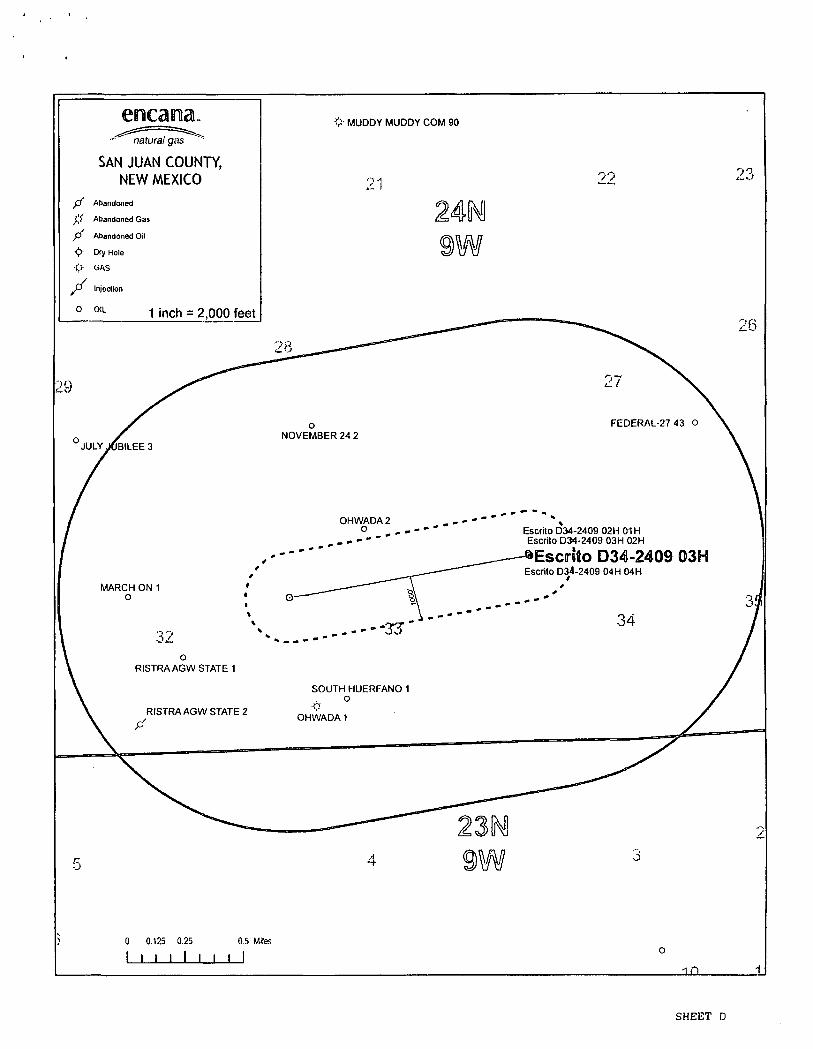
Escrito D34-2409 03H SHL: NWNW Section 34, T24N, R9W
1162 FNL and 536 FWL BHL: SWNW Section 33, T24N, R9W
1870 FNL and 330 FWL San Juan County, New Mexico Lease Number: NM 012374 & NMNM 90843
Encana Oil & G a s (USA) Inc. Certification
I hereby certify that I, or someone under my direct supervision, have inspected the drill site and access route proposed herein; that I am familiar with the conditions which currently exist; that I have full knowledge of state and Federal laws applicable to this operation; that the statements made in this APD package are, to the best of my knowledge, true and correct; and that the work associated with the operations proposed herein will be performed in conformity with this APD package and the terms and conditions under which it is approved. I also certify that I, or the company I represent, am responsible for the operations conducted under this application. These statements are subject to the provisions of 18 U.S.C. 1001 for the filing of false statements/
2 13 Srenda R. Linster Regulatory Lead
Encana Oil & Gas (USA) Inc 370 17 th Street, Suite 1700 Denver, CO 80202 Phone: (720) 876-3989 Cell: (970) 309-8106
Date
- I -
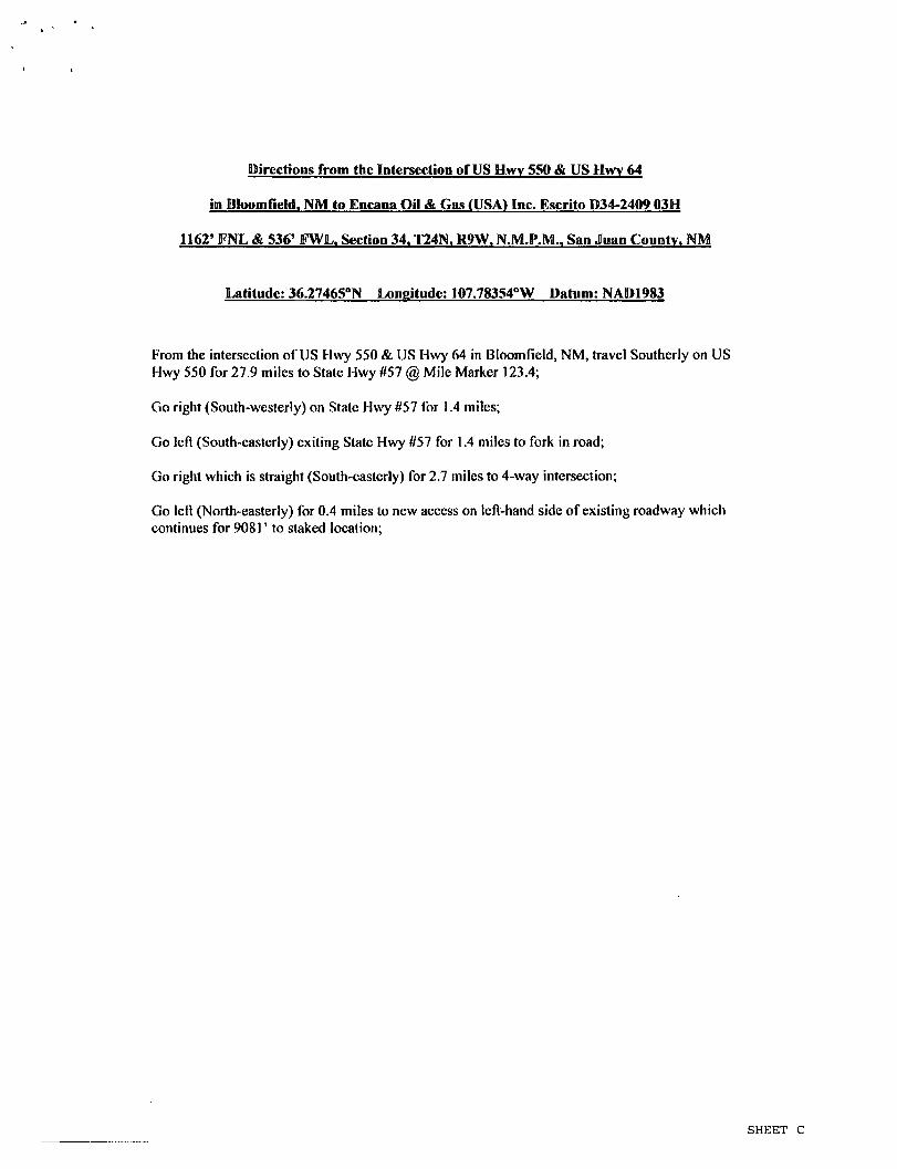
Directions from thc Intersection of US Hwy 550 & US Hwy 64
in Bloomfield. NM to Encana Oil & Gas (USA) Inc. Escrito D34-2409 03H
1162* FNL & 536' FWL. Section 34. T24N. R9W, N.M.P.M.. San Juan County. NM
Latitude: 36.27465°N Longitude: 107.78354°W Datum: NAD1983
From the intersection of US Hwy 550 & US Hwy 64 in Bloomfield, NM, travel Southerly on US Hwy 550 for 27.9 miles to State Hwy #57 @ Mile Marker 123.4;
Go right (South-westerly) on State Hwy #57 for 1.4 miles;
Go left (South-easterly) exiting State Hwy #57 for 1.4 miles to fork in road;
Go right which is straight (South-easterly) for 2.7 miles to 4-way intersection;
Go left (North-easterly) for 0.4 miles to new access on left-hand side of existing roadway which continues for 90811 to staked location;
SHEET C
natural gas
SAN JUAN COUNTY, NEW MEXICO
f f Abandoned
}',{ Abandoned Gas
f f Abandoned Oil
<!>- Dry Hole
•t> GAS
Injection
0 0 , L 1 inch = 2,000 feet
28
<V MUDDY MUDDY COM 90
!4 9?
16
29 11
JULY JOBILEE 3 NOVEMBER 24 2
FEDERAL-27 43 O
MARCH ON 1 O
32
OHWADA 2 O Esaito D34-2409 02H01H
Escrito D34-2409 03H 02H
^Escirito D34-2409 03H Escrito D34-2409 04H 04H
34
RISTRAAGW STATE 1
ff RISTRAAGW STATE 2
SOUTH HUERFANO 1 O
•{>•
OHWADA 1
5
0 0.125 0.25
1 I I I I I 0.5 Mites
J__L _l£L
SHEET D

Escrito D34-2409 03H SHL: NWNW Section 34, T24N, R9W
1162 FNL and 536 FWL BHL: SWNW Section 33, T24N, R9W
1870 FNL and 330 FWL San Juan County, New Mexico Lease Number: NM 012374 & NMNM 90843
Encana Oil & Gas (USA) Inc. Drilling Plan
1. ESTIMATED TOPS OF GEOLOGICAL MARKERS (TVD)
The estimated tops of important geologic markers are as follows:
Formation Depth (TVD) Ojo Alamo Ss. 758' Kirtland 932' Fruitland Coal 1177' Pictured Cliffs 1503' Lewis 1615' Cliffhouse 2258" Menefee 3020' Point Lookout 3930' Mancos Shale 4088' Mancos Silt 4648' Gallup 4905'
The referenced surface elevation is 6857', KB 6870'
2. ESTIMATED DEPTH OF POTENTIAL WATER, OIL, GAS, & OTHER MINERAL BEARING FORMATIONS
Substance Formation Depth (TVD) Gas Fruitland Coal 1177' Gas Pictured Cliffs 1503' Gas Cliffhouse 2258' Gas Point Lookout 3930' Oil/Gas Mancos 4088'
All shows of fresh water and minerals will be reported and protected.
3. PRESSURE CONTROL
a) Pressure control equipment and configuration will be designed to meet 2M standards. b) Working pressure on rams and BOPE will be 3,000 psi c) Function test and visual inspection of the BOP will be conducted daily and noted in the IADC
Daily Drilling Report. d) The Annular BOP will be pressure tested to a minimum of 50 percent of its rated working
pressure. e) Blind and Pipe Rams/BOP will be tested against a test plug to 100 percent of rated working
pressure. f) Pressure tests are required before drilling out from under all casing strings set and cemented in
place. g) BOP controls must be installed prior to drilling the surface casing plug and will remain in use until
the well is completed or abandoned. h) BOP testing procedures and testing frequency will conform to Onshore Order No. 2.
- I -

Escrito D34-2409 03H SHL: NWNW Section 34, T24N, R9W
1162 FNL and 536 FWL BHL: SWNW Section 33, T24N, R9W
1870 FNL and 330 FWL San Juan County, New Mexico Lease Number: NM 012374 & NMNM 90843
i) BOP remote controls shall be located on the rig floor at a location readily accessible to the driller. Master controls shall be on the ground at the accumulator and shall have the capability to function all preventers.
j) The kill line shall be 2-inch minimum and contain two kill line valves, one of which shall be a check valve.
k) The choke line shall be a 2-inch minimum and contain two choke line valves (2-inch minimum). I) The choke and manifold shall contain two adjustable chokes, m) Hand wheels shall be installed on all ram preventers. n) Safety valves and wrenches (with subs for drill string connections) shall be available on the rig
floor at all times. o) Inside BOP or float sub shall also be available on the rig floor at all times.
Proposed BOP and choke manifold arrangements are attached.
4. CASING & CEMENTING PROGRAM
The proposed casing and cementing program has been designed to protect and/or isolate all usable water zones, potentially productive zones, lost circulation zones, abnormally pressured zones, and any prospectively valuable deposits of minerals. Any isolating medium other than cement shall receive approval prior to use. The casing setting depth shall be calculated to position the casing seat opposite a competent formation which will contain the maximum pressure to which it will be exposed during normal drilling operations. All indications of useable water shall be reported.
a) The proposed casing design is as follows:
Casing Depth Hole Size Csg Size Weight Grade Conductor 0-60' 30" 20" 94# H40, STC New
Surface 0'-500' 12 1/4" 9 5/8" 36# J55, STC New Intermediate 0'-5835'MD 8 3/4" 7" 26# J55, LTC New
Production Liner 5635'-10553'MD 6 1/8" 4 1/2" 11.6# B80*, LTC New
Casing String Casing Strength Properties Minimum Design Factors
Size Weight (lb/ft) 36
Grade Connection Collapse
(psiL_ Burst (psi) 3520
Tensile (10001b)
Collapse Burst Tension
9 5/8"
Weight (lb/ft) 36 J55 STC 2020
Burst (psi) 3520 ^ 394 1.125 1.1 1.5
T 26 J55 LTC 4320 4980 367 1.125 1.1 1.5 A 1/2" 11.6 B80 LTC 6350 7780 201 1.125 1.1 1.5
*B80 pipe specifications are attached
Casing design is subject to revision based on geologic conditions encountered.
All casing strings below the conductor shall be pressure tested to 0.22 psi per foot of casing string length or 1,500 psi, whichever is greater, but not to exceed 70 percent of the minimum internal yield. If pressure declines more than 10 percent in 30 minutes, corrective action shall be taken.
b) The proposed cementing program is as follows:
Top plugs shall be used to reduce contamination of cement by displacement fluid. A bottom plug or other acceptable technique, such as a pre-flush fluid, inner string cement method, etc. shall be utilized to help isolate the cement from contamination by the mud fluid being displaced ahead of the cement slurry.
- 2 -

Escrito D34-2409 03H SHL: NWNW Section 34, T24N, R9W
1162 FNL and 536 FWL BHL: SWNW Section 33, T24N, R9W
1870 FNL and 330 FWL San Juan County, New Mexico Lease Number: NM 012374 & NMNM 90843
Casing Depth Cement Volume (sacks)
Cement Typeft Yield
Designed TOC Centralizers
Conductor 60' 100sk Type I Neat 14.8 PPQ
Surface None
Surface 500' 178sk Type III Cement + 1%CaCI +
0.25lb/sk Cello Flake + 0.2% FL,
14.6ppg, 1.38cuf/sk
Surface 1 per joint on bottom 3 joints
Intermediate 5835'MD 30% open hole excess
Stage 1 Lead: 275sks
Stage 1 Tail: 188sks
Stage 2 Lead: 135sks
Lead (Stages 1 and 2): PremLite + 3% CaCI + 0.25lb/sk
CelloFlake + 5lb/sk LCM, 12.1 ppg
2.13cuft/sk Tail (Stage 1): Type III Cmt + 1% CaCI +
0.25lb/sk Cello Flake 14.5ppg
1.38cuft/sk
Surface 1 per joint for bottom 3 joints, 1 every 3 joints for remaining joints
Production Liner*
5635'-10553'
None -External casing packers
N/A N/A N/A
'Production liner clarification: Utilizing external swell casing packer system for zonal isolation will not use cement in the production liner.
Actual volumes will be calculated and determined by conditions onsite. All cement slurries will meet or exceed minimum BLM and New Mexico Oil Conservation Division requirements. Slurries used will be the slurries listed above or equivalent slurries depending on service provider selected. Cement yields may change depending on slurries selected.
All waiting on cement times shall be a minimum of 8 hours or adequate to achieve a minimum of 500 psi compressive strength at the casing shoe prior to drilling out.
5. WELL PLAN & DIRECTIONAL DRILLING PROGRAM
The proposed horizontal well will have a kick off point of 4400'. Directional plans are attached.
Description Proposed Depth (TVD/MD) Formation
Horizontal Lateral TD 5102710553' Gallup
Escrito D34-2409 03H SHL: NWNW Section 34, T24N, R9W
1162 FNL and 536 FWL BHL: SWNW Section 33, T24N, R9W
1870 FNL and 330 FWL San Juan County, New Mexico Lease Number: NM 012374 & NMNM 90843
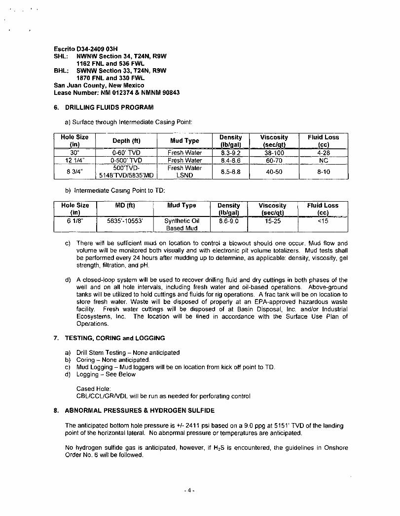
6. DRILLING FLUIDS PROGRAM
a) Surface through Intermediate Casing Point:
Hole Size (in) Depth (ft) Mud Type Density
(Ib/gal) 8.3-9.2
Viscosity (sec/qt)
Fluid Loss (cc)
30" 0-60' TVD Fresh Water
Density (Ib/gal) 8.3-9.2 38-100 4-28
12 1/4" 0-500' TVD Fresh Water 8.4-8.6 60-70 NC
8 3/4" 500TVD-5148TVD/5835'MD
Fresh Water LSND 8.5-8.8 40-50 8-10
b) Intermediate Casing Point to TD:
Hole Size (in)
MD (ft) Mud Type Density (Ib/gal)
Viscosity (sec/qt)
Fluid Loss (cc)
6 1/8" 5835-10553' Synthetic Oil Based Mud
8.6-9.0 15-25 <15
c) There will be sufficient mud on location to control a blowout should one occur. Mud flow and volume will be monitored both visually and with electronic pit volume totalizers. Mud tests shall be performed every 24 hours after mudding up to determine, as applicable: density, viscosity, gel strength, filtration, and pH.
d) A closed-loop system will be used to recover drilling fluid and dry cuttings in both phases of the well and on all hole intervals, including fresh water and oil-based operations. Above-ground tanks will be utilized to hold cuttings and fluids for rig operations. A frac tank will be on location to store fresh water. Waste will be disposed of properly at an EPA-approved hazardous waste facility. Fresh water cuttings will be disposed of at Basin Disposal, Inc. and/or Industrial Ecosystems, Inc. The location will be lined in accordance with the Surface Use Plan of Operations.
7. TESTING, CORING and LOGGING
a) Drill Stem Testing - None anticipated b) Coring - None anticipated. c) Mud Logging - Mud loggers will be on location from kick off point to TD. d) Logging - See Below
Cased Hole: CBL/CCL/GR/VDL will be run as needed for perforating control
8. ABNORMAL PRESSURES & HYDROGEN SULFIDE
The anticipated bottom hole pressure is +/- 2411 psi based on a 9.0 ppg at 5151' TVD of the landing point of the horizontal lateral. No abnormal pressure or temperatures are anticipated.
No hydrogen sulfide gas is anticipated, however, if H2S is encountered, the guidelines in Onshore Order No. 6 will be followed.
- 4 -
Escrito D34-2409 03H SHL: NWNW Section 34, T24N, R9W
1162 FNL and 536 FWL BHL: SWNW Section 33, T24N, R9W
1870 FNL and 330 FWL San Juan County, New Mexico Lease Number: NM 012374 & NMNM 90843
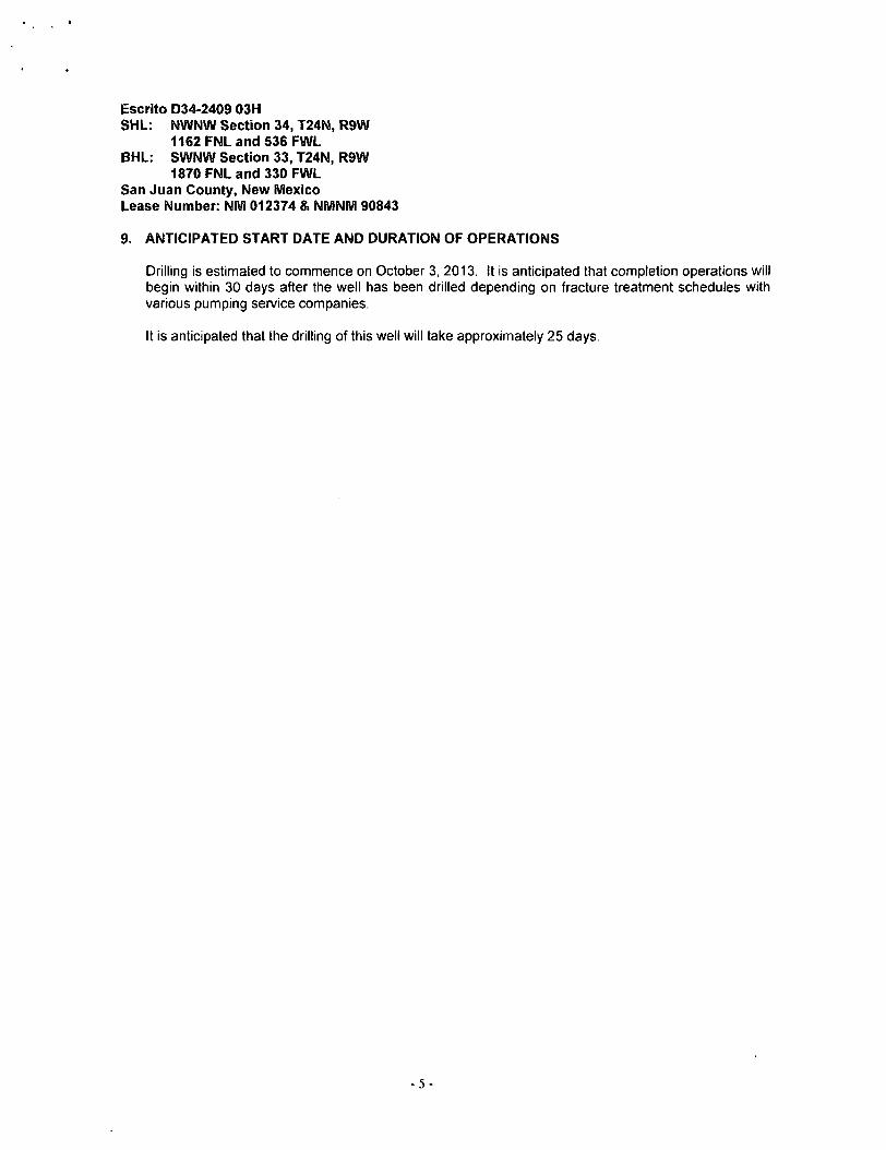
9- ANTICIPATED START DATE AND DURATION OF OPERATIONS
Drilling is estimated to commence on October 3, 2013. It is anticipated that completion operations will begin within 30 days after the well has been drilled depending on fracture treatment schedules with various pumping service companies.
It is anticipated that the drilling of this well will take approximately 25 days.
- 5 -
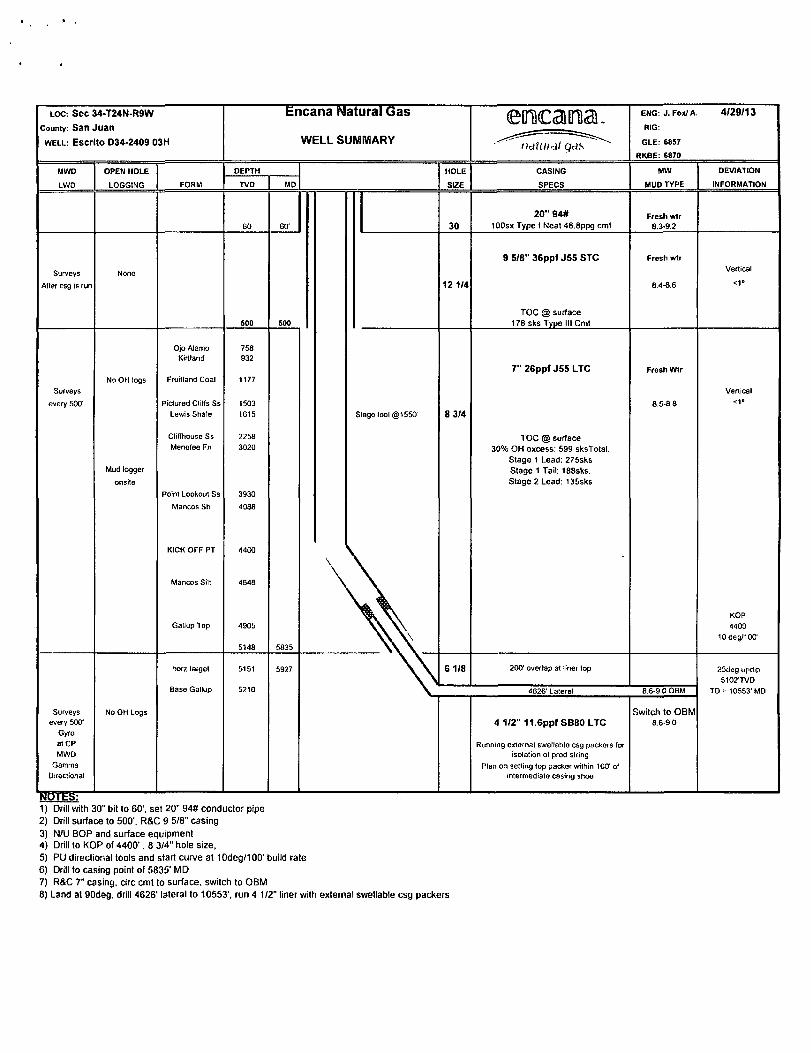
LOC: Sec 34-T24N-R9W
County: San Juan
WELL: Escrito 034-2409 03H
Encana Natural Gas
WELL SUMMARY eoncaima..
^^naXuiS yds
ENG: J. Fox/ A
RIG:
GLE: 6857
RKBE: 6870
4/29/13
MWD OPEN HOLE DEPTH HOLE CASING MW DEVIATION
LWO LOGGING FORM TVD MD SIZE SPECS MUD TYPE INFORMATION
60 6ff 30 20" 94#
100sx Type I Neat 48.8ppg cmt Fresh wtr
8,3-9.2
Surveys
After csg is run
None
soo 500
12 1/4
9 5/8" 36ppf J S S S T C
TOC @ surface 178 sks Typo III Cmt
Frosh wtr
8.4-8.6
Vertical
<1°
Surveys
every 500'
No OH logs
Ojo Alamo Kirtland
Fruitland Coal
Pictured Cliffs Ss Lewis Shale
758 932
1177
1503 1615 Stage tool (§1550' 8 3/4
7" 26ppf J 5 5 L T C Frosh Wtr
8.5-88
Vertical <1»
Mud logger
onsito
Cliffhouse Ss Menefee Fn
Point Lookout Ss
Mancos Sh
KICK OFF PT
Mancos Silt
Gallup Top
2258 3020
3930
4088
1400
4648
4905
5148 5835
\
TOC @ surface 30% OH oxcess: 599 sksTotal.
Stage 1 Lead: 275sks Stage 1 Tail: 188sks. Stage 2 Lead: 135sks
KOP 4400
10 deg/100'
horz target 5151 5927 6 1/8 200' overlap al liner lop 25ri<2g updip 5102'TVD
Base Gallup 5210 4G26' Lateral 8 6-9 0 OBM TD = 10553'MD
Surveys every 500'
Gyro at CP MWD
Gamma Directional
No OH Logs 4 1/2" 11.6ppf SB80 LTC
Running external swellablo csg packers for isolation of prod string
Plan on sotting top packer wilhin 100' of intermediate casing shoe
Switch to OBM 8.6-9.0
1) Drill with 30" bit to 60'. set 20" 94# conductor pipe 2) Drill surface to 500'. R&C 9 5/8" casing 3) N/U BOP and surface equipment 4) Drill to KOP of 4400'. 8 3/4" hole size, 5) PU directional tools and start curve at 10deg/100' build rate 6) Drill to casing point of 5835' MD 7) R&C 7" casing, circ cmt to surface, switch to OBM 8) Land at 90deg. drill 4626' lateral to 10553', run 4 1/2" liner with external swellable csg packers

CASING (OR) TUBING DESCRIPTION AND PERFORMANCE PROPERTIES
Pipe Outside Diameter (ins) 4.500 Pipe Wall Thickness (ins) 0.250 Nominal Weight Per Foot (lbs) 11.60
Thread Name Long Thread CSG Grade Name SB-80
Pipe Minimum Yield (psi) 80,000 Pipe Minimum Ultimate (psi) 90,000
Coupling Minimum Yield (psi) 80,000 Coupling Minimum Ultimate (psi) 100,000
Coupling or Joint Outside Diameter (ins) 5.000 Drift Diameter (ins) 3.875 Plain End Weight per Foot (lbs) 11.36
Joint Strength (lbs) 201,000 Internal Yield (psi) 7,780 Collapse Rating (psi) 6,350
MAXIMUM DEPTH/LENGTH BASED ON MUD WTS & SAFETY FACTORS
Drilling Mud Weight (ppg) 9.625
Tension Safety Factor 1.80 Maximum Tension Length (ft) 9,630
Internal Yield Safety Factor 1.10 Maximum Depth for Internal Yield (ft) 14,150
Collapse Safety Factor 1.125 Maximum Collapse Depth (ft) 11,290
API RELATED VALUES and INTERMEDIATE CALCULATION RESULTS
Coupling Thread Fracture Strength 464,000 Pipe Thread Fracture Strength (lbs) 201,000
Pipe Body Plain End Yield (lbs) 267,000 Round Thread Pull-Out (lbs) 219,000
Minimum Make-up Torque (ft-lbs) 1,640 Nominal Make-up Torque (ft-lbs) 2,190 Maximum Make-up Torque (ft-lbs) 2,740
Coupling Internal Yield (psi) 10,660 Pipe Body Internal Yield (psi) 7,780 Leak @ El or E7 plane (psi) 17,920
Pipe Hydrostatic Test Pressure @ 80 % SMYS 7,100

erocamia. natural gas
Project: San Juan County, NM Site: S34-T24N-R9W (Escrito) Well: Escrito D34-2409 03H
Wellbore: Hz Design: Plan #1
CATHEDRAL
-1500-
-1000-
-500-
500 —
1 0 0 0 —
1 5 0 0 -
2 0 0 0
O o -, O 2500— -
Q . Q)
Q 3 0 0 0 -
O 3 5 0 0 ^ -
=3
• Ojo Atnmo Ssr I
-Kirtland Stinte-
I - - - Fiuitlarul Coal"
- Piciuied cfiBs Si": - Lewis Shale — - — —
-CMIioubC S i . —
-Point Lookout Ssr i
- Mancos Stole " -
4500-
SECTION DETAILS
See MD Inc Azi TVD •N.l-S «E/-W Dleg TFaco VSect 1 0.0 0.00 0.00 0.0 0.0 0.0 0.00 0.00 0.0 2 4400.0 0.00 0.00 4400.0 0.0 0.0 0.00 0.00 0.0 3 5081.2 68.13 218.80 4931,7 -280,2 •225.2 10.00 218.80 226.9 4 5383.3 68.13 218.80 5044.2 -498.6 •400.8 0.00 0.00 403.9 5 5927.4 90.60 269.65 5150.9 -713.5 •866.6 10.00 72.47 871.0 6 10552 6 90.60 269.65 5102.4 -742.1 -5491.5 0.00 0.00 5495.9
Target
Escrito D34-2209 03H POE Escrito D34-2209 03H PBHL
2000-
1500 —
• £ 1000-
£ o o CM 5 0 0 -
o z
-500—
-1000-
-2000-
870J
1.330'- I 1.74? r ]
Surface Hole Location Escrito 034-2409 03H
Lat : 36,274650 long ; -107.783540
I
7 ' Casing Sollinp. Depth
I LPffiSISO TVD:90
Escnto D 34-2703 03H POE
Escrilo O34-2209 03H PBHL
KOP @ 4400'
E08. lnc-68'
Clan builnVtuni @ S383' MO
I I 11 II11111 I I I I 111II1111111111 I I I I I 111111 11111111 11 I 11 111111 11 11 I 11 I |11 I 11 11 I I I I I I I 1111 111111 111 1111111111111111111111 1111 11 I
-5500 -5000 -4500 -4000 -3500 -3000 -2500 -2000 -1500 -1000 -500 0
West(-)/East(+) (1200 ft/in)
KOP @ 4400
I EOB: I
DESIGN TARGET DETAILS
Mume Eiento D34-2200 03H PBKl Esciit!) 034-2209 03H POE
«H<-S -74? I -713 !.
• EMV •S40I S
•«56.6
Nwiltimy 1618534.40 10IB56S
EusIuiU 2/32283 02 2736907 90
LaMlKje LOIHJItiKJu 35 272010 -107 802170 35 272690 -107 78*480
Hnri7on:al Target „
Rase Gatup
6500
7000 —
lnc"68*
Slan huilaVluro @ S3S3' MD
j l P ® SIM' TVD; 90 6"
- - - I " - |
Escnto 034-2709 03H POE
7' Cosing Setting Depth
i •
T . Wl Azimuths to True North
/ ^ Magnetic North: 9.63"
r Magnetic Field / Strength: 50283.8snT
c K Dip Angle: 63 .Or
•f- - + • Date: 4/1/2013 s Model: IGRF2010
CASING DETAILS
TVD 500.0 5148.4
MD 500.0
58350
Name 9 5/8"
7" Casing Setting Depth
Plan #1 Escrito 034-2409 03H
t3xxx LR WELL @ 6870.0ft (Original Well Elev)
Ground Elevation @ 6857.0 North American Datum 1983
Well Escrito D34-2409 03H. True North
1 1 ; 11111111111
I
H
Escrilo D34-2209 0 3H PBHL
F O R M A T I O N T O P DETAILS
T V D P a t h M D P a t h F o r m a t i o n 7 5 8 . 0 758 .0 0 ] o A l a m o Ss . 9 3 2 . 0 9 3 2 . 0 Ki r t land Sha le
1177 .0 1177 .0 Fru i t land Coa l 1503 .0 1503 .0 Pic tured Cliffs S s . 1615 .0 1615 .0 Lewis Sha le 2258 .0 2258 .0 Cl i f fhouse S s . 3020 .0 3020 .0 Menefee F n . 3930 .0 3930 .0 Point Lookout S s . 4088 .0 4088 .0 Mancos Sha le 4 6 4 7 . 6 4 6 5 6 . 1 M a n c o s Silt 4903 .0 5 0 1 4 . 0 Gal lup F n .
I I I | I I I I I I I I I | I I I I I I I I I | I I I I I I I I I | I I I I I I I I I | I I I I I I I I I | I U I I I I I I | I I I \ I I I I I |
500 1000 1500 2000 2500 3000 3500 4000
Vertical Section at 269.65° (1000 ft/in)
11111111 M i I I 11111111111111111111111 n i
4500 5000 5500 6000
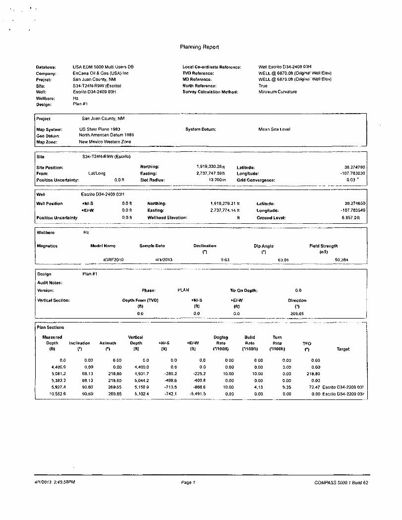
Planning Report
Database: USA EDM 5000 Multi Users DB Local Co-ordinate Reference: Well Escrito D34-2409 03H
Company: EnCana Oil & Gas (USA) Inc TVD Reference: WELL @ 6870.0ft (Original Well Elev)
Project: San Juan County, NM MD Reference: WELL @ 6870.0ft (Original Well Elev)
Site: S34-T24N-R9W (Escrito) North Reference: True
Well: Escrito D34-2409 03H Survey Calculation Method: Minimum Curvature
Wellbore: Hz
Design: Plan#1
Project San Juan County, NM
Map System: US State Plane 1983 System Datum: Mean Sea Level
Geo Datum: North American Datum 1983
Map Zone: New Mexico Western Zone
Site
Site Position:
From:
Position Uncertainty:
S34-T24N-R9W (Escrito)
Lat/Long
0.0 ft
Northing:
Easting:
Slot Radius:
1.919.330.26f, Latitude:
2,737.747.59ft Longitude:
13.200 in Grid Convergence:
36.274790
-107.783630
0.03 '
Well
Well Position
Position Uncertainty
Escrito D34-2409 03H
+N/-S 0.0 ft
+EI-W 0.0 ft
0.0 ft
Northing:
Easting:
Wellhead Elevation:
1.919.279.31 ft
2,737.774.14 ft
ft
Latitude:
Longitude:
Ground Level:
36.274650
-107.783540
6,857.0 ft
Wellbore
Magnetics
Hz
Model Name
IGRF2010
Sample Date
4/1/2013
Declination
n Dip Angle
C) Field Strength
(nT)
9.63 6301 50.284
Design
Audit Notes:
Version:
Vortical Section:
Plan#1
Phase:
Depth From (TVD)
(ft)
0.0
PLAN
+N/-S
(ft)
0.0
Tie On Depth:
+E/-W
(ft)
0.0
0.0
Direction
n 269.65
Plan Sections
Measured Vortical Dogleg Build Turn Depth Inclination Azimuth Depth +N/-S +FJ-W Rate Rate Rate TFO
{«> C) n (ft) (ft) (ft) (°/100ft) (•/100ft) (•7100ft) (°) Target
0.0 0.00 0.00 0.0 0.0 0.0 0.00 0.00 0.00 0.00
4,400.0 0.00 0.00 4.400.0 0.0 0.0 0.00 0.00 0.00 0.00
5,081.2 68.13 218.80 4.931.7 -280.2 -225.2 10.00 10.00 0.00 218.80
5.383.3 68.13 218.80 5.044.2 -498.6 •400.8 0.00 0.00 0.00 0.00
5,927.4 90.60 269.65 5,150.9 -713.5 -666.6 10.00 4.13 9.35 72.47 Escrito D34-2209 031-
10,552.6 90.60 269.65 5,1024 -742.1 -5,491.5 0.00 0.00 0.00 0.00 Escrito D34-2209 03I-
4/1/2013 2:4S:58PM Page ? COMPASS 5000.1 Build 62

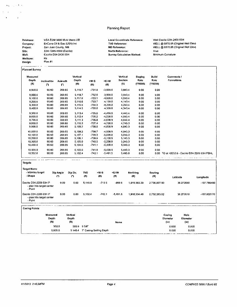
Planning Report
Database: USA EDM 5000 Multi Users DB Local Co-ordinate Reference: Well Escrito D34-2409 03H
Company: EnCana Oil & Gas (USA) Inc TVD Reference: WELL @ 6870.0ft (Original Well Elev)
Project: San Juan County. NM MD Reference: WELL @ 6870.0ft (Original Well Elev)
Site: S34-T24N-R9W (Escrito) North Reference: True
Well: Escrito D34-2409 03H Survoy Calculation Method: Minimum Curvature
Wellbore: Hz
Design: Plan#1
Planned Survey
Measured Vertical Vertical Dogleg Build Comments / Depth Inclination Azimuth Depth +N/-S +E/-W Section Rate Rate Formations
(ft) O (•) (ft) (ft) (ft) (ft) (•/100ft) (°/100ft)
0.0 0.00 0.00 0.0 0.0 0.0 0.0 0.00 0.00 100.0 0.00 0.00 100.0 0.0 0.0 0.0 0.00 0.00 200.0 0.00 0,00 200.0 0.0 0.0 0.0 0.00 0.00 300.0 0.00 0.00 300.0 0.0 0.0 0.0 0.00 0.00 400.0 0.00 0.00 400.0 0.0 0.0 0.0 0.00 0.00
500.0 0.00 0.00 500.0 0.0 0.0 0.0 0.00 0.00 9 5/8" 600.0 0.00 0.00 600.0 0.0 0.0 0.0 0.00 0.00 700.0 0.00 0.00 700.0 0.0 0.0 0.0 0.00 0.00 758.0 0.00 0.00 758.0 0.0 0.0 0.0 0.00 0.00 Ojo Alamo Ss. 800.0 0.00 0.00 800.0 0.0 0.0 0.0 0.00 0.00
900.0 0.00 0.00 900.0 0.0 0.0 0.0 0.00 0.00 932.0 0.00 0.00 932.0 0.0 0.0 0.0 0.00 0.00 Kirtland Shale
1.000.0 0.00 0.00 1,000.0 0.0 0.0 0.0 0.00 0.00 1.100.0 0.00 0.00 1.100.0 0.0 0.0 0.0 0.00 0.00 1.177.0 0.00 0.00 1.177.0 0.0 0.0 0.0 0.00 0.00 Fruitland Coal
1.200.0 0.00 0.00 1,200.0 0.0 0.0 0.0 0.00 0.00 1.300.0 0.00 0.00 1,300.0 0.0 0.0 0.0 0.00 0.00 1.400.0 0.00 0.00 1,400.0 0.0 0 0 0.0 0.00 0.00 1,500.0 0.00 0.00 1,500.0 0.0 0.0 0.0 0.00 0.00 1,503.0 0.00 0.00 1,503.0 0.0 0.0 0.0 0.00 0.00 Pictured Cliffs Ss.
1,600.0 0.00 0.00 1.600.0 0.0 0.0 0.0 0.00 0.00 1,615.0 0.00 0.00 1,615.0 0.0 0.0 0.0 0.00 0.00 Lewis Shale 1.700.0 0.00 0.00 1,700.0 0.0 0.0 0.0 0.00 0.00 1,800.0 0.00 0.00 1,800.0 0.0 0.0 0 0 0.00 0.00 1,900.0 0.00 0.00 1,900.0 0.0 0.0 0.0 0.00 0.00
2,000.0 0.00 0.00 2.000.0 0.0 0.0 0 0 0.00 0.00 2.100.0 0.00 0.00 2.100.0 0.0 0.0 0.0 0.00 0.00 2.200.0 0.00 0.00 2.200.0 0.0 0.0 0.0 0.00 0.00 2,258.0 0.00 0.00 2,258.0 0.0 0.0 0.0 0.00 0,00 Cliffhouse Ss. 2.300.0 0.00 0.00 2.300.0 0.0 0.0 0.0 0.00 0.00
2.400.0 0.00 0.00 2.400.0 0.0 0.0 0.0 0.00 0.00 2.500.0 0.00 0.00 2,500.0 0.0 0.0 0.0 0.00 0.00 2.600.0 0.00 0.00 2,600.0 0.0 0.0 0.0 0.00 0.00 2,700.0 0.00 0.00 2.700.0 0.0 0.0 0.0 0.00 0.00 2,800.0 0.00 0.00 2,800.0 0.0 0.0 0.0 0.00 0.00
2.900.0 0.00 0.00 2,900.0 0.0 0.0 0.0 0.00 0.00 3.000.0 0.00 0.00 3,000.0 0 0 0.0 0.0 0.00 0.00 3,020.0 0.00 0.00 3,020.0 0.0 0.0 0.0 0.00 0.00 Menefee Fn. 3,100.0 0.00 0.00 3.100.0 0 0 0.0 0.0 0.00 0.00 3.200.0 0.00 0.00 3,200.0 0.0 0.0 0.0 0.00 0.00
3.300.0 0.00 0.00 3,300.0 0.0 0.0 0.0 0.00 0.00 3.400.0 0.00 0.00 3.400.0 0.0 0.0 0.0 0.00 0.00 3.500.0 0.00 0.00 3,500.0 0.0 0.0 0.0 0.00 0.00 3.600.0 0.00 0.00 3.600.0 0.0 0.0 0.0 0.00 0.00 3.700.0 0.00 0.00 3.700.0 0.0 0.0 0.0 0.00 0.00
3.800.0 0.00 0.00 3.800.0 0.0 0.0 0 0 0.00 0.00 3.900.0 0.00 0.00 3.900.0 0.0 0.0 0.0 0.00 0.00 3.930.0 0.00 0.00 3.930.0 0.0 0.0 0.0 0.00 0.00 Point Lookout Ss. 4,000.0 0.00 0.00 4,000.0 0.0 0.0 0.0 0.00 0.00 4,088.0 0.00 0.00 4,088,0 0.0 0 0 0.0 0.00 0.00 Mancos Shale
4,100.0 0.00 0.00 4,100.0 0.0 0.0 0.0 0.00 0.00 4,200.0 0.00 0.00 4,200.0 0.0 0.0 0.0 0.00 0.00
4/1/2013 2.45:58PM Page 2 COMPASS 5000.1 Build 62

Planning Report
Database: USA EDM 5000 Multi Users DB Local Co-ordinate Reference: Well Escrito D34-2409 03H
Company: EnCana Oil & Gas (USA) Inc TVD Reference: WELL @ 6870.0ft (Original Well Elev)
Project: San Juan County, NM MD Reference: WELL @ 6870.0ft (Original Well Elev)
Site: S34-T24N-R9W (Escrito) North Roference: True
Woll: Escrito D34-2409 03H Survey Calculation Method: Minimum Curvature
Wellbore: Hz
Design: Plan#1
Planned Survey
easured Vertical
Depth Inclination Azimuth Depth +N/-S •E/-W (ft) C) C) (ft) (ft) (ft)
4.300.0 0.00 0.00 4.300.0 0.0 0.0
4,400.0 0.00 0.00 4,400.0 0.0 0.0
4.500.0 10.00 218.80 4,499.5 -6.8 -5.5
4.600.0 20.00 218.80 4,596.0 -26.9 -21.6
4.656 1 25.61 218.80 4,647.6 -43.9 -35.3 4.700.0 30.00 218.80 4.686.5 -59.8 -48.1
4.800.0 40.00 218.80 4,768.3 -104.5 -84.0 4.900.0 50.00 218.80 4.838.9 -159 5 -128.2
5.000.0 60.00 218.80 4.896.2 -223.3 -179.5 5.014.0 61.40 218.80 4,903.0 -232.8 -187.1 5.081.2 68.13 216.80 4,931.7 -280.2 -225.2 5.100.0 68.13 218.80 4,938.7 -293.7 -236.1 5.200.0 68.13 218.80 4,975.9 -366.1 -294.3
5.300.0 68.13 218.80 5.013.2 •438.4 -352.4 5.383.3 68.13 218.80 5,044.2 -498.6 -400.8 5.400.0 68.64 220.51 5.050.4 -510.6 -410.8 5.500.0 72.04 230.50 5,084.1 -576.4 -477.9
5,600.0 75.94 240.08 5,111.7 -631.0 -556.8
5.700.0 80.19 249.33 5,132.5 -672.7 -645.2 5.800.0 84.70 256.34 5,145.6 -700.2 -740.3
5,835.0 86.31 261.46 5.14B.4 -706.3 -774.6
5,900.0 89.33 267.22 5,150.8 -712.7 -839.2 5,927.4 90.60 269.65 5,150.9 -713.5 -8666
6,000.0 90.60 269.65 5,150.1 -713.9 -939.2 6.100.0 90.60 269.65 5,149.1 -714.5 -1.039.2 6.200.0 90.60 269.65 5,148.0 -715.2 -1.139.2 6,300.0 90.60 269.65 5,147.0 -715.8 -1.239.2 6,400.0 90.60 269.65 5.145.9 -716.4 -1,339.2
6.500.0 90.60 269.65 5.144.9 -717.0 -1.439 2 6.600.0 90.60 269.65 5.143.8 -717.6 -1,539.2 6.700.0 90.60 269.65 5.142.8 -718.3 -1.639 2 6.800.0 90.60 269.65 5.141.7 -718.9 -1.739.2 6,900.0 90.60 269.65 5.140.7 -719.5 -1.839.1
7,000.0 90.60 269.65 5.139.6 -720.1 -1.939.1 7.100.0 90.60 269.65 5.138.6 -720.7 -2,039.1 7,200.0 90.60 269.65 5.137.5 -721.3 -2.139.1 7,300.0 90.60 269.65 5,136.5 -722.0 -2.239,1 7.400.0 90.60 269.65 5,135.4 -7226 -2.339.1
7.500.0 90.60 269.65 5.134.4 -723.2 -2,439.1 7.600.0 90.60 26965 5.133.3 -723.8 -2,539.1 7,700.0 90.60 269.65 5.132.3 -724.4 -2,639.1
7.800.0 90.60 269.65 5,131.2 -725.1 -2,739.1 7.900.0 90.60 269.65 5,130.2 -725.7 -2,839.1
8,000.0 90.60 269.65 5,129.2 -726.3 -2.939.1 8,100.0 90.60 269.65 5,128.1 -726.9 -3.039.1 8,200.0 90.60 269.65 5,127.1 -727.5 -3,139.0 8,300.0 90.60 269.65 5,126.0 -728.2 -3,239.0 8,400.0 90.60 269.65 5.125.0 -728.8 -3.339.0
8,500.0 90.60 269.65 5,123.9 -729.4 -3.439.0
8,600.0 90.60 269.65 5.122.9 -730.0 -3.539.0
8.700.0 90.60 269.65 5.121.8 -730.6 -3.639.0 8,800.0 90.60 269.65 5,120.8 -731.2 -3,739.0
ical Dogleg Build Comments /
lion Rate Rate Formations
(ft) C7100ft) C/100K)
0.0 0.00 0.00 0.0 0.00 0.00 KOP @ 4400' 5.5 10.00 10.00
21.8 10.00 10.00 35.5 10.00 10.00 Mancos Silt 48.5 10.00 10.00 84.6 10.00 10.00
129.2 10.00 10.00
180.9 10.00 10.00 188.5 10.00 10.00 Gallup Fn 226.9 10.00 10.00 EOB. Inc=66" 237.9 0.00 0.00 296.5 0.00 0.00
355.1 0.00 0.00 403.9 0.00 0.00 Start build/turn @ 5383'MD 413.9 10.00 3.06 481.4 10.00 3.40 560.7 10.00 3.89
649.3 10.00 4.26 744.5 10.00 4.50 778.9 10.00 4.60 7" Casing Setting Depth 843.6 10.00 4.64 871.0 10.00 4.66 LP @ 5150' TVD; 90.6' - Escrito D34-2209 03H
943.6 0.00 0.00 1.043.6 0.00 0.00 1.143.5 0.00 0.00 1.243.5 0.00 0.00 1.3435 0 0 0 0.00
1,443.5 0.00 0.00 1,543.5 0.00 0.00 1,643.5 0.00 0.00 1.743.5 0.00 0.00 1.843.5 0.00 0.00
1.943.5 0.00 0.00 2,043.5 0.00 0.00 2.143.5 0.00 0.00 2.243.5 0.00 0.00 2.343.5 0.00 0.00
2.443.5 0.00 0.00 2.543.5 0.00 0.00 2.643.5 0.00 0.00 2,743.5 0,00 0.00 2,843.5 0.00 0.00
2.943.4 0.00 0.00 3.043.4 0.00 0.00 3,143.4 0.00 0.00 3,243.4 0.00 0.00
3.343.4 0.00 0.00
3.443.4 0.00 0.00 3.543.4 0.00 0.00 3.643.4 0.00 0.00 3,743.4 0.00 0.00
-1/1/2013 2A5.B8PM Page 3 COMPASS 5000.1 Build 62
Planning Report
Database: USA EDM 5000 Multi Users DB Local Co-ordinate Reference: Well Escrito D34-2409 03H
Company: EnCana Oil & Gas (USA) Inc TVD Reference: WELL @ 6870.0ft (Original Well Elev)
Project: San Juan County, NM MD Reference: WELL @ 6870.0ft (Original Well Elev)
Site: S34-T24N-R9W (Escrito) North Reference: True
Well: Escrito D34-2409 03H Survey Calculation Method: Minimum Curvature
Wellbore: Hz
Design: Plan#1
Planned Survey
Measured Vertical Vertical Dogleg Build
Depth Inclination Azimuth Depth +N/-S +E/-W Section Rate Rate
(ft) n C) (ft) (ft) (ft) (ft) (°/100ft) CVIOOft)
8,900.0 90.60 269.65 5.119.7 •731.9 -3,839.0 3,843.4 0.00 0.00
9,000.0 90.60 269.65 5.118.7 -732.5 -3,939.0 3,943.4 0.00 0.00 9,100.0 90.60 269.65 5,117.6 -733.1 -4,039.0 4,043.4 0.00 0.00 9,200.0 90.60 269.65 5.116.6 -733.7 -4,139.0 4,143.4 0.00 0.00 9,300.0 90.60 269.65 5.115.5 -734.3 •4,239.0 4,243.4 0.00 0.00 9,400,0 90.60 269.65 5.114.5 -735.0 -4,339.0 4,343.4 0.00 0.00
9,500.0 90.60 269.65 5.113.4 -735.6 -4,439.0 4,443,4 0.00 0.00 9,600.0 90.60 269.65 5.112.4 -736.2 -4.538.9 4,543.4 0.00 0.00 9,700.0 90.60 269.65 5.111.3 -736.8 -4.638.9 4,643.4 0.00 0.00 9,800.0 90.60 269.65 5,110.3 -737.4 -4.738.9 4.743.3 0.00 0.00 9,900.0 9060 269.65 5.109.2 -738.0 -4.838.9 4,843.3 0.00 0.00
10,000.0 90.60 269.65 5.10B.2 -738.7 -4.938.9 4,943.3 0.00 0.00 10.100.0 90.60 269.65 5,107.1 -739.3 -5.038.9 5.043.3 0 0 0 0 00 10.200.0 90.60 269,65 5.106.1 -739.9 -5.138.9 5.143.3 0.00 0.00 10,300.0 90.60 269.65 5.105.0 -740.5 -5.238.9 5.243.3 0 0 0 0.00 10.400.0 90.60 269.65 5.104.0 •741.1 -5.338.9 5.343.3 0.00 0.00
10,500.0 90.60 269.65 5.103.0 -741 8 -5,438.9 5.443.3 0 0 0 0.00 10.552.6 90.60 269.65 5.102.4 -742.1 -5.491.5 5.495.9 0.00 0.00
Comments /
Formations
Escrito D34-2209 03H PBHL
Targets
Target Name
- hit/miss target
-Shape Dip Anglo Dip Dir.
H C) TVD
(ft)
5.150.9
+N/-S
(ft)
+E/-W
(ft)
Escrito D34-2209 03H P 0.00 0.00 - plan hits target center - Point
Escrito D34-2209 03H P 0.00 0.00 5,102.4 - plan hits target center - Point
-713.5
-742.1
-866.6
-5,491.5
Northing
(ft)
1.918,565.39
1,918,534.40
Easting
| f t * Latitude Longitude
2.736,907.90 36.272690 -107.786480
2.732,263.02 36.272610 -107.802170
Casing Points
Measured Vertical
Depth Depth
(ft) (ft)
500.0 500.0 9 5/8"
5.835.0 5,148.4 7" Casing Setting Depth
Name
Casing Hole
Diameter Diameter
(in) (in)
0.000 0.000
0.000 0.000
4/1/2013 2:45:58PM Page 4 COMPASS 5000.1 Build 62

Planning Report
Database: USA EDM 5000 Multi Users DB Local Co-ordinate Reference: Well Escrito D34-2409 03H
Company: EnCana Oil S Gas (USA) Inc TVD Reference: WELL @ 6870.0ft (Original Well Elev)
Projoct: San Juan County, NM MD Reforence: WELL @ 6870.0ft (Original Well Elev)
Site: S34-T24N-R9W (Escrito) North Reference: True
Well: Escrito D34-2409 03H Survey Calculation Method: Minimum Curvature
Wellbore: Hz
Design: Plan #1
Formations
Measurod Vertical Dip
Depth Depth Dip Direction
(ff) (ft) Name Lithology C) n 758.0 758.0 Ojo Alamo Ss. -0.60 269.65
932.0 932.0 Kirtland Shale -0.60 269.65
1.177.0 1.177.0 Fruitland Coal -0.60 269.65
1,503.0 1.503.0 Pictured Cliffs Ss. -0.60 269.65
1,615.0 1.615.0 Lewis Shale -0.60 269.65
2,258.0 2.258.0 Cliffhouse Ss. -0.60 269.65
3,020.0 3.020.0 Menefee Fn. -0.60 269.65
3,930.0 3,930.0 Point Lookout Ss. -0.60 269.65
4.088.0 4,088.0 Mancos Shale -0.60 269.65
4,656.1 4,648.0 Mancos Silt -0.60 269.65
5.014.0 4.905.0 Gallup Fn. -0.60 269.65
Plan Annotations
Measured Vertical Local Coordinates
Depth Depth •N/-S •E/-W
(«) (ft) (ft) (ft) Comment
4,400.0 4,400.0 0.0 0.0 KOP @ 4400' 5.081 2 4,931 7 -280.2 -225.2 EOB; lnc=66" 5,383.3 5,044.2 -498.6 -400.8 Start build/turn @ 5383' MD 5.927.4 5,150.9 -713.5 -666.6 LP @ 5150' TVD; 90.6"
10.552.6 5.102.4 -742.1 -5.491.5 TDat 10552.6
4/1/2013 2:45:58PM Page 5 COMPASS 5000.1 Build 62
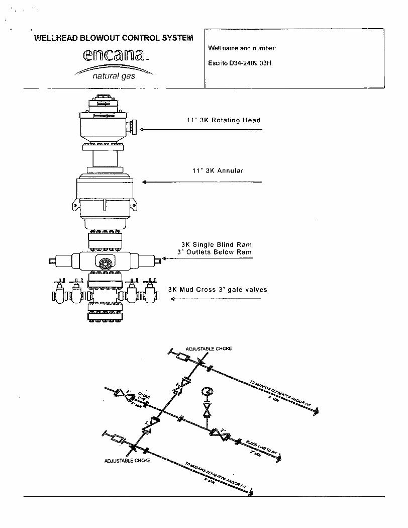
WELLHEAD BLOWOUT CONTROL SYSTEM
eEncama.. Well name and number: eEncama.. Escrito D34-2409 03H
-'^"natural gaT^^
61 U [3
11" 3K Rotating Head
11" 3K Annular
3K Single Blind Ram 3" Outlets Below Ram
3K Mud Cross 3" gate valves <
Related Documents