State of Alaska Statewide Assessment of Forest Resources Division of Forestry 2010

Welcome message from author
This document is posted to help you gain knowledge. Please leave a comment to let me know what you think about it! Share it to your friends and learn new things together.
Transcript

State of Alaska
Statewide Assessment of Forest Resources
Division of Forestry2010

Table of Contents
Executive Summary.............................................................. 3Introduction ........................................................................... 5 Alaska Land History ......................................................... 5 Forest Regions................................................................. 6 Land Ownership ............................................................... 7 Population Demographics .............................................. 12 Economy ........................................................................ 12Forest Conditions, Threats, Benefits, and Trends .............. 15 Climate Change ............................................................. 15 Wildfire ........................................................................... 16 Forest Products Industry ................................................ 24 Forest Health ................................................................. 30 Urban and Community Forests ...................................... 41 Wildlife ........................................................................... 45 Non-Timber Forest Products and Ecosystem Services . 46 Tourism and Recreation ................................................. 47 Forest Conservation....................................................... 48Forest Issues ...................................................................... 49GIS Modeling and Priority Landscapes .............................. 50Conclusion .......................................................................... 52List of Tables ....................................................................... 52List of Figures ..................................................................... 53Appendix A ~ GIS Maps ....................................................A:1Appendix B ~ Stakeholder Process Summary ..................B:1Appendix C ~ Citations ......................................................C:1

Alaska Division of Forestry Statewide Assessment 2010 �
Executive Summary
The 2008 Farm Bill requires states to complete a State-wide Assessment of Forest Resources and a Statewide Forest Resource Strategy. This assessment analyzes the present conditions, trends, threats, and benefits of forest resources across all ownerships and identifies priority issues and landscapes. It supports a comprehensive strat-egy to most effectively leverage federal dollars in support of state and national forestry objectives. The assessment focuses on all ownerships in an “all lands” approach, with emphasis on priority landscapes upon which to build a strategy to conserve working forests, protect forests from harm, and enhance public benefits from trees and forests.
The task of summarizing the condition of Alaska’s forests in a single concise document is daunting. Alaska has approximately 126 million acres of forest land in diverse ecoregions from a sub-arctic boreal forest in a fire de-pendent ecosystem to the temperate coastal rainforest along the Gulf of Alaska coast and southeastern Alaska panhandle. Land ownership, management objectives, and the level of human and physical infrastructure vary widely across these diverse ownerships and landscapes.
Alaska has 17 percent of the nation’s forestland, 26 percent of the federal forestland, and 43 percent of state owned forestland. Unique among the United States are the more than 200 Alaska Native Corporations, which own 35 million acres of non-industrial private forestland. Also unique among the United States are the hundred plus isolated communities without road access, reached only by air or water travel. Many of these isolated communi-ties have significant populations of Alaska Natives and forests play an important role in contributing to subsis-tence resources and other cultural and economic benefits, particularly in rural Alaska.
Similar to Canada, Alaska has a significant wildfire season in the boreal forest, with an average of approximately 1 million acres burned each year. Alaska is a leader na-tionwide in that it has an Alaska Interagency Wildland Fire Management Plan that prioritizes landscapes for fire suppression resources statewide for all ownerships, public and private.
Like other western states, Alaska has had a major epi-demic of bark beetles, affecting over 4 million acres in Southcentral Alaska during the 1990s. Alaska has few
invasive species, primarily plants, and prevention of more serious invasive insects is a priority. Alaska is developing an early detection rapid response system as well as a for-est health risk assessment and mapping strategy.
Overshadowing the ongoing challenges associated with managing the risks of wildland fire and forest pests, are the effects of climate change on these natural threats to Alaska’s forests. These effects have been manifested in longer fire seasons, increased fire severity, and warmer and drier weather cycles over the past several decades. A changing climate during the same period was very likely a primary contributing factor to the severity of the spruce bark beetle epidemic across the extent of Alaska’s spruce forests in the 1990s.
The forest products industry has been a major part of the economy of southeast Alaska since the 1950s. Reduc-tions in federal timber sales, coupled with large mill clo-sures, have greatly diminished the industry. While some stakeholders and federal policy makers are calling for a rapid transition from a forest products industry dependent on old growth timber supply from the Tongass National Forest, second-growth forests are simply too young to become commercial in significant quantities. Alaska is at risk from losing what little remains of its industrial infra-structure to support southeast Alaska communities and also provide the tools for desired restoration and wood energy initiatives.
Alaska’s interior has supported a modest, but stable, for-est products industry for local uses. Currently, very high fossil fuel costs are causing great interest in wood energy for both urban and rural residents. The demand for energy resources is creating new opportunities to more fully use forest resources and develop a more fully integrated forest products industry. In many areas the lack of forest products industry infrastructure is a significant barrier to implementing biomass energy projects.
Alaska’s population has more than tripled in the past 50 years. More than two-thirds of Alaska’s communities and more than three-quarters of the state’s population live in or adjacent to forests. The Alaska Department of Labor predicts significant c ontinued population growth in south-central Alaska, particularly in Anchorage and the Matanuska-Susitna Valley. These population trends will put increased pressure on both community and rural

� Alaska Division of Forestry Statewide Assessment 2010
forests, exacerbate challenges in managing wildfire in the wildland urban interface, and increase the risk of loss of forests to pressure from urban development. Many Alaska communities have increased their management capacity to better deal with these increased pressures. As of 2009, eight Tree Cities USA have been recognized, there are 35 certified arborists, and the Municipality of Anchorage has developed an Urban Forest Management Plan and hired an Urban Forester. In addition Alaska has two nation-ally recognized Firewise Communities and 30 completed Community Wildfire Protection Plans covering 70 com-munities.
A cross-cutting challenge to assessing Alaska’s forest conditions, threats, and trends and to developing and implementing a statewide strategy is the lack of basic imagery, mapping, and data. Large areas of forest land in Alaska lack imagery of even moderate resolution to map priority forest landscapes at an appropriate level of detail or accuracy. Alaska is the only state in the nation lacking current accurate high-resolution maps. Only five percent of Alaska has imagery with a special resolution of one meter or better. Unlike other states, the Forest Inventory and Analysis program of the U.S. Forest Service only covers a portion of Alaska’s forest lands, and communities statewide and the vast boreal forest of Alaska’s interior is underserved.
To assist in developing a geographic model to identify priority landscapes, stakeholders were engaged through several means. Northern Economics conducted interviews with 34 stakeholders. Issues derived from these interviews were further evaluated by Division of Forestry staff, the Alaska Board of Forestry, the Alaska Forest Stewardship committee, the Alaska Community Forest Council, and the Natural Resource Conservation Service State Techni-cal Committee. A multitude of issues and themes were identified as important elements to consider in identifying priority landscapes that focus efforts to conserve working forests, protect forests from harm, and enhance public benefits from trees and forests.
Seventy-nine geospatial data sets were collected that represent the issues identified by stakeholders. Priority landscapes represent those forest lands in Alaska where the best opportunities exist to meet the conservation, protection, and enhancement objectives. After evaluating the issues and themes, these priority landscapes were
identified from a combination of data layers representing four key issues: fire, sustainable forest products, forest health, and community benefits from forests. GIS data lay-ers including the level of fire protection required, proxim-ity to communities, opportunities for forest management including developing markets for wood energy in rural communities, and threats to urban expansion and loss of forest cover contributed to the priority landscape designa-tion. This GIS modeling produced priority landscapes for Alaska that represent approximately 30 percent of the state’s land area.
Maintaining and enhancing the host of ecosystem ser-vices that are provided by Alaska’s forests including water and air quality, fish and wildlife habitat, and wild land recreation was identified as an important issue. This issue was not used in developing the priority landscape because ecosystem services by their nature occur across broad managed and unmanaged landscapes in Alaska. 27,172 miles of documented and catalogued anadromous fish streams in Alaska’s forests fall within the identified priority landscape.
Alaska Division of Forestry Statewide Assessment 2010 �
Introduction
The 2008 Farm Bill requires states to complete a State-wide Assessment of Forest Resources and a Statewide Forest Resource Strategy by June 2010 in order to qualify for future federal funding assistance under the U.S. Forest Service State and Private Forestry Program. The State-wide Assessment of Forest Resources along with the Statewide Forest Resource Strategy is intended to fulfill this federal requirement.
Assessing the forest resource of the 49th state presents significant challenges. Compared to other states, Alaska has substantially more land; much of which is inacces-sible by road. Resource information , remote sensing imagery data, and management experiences are lim-ited; and winter conditions are longer and more severe. However, Alaska also has opportunities not present in other states. Alaska has significant proven quantities of many natural resources including timber, minerals, oil and gas, and geothermal resources; Alaska is near Asian markets; Alaska has large and unfragmented ecosystems with no forest dwelling species that are threatened or endangered; Alaska has abundant and nearly intact wild salmon stocks; and Alaska has the land area to provide both unparalleled wilderness experiences and resources development. This assessment is intended to summarize the condi-tions of Alaska’s forest resources, and threats and trends affecting this valued resource. The report also serves to document the stakeholder process used to identify forest resource issues, identify priority landscapes, and provide a guideline for development of an Alaska Forest Resource Strategy.
Alaska Land HistoryAlaska’s forest land use should be viewed in context with historical events (Department of Natural Resources, 2000). Eskimos, Aleuts, and Indians are Alaska’s first peo-ples. Anthropologists believe that Native Americans have lived in parts of Alaska for at least 10,000 years and there is evidence that colonization initially took place many thousands of years earlier. In the mid-1700s Russian fur traders established posts and purportedly claimed Alaska. On October 18, 1867, Russia sold its interest in Alaska to the United States government for $7.2 million, or about
two cents an acre. As a result, the federal government was the principle colonial power of the Alaska Territory for over 90 years.
On January 3, 1959 Alaska became a state. With the Statehood Act, the federal government granted entitle-ment to 28 percent of Alaska’s total area to the new state. State lands were selected under three types of grants: Community, National Forest Community, and General Se-lection. Territorial grants for school, university, and mental health trust lands were continued with statehood. In total, federal land grants gave the State of Alaska an entitle-ment of 105 million acres.
Much of the land near major communities was granted to the state and then transferred to local governments or private individuals. Much of the best land for develop-ment around Alaska’s communities is, or will be, privately owned. Although homesteading no longer occurs, public land sales are ongoing, mostly in remote locations without road access.
The Russian claims to Alaska and the subsequent pur-chase of Alaska by the United States were subject to un-resolved aboriginal land claims by Alaska’s first people. In 1971 Congress passed the Alaska Native Claims Settle-ment Act (ANCSA). This law settled aboriginal land claims in exchange for 44 million acres of federal land in Alaska and $1 billion. Generally, ANCSA gave Native selections priority over state land selections. However, under Section 17(d)(2) of that act, “the Secretary of the Interior was au-thorized to withdraw up to 80 million acres of unreserved public lands….which the Secretary deemed suitable as units of the National Park, Forest, Wildlife Refuge and Wild and Scenic River Systems”.
On December 2, 1980 President Carter signed the Alaska National Interest Lands Conservation Act (ANILCA) designating an area larger than the State of California for conservation, implementing the (d)(2) section of ANCSA. ANILCA set aside 106 million acres of federal lands in conservation system units enlarging the federal acreage dedicated to conservation purposes in Alaska to 131 mil-lion acres. Alaska has 70 percent of all national park lands in the United States and 85 percent of all wildlife refuge acreage.
1 In Alaska the U.S. Forest Service Forest Inventory and Analysis (FIA) program, which typically covers all forest lands in the contiguous 48 states, only covers coastal and limited south-central Alaska forest lands. The FIA budget has not supported sampling in the vast boreal forests of interior Alaska. As a result much of Alaska’s forest land has never been inventoried.
� Alaska Division of Forestry Statewide Assessment 2010
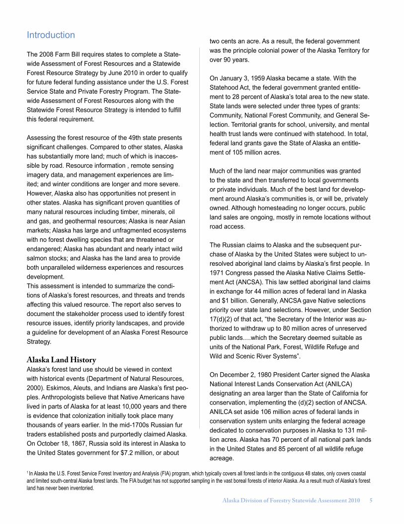
Forest RegionsAlaska has 16 percent of the land area and 17 percent of all forest area of the United States (Smith et al., 2009). Understandably, Alaska encompasses a diverse set of geological, climatic, and vegetative conditions. The state’s 365 million acres have been divided into six ecologi-cal units: Southeast, Southcentral, Southwest, Interior, Northwest, and Arctic (Viereck et al., 1992). More compre-hensive analysis has described 31 ecoregions (Nowacki et al., 2000). Recently, van Hees (2009) described three broad ecoregions (Figure 1).
Alaska forests are divided into three operational regions for implementing the Forest Resources and Practices Act (FRPA) and these are termed Coastal Rain Forest (Region I), Transitional Forest (Region II), and Interior Forest (Region III) (Alaska Division of Forestry 2006). The interior forest is part of the circumpolar boreal forest type. The boreal zone comprises about dominates 85 percent of Alaska.
The temperate oceanic climatic zone occupies the south-east and south-central coast of Alaska, making up roughly nine percent of the state’s forests. The coastal forest is part of one of the most productive forest ecosystems in the world. Western hemlock/Sitka spruce is the predomi-nant forest type but both western redcedar and Alaska yellowcedar are present. Large trees exceeding six feet in diameter and reaching nearly 200 feet in height can be
found in the southern part of this forest ecosystem. Tree size decreases, generally, with increasing latitude and longitude. On the western edge, hemlock drops out and only pure Sitka spruce stands occur. A wide diversity of wildlife species are found in this forest. They include Sitka black-tailed deer, black and brown bear, marten, moose, mountain goat, five species of salmon, and the bald eagle. There are approximately 31 Alaska Native village corpo-rations, three regional corporations, and some individual owners within the coastal forest.
Historically, the coastal forest has supported significant timber harvest (Rakestraw 2002). Native Americans and then Russian settlers were known to use timber for build-ings and vessels. In 1889, the territorial governor reported 11 sawmills were operating in Alaska. Timber harvest was high during the operation of two large pulp mills, but these are now closed and harvest has greatly declined in recent years. The few remaining medium size mills in southeast Alaska have been struggling to remain open.
In south-central Alaska on the Kenai Peninsula, there is a transitional zone between the coastal and boreal forests. Elsewhere mountain ranges separate the two forest for-mations. The western hemlock/Sitka spruce forest typical of Southeast is found near Homer. Northward this forest type is replaced by the boreal forest of mostly paper birch, quaking aspen, and white and black spruce. Wildlife found in this blend of forest types include mountain goat, Dall
Figure 1 Alaska’s three major forest regions defined by Alaska Forest Resources and Practices Act.

Alaska Division of Forestry Statewide Assessment 2010 �
sheep, brown and black bear, lynx, marten, and moose. Streams are rich with salmon through much of the sum-mer. There is a concentration of individual private forest owners in the boreal forest on the peninsula.
The Matanuska-Susitna Valley has the largest individual private ownership acreage, excluding Native corporations, of any area in Alaska. The original Matanuska Colony, established by the federal government in the 1930s and the federal homestead program, which ended in 1967, transferred many acres of forest land to private individu-als. Much of this land is road accessible, an unusual circumstance in Alaska. Since the area is close to Anchor-age, many residents own recreation property there. The “Mat-Su” Valley is within the boreal forest.
Portions of the Yukon, Southwest, and Northwest regions are in the boreal forest. There are large, important stands of white spruce and mixed stands of spruce and birch, but riparian forest and the taiga, or “land of little sticks”, are most distinctive. In some stands white spruce measure over two feet in diameter and reach 100 feet in height. Stands of black spruce are also common, usually on sites where permafrost is present. Permafrost, in discontinu-ous pockets and extensive areas, is a significant factor. Birch and aspen stands are usually located on previ-ously disturbed sites, generally as a result of fire. Moose, black and brown bear, caribou, marten, beaver and wolf are common species found in this forest type. There are significant numbers of spawning salmon in many of the streams during the summer. The federal government is the principal landowner in these regions, although large tracts of lands have been transferred to ANCSA corpora-tions, to the state, and to various boroughs. Individually owned tracts are relatively few. Very remote individual
Native allotments may be a significant element of private forest acreage in these regions.
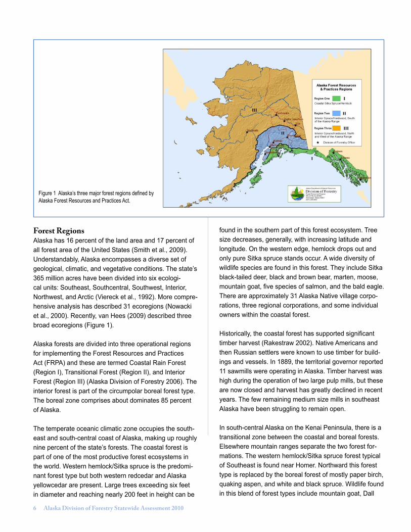
Land OwnershipThere are 126 million acres of forest land in Alaska (Smith et al. 2009), which is 35 percent of the state’s total area. There are 11 million acres of coastal, or maritime, forest and 115 million acres of interior, or boreal, forest. More than two-thirds of Alaska’s communities and more than three-quarters of the state’s population live in or adjacent to these forests. Ninety percent of the Alaska Native vil-lage and regional corporations own forest land. Federal ownership of forest land is disproportionate in Alaska compared to the nation as a whole (Table 1, Figures 2, and 3).
Federal LandThe federal government is the largest landowner in Alaska, responsible for the management of 222 million acres, 60 percent of the state. More than a dozen federal agencies manage lands in Alaska. The majority of federal land is reserved for conservation of natural areas, such as national parks and wildlife refuges. The Forest Service and Bureau of Land Management (BLM) manage for mul-tiple use including timber production and mining as well as subsistence and recreation. The remaining federal land is designated for special purposes, such as military reserva-tions and the National Petroleum Reserve.
The BLM manages 82 million acres, the largest amount of federal land in Alaska, with a mandate for multiple use. The BLM is the federal agency in which title to federal land rests, similar to the vesting of state land in the De-partment of Natural Resources. As such, BLM in Alaska is responsible for adjudicating land conveyance pursuant to
Table 1 Comparison of Land Ownership in Alaska and United StatesForest land by owner in thousand of acres (Smith et al. 2009)
All Forest Land
All FederalLand
USFS State Local Gov. Private
All US 751,228 248,413 147,181 68,831 10,955 423,029
Alaska 126,869 63,423 10,455 27,469 101 35,875
Alaska % of Acres Nationwide 17% 26% 7% 40% 1% 8%
� Alaska Division of Forestry Statewide Assessment 2010
Figure 2 Alaska forest land by ownership
Figure 3 Total U.S. forest land by ownership, excluding Alaska
Alaska Forest Land by Ownership126 million acres total
Total US Forest Land by OwnershipExcluding Alaska - 624 million acres total

Alaska Division of Forestry Statewide Assessment 2010 �
ANCSA and the Statehood Act, wildland fire management (Alaska Fire Service), and management of natural re-sources including administrative offices such as the Joint Pipeline Office for the Trans-Alaska Oil Pipeline. The BLM also manages the Steese National Conservation Area and the White Mountains National Recreation Area.
The Fish and Wildlife Service manages 79 million acres in 16 National Wildlife Refuges, which include the Yukon Delta National Wildlife Refuge, the Kodiak National Wild-life Refuge, the Alaska Maritime National Wildlife Refuge, and the Arctic National Wildlife Refuge. The National Park Service is responsible for management of 52 million acres in 13 national parks and/or preserves including the five largest parks in the U.S. The Forest Service is responsible for managing 22 million acres, including the two largest national forests in the U.S., the Chugach National For-est and Tongass National Forest, as well as two national monuments.
Alaska Native LandsThe Alaska Native Claims Settlement Act mandated the creation of regional and village Native corporations to accept the title of selected federal lands. Thirteen regional corporations were created; 12 shared in selection of 16 million acres while the thirteenth corporation, based in Seattle, received a cash settlement only. A total of 224 vil-lage corporations, each with 25 or more residents, shared 26 million acres. The remaining acres, which include historical sites and existing native-owned lands, went into a land pool to provide land to small villages of less than 25 people. ANCSA corporations currently have received approximately 35 million acres of land, including surface and subsurface resources. The process of transfer of title from the federal government to the corporations is still in progress. Regional corporations own both surface and subsurface resources. Village corporations own only the surface estate, while the regional corporations own the full fee estate including underlying subsurface resources, or just the subsurface resources on village corporation hold-ings. Several village corporations have merged with their regional corporation and some village corporations have consolidated. There is great variation in the size of corpo-rate holdings and management objectives. Lands granted under ANCSA are private and thus not federal trust lands managed by the Bureau of Indian Affairs. Alaska does have one Indian reservation, Annette Island Reserve in Southeast Alaska.
An estimated 95 percent of the private forest acreage in Alaska is owned by ANCSA corporations. Less than one percent (about 700,000 acres) is estimated to be in ap-proximately 5,200 individual Native allotments, which are mostly located in the boreal forest and have high subsis-tence and social/cultural values. Allotments were issued pursuant to the Alaska Native Allotment Act of 1906, which was ended by ANCSA, but existing allotments are still valid. Almost twice that number of allotment applications has been received and many are not yet processed. Each allotment can contain from one to four parcels with a com-bined aggregate not to exceed 160 acres. Allotments are trust lands under some form of Secretary of the Interior jurisdiction. The BIA has prepared land, resource, and timber inventories on some of the patented allotments.
State Land and State ForestsAs of 2009, the state has received patent to approximately 96 percent (99 million acres) of its total land entitlement. The state was permitted to select lands from any fed-eral land not already reserved for other uses, to provide land and resources to support the state’s economy, for road construction, economic development, and build-ing houses, schools, and other public and private facili-ties. The state chose land to meet three specific needs - settlement, resource stewardship, and development and recreation.
About two percent of Alaska’s state-owned land is in two designated state forests. In 1982, the legislature established the 270,410-acre Haines State Forest in the Chilkoot, Chilkat, and Ferebee river drainages. The next year, it created the 1.8 million-acre Tanana Valley State Forest that stretches from Manley to Tok. In addition to these two designated state forests, much of the state’s public domain land is available for multiple use, including forest management.
The Haines State Forest includes the watersheds of the major tributaries to the Chilkat River. Located in a transi-tion zone between the moderate and wet coastal climate and the dry cold interior, the forest provides suitable conditions for a diversity of vegetation. The rugged topog-raphy ranges from sea level to over 7,000 feet. The forest is composed mostly of two forest types, western hemlock/Sitka spruce, and black cottonwood/willow. Lodgepole pine and paper birch occur as minor species throughout the forest. About 15 percent of the state forest (41,831

10 Alaska Division of Forestry Statewide Assessment 2010
acres) is dedicated to timber harvest with an allowable harvest of 5.88 million board feet per year. Although natu-ral regeneration occurs readily, all large commercial sales have been replanted since the 1970s.
The Tanana Valley State Forest’s 1.81 million acres lie almost entirely within the Tanana River Basin, located in the east-central part of Alaska. The forest extends 265 miles, from near the Canadian border west to Manley Hot Springs. It varies in elevation from 275 feet along the Tanana River to over 5,000 feet in the Alaska Range. The Tanana River flows for 200 miles through the forest. Almost 90 percent of the state forest (1.59 million acres) is forested, mostly with paper birch, quaking aspen, balsam poplar, black spruce, white spruce, and tamarack. About half of the Tanana Basin’s productive forest land (1.1 million acres) is located within the state forest. About 85 percent of the forest is within 20 miles of a state highway.
Municipal LandsAlaska is home to approximately 686,000 people. Al-though there are many small villages across the state, more than half of the population lives in the Municipality of Anchorage or the Matanuska-Susitna Borough. More than 60 percent of the population lives in towns with popula-tions in excess of 5,000 people. Alaska has experienced rapid population growth (Figure 4).
Alaska’s local government structure is organized by just two types of municipal government – cities and organized boroughs (Bockhorst, 2001). On average, the corporate boundaries of cities in Alaska encompass just over 27 square miles. However, there are wide variations in the size of individual cities. The City of Skagway encompass-es the largest area (466 square miles), while the City of Kiana encompasses the smallest area (0.3 square miles). Current state law restricts the inclusion of large geograph-ical regions or large unpopulated areas in cities.
Presently, there are 145 city governments in Alaska. In 2000, those cities were inhabited by 161,591 individuals or 25.7 percent of the state’s population. The 2000 census indicated that the population of cities ranged from a high of 31,423 (City of Fairbanks) to a low of 24 (City of Kupre-anof). The Municipality of Anchorage, with a 2008 popula-tion of 279,243, is classified as an organized borough.
Like a city, an organized borough in Alaska is a municipal corporation and political subdivision of the State of Alaska. However, organized boroughs are intermediate-sized governments – much larger than cities. Alaska’s constitu-tion requires that the entire state be divided into boroughs, organized or unorganized. The constitution also requires that each borough embrace an area and population with common interests to the maximum degree possible.
Figure 4 Population change in South-central Alaska communities (Alaska Department of Labor & Workforce Development, Research & Analysis).
Percent Population Change 2000-2007
Alaska Division of Forestry Statewide Assessment 2010 11
Presently, there are 16 organized boroughs in Alaska, which average just over 17,400 square miles (644 times the average size of cities). Like cities, the size of individ-ual organized boroughs varies considerably. The largest organized borough is the North Slope Borough (93,823 square miles), while the Bristol Bay Borough is the small-est (918 square miles). In 2000, Alaska’s 16 organized boroughs were inhabited by 545,664 individuals, or 86.8 percent of the total population of the state. Of the 545,664 residents of organized boroughs, 98,246 (18 percent) also lived within a city government. Organized boroughs encompass about 43 percent of the geographic area of Alaska. State law provides that any area outside of an or-ganized borough comprise a single unorganized borough. As it is presently configured, the unorganized borough encompasses 374,843 square miles and was inhabited by 83,136 residents in 2000.
Alaska’s municipal and borough governments manage approximately 660,000 acres of land in Alaska (Hull, T and L. Leask).
Individually Owned Private LandExcluding the previously discussed Alaska Native cor-poration and Native allotment land, individual private land comprises less than one percent of the total land in Alaska. Information about individual private forest land ownership is limited and changing. The most recent national survey reported that Alaska has an estimated
16,600 private landowners with one or more acres of for-estland (Birch 1997). However, the accuracy of this report is questionable, because only 9 million acres of private forest land was reported, which is well below estimates from other reputable sources.
An estimated 413,000 acres are in the individual owner-ship class; however, the number of acres or the number of individual landowners suitable for Forest Stewardship Program services has not been determined. Objectives of individual forest landowners are diverse. In the boreal for-est region, most have concerns about wildfire and damag-ing insects and diseases. Most landowners are interested in maintaining wildlife habitat. Adjoining landowners may have quite different objectives.
Some individual Native allotments occur within large public holdings. Most other private lands are in the more settled areas of the state, e.g., the Kenai Peninsula, the Matanuska and Susitna valleys and the Fairbanks area. Many of these small tracts are within large borough own-erships. Some state and borough land sales have resulted in blocks of individually owned tracts within larger public holdings.
Trust LandsThe University of Alaska and Alaska Mental Health Trust are significant land owners and enjoy quasi-private land-owner status. A September 2006 determination by the Office of General Council found that lands of the Univer-sity of Alaska and the Mental Health Trust are similar to private lands and can be considered private for purposes of the Forest Legacy Program. Currently, the Mental Health Land Trust holds 999,860 acres and the University Land Trust holds approximately 150,000 acres. In May 2009 the Alaska Supreme Court overturned a 2005 state law intended to grant an additional 250,000 acres to the university and a bill before the Alaska State Legislature again seeks to grant additional lands to the university.
Table 2 Municipal lands in Alaska Individually Owned Private Land
Local Governments Acres
Matanuska-Susitna Borough 383,000
Fairbanks North Star Borough 116,000
Kenai Peninsula Borough 73,600
Anchorage Borough 26,000
City and Borough of Juneau 20,000
Other 41,400
Total 660,000
12 Alaska Division of Forestry Statewide Assessment 2010
Population Demographics Alaska experienced an estimated nine percent increase in population from 2000 to 2008, one percentage point above the national average during the same period. (U.S. Census Bureau, 2009). Approximately one-third of Alaska census areas experienced population declines between 2000 and 2008. Many of these areas are in southeast Alaska. The Matanuska-Susitna Borough was the fastest growing census area while the Yukon-Koyukuk area had the largest population decline.
Most of Alaska’s population lives along the Railbelt, extending from Seward, north to Anchorage, and parallel-ing the Parks Highway to Fairbanks (Northern Economics, 2009). Forecasting population growth statewide is difficult and regional forecasts may have greater volatility than the state as a whole (Hunsanger, 2007). High costs of energy and limited employment opportunities in rural areas have led to a shift to urban population centers. Both Anchorage and the Mat-Su Borough are expected to show positive net growth through 2030. Southeast Alaska, by com-parison, is projected to continue its loss of population as residents migrate to other states and other parts of Alaska (Northern Economics, 2009).
Volatile fuel prices in rural Alaska may have stimulated migration to urban areas, but a recent report (Stephanie Martin 2008) suggests it may be one of several factors. Findings suggest that migration from smaller villages and towns is an ongoing phenomenon and fuel prices,
by themselves, cannot be definitively linked to migration. A primary cause of migration is the pursuit of economic and educational opportunities but as of 2008, survey data were inadequate to determine other reasons.
Rural Alaska is defined as all areas except the Municipali-ty of Anchorage and the Matanuska-Susitna, Kenai Penin-sula, Fairbanks North Star, and Juneau boroughs (Alaska Department of Commerce, Community, and Economic Development. 2009). Under this definition approximately 20 percent of Alaska’s population is considered rural.
EconomyThis overview of Alaska’s economy is provided by Gold-smith (2008). Alaska has eight main sectors: federal government, petroleum, seafood, tourism, mining, timber, international air cargo, and personal assets from outside Alaska, which are primarily federal retirement benefits. Federal government and the petroleum sector each constitute a third of the economy, with the other sectors combined contributing to the final third.
The petroleum industry comprises the state’s most impor-tant natural resource development sector of the economy. However, only a small portion of the 52,000 jobs that de-pend on petroleum are direct production jobs. Many more jobs are found in the industries that support oil and gas exploration and development. About 17 percent of U.S. oil production is from Alaska.
Figure 5 Fort Yukon in 2009 (AK Division of Community and Regional Affairs)
Alaska Division of Forestry Statewide Assessment 2010 1�
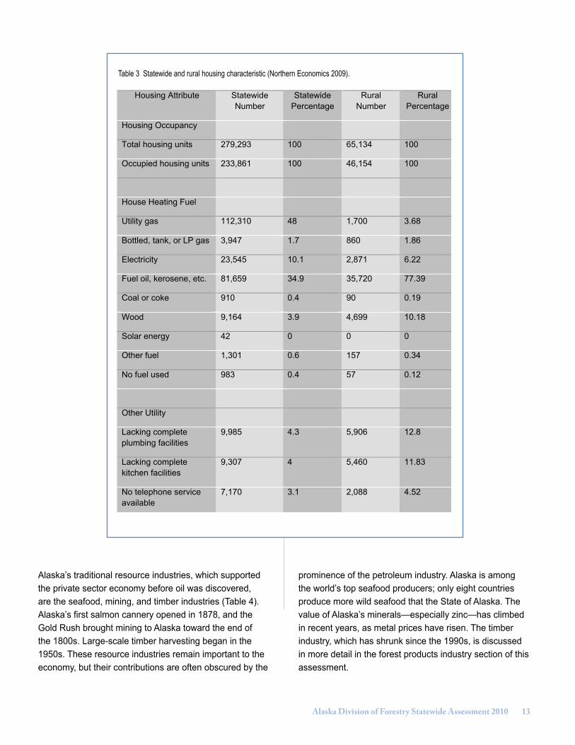
Housing Attribute StatewideNumber
StatewidePercentage
RuralNumber
RuralPercentage
Housing Occupancy
Total housing units 279,293 100 65,134 100
Occupied housing units 233,861 100 46,154 100
House Heating Fuel
Utility gas 112,310 48 1,700 3.68
Bottled, tank, or LP gas 3,947 1.7 860 1.86
Electricity 23,545 10.1 2,871 6.22
Fuel oil, kerosene, etc. 81,659 34.9 35,720 77.39
Coal or coke 910 0.4 90 0.19
Wood 9,164 3.9 4,699 10.18
Solar energy 42 0 0 0
Other fuel 1,301 0.6 157 0.34
No fuel used 983 0.4 57 0.12
Other Utility
Lacking completeplumbing facilities
9,985 4.3 5,906 12.8
Lacking completekitchen facilities
9,307 4 5,460 11.83
No telephone serviceavailable
7,170 3.1 2,088 4.52
Table 1 Statewide and rural housing characteristic (Northern Economics 2009).
Table 3 Statewide and rural housing characteristic (Northern Economics 2009).
Alaska’s traditional resource industries, which supported the private sector economy before oil was discovered, are the seafood, mining, and timber industries (Table 4). Alaska’s first salmon cannery opened in 1878, and the Gold Rush brought mining to Alaska toward the end of the 1800s. Large-scale timber harvesting began in the 1950s. These resource industries remain important to the economy, but their contributions are often obscured by the
prominence of the petroleum industry. Alaska is among the world’s top seafood producers; only eight countries produce more wild seafood that the State of Alaska. The value of Alaska’s minerals—especially zinc—has climbed in recent years, as metal prices have risen. The timber industry, which has shrunk since the 1990s, is discussed in more detail in the forest products industry section of this assessment.

1� Alaska Division of Forestry Statewide Assessment 2010
Table 4 Contributions of the 14 economic sectors in 2005 (Goldsmith 2008).
Alaska ResidentEmployment
Alaska ResidentPersonal Income
Thousands Share $Billion Share
Total 361.37 $24.270
Traditional Resources: 15.5% 10.8%
--Seafood 37.71 10.4% $1.481 6.1%
--Mining 12.06 3.3% $.799 3.3%
--Timber 5.90 1.6% $.315 1.3%
--Agriculture 0.45 .1% $.028 .1%
New Resources: 13.3% 9.6%
--Tourism 40.22 11.1% $1.894 7.8%
--Air Cargo 7.38 2.0% $.415 1.7%
--Other Manufacturing and Services 0.32 .1% $.016 .1%
Federal Government: 36.4% 40.1%
--Non-Defense Federal Government 67.01 18.5% $5.576 23.0%
--National Defense 64.35 17.8% $4.160 17.1%
Petroleum: 29.8% 28.5%
--Production 51.78 14.3% $3.596 14.8%
--State/Local Revenues 50.16 13.9% $2.538 10.5%
--Permanent Fund & CBR 5.87 1.6% $.788 3.2%
Personal Assets: 5.0% 11.0%
--Retirees 14.53 4.0% $2.147 8.8%
--Non-Earned Income 3.63 1.0% $.516 2.1%

Alaska Division of Forestry Statewide Assessment 2010 1�
Forest Conditions, Threats, Benefits, and Trends
Climate ChangeClimate change is increasingly in the news. In Alaska, the Scenarios Network for Alaska Planning (SNAP) is a University of Alaska Fairbanks network that provides scenarios of future conditions in Alaska for more effective planning by communities, industry, and land managers (SNAP Integration Team 2008). SNAP has employed general circulation models for projections of global cli-mate similar to the Intergovernmental Panel on Climate Change. The projected Alaska statewide trends indicate temperatures and precipitation are expected to increase across all regions. Temperature increases are predicted for every month, and increases are expected to continue throughout the century (SNAP Integration Team 2010, Figure 6). The growing season is likely to become longer statewide, however precipitation alone does not predict ecosystem moisture limitations (Figure 7). Increased plant growth and increased evaporation due to higher tempera-tures may more than offset the additional precipitation, resulting in drier soils.
Climate change is expected to impact many aspects of Alaska. Related to Alaska forests, climate change may affect wildfire, insect epidemics, invasive species, regen-
eration and growth, and wildlife habitat. For example, the 2004 wildfire season, the largest documented since the early 1950s, was a direct result of record temperatures and little precipitation. Also, the first recorded large spruce budworm outbreak, in the early 1990s, may have re-sulted from elevated summer temperatures that produced drought stress in the host white spruce trees. Climate change may also impact forest management operations by causing shorter winter logging seasons, shorter win-dows for use of ice bridges, and thawing permafrost that will impact existing or planned roads and other infrastruc-ture.
Some non-forest impacts of climate warming in Alaska are clearly occurring. These include coastal erosion, increased storm effects, sea ice retreat, and permafrost melt. As a consequence, the governor created a Climate Change Sub-Cabinet in 2007. The sub-cabinet has con-vened advisory and working groups to provide analysis and recommendations. Draft final reports were released in January 2010 for four working groups: adaptation, mitiga-tion, immediate action, and research needs.
1) Adaptation to climate change was categorized as: • Public infrastructure, such as construction design and monitoring.
Figure 6 Temperature projections for Fairbanks (Scenarios Network for Alaska Planning)

1� Alaska Division of Forestry Statewide Assessment 2010
Figure 7 Precipitation projections for Fairbanks (Scenarios Network for Alaska Planning)
• Natural systems management, including fisheries, wild life, and wildfire. • Economic activities, including improve availability of mapping, surveying, charting, and imagery data. • Health and culture, including diseases, sanitation, and community health, and coordinated community assistance and education. • Common themes, including community climate impact assistance.
2) Mitigation activities focused on reducing greenhouse gas emissions. The working group analysis included:• Cross-cutting issues, such as establish an Alaska greenhouse gas emission reporting program.• Energy supply and demand policy, such as implemen tation of renewable energy.• Forestry, agriculture, and waste management, including forest management strategies.
3) Immediate needs focus on coastal erosion impacts on rural communities.
4) Research needs identified the following broad areas: • Data collection and management• Monitoring
• Addressing workforce needs• Scientific research• The development of engineering standards, practices, and other support tools• Infrastructure needs and improvements• Technology development• The assembly of traditional knowledge• Modeling
Wildfire Wildfire PlanningAnnual acreage burned in the boreal forest ranges from an average low of about one hundred thousand to a high of over 6 million acres. Most acreage burned from wildfire is caused by lightning but the large majority of starts near communities are human caused. The Alaska Division of Forestry, Bureau of Land Management Alaska Fire Service, and the U.S .Forest Service have active fire programs and are responsible for the protection of the wildlands, both pubic and private, within the state. Legisla-tion passed in 2007 has realigned department authority that allows fire management decision-making to include all values, not just the values of the natural resources threatened by wildland fires. All houses, cabins, com-mercial property, and other cultural resources can be considered when assessing the most appropriate and cost effective fire management strategies.
Alaska Division of Forestry Statewide Assessment 2010 1�
Alaska Interagency Wildfire Coordinating Group The Alaska Interagency Wildfire Coordinating Group (AWFCG) provides a forum that fosters cooperation, coordination, collaboration, and communication for wildland fire management and related activities in the state of Alaska. This group provides a perfect avenue in which to bring forward issues and implement strategies on a broad scale, interagency basis. The AWFCG task groups include: Air Quality and Smoke Management, Fire Program Analysis, Fire Research Development and Ap-plication, Fire Training Qualifications, Fire Weather, Fuels, Prescribed Fire and Community Assistance, Operations, Safety and Health, and Wildland Fire Education and Prevention.
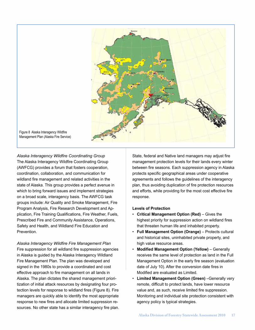
Alaska Interagency Wildfire Fire Management PlanFire suppression for all wildland fire suppression agencies in Alaska is guided by the Alaska Interagency Wildland Fire Management Plan. The plan was developed and signed in the 1980s to provide a coordinated and cost effective approach to fire management on all lands in Alaska. The plan dictates the shared management priori-tization of initial attack resources by designating four pro-tection levels for response to wildland fires (Figure 8). Fire managers are quickly able to identify the most appropriate response to new fires and allocate limited suppression re-sources. No other state has a similar interagency fire plan.
State, federal and Native land managers may adjust fire management protection levels for their lands every winter between fire seasons. Each suppression agency in Alaska protects specific geographical areas under cooperative agreements and follows the guidelines of the interagency plan, thus avoiding duplication of fire protection resources and efforts, while providing for the most cost effective fire response.
Levels of Protection• Critical Management Option (Red) – Gives the highest priority for suppression action on wildland fires that threaten human life and inhabited property.• Full Management Option (Orange) – Protects cultural and historical sites, uninhabited private property, and high value resource areas.• Modified Management Option (Yellow) – Generally receives the same level of protection as land in the Full Management Option in the early fire season (evaluation date of July 10). After the conversion date fires in Modified are evaluated as Limited.• Limited Management Option (Green) –Generally very remote, difficult to protect lands, have lower resource value and, as such, receive limited fire suppression. Monitoring and individual site protection consistent with agency policy is typical strategies.
Figure 8 Alaska Interagency Wildfire Management Plan (Alaska Fire Service)
1� Alaska Division of Forestry Statewide Assessment 2010
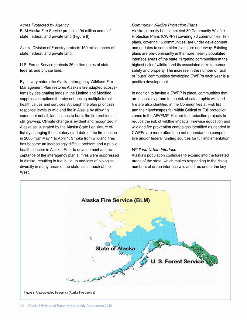
Acres Protected by AgencyBLM Alaska Fire Service protects 194 million acres of state, federal, and private land (Figure 9).
Alaska Division of Forestry protects 150 million acres of state, federal, and private land.
U.S. Forest Service protects 26 million acres of state, federal, and private land.
By its very nature the Alaska Interagency Wildland Fire Management Plan restores Alaska’s fire adapted ecosys-tems by designating lands in the Limited and Modified suppression options thereby enhancing multiple forest health values and services. Although the plan prioritizes response levels to wildland fire in Alaska by allowing some, but not all, landscapes to burn, the fire problem is still growing. Climate change is evident and recognized in Alaska as illustrated by the Alaska State Legislature of-ficially changing the statutory start date of the fire season in 2006 from May 1 to April 1. Smoke from wildland fires has become an increasingly difficult problem and a public health concern in Alaska. Prior to development and ac-ceptance of the interagency plan all fires were suppressed in Alaska, resulting in fuel build up and loss of biological diversity in many areas of the state, as in much of the West.
Community Wildfire Protection PlansAlaska currently has completed 30 Community Wildfire Protection Plans (CWPPs) covering 70 communities. Ten plans, covering 16 communities, are under development and updates to some older plans are underway. Existing plans are pre-dominantly in the more heavily populated interface areas of the state, targeting communities at the highest risk of wildfire and its associated risks to human safety and property. The increase in the number of rural or “bush” communities developing CWPPs each year is a positive development.
In addition to having a CWPP in place, communities that are especially prone to the risk of catastrophic wildland fire are also identified in the Communities at Risk list and their landscapes fall within Critical or Full protection zones in the AIWFMP Hazard fuel reduction projects to reduce the risk of wildfire impacts, Firewise education and wildland fire prevention campaigns identified as needed in CWPPs are more often than not dependant on competi-tive and/or federal funding sources for full implementation. Wildland Urban InterfaceAlaska’s population continues to expand into the forested areas of the state, which makes responding to the rising numbers of urban interface wildland fires one of the key
Figure 9 Area protected by agency (Alaska Fire Service)

Alaska Division of Forestry Statewide Assessment 2010 1�
issues facing the state and its cooperators. In recent years, numerous serious urban interface wildland fires have threatened homes and communities. For the 2009 Fire Season, 221 of 254 fires were in wildland urban interface areas of the state. Geographically, the urban interface fire zone continues to increase as new homes and subdivisions are built to accommodate the increasing population of Alaskan communities. 2009 was the ninth highest season for acres burned with 520 fires statewide and 2,951,582 acres burned. This was only four years after the first and third largest fire seasons in Alaska’s history. In 2004, 6.6 million acres of forested lands burned in Alaska and 4.6 million acres burned in 2005. The 17-Mile Fire in Homer and the Caribou Hills Fire in 2008, the Parks Highway Fire in 2006, and three fires in 2004 were declared FEMA fires eligible for Federal Fire Management Assistance. These fires posed “significant risk to consti-tute a major catastrophe” to life and property.
State Land Disposal ProgramThe Alaska Constitution, state laws, and the Alaska Leg-islature all direct the Department of Natural Resources to sell state land for settlement and private ownership. Article VIII of the Alaska Constitution states that, “It is the policy of the state to encourage the settlement of its land and development of its resources by making them available for maximum use consistent with the public interest.”
This policy adds to the already increasing wildland/urban interface problem fire managers are facing. Thousands of acres of state land have been sold, primarily in remote ar-eas that are often poorly situated (such as on a ridge top) with limited or no ingress and egress, and among vola-tile fuels. Alaskans are building recreational cabins and primary homes in these areas. Presently, no regulations or ordinances exist requiring a reduction of hazardous fuels prior to land disposal, or require more than one way in or out of the subdivision, or require property owners to observe Firewise principles once they have built a cabin or home on the purchased land (Figure 10). Furthermore, no state general funds are available for hazardous fuels projects.
Spruce Bark Beetle EpidemicThe threat of a catastrophic wildland fire is exacerbated not only by the continued human expansion into the forestland lands of the state but by the buildup of bark beetle killed timber (Figure 11). The spruce beetle out
break on the Kenai Peninsula is considered to be the most intensive outbreak documented in North America. In 1998, state aerial surveys indicated that approximately 1.1 million acres of the Kenai Peninsula Borough had been impacted. Growth of the outbreak has slowed, but the risk for catastrophic wildfire with the potential to impact private land in the urban interface will continue for decades to come.
The combination of fine fuels and sound, woody material can produce intense fires. Because they are exposed to the wind and sunlight, standing dead spruce trees dry out quickly after wet periods. These standing dead trees can torch and initiate spot fires even after the needles have been lost. If stands are open enough to allow winds to reach surface fuels, fires may spread more rapidly than in stands of live trees with a closed canopy. The present fuel conditions in spruce beetle-impacted stands of south-central Alaska may lead to severe and unpredictable fire behavior (Alaska Society of American Foresters 1997). In addition to the heavy fuel loads, several other condi-tions in south-central Alaska contribute to the higher than normal fire hazard. Temperatures over the last several decades have been warming thereby resulting in a longer fire season. Also, the growing population in South-central is leading to increasing probabilities of human-caused fire ignitions. (Ross et al. 2001)
Another area of significant infestation is the Copper River Valley between Glennallen and McCarthy where 680,500
Figure 10 Homes outside of Fairbanks, Alaska (Alaska Department of Fish and Game)

20 Alaska Division of Forestry Statewide Assessment 2010
acres has been impacted. The remainder of the most significant infestation has been along the lower Yukon and Kuskokwim rivers and tributaries, the Lake Clark/Il-iamna region, the Cook Inlet west of Anchorage (including 88,000 acres within this municipality) and in southeast Alaska, predominantly near Haines, Juneau, and Gustavus.
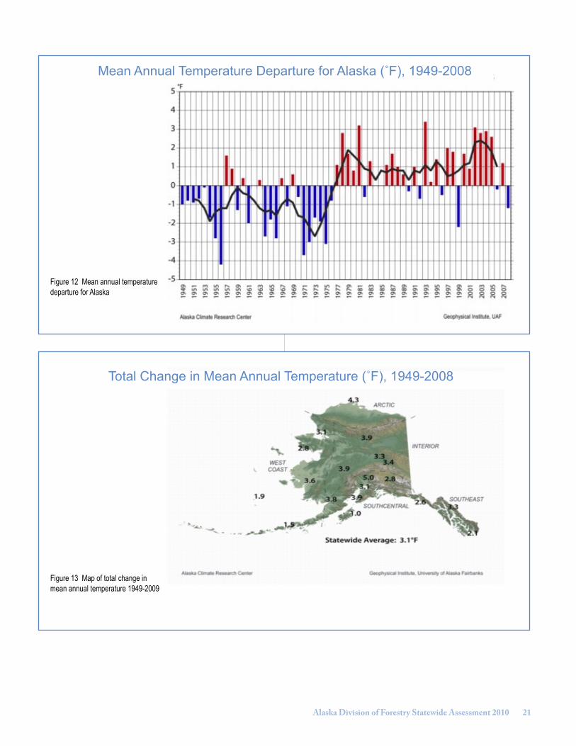
Climate Change and Wildland FireClimate changes, with trends to warmer and drier sum-mers, are having an effect on the length of the wildland fire season in Alaska (Figures 12, 13). Fire activity tends to begin earlier and has increased activity into the fall beyond the historical norms. Along with an earlier fire season, an increase in lightning in portions of the state, all-risk incidents, and increased urban interface, wildland fire has occurred with the growth in population. There has been a trend towards larger fires impacting towns and communities with smoke (Figure 14). This has brought some temporary interruptions in tourism and increased health concerns. A longer growing season could improve forestry yields but warmer temperatures and increased summer drying will also increase the amount of flammable vegetation, thus increasing the potential for more wildland fires. The lengthening fire season and increased fire activ-ity requires the constant rotation of firefighting personnel, including incident management teams and suppression crews. In the past five years in Alaska, there have been 18 requests for Incident Management Teams for 17 differ-ent fires and fire complexes. Eight of these requests were in 2009 alone.
Mega FiresThe concept of the “mega-fire” has evolved over the last two decades. Mega-fires are extraordinary in terms of their size, complexity, and resistance to control. They often burn into the wildland-urban interface where values to be protected are high. It is not unusual that fire severity in these stands is exacerbated following years of drought, insect infestations, and disease. These few wildfires, often burning under extreme fire weather conditions and exhibit-ing extreme fire behavior characteristics, exceed all efforts at conventional control until relief in weather or a break in fuel occurs.” (Brookings Institute, 2005)
Alaska is experiencing its share of mega fires; beginning in 1994 when the Miller’s Reach # 4 Fire burned more than 400 structures. This fire was Alaska’s “wake up call” to the wildland urban interface problem it now faces. Since Miller’s Reach, Alaska has faced numerous mega-fires, particularly in 2004 with the Boundary Fire just outside of Fairbanks, and the Taylor Complex outside of Tok, and in 2009; the Railbelt Complex, outside of Nenana, and the Crazy Mountain Complex, outside of Circle.
Lack of Known Sites Database & Geospatial DataWith the passage of legislation in 2007, department au-thority allows fire management decision makers to include all values, not just the values of the natural resources threatened by wildland fires. All houses, cabins, com-mercial property and other cultural resources can be considered when assessing the most appropriate and cost effective fire management strategies, not just the natural resources. Many of these values lie outside of organized boroughs and the locations of these values at risk are not captured in any databases. Incident management teams are constantly discovering cabins, homes and other resources while trying to manage a fire, necessitating a constant change of tactics. (Figure 15). In order to most effectively apply fire management strategies, identifying and inventorying those values must be done, preferably prior to the start of a wildland fire.
The ability to inventory and display the location of values at risk is hampered by the minimal Geographic Infor-mation System (GIS) capability and lack of underlying geospatial data. Sound fire management requires ac-cess to data, from vegetation type, to land ownership, to improvement locations. In order to build this capability, GIS systems and databases need to be developed. The cost of acquiring the necessary underlying geospatial data
Figure 11 Spruce bark beetle devastation on the Kenai Peninsula. (Division of Forestry)
Alaska Division of Forestry Statewide Assessment 2010 21
Figure 12 Mean annual temperature departure for Alaska
Figure 13 Map of total change in mean annual temperature 1949-2009
Mean Annual Temperature Departure for Alaska (˚F), 1949-2008
Total Change in Mean Annual Temperature (˚F), 1949-2008

22 Alaska Division of Forestry Statewide Assessment 2010
Figure 14 Acres burned, 10 year running average 1955-2009 (Alaska Fire Service)
for the entire state of Alaska is estimated at $70 million, a cost too steep for the state to bear. To date, Landfire data has proven to be inaccurate for many fuel types.
Geographical, Social, and Political ConditionsMost of Alaska is accessible only by air or river and the distance and isolation between communities is con-siderable. Alaska does not have the physical or social infrastructure most states have. Unemployment in rural areas is as high 16 percent. Many communities lack basic infrastructure such as running water and sewer systems, and cell and internet service is limited. Population in rural villages is small and firefighting on a village Native crew can be the sole source of income for local residents. Local government structure, nonprofits, community associations, and environmental groups so prevalent in the lower 48 states are all but nonexistent in rural Alaska, and even in the populated regions are found at a much lower percent-age that the rest of U.S.
Communities are hard pressed to form viable partnerships and more often than not are unable to meet minimum matching requirements for Western Wildland Urban In-terface and Volunteer Fire Assistance grant programs. In addition, state agencies are in “competition “with federal agencies offering funds related to wildland fire mitigation that have no matching requirements, such as the funds
the Bureau of Indian Affairs and U.S. Fish & Wildlife Service distributes for fuels mitigation. These factors compound an already challenging situation. State and federal agencies can leverage each others projects, but if a community can not come up with a nonfederal matching share, often at 50 percent, opportunities for leverage and for working on a landscape scale with partner agencies diminish.
Economic Conditions The state faces unprecedented economic challenges which are having an effect on the ability to deliver the fire program and will ultimately hinder suppression efforts. Vacancies in key fire management positions, unavailability of firefighting aircraft, decreased federal capacity, and increased vendor and contractual cost will all takes a toll on the ability to effectively and safely fight fire.
Employee RetentionCompetition for personnel from municipal and federal positions offering significantly higher wages is no longer offset by the state’s benefits since the advent of Tier III and Tier IV employment plans. Recruitment for firefighting positions is a major problem and openings continue to be recruited within Alaska and nationally with very poor re-sults. Critical shortages in dispatch, logistics, and experi-enced professional level fire managers have necessitated
Acres Burned by Year 1955-200910 Year Running Average

Alaska Division of Forestry Statewide Assessment 2010 2�
Figure 15 Site protection on the Taylor complex fire, 2004. (Division of Forestry)
national recruitment, often without success. Salaries and benefits are not competitive. The expected loss due to retirement of two-thirds of the division’s fire managers, su-pervisors, and fire personnel in the lead technician class within the next five years is alarming.
Contractual CostsAlaska’s vast distances and lack of roads necessitates the use of air resources when responding to many wildland fires in the state; air tankers, helicopters, lead planes, smokejumpers, and reconnaissance aircraft are essential to the success of fire management programs. Initial at-tack and the ability to support remote fires in Critical, Full or Modified Protection Areas with supplies, crews, and equipment can be logistically complicated and requires aircraft and sometimes watercraft. This accounts for the high cost of remote incidents. Reconnaissance aircraft are needed to monitor staffed fires and fires in the limited management option zones.
Cost increases due to market pressures on vendors, particularly those supplying contractual fire fighting aircraft, are seen in much higher than anticipated bids on all aviation contracts. Due to the limited road access, the division relies heavily on aircraft to support fire manage-ment activities. Availability of aircraft has been severely impacted by increased mining and oil and gas exploration in the state. In addition, changes in the aviation industry caused by fuel, labor, and liability insurance have in-creased overall costs. Forestry received funding in Fiscal Year 2009 to fund aviation shortfalls, although increased
costs (as new contracts are due for rebid) are anticipated in future years.
Costs of the fire program vary not only directly with the intensity and length of the fire seasons, but with unavoid-able increases in service contract costs such as catering, fresh food boxes, showers, and emergency rental vehi-cles. Costs for private sector services, on which the state relies heavily during the fire season, continue to escalate with liability, energy, and additional labor costs. The earlier and longer fire season has resulted in the baseline historic expenditures no longer being indicative of the previously normal fire season. Suppression cost trends are based on the average fire costs over a ten-year period, eliminating the high and low years. The 2004 fire season established a new high year, which increased the expenditure trend even more above the budgeted funding level.
Decreased Federal CapacityThe Bureau of Land Management Alaska Fire Service, the Division of Forestry’s primary cooperator, has experienced a significant reduction in its operational capability due to federal budget reductions. While the state has relied on federal cooperators for support in the past, there is now reduced ability to use federal resources to augment state resources on wildland fires. In addition, U.S. Forest Service State Fire Assistance (SFA) grants have been a significant source for funding key preparedness programs. Large fire costs experienced by the Forest Service have caused, at times, re-direction of SFA funds to cover the expense of fire suppression on national forest lands.
Non-Wildfire ResponsePersonnel with Incident Command System (ICS) train-ing and experience are increasingly being used for all risk incident response both instate and nationally. These responses range from the 9/11 terrorist attack in New York City, to hurricanes, such as Katrina and Rita, to windstorms, floods, fuel spills, and earthquakes (Figure 16). The state is increasingly relying on Division of For-estry availability in disaster planning and all risk incident management. The division provided extensive assistance to the Division of Homeland Security and Emergency Management in the 2009 response to flooding of villages along the Kuskokwim and Yukon rivers. The division provided logistical and warehouse support, which was an integral part of the most significant interagency flood re-sponse experienced in the last several years. The division sent water, rations wall tents, and other supplies to sites

2� Alaska Division of Forestry Statewide Assessment 2010
from Akiachak to Eagle, and provided a Type 3 Incident Management Team. However, the majority of these per-sonnel are not budgeted for the duration of the fire season to ensure their availability for fires. The division has a large cadre of trained and experienced personnel that can be used for all-risk management. This increased workload falls to fire managers who have full-time fire management responsibilities; however, it assists in retaining seasonal employees by increasing work opportunities.
Forest Products Industry FRPA Region I (Coastal Rain Forest, Southeast Alaska, Southcentral Coast)A historical context is helpful to fully appreciate the pres-ent condition, threats, and trends associated with the for-est products industry in Alaska. Figure 17 shows historic timber harvest levels in Alaska from 1940 through 2006. In Alaska’s coastal region (Region I) the past century has seen the rise and fall of a major industrial player. This graph shows the peak in Forest Service harvest in 1973 and the peak in total harvests from all lands in the late 1980s. Since that time timber harvest has plummeted to a 50-year low.
Brackley et al., 2009, describes the early pre-World War II industry in Southeast as follows:The Tongass National Forest was created by a procla-mation signed on September 7, 1907 and timber sales reported in 1909 and 1910 averaged 13 million board feet (mmbf) of logs per year. Much of this supported local consumption and a thriving wooden box industry for shipping canned salmon to world markets (Heintzle-man 1954). Annual volumes of timber harvested follow-ing World War I and prior to World War II ranged from 14 to 57 mmbf. This rose during World War II to more than 90 mmbf in southeast Alaska to support the war effort. About 45 percent of this war-year volume was shipped to Seattle for use in airplane construction. The remaining amount was sawn and used in construction in Alaska.
Figure 16 Alaska Type 1 team members, World Trade Center disaster, 2001. (Alaska Fire Service)
Figure 17 Harvest in Alaska. (Brack-ley et al. 2009)
Historic Timber Harvest by Landowner

Alaska Division of Forestry Statewide Assessment 2010 2�
It was after major efforts by the U.S. Forest Service to attract industrial investment to the region as authorized by The Tongass Timber Act (TTA 1947) that two long-term timber sale agreements were signed in the early 1950s, each of which required construction of pulp mills, the first in Wards Cove in Ketchikan, and the second in Sitka. As production ensued an integrated industry was developed with sawmilling capacity in addition to the pulp mills. By the early 1970s, Alaska producers accounted for a major share of west coast lumber exports, and timber harvest from the National Forest Lands in Alaska peaked in 1973.
The 1971 Alaska Native Claims Settlement Act (ANCSA 1971: PL 92-203) was passed by Congress to settle out-standing aboriginal land claims by Alaska Natives, created Native land ownerships that resulted in a reduction in the area available for producing timber on the Tongass, but led to a thriving industry developed from timber available from the newly formed Alaska Native Corporations. Tim-ber harvests from Native corporation lands in Southeast as well as south-central Alaska boosted the industry with corporation timber harvests peaking in 1989.
Concurrent with the shift of timber harvest to private lands and an export trade, timber supply from the Tongass National Forest became less certain. Changes in national priorities for the forest began to impact timber supply. Efforts to retool the industry to modern plant and equip-ment were frustrated by both economic challenges and uncertainty in future log supply. After 40 years in operation the Sitka mill closed in April 1994 and the Ketchikan mill closed in March 1997.
Region I ThreatsSince the mill closures, smaller sawmill operators have struggled to continue operating as log supply has been further constrained, and the industry that was once integrated with both pulp and sawlog operations was now burdened with a lack of market for low quality logs that had previously been used for pulp production.
Timber and related products from the Tongass National Forest have long played an important role in the economy of Southeast Alaska. Their importance was formally recog-nized in 1990 with passage of the Tongass Timber Reform Act. This act requires the Forest Service to seek to provide a supply of timber in a sustainable balance with all multiple resource objectives on the Tongass. The Tongass Forest Plan guides the management of all resources on
the forest. (U.S. Forest Service 2008). The 16.8 million-acre Tongass has about 9.4 million acres of old-growth forest, about 5 million acres of which are of commercial size. The forest also has about 400,000 acres of young growth stands that are the result of timber management activities initiated primarily in the 1950s. Under the current Tongass Forest Plan, about 3.6 million gross acres of land are zoned to allow for some level of timber management; however, only 676,000 acres are programmed for long term timber management. This amounts to about four per-cent of the Tongass land base and less than 15 percent of the original commercial sized old growth forest.
Even this dramatically reduced target for output from the Tongass has been elusive, with a series of appeals and legal challenges to both the Tongass Land Management Plan and individual sales. To compound these difficul-ties, a significant decline in timber available from Native corporation lands, began in the late 1990s. This coupled with significant structural shifts in the log export market have resulted in the industry’s infrastructure, including human expertise, capital, and support services, declining to a critical mass. The very survival of the timber industry hangs in balance with total industry harvest levels reach-ing their lowest level in a half century.
Compounding timber supply threats are market related challenges for log export and manufactured forest prod-ucts. Alaska has disproportionately high production costs due to many factors including the remote nature of opera-tions, high cost of labor and energy, and often costly road and infrastructure costs. Alaska forest products are com-peting in global markets, and suppliers from other regions have significant cost advantages. In the late 1990s the premiums that were once paid for Alaska’s fine grained old growth timber declined significantly, compounding the economic challenges of managing coastal forest resourc-es in Alaska.

2� Alaska Division of Forestry Statewide Assessment 2010
Region I TrendsAs discussed in preceding discussion of industry threats, the decline in timber supply has affected every aspect of the forest products industry in southeast Alaska. The industry is at a critical turning point and the next few years will determine whether this trend can be reversed. In 1990 the Alaska Department of Labor reported 3,450 logging, sawmilling pulp mill, and wood products jobs in Southeast. For October 2009 only 200 jobs were reported in this sector statewide. (Alaska Department of Labor, December 2009).
A transition to young growth on federal, state, and Native corporation lands in southeast Alaska will be a significant trend for a future forest products industry. The challenge is to provide sufficient economic timber from older forests to fill the gap while the legacy stands, harvested since the mid 1950s, mature. This is further complicated by restrictions that have put many of the older second growth stands off limits to a second entry, such as stands along the beach fringe that are now restricted by standards and guidelines in the Tongass Land Management Plan. Because Native corporation harvests didn’t ramp up until the 1980s young growth on corporation lands won’t be available in significant quantities for decades, presenting a further gap in timber availability.
In 2005, the American Lumber Standards Committee ap-proved new strength values for Alaska softwoods species, which were developed at the Ketchikan Wood Technol-ogy Center. The committee also approved grade stamps for Alaska spruce, hemlock, and yellowcedar lumber. These advances have allowed Alaskan softwood species to gain recognition for their aesthetic values as well as their exceptional structural properties. Should sufficient reliable log supply become available to enable investment in processing capacity, the new grade stamps for Alaskan species may help facilitate an increase in the use of local wood in Alaska. For example, Alaskans use about 120 million board feet of construction-grade lumber each year. While demand for construction-grade lumber is currently met through imports, we now recognize that Alaskan spe-cies can provide a suitable, if not superior, substitute for imported wood products.
Land tenure in Alaska will become more settled as the state and Native corporations receive their final federal land entitlements. Unless the ongoing gridlock regarding federal timber supply from the Tongass National Forest can be resolved, state, Native corporation, and trust lands will become the dominant working forests to provide for a forest industry in Alaska. Timber availability from the Tongass National Forest may become more dependent on forest stewardship contract, which are dependant on federal appropriations.
Figure 18 Timber harvest by landowner 1976
Figure 19 Timber harvest by landowner, 2006
1976 Timber Harvest by Owner
2006 Timber Harvest by Owner
Alaska Division of Forestry Statewide Assessment 2010 2�
In addition to the decline in timber harvest over the past 30 years, a significant shift in the land ownership sup-porting the industry demonstrates the trend towards state and Native corporation lands supplying a higher propor-tion of timber to the forest products industry. Because federal lands dominate Alaska’s most productive forest lands, which are those in Southeast, timber from state and private lands cannot offset the reduction in timber supply from federal lands.
It will become increasingly difficult for private and public landowners to maintain roads, bridges, and log transfer facility infrastructure in previously harvested areas without regular stumpage returns to support these land manage-ment costs. In the past, federal dollars were invested in road construction and maintenance either through appro-priations or timber sale purchaser credits.
South-Central and Interior Alaska(Regions II and III)The potential for forest products industry growth in south-central and interior Alaska is significant. The forest products industry in South-central and Interior presently serves a small percentage of local demand for wood prod-ucts and a more significant portion of the demand for fuel wood. During times of robust export markets, white spruce logs from interior Alaska were exported via rail to the ports of Seward and Anchorage. Chip export operations were established in Tyonek in late the 1970s and early 1980s and in Homer in the 1990s in response to timber salvage efforts in the wake of bark beetle outbreaks. More recent-ly, wood chips were exported from the Mat-Su Valley from Point MacKenzie.
The state is the major timber owner in interior Alaska, including 1.8 million acres in the Tanana Valley State Forest. Native corporations, the University of Alaska, and the Fairbanks North Star Borough also have significant timber holdings. Local forests have supplied lumber, logs, and firewood for use in the region since the days of the gold rush. Interior forests once served as a major sup-plier of transportation fuel, with more than 50 steamboats operating on the Yukon River in 1900. Steamboats of the Northern Commercial Company used 48,438 cords of wood between 1897 and 1902. In recent years, local mills have added kilns and planers to their facilities. Currently, high oil prices are raising interest in wood energy from biomass. Extensive hardwood forests offer potential for a variety of manufactured products and energy sources.
The paper birch and spruce forest in the Susitna Valley, north of Anchorage, historically has had little economic value due to a high defect rate. This had made it difficult to create more than the few jobs offered by log home builders and very small sawmills. Growing interest in wood chips, biomass for energy, and hardwood saw timber may provide wider opportunities for use of South-central forests. Farther south, on the Kenai Peninsula, continued deterioration of beetle killed spruce has limited the amount of useful timber to the local mills. This has forced some mills to move out of the area or cease operations entirely.
Silviculture and Forest ProductsSilviculture investigation of second growth forest in Alaska has been underway for many years (Taylor 1934, Farr 1967, Zasada 1976). Regeneration of forests follow-ing timber harvest in Southeast is generally abundant. Southeast second growth forests often have densities far above optimum for individual tree and value growth. Thin-ning, pruning, and fertilization are silvicultural techniques that may be applicable. Thinning allows greater diam-eter growth and hence lumber production. Thinning can increase browse and hasten the time for the forest to have mature forest habitats. It also allows modifying species composition in regeneration often dominated by western hemlock. Pruning the basal eight-foot log can produce a more knot free and valuable log. Forest fertilization has been very limited in Alaska, but is believed to have prom-ise when combined with thinning. Forest fertilization has been used operationally in British Columbia and the Pacif-ic Northwest states for years. In the Haines State Forest, tree planting has been found beneficial to ensure prompt regeneration. Nonetheless, thinning and basal pruning are sometimes used to improve forest product values.
Reforestation on boreal forest sites can be problematic and some sites can become dominated by bluejoint reed grass for many years. Mechanical scarification or fire can be effective for site preparation and natural regeneration, but winter logging can have little site preparation effect. Tree planting has been used effectively on boreal sites, but planting nursery grown seedlings may be too costly for many rural boreal sites. Spruce seed has been collected and stored to provide nurseries with Alaska seed sources. Although spruce seed can retain viability for 20 years, new seed collections are advisable when good cone crops occur.

2� Alaska Division of Forestry Statewide Assessment 2010
Tree improvement to produce faster growing trees by ge-netic gain has been considered for many years in Alaska. In Southeast Alaska, abundant natural regeneration and high logistical cost has limited tree improvement develop-ment. In interior Alaska, lower growth rate for white spruce has limited tree improvement due to investment concerns. Nonetheless, tree improvement to develop hybrid poplars for boreal sites may be re-considered. Also, newly devel-oped hybrid poplars from Canada may have sufficient cold tolerance for interior Alaska. Hybrid poplars grow substan-tially faster than parent types and planting poplar stem cuttings may be a low-cost method of biomass reforesting. In addition to providing energy, regeneration of hardwood species should enhance moose browse.
Region II-III ThreatsIn fast growing areas of the state, particularly portions of the Matanuska-Susitna Borough (Mat-Su), forest fragmen-tation, urbanization, and associated conflicts with timber harvest and processing operations and forest manage-ment present a significant threat to the ability of the forest products industry to reach its potential. The Mat-Su is the fastest growing area in Alaska with a population increase of 35 percent between 2000 and 2007 compared to 9 percent growth in Anchorage and 8 percent statewide.
Statewide ThreatsWhile short term salvage efforts have increased forest product industry activity on the western Kenai Peninsula and on the west side of Cook Inlet, the long term impact of epidemics such as the spruce bark beetle present significant threats to the long-term resource values neces-sary to support a viable forest products industry. Much of the hardwood in south-central Alaska is well beyond its economic maturity and many stands have high levels of defects, which results in further economic challenges to development.
The lack of roads and other infrastructure threatens to limit the potential economic contribution of the forest products industry. Active forest management is limited to areas with existing infrastructure; lower cost winter road construction; or sufficient resource values to pay for new access development.
The ability to effectively manage public and private forest lands is largely dependent on public understanding and acceptance of forest management activities. A lack of pub-lic acceptance of management practices is in part respon-
sible for the decline in harvest levels on national forest lands. This “social license” to practice forest management and support a forest industry in Alaska can not be taken for granted, and a loss of public acceptance of forestry activities is a threat.
Statewide Trends: Wood EnergyIncreasing costs of energy in interior and rural Alaska combined with energy policy initiatives at the state and federal levels to increase the use of renewable energy and decrease carbon emissions will increase demand on Alaska forest resources for energy production. Between 2002 and 2006 in rural communities the median price of diesel power fuel increased 67 percent to $2.35 per gallon and the median residential power costs increased by 20 percent to $0.47/kWh before the power cost support sub-sidy provided through the State’s power cost equalization program (PCE). (Crimp, Alaska Energy Authority, 2007). Demand for personal use firewood permits from state lands increased almost five fold from FY 07 to FY 09.
The Alaska Wood Energy Development Task Group is a coalition, formed in 2004, to explore opportunities to increase the use of wood for energy in Alaska. The group provides funding and expertise for selected projects that promote the use of biomass over fossil fuels. It provided the following information (Alaska Department of Natural Resources, 2008).
With national heating and electricity costs increasing yearly, Alaskan communities are experiencing drastic fis-cal impacts. In some communities, use of excess woody biomass from Alaska’s forests has risen from being a prominent issue to a necessity for survival. Economic and environmental stressors promote developing markets for alternative biomass energy. In both the short and long term, alternative energy will save money; however, the fiscal resources required to cover the up-front costs for transitioning from fossil fuels to wood or wood-chip/wood-pellet burning appliances and support infrastructure are limited.
Alaska’s forests provide an abundance of locally-grown, sustainable wood products. Broader use of forest re-sources creates economic opportunity, beyond traditional sawmill uses, through a wood-based bioenergy industry. Renewable wood energy products are also considered carbon neutral from a climate change perspective. Addi-tional benefits from a more holistic use of forest resources

Alaska Division of Forestry Statewide Assessment 2010 2�
include habitat improvements for a wide range of wild-life that depend on a mosaic of forest age classes, and fuels management in the wildland urban interface from a wildland fire risk management perspective. Wood energy projects are now operational in Craig (Figure 20), Kasilof, and Tanana.
Emerging markets for biomass for energy may encourage the development of a more fully integrated forest products industry. Efforts to encourage major industrial investment, such as the “New Growth” initiative in interior Alaska (Alaska Division of Forestry et al.) have been frustrated by global economic recession. Emerging biomass de-mand may create opportunities to serve markets for low grade material alongside saw logs and house logs. This is providing opportunities for an integrated industry at a smaller scale than that required to develop larger scale manufacturing facilities. Like other potential markets for forest products, enterprises serving energy markets using biomass face the economic challenges related to de-pendable supply, lack of infrastructure, and high costs of production.
Air quality concerns in communities such as Fairbanks may lead to an accelerated shift to cleaner burning wood based fuels such as wood pellets. Pellet stoves are gain-ing acceptance and pellet manufacturers are investing in manufacturing facilities in interior Alaska.
Markets for wood fiber for biomass energy may create opportunities to better manage and reduce threats to for-
Figure 20 Chiptec Wood Energy System, installed at Craig, Alaska (Karen Petersen, Cooperative Extension Service)
est ecosystem health and reduce risks of wildfire impacts. Established and viable forest enterprises that are provid-ing biomass for energy will be well positioned to help implement Community Wildfire Protection Plans.
Forest Products Industry Benefits and ServicesThe socioeconomic benefits of a vibrant and integrated forest products industry have long been recognized. Economies in rural Alaska are challenged and creating opportunities for employment in harvesting, transporting, and manufacturing of forest products has been a goal of state and federal policy makers since statehood. As described previously, the recent decline in timber harvest and associated manufacturing in coastal Alaska has con-tributed to significant decline in socioeconomic benefits as compared with prior decades.
A vibrant forest products industry provides forest land-owners with economic incentive to keep working forests working and invest in increase yields of forest products from working forests. Without an outlet for forest products landowners lack the means to manage forest lands for long-term economic gain.
The infrastructure supporting the forest products industry is necessary for many management activities that support other objectives including: habitat enhancement and res-toration; hazardous fuels mitigation; wildfire suppression and management; providing cost competitive delivered biomass fuels to emerging markets; forest health early detection and rapid response; and access for other uses such as recreation, hunting, and subsistence.
The lack of a fully integrated forest products industry in many parts of Alaska limits management options and benefits and response strategies available to forest man-agers.

�0 Alaska Division of Forestry Statewide Assessment 2010
Forest HealthStatewideThe condition of forest health in Alaska is assessed, compiled, and published annually as an interagency effort. Due to the size of Alaska, much of the assessment is by aerial survey and even then only about a quarter of the state is covered each year. The focus of the aerial detec-tion survey has been on native insect pests, but the condi-tions report also addresses diseases, declines, invasive insects and plants. Widespread decline in alder health has the potential to significantly alter riparian habitat across much of south-central and interior Alaska. Sawfly defolia-tion and dieback and mortality due to the canker causing fungus Valsa melanodiscus are associated with de-creased physiological performance and nitrogen fixation.
Coastal South-central & Southeast Alaska The Alaska coastal forest, including forested areas south of the Alaska Range and the southeastern Alaska pan-handle, occupies a vast, largely inaccessible area. The coastal forests of south-central and southeast Alaska experience periodic disturbance from several forest pests. Spruce beetle (Dendroctonus rufipennis) and northern spruce engraver beetles (Ips perturbatus) are the primary tree-killing species with another 50+ species of bark bee-tles having secondary effects. Spruce aphid, spruce bud-worms, and black-headed budworm, cause growth loss but usually not tree mortality. Stem, butt, and root decays
reduce tree volume, cause wood defects, and contribute to mortality in every tree species across millions of acres throughout the state. Hemlock dwarf mistletoe cause growth loss, top kill, and mortality in Southeast Alaska and contributes to canopy wildlife habitat. Yellow-cedar decline has been a long-term perplexing phenomenon in the southeast Alaska forests. Other known forest disturbances also include strong winds, flooding, avalanches, wildfires, ice and snow events and other associated factors that predispose stands to forest pest outbreaks.
Spruce beetle outbreaks in Alaska have historically been associated with wind events (1,000+ acres of spruce stem breakage/windthrow) and spruce slash accumula-tions from right-of-way clearing (utility lines, seismic line exploration), general land development clearing, and/or timber harvest. Fire is not a significant threat in the coastal forest due to the cooler and wetter climate regime, but windthrow can be extensive. However, as a result of changing climate, spruce beetle outbreaks and catastrophic wildfire events are expected to become more frequent in spruce forests of south-central (e.g., Kenai Peninsula) and western (Iliamna and Lake Clark regions) Alaska.
Figure 21. Forest area infested by spruce beetles per year by time period in Alaska from 1971 to 2009 (data prior to 1980 is estimated for the annual statewide totals from early aerial surveys on the Kenai Peninsula and historical accounts from published U.S. Forest Service conditions reports).
Spruce Beetle Activity, 1971-2009
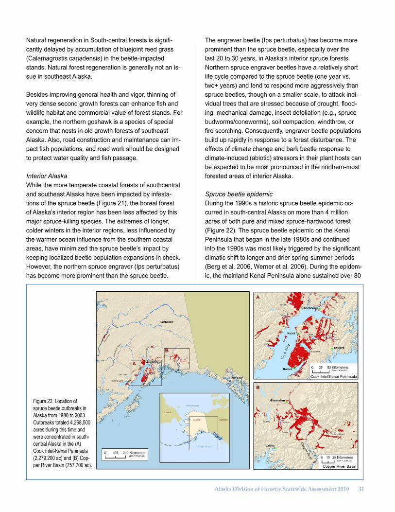
Alaska Division of Forestry Statewide Assessment 2010 �1
Natural regeneration in South-central forests is signifi-cantly delayed by accumulation of bluejoint reed grass (Calamagrostis canadensis) in the beetle-impacted stands. Natural forest regeneration is generally not an is-sue in southeast Alaska.
Besides improving general health and vigor, thinning of very dense second growth forests can enhance fish and wildlife habitat and commercial value of forest stands. For example, the northern goshawk is a species of special concern that nests in old growth forests of southeast Alaska. Also, road construction and maintenance can im-pact fish populations, and road work should be designed to protect water quality and fish passage.
Interior Alaska While the more temperate coastal forests of southcentral and southeast Alaska have been impacted by infesta-tions of the spruce beetle (Figure 21), the boreal forest of Alaska’s interior region has been less affected by this major spruce-killing species. The extremes of longer, colder winters in the interior regions, less influenced by the warmer ocean influence from the southern coastal areas, have minimized the spruce beetle’s impact by keeping localized beetle population expansions in check. However, the northern spruce engraver (Ips perturbatus) has become more prominent than the spruce beetle.
The engraver beetle (Ips perturbatus) has become more prominent than the spruce beetle, especially over the last 20 to 30 years, in Alaska’s interior spruce forests. Northern spruce engraver beetles have a relatively short life cycle compared to the spruce beetle (one year vs. two+ years) and tend to respond more aggressively than spruce beetles, though on a smaller scale, to attack indi-vidual trees that are stressed because of drought, flood-ing, mechanical damage, insect defoliation (e.g., spruce budworms/coneworms), soil compaction, windthrow, or fire scorching. Consequently, engraver beetle populations build up rapidly in response to a forest disturbance. The effects of climate change and bark beetle response to climate-induced (abiotic) stressors in their plant hosts can be expected to be most pronounced in the northern-most forested areas of interior Alaska.
Spruce beetle epidemic During the 1990s a historic spruce beetle epidemic oc-curred in south-central Alaska on more than 4 million acres of both pure and mixed spruce-hardwood forest (Figure 22). The spruce beetle epidemic on the Kenai Peninsula that began in the late 1980s and continued into the 1990s was most likely triggered by the significant climatic shift to longer and drier spring-summer periods (Berg et al. 2006, Werner et al. 2006). During the epidem-ic, the mainland Kenai Peninsula alone sustained over 80
Figure 22. Location of spruce beetle outbreaks in Alaska from 1980 to 2003. Outbreaks totaled 4,268,500 acres during this time and were concentrated in south-central Alaska in the (A) Cook Inlet-Kenai Peninsula (2,279,200 ac) and (B) Cop-per River Basin (757,700 ac).

�2 Alaska Division of Forestry Statewide Assessment 2010
percent beetle-caused mortality on approximately 1 million acres of mature spruce forest. Spruce beetle mortality was also extensive in the Copper River Valley between Valdez and Glennallen, including areas of the 1920s outbreak that had mature spruce trees again susceptible to beetle attack. The Haines State Forest in northern southeast Alaska also sustained a spruce beetle outbreak during this period.
Given the extent and magnitude of the south-central and northern southeast Alaska spruce beetle outbreaks and the absence of an existing infrastructure to harvest the mostly inaccessible, damaged trees (especially in South-central), approximately 12 percent of the beetle-killed spruce were salvaged, mostly for pulp and chips that were exported to Japan and Asian markets. Spruce beetle-kill salvaged from the Haines outbreak in southeast Alaska was used for pulp and some dimensional lumber products at then existing local mills.
Knowledge gained by studies conducted after the epidem-ic helped to explain root causes for these insect epidem-ics. Warmer temperatures increase overwinter survival and shorter maturation rates of beetles, thus, increasing the potential for epidemics (Berg et al. 2006). In addi-tion, increased summer temperatures can cause drought stress in trees, favoring successful beetle attacks, and it shifts beetle generation times to a shorter and more com-
pressed bark beetle brood development period (Werner and Holsten 1985). So, the changing climate may have impacted beetle outbreaks, which increased the abun-dance of dead fuel, which in turn may have influenced fire behavior and its effects (Berg and Anderson 2006). Hu-man influences in the wildland urban interface impacted both fire ignition and fire extent through active suppres-sion. Fire effects will interact with natural regeneration, plant competition, and climate to determine the future path of succession.
Changes in spruce beetle activity trends are most easily illustrated from the Kenai Peninsula spruce beetle epi-demic, which expanded from approximately 40,000 acres mapped in 1989 to over 1 million acres of cumulative beetle activity as of the 1997 aerial surveys. The Kenai Peninsula region of south-central Alaska has seen the most dramatic increases in bark beetle mortality during the past 50 years. An illustration of the rapid expansion of this outbreak is seen in a comparative beetle activity map prepared during the peak of the 1990s spruce beetle epidemic. The map depiction below (Figure 23) illustratesthe expansion of new and ongoing beetle activity in rela-tion to older (brown/gray) beetle activity as a means to illustrate graphically the expanding bark beetle epidemic in relation to cumulative forest damaged. Another way to compare and contrast local pest activity trends and forest effects across larger geographic areas (in this case Kenai
Figure 23. Spruce beetle activity on the western Kenai Peninsula mapped from USFS/AKDOF annual Aerial Detection surveys during the peak of the 1990s epi-demic (1993-1998). Areas of cumulative older mortality (brown areas) contained no significant, observable new beetle activity, for each respective survey year during this 6-year period.
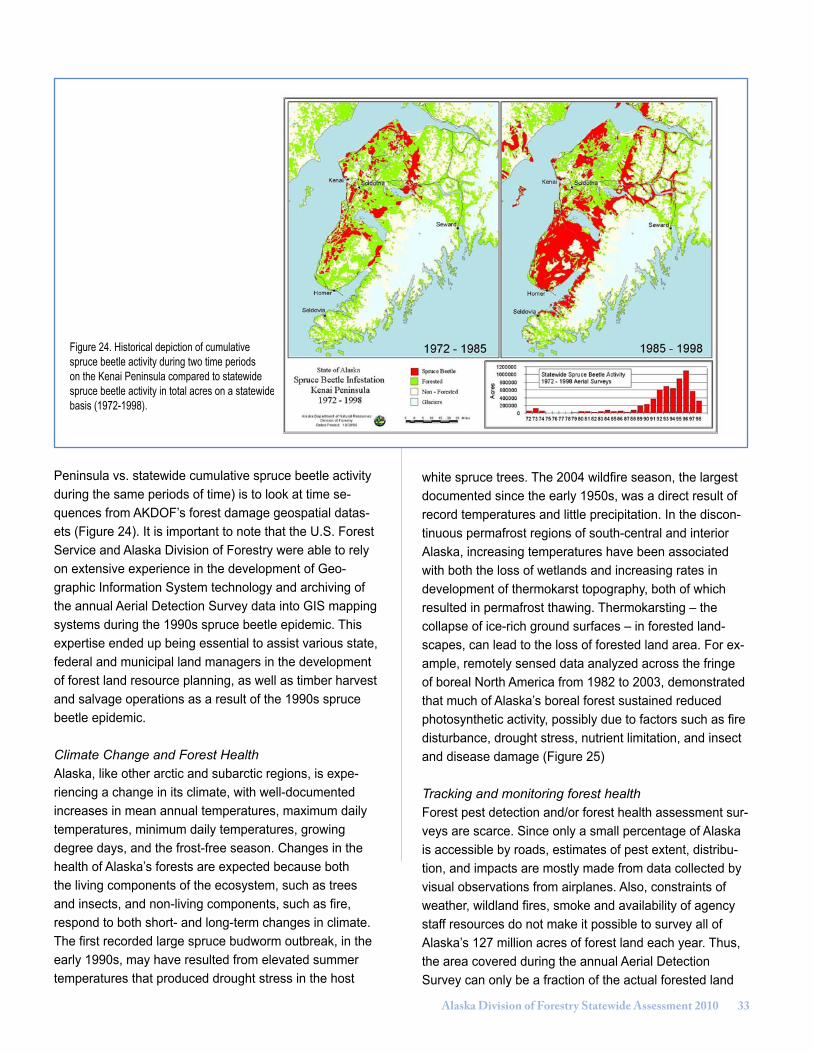
Alaska Division of Forestry Statewide Assessment 2010 ��
Figure 24. Historical depiction of cumulative spruce beetle activity during two time periods on the Kenai Peninsula compared to statewide spruce beetle activity in total acres on a statewide basis (1972-1998).
Peninsula vs. statewide cumulative spruce beetle activity during the same periods of time) is to look at time se-quences from AKDOF’s forest damage geospatial datas-ets (Figure 24). It is important to note that the U.S. Forest Service and Alaska Division of Forestry were able to rely on extensive experience in the development of Geo-graphic Information System technology and archiving of the annual Aerial Detection Survey data into GIS mapping systems during the 1990s spruce beetle epidemic. This expertise ended up being essential to assist various state, federal and municipal land managers in the development of forest land resource planning, as well as timber harvest and salvage operations as a result of the 1990s spruce beetle epidemic.
Climate Change and Forest HealthAlaska, like other arctic and subarctic regions, is expe-riencing a change in its climate, with well-documented increases in mean annual temperatures, maximum daily temperatures, minimum daily temperatures, growing degree days, and the frost-free season. Changes in the health of Alaska’s forests are expected because both the living components of the ecosystem, such as trees and insects, and non-living components, such as fire, respond to both short- and long-term changes in climate. The first recorded large spruce budworm outbreak, in the early 1990s, may have resulted from elevated summer temperatures that produced drought stress in the host
white spruce trees. The 2004 wildfire season, the largest documented since the early 1950s, was a direct result of record temperatures and little precipitation. In the discon-tinuous permafrost regions of south-central and interior Alaska, increasing temperatures have been associated with both the loss of wetlands and increasing rates in development of thermokarst topography, both of which resulted in permafrost thawing. Thermokarsting – the collapse of ice-rich ground surfaces – in forested land-scapes, can lead to the loss of forested land area. For ex-ample, remotely sensed data analyzed across the fringe of boreal North America from 1982 to 2003, demonstrated that much of Alaska’s boreal forest sustained reduced photosynthetic activity, possibly due to factors such as fire disturbance, drought stress, nutrient limitation, and insect and disease damage (Figure 25) Tracking and monitoring forest health Forest pest detection and/or forest health assessment sur-veys are scarce. Since only a small percentage of Alaska is accessible by roads, estimates of pest extent, distribu-tion, and impacts are mostly made from data collected by visual observations from airplanes. Also, constraints of weather, wildland fires, smoke and availability of agency staff resources do not make it possible to survey all of Alaska’s 127 million acres of forest land each year. Thus, the area covered during the annual Aerial Detection Survey can only be a fraction of the actual forested land
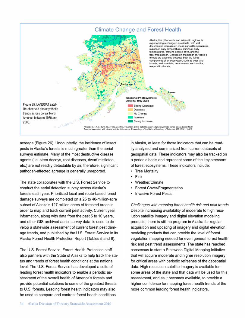
�� Alaska Division of Forestry Statewide Assessment 2010
acreage (Figure 26). Undoubtedly, the incidence of insect pests in Alaska’s forests is much greater than the aerial surveys estimate. Many of the most destructive disease agents (i.e. stem decays, root diseases, dwarf mistletoe, etc.) are not readily detectable by air, therefore, significant pathogen-affected acreage is generally unreported.
The state collaborates with the U.S. Forest Service to conduct the aerial detection survey across Alaska’s forests each year. Prioritized local and route-based forest damage surveys are completed on a 25 to 40-million-acre subset of Alaska’s 127 million acres of forested areas in order to map and track current pest activity. Current year information, along with data from the past 5 to 10 years, and other GIS-archived aerial survey data, is used to de-velop a statewide assessment of current forest pest dam-age trends, and published by the U.S. Forest Service in its Alaska Forest Health Protection Report (Tables 5 and 6). The U.S. Forest Service, Forest Health Protection staff also partners with the State of Alaska to help track the sta-tus and trends of forest health conditions at the national level. The U.S. Forest Service has developed a suite of leading forest health indicators to enable a periodic as-sessment of the overall health of America’s forests and provide potential solutions to some of the greatest threats to U.S. forests. Leading forest health indicators may also be used to compare and contrast forest health conditions
in Alaska, at least for those indicators that can be read-ily analyzed and summarized from current datasets of geospatial data. These indicators may also be tracked on a periodic basis and represent some of the key stressors of forest ecosystems. These indicators include:• Tree Mortality• Fire• Weather/Climate• Forest Cover/Fragmentation• Invasive Forest Pests
Challenges with mapping forest health risk and pest trends Despite increasing availability of moderate to high reso-lution satellite imagery and digital elevation modeling products, there is still no program in Alaska for regular acquisition and updating of imagery and digital elevation modeling products that can provide the level of forest vegetation mapping needed for even general forest health risk and pest trend assessments. The state has reached consensus to start a Statewide Digital Mapping Initiative that will acquire moderate and higher resolution imagery for critical areas with periodic refreshes of the geospatial data. High resolution satellite imagery is available for some areas of the state and that data will be used for this assessment, and as it becomes available, to provide a higher confidence for mapping forest health trends of the more common leading forest health indicators.
Figure 25. LANDSAT satel-lite-observed photosynthetic trends across boreal North America between 1980 and 2003.
Climate Change and Forest Health
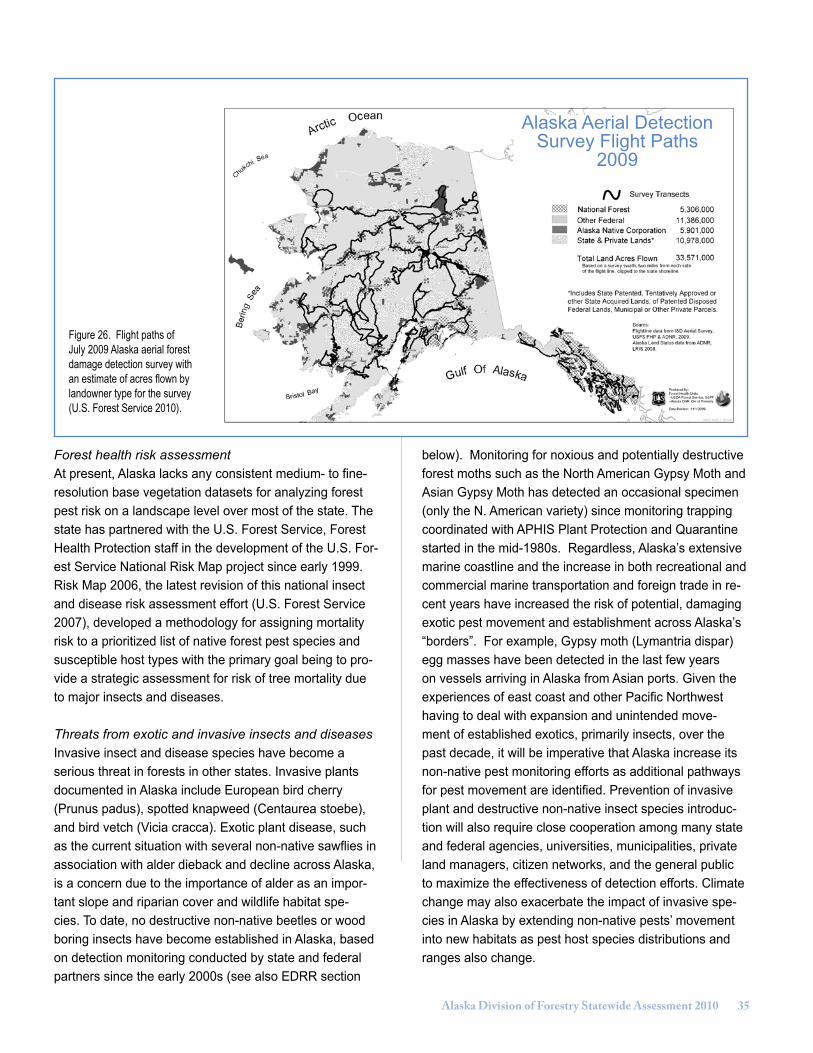
Alaska Division of Forestry Statewide Assessment 2010 ��
Figure 26. Flight paths of July 2009 Alaska aerial forest damage detection survey with an estimate of acres flown by landowner type for the survey (U.S. Forest Service 2010).
Forest health risk assessmentAt present, Alaska lacks any consistent medium- to fine-resolution base vegetation datasets for analyzing forest pest risk on a landscape level over most of the state. The state has partnered with the U.S. Forest Service, Forest Health Protection staff in the development of the U.S. For-est Service National Risk Map project since early 1999. Risk Map 2006, the latest revision of this national insect and disease risk assessment effort (U.S. Forest Service 2007), developed a methodology for assigning mortality risk to a prioritized list of native forest pest species and susceptible host types with the primary goal being to pro-vide a strategic assessment for risk of tree mortality due to major insects and diseases.
Threats from exotic and invasive insects and diseasesInvasive insect and disease species have become a serious threat in forests in other states. Invasive plants documented in Alaska include European bird cherry (Prunus padus), spotted knapweed (Centaurea stoebe), and bird vetch (Vicia cracca). Exotic plant disease, such as the current situation with several non-native sawflies in association with alder dieback and decline across Alaska, is a concern due to the importance of alder as an impor-tant slope and riparian cover and wildlife habitat spe-cies. To date, no destructive non-native beetles or wood boring insects have become established in Alaska, based on detection monitoring conducted by state and federal partners since the early 2000s (see also EDRR section
below). Monitoring for noxious and potentially destructive forest moths such as the North American Gypsy Moth and Asian Gypsy Moth has detected an occasional specimen (only the N. American variety) since monitoring trapping coordinated with APHIS Plant Protection and Quarantine started in the mid-1980s. Regardless, Alaska’s extensive marine coastline and the increase in both recreational and commercial marine transportation and foreign trade in re-cent years have increased the risk of potential, damaging exotic pest movement and establishment across Alaska’s “borders”. For example, Gypsy moth (Lymantria dispar) egg masses have been detected in the last few years on vessels arriving in Alaska from Asian ports. Given the experiences of east coast and other Pacific Northwest having to deal with expansion and unintended move-ment of established exotics, primarily insects, over the past decade, it will be imperative that Alaska increase its non-native pest monitoring efforts as additional pathways for pest movement are identified. Prevention of invasive plant and destructive non-native insect species introduc-tion will also require close cooperation among many state and federal agencies, universities, municipalities, private land managers, citizen networks, and the general public to maximize the effectiveness of detection efforts. Climate change may also exacerbate the impact of invasive spe-cies in Alaska by extending non-native pests’ movement into new habitats as pest host species distributions and ranges also change.
Alaska Aerial Detection Survey Flight Paths
2009

�� Alaska Division of Forestry Statewide Assessment 2010
2009 forest insect and disease activity as detected during the annual Alaska aerial detection survey
by land ownership1
and agent.2
All values are in acres.3
National Forest
Native Other Federal
State & Private
Total
Alder defoliation4 1,208 2,202 3,410
Alder mortality 207 319 791 1,317
Aspen Leaf Miner 67,680 106,363 136,558 310,601
Black-headed budworm 535 593 1,128
Cedar decline faders 15,626 174 12 485 16,297
Cottonwood defoliation4 325 2,758 5,730 2,338 11,152
Flooding/high-water damage 106 138 802 301 1,346
Hemlock sawfly 2,539 35 981 3,555
IPS and SPB5 4,407 739 1,451 6,596
Ips engraver beetle 9,226 18,865 3,581 31,673
Landslide/Avalanche 426 20 447
Porcupine damage 792 14 146 952
Spear-marked black moth 13,913 251 146 14,310
Spruce beetle 210 28,502 45,855 26,075 100,642
Spruce/Larch budmoth 694 20 12,485 13,199
unknown hemlock mortality 1,916 220 2,136
Willow defoliation6 54,142 66,777 120,920
1 Ownership derived from 2008 version of Land Status GIS coverage, State of Alaska, DNR/Land records Information Section. State & private lands include: state patented, tentatively approved, or other state acquired lands, and of patented disposed federal lands, municipal, or other private parcels.2 Acre values are only relative to survey transects and do not represent the total possible area affected. Table entries do not include many of the most destructive diseases (e.g., wood decays and dwarf mistletoe) which are not detectable in aerial surveys. Damage acres from animals and abiotic agents are also not shown in this table.3 Aerial forest damage survey is not 100% of all forested land in Alaska. Acreage represents only areas flown during July 2009 (approx. 25%-30% of the total forested area of Alaska).4 Significant contributors include leaf miners and leaf rollers for the respective host. Drought stress also directly caused reduced foliation or premature foliage loss.
5 These acreage values are the cumulative effect of IPS engraver beetle (Ips perturbatus) and spruce beetle (Dendroctonus rufipennis) working in tandem on the same stands of trees.6 Acres recorded for willow defoliation are primarily from leaf miners. The affected acreage is much more extensive then can be mapped.
Table 5. Forest insect and disease activity mapped from the 2009 cooperative U.S. Forest Service/Alaska DOF statewide Aerial Detection Survey.
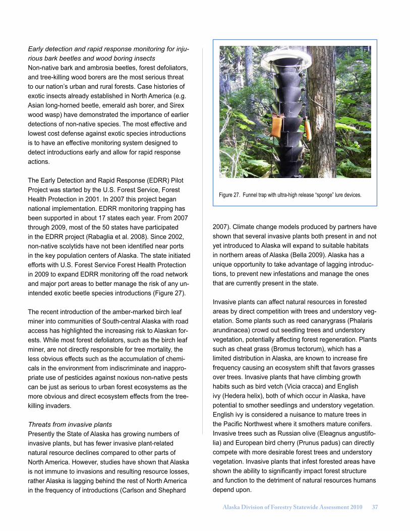
Alaska Division of Forestry Statewide Assessment 2010 ��
Early detection and rapid response monitoring for inju-rious bark beetles and wood boring insects Non-native bark and ambrosia beetles, forest defoliators, and tree-killing wood borers are the most serious threat to our nation’s urban and rural forests. Case histories of exotic insects already established in North America (e.g. Asian long-horned beetle, emerald ash borer, and Sirex wood wasp) have demonstrated the importance of earlier detections of non-native species. The most effective and lowest cost defense against exotic species introductions is to have an effective monitoring system designed to detect introductions early and allow for rapid response actions.
The Early Detection and Rapid Response (EDRR) Pilot Project was started by the U.S. Forest Service, Forest Health Protection in 2001. In 2007 this project began national implementation. EDRR monitoring trapping has been supported in about 17 states each year. From 2007 through 2009, most of the 50 states have participated in the EDRR project (Rabaglia et al. 2008). Since 2002, non-native scolytids have not been identified near ports in the key population centers of Alaska. The state initiated efforts with U.S. Forest Service Forest Health Protection in 2009 to expand EDRR monitoring off the road network and major port areas to better manage the risk of any un-intended exotic beetle species introductions (Figure 27).
The recent introduction of the amber-marked birch leaf miner into communities of South-central Alaska with road access has highlighted the increasing risk to Alaskan for-ests. While most forest defoliators, such as the birch leaf miner, are not directly responsible for tree mortality, the less obvious effects such as the accumulation of chemi-cals in the environment from indiscriminate and inappro-priate use of pesticides against noxious non-native pests can be just as serious to urban forest ecosystems as the more obvious and direct ecosystem effects from the tree-killing invaders.
Threats from invasive plantsPresently the State of Alaska has growing numbers of invasive plants, but has fewer invasive plant-related natural resource declines compared to other parts of North America. However, studies have shown that Alaska is not immune to invasions and resulting resource losses, rather Alaska is lagging behind the rest of North America in the frequency of introductions (Carlson and Shephard
Figure 27. Funnel trap with ultra-high release “sponge” lure devices.
2007). Climate change models produced by partners have shown that several invasive plants both present in and not yet introduced to Alaska will expand to suitable habitats in northern areas of Alaska (Bella 2009). Alaska has a unique opportunity to take advantage of lagging introduc-tions, to prevent new infestations and manage the ones that are currently present in the state.
Invasive plants can affect natural resources in forested areas by direct competition with trees and understory veg-etation. Some plants such as reed canarygrass (Phalaris arundinacea) crowd out seedling trees and understory vegetation, potentially affecting forest regeneration. Plants such as cheat grass (Bromus tectorum), which has a limited distribution in Alaska, are known to increase fire frequency causing an ecosystem shift that favors grasses over trees. Invasive plants that have climbing growth habits such as bird vetch (Vicia cracca) and English ivy (Hedera helix), both of which occur in Alaska, have potential to smother seedlings and understory vegetation. English ivy is considered a nuisance to mature trees in the Pacific Northwest where it smothers mature conifers. Invasive trees such as Russian olive (Eleagnus angustifo-lia) and European bird cherry (Prunus padus) can directly compete with more desirable forest trees and understory vegetation. Invasive plants that infest forested areas have shown the ability to significantly impact forest structure and function to the detriment of natural resources humans depend upon.

�� Alaska Division of Forestry Statewide Assessment 2010
Comparative area of forest insect and disease activity as determined from the Alaska statewide aerial detection survey (in thousands of acres) for each host group and damage type over the six years prior to 2009; and a 10-year (2000-2009) cumulative sum.
1 Summaries identify damage, mostly from insect agents. Foliar disease agents contribute to the spruce defoliation and hemlock mortality totals. Damage agents such as fire, wind, flooding, slides and animal damage are not included. 2 The same stand can sustain active infestation for several years. The cumulative total is a union of all areas from 2000through 2009 and does not double-count acres.
Host Group / 2003 2004 2005 2006 2007 2008 2009 Ten Year
Damage Type1 Cumulative2
Alder Defoliation 2.8 10.5 17.3 10.6 10.0 0.7 3.4 61.0
Aspen Defoliation 351.4 591.5 678.9 509.5 796.0 219.7 310.8 3,097.3
Birch Defoliation 217.5 163.9 47.5 13.2 1.5 0.1 14.3 463.8
Cottonwood Defoliation 13.1 16.7 8 24.6 11.5 13.2 11.2 121.5
Hemlock Defoliation 0.2 0.5 0.2 0 0.1 0.1 3.6 12.0
Hemlock Mortality 0 0 0.1 0 0.0 2.0 2.1 4.5
Larch Defoliation 0.6 14.2 16.8 2.7 0.1 0.2 0.1 117.2
Larch Mortality 22.5 11.8 0 0 0.0 0.2 0.1 39.5
Spruce Defoliation 61.5 93.4 31.9 68.1 41.9 6.9 0.8 429.7
Spruce Mortality 92.8 145.2 93.8 130.6 183.9 129.1 138.9 1,006.4
Spruce/Hemlock Defoliation
15.1 1.5 1.4 1.5 10.3 2.8 1.1 82.2
Spruce/Larch Defoliation
0.3 0 0.3 2.8 0.0 0.0 13.2 16.6
Sub Alpine Fir Mortality 0 0.2 0.8 0.5 0.1 0.0 0.0 1.7
Willow Defoliation 83.9 111.2 44.5 50.7 92.7 76.8 139.7 608.6
Total damage acres -thousands
861.7 1,160.5 941.5 814.8 1148.1 451.8 639.3 6,062.0
Total acres surveyed 25,588 36,343 39,206 32,991 38,365 36,402 33,571
Percent of acres surveyed showing damage
3.4 3.2 2.4 2.5 3.0 1.2 1.9
Table 6. Affected forest damage for each forest plant host group and damage agent mapped during the 2009 Alaska statewide Aerial Detection Survey.

Alaska Division of Forestry Statewide Assessment 2010 ��
Several invasive plants that have a long history of in-troduction to Alaska are showing their potential to affect forest related resources and key ecosystems. Narrowleaf hawksbeard (Crepis tectorum) and white sweetclover (Melilotus officinalis formerly M. alba), were discovered spreading to forested landscapes after fires had spread through the area (Cortes-Burns et al. 2008, Villano 2008). White sweetclover is presently spreading from roadside river crossings to glacially fed streams where it is impact-ing recruitment of species important to wildlife, such as willows, in early successional flood plain habitats (Spell-man 2008). Reed canarygrass, a notorious ecosystem changer capable of preventing establishment of woody vegetation and hindering restoration activities has a long history of introductions in Alaska. During stream surveys, Reed canarygrass infestations were discovered in several salmon bearing streams on the Kenai Peninsula, where it has potential to impact salmon habitat (Figure 28). Invasive woody plants are on the rise in Alaska, including European bird cherry, which is found throughout urban forests and riparian areas in the Anchorage Bowl and in
Figure 28. Reed canarygrass (Phalaris arundinacea) infestations on the North Fork of the Anchor River a salmon bearing stream located on the Kenai Peninsula, Alaska. Reed canarygrass is an invader that has proven problematic to land managers involved in habitat management and restoration, primarily for salmon. Map Courtesy of Spellman, 2009.
Table 7. A subset of plants that are known in Alaska to invade natural areas, and a subset of invasive plants that are present in Alaska, but are confined to the human footprint. *Ranks are for relative invasiveness from 0-100 where 100 is most invasive. Ranks come from system developed for invasive plants in Alaska (Carlson et al. 2008).
Invading natural area Rank* Confined to human footprint Rank*Reed canarygrass, Phalaris arundinacea
83 Spotted knapweed, Centaurea stoebe
86
Narrow leaved hawkweed, Hi-eracium umbellatum
54 Japanese knotweed, Polygonum cuspidatum
87
Orange hawkweed, Hieracium aurantiacum
79 Garlic mustard, Alliaria petiolata 70
White sweetclover, Melilotus of-ficinalis (formerly alba)
81 Yellow toadflax, Linaria vulgaris 61
European bird cherry, Prunus padus
74 Scotchbroom, Cytisus scoparius 69
Bird vetch, Vicia cracca 73 Himalayan blackberry, Rubus amerianus
77
Purple loosestrife, Lythrum salicaria
83 Canada thistle, Cirsium arvense 76
Narrowleaf hawksbeard, Crepis tectorum
54 Perrenial sowthistle, Sonchus arvense
72

�0 Alaska Division of Forestry Statewide Assessment 2010
Fairbanks. Numerous other highly invasive plants are present in Alaska, however, are predominately infesting roadsides urban areas and other places within the human footprint (Table 7).
Analysis of spreading invasive plants in Alaska leads to identification of urban areas, roadsides, and recent burns as key areas to prevent impacts from invasive plants to for-ested areas and key ecosystems. Urban areas such as An-chorage, Fairbanks, the Matanuska-Susitna Valley, Juneau, and Ketchikan are hot spots for introductions. These areas host some of the largest densities and diversity of invasive plants in Alaska. Some of these urban hot spots host inva-sive plants such as garlic mustard (Alliaria petiolata),
Scotchbroom (Cytisus scoparious), and spotted knap-weed (Centaurea stoebe) that are new invaders to the state with great potential to affect forest resources. These urban areas with large infestations of Japanese knotweed (Polygonum cuspidatum), European bird cherry and Siberian pea shrub (Caragana arborescens) demonstrate the potential for these plants to spread to natural areas. Rapidly expanding urban areas provide the increased propagule pressure necessary to accelerate the spread of invasive plants to natural areas and along roadsides to rural areas of Alaska.
Roadsides represent key corridors of invasive plant move-ment that are continuously disturbed through construction and maintenance activities. Inventory results for invasive plants in Alaska depict the use of roads as corridors for invasive plant movement (Figure 29). Further, the evi-dence from numerous studies and surveys indicates that forested areas are threatened by invasive plants spread-ing from roadsides to natural areas (Villano 2008, Cor-tes-Burns 2008, Spellman 2008). Implementing invasive plant control and best management practices to prevent introduction and spread of invasive plants during roadside maintenance, construction, and plant management activi-ties are considered high priority activities to reduce threats to forest health from invasive plants. Roads are areas that cross streams, wetlands and other water bodies are of particular concern. Areas of high susceptibility to forest fires present another priority for invasive plant management. The source of invasive plants that will spread to recently burned areas is primarily from roadside infestations (Villano 2008, Cortes-Burns 2008). Preventing impacts from invasive plants to
burned areas involves ensuring that roadside infestations of species capable of long distance dispersal via wind or other vectors are managed. Narrowleaf hawksbeard has proven its ability to move from roadsides into burned areas (Villano 2008). Of possibly more concern are highly invasive species with similar methods of dispersal that are increasing in numbers along roadsides (e.g. orange hawkweed, Hieracium aurantiacum, perennial sowthistle, Sonchus arvensis, and Canada thistle, Cirsium arvense).
Management plans for invasive plants are being devel-oped at both the statewide and local levels. The Division of Agriculture is nearing completion of Alaska’s first inva-sive plant management plan which will identify priorities for prevention, management, research, education and early detection and rapid response activities. At the local level, strategic management plans are being developed by Cooperative Weed Management Areas (CWMA). Some CWMA groups, such as the Kenai Peninsula CWMA have already developed their management plans and are in the process of implementing them (http://www.homerswcd.org/invasives/FINCWMAStrategy120107.pdf). Other CWMA groups located in Juneau, Anchorage, and Kodiak Island are presently working to create management plans. The University of Alaska Fairbanks and the Municipality of An-chorage are developing their own long-term invasive plant management plans. Working with established management plans and continuing to support the establishment of new management plans will increase partnering and enhance efforts to manage infestations in priority areas.
Continuing efforts to engage the public and connect them to the forests that surround them is a key priority to inva-sive plant prevention and management. As noted earlier, urban areas are hot spots for invasive plants in the state, a status that in part is due to increased purposeful and accidental introductions from private landowners. Ongo-ing deliberate introductions of invasive plants may include species such as Japanese knotweed and European bird cherry. Accidental introductions most often include species such as Canada thistle, and perennial sowthistle that may contaminate potting soils, ornamental plants, or imported hay and straw. Educating the public about the connection between their managed landscape and forested land-scapes is a priority that helps the public make the connec-tion between their actions and consequences to natural ar-eas. This knowledge allows us to educate the public about ways to avoid accidental introductions and alternatives to ornamentals that are purposely introduced. Engaging the

Alaska Division of Forestry Statewide Assessment 2010 �1
public is an ongoing priority to help prevent the accidental and deliberate introductions of invasive plants.
Ongoing invasive plant management projects are primar-ily undertaken by Division of Forestry partners including the Division of Agriculture and the Soil and Water Con-servation Districts (SWCD), federal agencies and other conservation groups. SWCDs in Alaska led in the forma-tion of CWMA groups throughout the state. Consequently SWCDs are the primary local coordinating bodies and typically implement education and control work in the areas they work. The Division of Agriculture has several active projects it is working on in relation to invasive plants including: Spotted knapweed, Centaurea stoebe, eradica-tion; Canada thistle management in Anchorage; working with horticulture businesses in Alaska to prevent introduc-tions and foster cooperation; inventory of gravel pits for in-vasive plants. As the invasive plant management programs of the Division of Agriculture and SWCDs grow, priorities for forest health protection in Alaska will be addressed.
Urban and Community ForestsCommunity forests are the trees and other vegetation in a
Figure 29. Invasive plant infestations recorded in Alaska, as of 2008, prioritized by a ranking system developed for invasive plants in Alaska (Carlson 2008). Notice the clear example of infestations following roads throughout Alaska. Map courtesy of Bella 2009.
village, town, or city. They include trees along streets and streams, in parks and cemeteries, on school grounds, and around homes and businesses - anywhere trees grow in and around a community of any size.
ConditionsAlaska is home to 686,000 people and more than 60 percent live in towns with populations above 5,000. More than half of the population lives in the Municipality of Anchorage or the Matanuska-Susitna Borough. Trees in communities require extra care to be healthy, beautiful, and safe but they reward this effort by providing many economic, environmental, and social benefits to residents and visitors.
A healthy community forest doesn’t happen by chance; it is the result of planning, management, and commu-nity investment. The planning begins with the collection of data on the condition of the forest, which is used to develop long-term management plans and annual work plans. Inventories and plans allow communities to iden-tify and reduce threats to forest and ecosystem health. Professional management helps communities maximize
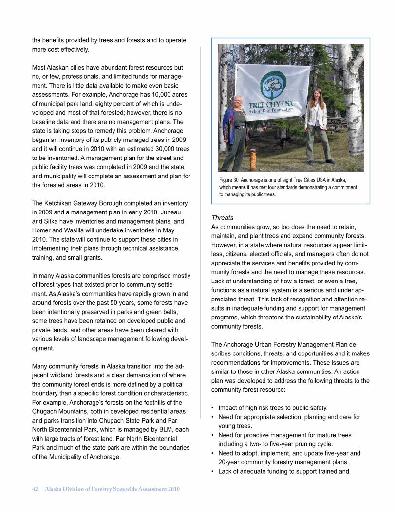
�2 Alaska Division of Forestry Statewide Assessment 2010
the benefits provided by trees and forests and to operate more cost effectively.
Most Alaskan cities have abundant forest resources but no, or few, professionals, and limited funds for manage-ment. There is little data available to make even basic assessments. For example, Anchorage has 10,000 acres of municipal park land, eighty percent of which is unde-veloped and most of that forested; however, there is no baseline data and there are no management plans. The state is taking steps to remedy this problem. Anchorage began an inventory of its publicly managed trees in 2009 and it will continue in 2010 with an estimated 30,000 trees to be inventoried. A management plan for the street and public facility trees was completed in 2009 and the state and municipality will complete an assessment and plan for the forested areas in 2010.
The Ketchikan Gateway Borough completed an inventory in 2009 and a management plan in early 2010. Juneau and Sitka have inventories and management plans, and Homer and Wasilla will undertake inventories in May 2010. The state will continue to support these cities in implementing their plans through technical assistance, training, and small grants.
In many Alaska communities forests are comprised mostly of forest types that existed prior to community settle-ment. As Alaska’s communities have rapidly grown in and around forests over the past 50 years, some forests have been intentionally preserved in parks and green belts, some trees have been retained on developed public and private lands, and other areas have been cleared with various levels of landscape management following devel-opment.
Many community forests in Alaska transition into the ad-jacent wildland forests and a clear demarcation of where the community forest ends is more defined by a political boundary than a specific forest condition or characteristic. For example, Anchorage’s forests on the foothills of the Chugach Mountains, both in developed residential areas and parks transition into Chugach State Park and Far North Bicentennial Park, which is managed by BLM, each with large tracts of forest land. Far North Bicentennial Park and much of the state park are within the boundaries of the Municipality of Anchorage.
ThreatsAs communities grow, so too does the need to retain, maintain, and plant trees and expand community forests. However, in a state where natural resources appear limit-less, citizens, elected officials, and managers often do not appreciate the services and benefits provided by com-munity forests and the need to manage these resources. Lack of understanding of how a forest, or even a tree, functions as a natural system is a serious and under ap-preciated threat. This lack of recognition and attention re-sults in inadequate funding and support for management programs, which threatens the sustainability of Alaska’s community forests.
The Anchorage Urban Forestry Management Plan de-scribes conditions, threats, and opportunities and it makes recommendations for improvements. These issues are similar to those in other Alaska communities. An action plan was developed to address the following threats to the community forest resource:
• Impact of high risk trees to public safety.• Need for appropriate selection, planting and care for young trees.• Need for proactive management for mature trees including a two- to five-year pruning cycle.• Need to adopt, implement, and update five-year and 20-year community forestry management plans.• Lack of adequate funding to support trained and
Figure 30 Anchorage is one of eight Tree Cities USA in Alaska, which means it has met four standards demonstrating a commitment to managing its public trees.
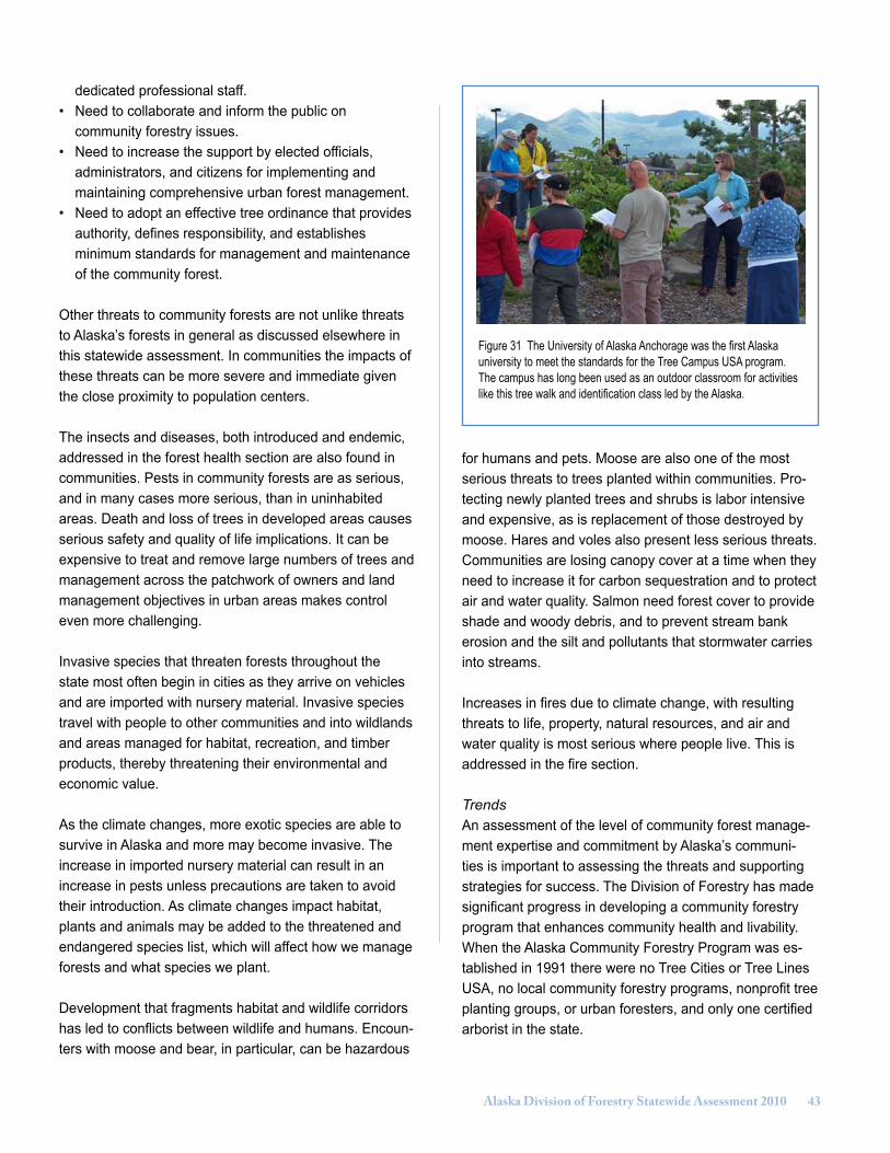
Alaska Division of Forestry Statewide Assessment 2010 ��
dedicated professional staff.• Need to collaborate and inform the public on community forestry issues.• Need to increase the support by elected officials, administrators, and citizens for implementing and maintaining comprehensive urban forest management.• Need to adopt an effective tree ordinance that provides authority, defines responsibility, and establishes minimum standards for management and maintenance of the community forest.
Other threats to community forests are not unlike threats to Alaska’s forests in general as discussed elsewhere in this statewide assessment. In communities the impacts of these threats can be more severe and immediate given the close proximity to population centers.
The insects and diseases, both introduced and endemic, addressed in the forest health section are also found in communities. Pests in community forests are as serious, and in many cases more serious, than in uninhabited areas. Death and loss of trees in developed areas causes serious safety and quality of life implications. It can be expensive to treat and remove large numbers of trees and management across the patchwork of owners and land management objectives in urban areas makes control even more challenging.
Invasive species that threaten forests throughout the state most often begin in cities as they arrive on vehicles and are imported with nursery material. Invasive species travel with people to other communities and into wildlands and areas managed for habitat, recreation, and timber products, thereby threatening their environmental and economic value.
As the climate changes, more exotic species are able to survive in Alaska and more may become invasive. The increase in imported nursery material can result in an increase in pests unless precautions are taken to avoid their introduction. As climate changes impact habitat, plants and animals may be added to the threatened and endangered species list, which will affect how we manage forests and what species we plant.
Development that fragments habitat and wildlife corridors has led to conflicts between wildlife and humans. Encoun-ters with moose and bear, in particular, can be hazardous
for humans and pets. Moose are also one of the most serious threats to trees planted within communities. Pro-tecting newly planted trees and shrubs is labor intensive and expensive, as is replacement of those destroyed by moose. Hares and voles also present less serious threats.Communities are losing canopy cover at a time when they need to increase it for carbon sequestration and to protect air and water quality. Salmon need forest cover to provide shade and woody debris, and to prevent stream bank erosion and the silt and pollutants that stormwater carries into streams.
Increases in fires due to climate change, with resulting threats to life, property, natural resources, and air and water quality is most serious where people live. This is addressed in the fire section.
TrendsAn assessment of the level of community forest manage-ment expertise and commitment by Alaska’s communi-ties is important to assessing the threats and supporting strategies for success. The Division of Forestry has made significant progress in developing a community forestry program that enhances community health and livability. When the Alaska Community Forestry Program was es-tablished in 1991 there were no Tree Cities or Tree Lines USA, no local community forestry programs, nonprofit tree planting groups, or urban foresters, and only one certified arborist in the state.
Figure 31 The University of Alaska Anchorage was the first Alaska university to meet the standards for the Tree Campus USA program. The campus has long been used as an outdoor classroom for activities like this tree walk and identification class led by the Alaska.

�� Alaska Division of Forestry Statewide Assessment 2010
By 2001, there were three Tree Cities USA in Alaska, and in 2009 the number had grown to eight - Eielson Air Force Base, Fort Wainwright, Fort Richardson, and the cities of Wasilla, Sitka, Juneau, Ketchikan Gateway Borough, and Anchorage. More than 80 percent of Alaskans live in communities that have taken steps toward developing a sustainable community forestry program.
The three major electric utilities serving communities, Golden Valley Electric Association, Matanuska Electric Association, and Chugach Electric Association are recog-nized as Tree Lines USA.
The number of arborists in Alaska certified by the Interna-tional Society of Arboriculture has grown from 1 in 1991 to 35 in 2009. Six communities now have arborists, forest-ers, or natural resource managers employed in their com-munity forestry programs. The Municipality of Anchorage hired the state’s first urban forester in November 2008. All these steps are the direct result of technical, educational, and financial assistance provided by the state and made possible by grants from the U.S. Forest Service.
The increasing level of management by cities is a notable trend in Alaska. Characteristics of communities managing their community forests are: • Active community tree and forest management plan developed from professionally-based resource assessments/inventories• Employ or retain through written agreement, the services of professional forestry staff that have a degree in forestry or related field and/or ISA arborist certification• Adopted local or statewide ordinances or policies that focus on planting, protecting, and maintaining community trees and forests;• Local advocacy/advisory organization such as active tree board or commissions, or non-profit organizations that are formalized or chartered to advise and /or advocate for the planting, protection, and maintenance of community trees and forests.
Alaska communities at the managing level:• Municipality of Anchorage• Eielson Air Force Base
• City & Borough of Sitka• City of Wasilla
Communities that are in the developing phase of man-agement have achieved at least one of the above four standards. Alaska communities at the developing level:• Fairbanks North Star Borough• City of Fairbanks• City & Borough of Juneau• Ketchikan Gateway Borough• City of Homer
Support for community forests is essential if communities are to ensure sustainable benefits from forests and trees in communities. A trend towards increased community support for community forestry is demonstrated by the level of citizen advocacy and/or advisory groups that are active in Alaska communities. The Juneau Urban Forestry Partnership, Sitka Tree & Landscape Committee, Anchor-age TREErific, and the Fairbanks Arbor Day Committee plant trees, provide information to the public, and support local government management efforts. Wasilla, Ketchi-kan Gateway Borough, Elmendorf and Eielson Air Force bases, and Fort Wainwright have advisory bodies that make recommendations to local government or military leaders.
On a statewide level the Alaska Community Forest Council helps determine goals and priorities of the state’s community forestry program and provides expertise and
Figure 32 Community Forestry Program staff provide technical as-sistance and training to local governments, agencies, and businesses. This class on tree planting and pruning was for facility managers at the Ted Stevens International Airport.
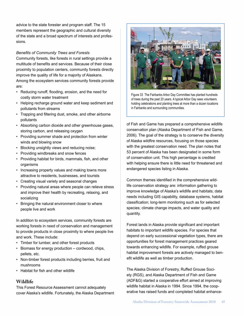
Alaska Division of Forestry Statewide Assessment 2010 ��
advice to the state forester and program staff. The 15 members represent the geographic and cultural diversity of the state and a broad spectrum of interests and profes-sions.
Benefits of Community Trees and ForestsCommunity forests, like forests in rural settings provide a multitude of benefits and services. Because of their close proximity to population centers, community forests directly improve the quality of life for a majority of Alaskans. Among the ecosystem services community forests provide are:• Reducing runoff, flooding, erosion, and the need for costly storm water treatment• Helping recharge ground water and keep sediment and pollutants from streams• Trapping and filtering dust, smoke, and other airborne pollutants• Absorbing carbon dioxide and other greenhouse gases, storing carbon, and releasing oxygen• Providing summer shade and protection from winter winds and blowing snow• Blocking unsightly views and reducing noise;• Providing windbreaks and snow fences• Providing habitat for birds, mammals, fish, and other organisms• Increasing property values and making towns more attractive to residents, businesses, and tourists• Creating visual variety and seasonal changes• Providing natural areas where people can relieve stress and improve their health by recreating, relaxing, and socializing• Bringing the natural environment closer to where people live and work
In addition to ecosystem services, community forests are working forests in need of conservation and management to provide products in close proximity to where people live and work. These include:• Timber for lumber, and other forest products• Biomass for energy production – cordwood, chips, pellets, etc.• Non-timber forest products including berries, fruit and mushrooms• Habitat for fish and other wildlife
WildlifeThis Forest Resource Assessment cannot adequately cover Alaska’s wildlife. Fortunately, the Alaska Department
of Fish and Game has prepared a comprehensive wildlife conservation plan (Alaska Department of Fish and Game, 2006). The goal of the strategy is to conserve the diversity of Alaska wildfire resources, focusing on those species with the greatest conservation need. The plan notes that 53 percent of Alaska has been designated in some form of conservation unit. This high percentage is credited with helping ensure there is little need for threatened and endangered species listing in Alaska.
Common themes identified in the comprehensive wild-life conservation strategy are: information gathering to improve knowledge of Alaska’s wildlife and habitats; data needs including GIS capability, database systems, habitat classification; long-term monitoring such as for selected species; climate change impacts, and water quality and quantity.
Forest lands in Alaska provide significant and important habitats to important wildlife species. For species that depend on early successional vegetation types, there are opportunities for forest management practices geared towards enhancing wildlife. For example, ruffed grouse habitat improvement forests are actively managed to ben-efit wildlife as well as timber production.
The Alaska Division of Forestry, Ruffed Grouse Soci-ety (RGS), and Alaska Department of Fish and Game (ADF&G) started a cooperative effort aimed at improving wildlife habitat in Alaska in 1994. Since 1994, the coop-erative has raised funds and completed habitat enhance-
Figure 33 The Fairbanks Arbor Day Committee has planted hundreds of trees during the past 20 years. A typical Arbor Day sees volunteers holding celebrations and planting trees at more than a dozen locations in Fairbanks and surrounding communities.
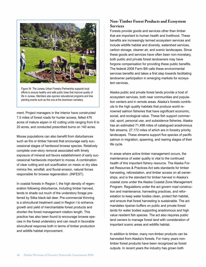
�� Alaska Division of Forestry Statewide Assessment 2010
Figure 34 The Juneau Urban Forestry Partnership supports local efforts to ensure healthy and safe public trees that improve quality of life in Juneau. Members also sponsor educational programs and tree planting events such as this one at the downtown cemetery.
ment. Project managers in the Interior have constructed 7.5 miles of forest roads for hunter access, felled 476 acres of mature aspen in 42 cutting units ranging from 6 to 20 acres, and conducted prescribed burns on 140 acres.
Moose populations can also benefit from disturbances such as fire or timber harvest that encourage early suc-cessional stages of hardwood browse species. Relatively complete over-story removal associated with timely exposure of mineral soil favors establishment of early suc-cessional hardwoods important to moose. A combination of clear cutting and soil scarification on mesic or dry sites mimics fire, windfall, and fluvial erosion, natural forces responsible for browse regeneration. (INFEST).
In coastal forests in Region I, the high density of regen-eration following disturbance, including timber harvest, tends to shade out much of the understory forage pre-ferred by Sitka black-tail deer. Pre-commercial thinning is a silvicultural treatment used in Region I to enhance growth and yield of merchantable forest products and shorten the forest management rotation length. This practice has also been found to encourage browse spe-cies in the forest understory and can result in favorable silvicultural response both in terms of timber production and wildlife habitat improvement.
Non-Timber Forest Products and Ecosystem ServicesForests provide goods and services other than timber that are important to human health and livelihood. These benefits are increasingly termed ecosystem services and include wildlife habitat and diversity, watershed services, carbon storage, cleaner air, and scenic landscapes. Since these goods and services have often been non-monetary, both public and private forest landowners may have forgone compensation for providing these public benefits. The federal 2008 Farm Bill calls these environmental services benefits and takes a first step towards facilitating landowner participation in emerging markets for ecosys-tem services.
Alaska public and private forest lands provide a host of ecosystem services, both near communities and popula-tion centers and in remote areas. Alaska’s forests contrib-ute to the high quality habitats that produce world re-nowned salmon fisheries that have significant economic, social, and ecological value. These fish support commer-cial, sport, personal use, and subsistence fisheries. Alaska has an estimated 71,498 miles of catalogued anadromous fish streams, 27,172 miles of which are in forestry priority landscapes. These streams support five species of pacific salmon in migration, spawning, and rearing stages of their life cycle.
In areas where active timber management occurs, the maintenance of water quality is vital to the continued health of this important fishery resource. The Alaska For-est Resources & Practices Act sets standards for timber harvesting, reforestation, and timber access on all owner-ships, and is the standard for timber harvest in Alaska’s coastal zone under the Alaska Coastal Zone Management Program. Regulations under the act govern road construc-tion and maintenance, harvesting practices, and refor-estation to keep water bodies clean, protect fish habitat, and ensure that forest harvesting is sustainable. The act mandates riparian buffers on public and private forest lands for water bodies supporting anadromous and high value resident fish species. The act also requires public land owners to manage forest land with consideration of important scenic areas and wildlife habitat.
In addition to timber, many non-timber products can be harvested from Alaska’s forests. For many years non-timber forest products have been recognized as forest outputs. In recent years the industry has grown both
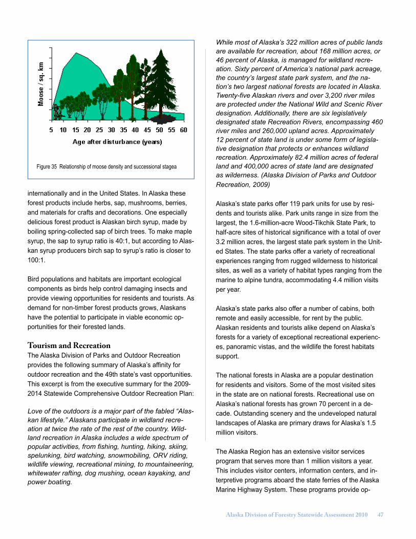
Alaska Division of Forestry Statewide Assessment 2010 ��
internationally and in the United States. In Alaska these forest products include herbs, sap, mushrooms, berries, and materials for crafts and decorations. One especially delicious forest product is Alaskan birch syrup, made by boiling spring-collected sap of birch trees. To make maple syrup, the sap to syrup ratio is 40:1, but according to Alas-kan syrup producers birch sap to syrup’s ratio is closer to 100:1.
Bird populations and habitats are important ecological components as birds help control damaging insects and provide viewing opportunities for residents and tourists. As demand for non-timber forest products grows, Alaskans have the potential to participate in viable economic op-portunities for their forested lands.
Tourism and RecreationThe Alaska Division of Parks and Outdoor Recreation provides the following summary of Alaska’s affinity for outdoor recreation and the 49th state’s vast opportunities. This excerpt is from the executive summary for the 2009-2014 Statewide Comprehensive Outdoor Recreation Plan:
Love of the outdoors is a major part of the fabled “Alas-kan lifestyle.” Alaskans participate in wildland recre-ation at twice the rate of the rest of the country. Wild-land recreation in Alaska includes a wide spectrum of popular activities, from fishing, hunting, hiking, skiing, spelunking, bird watching, snowmobiling, ORV riding, wildlife viewing, recreational mining, to mountaineering, whitewater rafting, dog mushing, ocean kayaking, and power boating.
While most of Alaska’s 322 million acres of public lands are available for recreation, about 168 million acres, or 46 percent of Alaska, is managed for wildland recre-ation. Sixty percent of America’s national park acreage, the country’s largest state park system, and the na-tion’s two largest national forests are located in Alaska. Twenty-five Alaskan rivers and over 3,200 river miles are protected under the National Wild and Scenic River designation. Additionally, there are six legislatively designated state Recreation Rivers, encompassing 460 river miles and 260,000 upland acres. Approximately 12 percent of state land is under some form of legisla-tive designation that protects or enhances wildland recreation. Approximately 82.4 million acres of federal land and 400,000 acres of state land are designated as wilderness. (Alaska Division of Parks and Outdoor Recreation, 2009)
Alaska’s state parks offer 119 park units for use by resi-dents and tourists alike. Park units range in size from the largest, the 1.6-million-acre Wood-Tikchik State Park, to half-acre sites of historical significance with a total of over 3.2 million acres, the largest state park system in the Unit-ed States. The state parks offer a variety of recreational experiences ranging from rugged wilderness to historical sites, as well as a variety of habitat types ranging from the marine to alpine tundra, accommodating 4.4 million visits per year.
Alaska’s state parks also offer a number of cabins, both remote and easily accessible, for rent by the public. Alaskan residents and tourists alike depend on Alaska’s forests for a variety of exceptional recreational experienc-es, panoramic vistas, and the wildlife the forest habitats support.
The national forests in Alaska are a popular destination for residents and visitors. Some of the most visited sites in the state are on national forests. Recreational use on Alaska’s national forests has grown 70 percent in a de-cade. Outstanding scenery and the undeveloped natural landscapes of Alaska are primary draws for Alaska’s 1.5 million visitors.
The Alaska Region has an extensive visitor services program that serves more than 1 million visitors a year. This includes visitor centers, information centers, and in-terpretive programs aboard the state ferries of the Alaska Marine Highway System. These programs provide op-
Figure 35 Relationship of moose density and successional stagea

�� Alaska Division of Forestry Statewide Assessment 2010
portunities to interpret national forest resources to Alaska residents and visitors. The U.S. Forest Service and the State of Alaska partner on many of these programs, such as the Southeast Alaska Discovery Center in Ketchikan and the resource interpretation program offered on the state ferries of southeast and south-central Alaska.
The Tongass and Chugach national forests offer 197 remote recreation cabins available for rent by the public. Cabins are located near good fishing, hunting, and terrific scenery. Renters need to hike, fly, or boat to reach the cabins. The forests also protect heritage resources. Alas-ka’s Native people have made their home and life among the bounty of Alaska’s forests and sea. Archaeologists know of more than 3,500 historic and prehistoric sites on the Chugach and Tongass national forests. These sites bear witness to more than 10,000 years of Alaska Native and 250 years of European and American settlement. The Alaska Region has four national historic landmarks and lists 32 sites on the National Register of Historic Places.
The Bureau of Land Management (BLM) is generally responsible for the management of federal lands outside of Conservation System Units. In Alaska, BLM admin-isters approximately 80 million surface acres of federal land. BLM’s mission is to sustain the health, diversity and productivity of the public lands for the use and enjoyment of present and future generations. BLM’s mandate is to manage for multiple use and as such, recreation and sub-sistence use are important components of the agency’s land use planning and management strategies. Millions of acres are managed to support recreational use.
Forest resources, while not typically harvested commer-cially, are available for personal use and are considered an important landscape attribute. Visual resource man-agement strategies prevent alteration of the landscape when doing so would negatively impact the users’ experi-ence. BLM maintains recreational facilities including public use cabins, hiking trails, and trailheads in areas such as the Denali Highway, White Mountains National Recreation Area, the Tangle Lakes area, and along a variety of Wild and Scenic Rivers such as the Delta and the Gulkana.
Forest ConservationDespite the large number of parks and refuges in Alaska, some additions to publicly owned conservation units have been occurring. Federal and state partnership programs that allow easements or purchase of land include National
Coastal Wetlands Grant Program, Land and Water Con-servation Fund, North American Wetlands Conservation Act, and Recreational Trails Program. The Forest Legacy Program is a U.S. Forest Service Cooperative Program for protection of environmentally important forest lands threatened with conversion to non-forest use. In Alaska, the DNR-Division of Parks and Outdoor Recreation is the lead state agency for Forest Legacy.
A Forest Legacy Assessment of Need was prepared in 2002 and renewed in 2008 (Alaska Division of Parks and Outdoor Recreation. 2002). The assessment of need ana-lyzed areas potentially benefitting from public protection and established a Forest Legacy Area. Generally, parcels submitted to Congress for acquisition are within the Forest Legacy Area. Since Forest Legacy has distinct require-ments, this Forest Resource Assessment will continue the current assessment and Forest Legacy Area without modification.
Fig. 36 Forest Legacy Area

Alaska Division of Forestry Statewide Assessment 2010 ��
Forest Issues
To assist in developing a geographic model to identify pri-ority landscapes and the statewide strategy, stakeholders were engaged through several means. Northern Econom-ics conducted interviews with 34 stakeholders. Issues derived from these interviews were further evaluated by Division of Forestry staff, the Alaska Board of Forestry, the Alaska Forest Stewardship Committee, the Alaska Community Forest Council, and the Natural Resources Conservation Service State Technical Committee. Five core issues were identified as important elements to consider in modeling priority landscapes and developing a strategy that will focus the state’s efforts to conserve working forests, protect forests from harm, and enhance public benefits from trees and forests.
Issue 1: Maintaining capacity to control and mitigate risks of wildfire• Longer fire season and increased fire intensity resulting from climate change (mega fires)• Expanding wildland urban interface and associated challenges for fire management• Difficult fuel types resulting from spruce bark beetle epidemic
Issue 2: Maintaining and expanding sustainable output of forest products• Declining timber supply resulting in loss of industrial capacity and infrastructure to conserve working forest in Southeast Alaska• Barriers to effective management of second growth forest, including maintaining access roads• Development of biomass energy facilities in Alaska• Need for dependable and sustainable timber supply to industry• Lack of Infrastructure, which constrains opportunities for public benefits• High costs of production and barriers to market entry
Issue 3: Mitigating threats to forest health• Providing effective early detection and response to invasive forest pests• Mitigating impacts of damaging pest species, (insects, pathogens, and plants)• Adapting management to changing climate with uncertain and varying scenarios
Issue 4: Maintaining and enhancing community benefits from forests• Land transfers, forest conversion and demographic changes• Increasing demands for fire wood for home heating• Need for management that maximizes services provided by community forests
Issue 5: Maintaining and expanding output of ecosystem services• Maintain best management practices on all ownerships through administration of the Forest Resources and Practices Act.• Logistical and financial barriers to cost effective habitat management for community and personal uses. • Maintaining recreation, tourism, fish and wildlife, agriculture, water quality, and development concurrently with forest management
Issue 6: Non spatial cross cutting issuesIn the process of developing the core issues and themes, several issues and needed strategies reoccurred regard-less of the particular issue or geographic area involved. These cut across issues and programs, and have been categorized as “cross cutting issues”. These non-spatial elements, common across a broad range of issues and programs, are listed below and will provide a common frame of reference in developing strategies for the five core issues.
• Maintaining and increasing public support of forest management (social license)• Need for better data and information > Greater coverage of high resolution imagery > Improved forest inventory > Software based science and technical bibliography > Problem analyses to identify research and training needs > Gaps in known sites database to manage fire suppression priorities• Maintaining state, federal, and private management capacity for fire and resource management > Employee retention and recruitment > Increases in contractual costs > Uncertain future state and federal funding > Increasing demand for fire personnel with Incident Command System training for non wildfire response > Lack of land management plans for some large

�0 Alaska Division of Forestry Statewide Assessment 2010
landowners including rural village corporations and local governments• Unique geographical, social and political challenges in Alaska > Delivery of training, education and assistance in Alaska due to distance between communities and access to rural areas > Building adequate fire suppression capacity in rural Alaska > Delivering technical assistance in Alaska often requires expensive travel across vast distances. > Maintaining current inventory of forest conditions and pests across vast and dynamic landscapes > Access, transportation, and infrastructure limitations that impact every program
GIS Modeling and Priority Landscapes
In response to the stakeholder involvement described above, 79 geospatial data sets were collected that repre-sent the issues identified. Priority landscapes represent those forest lands in Alaska where the best opportunities exist to meet the conservation, protection, and enhance-ment objectives. After evaluating the issues and themes, these priority landscapes were identified from a combi-nation of data layers representing four key issues: fire, forest health, sustainable forest products, and community forests.
GIS data layers used to determine priority landscapes are as follows:• the level of fire protection required• proximity to communities• opportunities for forest management including developing markets for wood energy in rural communities• threats to urban expansion and loss of forest cover
This GIS modeling produced priority landscapes for Alaska that represent approximately 30 percent of the state’s land area.
Maintaining and enhancing the host of ecosystem ser-vices that are provided by Alaska’s forests including water and air quality, fish and wildlife habitat, and wild land recreation was identified as an important issue. This issue was not used in developing the priority landscape, as eco-system services by their nature occur across broad man-aged and unmanaged landscapes in Alaska. As a proxy to represent this issue, 27,172 miles of the 71,498 miles of documented and catalogued anadromous fish streams in Alaska’s forests fall within the identified priority landscape.
The complete list of GIS layers is available at Division of Forestry, but is summarized in Table 8.
GIS Layer One: Maintaining capacity to control and mitigate risks of wildfire.• The Alaska Fire Management Plan protection levels obtained from BLM Alaska Fire Service. GIS polygons include protection levels critical, full, and modified• Community Wildfire Protection Plans obtained from Division of Forestry GIS staff. GIS polygon shown is 2-mile radius of community centers, however protection levels polygon includes all communities with
Table 8 GIS layer summaryData was obtained or derived from several sources and combined in additive method.
Core Issue # of Layers
Priority Landscape
Maintaining capacity to control and mitigate risks of wildfire
2 96.3 million acres
Maintaining and expanding sustainable output of forest products
6 21.4 million acres
Mitigating threats to forest health
3 17.5 milliion acres
Maintaining and enhancing community benefits from forests
3 2.4 million
Maintaining and expanding output of ecosystem services
1 27.1 thousand miles
All issues priority landscape
112.1 million acres

Alaska Division of Forestry Statewide Assessment 2010 �1
wildfire protection plans except the community of Seldovia.
GIS Layer Two: Maintaining and expanding sustainable output of forest products. • Division of Forestry’s past harvest and planned harvest received from the division’s area and regional GIS staff. This includes general state lands with forestry use classification.• Haines and Tanana Valley State Forest boundaries received from area and regional GIS staff.• U.S. Forest Service projected management actions received from Tongass and Chugach National Forests.• Alaska Native Corporations’ past harvest and planned harvest received from corporation staff.• Other forest harvesting including that by boroughs, individual private landowners, and the University of Alaska.• Community wood energy zones around communities listed in the Alaska Energy Plan for communities with wood energy potential. For communities along a river, GIS polygons extend 30 miles up and 30 miles down river from community center and two miles inland from river. For coastal communities, GIS polygon extends for 2-mile radius around community, excluding marine zone.
GIS Layer Three: Mitigating threats to forest health. • Cumulative forest damage mapped from aerial detection surveys from 1980 to 2009.• Invasive beetle introduction risk GIS data received from
U.S. Forest Service, Forest Health Technology Enterprise Team of Fort Collins, CO. Potential entry points are included such as ports at Barrow and Kotzebue.• The Alaska Forest Health Risk Map was received from the Forest Health Technology Enterprise Team assisted by data supplied from Division of Forestry and Forest Service Region 10 Forest health Protection.
GIS Layer Four: Maintaining and enhancing community benefits from forests.• Southeast Alaska communities with current or developing management plans (Juneau, Ketchikan, Sitka) with GIS polygon extending 1-mile from all public roads. • Major cities of Anchorage and Fairbanks with GIS polygon extending two miles from all public roads.• All other communities within 10 miles of forest cover with GIS polygon extending for 1-mile radius of community center.
GIS Layer Five: Maintaining and expanding output of ecosystem services.• Catalogued anadromous streams for 2009 obtained from Alaska Department of Fish and Game.
The priority landscape is developed based on on forest resource issues and is irrespective of ownership. Conse-quently, the priority landscape is cross-boundary. Over 58% of the priority landscape is Alaska Native and State ownership (Table 9).
All Issues Wildfire Forest Products
Forest Health
Community Forests
Ownership Million of AcresANCSA Native Corporation 30.7 29.4 7.2 3.7 0.2Bureau of Land Management 19.5 18.2 1.6 1.9 0.0Department of Defense 0.7 0.4 0.0 0.4 0.2National Park Service 4.9 4.0 0.5 0.8 0.0Non ANCSA Private & Local Government
5.8 5.2 1.5 2.1 1.1
State of Alaska 26.0 23.0 5.8 4.3 0.8U.S. Fish & Wildlife Service 19.6 16.7 2.7 2.7 0.0U.S. Forest Service 4.9 1.5 2.2 1.5 0.1
Totals 112.1 96.3 21.4 17.5 2.4
Table 9. Land ownership in priority landscape.
�2 Alaska Division of Forestry Statewide Assessment 2010
Conclusion
Alaska’s forest resources, ecosystems, and issues are vast, complex, and changing. A Statewide Forest Re-source Assessment is inevitably incomplete and needs regular updating. Nonetheless, for this current assess-ment, six key issues were identified by stakeholders and five were depicted geospatially. A priority landscape was developed by overlaying geospatial layers, mostly in an additive manner. To comply with federal expectations, the priority landscape represents no more 30 percent of the state. This should not be interpreted that the remaining 70 percent is unimportant. Rather, the priority landscape is where limited federal forestry assistance will be focused in the upcoming five years. This Statewide Forest Resource Assessment and resulting priority landscape is intended to comply with requirements of the 2008 Farm Bill.
List of Tables
Table 1 Forest land by owner in thousand of acres (Smith et al. 2009). ..........................................................................7Table 2 Municipal lands in Alaska ...................................................................................................................................11Table 3 Statewide and rural housing characteristic (Northern Economics 2009). ..........................................................13Table 4 Contributions of the 14 economic sectors in 2005 (Goldsmith 2008). ...............................................................14Table 5 2009 Forest insect and disease activity as detected by aerial surveys (2009 USFS & AKDOF Forest Health Protection report, in press as of March 2010). ..................................................................................................36Table 6 2009 Affected area for each host group and damage agent mapped (statewide Aerial Detection Survey) .......38Table 7 A subset of plants that are known in Alaska to invade natural areas, and a subset of invasive plants that are present in Alaska, but are confined to the human footprint ....................................................................................39Table 8 GIS layer summary ............................................................................................................................................50Table 9 Land ownership in priority landscape ...............................................................................................................51
Alaska Division of Forestry Statewide Assessment 2010 ��
List of Figures
Figure 1 Alaska’s three major forest regions defined by Alaska Forest Resources and Practices Act. .............................6Figure 2 Alaska forest land by ownership ..........................................................................................................................8Figure 3 Total U.S. forest land by ownership, excluding Alaska ........................................................................................8Figure 4 Population change in South-central Alaska communities (Alaska Department of Labor & Workforce Development, Research & Analysis). ...........................................................................................................................10Figure 5 Fort Yukon in 2009 (AK Division of Community and Regional Affaris) ..............................................................12Figure 6 Temperature projections for Fairbanks (Scenarios Network for Alaska Planning) .............................................15Figure 7 Precipitation projections for Fairbanks (Scenarios Network for Alaska Planning) .............................................16Figure 8 Alaska Interagency Wildfire Management Plan (Alaska Fire Service) ...............................................................17Figure 9 Area protected by agency (Alaska Fire Service) ...............................................................................................18Figure 10 Homes outside of Fairbanks, Alaska (Alaska Department of Fish and Game) ...............................................19Figure 11 Spruce bark beetle devastation on the Kenai Peninsula. (Division of Forestry) ..............................................20Figure 12 Mean annual temperature departure for Alaska ..............................................................................................21Figure 13 Map of total change in mean annual temperature 1949-2009 ........................................................................21Figure 14 Acres burned, 10 year running average 1955-2009 (Alaska Fire Service) .....................................................22Figure 15 Site protection on the Taylor complex, 2004. (Division of Forestry) ................................................................23Figure 16 Alaska Type 1 team members, World Trade Center disaster, 2001. (Alaska Fire Service) ............................24Figure 17 Harvest in Alaska. (Brackley et al. 2009 .........................................................................................................24Figure 18 Timber harvest by landowner 1976 .................................................................................................................26Figure 19 Timber harvest by landowner, 2006 ................................................................................................................26Figure 20 Chiptec Wood Energy System, installed at Craig, Alaska (Karen Petersen, Cooperative Extension Service) .......................................................................................................................................................29Figure 21 Forest area infested by spruce beetles per year by time period in Alaska from 1971 to 2009. .....................30Figure 22 Location of spruce beetle outbreaks in Alaska from 1980 to 2003.. ................................................................31Figure 23 Yearly spruce beetle activity on the western Kenai Peninsula. Areas of cumulative older mortality (brown areas) contained no significant, observable new beetle activity. ......................................................................32Figure 24 Historical depiction of cumulative spruce beetle activity during two time periods on the Kenai Peninsula compared to statewide spruce beetle activity in total acres on a statewide basis (1972-1998). ..................................33Figure 25 Satellite observed photosynthetic trends across boreal North America (1980-2003) ......................................34Figure 26 Flight paths of July 2009 Alaska aerial forest damage detection survey with an estimate of acres flown by landowner type for the survey. .................................................................................................................................35Figure 27 Funnel trap with ultra-high release “sponge” lure devices...............................................................................37Figure 28 Reed canarygrass (Phalaris arundinacea) infestations on the North Fork of the Anchor River a salmon bearing stream located on the Kenai Peninsula, Alaska..................................................................................39Figure 29 Invasive plant infestations recorded in Alaska, as of 2008 ...............................................................................41Figure 30 Anchorage is one of eight Tree Cities USA in Alaska, which means it has met four standards demonstrating a commitment to managing its public trees. .........................................................................................42Figure 31 The University of Alaska Anchorage was the first Alaska university to meet the standards for the Tree Campus USA program. .......................................................................................................................................43Figure 32 Community Forestry Program staff provide technical assistance and training to local governments, agencies, and businesses. ...........................................................................................................................................44Figure 33 The Fairbanks Arbor Day Committee has planted hundreds of trees during the past 20 years. .....................45Figure 34 The Juneau Urban Forestry Partnership Members sponsor educational programs and tree planting events such as this one at the downtown cemetery. ....................................................................................................46Figure 35 Relationship of moose density and successional stage ..................................................................................47Figure 36 Forest Legacy Map .........................................................................................................................................48
�� Alaska Division of Forestry Statewide Assessment 2010
Appendix A ~ GIS Maps
Map 1: Priority LandscapeMap 2: Issue One, Fire ProtectionMap 3: Issue Two, Sustainable Forest ProductsMap 4: Issue Three, Forest Health ProtectionMap 5: Issue Four, Community Benefits from ForestsMap 6: Issue Five, Ecosystem ServicesMap 7: Land ManagementMap 8: Alaska Interagency Wildland Fire Management PlanMap 9: Fire HistoryMap 10: Forest CoverMap 11: Alaska Forest Resources and Practices RegionsMap 12: Wood Product ManufacturersMap 13: TransportationMap 14: 2000 CensusMap 15: PermafrostMap 16: Soil Survey (legend at page 16a)Map 17: USFWS National Wetland Mapping StatusMap 18: Digital Imagery Available in Alaska
A:1
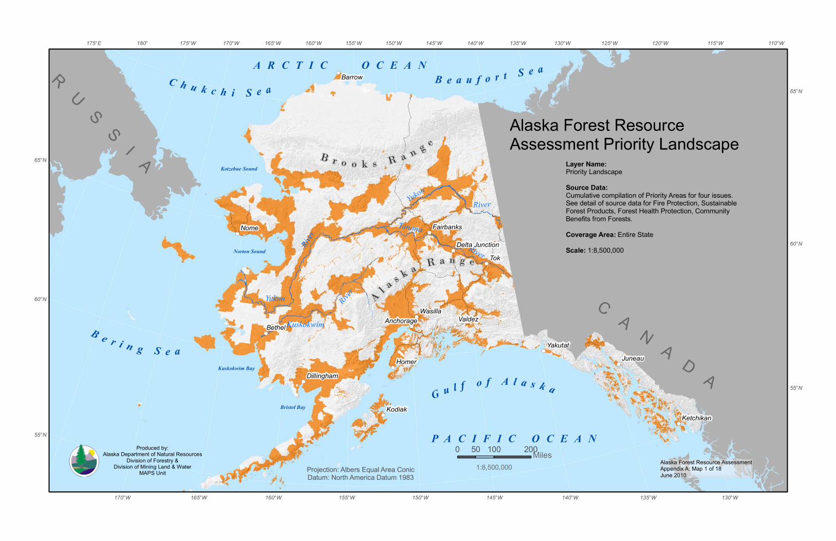
Alaska Forest Resource AssessmentAppendix A: Map 1 of 18June 2010
G u l f o f A l a s k a
B e r i n g S e a
B e a u f o r t S e aC h u k c h i S e a
Bristol Bay
Norton Sound
P A C I F I C O C E A N
Kotzebue Sound
Kuskokwim Bay
Tanana
River
River
KuskokwimRiver
YukonRiver
Yukon
A R C T I C O C E A N
B r o o k s R a n g e
A l a s k a R a n g e
RU
SS
I A
C A N A D A
Tok
Nome
Homer
Valdez
Kodiak
Juneau
Bethel
Barrow
Yakutat
Wasilla
Ketchikan
Fairbanks
Anchorage
Dillingham
Delta Junction
155°W
155°W 110°W115°W120°W125°W
130°W
130°W
135°W
135°W
140°W
140°W
145°W
145°W
150°W
150°W
160°W
160°W
165°W
165°W
170°W
170°W175°W180°175°E
65°N
65°N
60°N
60°N
55°N
55°N
0 100 20050 MilesProjection: Albers Equal Area ConicDatum: North America Datum 1983
Alaska Forest Resource Assessment Priority Landscape
1:8,500,000
Layer Name:Priority LandscapeSource Data:Cumulative compilation of Priority Areas for four issues. See detail of source data for Fire Protection, SustainableForest Products, Forest Health Protection, Community Benefits from Forests.Coverage Area: Entire StateScale: 1:8,500,000
Produced by:Alaska Department of Natural Resources
Division of Forestry &Division of Mining Land & Water
MAPS Unit

Alaska Forest Resource AssessmentAppendix A: Map 2 of 18June 2010
G u l f o f A l a s k a
B e r i n g S e a
B e a u f o r t S e aC h u k c h i S e a
Bristol Bay
Norton Sound
P A C I F I C O C E A N
Kotzebue Sound
Kuskokwim Bay
Tanana
River
River
Kuskokwim
River
YukonRiver
Yukon
A R C T I C O C E A N
B r o o k s R a n g e
A l a s k a R a n g e
RU
SS
I A
C A N A D A
Tok
Nome
Homer
Valdez
Kodiak
Juneau
Bethel
Barrow
Yakutat
Wasilla
Ketchikan
Fairbanks
Anchorage
Dillingham
Delta Junction
155°W
155°W 110°W115°W120°W125°W
130°W
130°W
135°W
135°W
140°W
140°W
145°W
145°W
150°W
150°W
160°W
160°W
165°W
165°W
170°W
170°W175°W180°175°E
65°N
65°N
60°N
60°N
55°N
55°N
0 100 20050 MilesProjection: Albers Equal Area ConicDatum: North America Datum 1983
LegendFire Protection Priority AreaCumulative Priority Landscape
Issue One
Layer Name:Cumulative Priority AreasFire Protection Critical Fire Protection FullFire Protection ModifiedSource Data:Alaska Fire Service, Alaska Interagency Wildland Fire Management Plan.Coverage Area: Entire StateScale: 1:8,500,000
1:8,500,000
Fire Protection
Produced by:Alaska Department of Natural Resources
Division of Forestry &Division of Mining Land & Water
MAPS Unit
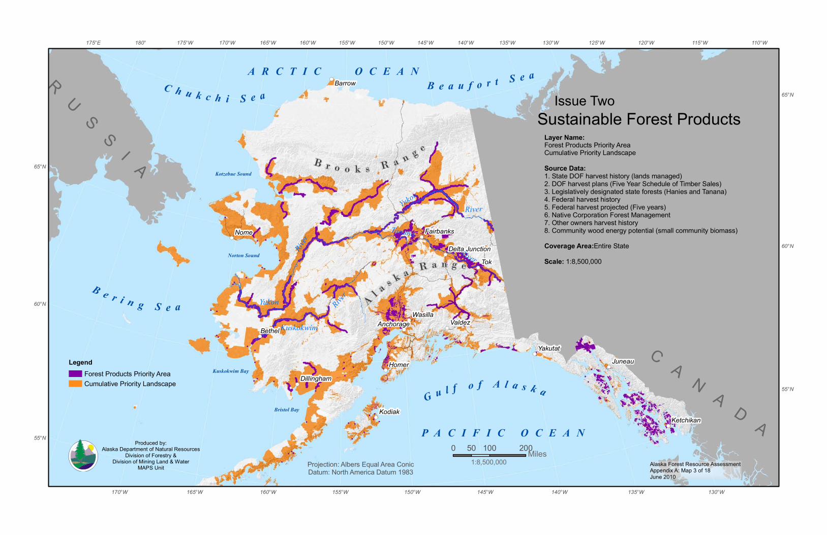
Alaska Forest Resource AssessmentAppendix A: Map 3 of 18June 2010
G u l f o f A l a s k a
B e r i n g S e a
B e a u f o r t S e aC h u k c h i S e a
Bristol Bay
Norton Sound
P A C I F I C O C E A N
Kotzebue Sound
Kuskokwim Bay
Tanana
River
River
KuskokwimRiver
YukonRiver
Yukon
A R C T I C O C E A N
B r o o k s R a n g e
A l a s k a R a n g e
RU
SS
I A
C A N A D A
Tok
Nome
Homer
Valdez
Kodiak
Juneau
Bethel
Barrow
Yakutat
Wasilla
Ketchikan
Fairbanks
Anchorage
Dillingham
Delta Junction
155°W
155°W 110°W115°W120°W125°W
130°W
130°W
135°W
135°W
140°W
140°W
145°W
145°W
150°W
150°W
160°W
160°W
165°W
165°W
170°W
170°W175°W180°175°E
65°N
65°N
60°N
60°N
55°N
55°N0 100 20050 Miles
Projection: Albers Equal Area ConicDatum: North America Datum 1983
LegendForest Products Priority AreaCumulative Priority Landscape
Issue Two
Layer Name:Forest Products Priority AreaCumulative Priority LandscapeSource Data:1. State DOF harvest history (lands managed)2. DOF harvest plans (Five Year Schedule of Timber Sales) 3. Legislatively designated state forests (Hanies and Tanana) 4. Federal harvest history5. Federal harvest projected (Five years) 6. Native Corporation Forest Management7. Other owners harvest history8. Community wood energy potential (small community biomass) Coverage Area:Entire StateScale: 1:8,500,000
1:8,500,000
Sustainable Forest Products
Produced by:Alaska Department of Natural Resources
Division of Forestry &Division of Mining Land & Water
MAPS Unit

Alaska Forest Resource AssessmentAppendix A: Map 4 of 18June 2010
G u l f o f A l a s k a
B e r i n g S e a
B e a u f o r t S e aC h u k c h i S e a
Bristol Bay
Norton Sound
P A C I F I C O C E A N
Kotzebue Sound
Kuskokwim Bay
Tanana
River
River
KuskokwimRiver
YukonRiver
Yukon
A R C T I C O C E A N
B r o o k s R a n g e
A l a s k a R a n g e
RU
SS
I A
C A N A D A
Tok
Nome
Homer
Valdez
Kodiak
Juneau
Bethel
Barrow
Yakutat
Wasilla
Ketchikan
Fairbanks
Anchorage
Dillingham
Delta Junction
155°W
155°W 110°W115°W120°W125°W
130°W
130°W
135°W
135°W
140°W
140°W
145°W
145°W
150°W
150°W
160°W
160°W
165°W
165°W
170°W
170°W175°W180°175°E
65°N
65°N
60°N
60°N
55°N
55°N0 100 20050 Miles
Projection: Albers Equal Area ConicDatum: North America Datum 1983
LegendForest Health Proctection Priority AreaCumulative Priority Landscape
Issue Three
1:8,500,000
Forest Health Protection Layer Name:Forest Health Proctection Priority AreaCumulative Priority LandscapeSource Data:1.1980-2009 Cooperative Aerial Detection Survey (USFS and AKDOF) forest pest activity mapping of Alaska’s forests.2.USFS Forest Health Monitoring Program, National Insect and Disease Forest Health Risk Map (NIDRM) for Alaska-2006 update; NDIRM 2012 in progress (forest at risk to economic pests 15 year projection).3.USFS, FHM/Forest Health Technology Enterprise Team, Non-native Invasive Bark Beetle (Ips typographus) Introduction Potential(based on hierarchical prioritization and modeling of specific riskfactors-2007 dataset).Coverage Area: Entire StateScale: 1:8,500,000
Produced by:Alaska Department of Natural Resources
Division of Forestry &Division of Mining Land & Water
MAPS Unit
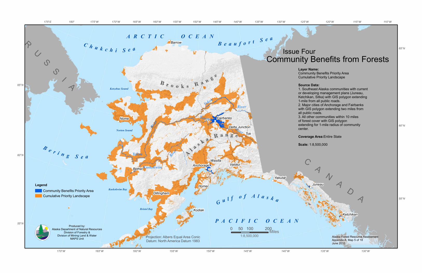
Alaska Forest Resource AssessmentAppendix A: Map 5 of 18June 2010
G u l f o f A l a s k a
B e r i n g S e a
B e a u f o r t S e aC h u k c h i S e a
Bristol Bay
Norton Sound
P A C I F I C O C E A N
Kotzebue Sound
Kuskokwim Bay
Tanana
River
River
KuskokwimRiver
YukonRiver
Yukon
A R C T I C O C E A N
B r o o k s R a n g e
A l a s k a R a n g e
RU
SS
I A
C A N A D A
Tok
Nome
Homer
Valdez
Kodiak
Juneau
Bethel
Barrow
Yakutat
Wasilla
Ketchikan
Fairbanks
Anchorage
Dillingham
Delta Junction
155°W
155°W 110°W115°W120°W125°W
130°W
130°W
135°W
135°W
140°W
140°W
145°W
145°W
150°W
150°W
160°W
160°W
165°W
165°W
170°W
170°W175°W180°175°E
65°N
65°N
60°N
60°N
55°N
55°N0 100 20050 Miles
Projection: Albers Equal Area ConicDatum: North America Datum 1983
LegendCommunity Benefits Priority AreaCumulative Priority Landscape
Issue Four
Layer Name:Community Benefits Priority AreaCumulative Priority LandscapeSource Data:1. Southeast Alaska communities with current or developing management plans (Juneau, Ketchikan, Sitka) with GIS polygon extending 1-mile from all public roads.2. Major cities of Anchorage and Fairbanks with GIS polygon extending two miles from all public roads.3. All other communities within 10 miles of forest cover with GIS polygon extending for 1-mile radius of community center.Coverage Area:Entire StateScale: 1:8,500,000
1:8,500,000
Community Benefits from Forests
Produced by:Alaska Department of Natural Resources
Division of Forestry &Division of Mining Land & Water
MAPS Unit
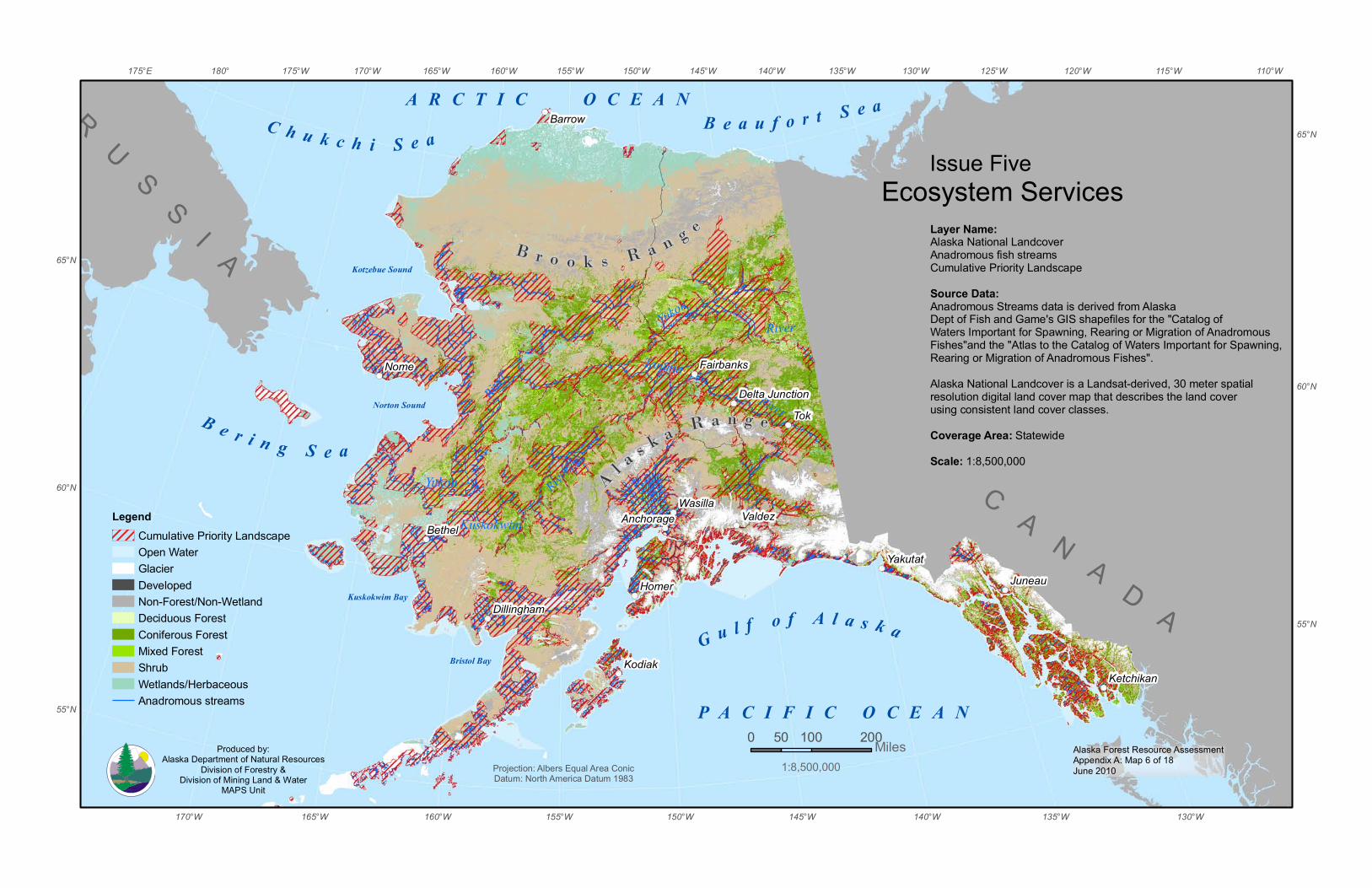
Alaska Forest Resource AssessmentAppendix A: Map 6 of 18June 2010
G u l f o f A l a s k a
B e r i n g S e a
B e a u f o r t S e aC h u k c h i S e a
Bristol Bay
Norton Sound
P A C I F I C O C E A N
Kotzebue Sound
Kuskokwim Bay
Tanana
River
River
KuskokwimRiver
YukonRiver
Yukon
A R C T I C O C E A N
B r o o k s R a n g e
A l a s k a R a n g e
RU
SS
I A
C A N A D A
Tok
Nome
Homer
Valdez
Kodiak
Juneau
Bethel
Barrow
Yakutat
Wasilla
Ketchikan
Fairbanks
Anchorage
Dillingham
Delta Junction
155°W
155°W 110°W115°W120°W125°W
130°W
130°W
135°W
135°W
140°W
140°W
145°W
145°W
150°W
150°W
160°W
160°W
165°W
165°W
170°W
170°W175°W180°175°E
65°N
65°N
60°N
60°N
55°N
55°N
0 100 20050 MilesProjection: Albers Equal Area ConicDatum: North America Datum 1983
LegendCumulative Priority LandscapeOpen WaterGlacierDeveloped Non-Forest/Non-WetlandDeciduous ForestConiferous ForestMixed ForestShrubWetlands/HerbaceousAnadromous streams
Ecosystem ServicesLayer Name:Alaska National LandcoverAnadromous fish streamsCumulative Priority LandscapeSource Data:Anadromous Streams data is derived from Alaska Dept of Fish and Game's GIS shapefiles for the "Catalog ofWaters Important for Spawning, Rearing or Migration of Anadromous Fishes"and the "Atlas to the Catalog of Waters Important for Spawning, Rearing or Migration of Anadromous Fishes".Alaska National Landcover is a Landsat-derived, 30 meter spatialresolution digital land cover map that describes the land coverusing consistent land cover classes. Coverage Area: StatewideScale: 1:8,500,000
1:8,500,000
Issue Five
Produced by:Alaska Department of Natural Resources
Division of Forestry &Division of Mining Land & Water
MAPS Unit
Alaska Forest Resource AssessmentAppendix A: Map 7 of 18June 2010
G u l f o f A l a s k a
B e r i n g S e a
B e a u f o r t S e aC h u k c h i S e a
Bristol Bay
Norton Sound
P A C I F I C O C E A N
Kotzebue Sound
Kuskokwim Bay
Tanana
River
River
Kuskokwim
River
YukonRiver
Yukon
A R C T I C O C E A N
B r o o k s R a n g e
A l a s k a R a n g e
RU
SS
I A
C A N A D A
Tok
Nome
Homer
Valdez
Kodiak
Juneau
Bethel
Barrow
Yakutat
Wasilla
Ketchikan
Fairbanks
Anchorage
Dillingham
Delta Junction
155°W
155°W 110°W115°W120°W125°W
130°W
130°W
135°W
135°W
140°W
140°W
145°W
145°W
150°W
150°W
160°W
160°W
165°W
165°W
170°W
170°W175°W180°175°E
65°N
65°N
60°N
60°N
55°N
55°N
0 100 20050Miles
Projection: Albers Equal Area ConicDatum: North America Datum 1983
LegendCumulative Priority Landscape
General Land StatusU.S. Forest ServiceNational Park ServiceU.S. Fish & Wildlife ServiceDepartment of DefenseState of AlaskaBureau of Land ManagementANCSA Native Corporation (Private)Non ANCSA Private & Local Government
Land ManagementLayer Name:General Land Status Statewide Land OwnershipCumulative Priority LandscapeSource Data:Bureau of Land Management (BLM) and the State of Alaska Department ofNatural Resources (ADNR).This coverage uses data extracted from BLM's records, stored in Alaska Land Information System (ALIS) and ADNR's land records stored in the Land Administration System (LAS).Coverage Area:Entire StateScale: 1:8,500,000Supplemental Datasets:Parcel Data (Municipality of Anchorage Kenai Peninsula Borough, Mat-su Borough, Fairbanks Borough)Conveyance
1:8,500,000
Produced by:Alaska Department of Natural Resources
Division of Forestry &Division of Mining Land & Water
MAPS Unit
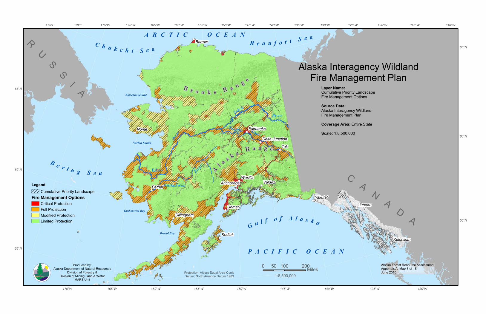
Alaska Forest Resource AssessmentAppendix A: Map 8 of 18June 2010
G u l f o f A l a s k a
B e r i n g S e a
B e a u f o r t S e aC h u k c h i S e a
Bristol Bay
Norton Sound
P A C I F I C O C E A N
Kotzebue Sound
Kuskokwim Bay
Tanana River
River
KuskokwimRiver
YukonRiver
Yukon
A R C T I C O C E A N
B r o o k s R a n g e
A l a s k a R a n g e
RU
SS
I A
C A N A D A
Tok
Nome
Homer
Valdez
Kodiak
Juneau
Bethel
Barrow
Yakutat
Wasilla
Ketchikan
Anchorage
Dillingham
Fairbanks
Delta Junction
155°W
155°W 110°W115°W120°W125°W
130°W
130°W
135°W
135°W
140°W
140°W
145°W
145°W
150°W
150°W
160°W
160°W
165°W
165°W
170°W
170°W175°W180°175°E
65°N
65°N
60°N
60°N
55°N
55°N
0 100 20050 MilesProjection: Albers Equal Area ConicDatum: North America Datum 1983
Layer Name:Cumulative Priority LandscapeFire Management OptionsSource Data:Alaska Interagency WildlandFire Management PlanCoverage Area: Entire StateScale: 1:8,500,000
LegendCumulative Priority Landscape
Fire Management OptionsCritical ProtectionFull ProtectionModified ProtectionLimited Protection
1:8,500,000
Alaska Interagency WildlandFire Management Plan
Produced by:Alaska Department of Natural Resources
Division of Forestry &Division of Mining Land & Water
MAPS Unit

Alaska Forest Resource AssessmentAppendix A: Map 9 of 18June 2010
G u l f o f A l a s k a
B e r i n g S e a
B e a u f o r t S e aC h u k c h i S e a
Bristol Bay
Norton Sound
P A C I F I C O C E A N
Kotzebue Sound
Kuskokwim Bay
Tanana
River
River
KuskokwimRiver
YukonRiver
Yukon
A R C T I C O C E A N
B r o o k s R a n g e
A l a s k a R a n g e
RU
SS
I A
C A N A D A
Tok
Nome
Homer
Valdez
Kodiak
Juneau
Bethel
Barrow
Yakutat
Wasilla
Ketchikan
Fairbanks
Anchorage
Dillingham
Delta Junction
155°W
155°W 110°W115°W120°W125°W
130°W
130°W
135°W
135°W
140°W
140°W
145°W
145°W
150°W
150°W
160°W
160°W
165°W
165°W
170°W
170°W175°W180°175°E
65°N
65°N
60°N
60°N
55°N
55°N
0 100 20050 MilesProjection: Albers Equal Area ConicDatum: North America Datum 1983
LegendCumulative Priority Landscape
Fire Occurance2000 - 20091990 - 19991980 - 1989Prior to 1980
1:8,500,000
Fire History Layer Name:Cumulative Priority LandscapeAlaska Historical Wildland Fire Perimeters from 1942 to 2007Source Data:BLM, Alaska Fire Service, Environmental Resource Institute of MichiganHistorical wildland fire perimeters located in Alaska spanning the years 1942 to 2007.Coverage Area: Entire StateScale: 1:8,500,000
Produced by:Alaska Department of Natural Resources
Division of Forestry &Division of Mining Land & Water
MAPS Unit

Alaska Forest Resource AssessmentAppendix A: Map 10 of 18June 2010
G u l f o f A l a s k a
B e r i n g S e a
B e a u f o r t S e aC h u k c h i S e a
Bristol Bay
Norton Sound
P A C I F I C O C E A N
Kotzebue Sound
Kuskokwim Bay
Tanana River
River
KuskokwimRiver
YukonRiver
Yukon
A R C T I C O C E A N
B r o o k s R a n g e
A l a s k a R a n g e
RU
SS
I A
C A N A D A
Tok
Nome
Homer
Valdez
Kodiak
Juneau
Bethel
Barrow
Yakutat
Wasilla
Ketchikan
Anchorage
Dillingham
Fairbanks
Delta Junction
155°W
155°W 110°W115°W120°W125°W
130°W
130°W
135°W
135°W
140°W
140°W
145°W
145°W
150°W
150°W
160°W
160°W
165°W
165°W
170°W
170°W175°W180°175°E
65°N
65°N
60°N
60°N
55°N
55°N
0 100 20050 MilesProjection: Albers Equal Area ConicDatum: North America Datum 1983
Forest CoverLayer Name:Cumulative Priority LandscapeAlaska National LandcoverSource Data:Land cover from the National Land Cover Database(NLCD), U.S. Geologiacal Survey, Alaska Science Center, 2008.
Coverage Area: Entire StateScale: 1:8,500,000
1:8,500,000
Produced by:Alaska Department of Natural Resources
Division of Forestry &Division of Mining Land & Water
MAPS Unit
LegendCumulative Priority Landscape
Open Water
Glacier
Developed
Non-Forest/Non-Wetland
Deciduous Forest
Coniferous Forest
Mixed Forest
Shrub
Wetlands/Herbaceous

Alaska Forest Resource AssessmentAppendix A: Map 11 of 18June 2010
G u l f o f A l a s k a
B e r i n g S e a
B e a u f o r t S e aC h u k c h i S e a
Bristol Bay
Norton Sound
P A C I F I C O C E A N
Kotzebue Sound
Kuskokwim Bay
Tanana
River
River
KuskokwimRiver
YukonRiver
Yukon
A R C T I C O C E A N
B r o o k s R a n g e
A l a s k a R a n g e
RU
SS
I A
C A N A D A
Tok
Nome
Homer
Valdez
Kodiak
Juneau
Bethel
Barrow
Yakutat
Wasilla
Ketchikan
Fairbanks
Anchorage
Dillingham
Delta Junction
155°W
155°W 110°W115°W120°W125°W
130°W
130°W
135°W
135°W
140°W
140°W
145°W
145°W
150°W
150°W
160°W
160°W
165°W
165°W
170°W
170°W175°W180°175°E
65°N
65°N
60°N
60°N
55°N
55°N
0 100 20050 MilesProjection: Albers Equal Area ConicDatum: North America Datum 1983
LegendCumulative Priority LandscapeForest Resource and Practices Region IForest Resource and Practices Region IIForest Resource and Practices Region III
Alaska Forest Resources & Practices Regions
1:8,500,000
Produced by:Alaska Department of Natural Resources
Division of Forestry &Division of Mining Land & Water
MAPS Unit
Layer Name:Cumulative Priority LandscapeFRPA regionsSource Data:Alaska's three major forest regions defined by Alaska Forest Resources and PracticesActCoverage: StatewideScale: 1:8,500,000
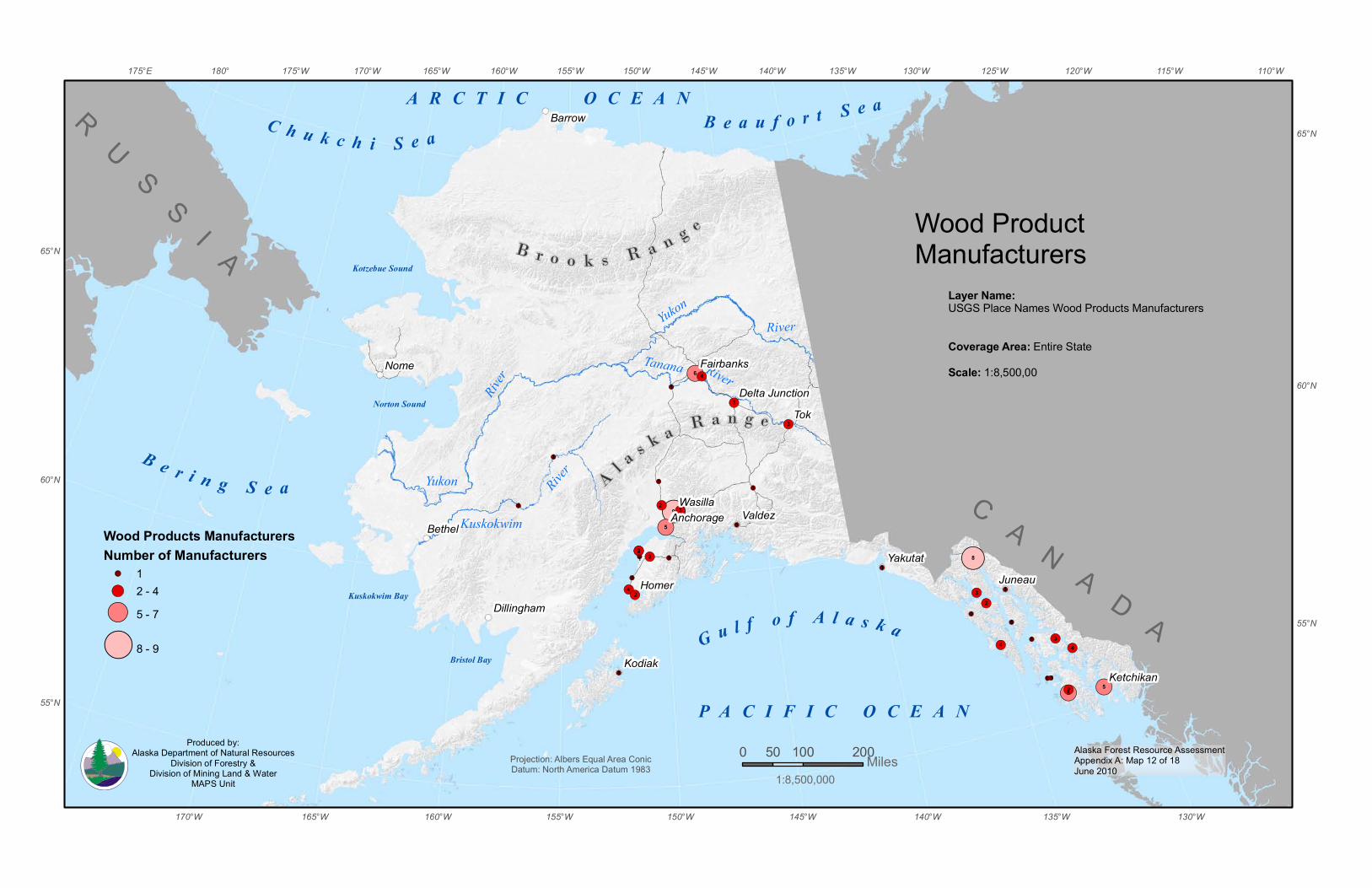
!(
!(
!(
!(
!( !(
!(
!(
!( !(
!(
!(
!(
!(
!(
!(!(
!(
!(!(!(
!(
!(
!(
!(
!(
!(
!(
!(
!(
!(
!(
!(
!(
!(
!( !(
!(
!(
!(
Alaska Forest Resource AssessmentAppendix A: Map 12 of 18June 2010
G u l f o f A l a s k a
B e r i n g S e a
B e a u f o r t S e aC h u k c h i S e a
Bristol Bay
Norton Sound
P A C I F I C O C E A N
Kotzebue Sound
Kuskokwim Bay
Tanana River
River
KuskokwimRiver
YukonRiver
Yukon
A R C T I C O C E A N
B r o o k s R a n g e
A l a s k a R a n g e
RU
SS
I A
C A N A D A1
4
29
1
3
1
2
4
1
3
1
1
1
1
1
5
1
1
1
22
8
3
6
1
1
1
1
1
5
4
Nome
Valdez
Kodiak
Juneau
Bethel
Barrow
Yakutat
Dillingham
13
4
22
2
3
5
Tok
Homer
Wasilla
Ketchikan
Fairbanks
Anchorage
Delta Junction
155°W
155°W 110°W115°W120°W125°W
130°W
130°W
135°W
135°W
140°W
140°W
145°W
145°W
150°W
150°W
160°W
160°W
165°W
165°W
170°W
170°W175°W180°175°E
65°N
65°N
60°N
60°N
55°N
55°N
0 100 20050 MilesProjection: Albers Equal Area ConicDatum: North America Datum 1983
Wood ProductManufacturers
1:8,500,000
Wood Products ManufacturersNumber of Manufacturers
!( 1!( 2 - 4!( 5 - 7
!( 8 - 9
Produced by:Alaska Department of Natural Resources
Division of Forestry &Division of Mining Land & Water
MAPS Unit
Layer Name:USGS Place Names Wood Products Manufacturers
Coverage Area: Entire State Scale: 1:8,500,00

Alaska Forest Resource AssessmentAppendix A: Map 13 of 18June 2010
G u l f o f A l a s k a
B e r i n g S e a
B e a u f o r t S e aC h u k c h i S e a
Bristol Bay
Norton Sound
P A C I F I C O C E A N
Kotzebue Sound
Kuskokwim Bay
Tanana
River
River
KuskokwimRiver
YukonRiver
Yukon
A R C T I C O C E A N
B r o o k s R a n g e
A l a s k a R a n g e
RU
SS
I A
C A N A D A
Tok
Nome
Homer
Valdez
Kodiak
Juneau
Bethel
Barrow
Yakutat
Wasilla
Ketchikan
Fairbanks
Anchorage
Dillingham
Delta Junction
155°W
155°W 110°W115°W120°W125°W
130°W
130°W
135°W
135°W
140°W
140°W
145°W
145°W
150°W
150°W
160°W
160°W
165°W
165°W
170°W
170°W175°W180°175°E
65°N
65°N
60°N
60°N
55°N
55°N
0 100 20050 MilesProjection: Albers Equal Area ConicDatum: North America Datum 1983
LegendRailroadsState RoadwaysAlaska Marine HighwayRivers with known barge travel
TransportationLayer Name:Transportation - Roads - Highway 63,360_LINETransportation - Roads - Secondary 63,360_LINETransportation - RiversSource Data:Alaska Department of Natural Resources - Land Records Information SectionThis data depicts highway locations in Alaska as digitizedprimarily from 1:24,000, 1:63,360, and 1:250,000 USGS quadrangles.Coverage Area:Entire StateScale: 1:8,500,000Supplemental Datasets:Borough RoadsKenai PeninsulaFairbanksJuneauAnchorageMat-Su
1:8,500,000
Produced by:Alaska Department of Natural Resources
Division of Forestry &Division of Mining Land & Water
MAPS Unit
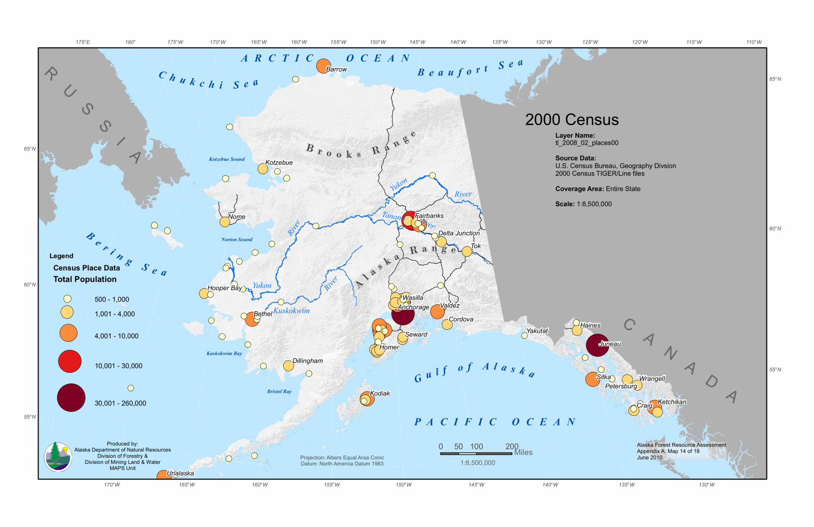
Alaska Forest Resource AssessmentAppendix A: Map 14 of 18June 2010
G u l f o f A l a s k a
B e r i n g S e a
B e a u f o r t S e aC h u k c h i S e a
Bristol Bay
Norton Sound
P A C I F I C O C E A N
Kotzebue Sound
Kuskokwim Bay
Tanana River
River
KuskokwimRiver
YukonRiver
Yukon
A R C T I C O C E A N
B r o o k s R a n g e
A l a s k a R a n g e
RU
SS
I A
C A N A D A
Tok
Nome
Sitka
Homer
Craig
Valdez
Seward
Kodiak
Juneau
HainesBethel
Barrow
Yakutat
Wasilla
Cordova
Wrangell
Unalaska
Kotzebue
Ketchikan
Anchorage
Petersburg
Hooper Bay
Dillingham
Fairbanks
Delta Junction
155°W
155°W 110°W115°W120°W125°W
130°W
130°W
135°W
135°W
140°W
140°W
145°W
145°W
150°W
150°W
160°W
160°W
165°W
165°W
170°W
170°W175°W180°175°E
65°N
65°N
60°N
60°N
55°N
55°N
0 100 20050 MilesProjection: Albers Equal Area ConicDatum: North America Datum 1983
2000 CensusLayer Name:tl_2008_02_places00Source Data:U.S. Census Bureau, Geography Divsion2000 Census TIGER/Line filesCoverage Area: Entire StateScale: 1:8,500,000
LegendCensus Place DataTotal Population
500 - 1,0001,001 - 4,000
4,001 - 10,000
10,001 - 30,000
30,001 - 260,000
1:8,500,000
Produced by:Alaska Department of Natural Resources
Division of Forestry &Division of Mining Land & Water
MAPS Unit
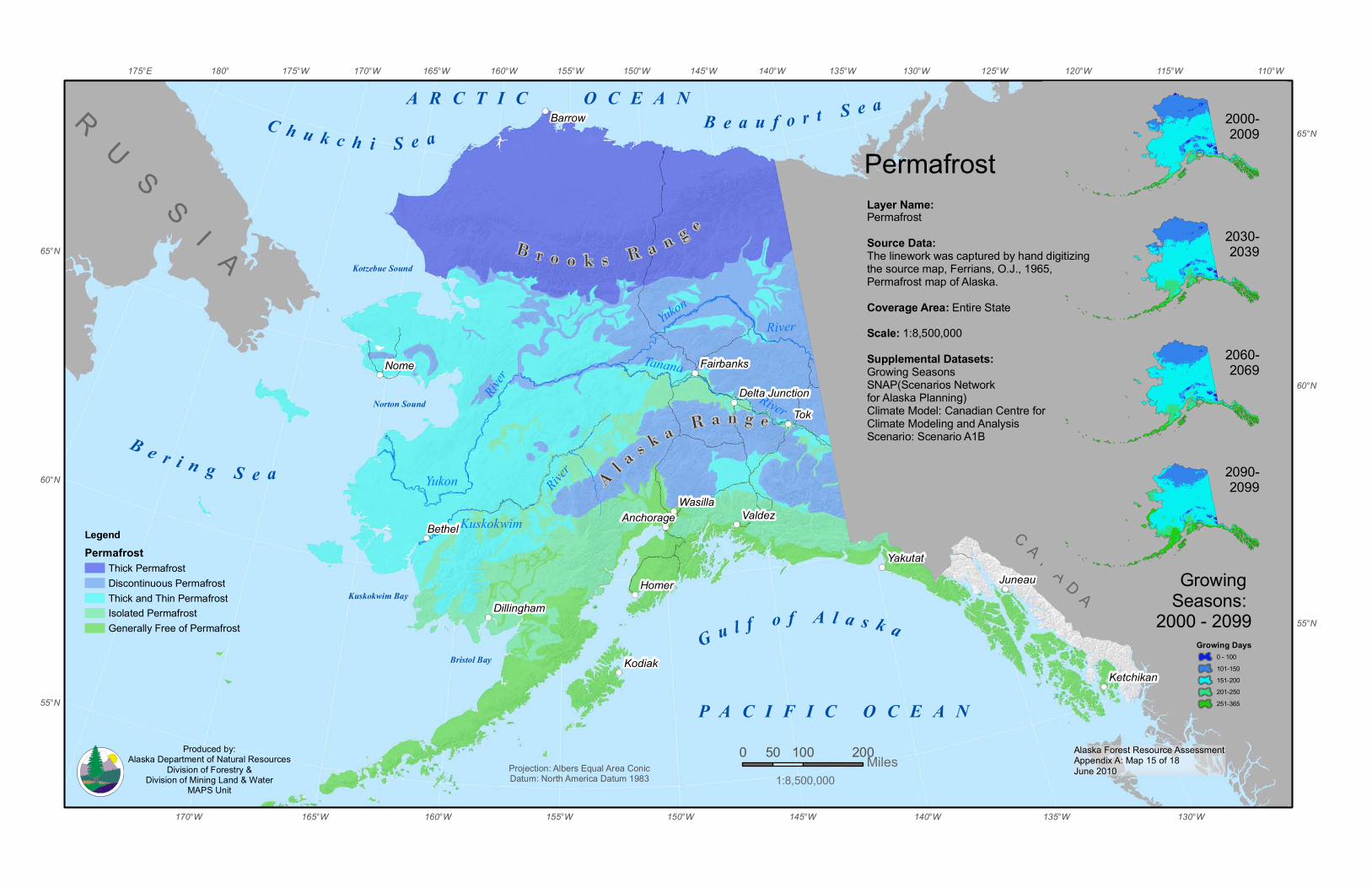
Alaska Forest Resource AssessmentAppendix A: Map 15 of 18June 2010
G u l f o f A l a s k a
B e r i n g S e a
B e a u f o r t S e aC h u k c h i S e a
Bristol Bay
Norton Sound
P A C I F I C O C E A N
Kotzebue Sound
Kuskokwim Bay
Tanana
River
River
KuskokwimRiver
YukonRiver
Yukon
A R C T I C O C E A N
B r o o k s R a n g e
A l a s k a R a n g e
RU
SS
I A
C A N A D A
Tok
Nome
Homer
Valdez
Kodiak
Juneau
Bethel
Barrow
Yakutat
Wasilla
Ketchikan
Fairbanks
Anchorage
Dillingham
Delta Junction
155°W
155°W 110°W115°W120°W125°W
130°W
130°W
135°W
135°W
140°W
140°W
145°W
145°W
150°W
150°W
160°W
160°W
165°W
165°W
170°W
170°W175°W180°175°E
65°N
65°N
60°N
60°N
55°N
55°N
0 100 20050 MilesProjection: Albers Equal Area ConicDatum: North America Datum 1983
PermafrostLayer Name:PermafrostSource Data:The linework was captured by hand digitizing the source map, Ferrians, O.J., 1965, Permafrost map of Alaska.Coverage Area: Entire StateScale: 1:8,500,000Supplemental Datasets:Growing SeasonsSNAP(Scenarios Network for Alaska Planning)Climate Model: Canadian Centre for Climate Modeling and AnalysisScenario: Scenario A1B
LegendPermafrost
Thick PermafrostDiscontinuous PermafrostThick and Thin PermafrostIsolated PermafrostGenerally Free of Permafrost
Growing Seasons:
2000 - 2099Growing Days
0 - 100101-150151-200201-250251-365
2000-2009
2030-2039
2060-2069
2090-2099
1:8,500,000
Produced by:Alaska Department of Natural Resources
Division of Forestry &Division of Mining Land & Water
MAPS Unit

Alaska Forest Resource AssessmentAppendix A: Map 16 of 18June 2010
G u l f o f A l a s k a
B e r i n g S e a
B e a u f o r t S e aC h u k c h i S e a
Bristol Bay
Norton Sound
P A C I F I C O C E A N
Kotzebue Sound
Kuskokwim Bay
Tanana River
River
KuskokwimRiver
YukonRiver
Yukon
A R C T I C O C E A N
B r o o k s R a n g e
A l a s k a R a n g e
RU
SS
I A
C A N A D A
Tok
Nome
Homer
Valdez
Kodiak
Juneau
Bethel
Barrow
Yakutat
Wasilla
Ketchikan
Anchorage
Dillingham
Fairbanks
Delta Junction
155°W
155°W 110°W115°W120°W125°W
130°W
130°W
135°W
135°W
140°W
140°W
145°W
145°W
150°W
150°W
160°W
160°W
165°W
165°W
170°W
170°W175°W180°175°E
65°N
65°N
60°N
60°N
55°N
55°N
0 100 20050 MilesProjection: Albers Equal Area ConicDatum: North America Datum 1983
Soils Survey�L�a�y�e�r� �N�a�m�e�:SoilsSource Data:U.S. Department of Agriculture, Natural Resources Conservation ServiceSSURGO depicts information about the kinds and distribution ofsoils on the landscape. The soil map and data used in theSSURGO product were prepared by soil scientists as part of the National Cooperative Soil SurveyThis data set is a digital soil survey and generally is the mostdetailed level of soil geographic data developed by the NationalCooperative Soil Survey. The information was prepared by digitizingmaps, by compiling information onto a planimetric correct baseand digitizing, or by revising digitized maps using remotelysensed and other information.Coverage Area: Entire StateScale/Resolution: Varies
1:8,500,000Produced by:
Alaska Department of Natural ResourcesDivision of Forestry &
Division of Mining Land & WaterMAPS Unit
Produced by:Alaska Department of Natural Resources
Division of Forestry &Division of Mining Land & Water
MAPS Unit
LegendDune land Fluvaquentic Cryofibrists-Andic Dystrocryepts Lithic Haplocryands-Andic Dystrocryepts Rough mountainous land Sphagnic Cryofibrists-Andic Haplocryods Sphagnic Cryofibrists-Andic Humicryods-Andic HaplocryodsTypic Aquiturbels-Lava flows Typic Aquiturbels-Rough mountainous land-Humic Lithic Dystrocryepts-Andic Humicryods Typic Aquiturbels-Rough mountainous land-Lithic Cryorthents Typic Aquiturbels-Rough mountainous land-Lithic Haploturbels Typic Cryaquepts-Fluvaquentic Cryohemists-Andic Haplocryods-Andic Dystrocryepts Typic Cryofluvents-Typic Cryaquents-Fluvaquentic Cryohemists Typic Cryofluvents-Typic Cryaquents-Sphagnic Cryofibrists Typic Cryofolists-Typic Cryaquents-Terric Cryohemists-Rough mountainous land-Lithic Humicryods Typic Cryorthents Typic Cryorthents-Typic Aquiturbels Typic Dystrocryepts-Typic Cryopsamments-Aeric Cryaquepts Typic Dystrocryepts-Typic Cryorthents-Typic AquiturbelsTypic Eutrocryepts Typic Eutrocryepts-Typic Cryopsamments-Aeric Cryaquepts Typic Fibristels-Lithic Haplocryands-Andic HumicryodsTypic Haplocryands Typic Haplocryands-Fluvaquentic CryofibristsTypic Haplocryands-Rough mountainous land Typic Haplocryands-Rough mountainous land-Lithic DystrocryeptsTypic Haplocryands-Rough mountainous land-Lithic HaplocryandsTypic Haplocryands-Rough mountainous land-Riverwash Typic Haplocryands-Typic Fibristels-Andic Humicryods Typic Haplocryods-Andic Humicryods-Andic HaplocryodsTypic Haplocryods-Sphagnic CryofibristsTypic Haplocryods-Sphagnic Cryofibrists-Andic HaplocryodsTypic Haplocryods-Typic Aquiturbels-Lithic Cryorthents-Humic DystrocryeptsTypic Haplocryods-Typic Aquiturbels-Rough mountainous land-Lithic CryorthentsTypic Haplocryods-Typic Cryofluvents-Typic Cryaquents-Terric Cryofibrists Typic Haplocryods-Typic Cryofluvents-Typic Cryaquents-Terric Cryofibrists-Sphagnic CryofibristsTypic Haplocryods-Typic Cryopsamments-Typic AquiturbelsTypic Haplocryods-Typic Cryorthents-Typic Cryohemists-Terric CryosapristsTypic Haplocryolls-Typic Aquiturbels-Lithic CryorthentsTypic Haplocryolls-Typic Eutrocryepts-Typic Aquiturbels Typic Haploturbels-Typic AquiturbelsTypic Histoturbels Typic Histoturbels-Rough mountainous land-Humic DystrocryeptsTypic Histoturbels-Rough mountainous land-Humic EutrocryeptsTypic Histoturbels-Typic AquiturbelsTypic Histoturbels-Typic Aquiturbels-Humic Lithic Dystrocryepts-Humic Dystrocryepts
Typic Histoturbels-Typic Aquiturbels-Humic Lithic Eutrocryepts-Humic EutrocryeptsTypic Histoturbels-Typic Aquiturbels-Ruptic histic aquiturbels Typic Histoturbels-Typic Aquiturbels-Ruptic histic aquiturbels-Humic DystrocryeptsTypic Histoturbels-Typic Aquiturbels-Ruptic histic aquiturbels-Humic Eutrocryepts Typic Histoturbels-Typic CryofluventsTypic Histoturbels-Typic Cryorthents-Ruptic histic aquiturbels-Humic Dystrocryepts Typic Histoturbels-Typic Cryorthents-Typic Aquiturbels-Humic EutrocryeptsTypic Histoturbels-Typic Cryorthents-Typic Aquiturbels-Ruptic histic aquiturbelsTypic Histoturbels-Typic DystrocryeptsTypic Histoturbels-Typic Dystrocryepts-Aeric CryaqueptsTypic Histoturbels-Typic Dystrocryepts-Aquic CryorthentsTypic Histoturbels-Typic Dystrocryepts-Lithic DystrocryeptsTypic Histoturbels-Typic Dystrocryepts-Rough mountainous land Typic Histoturbels-Typic Dystrocryepts-Typic AquiturbelsTypic Histoturbels-Typic Dystrocryepts-Typic Aquiturbels-Humic Lithic DystrocryeptsTypic Histoturbels-Typic Dystrocryepts-Typic Aquiturbels-Lithic DystrocryeptsTypic Histoturbels-Typic Dystrocryepts-Typic Cryopsamments Typic Histoturbels-Typic Dystrocryepts-Typic Cryorthents-Typic AquiturbelsTypic Histoturbels-Typic EutrocryeptsTypic Histoturbels-Typic Eutrocryepts-Aeric CryaqueptsTypic Histoturbels-Typic Eutrocryepts-Lithic EutrocryeptsTypic Histoturbels-Typic Eutrocryepts-Typic AquiturbelsTypic Histoturbels-Typic Eutrocryepts-Typic Aquiturbels-Humic EutrocryeptsTypic Histoturbels-Typic Eutrocryepts-Typic Aquiturbels-Lithic EutrocryeptsTypic Histoturbels-Typic Eutrocryepts-Typic CryopsammentsTypic Histoturbels-Typic Eutrocryepts-Typic CryorthentsTypic Histoturbels-Typic Eutrocryepts-Typic Cryorthents-Aeric CryaqueptsTypic Histoturbels-Typic Eutrocryepts-Typic Dystrocryepts-Aeric CryaqueptsTypic Histoturbels-Typic FibristelsTypic Histoturbels-Typic Fibristels-Andic DystrocryeptsTypic Histoturbels-Typic Fibristels-Andic HumicryodsTypic Histoturbels-Typic Fibristels-Humic Dystrocryepts Typic Histoturbels-Typic Fibristels-Typic AquiturbelsTypic Histoturbels-Typic Fibristels-Typic Aquiturbels-Andic Dystrocryepts Typic Histoturbels-Typic Fibristels-Typic CryaquentsTypic Histoturbels-Typic Fibristels-Typic Cryofluvents-Typic Aquiturbels Typic Histoturbels-Typic Fibristels-Typic CryorthentsTypic Histoturbels-Typic Fibristels-Typic Dystrocryepts-Typic Cryorthents Typic Histoturbels-Typic Fibristels-Typic Eutrocryepts-Typic CryorthentsTypic Histoturbels-Typic Haplocryands-Fluvaquentic CryofibristsTypic Histoturbels-Typic Haplocryands-Fluvaquentic Fibristels Typic Histoturbels-Typic Haplocryands-Lithic Haplocryands Typic Histoturbels-Typic Haplocryands-Typic FibristelsTypic Histoturbels-Typic HaplocryodsTypic Histoturbels-Typic Haplocryods-Aeric Cryaquepts
Typic Histoturbels-Typic Haplocryods-Humic Eutrocryepts Typic Histoturbels-Typic Haplocryods-Typic Aquiturbels Typic Histoturbels-Typic Haplocryods-Typic Aquiturbels-Humic Lithic Dystrocryepts-Humic Dystrocryepts Typic Histoturbels-Typic Haplocryods-Typic CryorthentsTypic Histoturbels-Typic Haplocryods-Typic Cryorthents-Rough mountainous land-Humic DystrocryeptsTypic Histoturbels-Typic Haplocryods-Typic Cryorthents-Rough mountainous land-Humic EutrocryeptsTypic Histoturbels-Typic Haplocryods-Typic Cryorthents-Typic CryopsammentsTypic Histoturbels-Typic Haplocryods-Typic Dystrocryepts-Humic DystrocryeptsTypic Histoturbels-Typic Haplocryods-Typic Dystrocryepts-Typic AquiturbelsTypic Histoturbels-Typic Haplocryods-Typic Eutrocryepts-Humic Eutrocryepts Typic Histoturbels-Typic Haplocryods-Typic Eutrocryepts-Typic Aquiturbels Typic Histoturbels-Typic Haplocryods-Typic Fibristels-Humic DystrocryeptsTypic Histoturbels-Typic Haplocryods-Typic Fibristels-Humic Eutrocryepts Typic Histoturbels-Typic Haplocryods-Typic Fibristels-Typic AquiturbelsTypic Histoturbels-Typic Haplocryods-Typic Fibristels-Typic CryofluventsTypic Histoturbels-Typic Haplocryolls (s9309); Typic Histoturbels-Typic HaplocryollsTypic Histoturbels-Typic Haplocryolls-Typic AquiturbelsTypic Histoturbels-Typic Haplocryolls-Typic Cryorthents-Typic AquiturbelsTypic Histoturbels-Typic Haplocryolls-Typic Eutrocryepts-Humic Eutrocryepts Typic Histoturbels-Typic Haploturbels-Typic Aquiturbels-Ruptic histic aquiturbelsTypic Histoturbels-Typic Haploturbels-Typic Eutrocryepts Typic Histoturbels-Typic Haploturbels-Typic Fibristels Typic Histoturbels-Typic Haploturbels-Typic Fibristels-Typic Aquiturbels-Ruptic histic aquiturbels Typic Humicryods-Lithic Cryohemists-Humic Placocryods-Andic Humicryods Typic Humicryods-Typic Aquiturbels-Rough mountainous land-Humic Lithic Dystrocryepts Typic Humicryods-Typic Aquiturbels-Rough mountainous land-Lithic Dystrocryepts Typic Humicryods-Typic Cryaquods-Terric Cryosaprists-Terric Cryohemists Typic Humicryods-Typic Cryohemists-Terric Cryosaprists-Lithic Humicryods-Lithic Cryofolists-Andic Haplocryods Typic Humicryods-Typic Cryohemists-Terric Cryosaprists-Lithic Humicryods-Lithic Cryofolists-Andic Haplocryods Typic Humicryods-Typic Haplocryods Typic Humicryods-Typic Haplocryods-Typic Cryaquepts-Rough mountainous land-Humic Lithic Dystrocryepts-Humic Dystrocryepts Typic Humicryods-Typic Haplocryods-Typic Cryofluvents-Typic Cryaquents-Terric Cryohemists Typic Humicryods-Typic Histoturbels-Lithic Haplocryods-Andic Dystrocryepts Typic Molliturbels-Typic Aquiturbels-Lithic Haploturbels Typic Molliturbels-Typic Histoturbels-Typic Aquiturbels-Ruptic histic aquiturbelsTypic Molliturbels-Typic Histoturbels-Typic Haploturbels-Typic Aquiturbels Typic Mollorthels-Typic Histoturbels-Typic Aquiturbels-Ruptic histic aquiturbelsTypic Psammoturbels-Typic Histoturbels-Typic Aquiturbels Typic Umbriturbels-Typic Histoturbels-Typic Aquiturbels-Lithic Umbriturbels Typic Umbriturbels-Typic Histoturbels-Typic Aquiturbels-Ruptic histic aquiturbels Typic Umbriturbels-Typic Histoturbels-Typic Haploturbels-Typic AquiturbelsTypic Vitricryands-Rough mountainous land-Lithic Haplocryands Vitric Haplocryands-Cinder land
Alaska Forest Resource AssessmentAppendix A: Map 16aJune 2010
Alaska Forest Resource AssessmentAppendix A: Map 17 of 18June 2010
G u l f o f A l a s k a
B e r i n g S e a
B e a u f o r t S e aC h u k c h i S e a
Bristol Bay
Norton Sound
P A C I F I C O C E A N
Kotzebue Sound
Kuskokwim Bay
Tanana River
River
KuskokwimRiver
YukonRiver
Yukon
A R C T I C O C E A N
B r o o k s R a n g e
A l a s k a R a n g e
RU
SS
I A
C A N A D A
Tok
Nome
Homer
Valdez
Kodiak
Juneau
Bethel
Barrow
Yakutat
Wasilla
Ketchikan
Anchorage
Dillingham
Fairbanks
Delta Junction
155°W
155°W 110°W115°W120°W125°W
130°W
130°W
135°W
135°W
140°W
140°W
145°W
145°W
150°W
150°W
160°W
160°W
165°W
165°W
170°W
170°W175°W180°175°E
65°N
65°N
60°N
60°N
55°N
55°N
0 100 20050 MilesProjection: Albers Equal Area ConicDatum: North America Datum 1983
USFWS National Wetlands Mapping StatusLayer Name:AK wet polySource Data:U.S. Fish and Wildlife ServiceThis data set represents the extent, approximate location and type of wetlands and deepwater habitats in the Alaska, United States. These data delineate the areal extent of wetlands and surface waters as defined by Cowardin et al. (1979). Coverage Area: Entire StateScale: 1:8,500,000
LegendWetlands Mapping Status
DigitalNon-DigitalNo - Data
1:8,500,000
Produced by:Alaska Department of Natural Resources
Division of Forestry &Division of Mining Land & Water
MAPS Unit
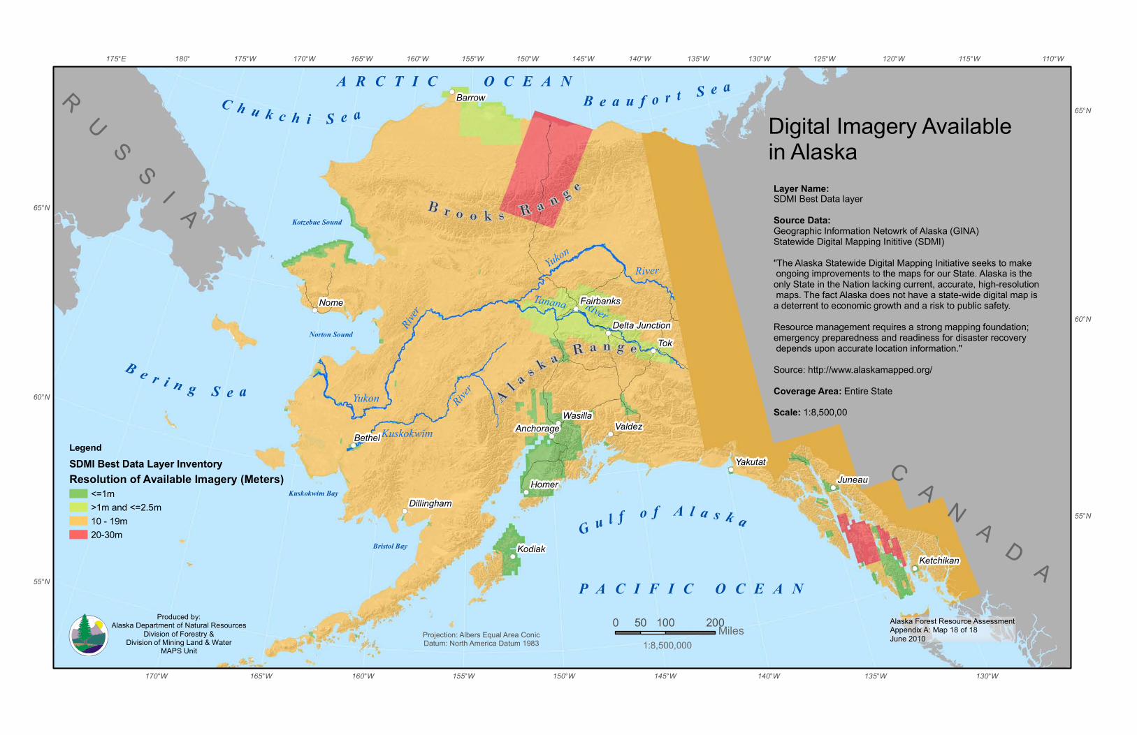
Alaska Forest Resource AssessmentAppendix A: Map 18 of 18June 2010
G u l f o f A l a s k a
B e r i n g S e a
B e a u f o r t S e aC h u k c h i S e a
Bristol Bay
Norton Sound
P A C I F I C O C E A N
Kotzebue Sound
Kuskokwim Bay
Tanana River
River
KuskokwimRiver
YukonRiver
Yukon
A R C T I C O C E A N
B r o o k s R a n g e
A l a s k a R a n g e
RU
SS
I A
C A N A D A
Tok
Nome
Homer
Valdez
Kodiak
Juneau
Bethel
Barrow
Yakutat
Wasilla
Ketchikan
Anchorage
Dillingham
Fairbanks
Delta Junction
155°W
155°W 110°W115°W120°W125°W
130°W
130°W
135°W
135°W
140°W
140°W
145°W
145°W
150°W
150°W
160°W
160°W
165°W
165°W
170°W
170°W175°W180°175°E
65°N
65°N
60°N
60°N
55°N
55°N
0 100 20050 MilesProjection: Albers Equal Area ConicDatum: North America Datum 1983
Digital Imagery Available in AlaskaLayer Name:SDMI Best Data layerSource Data:Geographic Information Netowrk of Alaska (GINA)Statewide Digital Mapping Inititive (SDMI)"The Alaska Statewide Digital Mapping Initiative seeks to make ongoing improvements to the maps for our State. Alaska is the only State in the Nation lacking current, accurate, high-resolution maps. The fact Alaska does not have a state-wide digital map is a deterrent to economic growth and a risk to public safety. Resource management requires a strong mapping foundation; emergency preparedness and readiness for disaster recovery depends upon accurate location information."Source: http://www.alaskamapped.org/Coverage Area: Entire StateScale: 1:8,500,00
LegendSDMI Best Data Layer InventoryResolution of Available Imagery (Meters)
<=1m >1m and <=2.5m10 - 19m20-30m
1:8,500,000
Produced by:Alaska Department of Natural Resources
Division of Forestry &Division of Mining Land & Water
MAPS Unit
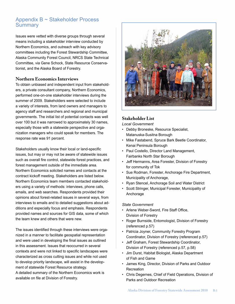
Alaska Division of Forestry Statewide Assessment 2010 ��
Appendix B ~ Stakeholder Process Summary
Issues were vetted with diverse groups through several means including a stakeholder interview conducted by Northern Economics, and outreach with key advisory committees including the Forest Stewardship Committee, Alaska Community Forest Council, NRCS State Technical Committee, via Gene Schock, State Resource Conserva-tionist, and the Alaska Board of Forestry.
Northern Economics InterviewsTo obtain unbiased and independent input from stakehold-ers, a private consultant company, Northern Economics, performed one-on-one stakeholder interviews during the summer of 2009. Stakeholders were selected to include a variety of interests, from land owners and managers to agency staff and researchers and regional and municipal governments. The initial list of potential contacts was well over 100 but it was narrowed to approximately 30 names, especially those with a statewide perspective and orga-nization managers who could speak for members. The response rate was 91 percent.
Stakeholders usually know their local or land-specific issues, but may or may not be aware of statewide issues such as overall fire control, statewide forest practices, and forest management outside of the immediate area. Northern Economics solicited names and contacts at the contract kickoff meeting. Stakeholders are listed below. Northern Economics team members contacted stakehold-ers using a variety of methods: interviews, phone calls, emails, and web searches. Respondents provided their opinions about forest-related issues in several ways, from interviews to emails and to detailed suggestions about ad-ditions and especially focus and emphasis. Respondents provided names and sources for GIS data, some of which the team knew and others that were new.
The issues identified through these interviews were orga-nized in a manner to facilitate geospatial representation and were used in developing the final issues as outlined in this assessment. Issues that reoccurred in several contexts and were not linked to specific landscapes were characterized as cross cutting issues and while not used to develop priority landscape, will assist in the develop-ment of statewide Forest Resource strategy.A detailed summary of the Northern Economics work is available on file at Division of Forestry.
Stakeholder ListLocal Government• Debby Broneske, Resource Specialist, Matanuska-Susitna Borough • Mike Fastabend, Spruce Bark Beetle Coordinator, Kenai Peninsula Borough • Paul Costello, Director Land Management, Fairbanks North Star Borough • Jeff Hermanns, Area Forester, Division of Forestry for community of Tok• Sue Rodman, Forester, Anchorage Fire Department, Municipality of Anchorage, • Ryan Stencel, Anchorage Soil and Water District • Scott Stringer, Municipal Forester, Municipality of Anchorage
State Government• Arlene Weber-Sword, Fire Staff Office, Division of Forestry• Roger Burnside, Entomologist, Division of Forestry (referenced p.57)• Patricia Joyner, Community Forestry Program Coordinator, Division of Forestry (referenced p.57)• Jeff Graham, Forest Stewardship Coordinator, Division of Forestry (referenced p.57, p.58)• Jim Durst, Habitat Biologist, Alaska Department of Fish and Game• James King, Director, Division of Parks and Outdoor Recreation• Chris Degernes, Chief of Field Operations, Division of Parks and Outdoor Recreation
B:1
�� Alaska Division of Forestry Statewide Assessment 2010
• Dick Mylius, Director, Division of Mining, Land and Water • Carol Fries, Project Manager, DNR-Commissioners Office• Rick Jandreau, Acting Resources Program Manager, Division of Forestry• Doug Schrage, President, state of Alaska Fire Chiefs Association
Federal Government• Ron Knowles, Group leader, Fire and Fuels, State & Private Forestry, U.S. Forest Service • Steve Patterson, Asst Director for Forest Health, State & Private Forestry, U.S. Forest Service• Paul Brewster, Deputy Regional Forester, Resources, U.S. Forest Service, Region 10 • Mitch Michaud, Forester for state, Natural Resource Conservation Service• Matthew Anderson, Lead Forester, Bureau of Land Management • Sue Masica, AK Regional Director, National Park Service• Suzy Wooliver, National Park Service• Steve Heppner, Fire Management Officer, Bureau of Indian Affairs• Debbie Steen, Fire Staff, U.S. Fish & Wildlife Service• Brad Reed, U.S. Fish & Wildlife Service
Native Alaskans and Private Landowners• Rick Rogers, Vice President, Chugach Alaska Corporation• Charles Parker, president, Alaska Villages Initiatives • Brad Garness, Executive Director, Alaska Inter-Tribal Council• Will Putman, Forestry Director, Tanana Chiefs Conference• Clare Doig, Consulting Forester ANCSA Corporations Kavilco, Klawock, Huna Totem, Cape Fox• Ron Wolfe, Corporate Forester, Sealaska Native Corporation
Forest Stewardship CommitteeThe Forest Stewardship Committee is comprised of 14 diverse stakeholders knowledgeable and experienced about Alaska’s private forest lands. The committee make-up is derived from Forest Service national guidelines. Jeff Graham, DOF Forest Stewardship Coordinator and Roger Burnside, DOF Forest Entomologist provided an overview of the Statewide Assessment on March 31, 2010. Twelve of fourteen members were present. Most committee mem-bers were supportive of the assessment overall. Com-ments included: the potential for biomass utilization from wildland urban interface zones, elaboration on definition of pests, concerns about bird habitats, expanding subsis-tence use to personnel and non-timber uses, consider-ation of agricultural lands, expanding priority landscape to high-medium-low designation. Many suggestions were addressed in the final assessment.
Alaska Community Forest CouncilThe Alaska Community Forest Council’s 15 members received drafts of the Statewide Assessment and Commu-nity Forestry Program Five-Year Strategy and were asked for comments. The council is composed of members rep-resenting most of the population centers of the state and serves an advisory role to the state forester and the Com-munity Forestry Program. Community Forestry Program Coordinator Patricia Joyner presented the assessment and strategy at the March 12, 2010 council meeting and asked for discussion and comments.
The council discussed the selected communities list, based on which have possibility of developing or manag-ing CF programs. They discussed how to address com-munities like Chitina and Tok, which can not meet four standards set by the Forest Service because there is no local government, but forest management is important to the community. There was general agreement that the document was interesting and a good compilation of information that had not been in one document previously. Members thought it would useful for providing an overview of forestry in Alaska and for building support for State Cooperative Programs.
B:2
Alaska Division of Forestry Statewide Assessment 2010 ��
Natural Resource Conservation Service State Technical CommitteeThe Natural Resource Conservation Service (NRCS) State Technical Committee provides advice on a number of issues within a variety of NRCS conservation programs. Although the State Technical Committee has no imple-mentation or enforcement authority, USDA gives strong consideration to the Committee’s recommendations. The Statewide Assessment and Strategy was presented at the committee meeting on May 26, 2010 by Jeff Graham. At the meeting, 20 were present representing Alaska Native landowners, the Alaska Federation of Natives, the Alaska Department of Fish and Game, Alaska Division of Agricul-ture, and NRCS. The primary comment inquired if Alaska will receive additional Federal funding due to extra need and large acreage.
US Forest Service Alaska Region Leadership TeamA presentation on the Statewide Assessment and Strategy was given to the R10 leadership team on May 7, 2010 by Jeff Graham, Chris Maisch, Alaska State Forester and Rick Rogers, DOF Chief of Forest Resources. The leadership team had 11 members in attendance via video conference. Comments included discussion of transition to second growth management, emerging markets for for-est products, transportation as a major challenge for small operators on Tongass National Forest, interaction of forest and salmon habitat, important in restoration investments. Note was made of the amount of priority landscape that was non-forested. A suggestion was made to reference the National Forest Management Plans.
Bureau of Land Management Alaska Leadership TeamThe Bureau of Land Management (BLM) leadership was given a presentation on the Statewide Assessment and Strategy by Jeff Graham, Chris Maisch, and Rick Rog-ers on June 3, 2010. Ten members of the leadership team were present. Comments were made noting wildfire protection coverage, spruce beetle occurrence, and cross boundary management possibilities. Request was made for final Assessment and Strategy and documents will be made available to the Alaska BLM.
The Alaska Board of ForestryThe nine-member Alaska Board of Forestry is an advisory board established by the Alaska Forest Resources and Practices Act. Eight members are appointed to three year terms by the Governor, with the ninth seat filled by the State Forester serving as ex officio and board chair. This board represents a broad range of interest groups with board seats representing: a commercial fishermen’s orga-nization; an Alaska Native corporation; an environmental organization; a forest industry trade association; a profes-sional fish or wildlife biologist; a professional forester; a mining organization; and a recreational organization.
Jeff Graham presented the Statewide Assessment and draft strategy to the Alaska Board of Forestry at their spring meeting in Juneau Alaska on March 18, 2010. Comments included: emphasis of fish resources in regard to communities, addressing climate change and carbon sequestration, adequate coverage of southeast Alaska, and similarities with other states such as the Texas model. Many suggestions were addressed in the final assess-ment.
B:�

�� Alaska Division of Forestry Statewide Assessment 2010
Appendix C ~ Citations
Alaska Department of Commerce, Community, and Economic Development. 2009. Rural Population Report: the Trends are Changing. 34 p.
Alaska Department of Fish and Game. 2006. Our Wealth Maintained: A Strategy for Conserving Alaska’s Diverse Wildlife and Fish Re-sources. Alaska Department of Fish and Game, Juneau, Alaska. Xviii + 824 p.
Alaska Dept. of Labor and Workforce Development, Alaska Economic Trends Dec. 2009
Alaska Department of Natural Resources. 2008. Alaska Wood Energy Development Task Group. Office of the Commissioner and Division of Forestry Briefing Paper. 2 p.
Alaska Division of Forestry, 2006. Alaska’s Forests in the 21st Century. 14 p.
Alaska Division of Forestry, et al. New Growth Prospectus for the Forest Products Industry of Interior Alaska at http://www.investfairbanks.com/Projects/documents/F_ForBroch.pdf
Alaska Division of Parks and Outdoor recreation, 2009, Executive Summary to the 2009-2014 state Comprehensive Outdoor Recreation Plan at http://dnr.alaska.gov/parks/plans/scorp/scorpsum.pdf
Alaska Division of Parks and Outdoor Recreation. 2002. Alaska Forest Legacy Program Assessment of Need. Alaska Division of Parks and Outdoor Recreation. 87 p.
Bella, Elizabeth. 2009. “Invasion Prediction in Alaska: Building a Strategy”, Alaska Invasive Species Conference, Ketchikan, AK, Cape Fox Lodge.
Berg, E.E. and R.S. Anderson. 2006. Fire history of white and Lutz spruce forests on the Kenai Peninsula, Alaska, over the last two millen-nia as determined from soil charcoal. For. Ecol. Manage. 227(3):275-283.
Berg, E.E, J. D. Henry, C.L. Fastie, A.D. DeVolder and S.M. Matsuoka. 2006. Spruce beetle outbreaks on the Kenai Peninsula, Alaska, and Kluane National Park and Reserve, Yukon Territory: relationship to summer temperatures and regional differences in disturbance regimes. For. Ecol. Manage. 227(3):219-232.
Birch, T.W. 1997. Private Forest-land Owners of the Western United States, 1994. U.S. Forest Service Resource Bulletin NE-137. 249 p.
Bockhorst, Dan. 2001. Local Government in Alaska. Alaska Department of Community and Economic Development. 22 p.
Brackley, Allen M., Haynes, Richard W., and Alexander, Susan J. Timber Harvests in Alaska: 1910-2006, 2009, U.S. Forest service Re-search note PNW-RN-560
Brookings Institute – Mega Fire Concept Paper 2005
Carlson, M. L., Lapina, I. V., Shephard, M., Conn, J. S., Densmore, R., Spencer, P., Heys, J. Riley, J. and J. Nielsen. 2008. Invasiveness Ranking System for Non-Native Plants of Alaska. USDA Forest Service, R10, R10-TP-143. 218 pp.
Carlson, M. L. and M. Shephard. 2007. Is the spread of non-native plants in Alaska accelerating? In: Meeting the challenge: invasive plants in the Pacific Northwest ecosystems, Portland, OR (Harrington, T.B., and S. H. Reichard, tech. eds.). U.S. Department of Agricul-ture, Forest Service, Pacific Northwest Research Station, En. Tech. Rep. PNW-GTR-694.: 111-127. http://akweeds.uaa.alaska.edu/ak-weeds_literature.htm
Community Forestry Consultants, Inc. 2009. Urban Forestry Management Plan. Municipality of Anchorage. 95p.
Cortes-Burns, H., Lapina, I., Klein, S. C., and M. L. Carlson. 2007. Invasive Plant Species Monitoring and Control – Areas impacted by 2004 and 2005 Fires in Interior Alaska: A survey of Alaska BLM lands along the Dalton, Steese, and Taylor Highways. Report funded by the Bureau of Land Management, Alaska state Office, Anchorage, AK. 91 pp. http://akweeds.uaa.alaska.edu/akweeds_literature.htm
Crimp, Peter, Presentation to Alaska Wood Energy Conference, Nov. 14, 2007, Fairbanks.
C:1
Alaska Division of Forestry Statewide Assessment 2010 ��
Farr, W. A. 1967. Growth and Yield of Well-Stocked White Spruce Stands in Alaska. U.S. Forest Service, Pacific Northwest Forest and Range Experiment Station, Res. Paper PNW-63. 30 p.
Goetz, S.J., A.G. Bunn, G.J. Fiske, and R.A. Houghton. 2005 Satellite-observed photosynthetic trends across boreal North America as-sociated with climate and fire disturbance. Proceedings of the National Academy of Sciences 102: 13521-13525.
Goldsmith, Scott. 2008. Structural Analysis of the Alaska Economy: What are the Drivers? Institute of Social and Economic Research, University of Alaska Anchorage. 140 p.
Hull, T and L. Leask. 2000. Dividing Alaska, 1867-2000: Changing Land Ownership andManagement. Institute of Social and Economic Research, University of Alaska Anchorage.
Hunsanger, Eddie. “Population Projections, 2007 to 2030.” Alaska Economics Trends, October 2007: 4-12.
INFEST, Interagency Forest Ecology Study Team (ADFG, ADNR, USFWS, USFS, USGS) at http://www.sf.adfg.state.ak.us/sarr/forestecology/fsbrowse.cfm
Institute of the North, Alaska Pacific University 2004Stephanie Martin, Mary Killorin, Steve Colt. Fuel Costs, Migration, and Community Viability. Final Report. Research findings, Anchorage: University of Alaska, Institute of Social and Economic Research, 2008.
Northern Economics, Inc. 2009. Phase 1: Alaska Statewide Assessment and Preliminary Strategy. Report on file with Alaska Division of Forestry. 54 p.
Nowacki, G., P. Spencer, T. Brock, M. Fleming, and T. Jorgenson, 2000. Narrative Descriptions for the Ecoregions of Alaska and Neigh-boring Territories. Interagency Report, USDA Forest Service. 16 p.
Rabaglia, R.R., D. Duerr, R. Acciavatti and I. Ragenovice. 2008. Early detection and rapid response for non-native bark and ambrosia beetles. U.S. Department of Agriculture, Forest Service, Forest Health Protection. 12p.
Ross Darrell W., Daterman, Gary E. Boughton Jerry L., and Quigley Thomas M. 2001, Forest Health Restoration in South-Central Alaska: A Problem Analysis, U.S. Forest Service
Smith, W.B., P.D. Miles, C.H. Perry, and S.A. Pugh, 2009. Forest Resources of the United States, 2007. Gen. Tech. Rep. WO-78. Wash-ington, DC: U.S. Department of Agriculture, Forest Service, Washington Office. 336 p.
SNAP Integration Team 2008. Preliminary Report to the Governor’s Sub-Cabinet on Climate Change. University of Alaska Fairbanks,
SNRAS Pub. No. MP 2008-06. 24 p.
SNAP Integration Team 2010. Alaska Regional Climate Projections. SNAP Integration Team Fact Sheet. 6 p.
Spellman, B. T. 2008. The impacts of invasive sweetclover (Melilotus alba) in early successional floodplain habitats of Alaska. Masters thesis. University of Alaska, Fairbanks, AK. 94 pp. http://akweeds.uaa.alaska.edu/akweeds_literature.htm
Spellman, B. T. 2009. “Managing Reed Canarygrass on the Kenai Peninsula, Before, Now and the Future”, Alaska Invasive Species Con-ference, Ketchikan, AK, Cape Fox Lodge.
Taylor, R. F. 1934. Yield of Second-Growth Western Hemlock-Sitka Spruce Stands in Southeast Alaska. U.S. Forest Service, Technical Bull. 412. 29 p.
U.S. Census Bureau. 2009. Alaska 2008 Population Estimates. Web-based report.
U.S. Forest Service, 2002. Chugach National Forest Revised Land and Resource Management Plan, US Forest Service, R10-MB-480c, 328 p.
C:2

�0 Alaska Division of Forestry Statewide Assessment 2010
U.S. Forest Service, 2008. Tongass National Forest Land and Resource Management Plan, Forest Service, R10-MB-603b, 468 p. U.S. Forest Service. 2009 (Final Draft). The early warning system for forest health threats in the United States. U.S. Department of Agri-culture, Forest Service, Forest Health Protection, Arlington, VA 40p.
U.S. Forest Service. 2007. Mapping risk from forest insects and diseases. Forest Health Protection, Forest Health Technology Enterprise Team, Report FHTET 2007-06. 115p. with map and appendices.
U.S. Forest Service 2009a. Forest Health Conditions in Alaska—2008. Region 10 Forest Health Protection Report R10-PR-20. 102p.
U.S. Forest Service. 2009b). The early warning system for forest health threats in the United States (Final Draft). U.S. Department of Agriculture, Forest Service, Forest Health Protection, Arlington, VA 40p.
U.S. Forest Service. 2010. Forest Health Conditions in Alaska – 2009. Region 10 Forest Health Protection Report R10-PR-21. 83p.van Hees, W. 2009. Forests of Interior Alaska. in Forest Resources of the United States, 2007. Gen. Tech. Rep. WO-78. Washington, DC:
U.S. Department of Agriculture, Forest Service, Washington Office. p. 92-95.
Van Hees, W. 2007. Forests of Interior Alaska. in Forest Resources of the United States, 2007. Gen. Tech. Rep. WO-78. Washington, DC: U.S. Department of Agriculture, Forest Service, Washington Office. p. 92-95.
Viereck, L.A., C. T. Dyryness, A.R. Batten, and K.T. Wenzlick. 1992. The Alaska Vegetation Classification. U.S. Forest Service General Technical Report PNW-GTR-286. 278 p.
Villano, K. L. and C. P. H. Mulder. 2008. Invasive plant spread in burned lands of interior Alaska. Final report for National Park Service-Alaska Region and National Aeronautics and Space Administration. Fairbanks, AK 25 pp. http://akweeds.uaa.alaska.edu/akweeds_litera-ture.htm
Werner, R.A. and E.H. Holsten. 1985. Factors influencing generation times of spruce beetles in Alaska. Can. J. For. Res. 15:438-44.
Werner, R.A., E.H. Holsten, S.M. Matsuoka and R.E. Burnside. 2006. Spruce beetles and forest ecosystems of southcentral Alaska: A review of 30 years of research. For. Ecol. Manage. 227(3):195-206.
Zasada, J. C. 1976. Alaska’s Interior Forests: Ecological and Silvicultural Considerations. Journal of Forestry. Vol. 74, No 6, p. 333-341.
C:�
Alaska Division of Forestry��0 W. Seventh Avenue
Suite 1��0Anchorage, Alaska ���01-����
(�0�) 2��-����
www.dnr.state.ak.us/forestry
Related Documents