OCEANOLOGICA ACTA - VOL. 22 - N” 1 Standardization proposal for the mapping of Caulerpa taxifolia expansion in the Mediterranean Sea Jean de VAUGELAS ‘, Alexandre MEINESZ ‘, Boris ANTOLIC b, Enrique BALLESTEROS ‘, Thomas BELSHER d, Nicolas CASSAR ‘, Giulia CECCHERELLI e, Francesco CINELLI e, Jean-Michel COTTALORDA a, Carla FRADA ORESTANO f, Antoni M. GRAU s, Andrej JAKLIN h, Carlo MORUCCI i, Marco RELINI j, Roberto SANDULLI k, Ante SPAN b, Giuseppe TRIPALDI i, Patrick VAN KLAVEREN I, Nevenka ZAVODNIK h, Ante ZULJEVIC b a Laboratoire environnement marin littoral, universite de Nice-Sophia-Antipolis, faculte des sciences, campus Vahose, 06108 Nice cedex 2, France. [email protected] b Laboratori of fitobenthos, Institute of Oceanography and Fisheries, I Mestrovica 63, 21000 Split, P.P. 500, Croatia. [email protected] ’ Centre d’Estudis Avancat de Blanes- CSIC, C. Santa Barbara s/n, 17300 Blanes, Girona, Spain. [email protected] d Ifremer, centre de Brest, dtpartement d’ecologie c&i&e, BP 70,29280 Plouzane cedex, France. [email protected] e Dipartimento di Scienze dell’Uomo e dell’Ambiente, Universita di Pisa, Via A. Volta 6, 56121 Pisa, Italy. cinelli@ discat.unipi.it f Laboratorio di Ecologia Acquatica, Dipartimento di Scienze Botaniche, Universid degli studi di Palermo, Via Archirafi 38,90123, Palermo, Italy g Conselleria d’agricultura i Pesca, C/. Fomers. num. 10,07006, Palmade, Mallorca, Spain h Laboratory for Ecology and Systematics, “Ruder Boskovic” Institute, Center for Marine Research, Obala Giordano Paliaga 5, 52210 Rovinj, Croatia. [email protected] i Castalia S.p.A., Via Vitorchiano 151,00189 Roma, Italy j Istituto di Zoologia, Via Balbi 5, 16126 Genova, Italy. [email protected] k Zoology Department, Bari University, Via Orabona 4,70125 Bari, Italy. [email protected] ’ Service de l’environnement. 3 av. de Fontvieille, MC 98000, Monaco. [email protected] (Received 24 February 1998, revised 27 August 1998, accepted 1 September 1998) Abstract - Fourteen years after the first observation of Cuulerpa tuxifolia (Valh) C. Agardh in the northwestern Mediterranean Sea, this green alga of tropical origin is now present in five countries (Spain, France, Monaco, Italy and Croatia). By the end of 1997, more than 46 km2, at depths of between 0 and 50 m, were found to be affected by this expan- sion. A standardization of the cartographic procedure is proposed here. Such a standardization is necessary to compare maps produced by various organizations from different countries. For a given independent station, it is based on the definition of three levels of colonization: - Level I refers to a station where one or several colonies less than 100 m apart cover a total surface area inferior to 1000 m2; - Level II refers to a station where several colonies less than 250 m apart totally cover more than 1000 m2 with fragments and small colonies dispersed over a surface area inferior to 10 ha; - Level III is attained when several large colonies are dispersed over a surface area superior to 10 ha, with a total covered surface of more than 1000 m2, impossible to map with precision due to its size. Oceanologica Acta (1999) 22, 1, S-94 @ Elsevier, Paris / lfremer I Cnrs I Ird 85

Welcome message from author
This document is posted to help you gain knowledge. Please leave a comment to let me know what you think about it! Share it to your friends and learn new things together.
Transcript

OCEANOLOGICA ACTA - VOL. 22 - N” 1
Standardization proposal for the mapping of Caulerpa taxifolia expansion in the Mediterranean Sea Jean de VAUGELAS ‘, Alexandre MEINESZ ‘, Boris ANTOLIC b, Enrique BALLESTEROS ‘, Thomas BELSHER d, Nicolas CASSAR ‘, Giulia CECCHERELLI e, Francesco CINELLI e, Jean-Michel COTTALORDA a, Carla FRADA ORESTANO f, Antoni M. GRAU s, Andrej JAKLIN h, Carlo MORUCCI i, Marco RELINI j, Roberto SANDULLI k, Ante SPAN b, Giuseppe TRIPALDI i, Patrick VAN KLAVEREN I, Nevenka ZAVODNIK h, Ante ZULJEVIC b
a Laboratoire environnement marin littoral, universite de Nice-Sophia-Antipolis, faculte des sciences, campus Vahose, 06108 Nice cedex 2, France. [email protected] b Laboratori of fitobenthos, Institute of Oceanography and Fisheries, I Mestrovica 63, 21000 Split, P.P. 500, Croatia. [email protected] ’ Centre d’Estudis Avancat de Blanes- CSIC, C. Santa Barbara s/n, 17300 Blanes, Girona, Spain. [email protected] d Ifremer, centre de Brest, dtpartement d’ecologie c&i&e, BP 70,29280 Plouzane cedex, France. [email protected] e Dipartimento di Scienze dell’Uomo e dell’Ambiente, Universita di Pisa, Via A. Volta 6, 56121 Pisa, Italy. cinelli@ discat.unipi.it f Laboratorio di Ecologia Acquatica, Dipartimento di Scienze Botaniche, Universid degli studi di Palermo, Via Archirafi 38,90123, Palermo, Italy g Conselleria d’agricultura i Pesca, C/. Fomers. num. 10,07006, Palmade, Mallorca, Spain h Laboratory for Ecology and Systematics, “Ruder Boskovic” Institute, Center for Marine Research, Obala Giordano Paliaga 5, 52210 Rovinj, Croatia. [email protected] i Castalia S.p.A., Via Vitorchiano 151,00189 Roma, Italy j Istituto di Zoologia, Via Balbi 5, 16126 Genova, Italy. [email protected] k Zoology Department, Bari University, Via Orabona 4,70125 Bari, Italy. [email protected] ’ Service de l’environnement. 3 av. de Fontvieille, MC 98000, Monaco. [email protected]
(Received 24 February 1998, revised 27 August 1998, accepted 1 September 1998)
Abstract - Fourteen years after the first observation of Cuulerpa tuxifolia (Valh) C. Agardh in the northwestern Mediterranean Sea, this green alga of tropical origin is now present in five countries (Spain, France, Monaco, Italy and Croatia). By the end of 1997, more than 46 km2, at depths of between 0 and 50 m, were found to be affected by this expan- sion. A standardization of the cartographic procedure is proposed here. Such a standardization is necessary to compare maps produced by various organizations from different countries. For a given independent station, it is based on the definition of three levels of colonization: - Level I refers to a station where one or several colonies less than 100 m apart cover a total surface area inferior to 1000 m2; - Level II refers to a station where several colonies less than 250 m apart totally cover more than 1000 m2 with fragments and small colonies dispersed over a surface area inferior to 10 ha; - Level III is attained when several large colonies are dispersed over a surface area superior to 10 ha, with a total covered surface of more than 1000 m2, impossible to map with precision due to its size.
Oceanologica Acta (1999) 22, 1, S-94 @ Elsevier, Paris / lfremer I Cnrs I Ird
85
fmerceur
Archimer
J. DE VAUGELAS et al
For each of these colonization levels, descriptive parameters can be used to precisely describe the situation: covered sur- face area, dispersion surface (i.e. “affected” zone), estimation of very large affected zones (i.e. “concerned” zones) and the portions of the coastline along which an affected or concerned zone can be found. 0 Elsevier, Paris / Ifremer / Cnrs / Ird
cartography I Caulerpa taxifoliu I standardization I Invasive species I Mediterranean Sea
R&urn6 - Standardisation des repri%entations cartographiques de I’expansion de Caulerpa taxifolia en Mkditer- ranbe. Quatorze an&es aprbs la premibre observation de Cuulerpa tuxifolia en M&&terra&e nord-occidentale, cette algue d’origine tropicale est prCsente dans cinq pays (Espagne, France, Monaco, Italie et Croatie). A la fin de 1’annCe 1997, plus de 46 km2 de fonds, situ& essentiellement entre 0 et 50 m de profondeur, sont concern& B divers degr& par cette invasion. Une standardisation de la reprksentation cartographique est proposCe. L’objectif de cette normalisation est de pouvoir com- parer les cartes produites par divers organismes appartenant ?I plusieurs pays. Elle est baste sur la dkfinition, pour une sta- tion donnke, de trois niveaux de colonisation : - Le niveau I correspond 2 une station oh se dCveloppent une ou plusieurs colonies (tiparties 51 moins de 100 m les unes des autres) et couvrant au total une surface infkrieure B 1000 m2 ; - Le niveau II correspond B une station oti de nombreuses colonies (rdparties g moins de 250 m les unes des autres) couvrent au total plus de 1000 m2 et sont dispersCes dans une surface infdrieure a 10 ha ; - Le niveau III correspond ?I une station oti les colonies sont dissCminkes dans une zone sup&ieure B 10 ha et pour lesquelles la surface totale couverte (t&s sup&ieure 2 1000 m*) n’est plus cartographiable avec pr&ision. Pour chaque niveau un ensemble de parametres descriptifs permet de priciser la situation : surface tofale couverte, surface atteinte, estimation des larges surfaces atteintes (ou surface concemte), lidaire de c&e devant lequel on trouve des surfaces atteintes ou concemCes. 0 Elsevier, Paris / Ifremer / Cnrs / Ird
cartographic / Caulerpa taxifolia / standardisation / espsces envahissantes / mer M&iterranCe
1. INTRODUCTION
The tropical alga Caulerpa taxifoliu (Vahl) C. Agardh, a species currently spreading throughout the Mediterranean Sea, was first observed in Monaco in 1984 [ 131. At that time, only one square metre of C. taxifolia was observed. By 1990, this alga had spread to cover more than 1 ha in Monaco and, during this same year, was observed in France, at Cap Martin, a few kilometres east of Monaco. After 14 years of continuous expansion, the alga is present to a varying degree over approximately 4 600 ha of the littoral zone at depths of between 0 and 50 m, and this along the coasts of five countries: Spain, France, Monaco, Italy and Croatia [21].
This ubiquitous alga is able to colonize most Mediterra- nean habitats (Posidonia or Cymodocea seagrass beds, rocks with photophilic or sciaphilic algae, steep cliffs with sponges and sea fans, coarse and muddy sands), up to a 100 % cover throughout the year. The only excep- tions are unstable substrates such as ripple-marked sedi- ments and shallow rocky shores exposed to strong wave action, on both of which C. tuxifolia only grows as tem- porary colonies.
Mapping the expansion of Caulerpa taxifolia in the Mediterranean Sea is necessary for a number of reasons:
1) to follow its progression from one year to the next;
2) to assess its environmental impact and analyze the regression of outcompeted species;
3) to estimate C. tuxifolia biomass and other related bio- logical data;
4) to calibrate computer models to simulate its spread [IO, 111; 5) to describe the situation to decision-makers for possi- ble control measures.
Numerous maps describing C. tuxifoliu spread have been published in the past six years [l, 4, 2, 3, 7, 8, 9, 15, 16, 17, 18, 19, 20, 21, 22, 231. Nine additional references are available from the first [6] and second f24] workshops on C. taxifolia.
The rapid colonization rate of this species requires a time-consuming/constant and costly effort in order to provide up-to-date information. Furthermore, as the extent of colonization increases, mapping precision decreases. Therefore, in order to provide a standardized description of the situation, a normalization of the carto- graphic procedure is proposed in the present paper which takes into account the dynamic aspect of C. taxifolia’s rapid expansion.
86
CARTOGRAPHY OF CAULERPA TAXFOLIA IN THE MEDITERRANEAN SEA
2. DEFINITIONS
From field observations, one can roughly distinguish three levels of colonization of a new patch of Caulerpa taxifolia, and this from the first settlement of a few frag- ments up to the expansion over large areas. Before a detailed presentation of these three levels can be made, some key words must be defined which help to describe the main characteristics of a station (table I).
Station: a C. taxifolia “station” is a surface area colo- nized to a varying degree by one or more colonies located close to each other [16]. In most cases, several different substrates or ecosystems may be invaded in a single sta- tion. Thus, in the naming of the station, we recommend that it be given the name of the nearest geographic local- ity (or the name of a known place between two localities), rather than a name referring to a specific substrate or eco- system. The older the colonization, the greater the num- ber of separate colonies and the distance between them. As a result, and for each level of colonization, specific distances are proposed (in metres or kilometres) to clearly distinguish one station from another.
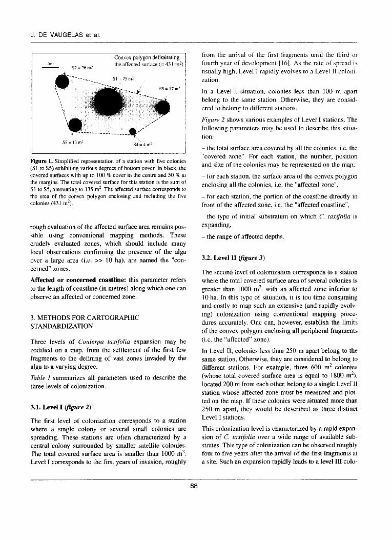
Covered surface: when a single colony is growing, it expands in dense clusters, with up to 100 % bottom cover in the middle and 50 % cover at the periphery. The total area over which C. taxifolia grows with these coverage percentages is considered to be “covered”. Based on field observations, such colonies are easy to map underwater using scuba-diving when the covered surface remains below 1000 m2. The total covered surface of a station is the sum of the surface areas of the various colonies present (/&0-e I).
Affected surface: the dispersion pattern of the colonies at a station is an important parameter as it allows one to describe the characteristics of the vegetative dissemina- tion of this alga. All the suitable substrates within the area of dispersal can eventually be colonised. Thus, the delimitation of the perimeter in which all the colonies, big or small, are growing is a convex polygon corres- ponding to the “affected” zone (&ure I).
Concerned surface: when the affected zone is larger than 10 ha, field observations have revealed that it is increasingly difficult to delimit the convex polygon of these large affected zones. Under these conditions, only a
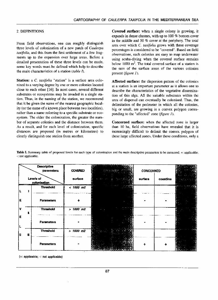
Table I. Summary table of proposed levels for each type of colonization and the main descriptive parameters to be measured. +: applicable; -: not applicable.
:okslisstiuIl 1 l’hretshold
Threshold
Parameters
Threshold
Parameters
(+: applicable: -: not applicable)
surface
e 7000 m2
--- -
+
s 1000 m2 1
> 7000 m2
87
J. DE VAUGELAS et al.
Convex polygon delimitating the affected surface (= 43 1 m’)
Figure 1. Simplified representation of a station with five colonies (S 1 to S5) exhibiting various degrees of bottom cover. In black, the covered surfaces with up to 100 % cover in the centre and 50 % at the margins. The total covered surface for this station is the sum ot Sl to S5, amounting to 135 m2. The affected surface corresponds to the area of the convex polygon enclosing and including the five colonies (43 I m2).
rough evaluation of the affected surface area remains pos- sible using conventional mapping methods. These crudely evaluated zones, which should include many local observations confirming the presence of the alga over a large area (i.e. >> 10 ha), are named the “con- cerned” zones.
Affected or concerned coastline: this parameter refers to the length of coastline (in metres) along which one can observe an affected or concerned zone.
3. METHODS FOR CARTOGRAPHIC STANDARDIZATION
Three levels of Caulerpa taxifolia expansion may be codified on a map, from the settlement of the first few fragments to the defining of vast zones invaded by the alga to a varying degree.
Table I summarizes all parameters used to describe the three levels of colonization.
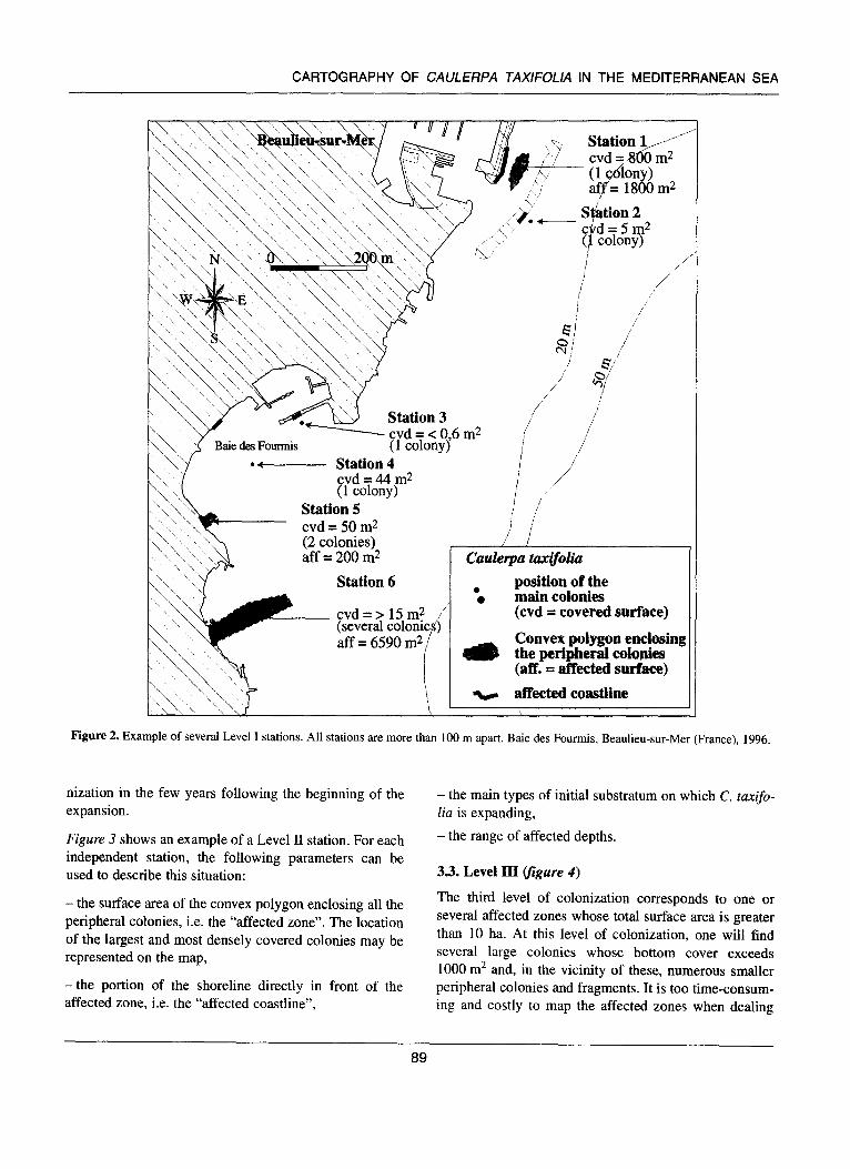
3.1. Level I (fiiure 2)
The first level of colonization corresponds to a station where a single colony or several small colonies are spreading. These stations are often characterized by a central colony surrounded by smaller satellite colonies. The total covered surface area is smaller than 1000 m*. Level I corresponds to the first years of invasion, roughly
from the arrival of the first fragments until the third OI fourth year of’ development [ 161. As the rate of spread is usually high, Level I rapidly evolves to a Level II coloni- zation.
In a Level I situation, colonies less than 100 m apart belong to the same station. Otherwise, they are consid- ered to belong to different stations.
Figure 2 shows various examples of Level I stations. The following parameters may be used to describe this situa- tion:
- the total surface area covered by all the colonies, i.e. the “covered zone”. For each station, the number, position and size of the colonies may be represented on the map,
- for each station, the surface area of the convex polygon enclosing all the colonies, i.e. the “affected zone”,
- for each station, the portion of the coastline directly in front of the affected zone, i.e. the “affected coastline”,
-the type of initial substratum on which C. taxifolia is expanding,
-the range of affected depths.
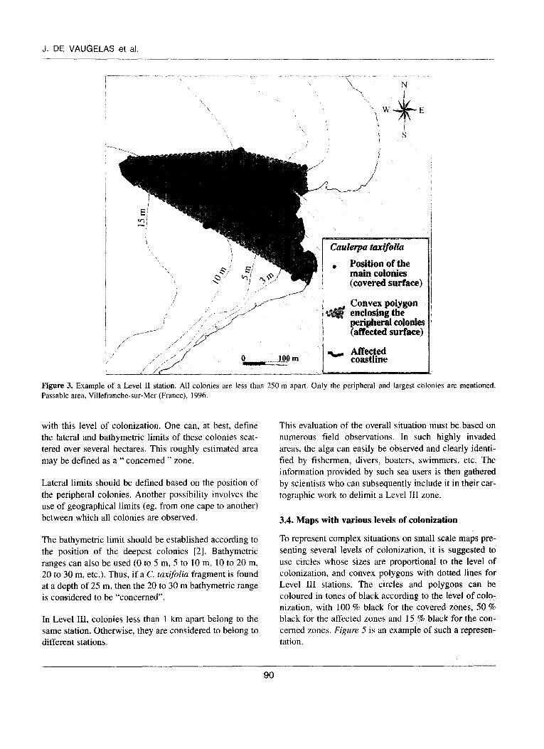
3.2. Level II yigure 3)
The second level of colonization corresponds to a station where the total covered surface area of several colonies is greater than 1000 m2, with an affected zone inferior to 10 ha. In this type of situation, it is too time consuming and costly to map such an extensive (and rapidly evolv- ing) colonization using conventional mapping proce- dures accurately. One can, however, establish the limits of the convex polygon enclosing all peripheral fragments (i.e. the “affected” zone).
In Level II, colonies less than 250 m apart belong to the same station. Otherwise, they are considered to belong to different stations. For example, three 600 m2 colonies (whose total covered surface area is equal to 1800 m2), located 200 m from each other, belong to a single Level II station whose affected zone must be measured and plot- ted on the map. If these colonies were situated more than 250 m apart, they would be described as three distinct Level I stations.
This colonization level is characterized by a rapid expan- sion of C. tuxifoliu over a wide range of available sub- strates. This type of colonization can be observed roughly four to five years after the arrival of the first fragments at a site. Such an expansion rapidly leads to a level III colo-
88
CARTOGRAPHY OF CAULERPA TAXlFOllA IN THE MEDITERRANEAN SEA
Station 3 ’ / ,; - cvd = < 0,6 m2 ) / ;/
-A Station 4 / ,/
i / ;’ /’ ! : / ’ i
r clluk~~a’taxifoli4l
. position of the 0 main colonies
(cvd = covered surface)
aff = 6590 m2 / Convex polygw enclosing i the peripheral colouies
(aff. = affected surface) I v affected coastline i
Figure 2. Example of several Level I stations. All stations are more than 100 m apart. Baie des Fourmis, Beaulieu-sur-Mer (France), 1996.
nization in the few years following the beginning of the expansion.
Figure 3 shows an example of a Level II station. For each independent station, the following parameters can be used to describe this situation:
- the surface area of the convex polygon enclosing all the peripheral colonies, i.e. the “affected zone”. The location of the largest and most densely covered colonies may be represented on the map,
-the portion of the shoreline directly in front of the affected zone, i.e. the “affected coastline”,
- the main types of initial substratum on which C. fuxifo- lia is expanding,
- the range of affected depths.
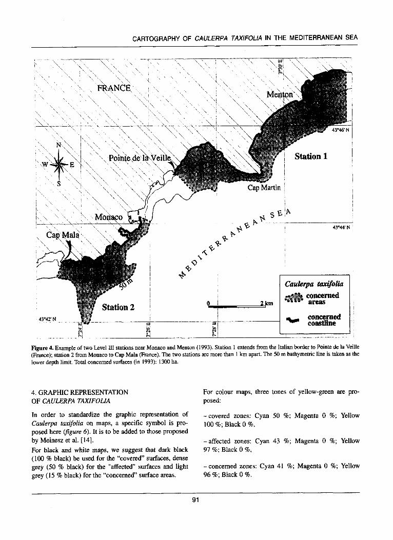
3.3. Level III figure 4) The third level of colonization corresponds to one or several affected zones whose total surface area is greater than 10 ha. At this level of colonization, one will find several large colonies whose bottom cover exceeds 1000 m2 and, in the vicinity of these, numerous smaller peripheral colonies and fragments. It is too time-consum- ing and costly to map the affected zones when dealing
89
J. DE VAUGELAS et al.
,,y ,-.-” ---,, ,.Y
i / ,,I -1,. .’ / ____._----- ,
/ I
/” ; I/” i
“
/
,i’ /’ ,/ A’
.“ /’ ;/ , / 0 -.A!@ m
/ /’
l Position of the main coIonies (covered surface)
Convex polygon enclosing the periphera colonies (affected surface)
‘cr Affected coastline
Figure 3. Example of a Level II station. All colonies are less than 250 m apart. Only the peripheral and largest colonies are mentioned. Passable area, Villefranche-sur-Mer (France), 1996
with this level of colonization. One can, at best, define the lateral and bathymetric limits of these colonies scat- tered over several hectares. This roughly estimated area may be defined as a “ concerned ” zone.
Lateral limits should be defined based on the position of the peripheral colonies. Another possibility involves the use of geographical limits (eg. from one cape to another) between which all colonies are observed.
The bathymetric limit should be established according to the position of the deepest colonies [2]. Bathymetric ranges can also be used (0 to 5 m, 5 to 10 m, 10 to 20 m, 20 to 30 m, etc.). Thus, if a C. taxifoliu fragment is found at a depth of 25 m, then the 20 to 30 m bathymetric range is considered to be “concerned”.
In Level III, colonies less than 1 km apart belong to the same station. Otherwise, they are considered to belong to different stations.
This evaluation of the overall situation must be based on numerous field observations. In such highly invaded areas, the alga can easily be observed and clearly identi- fied by fishermen, divers, boaters, swimmers, etc. The information provided by such sea users is then gathered by scientists who can subsequently include it in their car- tographic work to delimit a Level III zone.
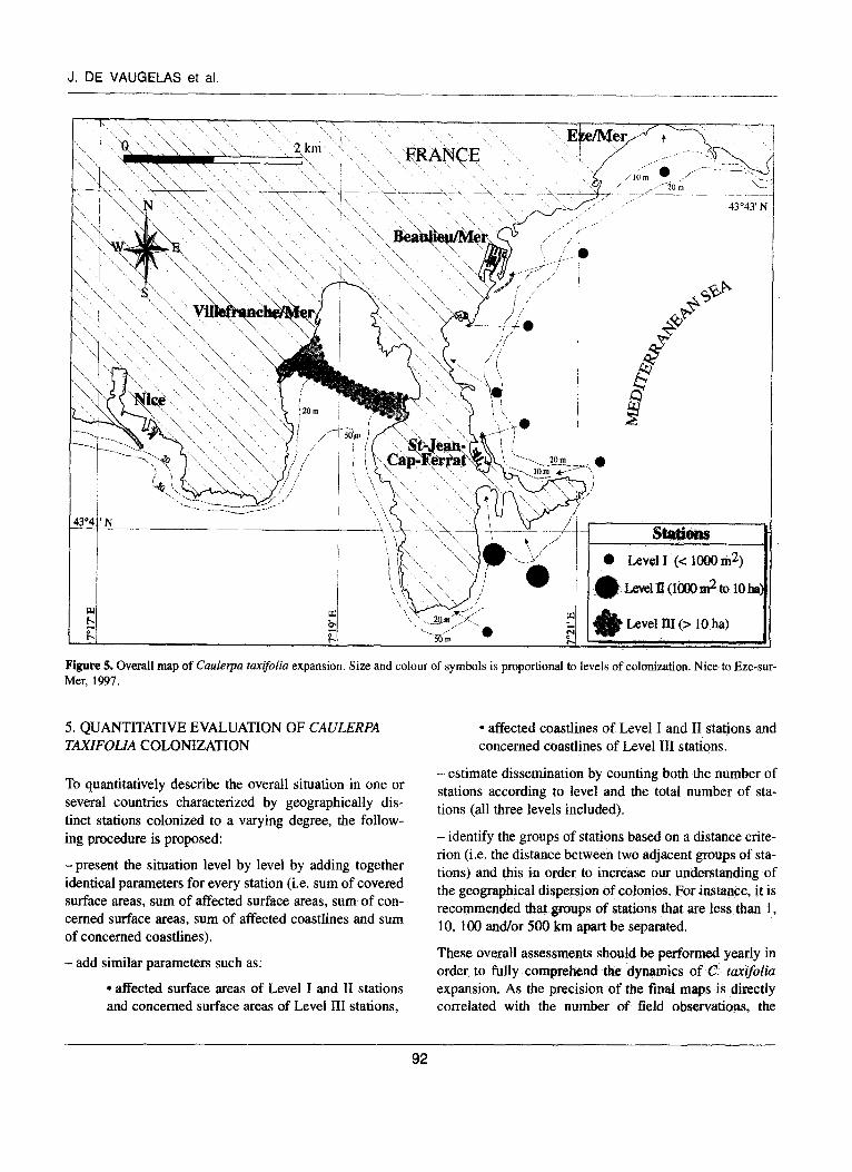
3.4. Maps with various levels of colonization
To represent complex situations on small scale maps pre- senting several levels of colonization, it is suggested to use circles whose sizes are proportional to the level of colonization, and convex polygons with dotted lines for Level III stations. The circles and polygons can be coloured in tones of black according to the level of colo- nization, with 100 % black for the covered zones, 50 % black for the affected zones and 15 % black for the con- cerned zones. Figure 5 is an example of such a represen- tation.
90
CARTOGRAPHY OF CAULERPA TAXlFOLlA IN THE MEDITERRANEAN SEA
Station 1
2m
Caukiwpa hxk@#a concerned areas
Figure 4. Example of two Level III stations near Monaco and Menton (1993). Station 1 extends from the Italian border to Pointe de la Veille (France); station 2 from Monaco to Cap Mala (France). The two stations are more than 1 km apart. The 50 m bathymetric line is taken as the lower depth limit. Total concerned surfaces (in 1993): 1300 ha.
4. GRAPHIC REPRESENTATION OF CAULERPA TAXIFOLIA
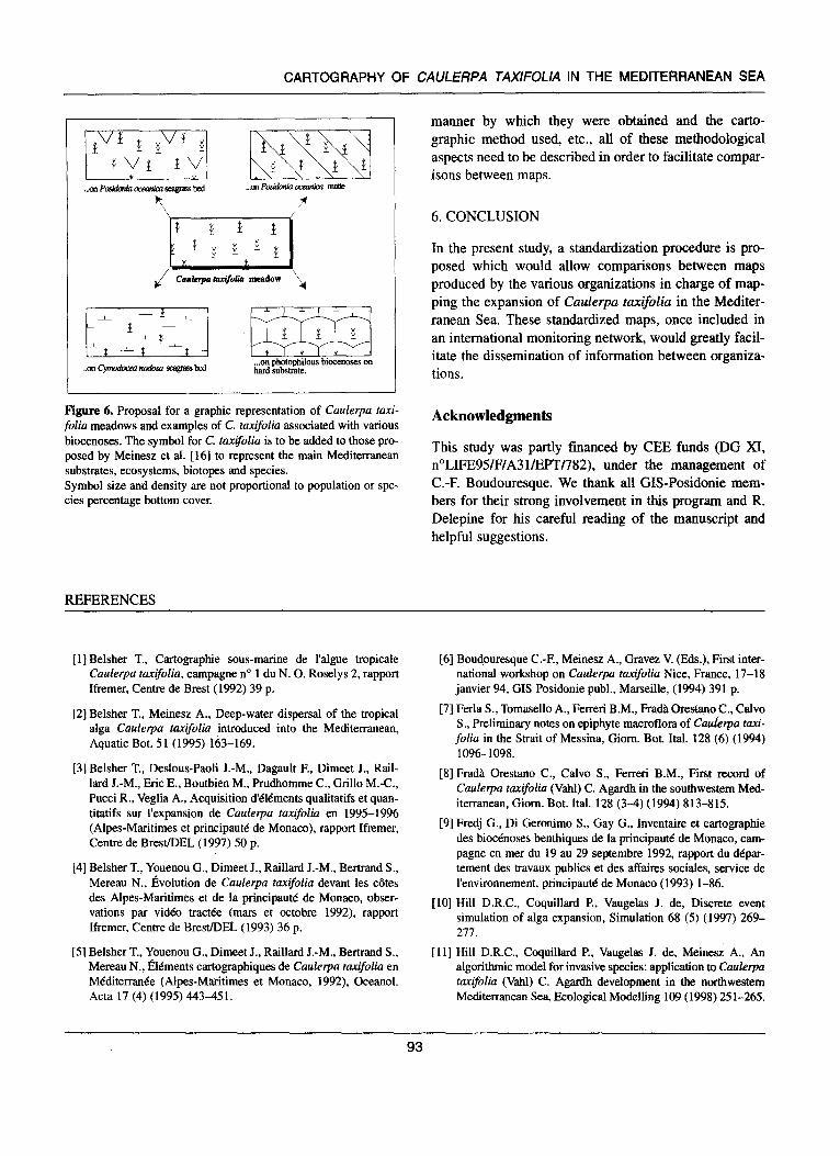
In order to standardize the graphic representation of Caulerpa taxifolia on maps, a specific symbol is pro- posed here (figure 6). It is to be added to those proposed by Meinesz et al. [14]. For black and white maps, we suggest that dark black (100 % black) be used for the “covered” surfaces, dense grey (50 % black) for the “affected” surfaces and light grey (15 % black) for the “concerned” surface areas.
For colour maps, three tones of yellow-green are pro- posed:
-covered zones: Cyan 50 %; Magenta 0 %; Yellow 100 %; Black 0 %,
-affected zones: Cyan 43 %; Magenta 0 %; Yellow 97 %; Black 0 %,
-concerned zones: Cyan 41 %; Magenta 0 %; Yellow 96 %; Black 0 %.
91
J. DE VAIJGELAS et al.
’ \ 43’=43’ N
Figure 5. Overall map of Caulerpa tanifolia expansion. Size and colour of symbols is proportional to levels of colonization. Nice to Eze-sur- Mer, 1997.
5. QUANTITATIVE EVALUATION OF CAULERPA l affected coastlines of Level I and II stations and TAXIFOLZA COLONIZATION concerned coastIines of Level III stations.
To quantitatively describe the overall situation in one or several countries characterized by geographically dis- tinct stations colonized to a varying degree, the follow- ing procedure is proposed:
-present the situation level by level by adding together identical parameters for every station (i.e. sum of covered surface areas, sum of affected surface areas, sum of con- cerned surface areas, sum of affected coastlines and sum of concerned coastlines).
- estimate dissemination by counting both the number of stations according to level and the total number of sta- tions (all three levels included).
- identify the groups of stations based on a distance crite- rion (i.e. the distance between two adjacent groups of sta- tions) and this in order to increase our understanding of the geographical dispersion of colonies. For instance, it is recommended that groups of stations that are less than I, 10, 100 and/or SO0 km apart be separated.
- add similar parameters such as:
l affected surface areas of Level I and II stations and concerned surface areas of Level III stations,
These overall assessments should be performed yearly in order, to fully comprehend the dynamics of C. tmifoliu expansion. As the precision of the final maps is directly correlated with the number of field observations, the
92
CARTOGRAPHY OF CAULERPA TAX/FOL/A IN THE MEDITERRANEAN SEA
. ..ca photopbilous biocewses on hard substrate..
Figure 6. Proposal for a graphic representation of Caulerpa &xi- folia meadows and examples of C. taxifolia associated with various biocenoses. The symbol for C. taxifolia is to be added to those pro- posed by Meinesz et al. [ 161 to represent the main Mediterranean substrates, ecosystems, biotopes and species. Symbol size and density are not proportional to population or spe- cies Percentage bottom cover.
REFERENCES
manner by which they were obtained and the carto- graphic method used, etc., all of these methodological aspects need to be described in order to facilitate compar- isons between maps.
6. CONCLUSION
In the present study, a standardization procedure is pro- posed which would allow comparisons between maps produced by the various organizations in charge of map- ping the expansion of Caulerpa tax$olia in the Mediter- ranean Sea. These standardized maps, once included in an international monitoring network, would greatly facil- itate the dissemination of information between organiza- tions.
Acknowledgments
This study was partly financed by CEE funds (DG XI, n”LIFE95/F/A31/EPT/782), under the management of C.-F. Boudouresque. We thank all GIS-Posidonie mem- bers for their strong involvement in this program and R. Delepine for his careful reading of the manuscript and helpful suggestions.
[l] Belsher T., Cartographic sous-marine de l’algue tropicale Caulerpa taxijolia, campagne no 1 du N. 0. Roselys 2, rapport Ifremer, Centre de Brest (1992) 39 p.
[2] Belsher T., Meinesz A., Deep-water dispersal of the tropical alga CadeTa taxifolia introduced into the Mediterranean, Aquatic Bot. 5 1 (1995) 163-169.
[6] Boudouresque C.-F, Meinesz A., Gravez V. @is.), First inter- national workshop on Caulerpa tanifolia Nice, France, 17-18 janvier 94, GIS Posidonie publ., Marseille, (1994) 391 p.
[7] Ferla S., Tomasello A., Ferreri B.M., Frada Orestano C., Calvo S., Preliminary notes on epiphyte macroflora of Caukrpa taxi-
folia in the Strait of Messina, Giom. Bot. Ital. 128 (6) (1994) 1096-1098.
[3] Belsher T., Deslous-Paoli J.-M., Dagault F., Dimeet J., Rail- lard J.-M., Eric E., Boutbien M., Prudhomrne C., Grill0 M.-C., Pucci R., Veglia A., Acquisition d’tlements qualitatifs et quan- titatifs sur l’expansion de Caukrpa taxifolio en 1995-1996 (Alpes-Maritimes et principautt de Monaco), rapport Ifremer, Centre de Brest/DEL (1997) 50 p.
[4] Belsher T., Youenou G., Dimeet J., Raillard J.-M., Bertrand S., Mereau N., Evolution de Caulerpa taxifolia devant les &es des Alpes-Maritimes et de la principaute de Monaco, obser- vations par video track% (mars et octobre 1992), rapport Ifremer, Centre de Brest/DEL (1993) 36 p.
[8] Frada Orestano C., Calvo S., Ferreri B.M., First record of Caulerpa taxifolia (Vahl) C. Agardh in the southwestern Med- iterranean, Giom. Bot. Ital. 128 (3-4) (1994) 8 13-8 15.
[9] Fredj G., Di Geronimo S., Gay G., Inventaire et cartographic des biocenoses benthiques de la principautd de Monaco, cam- pagne en mer du 19 au 29 septembre 1992, rapport du ddpar- tement des travaux publics et des affaires sociales, service de l’environnement, principaute de Monaco (1993) l-86.
[lo] Hill D.R.C., Coquillard P., Vaugelas J. de, Discrete event simulation of alga expansion, Simulation 68 (5) (1997) 2651 277.
[5] Belsher T., Youenou G., Dimeet J., Raillard J.-M., Bertrand S., Mereau N., Elements cartographiques de Caulerpa taxifolia en
Ill] Hill D.R.C., Coquillard I?, Vaugelas J. de, Meinesz A., An algorithmic model for invasive species: application to Caulerpa
Mtditerranee (Alpes-Maritimes et Monaco, 1992), Gceanol. tawifolia (Vahl) C. Agardh development in the northwestern Acta 17 (4) (1995) 443-451. Mediterranean Sea, Ecological Modelling 109 (1998) 25 l-265.
93
J. DE VAUGELAS et al.
[I21 Meinesz A., Modes de dissemination de l’algue Cuulrrpa taxi- fofia en Mediterranee, Comm lnt. Exp. SC. Med., rapp. Comm. int. Mer Medit. 33 (1992) 44.
[13] Meinesz A., Hesse B., Introduction et invasion de l’algue tro- picale Caulerpa ruxifolia en Mediterranee nord-occidentale, Oceanol. Acta 14 (4) (1991) 415-426.
[14] Meinesz A., Boudouresque C.F., Falconetti C., Astier J.M., Bay D., Blanc J.J., Bourcier M., Cinelli F., Cirik S., Cristiani G., Geronimo I. di, Giaccone G., Harmelin J.G., Laubier L., Lovric A.Z., Molinier R., Soyer J., Vamvakas C., Normalisa- tion des symboles pour la representation et la cartographic des biocenoses benthiques littorales de Mtditerranee Ann. Inst. odanogr. Paris, 59 (2) (I 983) 155-l 72.
[15] Meinesz A., de Vaugelas J., Benichou L., Caye G., Cottalorda J.-M., Delahaye L., Febvre M., Garin S., Komatsu T., Lemte R., Mari X., Molenaar H., Pemey L., Venturini A., Suivi de I’invasion de I’algue tropicale Cadet-pa tuxifolia en Mediterra- n&e : situation au 31 decembre 1992, Ed. laboratoire environ- nement marin littoral, universite’ de Nice-Sophia-Antipolis (1992) 80 p.
[16] Meinesz A., de Vaugelas J., Hesse B., Mari X., Spreading of the introduced tropical green alga Caulerpa taxifolia in nor- them Mediterranean waters, J. appl. Phycol. 5 (1993) 141- 147.
[17] Meinesz A., Ballesteros E., Blachier J., Cinelli F., Cottalorda J.-M., Frada Orestano C., Komatsu T., LemCe R., Molenaar H., Morucci C., Pou S., Sandulli R., Tripaldi G., Vaugelas J. de, Latest news on the spread of Cuulerpa taxifolia introduced in the Mediterranean, 5 rh int. Phycol. Congress, Qingdao 164 ( 1994) 28.
[18] Meinesz A., Vaugelas J. de, Cottalorda J.-M., Benichou L., Blachier J., Caye G., Chambet P., Delahaye L., Febvre M., Garin S., Komatsu T., Lemee R., Mari X., Molenaar H., Pemey L., Pietkiewicz D., Suivi de I’invasion de I’algue tro-
picale Cuulerpa ruxijhlin en Mediterranee : situation au 3 I decembre 1993, Ed. laboratoire environnement marin lirto- ral, universite de Nice-Sophia-Antipolis (1994) 100 p.
[19] Meinesz A., Vaugelas J. de, Cottalorda J.-M., Caye G., Char- rier S., Commeau T., Delahaye L., Febvre M., Jaffrenou F.. Molenaar H., Pietkiewicz D., Suivi de I’invasion de I’algue tro- picale Caulerpa tuxifolia devant les c&es franc;aises de la Mediterranee : situation au 3 1 dtcembre 1994, Ed. laboratoire environnement marin littoral, universite de Nice-Sophia- Antipolis (I 995) I I6 p.
[20] Meinesz A., Cottalorda J.-M., Chiaverini D., Braun M., Car valho N., Febvre M., lerardi S., Mangiaiajo L., Passeron Seitre G., Thibaut T., Vaugelas J. de, Suivi de l’invasion de I’algue tropicale Cuderpa taxifolia devant les &es franqaises de la M&iiterranee : situation au 3 I d&cembre 1996, Ed. laboratoire environnement marin littoral, universite de Nice-Sophia- Antipolis (I 997) 190 p.
[21] Meinesz A., Cottalorda J.-M., Chiaverini D., Cassar N.. Vau- gelas J. de, Suivi de l’invasion de I’algue tropicale Caulerpa taxifolia devant les c&es franqaises de la MBditerrande : situa- tion au 31 decembre 1997, Ed. laboratoire environnement marin littoral, universite de Nice-Sophia-Antipolis (1998) 250 p.
[22] Pou S., Ballesteros E., Delgado O., Grau A.M., Riera F., Weitzmann B., Sobre la presencia de1 alga Caulerpu fuxifoliu (Vahl) C. Agardb (Caulerpales, Chlorophyta) en aguas coste- ras de Mallorca, Boll. Sot. Hist. Nat. Balears 36 (1993) 84-90.
[23] Relini M., Torchia G., Prima segnalazione di Caulerpa taxi- folia in acque italiane, Doriana 6 (279) (1992) l-4.
[24] Ribera A., Ballesteros E., Boudouresque C.-F., Gomez A., Gravez V., (Eds.) Second international workshop on Cuulerpa raxifoliu, Barcelona, Spain, 15-17 Decembre 94, Universitat de Barcelona pub]., Barcelona (1996) 457 p.
94
Related Documents