Stages of sedimentary prism development on a convergent margin — Eocene Tyee Forearc Basin, Coast Range, Oregon, USA Manasij Santra a, ⁎, Ronald J. Steel a , Cornel Olariu a , Michael L. Sweet b a The University of Texas at Austin, Department of Geological Sciences, United States b ExxonMobil Production Company, Houston, Texas, United States abstract article info Article history: Accepted 15 November 2012 Available online xxxx Keywords: Tyee Basin forearc sedimentary prism slope channel slope apron deep-water fan basin-margin clinoform Architecture of ancient forearc basin successions can be difficult to reconstruct because of the widespread syn-depositional and post-depositional deformations experienced by many forearc basin-fills. For this reason various techniques have been used for reconstructing forearc basin-infill geometry, including geochemical cor- relation. The Tyee Basin succession exposed in Coast Range of Western Oregon, USA, is an Eocene forearc-fill that includes genetically related non-marine, shallow marine and deepwater clastic deposits and is gently deformed. Reconstruction of the depositional geometry of the Tyee Basin succession from detailed outcrop and subsurface data reveals two distinct stages of development for this active basin-margin. These stages are characterized by two different basin-margin clinoform architectures and also by a pronounced change in the character of the associated deepwater deposits. During the initial stage, the basin-margin clinoforms are smaller (b 250 m clinoform height) and strongly progradational, with clinoform topset dominated by fluvial deposits. At this stage thick sand-rich unconfined turbidite beds accumulated on the slope segment of the clinoforms and ex- tended out onto the basin-floor. Large scale slope conduits such as slope channels or canyons, are notably absent in this stage. The second stage is characterized by larger clinoform height (>500 m), a greater degree of topset aggradation with repeated fluvio-deltaic cycles on the shelf, and well-organized, large turbidite channels on the slope. The turbidite channels supplied medium-grained sands to the extensive, stacked basin-floor fans. The first stage described above marks the early development of a shelf-slope prism on the Tyee continental margin, and has been interpreted by some earlier workers as an unique category of basin-margin architecture, termed as a ‘submarine ramp’. However, this was only the initial stage of development of the Tyee margin and it was followed by a period of basin-filling when repeated fluvial and shallow marine shelf-transit cycles fed well-organized turbidite channels on the slope as well as Tyee Basin floor fans. The large volume of sediment deposited during the initial stage, resulted from of the unique geometry of the Tyee Basin, as influenced by the presence of pre-existing topography on the accreted oceanic basement underlying the Tyee succession. © 2012 Elsevier B.V. All rights reserved. 1. Introduction Because of the subsequent (post-depositional) tectonic deforma- tion of forearc basin deposits, there are only a limited number of stud- ies that describe large-scale depositional architecture of such basins in ancient successions (Tokuhashi, 1989; Takashima et al., 2004; Trop, 2008). In some cases, seismic data can provide a basis for basin-wide correlation (e.g., Marcaillou and Collot, 2008), but are of limited use in detailed identification of depositional environments. As a conse- quence, the well-known clinoformal geometry (Johannessen and Steel, 2005; Helland-Hansen et al., 2012) of the shelf-slope sedimenta- ry prism (alternatively termed as the ‘basin-margin sediment wedge’ as described by Burgess and Steel, 2008) that include non-marine to shelfal topset and a deep-water slope foreset, cannot be easily demon- strated from many ancient forearc margins. The Tyee Forearc Basin in the Coast Range of Oregon (Fig. 1) was filled in Early to Middle Eocene and was gently deformed subsequently, so that a reconstruction of the clinoformal geometry of the shelf-slope sedimentary prism at the Tyee forearc margin can be attempted, using outcrop and subsurface data. The exposed deposits of the Tyee Forearc Basin include non-marine, shallow marine and deepwater deposits, which can be interpreted as various components of the proposed basin-margin clinothems, provid- ed their chrostratigraphic equivalence is established by basin-scale cor- relation. This article puts forward a depositional model for the clastic succession of the Tyee Forearc Basin, primarily on the basis of outcrop observations, that allows reconstruction of the clinoform geometry, and demonstrates the stages of basin-margin sediment wedge develop- ment at this active forearc margin. The Tyee Basin is thought to have had topographic/bathymetric variations as a result of pre-existing base- ment structures (Snavely and Wagner, 1963). The proposed deposi- tional model also demonstrates the effect of bathymetric variation on Global and Planetary Change xxx (2013) xxx–xxx ⁎ Corresponding author at: The University of Texas at Austin, Department of Geological Sciences, 9701 Meyer Forest Dr., #14206, Houston, TX 77096, United States. Tel.: +1 512 584 9767. E-mail addresses: [email protected] (M. Santra), [email protected] (M.L. Sweet). GLOBAL-01905; No of Pages 25 0921-8181/$ – see front matter © 2012 Elsevier B.V. All rights reserved. http://dx.doi.org/10.1016/j.gloplacha.2012.11.006 Contents lists available at SciVerse ScienceDirect Global and Planetary Change journal homepage: www.elsevier.com/locate/gloplacha Please cite this article as: Santra, M., et al., Stages of sedimentary prism development on a convergent margin — Eocene Tyee Forearc Basin, Coast Range, Oregon, USA, Global and Planetary Change (2013), http://dx.doi.org/10.1016/j.gloplacha.2012.11.006

Welcome message from author
This document is posted to help you gain knowledge. Please leave a comment to let me know what you think about it! Share it to your friends and learn new things together.
Transcript
Global and Planetary Change xxx (2013) xxx–xxx
GLOBAL-01905; No of Pages 25
Contents lists available at SciVerse ScienceDirect
Global and Planetary Change
j ourna l homepage: www.e lsev ie r .com/ locate /g lop lacha
Stages of sedimentary prism development on a convergent margin — Eocene TyeeForearc Basin, Coast Range, Oregon, USA
Manasij Santra a,⁎, Ronald J. Steel a, Cornel Olariu a, Michael L. Sweet b
a The University of Texas at Austin, Department of Geological Sciences, United Statesb ExxonMobil Production Company, Houston, Texas, United States
⁎ Corresponding author at: TheUniversity of Texas at ASciences, 9701 Meyer Forest Dr., #14206, Houston, TX 770584 9767.
E-mail addresses: [email protected] (M. Santra)[email protected] (M.L. Sweet).
0921-8181/$ – see front matter © 2012 Elsevier B.V. Allhttp://dx.doi.org/10.1016/j.gloplacha.2012.11.006
Please cite this article as: Santra, M., et al., StaRange, Oregon, USA, Global and Planetary Ch
a b s t r a c t
a r t i c l e i n f oArticle history:Accepted 15 November 2012Available online xxxx
Keywords:Tyee Basinforearcsedimentary prismslope channelslope aprondeep-water fanbasin-margin clinoform
Architecture of ancient forearc basin successions can be difficult to reconstruct because of the widespreadsyn-depositional and post-depositional deformations experienced by many forearc basin-fills. For this reasonvarious techniques have been used for reconstructing forearc basin-infill geometry, including geochemical cor-relation. The Tyee Basin succession exposed in Coast Range of Western Oregon, USA, is an Eocene forearc-fillthat includes genetically related non-marine, shallow marine and deepwater clastic deposits and is gentlydeformed. Reconstruction of the depositional geometry of the Tyee Basin succession from detailed outcropand subsurface data reveals two distinct stages of development for this active basin-margin. These stages arecharacterized by two different basin-margin clinoform architectures and also by a pronounced change in thecharacter of the associated deepwater deposits. During the initial stage, the basin-margin clinoforms are smaller(b250 m clinoform height) and strongly progradational, with clinoform topset dominated by fluvial deposits. Atthis stage thick sand-rich unconfined turbidite beds accumulated on the slope segment of the clinoforms and ex-tended out onto the basin-floor. Large scale slope conduits such as slope channels or canyons, are notably absentin this stage. The second stage is characterized by larger clinoform height (>500 m), a greater degree of topsetaggradation with repeated fluvio-deltaic cycles on the shelf, and well-organized, large turbidite channels on theslope. The turbidite channels suppliedmedium-grained sands to the extensive, stacked basin-floor fans. The firststage described above marks the early development of a shelf-slope prism on the Tyee continental margin, andhas been interpreted by some earlier workers as an unique category of basin-margin architecture, termed asa ‘submarine ramp’. However, this was only the initial stage of development of the Tyee margin and it wasfollowed by a period of basin-filling when repeated fluvial and shallow marine shelf-transit cycles fedwell-organized turbidite channels on the slope as well as Tyee Basin floor fans. The large volume of sedimentdeposited during the initial stage, resulted from of the unique geometry of the Tyee Basin, as influenced by thepresence of pre-existing topography on the accreted oceanic basement underlying the Tyee succession.
© 2012 Elsevier B.V. All rights reserved.
1. Introduction
Because of the subsequent (post-depositional) tectonic deforma-tion of forearc basin deposits, there are only a limited number of stud-ies that describe large-scale depositional architecture of such basins inancient successions (Tokuhashi, 1989; Takashima et al., 2004; Trop,2008). In some cases, seismic data can provide a basis for basin-widecorrelation (e.g., Marcaillou and Collot, 2008), but are of limited usein detailed identification of depositional environments. As a conse-quence, the well-known clinoformal geometry (Johannessen andSteel, 2005; Helland-Hansen et al., 2012) of the shelf-slope sedimenta-ry prism (alternatively termed as the ‘basin-margin sediment wedge’as described by Burgess and Steel, 2008) that include non-marine to
ustin, Department of Geological96, United States. Tel.: +1 512
,
rights reserved.
ges of sedimentary prism devange (2013), http://dx.doi.or
shelfal topset and a deep-water slope foreset, cannot be easily demon-strated from many ancient forearc margins. The Tyee Forearc Basin inthe Coast Range of Oregon (Fig. 1) was filled in Early to Middle Eoceneandwas gently deformed subsequently, so that a reconstruction of theclinoformal geometry of the shelf-slope sedimentary prism at the Tyeeforearc margin can be attempted, using outcrop and subsurface data.The exposed deposits of the Tyee Forearc Basin include non-marine,shallow marine and deepwater deposits, which can be interpreted asvarious components of the proposed basin-margin clinothems, provid-ed their chrostratigraphic equivalence is established by basin-scale cor-relation. This article puts forward a depositional model for the clasticsuccession of the Tyee Forearc Basin, primarily on the basis of outcropobservations, that allows reconstruction of the clinoform geometry,and demonstrates the stages of basin-margin sedimentwedge develop-ment at this active forearc margin. The Tyee Basin is thought to havehad topographic/bathymetric variations as a result of pre-existing base-ment structures (Snavely and Wagner, 1963). The proposed deposi-tional model also demonstrates the effect of bathymetric variation on
elopment on a convergentmargin— Eocene Tyee Forearc Basin, Coastg/10.1016/j.gloplacha.2012.11.006
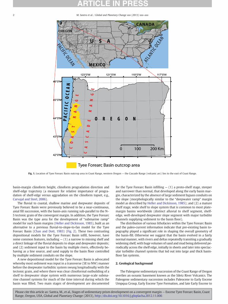
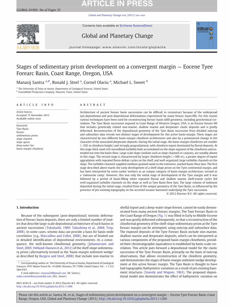
Fig. 1. Location of Tyee Forearc Basin outcrop area in Coast Range, western Oregon — the Cascade Range (volcanic arc) lies to the east of Coast Range.
2 M. Santra et al. / Global and Planetary Change xxx (2013) xxx–xxx
basin-margin clinoform height, clinoform progradation direction andshelf-edge trajectory (a measure for relative importance of progra-dation of shelf-edge versus aggradation on the clinoform topset, e.g.,Carvajal and Steel, 2006).
The fluvial to coastal, shallow marine and deepwater deposits ofTyee Forearc Basin were previously believed to be a near-continuous,axial fill succession, with the basin-axis running sub-parallel to the N–S tectonic grain of the convergent margin. In addition, the Tyee ForearcBasin was the type area for the development of “submarine ramp”model for such basin margins (Heller and Dickinson, 1985), built as analternative to a previous fluvial-to-slope-to-fan model for the TyeeForearc Basin (Chan and Dott, 1983) (Fig. 2). These two contrastingdepositional models for the Tyee Forearc Basin infill, however, havesome common features, including — (1) a narrow to missing shelf anda direct linkage of the fluvial deposits to slope and deepwater deposits;and (2) sediment input to the basin by multiple rivers, effectively be-having as a line source, and sand supply to the basin floor controlledby multiple sediment conduits on the slope.
A new depositional model for the Tyee Forearc Basin is advocatedwherebymost sediment was input in a transverse (SE to NW)mannerbefore the deepwater turbiditic system swung longitudinally with thetectonic grain, and where there was clear clinoformal outbuilding of ashelf to deepwater slope system with numerous large-scale subma-rine channel systems for much of the time interval during which thebasin was filled. Two main stages of development are documented
Please cite this article as: Santra, M., et al., Stages of sedimentary prism devRange, Oregon, USA, Global and Planetary Change (2013), http://dx.doi.or
for the Tyee Forearc Basin infilling — (1) a proto-shelf stage, steeperand narrower than normal, that developed along the early basin mar-gin, characterized by the absence of large sediment bypass conduits onthe slope (morphologically similar to the “deepwater ramp” marginmodel as described by Heller and Dickinson, 1985); and (2) a matureshelf stage, wide shelf to slope system that is common to most plate-margin basins worldwide (distinct alluvial to shelf segment, shelf-edge, well-developed deepwater slope segment with major turbiditechannels supplying sediment to the basin floor).
The distribution of various lithofacies within the Tyee Forearc Basinand the paleo-current information indicate that pre-existing basin to-pography played a significant role in shaping the overall geometry ofthe basin-fill. Otherwise we suggest that the basin evolved in a fairlynormalmanner, with rivers and deltas repeatedly transiting a graduallywidening shelf, with huge volumes of sand andmudbeingdeliveredpe-riodically across the shelf edge, initially in sheets and later into spectac-ular turbidite channel systems that led out into large and thick basin-floor fan systems.
2. Geological background
The Paleogene sedimentary succession of the Coast Range of Oregonoverlies an oceanic basement known as the Siletz River Volcanics. ThePaleogene sedimentary succession includes Paleocene to Early EoceneUmpqua Group, Early Eocene Tyee Formation, and late Early Eocene to
elopment on a convergentmargin— Eocene Tyee Forearc Basin, Coastg/10.1016/j.gloplacha.2012.11.006
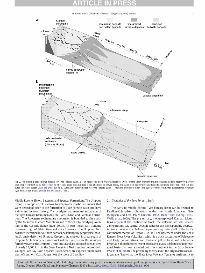
Fig. 2. Pre-existing depositional models for Tyee Forearc Basin. a. ‘Fan model’ for deep water deposits of Tyee Forearc Basin showing multiple fluvial feeders, relatively narrowshelf-slope segment with deltas close to the shelf-edge and multiple slope channels on lower slope, and sand-rich deepwater fan deposits including inner fan, mid-fan andouter fan facies (after Chan and Dott, 1983). b. Submarine ramp model for Tyee Forearc Basin — showing deformed older (pre-Tyee Forearc) sediments, undeformed youngerTyee Forearc sediments (Heller and Dickinson, 1985).
3M. Santra et al. / Global and Planetary Change xxx (2013) xxx–xxx
Middle Eocene Elkton, Bateman and Spencer Formations. The UmpquaGroup is composed of shallow to deepwater clastic sediments thatwere deposited prior to the formation of Tyee Forearc basin and havea different tectonic history. The overlying sedimentary succession ofthe Tyee Forearc Basin includes the Tyee, Elkton and Bateman Forma-tions. The Paleogene sedimentary succession is bounded to the southby theMesozoic KlamathMountains and to the east by overlying volca-nics of the Cascade Range (Ryu, 2003). An east–north-east trendingbasement high of Siletz River volcanics known as the Umpqua Archhas been identified in southern part of Coast Range by geophysical stud-ies. Strongly deformed Umpqua Group strata crop out in areas south ofUmpqua Arch. Gently deformed rocks of the Tyee Forearc Basin uncon-formably overlie theUmpquaGroup strata and are exposed over an areaof nearly 15,000 km2 in the Coast Range in a N–S trending outcrop belt.Younger Coos Bay Basin deposits (Late Eocene) are exposed on the coastwest of southern Coast Range near the town of Coos Bay.
Please cite this article as: Santra, M., et al., Stages of sedimentary prism devRange, Oregon, USA, Global and Planetary Change (2013), http://dx.doi.or
2.1. Tectonics of the Tyee Forearc Basin
The Early to Middle Eocene Tyee Forearc Basin can be related toFarallon/Kula plate subduction under the North American Plate(Simpson and Cox, 1977; Duncan, 1982; Heller and Ryberg, 1983;Wells et al., 2000). The pre-tertiary, metamorphosed Klamath Moun-tains represent the continental block; the volcanic arc was locatedalong present-day central Oregon, whereas the corresponding deepwa-ter trench was located below the present-day outer shelf of the Pacificcontinental margin of Oregon (Fig. 3a). The basement under the CoastRange (Siletz River Volcanics), which is a thick succession of Paleoceneand Early Eocene alkalic and tholeiitic pillow lavas and submarinebreccias is thought to represent an oceanic plateau, island chain ormar-ginal basin that was accreted onto the continent in the Early Eocene(Wells et al., 2000). The prevailing theory about the origin of this ocean-ic terrane (known as the Siletz River Volcanic Terrane) attributes it to
elopment on a convergentmargin— Eocene Tyee Forearc Basin, Coastg/10.1016/j.gloplacha.2012.11.006
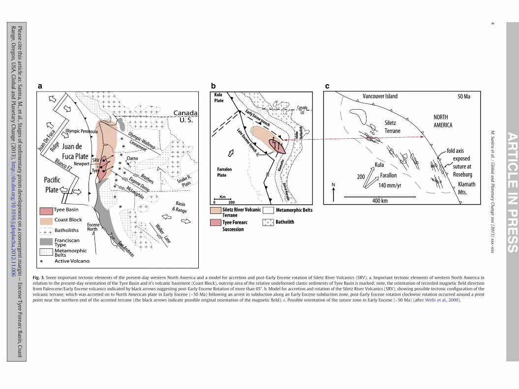
Fig. 3. Some important tectonic elements of the present-day western North America and a model for accretion and post-Early Eocene rotation of Siletz River Volcanics (SRV). a. Important tectonic elements of western North America inrelation to the present-day orientation of the Tyee Basin and it's volcanic basement (Coast Block), outcrop area of the relative undeformed clastic sediments of Tyee Basin is marked; note, the orientation of recorded magnetic field directionfrom Paleocene/Early Eocene volcanics indicated by black arrows suggesting post-Early Eocene Rotation of more than 65°. b. Model for accretion and rotation of the Siletz River Volcanics (SRV), showing possible tectonic configuration of thevolcanic terrane, which was accreted on to North American plate in Early Eocene (~50 Ma) following an arrest in subduction along an Early Eocene subduction zone, post-Early Eocene rotation clockwise rotation occurred around a pivotpoint near the northern end of the accreted terrane (the black arrows indicate possible original orientation of the magnetic field). c. Possible orientation of the suture zone in Early Eocene (~50 Ma) (after Wells et al., 2000).
4M.Santra
etal./
Globaland
PlanetaryChange
xxx(2013)
xxx–xxx
Pleasecite
thisarticle
as:Santra,M.,etal.,Stages
ofsedimentary
prismdevelopm
entonaconvergentm
argin—
EoceneTyee
ForearcBasin,Coast
Range,Oregon,U
SA,G
lobalandPlanetary
Change(2013),http://dx.doi.org/10.1016/j.gloplacha.2012.11.006
5M. Santra et al. / Global and Planetary Change xxx (2013) xxx–xxx
the collision and accretion of a hotspot generated oceanic island chainor anoceanic plateau to theNorthAmerican continental block followingan arrested subduction (Simpson and Cox, 1977; Heller and Ryberg,1983). Paleomagnetic data from the Coast Range of Oregon stronglysuggest that the Siletz River Volcanic Terrane along with the overlyingEocene sediments of Umpqua and Tyee Forearc basins experienceda clockwise rotation of more than 65° since late Early Eocene time(Simpson and Cox, 1977; Heller and Ryberg, 1983). The tectonicmodel for this rotation (Fig. 3b) also incorporates the idea that the su-ture zone between Siletz River Volcanic Terrane and North Americancontinental plate represents an early Tertiary subduction zone thatwas clogged because of the presence of a possible hotspot-generatedaseismic ridge or a series of oceanic islands/seamounts (Simpson andCox, 1977). As a result, a new subduction zone formed farther seawardin late Early Eocene. Observations from several data sources supportsthis model, including observation made by Heller and Ryberg (1983)from petrology and composition of Umpqua and Tyee Forearc Basinsandstones and interpretation of offshore seismic lines by Snavelyet al. (1980) (Snavely et al., 1980). Wells et al. (2000) have presenteda possible configuration of the suture zone representing the easternboundary of Siletz Terrane (also the possible Early Eocene Trench)extending along Wild Life Safari Fault near Roseburg in Oregon toVancouver Island in the north (Fig. 3c).
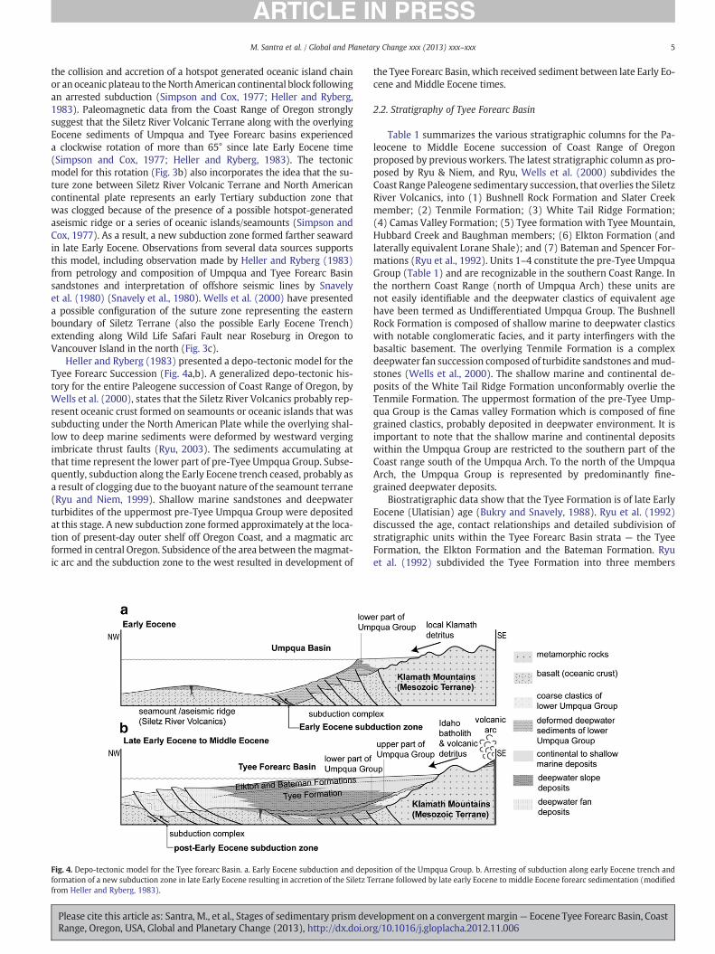
Heller and Ryberg (1983) presented a depo-tectonic model for theTyee Forearc Succession (Fig. 4a,b). A generalized depo-tectonic his-tory for the entire Paleogene succession of Coast Range of Oregon, byWells et al. (2000), states that the Siletz River Volcanics probably rep-resent oceanic crust formed on seamounts or oceanic islands that wassubducting under the North American Plate while the overlying shal-low to deep marine sediments were deformed by westward vergingimbricate thrust faults (Ryu, 2003). The sediments accumulating atthat time represent the lower part of pre-Tyee Umpqua Group. Subse-quently, subduction along the Early Eocene trench ceased, probably asa result of clogging due to the buoyant nature of the seamount terrane(Ryu and Niem, 1999). Shallow marine sandstones and deepwaterturbidites of the uppermost pre-Tyee Umpqua Group were depositedat this stage. A new subduction zone formed approximately at the loca-tion of present-day outer shelf off Oregon Coast, and a magmatic arcformed in central Oregon. Subsidence of the area between themagmat-ic arc and the subduction zone to the west resulted in development of
Fig. 4. Depo-tectonic model for the Tyee forearc Basin. a. Early Eocene subduction and depoformation of a new subduction zone in late Early Eocene resulting in accretion of the Siletz Tfrom Heller and Ryberg, 1983).
Please cite this article as: Santra, M., et al., Stages of sedimentary prism devRange, Oregon, USA, Global and Planetary Change (2013), http://dx.doi.or
the Tyee Forearc Basin, which received sediment between late Early Eo-cene and Middle Eocene times.
2.2. Stratigraphy of Tyee Forearc Basin
Table 1 summarizes the various stratigraphic columns for the Pa-leocene to Middle Eocene succession of Coast Range of Oregonproposed by previous workers. The latest stratigraphic column as pro-posed by Ryu & Niem, and Ryu, Wells et al. (2000) subdivides theCoast Range Paleogene sedimentary succession, that overlies the SiletzRiver Volcanics, into (1) Bushnell Rock Formation and Slater Creekmember; (2) Tenmile Formation; (3) White Tail Ridge Formation;(4) Camas Valley Formation; (5) Tyee formation with Tyee Mountain,Hubbard Creek and Baughman members; (6) Elkton Formation (andlaterally equivalent Lorane Shale); and (7) Bateman and Spencer For-mations (Ryu et al., 1992). Units 1–4 constitute the pre-Tyee UmpquaGroup (Table 1) and are recognizable in the southern Coast Range. Inthe northern Coast Range (north of Umpqua Arch) these units arenot easily identifiable and the deepwater clastics of equivalent agehave been termed as Undifferentiated Umpqua Group. The BushnellRock Formation is composed of shallow marine to deepwater clasticswith notable conglomeratic facies, and it party interfingers with thebasaltic basement. The overlying Tenmile Formation is a complexdeepwater fan succession composed of turbidite sandstones andmud-stones (Wells et al., 2000). The shallow marine and continental de-posits of the White Tail Ridge Formation unconformably overlie theTenmile Formation. The uppermost formation of the pre-Tyee Ump-qua Group is the Camas valley Formation which is composed of finegrained clastics, probably deposited in deepwater environment. It isimportant to note that the shallow marine and continental depositswithin the Umpqua Group are restricted to the southern part of theCoast range south of the Umpqua Arch. To the north of the UmpquaArch, the Umpqua Group is represented by predominantly fine-grained deepwater deposits.
Biostratigraphic data show that the Tyee Formation is of late EarlyEocene (Ulatisian) age (Bukry and Snavely, 1988). Ryu et al. (1992)discussed the age, contact relationships and detailed subdivision ofstratigraphic units within the Tyee Forearc Basin strata — the TyeeFormation, the Elkton Formation and the Bateman Formation. Ryuet al. (1992) subdivided the Tyee Formation into three members
sition of the Umpqua Group. b. Arresting of subduction along early Eocene trench anderrane followed by late early Eocene to middle Eocene forearc sedimentation (modified
elopment on a convergentmargin— Eocene Tyee Forearc Basin, Coastg/10.1016/j.gloplacha.2012.11.006
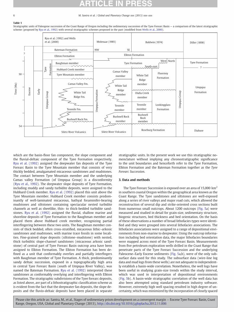
Table 1Stratigraphic units of Paleogene succession of the Coast Range of Oregon including the sedimentary succession of the Tyee Forearc Basin — a comparison of the latest stratigraphicscheme (proposed by Ryu et al., 1992) with several stratigraphic schemes proposed in the past (modified from Wells et al., 2000).
Ryu et al. (1992) and Wells
et al. (2000) Molenaar (1985) Baldwin (1974) Diller (1898)
Tyee Formation
Umpqua
Formation
Diabase
NWBateman Formation
Elkton Formation
Baughman member
Hubbard Creek member
Tyee Mountain member
Camas Valley Fm.
White Tail
50
54
Ridge Fm.
Tenmile Fm.
Bushnell Rock Fm.
Siletz River Volcanics
SE
Elkton Formation
Tyee Formation
South-east
West North
Fluornoy
FormationWhite Tail
Camas Valley
member
Ridge
member
member
member
BushnellRock
membermember
Roseburg FormationSiletz River Volcanics
Bushnell Rock
Olalla Creek
White Tail
Ridge
memberU
mp
qu
a F
orm
ati
on
Um
pq
ua
Gro
up
Ty
ee
Form
ati
on
Um
pq
ua
Gro
up
Ea
rly
Eo
cen
e
Tim
e (
Ma
)
Tenmile
member
Tenmile Lookingglass
Formation
?
?
? ?
6 M. Santra et al. / Global and Planetary Change xxx (2013) xxx–xxx
which are the basin-floor fan component, the slope component andthe fluvial-deltaic component of the Tyee Formation respectively.Ryu et al. (1992) assigned the deepwater fan deposits of the TyeeForearc Basin to the Tyee Mountain member that consists of verythickly bedded, amalgamated micaceous sandstones and mudstones.The contact between Tyee Mountain member and the underlyingCamas valley Formation (of Umpqua Group) is a disconformity(Ryu et al., 1992). The deepwater slope deposits of Tyee Formation,including muddy and sandy turbidite deposits, were assigned to theHubbard Creek member. Ryu et al. (1992) placed this unit above theTyee Mountain member. Hubbard Creek member consists predom-inantly of well-laminated micaceous, bathyal foraminifer-bearingmudstones and siltstones containing spectacular nested turbiditechannels as well as sheetlike, thin- to thick-bedded turbidite sand-stones. Ryu et al. (1992) assigned the fluvial, shallow marine andshoreline deposits of Tyee Formation to the Baughman member andplaced them above Hubbard creek member, recognizing partialinterfingering between these two units. The Baughman member con-sists of thick bedded, often cross-stratified, micaceous lithic–arkosicsandstones and mudstones, with marine trace fossils in some locali-ties. Fine-grained slope deposits (siltstone–mudstone) with nested,thick turbiditic slope-channel sandstones (micaceous arkosic sand-stone) of central part of Tyee Forearc Basin outcrop area have beenassigned to Elkton Formation. The Elkton Formation has been de-fined as a unit that conformably overlies and partially interfingerswith Baughman member of Tyee Formation. A thick, predominantlysandy deltaic succession, exposed in a topographically high areain central Tyee Forearc Basin (south of Umpqua River Valley), wasnamed the Bateman Formation. Ryu et al. (1992) interpreted thesesandstones as conformably overlying and interfingering with ElktonFormation. The stratigraphic subdivisions of the Tyee forearc deposits,as listed above, are part of a lithostratigraphic classification scheme asis evident from the fact that the deepwater fan deposits, the slope de-posits and the fluvio-deltaic deposits have been placed in separate
Please cite this article as: Santra, M., et al., Stages of sedimentary prism devRange, Oregon, USA, Global and Planetary Change (2013), http://dx.doi.or
stratigraphic units. In the present work we use this stratigraphic no-menclature without implying any chronostratigraphic significanceto the unit boundaries and henceforth refer to the Tyee Formation,Elkton Formation and the Bateman Formation together as the TyeeForearc Succession.
3. Data and methods
The Tyee Forearc Succession is exposed over an area of 15,000 km2
in southern coastal Oregon within the geographical area known as theCoast Range. The Tyee sandstones and siltstones are well-exposedalong a series of river valleys and major road cuts, which allowed thereconstruction of several dip and strike-oriented cross sections builtfrom numerous small outcrops. About 1200 outcrops (Fig. 5a) weremeasured and studied in detail for grain-size, sedimentary structure,biogenic structures, bed thickness and bed orientation. On the basisof these observations a number of broad lithofacies types were identi-fied and they were grouped into several lithofacies associations. Thelithofacies associations were assigned to a range of depositional envi-ronments from non-marine to deepwater. Using the outcrop informa-tion including bed orientation data, the major lithofacies boundarieswere mapped across most of the Tyee Forearc Basin. Measurementsfrom five petroleum exploration wells drilled in the Coast Range thatpenetrate parts of the Tyee Forearc Succession and the underlyingPaleocene–Early Eocene sediments (Fig. 5a,b), were of the only sub-surface data used for this study. The subsurface data (wire-line logdata andmud logs from thesewells) are not adequate to independent-ly establish a basin-wide correlation. Nonetheless, the well logs havebeen useful in studying grain-size trends within the study interval,which was used in interpretation of depositional environments(Fig. 5b). A basin-wide stratigraphic correlation of the well data hasalso been attempted using standard petroleum industry software.However, extremely high well spacing resulted in high degree of un-certainty, whichwasminimized by the incorporation of closely spaced
elopment on a convergentmargin— Eocene Tyee Forearc Basin, Coastg/10.1016/j.gloplacha.2012.11.006
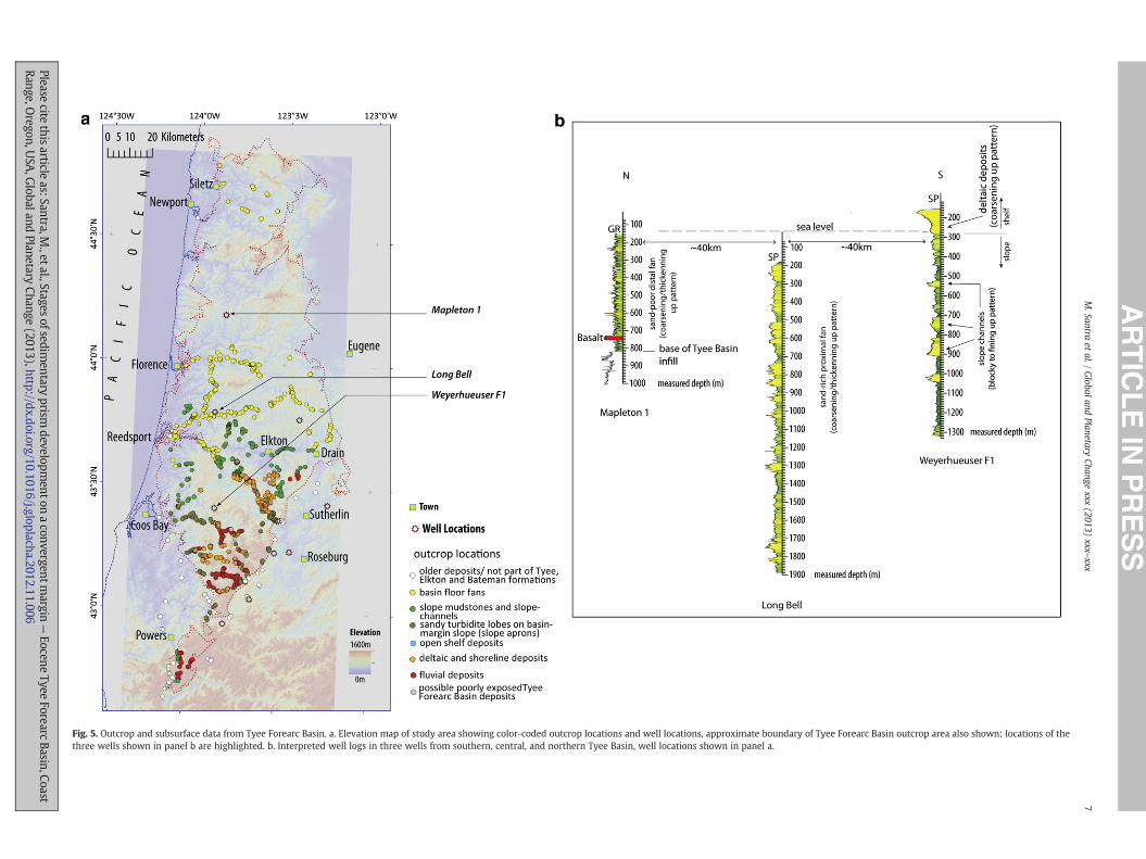
Fig. 5. Outcrop and subsurface data from Tyee Forearc Basin. a. Elevation map of study area showing color-coded outcrop locations and well locations, approximate boundary of Tyee Forearc Basin outcrop area also shown; locations of thethree wells shown in panel b are highlighted. b. Interpreted well logs in three wells from southern, central, and northern Tyee Basin, well locations shown in panel a.
7M.Santra
etal./
Globaland
PlanetaryChange
xxx(2013)
xxx–xxx
Pleasecite
thisarticle
as:Santra,M.,etal.,Stages
ofsedimentary
prismdevelopm
entonaconvergentm
argin—
EoceneTyee
ForearcBasin,Coast
Range,Oregon,U
SA,G
lobalandPlanetary
Change(2013),http://dx.doi.org/10.1016/j.gloplacha.2012.11.006
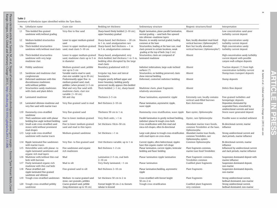
Table 2Summary of lithofacies types identified within the Tyee Basin.
No. Lithofacies name Grain size Bedding/set thickness Sedimentary structure Biogenic structures/fossil Interpretation
L1 Thin-bedded fine-grainedsandstone with/without grading
Very-fine to fine sand Sharp-based thinly bedded (2–10 cm);upper boundary gradual
Ripple lamination, plane-parallel lamination,normal grading— sand beds fine upwardinto siltstone–mudstone layers
Absent Low concentration sand-poorturbidity current deposit
L2 Medium-bedded structurelesssandstones
Lower to upper medium-grainedsand
Sharp-based, bed thickness — 20 cmto 1 m, sand amalgamation rare
Massive, to weakly normal graded, loadingcommon at the base
Rare, locally abundant mud-linedvertical burrows (Ophiomorpha?)
High concentration sandyturbidity current deposit
L3a Thick-bedded structurelesssandstone with/without mud clasts
Lower to upper medium-grainedsand, mud clasts 5–10 cm
Sharp-based, bed thickness — 1 mto 5 m, amalgamation common
Structureless, loading at the base rare, mudclasts present in certain locations, weakgrading at the top of beds (top 2 cm)
Rare but locally abundantvertical burrows (Ophiomorpha?)
High concentration sandyturbidity current deposit
L3b Thick-bedded structurelesssandstone with very largemudstone clast
Lower to upper medium-grainedsand, mudstone clasts up to 5 min diameter
Sharp-based, amalgamated, verythick-bedded, bed thickness 1 m–5 m,bedding often disrupted by the largemud clasts
Structureless, clasts are composed oflaminated mudstone
Absent High concentration sandy turbiditycurrent deposit with possiblecanyon wall-collapse deposits
L4 Pebbly sandstone Medium-grained sand, pebblesize up to 5 cm
Boundary gradational with L3 Indistinct imbrications, large-scale inclinedsurfaces (?)
Absent Traction deposit (?) from highconcentration turbidity current
L5 Sandstone and mudstone clastconglomerate
Variable matrix-mud to sand,clast-size variable (up to 20 cm)
Irregular top, base and lateralboundaries
Structureless, no bedding preserved, clastsshow internal bedding
Absent Slump/mass transport deposits
L6 Deformed sandstones with thindiscontinuous mudstoneswith/without pebbles
Predominantly upper fine- tomedium grained sand, mud,pebbles (when present) 2–5 cm
Irregular poorly defined upper andlower boundary, bedding poorlypreserved, locally appears thin-bedded
Deformed, contorted indistinct bedding Absent Slump deposits
L7 Structureless sandy mudstoneswith clasts and plant debris
Mud and very fine sand withmudstone clasts, clast sizevariable (1–10 cm)
Thick-bedded (>1 m), sharp-based Mudstone clasts, plant fragmentsrelatively uncommon
Absent Debris flow deposit
L8 Laminated mudstone Silt and clay Thickness 2–5 cm Planar lamination, asymmetric ripple Extremely rare, locally containsvertical sand-filled burrows
Fine-grained turbidites andhemipelagic deposits
L9 Laminated siltstone-mudstone andvery fine sand with marine trace
Very fine-grained sand to mud Bed thickness 2–10 cm Planar lamination, asymmetric ripple,wave ripple
Rare Asterosoma Deposition dominated bysuspended fines, reworked byunidirectional currents and wave
L10 Hummocky cross-stratifiedsandstone
Very fine-grained sand Thickness 50 cm to 1 m Hummocky cross stratification, wave ripple Rare oyster, Ophiomorpha Storm wave generated deposit
L11 Thick sandstone units with planarbedding/low angle inclined bedding
Fine to lower medium-grainedsand
Very thick units, >1 m Parallel lamination to gently inclined bedding,indistinct planar & trough cross-beds
Oyster, rare Ophiomorpha Possible wave re-worked sediment
L12 Small-scale cross-stratified sandstones with/without prominentmud-drapes
Fine to lower medium-grainedsand and mud in thin layers
Set thickness 10cm–50 cm Cross stratification with thin mud andmica-rich drapes, often bi-directional
Abundant marine trace fossils,common Teredolites at the base,Ophiomorpha
Bi-directional current, marineinfluence
L13 Large scale cross-stratifiedsandstone with marine traces
Medium-grained sandstone Set thickness >1 m Large scale planar to trough cross-stratificationwith mud-layers on cross-strata
Abundant marine trace fossils,common Teredolites, rareOphiomorpha, oysters
Strong unidirectional current andslack periods, marine influence
L14 Ripple laminated fine sandstoneswith marine traces
Very fine- to fine-grained sand Unit thickness variable, up to 1 m Current ripples, often bidirectional, rippleshave thin organic-matter rich drape
Common Ophiomorpha Bi-directional currents, marineinfluence
L15 Heterolithic units with planar- toripple-laminated sandstones andorganic rich mud layers
Fine sandstones and organicrich mudstones
Bed thickness 1–2 cm Planar lamination, current ripples, lenticularbedding and flaser bedding
Plant fragments common,marine trace fossil Teredolites
Influenced by unidirectional currentand slack periods, marine influence
L16 Mudstone with/without thin coalbeds with burrows
Mud Lamination 2–5 cm, coal beds2–10 cm
Planar lamination ripple lamination Plant fragments common,Teredolites common
Suspension dominated deposit withmarine influence
L17 Finely laminated organic-richmudstone with thin coal beds
Mud to silt Very finely laminated, b1 cm Planar lamination Coalified plant fragments Suspension dominated deposit,non-marine
L18 Planar-stratified andripple-laminated fine-grainedsandstone and siltstone
Fine-grained sand to silt Bed thickness 2–10 cm Planar lamination/bedding, asymmetricripple
Plant fragments Suspension dominated deposits,non-marine
L19 Trough cross-stratified sandstones Medium- to coarse-grained sandstone, rare granules, pebbles
Set thickness 50 cm to 2 m Cross-stratified with foreset height50 cm–2 m
Plant fragments Strong unidirectional current,bedload dominated, non-marine
L20 Trough cross-stratified pebblysandstone
Coarse-grained sand, pebble(long dimension up to 10 cm)
Foreset height 50 cm–2 m. foresetstabular to lensoid
Trough cross stratification Coalified plant fragmentsvery common
Strong unidirectional current,bedload dominated, non-marine
8M.Santra
etal./
Globaland
PlanetaryChange
xxx(2013)
xxx–xxx
Pleasecite
thisarticle
as:Santra,M.,etal.,Stages
ofsedimentary
prismdevelopm
entonaconvergentm
argin—
EoceneTyee
ForearcBasin,Coast
Range,Oregon,U
SA,G
lobalandPlanetary
Change(2013),http://dx.doi.org/10.1016/j.gloplacha.2012.11.006
9M. Santra et al. / Global and Planetary Change xxx (2013) xxx–xxx
outcrop data. All outcrop information and the well-data were placedin a three-dimensional framework using standard 3D seismic inter-pretation software that allowed reconstruction of vertical profiles in
Fig. 6. Unconfined turbidite deposits of central and northern Tyee Forearc Basin — proximal(FA) shown in the figure, see Tables 1 and 2; locations of the outcrops are shown in Fig. 10stones (L1) and thick, laterally continuous layers of laminated mudstones (L8). b. Distmedium-bedded sandstones (L1, L2), thin laterally continuous mudstones (L8) and debris flnorthern Tyee Forearc Basin. d. Proximal fan outcrop from central Tyee Forearc Basin (FA 2)—layers of laminated mudstones (L8), sandstone amalgamation (indicated by red arrow) ise. Thick-bedded laterally continuous amalgamated sandstones (L3a) — proximal fan, expos
Please cite this article as: Santra, M., et al., Stages of sedimentary prism devRange, Oregon, USA, Global and Planetary Change (2013), http://dx.doi.or
arbitrary directions. The measured stratigraphic sections at the out-crop locations were treated as well data and were correlated acrossthe basin. For each profile, a large number (100–300) of relatively
and distal deepwater fan deposits; for lithofacies types (L) and lithofacies associations. a. Most distal sandy deepwater fan outcrop — laterally continuous thin-bedded sand-al fan (FA 2) exposed in northern Tyee Forearc Basin — outcrop shows thin- andow deposits (L7). c. Rip-up clasts within the debris flow deposits — distal fan outcrop,thick-bedded and medium-bedded laterally continuous sandstones (L2, L3a) and thin
rare, pronounced loading at the base of sandstone layers (indicated by yellow arrow).ed in central Tyee Forearc Basin.
elopment on a convergentmargin— Eocene Tyee Forearc Basin, Coastg/10.1016/j.gloplacha.2012.11.006
10 M. Santra et al. / Global and Planetary Change xxx (2013) xxx–xxx
short measured sections studied along multiple transects were com-bined to reconstruct the stratigraphy of the Tyee Forearc Successionat various scales. The correlations between outcrop locations are inter-pretive, as the outcrops are not very continuous in most areas of thebasin, but the interpretations are consistent with topographic dataand structural data at all locations.
Correlation of measured outcrops and well data across the basinresulted in several basin-wide cross sections that demonstrate thestacking pattern of non-marine, shelf, deepwater slope, and basinfloor deposits. These basin-wide cross sections and the lithofaciesmap together provided good control on the three dimensional geom-etry of the basin-fill and allowed the stratigraphic reconstruction ofshelf-margin clinothems, each of which includes topsets of fluvialto shoreline and shelf deposits, a muddy to sandy deepwater slope(foreset), and a sandy basin-floor fan component (bottomset). An im-portant tool for reconstruction of the clinothems within the TyeeForearc Succession has been the identification of a number of repeti-tive coarsening upward successions or parasequences within thefluvial/shallow-marine deposits of the southern Tyee Forearc Basin.These repetitive successions were recognized by their generallycoarsening/thickening upward character, with a prominent andwidespread fine-grained horizon at their bases in most cases. Thesesuccessions have been correlated across the continental/shallow-marine succession of southern Tyee Forearc Basin and into theTyee deepwater slope and basinal part of Tyee forearc succession.From this complex correlation exercise a first attempt at addingchronostratigraphic surfaces/trends to the Tyee Forearc Basinlithostratigraphy has been achieved, not simply conceptually butwith ground-based information. This, in turn proved to be critical forseveral advances in our understanding of the basin-fill geometry.Clinoform reconstruction demonstrates that topset and slope stratain the basin fill accreted mainly in a transverse manner, whereas theand basin-floor turbidites swung longitudinally, sub-parallel with thetectonic grain along an older subduction trench.
4. Results
4.1. Lithofacies types and lithofacies associations
The clastic deposits of the Tyee Forearc Basin were subdivided into21 lithofacies types on the basis of grain-size, sedimentary structures,bed thickness and biogenic traces (Table 2). The 21 litofacies typeshave been grouped into facies associations that are representative ofvarious non-marine to deepwater depositional environments(Figs. 6–9). The locations of these outcrop photographs have beenshown in Fig. 10.
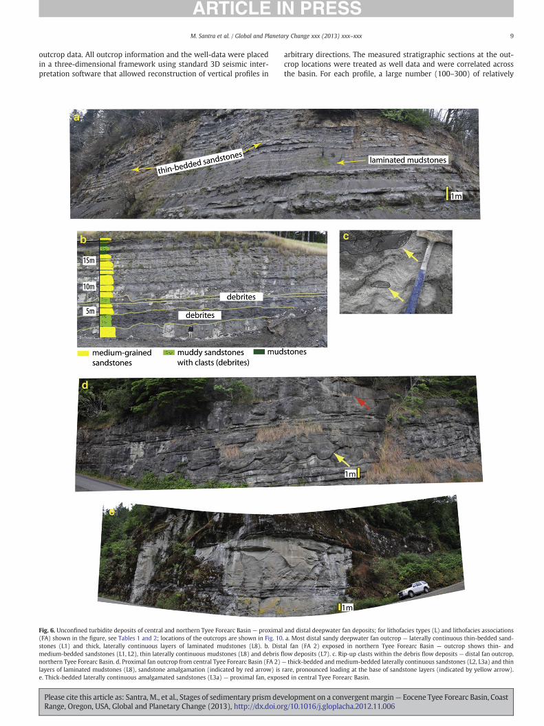
Seven facies associations were identified across Tyee Forearc Basinthat are dominated by turbidite deposits (Table 3), including FA 1(fine-grained turbidite and hemipelagic suspension deposits), FA 2(unconfined mud-rich sandy turbidite deposits), FA-3 (unconfinedsandy turbidite deposits), FA 4 (unconfined/semiconfined turbidite de-positswith evidence of instability), FA 5-1 (sandy turbidite channel-fillsand overbank), FA 5-2 (sandy slope canyon-fill) and FA 6 (sandy/muddy small channel/gully fill). FA 5-2 is very restricted in its occur-rence, being limited to a series of outcrops in southern-most outcrop
Fig. 7. Outcrop examples of channelized turbidite deposits (panels a–c), laterally extensivesandy turbidite deposits of southern Tyee Forearc Basin with associated deformed sedimeTables 1 and 2; locations of the outcrops are shown in Fig. 10. a. Partly exposed turbidite chements (separated by black broken lines in the figure), composed of thick-bedded amalgaoutcrop area showing very large mudstone blocks, outlined and marked by black arrowsline indicates the incisional contact between sandy canyon-fill and underlying laminated mulaminated siltstone and mudstone in central Tyee Forearc Basin. e. Outcrop example of thickand associated deformed layers — from southern Tyee Forearc Basin. f. Deformed gravel-ricthick-bedded sandstone. h. Extra-basinal clast (pebbles)-rich zone in thick-bedded sandsto(L4), sandstone and mudstone layers are folded within the deformed zone, red arrow pointthe deformed zone shown in panel i.
Please cite this article as: Santra, M., et al., Stages of sedimentary prism devRange, Oregon, USA, Global and Planetary Change (2013), http://dx.doi.or
areas of the Tyee Forearc Succession. Eight facies associations representshallow-marine and non-marine deposits (Table 3): FA 7 (openmarinemudstone), FA 8 (storm-dominated shelf deposits), FA 9 (wave domi-nated shoreface deposits), FA 10 (tide-dominated paralic deposits), FA11 (tidal channel deposits), FA 12 (incised valley-fill — fluvial), FA 13(point bar and flood plain deposits) and FA 14 (braided river deposits).
4.2. Facies distribution
The areal distribution of the facies associations shows that the fluvialto shallow-marine deposits, slope deposits, and basin-floor deposits ofTyee Forearc Basin (Fig. 11a,b) are not distributed in simple outcropbelts that show a deepening trend towards north as suggested insome previous publications (Lovell, 1969; Chan and Dott, 1983; Hellerand Dickinson, 1985). The distribution pattern of non-marine, shallowmarine and deepwater outcrops in the Tyee Forearc Basin is morecomplex; the result of the lithofacies stacking patterns generated byprograding/agrading basin fill, the effect of later structural deformation,and the present day topography of the Coast Range. For convenience ofdescription, Tyee Forearc Succession outcrop area has been subdi-vided into (1) Southern Outcrop Area, (2) Central Outcrop Area and(3) Northern Outcrop Area, without assuming any stratigraphic or tec-tonic connotation for these subdivisions (Fig. 11a) except that thesouthern outcrop area is limited mostly to the south of the basementhigh known as the Umpqua Arch mentioned earlier in the article. It isimportant to note that the facies distribution described here is limitedto themicaceous sandstones andfine-grained clastic deposits (siltstonesandminormudstones) of the stratigraphic units known as the Tyee For-mation, Elkton Formation and the Bateman Formation, and does not in-clude the older, and more deformed sediments of the Umpqua Group.The deposits of the Tyee Formation are usually easily distinguishablefrom older Umpqua Group by their gently deformed/undeformed char-acter as well as by the abundance of mica in the sandstones.
4.2.1. Southern outcrop areaAn elevation map of the southern Coast Range of Oregon (Fig. 11b)
shows a prominent NNE–SSW-oriented topographic break that definesthe south-east boundary of the Tyee Forearc Succession outcrop area.East of this topographic break muddy turbidites and shallow marinesandstones of underlying Umpqua Group are exposed (Fig. 11b). A nar-row belt of turbidites and mass transport deposits of the Tyee Forma-tion including small scale sandy to muddy channels (FA 4B) andsandy slope aprons (FA 3) are exposed along the topographic breakand immediately west of it. These turbidites directly overlie the older,more deformed siltstones of Umpqua Group. Non-marine and shallowmarine deposits of Tyee Forearc Succession including fluvial deposits(FA-13), tidal channel sandstones (FA 11), tide-dominated paralic de-posits (FA 10) and shoreface deposits (FA 9) are extensively exposedin the topographically high areas west of this topographic break. Thelower part of this fluvio-deltaic succession is dominated by stacked flu-vial sandstones (FA 13) that are exposed near the eastern and westernflanks of the topographic high. Turbidite deposits (sandy slope-apronsand fine-grained slope deposits) that underlie this predominantly fluvi-al succession are locally exposed along deeply entrenched river valleysthat transect this highland. Similar turbidite deposits are exposed along
fine-grained slope turbidites of central Tyee Forearc Basin (panel d), and unconfinednts; for lithofacies types (L) and lithofacies associations (FA) shown in the figure, seeannel complex (FA 5-1) in central Tyee Forearc Basin, showing at least five channel el-mated sandstones (L3a). b. Partly exposed canyon-fill (FA 5-2) in southern-most Tyeein the figure, within very thick-bedded amalgamated sandstone (L3b), yellow brokendstone. c. Large mudstone block (diameter >3 m) in canyon-fill. d. Laterally continuous-bedded, tabular, locally pebbly, sandstones (L4) with variable degree of amalgamationh zones within the thick-bedded sandstone in panel e. g. Rip-up clast-rich zone withinne (L4). i. Extensively deformed zone (L6) associated with thick turbidite sandstonesing at the hinge of a recumbent fold. j. distributed extra-basinal clasts (pebbles) within
elopment on a convergentmargin— Eocene Tyee Forearc Basin, Coastg/10.1016/j.gloplacha.2012.11.006
11M. Santra et al. / Global and Planetary Change xxx (2013) xxx–xxx
Please cite this article as: Santra, M., et al., Stages of sedimentary prism development on a convergentmargin— Eocene Tyee Forearc Basin, CoastRange, Oregon, USA, Global and Planetary Change (2013), http://dx.doi.org/10.1016/j.gloplacha.2012.11.006
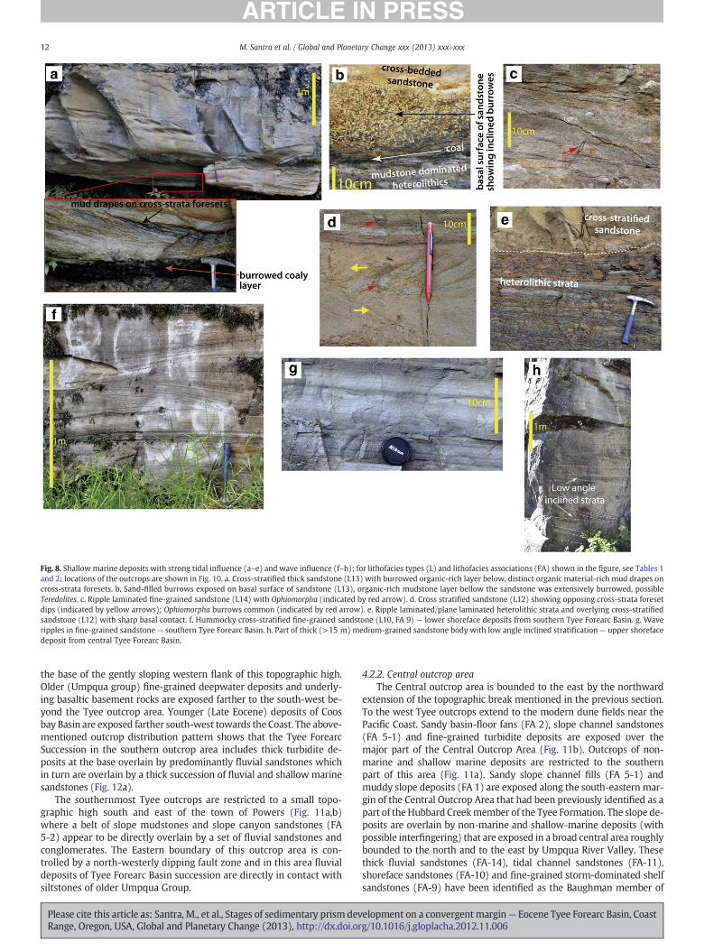
Fig. 8. Shallow marine deposits with strong tidal influence (a–e) and wave influence (f–h); for lithofacies types (L) and lithofacies associations (FA) shown in the figure, see Tables 1and 2; locations of the outcrops are shown in Fig. 10. a. Cross-stratified thick sandstone (L13) with burrowed organic-rich layer below, distinct organic material-rich mud drapes oncross-strata foresets. b. Sand-filled burrows exposed on basal surface of sandstone (L13), organic-rich mudstone layer bellow the sandstone was extensively burrowed, possibleTeredolites. c. Ripple laminated fine-grained sandstone (L14) with Ophiomorpha (indicated by red arrow). d. Cross stratified sandstone (L12) showing opposing cross-strata foresetdips (indicated by yellow arrows); Ophiomorpha burrows common (indicated by red arrow). e. Ripple laminated/plane laminated heterolithic strata and overlying cross-stratifiedsandstone (L12) with sharp basal contact. f. Hummocky cross-stratified fine-grained sandstone (L10, FA 9) — lower shoreface deposits from southern Tyee Forearc Basin. g. Waveripples in fine-grained sandstone — southern Tyee Forearc Basin. h. Part of thick (>15 m) medium-grained sandstone body with low angle inclined stratification— upper shorefacedeposit from central Tyee Forearc Basin.
12 M. Santra et al. / Global and Planetary Change xxx (2013) xxx–xxx
the base of the gently sloping western flank of this topographic high.Older (Umpqua group) fine-grained deepwater deposits and underly-ing basaltic basement rocks are exposed farther to the south-west be-yond the Tyee outcrop area. Younger (Late Eocene) deposits of Coosbay Basin are exposed farther south-west towards the Coast. The above-mentioned outcrop distribution pattern shows that the Tyee ForearcSuccession in the southern outcrop area includes thick turbidite de-posits at the base overlain by predominantly fluvial sandstones whichin turn are overlain by a thick succession of fluvial and shallow marinesandstones (Fig. 12a).
The southernmost Tyee outcrops are restricted to a small topo-graphic high south and east of the town of Powers (Fig. 11a,b)where a belt of slope mudstones and slope canyon sandstones (FA5-2) appear to be directly overlain by a set of fluvial sandstones andconglomerates. The Eastern boundary of this outcrop area is con-trolled by a north-westerly dipping fault zone and in this area fluvialdeposits of Tyee Forearc Basin succession are directly in contact withsiltstones of older Umpqua Group.
Please cite this article as: Santra, M., et al., Stages of sedimentary prism devRange, Oregon, USA, Global and Planetary Change (2013), http://dx.doi.or
4.2.2. Central outcrop areaThe Central outcrop area is bounded to the east by the northward
extension of the topographic break mentioned in the previous section.To the west Tyee outcrops extend to the modern dune fields near thePacific Coast. Sandy basin-floor fans (FA 2), slope channel sandstones(FA 5-1) and fine-grained turbidite deposits are exposed over themajor part of the Central Outcrop Area (Fig. 11b). Outcrops of non-marine and shallow marine deposits are restricted to the southernpart of this area (Fig. 11a). Sandy slope channel fills (FA 5-1) andmuddy slope deposits (FA 1) are exposed along the south-eastern mar-gin of the Central Outcrop Area that had been previously identified as apart of the Hubbard Creekmember of the Tyee Formation. The slope de-posits are overlain by non-marine and shallow-marine deposits (withpossible interfingering) that are exposed in a broad central area roughlybounded to the north and to the east by Umpqua River Valley. Thesethick fluvial sandstones (FA-14), tidal channel sandstones (FA-11),shoreface sandstones (FA-10) and fine-grained storm-dominated shelfsandstones (FA-9) have been identified as the Baughman member of
elopment on a convergentmargin— Eocene Tyee Forearc Basin, Coastg/10.1016/j.gloplacha.2012.11.006
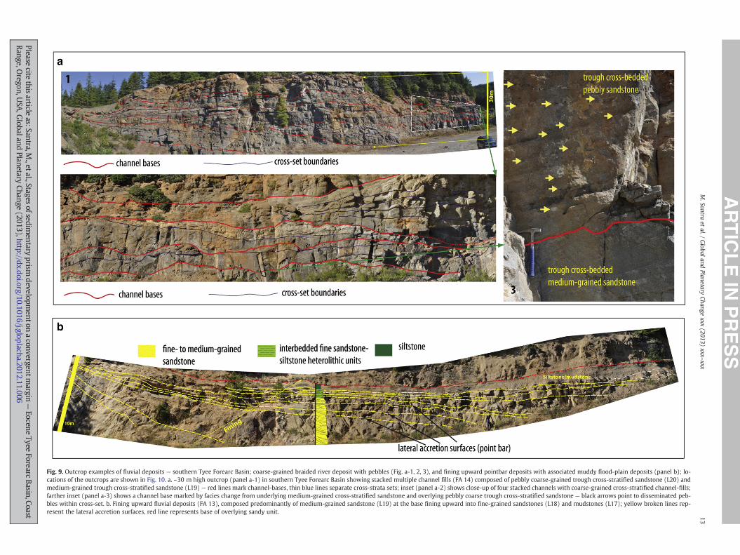
Fig. 9. Outcrop examples of fluvial deposits — southern Tyee Forearc Basin; coarse-grained braided river deposit with pebbles (Fig. a-1, 2, 3), and fining upward pointbar deposits with associated muddy flood-plain deposits (panel b); lo-cations of the outcrops are shown in Fig. 10. a. ~30 m high outcrop (panel a-1) in southern Tyee Forearc Basin showing stacked multiple channel fills (FA 14) composed of pebbly coarse-grained trough cross-stratified sandstone (L20) andmedium-grained trough cross-stratified sandstone (L19) — red lines mark channel-bases, thin blue lines separate cross-strata sets; inset (panel a-2) shows close-up of four stacked channels with coarse-grained cross-stratified channel-fills;farther inset (panel a-3) shows a channel base marked by facies change from underlying medium-grained cross-stratified sandstone and overlying pebbly coarse trough cross-stratified sandstone — black arrows point to disseminated peb-bles within cross-set. b. Fining upward fluvial deposits (FA 13), composed predominantly of medium-grained sandstone (L19) at the base fining upward into fine-grained sandstones (L18) and mudstones (L17); yellow broken lines rep-resent the lateral accretion surfaces, red line represents base of overlying sandy unit. 13
M.Santra
etal./
Globaland
PlanetaryChange
xxx(2013)
xxx–xxx
Pleasecite
thisarticle
as:Santra,M.,etal.,Stages
ofsedimentary
prismdevelopm
entonaconvergentm
argin—
EoceneTyee
ForearcBasin,Coast
Range,Oregon,U
SA,G
lobalandPlanetary
Change(2013),http://dx.doi.org/10.1016/j.gloplacha.2012.11.006

Fig. 10. Location map for the outcrop photographs shown in Figs. 6–9; map also shows the position of the transects represented by the stratigraphic sections in Fig. 11.
14 M. Santra et al. / Global and Planetary Change xxx (2013) xxx–xxx
Tyee Formation. Younger slope deposits (FA 5-1: channel fills, FA-1:slope mudstones), previously interpreted as part of the Elkton Forma-tion are exposed farther to the north, west and south-west of thetown of Elkton. The youngest non-marine and shallowmarine depositsof the Tyee Forearc Succession (previously identified as the BatemanFormation) that include tidal channel sandstones (FA-11), other tide-dominated paralic deposits (FA-10) and thick sandy incised-valleyfills (FA-12), are exposed in a topographic high (Figs. 11a,b and 12b)south of the Umpqua River valley. This predominantly sandy successionis underlain by a thick open-marine mudstone (FA-8) that outcropsalong the southern flank of this topographic high (Fig. 11a). This fine-grained unit appears to pinch out to the south and thickens to thenorth ultimately merging with the slope mudstones of the Elkton For-mation. In the southern part of Central Outcrop Area this mudstoneunit separates the two predominantly sandy units — the underlying
Please cite this article as: Santra, M., et al., Stages of sedimentary prism devRange, Oregon, USA, Global and Planetary Change (2013), http://dx.doi.or
Baughman member of Tyee Formation and the overlying BatemanFormation.
Sandy proximal basin-floor fan deposits (FA-3) are exposed in thenorthern half of the Central outcrop Area north of the Umpqua RiverValley. In the northern half of Central Outcrop Area the Smith RiverValley represents an excellent outcrop transect for the these thicksandy basin-floor fans where estimated cumulative thickness ofthese stacked basin-floor fans appear to be nearly 2000 m (measuredfrom outcrop and well data).
4.2.3. Northern outcrop areaExclusively deepwater fan deposits are exposed in the Northern
Outcrop Area. Thick, tabular, turbidite sandstones (FA-3) are exposedin southern part (Siuslaw River Valley). Relatively mud-rich distal fandeposits (FA-2) and extensive fine-grained turbidite deposits (FA-1)
elopment on a convergentmargin— Eocene Tyee Forearc Basin, Coastg/10.1016/j.gloplacha.2012.11.006
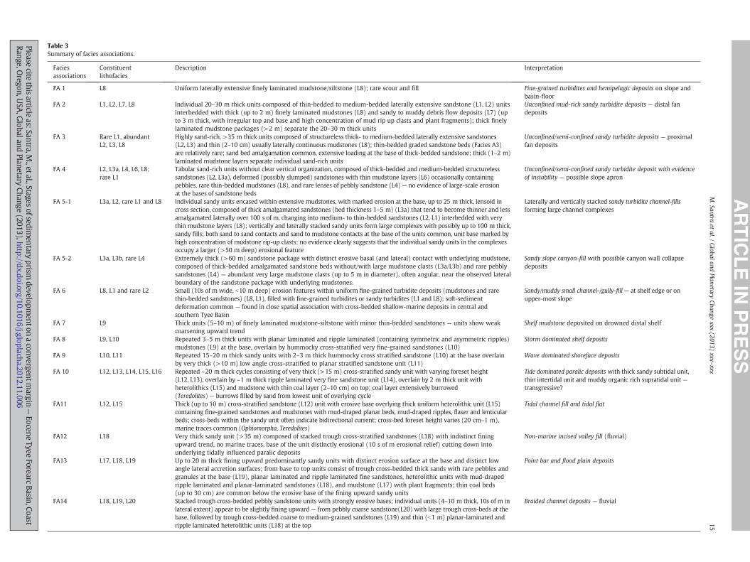
Table 3Summary of facies associations.
Faciesassociations
Constituentlithofacies
Description Interpretation
FA 1 L8 Uniform laterally extensive finely laminated mudstone/siltstone (L8); rare scour and fill Fine-grained turbidites and hemipelagic deposits on slope andbasin-floor
FA 2 L1, L2, L7, L8 Individual 20–30 m thick units composed of thin-bedded to medium-bedded laterally extensive sandstone (L1, L2) unitsinterbedded with thick (up to 2 m) finely laminated mudstones (L8) and sandy to muddy debris flow deposits (L7) (upto 3 m thick, with irregular top and base and high concentration of mud rip up clasts and plant fragments); thick finelylaminated mudstone packages (>2 m) separate the 20–30 m thick units
Unconfined mud-rich sandy turbidite deposits — distal fandeposits
FA 3 Rare L1, abundantL2, L3, L8
Highly sand-rich, >35 m thick units composed of structureless thick- to medium-bedded laterally extensive sandstones(L2, L3) and thin (2–10 cm) usually laterally continuous mudstones (L8); thin-bedded graded sandstone beds (Facies A3)are relatively rare; sand bed amalgamation common, extensive loading at the base of thick-bedded sandstone; thick (1–2 m)laminated mudstone layers separate individual sand-rich units
Unconfined/semi-confined sandy turbidite deposits — proximalfan deposits
FA 4 L2, L3a, L4, L6, L8;rare L1
Tabular sand-rich units without clear vertical organization, composed of thick-bedded and medium-bedded structurelesssandstones (L2, L3a), deformed (possibly slumped) sandstones with thin mudstone layers (L6) occasionally containingpebbles, rare thin-bedded mudstones (L8), and rare lenses of pebbly sandstone (L4) — no evidence of large-scale erosionat the bases of sandstone beds
Unconfined/semi-confined sandy turbidite deposit with evidenceof instability — possible slope apron
FA 5-1 L3a, L2, rare L1 and L8 Individual sandy units encased within extensive mudstones, with marked erosion at the base, up to 25 m thick, lensoid incross section, composed of thick amalgamated sandstones (bed thickness 1–5 m) (L3a) that tend to become thinner and lessamalgamated laterally over 100 s of m, changing into medium- to thin-bedded sandstones (L2, L1) interbedded with verythin mudstone layers (L8); vertically and laterally stacked sandy units form large complexes with possibly up to 100 m thick,sandy fills; both sand to sand contacts and sand to mudstone contacts at the base of the units common, unit base marked byhigh concentration of mudstone rip-up clasts; no evidence clearly suggests that the individual sandy units in the complexesoccupy a larger (>50 m deep) erosional feature
Laterally and vertically stacked sandy turbidite channel-fillsforming large channel complexes
FA 5-2 L3a, L3b, rare L4 Extremely thick (>60 m) sandstone package with distinct erosive basal (and lateral) contact with underlying mudstone,composed of thick-bedded amalgamated sandstone beds without/with large mudstone clasts (L3a/L3b) and rare pebblysandstones (L4) — abundant very large mudstone clasts (up to 5 m in diameter), often angular, near the observed lateralboundary of the sandstone package with underlying mudstones.
Sandy slope canyon-fill with possible canyon wall collapsedeposits
FA 6 L8, L1 and rare L2 Small (10s of m wide, b10 m deep) erosion features within uniform fine-grained turbidite deposits (mudstones and rarethin-bedded sandstones) (L8, L1), filled with fine-grained turbidites or sandy turbidites (L1 and L8); soft-sedimentdeformation common — found in close spatial association with cross-bedded shallow-marine deposits in central andsouthern Tyee Basin
Sandy/muddy small channel-/gully-fill — at shelf edge or onupper-most slope
FA 7 L9 Thick units (5–10 m) of finely laminated mudstone-siltstone with minor thin-bedded sandstones — units show weakcoarsening upward trend
Shelf mudstone deposited on drowned distal shelf
FA 8 L9, L10 Repeated 3–5 m thick units with planar laminated and ripple laminated (containing symmetric and asymmetric ripples)mudstones (L9) at the base, overlain by hummocky cross-stratified very fine-grained sandstones (L10)
Storm dominated shelf deposits
FA 9 L10, L11 Repeated 15–20 m thick sandy units with 2–3 m thick hummocky cross stratified sandstone (L10) at the base overlainby very thick (>10 m) low angle cross-stratified to planar stratified sandstone unit (L11)
Wave dominated shoreface deposits
FA 10 L12, L13, L14, L15, L16 Repeated ~20 m thick cycles consisting of very thick (>15 m) cross-stratified sandy unit with varying foreset height(L12, L13), overlain by ~1 m thick ripple laminated very fine sandstone unit (L14), overlain by 2 m thick unit withheterolithics (L15) and mudstone with thin coal layer (2–10 cm) on top; coal layer extensively burrowed(Teredolites) — burrows filled by sand from lowest unit of overlying cycle
Tide dominated paralic deposits with thick sandy subtidal unit,thin intertidal unit and muddy organic rich supratidal unit —transgressive?
FA11 L12, L15 Thick (up to 10 m) cross-stratified sandstone (L12) unit with erosive base overlying thick uniform heterolithic unit (L15)containing fine-grained sandstones and mudstones with mud-draped planar beds, mud-draped ripples, flaser and lenticularbeds; cross-beds within the sandy unit often indicate bidirectional current; cross-bed foreset height varies (20 cm–1 m),marine traces common (Ophiomorpha, Teredolites)
Tidal channel fill and tidal flat
FA12 L18 Very thick sandy unit (>35 m) composed of stacked trough cross-stratified sandstones (L18) with indistinct finingupward trend, no marine traces, base of the unit distinctly erosional (10 s of m erosional relief) cutting down intounderlying tidally influenced paralic deposits
Non-marine incised valley fill (fluvial)
FA13 L17, L18, L19 Up to 20 m thick fining upward predominantly sandy units with distinct erosion surface at the base and distinct lowangle lateral accretion surfaces; from base to top units consist of trough cross-bedded thick sands with rare pebbles andgranules at the base (L19), planar laminated and ripple laminated fine sandstones, heterolithic units with mud-drapedripple laminated and planar-laminated sandstones (L18), and mudstone (L17) with plant fragments; thin coal beds(up to 30 cm) are common below the erosive base of the fining upward sandy units
Point bar and flood plain deposits
FA14 L18, L19, L20 Stacked trough cross-bedded pebbly sandstone units with strongly erosive bases; individual units (4–10 m thick, 10s of m inlateral extent) appear to be slightly fining upward — from pebbly coarse sandstone(L20) with large trough cross-beds at thebase, followed by trough cross-bedded coarse to medium-grained sandstones (L19) and thin (b1 m) planar-laminated andripple laminated heterolithic units (L18) at the top
Braided channel deposits — fluvial
15M.Santra
etal./
Globaland
PlanetaryChange
xxx(2013)
xxx–xxx
Pleasecite
thisarticle
as:Santra,M.,etal.,Stages
ofsedimentary
prismdevelopm
entonaconvergentm
argin—
EoceneTyee
ForearcBasin,Coast
Range,Oregon,U
SA,G
lobalandPlanetary
Change(2013),http://dx.doi.org/10.1016/j.gloplacha.2012.11.006
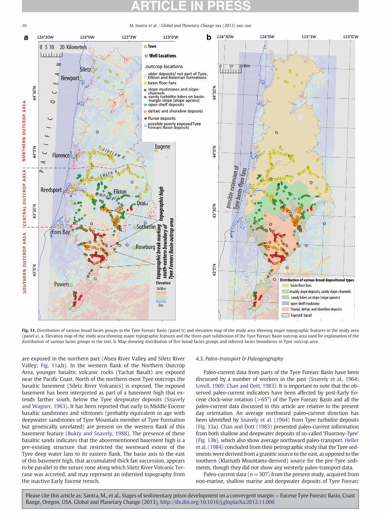
Fig. 11. Distribution of various broad facies groups in the Tyee Forearc Basin (panel b) and elevation map of the study area showing major topographic features in the study area(panel a). a. Elevation map of the study area showing major topographic features and the three-part subdivision of the Tyee Forearc Basin outcrop area used for explanation of thedistribution of various facies groups in the text. b. Map showing distribution of five broad facies groups and inferred facies boundaries in Tyee outcrop area.
16 M. Santra et al. / Global and Planetary Change xxx (2013) xxx–xxx
are exposed in the northern part (Alsea River Valley and Siletz RiverValley; Fig. 11a,b). In the western flank of the Northern OutcropArea, younger basaltic volcanic rocks (Yachat Basalt) are exposednear the Pacific Coast. North of the northern-most Tyee outcrops thebasaltic basement (Siletz River Volcanics) is exposed. The exposedbasement has been interpreted as part of a basement high that ex-tends farther south, below the Tyee deepwater deposits (Snavelyand Wagner, 1963). It has been reported that early to Middle Eocenebasaltic sandstones and siltstones (probably equivalent in age withdeepwater sandstones of Tyee Mountain member of Tyee Formationbut genetically unrelated) are present on the western flank of thisbasement feature (Bukry and Snavely, 1988). The presence of thesebasaltic sands indicates that the abovementioned basement high is apre-existing structure that restricted the westward extent of theTyee deep water fans to its eastern flank. The basin axis to the eastof this basement high, that accumulated thick fan succession, appearsto be parallel to the suture zone along which Siletz River Volcanic Ter-rane was accreted, and may represent an inherited topography fromthe inactive Early Eocene trench.
Please cite this article as: Santra, M., et al., Stages of sedimentary prism devRange, Oregon, USA, Global and Planetary Change (2013), http://dx.doi.or
4.3. Paleo-transport & Paleogeography
Paleo-current data from parts of the Tyee Forearc Basin have beendiscussed by a number of workers in the past (Snavely et al., 1964;Lovell, 1969; Chan and Dott, 1983). It is important to note that the ob-served paleo-current indicators have been affected by post-Early Eo-cene clock-wise rotation (>65°) of the Tyee Forearc Basin and all thepaleo-current data discussed in this article are relative to the presentday orientation. An average northward paleo-current direction hasbeen identified by Snavely et al. (1964) from Tyee turbidite deposits(Fig. 13a). Chan and Dott (1983) presented paleo-current informationfrom both shallow and deepwater deposits of so-called ‘Fluornoy-Tyee’(Fig. 13b), which also show average northward paleo-transport. Helleret al. (1984) concluded from their petrographic study that the Tyee sed-imentswere derived froma granitic source to the east, as opposed to thesouthern (Klamath Mountains-derived) source for the pre-Tyee sedi-ments, though they did not show any westerly paleo-transport data.
Paleo-current data (n=307) from the present study, acquired fromnon-marine, shallow marine and deepwater deposits of Tyee Forearc
elopment on a convergentmargin— Eocene Tyee Forearc Basin, Coastg/10.1016/j.gloplacha.2012.11.006
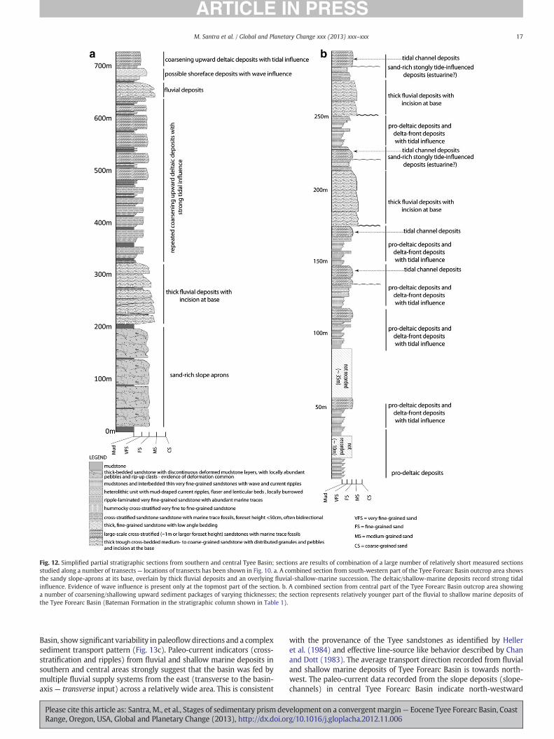
Fig. 12. Simplified partial stratigraphic sections from southern and central Tyee Basin; sections are results of combination of a large number of relatively short measured sectionsstudied along a number of transects— locations of transects has been shown in Fig. 10. a. A combined section from south-western part of the Tyee Forearc Basin outcrop area showsthe sandy slope-aprons at its base, overlain by thick fluvial deposits and an overlying fluvial-shallow-marine succession. The deltaic/shallow-marine deposits record strong tidalinfluence. Evidence of wave influence is present only at the topmost part of the section. b. A combined section from central part of the Tyee Forearc Basin outcrop area showinga number of coarsening/shallowing upward sediment packages of varying thicknesses; the section represents relatively younger part of the fluvial to shallow marine deposits ofthe Tyee Forearc Basin (Bateman Formation in the stratigraphic column shown in Table 1).
17M. Santra et al. / Global and Planetary Change xxx (2013) xxx–xxx
Basin, show significant variability in paleoflowdirections and a complexsediment transport pattern (Fig. 13c). Paleo-current indicators (cross-stratification and ripples) from fluvial and shallow marine deposits insouthern and central areas strongly suggest that the basin was fed bymultiple fluvial supply systems from the east (transverse to the basin-axis — transverse input) across a relatively wide area. This is consistent
Please cite this article as: Santra, M., et al., Stages of sedimentary prism devRange, Oregon, USA, Global and Planetary Change (2013), http://dx.doi.or
with the provenance of the Tyee sandstones as identified by Helleret al. (1984) and effective line-source like behavior described by Chanand Dott (1983). The average transport direction recorded from fluvialand shallow marine deposits of Tyee Forearc Basin is towards north-west. The paleo-current data recorded from the slope deposits (slope-channels) in central Tyee Forearc Basin indicate north-westward
elopment on a convergentmargin— Eocene Tyee Forearc Basin, Coastg/10.1016/j.gloplacha.2012.11.006
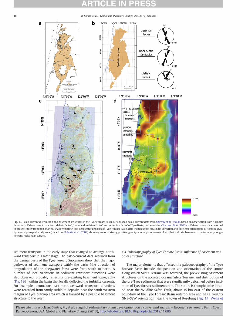
Fig. 13. Paleo-current distribution and basement structures in the Tyee Forearc Basin. a. Published paleo-current data from Snavely et al. (1964), based on observation from turbiditedeposits. b. Paleo-current data from ‘deltaic facies’, ‘inner and mid-fan facies’, and ‘outer fan facies’ of Tyee Basin, redrawn after Chan and Dott (1983). c. Paleo-current data recordedin present study from non-marine, shallow marine, and deepwater deposits of Tyee Forearc Basin, data include cross-strata dip-direction and flute cast orientation. d. Isostatic grav-ity anomaly map of study area (data from Roberts et al., 2008) showing areas of strong positive gravity anomaly (in warm colors) that indicate basement structures or youngerigneous rocks near surface.
18 M. Santra et al. / Global and Planetary Change xxx (2013) xxx–xxx
sediment transport in the early stage that changed to average north-ward transport in a later stage. The paleo-current data acquired fromthe basinal parts of the Tyee Forearc Succession show that the majorpathways of sediment transport within the basin (the direction ofprogradation of the deepwater fans) were from south to north. Anumber of local variations in sediment transport directions werealso observed, probably reflecting pre-existing basement topography(Fig. 13d) within the basin that locally deflected the turbidity currents.For example, anomalous east-north-eastward transport directionswere recorded from sandy turbidite deposits near the south-westernmargin of Tyee outcrop area which is flanked by a possible basementstructure to the west.
Please cite this article as: Santra, M., et al., Stages of sedimentary prism devRange, Oregon, USA, Global and Planetary Change (2013), http://dx.doi.or
4.4. Paleotopography of Tyee Forearc Basin: influence of basement andother structure
The major elements that affected the paleogeography of the TyeeForearc Basin include the position and orientation of the suturealong which Siletz Terrane was accreted, the pre-existing basementstructures on the accreted oceanic Siletz Terrane, and distribution ofthe pre-Tyee sediments that were significantly deformed before initi-ation of Tyee forearc sedimentation. The suture is thought to be locat-ed near the Wildlife Safari Fault, about 15 km east of the easternboundary of the Tyee Forearc Basin outcrop area and has a roughlyNNE–SSW orientation near the town of Roseburg (Fig. 14; Wells et
elopment on a convergentmargin— Eocene Tyee Forearc Basin, Coastg/10.1016/j.gloplacha.2012.11.006
19M. Santra et al. / Global and Planetary Change xxx (2013) xxx–xxx
al., 2000). Observations on the paleo-transport as discussed aboveindicate that the Tyee Forearc Basin received sediment across thissuture zone, through multiple rivers that derived sediments fromthe continental interior further to the east.
Pre-Tyee clastics of Umpqua group are exposed west of the suturezone and east of the Tyee outcrop area (Fig. 14). These clastics includethe pre- to syn-accretion and post accretion deposits accumulated be-fore the initiation of forearc sedimentation within the Tyee ForearcBasin. The lower part of the Umpqua Group is highly deformed and rep-resents part of the accretionary prism associated with the pre-EarlyEocene subduction zone and deposits formed during the accretion ofthe Siletz River Volcanic Terrane. The younger part of the UmpquaGroup, represented by the White Tail Ridge Formation (non-marine
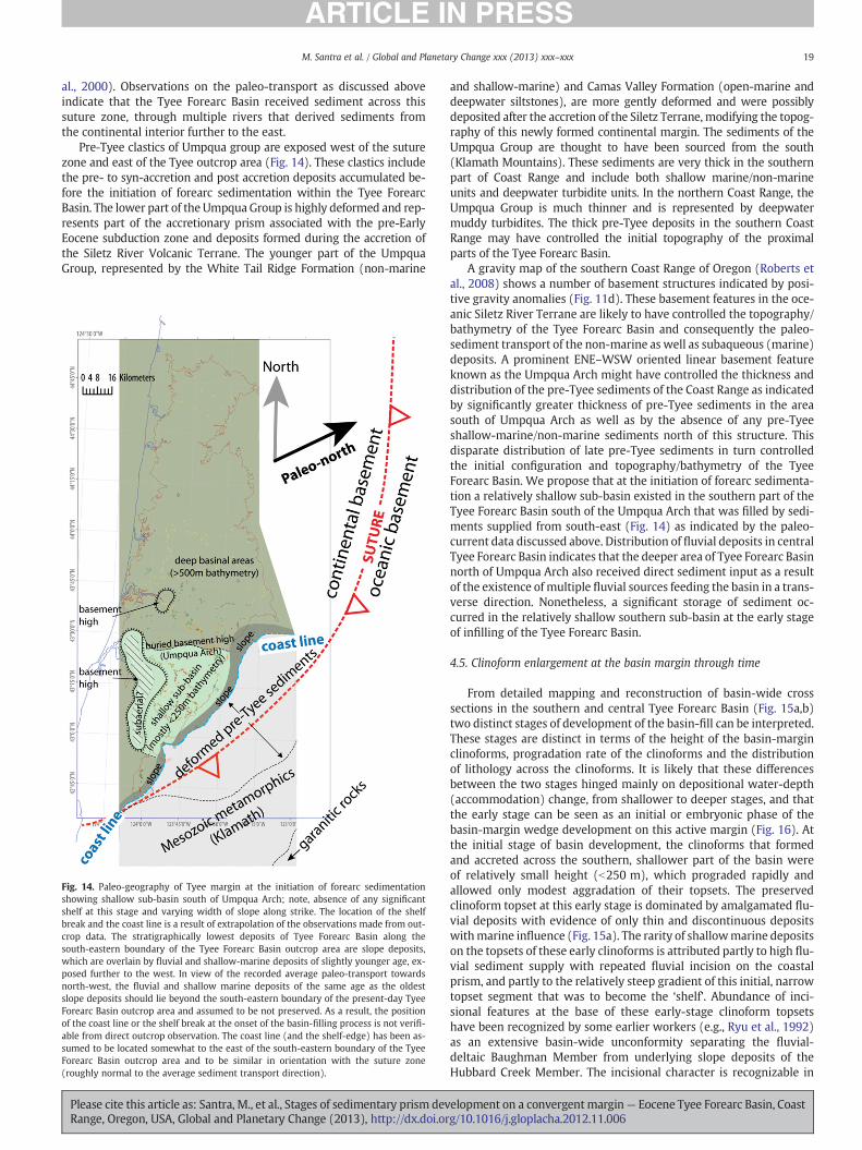
Fig. 14. Paleo-geography of Tyee margin at the initiation of forearc sedimentationshowing shallow sub-basin south of Umpqua Arch; note, absence of any significantshelf at this stage and varying width of slope along strike. The location of the shelfbreak and the coast line is a result of extrapolation of the observations made from out-crop data. The stratigraphically lowest deposits of Tyee Forearc Basin along thesouth-eastern boundary of the Tyee Forearc Basin outcrop area are slope deposits,which are overlain by fluvial and shallow-marine deposits of slightly younger age, ex-posed further to the west. In view of the recorded average paleo-transport towardsnorth-west, the fluvial and shallow marine deposits of the same age as the oldestslope deposits should lie beyond the south-eastern boundary of the present-day TyeeForearc Basin outcrop area and assumed to be not preserved. As a result, the positionof the coast line or the shelf break at the onset of the basin-filling process is not verifi-able from direct outcrop observation. The coast line (and the shelf-edge) has been as-sumed to be located somewhat to the east of the south-eastern boundary of the TyeeForearc Basin outcrop area and to be similar in orientation with the suture zone(roughly normal to the average sediment transport direction).
Please cite this article as: Santra, M., et al., Stages of sedimentary prism devRange, Oregon, USA, Global and Planetary Change (2013), http://dx.doi.or
and shallow-marine) and Camas Valley Formation (open-marine anddeepwater siltstones), are more gently deformed and were possiblydeposited after the accretion of the Siletz Terrane, modifying the topog-raphy of this newly formed continental margin. The sediments of theUmpqua Group are thought to have been sourced from the south(Klamath Mountains). These sediments are very thick in the southernpart of Coast Range and include both shallow marine/non-marineunits and deepwater turbidite units. In the northern Coast Range, theUmpqua Group is much thinner and is represented by deepwatermuddy turbidites. The thick pre-Tyee deposits in the southern CoastRange may have controlled the initial topography of the proximalparts of the Tyee Forearc Basin.
A gravity map of the southern Coast Range of Oregon (Roberts etal., 2008) shows a number of basement structures indicated by posi-tive gravity anomalies (Fig. 11d). These basement features in the oce-anic Siletz River Terrane are likely to have controlled the topography/bathymetry of the Tyee Forearc Basin and consequently the paleo-sediment transport of the non-marine as well as subaqueous (marine)deposits. A prominent ENE–WSW oriented linear basement featureknown as the Umpqua Arch might have controlled the thickness anddistribution of the pre-Tyee sediments of the Coast Range as indicatedby significantly greater thickness of pre-Tyee sediments in the areasouth of Umpqua Arch as well as by the absence of any pre-Tyeeshallow-marine/non-marine sediments north of this structure. Thisdisparate distribution of late pre-Tyee sediments in turn controlledthe initial configuration and topography/bathymetry of the TyeeForearc Basin. We propose that at the initiation of forearc sedimenta-tion a relatively shallow sub-basin existed in the southern part of theTyee Forearc Basin south of the Umpqua Arch that was filled by sedi-ments supplied from south-east (Fig. 14) as indicated by the paleo-current data discussed above. Distribution of fluvial deposits in centralTyee Forearc Basin indicates that the deeper area of Tyee Forearc Basinnorth of Umpqua Arch also received direct sediment input as a resultof the existence of multiple fluvial sources feeding the basin in a trans-verse direction. Nonetheless, a significant storage of sediment oc-curred in the relatively shallow southern sub-basin at the early stageof infilling of the Tyee Forearc Basin.
4.5. Clinoform enlargement at the basin margin through time
From detailed mapping and reconstruction of basin-wide crosssections in the southern and central Tyee Forearc Basin (Fig. 15a,b)two distinct stages of development of the basin-fill can be interpreted.These stages are distinct in terms of the height of the basin-marginclinoforms, progradation rate of the clinoforms and the distributionof lithology across the clinoforms. It is likely that these differencesbetween the two stages hinged mainly on depositional water-depth(accommodation) change, from shallower to deeper stages, and thatthe early stage can be seen as an initial or embryonic phase of thebasin-margin wedge development on this active margin (Fig. 16). Atthe initial stage of basin development, the clinoforms that formedand accreted across the southern, shallower part of the basin wereof relatively small height (b250 m), which prograded rapidly andallowed only modest aggradation of their topsets. The preservedclinoform topset at this early stage is dominated by amalgamated flu-vial deposits with evidence of only thin and discontinuous depositswithmarine influence (Fig. 15a). The rarity of shallowmarine depositson the topsets of these early clinoforms is attributed partly to high flu-vial sediment supply with repeated fluvial incision on the coastalprism, and partly to the relatively steep gradient of this initial, narrowtopset segment that was to become the ‘shelf’. Abundance of inci-sional features at the base of these early-stage clinoform topsetshave been recognized by some earlier workers (e.g., Ryu et al., 1992)as an extensive basin-wide unconformity separating the fluvial-deltaic Baughman Member from underlying slope deposits of theHubbard Creek Member. The incisional character is recognizable in
elopment on a convergentmargin— Eocene Tyee Forearc Basin, Coastg/10.1016/j.gloplacha.2012.11.006
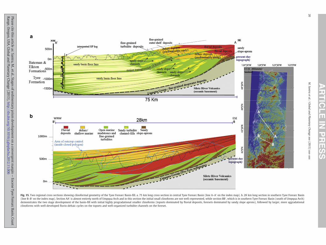
Fig. 15. Two regional cross sections showing clinoformal geometry of the Tyee Forearc Basin-fill. a. 75 km long cross section in central Tyee Forearc Basin (line A–A′ on the index map). b. 28 km long section in southern Tyee Forearc Basin(line B–B′ on the index map). Section AA′ is almost entirely north of Umpqua Arch and in this section the initial small clinoforms are not well-represented, while section BB′, which is in southern Tyee Forearc Basin (south of Umpqua Arch)demonstrates the two stage development of the basin-fill with initial highly progradational smaller clinoforms (topsets dominated by fluvial deposits, foresets dominated by sandy slope aprons), followed by larger, more aggradationalclinoforms with well-developed fluvio-deltaic cycles on the topsets and well-organized turbidite channels on the foreset.
20M.Santra
etal./
Globaland
PlanetaryChange
xxx(2013)
xxx–xxx
Pleasecite
thisarticle
as:Santra,M.,etal.,Stages
ofsedimentary
prismdevelopm
entonaconvergentm
argin—
EoceneTyee
ForearcBasin,Coast
Range,Oregon,U
SA,G
lobalandPlanetary
Change(2013),http://dx.doi.org/10.1016/j.gloplacha.2012.11.006
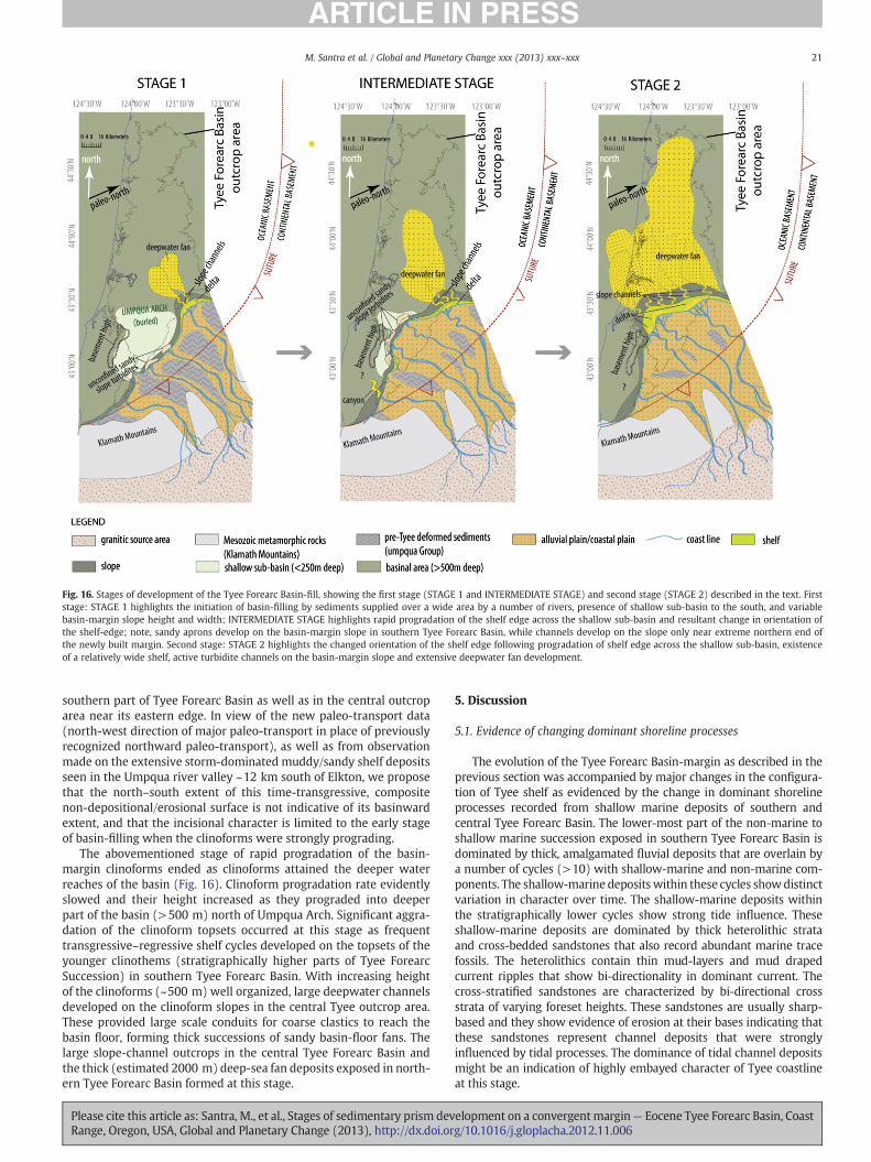
Fig. 16. Stages of development of the Tyee Forearc Basin-fill, showing the first stage (STAGE 1 and INTERMEDIATE STAGE) and second stage (STAGE 2) described in the text. Firststage: STAGE 1 highlights the initiation of basin-filling by sediments supplied over a wide area by a number of rivers, presence of shallow sub-basin to the south, and variablebasin-margin slope height and width; INTERMEDIATE STAGE highlights rapid progradation of the shelf edge across the shallow sub-basin and resultant change in orientation ofthe shelf-edge; note, sandy aprons develop on the basin-margin slope in southern Tyee Forearc Basin, while channels develop on the slope only near extreme northern end ofthe newly built margin. Second stage: STAGE 2 highlights the changed orientation of the shelf edge following progradation of shelf edge across the shallow sub-basin, existenceof a relatively wide shelf, active turbidite channels on the basin-margin slope and extensive deepwater fan development.
21M. Santra et al. / Global and Planetary Change xxx (2013) xxx–xxx
southern part of Tyee Forearc Basin as well as in the central outcroparea near its eastern edge. In view of the new paleo-transport data(north-west direction of major paleo-transport in place of previouslyrecognized northward paleo-transport), as well as from observationmade on the extensive storm-dominated muddy/sandy shelf depositsseen in the Umpqua river valley ~12 km south of Elkton, we proposethat the north–south extent of this time-transgressive, compositenon-depositional/erosional surface is not indicative of its basinwardextent, and that the incisional character is limited to the early stageof basin-filling when the clinoforms were strongly prograding.
The abovementioned stage of rapid progradation of the basin-margin clinoforms ended as clinoforms attained the deeper waterreaches of the basin (Fig. 16). Clinoform progradation rate evidentlyslowed and their height increased as they prograded into deeperpart of the basin (>500 m) north of Umpqua Arch. Significant aggra-dation of the clinoform topsets occurred at this stage as frequenttransgressive–regressive shelf cycles developed on the topsets of theyounger clinothems (stratigraphically higher parts of Tyee ForearcSuccession) in southern Tyee Forearc Basin. With increasing heightof the clinoforms (~500 m) well organized, large deepwater channelsdeveloped on the clinoform slopes in the central Tyee outcrop area.These provided large scale conduits for coarse clastics to reach thebasin floor, forming thick successions of sandy basin-floor fans. Thelarge slope-channel outcrops in the central Tyee Forearc Basin andthe thick (estimated 2000 m) deep-sea fan deposits exposed in north-ern Tyee Forearc Basin formed at this stage.
Please cite this article as: Santra, M., et al., Stages of sedimentary prism devRange, Oregon, USA, Global and Planetary Change (2013), http://dx.doi.or
5. Discussion
5.1. Evidence of changing dominant shoreline processes
The evolution of the Tyee Forearc Basin-margin as described in theprevious section was accompanied by major changes in the configura-tion of Tyee shelf as evidenced by the change in dominant shorelineprocesses recorded from shallow marine deposits of southern andcentral Tyee Forearc Basin. The lower-most part of the non-marine toshallow marine succession exposed in southern Tyee Forearc Basin isdominated by thick, amalgamated fluvial deposits that are overlain bya number of cycles (>10) with shallow-marine and non-marine com-ponents. The shallow-marine depositswithin these cycles showdistinctvariation in character over time. The shallow-marine deposits withinthe stratigraphically lower cycles show strong tide influence. Theseshallow-marine deposits are dominated by thick heterolithic strataand cross-bedded sandstones that also record abundant marine tracefossils. The heterolithics contain thin mud-layers and mud drapedcurrent ripples that show bi-directionality in dominant current. Thecross-stratified sandstones are characterized by bi-directional crossstrata of varying foreset heights. These sandstones are usually sharp-based and they show evidence of erosion at their bases indicating thatthese sandstones represent channel deposits that were stronglyinfluenced by tidal processes. The dominance of tidal channel depositsmight be an indication of highly embayed character of Tyee coastlineat this stage.
elopment on a convergentmargin— Eocene Tyee Forearc Basin, Coastg/10.1016/j.gloplacha.2012.11.006
22 M. Santra et al. / Global and Planetary Change xxx (2013) xxx–xxx
In contrast to the lower cycles, the shallowmarine deposits withinthe stratigraphically higher cycles include significant amount of wavedominated shoreline deposits in addition to the tidally influenced de-posits. The records of increasing wave influence include abundantwave-ripple and hummocky cross stratification. Indications of strongwave-influence have been observed from some of the shallow-marine deposits exposed in the central Tyee Forearc Basin, whichcan be correlated with the previously discussed uppermost cycles ofsouthern Tyee Forearc Basin. These deposits include shorefaces (FA9) and finer wave dominated shelf deposits (FA 8). The gradual in-crease in wave influence within the shallow-marine deposits of Tyeeis likely to be an indication of establishment of a wide and openshelf at relatively mature stage of development of the sedimentaryprism at the Tyee margin that replaced pre-existing highly embayednarrow shelf.
5.2. Variability of turbidite architecture
The Tyee Forearc Succession as a whole has a very thick and areallyextensive deepwater component that also shows significant spatialand temporal variability. As discussed earlier under lithofacies typesand lithofacies associations (Tables 2 and 3) the three major architec-tural classes of sandy turbidite deposits observed within the TyeeForearc Succession are (1) unconfined sandy slope turbidites orslope aprons, (2) sand-filled, large and very large-scale slope channelsystems (including finer overbank deposits) and (3) unconfined sandytubidite deposits that have been interpreted as the basin-floor fans.
The unconfined sandy slope turbidites, a key component of theearly-stage margin in southern Tyee Forearc Basin, are exposed alongthe south-eastern and south-western boundary of the Tyee outcroparea and they directly (and unconformably) overlie the older siltstonesof the Umpqua Group (Figs. 11b and 13a). These turbidite sandstonesare characterized by overall tabular nature, absence of large-scale chan-nelized erosion at their bases (as opposed to the slope channel-fills),evidence of slope instability in the form of large slump deposits (asopposed to the deepwater fans) and the presence of scattered extra-basinal pebbles. The latter suggest sediment transport to deep waterdirectly from feeder rivers. This conclusion is based on two obser-vations — a) the fluvial deposits are the only other deposits within theTyee Forearc Succession where significant amounts of extra-basinalpebbles occur, and b) the slope-apron deposits in the southern TyeeForearc Basin are directly overlain by thick fluvial deposits. The un-confined sandy slope turbidite deposits are restricted to the southern-most Tyee Forearc Basin, south of the Umpqua Arch, an interpretedshallow sub-basin that rapidly accumulated sediments in the earlieststage of the Tyee Forearc Basin-filling process. The unconfined turbiditedeposits described above formed as the foresets of the small early-stageclinoforms that prograded across the southern Tyee Forearc Basin. Atthis stage, these thick sandy turbidite lobes simply dominated theforesets of the small clinoforms and continued to merge downbasininto basin-floor turbidites without significant incisions (Fig. 16a).These early unconfined slope-turbidite deposits linked directly withthe fluvial sediment source, so that the basin-margin morphologicallyresembled a set of giant, turbidite-fronted deltas. Nearest modern anal-ogies might be with fjord deltas that pass quickly to deep water turbi-dite systems without much intervening shallow-marine storage (Priorand Bornhold, 1988, 1989). These morphological characteristics ofearly-stage Tyee margin, resembling large turbidite-fronted deltas, arepossibly the features highlighted in the ‘submarine ramp’ model ofHeller and Dickinson (1985). However, they are not representative ofthe later history of Tyee Forearc Basin infill.
Abundant sandy slope-channel-fills are exposed in central TyeeForearc Basin (Figs. 7a and 11b). At least six partly exposed deepwaterchannel systems were identified in this area. Outcrop information indi-cates a range of variability in channel width, degree of incision, degreeof sand amalgamation, and stacking pattern of individual channel
Please cite this article as: Santra, M., et al., Stages of sedimentary prism devRange, Oregon, USA, Global and Planetary Change (2013), http://dx.doi.or
elements. These channel systems have width ranging from few 100 sof m to few km. The channel-systems are made of laterally and vertical-ly stacked channel elements that are represented by 10 m to 25 m thickamalgamated sandstone bodies. The channel elements show lateralfacies variation, from amalgamated sandstones to thick-bedded/medium-bedded sandstones interbedded with thin mudstone layers,within few 100 s of m. The estimated combined sand-body thicknessfor a channel system ranges from 60 m to >100 m. Recorded visibleerosional relief associated with channel bases ranges from 10 m tofew 10 s of m. The sandy slope channel-fills are encased within the ex-tensive muddy slope deposits of central Tyee Forearc Basin that belongto the Elkton Formation or the Hubbard Creek member of Tyee Forma-tion. These slope-channels were mostly formed at the second stage ofbasin development except those exposed in east-central Tyee ForearcBasin (north of Umpqua Arch between Elkton & Sutherlin; Fig. 11a).At the second and main stage of Tyee Forearc Basin infill the clinoformslopes across the length of the Tyee margin had become >500 m highand ~10 km long, a fairly typical shelf margin supplied by repeatedlyregressing shorelines that delivered sediment to the shelf edge andinto the large channelized slope conduits. The thick sandy basin-floorsand succession in northern Tyee Forearc Basin was formed as a resultof this sand bypass across the deepwater slope through the above-mentioned large slope channel systems.
The thick basin-floor fan succession of Tyee Forearc Basin, character-ized by very thick, tabular, turbidite sandstone beds (FA 3), has formedmostly at the second stage of basin-filling when large-scale slope chan-nels were actively supplying sediment to the Tyee Forearc Basin-floor.At this stage the orientation of the Tyee shelf edge was close to E–W(with reference to present day orientation of the Tyee Forearc Basin)and fans were prograding northwards (Fig. 16). The deepwater fansuccession is notable for its very sand-rich character, remarkable arealextent and great thickness, at least locally. The fans formed in thedeeper part of the Tyee Forearc Basin (north of Umpqua Arch) conse-quently are restricted to the central and northern Tyee Forearc Basin.The progradation of the fans was probably influenced by topographicfeatures in the basin-floor that might have restricted north-west wardprogradation. At later stage of basin-filling the shelf-edge orientationwas closer to E–Wand the basin-floor fans prograded northward as in-dicated by the paleo-current data as well as facies trends.
5.3. Contrasting clinoform geometry (or margin style) within TyeeForearc Basin — causes and implications
The temporal change in height (b250 m to >500 m) and stackingpattern (highly progradational to relativelymore aggradational) char-acter of the basin-margin clinoforms observed within Tyee ForearcBasin-fill were either controlled entirely by the geometry of thebasin or by a combination of basin configuration and change in subsi-dence rate. Published subsidence data from the Tyee Forearc Basin,however, does not show evidence of increase in the rate of basin sub-sidence in Early or Middle Eocene. A comparison between recon-structed dip-oriented cross sections through central Tyee ForearcBasin (Fig. 15b) and southern Tyee Forearc Basin (Fig. 15a) showsthat the smaller early-stage clinoforms and their characteristic faciesstacking pattern were well-developed in southern Tyee ForearcBasin but not clearly distinguishable in central Tyee Forearc Basin. Itis likely that the development of these smaller clinoforms in theearly basin-filling stage was restricted to the southern part of theTyee Forearc Basin (south of Umpqua Arch) which was relatively shal-low. In central Tyee Forearc Basin no evidence for early stage smallerclinoforms have been observed as, in central Tyee Forearc Basin theclinoforms were advancing into a deeper (>500 m) bathymetry. It ispossible that the smaller clinoforms of southern Tyee Forearc Basinprograded north-west ward across the southern shallow sub-basin rel-atively rapidly as compared to the larger clinoforms in central TyeeForearc Basin. As a result, probably a progressive change in shelf edge
elopment on a convergentmargin— Eocene Tyee Forearc Basin, Coastg/10.1016/j.gloplacha.2012.11.006
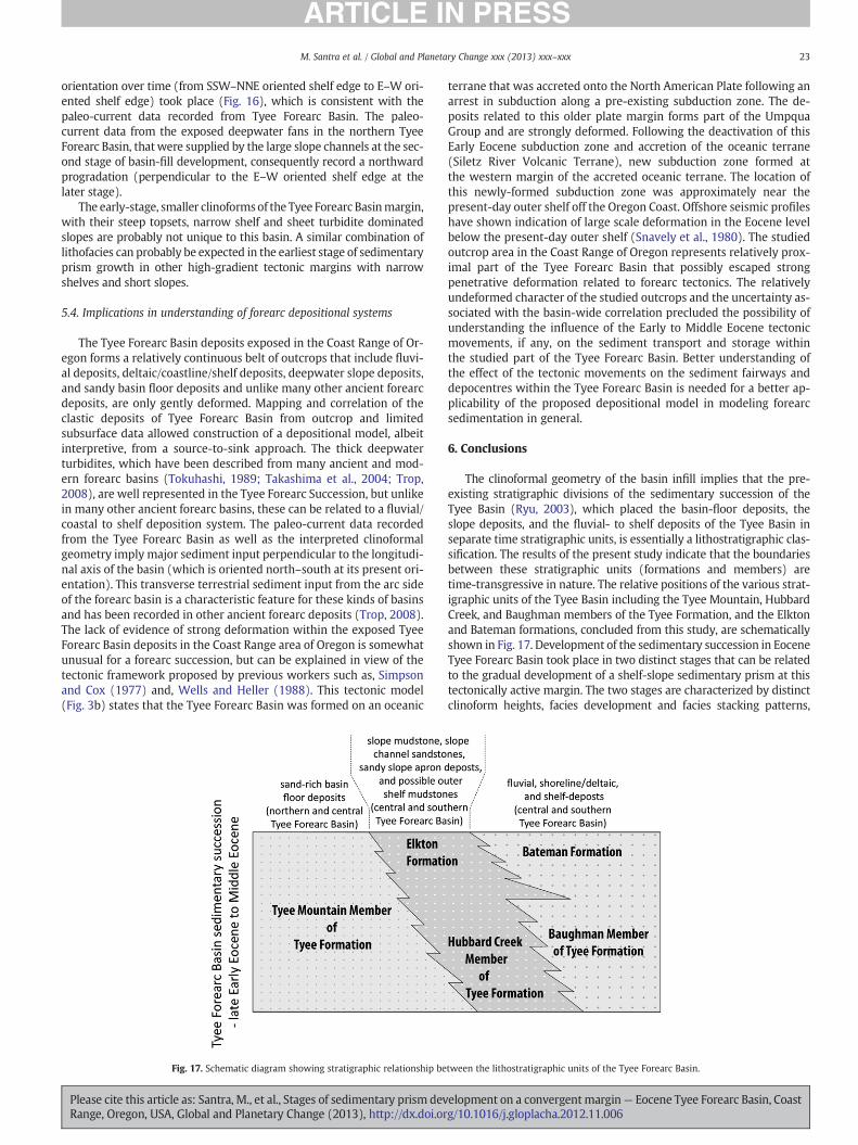
23M. Santra et al. / Global and Planetary Change xxx (2013) xxx–xxx
orientation over time (from SSW–NNE oriented shelf edge to E–W ori-ented shelf edge) took place (Fig. 16), which is consistent with thepaleo-current data recorded from Tyee Forearc Basin. The paleo-current data from the exposed deepwater fans in the northern TyeeForearc Basin, that were supplied by the large slope channels at the sec-ond stage of basin-fill development, consequently record a northwardprogradation (perpendicular to the E–W oriented shelf edge at thelater stage).
The early-stage, smaller clinoformsof the Tyee Forearc Basinmargin,with their steep topsets, narrow shelf and sheet turbidite dominatedslopes are probably not unique to this basin. A similar combination oflithofacies can probably be expected in the earliest stage of sedimentaryprism growth in other high-gradient tectonic margins with narrowshelves and short slopes.
5.4. Implications in understanding of forearc depositional systems
The Tyee Forearc Basin deposits exposed in the Coast Range of Or-egon forms a relatively continuous belt of outcrops that include fluvi-al deposits, deltaic/coastline/shelf deposits, deepwater slope deposits,and sandy basin floor deposits and unlike many other ancient forearcdeposits, are only gently deformed. Mapping and correlation of theclastic deposits of Tyee Forearc Basin from outcrop and limitedsubsurface data allowed construction of a depositional model, albeitinterpretive, from a source-to-sink approach. The thick deepwaterturbidites, which have been described from many ancient and mod-ern forearc basins (Tokuhashi, 1989; Takashima et al., 2004; Trop,2008), are well represented in the Tyee Forearc Succession, but unlikein many other ancient forearc basins, these can be related to a fluvial/coastal to shelf deposition system. The paleo-current data recordedfrom the Tyee Forearc Basin as well as the interpreted clinoformalgeometry imply major sediment input perpendicular to the longitudi-nal axis of the basin (which is oriented north–south at its present ori-entation). This transverse terrestrial sediment input from the arc sideof the forearc basin is a characteristic feature for these kinds of basinsand has been recorded in other ancient forearc deposits (Trop, 2008).The lack of evidence of strong deformation within the exposed TyeeForearc Basin deposits in the Coast Range area of Oregon is somewhatunusual for a forearc succession, but can be explained in view of thetectonic framework proposed by previous workers such as, Simpsonand Cox (1977) and, Wells and Heller (1988). This tectonic model(Fig. 3b) states that the Tyee Forearc Basin was formed on an oceanic
Fig. 17. Schematic diagram showing stratigraphic relationship be
Please cite this article as: Santra, M., et al., Stages of sedimentary prism devRange, Oregon, USA, Global and Planetary Change (2013), http://dx.doi.or
terrane that was accreted onto the North American Plate following anarrest in subduction along a pre-existing subduction zone. The de-posits related to this older plate margin forms part of the UmpquaGroup and are strongly deformed. Following the deactivation of thisEarly Eocene subduction zone and accretion of the oceanic terrane(Siletz River Volcanic Terrane), new subduction zone formed atthe western margin of the accreted oceanic terrane. The location ofthis newly-formed subduction zone was approximately near thepresent-day outer shelf off the Oregon Coast. Offshore seismic profileshave shown indication of large scale deformation in the Eocene levelbelow the present-day outer shelf (Snavely et al., 1980). The studiedoutcrop area in the Coast Range of Oregon represents relatively prox-imal part of the Tyee Forearc Basin that possibly escaped strongpenetrative deformation related to forearc tectonics. The relativelyundeformed character of the studied outcrops and the uncertainty as-sociated with the basin-wide correlation precluded the possibility ofunderstanding the influence of the Early to Middle Eocene tectonicmovements, if any, on the sediment transport and storage withinthe studied part of the Tyee Forearc Basin. Better understanding ofthe effect of the tectonic movements on the sediment fairways anddepocentres within the Tyee Forearc Basin is needed for a better ap-plicability of the proposed depositional model in modeling forearcsedimentation in general.
6. Conclusions
The clinoformal geometry of the basin infill implies that the pre-existing stratigraphic divisions of the sedimentary succession of theTyee Basin (Ryu, 2003), which placed the basin-floor deposits, theslope deposits, and the fluvial- to shelf deposits of the Tyee Basin inseparate time stratigraphic units, is essentially a lithostratigraphic clas-sification. The results of the present study indicate that the boundariesbetween these stratigraphic units (formations and members) aretime-transgressive in nature. The relative positions of the various strat-igraphic units of the Tyee Basin including the Tyee Mountain, HubbardCreek, and Baughman members of the Tyee Formation, and the Elktonand Bateman formations, concluded from this study, are schematicallyshown in Fig. 17. Development of the sedimentary succession in EoceneTyee Forearc Basin took place in two distinct stages that can be relatedto the gradual development of a shelf-slope sedimentary prism at thistectonically active margin. The two stages are characterized by distinctclinoform heights, facies development and facies stacking patterns,
tween the lithostratigraphic units of the Tyee Forearc Basin.
elopment on a convergentmargin— Eocene Tyee Forearc Basin, Coastg/10.1016/j.gloplacha.2012.11.006
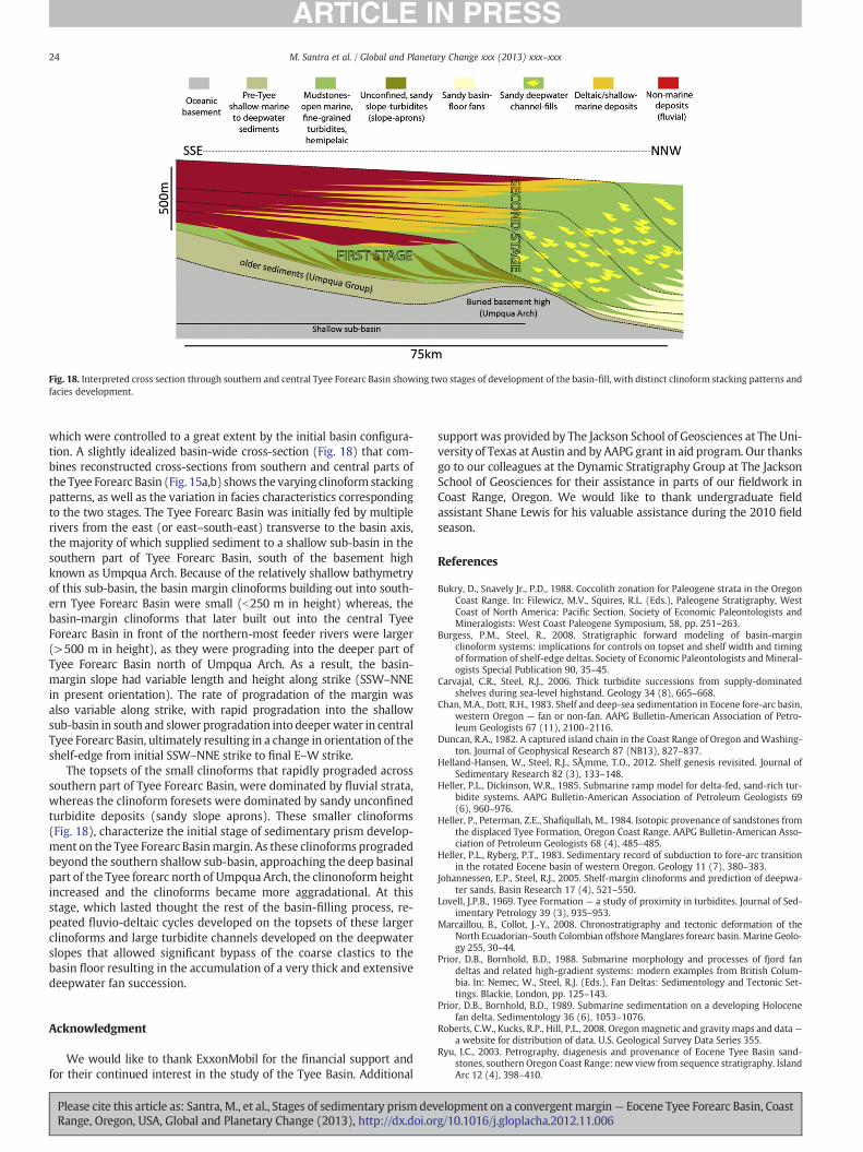
Fig. 18. Interpreted cross section through southern and central Tyee Forearc Basin showing two stages of development of the basin-fill, with distinct clinoform stacking patterns andfacies development.
24 M. Santra et al. / Global and Planetary Change xxx (2013) xxx–xxx
which were controlled to a great extent by the initial basin configura-tion. A slightly idealized basin-wide cross-section (Fig. 18) that com-bines reconstructed cross-sections from southern and central parts ofthe Tyee Forearc Basin (Fig. 15a,b) shows the varying clinoform stackingpatterns, as well as the variation in facies characteristics correspondingto the two stages. The Tyee Forearc Basin was initially fed by multiplerivers from the east (or east–south-east) transverse to the basin axis,the majority of which supplied sediment to a shallow sub-basin in thesouthern part of Tyee Forearc Basin, south of the basement highknown as Umpqua Arch. Because of the relatively shallow bathymetryof this sub-basin, the basin margin clinoforms building out into south-ern Tyee Forearc Basin were small (b250 m in height) whereas, thebasin-margin clinoforms that later built out into the central TyeeForearc Basin in front of the northern-most feeder rivers were larger(>500 m in height), as they were prograding into the deeper part ofTyee Forearc Basin north of Umpqua Arch. As a result, the basin-margin slope had variable length and height along strike (SSW–NNEin present orientation). The rate of progradation of the margin wasalso variable along strike, with rapid progradation into the shallowsub-basin in south and slower progradation into deeperwater in centralTyee Forearc Basin, ultimately resulting in a change in orientation of theshelf-edge from initial SSW–NNE strike to final E–W strike.
The topsets of the small clinoforms that rapidly prograded acrosssouthern part of Tyee Forearc Basin, were dominated by fluvial strata,whereas the clinoform foresets were dominated by sandy unconfinedturbidite deposits (sandy slope aprons). These smaller clinoforms(Fig. 18), characterize the initial stage of sedimentary prism develop-ment on the Tyee Forearc Basinmargin. As these clinoforms progradedbeyond the southern shallow sub-basin, approaching the deep basinalpart of the Tyee forearc north of Umpqua Arch, the clinonoform heightincreased and the clinoforms became more aggradational. At thisstage, which lasted thought the rest of the basin-filling process, re-peated fluvio-deltaic cycles developed on the topsets of these largerclinoforms and large turbidite channels developed on the deepwaterslopes that allowed significant bypass of the coarse clastics to thebasin floor resulting in the accumulation of a very thick and extensivedeepwater fan succession.
Acknowledgment
We would like to thank ExxonMobil for the financial support andfor their continued interest in the study of the Tyee Basin. Additional
Please cite this article as: Santra, M., et al., Stages of sedimentary prism devRange, Oregon, USA, Global and Planetary Change (2013), http://dx.doi.or
support was provided by The Jackson School of Geosciences at The Uni-versity of Texas at Austin and by AAPG grant in aid program. Our thanksgo to our colleagues at the Dynamic Stratigraphy Group at The JacksonSchool of Geosciences for their assistance in parts of our fieldwork inCoast Range, Oregon. We would like to thank undergraduate fieldassistant Shane Lewis for his valuable assistance during the 2010 fieldseason.
References
Bukry, D., Snavely Jr., P.D., 1988. Coccolith zonation for Paleogene strata in the OregonCoast Range. In: Filewicz, M.V., Squires, R.L. (Eds.), Paleogene Stratigraphy, WestCoast of North America: Pacific Section, Society of Economic Paleontologists andMineralogists: West Coast Paleogene Symposium, 58, pp. 251–263.
Burgess, P.M., Steel, R., 2008. Stratigraphic forward modeling of basin-marginclinoform systems: implications for controls on topset and shelf width and timingof formation of shelf-edge deltas. Society of Economic Paleontologists and Mineral-ogists Special Publication 90, 35–45.
Carvajal, C.R., Steel, R.J., 2006. Thick turbidite successions from supply-dominatedshelves during sea-level highstand. Geology 34 (8), 665–668.
Chan, M.A., Dott, R.H., 1983. Shelf and deep-sea sedimentation in Eocene fore-arc basin,western Oregon — fan or non-fan. AAPG Bulletin-American Association of Petro-leum Geologists 67 (11), 2100–2116.
Duncan, R.A., 1982. A captured island chain in the Coast Range of Oregon andWashing-ton. Journal of Geophysical Research 87 (NB13), 827–837.
Helland-Hansen, W., Steel, R.J., Sømme, T.O., 2012. Shelf genesis revisited. Journal ofSedimentary Research 82 (3), 133–148.
Heller, P.L., Dickinson, W.R., 1985. Submarine ramp model for delta-fed, sand-rich tur-bidite systems. AAPG Bulletin-American Association of Petroleum Geologists 69(6), 960–976.
Heller, P., Peterman, Z.E., Shafiqullah, M., 1984. Isotopic provenance of sandstones fromthe displaced Tyee Formation, Oregon Coast Range. AAPG Bulletin-American Asso-ciation of Petroleum Geologists 68 (4), 485–485.
Heller, P.L., Ryberg, P.T., 1983. Sedimentary record of subduction to fore-arc transitionin the rotated Eocene basin of western Oregon. Geology 11 (7), 380–383.
Johannessen, E.P., Steel, R.J., 2005. Shelf-margin clinoforms and prediction of deepwa-ter sands. Basin Research 17 (4), 521–550.
Lovell, J.P.B., 1969. Tyee Formation — a study of proximity in turbidites. Journal of Sed-imentary Petrology 39 (3), 935–953.
Marcaillou, B., Collot, J.-Y., 2008. Chronostratigraphy and tectonic deformation of theNorth Ecuadorian–South Colombian offshore Manglares forearc basin. Marine Geolo-gy 255, 30–44.
Prior, D.B., Bornhold, B.D., 1988. Submarine morphology and processes of fjord fandeltas and related high-gradient systems: modern examples from British Colum-bia. In: Nemec, W., Steel, R.J. (Eds.), Fan Deltas: Sedimentology and Tectonic Set-tings. Blackie, London, pp. 125–143.
Prior, D.B., Bornhold, B.D., 1989. Submarine sedimentation on a developing Holocenefan delta. Sedimentology 36 (6), 1053–1076.
Roberts, C.W., Kucks, R.P., Hill, P.L., 2008. Oregon magnetic and gravity maps and data—a website for distribution of data. U.S. Geological Survey Data Series 355.
Ryu, I.C., 2003. Petrography, diagenesis and provenance of Eocene Tyee Basin sand-stones, southern Oregon Coast Range: new view from sequence stratigraphy. IslandArc 12 (4), 398–410.
elopment on a convergentmargin— Eocene Tyee Forearc Basin, Coastg/10.1016/j.gloplacha.2012.11.006

25M. Santra et al. / Global and Planetary Change xxx (2013) xxx–xxx
Ryu, I.C., Niem, A.R., 1999. Sandstone diagenesis, reservoir potential, and sequencestratigraphy of the Eocene Tyee basin, Oregon. Journal of Sedimentary Research69 (2), 384–393.
Ryu, I.C., Niem, A.R., Niem, W.A., 1992. Schematic fence diagram of the southern Tyeebasin, Oregon Coast Range, showing stratigraphic relationships of exploration wellsto surface measured sections. Oregon Dept. of Geology and Mineral Industries Oiland Gas Investigation, 18 . (29 pp.).
Simpson, R.W., Cox, A., 1977. Paleomagnetic evidence for tectonic rotation of OregonCoast Range. Geology 5 (10), 585–589.
Snavely Jr., P.D., Wagner, H.C., 1963. Tertiary geologic history of western Oregon andWashington.
Snavely Jr., P.D., Wagner, H.C., McLeod, N.S., 1964. Rhythmic-bedded eugeosynclinaldeposits of the Tyee Formation, Oregon Coast Range. Kansas Geological Survey Bul-letin 169, 461–480.
Snavely Jr., P.D., Wagner, H.C., Lander, D.L., 1980. Interpretation of the Cenozoic geolog-ic history, central Oregon continental margin: Cross-section summary. GeologicalSociety of America Bulletin 91, 143–146.
Please cite this article as: Santra, M., et al., Stages of sedimentary prism devRange, Oregon, USA, Global and Planetary Change (2013), http://dx.doi.or
Takashima, R., et al., 2004. Geology and stratigraphy of forearc basin sediments inHokkaido, Japan; Cretaceous environmental events on the north-west Pacific mar-gin. Cretaceous Research 25 (3), 365–390.
Tokuhashi, S., 1989. Two Stages of Submarine Fan Sedimentation in an Ancient ForearcBasin, Central Japan Advances in Earth and Planetary Sciences. Terra Sci. Publ. Co.,Tokyo, Japan, Japan, pp. 439–468.
Trop, J.M., 2008. Latest Cretaceous forearc basin development along an accretionaryconvergent margin: South-central Alaska. Geological Society of America Bulletin120, 207–224.
Wells, R.E. et al., 2000. Geologic Map and Database of the Roseburg 30×60′ Quadran-gle, Douglas and Coos Counties, Oregon U.S. Geological Survey Open-File Report00-376.
Wells, R.E., Heller, P.L., 1988. The relative contribution of accretion, shear, and exten-sion to Cenozoic tectonic rotation in the Pacific Northwest. Geological Society ofAmerica Bulletin 100 (3), 325–338.
elopment on a convergentmargin— Eocene Tyee Forearc Basin, Coastg/10.1016/j.gloplacha.2012.11.006
Related Documents