68030 Adopted September 2020 Staffordshire Moorlands Local Plan

Welcome message from author
This document is posted to help you gain knowledge. Please leave a comment to let me know what you think about it! Share it to your friends and learn new things together.
Transcript
68030
AdoptedSeptember 2020
Sta�ordshire MoorlandsLocal Plan

61 Introduction and background
182 A Portrait of Staffordshire Moorlands
243 The Challenges
304 The Vision
355 Aims and Objectives
386 Spatial Strategy and Strategic Policies
737 Development Management Policies737.1 Sustainable Development
837.2 Economy and Employment
917.3 Housing
1017.4 Town Centres and Retailing
1047.5 Design and Conservation
1117.6 Sustainable Communities
1187.7 Natural Environment
1227.8 Transport
1288 Site Specific Policies1288.1 Leek
1348.2 Biddulph
1428.3 Cheadle
1488.4 Rural Areas
1589 Implementation and Monitoring
184Appendix 1 - Housing Trajectory
186Appendix 2 - Parking Guidance
192Appendix 3 - Policies to be Superseded
196Appendix 4- Local Green Spaces
200Appendix 5 - Neighbourhood Plan housing requirement methodology
September 2020
Staffordshire Moorlands Local Plan - Adopted

209Appendix 6 - Glossary
September 2020
Staffordshire Moorlands Local Plan - Adopted
Local Plan Policies39Policy SS 1 Development Principles41Policy SS 2 Settlement Hierarchy43Policy SS 3 Future Provision and Distribution of Development47Policy SS 4 Strategic Housing and Employment Land Supply51Policy SS 5 Leek Area Strategy55Policy SS 6 Biddulph Area Strategy57Policy SS 7 Cheadle Area Strategy59Policy SS 8 Larger Villages Areas Strategy62Policy SS 9 Smaller Villages Area Strategy65Policy SS 10 Other Rural Areas Strategy68Policy SS 11 Churnet Valley Strategy70Policy SS 12 Planning Obligations and Community Infrastructure Levy75Policy SD 1 Sustainable Use of Resources77Policy SD 2 Renewable/Low-Carbon Energy78Policy SD 3 Sustainability Measures in Development79Policy SD 4 Pollution and Water Quality82Policy SD 5 Flood Risk84Policy E 1 New Employment Development86Policy E 2 Employment Allocations88Policy E 3 Existing Employment Areas, Premises and Allocations90Policy E 4 Tourism and Cultural Development92Policy H 1 New Housing Development94Policy H 2 Housing Allocations98Policy H 3 Affordable Housing
100Policy H 4 Gypsy and Traveller Sites and Sites for Travelling Showpeople102Policy TCR 1 Development in the Town Centres103Policy TCR 2 Primary Shopping Frontages104Policy TCR 3 Retailing and other Town Centre uses outside Town Centres106Policy DC 1 Design Considerations109Policy DC 2 The Historic Environment110Policy DC 3 Landscape and Settlement Setting111Policy DC 4 Local Green Space112Policy C 1 Creating Sustainable Communities114Policy C 2 Sport, Recreation and Open Space117Policy C 3 Green Infrastructure119Policy NE 1 Biodiversity and Geological Resources122Policy NE 2 Trees, Woodland and Hedgerows124Policy T 1 Development and Sustainable Transport126Policy T 2 Other Sustainable Transport Measures129Policy DSL 1 Land at Horsecroft Farm, Leek (ADD01)
September 2020
Staffordshire Moorlands Local Plan - Adopted
130Policy DSL 2 Land at The Mount, Leek (LE066, LE128a&b, LE140, LE142a, LE142b)132Policy DSL 3 Land at Newton House, Leek (LE150)134Policy DSL 4 Cornhill East, Leek (LE235)
137Policy DSB 1 Wharf Road Strategic Development Area (BD055, BD071, BD071a,BD106, BD156, BD076, BD076a, BD108, BD016, BD104)
139Policy DSB 2 Biddulph Mills (BD101 and BD102)
141Policy DSB 3 Tunstall Road Strategic Development Area (opposite Victoria BusinessPark) (BD117)
143Policy DSC 1 Cheadle North Strategic Development Area (CH001 & CH132)144Policy DSC 2 Cecilly Brook Strategic Development Area (CH002a, CH002b & CH024).
146Policy DSC 3 Mobberley Strategic Development Area (CH085a, CH085b, CH085c,CH085d & CH128)
148Policy DSC 4 Land North of New Haden Road, Cheadle (Cheadle EM1)150Policy DSR 1 Blythe Vale152Policy DSR 2 Land east of Brooklands Way, Leekbrook (EM2)154Policy DSR 3 Land off Ash Bank Road Werrington (WE003 & WE052)155Policy DSR 4 Bolton Copperworks156Policy DSR 5 Anzio Camp
September 2020
Staffordshire Moorlands Local Plan - Adopted

Introduction and background
5September 2020
Staffordshire Moorlands Local Plan - Adopted
1 Introduction and background
The Local Plan
1.1 The Staffordshire Moorlands Local Plan is a District wide development plan whichreplaces the Staffordshire Moorlands Core Strategy, Biddulph Area Action Plan (AAP) andprevious Local Plan to provide a framework for delivering development for the period 2014to 2033. The Local Plan was adopted on 9th September 2020.
1.2 The Local Plan sets out the development strategy, strategic and developmentmanagement policies and land designations for the District. It influences how and where theStaffordshire Moorlands will develop in the future. It sets out what the District Council wouldlike to achieve in each of the main towns and the rural areas outside the Peak District NationalPark. The Local Plan also provides the framework for future detailed guidance to supplementthe policies.
1.3 The Local Plan covers only that part of the District for which the Council hasresponsibility as a local planning authority. It therefore excludes the Peak District NationalPark which is covered by a separate policy framework prepared by the Peak District NationalPark Authority.
This Local Plan comprises of the following:
A Portrait of Staffordshire Moorlands - a description of the District
The Challenges - a summary of the key challenges facing the District
The Vision – detailing what the Staffordshire Moorlands will be like in 2033
Aims and Objectives – stating what the Local Plan is proposing to achieve
A Spatial Strategy and Strategic Policies – setting out the over-arching strategyand policies for the District
Development Management Policies – setting out specific measures to managedevelopment
Site Specific Policies - specific policy to guide the development of strategic sitesand others requiring bespoke policy
Implementation andMonitoring - a framework for how the plan will be implementedand monitored
Maps - for Leek, Biddulph, Cheadle and the Rural Areas which identify proposedsites and boundaries
September 20206
Staffordshire Moorlands Local Plan - Adopted
The Core Strategy
1.4 The Staffordshire Moorlands Core Strategy was adopted in March 2014. The CoreStrategy identified a housing requirement of 300 homes per year and an employment landrequirement of at least 24ha over the period 2011 to 2026. The Core Strategy also establishedthe appropriate distribution of development across the District with the emphasis being ondevelopment in the market towns of Leek, Biddulph and Cheadle with a more modest scaleof development in the villages that lie within the Rural Area. However, the Planning Inspectorwho considered the Core Strategy determined that an early and comprehensive review ofthe Core Strategy for the period 2016 – 2031 would be required to take account of longerterm development requirements. The review of the Core Strategy would also roll it forwardinto a single local plan combined with site allocations.
1.5 This Local Plan is the review of the Core Strategy and its policies, and supersedesthe Core Strategy.
Statutory Period for Representations on the Submission Version Local Plan
1.6 This is a statutory stage in the Local Plan process where the Council publishes its finaldraft of the Local Plan, the 'Submission Version' and invites comments on the soundnessand legal compliance of its content during a 6 week period. This took place between 27thFebruary and 11th April 2018. All representations received at this stage were 'submitted' tothe Secretary of State alongside the Submission Version Local Plan. Those objectors fromthe statutory period for representations had the right to be heard at an examination in publiceither in writing (written representations) or verbally at a hearing session conducted by anindependent inspector appointed by the Secretary of State. The examination hearings tookplace in October 2018 and February 2020.
1.7 This statutory period for representations is the final stage of consultation following:
Site Options consultation held between July and September 2015. Over 5500 responseswere received regarding site and boundary options for housing, employment, mixed-use,open space, town centres, retail frontages, settlement boundaries and infill. Views werealso sought on policy matters and potential changes to the Statement of CommunityInvolvement (SCI). An updated SCI was adopted by the Council on 13th April 2016.
Preferred Options Sites and Boundaries consultation held between April and June2016. Over 8600 responses were received. Analysis of the consultation responses hasinformed the content of this consultation and updates to the evidence base.
Preferred Options consultation held between July and September 2017. Over 2600responses were received. Analysis of the consultation responses has informed thecontent of the Submission Version document and updates to the evidence base.
Evidence Base
1.8 The Council needs to ensure that the Local Plan is based on adequate, up-to-dateand relevant evidence about the economic, social and environmental characteristics andprospects of the area. The Council has been in the process of updating and commissioningadditional evidence to support the Local Plan as follows:
Strategic Housing Market Assessment (SHMA) (2014) and Update (2017)
7September 2020
Staffordshire Moorlands Local Plan - Adopted
Employment Land Study (2014) and Update (2017)
Sustainability Appraisal Report (Submission version Local Plan) (2018)
Updated Gypsy and Traveller Needs Assessment (2015)
Retail Study (2013)
Retail Impact Assessment Thresholds Review (2017)
Level 1 Strategic Flood Risk Assessment Update (SFRA) (2015)
Ecological Studies (2015, 2016 and 2017)
Cheadle Town Centre Transport Study (2015) and Phase 2 Assessment (2017)
Green Belt Review (2015) and Updates (2016 and 2017)
Strategic Housing Land Availability Assessment (SHLAA) (2015)
Green Infrastructure Strategy (2017)
Open Space Update Report and Standards Paper (2017)
Playing Pitch Strategy (2017)
Development Capacity, Viability and Community Infrastructure Levy Study (2018)
Infrastructure Delivery Plan (2018)
Habitats Regulations Assessment of Submission Version Local Plan (2018)
Landscape, Local Green Space and Heritage Impact Assessment (2016 and 2017)
1.9 Evidence base studies that informed the Core Strategy and which are still of relevanceto the Local Plan include:
Development Capacity Study (2008/9, and update 2010/11)
Landscape & Settlement Character Appraisal (2008)
Renewable Energy/Low Carbon Energy Study (2010)
Tourism Study (2011)
Ecological Surveys (2010/11)
Historic Environment Character Assessment: Staffordshire Moorlands (2010)
1.10 These documents are available to view on the Council's evidence base webpage:
1.11 www.staffsmoorlands.gov.uk/article/1163/Evidence-base
September 20208
Staffordshire Moorlands Local Plan - Adopted
The Development Plan
1.12 The adopted Local Plan forms part of the statutory Development Plan setting out thelocal planning authority’s policies and proposals for the development and use of land andbuildings in the authority’s area. Decisions on planning applications are required to be madein accordance with the Development Plan unless material considerations indicate otherwise.The material considerations could include national planning policy or significant local issuesthat have arisen since the Development Plan was prepared. The Local Plan Policies Mapsreplaced the previous policies maps attached to the 1998 Local Plan.
1.13 Whilst the Local Plan provides numerous individual policies on a wide range ofplanning matters, the Development Plan should be read as a whole during the considerationof planning applications.
1.14 The statutory Development Plan for the Staffordshire Moorlands outside of the PeakDistrict National Park now consists of:
Adopted Staffordshire Moorlands Local Plan
Minerals Local Plan for Staffordshire (2015-2030)
Staffordshire and Stoke-on-Trent Waste Local Plan (2010 to 2026)
Any "made" Neighbourhood Plans
Waste and Minerals
1.15 Staffordshire County Council is responsible for waste and minerals plan preparationin Staffordshire, excluding the Peak District National Park. Waste and minerals planningapplications in the District (excluding the Peak District National Park) are also determinedby Staffordshire County Council.
1.16 As such, within the plan area the issue of minerals is covered by the Minerals LocalPlan for Staffordshire, and waste matters by the Staffordshire and Stoke-on-Trent WasteLocal Plan.
1.17 The policies in those two plans also form part of the development plan for StaffordshireMoorlands and should be taken into account during the consideration of developmentproposals. Any successor documents would also form part of the Development Plan.
1.18 The NPPF (National Planning Policy Framework) also sets out policy in respect ofminerals and waste to ensure that minerals of local and national importance are not needlesslysterilised by non-mineral development and that waste is appropriately managed. It alsorequires the prior extraction of minerals to be considered in these areas where practicableand feasible, if it is necessary for non-mineral development to take place.
Neighbourhood planning
1.19 Neighbourhood Plans were introduced through the Localism Act in 2011 and theNeighbourhood Planning Regulations (as amended) have been in place since April 2012.Neighbourhood planning enables members of a local community to take forward planning
9September 2020
Staffordshire Moorlands Local Plan - Adopted
proposals for the area in which they live. Neighbourhood Plans are voluntary local planningpolicy documents that are written and developed by a community, usually led by a town orparish council.
1.20 In areas without a town or parish council, a Neighbourhood Forum can be establishedto prepare a plan. Once a neighbourhood plan is adopted, it will form part of the DevelopmentPlan for Staffordshire Moorlands. This means that it will become amajor consideration duringthe determination of planning applications.
1.21 Neighbourhood plans prepared in the Staffordshire Moorlands Local Plan area shouldbe in general conformity with the strategic policies of the Local Plan and the National PlanningPolicy Framework. Strategic policies are those which are essential to delivering the overallplanning and development strategy for the District, such as those that set out the numberof homes that should be built. Neighbourhood Plans cannot therefore plan for lessdevelopment than is required by the Local Plan. However, they may be used to plan foradditional growth, identify sites for development or protection, or provide guidance on matterssuch as design.
1.22 There are currently eight "Neighbourhood Areas" in which Neighbourhood Plans arebeing prepared in the District:
Biddulph
Brown Edge
Checkley
Forsbook
Leek
Leekfrith
Draycott-in-the-Moors
Rushton
Supplementary Planning Documents
1.23 In addition to the Development Plan Supplementary Planning Documents (SPDs)also provide further guidance and background details to support the implementation ofpolicies. They include:
Developer Contributions SPD (to be updated)Design Guide SPD (adopted 2018)Churnet Valley Master Plan SPD (adopted 2014)Leek Town Centre Master Plan SPD (adopted 2014)Cheadle Town Centre Master Plan SPD (adopted 2014)
Peak District National Park
September 202010
Staffordshire Moorlands Local Plan - Adopted
1.24 The Peak District National Park Authority is the planning authority with responsibilityfor plans and proposals within the National Park. The Peak District National Park CoreStrategy was adopted in 2011. It provides the spatial strategy and strategic policies for theNational Park up to the year 2026. A Development Management Policies Development PlanDocument for the Peak District National Park was adopted in May 2019.
Policy Context
Integration of policy, plans and strategies
National Planning Policy Framework
1.25 Local Plans must be consistent with Government policy. The National Planning PolicyFramework (NPPF) sets out Government policy regarding planning matters. Paragraph 14of the NPPF is a critical element of national planning policy in relation to Local Plans. Itstates that:
“At the heart of the National Planning Policy Framework is a presumption in favour ofsustainable development, which should be seen as a golden thread running throughboth plan-making and decision taking.
For plan-making this means that:
local planning authorities should positively seek opportunities to meet thedevelopment needs of their area:
Local Plans should meet objectively assessed needs, with sufficient flexibility toadapt to rapid change, unless
any adverse impacts of doing so would significantly and demonstrably outweighthe benefits, when assessed against the policies in this Framework taken asa whole; or
specific policies in this Framework indicate development should be restricted”
1.26 This "presumption in favour of sustainable development" makes it clear that theDistrict Council should seek to meet identified needs for development in StaffordshireMoorlands in the Local Plan unless there are very clear and robust reasons not to do so.
1.27 Another key element of the NPPF are the "tests of soundness". These tests wereapplied by the Planning Inspector when the Local Plan was under examination. The LocalPlan (as modified) was deemed to have met all of the tests in order for it to be adopted. Thetests are that the Local Plan must be:
“Positively prepared – the plan should be prepared based on a strategy whichseeks to meet objectively assessed development and infrastructure requirements,including unmet requirements from neighbouring authorities which it is reasonableto do so and consistent with achieving sustainable development;
11September 2020
Staffordshire Moorlands Local Plan - Adopted
Justified – the plan should be the most appropriate strategy, when consideredagainst the reasonable alternatives, based on proportionate evidence;
Effective – the plan should be deliverable over its period and based on effectivejoint working on cross-boundary strategic priorities; and
Consistent with national policy – the plan should enable the delivery ofsustainable development in accordance with the policies in the NPPF.”
1.28 Note that for clarification this Local Plan has been prepared and examined under thetransitional arrangements of the 2012 NPPF, consequently references made throughout thedocument to the NPPF refer to the 2012 version. Planning applications will be determinedin accordance with the development plan unless material considerations determine otherwise.Themost recent version of the NPPF is a material planning consideration in the determinationof planning applications.
1.29 The Government's detailed planning policy in relation to travellers is set out in aseparate document - "Planning policy for traveller sites".
1.30 In preparing this Local Plan, consideration has also been given to other new oremerging policies and regulations, including; the Housing and Planning Act 2016, theSelf-Build and CustomHouse Building Act 2015 and associated Regulations (2016), the Townand Country Planning (Brownfield Land Register) Regulations 2017, Town and CountryPlanning (Permission in Principle) Order 2017, Neighbourhood Planning Act 2017 and theHousing White paper published in February 2017.
1.31 The Housing White Paper published in February 2017 sets out a number of potentialpolicy changes and information relating to the provision of housing, design and Green Beltamongst others. The Government published its response to White Paper consultationresponses in March 2018. The Self-Build and Custom House Building Act 2015 andassociated Regulations (2016) introduced a new requirement for the District Council tomaintain a register of individuals and associations of individuals who are seeking to acquirea plot of land to provide their own home. Councils are then required to have regard to theregister in carrying out their planning and regeneration functions. The Regulations requirethat sufficient land is granted planning consent to meet the demand on the register withinthree years.
1.32 The Town and Country Planning (Brownfield Land Register) Regulations 2017 makeprovisions for Councils to maintain a register of brownfield sites that are suitable for residentialdevelopment irrespective of their planning status. The District Council's register was firstpublished in December 2017 and updated annually and can be found on its website. Sitesidentified in Local Plans may be included on the register alongside others that are consideredsuitable for development. Permission in Principle (PiP) may then be granted for some siteson the register.
1.33 The Local Plan has a key role in providing a spatial dimension for many other strategiesand helping in their co-ordination and delivery throughout the Local Planning Authority area.The Local Plan must also accord with national policy and relevant legislation. This sectionsummarises the main strategies and policy influences, which have both directed the approachtaken in the Local Plan, and which in turn the Local Plan will help to deliver and potentially
September 202012
Staffordshire Moorlands Local Plan - Adopted
shape. These include the Local Transport Plan, Sustainable Community Strategy, Stokeand Staffordshire Local Enterprise Partnership Strategic Economic Plan, the Council's ownCorporate Plan and the emerging work of the Constellation Partnership.
Local Transport Plan
1.34 A Local Transport Plan was published in 2011 that sets out the transport objectivesfor Staffordshire. Integrated Transport Strategies have also been produced that outline localtransport priorities at a District level and are regularly reviewed to support the Local Planprocess and the Stoke-on-Trent and Staffordshire Local Enterprise Partnership (LEP).
1.35 An Integrated Transport Strategy for Staffordshire Moorlands was published in 2013to support the Core Strategy Development Plan Document, 2014. The Strategy has beenrevised to support the Local Plan.
Sustainable Community Strategy
1.36 The Sustainable Community Strategy sets a long-term vision and plan for bringingabout a sustainable improvement in the social, economic and environmental conditions ofStaffordshire Moorlands. It brings together the needs, interests and aspirations of thecommunity of Staffordshire Moorlands. The latest Sustainable Community Strategy (2007–2020) sets out the following key outcomes:
Children and young people
Stronger, safer communities
Older people and adults at risk of exclusion
Economic regeneration
Environment and climate change
1.37 The Council developed the Core Strategy in tandem with the development of theSustainable Community Strategy through theMoorlands Together Local Strategic Partnership.In order to ensure that the Core Strategy was completely aligned with the SustainableCommunity Strategy early public consultation on the Core Strategy and SustainableCommunity Strategy was undertaken as a single exercise – such that both draw on the sameinformation about community priorities and the same set of local data.
1.38 ‘Shaping the Future of Staffordshire 2005 – 2020’ – The Sustainable Strategy for theCounty focuses on six key priorities:
enhancing the voice and profile of Staffordshire;
developing strong and rural communities;
integrating and sustaining transport; improving health and social care;
supporting the growth of the local economy and encouraging prosperity; and
sharing data and information.
13September 2020
Staffordshire Moorlands Local Plan - Adopted
1.39 Corporate Plan
1.40 The Council’s Corporate Plan sets out the key aspirations of the Council for improvingservices for Staffordshire Moorlands. The 2017-2019 Corporate Plan identifies the followingaims. All Aims are of particular relevance to the Local Plan:
Aim 1 - To help create a safer and healthier environment for our communities to liveand work
Aim 2 - To meet our financial challenges and provide value for money
Aim 3 - To help create a strong economy by supporting further regeneration of townsand villages
Aim 4: To protect and improve the environment
Stoke and Staffordshire Local Enterprise Partnership Strategic Economic Plan
1.41 The Local Enterprise Partnership is comprised of business and local governmentrepresentatives that help to determine the economic and investment priorities for Stoke andStaffordshire. Their Strategic Economic Plan sets out five central goals for the period up to2030 which are:
A Core City - planned growth of the conurbation with Stoke-on-Trent acting as key driver
Connected County - to build on our central location and connectivity to deliver the rightblend of employment sites and infrastructure to support business growth and meetlabour market needs
Competitive Urban Centres - to significantly enhance growth opportunities from anattractive and thriving city of Stoke-on-Trent and other towns across Staffordshire wherepeople are eager to live, work and enjoy themselves
Sector Growth - ensure globally competitive innovation, investment and enterprise– ledexpansion in large & small businesses across our priority sectors
Skilled Workforce - to develop a modern and flexible skills to meet the needs of ourgrowth sectors
Constellation Partnership
1.42 The Constellation Partnership is a grouping of local authorities and LocalEnterprise Partnerships in Cheshire and north Staffordshire that have come together tomaximise the potential benefits to the area arising from the proposed HS2 Hub Station atCrewe and related economic growth opportunities up to the year 2040. Land at Blythe Valehas been identified by the Partnership as an investment opportunity. Whilst a strategy hasyet to be published, the Local Plan will seek to provide support to this initiative insofar as itrelates to the timescales for the Local Plan up to the year 2033.
September 202014
Staffordshire Moorlands Local Plan - Adopted
Duty to Co-operate
1.43 Many social, environmental and economic issues can only be effectively addressedat a larger than local scale. This is because people and businesses do not confine theiractivities to one council area - for example, employees may live in one area and work inanother; and a retail development may attract customers from across a wide catchmentarea. Similarly from an environmental perspective - surface water run-off in one location maypresent a flooding hazard to communities further ‘downstream’; and water and air pollutionmay have a damaging impact on environmental assets some distance away.
1.44 In order to address such strategic planning issues in the absence of a regionalplanning function, Section 110 of the Localism Act set out a "duty to co-operate". This dutyapplies to all local planning authorities in England and to a number of other public bodies.The duty:
relates to sustainable development or use of land that would have a significant impacton at least two local planning areas or on a planning matter that falls within the remitof a county council
requires that councils set out planning policies to address such issues;
requires that councils and public bodies ‘engage constructively, actively and on anongoing basis’ to develop strategic policies;
requires councils to consider joint approaches to plan making
1.45 Paragraph 156 of the National Planning Policy Framework (NPPF) sets out thestrategic issues where co-operation might be appropriate. Paragraph 179 of the NPPFrequires councils to work together to address strategic priorities across boundaries anddevelopment requirements which cannot be wholly met within their own areas.
1.46 To date, in order to satisfy the duty to co-operate, Staffordshire Moorlands DistrictCouncil has engaged with authorities including Staffordshire County Council, Stoke-on-TrentCity Council, Newcastle-under-Lyme Borough Council, Stafford Borough Council, the PeakDistrict National Park Authority, Cheshire East Council, High Peak Borough Council,Derbyshire Dales District Council and East Staffordshire Borough Council. Strategic issuesthat have been identified to date include:
The provision of suitable supporting infrastructure for planned growth, including transport,education, utilities, green infrastructure and health with Staffordshire County Council,Highways England, Clinical Commissioning Groups and other bodies
The need to protect the setting of the Peak District National Park
Meeting development requirements across the entire District, including the Peak DistrictNational Park and neighbouring areas with shared housing market and economicrelationships
Engaging in the emerging proposals for economic growth and investment through theConstellation Partnership
15September 2020
Staffordshire Moorlands Local Plan - Adopted
1.47 The Duty to Co-operate Statement which accompanies the Local Plan provides moredetails on how the Council has co-operated to date, outcomes and arrangements for futurecollaboration.
Sustainability and Equalities
1.48 This Local Plan is supported by a Sustainability Appraisal. The appraisal has helpedto inform the content of the Local Plan. The Sustainability Appraisal was itself also subjectto public consultation alongside the Local Plan during the examination process. If you wishto read the Sustainability Appraisal, you may find further details at Council offices andonline: www.staffsmoorlands.gov.uk/localplan
1.49 An Equalities Impact Assessment has also been undertaken to consider how theLocal Plan may impact upon different groups within the community. A Habitats RegulationsAssessment has also been prepared. With the recommendedmitigation measures, the reportconcludes that the Submission Local Plan will not result in adverse effects on Europeansites, both alone and in combination with growth in neighbouring areas. These documentsare also available to view at Council offices and on the Council's website.
September 202016
Staffordshire Moorlands Local Plan - Adopted
A Portrait of Staffordshire Moorlands
17September 2020
Staffordshire Moorlands Local Plan - Adopted
2 A Portrait of Staffordshire Moorlands
September 202018
Staffordshire Moorlands Local Plan - Adopted
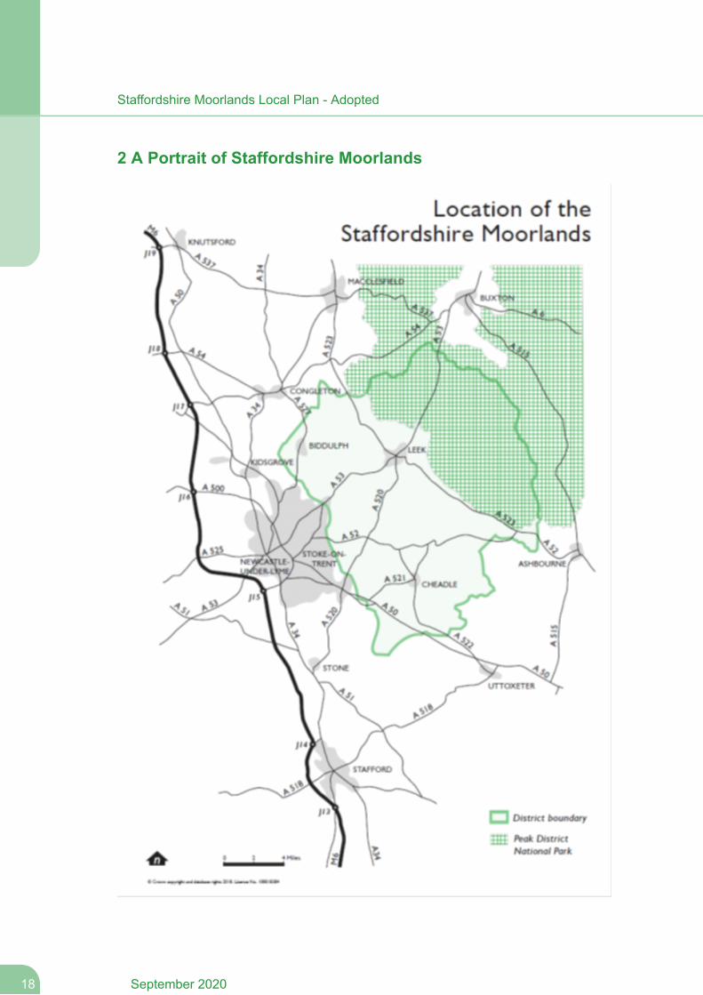
2.1 Staffordshire Moorlands is in north east Staffordshire, bordered by Cheshire to thenorth-west, Derbyshire to the east and Stoke-on-Trent to the south-west.The district coversan area of 57,624 hectares and has a population of 97,106 (2011 Census). Around 54% ofthe population is based in the three towns of Leek, Biddulph and Cheadle; around 22% ofthe population lives in the larger settlements of Cheddleton, Endon, Werrington & Cellarheadand Blythe Bridge, located in the west of the district. The remainder are divided among 34rural parishes.
2.2 A third of the district lies inside the Peak Park - the Peak District National Park Authorityrepresents the special interests of this Park. Of the remainder of the Moorlands, around 30per cent is designated as Green Belt. The district has close links to parts of Cheshire, aswell as to the city of Stoke-on-Trent, which exerts a strong influence on the west of the districtin particular, and provides significant employment opportunities and services for many peoplein the district.
2.3 Between 1991 and 2001 Staffordshire Moorlands recorded a decline in population,although this was primarily driven by natural change as a result of falling birth rates. Since2001 the District has continued to experience negative natural change, but has made up forthis with positive net migration resulting in a steady increase in population.
2.4 The Strategic Housing Market Assessment (2014) concluded that the District doesnot form a self contained housing market area and that cross boundary relationships areshared with Stoke-on-Trent in particular.
2.5 There are approximately 43,585 houses in the District (2011 Census). According tothe 2011 Census approx 80% of households owned their own home. As of October 2012,there was a total of 1,982 vacant dwellings in Staffordshire Moorlands, representing 4.6%of the total stock. Of these dwellings, 842 had been vacant for longer than 6 months.
2.6 The average household size is currently estimated to be 2.38 persons per household.The predominant type of housing in Staffordshire Moorlands is detached (40%) - the levelof terraced stock is particularly low at 16.6%, against a regional level of 23.9%. The proportionof social rented households and private-rented households in Staffordshire Moorlands isalso low in comparison with the average for Staffordshire or England.
2.7 The Council transferred its Local Authority housing stock to Moorlands Housing in2001, with a stock base of around 3,700 properties principally located in the Leek, Cheadleand Biddulph areas.
2.8 The District experienced rapid house price growth from 2001 to 2007. After falling andstagnant prices during and after the recession, house prices began to rise again. However,as of 2015, average (median) house prices remain low in the District (£153,750) whencompared to Staffordshire (£162,000) and England (£212,000). Houses prices within theDistrict are also variable with the Rural Areas experiencing higher average house pricesthan in Leek, Biddulph or Cheadle.
2.9 In terms of the local economy, the public administration, education & health sectorsare well represented and provide a larger proportion of employment than regional and nationalrates. Other key sectors of employment are distribution, hotels & restaurants andmanufacturing. Manufacturing in particular is over-represented in comparison with regionaland national levels and has experienced amuch slower rate of decline than theWest Midlandsaverage. A third of the District lies in the Peak District National Park. Approximately 11% ofPeak District National Park residents live in the Staffordshire Moorlands authority boundary.
19September 2020
Staffordshire Moorlands Local Plan - Adopted
2.10 Employment sites are almost at full capacity and there are a number of nationallysignificant businesses, including JCB and Alton Towers. However, there is a lack of goodquality small to medium-sized industrial premises, which is suppressing demand. In particular,the limited level of development in recent years has restricted the availability of sites for localbusinesses to expand.
2.11 Whilst there is the continued presence of large nationally recognised employers, thebusiness structure of Staffordshire Moorlands is dominated by micro and small businessesof between 1 and 10 employees which collectively accounted for over 92 per cent of allbusinesses in 2016.
2.12 As with elsewhere across the country, Staffordshire Moorlands has been experiencingrapid economic change, moving away from the traditional industries of agriculture,textiles/manufacturing, and coal mining towards service sector businesses such as finance,retailing, tourism, leisure and the knowledge economy. The District’s workforce is seeing atrend towards growth amongst managers and senior officials and increases in the professionalclass.
2.13 Economic activity rates in the District (84.2%) are higher than national (77.8%) andregional averages (75.4%). (1) Whilst this is a positive sign, average weekly pay for jobsavailable in the District is low (£486.2) when compared to the West Midlands (£510.20) orGreat Britain (£540.20). (2)
2.14 In terms of quality of life, the District is ranked 203 out of 326 Districts in England inthe 2015 Index of Multiple Deprivation. Levels of deprivation are higher in certain areas ofthe District including Biddulph East area, a former coal board housing estate that suffersfrom a range of socio-economic and environmental deprivation problems and within LeekNorth and Cheadle North East areas.
2.15 There are strong ‘cross-border’ workforce links with the Stoke conurbation (about15.4% of daily work-journeys into the Moorlands are from the conurbation and about 26.8%of the Moorlands resident workforce work in the conurbation). The District also has high caruse and low public transport use. There is only one railway station in the District, at BlytheBridge in the south-west of the District on the Crewe-Stoke-Derby line. The overall rate forall walk-to work journeys is only 0.56% (into/within/out of the Moorlands). However theequivalent figure for those who work in the Moorlands (which includes those who alreadylive in the Moorlands) is significantly higher, at 13.08%.
2.16 In terms of health and wellbeing, the District has the highest levels of death fromrespiratory disease (chronic obstructive pulmonary disease, asthma) and prevalence ofrespiratory disease in the county, but the lowest levels of air pollution. This is consistent withan older population and population projections suggest that between 2012 to 2021 thenumber of residents aged 65 years older will have increased by 22.3%. The StaffordshireMoorlands also has some of the highest levels of physical inactivity among the Staffordshiredistricts, 65% of all adults having excess weight, 24.4% of children aged 5 also have excessweight, and 30% of children aged 10. The District also has high levels of severe mentalhealth issues with highest levels of deprivation linked to geographic access.
1 2016 ONS annual population survey2 2016 ONS annual survey of hours and earnings - workplace analysis
September 202020
Staffordshire Moorlands Local Plan - Adopted
2.17 The landscape and historic environment of the District is highly valued by bothresidents and visitors and contains a large and particularly rich stock of protected assets,reflected in the number of formal designations. There are extensive protected environments(SSSIs, Special Conservation Areas) distributed across the District and particularly withinthe Peak District National Park boundary. The District (outside the Peak District) also includes967 Listed buildings and structures, 117 Scheduled Monuments and 16 ConservationAreas. The Staffordshire Moorlands district is located within the southern uplands and foothillsof the Pennines and is crossed by the valley of the River Churnet. Although the plan arealies outside the Peak District National Park, it contains a number of villages and towns whosepresent-day picturesque qualities belie an often industrial past based on iron and brassproduction in the Churnet Valley; silk and tape manufacture in Leek, Cheadle and the Teansand coal mining in Biddulph. As such, despite a number of successful conversions of formermill buildings, many remain empty or underused and at risk. The plan area’s rural hinterlandwas once prosperous, as is evident by the number and quality of the historic farmsteads.Unfortunately, these have fallen on harder times and many now are in need of repair or amore intensive use.
2.18 The landscape is characterised by attractive countryside comprising of farmland,extensive woodland areas, natural grassland and moors interspersed by distinctivesettlements. The rural heritage of the District (historic farm buildings, archaeological sites,parkland, historic landscape character) is also highly significant. There are currently 2parklands included within the Historic England Register of Parks and Gardens and numerousother notable parklands. The Canal & River Trust own and operate some 17km of the CaldonCanal, together with 4km of the Leek Branch of the Caldon Canal and also Rudyard Lake,which is a reservoir providing a water supply for the canal. The canal network forms animportant part of the industrial heritage of the area.
2.19 Community life is a strong and distinctive feature of Staffordshire Moorlands. Peopleidentify closely with their towns, neighbourhoods and villages. Pride in local communities ishigh, leading to a rich pattern of community activities and organisations. Local parish councils,voluntary and community groups play a vital part in maintaining this special characteristicof the district.
Leek (pop. 20,768) is the principal town in the District with a large range of facilities. Itstands below the open moorland of the Peak District and serves a wide rural area, yetit lies only 10 miles east of the North Staffordshire conurbation. It is a traditional markettown with a large number of listed buildings and a strong sense of identity and hasbecome a recognised national centre for antiques and fine arts. The town has anindustrial heritage with a large number of former textile mills and streets of pre-1919terraced housing
Biddulph (pop. 19,892 including Biddulph Moor) is a former mining town that lies in thenorth west corner of the Staffordshire Moorlands District and it is near to the boundarywith Cheshire and abuts the North Staffordshire conurbation to the South. It serves amuch more constrained area to the west of the District with strong cross-boundarylinkages, particularly with the conurbation. The building of a new by-pass has openedup opportunities for new development and regeneration. The area has issues relating
21September 2020
Staffordshire Moorlands Local Plan - Adopted
to former National Coal Board housing and low demand in the east of the town. Biddulphis home to the celebrated Biddulph Grange Gardens, the best surviving example of anornamental Victorian garden.
Cheadle (pop. 12,165) is the smallest town, located 10 miles south east of Leek and10miles east of the north Staffordshire conurbation and serving amore limited catchmentarea. Cheadle has suffered from under-investment and a poor infrastructure and itstown centre has declined in recent years but a successful Heritage EconomicRegeneration Scheme has led to some improvements. Whilst the town has some notablebuildings, including the precious asset of St. Giles’ RC Church, one of the finest worksof the celebrated Victorian architect A W Pugin, the majority of its houses have beenbuilt since the First World War. Cheadle is only 4 miles from the A50 [T] Stoke to Derbyroad that links the M1 and M6 motorways.
September 202022
Staffordshire Moorlands Local Plan - Adopted

The Challenges
23September 2020
Staffordshire Moorlands Local Plan - Adopted
3 The Challenges
3.1 Staffordshire Moorlands is an area of great diversity and opportunity which faces anumber of significant challenges, both from external influences and pressures at a global,national and regional level and from changes occurring at a more local level. These will drivethe changes that are going to be necessary to bring about a sustainable improvement in thesocial, economic and environmental conditions of the District. The following summary of thechallenges and the related issues are those which were identified in the Core Strategy andany subsequent issues arising from the evidence base, the consultations we have undertaken,the various information and monitoring sources and the requirements of various key bodiesand organisations.
Accommodating and delivering growth
Need to meet the development requirements for the District, including housing andemployment
Need to ensure sufficient land identified for development needs is deliverable andcan help to address historic under delivery
Importance of working in partnership with other organisations and groups to deliverthis growth and the necessary infrastructure improvements.
Strengthening the District’s wider role
Major strengths of Staffordshire Moorlands are the quality of its rural landscapewith its proximity to the Peak District National Park and the quality of its markettowns and villages which offer a highly regarded quality of life.
Tourism is identified as one of the key areas where the District can have a majorrole to help bring more people in and diversify its economy.
Need to strengthen connections with service providers and ensure betteraccessibility by road and public transport to and from our towns, villages, visitordestinations and strategic infrastructure
District's role with the Peak District is particularly important – relieving the pressureof tourism, limiting impact on landscape and protecting sites of value.
Potential threats from the growth of other centres, undermining the role of localcentres and placing pressure on transport links.
Supporting wider economic initiatives and strategies including the Local EnterprisePartnership's Strategic Economic Plan and the Constellation Partnership.
September 202024
Staffordshire Moorlands Local Plan - Adopted
Creating healthy, sustainable communities
Need to maintain and improve the quality and diversity of the District’s communitiesby ensuring accessibility to services and determining the best pattern of provisionand distribution of development across the District, which is sustainable, reflectsthe role of the different settlements and is not compromised by inadequateavailability of infrastructure.
Need to support the quality of community life through partnership working –improving community safety, tackling health inequalities, social isolation, reducingthe fear of crime, encouraging community cohesion, and tackling deprivation andinequalities.
Need to improve provision and accessibility to health and education services andfacilities.
Need to increase physical activity and encourage active travel across all age groupsand address the under-provision or poor quality provision of sport and recreationalfacilities and open space.
Adapting to changes in population structure
Significant rise in older persons requires a better understanding of the aspirationsand needs of people aged 60 and over, providing opportunities for people to workbeyond the traditional retirement age and meeting changing housing needs. Needto develop services which maintain people’s social contact and independence,reduce social isolation and encourage physical activity and active travel.
Decline in numbers of younger people and families is a major concern, particularlythe rural areas where communities are ageing. Requiresmore investment in childrenand young people in terms of raising aspirations and educational attainment,improving access to services and recreational opportunities, providing affordablehousing for future generations and providing appropriate local employmentopportunities.
Unless sufficient new housing is delivered to attract people of working age to theDistrict, a projected decline in the working age population will have a detrimentalimpact on the local economy by restricting the supply of labour leading to a declinein businesses and the number of jobs in the District.
Improving the housing market
There is a high need for affordable housing (224 to 432 per year) that is unlikelyto be fully delivered through developer contributions alone
25September 2020
Staffordshire Moorlands Local Plan - Adopted
There is a need to re-balance the housing stock for example a need for moreterraced properties and more rental sector properties and better quality, aspirationalproperties to reduce the levels of net out-migration to neighbouring areas. Thereis also a need for accommodation to support a growing elderly population
Need to support a diverse range of housing needs, including self and custom buildand Starter Homes
Fostering business growth and economic sustainability
Threats to the economy from a constrained labour force, the loss of existingemployment sites due to closures, restructuring and pressure for redevelopmentfor other uses, especially housing.
Need to support existing major employers whilst developing policies to diversifythe economic base by making sites available for modern employment facilities.
There is an identified lack of good quality modern premises and smaller sized unitsavailable for immediate take up and a significant under-representation of highquality office locations.
Service sector is seen as the main driver for economic growth with an opportunityto capitalise on the growth of the ‘experience economy’ – tourism, leisure and retail- in particular developing the District’s tourism role.
To support economic growth there is a continuing need to ensure the provision ofrelevant employment skills, training and support to retain and develop localworkforce.
Creating thriving, distinctive market towns
Vitality and viability of town centres facing challenges associated with ever changingretail trends such as online shopping
Biddulph and Cheadle catchment areas are not using the town for their mainshopping and instead are choosing to shop outside the District, particularly forcomparison shopping. Whilst there is some leakage of expenditure from Leek, thetown centre performs relatively well in comparison
A need for an additional centrally located convenience retail store in Biddulph hasbeen identified to support the town centre
September 202026
Staffordshire Moorlands Local Plan - Adopted
Tackling social exclusion and economic decline in the rural areas
Economic development needs to recognise the contribution which the rural areascanmake to the District’s economy with a major role for tourism in terms of providingopportunities for jobs, attracting investment and bringing in wealth.The dispersed rural settlement pattern in the District means that accessibility toservices and infrastructure is often limitedThere is often limited scope to accommodate significant new development in therural areas due to the sustainability of sitesThe need for affordable housing is particularly critical to encourage young and/orsmaller households to remain in the rural settlements but smaller sites and higherland values can make their delivery difficultThere is a need to exploit opportunities arising from the closure of major developedareas in the countryside.
Protecting and enhancing the distinctive quality of the environment
Whilst continuing to protect, manage and enhance the quality of the District’sphysical, natural and historic environment including its biodiversity is crucial, thereis also opportunity to capitalise on the built and natural assets of the District andits heritage to maximise the quality of life for local residents, attract new investmentand achieve economic benefits through tourism.The built heritage of the plan area is rich and varied - containing a valuable resourceof surviving high quality vernacular and industrial architecture. Whilst this resourcehas escaped the alterations and interventions typically found elsewhere, they often,today, suffer from underuse and dereliction. In response to this, there is a needfor the plan to create a more sustainable local economy that can better support itsbuilt heritage.
Need to enhance and protect Green InfrastructureThere is potential to raise the quality of new development still further, and to ensurethat it contributes more significantly to meeting local distinctiveness, sustainabilityobjectives and to health improvement/increasing levels of physical activity (throughActive Design).There is also a need to make better use of existing buildings which are of valueand add to the character of settlementsThe setting of the District’s settlements is important – the landscape provides animportant edge to the urban area and defines their character. There are alsoimportant areas of open space and Local Green Space within settlements whichneed to be retainedThe close physical relationship of the District with the Peak District requires specialattention to development which may impact on its setting, landscape and areas ofvalue.
27September 2020
Staffordshire Moorlands Local Plan - Adopted
Tackling climate change
Planning has a key role to play in mitigating the causes and effects of climatechange through the location and nature of development and by helping to shapeplaces which have lower carbon emissions and are resilient to climate change.The District should aim to contribute to the wider Government objective of achievinga low carbon futureEnergy efficiency in the design, construction and use of buildings will be vital toreducing the impact of development on climate change.Flooding is also an issue which has become significant in recent years due toincreased incidences across the country. The Local Plan should seek to steerdevelopment to areas of low flood risk and support the delivery of appropriatemitigation and sustainable drainage where necessary
Making travel more sustainable
High levels of car ownership and car usage and an over-dependence on use ofthe car for both work and non-work related journeys, partly as a consequence ofpoor public transport, particularly in the Rural Areas. This can lead to trafficcongestion.Addressing these transport issues will require a range of measures aimed atensuring maximum accessibility to development sites by public transport, walkingand cycling as well as focusing development in the most sustainable locations
September 202028
Staffordshire Moorlands Local Plan - Adopted

The Vision
29September 2020
Staffordshire Moorlands Local Plan - Adopted
4 The Vision
4.1 The Vision is carried forward from the adopted Core Strategy and sets out the directionin which the Council would like to take the District in the long term and sets the context forderiving more detailed objectives and policies within the Local Plan. It is a vision which seeksto drive forward change and address the key challenges the District faces and shares asimilar vision to the Sustainable Community Strategy as well as reflecting theCouncil’s Corporate Plan and the community’s aspirations. It is also a shared vision whichwill require the co-ordinated effort of many agencies and partners working together to achieve,including those working outside of the Staffordshire Moorlands.
4.2 The central theme of the vision will be to see Staffordshire Moorlands become anexceptional place to live, work and visit. This means balancing the need to foster sustainablegrowth where it is needed and beneficial, with the need to protect and enhance the District’sheritage and its significant built and natural assets.
4.3 It is recognised that some parts of the proposed vision for the District may beaspirational but it is important that we gain a clear understanding about what sort of Districtwe are aiming for in the future.
Spatial Vision for Staffordshire Moorlands
The vision for Staffordshire Moorlands is that it will be recognised as a vital part of aregenerated North Staffordshire in terms of its functional relationship, its social andeconomic contribution, its rich historic and natural heritage and its distinctive character.
We will have sustainable and balanced urban and rural communities which have anexcellent quality of life with access to appropriate, affordable and desirable housing,suitable local jobs, a range of recreational, cultural and leisure opportunities and highquality public services and facilities. Development clusters and smaller sites insustainable locations will provide attractive opportunities for investment and communities.
The economy of the Moorlands will have undergone a significant change with morediversified and higher quality employment provision better meeting the skills and needsof its workforce and more opportunities for business start-ups across the whole of theDistrict. There will be a more flexible and proactive approach to employmentdevelopment, raising the District’s economic fortunes by exploiting its assets, raisinglocal skill levels and opportunities and addressing deficiencies and disadvantages.Importantly, we will tackle the potential issues relating to an ageing population bysupporting inward investment providing desirable housing for people of working age.The District will support economic growth initiatives for the wider area, including thoseled by the Local Enterprise Partnership
Tourism will be a key element in the diversification of the District’s economy and willalso contribute significantly to raising the environmental quality and the regeneration ofthe District. Its market towns will each have their own unique selling point for attractingvisitors. The diversity and quality of the District’s natural and historic assets will haveimproved and greater use will be made of the opportunities they provide for recreationand tourism, particularly around the Churnet Valley which together with Alton Towerswill be a significant tourist attraction. The implementation of a GreenInfrastructure Strategy will protect and enhance the environment as well as providing
September 202030
Staffordshire Moorlands Local Plan - Adopted
recreational opportunities where appropriate. The implementation of a Playing Pitchand Built Facilities Strategy will seek to provide and enhance formal sports facilities(indoor and outdoor). The wealth of biological and geological resources will continue tobe protected, conserved and enhanced where appropriate and net gains andimprovements to biodiversity will be made.
The needs of all sectors of the community, in particular younger and older people, willbe better met through provision of recreational, sport and community facilities, localemployment opportunities and appropriate housing. Encouragement of physical activityand active travel throughout the District and across all age groups will improve healthand wellbeing.
Development will be of a high standard of design and sustainability seeking to addressand adapt to climate change. Settlements will develop in a way that acknowledges theirhistoric and natural heritage, their unique setting and their green infrastructure.
Our market towns of Leek, Cheadle and Biddulph will remain the focus of the Moorlands.They will be distinctive and unique in terms of their character and the quality and rangeof shops, services and facilities they provide for both residents and visitors. Their towncentres will be welcoming, safe and appealing and will retain their significant historicheritage and distinctiveness which makes them special places, as well as beingprosperous and vibrant, catering for the needs of both the town and its hinterland.Access will be improved between market towns and with their surrounding settlementswith greater opportunities to travel by means other than the car.
4.4 This vision is further detailed below to cover the specific challenges which need to beaddressed in our towns and the rural areas:
Vision for Leek
Leek will be an increasingly important civic and service centre for its population and theDistrict and will further strengthen its role as the principal town in the District. The qualityof the retail offer in the town centre will have improved further, and the diversity ofemployment opportunities, facilities and services it offers increased. It will have enhancedits role as a tourist attraction, building on its special character, heritage and builtenvironment assets. Major employers in the town will grow, but will be balanced by newbusinesses on improved existing and new employment sites. Underused and poorerquality areas, such as Cornhill, Newton House and the Churnet Works, will have beenregenerated providing new development opportunities and its mill buildings will havebeen conserved with new uses. The bus station will be served by a reliable publictransport system whilst access and car parking in the town centre will be improved.
New housing will help to support the role of the town, including the development clusteroff Mount Road, which will be supported by necessary infrastructureimprovements including education, transport and open space, sport and recreation.Green infrastructure and open space will protect and enhance the environment whilstproviding recreational opportunities alongside sport and improvements to health andwell being.
31September 2020
Staffordshire Moorlands Local Plan - Adopted
Vision for Biddulph
Biddulph will continue to maintain its role as a significant service centre for its residentsand those in outlying rural areas but with a focus on improving its image and prosperity.The town's heritage will be maintained and where possible enhanced. Significant growthand change will have taken place within the town through the development of the WharfRoad mixed-use allocation which will support additional housing, retail and employment.Further housing and employment will serve the town near to Victoria Business Park andmill buildings will be regenerated. It will benefit from environmental improvements andimproved community facilities with more sustainable, thriving and balanced localcommunities with an expanded local economy. Green infrastructure and open spacewill protect and enhance the environment whilst providing recreational opportunitiesalongside sport and improvements to health and well being. There will be a greatervariety of housing types and tenures which better meets the needs of the community.It will have improved connections with the rest of the District. The local community willhelp guide the development of Biddulph with a Neighbourhood Plan
Vision for Cheadle
Cheadle will become a more sustainable settlement, better able to meet its own needs,enhancing and enlarging its role as a significant service centre for the local populationand those in its rural hinterland. This will have been achieved through a focus on growthin housing and employment provision with significant complementary investment in thetown's social and physical infrastructure. Its town centre will become more vibrant andattractive supported by investment in the town. The town's heritage will be maintainedand where possible enhanced. JCB and other major employers will grow, but the localeconomy will have been diversified and expanded with new employment areas. It willbenefit from improved transport infrastructure and local public, sustainable transportlinks focused on the town centre and improved access to other urban areas. Greeninfrastructure and open space will protect and enhance the environment whilst providingrecreational opportunities alongside sport and improvements to health and well being.With a greater range of housing and employment opportunities Cheadle will have becomea more successful and dynamic place where people choose to live and work.Development clusters to the north and south of the town will provide new housing andsupporting infrastructure where required.
Vision for the Rural Areas
The Rural Areas will have viable, attractive villages and smaller settlements which willcontinue to foster appropriate, sensitive growth and vitality to support rural living andwork. The larger villages will be the rural centres for services, facilities and jobs actingto sustain the rural areas. Smaller village communities will also continue to thrive witha range of housing opportunities and improved access to community services. Therewill be a more vibrant and diverse rural economy which will provide a range of local jobopportunities and support a thriving agricultural sector. Mixed-use development at BlytheBridge will support the Rural Areas and potential wider regeneration initiatives.
September 202032
Staffordshire Moorlands Local Plan - Adopted
Well managed, sustainable tourism will be a major driver in regenerating the rural areasand enhancing their character and quality. Major redundant sites in the countryside willhave been redeveloped for new uses, improving the environment and diversifying therural economy. In the countryside, the richness of the District’s landscape, heritage andits biodiversity will continue to be valued, maintained and protected in a way whichsensitively accommodates the needs of farmers, rural businesses, visitors and residents.Landscape character and quality will be conserved and enhanced and biodiversityfostered with appropriate new landscaping encouraged. Public access to the countrysidewill be extended with new walking, cycling and horse riding routes developed. Greeninfrastructure and open space will protect and enhance the environment whilst providingrecreational opportunities alongside sport and improvements to health and well being.Neighbourhood Plans will be prepared where desired by local communities to guidedevelopment.
33September 2020
Staffordshire Moorlands Local Plan - Adopted

Aims and Objectives
34September 2020
Staffordshire Moorlands Local Plan - Adopted
5 Aims and Objectives
5.1 Whilst the vision sets out how we would like to see the District develop by 2033, themain challenge will be how we can achieve this in a sustainable manner which delivers thenecessary housing, employment, shopping and community facilities whilst ensuring that theDistrict’s valuable natural and built heritage assets and its character are not compromised.
5.2 Getting the objectives right is important because they indicate the broad direction thatthe more detailed strategy and policy measures should take and provide the basis forsubsequent targets and indicators. They are closely linked to the key aims/themes of theSustainable Community Strategy and the key priorities of the Council’s Corporate Strategyand have been derived from the challenges and the vision.
Spatial Aims
To see Staffordshire Moorlands become an exceptional place to live, work and visit by:
SA1. Creating distinctive, sustainable, self-supporting settlements
SA2. Meeting the needs of our communities
SA3. Encouraging a strong, prosperous and diverse economy
SA4. Maintaining a quality environment and special places
Spatial Objectives
SO1. To make provision for the overall land-use requirements for the District, consistentwith national policy and evidence.
SO2. To create a District where development minimises its impact on the environment,helps to mitigate and adapt to the adverse effects of climate change and makes efficientuse of resources.
SO3. To develop and diversify in a sustainable manner the District’s economy and meetlocal employment needs in the towns and villages.
SO4. To provide new housing that is affordable, desirable, well-designed and meetsthe needs of residents of the Moorlands.
SO5. To ensure the long-term vitality and viability of the three market towns of Leek,Biddulph and Cheadle.
SO6. To maintain and promote sustainable regenerated rural areas and communitieswith access to employment opportunities, housing and services for all.
SO7. To protect, provide and enhance the tourism, cultural, sport and recreation andleisure opportunities for the District’s residents and visitors.
35September 2020
Staffordshire Moorlands Local Plan - Adopted
SO8. To promote local distinctiveness by means of good design and the conservation,protection and enhancement of historic, environmental and cultural assets throughoutthe District.
SO9. To conserve and improve the character and distinctiveness of the countrysideand its landscape, heritage, biodiversity and geological resources.
SO10. To deliver sustainable, inclusive, healthy and safe communities.
SO11. To reduce the need to travel or make it safer and easier to travel by moresustainable forms of transport.
September 202036
Staffordshire Moorlands Local Plan - Adopted

Spatial Strategy and Strategic Policies
37September 2020
Staffordshire Moorlands Local Plan - Adopted
6 Spatial Strategy and Strategic Policies
Spatial Objectives
SO1. To make provision for the overall land-use requirements for the District, consistentwith national policy and evidence.
6.1 This section seeks to set out the long term planning framework for StaffordshireMoorlands focusing on particular policy matters that are of strategic importance to the futuregrowth and development of the area and the broad approach to the overall distribution ofdevelopment across the plan area. More detailed information on the scale and location ofnew housing, employment and retail development is set out in subsequent sections.
6.2 Any Neighbourhood Plan prepared for areas within the Staffordshire Moorlands willbe required to be in general conformity with the strategic policies within this section, as wellas other appropriate policies where these are considered to be essential to the overall deliveryof the Local Plan.
Development Approach
6.3 The Local Plan seeks to carry forward the development approach from the CoreStrategy which focused development on the three market towns of Leek, Cheadle andBiddulph and the larger villages but allowed for limited development of other settlements.
6.4 This development approach facilitates growth of towns and larger villages where itcan be accommodated whilst enabling an appropriate scale of development in rural areasto support sustainable communities and help bring forward regeneration opportunities.
6.5 This development approach is also considered to be a sustainable option which wouldenable development to be focused on regeneration and targeted opportunities in areas ofhighest accessibility and where it could be supported by existing infrastructure or could bestfacilitate infrastructure improvements, and where it could achieve high levels of affordablehousing. It is a realistic and balanced approach which recognises the needs of both urbanand rural areas, increases opportunities to utilise brownfield sites and minimises the needfor major green belt/countryside changes.
6.6 As well as supporting the regeneration of towns, this approach also helps ruralsettlements maintain services and facilities and would ensure that the needs of rural areasare continued to be met.
6.7 In order to ensure that settlements develop in accordance with the proposeddevelopment approach and their capacity to support growth, the Core Strategy defined asettlement hierarchy which is also proposed to be carried forward into the Local Plan.
6.8 To inform the Core Strategy process the Development Capacity Study assessed theinfrastructure and accessibility of all settlements with a population of 1,000 or more. Thishelped to determine the scale and distribution of development.
6.9 As part of the review of evidence to inform the new Local Plan, the InfrastructureDelivery Plan (IDP) Baseline Report was prepared in 2016. The report reviewed the latestinfrastructure capacity, planned provision and requirements in the context of the development
September 202038
Staffordshire Moorlands Local Plan - Adopted
approach and requirements as agreed in the Core Strategy. Its overall conclusion is thatbroadly that the distribution of growth in the Core Strategy can be supported by current andplanned infrastructure. Schemes are identified which align with the spatial distribution ofgrowth proposals in the Core Strategy and there are no significant constraints to the levelof growth proposed. Given that the development requirements of the Local Plan are broadlyconsistent with those in the Core Strategy, it is proposed to carry forward the developmentapproach.
Development Principles
6.10 This policy underpins the whole Local Plan and provides a fundamental set of criteriathat will be applied to all development proposals to ensure that all development providesintegrated solutions which meet social, economic and environmental objectives at the sametime.
6.11 It is considered that the broad thrust of the policy is in line with the Council’sSustainable Community Strategy and the aims and objectives of the Local Plan. Detailedrequirements concerning the management of development and specific designations areset out later in the Local Plan.
Policy SS 1
Development Principles
The Council will expect the development and use of land to contribute positively to thesocial, economic and environmental improvement of the Staffordshire Moorlands interms of delivering, in partnership with other agencies and services:
a mix of types and tenures of quality, affordable homes, to meet the needs andaspirations of the existing and future communities
quality local services, including provision for education, healthcare, leisure,community, cultural and tourist facilities in response to anticipated populationchange and visitor numbers;
easy access to jobs, shops and transport services by all sections of the community;
increased economic prosperity and opportunities for employment and greater localcapacity with an educated, skilled and flexible workforce;
a healthy, safe, attractive, active, well-designed and well-maintained environment;
development which maintains the locally distinctive character of the StaffordshireMoorlands, its individual towns and villages and their settings;
development that is undertaken in a way that protects and enhances the naturaland historic environment of the District and its surrounding areas, including thePeak District National Park, both now and for future generations.
support development which secures high quality, sustainable environments, efficientand effective use of resources and contributes effectively to tackling climate changeand reduced carbon emissions.
39September 2020
Staffordshire Moorlands Local Plan - Adopted
All proposals for development will be considered in the context of the District-wideSpatial Strategy and with regard to both its direct and indirect cumulative impact overthe longer term. New development will make effective use of land and the best use ofpreviously developed land and buildings.
Settlement Hierarchy
6.12 The three towns of Leek, Biddulph and Cheadle are the largest settlements in theDistrict accommodating 50% of the District's population and the majority of the District’sservices and facilities. The spatial strategy seeks to focus future growth in these settlementsand to strengthen their role as significant service centres.
6.13 The rural areas outside of the Peak District make up over two-thirds of the plan areain terms of land coverage and contain nearly half of the plan area’s population. The majorityof this area is undeveloped countryside which is of high landscape quality and has pooraccessibility. However, the rural areas also includes a diverse mixture of large and smallvillages, hamlets and scattered development as well as some major developed areas.
6.14 In order to properly deliver the spatial strategy at a local level it is proposed to establisha hierarchy of settlements reflecting the roles, function and capacity of individual settlements.This hierarchy will ensure that the aims and objectives of the Local Plan and the proposeddevelopment approach are properly met through an appropriate balance of development. Itwill also provide a spatial context for the co-ordination of the plans, strategies and initiativesof the various service providers and agencies with an interest in the Staffordshire Moorlands.This hierarchy is in line with the adopted Core Strategy. It should be noted that the designationof a settlement within the hierarchy reflects its planning status only and does not confer anyother status as a town or village.
6.15 The status of each category of settlement, a list of those settlements included withinthem and the development principles and levels of development which apply to each categoryare set out in policies SS 5 to SS 10. In considering sites for development regard should behad to the hierarchy to ensure that the appropriate scale and type of development is providedin each settlement and other rural areas.
6.16 All development will need to be of a scale and nature appropriate to the characterand role of each area within its hierarchy. For each town and the rural area categories thereis an Area Strategy which sets out the various measures and actions which will be taken toaddress the needs of those areas. The Area Strategies are key policies which drive forwardthe Local Plan and help implement the strategies and plans of other organisations and serviceproviders as well as establishing how settlements are to develop over the plan period.
6.17 Neighbourhood Plans must be in general conformity with the strategic policies of theLocal Plan. This includes the settlement hierarchy as set out below. Neighbourhood Plansmay wish to amend proposed settlement boundaries or create new boundaries where noneare proposed. Such proposals could be supported subject to the settlement hierarchy, widerstrategic Local Plan policies and national planning policy, including on Green Belt.
September 202040
Staffordshire Moorlands Local Plan - Adopted
Policy SS 2
Settlement Hierarchy
Towns – these are the largest settlements comprising of Leek, Biddulph and Cheadlewhich accommodate half of the District's population and the majority of the District’sservices and facilities. The spatial strategy seeks to focus future growth in thesesettlements and to strengthen their role as service centres. These settlements will bedefined by a Development Boundary.
Rural Area Larger Villages – these are the most sustainable settlements in the ruralareas which generally have a good local social infrastructure, some local employmentopportunities and good accessibility to the towns and larger centres. These villagesalso have an important role in terms of serving and supporting their immediatesurrounding rural areas and smaller villages. The spatial strategy focuses the bulk ofthe rural development in these settlements and seeks to ensure that they are sustainedand promoted as service centres. These settlements will be defined by a DevelopmentBoundary. It is recognised that there is a significant range amongst these villages interms of their size and facilities and it is proposed therefore that the scale of developmentin each area should be relative to their current size and infrastructure capacity.
Rural Area Smaller Villages – these villages generally have a poor range of servicesand facilities and it is often necessary for local residents to travel outside the village formost of their daily needs. Development on a large scale would be unsustainable inthese villages, as it is will generate a disproportionate number of additional journeysoutside the village and may undermine the spatial strategy. However, it is recognisedthat these settlements have a limited role in meeting the development requirements forthe District which may assist in maintaining the vitality of the smaller villages. Thesesettlements are not defined by a Development Boundary and only limited developmentof an appropriate nature will be allowed. Where relevant, Green Belt policy will alsoapply.
Other Rural Areas – this comprises the open countryside where development is normallyunacceptable and green belt where further development is generally inappropriate.Within these areas there are some groups of houses and hamlets which are not identifiedas ‘smaller villages’ because of their predominantly open character and loose-knitnature. They also contain major developed areas which may be suitable for appropriatedevelopment or redevelopment.
Future Provision and Distribution of Development
6.18 The NPPF requires that authorities meet the full, objectively assessed needs formarket and affordable housing. The 2014 Strategic Housing Market Assessment (SHMA)assessed the extent of the local housing market and its characteristics and provided anassessment of the need for market and affordable housing. It was updated in 2017 to takeaccount of the 2014 based Sub-National Household Projections and new employmentprojections. The 2017 SHMA update concluded that the housing needs of the District liewithin the range of 235 to 330 additional homes per year up to 2031. The top of the range
41September 2020
Staffordshire Moorlands Local Plan - Adopted
relates to the level of housing growth required to support potential employment growth, whilstthe bottom reflects household projections. The latter would lead to a decline in the numberof jobs in the District due to a decline in the working age population.
6.19 This range also reflects an uplift to support additional affordable housing of whichthere is a relatively high need in the District (224 to 432 homes per year). The 2017 SHMAUpdate reviewed the Housing Register as of October 2016 and current supply of affordablehousing to identify a net backlog of 408. An assessment of likely newly arising affordablehousing needs over the plan period was then undertaken to identify a net annual need foraffordable housing of 224 to 432 homes per year. The lower figure of 224 would apply ifallowances are made for a deposit and/or a greater proportion (35%) of income is spent onrenting a property.
6.20 In order to address the objectively assessed needs for housing in the District theLocal Plan proposes 6,080 dwellings for the period 2014 – 2033 (320 per year) which isexpected to meet the projected household increase for the District over this period. Althoughthe Core Strategy required an early and comprehensive review of the Core Strategy for theperiod 2016 – 2031, the plan period is 2014 to 2033 as it more closely reflects the evidencebase and provides an adequate time frame. The proposed level of provision will enablethe Council to:
fully meet demographic housing needs
help support an increase of over 800 full time equivalent (FTE) jobs across the planperiod
help address the affordable housing need.
6.21 This requirement is seen to be "aspirational but realistic " as required by the NPPFwhen considered in the context of an historic average delivery rate of 161 homes per year.It is deliverable in the terms of suitable housing land and is not considered to give rise tosignificant landscape impacts including on the setting of the Peak District National Park. Itprovides a more balanced range of social, economic and environmental effects as set outin the Sustainability Appraisals.
6.22 The requirement for 6,080 dwellings is a target and should not be seen as an absoluteceiling as there needs to be flexibility to ensure there is a continuous 5 year supply ofdeliverable land at all times in accordance with the NPPF. The Council will monitor theamount of development over the plan period to ensure there is a five year housing landsupply. The land supply calculation applies a 20% buffer to reflect persistent under deliveryand applies the ‘Liverpool method’ to spread the housing shortfall up to the year 2033. Theshortfall in completions is high (788 at March 2019) and it is considered to be unrealistic toapply the ‘Sedgefield method’ and meet the shortfall over five years which would give a veryhigh annual requirement.
6.23 The requirement will be met from all sources of permanent housing provision includingnew build market dwellings and flats, conversions or changes of use of existing properties,affordable and local needs housing, rural exceptions housing and sheltered and extracare/flexicare housing which is self-contained. Losses of housing through demolitions orconversions or changes of use to non-residential uses will be deducted from the provision.
September 202042
Staffordshire Moorlands Local Plan - Adopted
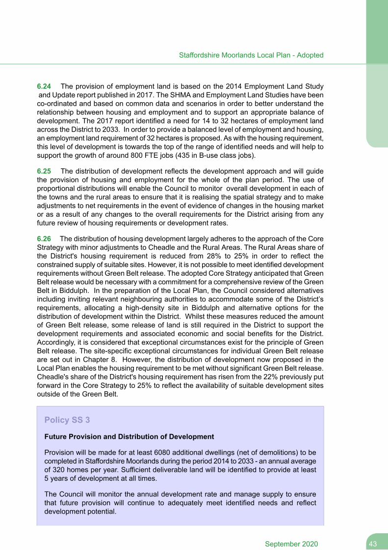
6.24 The provision of employment land is based on the 2014 Employment Land Studyand Update report published in 2017. The SHMA and Employment Land Studies have beenco-ordinated and based on common data and scenarios in order to better understand therelationship between housing and employment and to support an appropriate balance ofdevelopment. The 2017 report identified a need for 14 to 32 hectares of employment landacross the District to 2033. In order to provide a balanced level of employment and housing,an employment land requirement of 32 hectares is proposed. As with the housing requirement,this level of development is towards the top of the range of identified needs and will help tosupport the growth of around 800 FTE jobs (435 in B-use class jobs).
6.25 The distribution of development reflects the development approach and will guidethe provision of housing and employment for the whole of the plan period. The use ofproportional distributions will enable the Council to monitor overall development in each ofthe towns and the rural areas to ensure that it is realising the spatial strategy and to makeadjustments to net requirements in the event of evidence of changes in the housing marketor as a result of any changes to the overall requirements for the District arising from anyfuture review of housing requirements or development rates.
6.26 The distribution of housing development largely adheres to the approach of the CoreStrategy with minor adjustments to Cheadle and the Rural Areas. The Rural Areas share ofthe District's housing requirement is reduced from 28% to 25% in order to reflect theconstrained supply of suitable sites. However, it is not possible to meet identified developmentrequirements without Green Belt release. The adopted Core Strategy anticipated that GreenBelt release would be necessary with a commitment for a comprehensive review of the GreenBelt in Biddulph. In the preparation of the Local Plan, the Council considered alternativesincluding inviting relevant neighbouring authorities to accommodate some of the District’srequirements, allocating a high-density site in Biddulph and alternative options for thedistribution of development within the District. Whilst these measures reduced the amountof Green Belt release, some release of land is still required in the District to support thedevelopment requirements and associated economic and social benefits for the District.Accordingly, it is considered that exceptional circumstances exist for the principle of GreenBelt release. The site-specific exceptional circumstances for individual Green Belt releaseare set out in Chapter 8. However, the distribution of development now proposed in theLocal Plan enables the housing requirement to be met without significant Green Belt release.Cheadle's share of the District's housing requirement has risen from the 22% previously putforward in the Core Strategy to 25% to reflect the availability of suitable development sitesoutside of the Green Belt.
Policy SS 3
Future Provision and Distribution of Development
Provision will be made for at least 6080 additional dwellings (net of demolitions) to becompleted in Staffordshire Moorlands during the period 2014 to 2033 - an annual averageof 320 homes per year. Sufficient deliverable land will be identified to provide at least5 years of development at all times.
The Council will monitor the annual development rate and manage supply to ensurethat future provision will continue to adequately meet identified needs and reflectdevelopment potential.
43September 2020
Staffordshire Moorlands Local Plan - Adopted
Provision will be made for at least 32 hectares of additional employment land inStaffordshire Moorlands (excluding the Peak District National Park) up to the year 2033.
Provision will be made for new retail, transport, recreational, community and tourismfacilities and services to meet the identified needs of settlements within StaffordshireMoorlands (excluding the Peak District National Park) up to 2033 as set out in the AreaStrategies.
Development will be located in accordance with the Spatial Strategy and will bedistributed between the towns and rural areas as set out below. In identifying land fornew development or in considering planning applications, development shall also becompatible with the settlement hierarchy in terms of the development approaches setout in the Area Strategies.
EmploymentHousing
30%30%Leek
20%20%Biddulph
20%25%Cheadle
30%25%Rural Areas
Table 6.1 Distribution of Development
Neighbourhood Plans
In order to assist in meeting the identified development requirements for the Local Plan,Neighbourhood Plans should maximise the opportunities for housing and employmentgrowth in sustainable locations, and where appropriate, make allocations in their planfor at least the same amount of housing and employment land identified in the LocalPlan for the relevant parish or Neighbourhood Area.
Strategic Housing and Employment Land Supply
6.27 The housing and employment requirements are based on the distributions set out inPolicy SS 3 which reflect the spatial strategy and development requirements. The housingrequirements will be met from completions since 2014, current commitments, windfallallowances and the site allocations. The employment requirement is capable of being metfrom existing commitments and the proposed employment allocations detailed in Policy E2. Windfalls will provide flexibility in the supply and will also be capable of making up theslight under provision in the Leek and Biddulph Sub-Areas. The figures for housing andemployment are targets for the whole plan period and will be monitored through the AnnualMonitoring Report and monitoring schedules to assess performance and the need formanagement measures.
6.28 The objectively assessed need for housing as identified in the Strategic HousingMarket Assessment relates to the District as whole. As such, this includes the parts of theDistrict that lie within the Peak District National Park. The Peak District National Park Authorityhave their own adopted Core Strategy which governs development across the National Park.Due to the constraints and purposes of the National Park, the Core Strategy does not include
September 202044
Staffordshire Moorlands Local Plan - Adopted
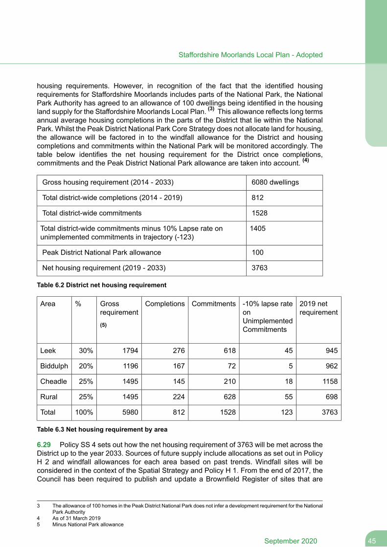
housing requirements. However, in recognition of the fact that the identified housingrequirements for Staffordshire Moorlands includes parts of the National Park, the NationalPark Authority has agreed to an allowance of 100 dwellings being identified in the housingland supply for the Staffordshire Moorlands Local Plan. (3) This allowance reflects long termsannual average housing completions in the parts of the District that lie within the NationalPark. Whilst the Peak District National Park Core Strategy does not allocate land for housing,the allowance will be factored in to the windfall allowance for the District and housingcompletions and commitments within the National Park will be monitored accordingly. Thetable below identifies the net housing requirement for the District once completions,commitments and the Peak District National Park allowance are taken into account. (4)
6080 dwellingsGross housing requirement (2014 - 2033)
812Total district-wide completions (2014 - 2019)
1528Total district-wide commitments
1405Total district-wide commitments minus 10% Lapse rate onunimplemented commitments in trajectory (-123)
100Peak District National Park allowance
3763Net housing requirement (2019 - 2033)
Table 6.2 District net housing requirement
2019 netrequirement
-10% lapse rateonUnimplementedCommitments
CommitmentsCompletionsGrossrequirement
(5)
%Area
94545618276179430%Leek
962572167119620%Biddulph
115818210145149525%Cheadle
69855628224149525%Rural
376312315288125980100%Total
Table 6.3 Net housing requirement by area
6.29 Policy SS 4 sets out how the net housing requirement of 3763 will be met across theDistrict up to the year 2033. Sources of future supply include allocations as set out in PolicyH 2 and windfall allowances for each area based on past trends. Windfall sites will beconsidered in the context of the Spatial Strategy and Policy H 1. From the end of 2017, theCouncil has been required to publish and update a Brownfield Register of sites that are
3 The allowance of 100 homes in the Peak District National Park does not infer a development requirement for the NationalPark Authority
4 As of 31 March 20195 Minus National Park allowance
45September 2020
Staffordshire Moorlands Local Plan - Adopted
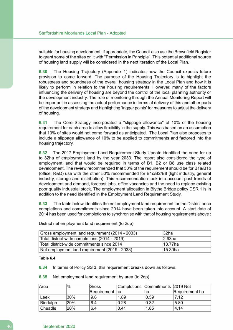
suitable for housing development. If appropriate, the Council also use the Brownfield Registerto grant some of the sites on it with "Permission in Principle". This potential additional sourceof housing land supply will be considered in the next iteration of the Local Plan.
6.30 The Housing Trajectory (Appendix 1) indicates how the Council expects futureprovision to come forward. The purpose of the Housing Trajectory is to highlight therobustness and soundness of the overall housing strategy in the Local Plan and how it islikely to perform in relation to the housing requirements. However, many of the factorsinfluencing the delivery of housing are beyond the control of the local planning authority orthe development industry. The role of monitoring through the Annual Monitoring Report willbe important in assessing the actual performance in terms of delivery of this and other partsof the development strategy and highlighting ‘trigger points’ for measures to adjust the deliveryof housing.
6.31 The Core Strategy incorporated a "slippage allowance" of 10% of the housingrequirement for each area to allow flexibility in the supply. This was based on an assumptionthat 10% of sites would not come forward as anticipated. The Local Plan also proposes toinclude a slippage allowance of 10% to be applied to commitments and factored into thehousing trajectory.
6.32 The 2017 Employment Land Requirement Study Update identified the need for upto 32ha of employment land by the year 2033. The report also considered the type ofemployment land that would be required in terms of B1, B2 or B8 use class relateddevelopment. The review recommended that 50% of the requirement should be for B1a/B1b(office, R&D) use with the other 50% recommended for B1c/B2/B8 (light industry, generalindustry, storage and distribution). This recommendation took into account past trends ofdevelopment and demand, forecast jobs, office vacancies and the need to replace existingpoor quality industrial stock. The employment allocation in Blythe Bridge policy DSR 1 is inaddition to the need identified in the Employment Land Requirement Study.
6.33 The table below identifies the net employment land requirement for the District oncecompletions and commitments since 2014 have been taken into account. A start date of2014 has been used for completions to synchronise with that of housing requirements above :
District net employment land requirement (to 2dp):
32haGross employment land requirement (2014 - 2033)2.93haTotal district-wide completions (2014 - 2019)13.77haTotal district-wide commitments since 201415.30haNet employment land requirement (2019 - 2033)
Table 6.4
6.34 In terms of Policy SS 3, this requirement breaks down as follows:
6.35 Net employment land requirement by area (to 2dp)
2019 NetRequirement ha
Commitmentsha
Completionsha
GrossRequirement
%Area
7.120.591.899.630%Leek5.800.320.286.420%Biddulph4.141.850.416.420%Cheadle
September 202046
Staffordshire Moorlands Local Plan - Adopted
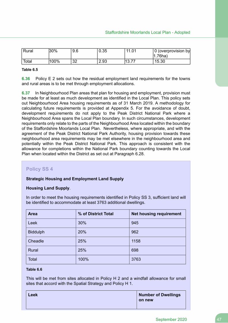
0 (overprovision by1.76ha)
11.010.359.630%Rural
15.3013.772.9332100%Total
Table 6.5
6.36 Policy E 2 sets out how the residual employment land requirements for the townsand rural areas is to be met through employment allocations.
6.37 In Neighbourhood Plan areas that plan for housing and employment, provision mustbe made for at least as much development as identified in the Local Plan. This policy setsout Neighbourhood Area housing requirements as of 31 March 2019. A methodology forcalculating future requirements is provided at Appendix 5. For the avoidance of doubt,development requirements do not apply to the Peak District National Park where aNeighbourhood Area spans the Local Plan boundary. In such circumstances, developmentrequirements only relate to the parts of the Neighbourhood Area located within the boundaryof the Staffordshire Moorlands Local Plan. Nevertheless, where appropriate, and with theagreement of the Peak District National Park Authority, housing provision towards theseneighbourhood area requirements may be met elsewhere in the neighbourhood area andpotentially within the Peak District National Park. This approach is consistent with theallowance for completions within the National Park boundary counting towards the LocalPlan when located within the District as set out at Paragraph 6.28.
Policy SS 4
Strategic Housing and Employment Land Supply
Housing Land Supply.
In order to meet the housing requirements identified in Policy SS 3, sufficient land willbe identified to accommodate at least 3763 additional dwellings.
Net housing requirement% of District TotalArea
94530%Leek
96220%Biddulph
115825%Cheadle
69825%Rural
3763100%Total
Table 6.6
This will be met from sites allocated in Policy H 2 and a windfall allowance for smallsites that accord with the Spatial Strategy and Policy H 1.
Number of Dwellingson new
Leek
47September 2020
Staffordshire Moorlands Local Plan - Adopted
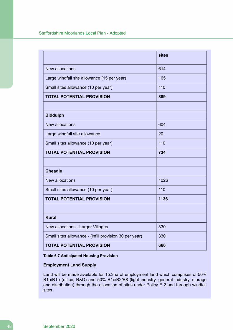
sites
614New allocations
165Large windfall site allowance (15 per year)
110Small sites allowance (10 per year)
889TOTAL POTENTIAL PROVISION
Biddulph
604New allocations
20Large windfall site allowance
110Small sites allowance (10 per year)
734TOTAL POTENTIAL PROVISION
Cheadle
1026New allocations
110Small sites allowance (10 per year)
1136TOTAL POTENTIAL PROVISION
Rural
330New allocations - Larger Villages
330Small sites allowance - (infill provision 30 per year)
660TOTAL POTENTIAL PROVISION
Table 6.7 Anticipated Housing Provision
Employment Land Supply
Land will be made available for 15.3ha of employment land which comprises of 50%B1a/B1b (office, R&D) and 50% B1c/B2/B8 (light industry, general industry, storageand distribution) through the allocation of sites under Policy E 2 and through windfallsites.
September 202048
Staffordshire Moorlands Local Plan - Adopted
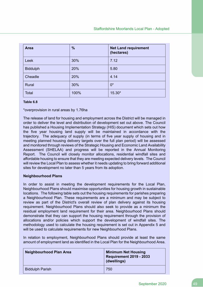
Net Land requirement(hectares)
%Area
7.1230%Leek
5.8020%Biddulph
4.1420%Cheadle
0*30%Rural
15.30*100%Total
Table 6.8
*overprovision in rural areas by 1.76ha
The release of land for housing and employment across the District will be managed inorder to deliver the level and distribution of development set out above. The Councilhas published a Housing Implementation Strategy (HIS) document which sets out howthe five year housing land supply will be maintained in accordance with thetrajectory. The adequacy of supply (in terms of five year supply of housing and inmeeting planned housing delivery targets over the full plan period) will be assessedand monitored through reviews of the Strategic Housing and Economic Land AvailabilityAssessment (SHELAA) and progress will be reported in the Annual MonitoringReport. The Council will closely monitor allocations, residential windfall sites andaffordable housing to ensure that they are meeting expected delivery levels. The Councilwill review the Local Plan to assess whether it needs updating to bring forward additionalsites for development no later than 5 years from its adoption.
Neighbourhood Plans
In order to assist in meeting the development requirements for the Local Plan,Neighbourhood Plans should maximise opportunities for housing growth in sustainablelocations. The following table sets out the housing requirements for parishes preparinga Neighbourhood Plan. These requirements are a minimum and may be subject toreview as part of the District's overall review of plan delivery against its housingrequirement. Neighbourhood Plans should also seek to provide as a minimum theresidual employment land requirement for their area. Neighbourhood Plans shoulddemonstrate that they can support the housing requirement through the provision ofallocations and/or policies which support the development of windfall sites. Themethodology used to calculate the housing requirement is set out in Appendix 5 andwill be used to calculate requirements for new Neighbourhood Plans.
In relation to employment, Neighbourhood Plans should provide at least the sameamount of employment land as identified in the Local Plan for the Neighbourhood Area.
Minimum Net HousingRequirement 2019 - 2033(dwellings)
Neighbourhood Plan Area
750Biddulph Parish
49September 2020
Staffordshire Moorlands Local Plan - Adopted
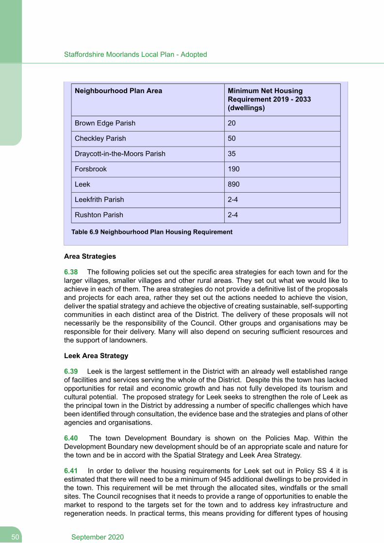
Minimum Net HousingRequirement 2019 - 2033(dwellings)
Neighbourhood Plan Area
20Brown Edge Parish
50Checkley Parish
35Draycott-in-the-Moors Parish
190Forsbrook
890Leek
2-4Leekfrith Parish
2-4Rushton Parish
Table 6.9 Neighbourhood Plan Housing Requirement
Area Strategies
6.38 The following policies set out the specific area strategies for each town and for thelarger villages, smaller villages and other rural areas. They set out what we would like toachieve in each of them. The area strategies do not provide a definitive list of the proposalsand projects for each area, rather they set out the actions needed to achieve the vision,deliver the spatial strategy and achieve the objective of creating sustainable, self-supportingcommunities in each distinct area of the District. The delivery of these proposals will notnecessarily be the responsibility of the Council. Other groups and organisations may beresponsible for their delivery. Many will also depend on securing sufficient resources andthe support of landowners.
Leek Area Strategy
6.39 Leek is the largest settlement in the District with an already well established rangeof facilities and services serving the whole of the District. Despite this the town has lackedopportunities for retail and economic growth and has not fully developed its tourism andcultural potential. The proposed strategy for Leek seeks to strengthen the role of Leek asthe principal town in the District by addressing a number of specific challenges which havebeen identified through consultation, the evidence base and the strategies and plans of otheragencies and organisations.
6.40 The town Development Boundary is shown on the Policies Map. Within theDevelopment Boundary new development should be of an appropriate scale and nature forthe town and be in accord with the Spatial Strategy and Leek Area Strategy.
6.41 In order to deliver the housing requirements for Leek set out in Policy SS 4 it isestimated that there will need to be a minimum of 945 additional dwellings to be provided inthe town. This requirement will be met through the allocated sites, windfalls or the smallsites. The Council recognises that it needs to provide a range of opportunities to enable themarket to respond to the targets set for the town and to address key infrastructure andregeneration needs. In practical terms, this means providing for different types of housing
September 202050
Staffordshire Moorlands Local Plan - Adopted
development in a variety of locations including greenfield development on the edge of theurban areas. A cluster of housing sites located off Mount Road has been identified as anopportunity to make a significant contribution towards the housing needs of the town. Thisdevelopment will be supported with additional infrastructure, including additional schoolcapacity and transport improvements.
6.42 There are high levels of deprivation in Leek North ward where residents experienceabove average health problems including childhood obesity and economic issues includinglower than average wages. The implementation of the Green Infrastructure Strategy togetherwith protecting, increasing and improving the provision and accessibility of open space, sportand recreational facilities will help to address the health issues. Improvement of accessibilityto employment areas, particularly from areas of local deprivation and need will help to addressthe economic issues.
6.43 Policy SS 4 details a net employment land requirement of 7.12 ha for the Leek areaup to 2033. Employment provision will be met through the expansion of existing employmentareas to the south of the town and Leekbrook which have good access to the road network.These are considered to be the most sustainable locations for employment developmentand will minimise the impact of development on the countryside and residential areas. Inresponse to Leek’s residual employment land requirements Policy SS 3 of the 2014 CoreStrategy identified 'Broad location EM2' east of Brooklands Way Leekbrook, for futureemployment allocation (dependent on the need for further employment land provision acrossthe town).Despite being a smaller village Leekbrook is closely related to Leek (falling withinthe same Ward), and it is considered that the Leek EM2 allocations in the village cancontribute towards the future employment land requirements for Leek as existing industrialareas in the village already serve Leek residents; and industrial areas by definition oftentend to be peripheral.
6.44 The policy also identifies the Cornhill and Newton House area of Leek as a majormixed-use regeneration opportunity which is strategically important and has been recognisedas a Council objective for a number of years. Cornhill is part owned by the District Counciland is well related to existing employment uses as well as potential tourism facilities to thesouth. Both sites provide opportunities to support the town's need for housing and economicgrowth. Development should enable the provision of an east-west link road between theA520 Cheddleton Road and the Barnfield Industrial estate, to allow easier access acrossthe southern side of the town, and to relieve pressure on Junction Road.
Policy SS 5
Leek Area Strategy
The Council and its partners will seek to consolidate the role of Leek as the principalservice centre and a market town and support its regeneration. This will be achievedthrough the following actions:
1. Continue to meet the housing and community needs of Leek and its rural hinterlandby:
Increasing the range of available and affordable house types, including for firsttime buyers and older people.
51September 2020
Staffordshire Moorlands Local Plan - Adopted
Allocating a range of suitable, deliverable housing sites sufficient to meet therequirements of the area.
Supporting the development of new housing on sustainable sites within theDevelopment Boundary.
Protecting, increasing and improving the provision and accessibility of open space,sport and recreational facilities in line with the updated Open Space Study, PlayingPitch Strategy and Indoor Facility Assessment.
Increasing and improving the provision of educational, health and communityfacilities and enabling further shared use of facilities. Specific facilities and needswill be identified through the Plans and Strategies of relevant service providers.Supporting the provision of the identified education facilities, in particular thefollowing sites identified on the Policies Map:
New first school
Expansion of existing middle school
Promoting measures to encourage walking and cycling.
Reducing levels of health and economic deprivation in Leek North.
2. Create employment growth and increase the diversity of employment opportunitiesto meet existing and future needs by:
Supporting the retention and growth of existing businesses within the town
Seeking the comprehensive redevelopment of the Cornhill East area for a mix ofuses as set out in the Cornhill Masterplan and the Newton House site
Supporting the development of the employment site allocations (as identified onthe Leek and Leekbrook Policies Maps)
Providing facilities and sites for new start-up businesses and expanding the servicesector, in particular small B1(a) and B1(b) uses, knowledge-based and creativeindustries;
Improving the provision of prime office space and commercial premises in andaround the town centre;
Encouraging mixed use development on larger redevelopment sites, particularlywithin or near to the more accessible town centre locations, on former employmentpremises, and in mill buildings within the town centre where consistent with widerPolicies including E 1;
September 202052
Staffordshire Moorlands Local Plan - Adopted

Improving and intensifying the use of existing employment areas at Barnfields andLeekbrook;
Improving accessibility to employment areas, particularly from areas of localdeprivation and need.
3. Strengthen the role of Leek as a principal service and retailing centre for the Districtby:
Supporting sensitive improvements to the town centre to increase the quality ofthe retail offer and supporting town centre uses, improve linkages between areasand establish new development opportunities in accordance with the adopted TownCentre Masterplan.
Consolidating the main retail core and the market area and protecting andenhancing its distinctiveness, vitality and viability
Supporting improvements to the range and diversity of educational, health, culturaland community services and facilities in the town.
Improving accessibility to the town's major retail, service and employment areas,particularly by public transport, from the rest of the District.
Managing car parking to support the role of Leek as a destination for shopping,employment, entertainment and tourism without leading to congestion of the towncentre.
4. Promote Leek’s special character and heritage and strengthen its role as a visitordestination by:
Conserving and enhancing buildings, sites and areas of heritage and culturalimportance, including heritage assets, complemented by new distinctive, sensitivelydesigned, high quality, sustainable buildings;
Promoting environmental enhancements in and on the edges of the town centre,establishing the Market as a central feature, creating strong, high quality ‘gateways’into the centre and improving signposting;
Increasing tourist opportunities for visitors through additional high qualityaccommodation, promoting links with the Peak District and the development ofnew tourist attractions linked to the Churnet Valley (see policy SS 11);
Improving and creating pedestrian and cycle links in the town and in particularbetween the town centre and Brough Park, Westwood College, Leek High Schooland Churnet View Middle School; and encouraging Active Design principles toencourage physical activity;
Protecting and improving the setting and historic character of the town andincreasing access into the countryside by foot, cycling and horse riding;
53September 2020
Staffordshire Moorlands Local Plan - Adopted
Implementing measures identified for Leek in the Green Infrastructure Strategy;
Ensuring proposals at LE102 are accompanied by a heritage statement thatdescribes the significance of Highfield Hall Estate including any contribution madeby its setting, the potential impact of the proposals on its significance andopportunities to enhance or better reveal its significance; to addressrecommendations set out in the Council’s Landscape, Local Green Space andHeritage Impact Study.
5. Create major mixed use development opportunities and related infrastructureimprovements for the following strategic sites:
Cornhill East – uses which may be suitable include employmentand housing. Development should enable provision for a link between the A520and A53 to the south of the town and links to the canal and Churnet Valley railwayand should have regard to the Churnet Valley Masterplan. Further policy for thissite is set out in Policy DSL 4
Land at Newton House - a mix of uses including housing and employment will besupported in line with policy DSL 3
Land at the Mount - the provision of housing and supporting infrastructure, includingadditional school capacity and transport improvements will be supported in linewith policy DSL 2.
Biddulph Area Strategy
6.45 Biddulph is the second largest settlement in the District. It has suffered from economicdecline and includes the Biddulph East Ward, an area of high deprivation. The town centrehas seen recent improvements due to proposals within the Biddulph Town Centre AreaAction Plan coming to fruition. The proposed strategy for Biddulph seeks to further enhanceits role as a significant service centre and a market town.
6.46 The Local Plan defines the extent of the town development boundary (shown on thePolicies Map). Due to the extent of green belt around the town, opportunities for peripheralexpansion are constrained. A District wide Green Belt Review has been undertaken by theCouncil and this recommends areas around Biddulph which could be considered for releasein exceptional circumstances. The Core Strategy recognised that a review of the Green Beltwas necessary in order for Biddulph to accommodate the identified development requirementsfor the town.
6.47 The Retail Study (2013) recommends the allocation of a site in Biddulph toaccommodate a discount foodstore of around 1000m2 (net sales) to claw back some of the45% of residents who shop out of town for their main food shopping. The study identifiesoutflow to mainstream and discount foodstores. It is considered that a discount store wouldprovide the local population with more choice as due to closures of other stores, Sainsburysis now the only mainstream foodstore in the town. The study identifies land west of thebypass (in an edge of centre location) as the only area with capacity and with appropriatelinkages to the town centre.
September 202054
Staffordshire Moorlands Local Plan - Adopted
6.48 In order to meet some of the plan requirements for Biddulph, two key mixed-usedevelopment areas are identified. The Wharf Road Strategic development site will help tosupport a significant degree of the future housing land supply for the town as well asaccommodating additional retail and employment development and supporting infrastructure.This area was previously identified as a Broad Area in the Core Strategy for mixed-usedevelopment. A further mixed-use site opposite Victoria Business Park has also been identifiedfor housing and employment. This site will require the release of Green Belt land. Elsewhere,the regeneration of mills in the town will further support the sustainability of the town.
6.49 The identification of sites and proposals for improved or new recreational and sportsfacilities and for additional or improved educational and health facilities and services havebeen considered by the various evidence base studies and on-going discussions with serviceproviders will continue.
6.50 In order to manage surface water discharge rates into the waste water network inthe Biddulph area, the use of Sustainable Urban Drainage Systems should be applied alongwith DEFRA's non-statutory technical standards.
Policy SS 6
Biddulph Area Strategy
The Council and its partners will seek to enhance the role of Biddulph as a significantservice centre and a market town and support its regeneration. This will be achievedthrough the following actions:
1. Improve the local housing market and range of community facilities by:
Increasing the range of available and affordable house types, especially for firsttime buyers, families and older people, including extra care housing.
Identifying suitable land for housing sites both within the urban area and, on landadjacent to the urban area. Sites within the urban area shall be in locations acrossthe town which have good accessibility to services and facilities with encouragementbeing given to previously developed (brownfield) sites.
Protecting, increasing and improving the provision and accessibility of open space,sport and recreational facilities in line with the updated Open Space Strategy,Playing Pitch Strategy and Indoor Sports Facility Assessment.
Increasing the provision of educational, health and community facilities. Specificfacilities and needs will be identified through the Plans and Strategies of relevantservice providers.
2. Create employment growth and increase the diversity of employment opportunitiesto meet existing and future needs by:
Supporting the retention and growth of existing businesses within the town.
Providing opportunities for new enterprises and businesses by promoting furtherdevelopment.
55September 2020
Staffordshire Moorlands Local Plan - Adopted
Providing facilities and sites for new start-up businesses.
Supporting improvements to accessibility to employment areas, particularly fromareas of local deprivation and need.
3. Strengthen the role of Biddulph as a significant service and retailing centre for theDistrict by:
Allocation of land for a new foodstore of 1000m2 (net sales)
Supporting improvements to public transport connections to the town centre.
4. Improve the image and identity of Biddulph and strengthen its role as a visitordestination by:
Regenerating and improving the streetscape of the town centre.
Upgrading the general environment of the town through landscaping and theimprovement and creation of green spaces.
Strengthening and promoting links between the town and countryside in particularwith the Biddulph Valley Way, Biddulph Grange Garden and the Country Parks.This will include the implementation of the Green Infrastructure Strategy.
Improving the main approaches to the town from the south.
Protecting and enhancing the setting and historic character of the town, includingheritage assets.
5. Create major mixed use development opportunities and related infrastructureimprovements for the following strategic sites:
Wharf Road Strategic Development site - mixed-use development including housing,employment, retail and supporting infrastructure will be supported in line with policyDSB 1.
Tunstall Road Strategic Development site - housing and employment will besupported in line with policy DSB 3.
Developments should secure Sustainable Urban Drainage Systems in line with nationalplanning policy and manage surface water discharge rates in accordance with theSustainable Drainage Systems Non-statutory Technical Standards (DEFRA, 2015).
Cheadle Area Strategy
6.51 Cheadle is the smallest of the District’s market towns and has suffered fromunder-investment in its infrastructure and town centre and a lack of housing opportunities.The Spatial Strategy identifies the town as an area for significant growth in order to expand
September 202056
Staffordshire Moorlands Local Plan - Adopted
its role as a service centre and market town. The proposed strategy for Cheadle thereforeseeks to achieve this through a range of actions and measures as well as addressing anumber of specific challenges which have been identified through consultation, the evidencebase and the strategies and plans of other agencies and organisations.
6.52 One of the most significant challenges is identifying the need for and viability of alink road to relieve through traffic in the town and provide improved access to existing andplanned housing and employment areas. Whilst some junction improvements have beenimplemented, there remains scope for further improvements to address transport issues inthe town. Assessments undertaken have identified potential improvements such as junctionimprovements, road widening, improved signage and highways management. The Councilwill work with partners, including Staffordshire County Council and developers to developand implement the required improvements.
6.53 A further significant challenge is the need for more community facilities to serve agrowing population. The County Council has identified the need for a new primary schoolto serve the north of the town. An updated Open Space Study and Playing Pitch Strategyconsiders the need for new and improved provision across the town.
6.54 Housing requirements will be met through the identification of key clusters ofdevelopment to the north and south of the town. The former formed part of the Broad Areaas identified in the Core Strategy. Elsewhere, smaller housing allocations within the townwill support the sustainable development of Cheadle.
6.55 Employment provision will be met through the expansion of existing employmentareas to the south of the town. This is considered to be the most sustainable location foremployment development and will minimise the impact of development on the countrysideand existing residential areas.
Policy SS 7
Cheadle Area Strategy
The Council and its partners will seek to expand the role of Cheadle as a significantservice centre and a market town. This will be achieved through the following actions:
1. Expand the housing market area and community provision by:
Increasing the range of available and affordable house types and higher markethousing, including for first time buyers and families;
The development of specific housing sites through new site allocations in the LocalPlan. This will include two strategic housing clusters to the north and south of thetown, namely:
Cheadle North Strategic Development Area - housing and school developmentwill be supported in line with policy DSC 1
Mobberley Farm - housing development will be supported in line with policyDSC 3
57September 2020
Staffordshire Moorlands Local Plan - Adopted
Protecting, increasing and improving the provision and accessibility of open space,sport and recreational facilities in line with the updated Open Space Study, PlayingPitch Strategy and Indoor Sports Facility
Providing additional educational, health and community facilities, including a newprimary school to serve north Cheadle at the Donkey Lane site
Ensuring development of site CH015 Stoddards Depot, Leek Road adjacent to theConservation Area enhances the frontage with sensitive design as set out in theCouncil’s Landscape, Local Green Space and Heritage Impact Study
2. Create employment growth and increase the diversity of employment opportunitiesto meet existing and future needs by:
Supporting the retention and growth of JCB and other existing businesses withinthe town;
Supporting improved access to JCB and existing employment sites;
The development of employment land through new site allocations in the LocalPlan;
Providing facilities and land for new start-up businesses;
Improving and intensifying the use of existing employment areas at NewHaden/Brookhouses.
3. Expand the role of Cheadle as a significant service and retailing centre for theDistrict by:
Supporting improvements to the quality and range of the retail offer and supportingtown centre uses
Regenerating and improving the streetscape of the town centre and creating morepublic realm
Expanding the range and diversity of educational, health, sport, cultural andcommunity services and facilities in the town;
4. Improve environmental quality and accessibility by:
Addressing traffic related issues in the town centre and along the A521 and A522by working with partners to develop and implement transport improvements andby safeguarding the route of a potential future link road;
Improving pedestrian and cycle links across the town and into the countryside,including the implementation of the Green Infrastructure Strategy;
September 202058
Staffordshire Moorlands Local Plan - Adopted
Improving public transport links between the town and other main settlements;
Promoting the role and historic character of the town, including the protection ofheritage assets and its links with the Churnet Valley as a visitor destination.
Larger Villages Area Strategy
6.56 The larger villages have an important role in terms of serving and supporting theirimmediate surrounding rural areas and smaller villages. It is important therefore that theyare sustained and promoted as service centres. A major issue in such settlements isbalancing the need to retain local facilities and accommodate housing and other needs withmaintaining their character and avoiding over-development. The proposed strategy for thelarger villages seeks to sensitively retain and enhance their role as service centres byaddressing a number of specific social, economic and environmental challenges which havebeen identified through consultation, the evidence base and the strategies and plans of otheragencies and organisations.
6.57 The policy allows for development or redevelopment of land to come forward whichis appropriate to the Spatial Strategy and character of each settlement. The amount andnature of development will be dependent on the development capacity of individualsettlements and the availability of suitable sites. In some settlements the scale of developmentmay therefore be limited. Development boundaries are identified on the Policies Map, withinthe Development Boundary development of an appropriate scale and nature will be allowed.Outside of the boundaries, limited infilling may be supported, subject to key criteria beingmet as set out in Policy H 1.
Policy SS 8
Larger Villages Areas Strategy
The following are identified as larger villages:
Alton
Biddulph Moor
Blythe Bridge & Forsbrook
Brown Edge
Cheddleton
Endon
Ipstones
Kingsley
Upper Tean
59September 2020
Staffordshire Moorlands Local Plan - Adopted
Waterhouses
Werrington & Cellarhead
Wetley Rocks
These settlements shall retain and enhance their role as rural service centres, providingfor the bulk of the housing requirement of the rural areas and also for employment needsof a scale and type appropriate to each settlement having regard to infrastructurecapacity and character. The Council and its partners will achieve this through thefollowing actions:
1. Retain and enhance their role as rural service centres by:
Enabling appropriate development which supports and increases the range andquality of community facilities available to the rural areas;
Protecting community facilities where loss would be deemed to reduce thecommunity's ability to meet it's day to day needs
Improving connections by public transport to surrounding smaller villages andmarket towns.
2. Meet housing requirements by:
Increasing the range of available and affordable house types, including for firsttime buyers and families;
Allocating a range of deliverable housing sites with good accessibility to servicesand facilities
Supporting the development of housing windfall sites within the village boundaries,subject to wider Local Plan polices
Allowing for rural exceptions housing in appropriate locations on the edge ofsettlements (in accordance with Policy H 1). This will be additional to the housingprovision for the rural areas
Giving consideration to limited infilling on the edge of settlement boundaries, subjectto the criteria set out in Policy H 1.
3. Meet limited employment needs by:
Enabling small-scale new employment development;
Improving and intensifying the use of existing employment areas and, whereappropriate, expanding them.
4. Ensure that new development reflects and enhances each village’s special characterand heritage by:
September 202060
Staffordshire Moorlands Local Plan - Adopted
Giving priority to the reuse and regeneration of existing redundant, underused orsurplus sites and premises for new development;
Ensuring that development is of a suitable scale in relation to the role and functionof the villages as set out in the Spatial Strategy
Supporting the use of Neighbourhood Plans and Village Design Statements toguide future development
Protecting and enhancing the setting of individual settlements
Supporting the implementation of the Green Infrastructure Strategy and LocalGreen Spaces
Protecting and enhancing the setting and historic character of the village, includingheritage assets
Ensuring development of site UT019 in Upper Tean is sensitively designed toenhance the Conservation Area and proposals include mitigation measuresincluding appropriate screening of the southern boundary as set out in the Council’sLandscape, Local Green Space and Heritage Impact Study
Ensuring development of site WA004 in Waterhouses is sensitively designed andincludes heritage masterplanning and provision of a landscaping plan includingsubmission of landscape and visual impact assessments to addressrecommendations set out in the Council’s Landscape, Local Green Space andHeritage Impact Study.
5. Supporting the mixed-use development of the Blythe Vale site at Blythe Bridge inline with policy DSR 1.
Any development proposal that might have the potential to affect a European or RamsarSite must itself be subject to appropriate assessment.
Smaller Villages Area Strategy
6.58 The smaller villages have a more limited role as service centres, but they are vital tothe rural areas particularly in terms of providing for local housing and rural employmentneeds. A major issue for smaller villages is the loss of local population through lack ofhousing opportunities. The proposed strategy for the smaller villages therefore seeks toallow an appropriate level of sensitive development which enhances community vitality.
6.59 Development on a large scale would be unsustainable in these villages, as it willgenerate a disproportionate number of additional journeys outside the village and mayundermine the spatial strategy. Development will be strictly controlled in order to ensurethat the character and life of the settlement is not undermined. Boundaries are not definedfor smaller villages, however, some are set within the Green Belt by virtue of the alignmentof the Green Belt boundary. Limited development, including infill will be supported subjectto this policy and Green Belt policy set out in the National Planning Policy Framework.
61September 2020
Staffordshire Moorlands Local Plan - Adopted
Policy SS 9
Smaller Villages Area Strategy
The following are identified as smaller villages:
Bagnall
Blackshaw Moor
Boundary
Bradnop
Caverswall
Checkley
Consall
Cookshill
Cotton
Dilhorne
Draycott
Foxt
Froghall
Heaton
Hollington
Hulme
Kingsley Holt
Leekbrook
Longsdon
Lower Tean
Meerbrook
Oakamoor
Rudyard
Rushton Spencer
September 202062
Staffordshire Moorlands Local Plan - Adopted

Stanley
Stockton Brook
Swinscoe
Whiston
Winkhill
These settlements shall provide only for appropriate development which enhancescommunity vitality or meets a social or economic need of the settlement and itshinterland. The Council and its partners will achieve this through the following actions:
1. Enhance community vitality by:
Protecting and enabling services and facilities which are essential to sustain ruralliving;
Improving connections by public transport and other transport measures toneighbouring larger villages and market towns;
Supporting the provision of local, mobile and electronic services which increasesthe range and quality of services
Supporting the implementation of the Green Infrastructure Strategy and LocalGreen Spaces
2. Meet community, social or economic need by:
Enabling limited new housing development, including small infill schemes inaccordance with Policy H 1
Allowing for rural exceptions housing in appropriate locations (in accordance withPolicy H 1). This will be additional to the housing provision for the rural areas.
Enabling small-scale new employment development including ‘live-work’developments which are for a rural enterprise or an existing authorised businessuse;
Supporting the diversification of existing farm enterprises
Supporting the development of appropriate ICT and newmeans of communicationsto enable homeworking and small businesses reliant on e-technology.
Ensure that new development reflects and enhances each village’s special characterand heritage by protecting and enhancing the setting and historic character of thevillage, including heritage assets.
Any development proposal that might have the potential to affect a European or RamsarSite must itself be subject to appropriate assessment.
63September 2020
Staffordshire Moorlands Local Plan - Adopted
Other Rural Areas Strategy
6.60 The concept of sustainability argues in favour of concentrating most development inor adjoining existing built-up areas. However, there can be cases where some developmentand diversification of use in the countryside can be beneficial and sustainable. For instance,some farm businesses may benefit from diversification and an increased number of visitsto the countryside can help the rural economy. However this needs to be appropriate to thecharacter of the countryside which also needs to be sustained.
6.61 Where development in the open countryside is justified, the preference will be for there-use or redevelopment of existing buildings. All development in these areas will be strictlycontrolled, both in terms of its scale and type in order to ensure that the character and roleof the countryside and the green belt is not undermined.
6.62 Within these areas there are some smaller settlements and hamlets which are notidentified in Policy SS 9 as ‘Small Villages’ because their predominantly open character,loose-knit nature and lack of services and facilities.
6.63 The development of renewable energy sources will also often be in rural areas butsuch development will almost always have an environmental cost as well as benefits. Suchproposals must be weighed against the continuing commitment to protect the environment.The scale and design of such schemes will therefore be of paramount importance and shouldaccord with Policy SD 2.
6.64 Historically development of a large scale has taken place in a number of areas in thecountryside of Staffordshire Moorlands, often associated with past industrial activity or specificneeds. These are brownfield sites and where these are no longer needed it is necessaryto consider whether an alternative use would be appropriate. The complete or partialredevelopment of such major developed areas may offer the opportunity for environmentalimprovement without adding to their impact as well as helping to meet the needs of the ruralareas and improve the rural economy. Two such areas were identified in the Core Strategy atBolton Copperworks, Froghall and the Anzio Camp Blackshaw Moor. Policies DSR 5 andDSR 6 provide development criteria for these sites.
6.65 The policy also places considerable emphasis on tourism. This is identified in thespatial strategy and the Sustainable Community Strategy as a major opportunity to sustainthe rural economy and strengthen the role of the District within the region and NorthStaffordshire.
6.66 The District has a close link with the Peak District National Park in terms of tourismand the policy seeks to encourage and promote tourism opportunities that could easepressures on the Park itself, provided this would not increase pressure on areas of biodiversityinterest.
6.67 The Green Belt serves a number of purposes which are derived from Governmentpolicy in the NPPF and the former Staffordshire Structure Plan. The Green Belt keeps landopen and free from development over a long period, which extends beyond the plan period,in order to give assurance that its boundaries will endure. National policy on Green Belts is
September 202064
Staffordshire Moorlands Local Plan - Adopted
set out in the NPPF and will apply to the whole of the Green Belt. The Green Belt Reviewassessed the Green Belt in the District against the five purposes of the Green Belt. TheGreen Belt boundary (as revised) is identified on the Policies Maps.
Policy SS 10
Other Rural Areas Strategy
The other rural areas comprise the countryside and the green belt outside of thedevelopment boundaries of the towns and larger villages and the open countrysidesurrounding the smaller villages.
These areas will provide only for development which has an essential need to be locatedin the countryside, supports the rural diversification and sustainability of the rural areas,promotes sustainable tourism or enhances the countryside. The Council and its partnerswill achieve this through the following actions:
1. Meet housing requirements and specific needs by:
Restricting new build housing development in the countryside to that which hasan essential need to be located in the countryside in accordance with Policy H 1;
Allowing the conversion or replacement of an existing rural building in accordancewith Policy H 1;
Allowing extensions or additional domestic outbuildings to existing dwellingsprovided they are appropriate in scale and design and do not have a detrimentalimpact on the existing dwelling and the character of the rural area. The Councilwill assess schemes having regard to the original dwelling, in cases wherecumulative change has occurred;
Allowing suitable development which would secure the future conservation of aheritage asset in accordance with Policy DC 2;
Allowing rural exceptions housing (in accordance with Policies H 1 and H 3);
Allowing community facilities where that need cannot be met in a settlement withinthe hierarchy. In such cases the development should be in a sustainable locationclose to an existing serviced settlement.
2. Sustain the rural economy by:
Enabling the limited expansion or development of business for employment useswhere a rural location can be justified
Supporting the diversification of existing farm enterprises
Supporting the development of appropriate ICT and newmeans of communicationsto enable homeworking and small businesses reliant on e-technology;
65September 2020
Staffordshire Moorlands Local Plan - Adopted
3. Enhance and conserve the quality of the countryside by:
Giving priority to the need to protect the quality and character of the area andrequiring all development proposals to respect and respond sensitively to thedistinctive qualities of the surrounding landscape;
Limiting uses which generate a substantial number of regular trips in areas thatare not well served by public transport;
Ensuring renewable energy schemes are of an appropriate scale, type and location;
Recognising and conserving the special quality of the landscape in the Peak DistrictNational Park (in accordance with Policy DC 3);
Encouraging measures which protect and enhance the biodiversity, geologicalresources and heritage of the District.
4. Regenerate underused major developed areas in the countryside including:
Bolton Copperworks, Froghall and Anzio Camp, Blackshaw Moor (in accordancewith policies DSR 5 and DSR 6).
Development of these areas shall be complementary to and not undermine therole of the towns and larger villages nor shall it undermine wider strategicobjectives. It shall also avoid or minimise environmental impacts and congestionand safeguard and enhance natural and cultural assets.
Facilitating the appropriate redevelopment of other major developed areas wherethe proposed development brings positive benefits to the area and any resultantenvironmental or highways concerns could be adequately addressed andminimised. Such proposals will be expected to provide supporting information thatdemonstrates clearly that the redevelopment will complement the overalldevelopment strategy for the District.
5. Enhance tourist opportunities by:
Supporting sustainable tourism developments and measures in the Churnet Valleyin accordance with Policy SS 11 and the Churnet Valley Masterplan SPD;
Allowing for small-scale tourism developments in other areas (in accordance withpolicy E 4);
Establishing strong linkages between recreational and tourist resources;
Recognising and developing the close linkages to the Peak District National Park.
6. Maintain the Green Belt within Staffordshire Moorlands. Strict control will continueto be exercised over inappropriate development within the Green Belt allowing only forexceptions as defined by Government policy.
September 202066
Staffordshire Moorlands Local Plan - Adopted
Any development proposal that might have the potential to affect a European or RamsarSite must itself be subject to appropriate assessment.
Churnet Valley Strategy
6.68 The Churnet Valley, running from Rudyard Lake and Tittesworth Water through Leek,Cheddleton, Froghall and Oakamoor to Alton, is an area of significant landscape, wildlifeand heritage value with a number of existing well-established tourist and visitor attractions.The Churnet Valley can provide a strong focus for sustainable rural regeneration across theDistrict and a significant sub-regional asset as well as complementing and easing pressureson the neighbouring Peak District National Park. The Churnet Valley Masterplan was adoptedas a Supplementary Planning Document (SPD) in 2014. It provides a comprehensiveframework for future development in the Churnet Valley. The extent of the area covered isdefined in the Masterplan. It identifies opportunities and measures to help regenerate andmanage this important rural area based around sustainable tourism in a manner which issensitive to and enhances its important heritage, landscape and ecology.
6.69 To reflect the aims of the strategy for the Churnet Valley and the Churnet ValleyMasterplan the policy seeks to manage opportunities for further appropriate visitoraccommodation and tourist facilities with an emphasis on increasing overnight stays withvisitors staying for longer and throughout the year and on further developing the visitorexperience of the Churnet Valley through the development of its heritage, nature based andoutdoor recreation products, improving and developing links between existing facilities andactivities so that they are benefiting from each other, and maintaining and establishing linkswith regional tourism facilities. This will be supported by measures to improve access bypublic transport, walking and cycling into the countryside.
6.70 Sustainable tourism is tourism which takes account of its current and future economic,social and environmental impacts, balancing the needs of visitors, the economy, theenvironment and host communities. Tourism development must not be at the expense ofthe special qualities of the Churnet Valley which draw so many people to the area. A verysensitive approach to the provision and expansion of facilities and accommodation willtherefore be required to ensure that it is of an appropriate scale and design and compatiblewith the nature of the local area and enhances the heritage, landscape and ecology of theChurnet Valley. The appropriate redevelopment of existing brownfield sites in the ChurnetValley can also provide overlapping ecological, green infrastructure, flood risk mitigation,landscape impact and remediation benefits eg sensitive redevelopments involving riverrenaturalisation and landscaping. Flood risk and remediation Policies are set out elsewherein the Plan.
6.71 The principal purpose and role of the existing green belt should also not be underminedby development which can still take place provided it is of an appropriate use, scale andform in accordance with national green belt policy.
67September 2020
Staffordshire Moorlands Local Plan - Adopted
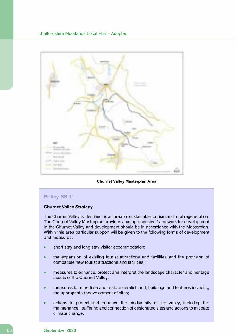
Churnet Valley Masterplan Area
Policy SS 11
Churnet Valley Strategy
The Churnet Valley is identified as an area for sustainable tourism and rural regeneration.The Churnet Valley Masterplan provides a comprehensive framework for developmentin the Churnet Valley and development should be in accordance with the Masterplan.Within this area particular support will be given to the following forms of developmentand measures:
short stay and long stay visitor accommodation;
the expansion of existing tourist attractions and facilities and the provision ofcompatible new tourist attractions and facilities;
measures to enhance, protect and interpret the landscape character and heritageassets of the Churnet Valley;
measures to remediate and restore derelict land, buildings and features includingthe appropriate redevelopment of sites;
actions to protect and enhance the biodiversity of the valley, including themaintenance, buffering and connection of designated sites and actions to mitigateclimate change.
September 202068
Staffordshire Moorlands Local Plan - Adopted
measures that support and integrate the heritage transport infrastructure of thevalley, sympathetically with enhancing and developing links to strategic footpaths,cycle and horse riding routes.
measures to improve connectivity and accessibility to and within the Churnet Valleyby sustainable transport means having regard to the Green Infrastructure Strategy.
Any development should be of a scale and nature and of a high standard of designwhich conserves and enhances the heritage, landscape and biodiversity of the area.Strong sustainable development and environmental management principles should alsobe demonstrated. The consideration of landscape character will be paramount in alldevelopment proposals in order to protect and conserve locally distinctive qualities andsense of place and to maximise opportunities for restoring, strengthening and enhancingdistinctive landscape features.
Complementary and sensitive highway improvements to access routes and/or measuresto support other alternative means of access will be required to serve any developmentswhich generate significant additional demand for travel.
Planning Obligations and Community Infrastructure Levy
6.72 Developer contributions will have a significant role to play in infrastructure delivery,including contributions towards affordable housing (on-site or off-site) and other measuresrequired to make developments acceptable in planning terms. Standard formulae used tosecure infrastructure provision used by the Local Planning Authority and its partners mayalso be applied where appropriate. A Developer Contributions SPD will provide detail of howcontributions will be calculated. This will be subjected to a viability appraisal to ensure thatany requirements do not undermine development viability.
6.73 The Community Infrastructure Levy could also provide an important funding sourcefor infrastructure required to support the cumulative impacts of growth. An assessment ofthe viability of development in Staffordshire Moorlands and the scope for potential rates tobe charged on developments is ongoing. Subject to the findings of this study and furtherconsideration by the Council, a levy could be pursued in the District. Any levy would besubject to public consultation and an examination prior to adoption. The levy cannot beadopted prior to the new Local Plan.
6.74 The Infrastructure Delivery Plan that supports the Local Plan identifies the types ofinfrastructure or specific projects that are expected to be funded either by planning obligationsor a levy along with phasing requirements when necessary. However, in many cases it shouldbe recognised that wider sources of funding will be required to provide new infrastructure.In the case of strategic development sites in multiple ownership the Council will encourageapplicants to work with the Council and other landowners on joint funding arrangements tocoordinate contributions.
6.75 Other such sources may include the New Homes Bonus or other public and privatecapital programmes. The Infrastructure Delivery Plan will be updated in consultation withpartners to reflect changing circumstances and funding opportunities during the plan period.
69September 2020
Staffordshire Moorlands Local Plan - Adopted
Policy SS 12
Planning Obligations and Community Infrastructure Levy
Development proposals will be required to provide, or meet the reasonable costs ofproviding, the on-site and off-site infrastructure, facilities and/or mitigation necessarythrough the appropriate use of planning obligations and/or conditions. Planningobligations will only be sought where they met all of the following tests:
a. necessary to make the development acceptable in planning terms;b. directly related to the development; andc. fairly and reasonably related in scale and kind to the development.
Standard formula will be applied when applicable. The Developer Contributions SPDwill provide further guidance on how contributions will be calculated.
Provision will be required for subsequent maintenance where contributions are securedfor facilities which are predominantly for the benefit of users of the developmentconcerned.
Subject to an assessment of development viability and further consideration by theCouncil, infrastructure requirements related to the cumulative impact of developmentin Staffordshire Moorlands will generally be supported by the Community InfrastructureLevy. The Infrastructure Delivery Plan that supports the Local Plan provides furtherclarification on infrastructure needs and sources of funding.
The Infrastructure Delivery Plan will be reviewed regularly to ensure that it remainsup-to-date. In implementing this policy regard will be had to economic viabilityconsiderations, consistent with meeting the Local Plan objectives.
September 202070
Staffordshire Moorlands Local Plan - Adopted
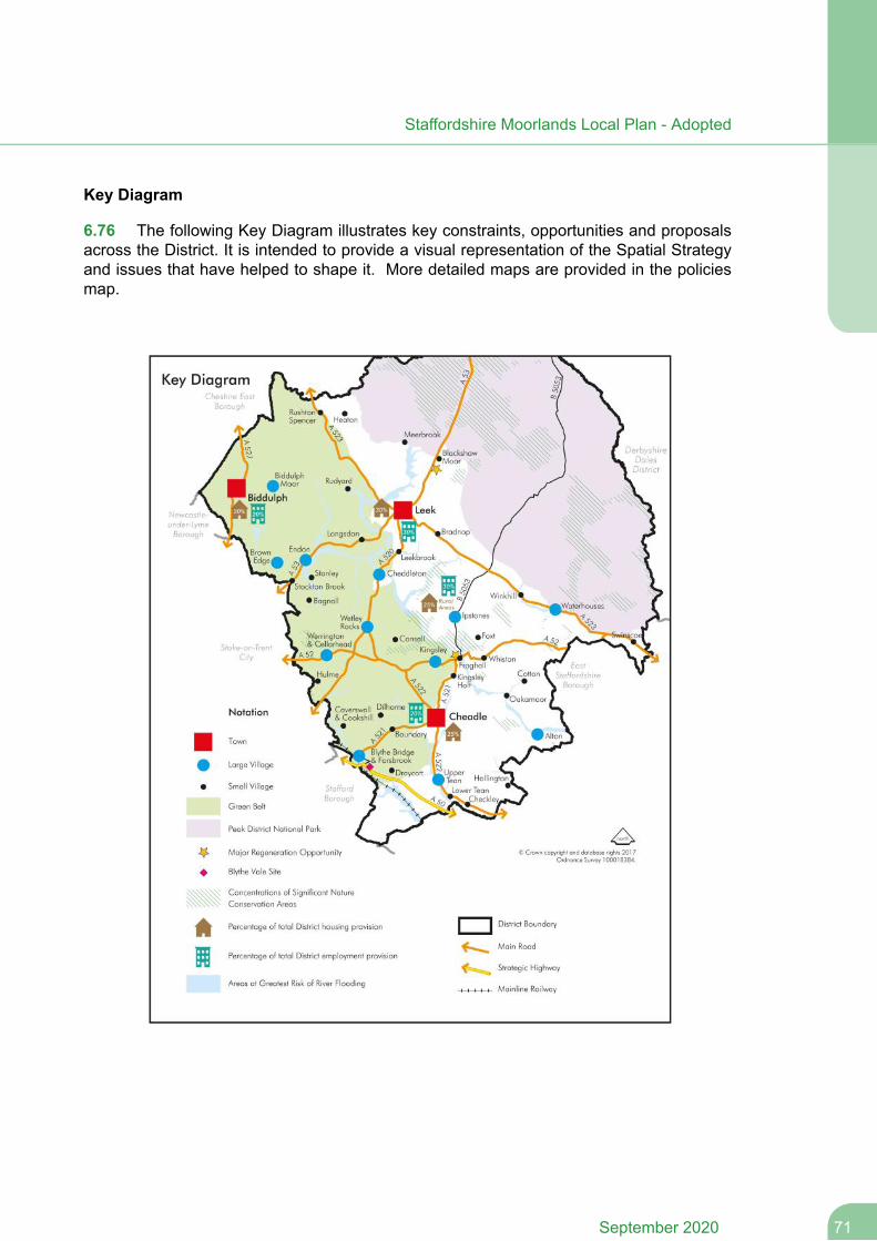
Key Diagram
6.76 The following Key Diagram illustrates key constraints, opportunities and proposalsacross the District. It is intended to provide a visual representation of the Spatial Strategyand issues that have helped to shape it. More detailed maps are provided in the policiesmap.
71September 2020
Staffordshire Moorlands Local Plan - Adopted

Development Management Policies
72September 2020
Staffordshire Moorlands Local Plan - Adopted
7 Development Management Policies
7.1 This chapter provides more detailed development management policies for specificplanning related matters, namely:
Sustainable development
Economy and employment
Housing
Town centres and retail
Design and conservation
Sustainable communities
Natural environment
Transport
7.2 These policies should be read in the context of the Spatial Strategy and StrategicPolicies in the preceding chapter of this Local Plan. In addition, further site specific policies areprovided in Chapter 8.
7.1 Sustainable Development
Spatial Objectives
SO2. To create a District where development minimises its impact on the environment,helps to mitigate and adapt to the adverse effects of climate change and makes efficientuse of resources.
Sustainable Development Policies
Sustainable Use of Resources
7.3 The need to respond pro-actively to the issue of climate change has been identifiedas a major challenge for the District and planning has a key role to play in ensuring thatdevelopment minimises its impact on the environment, helps to mitigate and adapt to theadverse effects of climate change and makes efficient use of resources.
7.4 The Government has made it clear that sustainable development is the core principleunderpinning land use planning, in the NPPF and other guidance. In particular the SternReview (October 2006) identified that human activity is changing the world’s climate, withprofound and rising costs to the natural environment, concluding that action is needed nowto avoid the worst of these costs. For example in addition to global warming impacts, climatechange also results in more flooding and more unpredictable weather patterns generally;and also water scarcity issues. This was addressed in the 2008 Planning Act, which requiresthat Local Plans contain policies (when taken as a whole) designed to “..contribute to the
73September 2020
Staffordshire Moorlands Local Plan - Adopted
mitigation of, and adaptation to, climate change.” The NPPF also addresses climate changemitigation with its support for transition to a low carbon future, support for more renewables;and its direction that Planning should play a key role in helping to secure radical reductionsin greenhouse gas emissions.
7.5 National policy guidance and Policy SD 1 support the use of previously developedland for development and the efficient use of land subject to wider considerations. Whilstthe Council's Strategic Housing Land Availability Assessment indicates that much newhousing could be built on previously developed land, the Council's overall developmentrequirements will mean that it will still need to allocate some greenfield land; further theremay be other circumstances where the re-use of a brownfield site over greenfield may notbe appropriate, for example on sustainability grounds.
7.6 Government Policy states that Councils should take into account the economic andother benefits of the best and most versatile (BMV) agricultural land with a preference fordevelopment of areas of poorer quality land over those of a higher quality. The Council hasused the Natural England likelihood of Best and Most Versatile dataset and this formed partof site assessments against the sustainability appraisal framework. Soil is a finite resource,and fulfils many roles that are beneficial to society. As a component of the naturalenvironment, it is important that soils are protected and used sustainably. Development (soilsealing) has a major and usually irreversible adverse impact on soils. Mitigation should aimto minimise soil disturbance and to retain as many ecosystem services as possible throughcareful soil management during the construction process. However soil protection needs tobe balanced against other Council policies which for example expect demonstration ofappropriate housing density for its location, with higher densities expected in more accessiblelocations, to encouragemore sustainable patterns of development. Soils of high environmentalvalue (e.g. wetland and carbon stores such as peatland) should also be considered as partof ecological connectivity. Developers should refer to the Defra Code of practice for thesustainable use of soils on construction sites.
7.7 The submission of environmental information listed in Part(5) SD 1 for majordevelopments (broadly as defined in the Development Management Procedure Order) willenable the Council and applicant to explore how they can further contribute towards improvinga scheme in relation to climate change/carbon-saving in the context of the viabilityexpectations of the NPPF. Such information may be submitted as part of a Design andAccess Statement or separately. Where the Council considers insufficient information hasbeen submitted given the complexity of the proposal, it may request further information tocover the expectations regarding this part of the Policy.
7.8 The District contains a number of older settlements, many of which contain buildingsand sites which could be re-used. Some of these have a history of contamination due toindustrial legacy, and remediation measures will be necessary where redevelopment isproposed. Where a site is affected by contamination or land stability issues, responsibilityfor securing a safe development rests with the developer and/or landowner. In some casesa developer may be required to submit pre-application evidence as to the presence ofcontamination across the site, under the 2011 Environmental Impact Regulations (asamended), before a planning application can be determined. Any proposal to develop landwhich has been subject to a previous use which may have caused contamination of theunderlying soils and groundwater will need to be supported by a Preliminary Risk Assessmentto identify the presence of receptors as identified under Part IIA of the Environmental
September 202074
Staffordshire Moorlands Local Plan - Adopted
Protection Act 1990. The NPPF requires that any contaminated site proposed forredevelopment should not be capable of being described as contaminated land under thislegislation, following remediation measures.
7.9 Further, there is a history of mining and the presence of old mine workings canpotentially adversely affect the stability of land within the District. For this reason, where landis located within an area defined as being at risk of instability due to previous mining,developers should consider national planning guidance and where relevant, guidance oncoal mining risk assessments produced by the Coal Authority. However, mining legacyissues affecting a site do not of themselves mean it is not suited to re-use, and indeedredevelopment schemes with appropriate remedial works/mitigation measures or that involverecovery of in-situ minerals prior to construction, can provide a good opportunity to re-usethe land.
7.10 The County Council as theMinerals Planning Authority have clarified that their adoptedpolicies seek to protect minerals safeguarding areas (MSAs) and safeguarded mineralinfrastructure sites as defined on mapping available on their website. Consequently,consultation with the Mineral Planning Authority may be required for any developmentschemes within a MSA or on or near to mineral infrastructure sites. Such proposals shouldbe accompanied by a mineral safeguarding statement which addresses the requirementsof Policy 3 of the Minerals Local Plan for Staffordshire (2015-2030). Developers should alsohave regard to the requirements of Policy 1.2 of the Staffordshire and Stoke on Trent WasteLocal Plan (2010-2026) that requires all major development proposals to make better useof, andminimise waste. Consequently major development schemes should be accompaniedby a site waste management plan.
Policy SD 1
Sustainable Use of Resources
The Council will require all development to make sustainable use of resources, andadapt to climate change. This will be achieved by:
1. Having regard to the BMV agricultural classification of the land, with a preference forthe use of lower quality over higher quality agricultural land. Development should alsoaim to minimise soil disturbance and to retain ecological connectivity as far as possible
2. Supporting or promoting proposals that remediate brownfield sites affected bycontamination.
3. Re-use of sites affected by mining activity will be supported, provided that any mininglegacy is appropriately addressed and it can be demonstrated that the site is safe andstable for the development proposed.
4. Supporting development that is located and designed to minimise energy needs andto take advantage of maximised orientation (subject to design and landscape policies)to achieve energy savings in line with Policy SD 3.
5. The Council will require applicants for all major-scale planning applications (10 ormore residential units or 1,000+ square metres floor area) to demonstrate that theyhave considered the energy efficiency, water conservation, sourcing of construction
75September 2020
Staffordshire Moorlands Local Plan - Adopted
materials, and site orientation aspects of the scheme, and where possible the feasibilityof integrating micro-renewables. The degree of detail expected will depend on thescale/complexity of the proposal.
6. The Council will encourage developers to investigate the potential for re-usingconstruction or construction waste materials, especially those sourced locally (whichcan include those minerals available on site, as appropriate) and integrates wherepossible on-site waste management facilities.
Renewable/Low-Carbon Energy
7.11 In recent years the UK has committed itself to legal obligations stemming from EUDirectives, relating to both the reduction of future greenhouse gas (GHG) emissions (includingcarbon); and the meeting of a greater proportion of the UK’s future demand for energy throughrenewables - which have been reflected in more recent legislation. The Climate Change Act2008 requires the UK to reduce GHG emissions by 80% between 1990 and 2050; with arequirement that UK CO2 emissions reduce by 26% between 1990 and 2020. EU Directive2009/28/EC requires the UK to source 15% of its energy from renewables sources by 2020(the target for 2015-16 was 7.5% – actual uptake in 2015 was 8.3%). The NPPF reflects thiswith support for transition to a low carbon economy; and its support for greater uptake ofrenewables. LPAs can also continue to develop an evidence-based understanding ofrenewables opportunities in their areas. As a response to the above legislation and Policy,in 2009 the Council, along with other Staffordshire planning authorities, commissionedconsultants CAMCO to produce a Staffordshire-wide study examining in detail theopportunities for stand-alone renewables in general. The study included energy opportunitymapping, and was published in 2011.
7.12 In line with National Policy, Policy SD 2 gives support to new renewable energydevelopment generally without differentiating between forms, as the District has naturalcharacteristics (e.g. river flows) which could make this viable – either now, or due to futuretechnology. In the case of wind energy proposals, the Policy clarifies that recent GovernmentNPPG Policy (in particular Ministerial Statement HCWS42) will be applied, as the Local Plandoes not currently designate any "areas identified as suitable for wind energy development".Policy SD 2 also recognises that the siting and design of all stand-alone renewablesinstallations requires careful consideration, to protect the natural and built environment, andother amenities, without precluding the supply of any type of renewable energy. Renewablesschemes can also impact upon heritage assets such as Listed Buildings; it is understoodHistoric England are preparing an Advice Note, which developers should review whereappropriate. The viability of different forms of renewable energies, within different areas ofthe District, is examined in the CAMCO work (which may in future be informed by furtherlocal evidence). Note that non-renewable energy schemes not covered by this policy (suchas fossil fuel generators), will be assessed against all relevant policy, including the NationalPolicy Statements.
September 202076
Staffordshire Moorlands Local Plan - Adopted

Policy SD 2
Renewable/Low-Carbon Energy
The Council will strive to meet part of the District's future energy demand throughrenewable or low-carbon energy sources (which could be through a variety oftechnologies, for example solar energy, biomass etc), in line with current evidence whichidentifies the feasibility of these forms of energy across the District. The Council willassess wind turbine schemes in line with the Government’s specific policy on windturbines. For all other forms of renewable energy the Council will support small- andlarge- scale stand alone renewable or low-carbon energy schemes subject to thefollowing considerations:
the degree to which the scale and nature of a proposal impacts on the landscape,particularly having regard to relevant Landscape Character evidence and impacton the Peak District National Park (taking into account both individual andcumulative effects of similar proposals);
the degree to which the developer has demonstrated anyenvironmental/economic/social benefits of a scheme, as well as how anyenvironmental or social impacts have been minimised (e.g. visual, noise or smell);
the impact on designated sites of European (or successor), national and localbiodiversity and geological importance in accordance with policy NE 1;
the impact on the amenity of residents and other interests of acknowledgedimportance, including the historic environment;
the degree to which individual proposals reflect current local evidence regardingthe feasibility of different types of renewable or low-carbon energy at differentlocations across the District;
in the case of solar energy proposals that are not affixed to buildings or structures,applicants will be expected to demonstrate that they have examined whetherpreviously developed land is available before greenfield land. Where agriculturalland is proposed, poorer quality land should be utilised before higher qualityagricultural land.
Sustainability Measures in Development
7.13 A consequence of recent Governments’ commitment to mitigating climate changehas been a tightening of the building regulations with respect to environmental performanceof new dwellings (including thermal efficiency/ water consumption efficiency/ minimisationof surface water run-off etc), according to a trajectory aimed at attaining "zero carbon" statusfor new dwellings, by 2016 (though this trajectory was subsequently cancelled in July 2015as part of the Government’s Productivity Plan: Fixing the Foundations: Creating a MoreProsperous Nation). Previously under the Planning and Energy Act 2008, Councils couldset policy requirements that exceeded building regulations; however the Deregulation Act2015 has since removed this power, as part of the Government's intention to streamlinehousebuilding standards and remove financial viabilities upon developers. The NPPF is clear
77September 2020
Staffordshire Moorlands Local Plan - Adopted
in its support for reducing the carbon- and water- consumption impacts of new buildings,but, because this generally involves greater build-costs, this is subject to developer viabilityconsiderations. The Government has recently introduced a number of optional 'nationaltechnical standards' pertaining to access, space, and water efficiency in new dwellings(Councils can only apply a requirement for these in policy if justified by 'clear evidence').Thereare also a number of other voluntary schemes such as BREEAM 'Home Quality Mark', andthe UK New Construction Standard (for non-domestic buildings) which builders can refer to.
7.14 The Infrastructure Act 2015 also clarifies that developers can achieve 'zero carbon'homes standard by using "allowable solutions" such as near- or off-site carbon mitigationmeasures in addition to on-site environmental performance measures (the exception to thisis for 'smaller'-scale housing schemes which are exempted from off-site requirements).
7.15 For these reasons, Policy SD 3 supports a number of measures which can improvethe sustainability of new or existing development in advance of the Building Regulations;however it does not set (either on- or off- site) carbon reduction requirements in newdevelopment beyond that expected in the building regulations.
Policy SD 3
Sustainability Measures in Development
The Council will support further carbon-saving or water-saving measures in both newand existing developments, in the following ways:
1. Supporting developers who propose exceeding the thermal efficiency or waterconservation standards required by law for new buildings or extensions, at the time ofthe application. In the case of larger developments such as housing estates the Councilwill support measures such as ‘communal’ renewables, or District Heating installations.
2. The Council will support measures by landowners/developers designed to contributeto existing or emerging District Heating networks (for example by connecting ‘exporters’,with receptors, of heat).
3. The Council will support measures designed to improve the sustainability of existingbuildings (such as improved thermal insulation, water conservation, or the installationof micro-renewables).
Pollution and Water Quality
7.16 Pollution not only can negatively impact on the quality of life of people, but can alsocontribute to climate change (impact on ozone etc) and adversely impact on biodiversityassets (which can also affect ‘wealth creation’).
7.17 According to the Government, poor air quality is the largest environmental risk topublic health in the UK: pollutants including Nitrogen Dioxide and particulates are stillresponsible for 40,000 premature deaths each year nationally (according to Royal Collegeof Physicians); about 4% of all deaths across Staffordshire Moorlands were attributable to‘fine’ patriculate matter in 2015 (Public Health England). Air pollution tends to affect ‘hotspots’(such as roads and traffic intersections etc), and although there may be many contributorycauses, diesel engines are particularly recognised as a causal factor. Air pollution also
September 202078
Staffordshire Moorlands Local Plan - Adopted
negatively impacts upon the health of protected ecosystems, and agricultural productivity.In response to nitrogen limits set in the EU Air Quality Directive, the Government issued itslatest ‘UK Plan for Tackling Roadside Nitrogen Dioxide Concentrations’ in 2017.
7.18 The NPPF directs Councils to proactively provide needed economic development -however decisions should ensure that new development is “appropriate for its location” inpollution/contamination terms; andmore generally development should contribute to securinggood standards of amenity and reducing pollution. On the other hand the NPPF recognisesthat industrial expansions resulting in ‘some’ additional noise should not be unfairly restricted.In accordance with the Government's noise policies including the Noise Policy Statementfor England (NPSE) the Council will apply the principles in the following Policy to anydevelopment where pollution or contamination considerations may arise.
7.19 The Water Framework Directive (WFD) came into effect in 2003 and established alegal framework for the protection, improvement and sustainable use of water bodies acrossEurope: it applies to all surface water bodies (rivers, lakes, canals etc) and groundwaterresources. Its objectives include to improve (and prevent deterioration) in quality of waterbodies, reduce water pollution, conserve aqueous habitats, and promoting sustainable useof water. TheWFD supports a catchment based approach to managing the water environmentthrough separate 'River Basin Management Plans' (including the Humber River Basin DistrictManagement Plan) which are the key over-arching sources of information on the waterenvironment. Note that all Local Authorities have a legal duty to have regard to relevantRiver Basin Management Plans in exercising their planning functions. Water ResourceManagement Plans are prepared by water companies to reconcile future demand and supplyof water for both residents and businesses; they cover a 25-year period, and must beproduced every five years. Policy SD 4 therefore establishes the link between pollutioncontrol and water quality, water capacity; and integrates WFD objectives to improve waterquality, as a policy requirement of development.
7.20 Groundwater is a vital resource supplying about a third of the Country's drinkingwater, however is often under threat from development pressures. In order to protect thequality of this water resource the policy also sets out expectations concerning riskassessments and mitigation strategies with schemes. Other Policy requirements continueto apply, eg SD 5, with regards SuDS requirements, green infrastructure etc. More detailedguidance regarding groundwater mitigation strategies etc is available in the GroundwaterProtection Guides at Gov.uk (or any subsequent iteration of guidance on development inGroundwater Protection Zones). Early consultation with the Environment Agency and therelevant water company is also encouraged.
Policy SD 4
Pollution and Water Quality
The Council will protect people and the environment from unsafe, unhealthy and pollutedenvironments by ensuring proposals avoid potential adverse effects; and only permittingproposals that are deemed (individually or cumulatively) to result in pollution (includingair/ water/ noise/ vibration/ light/ ground contamination) if after mitigation, potentialadverse effects are deemed acceptable. This may be achieved by the imposition ofplanning conditions or through a planning obligation.
79September 2020
Staffordshire Moorlands Local Plan - Adopted
When considering planning applications, the Council will require developers to haveregard to the actions and objectives of all relevant River Basin Management Plans andrelated Plans affecting the District in striving to protect and improve the quality andcapacity of water bodies in or adjacent to the District. Planning permission shall onlybe granted where the proposal makes provision for the protection (and where feasible,enhancement) of water quality and waterside habitat, and water resources whereapplicable.
In the case of development within Groundwater Source Protection Zones (SPZs)applicants should demonstrate how site layout has sought to mitigate potential pollutionto public water supply. A quantitative and qualitative risk assessment and groundwaterprotection mitigation strategy may be required subject to consultation with relevantbodies.
Flood Risk
7.21 The Moorlands has a wet climate and within it there are significant corridors alongrivers identified as being within flood risk zones, in addition to other areas affected by surfacewater run off. Previous consultations have indicated acute public concerns about floodinggenerally. Development patterns can have distorting effects on the water cycle and drainagesystems (for example, artificial features such as hardstanding, new roads and pavementscan create channels of surface run-off). Further, Climate change can be seen to result inmore flooding and more unpredictable weather patterns generally; and also water scarcityissues. Therefore the NPPF expects that all new development proposals should be plannedto avoid increased vulnerability to the range of impacts arising from climate change in thelonger term; which should include mitigation and adaptation measures for the increased risk.
7.22 The District Council will continue to keep abreast of relevant evidence affecting floodrisk in its District, such as the requirements of the Flood & Water Management Act 2010,Humber River Basin District Management Plan, Staffordshire Local Flood Risk ManagementStrategy, Water Framework Directive and any other relevant Catchment Flood ManagementPlans. A level 1 Strategic Flood Risk Assessment has been undertaken for the District. Inaccordance with the NPPF, areas of ‘low’, ‘medium’ and ‘high’ risk have been mapped usingdata collected from the Environment Agency (EA), Staffordshire Moorlands District Council,Severn Trent Water, United Utilities, the Highways Agency and British Waterways. This hasincluded information on flooding from rivers, surface water (land drainage), groundwater,artificial water bodies and sewers. This provides the basis for the Sequential Test to beapplied. The Council will expect the Sequential Test to be applied to all sites within the ‘high’and ‘medium’ risk flood zones to demonstrate that there are no reasonably available sitesin areas with less risk of flooding that would be appropriate to the type of development orland use proposed. If there is an area of overlap between the site boundary and area at riskof flooding, this should be utilised as an opportunity to reduce flood risk within the site, byusing waterside areas for recreation, amenity and environmental purposes. Where sites areaffected by the presence of any type of watercourse, the Council will expect developers toundertake early discussions with the EA and the Lead Local Flood Authority (LLFA). TheNPPF provides guidance on the types of development which require the submission of asite-specific flood risk assessment; which should demonstrate that the development hasbeen designed to be flood resilient and resistant and safe for its users for the lifetime of thedevelopment; that the development will not increase flood risk elsewhere and, whereverpossible, will reduce overall flood risk.
September 202080
Staffordshire Moorlands Local Plan - Adopted
7.23 Where a site lies adjacent to a watercourse or existing flood risk management structure(such as defences) it is desirable to maintain a ‘buffer’ between development and thewatercourse or structure not only for maintenance purposes, but also as a ‘future-proofing’tool in the event of increase in flood risk over time. In the case of ‘main rivers’ a buffer of 8mis desirable; for smaller watercourses 4m. However this desire must be balanced againstthe viability of schemes which can be affected by a smaller development area (especiallyfor smaller sites) therefore the Council will expect developers to discuss potential for buffersat pre-application stage with both the EA and LLFA; the Council may require implementationof buffers on-site based on the advice of these bodies.
7.24 Where possible, watercourses should not be culverted, as this can impede waterflows and worsen flooding. Culverting also impacts on the ecological health of the watercourse.Proposals for culverting a watercourse may trigger a Water Frame Directive (WFD)assessment. Crossings of water courses should be made where possible by a bank top tobank top bridge system in preference to culverts. The Council expects developers to explorehow existing culverted watercourses on site can be 'opened up' to alleviate flood risk, createand improve habitat and develop green corridors. Where this is not possible for larger, deeperculverts, an assessment of its structural integrity should be made, with any remedial actionstaken prior to the development of the site. In addition, a maintenance regime should beagreed to reduce the likelihood of blockage.
7.25 Policy SD 5 is designed to limit the impact of surface water flooding from newdevelopment. The treatment and processing of surface water is not a sustainable solution.Surface water should be managed at source and not transferred. Every option should beinvestigated before discharging surface water into a public sewerage network. Applicantsshould target a reduction in surface water discharge in accordance with DEFRA and LLFAguidance. Applicants wishing to discharge to public sewer will need to submit clear evidencedemonstrating why alternative options are not available. On previously developed (brownfield)sites the aim should be to reduce runoff rates and volumes. On greenfield sites the aimshould be to ensure that there is no increase in the rate and volume of surface water runoff.Surface water from new development should be discharged in the following order of priority:
1. An adequate soakaway or some other form of Sustainable Drainage System (egpond,swale,wetland etc).
2. An attenuated discharge to watercourse.3. An attenuated discharge to public surface water sewer or highway drain.
4. An attenuated discharge to public combined sewer.
7.26 Approved development proposals will be expected to be supplemented by appropriatemaintenance and management regimes for surface water drainage schemes. On largersites drainage proposals should be part of a wider, holistic strategy which coordinates theapproach to drainage between phases, between developers, and over a number of yearsof construction; the Council will encourage applicants to engage in early discussion withutility providers and LLFA for this purpose.
7.27 Notwithstanding any requirements for site-specific flood risk assessments,new legislation (2010 Flood and Water Management Act) may require separate SustainableDrainage approval from the SuDS-approving authority (in all locations) for most newdevelopments. In December 2014, a written ministerial statement by Eric Pickles MP clarifiedthat the Government expects Planning Authorities to ensure that sustainable drainage
81September 2020
Staffordshire Moorlands Local Plan - Adopted

systems for the management of run-off are put in place for all ‘major’-scale developments,unless demonstrated to be inappropriate; and that there are clear arrangements in place forongoing maintenance over the lifetime of the development. SuDS can include permeablesurfaces, green roofs, filter strips and swales, infiltration devices and basins or ponds. Surfacewater run-off should be controlled as near to its source as possible through a sustainabledrainage approach to surface water management. The preference will be for new developmentto include genuine sustainable drainage systems as opposed to underground tanked storagefor surface water. Applicants should also consider how the landscaping of a site can contributeto surface water discharge (hard and soft landscaping, permeable surfaces etc). Developmentproposals should include an indicative drainage strategy to demonstrate how sustainabledrainage will be incorporated into the development. The strategy should include sustainabledrainage elements with attenuation, storage and treatment capacities incorporated as setout in (updated) national design guidance. Applicants will also be expected to review anyguidance issued by the County Council Lead Local Flood Risk Officer or Environment Agency,with regards to SuDS design expectations, as appropriate including Staffordshire CountyCouncil’s February 2017 'SuDS Handbook’; and the SCC SuDS information page fordevelopers at Staffordshire County Council website Additionally as the Moorlands is hilly,developers should also consider the issue of ‘peri-urban flooding’ in their surface water/SuDSstrategies: where water on land uphill of a site ‘sheds off’ down into the development. TheRisk of flooding from Surface Water map gives a good indication of where problems mightarise and developers should consider this potential risk carefully in hilly areas of the Districtsuch as Biddulph and Leek. Early pre-application consultation with the LLFA on these risksis advised.
Policy SD 5
Flood Risk
The Council will follow a sequential approach to the management of flood risk. Newdevelopment will be guided to the areas with the lowest risk of current and future floodingwhere this is viable and compatible with other polices aimed at achieving a sustainablepattern of development. The development of sites within areas at greater risk offlooding will only be considered where they are deemed acceptable due to national orother policies or material considerations.
All applicable development must be subject to a site-specific flood risk assessmentwhich demonstrates that the development has been designed to be flood resilient andresistant and safe for its users for the lifetime of the development; in accordance withNPPF Policy. In addition, schemes in flood risk areas should demonstrate how thesequential approach has been used to locate the most vulnerable parts of thedevelopment in the areas of lowest flood risk. Where development sites are located inflood risk areas and/or affected by the presence of watercourses, the Council expectsdevelopers to undertake early discussions with the EA and the LLFA.
Where a watercourse is present on a development site, applicants will be expected totake opportunities to undertake river restoration and enhance natural river corridorswhere appropriate, in line with the Water Framework Directive, and to make space forwater. The culverting of any watercourse will not normally be permitted and developmentshould, wherever possible, open up any culverted watercourses to increase flood waterstorage and create a green corridor. More generally the Council will support the
September 202082
Staffordshire Moorlands Local Plan - Adopted
identification and implementation of natural flood management measures that willcontribute towards delivering a reduction in local and catchment-wide flood risk andimpacts of climate change and other multiple benefits.
All applicable developments should incorporate sustainable drainage measures (SuDS)to reduce the risk of flooding from surface water runoff and contribute to on-site floodalleviation, as well as contributing to wider Council objectives such as its emergingGreen infrastructure Network; to enhancing biodiversity and recreation opportunities;landscape character etc. Developers should undertake early discussions with the LLFAto ensure that SuDs can be fully integrated into the final development layout.
Where appropriate suitablemeasures to deal with surface water arising from developmentproposals will be required to minimise the impact to and from new development. Insuch cases the Council will expect applicants to demonstrate how their proposalsmanage surface water run-off sustainably with discharge to the public sewer only beingconsidered as a last resort, where, clear evidence must be demonstrated why alternativeoptions are not available. On greenfield sites developers should aim to not increasesurface water runoff rates. On brownfield sites developers should aim to reduce surfacewater runoff to the greenfield rate wherever practical. Approved development proposalswill be expected to be supplemented by appropriate maintenance and managementregimes for surface water drainage. On larger sites involving phased developmentand/or involving multiple landowners the Council will where appropriate encourageapplicants to engage in early discussion with utility providers and LLFA for theachievement of coordinated, holistic drainage strategies across the whole site over time.
When considering planning applications, the Council will have regard to all relevantCatchment Flood Management Plans affecting the District. In all cases the Council willwork with developers, stakeholders and landowners to encourage and promoteimplementation of natural flood risk management measures which will contribute towardsflood risk reduction as well as achieve wider environmental benefits.
7.2 Economy and Employment
Spatial Objectives
SO3. To develop and diversify in a sustainable manner the District’s economy and meetlocal employment needs in the towns and villages.
SO7. To support and enhance the tourism, cultural, recreation and leisure opportunitiesfor the District’s residents and visitors.
New Employment Development
7.28 The provision of employment land of the right type and in the right place is a keyissue for the Local Plan. The Employment Land Study has highlighted the need for the localeconomy to rely less on the manufacturing industry and to stimulate the private sector bymaking more sites available. The Study particularly indicated the need for starter units andthe potential for offices. Tourism and cultural development is also seen in the EmploymentLand Study as being potentially significant for the District’s economy in terms of generating
83September 2020
Staffordshire Moorlands Local Plan - Adopted
income and providing employment. This section therefore contains 5 policies to help developthe District’s economy and maintain existing valuable employment land and premises. Theallocation of Blythe Vale for mixed uses under Policy DSR 1 responds to a unique set ofcircumstances as it is of regional-scale; a more flexible approach to mixed uses is advocatedunder Policy DSR 1 than in Policy E 1.
7.29 Policy E 1 will ensure that there is a choice of sustainably located employment sites,attractive to developers and operators and appropriate to market needs; including 'B' usesbut also wider employment uses (refer to Glossary). The Employment Land Study identifieda need to follow successful examples such as the Victoria Business Park, and opportunitiesto encourage more start-up businesses and embrace new technologies in order to diversifythe District’s economic base away from industrial to office markets.
7.30 This policy also supports local businesses many of which are located outside mainsettlements or designated industrial estates, are within rural locations or are tightly hemmedin by housing or other development. For those businesses wishing to expand and remainon their current sites, there needs to be a careful balance between protecting the countrysideor surrounding land uses, maintaining the openness of the green belt and allowing thesefirms to provide the additional floorspace that they require.
7.31 Expansion and consolidation land and premises also need to be provided for largeroccupiers. This will be particularly important for established businesses in the area that areplanning to expand locally or respond to changing market circumstances. In meeting theseneeds, it will be necessary for this policy to be complemented by on-going dialogue andconsultation, in particular with major employers in the area to identify not only land-userequirements but transportation and economic development strategies that may be required.
7.32 Large-scale office developments (200m2 gross or more), not otherwise allocated, willneed to provide an impact assessment regarding the impact of the proposal on town centrevitality and viability (threshold derives from District's 2013 retail study). Schemes havingsignificant adverse effects will be refused.
7.33 In order to ensure that the local workforce and businesses benefit from newdevelopment, the policy also proposes local labour or business agreements in appropriatecases to provide job opportunities and training for local people and businesses in theconstruction and running of the schemes. More detail on agreements with developers tocontribute towards training programmes and employment support and employment accessschemes and on off-site contributions for employment training and support will be providedin an SPD on Developer Contributions or any subsequently adopted Community InfrastructureLevy. This will contain additional information on when agreements may be needed, whatthey will seek to cover, levels of contribution and how they will operate.
Policy E 1
New Employment Development
New employment development will be assessed according to the extent to which itsupports and improves the local economy in terms of providing for the needs and skillsof the existing and future local resident workforce andmeeting identified business needs,having regard to the Spatial Strategy Policies in SS 2, SS 3, area strategy policies, and
September 202084
Staffordshire Moorlands Local Plan - Adopted
general employment land requirements set out in Policy SS 4. In general the Councilwill endeavour to support the expansion of existing businesses and new businesses inthe District, subject to the provisions below.
In addition:
All proposals should help maintain or enhance an appropriate range of employmentpremises and sites across the District in terms of their scale, location and type.
Within or on the edge of the town centres and on existing employment sites whereredevelopment for other uses is proposed, mixed use schemes will be promoted.Mixed use schemes should accommodate employment generating uses of a scaleand nature appropriate to their location.
New business developments (use class B1a) should be located in existing orproposed employment areas or in or on the edge of town centres. Preference willbe given to town centre locations for office developments, unless ancillary to anotheruse or specifically allocated. In other locations the Council will expect a sequentialdemonstration that there were no centre or edge of centre sites available first.Office (Class B1a) developments of 200m2 gross or more must provide an impactassessment regarding the impact of the proposal on town centre vitality and viability.This will not apply to appropriate expansions of existing authorised B1 sites.
Other types of employment uses (including B use class developments (B1b, B1c,B2 and B8), commercial sui generis uses etc) should be located in existing orproposed employment areas. Such development outside of existing or proposedemployment areas but within the settlement boundary may also be acceptablewhen it would not create undue harm to the character, appearance or amenity ofthe area. New-build developments not on existing or proposed employment sitesand outside of the settlement boundary may be supported where a rural locationcan be justified.
The sustainable redevelopment, intensification or improvement of existingemployment sites for new business and industrial developments will be supportedprovided it would not have an unacceptable impact on the amenities, character orappearance of the area.
Schemes involving the re-use of rural buildings for commercial enterprise, includingtourism uses, will be considered favourably where the proposed use does not harmthe building’s character and/or the character of its surroundings.
To support the growth of the economy, the Council will:
Support proposals that help to deliver priorities of the Local Enterprise Partnership;
Encourage flexible working practices via home-working where there is no adverseimpact on residential amenities, and allowing the development of live-work unitson residential and mixed use sites
Encourage provision for small-scale and start-up businesses
85September 2020
Staffordshire Moorlands Local Plan - Adopted
To ensure that the District’s workforce is suitably skilled, the Council will, whereappropriate, seek to enter into agreements with developers and employers to contributetowards training programmes and employment support and employment accessschemes.
Employment Allocations
7.34 The Employment Land Requirement Study was completed in July 2014 and updatedin February 2017. The study reviewed a range of economic factors, projections relating tothe performance of different sectors of the local economy and the working age population.The 2017 update concluded that 14 to 32ha of additional employment land was required forStaffordshire Moorlands for the period 2014 to 2033. An employment land requirement of32ha is recommended being at the top end of this range, to dovetail with a housingrequirement of 320 homes per year (relating to the level required to support projected increasein jobs).
7.35 This 32ha is then broken down into the three towns and rural areas, according to theproportions set out in Strategic Policies SS 3 and SS 4.The Council therefore makes thefollowing allocations for B Class employment use. Whilst the ELRS update 2017 tentativelyrecommends a 'split' of this figure (50% for B1a/B1b office, 50% for B1c/B2 industrial/B8storage and distribution); the policy does not specify sub-uses so as to maximise the freedomof subsequent occupants. However Policy SS 4 carries forward the ELRS update expectationsabout splits between B-uses. The Council will need to monitor the uptake of the respectivesub-uses to assess how effectively employment land is being delivered across the District.Land requirements are expressed as a minimum.
7.36 As in May 2016 the Council granted outline approval for a major residential andindustrial scheme in the countryside at Cresswell with the industrial elementcovering approx8.58ha (satisfying the District's residual employment land requirement 2014-2033) there isonly one employment allocation within the rural areas (excluding Leekbrook which servesLeek). This is site WA004 which, although amounting to around 1.66ha in total, includes anexisting 0.44ha industrial estate to which any development schemes across the wider sitewould have to demonstrate (at least) the protection or re-provision of this area, under PolicyE 3. As in the Core Strategy, due to the regional scale of the 48.5ha allocation of land atBlythe Vale (Policy DSR 1) for mixed uses, employment development will be consideredindependently of the general employment land requirements for the District set out in PolicyE 2.
Policy E 2
Employment Allocations
The following sites as identified on the Policies Map are allocated for employmentdevelopment (B1b, B1c, B2, B8 uses), and in some cases mixed uses. The Councilwill work with developers and the local community to bring forward sustainabledevelopments in accordance with the other policies in the Local Plan.
Leek (including Leekbrook)
September 202086
Staffordshire Moorlands Local Plan - Adopted
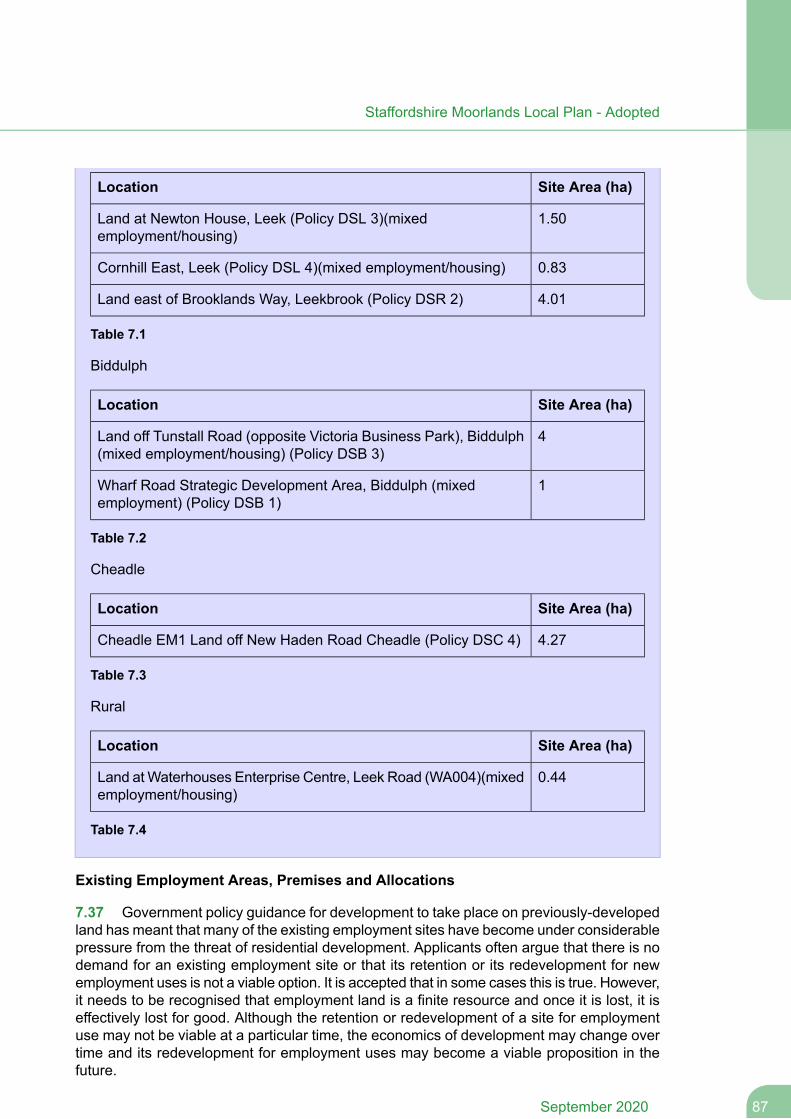
Site Area (ha)Location
1.50Land at Newton House, Leek (Policy DSL 3)(mixedemployment/housing)
0.83Cornhill East, Leek (Policy DSL 4)(mixed employment/housing)
4.01Land east of Brooklands Way, Leekbrook (Policy DSR 2)
Table 7.1
Biddulph
Site Area (ha)Location
4Land off Tunstall Road (opposite Victoria Business Park), Biddulph(mixed employment/housing) (Policy DSB 3)
1Wharf Road Strategic Development Area, Biddulph (mixedemployment) (Policy DSB 1)
Table 7.2
Cheadle
Site Area (ha)Location
4.27Cheadle EM1 Land off New Haden Road Cheadle (Policy DSC 4)
Table 7.3
Rural
Site Area (ha)Location
0.44Land atWaterhouses Enterprise Centre, Leek Road (WA004)(mixedemployment/housing)
Table 7.4
Existing Employment Areas, Premises and Allocations
7.37 Government policy guidance for development to take place on previously-developedland has meant that many of the existing employment sites have become under considerablepressure from the threat of residential development. Applicants often argue that there is nodemand for an existing employment site or that its retention or its redevelopment for newemployment uses is not a viable option. It is accepted that in some cases this is true. However,it needs to be recognised that employment land is a finite resource and once it is lost, it iseffectively lost for good. Although the retention or redevelopment of a site for employmentuse may not be viable at a particular time, the economics of development may change overtime and its redevelopment for employment uses may become a viable proposition in thefuture.
87September 2020
Staffordshire Moorlands Local Plan - Adopted
7.38 The Council will continue to resist proposals involving the loss of employment landor employment use (as defined in the Glossary) by proposing a sequential approach towardsplanning applications. Existing premises that employ people may fall into a number of differentuse classes, not just industrial (such as sui generis), or in some case it may not be clearwhat use classes are represented. The Council will reach a view as to what constitutes anexisting employment site on a case by case basis. For clarification Policy E 3 coversemployment sites currently in use; disused/vacant sites where employment use has not beenabandoned; and employment allocations (Policy E 2) whether or not they containdevelopment. This would initially involve retaining appropriate and viable employment sites.Where a lack of demand can be demonstrated by an appropriate marketing exercise andwhere the retention of a site in employment use can clearly be shown to be unviable throughthe submission of appropriate evidence, the potential for mixed-use development should beexplored incorporating an element of employment use within the development. To this endthe Council would expect that an applicant demonstrate that as much employment floorspaceis retained (or re-provided) as possible on site. In the case of 'enabler' redevelopmentschemes involving a proportion of non-employment uses needed to fund improvements toexisting employment premises or supporting infrastructure, the Council will consider theseon their individual merits (including consideration of evidence submitted), but will seek toretain as much of the redeveloped site in employment use. Schemes proposing changes ofuse amongst "employment" uses (as defined in this policy) but that do not result in a net lossof employment floorspace, will be assessed on their merits against wider policies includingSS4.
7.39 Mixed-use development is considered to be beneficial in contributing to sustainabledevelopment and provides the opportunity to build business units which might otherwise notbe viable. Permitting some residential development on employment sites for example canhelp to raise land value and generate additional revenue to bring forward sites with knownproblems that are costly to resolve. Locating housing and employment developments closeto each other also has added benefits of potentially helping to reduce the amount of traffic,congestion and pollution from work to home travel. This is particularly so with ‘live-work’units – purpose built units where the occupier of a studio, office or workshop lives in a flatattached to the place of work.
7.40 Where mixed use development is not viable then the Council will seek a financialcontribution in appropriate cases towards securing employment development elsewhere inthe area. Further details will be set out in the Developer Contributions SPD, which will firstbe tested by viability evidence to ensure that expected financial contributions are NPPFcompliant.
7.41 This policy will only apply insofar as it is consistent with any permanent or temporaryprovisions for changes of use permissible under the Town and Country Planning (GeneralPermitted Development) Order (as amended). This policy does not apply to any businessor industrial land or buildings which are allocated for an alternative use as these will havealready been assessed through the plan making process.
Policy E 3
Existing Employment Areas, Premises and Allocations
Employment areas, premises and allocations that:
September 202088
Staffordshire Moorlands Local Plan - Adopted

are well located to the main road and public transport network; and
provide, or are physically and viably capable of providing through redevelopment,good quality modern accommodation attractive to the market without harm to theamenity of nearby residents; and
are capable of meeting a range of employment uses to support the local economy;
will be safeguarded for such purposes.
Development of such areas that will lead to a loss of employment will not be permittedunless:
A) the site is identified in the Local Plan for development for non-employmentuses; or,
B) it can be demonstrated that the site would not be suitable or viable for anycontinued employment use having regard to the above criteria and evidence canbe provided that no suitable and viable alternative employment use can be found,or is likely to be found in the foreseeable future; or
C) substantial planning benefits would be achieved through development fornon-employment uses which would outweigh the loss of the site for employmentuse (including for example funding to support off-site employment provision); and
D) In the event that B) or C) applies preference will be given to a mixed use schemewhich retains as much employment floorspace on the site as possible (to bedemonstrated by evidence). The Council will consider "enabling" developmentproposals (required to support improvements to existing employment premisesor supporting infrastructure) on their individual merits. In such cases, a viabilityappraisal should be submitted to demonstrate that a change of use orredevelopment of the site is required to fund the improvements; and in all casesthe Council will seek to retain as much employment floorspace on the site aspossible.
Tourism and Cultural Development
7.42 Policy E 4 positively supports the important role that tourism and culture plays in theeconomy of the Staffordshire Moorlands and the contribution it makes to increasing physicalactivity and improving health and well-being. The District benefits from natural attributesincluding its landscapes, the Churnet River etc alongside man-made features includingindustrial heritage; prominent examples being the Caldon Canal; heritage railway system,reservoirs such as Rudyard and Tittesworth, and quarry workings. It is essential howeverthat all new tourism, visitor and cultural proposals that are located outside settlementboundaries should be in sustainable locations and carefully assessed so that they do nothave a detrimental impact on the local area unless it can be demonstrated that a particulartourism proposal requires such a location. The policy also accords with the Strategic Policiesand tourism policy for the Churnet Valley (Policy SS 11) which seeks to promote the ChurnetValley as a sustainable tourism and recreational resource.
89September 2020
Staffordshire Moorlands Local Plan - Adopted
7.43 Existing tourist accommodation in the Staffordshire Moorlands is generally smallscale family-run businesses, usually rurally located, often in converted buildings. The areahas a relatively high proportion of self-catering types of accommodation and very few hotelsand serviced accommodation. At present a very low proportion of visitors to the Moorlandsstay overnight in serviced accomodation and supply is particularly low in the three towns.Within the Churnet Valley the provision of further short and long stay visitor accommodationis particularly supported, the Churnet Valley Masterplan provides further guidance on suitablesites and scale. Particular attention should be paid to the quality of new touristaccommodation. A Staffordshire Moorlands Tourism Study undertaken in 2011 has identifieda number of projects that would enhance the tourism offer of the District. These includedeveloping and improving attractions and attractors, and enhancing the accommodationstock, notably further small serviced and self catering accommodation, particularly in theChurnet Valley, and providing budget hotel accommodation in the market towns. Tourismalso plays an important role in diversifying the rural economy. The Tourism Study identifieswhere there is scope for further provision and the nature of that provision which will helpinform decisions on applications for tourism uses in order to ensure supply matches demand.Policy E 4 sets out the considerations for tourism proposals.
7.44 Within town centres new tourism, visitor and cultural facilities and accommodationshould accord with Policy TCR 1. Outside settlement boundaries (beyond areas with goodconnectivity with other tourist destinations and amenities), and in areas not identified fortourism development in the Churnet Valley Masterplan or other relevant documents, proposalsfor new tourist, visitor and cultural accommodation and facilities will need to justify theirlocation as well as the need for the facility. Proposals for touring caravans and camping siteswill also need to satisfy the terms of the policy. Stronger controls will however apply acrossthe Green Belt, including those parts of the Churnet Valley which are within it, in order topreserve their openness.
Policy E 4
Tourism and Cultural Development
New tourism and cultural development which complements the distinctive characterand quality of the District will be supported having regard to the Area Strategies inPolicies SS 5 to SS 10 and and Churnet Valley Strategy Policy SS 11.
In addition:
1. New tourist, visitor and cultural accommodation, attractions and facilities should bedeveloped in locations that offer, or are capable of offering either:
A) good connectivity with other tourist destinations and amenities, particularly bypublic transport, walking and cycling; or
B) in locations in or close to settlements where local services, facilities and publictransport are available; or
C) in areas specifically identified for tourism development in the Churnet ValleyMasterplan or other relevant documents.
2. Developments in other locations may be supported where a rural location can bejustified.
September 202090
Staffordshire Moorlands Local Plan - Adopted
New accommodation, attractions and facilities should:
A) support the provision and expansion of tourist, visitor and cultural facilities inthe rural areas where needs are not met by existing facilities; and
B) all development shall be of an appropriate quality, scale and charactercompatible with the local area, protect the residential amenity of the area, enhancethe heritage, landscape and biodiversity of the area and shall not harm interestsof acknowledged importance.
7.3 Housing
Housing Policies
Spatial Objectives
SO4. To provide new housing that is affordable, desirable, well-designed and meetsthe needs of residents of the Moorlands.
7.45 The provision of sustainable, decent and affordable housing for all sectors of thecommunity remains one of the priorities of the Council, the Sustainable Community Strategyand of the Local Plan.
New Housing Development
7.46 Policy H 1 seeks to ensure that an appropriate range and type of housing is providedwhich meets identified needs arising from changes in population structure, including specialneeds of an ageing population, and promotes higher quality, more sustainable housingdesign and layout. It is proposed to address this through a range of measures andrequirements. In tackling these issues the proposed policy approach will be contributingtowards the delivery of not only local priorities but also national housing agendas.
7.47 This policy also ensures that housing including affordable housing – is provided tomeet the needs of the existing and future population. It reflects government guidance tocreate sustainable, inclusive and mixed communities and to make efficient use of land.Collaborative working between Local Planning Authorities, local communities, stakeholders,developers and house builders is also a key principle underlying the NPPF.
7.48 The range, type andmix of affordable accommodation required on development siteswill be determined by a combination of the results of housing needs studies, strategic housingmarket assessment, information from the waiting lists, neighbourhood plan evidence relatingto housing, consideration of existing housing stock, local housing market information as wellas any other available information including the constraints of sites.
7.49 Housing for special groups will also be needed to meet the future increase in elderlypersons across the District and the needs of those with a learning or physical disability –this may be in the form of sheltered housing, extra care homes or supported housing.Housing strategies produced by the Council, Staffordshire County Council and other agencieswill be used to support particular housing needs.
91September 2020
Staffordshire Moorlands Local Plan - Adopted
7.50 In order to address the changes in population structure, new homes should wherepossible be designed to provide flexible, accessible accommodation that is capable of futureadaptation to meet the differing and changing needs of households as they experience lifeevents. Accordingly, new developments should meet the needs of an ageing population byaiming to adhere to the nationally described space standard and apply the optional spaceand accessibility standards referred to in footnote 46 of the 2019 Framework. The Councilis to allow for consideration of the scope and merit of introducing the optional standards andthe extent to which they are applied as a percentage of the number of compliant units on asite-by-site basis. For example, the Council may look to achieve the optional space andaccessibility standards on all dwellings for a development specifically designed for olderpeople. Conversely, the conversion of a historic building to residential use may not be practicalfor the optional standards to be applied at all. For some applications financial viability mayalso be an issue.
7.51 The Self-build and Custom Housebuilding Act 2015 (as amended by the Housingand Planning Act 2016) places a duty on District Planning Authorities to maintain a registerof those wishing to acquire a serviced plot of land for self-build or custom-build projects andhave regard to the register when carrying out their planning functions. There has been a lowlevel of interest to date however the Council will keep this under review and where a demandexists, qualifying sites will be required to make a contribution. The Council’s Annual MonitoringReport will monitor information from the Self-build Register to assess the demand for thistype of accommodation in the district.
7.52 Details of the Council's requirements for sustainable design and construction are setout in Policy SD 1 and the accompanying supporting text.
7.53 It is essential that all applications for planning permission for new dwellings in thecountryside are scrutinised thoroughly to avoid new isolated homes in the countryside unlessthere are special circumstances in accordance with Government guidance. In the case ofoccupational dwellings the proposal will be required to meet functional and financial tests todemonstrate the essential need for a rural worker to live permanently at or near their placeof work in the countryside. It also allows for the re-use of redundant or disused buildingswhere it is worthy of conversion and lead to enhancement of the immediate setting. Outsideof the development boundaries, limited residential development of an appropriate scale andcharacter for the Spatial Strategy will be supported provided the specified criteria are met.The landscape components of this policy should be read in conjunction with Policy DC 3.
Policy H 1
New Housing Development
1) New housing development should provide for a mix of housing sizes, types and tenureincluding a proportion of affordable housing as set out in Policy H 3, and whereappropriate housing for special groups, to meet the needs and aspirations of the currentand future population having regard to the Area Strategies.
2) In line with Government legislation the Council will maintain and update a register ofthose interested in acquiring self-build / custom-build housing plots across the District.Where a demand exists, residential developments of 10 dwellings (or 0.5ha) or morewill make an appropriate contribution towards this need in agreement with the Council.This will be negotiated on a case by case basis.
September 202092
Staffordshire Moorlands Local Plan - Adopted
3) All development will be assessed according to the extent to which it provides for highquality, sustainable housing and to which it meets identified housing needs, havingregard to the location of the development, the characteristics of the site and theeconomics of provision.
In addition:
a) Housing for special groups, particularly for older people and others as identifiedin the SHMA or successor document should be of a scale and in a location whichis appropriate to its needs.
b) Housing proposals of 10 dwellings (or 0.5ha) or more will be required toprovide a mix of housing in terms of size, type and tenure on the site unless viabilityor other circumstances exist. The final mix will be negotiated with the developerbased on housing needs as informed by the SHMA or successor document andother relevant factors such as available supply and market demand.
c) All housing development should be at the most appropriate density compatiblewith the site and its location, and with the character of the surrounding area. Higherdensities will generally be appropriate in locations which are more accessible bypublic transport and which have good access to services.
d) All new dwellings should aim to provide flexible accommodation which iscapable of future adaptation by seeking to achieve adequate internal space forthe intended number of occupants in accordance with the Nationally DescribedSpace standard and delivered to meet accessibility standards set out in theOptional Requirement M4(2) of Part M of the Building Regulations. This will bedetermined on a site-by-site basis subject to considerations such as viability anddesign.
e) All new dwellings must be of sufficient size to provide satisfactory levels ofamenity for future occupiers of the dwellings whilst respecting the privacy andamenity of occupiers of existing dwellings.
4) Housing development on sites not allocated for such purposes in Policy H 2 will besupported as follows:
a) Within the development boundaries of the towns and larger villages, residentialdevelopment and development on unidentified (windfall) sites will be permitted,subject to compliance with the Spatial Strategy and wider Local Plan policies
b) Outside of the development boundaries, limited infill residential developmentof an appropriate scale and character for the Spatial Strategy will be supported,provided that:
The development will adjoin the boundary of a larger village and be well related tothe existing pattern of development and surrounding land uses, or;The development is well related to the existing pattern of development of a smallervillage and will not create or extend ribbon development or lead to sporadic patternof development; and
93September 2020
Staffordshire Moorlands Local Plan - Adopted
c) In all cases the development will not lead to a prominent intrusion into thecountryside or have a significant adverse impact on the character and appearanceof the countryside.
5) In the other rural areas in the open countryside, only the following forms of housingdevelopment will be permitted;
a) Affordable housing which cannot be met elsewhere, in accordance with PolicyH 3.
b) A new dwelling that meets an essential local need, such as accommodationfor an agricultural, forestry or other rural enterprise worker, where the need forsuch accommodation has been satisfactorily demonstrated and that need cannotbe met elsewhere.
c) Proposals for replacement dwellings, provided they do not have a significantlygreater detrimental impact on the existing character of the rural area than theoriginal dwelling or result in the loss of a building which is intrinsic to the characterof the area.
d) The conversion of rural buildings for residential use where the building is suitableand worthy in physical, architectural and character terms for conversion; or wheresuch development would represent the optimal viable use of a heritage asset orwould be appropriate enabling development to secure the future of heritage assets.
e) Proposals to redevelop previously developed land provided it is not of highenvironmental value.
f) The subdivision of an existing residential dwelling provided it is not in an isolatedlocation.
6) When development is located in the Green Belt, national Green Belt Policy will apply.
The Council will closely monitor the delivery of residential windfall sites and affordablehousing to ensure that it is meeting expected levels.
Housing Allocations
7.54 In order to meet the housing requirement outlined in Policy SS 3 and Policy SS 4,the sites below have been identified as suitable for development. In some cases this will behousing but in others the site may be more suitable for a mix of uses.
Policy H 2
Housing Allocations
The following sites will be allocated for housing or mixed use development. The Councilwill work with developers and the local community to bring forward sustainabledevelopments in accordance with the other policies in the Local Plan.
Leek
September 202094
Staffordshire Moorlands Local Plan - Adopted
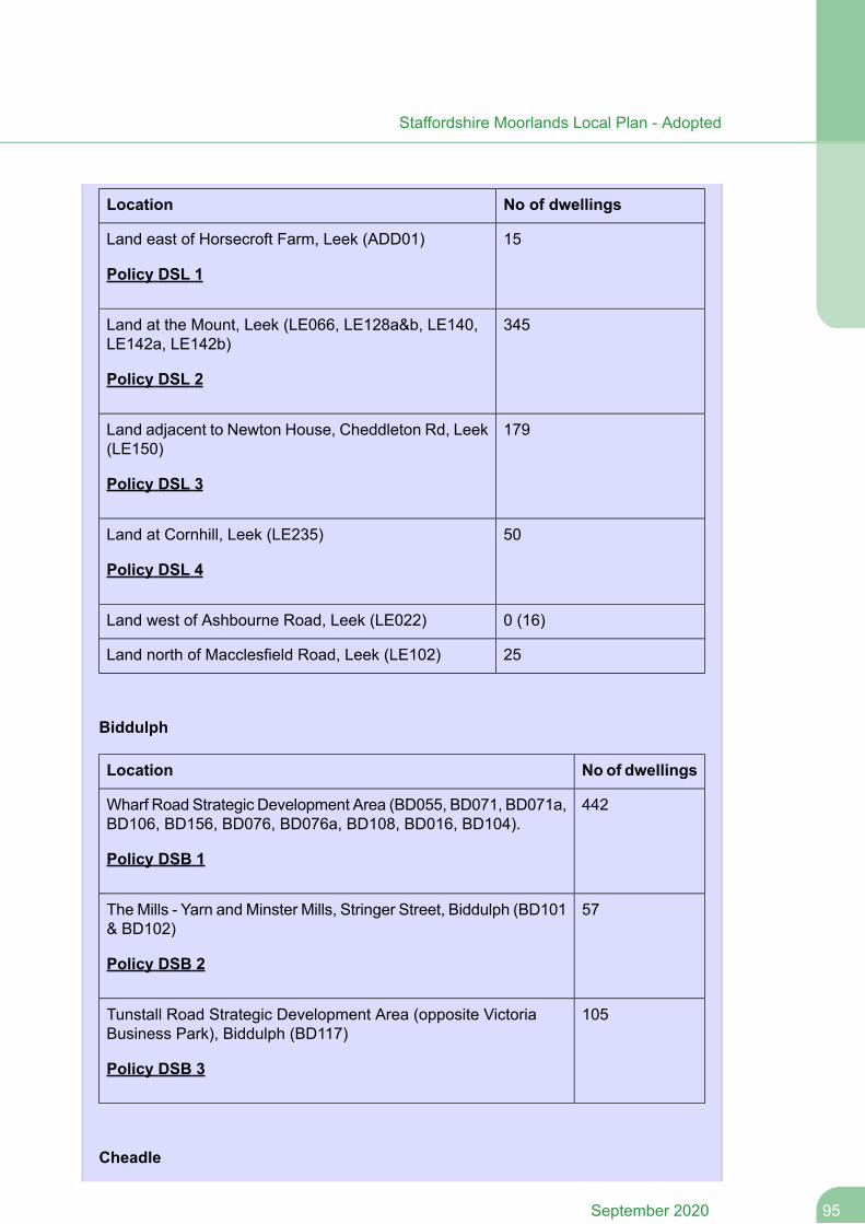
No of dwellingsLocation
15Land east of Horsecroft Farm, Leek (ADD01)
Policy DSL 1
345Land at the Mount, Leek (LE066, LE128a&b, LE140,LE142a, LE142b)
Policy DSL 2
179Land adjacent to Newton House, Cheddleton Rd, Leek(LE150)
Policy DSL 3
50Land at Cornhill, Leek (LE235)
Policy DSL 4
0 (16)Land west of Ashbourne Road, Leek (LE022)
25Land north of Macclesfield Road, Leek (LE102)
Biddulph
No of dwellingsLocation
442Wharf Road Strategic Development Area (BD055, BD071, BD071a,BD106, BD156, BD076, BD076a, BD108, BD016, BD104).
Policy DSB 1
57TheMills - Yarn and Minster Mills, Stringer Street, Biddulph (BD101& BD102)
Policy DSB 2
105Tunstall Road Strategic Development Area (opposite VictoriaBusiness Park), Biddulph (BD117)
Policy DSB 3
Cheadle
95September 2020
Staffordshire Moorlands Local Plan - Adopted
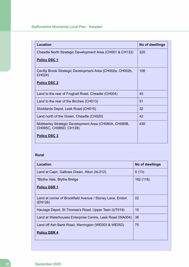
No of dwellingsLocation
320Cheadle North Strategic Development Area (CH001 & CH132)
Policy DSC 1
106Cecilly Brook Strategic Development Area (CH002a, CH002b,CH024)
Policy DSC 2
45Land to the rear of Froghall Road, Cheadle (CH004)
51Land to the rear of the Birches (CH013)
32Stoddards Depot, Leek Road (CH015)
42Land north of the Green, Cheadle (CH020)
430Mobberley Strategic Development Area (CH085A, CH085B,CH085C, CH085D, CH128)
Policy DSC 3
Rural
No of dwellingsLocation
0 (13)Land at Capri, Gallows Green, Alton (AL012)
182 (118)*Blythe Vale, Blythe Bridge
Policy DSR 1
22Land at corner of Brookfield Avenue / Stoney Lane, Endon(EN128)
15Haulage Depot, St Thomas's Road, Upper Tean (UT019)
36Land at Waterhouses Enterprise Centre, Leek Road (WA004)
75Land off Ash Bank Road, Werrington (WE003 & WE052)
Policy DSR 4
September 202096
Staffordshire Moorlands Local Plan - Adopted
Sites with a 0 in the number of dwellings column had planning consent for housingdevelopment at 31 March 2019. A zero figure is specified to avoid double counting inTable 6.3 ‘Net housing requirement by area’ which takes into account commitmentsand provides the net housing requirement for each of the areas. *Blythe Vale hadplanning consent for housing development on part of the allocation (118 dwellings) at31 March 2019. The remainder of the housing capacity is included in the number ofdwellings column.
In the event that these permissions lapse, indicative housing capacity figures for thesesites are provided in brackets and in the corresponding Strategic Development SitePolicy in Chapter 8.
Affordable Housing
7.55 The limited supply of, and high demand for, housing in Staffordshire Moorlands hasled to high prices and rents. It is now extremely difficult for local people on low incomes andincreasingly those on middle incomes to afford a home of their own. This is particularly soin the rural areas. Unless more affordable housing is provided, there is a danger that thoseon lower and middle incomes, particularly the young, will be forced to leave the district inincreasing numbers. As a result, our communities will be damaged and the district’s age andsocial structure will become even more biased towards the elderly and the wealthy.
7.56 The Strategic Housing Market Assessment (SHMA) demonstrates a significant needfor affordable housing in the District which exceeds the District’s average annual developmentrate requirements. This policy therefore seeks to support the provision of affordable housingacross the District through a range of measures. The SHMA findings would suggest a 100%affordable housing requirement, however this is considered unrealistic as it would not allowa sustainable housing market to be maintained. The NPPF requires that the sites and scaleof development should not be subject to such a scale of obligations and policy burdens,including affordable housing, that their ability to be developed is threatened. The Local Planand Site Allocations Viability Study tested different levels of on-site affordable housingprovision at 10%, 20% and 33% to provide an indication of the likely viability of affordablehousing provision in differing value areas across the District. The lowest value areas arelocated in Zone 1 and the highest value areas located in Zone 4 as identified below. However,the actual level of provision may vary due to individual site circumstances such as groundconditions and other required developer contributions.
Zone 1 - Blythe Bridge and Forsbrook;
Zone 2 - Biddulph, Biddulph Moor, Brown Edge and Upper Tean;
Zone 3 - Cheadle, Leek, Cheddleton, Werrington and Cellarhead, Ipstones and Kingsley;and
Zone 4 - Endon, Alton, Waterhouses and Wetley Rocks.
7.57 The threshold and required level of affordable housing provision are intended toensure that adequate provision is made both in urban and smaller rural settlements to helpaddress this need and ensure that a sustainable and deliverable housingmarket is maintainedwhich will deliver the range of housing needed to help meet market demand as well affordablehousing needs. All development involving the provision of housing which meet the thresholdswill be required to make provision for affordable housing.
97September 2020
Staffordshire Moorlands Local Plan - Adopted
7.58 The majority of any affordable housing that is likely to be provided will mostly be onallocated sites in or on the edges of the main market towns. Affordable housing provisionwill also be contributed to by windfall schemes, net gains from conversions, new provisionof non self contained household spaces, and long term vacant properties brought back intouse.
7.59 In the rural areas it is anticipated that the bulk of the provision of affordable houseswill be in the larger villages, either on allocated sites or on windfall sites. The approachestablished at Paragraph 6.28 of housing completions within the Peak District National Parkand within the District counting towards Local Plan housing figures also relates to affordablehousing. Applications for affordable housing may arise within the relevant parts of the NationalPark in the type of locations that would not normally be supported by Local Plan policy.However, for the avoidance of doubt, applications for affordable housing within the PeakDistrict National Park will be determined in accordance with the Development Plan for theNational Park including any relevant Neighbourhood Plans. These plans may identifyopportunities for affordable housing provision that would contribute towards the needs ofthe District.
7.60 The policy sets out the expected affordable housing split between starter homes,intermediate housing and social / affordable rent.
Policy H 3
Affordable Housing
1) Residential developments of 10 dwellings (or 0.5ha) or more shall provide 33%affordable housing. Where justified, the Council will consider a lower level of provisiontaking into account the Local Plan and Site Allocations Viability Study, other up-to-dateviability evidence and other contributions. Affordable housing should normally be providedon-site. Provision off-site or through a commuted sum payment in lieu will only beconsidered where it will be of broadly equivalent value to on-site provision and it canbe robustly justified in delivering affordable homes through mixed and balancedcommunities.
2) Unless circumstances dictate otherwise and in agreement with the Council, 60% ofall affordable dwellings provided on each site will be social / affordable rented housingwith the remaining 40% being intermediate / starter homes.
3) In or on the edge of villages, affordable housing schemes that are of an appropriatescale for the spatial strategy will be permitted on suitable rural exceptions sites whichare well related to services and facilities and where a demonstrable need exists withinthe local area which cannot otherwise be met by means of provision in the plan. Smallnumbers of market homes may be allowed at the Council’s discretion where it wouldfacilitate the provision of significant additional affordable housing to meet the needs ofthe local community.
4) Affordable housing should be designed as an integral part of developments and be‘tenure blind’ in relation to other properties within the site.
September 202098
Staffordshire Moorlands Local Plan - Adopted
5) In areas of low demand or where the stock does not meet and is not capable ofmeeting local housing market needs consideration will be given, in consultation withlocal communities, to options for renovation/improvement or redevelopment schemesto create more sustainable and balanced housing.
Gypsy and Traveller Sites and Sites for Travelling Showpeople
7.61 Recent legislation and guidance from the government has indicated a commitmentto taking steps to resolve some of the longstanding accommodation issues for members ofthe gypsy and traveller communities. This legislation and guidance has an overarching aimof ensuring that members of the gypsy and traveller communities have equal access todecent and appropriate accommodation options, health, education and employmentopportunities in sustainable locations akin to each and every other member of society.
7.62 This policy is based on the 2015 'Planning Policy for Traveller Sites' and wider NPPG,which seek to address this through criteria aimed at ensuring such provision is made inappropriate locations which will apply to the determination of planning applications. Thispolicy also relates to travelling showpeople. Although their work is of a mobile nature,showpeople nevertheless require secure, permanent bases for the storage of their equipmentand more particularly for residential purposes.
7.63 The need for sites for gypsies and travellers within Staffordshire Moorlands has beenidentified through a recent 2015 joint-Authority Gypsy and Traveller Accommodation NeedsAssessment (GTAA). This Assessment identifies a requirement for 6x residential and zerotransit pitches for the District over the period 2014 – 2019 (with an additional 2 residentialpitches up to 2034, taking account of household formation). This Assessment also coversthe separate provision for travelling showpeople (although this GTAA did not identify anyadditional plot requirements for travelling showpeople across the Staffordshire Moorlands). InFebruary 2018 the Council granted full permission for three pitches off Uttoxeter Road,Checkley, leaving a residual requirement of 3x permanent pitches to 2019. The Council hassought to address this residual requirement in a number of ways. This has included ‘call forsites’ exercises with the public; and investigating whether public sector bodies (includingSMDC and Staffordshire County Council) held suitable and available sites either within oradjacent to the District. As part of its Duty to Cooperate under the Localism Act the Councilhas investigated with neighbouring authorities (party to the Joint Gypsy and Traveller NeedsAssessment) the scope for provision of some/all of SMDC’s residual requirement withinneighbouring authorities. None of these actions elicited any suitable, available sites.
7.64 Proposals for the development of sites required to meet this need will be assessedagainst the parameters in policy H 4, taking into account other relevant criteria set out in theLocal Plan. The Council will monitor the availability of gypsy and traveller and travellingshowperson's accommodation and manage the provision of additional pitches/plots withinStaffordshire Moorlands against the need identified for the District and, as set out in theguidance in paragraphs 24 and 27 of the ‘Planning Policy for Traveller Sites’. The existinglevel of local provision and need for sites will be taken into account when considering planningapplications for gypsy and traveller sites. Section 124 of the Housing and Planning Act 2016has clarified that Local Authorities must periodically assess the need for people residing on"sites on which caravans can be stationed"; however the requirement to produce formal"GTAAs" has been removed. The Government also clarified changes to the definition oftraveller and travelling showperson, such that those who have ceased to travel permanently,
99September 2020
Staffordshire Moorlands Local Plan - Adopted
may now be excluded from assessment. However national policy in paragraph 61 of theNPPF 2019 clarifies that such ‘non-travellers’ would still need to have their housing needsassessed and reflected in housing policies in the normal way.
Policy H 4
Gypsy and Traveller Sites and Sites for Travelling Showpeople
The Council’s joint GTAA identified a requirement for 6x residential and zero transitpitches for the District over the period 2014–2019. Given subsequent commitments theresidual requirement for 2014-2019 is now 3x residential pitches. A requirement for afurther 2x residential pitches was also identified for the period 2019 -2034 taking accountof household formation.
The Council will seek to meet these residual requirements by applying the followingcriteria in the determination of applications for gypsy and traveller sites or sites fortravelling showpeople:
Safe and convenient vehicular and pedestrian access to the site should be provided;
The site must be large enough to provide for adequate on site facilities for parking,storage, play and residential amenity;
The site is reasonably accessible to shops, schools, health facilities and othercommunity facilities on foot, by cycle or public transport;
The site should not be detrimental to amenities of adjacent occupiers;
Adequate levels of privacy and residential amenity for occupiers should beprovided and sites should be ‘soft’ landscaped to positively enhance theenvironment and increase the site’s openness rather than ‘hard’ landscaped;
Sites or features of natural value should not be significantly harmed by the proposal;
development causing harm to heritage assets will need to be justified against NPPFPolicy.
Development of gypsy and traveller or travelling showpeople accommodation in theGreen Belt will not be allowed unless there are very special circumstances.
September 2020100
Staffordshire Moorlands Local Plan - Adopted
7.4 Town Centres and Retailing
Town Centre and Retailing Policies
Spatial Objectives
SO5. To ensure the long term vitality and viability of the three market towns of Leek,Biddulph and Cheadle.
7.65 The market towns of Leek, Biddulph and Cheadle are the main centres in theStaffordshire Moorlands, serving residents of the towns themselves and their large ruralhinterlands. It is recognised both locally and nationally that our town centres are very importantto the social, economic and environmental well being of the District. It is considered crucialto maintain and improve their long term vitality and viability so that they are attractive placesto shop, work, visit and invest in. In line with national guidance set out in the NPPF, thispolicy states how the Council will plan pro-actively for the town centres by focusing growthand development within them to meet the needs of all members of the community in termsof retailing and other facilities, whilst at the same time preserving their unique local identity.
7.66 This policy approach ties in with the vision of the Staffordshire Moorlands SustainableCommunity Strategy 2007 - 2020, which states that 'by 2020....Our vibrant market towns willbe home to a range of successful retail, visitor and knowledge based businesses'.
7.67 The policy contains a whole range of measures to maintain the vitality and viabilityof our town centres. Retailing and other key town centre uses like offices, leisure uses suchas hotels and cinemas and cultural facilities like those connected with performance and thearts should ideally be focused in town centres. However, as the District has a thriving touristindustry it is recognised that when special circumstances dictate, hotels in particular mayneed to be located outside town centres, subject to the impact test (required by Policy TCR3) not concluding that this would have an adverse impact on the vitality and viability of thetown centre.
7.68 Examples of measures to enhance the town centres which could be considered areimprovements to the public realm such as greening the town centres. It is also extremelyimportant to ensure that our town centres, which are our key service centres for a large ruralhinterland, are accessible by a choice of means of transport as well as to pedestrians. It isrecognised that a proportion of town centre users travel by private transport and needconvenient parking places to encourage them to use the town centres rather than go to othercentres outside the District.
7.69 Retaining and enhancing local distinctiveness has strong local support with residentsand businesses alike not wanting our historic market towns to become ‘clone towns’.Supporting independent traders and niche markets (such as antiques in Leek) is a positiveway of doing this. Good design is also particularly important in our town centres in order toretain distinctiveness, attract visitors and also ensure that key areas and buildings are userfriendly for the whole community. The Design Guide SPD and Policy DC 1 cover this in moredetail.
101September 2020
Staffordshire Moorlands Local Plan - Adopted
7.70 Upper floors in our town centres are not used to their full capacity. There is a localneed for housing in accessible locations as well as the other benefits residential use couldbring, such as security outside normal working hours and assisting with the development ofthe evening economy.
7.71 The 2013 Retail Study did not identify a need to allocate land for additionalconvenience or comparison goods floorspace in Leek or Cheadle. A need for a discountfoodstore was identified in Biddulph and an allocation is proposed on the west side of Biddulphbypass to meet this need. A further review of capacity for convenience and comparisongoods floorspace will be undertaken during the plan period to confirm developmentrequirements for the latter phase of the plan.
Policy TCR 1
Development in the Town Centres
The vitality and viability of the town centres of Leek, Biddulph and Cheadle (defined onthe Policies Maps) will be protected and enhanced by positive management as follows:
1. Focusing and promoting retailing as well as other key town centre uses such asoffices, leisure and cultural facilities within the town centres.
2. Supporting positive measures and proposals which enhance and regenerate theshopping and town centre environment and promote their tourism potential.
3. Enhancing local distinctiveness by supporting proposals which help retain, attract orexpand the provision of independent retailers in the town centres including nichemarkets.
4. Ensuring new development is well related to pedestrian shopping routes.
5. Ensuring there are adequate parking facilities in suitable locations in and around thetown centres and good access to the town centres is strengthened for those using publictransport, cycling or walking.
6. Setting out design principles to improve and enhance the distinctive heritage of thetown centres including high quality public spaces as well as minimising the risk of crimeand considering the needs of disabled people.
7. Promoting housing on upper floors within town centres where this does not jeopardisetheir vitality and viability.
Primary Shopping Frontages
7.72 The safeguarding of the retail function at the heart of the town centres is consideredto be a crucial factor in maintaining their vitality and viability, so primary shopping frontagesfor Leek, Biddulph and Cheadle have been defined on the policies maps.
7.73 It is considered that in the designated primary shopping frontages if a proposedchange of use to a non-A1 use would result in three or more adjacent units in non-A1 usethen this would create a concentration. In some locations within a primary shopping frontage,where two non-A1 use units are created opposite a single non-A1 unit or where there is a
September 2020102
Staffordshire Moorlands Local Plan - Adopted
significant A1 frontage (i.e. larger units in prominent positions) the change of use may beunacceptable. Where the units are near a street junction, the presence of non-retail unitsaround the corner may also be a material factor. If significant numbers of non-A1 uses areclustered in a part of the Primary Shopping Frontage, even if they are not adjacent, this mayalso constitute a concentration. It is recognised that sometimes non-A1 uses in PrimaryShopping Frontages can help to contribute towards the vitality and viability of town centres.A judgment will be made on a case-by-case basis. Additionally it is recognised that the retailcharacter of an area can be adversely affected by concentrations of particular types of non-A1uses. In line with a recommendation in the Council's Retail Study, frontage policies relatingto a potential creation of a concentration of evening economy uses (A3, A4 & A5) that wouldgive rise to social and environmental issues are not supported.
Policy TCR 2
Primary Shopping Frontages
In primary shopping frontages (defined on the policies maps), proposals for changesof use to A1 retail will be supported. Development falling within other use classes willonly be permitted where it will not create a concentration of non-shopping uses andresult in an unacceptable change in the retail character of the immediate area or havean adverse effect on the vitality or viability of the town centre.
Proposals for residential use at ground floor level in primary shopping frontages will notbe supported.
Any non-A1 use must be complementary to adjacent shopping uses in terms of itsoperational characteristics.
Other Frontages within the Town Centre Boundary
In other frontages, development falling within other use classes will be permitted whereit will contribute to the vitality and viability of the town centre.
Proposals within the town centre boundary that would create a concentration of eveningeconomy uses (A3, A4 & A5) that would give rise to social and environmental issueswill not be supported.
This policy will only apply insofar as it is consistent with any permanent or temporaryprovisions for changes of use permissible under the Town and Country Planning (GeneralPermitted Development) Order (as amended).
TCR 3 Retailing and other Town Centre Uses outside Town Centres
7.74 As well as requiring the applicant to apply a sequential test to proposals for maintown centre uses outside existing town centres which are not in accordance with an up todate Local Plan, the NPPF also requires an impact assessment and allows Councils to definea locally set floorspace threshold to which this should apply. The Council's Retail Study(2013) recommends that the Council should adopt a minimum local floorspace threshold of200 m2 (Class A1 net sales floorspace) for impact assessment. A recent update report 'RetailImpact Thresholds - Review' (2017) confirms that this impact threshold is appropriate andinformed by robust evidence. The rationale for this has specific regard to the latest NPPG
103September 2020
Staffordshire Moorlands Local Plan - Adopted
indicators. The majority of units are relatively small and will be more susceptible to the impactof larger-scale retail development outside of the town centres. This threshold provides anappropriate mechanism with which to protect the vitality and viability of the District's towncentres. The requirement for qualifying proposals to provide evidence around impact shouldnot be onerous; a proportionate approach in terms of the scoping and extent of informationrequired can be applied through pre-application dialogue with applicants. It is consideredappropriate to apply the same threshold to the sequential test requirement.
Policy TCR 3
Retailing and other Town Centre uses outside Town Centres
In determining proposals for retail and other town centre uses of 200m2 or more (netsales for A1) on sites outside town centres and not in accordance with an up-to-dateLocal Plan a Sequential Assessment will be required. Preference will be given to towncentre and then edge of centre sites. Where there are no sequentially preferable sitesavailable, sites outside Leek, Biddulph and Cheadle in highly accessible locations thatare well connected to the town centre will be considered.
An Impact Assessment will be required on proposals for town centre uses of 200m2 ormore (net sales for A1) located outside of the town centres and not in accordance withthe Local Plan. Developer contributions may be sought to mitigate identified impactson defined centres where appropriate. Proposals with a significant adverse impact willbe refused.
7.5 Design and Conservation
Design Considerations
Spatial Objectives
SO7. To support and enhance the tourism, cultural, recreation and leisure opportunitiesfor the District's residents and visitors.
SO8. To promote local distinctiveness by means of good design and the conservation,protection and enhancement of historic, environmental and cultural assets throughoutthe District.
SO9. To protect and improve the character and distinctiveness of the countryside andits landscape, biodiversity and geological resources.
SO10. To deliver sustainable, inclusive, healthy and safe communities.
7.75 Good design is a key element of sustainable development, so the Council will promotea high standard of design which is locally distinctive and reinforces the unique character ofits individual settlements. A high quality, well designed, development can enhance the senseof place and identity of an area and can bring significant benefits to the local environmentand economy. In this way, new development can have a positive impact on the lives of local
September 2020104
Staffordshire Moorlands Local Plan - Adopted
people and visitors to the District. To this end, the Council operates a 'Design Review Panel'where larger planning applications and other development proposals are considered by adesign team and recommendations made to inform the decision on the application ormasterplan etc. The 'Building for Life' toolkit is also a useful resource.
7.76 Guidance on those features and characteristics which make the Moorlands so uniqueand how design can complement and reflect this will be provided through the Design GuideSPD. All developers and applicants will be required to provide a Design and AccessStatement to accompany planning applications for major developments or proposals indesignated areas (refer to http://www.legislation.gov.uk/uksi/2015/595/article/9/made) whichaddresses, as appropriate, the issues set out in Policy DC 1 and the Design Guide SPD. ADesign and Access Statement will be required to accompany proposals for developmentincluding an accurate illustration of the proposal and its relationship with its surroundingsand crime prevention considerations.
7.77 Assessment of potential impacts from new developments at the earliest possiblestage of the design process will assist in identifying problems to be overcome. Detailedguidance on issues of security and public safety in the public realm can be found in ‘Securedby Design’ (www.securedbydesign.com) produced by the police. A further useful referencepoint is the ‘Streets for All Manual: West Midlands’ produced by the Department of Transportand Historic England. This contains guidance on the retention and conservation of historicstreet furniture, rationalisation of existing signage, minimisation of street markings, use ofappropriate surfacing and associated highway improvements. The principles of active designset out by Sport England promote opportunities for sport and physical activity in the designand layout of development.
7.78 Sport England have produced new 'Active Design' (2015) guidelines to promote therole of sport and physical activity in creating healthy and sustainable communities. Thisdocument sets out the ten principles of active design and how these can be incorporatedinto new development.
7.79 New developments which are located adjacent to existing sports facilities or playingfields should consider the location of housing and gardens within the scheme and/or theerection of ball netting/fencing. For example, new housing developments located next tosports pitches can raise the issue of ball strike including damage to property and vehiclesand potential danger to residents. New housing built close to artificial turf pitches can causeissues about the use of floodlights and noise generated. If mitigation is required it shouldbe the duty of the developer to provide and fund measures to ensure there is no indirectnegative impact.
7.80 In line with the Council's Sustainability Appraisal, the policy includes a requirementfor developments to be well integrated for car, pedestrian and cycle use as well as othersustainable transport links. It also includes a requirement for the creation of healthyenvironments (to address potential impacts of air pollution).
7.81 The ‘green infrastructure’ can be defined as a network of multi-functional open spaces,including formal parks, gardens, woodlands, green corridors, waterways, street trees andopen countryside. It performs a valuable role in the District’s towns and villages. The Councilhas produced a Green Infrastructure Strategy to consider how the green spaces relate toone another in the District and where there may be opportunities to extend them. Wherepossible, opportunities will be sought to undertake river restoration and enhance naturalriver corridors as part of a new development in line with the Water Framework Directive.
105September 2020
Staffordshire Moorlands Local Plan - Adopted
7.82 Residents of new housing sites and occupiers of new business premises generallyexpect to be able to access high speed broadband. The Broadband Delivery UK programmedoes not cover new development sites. New sites should be planned so that these vitalservices are designed into the development from the outset, and should not require a publicsubsidy to make them commercially viable. Access to high speed broadband should enhancethe sale-ability of both residential units and businesses premises alike. The failure to supplysuch access to high speed broadband services could prove to be a real barrier to selling orletting the completed premises. If the developers engage with the network operators at thestart of the planning process, they will generally be amenable to supplying access to therequired infrastructure at little or no cost to the developer.
Policy DC 1
Design Considerations
All development shall be well designed and reinforce local distinctiveness by positivelycontributing to and complementing the special character and heritage of the area in linewith the Council’s Design Guide SPD. In particular, new development should:
1. be of a high quality and add value to the local area, incorporating creativity, detailingand materials appropriate to the character of the area;
2. be designed to respect the site and its surroundings and promote a positive senseof place and identity through its scale, height, density, layout, siting, landscaping,character and appearance;
3. create, where appropriate, attractive, active, functional, accessible and safe publicand private environments which incorporate public spaces, green infrastructureincluding making provision for networks of multi-functional new and existing greenspace (both public and private), landscaping, public art, ‘designing out crime’initiatives and the principles of Active Design;
4. incorporate sustainable construction techniques and design concepts for buildingsand their layouts to reduce the impact of the development;
5. protect the amenity of the area, including creation of healthy active environmentsand residential amenity, in terms of satisfactory daylight, visual impact, sunlight,outlook, privacy, soft landscaping as well as noise, odour and light pollution;
6. promote the maintenance, enhancement, restoration and re-creation of biodiversityand geological heritage, where appropriate;
7. provide for safe and satisfactory access and make a contribution to meeting theparking requirement arising from necessary car use;
8. require new developments to be well integrated for car, pedestrian and cycle useas well as other sustainable transport links;
9. ensure that existing drainage, waste water and sewerage infrastructure capacityis available, and where necessary enhanced, to enable the development to proceed;
September 2020106
Staffordshire Moorlands Local Plan - Adopted
10. ensure, where appropriate, equality of access and use for all sections of thecommunity;
11. be served by high speed broadband (>30mbps) unless it can be demonstratedthrough consultation with Next Generation Access Network providers that thiswould not be possible, practical or economically viable. In all circumstances duringconstruction of the site sufficient and suitable ducting should be provided withinthe site and to the property to facilitate ease of installation at a future date.
The Historic Environment
7.83 The historic environment of Staffordshire Moorlands is a resource for which the Districtis renowned. It includes a range of buildings, gardens and structures many of which arestatutorily protected. The historic environment also extends beyond individual assets to thehistoric character of the wider landscape. Historic farmsteads are a particular feature of theStaffordshire Moorlands countryside. This policy seeks to ensure that sites and areas ofparticular heritage value are both safeguarded for the future and, where possible, enhancedboth for their own heritage merits and as part of wider heritage regeneration proposals. Thepolicy requirements apply to all types of development.
7.84 The NPPF uses the term 'heritage asset' which can be designated or non-designated.Examples of these are Scheduled Monuments, Listed Buildings, Historic Farmsteads,Conservation Areas, Registered Parks and Gardens, Registered Battlefields andarchaeological remains. There are just under 1,000 Listed Buildings and structures, 16Conservation Areas and a number of Scheduled Monuments within the District outside thePeak District National Park. Conservation Areas and Listed Buildings are protected bynational legislation and guidance. Additionally the Council has adopted an SPD 'StaffordshireMoorlands Local Heritage Register' which outlines procedures for identifying local buildingsnot statutorily protected but considered worthy of recognition (local listing). In addition,Government Guidance (NPPF) requires the Council to consider any impacts arising from adevelopment proposal on non-designated heritage assets.
7.85 Ten of the designated Conservation Areas have adopted character appraisals. Thesec a n b e f o u n d o n t h e D i s t r i c t C o u n c i l ’ s w e b s i t e a thttps://www.staffsmoorlands.gov.uk/article/1358/Character-appraisals The appraisals assessthe particular qualities and needs of each Conservation Area and will act as tools in definingthe character of the areas and as an aid in considering development proposals. The characterappraisals produced include recommendations for enhancing the Conservation Area, forexample, introduction of Article 4 Directions.
7.86 The built heritage of the plan area is rich and varied - containing a valuable resourceof surviving high quality vernacular and industrial architecture. Whilst this resource hasescaped the alterations and interventions typically found elsewhere, they often, today, sufferfrom under-use and dereliction. The plan area’s rural hinterland was once prosperous, asis evident by the number and quality of the historic farmsteads. Unfortunately, these havefallen on harder times and many now are in need of repair and a diversification of uses. Inresponse to this, therefore, the plan seeks to create a more sustainable local economy thatcan better support its built heritage. The Authority will continue to monitor its Listed Buildingsat Risk and will be proactive in bringing about their repair and reuse. In relation to ’HeritageAssets at Risk’, the Council maintains a local register of all listed buildings which are
107September 2020
Staffordshire Moorlands Local Plan - Adopted
considered to be at risk through vacancy, under-use, neglect or structural repair. HistoricEngland also publish a national 'Heritage at Risk' register which contains Grade I and II*listed buildings or structures known to be 'at risk' through neglect and delay. Mill buildingsand historic farmsteads are two types of heritage asset which contribute to the character ofthe Staffordshire Moorlands and clearly the Council would wish to see viable uses for suchproperties to secure their future. The Council has been working pro-actively with the ownersof Big Mill in Leek in order to encourage re-development of the mill which would ensure thatit does not remain a heritage asset at risk.
7.87 Work is being undertaken by the Council to monitor and reduce the number of heritageassets at risk in the District:
A recent survey revealed that a number of listed funerary monuments are at risk (21 ofthese structures - 11 Listed Building entries). The Moorlands Partnership Board (fundedby SMDC) has allocated £10,000 towards the repair of these and removal from thelocal register.
In 2013, the Council took part in the pilot scheme funded by (what was then) English Heritagelooking at innovative ways of recording heritage at risk using non-professional volunteers.The local project, known as ‘Counting our Heritage’ was undertaken jointly with High PeakBorough Council and proved to be a success. Both Councils are looking at how this approachcan be repeated using volunteers coupled with hand-held technology to simplify how theemerging data is processed.
7.88 A Register of Parks and Gardens of Special Historic Interest is maintained by HistoricEngland. Although there are no specific additional statutory controls resulting from inclusionon the Register, Government guidance (NPPF) indicates that local authorities must haveregard to the protection of these sites in preparing plans and determining planningapplications. Staffordshire County Council has undertaken a countywide Historic LandscapeCharacterisation Project which was taken into account when producing the District Council’sLandscape & Settlement Setting Study (refer to Policy DC 3).
7.89 The Landscape, Local Green Space and Heritage Impact Study (2016) assesses theheritage impacts of sites that have been identified for development in the Local Plan in linewith NPPF methodology, identifying sites where appropriate masterplanning would benecessary. This has been incorporated into the relevant development site policy.
7.90 This policy does not seek to repeat NPPF wording which clearly sets out how toassess a development proposal which would lead to 'substantial harm' or 'less than substantialharm' to a heritage asset. It is intended that developers refer to NPPF wording to assessproposals affecting the historic environment.
7.91 In addition, proposals for sites and areas of heritage importance, including sitesidentified under local listing and non-designated heritage assets, should adhere to the designguidance to be set out through the Design Guide SPD and any relevant Conservation AreaAppraisals and management plans.
7.92 The policy requires applicants to submit a heritage statement in order for the Authorityto understand the potential impact of the proposed works on the significance of a heritageasset and its setting, and to justify that impact. The Council would expect to see anassessment of how the application/proposal will affect the significance of a heritage asset,including its setting and what mitigation/ enhancement measuresmay be needed to overcomeany potential harm. This should refer to the Historic Environment Record (HER) in the first
September 2020108
Staffordshire Moorlands Local Plan - Adopted
instance, and any other documents such as listing, conservation area appraisals, historiclandscape characterisation etc. This should be carried out by an appropriate qualifiedprofessional and may require detailed supporting documents such as historic phasing plans,photographic survey, structural survey, detailed analysis of views and setting or archeologicalfield evaluation. To assess impact, detailed drawings will be required and photomontagescan be particularly useful to demonstrate the impact of a new development on the asset andits setting. Further useful information such as Good Practice Advice Notes (GPA) 2 and 3and Conservation Principles, as well as the variety of Historic Environment Advice Notes(HEAN’s) (of which the Heritage Statement will be one) can be found on the Historic Englandwebsite.
Policy DC 2
The Historic Environment
1. The Council will conserve and where possible enhance heritage assets, includingtheir setting in a manner appropriate to their significance. This will take into accountthe desirability of maintaining and enhancing their significance and will ensure thatdevelopment proposals contribute positively to the character of the built and historicenvironment.
2. Protection will be given to designated heritage assets and their settings andnon-designated heritage assets as set out in the NPPF.
3. All applications likely to affect heritage assets will require the submission of aheritage statement, including a qualitative visual assessment where appropriate.
4. Where development is likely to affect archaeology, both designated andundesignated, the Council requires the submission of a desk based assessment,and where appropriate, field surveys and trench evaluation by a qualifiedprofessional.
5. Where the loss of significance is unavoidable, recording should take place andthis should be added to the Historic Environment Record as a minimum, held byStaffordshire County Council.
6. The Council will continue its proactive approach to heritage assets at risk andwelcomes development proposals which would result in the sympathetic reuse ofthese assets in line with NPPF policy.
7. The Council will promote development which sustains, respects or enhancesbuildings and features which contribute to the character or heritage of an area andthose interests of acknowledged importance through the use of Conservation AreaAppraisals, Design Guidance and Statements, Archaeological Assessments,Characterisation Studies and Masterplanning.
Landscape and Settlement Setting
7.93 The Staffordshire Moorland’s natural environment is one of the District’s greatestassets. National guidance set out in the NPPF identifies the need for Council’s to producepolicies that maintain and enhance the value of the countryside.
7.94 The Council has developed robust landscape character evidence by undertaking aLandscape Character Assessment in order to identify character features in the District whichshould be used to inform planning decisions taking into account Staffordshire County Council’sHistoric Landscape Characterisation Study and earlier Planning for Landscape Change:
109September 2020
Staffordshire Moorlands Local Plan - Adopted
Supplementary Planning Guidance to the Staffordshire and Stoke on Trent Structure Plan,1996 – 2011 (2000). This identifies a range of 10 different landscape character types acrossthe District.
7.95 Policy DC 3 provides protection for local landscape character which includes features,qualities and views that can make a valuable contribution to the landscape quality. This willbe achieved through resisting development that would have a detrimental impact on landscapefeatures, qualities and views.
7.96 The setting of settlements is also considered important to the character of theMoorlands and the special qualities of its towns and villages. This policy seeks to ensurethat new development respects and reinforces these qualities. The Landscape and SettlementCharacter Study is seen as a positive way of identifying and highlighting the importance ofan area and its setting which will form a significant piece of evidence to support both theallocation of sites and the day-to-day control of development.
7.97 The Landscape, Local Green Space and Heritage Impact Study (2016) assesses thelandscape impacts of sites that have been identified for development in the Local Plan. TheAssessment also identifies appropriate landscape mitigation measures for development onthese sites which should be incorporated into development schemes where appropriate.
Policy DC 3
Landscape and Settlement Setting
The Council will protect and, where possible, enhance local landscape and the settingof settlements in the Staffordshire Moorlands by:
1. Resisting development which would lead to prominent intrusion into the countrysideor have a significant adverse impact on the character or the setting of a settlementor important views into and out of the settlement as identified in the Landscapeand Settlement Character evidence;
2. Supporting development which respects and enhances local landscape characterand which reinforces and enhances the setting of the settlement as identified inthe Landscape and Settlement Character evidence;
3. Supporting developments which conserve or enhance the biodiversity qualities ofany natural or man-made features within the landscape, such as trees, woodlands,hedgerows, walls, watercourses or ponds;
4. Supporting opportunities to positively manage the landscape and use sustainablebuilding techniques and materials which are sympathetic to the landscape;
5. Ensuring that development does not adversely affect the wider setting of the PeakDistrict National Park.
September 2020110
Staffordshire Moorlands Local Plan - Adopted

Local Green Space
7.98 The Landscape, Local Green Space and Heritage Impact Study (2016) reviews the'Visual Open Space' designation used in the old Local Plan and recommends that in orderto be NPPF compliant, a new 'Local Green Space' (LGS) designation would be appropriate.The Local Green Space designation allows local communities to protect spaces that areimportant to them in Local Plans or Neighbourhood Plans provided that they meet the criteriaset out in national guidance. The LGS Study specifically notes Brough Park as worthy ofmention due to its special character and importance to the town of Leek. Each of the 'VisualOpen Space' sites have been re-assessed using the criteria for Local Green Space set outin the NPPF. Following recommendations made by the Inspector at examination most ofthose assessed as being suitable for a 'Local Green Space' designation are included as adesignation in the Local Plan. Their location can be viewed on the policies maps and a fulllist can be found in Appendix 4.
Policy DC 4
Local Green Space
The Council has identified and will protect from inappropriate development Local GreenSpace shown on the policies maps and listed in Appendix 4.Development proposals within a Local Green Space will be assessed against nationalGreen Belt policy.
7.6 Sustainable Communities
Sustainable Communities Policies
Spatial Objectives
SO6. To maintain and promote sustainable regenerated rural areas and communitieswith access to employment opportunities, housing and services for all.
SO7. To support and enhance the tourism, cultural, recreation and leisure opportunitiesfor the District's residents and visitors.
SO10. To deliver sustainable, inclusive, healthy and safe communities.
7.99 Creating sustainable communities by ensuring that new development contributes tothe creation of safe, livable andmixed communities with good access to jobs and key servicesand to sports, recreation and leisure facilities for all the population is a key principle ofGovernment planning policy and is widely supported by local residents. It is particularlyimportant in rural areas like the Staffordshire Moorlands where accessibility to facilities andservices by transport modes other than the private car can be limited. The proposedSustainable Communities policies therefore seek to establish measures which will support,protect and promote community facilities and services and the provision of infrastructureimprovements to serve new development.
111September 2020
Staffordshire Moorlands Local Plan - Adopted
Sustainable Communities
7.100 Community facilities such as village halls, village shops and post offices, schools,colleges, nurseries, places of worship, health services, sports and physical activity facilities,convenience stores, libraries, public houses and cultural facilities such as theatres and artscentres play an important role in community life in the Staffordshire Moorlands. The loss ofsuch facilities can have a widespread negative impact on the community, particularly the oldand the young who live in rural areas and may have limited access to alternative facilities.The NPPF promotes the retention and development of local services and community facilitiesin rural areas. In line with this Government guidance, the policy seeks to support the retentionof community facilities. Where an alternative facility of the same type already exists or thelost facility is replaced in the same locality so that it is accessible to all members of thecommunity, this could mitigate the loss. It is recognised that there are occasions whereparticular uses may become financially unviable. In such cases, a thorough marketingexercise must take place and all options for continued use as a community facility (such asa multi use scheme) must be thoroughly explored.
7.101 An important part of creating sustainable communities is the provision of thenecessary infrastructure to serve new development (such as roads, accessibility by publictransport, schools and public open space), where this is lacking. Otherwise, new developmentcan put a strain on existing facilities and disadvantage both existing and new residents inan area. This is recognised by the Government as a development cost to be met by thelandowner or developer. Full details of the Council’s requirements will be produced in anSPD. The Council will also consider the use of Community Infrastructure Levy to fundinvestment in vital infrastructure either across the District or in specific areas.
7.102 In accordance with sustainability principles, major new development must beaccessible by a choice of means of transport so that all members of the community are ableto access it.
Policy C 1
Creating Sustainable Communities
In order to create sustainable communities at a local level the Council will:
1. Support proposals which protect, retain or enhance existing community facilities(including multi use and shared schemes) or provide new facilities. New facilitiesshould preferably be located within defined built up areas where they are mostaccessible. In exceptional cases facilities may be located adjacent to these areaswhere it can be demonstrated that this is the only practical option and where a siteis well related to the existing settlement.
2. Safeguard land required for the provision of facilities to meet existing and futurecommunity needs, as identified by service providers.
3. Resist proposals involving the loss of community facilities unless:
September 2020112
Staffordshire Moorlands Local Plan - Adopted
a) an alternative facility of the same type and quality that meets the needs of thecommunity is available in the locality or can be provided in an accessible locationin the same locality; or
b) a viability appraisal including a marketing exercise by a qualified professionaldemonstrates that there are no options for continued or shared use as any type ofcommunity facility which are financially viable and it can be demonstrated that lossof the facility would not disadvantage local residents.
c) In the case of proposals to change use from one type of community facility toanother, the Council will consider the respective benefits of both the existing andproposed uses in terms of their contribution to the community's ability to meet itsday to day needs.
4. Only permit new development where the utility, transport and communityinfrastructure necessary to serve it is either available, or will be made available bythe time it is needed. All development proposals must therefore either incorporatethe infrastructure required as a result of the scheme, or make provision for financialcontributions and/or land to secure such infrastructure or service provision at thetime it is needed, by means of conditions or a planning obligation in line with theDeveloper Contributions SPD, or any subsequently adopted CommunityInfrastructure Levy.
5. Support the relocation of uses which are no longer compatible with theirsurroundings due to negative amenity issues such as noise or accessibility wherean alternative suitable site can be secured, subject to the requirements set out inPolicy E 2 in order to facilitate regeneration.
This policy will only apply insofar as it is consistent with any permanent or temporaryprovisions for changes of use permissible under the Town and Country Planning (GeneralPermitted Development) Order (as amended).
Sport, Recreation and Open Space
7.103 Open space in the Staffordshire Moorlands forming a network of green infrastructureand active travel routes, is important to both residents and visitors in terms of health andwell-being and this policy promotes and safeguards many types of open space. The Council'sstrategy for Physical Activity and Sport also recognises the importance of good quality openspace, sports and recreation facilities and improving the quality of life and health ofcommunities. An updated Open Space Study, Playing Pitch Strategy and Indoor SportsFacilities Assessment has identified future needs and informed the preparation of the LocalPlan.
7.104 TheOpen Space Study recommends local standards and the Playing Pitch Strategyrecommends using the Sport England Toolkits to calculate the requirements for for planningapplications or alternatively, the amount of contribution payable in lieu of that provision tothe Council. Further guidance will be set out in the Developer Contributions SPD.
113September 2020
Staffordshire Moorlands Local Plan - Adopted
7.105 New sport, recreation and open space facilities should be in an accessible andsustainable location and carefully assessed so that they do not have a detrimental impacton the local area, especially if they are proposed on the edge of a settlement in the opencountryside. Opportunities to promote access to facilities by public transport and byalternatives to the car such as recreational routes, cycleways and bridleways etc should bemaximised. The Council also supports the improvement and extension of existing facilitiesin order to increase their use and availability such as new playing spaces, changing facilities,car parking, floodlighting, social facilities such as kitchens and improvements to the qualityof playing surfaces. Again these need to be carefully assessed so that the scale is directlyrelated to the needs of the facility, they do not have a detrimental impact on the residentialamenity of the area and do not impact on the ‘openness’ of the Green Belt.
7.106 The protection and enhancement of existing areas of open space and recreationalfacilities is also considered necessary to ensure that there is no net loss of open space, sportand recreation in terms of quantity and quality. However, the policy recognises that theremay be instances where alternative provision elsewhere or improvements to neighbouringfacilities may be a more appropriate option. Areas of open space and outdoor sports facilitiesidentified in the updated studies (2017) are identified on the Policies Maps. It should benoted that there may be changes to these areas over time as a result of new planningpermissions.
7.107 It is acknowledged that due to housing growth and increasing population, someschools may be required to expand, potentially onto playing pitch land. Where this is thecase, it is imperative that the schools in question are left with sufficient playing pitch land todeliver curricular and extra-curricular needs as well as any community use arrangements.The Playing Pitch Strategy (2017) advises that if the schools curricular and extra-curricularneeds can continue to be met despite the expansion, mitigation for the loss of the playingpitch land is still required, given the shortfalls identified.
7.108 Where schools are required to expand to accommodate growth from developments,expansion on to usable school playing field land should be as a last resort. Where replacementplaying field land or other off-site mitigation is required, the cost of the new provision shouldbe borne by the developers of those developments directly linked to the school expansion,secured through a section 106 agreement. The replacement school playing field cost will bein addition to the education based contribution for school places. The potential playing fieldlosses will be considered in the round and in certain circumstances, depending on the site(s)and the findings of an up to date Playing Pitch Strategy, could be dealt with on a strategicbasis with a mitigation package agreed upon with Sport England.
Policy C 2
Sport, Recreation and Open Space
The Council will promote the provision of high quality recreational open space byimplementing and supporting schemes that will protect, provide and improve the quantity,quality and accessibility of open space, indoor and outdoor sports and children’s playfacilities throughout the district, in accordance with the updated Open Space Study,Playing Pitch Strategy and Indoor Sports Facility Assessment (2017) and successordocuments.
September 2020114
Staffordshire Moorlands Local Plan - Adopted
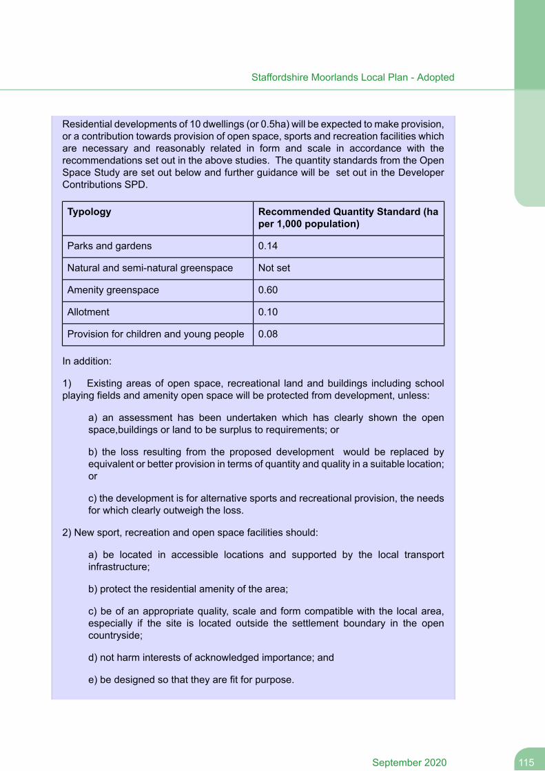
Residential developments of 10 dwellings (or 0.5ha) will be expected to make provision,or a contribution towards provision of open space, sports and recreation facilities whichare necessary and reasonably related in form and scale in accordance with therecommendations set out in the above studies. The quantity standards from the OpenSpace Study are set out below and further guidance will be set out in the DeveloperContributions SPD.
Recommended Quantity Standard (haper 1,000 population)
Typology
0.14Parks and gardens
Not setNatural and semi-natural greenspace
0.60Amenity greenspace
0.10Allotment
0.08Provision for children and young people
In addition:
1) Existing areas of open space, recreational land and buildings including schoolplaying fields and amenity open space will be protected from development, unless:
a) an assessment has been undertaken which has clearly shown the openspace,buildings or land to be surplus to requirements; or
b) the loss resulting from the proposed development would be replaced byequivalent or better provision in terms of quantity and quality in a suitable location;or
c) the development is for alternative sports and recreational provision, the needsfor which clearly outweigh the loss.
2) New sport, recreation and open space facilities should:
a) be located in accessible locations and supported by the local transportinfrastructure;
b) protect the residential amenity of the area;
c) be of an appropriate quality, scale and form compatible with the local area,especially if the site is located outside the settlement boundary in the opencountryside;
d) not harm interests of acknowledged importance; and
e) be designed so that they are fit for purpose.
115September 2020
Staffordshire Moorlands Local Plan - Adopted
3) Applications to improve the use and availability of existing outdoor sports andrecreation provision such as the creation of artificial grass pitches and introduction ofancillary facilities such as changing rooms, artificial surfaces or floodlighting will bepermitted provided that they :
a) are directly related to the needs of the facility and are proportionate in scale;
b) can be satisfactorily and economically serviced;
c) do not have an unacceptable impact on existing neighbours;
d) meet the above criteria for new sport, recreation and open space facilities; and
e) are acceptable in other respects e.g. design, landscape impact, not inappropriatein Green Belt
4) The Council will encourage securing community access to schools to maximise theuse of existing sports provision outside of the school day and the co-location ofcommunity infrastructure wherever possible.
Any of the above development should be consistent with the updated Open SpaceStudy, Playing Pitch Strategy and Indoor Sports Facilities Assessment and the guidancein the Developer Contributions SPD.
Green Infrastructure
7.109 Green Infrastructure is the network of green spaces and natural elements that liewithin and connect our towns, villages and countryside. It is the open spaces, waterways,gardens, woodlands, green corridors, wildlife habitats, street trees, natural heritage and opencountryside.
7.110 Green Infrastructure provides multiple benefits for the economy, the environmentand people. A high quality environment has a key role in delivering the spatial strategy. It isimportant for the quality of life of local residents and improves the perception andattractiveness of the area for visitors and investment. Green infrastructure also has a rolein our adaption to climate change and contributing to carbon neutral development.
7.111 Staffordshire Moorlands contains a wide range of existing and potential greeninfrastructure assets, which can benefit from a strategic approach to ensure adequateprotection is given to key features, to identify areas where new linkages and assets need tobe created and to guide and manage development which may impact on such areas. TheLocal Plan recognises the cross cutting function that green infrastructure has, and the benefitsof integrating green infrastructure with social and economic priorities, which will help contributeto the development of sustainable communities.
7.112 This policy is supported by a ‘Green Infrastructure Strategy’ which will seek to createfunctional and physical connectivity between green spaces, identify opportunities to provideadditional green routes, consider how land can help to alleviate flooding through providingstorage areas at times of flooding, consider opportunities to adapt to climate change andimportantly make recommendations for how new development should be designed and howit can contribute to the wider green infrastructure network.
September 2020116
Staffordshire Moorlands Local Plan - Adopted
7.113 The provision of green infrastructure is also recognised as benefiting biological andgeological resources. Defra has produced ‘Guidance for Local Authorities on ImplementingBiodiversity Duty’ which states ‘The creation and improvement of Green Infrastructure inurban and rural areas and the countryside in and around towns can help to deliver multiplebenefits for biodiversity, landscape, and health and recreation.' Sport England have producednew 'Active Design' (2015) guidelines to promote the role of sport and physical activity. TheTown and Country Planning Association (TCPA) have also produced guidance ‘Planning fora Healthy Environment – Good Practice Guidance for Green Infrastructure and Biodiversity'.Policy C 3 therefore sets out the Council's policy for developing an integrated network ofgreen infrastructure which is informed and supported by a Green Infrastructure Strategy.
Policy C 3
Green Infrastructure
The Council will, through partnership working with local communities, organisations,landowners and developers, develop an integrated network of high quality andmulti-functional green infrastructure that will:
a) Support and improve the provision of open space, sport and recreationalfacilities for local communities and enhance the settings of neighbourhoods;
b) Link existing and potential sites of nature conservation value and historiclandscape features, create newwildlife habitats, increase biodiversity, and increasetree cover where it is appropriate to the landscape;
c) Enhance the natural, man-made and cultural features that are crucial to thelocal landscape and create opportunities for the restoration of degraded landscapesand the enhancement of the urban fringe;
d) Mitigate the negative effects of climate change and maximise potential climatechange benefits including effective flood risk and waterways management;
e) Create appropriate access for a wide range of users to enjoy the countryside,including improved linkages to and provision of formal and informal recreationopportunities and accessible woodland areas, encouraging walking, cycling andhorse riding;
f) Contribute to the diversification of the local economy and tourist developmentthrough the enhancement of existing, and provision of new facilities.
The Council will identify, protect and enhance Green Infrastructure assets through theGreen Infrastructure Strategy.
117September 2020
Staffordshire Moorlands Local Plan - Adopted
7.7 Natural Environment
Natural Environment Policies
Spatial Objectives
SO9. To protect and improve the character and distinctiveness of the countryside andits landscape, biodiversity and geological resources.
Biodiversity and Geological Resources
7.114 Biodiversity enhancement has the potential to aid in addressing climate change byhaving more and better connected habitats, through providing valuable green infrastructureand helping reconnect people and nature, especially if local communities are encouragedto help establish or maintain new and existing habitats.
7.115 The District has a wealth of biological and geological resources many of which arestatutorily protected. Government guidance states that the planning system should contributeto and enhance the natural and local environment and local planning authorities should 'setout a strategic approach in their Local Plans, planning positively for the creation, protection,enhancement and management of networks of biodiversity and green infrastructure.' TheNPPF requires that distinctions are made between the hierarchy of international, nationaland locally designated sites. These sites are protected under separate legislation with ODPMCircular 06/2005 outlining how statutory obligations impact within the planning system andpolicy NE 1 will seek to reinforce their protection through the planning process. In additionthe 2006 Natural Environment and Rural Communities Act states that planning authoritiesmust in their Planmaking, have regard to the purpose of conserving biodiversity; and theCouncil will seek to produce net gains and enhance biodiversity having regard to theobjectives and priorities for the various ecosystems identified within the StaffordshireMoorlands in the Staffordshire Biodiversity Action Plan.
7.116 The Council published a number of Phase 1 Ecological Studies for potentialdevelopment sites across the District since 2015, which have been used as part of the siteallocations process. This evidence assessed not only the ecological / nature conservationcharacteristics presently on-site, but also those immediately adjacent and within 2km of thesite, including ancient woodland; and includes an assessment of 'local wildlife site' (LWS)criteria for each site, for the purposes of the NPPF.
7.117 The Staffordshire Moorlands Biodiversity Opportunity Map has been produced byStaffordshire Wildlife Trust in conjunction with other nature conservation bodies to highlightareas of biodiversity importance. The Map and associated objectives are published as partof the Council’s Green Infrastructure Strategy.
7.118 The policies map shows the concentration of significant nature conservation siteswithin and around the District, which includes Special Protection Areas, Special Areas ofConservation and Sites of Special Scientific Interest. The policies map also identifies thelocation of designated sites of international, national, regional and local biological andgeological importance and ancient woodlands.
September 2020118
Staffordshire Moorlands Local Plan - Adopted
Policy NE 1
Biodiversity and Geological Resources
The biodiversity and geological resources of the District and neighbouring areas will beconserved and enhanced by positive management and strict control of development(and having regard to relevant ecological evidence) by:
1. By ensuring all development schemes have regard to the surveys and actionsrecommended by the Council’s Extended Phase 1 Habitat Surveys and LocalWildlife Assessment, and include measures for protection and enhancement ofsite biodiversity and protection of any geodiversity as appropriate.
2. Resisting any proposed development that could have an adverse effect on theintegrity of an International site (or successor designation) alone or in combinationwith other plans or projects unless it can be demonstrated that the legislativeprovisions to protect such sites can be fully met. Any development with a potentialto adversely affect a European site/s through construction activities should ensurethat Ciria construction guidelines are followed including environmental good practiceon control of dust and water pollution.
3. The Council will not normally permit any development proposal which would directlyor indirectly (either individually or in combination with other developments) havean adverse effect on a Site of Special Scientific Interest. Where an adverse effecton the site's notified special interest features is likely, an exception should only bemade where the benefits of the development, at this site, clearly outweigh both theimpacts that it is likely to have on the features of the site that make it of specialscientific interest and any broader impacts on the national network of Sites ofSpecial Scientific Interest.
4. Conserving, and enhancing regional and locally designated sites. The Council willnot permit any development proposal which would directly or indirectly result insignificant harm to geological and biodiversity conservation interests, unless it canbe demonstrated that:
a) there is no appropriate alternative site available; and
b) all statutory and regulatory requirements relating to any such proposal havebeen satisfied; and
c) appropriate conservation and mitigation measures are provided; or if it isdemonstrated that this is not possible
d) the need for, and benefit of, the development is demonstrated to clearly outweighthe need to safeguard the intrinsic nature conservation value of the site andcompensatory measures are implemented.
5. Expecting all development where possible seeks to deliver a net gain in biodiversityproportionate to the size and scale of the development. In circumstances whereadverse impacts are demonstrated to be unavoidable, developers will be requiredto ensure that impacts are appropriately mitigated, with suitable compensation
119September 2020
Staffordshire Moorlands Local Plan - Adopted
measures towards loss of habitat used only as a last resort where there is noalternative. Where any mitigation and compensation measures are required, theyshould be appropriately scheduled and managed according to the nature, size andscale of the development so as to minimise impacts that may disturb protected orimportant habitats and species.
6. Supporting opportunities to improve site management and increase public accessto wildlife sites including supporting the objectives of the Staffordshire CountyCouncil Rights of Way Improvement Plan.
7. Ensuring development promotes the appropriate maintenance, enhancement,restoration and/or re-creation of biodiversity through its proposed nature, scale,location and design. The Staffordshire Moorlands Biodiversity Opportunity Map,in conjunction with the Staffordshire Biodiversity Action Plan, will be used to guidebiodiversity enhancement measures to be included in development proposals asappropriate to the nature and scale of development proposed and otherenvironmental interest, in particular supporting opportunities to increase grasslandand heathland habitats including supporting targets in the UK and StaffordshireBiodiversity Action Plan.
8. Protecting and enhancing habitats and species of principal importance for theconservation of biodiversity as identified in legislation, and recognising andimplementing appropriate measures, including landscape-scale conservationmanagement, to take account of the fact that the distribution of habitats and specieswill be affected by climate change.
9. Recognising the value of the natural environment for sport and leisure activitiesand the need to manage such activities to ensure there is no conflict.
10. Ensuring the provision and protection of green infrastructure networks in line withPolicy C 3.
Trees Woodland and Hedgerows
7.119 Woodlands, trees and hedgerows are important to both the quality of life andenvironment, and are essential to life. Trees will play a role in mitigating the effects of climatechange through carbon storage, flood mitigation and urban cooling; and encouraging andsupporting woodland creation helps to manage flood risk. They are also an important featurein creating a high quality local environment. The Case for Trees – Forestry commission,(2010) and 'Trees in Townscape', (2012) produced by the Trees and Design Action Group(TDAG) bring together research, case studies and policy background with regards to thebenefits of trees, particular in built up areas.
7.120 In January 2013 DEFRA published its Government Forestry and Woodlands PolicyStatement. This explains the Government's policy of seeking to protect, improve and expandexisting public and private woodland assets, to improve and restore native and ancientwoodlands, and to improve the biodiversity of woodlands. It states that increasing woodlandcover by 12% across England by 2060 is deliverable.
September 2020120
Staffordshire Moorlands Local Plan - Adopted
7.121 Trees will increasingly contribute to making our towns and built up areas moresustainable. As well as preserving what we have the Council will be considering what isrequired in new developments to reach a good level of sustainability. The CABE publication‘What makes an eco town? ‘ (2008) recommends that a canopy cover of at least 25 per centin residential areas and 15 per cent in mixed-use or commercial areas be achieved. A canopycover study will be undertaken by the Council to identify the existing tree cover and identifyappropriate canopy cover targets for the District.
7.122 The Council adopted its own Tree Strategy in 2016. This sets out the Council's aimsto create a sustainable, robust tree population in the District to protect existing trees, and topromote tree planting. This will also be taken into account in the consideration of individualdevelopment proposals; and with regards to the Council's Green Infrastructure Strategy.
7.123 Ancient woodlands are irreplaceable habitats. The Staffordshire Moorlands has anabove average ancient woodland resource (3.07%) compared to England as a whole (2.78%)(Woodland Trust 2018). Mature and ancient woodland are an essential part of the District'snatural capital and a significant source of biodiversity. Development can impact on ancientwoodlands in a number of ways including through pollution, disturbance, introduction of newspecies etc.Veteran trees are trees of special interest because of their history and longevityand may lie outside of ancient woodlands - these are also protected by the policy below.Planning for Ancient Woodland - Planners’ Manual for Ancient Woodland and Veteran Trees(October 2017) provides guidance and key recommendations for developments that mayimpact on these features. Native woodland is also a priority habitat within the StaffordshireMoorlands in the Staffordshire Biodiversity Action Plan.
7.124 In order to protect trees in the interest of amenity, particularly when they areconsidered to be at risk, the Council can make a Tree Preservation Order (TPO) meaningthe tree has special protection under the Planning Acts. The District Council has made over200 Tree Preservation Orders (TPOs) covering thousands of individual trees, and hundredsof ‘areas’, ‘groups’ of trees, and ‘woodlands’. This covers over 14% of the District’s area(including that in the Peak Park). Hedgerows also share some of the benefits of trees andwoodlands in terms of climate change mitigation, biodiversity, and health and wellbeing.Changes to farming practices in the 20th Century saw a decline in particular in the extent ofrural hedgerows. In 1997 regulations were enacted that protect all rural hedgerows over20m in length from removal without permission. This policy goes further by seeking to protectall hedgerows in the District affected by development.
7.125 The council will require that tree survey information in accordance with current BritishStandard 5837 - Trees in relation to Design, Demolition and Construction is submitted withall planning applications, where trees are present on site. The tree survey information shouldinclude protection, mitigation and management measures.
7.126 New developments will be required to ensure that any canopy cover lost within adevelopment site will be replaced and where these cannot be accommodated on site theCouncil will work with applicants to ascertain if a suitable site(s) can be found off-site forreplacement planting in the locality, sufficient to replace the canopy cover lost to accommodatethe development. In order to help maximise the chances of survival for replacement trees,developments should also ensure that a landscape implementation and management planreflecting current best practice is put in place.
121September 2020
Staffordshire Moorlands Local Plan - Adopted
Policy NE 2
Trees, Woodland and Hedgerows
The Council will protect existing trees, woodlands and hedgerows, in particular, ancientwoodland, veteran trees and ancient or species-rich hedgerows from loss or deterioration.
This will be achieved by:
Requiring that existing woodlands, healthy trees and hedgerows are retained andintegrated within a proposed development unless the need for, and benefits of, thedevelopment clearly outweigh their loss;
Requiring new developments to provide tree cover that secures a good level ofsustainability through tree retention, planting and soft landscaping, including wherepossible the on site replacement of any trees that are removed with sufficient treeplanting to replace or increase the canopy cover on-site as appropriate. Landscapingschemes will also be required to mitigate against negative landscape impact andcomplement the design of new development and make provision for futuremaintenance. Where it is not possible to secure this new or replacement treeplanting within the site, the Council will work with applicants to ascertain if a suitablesite(s) can be found off-site for replacement planting in the locality;
Resisting development that would directly or indirectly damage existing ancientwoodland, veteran trees and ancient or species-rich hedgerows.
The Council will refer to its adopted Tree Strategy in the consideration of proposals;and will in general seek to retain as many trees and as much hedgerow on site aspossible.
7.8 Transport
Spatial Objectives
SO11. To reduce the need to travel or make it safer and easier to travel by moresustainable forms of transport
Development and Sustainable Transport
7.127 Reducing the need to travel, and reducing the reliance on the car is a well establishedplanning principle stemming from concerns at combating climate change (reducing vehicularemissions) and of addressing social equity (ensuring physical accessibility to all sections ofsociety). The Integrated Transport Strategy for Staffordshire Moorlands prioritises transportmeasures that are required to deliver the Local Plan.
September 2020122
Staffordshire Moorlands Local Plan - Adopted
7.128 It is considered that there is potential in influencing modal shift away from the carin Staffordshire Moorlands in two respects - by targeting public transport improvements alongthe main corridors connecting the Moorlands with the Stoke-on-Trent conurbation; and bypromoting walking, cycling and public transport within and between local settlements. Thiswill also help to support healthy, inclusive and sustainable communities as well as reducingthe impacts of travel. The Council's Development Capacity Studies have examined theaccessibility of the main settlements in the District using the existing transport networkincluding public transport and this has informed the development approach and identificationof development areas. However, it is important that strategic planning decisions are notpurely based on the location of existing sustainable transport infrastructure. For this reasonthe proposed policies are proactive in seeking improvements to the existing network.
7.129 Policy T 1 reflects national transport planning policy in the NPPF which seeks todeliver a system that supports sustainable transport through the integration with land useplanning at all levels, so that transport and planning work together to support more sustainabletravel choices and reduce the need to travel. However the NPPF also drives for theexpeditious delivery of necessary development, and is therefore clear that proposals shouldonly be refused on transport grounds alone, where residual cumulative impacts ofdevelopment are 'severe'. Reducing the need to travel, and reliance on the car, is linked tosocial equality, through making developments equally ‘accessible’ to all sections of society.The Policy aims to benefit not only work-related travel but also that for shopping, leisure andrecreation etc. In the case of existing major developed areas in the countryside (Policy SS10 Part(4)); these may have non-accessible locations but represent an opportunity to achieveplanning benefits such as environmental improvements and economic benefits. Such schemeswill therefore be treated on their merits having regard to all applicable policies.
7.130 The approach embodied in this policy will seek to manage travel demand in aneffective and sustainable way, while improving the range of choice and responding to theneeds of residents, workers and visitors.
7.131 The Council will continue to work closely with the Highway Authority to ensure thecoordination of proposals within the Local Plan and the priorities of the Staffordshire MoorlandsDistrict Integrated Transport Strategy. The location of development and the way thatdevelopment is carried out are important factors in helping achieve the priorities of theIntegrated Transport Strategy. In the case of proposals affecting the trunk road, there willbe close involvement with Highways England (formerly the Highways Agency) such that itcan undertake its duties as set out in DfT Circular 2/13 Strategic Road Network and Deliveryof Sustainable Development. Choices about where new housing and employment uses arelocated for example, and patterns of travel that result, will be important factors in helping toreduce reliance on the private car. Encouraging alternative forms of travel and securingaccess to the most sustainable modes of travel such as public transport, walking or cycling,represent approaches which aim to help achieve a new balance between non-motorisedtransport, public transport and private car use. Staffordshire County Council’s Rights of WayImprovement Plan assesses the quality and extent of the existing network of rights of way,permissive ways, bridleways, cycle tracks, greenways etc across the County; includingnon-definitive routes. This network enables people to access employment and facilities bya sustainable mode of travel so the ROWIP identifies the changes required to the networkto improve provision for all users. Applicants should consider how their schemes can alsocontribute to this network (for example through creation of local bridleways; upgrading offootpaths etc).
123September 2020
Staffordshire Moorlands Local Plan - Adopted
7.132 This approach also reflects the aims of the Council’s Sustainable Community Strategyand the Corporate Plan priorities to promote improved health and protect the environment.The Council will aim to ensure as far as possible, development minimises traffic problemsand maximises the potential benefits of accessibility and new infrastructure to the widercommunity.
7.133 The Government issued a ministerial statement in 2015 which stated arbitraryparking standards that restrict off-street parking (such as maximum standards), should notbe applied when assessing planning proposals, without compelling justification. Therefore,the Council will consider the appropriateness of proposed off-street parking in schemes, ona case by case basis, after (where appropriate) having consulted with SCCHighways Officer(and Manual for Streets (2007)/Manual for Streets 2(2010)), rather than referring to formallylaid out standards. However the Council has, after consultation with SCC Highways Officer,published recent guidance to accompany this Local Plan which suggests 'minimum' provisionof spaces, depending on use class; these are set out in Appendix 2 of the Local Plan.
7.134 The Council has a statutory responsibility to consult various organisations beforedetermining planning applications (depending on the scale and impact of the proposals) aslaid out in the Development Management Procedure Order. For example the Council mustconsult Highways England, Staffordshire County Council as Highways Authority, or NetworkRail for proposals which would have an impact upon trunk roads, local roads, or the railnetwork, including railway level crossings (respectively). It is also important that major newdevelopments help to mitigate any adverse impacts they may otherwise have on transportand travel. Transport Assessments are required to be prepared where any application wouldhave significant transport implications (in line with DfT’s former Guidance on TransportAssessment (March 2007), in consultation with the Highways Authority, so as to determinenecessary mitigation measures. Where appropriate, S106 planning obligations, or anyadopted Community Infrastructure Levy, will be used to ensure that such developmentsprovide for related transport improvements and fund other appropriate mitigation measures.This may also require developers to fund any qualitative improvements required in relationto existing facilities and infrastructure as a direct result of increased patronage resulting fromnew development. Further details regarding potential access and sustainable transportrequirements for individual site allocations are set out in this Plan.
Policy T 1
Development and Sustainable Transport
The Council will promote and support development which reduces reliance on the privatecar for travel journeys, reduces the need to travel generally and accommodates residualdevelopment traffic in line with the Integrated Transport Strategy. This will be achievedby:
1. Ensuring that all new development is located where the highway network cansatisfactorily accommodate traffic generated by the development or can be improvedas part of the development.
2. Ensuring that major development is located in areas that are accessible bysustainable travel modes or can be made accessible as part of the proposal.
September 2020124
Staffordshire Moorlands Local Plan - Adopted
3. Considering appropriate parking provision on a case by case basis with recourseto the parking guidance set out in Appendix 2.
4. Where appropriate all new development shall facilitate walking and cycling withinneighbourhoods and town centres, and link with or extend identified walking orcycling routes. In addition applicants should also consider how their schemescan enhance the existing path network in line with the Staffordshire County CouncilRights of Way Improvement Plan and also give consideration to the protection ofnon-definitive public footpath routes in addition to definitive routes.
Development which generates significant demand for travel or is likely to have significanttransport implications (as identified within a Transport Assessment) will, whereappropriate:
Contribute to improved public transport provision
Contribute to junction improvements, traffic management and highway infrastructure
Provide proactive facilities and measures to support sustainable transport modesincluding on-site features to encourage sustainable travel methods e.g. cycle pathlinks, cycle storage facilities, bus stops etc
Provide and actively promote travel plans.
Other Sustainable Transport Measures
7.135 The Integrated Transport Strategy prioritises the allocation of funding streams inaccordance with shared transport objectives and the Local Plan must decide broadly wherefuture population is distributed and ensure that the transport network is able to sustain it. Itis important therefore that strategic planning decisions are not purely based on the locationof existing public transport infrastructure, or predicted locations of funding. For this reasonPolicy T 2 is proactive in seeking improvements to the existing road/bus/rail networksgenerally. The Council will work with the highway authority to exploit opportunities for highwayimprovements. If they are feasible and subject to available finances, they will be included inboth the Infrastructure Plan and Integrated Transport Strategy.
7.136 A major issue for the District has been the inadequacy of the alternative modes oftravel and in particular the public transport system. Whilst there is an extensive network ofbus routes, with many settlements having daily bus links and a call-on-demand MoorlandsConnect service, the Development Capacity Study found that the frequency and accessibilityto these services can be limited, particularly in the rural areas.
7.137 The District also benefits from a network of legally recognised (and other) publicrights of way, including footpaths, bridleways and cycle routes which links the towns andvillages to the wider countryside. For example a number of National Cycle Network routesrun throughout the District. The Council will ensure that all legally recognised public rightsof way affected by development are protected (or diverted where necessary) and, wherepossible, enhanced.
125September 2020
Staffordshire Moorlands Local Plan - Adopted
Policy T 2
Other Sustainable Transport Measures
In line with priorities set out in the NPPF and the Integrated Transport Strategy, andthrough working with partner organisations, the Council will encourage and supportmeasures which promote better accessibility, create safer roads, reduce the impact oftraffic, or facilitate highway improvements. In particular, the Council will:
1. Support, subject to feasibility assessment, strategic infrastructure improvementsand links to major urban areas for example to road, rail, bus facilities in the District andthe development of new rail or bus termini within the District.
2. Continue to safeguard all existing disused railway lines within the District and supportthe reuse of these for public or commercial/tourism use. To this end the Council willrefuse any development which would impede or truncate these routes. Howeverproposals for recreational routes, cycleways, bridleways etc will generally be acceptable.
3. Work with its partners to promote the improvement/expansion of existing busservices and the provision of sustainable transport services in the District, particularlythose serving rural areas.
4. Support and promote the development of a network of safe walking, horse ridingand cycling routes (including the National Cycle Network), connecting to public transport,linking communities and recreational/tourist areas. The Council will also ensure that alllegally recognised public rights of way affected by development are protected (or divertedwhere necessary) and, where possible, enhanced.
5. Seek to minimise the environmental impact of freight road transport and to workwith Staffordshire County Council and other partner organisations to agree designatedlorry routes, freight handling facilities and greater rail use.
6. Support development proposals which encourage electrical battery poweredvehicles.
September 2020126
Staffordshire Moorlands Local Plan - Adopted

Site Specific Policies
127September 2020
Staffordshire Moorlands Local Plan - Adopted
8 Site Specific Policies
8.1 This Chapter provides additional policies for specific sites or clusters of allocateddevelopments sites that are of strategic importance to the Local Plan and/or require bespokepolicy to shape the development in an appropriate manner.
8.2 Each allocated site will be assessed against other policies of the plan including:
Affordable housing policy in accordance with Policy H 3;Flood risk policy in accordance with Policy SD 5;Infrastructure contributions in accordance with Policies SS 12 and C 1;Sport, Recreation and Open Space policy in accordance with Policy C 2;Heritage in accordance with Policy DC 2;Sustainable Transport policy in accordance with Policy T 1;Prevention of pollution in accordance with Policy SD 4;Conserving biodiversity and geodiversity in accordance with Policies NE 1 and NE 2;Retail and other town centre uses outside town centres in accordance with Policy TCR3; andGreen Infrastructure in accordance with Policy C 3.
8.1 Leek
Land at Horsecroft Farm
8.3 This is a small greenfield site lying immediately adjacent to the Leek developmentboundary to the northeast of the town.
8.4 The School Organisation Team at Staffordshire County Council have indicated thatadditional school places are required at the Middle School Level to meet the needs of newhousing development proposed in Leek. Churnet View Middle school located adjacent tothe Horsecroft Farm site, is one of only two middle schools in Leek (along with St EdwardsChurch of England Academy Middle School) and options to expand school buildings withinthe school site are limited. It is therefore proposed to provide some additional land for theschool within this site; however the site is large enough to provide an element of housing inaddition to this.
8.5 A track in ownership of Churnet View MIddle School running to Wardle Barn Farmseparates the Churnet View School from the Horsecroft Farm site. SCC Highways haveindicated that access via this track is acceptable through the Nightingale Estate (TittesworthAvenue), subject to access design. It is feasible that a mixed use scheme could be accessedeither via the current school track; or using land at Horsecroft Farm instead. The Councilwould also view favourably proposals that consolidate the additional school land with thecurrent school site, and consideration should be given to new alignment of this track toaccommodate this.
8.6 The Council's Environmental Health Team have advised that there may be constraintson development due to possible ground gas (methane and carbon dioxide) from nearbylandfill(s). Investigation would be required.
September 2020128
Staffordshire Moorlands Local Plan - Adopted
8.7 The Council's Landscape, Local Green Space and Heritage Impact Study considersthe site to be high landscape sensitivity. Development of this site will have to incorporate acomprehensive landscaping plan to ensure that any adverse landscape impacts areminimisedas far as possible.
8.8 The SCC Lead Local Flood Risk Officer has indicated that there may be a watercourseflow route to north of site; therefore recommends that a site-specific flood risk assessmentshould be submitted with any proposal.
8.9 The Extended Phase 1 Habitat Surveys and Local Wildlife Assessments alsorecommend a number of ecological surveys are undertaken (including survey of the peripheralhedgerow habitat to establish potential SBI (Site of Biological Importance)/BAS (BiodiversityAlert Site) status) and that any vegetation is removed at the appropriate time of year.
8.10 Developer contributions for affordable housing and infrastructure will be required asappropriate.
Policy DSL 1
Land at Horsecroft Farm, Leek (ADD01)
Land amounting to 0.89ha is allocated for a mix of uses including housing (approximately15 dwellings) and D1 education.
Development will be subject to compliance with other relevant Local Plan policies andinclude:
access arrangement via Tittesworth Avenue and consider re-alignment of the trackso that an extension to the school could be consolidated into the existing schoolsite; anda landscaping plan including submission of landscape and visual impactassessments and mitigation of heritage impact; in particular schemes shouldincorporate heritage masterplanning to include mitigation measures including theuse of vegetation screening to reduce effects on the setting of heritage assets.Proposals should also consider landscaping to form a new settlement edge.
Land at the Mount
8.11 This is a series of separate fields lying immediately adjacent to the developmentboundary or built up area of Leek on its eastern side, along Mount Road. Access to MountRoad is possible via Buxton Road, Kniveden Lane or Ashbourne Road.
8.12 Staffordshire Council Highways advise that development in this area should contributeto the improvement of Mount Road including provision of footways and pedestrian links. AlsoKniveden Lane should be brought up to adoptable standard with the implementation offootways. Further junction improvements at Mount Road/ Ashbourne Road may also beappropriate. Given the interconnection of these sites it may be considered appropriate toconsider highway improvement works holistically; the Council will encourage applicants towork with the Council and other landowners on joint funding arrangements to coordinatecontributions. Proposals should recognise the informal recreational value of the Mount by
129September 2020
Staffordshire Moorlands Local Plan - Adopted
pedestrians, cyclists etc. and consider scope for measures which allow for its continued usesuch as sympathetic highways engineering solutions where appropriate. Developers arealso encouraged to have regard to Active Design principles as set out in Sport EnglandOctober 2015 guidance.
8.13 The School Organisation Team at Staffordshire County Council have indicated thatan equivalent of at least 1 new first school should be provided within Leek during the LocalPlan period to take into account the number of dwellings required; and request that land tothe east of the town be safeguarded for this purpose. Policy DSL 2 provides for this.
8.14 The Council's landscape evidence indicates that the various sites around the Mountvary between low, to medium, to high landscape sensitivity. Development of sites shouldinclude appropriate landscape mitigation measures such as advanced planting andlandscaping along eastern boundaries, and limited building heights.
8.15 The Extended Phase 1 Habitat Surveys and Local Wildlife Assessments alsorecommend a number of ecological surveys are undertaken (including polecat surveys, batsurveys, further bat survey of trees, to establish potential SBI/BAS status on parts of thesite) and that any vegetation is removed at the appropriate time of year.
8.16 In 2013 a wind turbine was allowed at Kniveden Farm a short distance south of theMount, with a noise condition attached based on Energy Technology Support Unit (ETSU)criteria to control noise emissions that may impact nearby residents. Consequently, theEnvironmental Health officer advises a site-specific noise assessment should be submittedfor any scheme at the Mount to ensure that noise emissions upon future occupiers wouldbe within acceptable ETSU limits, and to guide site layout generally
8.17 Developer contributions for affordable housing and infrastructure will be required asappropriate. As the site is in multiple ownerships, owners will be encouraged to enter into aLand Equalisation Agreement to ensure an equitable distribution of benefits to landowners.
Policy DSL 2
Land at The Mount, Leek (LE066, LE128a&b, LE140, LE142a, LE142b)
Land amounting to approximately 10.62ha as shown on the policies map is allocatedfor housing (approximately 345 dwellings); and 0.76 ha for D1 education.
Development will be subject to compliance with other relevant Local Plan policies andwill require a comprehensive masterplan with indicative phasing programme to include:
a landscaping plan including submission of landscape and visual impactassessments and mitigation of heritage impact. Proposals should considerlandscapemitigation measures including advanced planting and landscaping alongeastern boundaries; limited building heights where appropriate; and consider scopefor retaining/ integrating existing landscape features, including those on site ofKniveden Hall; and
September 2020130
Staffordshire Moorlands Local Plan - Adopted
recognition of the informal recreational value of the Mount to the community andreflect this in masterplanning proposals through the sensitive treatment of MountRoad and Kniveden Lane, appropriately located green infrastructure, recognitionof key views and connectivity to public rights of way; and
a site-specific noise assessment to guide layouts and ensure that the amenitylevels of future occupants are acceptable in relation to wind turbine noise.
Land for a new first school shall be safeguarded as identified on the policies map, orsimilar location, if forming part of a mixed education and residential development.
Development proposals on the allocations listed above, shall be expected to contributeto highway or junction improvements in this area, as deemed necessary by the CountyHighways Authority to address the cumulative impact of the wider developments alongMount Road.
Land at Newton House
8.18 This site is the former Britannia/Coop headquarters located off a purpose builtroundabout to the east of the A520 at Cornhill, on the edge of the Leek town boundary. TheCouncil needs to provide additional employment land in the Leek area (about 7.12ha), inaddition to new housing, to 2033.
8.19 This 9.27ha brownfield site provides an opportunity to comprehensively redevelopfor mixed residential and commercial purposes; the Council considers that this could yieldat least 5.25ha for residential use (about 179 dwellings), and at least 1.5ha employmentland. The nature and location of employment uses across the site would need to take accountof the amenity of adjacent housing. The site is closely related to the adjacent 'Cornhill East'site, which is itself the subject of a detailed Masterplan for mixed use redevelopment [seePolicy DSL 4 below]. The Council considers it appropriate to identify additional employmentland for Leek across a range of locations, with good access to main roads such as the A520,to provide choice in locations around the town, to at least meet its residual employment landrequirement.
8.20 Staffordshire County Council Highways advise that proposals would need to assessimpact on the existing access roundabout onto the A520 and local traffic impacts, andschemes must demonstrate access onto this roundabout. Also footway links connecting ontothe A520 should be provided and cycle facilities should be considered.
8.21 The School Organisation Team at Staffordshire County Council have indicated thatdevelopment of this and other sites would add to the existing pressure for first school placesin this area (therefore recommend the safeguarding of a site for a new first school in the eastof the town).
8.22 The Council's landscape evidence indicates that whilst the site overall is of lowlandscape sensitivity the southeast corner is more visually prominent and should ideallyremain undeveloped. Development should be concentrated in the north of the site wherevisual prominence is lowest; and existing trees and landscaping should be retained wherepossible.
131September 2020
Staffordshire Moorlands Local Plan - Adopted
8.23 The Council's ecological evidence also indicates the proximity to Ballington Wood tothe immediate east which is both an ancient woodland and (County-level) Site of BiologicalImportance at this location. It therefore has the potential for certain species such as badgerand newt to forage on the site. In addition to taking account of this ecological evidence(requirements for pre-development surveys), the policy also expects incorporation of a wildlifebuffer in design schemes between the allocation and the woodland to the east.
8.24 There are tennis courts on the site which would be subject to protection under PolicyC 2. Developer contributions for affordable housing and infrastructure will also be requiredas appropriate.
Policy DSL 3
Land at Newton House, Leek (LE150)
This site amounting to around 9.27ha is allocated for mixed residential and employmentuse. Approximately 5.25ha of the site should be dedicated to residential use(approximately 180 dwellings) and 1.5ha of the site area should provide for B-Classemployment purposes; mixed use proposals must demonstrate how the amenity ofhousing will be maintained around employment uses.
Development will be subject to compliance with other relevant Local Plan policies andwill require a comprehensive masterplan with indicative phasing programme to include:
heritagemasterplanning; mitigationmeasures against adverse effects upon heritageassets which should include stepping development back and using vegetationscreening along the south-western edge of the site;
demonstration of how the southeast corner of the site should remain undevelopedto minimise landscape impacts;
schemes must demonstrate the incorporation of a wildlife 'buffer' along the easternedge of the site for ecological protection, to the satisfaction of the Council.
appropriate contributions to improved pedestrian and cycle links from the site; and
retention of the existing tennis courts on the site unless alternative facilities areprovided on or off-site in accordance with Policy C 2.
Land at Cornhill East
8.25 Policy SS 3 of the 2014 Core Strategy identified a residual employment landrequirement for Leek (to 2026) and identified the Cornhill East area as 'Broad Area EM1' asa "Major Regeneration Opportunity" for future employment allocation (dependent on theneed for further employment land provision across the town). Further to the NLP studyfindings, the Council considers it appropriate to identify additional employment land for Leekacross a range of locations, with good access to main roads such as the A520, to providechoice in locations around the town, to meet its residual employment land requirement inconjunction with future employment windfalls across the town. The SS 3 Policy stance isretained under Local Plan Policies SS 3 and SS 5 (but up to 2033).
September 2020132
Staffordshire Moorlands Local Plan - Adopted
8.26 In 2014 the Council adopted the Churnet Valley Masterplan to guide developmentproposals within this Valley, which is considered to extend from Rushton Spencer/BlackshawMoor in the north, to Alton in the southeast, and including Leek town. The terminus of thedisused Churnet Valley railway line from Leekbrook at Cornhill in the south of the town (whereit meets Caldon Canal) is identified as a tourism 'gateway' into the town, and the widerCornhill area encompassing Barnfields industrial estate to the A52 to the west, as far as theland east of the railway line but west of Britannia House premises is identified as an'opportunity site' for commercial/ residential/ tourism redevelopment, with concept plan. Asper Leek Strategic Spatial Policy SS 5, it also supports a potential link road route in betweenA53 and A520 to allow easier access across the southern side of the town, and to relievepressure on Junction Road.
8.27 In 2015 the Council approved a major redevelopment scheme on the Cornhill areawest of the railway line, to accommodate residential, commercial and tourism-related uses(including boating marina, railway station and pub/restaurant); crucially this scheme reservedland for a link road to enable continuation east across the railway line to the Britannia Housejunction with A520.
8.28 The site includes Birchall Meadow 'Biodiversity Alert Site' (ie contender- SBI site) tothe south west corner covering around 1.12ha, which the Masterplan proposes beredeveloped. Given the sensitivity of this area the Council commissioned further detailedecological work for the whole Cornhill East site in late 2016, to make any recommendationsregarding the status of the BAS, appropriate ecological compensatory measures in the eventof its loss, and general recommendations for the whole Cornhill East site. This study isavailable on the Council's website. The Council's existing natural environment policies andthe NPPF expect that loss of such sites would require appropriate mitigation/compensation;therefore this is a requirement of the policy. The nature and location of employment usesacross the site would also need to take account of the amenity of adjacent housing.
8.29 Staffordshire Council Highways advise that access to the site must (whether or notvia link road) be onto the existing roundabout junction onto A520, not via Sandon Street.Connectivity measures for pedestrians and cyclists into the town centre may also beappropriate.
8.30 The School Organisation Team at Staffordshire County Council have indicated thatdevelopment of this and other sites would add to the existing pressure for first school placesin this area (therefore recommend the safeguarding of a site for a new first school in the eastof the town).
8.31 The Council's landscape evidence indicates that the site is of low landscape sensitivityand that development of the site, with planting on its southern boundary, could strengthenLeek's southern boundary and reduce visual prominence. Redevelopment schemes shouldhowever have regard to the changing aspects north to south across the site.
8.32 Developer contributions for affordable housing and infrastructure will be required asappropriate. As the site is in multiple ownerships, owners will be encouraged to enter into aLand Equalisation Agreement to ensure an equitable distribution of benefits to landowners.
133September 2020
Staffordshire Moorlands Local Plan - Adopted
Policy DSL 4
Cornhill East, Leek (LE235)
This 3.13ha site is allocated for comprehensive redevelopment for mixed employmentand residential purposes. Schemes should have regard to the adopted Churnet ValleyMasterplan, development proposals should support approximately 50 dwellings as partof a mixed use scheme also incorporating at least 0.83ha B-Class employment; andmixed use proposals must demonstrate how the amenity of housing will be maintainedaround employment uses.
Development will be subject to compliance with other relevant Local Plan policies andwill require a comprehensive masterplan with indicative phasing programme to include:
provision for any transport infrastructure improvements having regard to the ChurnetValley Masterplan; schemes should enable provision for a link between the A520and A53 to the south of the town and links to the canal and Churnet Valley railway;and
demonstrate acceptable access arrangements to the site which must not be directlyserved off Sandon Street;
in the event of proposals affecting Birchall Meadow BAS, appropriate mitigation /compensation measures will be required.
8.2 Biddulph
Wharf Road Strategic Development Area
8.33 This is a key mixed use development site in the Local Plan. It is in a sustainablelocation close to the town centre and lies outside the Green Belt. It presents an opportunityto comprehensively plan for a range of uses to make a significant contribution to Biddulph'sdevelopment needs over the plan period. There are opportunities to provide improvedpedestrian and cycle linkages with the town centre and with the adjacent Biddulph ValleyWay for access to the wider countryside.
8.34 The Employment Land Requirement Study was completed in July 2014 and updatedin February 2017. The study reviewed a range of economic factors, projections relating tothe performance of different sectors of the local economy and the working age population.The 2017 update concluded that 14 to 32ha of additional employment land was required forStaffordshire Moorlands for the period 2014 to 2033. An employment land requirement of32ha is recommended being at the top end of this range, to dovetail with a housingrequirement of 320 homes per year (relating to the level required to support projected increasein jobs). The majority of the residual requirement in Biddulph (over and above the land stillavailable at Victoria Business Park) has been split over 2 sites - Wharf Road and TunstallRoad (opposite Victoria Business Park) in conjunction with a small number of windfalls acrossthe town. The Council considers this approach appropriate to cater for businesses who need
September 2020134
Staffordshire Moorlands Local Plan - Adopted
a location close to the town centre as well as businesses who wish to locate on a largerbusiness park. The type of employment use to be located at Wharf Road is dependent uponhow this integrates with other land uses and will be determined as part of the masterplan.
8.35 The Council's Retail Study (2013) recommends the allocation of a site to accommodatea discount foodstore (a standard sized store of around 1,000m2 (net sales) is recommended)to claw back some of the 45% of residents who still shop out of town for their main foodshopping. Note that this is a qualitative rather than quantitative need. The study identifiesoutflow to mainstream and discount foodstores and explains that a discount store wouldprovide the local population with more choice as there is a lack of such a facility in the townat present. The study advises that any new store would have to be sustainably located sothat linked trips to the town centre can still be achieved.
8.36 The school playing field included in the allocation is in use and is proposed for retentionin situ.
8.37 Housing density calculations reflect the results of the Wharf Road StrategicDevelopment Area Concept Masterplan. Market demand was tested, including suitabledensities which could be accommodated on the site. Consequently, it was found that morehousing (+109 dwellings) could be accommodated on the site than originally anticipated.This is reflected in the policy.
8.38 The Council's Landscape, Local Green Space & Heritage Impact Study (2016) makesrecommendations to mitigate landscape and heritage impact which the developer shouldadhere to. This study covers the land between the bypass and Biddulph Valley Way as wellas land at Beehive Farm. Assessment of the land between Beehive Farm and the roundaboutcan be found in a later document dated October 2017. Landscape sensitivity across the sitearea varies with low impact to the east of the bypass, in and around the former MeadowsSchool and on land around the telephone exchange. Most of the site has medium landscapesensitivity including the area immediately to the east of the Biddulph Valley Way (BVW).The landscaping plan should reflect the study by including additional advanced planting onthe ridge and along the boundary with the BVW and screening in the south-eastern part ofthe site. The large mature tree adjacent to the telephone exchange access point needs tobe retained. Landscaping should be used as a buffer between the residential and employment/ retail development. Development of land between Tunstall Road and the bypass providesan opportunity for urban greening along the Tunstall Road frontage and buffer planting forvisual and noise purposes along the bypass boundary. Submission of landscape and visualimpact assessments alongside any planning application will be necessary.
8.39 There is a cluster of heritage assets within and immediately adjacent to the southeastern boundary. Most of these are listed buildings associated with the property known as'Fairhaven' which is currently occupied by the Roaches School. There are two Grade IIListed Buildings in the site and five additional Grade II Listed Buildings within the 400m bufferused in the study. As a consequence, mitigation must take place to include settingdevelopment back from the assets coupled with landscape masterplanning to providescreening. Historic England requires an assessment of how the setting of the Listed Buildingscontributes to their significance and this must be undertaken to inform any development.
8.40 The Council's Environmental Health department has advised that air quality issuesof future occupants of the housing can be avoided by careful site design to avoid placinghousing too close to the bypass.
135September 2020
Staffordshire Moorlands Local Plan - Adopted
8.41 This area, along with many others around Biddulph, has a mining legacy. The CoalAuthority has advised that new development should recognise the problems and how theycan be positively addressed. They consider that mining legacy is not always a completeconstraint and new development can address issues making it safe, sustainable and stable.The mining legacy of this site will not prevent development but detailed site investigationwork must take place to inform site design. A developer will therefore need to undertakeintrusive site investigations to locate these mine entries and determine their current conditionfollowed by undertaking consequential treatment. Any layout would then need to try andlocate the mine entries within landscaping belts, open space, roads etc. The developer mustensure that no development takes place over mine entries even when treated. Mine entriesare positioned parallel to the BVW so this land could potentially be integrated into openspace providing a buffer between the BVW and new development. As the site is likely to bedeveloped in phases, any parts of the site not affected by mining legacy could be commencedearlier than those which require detailed investigations (subject to policy objectives beingmet and delivery of the wider development area not being undermined).
8.42 A watercourse runs through the middle of the site, which the Lead Local FloodAuthority would like to see preserved to contribute towards Water Framework Directiveobjectives. This may take up space within the site, however it may be possible to divert thechannel round the edge to create more developable space. The Environment Agency shouldbe contacted by the developer at an early stage to discuss this issue. The EnvironmentAgency also requires a Preliminary Risk Assessment of controlled waters to identify anycontamination issues and advises that the developer has regard to the relevant River BasinManagement Plan. The Lead Local Flood Authority would like to see a Flood RiskAssessment of the whole site undertaken by the developer prior to any development takingplace. Any application submission will also be required to include a holistic site wide drainagestrategy for foul and surface water which considers how the site will be developed in variousphases andmost likely by various developers over a number of years. The drainage strategyshould clearly demonstrate how the drainage in earlier phases of development interact withthe wider phases of development and how the approach to foul and surface water drainagetakes account of the flows from later phases of development. Given the availability of anon-site watercourse, only foul flows should be connected to the public sewerage system.Surface water should also be managed by sustainable drainage features. Applicants shouldnote that the site includes large public sewers which cannot be built over. Applicants shouldengage in early pre- application dialogue with the respective water and wastewaterundertakers. The current wastewater undertaker for the area is United Utilities. Options forincorporating the undevelopable land into the Green Infrastructure for the site should beinvestigated.
8.43 County Highways has stated that development of this site is acceptable in principlesubject to suitable access design and a Transport Assessment. They require site access tothe sites on the east side of the bypass to be gained from Tunstall Road and not the bypass.
8.44 The Council's Environmental Health department has advised that there is possiblelandfill in the North West of the site which the developer would need to investigate. Alsoinvestigation will be required to determine whether any minor contamination from previoususes has occurred on the brownfield parts of the site e.g. the possibility of minor contaminationon the land which was formerly Jacksons Nursery due to possible pesticide use.
8.45 There is ecological interest on the site and comprehensive survey work will need tobe carried out at an early stage. Recommendations for survey work are set out in theCouncil's 2015 Phase 1 Habitat Survey and its 2016 Local Wildlife Assessment work (for
September 2020136
Staffordshire Moorlands Local Plan - Adopted
land between the bypass and the Biddulph Valley Way as well as land at Beehive Farm).The Extended Phase 1 Habitat Survey (September 2017) covers land between BeehiveFarm and the roundabout. All of this survey work must be undertaken. This includes a batsurvey for all buildings and trees with potential to support roosting bats, a reptile survey, ahedgerow survey following modified HEGS (Hedgerow Evaluation and Grading System)methodology, vegetation removal at the appropriate time of the year, assessment of thetrees for location, quantity, age and size and a detailed vegetation survey to determine thestatus of the habitat mosaic, particularly in the central part of the site, sensitive mowingregime of grassland and leaving rough margins, hedgerow planting of native woody speciesand management during winter, PSYM pond survey, presence / absence survey for greatcrested newts and removal of Himalayan balsam. All the surveys listed are not required onevery part of the site. The developer should refer to the Ecology Studies to identify whichparts of the site require which type of survey. This work will also establish the SBI / BASstatus of parts of the site.
8.46 The County ecologists point out that the north of the site is adjacent to, or overlapswith a Biodiversity Alert Site. With this in mind they state that design and layout should avoidimpacts on this site, it should be enhanced where possible and linear habitat connectivityshould be maintained.
8.47 Natural England have pointed out that a number of sites are located close to and/oradjoining existing areas of open space and green infrastructure and will need to includesuitable multi-functional green infrastructure. The Council has prepared a Green InfrastructureStrategy (GIS). This site borders the Biddulph Strategic Corridor, comprising the BiddulphValleyWay. The GIS aims to protect and improve the Biddulph ValleyWay as an establishedgreenway through the settlement, to increase its use and enjoyment by people for healthand recreation and to enhance its function as a wildlife corridor. Development of this areashould positively contribute to this aim including the provision of pedestrian and cyclinglinkages from the site to the BVW and investigation of opportunities to reduce habitatfragmentation and increase connectivity by helping to create and improve wildlife corridorsextending into the surrounding countryside.
8.48 Any public rights of way crossing the sites should be protected and, where possible,enhanced in conjunction with any development. It is accepted that diversions may berequired. The existing rights of way at the time of writing are the Biddulph Valley Way, andalong the old Wharf Road, (the northern boundary of the area).
8.49 As the site is in multiple ownerships, owners will be encouraged to enter into a LandEqualisation Agreement to ensure an equitable distribution of benefits to landowners. Asthe site is likely to be developed in phases, following the masterplanning process, earlyapplications for development on part of the site that would make a positive contribution tothe policy objectives and facilitate the delivery of the wider development area would beacceptable.
Policy DSB 1
Wharf Road Strategic Development Area (BD055, BD071, BD071a, BD106, BD156,BD076, BD076a, BD108, BD016, BD104)
Land amounting to around 18.5ha is allocated for amix of uses comprising approximately:
137September 2020
Staffordshire Moorlands Local Plan - Adopted
Housing 15.5ha (approximately 442 dwellings);
Employment 1ha;
Retail 0.5ha (food store of around 1000m2 net sales floor space);
Retention of School Playing Field 1.5ha.
Development will be subject to compliance with other relevant Local Plan policies anda comprehensive master plan with indicative phasing programme to include:
A landscape plan. On the part of the site between the bypass and the BVW,additional advanced planting on the ridge and along the boundary with the BVWand screening in the south-eastern part of the site is required. The large maturetree adjacent to the telephone exchange needs to be retained. Landscaping shouldbe used as a buffer between the residential and employment / retail development.Development of land between Tunstall Road and the bypass provides an opportunityfor urban greening along the Tunstall Road frontage and buffer planting for visualand noise purposes along the bypass boundary;
Mitigation of heritage impact by setting development back from the Listed Buildingswithin and in close proximity to the south eastern boundary (at Fairhaven) andreinstatement of historic screening along the field boundary between the formerJacksons Nursery and Levens. Any developer will be required to assess how thesetting of the Listed Buildings contributes to their significance prior to developmenttaking place;
Detailed investigation work in relation to the mining legacy of the site and possiblehistoric landfill in the north-western part of the site before development cancommence (where applicable);
De-culverting of the watercourse flowing beneath the site which should bere-naturalised through redevelopment and undertaking a Preliminary RiskAssessment in relation to the contamination of controlled waters;
Providing an access point to the area on the east side of the bypass from TunstallRoad;
Provision of pedestrian and cycle linkages from the site to the BVW and towncentre;
Investigation of opportunities to reduce habitat fragmentation and increaseconnectivity by helping to create and improve wildlife corridors extending into thesurrounding countryside including linkages with the nearby biodiversity alert site;
The employment use will be determined as part of the masterplan taking intoaccount amenity impact in relation to neighbouring land uses. The retail elementof the site is intended for a food store.
September 2020138
Staffordshire Moorlands Local Plan - Adopted
Biddulph Mills
8.50 The redevelopment of Yarn Mill and Minster Mill provides an opportunity to createhigh density residential development on these underused sites in the town centre.
8.51 Both buildings have no historic interest and have had various extensions which islikely to make residential conversion difficult. It is considered that a new build scheme onboth sites would be appropriate.
8.52 The Environment Agency has stated that the sites are within groundwater sourceprotection zones so the developer should check for any restrictions associated with this priorto redevelopment of the sites.
8.53 There may be ecological interest on the site. Recommendations for survey work areset out in the Council's 2015 Phase 1 Habitat Survey. All of this survey work must beundertaken. This includes a bat survey regime to ascertain whether bats roost in the buildingsand vegetation removal at the appropriate time of year.
8.54 The Highway Authority requires provision of adequate parking and a TransportAssessment / Transport Statement to compare trip generation to the potential maximum ofthe current planning use.
Policy DSB 2
Biddulph Mills (BD101 and BD102)
Land at Yarn Mill and Minster Mill amounting to about 0.38ha in total is allocated forresidential development of approximately 57 dwellings. Proposals for furtherintensification of these sites will be considered if residential amenity for future occupantsis not adversely affected.
Development will be subject to:
A bat survey being undertaken and vegetation removal at the appropriate time ofyear; and
Contributions towards, improved pedestrian and cycle linkages with the BiddulphValley Way;
Tunstall Road Strategic Development Area (opposite Victoria Business Park)
8.55 This land is on the edge of Biddulph and is proposed for removal from the Green Beltin line with the conclusion of the Council's District wide Green Belt Review and subject todemonstration of exceptional circumstances. The Green Belt Review has assessed the siteas having a limited overall contribution to Green Belt purposes. In particular, this land isconsidered to make a limited contribution to the purposes of checking sprawl and preventingencroachment. The Council’s Core Strategy acknowledges that some Green Belt releaseis necessary to enable sufficient growth in Biddulph. The Local Plan seeks to deliverBiddulph’s housing and employment requirement whilst ensuring that Green Belt release is
139September 2020
Staffordshire Moorlands Local Plan - Adopted
kept to a minimum. Land at Tunstall Road is proposed to be developed as part of a mixed-useemployment / residential scheme in order to address demand for employment and housingin Biddulph. It is considered that this site is ideally located with good road links oppositeVictoria Business Park and bringing it forward will have a positive impact on the localeconomy. Considering these factors collectively, it is considered that there are exceptionalcircumstances to release land at Tunstall Road from the Green Belt.
8.56 The Council considers that this site would provide for the bulk of the town's residualemployment land requirement (up to 2033), catering more for 'general' or heavy industrialuses [pursuant to Local Plan Policy E 2], given its position along the A527 that links Stokewith Cheshire, and its proximity to the existing industrial areas at Victoria Business Park,Forge Way etc. However given the site is also allocated for mixed residential use (and itsadjacent residential areas) it is important that development of the site achieves sufficientlevels of amenity for new and existing dwellings. The Council therefore expects that this willbe reflected in the masterplan.
8.57 Housing density calculations reflect the results of the Tunstall Road StrategicDevelopment Area Concept Masterplan. Market demand was tested, including suitabledensities which could be accommodated on the site. Consequently, it was found that morehousing (+20 dwellings) could be accommodated on the site than originally anticipated. Thisis reflected in the policy.
8.58 The site has limited ecological value according to the Council's Ecology Studies.However, the following surveys/actions are recommended in order to establish SBI/ BASstatus - hedgerow survey following modified HEGS methodology and relevant trees to beidentified and further assessed for their potential to support roosting bats. Following this abat survey may possibly be required.
8.59 The Council's Landscape, Local Green Space & Heritage Impact Study (2016)identifies that all but the south-west corner of the site has a high landscape sensitivity andtherefore the developer's landscape plan must adhere to the mitigation measures set out inthe policy. In order to limit potential landscape impacts the existing vegetation in thesouth-west of the site should be retained, and additional planting could be undertaken onthe edges of, and within the development, to create a strong vegetated edge and soften theappearance of the development in long distance views. Limits on the size and scale ofbuildings would also soften the appearance of the development.
8.60 There are no designated heritage assets within the 400m buffer, according to thestudy and development would be highly unlikely to adversely affect the HLC (HistoricLandscape Characterisation) zone BBHECZ 5 (Biddulph and Biddulph Moor HistoricEnvironment Character Zone 5) (Historic Environment Character Assessment 2010).
8.61 The Highway Authority advise that it would be preferable for the access to be achievedas part of the traffic signal controlled junction to Victoria Business Park. A TransportAssessment would be required.
8.62 This site adjoins existing areas of open space and will need to include suitablemulti-functional green infrastructure within the development scheme to provide links to theexisting open space. The Council has prepared a Green Infrastructure Strategy (GIS) anddevelopment of this area should positively contribute to the aims set out within this document.
September 2020140
Staffordshire Moorlands Local Plan - Adopted
8.63 This area, along with many others around Biddulph, has a mining legacy. The CoalAuthority has advised that new development should recognise the problems and how theycan be positively addressed. They consider that mining legacy is not always a completeconstraint and new development can address issues making it safe, sustainable and stable.The mining legacy of this site will not prevent development but detailed site investigationwork must take place to inform site design. Land in the central part of the site and landimmediately adjacent to Tunstall Road is defined as a high risk mining area. The rest of thesite is low risk. According to the latest Coal Authority data, there are no mine entries on oradjacent to the site.
8.64 The Council's Environmental Health department has advised that there are possiblelandfills nearby which the developer would need to investigate.
8.65 The Environment Agency advises that the developer needs to have regard to therelevant River Basin Management Plan.
8.66 A public right of way runs from Victoria Row along the northern boundary of the site.This will be protected and, where possible, enhanced in conjunction with any development.It is accepted that a diversion may be required.
8.67 As the site is in multiple ownerships, owners will be encouraged to enter into a LandEqualisation Agreement to ensure an equitable distribution of benefits to landowners.
Policy DSB 3
Tunstall Road Strategic Development Area (opposite Victoria Business Park)(BD117)
Land amounting to around 6.48ha is allocated for mixed-use development as follows:
Approximately 4ha is allocated for general employment development; and
Approximately 2.48ha is allocated for residential development amounting toapproximately 105 dwellings.
Development will be subject to compliance with other relevant Local Plan policies anda comprehensive masterplan with indicative phasing programme to include:
A landscape plan. Particular attention should be paid to landscaping to addressthe high landscape sensitivity of most of the site, namely retaining the existingvegetation in the south – west of the site, planting within and on the edges of thedevelopment to soften the appearance of the development in long distance viewsand limiting the sizes and scale of buildings. Landscaping should be used as abuffer between the residential and employment elements;
Investigating opportunities for providing footpath links into the countryside andadjoining open space and for habitat creation within the site and / or improvingwildlife corridors extending into the countryside;
141September 2020
Staffordshire Moorlands Local Plan - Adopted
Detailed investigation work in relation to the mining legacy of the site beforedevelopment can commence;
Safeguarding and where possible enhancing the existing right of way located alongthe northern boundary of the site;
Details in relation to the access point and employment and residential uses will bedetermined as part of the masterplan taking into account amenity impact in relationto neighbouring land uses.
8.3 Cheadle
Cheadle North Strategic Development Area
8.68 This is a key strategic mixed use development site in the Local Plan. It presents anopportunity to provide new housing and a new primary school to serve the northern part ofthe town. The southern section of the site is already located within the town developmentboundary and identified in the Core Strategy as a broad location for housing.
8.69 The school organisation team (SCC) has identified the need for new school placesin Cheadle, in particular a new county Primary School and have confirmed that it supportsthe proposed location for a new school. All the current schools in Cheadle are located inthe south west area of the town and the provision of a new school in the north area couldhelp to reduce the number of car-based trips travelling through the town centre at certaintimes of the day and increase the number of pupils walking to school.
8.70 This area, along with others around Cheadle has amining legacy. The Coal Authorityhas advised that new development should recognise the problems and how they can bepositively addressed. There are former mineral workings on the site (twomine shafts present).The Coal Authority have confirmed that this would not prevent development taking place,however no development should take place directly over the mine shafts. Investigative workwill take place in these areas prior to the commencement of any development.
8.71 The Council's Landscape, Local Green Space and Heritage Impact Study hasrecommended site-specific landscape mitigation measures which include limiting buildingheights in certain areas, advanced planting on some boundaries and setting developmentback in some other areas. There is one Grade II Listed Building within 400m. As a farm,the wider agricultural setting is considered to contribute to the overall significance of theasset. The site is not within the immediate setting of the asset and development would likelybe viewed as part of the existing residential development to the west. However, developmentmay cause adverse effects to its wider setting which could be reduced through mitigationincluding screening of the north-eastern boundary.
8.72 Cecilly Brook Local Nature Reserve (LNR) holds a strong isolated population of watervoles. As a protected species their habitat must be maintained with no development creatingdirect or indirect impacts to impinge movement and expansion of the population along theriparian corridor.
September 2020142
Staffordshire Moorlands Local Plan - Adopted
8.73 The Council's Green Infrastructure Strategy also recognises the importance of thenatural environment of Cecilly Brook for sense of place, nature experience, health andrecreation, biodiversity and flood risk management and it's key role to strengthen thepopulation of water voles in this location. It sets out priorities and actions for the strategiccorridor.
8.74 The Extended Phase 1 Habitat Survey and Local Wildlife Assessment recommendthat a bat survey and a tree and hedgerow survey are undertaken and that any vegetationis removed at the appropriate time of year.
8.75 The development area is located in Flood Zone 1 - low probability and therefore thesequential test required by national policy has been met. A Flood Risk Assessment will berequired and early discussions with the Lead Local Flood Authority in order to mitigate anysurface water flooding within the site. Land to the east, outside the site in Flood Zones 2 and3 could be used as additional open space to that provided within the allocated site.
8.76 The Highways Authority have confirmed that two separate accesses will be neededto accommodate the number of houses proposed plus a new school. A transport assessmentwill be required.
Policy DSC 1
Cheadle North Strategic Development Area (CH001 & CH132)
Land amounting to 11.2 ha is allocated for residential development of approximately320 dwellings, including a new County Primary School and school/community playingpitches (approximately 2ha) and associated public open space.
Development will be subject to comprehensive master planning to include:
Provision of two separate access points;
Land and access for the school should be made available during the 1st phase ofdevelopment to meet the requirements of the Education Authority;
Detailed investigation work in relation to the mining legacy of the site;
A detailed assessment of the significance of the heritage asset and how it may beaffected, in addition to mitigation measures including screening of the north-easternboundary;
An assessment of the impact on the Cecilly Brook Local Nature Reserve (LNR) inorder to manage the impact on the Green Infrastructure Network and the LNR toensure that Local Plan policy requirements can be met for minimising impacts onbiodiversity (and providing net gains in biodiversity where possible); and establishingcoherent ecological networks that are more resilient to current and future pressures;as well as enabling water quality improvements in line with the Water FrameworkDirective objectives;
Retention of trees protected by Tree Preservation Orders; and
143September 2020
Staffordshire Moorlands Local Plan - Adopted
Public footpaths crossing the site will need to be retained and pedestrianconnections should be made to the residential areas surrounding the site.
Cecilly Brook Strategic Development Area
8.77 This strategic area comprises two greenfield sites proposed for residential developmentthat lie within the town development boundary and adjacent to the Cecilly Brook Local NatureReserve.
8.78 Cecilly Brook Local Nature Reserve (LNR) holds a strong isolated population of watervoles. As a protected species their habitat must be maintained with no development creatingdirect or indirect impacts to impinge movement and expansion of the population along theriparian corridor.
8.79 The Council's Green Infrastructure Strategy also recognises the importance of thenatural environment of Cecilly Brook for sense of place, nature experience, health andrecreation, biodiversity and flood risk management and it's key role to strengthen thepopulation of water voles in this location. It sets out priorities and actions for the strategiccorridor.
8.80 The Extended Phase 1 Habitat Survey recommended that a buffer zone should becreated between the site at Moor Lane Farm (CH002a) and the LNR. The Extended Phase1 Habitat Surveys and Local Wildlife Assessments also recommend a number of ecologicalsurveys are undertaken and that any vegetation is removed at the appropriate time of year.
8.81 The site is located in Flood Zone 1 - low probability and therefore the sequential testrequired by national policy has been met. Site CH002a at Moor Lane Farm is immediatelyadjacent to Flood Zone 3 of the Cecilly Brook (main river) and a minor tributary (ordinarywatercourse). A Flood Risk Assessment will be required and early discussions with the LeadLocal Flood Authority in order to mitigate any surface water flooding within the site. Landlying outside the sites in Flood Zones 2 and 3 could be used as additional open space tothat provided within the allocated sites.
8.82 The Council's Landscape, Local Green Space and Heritage Impact Study considersthat the sites have low landscape sensitivity due to adjacent vegetation and surroundingdevelopment but recommends some site-specific landscape mitigation measures whichinclude planting to create a vegetated edge. There are three Grade II Listed Buildings andone Conservation Area within the 400m buffer. Due to the buildings as well as vegetationbetween the assets and the site it is considered that development would be highly unlikelyto adversely affect the settings of the heritage assets.
Policy DSC 2
Cecilly Brook Strategic Development Area (CH002a, CH002b & CH024).
Land amounting to 3.1 ha is allocated for residential development of approximately 106dwellings comprising:
September 2020144
Staffordshire Moorlands Local Plan - Adopted
Land at Moor Lane Farm (1.7 ha) of approximately 61 dwellings; and
Land off Churchill Road (1.4 ha) of approximately 45 dwellings
Development will be subject to;
An assessment of the impact on the Cecilly Brook Local Nature Reserve (LNR) inorder to manage the impact on the Green Infrastructure Network and the LNR toensure that Local Plan policy requirements can be met for minimising impacts onbiodiversity (and providing net gains in biodiversity where possible); and establishingcoherent ecological networks that are more resilient to current and future pressures;as well as enabling water quality improvements in line with the Water FrameworkDirective objectives;
An FRA which should determine the risk of flooding from both watercourses. Itshould be ensured that the development does not encroach into the floodplainarea and that at least 8m undeveloped easement/buffer strip is maintained adjacentto Cecilly Brook;
A detailed assessment of the significance of the heritage asset and how it may beaffected, in addition to mitigation measures; and
Public rights of way need to be protected.
Mobberley Strategic Development Area
8.83 This is a key strategic housing site in the Local Plan. It presents an opportunity toprovide new housing and associated public open space in the south west of Cheadle. Themajority of the land lies within the town development boundary and a small proportion of thearea to the south lies within the Green Belt.
8.84 The Green Belt Review recommends that the area to the south could be consideredfor release from the Green Belt if there are exceptional circumstances. The Green BeltReview has assessed the site as having a limited overall contribution to Green Belt purposes.In particular, this land is considered to make a limited contribution to the purposes of checkingsprawl, maintaining separation and preventing encroachment. The main part of the allocationis well related to the settlement and lies within the town development boundary. However,currently there is no access point to enable the delivery of the whole area via the existingroad network. Access to the area can only be achieved via land to the south (north of theveterinary practice) which is currently in the Green Belt. The proposed section of GreenBelt to be released has been limited to that which is required to provide an access to thewider site only and minimise the impact on the Green Belt. There are therefore consideredto be exceptional circumstances to release this small section of Green Belt to be able to gainaccess to this area.
8.85 The Cheadle Town Centre Phase 2 Study (2017) considered the provision of a linkroad between the A522 Tean Road and Brookhouse Way / A521 as part of this residentialscheme. The route is severed by a disused railway line which is in third party ownershipand a bridge would be required to connect a link road through.The Council will safeguard theroute within the site for a potential future link road and will require that access roads to serve
145September 2020
Staffordshire Moorlands Local Plan - Adopted
the new development will follow the indicative route and be of a sufficient design to facilitatea link road. Developers should liaise with the District Council and the Highways Authorityregarding the specification and route of the link road.
8.86 The site is located in Flood Zone 1 - low probability and therefore the sequential testrequired by national policy has been met. There is a main river floodplain located to the westof the site and evidence of some surface water flooding on the southern part of the site.The developer will need to consult with the Environment Agency and the Lead Local FloodAuthority as early as possible to discuss SuDs. The masterplan should include opportunitiesto make space for water through the design and layout of the proposed developments tohelp management of surface water and accommodate climate change. Land lying outsidethe sites in Flood Zones 2 and 3 could be used as additional open space to that providedwithin the allocated site. There will be a need to ensure that roads within the site do notimpact on the River Tean and its floodplain or increase flood risk elsewhere. A flood riskassessment will be required to support this.
8.87 The Council's Landscape, Local Green Space and Heritage Impact Study hasrecommended site-specific landscape mitigation measures which include limiting buildingheights in certain areas, and planting along the western edge of the site. There are twoGrade II Listed Buildings within 400m of the southern section of the site, as a farm theagricultural setting is considered to contribute to the overall significance of the asset. It isconsidered that mitigation through screening of the southern edge of the site would reducethose effects. However, the comprehensive masterplan for the site should avoid harm inheritage terms before mitigation is considered. The development access road has also beenassessed as part of a wider link road in the Heritage Impact Study.
8.88 The Council's Green Infrastructure Plan also recognises the importance of the naturalenvironment of Cecilly Brook for sense of place, nature experience, health and recreation,biodiversity and flood risk management. It sets out priorities and actions for the strategiccorridor.
8.89 The Extended Phase 1 Habitat Surveys and Local Wildlife Assessments alsorecommend a number of ecological surveys are undertaken and that any vegetation isremoved at the appropriate time of year.
8.90 Land north of the veterinary practice, west of Tean Road providing the main accessinto the site, is in a different land ownership to the rest of the wider site. A comprehensiveapproach to development will require landowners to co-operate to bring the siteforward. Owners will be encouraged to enter into a Land Equalisation Agreement to ensurean equitable distribution of benefits to landowners.
Policy DSC 3
Mobberley Strategic Development Area (CH085a, CH085b, CH085c, CH085d &CH128)
Land amounting to 16.64 ha is allocated for residential development (approximately430 dwellings) including associated public open space. The Council will resistdevelopment which would undermine a comprehensive approach to the developmentof the site.
September 2020146
Staffordshire Moorlands Local Plan - Adopted
Development will be subject to comprehensive master planning to include:
Construction of development access roads along the safeguarded route for apotential future link road of a sufficient design standard to facilitate a link road;
Provision of a landscape plan and indicative phasing programme includingsubmission of landscape and visual impact assessments to addressrecommendations set out in the Council's Landscape, Local Green Space andHeritage Impact Study;
A detailed assessment of the significance of the heritage asset and how it may beaffected, in addition to mitigation measures including screening of the southernedge of the site;Public footpaths crossing the site will need to be retained;
Ground conditions survey; and
The flood risk assessment (FRA) should determine the level of flood risk. It shouldbe ensured that the development does not encroach into the floodplain and thatat least 8m undeveloped easement/buffer strip is maintained adjacent to the river.
Land North of New Haden Road
8.91 Policy SS 3 of the 2014 Core Strategy identified a residual employment landrequirement for Cheadle (to 2026) so identified 'Broad location EM1' at NewHaden/Brookhouses Industrial Estate Road, for future employment allocation (dependenton the need for further employment land provision across the town). The SS 3 Policy stanceis retained under Local Plan Policies SS 2, SS 3, SS 4, SS 5, SS 6 and SS 7 (but up to2033). Further to the NLP study findings, the Council considers it appropriate to identify asingle site for allocation for general employment purposes within Cheadle to at least meetits residual employment land requirement. The 4.27ha site was formerly allocated in the1998 Local Plan, is adjacent to existing general industrial areas, and in proximity to mainroads including the A521 and A522.
8.92 The Council's Landscape, Local Green Space and Heritage Impact Study identifiesthe site as medium landscape sensitivity. It recommends that development schemesincorporate site-specific landscape mitigation measures including additional advancedplanting on the site boundaries and limiting building heights.
8.93 The northeast boundary of the site is bounded by the River Tean, which falls withinFloodzone 2/Floodzone 3. Therefore the SCC Lead Local Flood Risk Officer advises on theneed for submission of Flood Risk Assessment and need for early engagement withdevelopers.
8.94 The Extended Phase 1 Habitat Surveys and Local Wildlife Assessments alsorecommend a number of ecological surveys are undertaken (including bat survey of two oaktrees to establish potential SBI/BAS status) and that any vegetation is removed at theappropriate time of year.
147September 2020
Staffordshire Moorlands Local Plan - Adopted
8.95 The Coal Authority advise that Staffordshire Moorlands is an area where there havebeen significant coal mining activities which have left a legacy. They recommend that sitesare assessed to determine if there are coal related hazards which require remediation andthe likely impact on mineral resources. As most of the site falls within a 'Coal Authority HighRisk Area' this is a requirement of the Policy.
8.96 SCC Highways/Transportation advise that vehicular access may be achieved viaeither New Haden Road or Brookhouse Way, subject to any necessary highwaysimprovements; and a Transport Assessment will be required including assessment of impacton The Green/Brookhouse Way junction. Also new cycle links into the existing advisorynetwork and footway links to existing footways should be considered.
Policy DSC 4
Land North of New Haden Road, Cheadle (Cheadle EM1)
Land amounting to 4.27ha is allocated for general employment purposes.
Development will be subject to:
landscape mitigation measures which should include additional advanced plantingon the site boundaries and limiting building heights;
detailed investigation work in relation to the mining legacy of the site; and
submission of a Transport Assessment and demonstration of a satisfactory vehicularaccess arrangement, incorporating any necessary highways improvements orfinancial contributions.
8.4 Rural Areas
Blythe Bridge
8.97 The Core Strategy (Policy SS 8) supported the development of a Regional InvestmentSite for high quality, regional scale employment development at this location. Given that thissite was intended to serve a regional need, it was considered independently of theemployment land requirement for the District. The previous Core Strategy policy supportedthe development of the site for B1 development and B2 where appropriate.
8.98 The Local Plan proposes to take this site forward for a mixed use development witha more flexible approach to employment with the restriction to B1/B2 no longer applying. Itis still recognised that the site is regionally important and may have a role to play in supportingthe future Constellation Partnership regeneration initiative. As in the Core Strategy, due tothe regional scale of the site, employment development will be considered separately fromthe employment land requirement for the District.
8.99 The site is allocated for mixed-use which includes residential development ofapproximately 300 houses. This residential development should be located to the north ofthe site which is more closely related to the village of Blythe Bridge. The site has the capacity
September 2020148
Staffordshire Moorlands Local Plan - Adopted
to deliver housing outside the Green Belt in a sustainable and accessible location. Housingdevelopment on the site may also help support the delivery of the employment uses bystimulating new investment. The National Planning Policy Framework (NPPF) is clear thatGreen Belt boundaries should only be altered in exceptional circumstances where plans arebeing prepared or revised. The Housing White Paper (February 2017) reaffirms thegovernment's commitment to protecting and maintaining the Green Belt and states thatGreen Belt boundaries can only be amended when it can be demonstrated that all otherreasonable options have been fully examined. The allocation of this site to include residentialdevelopment is therefore considered important as it will enable the Council to meet it'sobjectively assessed need for housing in line with the principles in the Spatial Strategy andto reduce the amount of land that will be required to be removed Green Belt.
8.100 A masterplan will be prepared for the site which will look at the details of thedevelopment and sustainable transport and rail and road links to and from the site to BlytheBridge and the surrounding area. An assessment of the cumulative implications of thedevelopment traffic at the A50/A521 junction with planned growth in the neighbouring EastStaffordshire Local Plan and the emerging North Staffordshire Joint Local Plan will beundertaken at the appropriate time when there is further information regarding the details ofdevelopment in the neighbouring authorities.
8.101 The site is located either side of the A50 and is south of Blythe Bridge. It is enclosedby a railway line to the south west. It comprises large areas of agricultural land, and somedevelopment including residential properties. To the north of the A50 the site is semi enclosedby hedgerows and tree belts adjacent to the roads. To the south of the A50 the site is moreopen as screening reduces. The Landscape Local Green Space and Heritage Impact Study(2016) found the site was of medium-high landscape sensitivity to the north of the A50 andhigh landscape sensitivity to the south of the A50. It recommended landscape mitigationmeasures to include planting within and on the edges of the development and limits onbuildings sizes and scale. A comprehensive landscaping plan will be required to enable thevisual impact of development on the landscape to be assessed.
8.102 Given the proximity of the railway, early engagement with Network Rail will berequired to identify and address any impacts on the operation of the railway.
8.103 The south east of the site is within groundwater source protection zones 1 and 2defined by the Environment Agency. The zones show the risk of contamination from anyactivities that might cause pollution in the area. Zone 1 is the area most at risk. Pollutionprevention measures will therefore be required and early discussions with the EnvironmentAgency to consider the potential effects of the development with regard to pollutants enteringthe groundwater. Early discussions with Staffordshire Count Council as Lead Flood Authoritywill also be necessary as there is also a culvert on site and known flooding hotspots nearby.A Flood Risk Assessment will be required. The railway embankment on the western boundaryof the site is potentially acting as a flood defence from the River Blithe. The Flood RiskAssessment should give consideration to this and any necessary mitigation measures aswell as consideration of breach scenarios which could affect the flood levels of the newdevelopment. Early engagement is required with both the Environment Agency and NetworkRail.
8.104 The site is largely improved grassland and contains a number of trees and hedgerowsand a total of seven ponds. It has the potential to support wildlife and any development willneed to ensure it seeks to minimise impacts on biodiversity and if possible provideimprovements. The Local Wildlife Assessment (2017) found the site had biodiversity value,
149September 2020
Staffordshire Moorlands Local Plan - Adopted
in particular with the single length of species rich hedgerow to the north of the site, two ofthe ponds and the possibility of bats/badgers using the site. An ecological survey should besubmitted to provide an assessment of the wildlife on the site together with any mitigationand enhancement measures.
8.105 Consideration also needs to be given to improving connectivity with surroundingareas both in terms of wildlife corridors and sustainable transport routes to Blythe Bridgeand the wider transport network. It is important that there are sustainable transport links tothe employment development on the site. A cycle path crosses the southern part of the siteand this should be retained to provide access to the surrounding area.
8.106 The site is close to the Blythe Bridge Opportunity Corridor identified in The GreenInfrastructure Strategy. This is a corridor linking the Bromley Wood and Hose Wood SBIs inthe south with Cresswell and the proposed development site through to Forsbrook, andrunning north along the Foxfield Steam Railway linking Little Eaves Farm SBI with importanthabitats at Dilhorne Park and Godley Brook. The potential corridor has scope to create andcontribute to significant GI networks for people and wildlife as part of any development atBlythe Vale. The Strategy recommends:
extending the network of off-road paths around the site for walkers, cyclists and horseriders with links to the surrounding settlements and countryside.
investigating opportunities for delivery connectivity to new centres of employmentbrought forward at the site via a network of footpaths and cycle ways.
investigating opportunities for habitat creation within new developments including lookingat establishing wildlife corridors extending into the countryside
8.107 Development will need to deliver the requirements identified in the GreenInfrastructure Strategy.
8.108 As the site is in multiple ownerships, owners will be encouraged to enter into a LandEqualisation Agreement to ensure an equitable distribution of benefits to landowners.
Policy DSR 1
Blythe Vale
Land of approximately 48.5ha is allocated for mixed-use includingemployment, residential development of approximately 300 houses and supportinginfrastructure. This residential development should be located to the north of the site. Theemployment development is intended to serve a regional need and will be consideredseparately from the employment land requirement for the District.
Development will be subject to compliance with other relevant Local Plan policies and acomprehensive masterplan with indicative phasing programme to include:
A Transport Assessment to include an analysis of the site and it traffic impacts onthe surrounding road network including the A50 and potential mitigation measures,and early engagement with Highways England;
September 2020150
Staffordshire Moorlands Local Plan - Adopted
A landscaping scheme to provide appropriate landscape and visual mitigationmeasures including submission of landscape and visual impact assessments havingregard to the recommendations set out in the Council's Landscape, Local GreenSpace and Heritage Impact Study. The landscaping scheme shall includemeasuresto limit potential landscape impact and include additional planting on the edgesof and within the development to create a vegetated edge and soften theappearance of the development from long distance views, limiting the sizes andscale of buildings. Development should be set back from Draycott with additionalplanting to limit potential coalescence issues;
Details of surface water discharge;
Developers should liaise with Network Rail at an early stage to identify any potentialimpact on the operation of the adjacent railway and agree mitigation measures asappropriate;
Measures to improve sustainable transport routes and connectivity with BlytheBridge and surrounding area, and to protect and extend green infrastructure withinthe Blythe Bridge Opportunity corridor which is identified in the Green InfrastructureStrategy, to include the provision of suitable crossing facilities to enable accesson foot and bicycle to the existing schools in Blythe Bridge, safe walking and cycleroutes to and from the development to Blythe Bridge and investigation ofopportunities for habitat creation/restoration including establishing wildlife corridors;and
Cycle path crossing the site needs to be protected
Leekbrook
Land east of Brooklands Way, Leekbrook
8.109 Leekbrook is identified as a 'smaller village' in the Local Plan, which given its scaleand previous residential commitments it is not considered necessary to make an allocationfor residential purposes. The village is closely related to the town of Leek however (fallingwithin the same Ward), and it is considered that locations across the village can contributetowards the future employment land requirements for Leek.
8.110 Policy SS 3 of the 2014 Core Strategy identified a residual employment landrequirement for Leek (to 2026) so identified 'Broad location EM2' east of Brooklands WayLeekbrook, for future employment allocation (dependent on the need for further employmentland provision across the town). The SS 3 Policy stance is retained under Local Plan PoliciesSS 2, SS 3, SS 4, SS 5, SS 6 and SS 7 (but up to 2033). Further to the NLP study findings,the Council considers it appropriate to identify additional employment land for Leek acrossa range of locations, with good access to main roads such as the A520,to provide choice inlocations around the town, to meet its residual employment land requirement in conjunctionwith future employment windfalls across the town.
151September 2020
Staffordshire Moorlands Local Plan - Adopted
8.111 The Council's Landscape, Local Green Space and Heritage Impact Study identifiesa Listed building Finneylane Farm a short distance to the south and advises that despiteintervening screening, development of the site would adversely affect its setting. It thereforerecommends the site is only suitable for development in heritage terms, subject to suitablemasterplanning and appropriate mitigation.
8.112 The north of the site is bounded by the Leek brook, which falls within Floodzone2/Floodzone 3. The Environment Agency advise that the Leekbrook area is at risk of floodingfrom both River Churnet and the Leek Brook as this is a 'rapid response catchment' whichresponds very quickly to heavy rainfall. Part of Leekbrook is covered by a flood warning areafor the River Churnet and EA are currently investigating options for improving the flooddefences in the village; a local flood action group has also been set up. Therefore the EAand SCC Lead Local Flood Risk Officer advise on the need for submission of Flood RiskAssessment and need for early engagement with developers.
8.113 SCC Highways/Transportation advise that junction assessments at A520/BasfordLane/Brooklands Way will be required, and possible improvements to sustainable transportlinks. As the site is in multiple ownerships, owners will be encouraged to enter into a LandEqualisation Agreement to ensure an equitable distribution of benefits to landowners.
8.114 The wider site extends to over 8ha including wooded elements to the south, andsloping pasture to the north as far as the Leek brook; however virtually all the site (asidefrom SW access areas) lies within a designated Site of Biological Importance (SBI) "TwinneyWood and grassland". A 2016 outline application for major B2 and B8 development acrossthe site covered only 5.42ha of this (but still lying within the SBI, and containing TPOs): thenet developable area of the site covered 4.01ha only, excluding southern wooded areas andnorthern areas affected by flood risk. This has been the subject of a resolution to approveby the Council, on the basis of its contribution to meeting the residual (NLP) employmentland requirements for the Leek area; given its previous identification as a 'broad location' foremployment; and given that the scheme demonstrated ecological compensation andmanagement measures; and other landscape, flood risk, and heritage impact mitigationmeasures. Therefore the Policy below sets out the allocation of this site; and generalexpectations concerning mitigatory measures.
Policy DSR 2
Land east of Brooklands Way, Leekbrook (EM2)
Land amounting to approximately 8ha gross (4.01ha net) is allocated for employmentuses.
Development will be subject to compliance with other relevant Local Plan policies andinclude:
demonstration of how the SBI status of the Twinney Wood and Grassland site hasbeen taken into account and demonstration of appropriate ecological impactmitigatory/compensatory measures; and
a landscaping and heritage plan including submission of landscape and visualimpact assessments; in particular it must be demonstrated how heritage impactshave been mitigated, for example through submission of a masterplan of the
September 2020152
Staffordshire Moorlands Local Plan - Adopted
site; development should be focused to the western end of the site to protect thesetting of the listed Finneylane Farmhouse, and an appropriate mitigation strategyshould be put in place.
Werrington
8.115 Werrington is defined as a larger village in the settlement hierarchy, it has a rangeof facilities and services. It is located to the south of the District in a sustainable location.Two sites are allocated for residential development both are located to the southern edgeof the settlement off Ash Bank Road and are separated by the HMYoung Offenders Institute.
8.116 The Green Belt Study considered the housing sites in Werrington are suitable forrelease from the Green Belt if there are exceptional circumstances. The Green Belt Reviewhas assessed site WE003 as having a moderate overall contribution to Green Belt purposes.In particular, this land is considered to make a limited contribution to the purposes ofmaintaining separation and preventing encroachment. The Green Belt Review has assessedsite WE052 as having a limited overall contribution to Green Belt purposes. In particular,this land is considered to make a limited contribution to maintaining separation and preventingencroachment. It is considered in this case there are exceptional circumstances to justifythe release of the sites from the Green Belt. The Green Belt is tightly drawn aroundWerringtonand there is limited capacity in the settlement for further growth. The settlement has a rangeof facilities and services and is considered to be in a sustainable location to support somegrowth and contribute towards meeting the housing needs of the rural areas. The sites arein public ownership, they were previously owned by the Ministry of Justice and are currentlyowned by Homes England who are proposing to carry out work to ensure the delivery of thehousing through an appropriate developer.
WE003 Land adjacent to Stonehouse Farm Ash Bank Road
8.117 The larger site (WE003) of some 3ha comprises three fields . It is enclosed on allsides by existing development (including HM Young Offenders Institute to the east) apartfrom the southern edge which is open. The site slopes down from the road with somevegetation on the southern boundary. It is open to long distance views from Ash Bank Road.It forms a gap in the existing development along the A52.
8.118 The Landscape Local Green Space and Heritage Impact Study (2016) recognisedthe site would have some landscape impact and found it was of medium landscape sensitivity.It considered that the development would be viewed in the context of the surroundingdevelopment but landscape mitigation measures to include planting on the southern andsouth eastern boundaries would reduce the site's visual prominence. The Green Belt Review(2015) considered that the site was suitable for release from the Green Belt as the overallimpact of development on the purposes of the Green Belt would be moderate butrecommended development should ensure that the top third of the site should maintain thegap in existing development on the A52 and open space should be retained in this location.The proposed housing density for the site is relatively low due to these issues.
153September 2020
Staffordshire Moorlands Local Plan - Adopted
8.119 Access to the site should be from the eastern length of the frontage with Ash BankRoad. The Highway Authority advise access from the west frontage would not be supportedand any access would need to provided adequate visibility splays and ensure it did not forma crossroads with Oakmount Road. A traffic assessment will be required to look at the effectof traffic from the development on Ash Bank Road.
8.120 A site specific flood risk assessment has been requested by Staffordshire CountyCouncil Lead Local Flood Authority.
WE0052 land to the north of HM Young Offenders Institute Ash Bank Road
8.121 The smaller site is 1ha in size and is allocated for approximately 25 houses. Thesite is a single field enclosed with a hedgerow on the eastern boundary and existingdevelopment on the other sides including the HM Young Offenders Institute to the south. Itforms a gap in the development along the A52. The Landscape Local Green Space andHeritage Impact Study (2016) found the site had low landscape sensitivity and the GreenBelt review (2015) found the impact of development on the site to the purposes of the GreenBelt were limited.
8.122 Access to the site will need to consider the impact on the bus stop on Ash BankRoad and ensure adequate visibility splays are provided.
8.123 Both sites are grassland with some trees. There are hedgerows on the smaller site.The Phase 1 Habitat Study (2015) and the Local Wildlife Assessment (2017) considered thetrees on the site had potential to support bats and recommended a bat survey to establishif bats roost in the trees. A bat survey will therefore be necessary to show whether bats arepresent and how they use the site. If bats are found a mitigation plan will need to demonstratehow any negative impacts of the development on the bats will be avoided, reduced ormanaged.
8.124 The sites are adjacent to the HM Young Offenders Institute and there is potentialfor noise disturbance. A noise impact assessment will therefore be required to determinethe impact of noise and identify appropriate mitigation measures.
Policy DSR 3
Land off Ash Bank Road Werrington (WE003 & WE052)
Land comprising two sites is allocated for residential development. WE003 amounts toaround 3ha and is allocated for approximately 50 dwellings and WE0052 amounts toaround 1ha and is allocated for approximately 25 dwellings.
Development will be subject to compliance with other relevant Local Plan policies and;
A landscaping scheme to provide appropriate landscape and visual mitigationmeasures including submission of landscape and visual impact assessments havingregard to the recommendations set out in the Council's Landscape, Local GreenSpace and Heritage Impact Study. The landscaping scheme shall include plantingon the southern and south eastern boundaries;
The development shall maintain the gap on the top part of the site WE003 frontingAsh Bank Road by retaining open space on this part of the site;
September 2020154
Staffordshire Moorlands Local Plan - Adopted
A Noise impact assessment to consider the impact of the HM Young OffendersInstitute. Where appropriate the assessment shall provide details of measures tomitigate the impact of noise on residential development;
Access to WE003 should be from the eastern part of the site. It should not form acrossroads with Oak Mount road. Access to WE052 would need to take accountof the existing bus stop.
Adequate visibility splays and access shall be provided in line with the requirementsof the Highway Authority;
A traffic assessment to consider the effect of traffic from the development on AshBank Road;
Bolton Copperworks Froghall
8.125 The historic copper factory of Thomas Bolton and Sons is mostly now closed andderelict apart from a small section that services copper wires. It lies within an area of highlandscape and tourism value adjoining the village of Froghall. The whole site occupies anarea of approximately 17 hectares comprising of a range of industrial buildings.
8.126 The site is included as an opportunity site in the Churnet Valley Masterplan SPD.Opportunity sites are those which have or could play a key role in delivering the strategy inthe SPD. It is identified as having potential for mixed use development. Its strategic locationat the centre of the Churnet Valley is considered crucial to the area's success.
8.127 There are significant potential contamination issues which may be at some depthwithin the site which must be addressed; also flooding issues are a constraint and wouldneed to be addressed given the majority of the site is affected by either floodzone 3 orfloodzone 2.
Policy DSR 4
Bolton Copperworks
Land amounting to approximately 17 hectares is identified as an opportunity site formixed use development.
Development will need to demonstrate the flood risk issues can be satisfactorilyaddressed. A site-specific flood risk assessment (FRA) level 2 and early discussionswith the Environment Agency and Lead Local Flood Authority is required. The FRAshould determine the level of flood risk and appropriate mitigation measures.
Uses which may be suitable are employment, residential, tourist-related retail andaccommodation, leisure;Development shall make provision for appropriate off-site highway improvements;Development should be complementary to and not undermine the role of the townsand larger villages nor shall it undermine wider strategic objectives;
155September 2020
Staffordshire Moorlands Local Plan - Adopted
Development should avoid or minimise environmental impacts and congestion andsafeguard and enhance natural and cultural assets;Details of the development shall include an investigation of the extent and natureof any contamination on the site and appropriate remediation measures.Development shall be in accordance with the Churnet Valley Masterplan.
Anzio Camp
8.128 The Anzio Camp is a former army training base located 3 miles to the north of Leekon the southern edge of the Peak District National Park. It lies to the south of BlackshawMoor which is defined as a smaller village in the settlement hierarchy.
8.129 The site extends to some 15.4 hectares and includes 17 existing buildings whichare unused. The site has planning consent for a mixed-use development comprising extracare housing, live work units, ancillary social centre and facilities building and change of useto holiday park.
8.130 The Anzio Camp is included as an opportunity site in the Churnet Valley MasterplanSPD. Opportunity sites are those which have or could play a key role in delivering the strategyin the SPD. It is identified as having potential for mixed use development.
Policy DSR 5
Anzio Camp
Land amounting to approximately 15.4 hectares is identified as an opportunity site formixed use development.
Uses which may be suitable are employment, extra care housing, touristaccommodation;Development should be complementary to and not undermine the role of the townsand larger villages nor shall it undermine wider strategic objectives;Development should avoid or minimise environmental impacts and congestion andsafeguard and enhance natural and cultural assets;Development shall be in accordance with the Churnet Valley Masterplan.
September 2020156
Staffordshire Moorlands Local Plan - Adopted

Implementation and Monitoring
157September 2020
Staffordshire Moorlands Local Plan - Adopted
9 Implementation and Monitoring
Delivering and Monitoring the Local Plan
9.1 The Local Plan is required to set out how much development is intended to happen,where and when and by what means it will be delivered. To enable this to happen, the planshould be:
Capable of being delivered
Based on a partnership approach that helps to implement the aims and objectives ofpartner organisations that benefit Staffordshire Moorlands
Flexible to reflect to changing circumstances, and have appropriate contingencymeasures in place
Easy to monitor to determine how well the strategy is performing against indicators andtargets
Monitoring the Local Plan
9.2 It is important that the Local Plan is monitored to identify the need for any reviews topolicies or the strategy overall. By identifying appropriate indicators and targets, theeffectiveness of policies and implementation measures can be monitored. The results ofsuchmonitoring will then identify which policies and implementationmeasures are succeeding,and which need revising or replacing because they are not achieving the intended effect.
9.3 Policy SS 2 removes the village boundaries for the smaller villages and Policy SS 9details the smaller villages’ strategy which seeks to allow an appropriate level of sensitivedevelopment which enhances community vitality or meets a social or economic need of thesettlement and its hinterland. The Plan will be monitored to assess if housing is being deliveredin the smaller villages in accord with the policies.
9.4 Policies SS 8 and H 1 allow limited housing development on the edge of larger villages.The Plan will be monitored to assess if housing is being delivered on the edge of the largervillages in accord with the policies.
9.5 Policy SS 4 details the housing land supply and includes an allowance for windfalls.The housing trajectory also includes windfalls which form an element of the rolling 5 yearhousing land supply. The Plan will be monitored to consider whether windfall sites are comingforward as anticipated and also if the windfall sites, particularly in the rural areas, are deliveringaffordable housing.
9.6 Policy SS 4 also details the employment land supply. Employment monitoring willassess whether sufficient employment land is being delivered, if there are any issues withsupply and the contribution made by windfalls.
9.7 The Local Plan will be reviewed to assess whether it needs updating within 5 years inaccordance with the National Planning Policy Framework 2019. The need for a full or partialupdate of the Local Plan will also be considered at an earlier date when the Monitoring Reportidentifies housing delivery has not met the housing requirements in the Local Plan or theHousing Delivery Test. The table below identifies which indicators relate to housing delivery
September 2020158
Staffordshire Moorlands Local Plan - Adopted
and will be taken into account when determining if a Local Plan update is necessary. A fullor partial update may also be considered necessary where there is a significant change in(1) national policy, (2) the evidence base or (3) the needs of the adjoining authorities.
9.8 Subject to future development requirements, a full or partial update of the Plan shouldalso include a comprehensive review of the Green Belt around Biddulph, considering theneed for both additional allocations and safeguarded land.
9.9 In accordance with the Localism Act 2011 and the Town and Country Planning (LocalPlanning) (England) Regulations 2012, the Council is required to prepare and publish amonitoring report with up-to-date information annually. Information should be made availableon a number of matters, including;
Local Development Scheme - timetable and progress report on the Local Plan and anySupplementary Planning Documents
Implementation of Local Plan policies
Neighbourhood Plans and Neighbourhood Development Orders
Community Infrastructure Levy (if adopted) - details of receipts and expenditure duringthe Monitoring period
Duty to Cooperate - details of cooperation with neighbouring authorities,Staffordshire County Council and other key public bodies during the monitoring period
Housing - completions and commitments, including for affordable housing
The Self Build Register
9.10 In addition, issues such as the economy, town centres and the environment shouldalso be monitored in order to determine the effectiveness of relevant policies. The followingtable sets out the indicators that will be used to monitor all of the policies contained withinthe Local Plan in the Council's monitoring report. The table identifies relevant indicators andtargets for each policy of the Local Plan and their related Local Plan objectives. Sources ofdata for each indicator are also identified.
159September 2020
Staffordshire Moorlands Local Plan - Adopted
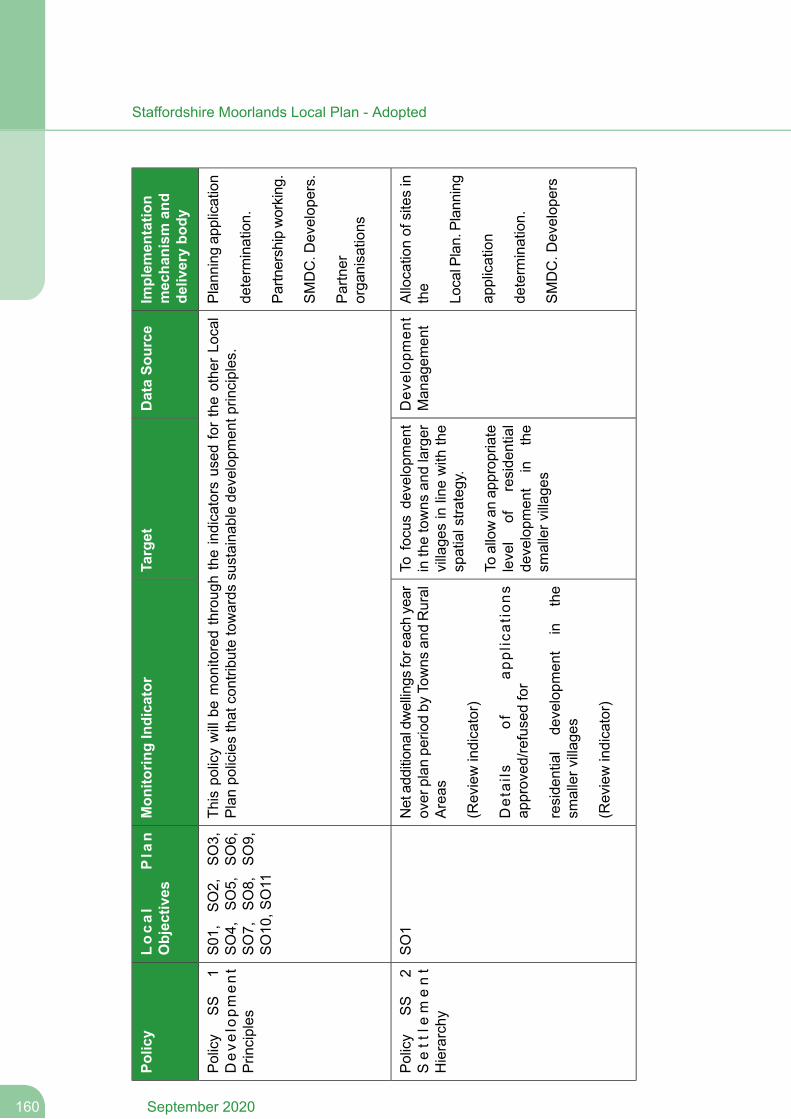
Implem
entatio
nmechanism
and
deliverybo
dy
DataSo
urce
Target
Mon
itorin
gIndicator
Local
Plan
Objectives
Policy
Plan
ning
application
This
policywillbe
mon
itoredthroug
htheindicators
used
fortheothe
rLo
cal
Planpo
liciesthat
contrib
utetowards
sustaina
blede
velopm
entp
rinciples.
S01
,SO2,
SO3,
SO4,
SO5,
SO6,
SO7,
SO8,
SO9,
SO10
,SO11
Policy
SS
1Deve
lopment
Prin
ciples
determ
ination.
Partn
ershipworking
.
SMDC.D
evelop
ers.
Partner
orga
nisations
Allocationof
sitesin
the
Dev
elop
men
tMan
agem
ent
Tofocusde
velopm
ent
inthetowns
andlarger
village
sin
linewith
the
spatialstra
tegy.
Netad
ditiona
ldwellings
fore
achyear
over
plan
perio
dby
Towns
andRural
Areas
(Reviewindicator)
SO1
Policy
SS
2Sett
lem
ent
Hierarchy
LocalP
lan.Plan
ning
application
Toallowan
approp
riate
level
ofreside
ntial
developm
ent
inthe
smallerv
illag
es
Details
ofap
plications
approved
/refusedfor
reside
ntial
developm
ent
inthe
smallerv
illag
es
determ
ination.
SMDC.D
evelop
ers
(Reviewindicator)
September 2020160
Staffordshire Moorlands Local Plan - Adopted
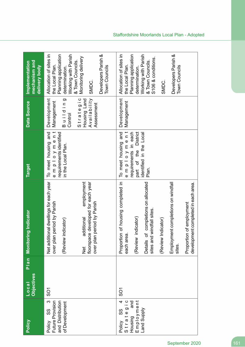
Implem
entatio
nmechanism
and
deliverybo
dy
DataSo
urce
Target
Mon
itorin
gIndicator
Local
Plan
Objectives
Policy
Allocationof
sitesin
theLo
calP
lan.
Plan
ning
application
Dev
elop
men
tMan
agem
ent
Buil
din
gCon
trol
Tomee
tho
using
and
em
plo
ym
en
trequ
iremen
tsiden
tified
intheLo
calP
lan.
Netad
ditiona
ldwellings
fore
achyear
over
plan
perio
dby
Parish
(Reviewindicator)
SO1
Policy
SS
3Fu
ture
Provision
andDistribu
tion
ofDevelop
men
tde
term
ination.
Working
with
Parish
&TownCou
ncils.
Mon
itorin
gde
livery
Str
ate
gic
Hou
sing
Land
Ava
ilability
Assessm
ent
Net
additiona
lem
ploymen
tfloorspacede
velope
dforea
chyear
over
plan
perio
dby
Parish
SMDC.
Develop
ersPa
rish&
TownCou
ncils
Allocationof
sitesin
theLo
calP
lan.
Plan
ning
application
Dev
elop
men
tMan
agem
ent
Tomee
tho
using
and
em
plo
ym
en
trequ
iremen
tsin
each
Propo
rtion
ofho
usingcompleted
inea
charea
.
(Review
indicator)
Details
ofcompletions
onallocated
sitesan
dwindfallsites.
SO1
Policy
SS
4S
trategic
Hou
sing
and
Emplo
yment
Land
Sup
ply
determ
ination.
Working
with
Parish
&TownCou
ncils.
S10
6&cond
ition
s.
part
ofthe
District
iden
tifiedin
theLo
cal
Plan.
(ReviewIndicator)
SMDC.
Employmen
tcom
pletions
onwindfall
sites.
Develop
ersPa
rish&
TownCou
ncils
Propo
rtion
ofem
ploymen
tde
velopm
entcom
pleted
inea
charea
.
161September 2020
Staffordshire Moorlands Local Plan - Adopted
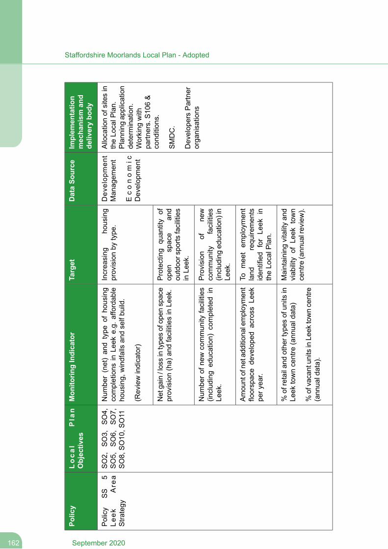
Implem
entatio
nmechanism
and
deliverybo
dy
DataSo
urce
Target
Mon
itorin
gIndicator
Local
Plan
Objectives
Policy
Allocationof
sitesin
theLo
calP
lan.
Plan
ning
application
Dev
elop
men
tMan
agem
ent
Econom
icDevelop
men
t
Increa
sing
housing
provisionby
type
.Num
ber(net)an
dtype
ofho
using
completions
inLe
eke.g.
affordab
leho
using,
windfallsan
dselfbu
ild.
(Reviewindicator)
SO2,
SO3,
SO4,
SO5,
SO6,
SO7,
SO8,
SO10
,SO11
Policy
SS
5Le
ekAre
aStra
tegy
determ
ination.
Working
with
partn
ers.S10
6&
cond
ition
s.Protecting
quan
tity
ofop
enspace
and
outdoo
rspo
rtsfacilities
inLe
ek.
Netga
in/lossintype
sofop
enspace
provision(ha)
andfacilitiesinLe
ek.
SMDC.
Develop
ersPartner
orga
nisations
Provision
ofne
wcommun
ityfacilities
(includ
inged
ucation)
inLe
ek.
Num
bero
fnew
commun
ityfacilities
(includ
ing
education)
completed
inLe
ek.
Tomee
tem
ploymen
tland
requ
iremen
tsiden
tified
forLe
ekin
theLo
calP
lan.
Amou
ntofne
tadd
ition
alem
ploymen
tfloorspace
develope
dacross
Leek
pery
ear.
Maintaining
vitalityan
dviab
ility
ofLe
ektown
centre
(ann
ualreview).
%of
retailan
dothe
rtypes
ofun
itsin
Leek
towncentre
(ann
ualdata)
%ofvacantun
itsinLe
ektowncentre
(ann
ualdata).
September 2020162
Staffordshire Moorlands Local Plan - Adopted
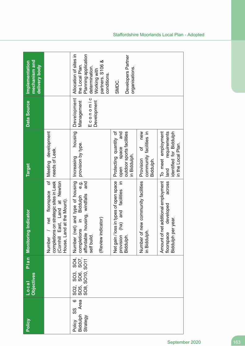
Implem
entatio
nmechanism
and
deliverybo
dy
DataSo
urce
Target
Mon
itorin
gIndicator
Local
Plan
Objectives
Policy
Mee
ting
developm
ent
need
sof
Leek.
Num
ber
/ne
tfloorspace
ofcompletions
onstrategicsitesinLe
ek(Cornh
illEast,
Land
atNew
ton
Hou
se,L
andat
theMou
nt).
Allocationof
sitesin
theLo
calP
lan.
Plan
ning
application
Dev
elop
men
tMan
agem
ent
Econom
icDevelop
men
t
Increa
sing
housing
provisionby
type
.Num
ber(net)an
dtype
ofho
using
completions
inBiddu
lph
e.g.
affordab
leho
using,
windfalls
and
selfbu
ild.
(Reviewindicator)
SO2,
SO3,
SO4,
SO5,
SO6,
SO7,
SO8,
SO10
,SO11
Policy
SS
6Biddu
lph
Area
Stra
tegy
determ
ination.
Working
with
partn
ers.S10
6&
cond
ition
s.
Protecting
quan
tity
ofop
enspace
and
outdoo
rspo
rtsfacilities
inBiddu
lph.
Netga
in/lossintype
sofop
enspace
provision
(ha)
and
facilities
inBiddu
lph.
SMDC.
Develop
ersPartner
orga
nisations.
Provision
ofne
wcommun
ityfacilitiesin
Biddu
lph.
Num
bero
fnew
commun
ityfacilities
inBiddu
lph.
Tomee
tem
ploymen
tland
requ
iremen
tsiden
tifiedforBiddu
lph
intheLo
calP
lan.
Amou
ntofne
tadd
ition
alem
ploymen
tfloorspace
develope
dacross
Biddu
lphpe
ryea
r.
163September 2020
Staffordshire Moorlands Local Plan - Adopted
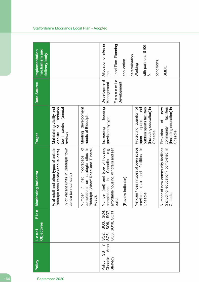
Implem
entatio
nmechanism
and
deliverybo
dy
DataSo
urce
Target
Mon
itorin
gIndicator
Local
Plan
Objectives
Policy
Maintaining
vitalityan
dviab
ility
ofBiddu
lph
town
centre
(ann
ual
review
)
%of
retailan
dothe
rtypes
ofun
itsin
Biddu
lphtowncentre
(ann
ualdata)
%of
vacant
units
inBiddu
lphtown
centre
(ann
ualdata)
Mee
ting
developm
ent
need
sof
Biddu
lph.
Num
ber
/ne
tfloorspace
ofcompletions
onstrategic
sites
inBiddu
lph(W
harfRoa
dan
dTu
nstall
Roa
d).
Allocationof
sitesin
the
Dev
elop
men
tMan
agem
ent
Increa
sing
housing
provisionby
type
.Num
ber(net)an
dtype
ofho
using
completions
inChe
adle
e.g.
affordab
leho
using,windfallsan
dself
build.
SO2,
SO3,
SO4,
SO5,
SO6,
SO7,
SO8,
SO10
,SO11
Policy
SS
7Che
adle
Area
Stra
tegy
LocalP
lan.Plan
ning
Econom
icDevelop
men
t(Reviewindicator)
application
determ
ination.
Working
Protecting
quan
tity
ofop
enspace
and
outdoo
rspo
rtsfacilities
(includ
inged
ucation)
inChe
adle.
Netga
in/lossintype
sofop
enspace
provision
(ha)
and
facilities
inChe
adle.
with
partn
ers.S10
6& cond
ition
s.Provision
ofne
wcommun
ityfacilities
(includ
inged
ucation)
inChe
adle.
Num
bero
fnew
commun
ityfacilities
(includ
ing
education)
completed
inChe
adle.
SMDC.
September 2020164
Staffordshire Moorlands Local Plan - Adopted
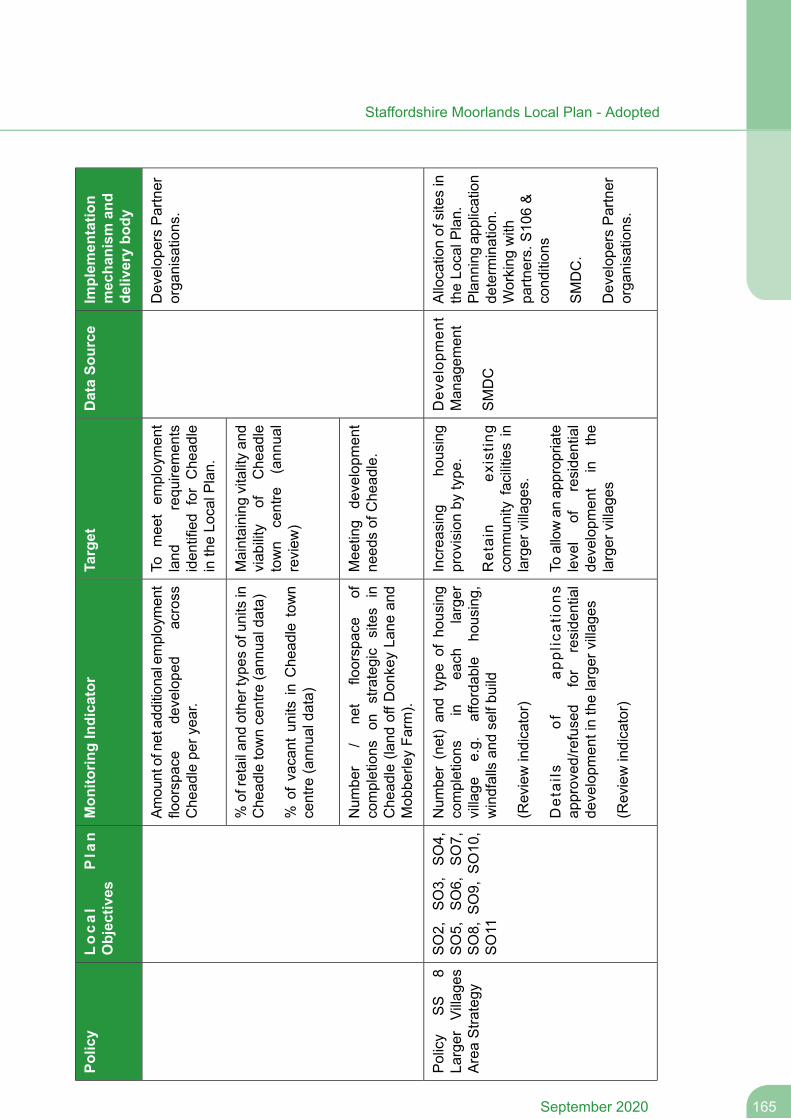
Implem
entatio
nmechanism
and
deliverybo
dy
DataSo
urce
Target
Mon
itorin
gIndicator
Local
Plan
Objectives
Policy
Develop
ersPartner
orga
nisations.
Tomee
tem
ploymen
tland
requ
iremen
tsiden
tified
forChe
adle
intheLo
calP
lan.
Amou
ntofne
tadd
ition
alem
ploymen
tfloorspace
develope
dacross
Che
adlepe
ryea
r.
Maintaining
vitalityan
dviab
ility
ofChe
adle
town
centre
(ann
ual
review
)
%of
retailan
dothe
rtypes
ofun
itsin
Che
adletowncentre
(ann
ualdata)
%of
vacant
units
inChe
adle
town
centre
(ann
ualdata)
Mee
ting
developm
ent
need
sof
Che
adle.
Num
ber
/ne
tfloorspace
ofcompletions
onstrategic
sites
inChe
adle
(land
offD
onkeyLa
nean
dMob
berle
yFa
rm).
Allocationof
sitesin
theLo
calP
lan.
Plan
ning
application
Dev
elop
men
tMan
agem
ent
SMDC
Increa
sing
housing
provisionby
type
.
Retain
existin
gcommun
ityfacilitiesin
larger
village
s.
Num
ber(net)an
dtype
ofho
using
completions
inea
chlarger
village
e.g.
affordab
leho
using,
windfallsan
dselfbu
ild
(Reviewindicator)
SO2,
SO3,
SO4,
SO5,
SO6,
SO7,
SO8,
SO9,
SO10
,SO11
Policy
SS
8La
rger
Village
sAreaStra
tegy
determ
ination.
Working
with
partn
ers.S10
6&
cond
ition
sTo
allowan
approp
riate
level
ofreside
ntial
developm
ent
inthe
larger
village
s
Details
ofap
plications
approved
/refused
for
reside
ntial
developm
entinthelarger
village
s
(Reviewindicator)
SMDC.
Develop
ersPartner
orga
nisations.
165September 2020
Staffordshire Moorlands Local Plan - Adopted
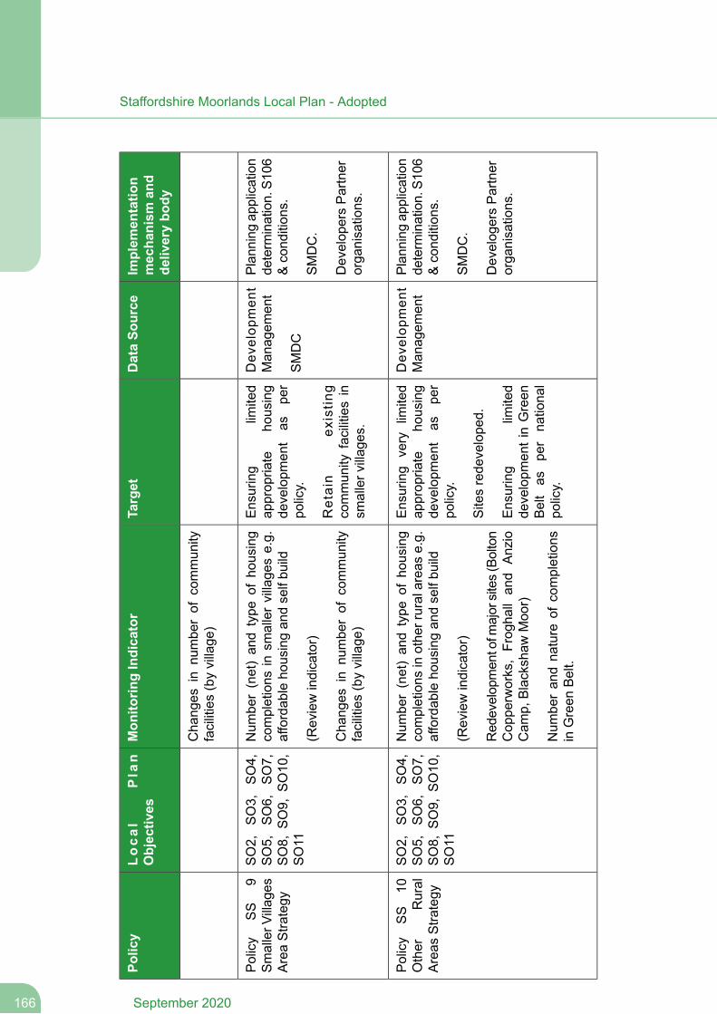
Implem
entatio
nmechanism
and
deliverybo
dy
DataSo
urce
Target
Mon
itorin
gIndicator
Local
Plan
Objectives
Policy
Cha
nges
innu
mbe
rof
commun
ityfacilities(byvillage
)
Plan
ning
application
determ
ination.S1
06&cond
ition
s.
Dev
elop
men
tMan
agem
ent
SMDC
Ensuring
limited
approp
riate
housing
developm
ent
aspe
rpo
licy.
Num
ber(net)an
dtype
ofho
using
completions
insm
allervillage
se.g.
affordab
leho
usingan
dselfbu
ild
(Reviewindicator)
SO2,
SO3,
SO4,
SO5,
SO6,
SO7,
SO8,
SO9,
SO10
,SO11
Policy
SS
9SmallerV
illag
esAreaStra
tegy
SMDC.
Retain
existin
gcommun
ityfacilitiesin
smallerv
illag
es.
Cha
nges
innu
mbe
rof
commun
ityfacilities(byvillage
)Develop
ersPartner
orga
nisations.
Plan
ning
application
determ
ination.S1
06&cond
ition
s.
Dev
elop
men
tMan
agem
ent
Ensuring
very
limited
approp
riate
housing
developm
ent
aspe
rpo
licy.
Num
ber(net)an
dtype
ofho
using
completions
inothe
rruralarea
se.g.
affordab
leho
usingan
dselfbu
ild
(Reviewindicator)
SO2,
SO3,
SO4,
SO5,
SO6,
SO7,
SO8,
SO9,
SO10
,SO11
Policy
SS
10Other
Rural
Areas
Stra
tegy
SMDC.
Sitesrede
velope
d.Red
evelop
men
tofm
ajor
sites(Bolton
Cop
perworks,Frog
hall
and
Anzio
Cam
p,Blackshaw
Moo
r)
Develog
ersPartner
orga
nisations.
Ensuring
limited
developm
entinGreen
Beltas
per
nationa
lpo
licy.
Num
beran
dna
ture
ofcompletions
inGreen
Belt.
September 2020166
Staffordshire Moorlands Local Plan - Adopted
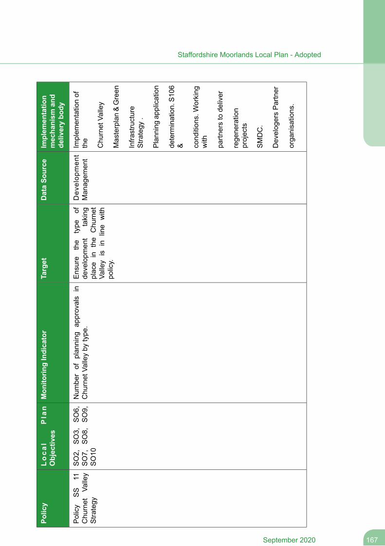
Implem
entatio
nmechanism
and
deliverybo
dy
DataSo
urce
Target
Mon
itorin
gIndicator
Local
Plan
Objectives
Policy
Implem
entationof
the
Dev
elop
men
tMan
agem
ent
Ensure
the
type
ofde
velopm
ent
taking
place
inthe
Chu
rnet
Valley
isin
line
with
policy.
Num
berof
plan
ning
approvals
inChu
rnet
Valleyby
type
.SO2,
SO3,
SO6,
SO7,
SO8,
SO9,
SO10
Policy
SS
11Chu
rnet
Valley
Stra
tegy
Chu
rnet
Valley
Masterplan&Green
Infra
structure
Stra
tegy
.
Plan
ning
application
determ
ination.S1
06& cond
ition
s.Working
with
partn
ersto
deliver
rege
neration
projects
SMDC.
Develog
ersPartner
orga
nisations.
167September 2020
Staffordshire Moorlands Local Plan - Adopted
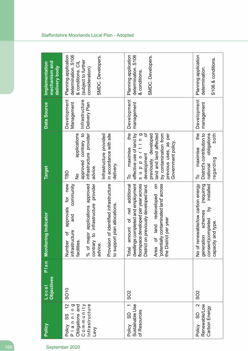
Implem
entatio
nmechanism
and
deliverybo
dy
DataSo
urce
Target
Mon
itorin
gIndicator
Local
Plan
Objectives
Policy
Plan
ning
application
determ
ination.S1
06&cond
ition
s.CIL
(sub
jectto
furth
erconsideration)
Dev
elop
men
tMan
agem
ent
Infras
truc
ture
DeliveryPlan
TBD
No
applications
approved
contrary
toinfra
structure
provider
advice.
Num
ber
ofap
provals
for
new
infra
structure
and
commun
ityfacilities.
%of
major
applications
approved
contrary
toinfra
structure
provider
advice.
SO10
Policy
SS
12P
lanning
Obligations
and
Com
munity
Infras
truc
ture
Levy
SMDC.D
evelop
ers.
Infra
structureprovided
inaccordan
cewith
site
delivery.
Provision
ofiden
tifiedinfra
structure
tosupp
ortp
lanallocations.
Plan
ning
application
determ
ination.S1
06&cond
ition
s.
Dev
elop
men
tman
agem
ent
Tomaximise
the
effectiveuseof
land
bys
up
po
rtin
g
Total
amou
ntof
net
additiona
ldw
ellings
completed
andem
ploymen
tfloorspacede
velope
dpe
ryea
racross
Districton
previouslyde
velope
dland
.
SO2
Policy
SD
1Su
staina
bleUse
ofResou
rces
SMDC.D
evelop
ers.
developm
ent
ofpreviously
develope
dArea
ofland
rede
velope
don
'poten
tially
contam
inated
land
'across
theDistrictpe
ryea
r
land
andland
affected
bycontam
inationfro
mprevious
uses,as
per
Governm
entp
olicy.
Plan
ning
application
determ
ination.
Dev
elop
men
tman
agem
ent
Tomaximise
the
District'scontrib
utionto
nationa
lob
ligations
Noof
rene
wab
le/lowcarbon
energy
gene
ration
sche
mes
(req
uirin
gconsen
t)com
pleted
byinstalled
capa
cityan
dtype
.
SO2
Policy
SD
2Ren
ewab
le/Low
Carbo
nEne
rgy
S10
6&cond
ition
s.rega
rding
both
September 2020168
Staffordshire Moorlands Local Plan - Adopted
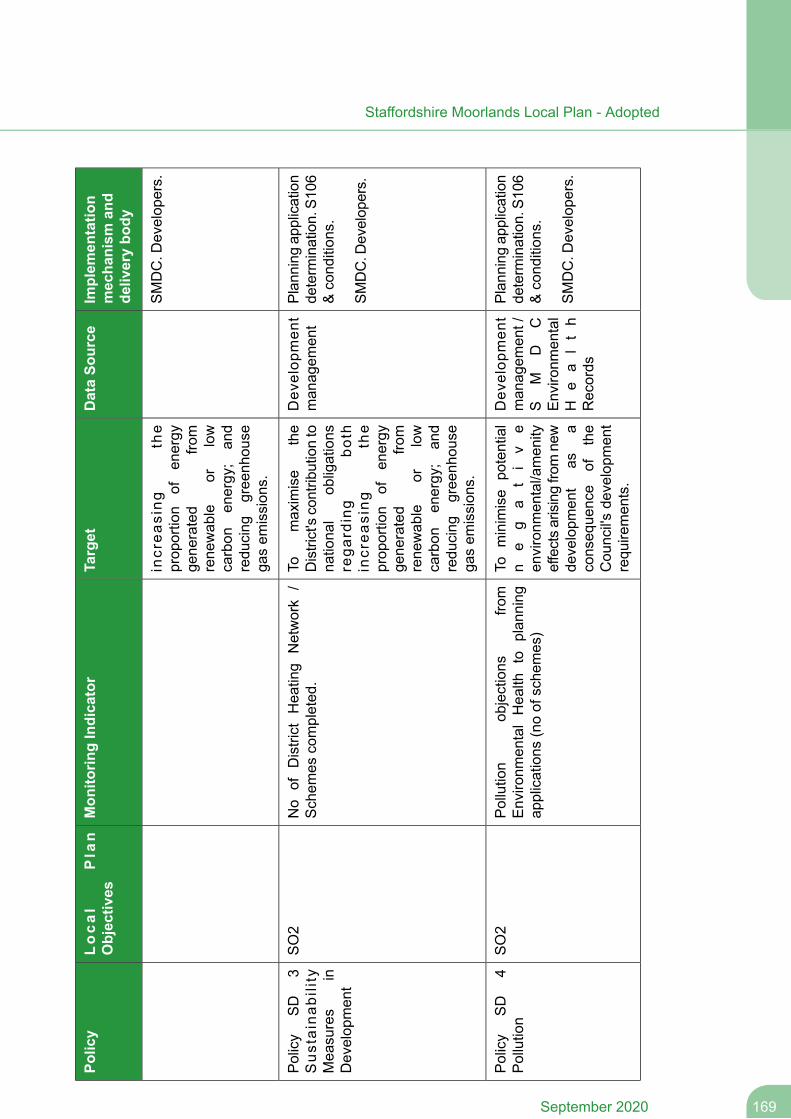
Implem
entatio
nmechanism
and
deliverybo
dy
DataSo
urce
Target
Mon
itorin
gIndicator
Local
Plan
Objectives
Policy
increa
sing
the
prop
ortion
ofen
ergy
gene
rated
from
SMDC.D
evelop
ers.
rene
wab
leor
low
carbon
energy;
and
redu
cing
gree
nhou
sega
sem
ission
s.
Plan
ning
application
determ
ination.S1
06&cond
ition
s.
Dev
elop
men
tman
agem
ent
Tomaximise
the
District'scontrib
utionto
nationa
lob
ligations
No
ofDistrict
Hea
ting
Network
/Schem
escompleted
.SO2
Policy
SD
3Sus
tainab
ility
Mea
sures
inDevelop
men
tSM
DC.D
evelop
ers.
rega
rding
both
increa
sing
the
prop
ortion
ofen
ergy
gene
rated
from
rene
wab
leor
low
carbon
energy;
and
redu
cing
gree
nhou
sega
sem
ission
s.
Plan
ning
application
determ
ination.S1
06&cond
ition
s.
Dev
elop
men
tman
agem
ent/
SM
DC
Tominimise
potential
ne
ga
ti
ve
environm
ental/amen
ity
Pollution
objections
from
Enviro
nmen
talHea
lthto
plan
ning
applications
(noof
sche
mes)
SO2
Policy
SD
4Pollution
Enviro
nmen
tal
He
alth
Records
effectsarisingfro
mne
wde
velopm
ent
asa
conseq
uence
ofthe
Cou
ncil's
developm
ent
requ
iremen
ts.
SMDC.D
evelop
ers.
169September 2020
Staffordshire Moorlands Local Plan - Adopted
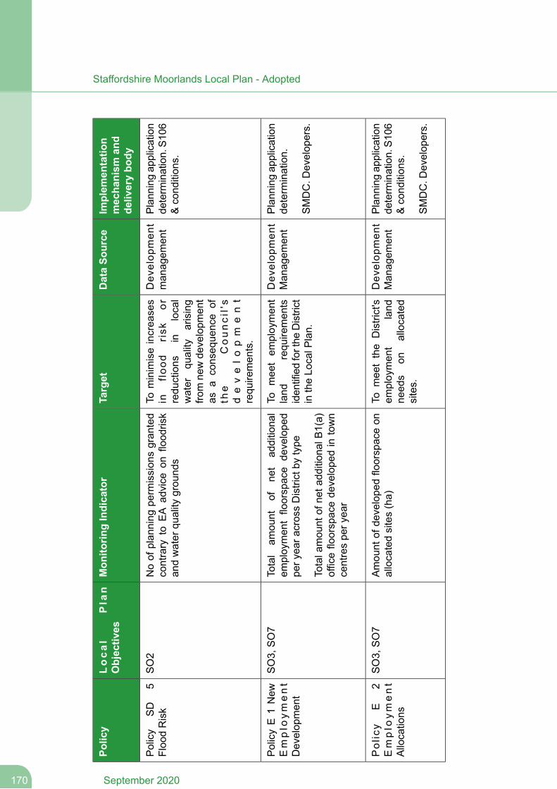
Implem
entatio
nmechanism
and
deliverybo
dy
DataSo
urce
Target
Mon
itorin
gIndicator
Local
Plan
Objectives
Policy
Plan
ning
application
determ
ination.S1
06&cond
ition
s.
Dev
elop
men
tman
agem
ent
Tominimiseincrea
ses
infloo
drisk
orredu
ctions
inlocal
Noof
plan
ning
perm
ission
sgran
ted
contrary
toEA
advice
onflood
risk
andwater
quality
grou
nds
SO2
Policy
SD
5Floo
dRisk
water
quality
arising
from
newde
velopm
ent
asa
conseq
uence
ofth
eCouncil's
develo
pm
ent
requ
iremen
ts.
Plan
ning
application
determ
ination.
Dev
elop
men
tMan
agem
ent
Tomee
tem
ploymen
tland
requ
iremen
tsiden
tifiedforthe
District
intheLo
calP
lan.
Total
amou
ntof
net
additiona
lem
ploymen
tfloorspace
develope
dpe
ryea
racrossDistrictby
type
Totala
mou
ntof
neta
ddition
alB1(a)
officefloorspacede
velope
din
town
centrespe
ryea
r
SO3,
SO7
PolicyE
1New
Emplo
yment
Develop
men
tSMDC.D
evelop
ers.
Plan
ning
application
determ
ination.S1
06&cond
ition
s.
Dev
elop
men
tMan
agem
ent
Tomee
tthe
District's
employmen
tland
need
son
allocated
sites.
Amou
ntof
develope
dfloorspaceon
allocatedsites(ha)
SO3,
SO7
Policy
E2
Emplo
yment
Allocations
SMDC.D
evelop
ers.
September 2020170
Staffordshire Moorlands Local Plan - Adopted
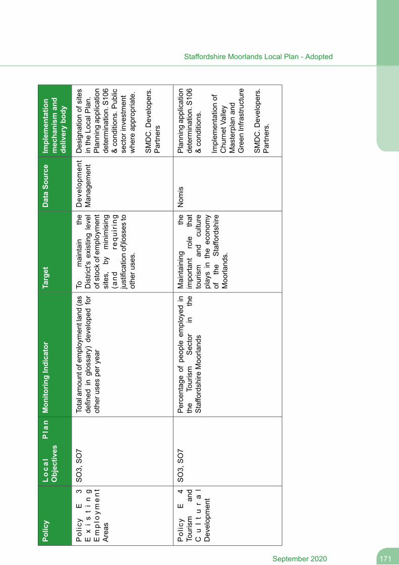
Implem
entatio
nmechanism
and
deliverybo
dy
DataSo
urce
Target
Mon
itorin
gIndicator
Local
Plan
Objectives
Policy
Designa
tionof
sites
intheLo
calP
lan.
Plan
ning
application
Dev
elop
men
tMan
agem
ent
Tomaintain
the
District's
existinglevel
ofstockofem
ploymen
t
Totalamou
ntofem
ploymen
tlan
d(as
defined
inglossary)de
velope
dfor
othe
rusespe
ryea
r
SO3,
SO7
Policy
E3
Existin
gEmplo
yment
Areas
determ
ination.S1
06sites,
byminimising
&cond
ition
s.Pub
licsector
investmen
twhe
reap
prop
riate.
(and
requ
iring
justificationof)lo
sses
toothe
ruses.
SMDC.D
evelop
ers.
Partners
Plan
ning
application
determ
ination.S1
06&cond
ition
s.
Nom
isMaintaining
the
impo
rtant
role
that
tourism
and
culture
Percentag
eof
peop
leem
ployed
inthe
Tourism
Sector
inthe
Staffo
rdshire
Moo
rland
s
SO3,
SO7
Policy
E4
Tourism
and
Cu
ltu
ra
lDevelop
men
tIm
plem
entationof
Chu
rnet
Valley
Masterplanan
dGreen
Infra
structure
playsin
theecon
omy
ofthe
Staffo
rdshire
Moo
rland
s.
SMDC.D
evelop
ers.
Partners.
171September 2020
Staffordshire Moorlands Local Plan - Adopted
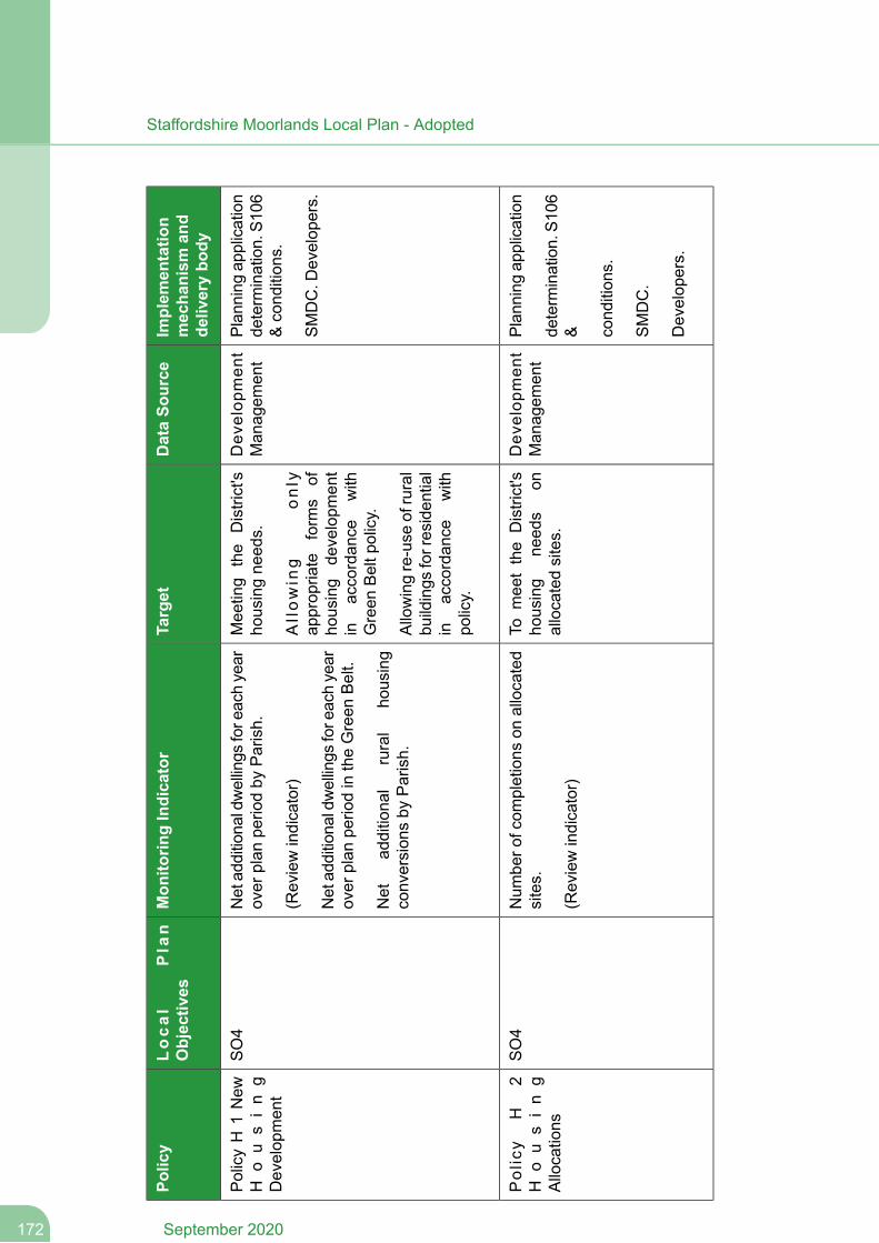
Implem
entatio
nmechanism
and
deliverybo
dy
DataSo
urce
Target
Mon
itorin
gIndicator
Local
Plan
Objectives
Policy
Plan
ning
application
determ
ination.S1
06&cond
ition
s.
Dev
elop
men
tMan
agem
ent
Mee
ting
the
District's
housingne
eds.
Allowin
gonly
approp
riate
form
sof
housing
developm
ent
inaccordan
cewith
Green
Beltp
olicy.
Netad
ditiona
ldwellings
fore
achyear
over
plan
perio
dby
Parish.
(Reviewindicator)
Netad
ditiona
ldwellings
fore
achyear
over
plan
perio
dintheGreen
Belt.
Net
additiona
lrural
housing
conversion
sby
Parish.
SO4
PolicyH
1New
Ho
us
in
gDevelop
men
t
SMDC.D
evelop
ers.
Allowingre-use
ofrural
buildings
forresiden
tial
inaccordan
cewith
policy.
Plan
ning
application
Dev
elop
men
tMan
agem
ent
Tomee
tthe
District's
housing
need
son
allocatedsites.
Num
bero
fcom
pletions
onallocated
sites.
(Reviewindicator)
SO4
Policy
H2
Ho
us
in
gAllocations
determ
ination.S1
06& cond
ition
s.
SMDC.
Develop
ers.
September 2020172
Staffordshire Moorlands Local Plan - Adopted
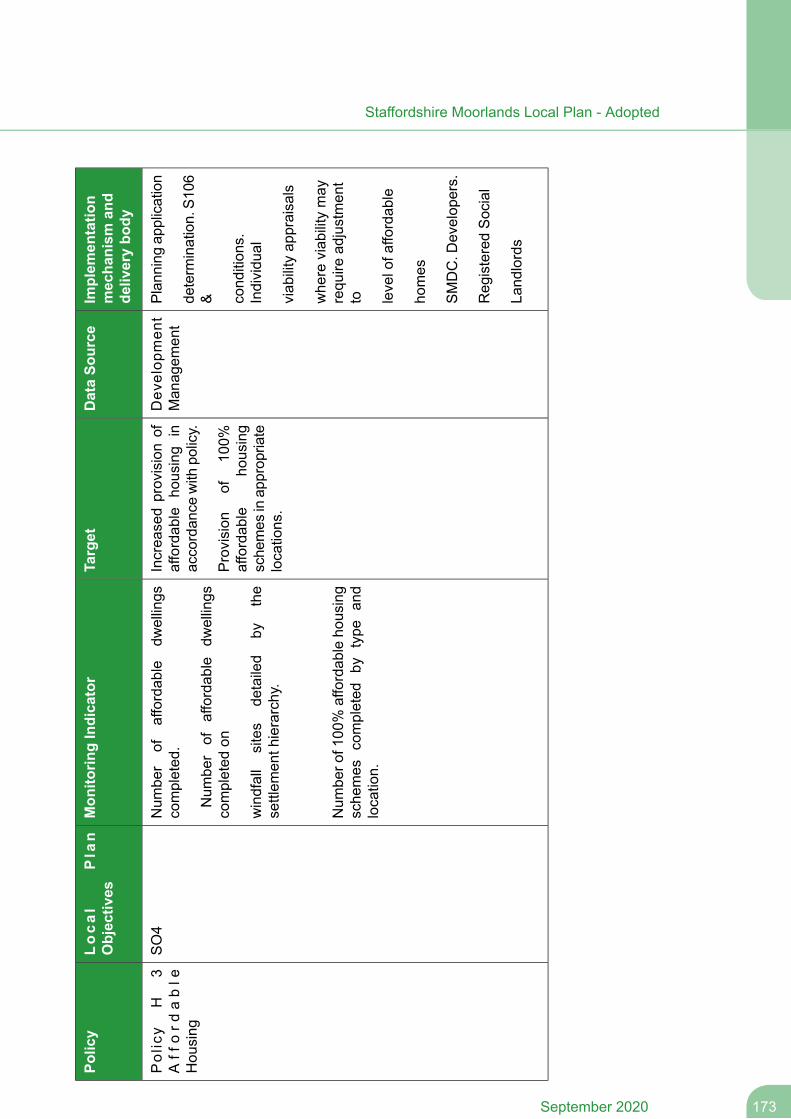
Implem
entatio
nmechanism
and
deliverybo
dy
DataSo
urce
Target
Mon
itorin
gIndicator
Local
Plan
Objectives
Policy
Plan
ning
application
Dev
elop
men
tMan
agem
ent
Increa
sedprovisionof
affordab
leho
using
inaccordan
cewith
policy.
Num
ber
ofaffordab
ledw
ellings
completed
.
Num
ber
ofaffordab
ledw
ellings
completed
on
SO4
Policy
H3
Aff
ord
able
Hou
sing
determ
ination.S1
06& cond
ition
s.Individu
al
Provision
of10
0%affordab
leho
using
sche
mes
inap
prop
riate
locations.
windfall
sites
detailed
bythe
settlem
enth
ierarchy.
Num
bero
f100
%affordab
leho
using
sche
mes
completed
bytype
and
location.
viab
ilityap
praisals
whe
reviab
ilitymay
requ
iread
justmen
tto levelofa
ffordab
le
homes
SMDC.D
evelop
ers.
Reg
isteredSocial
Land
lords
173September 2020
Staffordshire Moorlands Local Plan - Adopted
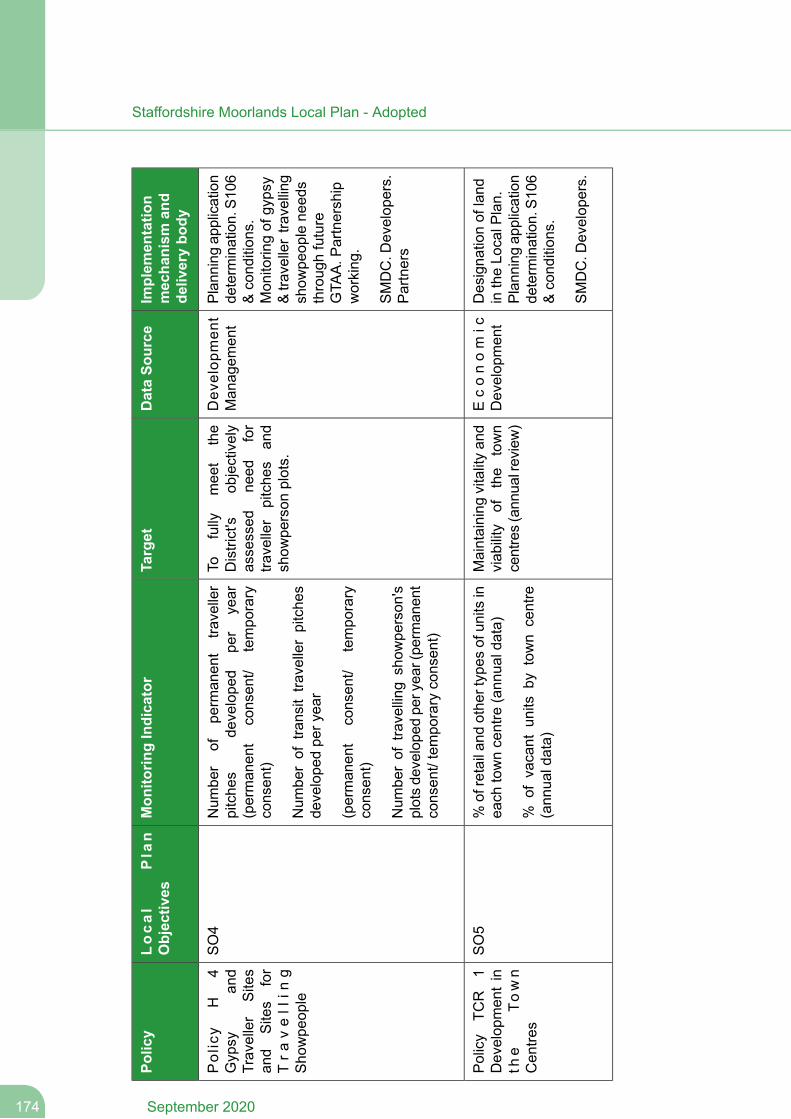
Implem
entatio
nmechanism
and
deliverybo
dy
DataSo
urce
Target
Mon
itorin
gIndicator
Local
Plan
Objectives
Policy
Plan
ning
application
determ
ination.S1
06&cond
ition
s.
Dev
elop
men
tMan
agem
ent
Tofully
mee
tthe
District's
objectively
assessed
need
for
traveller
pitche
san
dshow
person
plots.
Num
ber
ofpe
rman
ent
traveller
pitche
sde
velope
dpe
ryear
(perman
ent
consen
t/tempo
rary
consen
t)
Num
berof
transittra
vellerpitche
sde
velope
dpe
ryea
r
SO4
Policy
H4
Gypsy
and
Traveller
Sites
and
Sites
for
Tra
vell
ing
Sho
wpe
ople
Mon
itorin
gof
gypsy
&tra
vellertra
vellin
gshow
peop
lene
eds
throug
hfuture
GTA
A.P
artnership
working
.(perman
ent
consen
t/tempo
rary
consen
t)SMDC.D
evelop
ers.
Partners
Num
berof
travelling
show
person
'splotsde
velope
dpe
ryea
r(pe
rman
ent
consen
t/tempo
rary
consen
t)
Designa
tionof
land
intheLo
calP
lan.
Plan
ning
application
determ
ination.S1
06&cond
ition
s.
Econom
icDevelop
men
tMaintaining
vitalityan
dviab
ility
ofthe
town
centres(ann
ualreview)
%of
retailan
dothe
rtypes
ofun
itsin
each
towncentre
(ann
ualdata)
%of
vacant
units
bytown
centre
(ann
ualdata)
SO5
Policy
TCR
1Develop
men
tin
the
Town
Cen
tres
SMDC.D
evelop
ers.
September 2020174
Staffordshire Moorlands Local Plan - Adopted
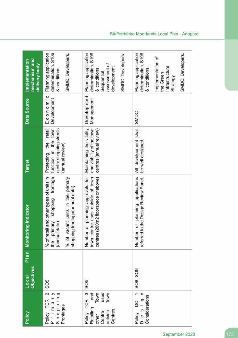
Implem
entatio
nmechanism
and
deliverybo
dy
DataSo
urce
Target
Mon
itorin
gIndicator
Local
Plan
Objectives
Policy
Plan
ning
application
determ
ination.S1
06&cond
ition
s.
Econom
icDevelop
men
tProtecting
the
retail
function
inthe
town
centre
shop
ping
streets
(ann
ualreview)
%of
retailan
dothe
rtypes
ofun
itsin
the
primary
shop
ping
frontag
e(ann
ualdata)
%of
vacant
units
inthe
primary
shop
ping
frontag
e(an
nualda
ta)
SO5
Policy
TCR
2P
rim
ary
Shoppin
gFron
tage
sSMDC.D
evelop
ers.
Plan
ning
application
determ
ination.S1
06&cond
ition
s.
Dev
elop
men
tMan
agem
ent
Maintaining
thevitality
andviab
ilityofthetown
centres(ann
ualreview)
Num
berof
plan
ning
approvalsfor
town
centre
uses
outside
oftown
centres(200
m2floorspaceor
above)
SO5
Policy
TCR
3Retailing
and
othe
rTown
Seq
uential
assessmen
tof
developm
ent.
Cen
treuses
outside
Town
Cen
tres
SMDC.D
evelop
ers.
Plan
ning
application
determ
ination.S1
06&cond
ition
s.
SMDC
Allde
velopm
entshall
bewelldesigne
d.Num
ber
ofplan
ning
applications
referre
dtotheDesignReviewPa
nel.
SO8,
SO9
Policy
DC
1D
es
ig
nCon
side
rations
Implem
entationof
theGreen
Infra
structure
Stra
tegy
SMDC.D
evelop
ers.
175September 2020
Staffordshire Moorlands Local Plan - Adopted
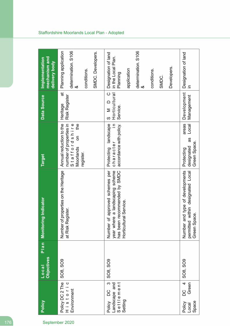
Implem
entatio
nmechanism
and
deliverybo
dy
DataSo
urce
Target
Mon
itorin
gIndicator
Local
Plan
Objectives
Policy
Plan
ning
application
Heritage
atRiskReg
ister
Ann
ualred
uctiontothe
numbe
rofprope
rties
inSta
ffordshir
eMoo
rland
son
the
register.
Num
bero
fprope
rties
ontheHeritage
atRiskReg
ister.
SO8,
SO9
PolicyDC2Th
eH
isto
ric
Enviro
nmen
tde
term
ination.S1
06& cond
ition
s.
SMDC.D
evelop
ers.
Designa
tionof
land
intheLo
calP
lan.
Plann
ing
SM
DC
Hor
ticu
ltur
alService.
Protecting
land
scap
echara
cte
rin
accordan
cewith
policy.
Num
berof
approved
sche
mes
per
year
whe
realand
scap
ingsche
me
hasbe
enrecommen
dedby
SMDC
HorticulturalS
ervice.
SO8,
SO9
Policy
DC
3La
ndscap
ean
dSett
lem
ent
Setting
application
determ
ination.S1
06& cond
ition
s.
SMDC.
Develop
ers.
Designa
tionof
land
inDev
elop
men
tMan
agem
ent
Protecting
area
sde
sign
ated
asLo
cal
Green
Spa
ce.
Num
beran
dtype
ofde
velopm
ents
perm
itted
within
design
ated
Local
Green
Spa
ce.
SO8,
SO9
Policy
DC
4Lo
cal
Green
Spa
ce
September 2020176
Staffordshire Moorlands Local Plan - Adopted
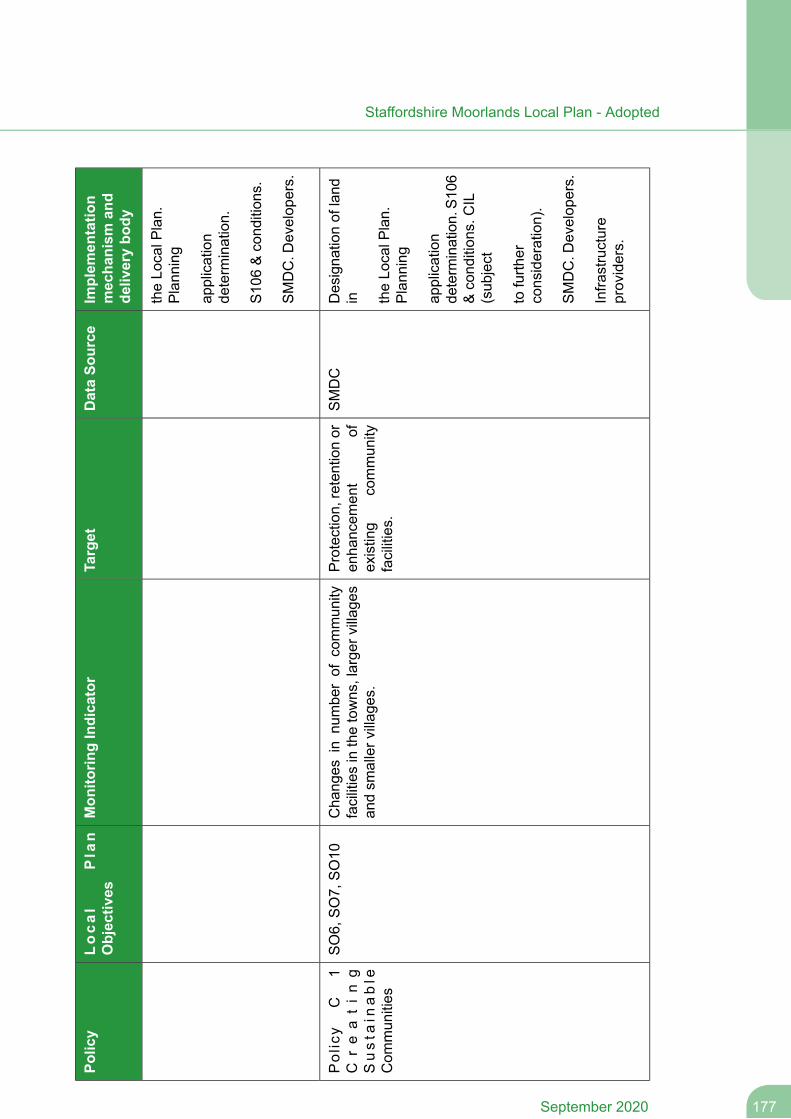
Implem
entatio
nmechanism
and
deliverybo
dy
DataSo
urce
Target
Mon
itorin
gIndicator
Local
Plan
Objectives
Policy
theLo
calP
lan.
Plann
ing
application
determ
ination.
S10
6&cond
ition
s.
SMDC.D
evelop
ers.
Designa
tionof
land
inSMDC
Protection,
retentionor
enha
ncem
ent
ofexisting
commun
ityfacilities.
Cha
nges
innu
mbe
rof
commun
ityfacilitiesinthetowns,large
rvillag
esan
dsm
allerv
illag
es.
SO6,
SO7,
SO10
Policy
C1
Creating
Susta
inable
Com
mun
ities
theLo
calP
lan.
Plann
ing
application
determ
ination.S1
06&cond
ition
s.CIL
(sub
ject
tofurth
erconsideration).
SMDC.D
evelop
ers.
Infra
structure
providers.
177September 2020
Staffordshire Moorlands Local Plan - Adopted
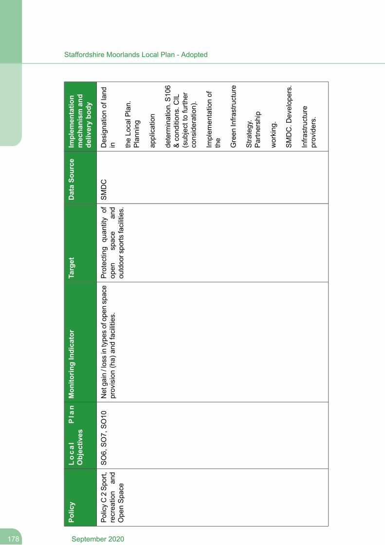
Implem
entatio
nmechanism
and
deliverybo
dy
DataSo
urce
Target
Mon
itorin
gIndicator
Local
Plan
Objectives
Policy
Designa
tionof
land
inSMDC
Protecting
quan
tity
ofop
enspace
and
outdoo
rspo
rtsfacilities.
Netga
in/lossintype
sofop
enspace
provision(ha)
andfacilities.
SO6,
SO7,
SO10
PolicyC2Sp
ort,
recrea
tion
and
Ope
nSpa
cetheLo
calP
lan.
Plann
ing
application
determ
ination.S1
06&cond
ition
s.CIL
(sub
jectto
furth
erconsideration).
Implem
entationof
the
Green
Infra
structure
Stra
tegy.
Partnership
working
.
SMDC.D
evelop
ers.
Infra
structure
providers.
September 2020178
Staffordshire Moorlands Local Plan - Adopted
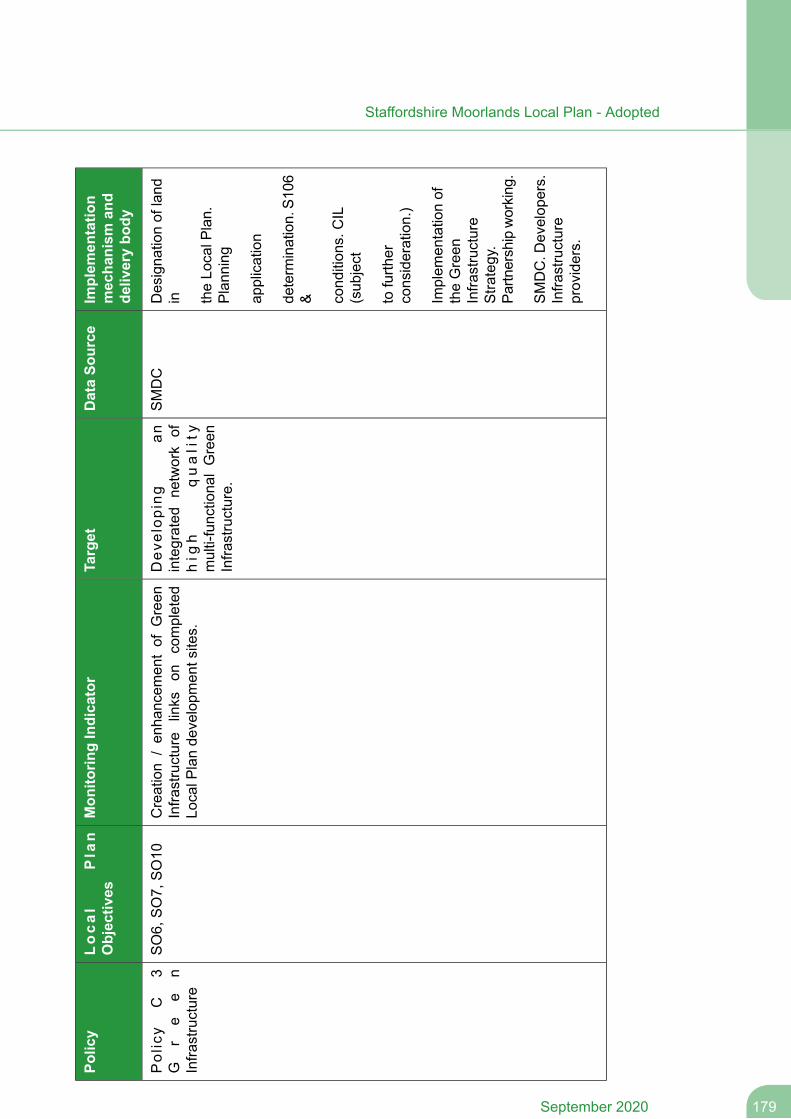
Implem
entatio
nmechanism
and
deliverybo
dy
DataSo
urce
Target
Mon
itorin
gIndicator
Local
Plan
Objectives
Policy
Designa
tionof
land
inSMDC
Dev
elop
ing
anintegrated
network
ofhig
hquality
multi-functiona
lGreen
Infra
structure.
Creation
/en
hancem
entof
Green
Infra
structure
links
oncompleted
LocalP
lande
velopm
entsites.
SO6,
SO7,
SO10
Policy
C3
Gr
ee
nInfra
structure
theLo
calP
lan.
Plann
ing
application
determ
ination.S1
06& cond
ition
s.CIL
(sub
ject
tofurth
erconsideration.)
Implem
entationof
theGreen
Infra
structure
Stra
tegy.
Partn
ershipworking
.
SMDC.D
evelop
ers.
Infra
structure
providers.
179September 2020
Staffordshire Moorlands Local Plan - Adopted
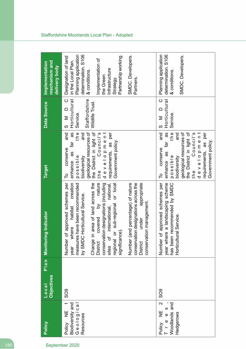
Implem
entatio
nmechanism
and
deliverybo
dy
DataSo
urce
Target
Mon
itorin
gIndicator
Local
Plan
Objectives
Policy
Designa
tionof
land
intheLo
calP
lan.
Plan
ning
application
determ
ination.S1
06&cond
ition
s.
SM
DC
Hor
ticu
ltur
alService.
Staffo
rdsh
ire
WildlifeTrust.
Toconserve
and
enha
nce
asfar
aspossib
leth
ebiod
iversity
and
geolog
icalresourcesof
the
District
inlight
ofth
eCouncil's
Num
berof
approved
sche
mes
per
year
whe
reha
bitat
crea
tion
mea
suresha
vebe
enrecommen
ded
bySMDCHorticulturalS
ervice.
Cha
ngein
area
ofland
across
the
District
covered
byna
ture
conservationde
sign
ations
(includ
ing
SO9
Policy
NE
1Biodiversity
and
Geolo
gic
al
Resou
rces
Implem
entationof
theGreen
Infra
structure
Stra
tegy.
Partn
ershipworking
.
develo
pm
ent
requ
iremen
ts,as
per
Governm
entp
olicy.
sites
ofinternationa
l,na
tiona
l,region
alor
sub-region
alor
local
sign
ificance).
SMDC.D
evelop
ers.
Partners.
Num
ber(an
dpe
rcen
tage
)ofn
ature
conservationde
sign
ations
across
the
District
unde
rap
prop
riate
conservationman
agem
ent.
Plan
ning
application
determ
ination.S1
06&cond
ition
s.
SM
DC
Hor
ticu
ltur
alService.
Toconserve
and
enha
nce
asfar
aspossib
leth
e
Num
berof
approved
sche
mes
per
year
whe
realand
scap
ingsche
me
hasbe
enrecommen
dedby
SMDC
HorticulturalS
ervice.
SO9
Policy
NE
2T
re
es
,Woo
dlan
dsan
dHed
gerows
SMDC.D
evelop
ers.
biod
iversity
and
geolog
icalresourcesof
the
District
inlight
ofth
eCouncil's
develo
pm
ent
requ
iremen
ts,as
per
Governm
entp
olicy.
September 2020180
Staffordshire Moorlands Local Plan - Adopted
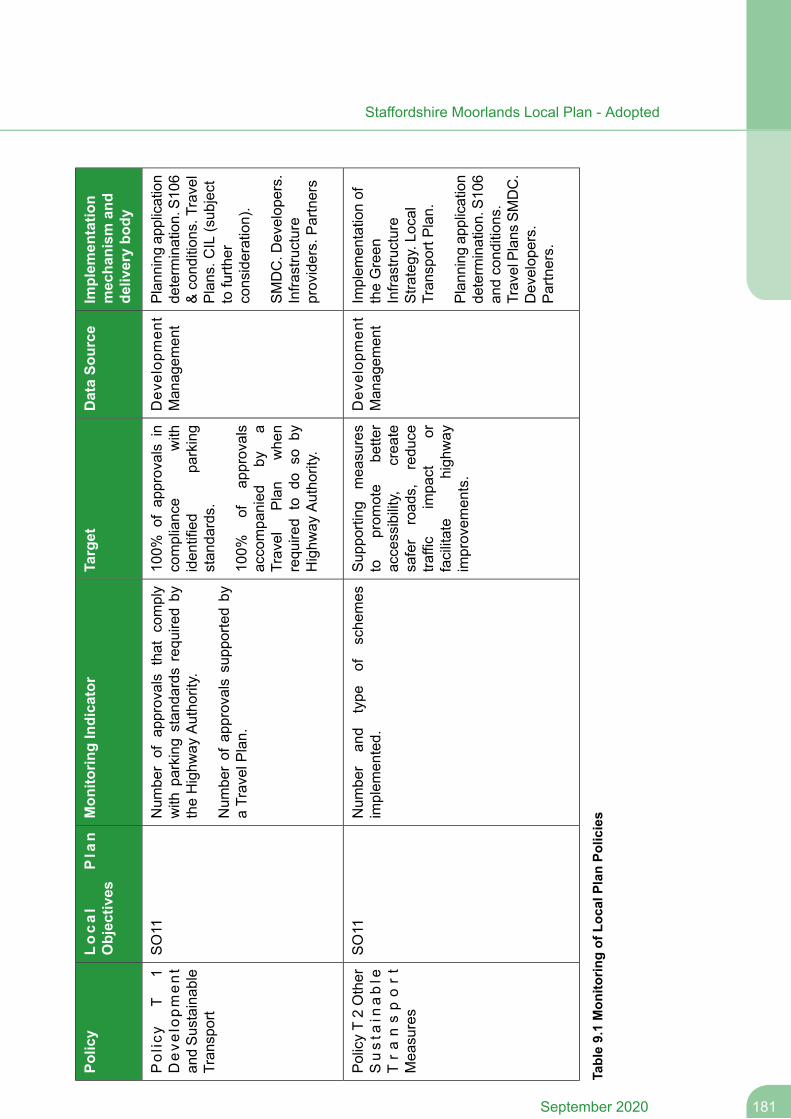
Implem
entatio
nmechanism
and
deliverybo
dy
DataSo
urce
Target
Mon
itorin
gIndicator
Local
Plan
Objectives
Policy
Plan
ning
application
determ
ination.S1
06&cond
ition
s.Travel
Dev
elop
men
tMan
agem
ent
100%
ofap
provalsin
compliance
with
iden
tified
parking
stan
dards.
Num
berof
approvals
that
comply
with
parkingstan
dardsrequ
iredby
theHighw
ayAutho
rity.
Num
berof
approvalssupp
ortedby
aTravelPlan.
SO11
Policy
T1
Deve
lopment
andSustainab
leTran
sport
Plans.C
IL(sub
ject
tofurth
erconsideration).
100%
ofap
provals
accompa
nied
bya
Travel
Plan
whe
nrequ
ired
todo
soby
Highw
ayAutho
rity.
SMDC.D
evelop
ers.
Infra
structure
providers.Partners
Implem
entationof
theGreen
Infra
structure
Stra
tegy.L
ocal
Tran
sportP
lan.
Dev
elop
men
tMan
agem
ent
Sup
porting
mea
sures
toprom
ote
bette
raccessibility,
crea
tesafer
road
s,redu
cetra
ffic
impa
ctor
facilitate
high
way
improvem
ents.
Num
ber
and
type
ofsche
mes
implem
ented.
SO11
PolicyT2Other
Susta
inable
Transport
Mea
sures
Plan
ning
application
determ
ination.S1
06an
dcond
ition
s.TravelPlan
sSM
DC.
Develop
ers.
Partners.
Table9.1Mon
itorin
gof
LocalP
lanPo
licies
181September 2020
Staffordshire Moorlands Local Plan - Adopted
Infrastructure Delivery
9.11 A key element of the delivery of the Local Plan is the provision of essential communityinfrastructure. The Local Plan will seek to optimise existing infrastructure in appropriatelocations and ensure that new infrastructure is provided to support development whererequired in accordance with Policy SS 12 (Planning Obligations and Community InfrastructureLevy). As required in this policy, funding will be sought from developers to invest ininfrastructure necessary to support on site requirements through planning obligations and /or conditions or to address the cumulative impacts on development through the CommunityInfrastructure Levy (subject to further consideration).
9.12 In preparing the Local Plan, discussions and consultations with key infrastructureproviders have been undertaken regarding the proposed Local Plan to ensure that, at thisstrategic level, plans are in place for infrastructure delivery.
9.13 To support the Local Plan, a separate Staffordshire Moorlands InfrastructureDelivery Plan has been prepared which identifies the infrastructure requirements forStaffordshire Moorlands, responsible delivery bodies, costs and sources of funding. It willbe updated on a regular basis and modified to reflect any changes in circumstances identifiedthrough the Annual Monitoring Report. Further engagement with infrastructure serviceproviders will be carried out during the final preparations of the Local Plan and following itsadoption to ensure that the Infrastructure Delivery Plan remains up to date. A copy of theInfrastructure Delivery Plan can be viewed on the Local Plan Evidence Base page of theDistrict Council's website.
September 2020182
Staffordshire Moorlands Local Plan - Adopted

Appendix 1 - Housing Trajectory
183September 2020
Staffordshire Moorlands Local Plan - Adopted
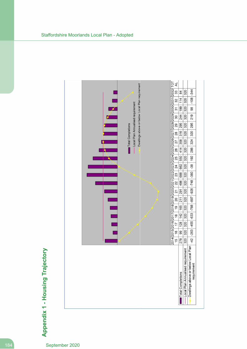
App
endix1-H
ousing
Trajectory
September 2020184
Staffordshire Moorlands Local Plan - Adopted

Appendix 2 - Parking Guidance
185September 2020
Staffordshire Moorlands Local Plan - Adopted
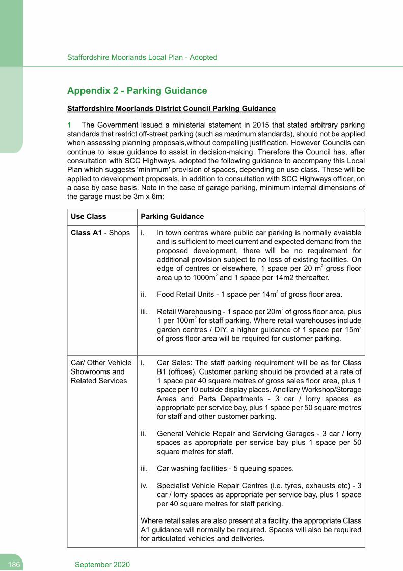
Appendix 2 - Parking Guidance
Staffordshire Moorlands District Council Parking Guidance
1 The Government issued a ministerial statement in 2015 that stated arbitrary parkingstandards that restrict off-street parking (such as maximum standards), should not be appliedwhen assessing planning proposals,without compelling justification. However Councils cancontinue to issue guidance to assist in decision-making. Therefore the Council has, afterconsultation with SCC Highways, adopted the following guidance to accompany this LocalPlan which suggests 'minimum' provision of spaces, depending on use class. These will beapplied to development proposals, in addition to consultation with SCC Highways officer, ona case by case basis. Note in the case of garage parking, minimum internal dimensions ofthe garage must be 3m x 6m:
Parking GuidanceUse Class
Class A1 - Shops i. In town centres where public car parking is normally avaiableand is sufficient to meet current and expected demand from theproposed development, there will be no requirement foradditional provision subject to no loss of existing facilities. Onedge of centres or elsewhere, 1 space per 20 m2 gross floorarea up to 1000m2 and 1 space per 14m2 thereafter.
ii. Food Retail Units - 1 space per 14m2 of gross floor area.
iii. Retail Warehousing - 1 space per 20m2 of gross floor area, plus1 per 100m2 for staff parking. Where retail warehouses includegarden centres / DIY, a higher guidance of 1 space per 15m2
of gross floor area will be required for customer parking.
Car/ Other VehicleShowrooms andRelated Services
i. Car Sales: The staff parking requirement will be as for ClassB1 (offices). Customer parking should be provided at a rate of1 space per 40 square metres of gross sales floor area, plus 1space per 10 outside display places. AncillaryWorkshop/StorageAreas and Parts Departments - 3 car / lorry spaces asappropriate per service bay, plus 1 space per 50 square metresfor staff and other customer parking.
ii. General Vehicle Repair and Servicing Garages - 3 car / lorryspaces as appropriate per service bay plus 1 space per 50square metres for staff.
iii. Car washing facilities - 5 queuing spaces.
iv. Specialist Vehicle Repair Centres (i.e. tyres, exhausts etc) - 3car / lorry spaces as appropriate per service bay, plus 1 spaceper 40 square metres for staff parking.
Where retail sales are also present at a facility, the appropriate ClassA1 guidance will normally be required. Spaces will also be requiredfor articulated vehicles and deliveries.
September 2020186
Staffordshire Moorlands Local Plan - Adopted
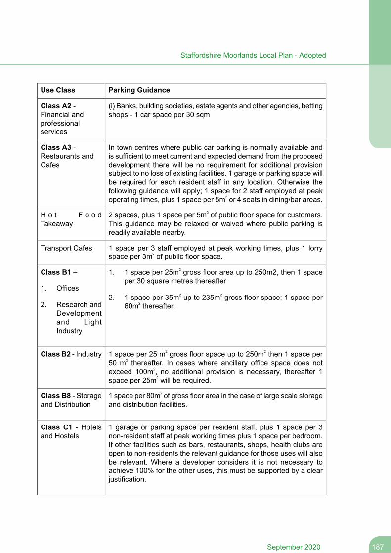
Parking GuidanceUse Class
(i) Banks, building societies, estate agents and other agencies, bettingshops - 1 car space per 30 sqm
Class A2 -Financial andprofessionalservices
In town centres where public car parking is normally available andis sufficient to meet current and expected demand from the proposeddevelopment there will be no requirement for additional provision
Class A3 -Restaurants andCafes
subject to no loss of existing facilities. 1 garage or parking space willbe required for each resident staff in any location. Otherwise thefollowing guidance will apply; 1 space for 2 staff employed at peakoperating times, plus 1 space per 5m2 or 4 seats in dining/bar areas.
2 spaces, plus 1 space per 5m2 of public floor space for customers.This guidance may be relaxed or waived where public parking isreadily available nearby.
H o t F o o dTakeaway
1 space per 3 staff employed at peak working times, plus 1 lorryspace per 3m2 of public floor space.
Transport Cafes
Class B1 – 1. 1 space per 25m2 gross floor area up to 250m2, then 1 spaceper 30 square metres thereafter
1. Offices2. 1 space per 35m2 up to 235m2 gross floor space; 1 space per
60m2 thereafter.2. Research andDevelopmentand LightIndustry
1 space per 25 m2 gross floor space up to 250m2 then 1 space per50 m2 thereafter. In cases where ancillary office space does notexceed 100m2, no additional provision is necessary, thereafter 1space per 25m2 will be required.
Class B2 - Industry
1 space per 80m2 of gross floor area in the case of large scale storageand distribution facilities.
Class B8 - Storageand Distribution
1 garage or parking space per resident staff, plus 1 space per 3non-resident staff at peak working times plus 1 space per bedroom.If other facilities such as bars, restaurants, shops, health clubs are
Class C1 - Hotelsand Hostels
open to non-residents the relevant guidance for those uses will alsobe relevant. Where a developer considers it is not necessary toachieve 100% for the other uses, this must be supported by a clearjustification.
187September 2020
Staffordshire Moorlands Local Plan - Adopted
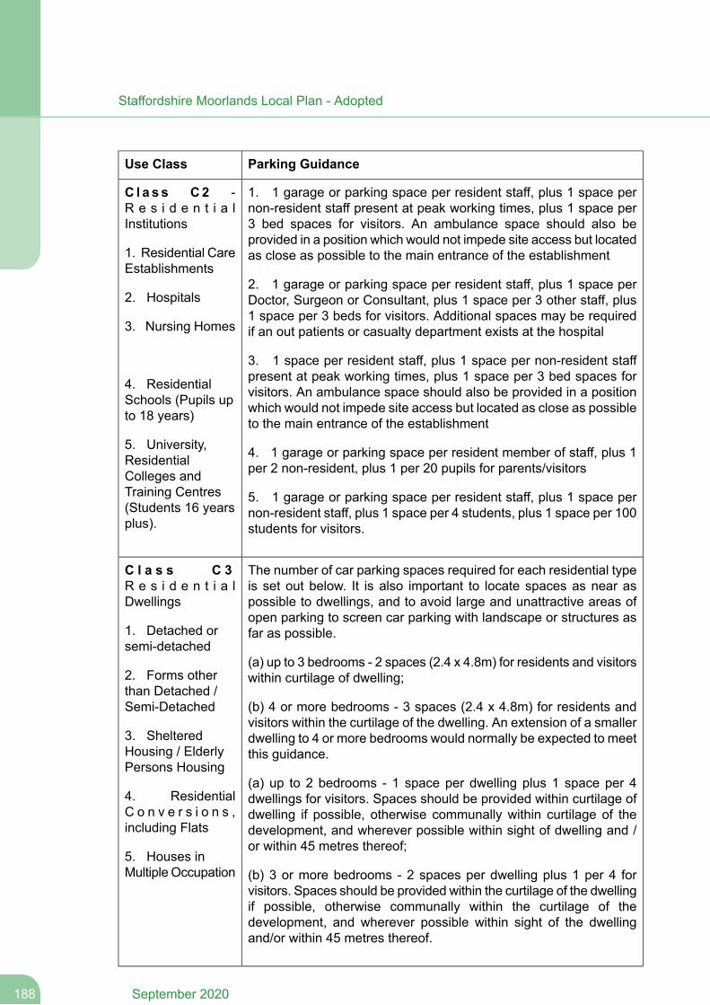
Parking GuidanceUse Class
1. 1 garage or parking space per resident staff, plus 1 space pernon-resident staff present at peak working times, plus 1 space per3 bed spaces for visitors. An ambulance space should also beprovided in a position which would not impede site access but locatedas close as possible to the main entrance of the establishment
C l a s s C2 -R e s i d e n t i a lInstitutions
1. Residential CareEstablishments
2. 1 garage or parking space per resident staff, plus 1 space perDoctor, Surgeon or Consultant, plus 1 space per 3 other staff, plus1 space per 3 beds for visitors. Additional spaces may be requiredif an out patients or casualty department exists at the hospital
2. Hospitals
3. Nursing Homes
4. ResidentialSchools (Pupils upto 18 years)
3. 1 space per resident staff, plus 1 space per non-resident staffpresent at peak working times, plus 1 space per 3 bed spaces forvisitors. An ambulance space should also be provided in a positionwhich would not impede site access but located as close as possibleto the main entrance of the establishment
5. University,ResidentialColleges and
4. 1 garage or parking space per resident member of staff, plus 1per 2 non-resident, plus 1 per 20 pupils for parents/visitors
Training Centres(Students 16 yearsplus).
5. 1 garage or parking space per resident staff, plus 1 space pernon-resident staff, plus 1 space per 4 students, plus 1 space per 100students for visitors.
The number of car parking spaces required for each residential typeis set out below. It is also important to locate spaces as near aspossible to dwellings, and to avoid large and unattractive areas ofopen parking to screen car parking with landscape or structures asfar as possible.
C l a s s C 3R e s i d e n t i a lDwellings
1. Detached orsemi-detached
(a) up to 3 bedrooms - 2 spaces (2.4 x 4.8m) for residents and visitorswithin curtilage of dwelling;2. Forms other
than Detached /Semi-Detached (b) 4 or more bedrooms - 3 spaces (2.4 x 4.8m) for residents and
visitors within the curtilage of the dwelling. An extension of a smallerdwelling to 4 or more bedrooms would normally be expected to meetthis guidance.
3. ShelteredHousing / ElderlyPersons Housing
(a) up to 2 bedrooms - 1 space per dwelling plus 1 space per 4dwellings for visitors. Spaces should be provided within curtilage ofdwelling if possible, otherwise communally within curtilage of thedevelopment, and wherever possible within sight of dwelling and /or within 45 metres thereof;
4. ResidentialC o n v e r s i o n s ,including Flats
5. Houses inMultiple Occupation (b) 3 or more bedrooms - 2 spaces per dwelling plus 1 per 4 for
visitors. Spaces should be provided within the curtilage of the dwellingif possible, otherwise communally within the curtilage of thedevelopment, and wherever possible within sight of the dwellingand/or within 45 metres thereof.
September 2020188
Staffordshire Moorlands Local Plan - Adopted

Parking GuidanceUse Class
1 space per 4 dwellings, plus 2 spaces per resident staff plus 1 spaceper non-resident staff present at peak working times. If developmentcomprises owner-occupied dwellings, 1 space per dwelling shouldbe provided communally, preferably adjacent to, but no more than45 metres from, the dwelling, to allow for resident and visitor parking.
1 space per dwelling, plus 1 per 4 dwellings for visitors, wherepossible within the curtilage of the original dwelling. Whereconversions provide for more than 2 bedrooms per unit, parkingrequirements will be based on merits of the proposed development.This guidance may be relaxed if the dwellings are provided by aHousing Association or on a shared equity basis.
1 space per 2 bedsits or bedrooms, wherever possible within curtilageof original dwelling.
1 space per medical practitioner, plus 1 space per staff memberpresent at peak working times, plus 3 spaces per consulting room /cubicle.
C l a s s D1 -Non- res iden t ia lInstitutions
3 spaces per consulting room/cubicle.1. Health Centres
1 space per 2 staff normally present at peak working times, plus 1space per 5 child placements and / or adequate pick up/set downpoints within the curtilage of the facility. Where possible, emergencyvehicle access should also be provided which cannot be obstructedby any of the above parking provision.
2. Dentists,Doctors orVeterinarySurgeries
3. Creches,Nurseries and DayCentres
1 space per full-time staff member, plus 1 space per 30 pupils forparents/visitors.
4. Schools forPupils up to 18years
1 space per full-time staff member, plus 2 spaces per 5 students plus1 space per 4 academic/administrative staff for visitors.
1 space per full-time staff member, plus 1 space per 30 square metrespublic floor area for visitors. In town centres where public parking isavailable, the need for visitor parking may be relaxed.
5. Colleges forStudents over 16years
1 space per resident member of clergy or staff, plus 1 per 2 otherclergy / staff, plus 1 per 10 seats. If the facility comprises anothercommunity use, an assessment will have to be made with referenceto the guidance for community centres and halls.
6. Art Galleries,Museums,Libraries, PublicReading Roomsand Exhibition Halls (i) 1 parking space per 5 fixed seats, and adequate turning and
loading facilities, incorporating space for one coach or a 16.5m lorry.7. Places ofWorship
Theatres
189September 2020
Staffordshire Moorlands Local Plan - Adopted
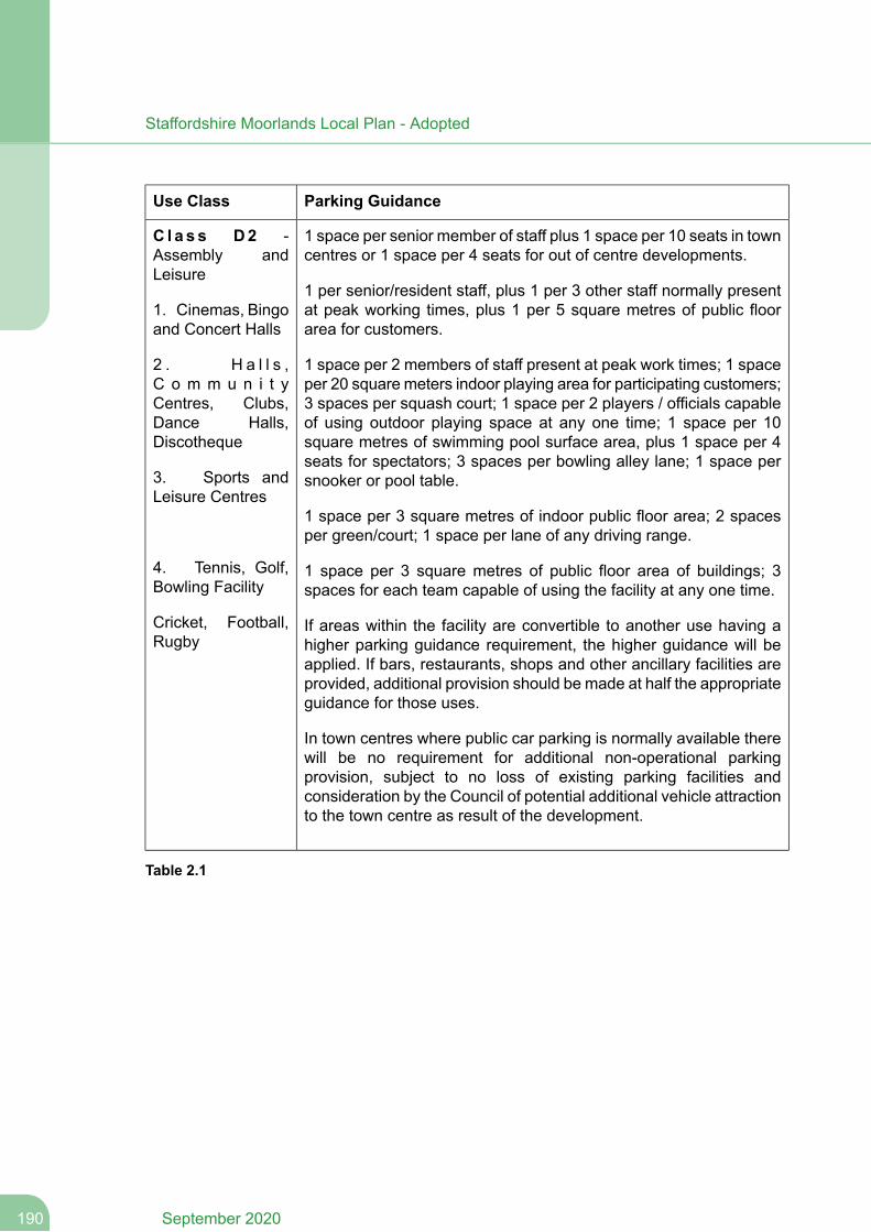
Parking GuidanceUse Class
1 space per senior member of staff plus 1 space per 10 seats in towncentres or 1 space per 4 seats for out of centre developments.
C l a s s D2 -Assembly andLeisure
1 per senior/resident staff, plus 1 per 3 other staff normally presentat peak working times, plus 1 per 5 square metres of public floorarea for customers.
1. Cinemas, Bingoand Concert Halls
1 space per 2 members of staff present at peak work times; 1 spaceper 20 square meters indoor playing area for participating customers;3 spaces per squash court; 1 space per 2 players / officials capable
2 . H a l l s ,C o m m u n i t yCentres, Clubs,Dance Halls,Discotheque
of using outdoor playing space at any one time; 1 space per 10square metres of swimming pool surface area, plus 1 space per 4seats for spectators; 3 spaces per bowling alley lane; 1 space persnooker or pool table.3. Sports and
Leisure Centres1 space per 3 square metres of indoor public floor area; 2 spacesper green/court; 1 space per lane of any driving range.
4. Tennis, Golf,Bowling Facility
1 space per 3 square metres of public floor area of buildings; 3spaces for each team capable of using the facility at any one time.
Cricket, Football,Rugby
If areas within the facility are convertible to another use having ahigher parking guidance requirement, the higher guidance will beapplied. If bars, restaurants, shops and other ancillary facilities areprovided, additional provision should be made at half the appropriateguidance for those uses.
In town centres where public car parking is normally available therewill be no requirement for additional non-operational parkingprovision, subject to no loss of existing parking facilities andconsideration by the Council of potential additional vehicle attractionto the town centre as result of the development.
Table 2.1
September 2020190
Staffordshire Moorlands Local Plan - Adopted

Appendix 3 - Policies to be Superseded
191September 2020
Staffordshire Moorlands Local Plan - Adopted
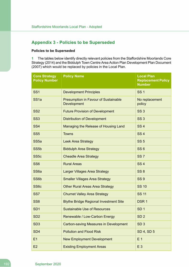
Appendix 3 - Policies to be Superseded
Policies to be Superseded
1 The tables below identify directly relevant policies from the Staffordshire Moorlands CoreStrategy (2014) and the Biddulph TownCentre Area Action Plan Development Plan Document(2007) which would be replaced by policies in the Local Plan.
Local PlanReplacement PolicyNumber
Policy NameCore StrategyPolicy Number
SS 1Development PrinciplesSS1
No replacementpolicy
Presumption in Favour of SustainableDevelopment
SS1a
SS 3Future Provision of DevelopmentSS2
SS 3Distribution of DevelopmentSS3
SS 4Managing the Release of Housing LandSS4
SS 4TownsSS5
SS 5Leek Area StrategySS5a
SS 6Biddulph Area StrategySS5b
SS 7Cheadle Area StrategySS5c
SS 4Rural AreasSS6
SS 8Larger Villages Area StrategySS6a
SS 9Smaller Villages Area StrategySS6b
SS 10Other Rural Areas Area StrategySS6c
SS 11Churnet Valley Area StrategySS7
DSR 1Blythe Bridge Regional Investment SiteSS8
SD 1Sustainable Use of ResourcesSD1
SD 2Renewable / Low-Carbon EnergySD2
SD 3Carbon-saving Measures in DevelopmentSD3
SD 4, SD 5Pollution and Flood RiskSD4
E 1New Employment DevelopmentE1
E 3Existing Employment AreasE2
September 2020192
Staffordshire Moorlands Local Plan - Adopted
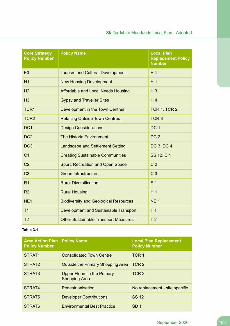
Local PlanReplacement PolicyNumber
Policy NameCore StrategyPolicy Number
E 4Tourism and Cultural DevelopmentE3
H 1New Housing DevelopmentH1
H 3Affordable and Local Needs HousingH2
H 4Gypsy and Traveller SitesH3
TCR 1, TCR 2Development in the Town CentresTCR1
TCR 3Retailing Outside Town CentresTCR2
DC 1Design ConsiderationsDC1
DC 2The Historic EnvironmentDC2
DC 3, DC 4Landscape and Settlement SettingDC3
SS 12, C 1Creating Sustainable CommunitiesC1
C 2Sport, Recreation and Open SpaceC2
C 3Green InfrastructureC3
E 1Rural DiversificationR1
H 1Rural HousingR2
NE 1Biodiversity and Geological ResourcesNE1
T 1Development and Sustainable TransportT1
T 2Other Sustainable Transport MeasuresT2
Table 3.1
Local Plan ReplacementPolicy Number
Policy NameArea Action PlanPolicy Number
TCR 1Consolidated Town CentreSTRAT1
TCR 2Outside the Primary Shopping AreaSTRAT2
TCR 2Upper Floors in the PrimaryShopping Area
STRAT3
No replacement - site specificPedestrianisationSTRAT4
SS 12Developer ContributionsSTRAT5
SD 1Environmental Best PracticeSTRAT6
193September 2020
Staffordshire Moorlands Local Plan - Adopted
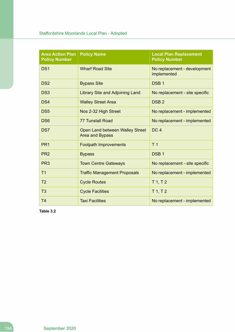
Local Plan ReplacementPolicy Number
Policy NameArea Action PlanPolicy Number
No replacement - developmentimplemented
Wharf Road SiteDS1
DSB 1Bypass SiteDS2
No replacement - site specificLibrary Site and Adjoining LandDS3
DSB 2Walley Street AreaDS4
No replacement - implementedNos 2-32 High StreetDS5
No replacement - implemented77 Tunstall RoadDS6
DC 4Open Land between Walley StreetArea and Bypass
DS7
T 1Footpath ImprovementsPR1
DSB 1BypassPR2
No replacement - site specificTown Centre GatewaysPR3
No replacement - implementedTraffic Management ProposalsT1
T 1, T 2Cycle RoutesT2
T 1, T 2Cycle FacilitiesT3
No replacement - implementedTaxi FacilitiesT4
Table 3.2
September 2020194
Staffordshire Moorlands Local Plan - Adopted

Appendix 4- Local Green Spaces
195September 2020
Staffordshire Moorlands Local Plan - Adopted
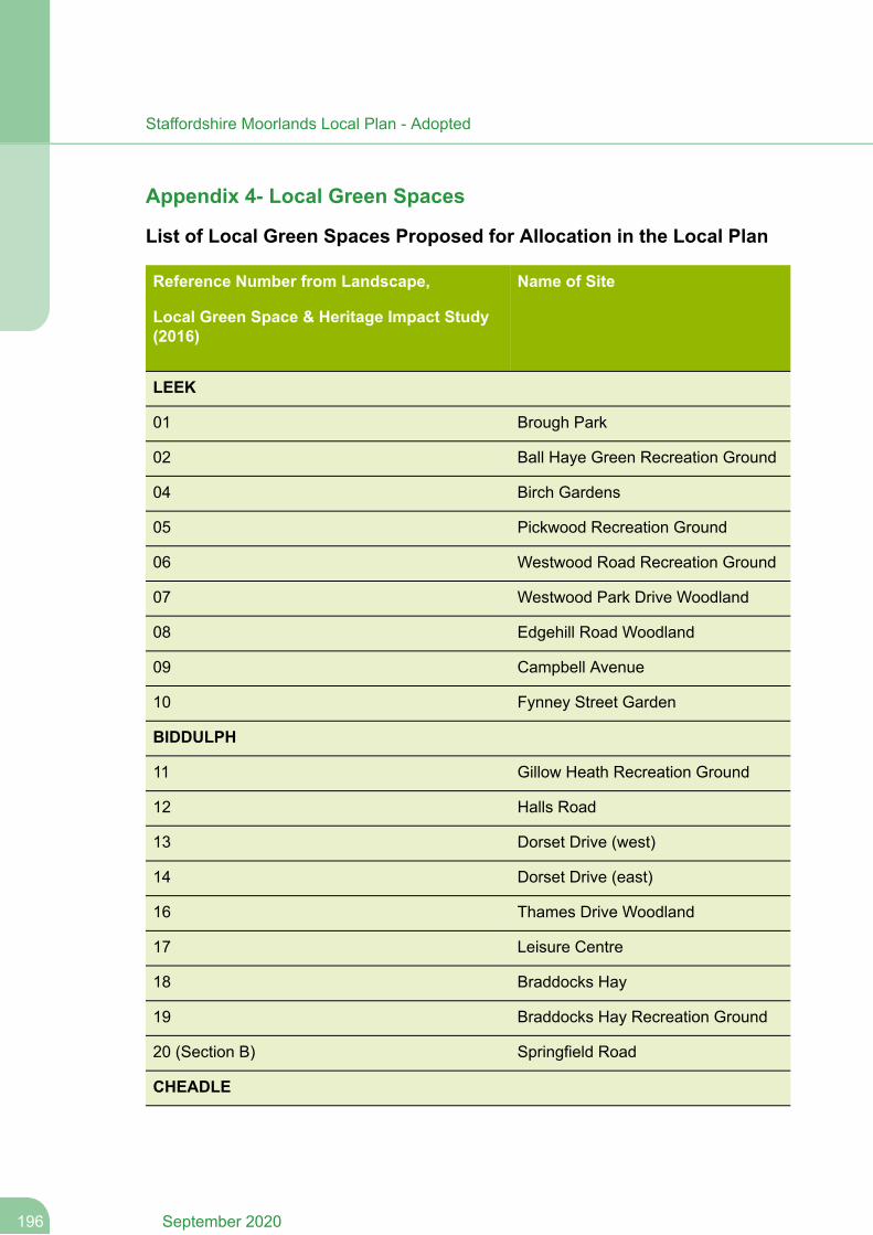
Appendix 4- Local Green Spaces
List of Local Green Spaces Proposed for Allocation in the Local Plan
Name of SiteReference Number from Landscape,
Local Green Space & Heritage Impact Study(2016)
LEEK
Brough Park01
Ball Haye Green Recreation Ground02
Birch Gardens04
Pickwood Recreation Ground05
Westwood Road Recreation Ground06
Westwood Park Drive Woodland07
Edgehill Road Woodland08
Campbell Avenue09
Fynney Street Garden10
BIDDULPH
Gillow Heath Recreation Ground11
Halls Road12
Dorset Drive (west)13
Dorset Drive (east)14
Thames Drive Woodland16
Leisure Centre17
Braddocks Hay18
Braddocks Hay Recreation Ground19
Springfield Road20 (Section B)
CHEADLE
September 2020196
Staffordshire Moorlands Local Plan - Adopted
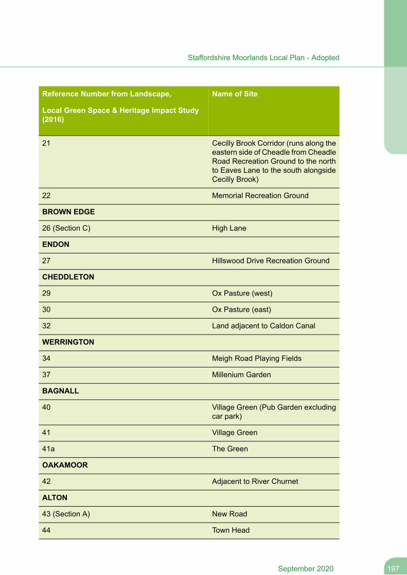
Name of SiteReference Number from Landscape,
Local Green Space & Heritage Impact Study(2016)
Cecilly Brook Corridor (runs along theeastern side of Cheadle fromCheadleRoad Recreation Ground to the northto Eaves Lane to the south alongsideCecilly Brook)
21
Memorial Recreation Ground22
BROWN EDGE
High Lane26 (Section C)
ENDON
Hillswood Drive Recreation Ground27
CHEDDLETON
Ox Pasture (west)29
Ox Pasture (east)30
Land adjacent to Caldon Canal32
WERRINGTON
Meigh Road Playing Fields34
Millenium Garden37
BAGNALL
Village Green (Pub Garden excludingcar park)
40
Village Green41
The Green41a
OAKAMOOR
Adjacent to River Churnet42
ALTON
New Road43 (Section A)
Town Head44
197September 2020
Staffordshire Moorlands Local Plan - Adopted
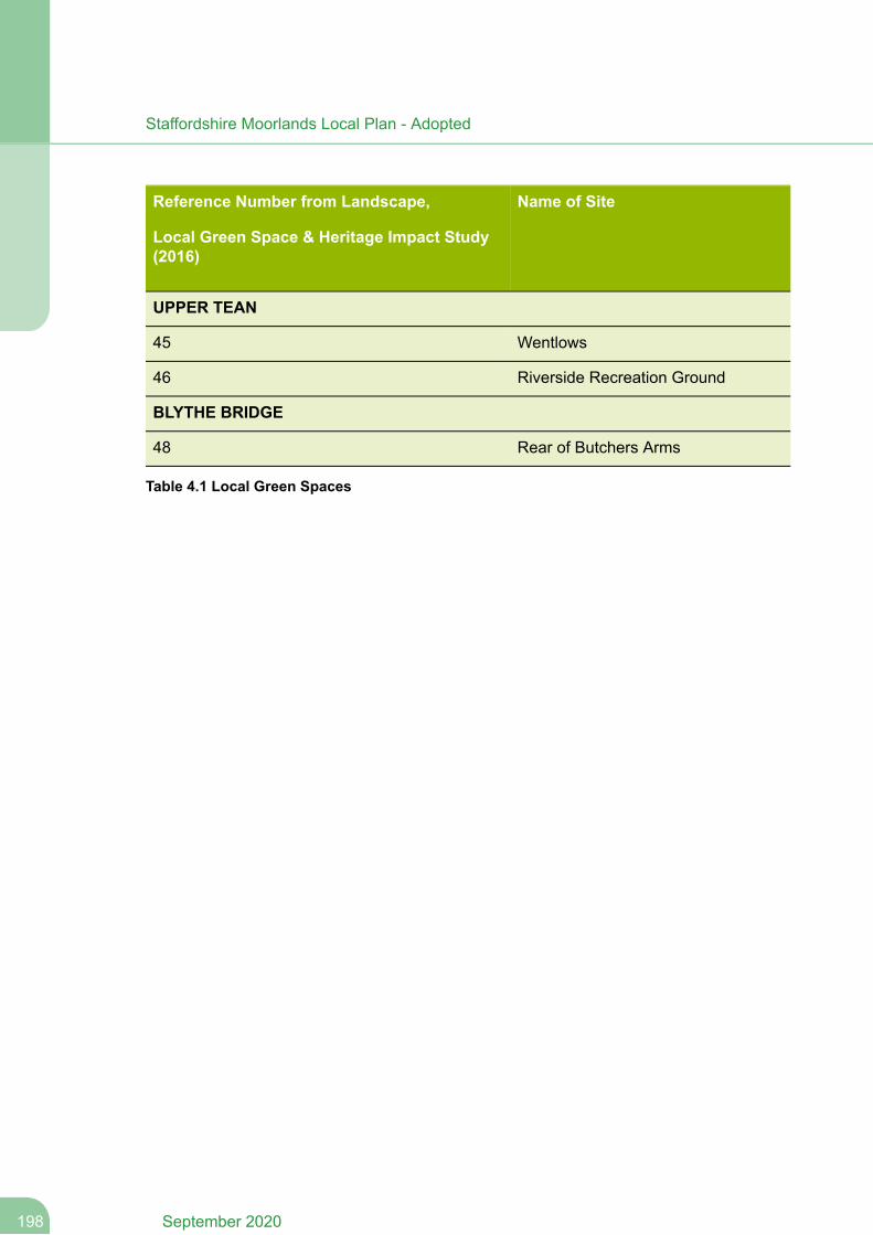
Name of SiteReference Number from Landscape,
Local Green Space & Heritage Impact Study(2016)
UPPER TEAN
Wentlows45
Riverside Recreation Ground46
BLYTHE BRIDGE
Rear of Butchers Arms48
Table 4.1 Local Green Spaces
September 2020198
Staffordshire Moorlands Local Plan - Adopted
Appendix 5 - Neighbourhood Plan housing requirement methodology
199September 2020
Staffordshire Moorlands Local Plan - Adopted
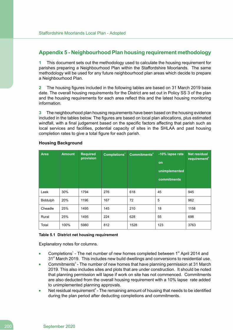
Appendix 5 - NeighbourhoodPlan housing requirementmethodology
1 This document sets out the methodology used to calculate the housing requirement forparishes preparing a Neighbourhood Plan within the Staffordshire Moorlands. The samemethodology will be used for any future neighbourhood plan areas which decide to preparea Neighbourhood Plan.
2 The housing figures included in the following tables are based on 31 March 2019 basedate. The overall housing requirements for the District are set out in Policy SS 3 of the planand the housing requirements for each area reflect this and the latest housing monitoringinformation.
3 The neighbourhood plan housing requirements have been based on the housing evidenceincluded in the tables below. The figures are based on local plan allocations, plus estimatedwindfall, with a final judgement based on the specific factors affecting that parish such aslocal services and facilities, potential capacity of sites in the SHLAA and past housingcompletion rates to give a total figure for each parish.
Housing Background
Net residualrequirement3
-10% lapse rate
on
unimplemented
commitments
Commitments2Completions1Requiredprovision
AmountArea
94545618276179430%Leek
962572167119620%Biddulph
115818210145149525%Cheadle
69855628224149525%Rural
376312315288125980100%Total
Table 5.1 District net housing requirement
Explanatory notes for columns.
Completions1 - The net number of new homes completed between 1st April 2014 and31st March 2019. This includes new build dwellings and conversions to residential use.Commitments2 - The number of new homes that have planning permission at 31 March2019. This also includes sites and plots that are under construction. It should be notedthat planning permission will lapse if work on site has not commenced. Commitmentsare also deducted from the overall housing requirement with a 10% lapse rate addedto unimplemented planning approvals.Net residual requirement3 - The remaining amount of housing that needs to be identifiedduring the plan period after deducting completions and commitments.
September 2020200
Staffordshire Moorlands Local Plan - Adopted
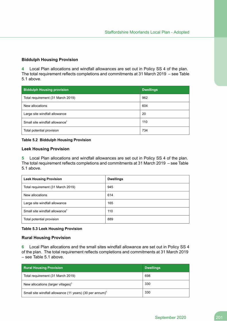
Biddulph Housing Provision
4 Local Plan allocations and windfall allowances are set out in Policy SS 4 of the plan.The total requirement reflects completions and commitments at 31 March 2019 – see Table5.1 above.
DwellingsBiddulph Housing provision
962Total requirement (31 March 2019)
604New allocations
20Large site windfall allowance
110Small site windfall allowance4
734Total potential provision
Table 5.2 Biddulph Housing Provision
Leek Housing Provision
5 Local Plan allocations and windfall allowances are set out in Policy SS 4 of the plan.The total requirement reflects completions and commitments at 31 March 2019 – see Table5.1 above.
DwellingsLeek Housing Provision
945Total requirement (31 March 2019)
614New allocations
165Large site windfall allowance
110Small site windfall allowance4
889Total potential provision
Table 5.3 Leek Housing Provision
Rural Housing Provision
6 Local Plan allocations and the small sites windfall allowance are set out in Policy SS 4of the plan. The total requirement reflects completions and commitments at 31 March 2019– see Table 5.1 above.
DwellingsRural Housing Provision
698Total requirement (31 March 2019)
330New allocations (larger villages)5
330Small site windfall allowance (11 years) (30 per annum)6
201September 2020
Staffordshire Moorlands Local Plan - Adopted
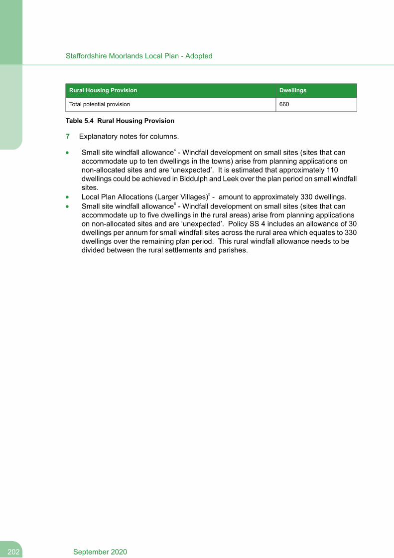
DwellingsRural Housing Provision
660Total potential provision
Table 5.4 Rural Housing Provision
7 Explanatory notes for columns.
Small site windfall allowance4 - Windfall development on small sites (sites that canaccommodate up to ten dwellings in the towns) arise from planning applications onnon-allocated sites and are ‘unexpected’. It is estimated that approximately 110dwellings could be achieved in Biddulph and Leek over the plan period on small windfallsites.Local Plan Allocations (Larger Villages)5 - amount to approximately 330 dwellings.Small site windfall allowance6 - Windfall development on small sites (sites that canaccommodate up to five dwellings in the rural areas) arise from planning applicationson non-allocated sites and are ‘unexpected’. Policy SS 4 includes an allowance of 30dwellings per annum for small windfall sites across the rural area which equates to 330dwellings over the remaining plan period. This rural windfall allowance needs to bedivided between the rural settlements and parishes.
September 2020202
Staffordshire Moorlands Local Plan - Adopted
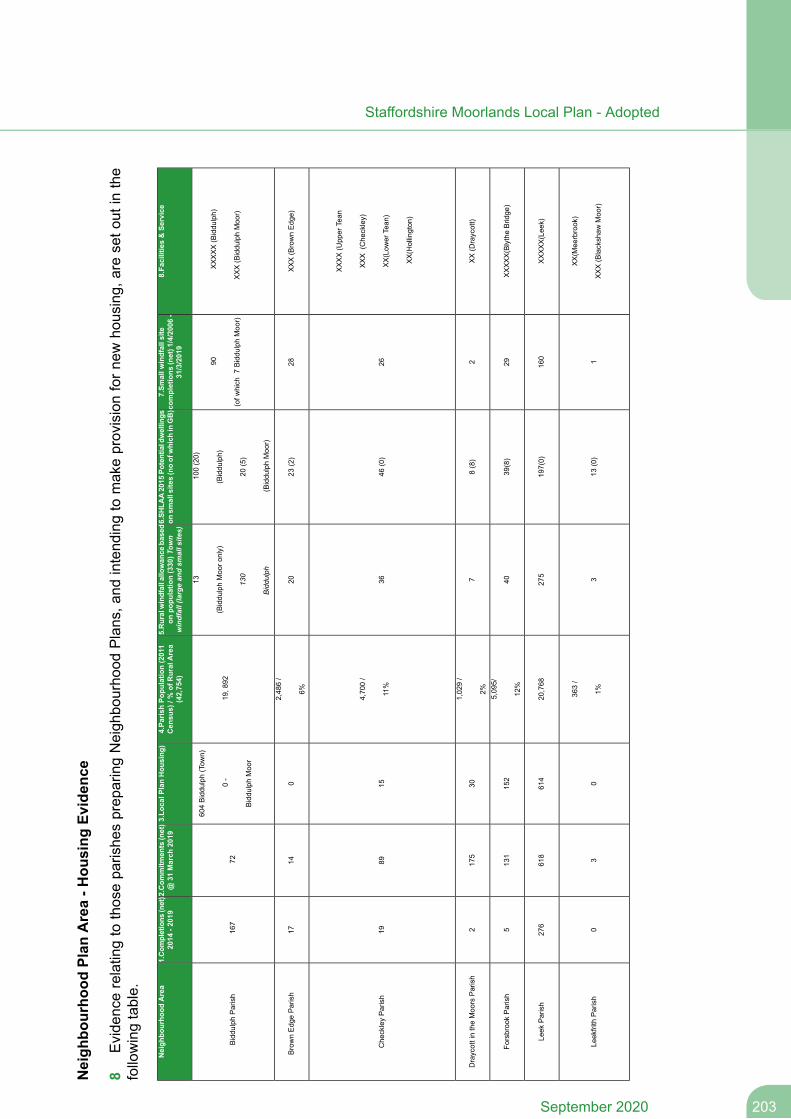
Neigh
bourho
odPlan
Area-H
ousing
Evidence
8Evide
ncerelatingto
thosepa
rishe
sprep
aringNeigh
bourho
odPlans,a
ndintend
ingto
makeprovisionforn
ewho
using,
areseto
utin
the
followingtable.
8.Facilities&Se
rvice
7.Sm
allw
indfallsite
completions
(net)1/4/2006-
31/3/2019
6.SH
LAA2015
Potentialdwellings
onsm
allsites(noofwhich
inGB)
5.Ruralwindfallallowance
based
onpo
pulatio
n(330)T
own
windfall(largean
dsm
alls
ites)
4.Pa
rishPo
pulatio
n(2011
Census)/%
ofRuralArea
(42,754)
3.Lo
calP
lanHou
sing
)2.Com
mitm
ents(net)
@31
March
2019
1.Com
pletions
(net)
2014
-2019
Neigh
bourho
odArea
XXXXX(Biddu
lph)
XXX(Biddu
lphMoo
r)
90
(ofw
hich
7Biddu
lphMoo
r)
100(20)
(Biddu
lph)
20(5)
(Biddu
lphMoo
r)
13
(Biddu
lphMoo
ronly)
130
Biddulph
19,8
92
604Biddu
lph(Tow
n)
0-
Biddu
lphMoo
r
7216
7Biddu
lphParish
XXX(BrownEdg
e)28
23(2)
20
2,48
6/
6%0
1417
BrownEdg
eParish
XXXX(Upp
erTean
XXX
(Che
ckley)
XX(Low
erTean
)
XX(Hollington
)
2646
(0)
36
4,70
0/
11%
1589
19Che
ckleyParish
XX(Draycott)
28(8)
7
1,02
9/
2%30
175
2DraycottintheMoo
rsParish
XXXXX(BlytheBrid
ge)
2939
(8)
40
5,09
5/
12%
152
131
5Fo
rsbroo
kParish
XXXXX(Lee
k)16
019
7(0)
275
20,768
614
618
276
Leek
Parish
XX(M
eerbrook)
XXX(Blackshaw
Moo
r)1
13(0)
3
363/
1%0
30
Leekfrith
Parish
203September 2020
Staffordshire Moorlands Local Plan - Adopted
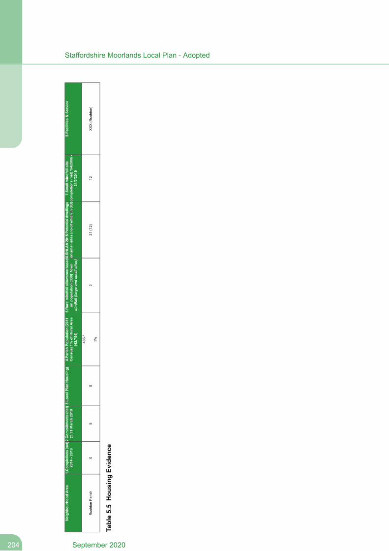
8.Facilities&Se
rvice
7.Sm
allw
indfallsite
completions
(net)1/4/2006-
31/3/2019
6.SH
LAA2015
Potentialdwellings
onsm
allsites(noofwhich
inGB)
5.Ruralwindfallallowance
based
onpo
pulatio
n(330)T
own
windfall(largean
dsm
alls
ites)
4.Pa
rishPo
pulatio
n(2011
Census)/%
ofRuralArea
(42,754)
3.Lo
calP
lanHou
sing
)2.Com
mitm
ents(net)
@31
March
2019
1.Com
pletions
(net)
2014
-2019
Neigh
bourho
odArea
XXX(Rushton
)12
21(12)
3
485/
1%0
50
Rushton
Parish
Table5.5Hou
sing
Evidence
September 2020204
Staffordshire Moorlands Local Plan - Adopted
9 Explanatory notes for columns.
1. Completions - The number of new housing completions between 1 April 2014 and 31March 2019 (including conversions) with any losses deducted, for example conversionsof two dwellings into one, to give a net figure.
2. Commitments - The number of new homes that have outline or full planning permissionin each parish. The table shows the level of commitments at 31 March 2019 whichincludes sites / plots that are under construction. Losses are deducted to give a netfigure.
3. Local Plan housing allocations - These sites are identified in Policy H 2.4. Parish population 2011 - The total population for the parishes within the rural area in
the Staffordshire Moorlands in 2011 was 41,114. Biddulph Moor is identified as a largervillage in the adopted Local Plan and is included within Biddulph Parish along with thetown of Biddulph. Biddulph Moor shares a proportion of the rural windfall allowanceand therefore the population for Biddulph Moor ward 1,640 has been added to the ruralarea population figure to give a total of 42,754. The population of each rural parish andthe ward of Biddulph Moor is expressed as a percentage of this overall figure.
5. Windfall allowance - The rural windfall allowance (330) is divided between each parishbased on 2011 percentage to provide a baseline. A windfall allowance of 130 dwellingsis included for the town of Biddulph which includes 20 dwellings for large sites and 110dwellings for small sites. A windfall allowance is also included for Leek which includes165 dwellings for large sites and 110 dwellings for small sites.
6. Site Availability - Figures are taken from the latest published Strategic Housing LandAvailability Assessment (SHLAA) (July 2015). They indicate the potential number ofdwellings on small sites that could accommodate 1 to 10 dwellings in the towns and 1and 5 dwellings in the rural areas and are classified as a ‘B’ which are considered tobe developable. The table also indicates the number of these potential homes in theGreen Belt (GB).
7. Past Trends / Small Windfall Site Completions - This is the net number of completionson small sites (1 to 10 dwellings in the towns and 1 to 5 dwellings in the rural areas)over the last 13 years in each parish.
8. Facilities and services - In order to promote sustainable development, an assessmenthas been made of services and facilities for each of the settlements located within eachparish. Local Plan Policies SS 8 and SS 9 define large and small villages.
XXXXX – primary and secondary school, GP/dentist, village hall, store/PO, PH
XXXX – primary school, GP/dentist, village hall, store/PO, PH
XXX – primary school, village hall/store/PO/PH
XX – no school, village hall/store/PO/PH
X – no school, no village hall/store/PO/PH
205September 2020
Staffordshire Moorlands Local Plan - Adopted
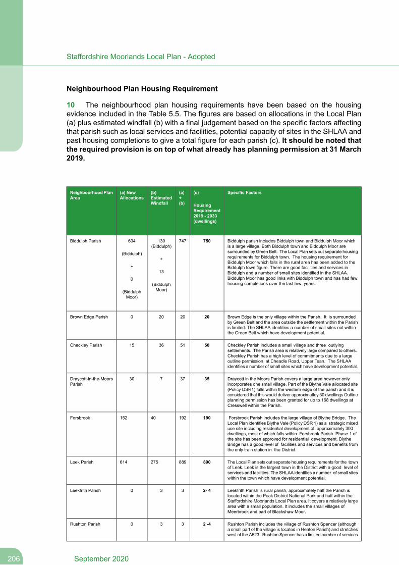
Neighbourhood Plan Housing Requirement
10 The neighbourhood plan housing requirements have been based on the housingevidence included in the Table 5.5. The figures are based on allocations in the Local Plan(a) plus estimated windfall (b) with a final judgement based on the specific factors affectingthat parish such as local services and facilities, potential capacity of sites in the SHLAA andpast housing completions to give a total figure for each parish (c). It should be noted thatthe required provision is on top of what already has planning permission at 31 March2019.
Specific Factors(c)
HousingRequirement2019 - 2033(dwellings)
(a)+(b)
(b)EstimatedWindfall
(a) NewAllocations
NeighbourhoodPlanArea
Biddulph parish includes Biddulph town and Biddulph Moor whichis a large village. Both Biddulph town and Biddulph Moor are
750747130(Biddulph)
604Biddulph Parish
surrounded by Green Belt. The Local Plan sets out separate housing(Biddulph)requirements for Biddulph town. The housing requirement for+Biddulph Moor which falls in the rural area has been added to the
+ Biddulph town figure. There are good facilities and services in13 Biddulph and a number of small sites identified in the SHLAA.
Biddulph Moor has good links with Biddulph town and has had fewhousing completions over the last few years.(Biddulph
Moor)
0
(BiddulphMoor)
Brown Edge is the only village within the Parish. It is surroundedby Green Belt and the area outside the settlement within the Parish
2020200Brown Edge Parish
is limited. The SHLAA identifies a number of small sites not withinthe Green Belt which have development potential.
Checkley Parish includes a small village and three outlyingsettlements. The Parish area is relatively large compared to others.
50513615Checkley Parish
Checkley Parish has a high level of commitments due to a largeoutline permission at Cheadle Road, Upper Tean. The SHLAAidentifies a number of small sites which have development potential.
Draycott in the Moors Parish covers a large area however onlyincorporates one small village. Part of the Blythe Vale allocated site
3537730Draycott-in-the-MoorsParish
(Policy DSR1) falls within the western edge of the parish and it isconsidered that this would deliver approximatley 30 dwellings Outlineplanning permission has been granted for up to 168 dwellings atCresswell within the Parish.
Forsbrook Parish includes the large village of Blythe Bridge. TheLocal Plan identifies Blythe Vale (Policy DSR 1) as a strategic mixeduse site including residential development of approximately 300
19019240152Forsbrook
dwellings, most of which falls within Forsbrook Parish. Phase 1 ofthe site has been approved for residential development. BlytheBridge has a good level of facilities and services and benefits fromthe only train station in the District.
The Local Plan sets out separate housing requirements for the townof Leek. Leek is the largest town in the District with a good level ofservices and facilities. The SHLAA identifies a number of small siteswithin the town which have development potential.
890889275614Leek Parish
Leekfrith Parish is rural parish, approximately half the Parish islocated within the Peak District National Park and half within the
2- 4330Leekfrith Parish
Staffordshire Moorlands Local Plan area. It covers a relatively largearea with a small population. It includes the small villages ofMeerbrook and part of Blackshaw Moor.
Rushton Parish includes the village of Rushton Spencer (althougha small part of the village is located in Heaton Parish) and stretches
2 -4330Rushton Parish
west of the A523. Rushton Spencer has a limited number of services
September 2020206
Staffordshire Moorlands Local Plan - Adopted
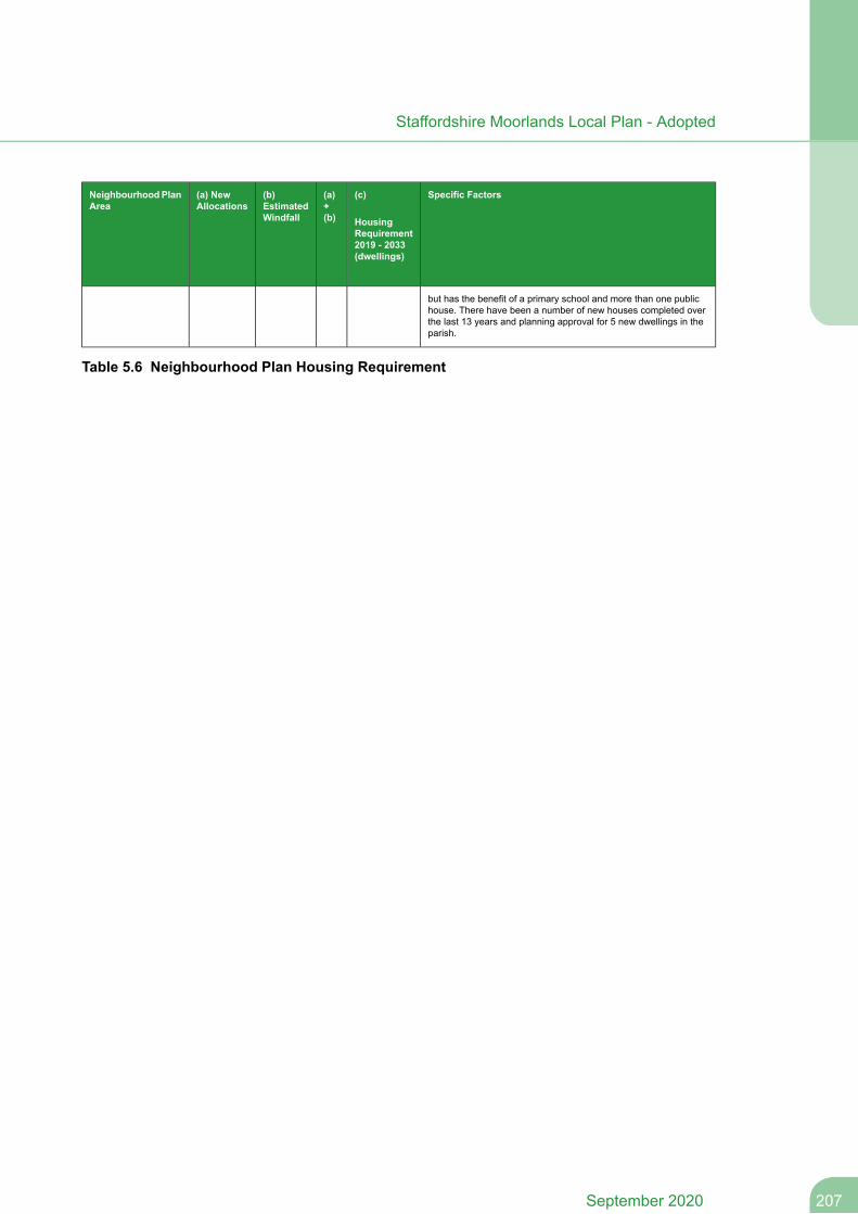
Specific Factors(c)
HousingRequirement2019 - 2033(dwellings)
(a)+(b)
(b)EstimatedWindfall
(a) NewAllocations
NeighbourhoodPlanArea
but has the benefit of a primary school and more than one publichouse. There have been a number of new houses completed overthe last 13 years and planning approval for 5 new dwellings in theparish.
Table 5.6 Neighbourhood Plan Housing Requirement
207September 2020
Staffordshire Moorlands Local Plan - Adopted

Appendix 6 - Glossary
208September 2020
Staffordshire Moorlands Local Plan - Adopted
Appendix 6 - Glossary
Glossary
Affordable Housing – defined in NPPF as including ‘social rented, affordable rentedand intermediate housing, provided to specified eligible households whose needs arenot met by the market.’
Aged or veteran tree - A tree which, because of its great age, size or condition is ofexceptional value for wildlife, in the landscape, or culturally.
Amenity - the pleasant or normally satisfactory aspects of a location which contributeto its overall character and enjoyment. It includes all forms of amenity (e.g. visual, noiseor smell).
Ancient woodland - An area that has been wooded continuously since at least 1600AD.
Annual Monitoring Report (AMR) – annual report monitoring the implementation ofthe Local Development Scheme and the extent to which policies in the LocalDevelopment Plan Documents are being achieved.
Appropriate Assessment - an assessment of plans that could affect the most seriouslythreatened habitats and species across Europe (Special Protection Areas or SpecialAreas of Conservation) as required by Article 6(3) of the European Habitats Directivewith the aim of protecting these from harm.
Archaeological interest - There will be archaeological interest in a heritage asset if itholds, or potentially may hold, evidence of past human activity worthy of expertinvestigation at some point. Heritage assets with archaeological interest are the primarysource of evidence about the substance and evolution of places, and of the people andcultures that made them.
Area Action Plan (AAP) – introduced in the 2004 Planning & Compulsory PurchaseAct and designed to facilitate the regeneration of a small defined area. An AAP includesplanning policies against which all proposals within it will be assessed, and a vision orstrategy with which to coordinate the work of other partner organizations.
Biodiversity Action Plan (BAP) – a document that details action to be undertaken toconserve any number of species or habitats in a given area. In response to Europeanlegislation there is a UK-wide BAP. Consequently Staffordshire County Council hasproduced a Biodiversity Action Plan for Staffordshire, sometimes called the ‘Local’ BAP.
Community Infrastructure Levy - A levy allowing local authorities to raise funds fromowners or developers of land undertaking new building projects in their area.
Commuted Sum – a financial obligation upon a developer to address some shortfallthat the development would create, where the scheme would otherwise still beacceptable. For example this might arise where some physical element should beaccommodated on-site, but for some reason cannot, e.g. highway improvements,affordable housing provision, play space; or in other circumstances e.g. contributionsto the local educational authority for additional schooling capacity.
209September 2020
Staffordshire Moorlands Local Plan - Adopted
Community Facilities – facilities which are open to and provided for the health, welfare,social, educational, leisure and cultural needs of the community. Examples includevillage/community halls, local shops, post offices, schools, colleges, nurseries, placesof worship, health services, libraries, public houses, theatres, arts centres and sportsand physical activity facilities.
Conservation Area – designation created under the Planning (Listed Buildings andConservation Areas) Act 1990, to establish an area of special architectural or historicinterest, the character and appearance of which, as a whole, should be protected. LocalPlanning Authorities have a duty to designate such areas where appropriate.
Corporate Plan – sets out how the authority intends to improve services. It does thisby outlining a vision, and cascading aims and objectives; followed by proposed ‘actions’to achieve targets (with an elaboration as to how this will be measured).
Cultural Facilities – Any building or structure used for programs or activities involvingthe arts. Includes theatres, museums, art galleries as well as tourism related facilitiessuch as heritage and interpretive centres.
Derelict Land – land so damaged by industrial or other development that it is incapableof beneficial use without treatment. This includes disused spoil heaps, worked outmineral excavations, abandoned industrial installations and land damaged by miningsubsidence. It excludes land derelict from natural causes, land still in use and land witha planning permission containing conditions requiring after-treatment.
Developer Contributions – contributions required as a condition of issuing planningconsent, where the scheme would otherwise not be acceptable on planning grounds.These are usually required to fund compensatory works off-site, where necessaryimprovements can not be made on-site.
Development Plan Document (DPD) – statutory planning documents first definedunder 2004 Planning and Compulsory Purchase Act (including Generic DevelopmentControl Policies, Site Specific Allocations, Area Action Plans etc) which collectivelymade up a Local Development Framework along with other local developmentdocuments (LDDs). DPDs (unlike other LDDs) require independent examination. LDFswere broadly equivalent to a Local Plan in content however the 2012 Local PlanRegulations removed the requirements to produce LDFs, instead referring to therequirement to produce a 'Local Plan' containing DPDs and LDDs.
Dwelling – a house, flat, bungalow or other permanent structure used (legitimately) asa residence as defined by Class C3 of the Town and Country Planning (Use Classes)Order.
Dwelling or Housing Density (dph)– net density is an expression of the intensity ofuse, and relates to the number of dwellings per hectare on a site (including roads,pavements, incidental open space and other such features usual in a housingdevelopment, but excluding strategic landscaping or highways outside the site).
Ecological networks - These link sites of biodiversity importance.
September 2020210
Staffordshire Moorlands Local Plan - Adopted
Economic development - Development, including those within the B Use Classes,public and community uses and main town centre uses (but excluding housingdevelopment).
Edge of centre - For retail purposes, a location that is well connected and up to 300metres from the primary shopping area. For all other main town centre uses, a locationwithin 300 metres from a town centre boundary. For office development, this includeslocations outside the town centre but within 500 metres of a public transport interchange.In determining whether a site falls within the definition of edge of centre, account shouldbe taken of local circumstances.
Employment Land/Employment Uses – In the context of the Local Plan this includesauthorised employment sites currently in use; disused/vacant sites where authorisedemployment use has not been abandoned; and employment allocations (Policy E 2)whether or not they contain development.
Environmental Impact Assessment - A procedure to be followed for certain types ofproject to ensure that decisions are made in full knowledge of any likely significanteffects on the environment.
European Sites – an umbrella term for two Europe-level nature conservationdesignations for threatened species applying to areas in the UK : Special Areas ofConservation and Special Protection Areas (for both, see below). These stem fromEuropean legislation (the 1992 “Habitats Directive”). It is possible that some national-or local-level designations, such as SSSIs can at the same time be designated SPAsor SACs.
Evening Economy – activity in town centres after normal opening hours, centred onleisure, culture and tourism and generally supported by the NPPF.
Extra Care/Flexi Care - accommodation (owned, leasehold or tenanted) with care andsupport available ‘round the clock’ and some provision of communal facilities. Themajority of people who live within such a housing scheme will be over the age of 55,but it may also include some younger people with learning disabilities. It relates to thecomplete package of accommodation, care and support from a range of providers,including the NHS.
Flood Risk Assessment - site-specific flood risk assessment is carried out by (or onbehalf of) a developer to assess the flood risk to and from a development site. Wherenecessary the assessment should accompany a planning application submitted to thelocal planning authority. The assessment should demonstrate how flood risk will bemanaged now and over the development’s lifetime, taking climate change into account,and with regard to the vulnerability of its user. See also 'Strategic Flood Risk Assessment'below.
General Permitted Developer Order (GPDO) - a form of subordinate legislationstemming from the Planning Acts, setting out certain classes of development which aredeemed 'permitted', therefore not requiring planning consent. See also 'Use ClassesOrder' below, which is generally linked to the GPDO.
211September 2020
Staffordshire Moorlands Local Plan - Adopted
Greenfield – a previously undeveloped area of land. Such land is normally, but notexclusively, outside the built up area of an existing settlement in agricultural use. Thiscategory can also include land which was once in use (‘brownfield’ or ‘previouslydeveloped’) but through the process of time has ‘reverted’ to a natural state (e.g.former-quarry areas) and land within built-up areas which have never been previouslydeveloped. It also includes garden land.
Green Belt – an area of principally open countryside surrounding existing built-up areas,the purpose of which is to check the unrestricted sprawl of the built-up area and tosafeguard the surrounding countryside against further encroachment.
Green Infrastructure - The network of green spaces and natural elements thatintersperse and connect the towns and villages. It is the open spaces, waterways,gardens, woodlands, green corridors, wildlife habitats, street trees, natural heritage andopen countryside.
Gross/Net Floorspace (Retail)– Gross floorspace is the total floor area of a buildingincluding storage and offices, whilst net floorspace is the area actually used for retailsales.
Heritage Asset - a building, monument, site, place or area of landscape identified ashaving a degree of significance meriting consideration in planning decisions becauseof its heritage interest. Includes designated heritage assets and assets identified by theCouncil (including any local listing).
Historic environment - All aspects of the environment resulting from the interactionbetween people and places through time, including all surviving physical remains ofpast human activity, whether visible, buried or submerged, and landscaped and plantedor managed flora.
Household – ‘one person living alone, or a group of people (not necessarily related)living at the same address with common housekeeping – that is, sharing either a livingroom or sitting room or at least one meal a day’ – as defined in the Census.
Household Size – the average number of people to be found in private householdswithin an area derived by dividing the total population by the total dwelling stock withinthe area.
Housing Land – in the context of the Local Plan housing land is land that is identifiedfor dwellings and includes both market and affordable housing irrespective of tenureand ownership.
Housing Trajectory – a projection of future housing provision and requirements. TheHousing Trajectory tracks the provision of housing supply over the lifespan of the LocalPlan (2014-2033). The purpose of the Housing Trajectory is to highlight the robustnessand soundness of the overall housing strategy in the Local Plan and how it is likely toperform in relation to the housing requirements.
ICT & E-technology – the use of information and communications technology to provideaccess to services and businesses, particularly from remote locations.
September 2020212
Staffordshire Moorlands Local Plan - Adopted
Infrastructure – generally refers to highway capacity, presence of utilities, etc ataccommodating further growth in a given location. In its widest sense it can also referto services or facilities in a settlement for the same reason.
Interests of Acknowledged Importance – a generic term encompassing any sites ordesignations which under national planning policy, or national/international legalobligations, would normally be protected from development e.g. nature conservationsites, TPOs, listed buildings/conservation areas etc.
LandscapeCharacter Assessment - assesses the whole of the Staffordshire landscapeand sub-divides the landscape into areas of similar character, called LandscapeCharacter Types. Subdivisions are also employed dividing up individual character typesinto those of varying degrees of risk/sensitivity to change.
Landscape-scale Conservation Management - measures, such as buffering andexpanding habitats, which can help make biodiversity more robust in the face of climatechange by reducing habitat fragmentation and inappropriate adjacent landmanagement.
Leisure - comprises of formal and informal sport and recreational activities, both outdoorand indoor. It also includes passive as well as active pursuits including entertainmentvenues such as cinemas and town centre uses such as restaurants and nightclubs.
Listed Building – a building included in a list compiled by the Secretary of State forCulture, Media and Sport as being of special architectural or historic interest as definedin Section 1 of the Planning (Listed Buildings and Conservation Areas) Act 1990.Buildings are classified in grades to show their relative importance (Grade I, II* and II).The effect of listing on a building, in planning terms, is to safeguard it from demolitionor insensitive alteration.
Live-work Units - units of living accommodation which are specifically designed toaccommodate work facilities for those residing therein. They may arise from conversionor from new-build, and can occur in both urban and rural areas. As residential use isjustified by an element of employment use; planning conditions are normally attachedthat specify maximum/minimum percentages of residential/employment floorspace.
Local Development Document (LDD) – the collective term for Development PlanDocuments, Supplementary Planning Documents and Statement of CommunityInvolvement. (See also 'DPD' above).
Local Enterprise Partnership - A body, designated by the Secretary of State forCommunities and Local Government, established for the purpose of creating or improvingthe conditions for economic growth in an area.
Local Needs Housing – housing whose occupation is restricted by a condition or legalobligation to persons (and their dependents) currently resident or working in the localarea.
Local Plan - a generic term for a plan for the future development of the local area whichcomprises of development plan documents adopted under the Planning and CompulsoryPurchase Act 2004. LDFs were broadly equivalent to a Local Plan in content howeverthe 2012 Local Plan Regulations removed the requirements to produce LDFs, insteadreferring to the requirement to produce a 'Local Plan' containing DPDs and LDDs.
213September 2020
Staffordshire Moorlands Local Plan - Adopted
Local Transport Plan – these are drawn up by [County] transport authorities underthe Transport 2000 Act. These are similar to Local Plans in that they are adoptedstatements of intent, with aims, objectives and targets but in relation to transportimprovements. They set out priority projects for any funds allocated by centralGovernment. For this reason they should be considered in conjunction with not onlyplanning decisions but also preparation of LDDs.
Low/Zero-Carbon Development – development which incorporates energy efficiencyfeatures e.g. sustainable building materials, greater insulation, on-site energy generation;such that over the lifetime of the development, traditional energy usage requirementsare reduced/removed.
Main town centre uses - Retail development (including warehouse clubs and factoryoutlet centres); leisure, entertainment facilities the more intensive sport and recreationuses (including cinemas, restaurants, drive-through restaurants, bars and pubs,night-clubs, casinos, health and fitness centres, indoor bowling centres, and bingohalls); offices; and arts, culture and tourism development (including theatres, museums,galleries and concert halls, hotels and conference facilities).
Mineral Safeguarding Area -An area designated by Minerals Planning Authoritieswhich covers known deposits of minerals which are desired to be kept safeguardedfrom unnecessary sterilisation by non-mineral development.
Mixed Use Development – developments comprising more than one type of use e.g.housing plus commercial, housing plus retail. ‘Live-work’ units are an example.
MUAs (Major Urban Areas) – these are the larger-scale settlements in the WestMidlands (including Birmingham and Stoke-on-Trent/Newcastle-under-Lyme) whichwere defined as MUAs in the (since-revoked) West Midlands Regional Spatial Strategy,where recent growth has been concentrated. There were none in the StaffordshireMoorlands.
Neighbourhood plans - Neighbourhood planning is a right for communities introducedthrough the Localism Act 2011. Parish / Town Councils or Neighbourhood Forums canhelp shape development in their areas through the production of NeighbourhoodDevelopment Plans, Neighbourhood Development Orders and Community Right toBuild Orders. Neighbourhood Development Plans become part of the DevelopmentPlan and the policies contained within them are then used in the determination ofplanning applications. A Neighbourhood Plan requires successful independentexamination followed by community referendum, to become adopted.
Net Dwellings - total number of dwelling completions minus losses through conversion,demolition, site redevelopment or changes of use.
North Staffordshire Conurbation – Stoke on Trent and Newcastle-under-Lyme (seealso ‘MUAs’).
NPPF - the National Planning Policy Framework was introduced in March 2012 andsets out the government's planning policies and how these are expected to be applied.It forms part of the Government's wider ' National Planning Practice Guidance'. It hasbeen subsequently updated, the current update is June 2019.
September 2020214
Staffordshire Moorlands Local Plan - Adopted
NPPG - National Planning Practice Guidance which provides guidance to support thepolicies in the NPPF. (See NPPF).
Older people - People over retirement age, including the active, newly-retired throughto the very frail elderly, whose housing needs can encompass accessible, adaptablegeneral needs housing for those looking to downsize from family housing and the fullrange of retirement and specialised housing for those with support or care needs.
Open Space, Sports and Recreation Facilities - Open Space includes parks andgardens, natural and semi-natural open space (e.g. woodlands, nature reserves),amenity green space (e.g. green spaces in and around housing), allotments, cemeteriesand churchyards, civic spaces and provision for children and young people (e.g. playareas, skate parks, informal kickabout areas). Sports and recreation facilities includeoutdoor sports facilities (e.g. playing pitches, bowling greens, tennis courts) and indoorfacilities (e.g. swimming pools, sports halls).
Phasing – Used to describe the action of controlling growth e.g. housing development,so as not to prematurely allow too much growth early on in the Plan process.
Physical Infrastructure – electricity supply, gas supply, water supply and seweragerequired to serve development.
Playing field - The whole of a site which encompasses at least one playing pitch asdefined in the Town and Country Planning (Development Management Procedure)(England) Order 2010.
Pollution - Anything that affects the quality of land, air, water or soils, which might leadto an adverse impact on human health, the natural environment or general amenity.Pollution can arise from a range of emissions, including smoke, fumes, gases, dust,steam, odour, noise and light.
Previously Developed Land (PDL) – as defined in the NPPF this comprises of landwhich is or was occupied by a permanent structure, including the curtilage of thedeveloped land and any associated fixed surface infrastructure. The definition excludesland that is or has been occupied by agricultural or forestry buildings; land that hasbeen developed for minerals extraction or waste disposal by landfill purposes whereprovision for restoration has been made through development control procedures; landin built-up areas such as private residential gardens, parks, recreation grounds andallotments; and land that was previously-developed but where the remains of thepermanent structure or fixed surface structure have blended into the landscape in theprocess of time. There is no presumption that land that is previously-developed isnecessarily suitable for housing development nor that the whole of the curtilage shouldbe developed.
Primary Shopping Frontages - Primary shopping frontages are likely to include a highproportion of retail uses which may include food, drinks, clothing and household goods.
Priority habitats and species - Species and Habitats of Principle Importance includedin the England Biodiversity List published by the Secretary of State under section 41of the Natural Environment and Rural Communities Act 2006.
PSYM - Predictive System for Multimetrics.
215September 2020
Staffordshire Moorlands Local Plan - Adopted
Ramsar sites - Wetlands of international importance, designated under the 1971Ramsar Convention.
Regeneration Sites - The rejuvenation of a run-down or underused area, bringingimportant wider social and economic benefits.
Regional Spatial Strategy (RSS)/ Regional Plan – These set out the region’s policiesin relation to the development and use of land, and formed part of constituent authorities'Development Plans. The RSS for theWest Midlands was produced by theWest MidlandsRegional Assembly. The West Midlands RSS was formally revoked under the LocalismAct in May 2013 and is now no longer part of the Development Plan.
Renewable and low carbon energy - Includes energy for heating and cooling as wellas generating electricity. Renewable energy covers those energy flows that occurnaturally and repeatedly in the environment – from the wind, the fall of water, themovement of the oceans, from the sun and also from biomass and deep geothermalheat. Low carbon technologies are those that can help reduce emissions (comparedto conventional use of fossil fuels).
Rural Diversification - in its simplest terms rural diversificationmeans the establishmentof new enterprises in rural locations. This can mean existing businesses entering intonew areas of activity or the creation of entirely new enterprises. These enterprises maybe an extension of the existing farm business but equally the new activity can beunrelated to agriculture but should be relevant to the rural area and support the ruraleconomy.
Rural exception sites - Small sites used for affordable housing in perpetuity wheresites would not normally be used for housing. Rural exception sites seek to addressthe needs of the local community by accommodating households who are either currentresidents or have an existing family or employment connection. Small numbers of markethomes may be allowed at the local authority’s discretion, for example where essentialto enable the delivery of affordable units without grant funding.
Saved Policies or Plans – existing adopted development plans saved for 3 years fromthe date of commencement of the Planning and Compulsory Purchase Act in September2004. At the end of this 3 year period any Policies which an authority intended to continueusing had to be submitted to, and approved for this purpose, by a planning inspectorrepresenting the Secretary of State.
Self-build and custom-build housing - The Self-build and Custom Housebuilding Act2015 (as amended by the Housing and Planning Act 2016) places a duty on DistrictPlanning Authorities to maintain and keep up to date a register of those wishing toacquire a serviced plot of land for self-build or custom-build projects and have regardto the register when carrying out their planning functions. The terms 'self-build' and'custom-build' have similar meaning, the latter being where the customer instructs ahousebuilder to complete a bespoke dwelling to the customer's requirements.
Sequential Test – a test conducted by a developer to demonstrate that they havepreviously assessed all available and viable sites in more preferable locations, wherea less preferable location is proposed. This approach is particularly pertinent regardingproposals for town centres uses as per advice in the NPPF, where a more central
September 2020216
Staffordshire Moorlands Local Plan - Adopted
location is generally deemed more preferable. The term is also used in relation to floodrisk assessments where sites within areas at lower flood risk are generally deemedmore preferable to those in higher risk areas.
Setting of a heritage asset - The surroundings in which a heritage asset is experienced.Its extent isnot fixed andmay change as the asset and its surroundings evolve. Elementsof a setting may make a positive or negative contribution to the significance of an asset,may affect the ability to appreciate that significance or may be neutral.
Schindler Properties - a non-traditional construction of dwellings using pre-reinforcedconcrete. In the early 1980s it was discovered that a long-term process known as‘carbonisation’ could over time reduce the structural life of certain types of pre-reinforcedconcrete homes.
Site Allocations DPD – this was intended to be a DPD containing all future allocationsof land for housing, employment, retail etc, to accompany the adopted Core Strategy.However it is now defunct as this Local Plan combines both adopted written Policies,and site allocations.
Sites of Special Scientific Interest (SSSI) – sites of national importance designatedby Natural England and given statutory protection as areas of special interest by reasonof flora, fauna, geological or physiological features. There are 22 SSSI sites within theDistrict.
Social Infrastructure – education, healthcare, community/social facilities, leisurefacilities and emergency services required to serve development.
Special Areas of Conservation - Areas given special protection under the EuropeanUnion’s Habitats Directive, which is transposed into UK law by the Habitats andConservation of Species Regulations 2010.
Special Protection Areas - Areas which have been identified as being of internationalimportance for the breeding, feeding, wintering or the migration of rare and vulnerablespecies of birds found within European Union countries. They are European designatedsites, classified under the Birds Directive.
Starter homes - the Housing and Planning Act 2016 introduced a general duty uponPlanning Authorities to promote the supply of starter homes in their areas. These aredefined as new dwellings available for purchase by qualifying "first-time buyers" only,at an (at least) 20% discount of market value (and in any case, below £250,000).
Statement of Community Involvement (SCI) – sets out the standards which authoritieswill achieve with regard to involving local communities in the preparation of LocalDevelopment Documents and development control decisions. It is not a DevelopmentPlan Document and is not subject to independent examination but local authorities havea statutory duty to produce one and comply with it when producing planning policydocuments.
Strategic Environmental Assessment (SEA) / SustainabilityAppraisal (SA) – SEAis a systematic assessment of the effects of certain plans and programmes on theenvironment as required by the European ‘SEA Directive’ (2001/42/EC). Section 19 ofthe Planning and Compulsory Purchase Act 2004 requires a local planning authority to
217September 2020
Staffordshire Moorlands Local Plan - Adopted
carry out a sustainability appraisal of each of the proposals in a Local Plan during itspreparation. Incorporating the requirements of the SEA Directive, the SA appraises thesocial, environmental and economic effects of policies and proposals of a plan ensuringthat they accord with the objectives of sustainable development.
Strategic Flood Risk Assessment (SFRA)– a higher level assessment than traditionalFRA (see above). It has two levels:
Level1 - This is a strategic flood risk study (undertaken by a Local PlanningAuthority), to provide baseline information to support the LDF process, on floodrisk across their District. This study is sufficiently detailed to allow application ofthe Sequential Test for plans and allocations, and to identify whether the applicationof the Exception Test is likely to be necessary.
Level2 - This is a follow-on strategic flood risk study to facilitate the application ofthe Exception Test. This will be required if inappropriate development is requiredwithin a Flood Zone. This will allow the sequential approach to site allocation tobe adopted within a flood zone.
Strategic Housing Land Availability Assessment (or SHLAA) – a periodic study ofpotential future housing sites (both market and affordable) across the District, requiredunder the NPPF to be prepared by the District to demonstrate that it can provideadequate future housing supply to meet assessed requirements. It is continually updatedon a ‘rolling’ basis. SHELAAs(Strategic Housing and Economic Land AvailabilityAssessments) are similar to SHLAAs but include consideration of potential commercialsites at the same time, and the suitability/availability of all sites for both housing andcommercial uses).
Strategic HousingMarket Assessment (or SHMA) - provides a detailed sub-regionalmarket analysis of housing demand and housing need, identifying the key drivers inthe housing market area. In addition it provides a robust evidence base for current andfuture requirements in terms of market and affordable housing to inform local policiesand strategies.
Structure Plan– a strategic planning document produced by the County Council toguide development across the County. The Staffordshire Structure Plan was formallyrevoked at the same time as the RSS was revoked.
Supplementary Planning Document (SPD) – provides supplementary information inrespect of the policies in the Development Plan Documents. Therefore any SPD must‘link’ to at least one Policy in a DPD. SPDs are different to DPDs inasmuch as whilsttheir content must be the subject of public consultation, they do not require approvalby the Secretary of State.
Sustainability Appraisal (SA)– Tool for appraising policies to ensure that they reflectsustainable development objectives (i.e. social, environmental and economic factors),and are required to be undertaken for all Local Development Documents. See also'SEA' above.
September 2020218
Staffordshire Moorlands Local Plan - Adopted
Sustainable Community Strategy – A document which contains a number ofcrosscutting ‘ambitions’ for the District, stemming from community consultation. TheStrategy’s ambitions must be adhered to by all departments in the Authority whenproducing their plans, etc.
Sustainable Development, Sustainability – generally defined as “development thatmeets the needs of the present without compromising the ability of future generationsto meet their own needs”. It means recognising that our economy, the environment andsocial well-being are interdependent. It requires that we have strong local economiesto create the wealth we need to provide for our social infrastructure but in ways thatprotect and improve the environment. In planning terms this means considering theeffects of development in terms of any resource depletions, vehicular/pollution emissionsetc, as to whether this can be sustained. Since development location is a factor incar/vehicle use (and vehicle emissions contribute to climate change) sometimes remotelocations can be considered ‘unsustainable’, especially when there are no publictransport options available.
Sustainable Tourism – tourism development which attempts to make a low impact onthe environment and local culture, while helping to support local communities, generateincome and employment, and conserve local ecosystems. It is responsible tourism thatis both ecologically and locally sensitive.
Sustainable transport modes - Any efficient, safe and accessible means of transportwith overall low impact on the environment, including walking and cycling, low and ultralow emission vehicles, car sharing and public transport.
Town centre - Area defined on the local authority’s policies map, including the primaryshopping area and areas predominantly occupied by main town centre uses within oradjacent to the primary shopping area. References to town centres or centres apply tocity centres, town centres, district centres and local centres but exclude small paradesof shops of purely neighbourhood significance. Unless they are identified as centres inLocal Plans, existing out-of-centre developments, comprising or including main towncentre uses, do not constitute town centres.
Transport assessment - A comprehensive and systematic process that sets outtransport issues relating to a proposed development. It identifies what measures willbe required to improve accessibility and safety for all modes of travel, particularly foralternatives to the car such as walking, cycling and public transport and what measureswill need to be taken to deal with the anticipated transport impacts of the development.
Transport statement - A simplified version of a transport assessment where it is agreedthe transport issues arising out of development proposals are limited and a full transportassessment is not required.
Travel Plans or Green Travel Plans – A travel plan is a package of practical measuresto reduce the cost and environmental impact of travel (particularly climate change) toa premises by offering realistic and cost effective alternatives to cars – for example carsharing, walking, cycling and use of public transport . They are implemented by businesspremises e.g. offices or factories, usually (but not necessarily) as a requirement of theplanning process - for example where such a development might otherwise be refused.
219September 2020
Staffordshire Moorlands Local Plan - Adopted
Urban Area – the continuously built up area of a town or village. The urban areas ofthe towns and larger villages are defined with development boundaries in the LocalPlan.
Use Class Order (UCO)– Classification of land use as defined by the Town and CountryPlanning (Use Classes) Order 1987 and amended by the Town and Country Planning(Use Classes) (Amendment) (England) Order 2005 or subsequently amended. Seealso 'General Permitted Development Order' above.
Windfall – a development which counts against an LDF/Local Plan requirement suchas housing/employment/retail, which is ‘unexpected’ because it arises from a planningapplication on a non-allocated site.
September 2020220
Staffordshire Moorlands Local Plan - Adopted


Staffordshire Moorlands Local Plan - Adopted
Related Documents