Geographia Polonica 2016, Volume 89, Issue 1, pp. 79-90 http://dx.doi.org/10.7163/GPol.0047 INSTITUTE OF GEOGRAPHY AND SPATIAL ORGANIZATION POLISH ACADEMY OF SCIENCES www.igipz.pan.pl www.geographiapolonica.pl SPATIAL MODELLING OF AVALANCHES BY APPLICATION OF GIS ON SELECTED SLOPES OF THE WESTERN TATRA MTS. AND BELIANSKE TATRA MTS., SLOVAKIA Martin Boltižiar 1,2 • Marek Biskupič 3,4 • Ivan Barka 5 1 Department of Geography and Regional Development Constantine the Philosopher University in Nitra Trieda A. Hlinku 1, 949 74 Nitra: Slovakia e-mail: [email protected] 2 Department of Geography J.E. Purkyně University in Ústí nad Labem České mládeže 8, 400 96 Ústi nad Labem: Czech Republic 3 Avalanche Prevention Center Dr. J. Gašperíka 598, 033 01 Liptovský Hrádok: Slovakia e-mail: [email protected] Abstract The avalanches represent a significant and very dynamic process within the Tatra high-mountain landscape. Undoubtedly avalanche run-out distances play a key role in land use planning within avalanche prone areas. The Žiarska valley and Predné Meďodoly valley are considered as one of the most avalanche prone valleys in Tatra Mts. This environment represents an excellent opportunity for studying and modelling extreme ava- lanche run-outs. Primarily avalanche release zones were estimated by using an existing model proposed by Hreško (1998). This model was modified and calibrated for both valleys. The alpha-beta regression model developed in Norway has been used to estimate avalanche run-outs. Data processing and model calibration have been elaborated in GIS environment. Avenue script for ArcGIS was written to perform automated run- out estimation based on alpha-beta regression model. Model managed to estimate run-outs on some slopes while it failed to model run-ups. Finally the results were visualized by creating the fly-through simulations and 3D views. Comparison between model calculation and avalanche cadastre showed correlation. Key words snow avalanche • GIS • run-out modelling • Western Tatra Mountains • Belianske Tatra Mountains 4 Institute for Environmental Studies Charles University Prague Ovocný trh 3-5, 116 36 Prague 1: Czech Republic 5 National Forest Department T.G. Masaryka 22, 960 92 Zvolen: Slovakia e-mail:[email protected]

Spatial modelling of avalanches by application of GIS on selected slopes in Slovakia
Jul 30, 2016
Spatial modelling of avalanches by application of GIS on selected slopes of the Western Tatra Mts. and Belianske Tatra Mts., Slovakia, Geographia Polonica2016, Volume 89, Issue 1, pp. 79-90http://dx.doi.org/10.7163/GPol.0047
Welcome message from author
This document is posted to help you gain knowledge. Please leave a comment to let me know what you think about it! Share it to your friends and learn new things together.
Transcript
Geographia Polonica2016, Volume 89, Issue 1, pp. 79-90http://dx.doi.org/10.7163/GPol.0047
INSTITUTE OF GEOGRAPHY AND SPATIAL ORGANIZATIONPOLISH ACADEMY OF SCIENCES
www.igipz.pan.pl
www.geographiapolonica.pl
SPATIAL MODELLING OF AVALANCHES BY APPLICATION OF GIS ON SELECTED SLOPES OF THE WESTERN TATRA MTS. AND BELIANSKE TATRA MTS., SLOVAKIA
Martin Boltižiar1,2 • Marek Biskupič3,4 • Ivan Barka5
1 Department of Geography and Regional Development Constantine the Philosopher University in Nitra Trieda A. Hlinku 1, 949 74 Nitra: Slovakia e-mail: [email protected]
2 Department of Geography J.E. Purkyně University in Ústí nad Labem České mládeže 8, 400 96 Ústi nad Labem: Czech Republic
3 Avalanche Prevention Center Dr. J. Gašperíka 598, 033 01 Liptovský Hrádok: Slovakia e-mail: [email protected]
AbstractThe avalanches represent a significant and very dynamic process within the Tatra high-mountain landscape. Undoubtedly avalanche run-out distances play a key role in land use planning within avalanche prone areas. The Žiarska valley and Predné Meďodoly valley are considered as one of the most avalanche prone valleys in Tatra Mts. This environment represents an excellent opportunity for studying and modelling extreme ava-lanche run-outs. Primarily avalanche release zones were estimated by using an existing model proposed by Hreško (1998). This model was modified and calibrated for both valleys. The alpha-beta regression model developed in Norway has been used to estimate avalanche run-outs. Data processing and model calibration have been elaborated in GIS environment. Avenue script for ArcGIS was written to perform automated run-out estimation based on alpha-beta regression model. Model managed to estimate run-outs on some slopes while it failed to model run-ups. Finally the results were visualized by creating the fly-through simulations and 3D views. Comparison between model calculation and avalanche cadastre showed correlation.
Key wordssnow avalanche • GIS • run-out modelling • Western Tatra Mountains • Belianske Tatra Mountains
4 Institute for Environmental Studies Charles University Prague Ovocný trh 3-5, 116 36 Prague 1: Czech Republic
5 National Forest Department T.G. Masaryka 22, 960 92 Zvolen: Slovakia e-mail:[email protected]
GP_2016_1.indb 79 2016-03-21 12:25:40

80 Martin Boltižiar • Marek Biskupič • Ivan Barka
Geographia Polonica 2016, 89, 1, pp. 79-90
Introduction
Over the course of several decades, the estimation of avalanche run-outs has been carried out in some countries within Europe and North America based on topographi-cal parameters. Early attempts were made in USA (Bovis & Mears 1976) and Norway (Lied & Bakkehøi 1980). Since then the so called alpha-beta regression model (Lied & Bakkehøi 1980) has been introduced in many countries and mountain ranges in the world (Fujisawa et al. 1993; Lied et al. 1995; Fur-dada & Vilaplana 1998; Johannesson 1998; Barka 2003; Jones & Jamieson 2004; Del-parte 2008). Later on, with the development of computers and geoinformatics and their application for natural hazard zoning, GIS has been widely adopted. Terrain models (Toppe 1987) and GIS have been used to esti-mate the probable avalanche release zones (Hreško 1998; Maggioni & Gruber 2003), model avalanche run-outs (Barka 2003; Del-parte 2008) or assess the protective function of forest against avalanches (Sitko 2008; Bebi et al. 2001).
Four thousand avalanche paths are reg-istered within five Slovak mountain ranges. Several hundred of these avalanche tracks cross roads, hiking trails and places often fre-quented by winter travellers and backcoun-try skiers. Avalanches have been observed during the last 50 years and their findings have been documented either in written form or drawn into an avalanche cadastre main-tained by the Slovak Centre for Avalanche Prevention (SCAP). Several disastrous ava-lanches with extreme run-outs have occurred in the last 15 years and most of them have gone beyond the borders of well-known ava-lanche paths.
So far several projects dealing with the estimation of probable avalanche trigger zones using GIS have been developed in Slo-vakia (Hreško 1998; Hreško & Bugár 1999; Hreško & Boltižiar 2001; Barka 2003; Barka & Rybár 2003; Kohút 2005; Boltižiar 2007; Sitko 2008) and also in Poland (Rączkowska
et al. 2013; Rojan et al. 2013; Lempa et al. 2014). Most of them were carried out as part of research in local universities or institutes. The aim of this work is to use GIS techniques to estimate probable avalanche trigger zones and model run-outs on selected slopes. A sim-ple equation model (Hreško 1998) for release zones is developed and used to automate the mapping of release zones in GIS. The model calibration has been based on data from the avalanche database maintained by SCAP. The avalanche path model uses a statistical regression model described by Lied and Bakkehøi (Lied & Bakkehøi 1980) and is implemented into GIS by script written in Avenue programming language. Despite this, the model failed to accurately represent run-ups and curved channeled paths; it has functioned well with linear paths which run straight down slopes.
Research area
The Ziarska valley is situated in the Western Tatra Mts. and the Predne Metodoly valley is situated in the Belianske Tatra Mts. (Fig. 1). Due to their overall geomorphological char-acter both valleys have very similar condi-tions for the formation of avalanches. From all the valleys in Slovakia’s high mountains, they have the greatest topographic suitabil-ity for the formation of avalanches, especially in terms of size and frequency. The decisive factor is the overall morphology of avalanche gullies, especially the length and position of the cut-off zone, size of catchment area, length and slope of avalanche paths and vegetation conditions. According to the SCAP avalanche cadastre the length of avalanche paths is approximately 500-2000 m and height difference is 300-950 m. These moun-tains provide particularly favourable condi-tions due to the lowering of the upper forest boundary and destruction of the dwarf-pine zone because of very long term extensive use of these areas for grazing sheep and cattle. On the longest and steepest section of the avalanche path, i.e. from the cut-off zone to the upper forest boundary, avalanches
GP_2016_1.indb 80 2016-03-21 12:25:40

81Spatial modelling of avalanches by application of GIS on selected slopes…
Geographia Polonica 2016, 89, 1, pp. 79-90
grow not only in size, but especially in dynam-ic force. Their dynamic effects cause a clear cut to be produced right through the current forest area down to the bottom of the val-leys, which shows not only their occurrence but also their destructive effects (Kňazovický 1967). The effects of avalanches were con-tinuously monitored during the field surveys conducted during which photographic docu-mentation was produced.
MethodsStatistical analyses of the avalanche database: SLPDB
The avalanche database contains informa-tion on avalanches that have occurred with-in the territory of Slovakia. The database consists of information on release zones (elevation, exposition, aspect, type of snow etc.), transport zones (shape, topographic
parameters), deposition zones (shape, height, type, etc.), casualties and damage (number of people involved and injured, deceased, forest damage). The first record dates back to 1937. For the purpose of iden-tifying release zones, relevant information (aspect and elevation of release zones) has been extracted from the database. Based on these parameters a model for avalanche trigger zones has been calibrated.
Data sources and pre-processing
The accuracy of the model results is depend-ent on the accuracy of data inputs. There-fore relative high accuracy of data inputs is required. Both models are based on topo-graphical factors which require an accurate digital elevation model (DEM). Contours at 5 m intervals were used as a base for creating a DEM. For the Žiarska valley these
Figure 1. Research areas: Žiarska valley in Western Tatra Mts. and Predné Meďodoly valley in Belianske Tatra Mts.
Source: Orthophotos: © Google Earth, 2014
GP_2016_1.indb 81 2016-03-21 12:25:40

82 Martin Boltižiar • Marek Biskupič • Ivan Barka
Geographia Polonica 2016, 89, 1, pp. 79-90
were scanned from “The Base Map of Slovak Republic” at a scale 1:10,000 and those for the Predné Meďodoly valley were also gen-erated by photogrammetric methods (Euro-senses s.r.o., Bratislava, SK). Consequently contour lines were vectorised and the DEM was computed using the spline function with tension (Mitášová & Hofierka 1993). Because of the presence of artificial undulations in the DEM (profile curvatures varied from concave to convex around contours), DEM preprocess-ing was performed. Random points with the elevation attribute were extracted from the DEM. Points from the valley bottom contours (in strips 20 m wide on each side of thalwegs) were added to random points. As a result new elevation data points were created. Com-pared to the general fill method, this method of DEM creation prevents the generation of depressions in the valleys. It can be argued that there are more accurate ways of creat-ing digital elevation models e.g. digital photo-grammetry, aerial or terrestrial laser scanning
or geodetic survey, but these methods are much more costly and time consuming. The land cover layer obtained by analysing the large scale vegetation maps (1:10,000) and aerial imagery were other important data inputs for estimating terrain roughness.
Model of probable avalanche release zones
An avalanche trigger or release zone can be described as an area with certain topo-graphical features which allow deposition of snow masses. These snow masses tend to release as a snow avalanche under certain conditions. Hreško (1998) proposed a simple equation model for estimating avalanche release zones. The equation and model fac-tors were modified according to the results of statistical analysis of the avalanche data-base. This step was done to calibrate real avalanche situations with the proposed model.
Table 1. Factors used to estimate trigger zones
Elevation[m a.s.l.]
Elevationfactor [Al]
Plancurvature
Curvaturefactor [Fy]
Profilecurvature
Curvaturefactor [Fx]
1200-14501450-17001700-19501950-2200
0.11.02.00.5
–4.0- (–0.2)–0.2-0.20.2-0.50.5-4.0
1.01.01.00.5
4.0-0.20.2- (–0.2)
–0.2- (–0.5)–0.5- (–4.0)
1.01.01.00.5
Cover type Roughness factor [Rg]
Forest (coniferous, deciduous, mixed)Open forest with dwarf-pine, rough stony debris and slope covered by lesser
blocksDeciduous shrub woodOpen forestDwarf-pine and slope with exposures of parent rock jutting out less than
50 cmGrass with sporadic dwarf-pine, and small size slope debrisCompact grass areas and rock plates
0.51.2
1.41.52.5
2.83.0
Slope[°]
Slopefactor [S]
Aspect Aspectfactor [Ex]
0°-10°, 70°-90°10°-19°, 60°-70°19°-25°, 55°-60°25°-30°, 50°-55°30°-35°,45°-50°35°-45°
0.00.40.81.21.62.0
NNEESES
SWW
NW
0.80.50.71.52.01.01.70.4
GP_2016_1.indb 82 2016-03-21 12:25:41

83Spatial modelling of avalanches by application of GIS on selected slopes…
Geographia Polonica 2016, 89, 1, pp. 79-90
visually assessed, and imported into Arc-Scene to create 3D bird’s eye views for the Žiarska valley (Fig. 6).
Avalanche run out modelling
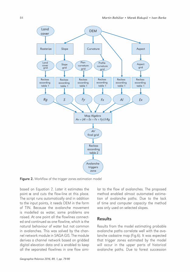
For the purpose of this work a model devel-oped in Norway by Lied and Bakkehøi was implemented into GIS. The model predicts a maximal avalanche run out using the ter-rain parameters of the avalanche chute. Ava-lanche dynamics are not taken into account. The authors based the model on analyses of hundreds of well-known avalanche chutes. They chose a reference point (the so called the point) with the angle defined as the aver-age gradient of the avalanche path profile from the position where the slope decreases to 10º to the trigger zone (Fig. 3).
The angle is the angle sighting from the extreme run out position to the trigger zone. Least square regression analysis showed a correlation between the and angle and that the relationship has the form of an equa-tion (Lied & Bakkehøi 1980).
= C0 + C1
The model was calibrated on a dataset of 44 avalanche paths from both valleys (30 from the Žiarska valley and 14 from the Predné Meďodoly valley) with well-known run-outs. With the assistance of the expert knowledge of avalanches of J. Peťo from SCAP, maximum run outs were measured on the terrain using GPS. A survey of aer-ial imagery accompanied the fieldwork to increase the accuracy of measurements. The topographical parameters of each path were extracted in ArcGIS and linear regres-sion analysis was performed using a statis-tical package NCSS. Acquired regression coefficients together with avalanche trigger zones (where Av ≥ 22.5) served as the input parameters for script written in Avenue for ArcGIS. This script models avalanche move-ment as flowing water. It creates flowlines from certain points (avalanche trigger zones), then it finds points, calculates the angle, and following this it estimates the angle
Av = (Al + Ex + Fx + Fy)·S·Rg
Where: Av – is a value estimating potential avalanche trigger zones, Al – is the elevation factor, Ex – is the aspect factor, Fx – is the profile curvature factor, Fy – is the plan curvature factor, S – is the slope inclination factor and Rg – is the roughness factor.
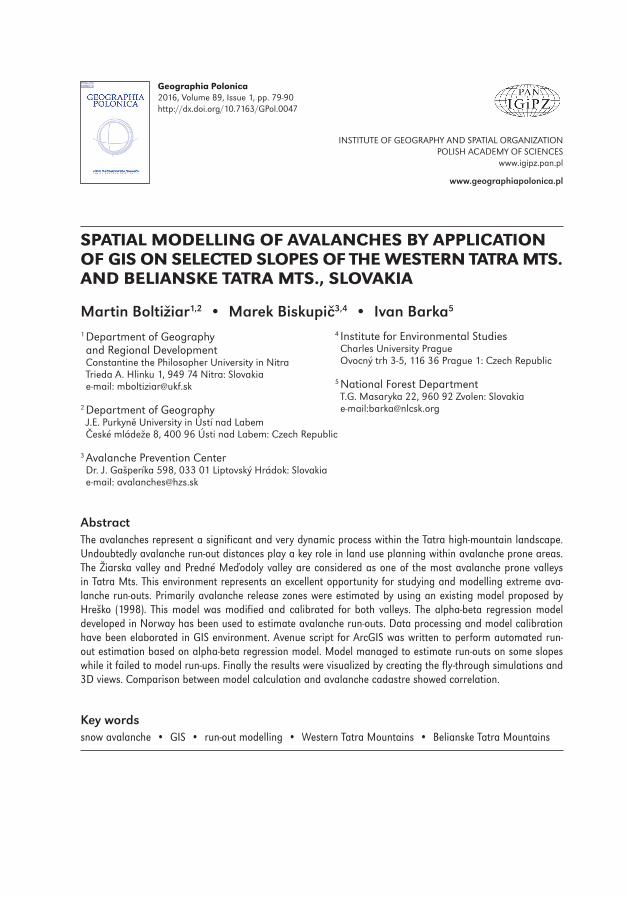
The land cover layer and DEM are the two main data inputs for calculation of the model. Each of the factors (Al, Ex, Fx, Fy, S, Rg) was classified according to Table 1 and the final grid layer (Av) was calculated using map algebra. The classification was based on the data extracted from the avalanche database. According to the database, the lowest ava-lanche frequency is observed in the interval from 1200 m-1450 m. Therefore this interval was given a score of 0.1. The same was car-ried out for other factors (plan and profile cur-vature, land cover, etc). The complete meth-odology of the classification can be found in studies done by Hreško, Bárka and Rybár (Hreško 1998; Bárka & Rybár 2003).
Final reclassification according to Table 2 resulted in a final grid layer which represents avalanche prone areas. Avalanche prone are-as have higher values of Av.
Table 2. Final reclassification
Equation (1) result Av
Avalanche trigger hazard
0.0-15.0 low
15.0-22.5 medium
22.5-30.0 high
30.0-36.0 very high
ArcGIS was used to fully automate the estimation of probable trigger zones by using the model builder module (Fig. 2). For ava-lanche run out modelling based on this, zones reaching an Av value of at least 22.5 or more were selected. The final output was compared with the avalanche cadastre map,
GP_2016_1.indb 83 2016-03-21 12:25:41
84 Martin Boltižiar • Marek Biskupič • Ivan Barka
Geographia Polonica 2016, 89, 1, pp. 79-90
based on Equation 2. Later it estimates the point and cuts the flow-line at this place. The script runs automatically and in addition to the input points, it needs DEM in the form of TIN. Because the avalanche movement is modelled as water, some problems are raised. At one point all the flowlines connect-ed and continued as one flowline, which is the natural behaviour of water but not common in avalanches. This was solved by the chan-nel network module in SAGA GIS. The module derives a channel network based on gridded digital elevation data and is enabled to keep all the separated flowlines in one flow simi-
lar to the flow of avalanches. The proposed method enabled almost automated estima-tion of avalanche paths. Due to the lack of time and computer capacity the method was only used on selected slopes.
Results
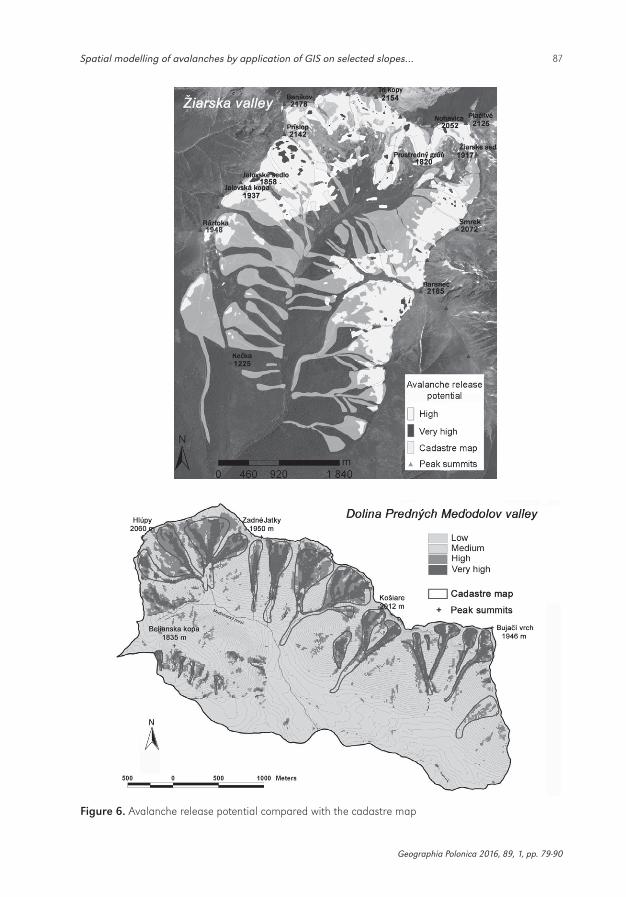
Results from the model estimating probable avalanche paths correlate well with the ava-lanche cadastre map (Fig.6). It was expected that trigger zones estimated by the model will occur in the upper parts of historical avalanche paths. Due to forest succession
Aspect
CurvatureSlope
Rasterize
DEM Land cover
Aspect
grid
Profile curvature
grid
Plan curvature
grid Slope
grid
Land
cover grid
Reclass according
table 1
Reclass according
table 1
Reclass according
table 1
Reclass according
table 1
Reclass according
table 1
Reclass according
table 1
Map Algebra Av = (Al + Ex + Fx + Fy)∙S∙Rg
Reclass according
table 2
AVfinal grid
Ex Al
Fx Fy
S Rg
Avalanche triggers
zone
Figure 2. Workflow of the trigger zones estimation model
GP_2016_1.indb 84 2016-03-21 12:25:41
85Spatial modelling of avalanches by application of GIS on selected slopes…
Geographia Polonica 2016, 89, 1, pp. 79-90
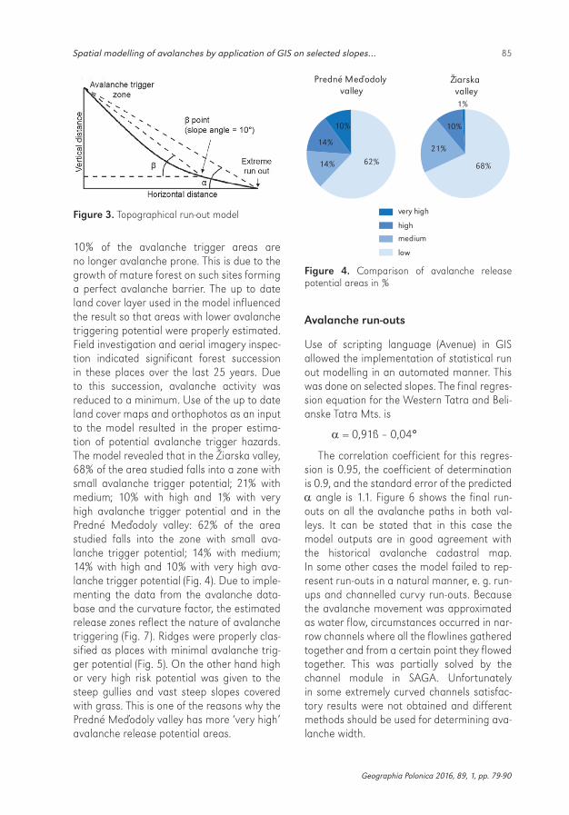
10% of the avalanche trigger areas are no longer avalanche prone. This is due to the growth of mature forest on such sites forming a perfect avalanche barrier. The up to date land cover layer used in the model influenced the result so that areas with lower avalanche triggering potential were properly estimated. Field investigation and aerial imagery inspec-tion indicated significant forest succession in these places over the last 25 years. Due to this succession, avalanche activity was reduced to a minimum. Use of the up to date land cover maps and orthophotos as an input to the model resulted in the proper estima-tion of potential avalanche trigger hazards. The model revealed that in the Žiarska valley, 68% of the area studied falls into a zone with small avalanche trigger potential; 21% with medium; 10% with high and 1% with very high avalanche trigger potential and in the Predné Meďodoly valley: 62% of the area studied falls into the zone with small ava-lanche trigger potential; 14% with medium; 14% with high and 10% with very high ava-lanche trigger potential (Fig. 4). Due to imple-menting the data from the avalanche data-base and the curvature factor, the estimated release zones reflect the nature of avalanche triggering (Fig. 7). Ridges were properly clas-sified as places with minimal avalanche trig-ger potential (Fig. 5). On the other hand high or very high risk potential was given to the steep gullies and vast steep slopes covered with grass. This is one of the reasons why the Predné Meďodoly valley has more ‘very high’ avalanche release potential areas.
very high
high
medium
low
Predné Meďodoly valley
14%
14% 62%
10%
Žiarska valley
21%
10%
1%
68%
Figure 4. Comparison of avalanche release potential areas in %
Avalanche run-outs
Use of scripting language (Avenue) in GIS allowed the implementation of statistical run out modelling in an automated manner. This was done on selected slopes. The final regres-sion equation for the Western Tatra and Beli-anske Tatra Mts. is
= 0,91ß – 0,04°
The correlation coefficient for this regres-sion is 0.95, the coefficient of determination is 0.9, and the standard error of the predicted angle is 1.1. Figure 6 shows the final run-outs on all the avalanche paths in both val-leys. It can be stated that in this case the model outputs are in good agreement with the historical avalanche cadastral map. In some other cases the model failed to rep-resent run-outs in a natural manner, e. g. run-ups and channelled curvy run-outs. Because the avalanche movement was approximated as water flow, circumstances occurred in nar-row channels where all the flowlines gathered together and from a certain point they flowed together. This was partially solved by the channel module in SAGA. Unfortunately in some extremely curved channels satisfac-tory results were not obtained and different methods should be used for determining ava-lanche width.
Figure 3. Topographical run-out model
GP_2016_1.indb 85 2016-03-21 12:25:41

86 Martin Boltižiar • Marek Biskupič • Ivan Barka
Geographia Polonica 2016, 89, 1, pp. 79-90
Figure 5. Avalanche release potential within the sites studied
GP_2016_1.indb 86 2016-03-21 12:25:41
87Spatial modelling of avalanches by application of GIS on selected slopes…
Geographia Polonica 2016, 89, 1, pp. 79-90
Figure 6. Avalanche release potential compared with the cadastre map
GP_2016_1.indb 87 2016-03-21 12:25:41

88 Martin Boltižiar • Marek Biskupič • Ivan Barka
Geographia Polonica 2016, 89, 1, pp. 79-90
Conclusions
A visual assessment of the avalanche trigger model shows agreement with the avalanche cadastre in some cases. The model did not estimate several trigger zones which were mainly located in the lower parts of the val-leys. In total 91% of the pixels marked as ava-lanche prone areas fit in the area of the avalanche cadastre. In future, more detailed observations and the use of satellite imagery will be required to obtain data on avalanche prone locations. This can be explained by the succession undergone in these trigger zones. Field investigation proved that the trigger zones are naturally reforested and therefore avalanche activity is reduced. This conclusion is also supported by direct avalanche obser-vations which did not report any avalanche for the last 15 years. It is crucial to use the most up to date data on land cover because only this can guarantee the proper estimation of the actual trigger areas. The release zones evolve in space and time according to the development of avalanche activity and forest succession.
The avalanche trigger model is easy to implement in the GIS environment. It is
simple to calculate the model factors and, after several improvements, the model may be used in avalanche zoning. It will be inter-esting to see the future development of the model. In operational use the coupling of the model with on line meteorological data could help to improve the results and it could, in particular, enable one to estimate the actu-al trigger zones in real time depending on the weather situation. This would be a great aid to people travelling in avalanche prone areas.
The alpha-beta regression model imple-mented into GIS showed several discrepan-cies with the real behaviour of avalanches. In many cases it was not possible to find the beta reference point. This is caused by the relative steepness of the study region. Most of the avalanches do not reach the beta point and they terminate either on the steep val-ley bottom or the opposite slope. The model was devolved in Norway taking into account local topography which differs from topogra-phies in the Western Tatra Mts. or Belianske Tatry Mts. It cannot be stated that the model doesn’t work at all. It works, but just for spe-cific slopes. The model is suitable for straight down sloping paths with no run-ups in the depositional area.
Figure 7. High and very high avalanche release potential in the Žiarska valley (3D view in ArcGIS)
GP_2016_1.indb 88 2016-03-21 12:25:42
89Spatial modelling of avalanches by application of GIS on selected slopes…
Geographia Polonica 2016, 89, 1, pp. 79-90
The method developed for avalanche zon-ing showed that many improvements will have to be done to use this method for land use planning. It is an advantage especially for avalanche zoning on small scales that models are implemented into GIS and can perform the simulations in an automated manner. After refinement and adjustment the method can be translated to other mountain areas. The proposed method of estimation of avalanche prone areas seems to be a good replacement of a method based entirely
on field observations. It saves time and brings more safety to the SCAP staff. On the other hand, avalanches are very difficult to pre-dict and only relying on model outputs is not advisable. In some way or other, field obser-vations will always be necessary.
Editors’ note:Unless otherwise stated, the sources of tables and figures are the authors’, on the basis of their own research.
ReferencesBARKA I., 2003. Identification of snow avalanche
trigger areas and avalanche paths by the GIS. Geomorphologia Slovaca, vol. 3, no. 2, pp. 60-63.
BARKA I., RYBÁR R., 2003. Identification of snow avalanche trigger areas using GIS. Ecology, vol. 22, suppl. 2, pp. 182-194.
BEBI P., KIENAST F., SCHONENBERGER W., 2001. Assessing structures in mountain forests as a basis for investigating the forests’ dynam-ics and protective function. Forest Ecology and Management, vol. 145, no. 1-2, pp. 3-14.
BOLTIŽIAR M., 2007. Structure of the Tatra high mountain (large scale mapping, analysis and evaluation of changes by application of remote sensing data). Nitra: Fakulta prírodných vied Univerzity Konštantína Filozofa, Ústav krajinnej ekológie SAV Bratislava, Pobočka Nitra, Slov-enský národný komitét pre program UNESCO Človek a biosféra.
BOVIS M., MEARS A., 1976. Statistical prediction of snow avalanche run-out from terrain vari-ables in Colorado. Arctic and Alpine Research, vol. 8, no. 1, pp. 115-120.
DELPARTE D., 2008. Avalanche terrain modeling in Glacier National Park, Canada. Calgary: Uni-versity of Calgary [PhD thesis].
FUJISAWA K., TSUNAKI R., KAMIISHI I., 1993. Esti-mating snow avalanche run out distances from topographic data. Annals of Glaciology, 18, pp. 239-244.
FURDADA G., VILAPLANA J.M., 1998. Statistical predication of maximum avalanche run-out distances from topographic data in the west-ern Catalan Pyrenees (northeast Spain). Annals of Glaciology, 26, pp. 285-288.
HREŠKO J., 1998. Avalanche hazard of the Tatra high mountain landscape. Folia Geographica, 2, Prešov: Prešovská univerzita, pp. 348-352.
HREŠKO J., BOLTIŽIAR M., 2001. The influence of the morphodynamic processes to landscape struc-ture in the high mountains (Tatra Mts.). Ekoló-gia, vol. 20, suppl. 3, pp. 141-148.
HREŠKO J., BUGÁR G., 1999. Avalanche risk of the SE part of Belianske Tatra Mts [in:] T. Hrnčiarová, Z. Izakovičová (eds.), Krajinnoekologické pláno-vanie na prahu 3. Tisícročia, Bratislava: Ústav krajinnej ekológie SAV, pp. 268-269.
JOHANNESSON T., 1998. A topographical model for Icelandic avalanches. Reykjavik: Icelandic Mete-orological Office Report Vi-G980003-UR03.
JONES A., JAMIESON B., 2004. Statistical avalanche runout estimation for short slopes in Canada. Annals of Glaciology, vol. 38, no. 1, pp. 363-372
KŇAZOVICKÝ L., 1967. Avalanches. Bratislava: Vydavateľstvo SAV.
KOHÚT F., 2005. Natural processes in high moun-tain landscape – Jalovecká valley. Nitra: Univer-sity of Constantine the Philosopher [PhD thesis].
LEMPA M., KACZKA R.J., RĄCZKOWSKA Z., 2014. Rekonstrukcja aktywności lawin śnieżnych w Białym Żlebie (Tary Wysokie) na podstawie przyrostów rocznych świerka pospolitego (Picea abies L. Karst.). Studia i Materiały Centrum
GP_2016_1.indb 89 2016-03-21 12:25:42
© Martin Boltižiar • Marek Biskupič • Ivan Barka© Geographia Polonica© Institute of Geography and Spatial Organization
Polish Academy of Sciences • Warsaw • 2016
Article first received • October 2015Article accepted • February 2016
90 Martin Boltižiar • Marek Biskupič • Ivan Barka
Edukacji Przyrodniczo-Leśnej, vol. 16, no. 3, pp. 105-112.
LIED K., BAKKEHOI S., 1980. Empirical calculation of snow-avalanche run-out distance based on topographic parameters. Journal of Glaciol-ogy, vol. 26, no. 94, pp. 165-177.
LIED K., WEILER C., BAKKEHØI S., HOPF J., 1995. Calculation methods for avalanche run-out distance for the Austrian Alps [in:] F. Sivardi-ère (ed.), The contribution of scientific research to safety with snow, ice and avalanche. Greno-ble: Association nationale pour l’étude de la neige et des avalanches, ANENA, pp. 63-68.
MAGGIONI M., GRUBER U., 2003. The influence of topographic parameters on avalanche release dimension and frequency. Cold Regions Science and Technology, vol. 37, no. 3, pp. 407-419.
MITÁŠOVÁ H., HOFIERKA J., 1993. Interpolation by regularized spline with tension: II. Applica-tion to terrain modeling and surface geometry analysis. Mathematical Geology, vol. 25, no. 6, pp. 657-667.
RĄCZKOWSKA Z., DŁUGOSZ M., KACZKA R., KALA-FARSKI M., ROJAN E., 2013. Geomorphological aspects of snow avalanche activity in the Polish Tatras. Geomorphologia Slovaca et Bohemica, vol. 13, no. 1, pp. 67-68.
RĄCZKOWSKA Z., DŁUGOSZ M., GĄDEK B., GRA-BIEC M., KALAFARSKI M., ROJAN E., 2014. Envi-ronmental conditions, dynamic and multiproxy records of snow avalanches in the Tatra Mts [in:] IGU 2014 Book of Abstracts, Kraków: IGU, pp. 1.
ROJAN E., RĄCZKOWSKA Z., KALAFARSKI M., DŁUGOSZ M., KACZKA R., GĄDEK B., 2013. Avalanches in relation to relief of the Tatra Mountains [in:] Geomorphology and Sustain-ability. Paris, 27-31 August 2013. 8th Interna-tional Conference (AIG) on Geomorphology. Abstracts volume, p. 1066.
SITKO R., 2008. Identification, classification and assessment of forest function with the use of geoinformatics. Zvolen: Technical University [PhD thesis].
TOPPE R., 1987. Terrain models: A tool for natural hazard mapping [in:] B. Salm, H. Gubler (eds.), Avalanche formation, movements and effects (Proceedings of the Davos Symposium, Septem-ber 1986), International Association of Hydro-logical Sciences (IAHS), no. 162, pp. 629-638.
GP_2016_1.indb 90 2016-03-21 12:25:42
http://rcin.org.pl
Related Documents