www.theinternationaljournal.org > RJSSM: Volume: 03, Number: 08, December-2013 Page 41 Spatial Harmonization Model Between Production And Conservation in a Forest Landscape (Case Study in Tesso Nilo Forest Landscape in Riau Province, Sumatra, Indonesia) Sri Mariati PhD Student, Postgraduate Program on Environmental Science, University of Indonesia, Indonesia Haryoto Kusnoputranto Department of Environmental Health, Faculty of Public Health and Postgraduate Program on Environmental Science, University of Indonesia, Indonesia Jatna Supriatna Department of Biology, and Research Center for Climate Change, University of Indonesia, Indonesia Raldi Hendro Koestoer Ministry of Economic Affairs, Republic of Indonesia Abstract A spatial Planning between production and conservation is very important in a forest area consisting of the functions of production, limited production and conservation as well as the surrounding community. Illegal logging and forest land use change to illegal residential and palm plantations resulted in the loss of wildlife habitat, and human conflict with wildlife. The purpose of this study is to construct a model that has the level of sustainability of protected areas to production in the future and has resistance or resilience to climate change. SMCA (Spatial Multi Criteria Analysis) becomes an alternative method in the spatial analysis. Combined GIS software applications already include MCA (Multi Criteria Analysis) therein including ArcGIS 10 software which has a spatial analysis tool with an overlay weighting system (overlay Weighted). On the development of spatial models, SMCA becomes important in any simulation scenarios that has been set up so that a different choice of different models can be analyzed for decision making. Tesso Nilo forest area becomes forest research model because it has 3 different functions at once and is currently experiencing a very high deforestation in the world. We use seven criteria: the aspect of distance from the river, distribution of wildlife such as elephants and sumatran tigers, the park boundary, industrial forest concessions, oil palm land suitability, slope and distance from the road. The result of simulation A shows the overall distribution of wildlife that has the highest value and distribution wildlife in industrial forest and limited production forest becomes dominant. then the results of the simulation B, conditions such as business as usual with this model will continue to happen until the deforestation of natural forests. The results of C simulation show solution to the problems existing in Tesso Nilo Forest. C simulation results can be used as an alternative for decision makers. Key words: model, spatial planning, conservation, production, spatial multi criteria analysis. Introduction Sumatra, as one of the islands for Indonesia, is located in the West part. It was densely forested as recently as 1950, but then clearance began in the lowland areas, where topography and soil fertility were most favorable to human settlement and agriculture. Clearance for plantation crops was carried out in the colonial era and then continued to transmigration programs in the 1970s-80s. Thus the activity encroached largely in lowlands or on gently sloping foothills. Commercial logging concentrated first in lowland forests, which were accessible, commercially valuable, and had the greatest potential for large-scale development. Unfortunately, lowland forests are also the most biologically diverse, harboring many of the most prized tree and animal species in Sumatra (Supriatna et al., 2002).

Welcome message from author
This document is posted to help you gain knowledge. Please leave a comment to let me know what you think about it! Share it to your friends and learn new things together.
Transcript
www.theinternationaljournal.org > RJSSM: Volume: 03, Number: 08, December-2013 Page 41
Spatial Harmonization Model Between Production And Conservation
in a Forest Landscape (Case Study in Tesso Nilo Forest Landscape in Riau Province, Sumatra, Indonesia)
Sri Mariati
PhD Student, Postgraduate Program on Environmental Science, University of Indonesia, Indonesia
Haryoto Kusnoputranto
Department of Environmental Health, Faculty of Public Health and Postgraduate Program on
Environmental Science, University of Indonesia, Indonesia
Jatna Supriatna
Department of Biology, and Research Center for Climate Change, University of Indonesia, Indonesia
Raldi Hendro Koestoer
Ministry of Economic Affairs, Republic of Indonesia
Abstract
A spatial Planning between production and conservation is very important in a forest area consisting
of the functions of production, limited production and conservation as well as the surrounding
community. Illegal logging and forest land use change to illegal residential and palm plantations
resulted in the loss of wildlife habitat, and human conflict with wildlife. The purpose of this study is to
construct a model that has the level of sustainability of protected areas to production in the future and
has resistance or resilience to climate change. SMCA (Spatial Multi Criteria Analysis) becomes an
alternative method in the spatial analysis. Combined GIS software applications already include MCA
(Multi Criteria Analysis) therein including ArcGIS 10 software which has a spatial analysis tool with
an overlay weighting system (overlay Weighted). On the development of spatial models, SMCA
becomes important in any simulation scenarios that has been set up so that a different choice of
different models can be analyzed for decision making. Tesso Nilo forest area becomes forest research
model because it has 3 different functions at once and is currently experiencing a very high
deforestation in the world. We use seven criteria: the aspect of distance from the river, distribution of
wildlife such as elephants and sumatran tigers, the park boundary, industrial forest concessions, oil
palm land suitability, slope and distance from the road. The result of simulation A shows the overall
distribution of wildlife that has the highest value and distribution wildlife in industrial forest and
limited production forest becomes dominant. then the results of the simulation B, conditions such as
business as usual with this model will continue to happen until the deforestation of natural forests.
The results of C simulation show solution to the problems existing in Tesso Nilo Forest. C simulation
results can be used as an alternative for decision makers.
Key words: model, spatial planning, conservation, production, spatial multi criteria analysis.
Introduction
Sumatra, as one of the islands for Indonesia, is located in the West part. It was densely forested
as recently as 1950, but then clearance began in the lowland areas, where topography and soil fertility
were most favorable to human settlement and agriculture. Clearance for plantation crops was carried
out in the colonial era and then continued to transmigration programs in the 1970s-80s. Thus the
activity encroached largely in lowlands or on gently sloping foothills. Commercial logging
concentrated first in lowland forests, which were accessible, commercially valuable, and had the
greatest potential for large-scale development. Unfortunately, lowland forests are also the most
biologically diverse, harboring many of the most prized tree and animal species in Sumatra (Supriatna
et al., 2002).
www.theinternationaljournal.org > RJSSM: Volume: 03, Number: 08, December-2013 Page 42
Since early 1970s, Sumatra Island has lost 6.6 mil ha of forest or 557,000ha per year due largely to
legal and illegal logging activities; conversion of natural forests to industrial plantations, and forest
encroachment by communities. Of this total, 2.6 million ha were natural tropical rain forest (Margono,
et al., 2012). Riau Province suffered the largest area loss around 30% (approximately 5 million ha)
Nanggroe Aceh Province suffered the second largest loss of 21.7% (approximately 3.6 million ha).
Riau province has not only approximately 8.6 million ha of forest remaining (Pemerintah Provinsi
Riau, 2010) but also the highest rate of loss around 42% between 1990 and 2010 (Margono et al.,
2012). Within Riau province, Tesso Nilo Forest block is the largest block of forest remaining (377,387
ha) consisting mainly of lowland tropical rain forest, heat forest and peat swamp forest (Mariati,
2004).
Tesso Nilo forest harbor was very high biodiversity. Gillison (2001) studied the plants in 200 m2
samples and found 218 species. This study indicates that the forest is one of the richest diversities of
plants in the world. The lowland forest is an important habitat for endangered species such as the
Sumatran tiger (Panthera tigris sumatrae) and Sumatran elephant (Elephas maximus sumatranus).
However, as large areas of this habitat have been converted into palm oil, pulp-paper wood plantations
and settlements; as a consequence, conflicts between humans and biodiversity protection have
increased (Margono et al., 2012).
In Tesso Nilo, serious conflicts between production and protection of biodiversity, ecosystem
functions and cultural values began after the construction of two road corridors, namely: Baserah and
Ukui between 2000 and 2012. WWF and many other NGOs have tried to quantify the forest and
biodiversity loss from the criss-crossed roads that resulted from these two major road corridors. The
study attempts to explore the rate of deforestation in Tesso Nilo forest by mapping the extent of
deforestation, and by calculating the rate of deforestation post road construction. Moreover, the
discussion would refer to policy implications towards mitigation improvement of forest loss. Shortly
the study focuses on the spatial planning approaches on optimal land-usage in Tesso Nilo forest area.
Methods
In this context, sound spatial approach between production and conservation would be worth-while to
be implemented. Spatial planning between production and conservation covering forest area consists
of the functions of production, limited production and conservation functions as well as the
surrounding community. Considering spatial conflicts between wildlife and humans, and also conflicts
between economic interests and conservation, one would need to conduct a study to find the best
spatial arrangement in order to halt ro reduce deforestation and wildlife conflicts with humans in Tesso
Nilo Forest Block. In addition, it is necessary to balance between production activities by companies,
while, the activities sound protecting biodiversity, ecosystem function, and the priority of social
culture in The forest area.
Spatial organization and systems have been used in devoping countries for discovering issues in bio-
regional conflicts (See http://faculty.nelson.wisc.edu/silbernagel/docs/Silb_inTressbook05.pdf).
Thus Spatial approaches might give solution to ensure environmental sustainability and support the
coordination of the territorial impact of sectoral policies. See MP3EI in www.ekon.go.id (2013). It is
believed that spatial planning is an effective and important tool in sustainable development to
synchronize social, environmental, and economic aspects. Integrated spatial planning system could
reduce the impacts of environmental destruction caused by purely economic purposes.
The development of spatial models is of importance in the simulation of each scenario that has been
set up, so that a different choice of models could be analyzed for decision making. Tesso Nilo forest
area becomes a research model because this forest has 3 different functions at once and is currently
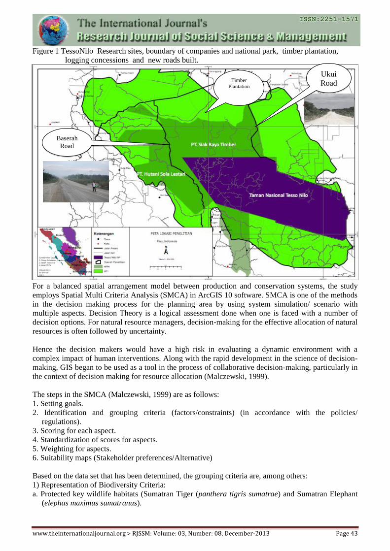
experiencing very high deforestation in the world (see Figure 1).
www.theinternationaljournal.org > RJSSM: Volume: 03, Number: 08, December-2013 Page 43
Figure 1 TessoNilo Research sites, boundary of companies and national park, timber plantation,
logging concessions and new roads built.
For a balanced spatial arrangement model between production and conservation systems, the study
employs Spatial Multi Criteria Analysis (SMCA) in ArcGIS 10 software. SMCA is one of the methods
in the decision making process for the planning area by using system simulation/ scenario with
multiple aspects. Decision Theory is a logical assessment done when one is faced with a number of
decision options. For natural resource managers, decision-making for the effective allocation of natural
resources is often followed by uncertainty.
Hence the decision makers would have a high risk in evaluating a dynamic environment with a
complex impact of human interventions. Along with the rapid development in the science of decision-
making, GIS began to be used as a tool in the process of collaborative decision-making, particularly in
the context of decision making for resource allocation (Malczewski, 1999).
The steps in the SMCA (Malczewski, 1999) are as follows:
1. Setting goals.
2. Identification and grouping criteria (factors/constraints) (in accordance with the policies/
regulations).
3. Scoring for each aspect.
4. Standardization of scores for aspects.
5. Weighting for aspects.
6. Suitability maps (Stakeholder preferences/Alternative)
Based on the data set that has been determined, the grouping criteria are, among others:
1) Representation of Biodiversity Criteria:
a. Protected key wildlife habitats (Sumatran Tiger (panthera tigris sumatrae) and Sumatran Elephant
(elephas maximus sumatranus).
Figure 1. Tesso Nilo Research sites, boundary of companies and national park, timber plantation,
logging concessions and new roads built.
Ukui
Road
Baserah
Road
Timber
Plantation
www.theinternationaljournal.org > RJSSM: Volume: 03, Number: 08, December-2013 Page 44
b. Must include the distribution of wildlife (Sumatran Tiger (panthera tigris sumatrae) and Sumatran
Elephant (elephas maximus sumatranus).
Determination of representative habitat for key wildlife (Sumatran Tiger (panthera tigris sumatrae)
and Sumatran Elephant (elephas maximus sumatranus) is determined by the following steps:
a. Knowing the number of Sumatran elephants and tigers in Tesso Nilo forest (data source: WWF
Indonesia, 2012)
b. Mapping the results of a ground check conducted by WWF Indonesia about the existence of
(Sumatran Tiger (panthera tigris sumatrae) and Sumatran Elephant (elephas maximus
sumatranus)).
2) Criteria of Spatial Characteristics:
a. Slope of more than 30% being constrained to be protected.
b. Maximum hydrologic connectivity.
Determination of hydrologic connectivity based on Law Number 41 Year 1999 on Forestry article
50, paragraph 3 (c) that the stream buffer areas to be protected are:
1. 100 meters from major rivers.
2. 50 meters from the creek.
c. Access roads (involving 3 scenarios)
Three scenarios are based on interviews and questionnaires with indigenous leaders and head of
Tesso Nilo National Park Authority. The three scenarios are as follows:
1. Scenario 1: all existing roads in the area Tesso Nilo forest are used (open).
2. Scenario 2: all excisiting roads is used except the road in the Tesso Nilo National Park.
3. Scenario 3: the entire road is used except Ukui corridor that borders the National Park and all
existing roads in the National Park.
3) Production Criteria
a. Industrial Forest concessions
The entire Industrial Forest concessions in the area of Tesso Nilo forest.
b. Land suitability for Oil Palm.
b.1. Value 1 = it is not suitable for production
b.2. Value 2 = moderately suitable areas for production
b.3. Value 3 = fairly suitable area for production
b.4. Value 4 = area corresponding to the production
For the analysis of land suitability for Industrial Plantation Forest (IPF) and Palm Oil, this study uses
Idrisi software with Multi Criteria Evaluation tool in model development tool, using criteria from the
Department of Agriculture (2003) in Supriatna et al., (2008).
Land suitability algorithm of Idrisi is:
S = Σwixi .............................................. .................................................. (1)
Where:
S is Conformity
Wi is the weight of factor i
Xi is the criterion score of factor i
4) Communities Criteria
a. Rural areas
Rural areas were excluded from Tesso Nilo forest area.
Scenarios set:
There are three scenarios used which are:
www.theinternationaljournal.org > RJSSM: Volume: 03, Number: 08, December-2013 Page 45
Scenario A: optimum conservation.
Scenario B: optimum production .
Scenario C: optimum production and conservation.
Simulation of each scenario uses trade off namely by taking into account criteria of cost and benefit to
the road network, river network, slopes and landforms.
Simulation for scenario A: Optimum Conservation:
a. Hydrologic connectivity area must be protected
b. The ranges of targeted wildlife should be protected (elephants and Sumatran tigers) (elephants and
Sumatran tigers (elephas maximus sumatranus and panthera tigris sumatrae).
c. Production area must be conducted outside the conservation area (oil palm and acacia outside the
National Park)
d. Slope of > 30% should be included as the protected area
e. Rural areas are excluded from the conservation area.
f. Production area functioning as a stepping stone becomes wildlife corridor for protected animals.
g. Open road network access to the conservation areas should be restricted.
h. The entire area of Tesso Nilo National Park should be maintained.
2. Simulation for scenario B: optimum production
a. Ranges of high-value wildlife in the production area must be protected
b. Acacia should be included in all areas of production.
c. The use of land for palm oil plantation should be incorporated in production area and the National
Park (National Park area constraint in phase 1)
d. Rural areas must be removed from the forest area
e. Buffer area of hydrologic connectivity in the acacia production area becomes a green belt.
f. Road access is open
3. Simulation for scenario C: optimum production and conservation.
a. Buffer area of hydrologic connectivity in the acacia production area becomes a green belt .
b. The area of hydrologic connectivity should be protect.
c. Rural areas are excluded from the conservation area.
d. Production area functioning as a stepping stone becomes wildlife corridor for protected animals.
e. National Park area must be protected (constraint).
f. Industrial forest concessions must include all.
g. Palm oil plantations areas outside the National Park should be included.
In detail, the steps are as follows:
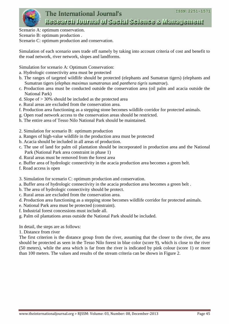
1. Distance from river
The first criterion is the distance group from the river, assuming that the closer to the river, the area
should be protected as seen in the Tesso Nilo forest in blue color (score 9), which is close to the river
(50 meters), while the area which is far from the river is indicated by pink colour (score 1) or more
than 100 meters. The values and results of the stream criteria can be shown in Figure 2.
www.theinternationaljournal.org > RJSSM: Volume: 03, Number: 08, December-2013 Page 46
Basic considerations for the standardization of the criteria is “benefit” standardization which means the
farther the distance from the river, the less benefit to be protected. For factors of distance group from
the river, this research includes riparian values protected by the law of 50 meters and 100 meters (Act
41 of 1999 on Forestry).
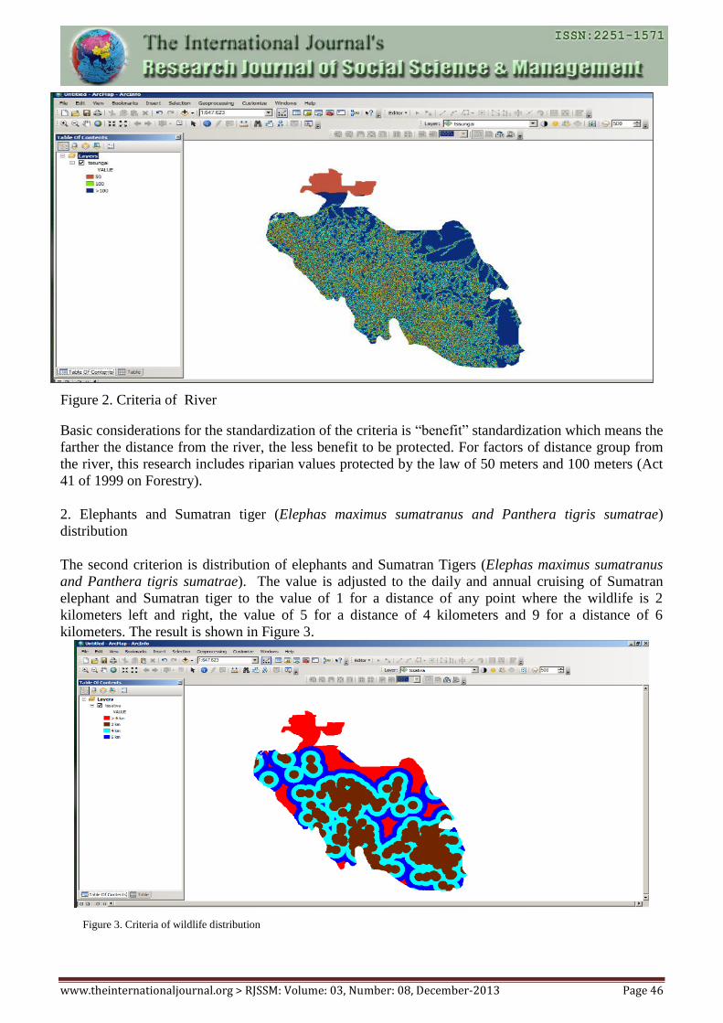
2. Elephants and Sumatran tiger (Elephas maximus sumatranus and Panthera tigris sumatrae)
distribution
The second criterion is distribution of elephants and Sumatran Tigers (Elephas maximus sumatranus
and Panthera tigris sumatrae). The value is adjusted to the daily and annual cruising of Sumatran
elephant and Sumatran tiger to the value of 1 for a distance of any point where the wildlife is 2
kilometers left and right, the value of 5 for a distance of 4 kilometers and 9 for a distance of 6
kilometers. The result is shown in Figure 3.
Figure 3. Criteria of wildlife distribution
Figure 2. Criteria of River
www.theinternationaljournal.org > RJSSM: Volume: 03, Number: 08, December-2013 Page 47
The orange color indicates a distance of more than 6 kilometers from the point where the wildlife is.
Blue colour indicates a distance of 6 kilometers from the point where the wildlife is. Light blue colour
indicates a distance of 4 kilometers from the point where the wildlife is. Brown colour indicates a
distance of 2 kilometers from the point where the wildlife is.
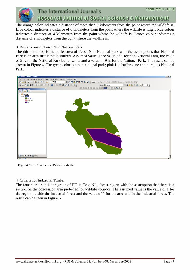
3. Buffer Zone of Tesso Nilo National Park
The third criterion is the buffer area of Tesso Nilo National Park with the assumptions that National
Park is an area that is not disturbed. Assumed value is the value of 1 for non-National Park, the value
of 5 is for the National Park buffer zone, and a value of 9 is for the National Park. The result can be
shown in Figure 4. The green color is a non-national park; pink is a buffer zone and purple is National
Park.
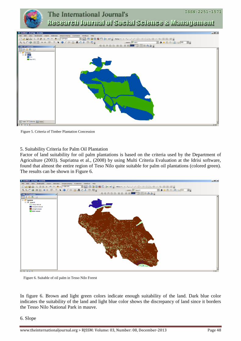
4. Criteria for Industrial Timber
The fourth criterion is the group of IPF in Teso Nilo forest region with the assumption that there is a
section on the concession area protected for wildlife corridor. The assumed value is the value of 1 for
the region outside the industrial forest and the value of 9 for the area within the industrial forest. The
result can be seen in Figure 5.
Figure 4. Tesso Nilo National Park and its buffer
www.theinternationaljournal.org > RJSSM: Volume: 03, Number: 08, December-2013 Page 48
5. Suitability Criteria for Palm Oil Plantation
Factor of land suitability for oil palm plantations is based on the criteria used by the Department of
Agriculture (2003). Supriatna et al., (2008) by using Multi Criteria Evaluation at the Idrisi software,
found that almost the entire region of Teso Nilo quite suitable for palm oil plantations (colored green).
The results can be shown in Figure 6.
In figure 6. Brown and light green colors indicate enough suitability of the land. Dark blue color
indicates the suitability of the land and light blue color shows the discrepancy of land since it borders
the Tesso Nilo National Park in mauve.
6. Slope
Figure 6. Suitable of oil palm in Tesso Nilo Forest
Figure 5. Criteria of Timber Plantation Concession
www.theinternationaljournal.org > RJSSM: Volume: 03, Number: 08, December-2013 Page 49
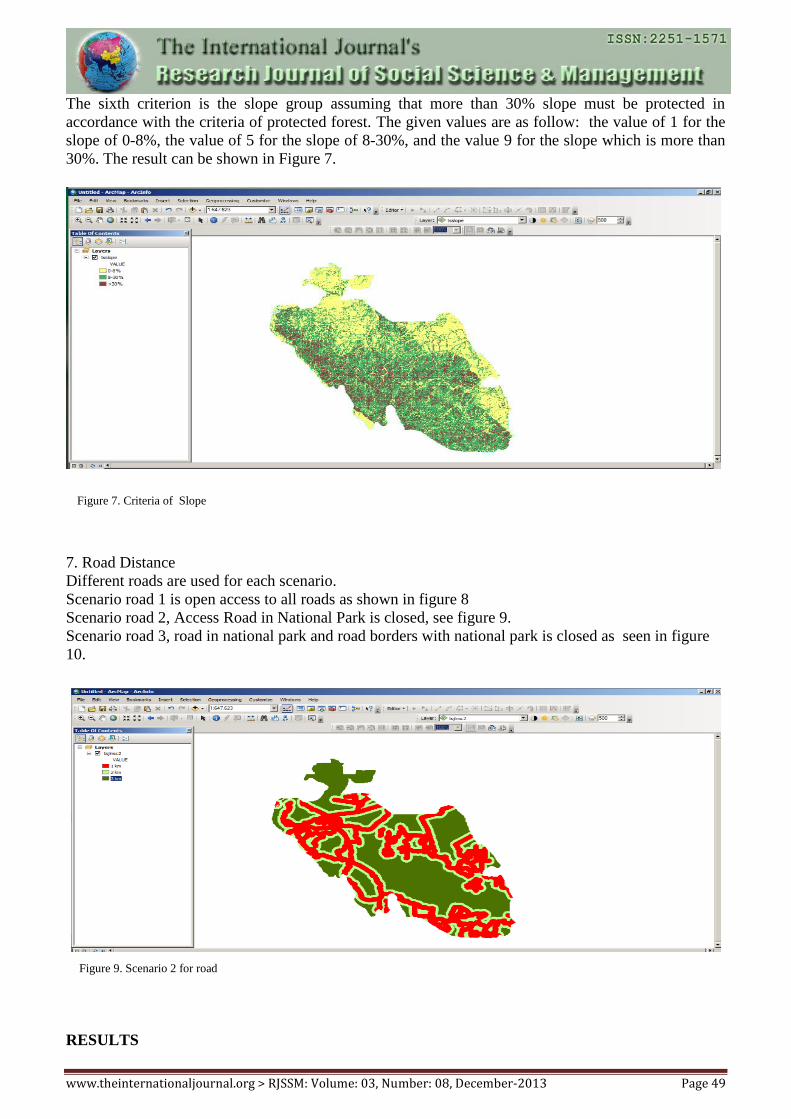
The sixth criterion is the slope group assuming that more than 30% slope must be protected in
accordance with the criteria of protected forest. The given values are as follow: the value of 1 for the
slope of 0-8%, the value of 5 for the slope of 8-30%, and the value 9 for the slope which is more than
30%. The result can be shown in Figure 7.
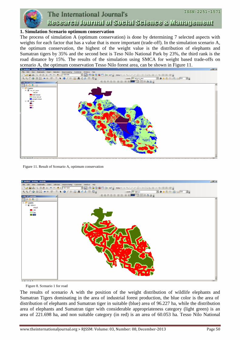
7. Road Distance
Different roads are used for each scenario.
Scenario road 1 is open access to all roads as shown in figure 8
Scenario road 2, Access Road in National Park is closed, see figure 9.
Scenario road 3, road in national park and road borders with national park is closed as seen in figure
10.
RESULTS
Figure 9. Scenario 2 for road
Figure 7. Criteria of Slope
www.theinternationaljournal.org > RJSSM: Volume: 03, Number: 08, December-2013 Page 50
1. Simulation Scenario optimum conservation
The process of simulation A (optimum conservation) is done by determining 7 selected aspects with
weights for each factor that has a value that is more important (trade-off). In the simulation scenario A,
the optimum conservation, the highest of the weight value is the distribution of elephants and
Sumatran tigers by 35% and the second best is Teso Nilo National Park by 23%, the third rank is the
road distance by 15%. The results of the simulation using SMCA for weight based trade-offs on
scenario A, the optimum conservation Tesso Nilo forest area, can be shown in Figure 11.
The results of scenario A with the position of the weight distribution of wildlife elephants and
Sumatran Tigers dominating in the area of industrial forest production, the blue color is the area of
distribution of elephants and Sumatran tiger in suitable (blue) area of 96.227 ha, while the distribution
area of elephants and Sumatran tiger with considerable appropriateness category (light green) is an
area of 221.698 ha, and non suitable category (in red) is an area of 60.053 ha. Tesso Nilo National
Figure 11. Result of Scenario A, optimum conservation
Figure 8. Scenario 1 for road
www.theinternationaljournal.org > RJSSM: Volume: 03, Number: 08, December-2013 Page 51
Park to buffer zone is protected due to Ukui road corridors and road in Tesso Nilo National Park is
closed. Distribution of Elephants and Tigers areas appear almost in the entire National Park area and
Timber Estate within 2 km to 6 km.
In this scenario, the value of the distribution of elephants and tigers shows high and the value of the
National Park is expected to retain the remaining biodiversity in forest areas Tesso Nilo. Thomson et
al., (2009) stated that maintaining biodiversity is a key to maintain forest resilience. Biodiversity in
forest ecosystems is associated with underlying productivity, durability and stability over time and
space. Biodiversity increases long-term durability and resilience of forest ecosystems, increases
production and improves the stability of their primary ecosystems at all scales.
2. Process Simulation results of Scenario optimum production
The process of simulation B (optimum production) is implemented by changing the weights on the
aspects and taking into account the interests of optimum production with the use of trade-offs. The
results of the simulation of the SMCA for spatial planning at Tesso Nilo forest area as shown in Figure
12. Scenario B is the optimum production. On this scenario, the highest value is industrial timber
weighting 31%. The second sequence is a road that uses all the existing access road weighing 18%.
The third sequence is a 15% distribution of wildlife. The weighted overlay results show the results of
current land use in the region Tesso Nilo Forest, which is widely suitability for plantation area of
253.731 ha.
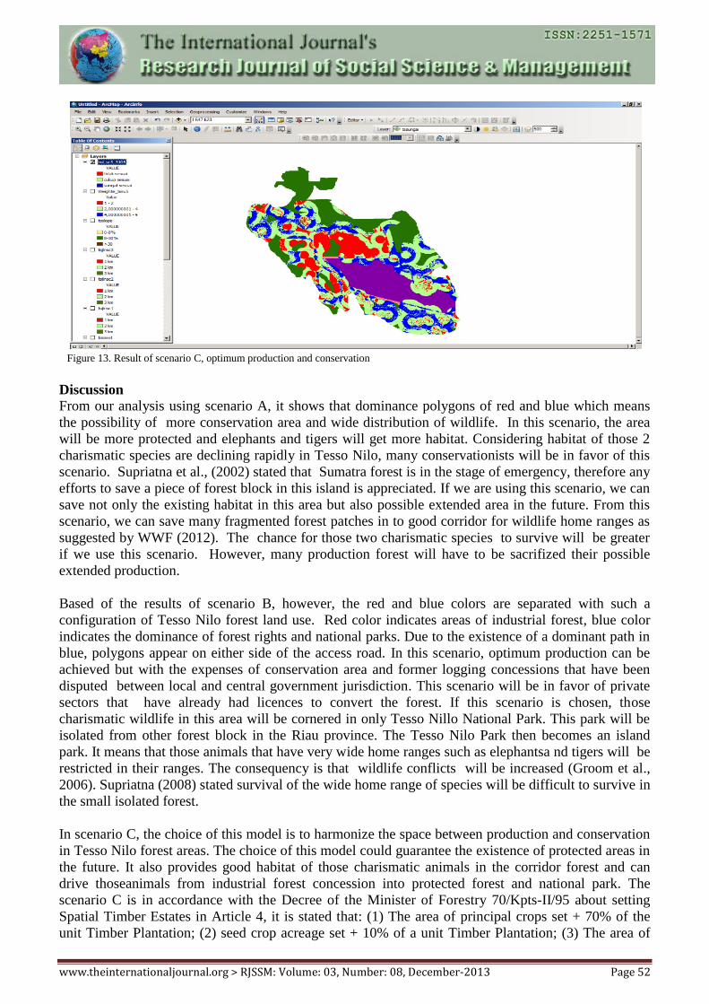
3. Process Simulation results of Trade off
Process Simulation in Scenario C (trade off) is the weighting for conservation and production by using
a trade-off. In this scenario, the optimum production and conservation use method of scenario road 2,
where all existing access road to Tesso Nilo National Park is closed and the other is open. This
scenario results indicate that the park will remain, plantation forests also remain on the current
concession areas and wildlife distribution remain in the industrial forest concessions covering an area
of 140.971 ha.
Figure 12. Result of scenario B, optimum production
www.theinternationaljournal.org > RJSSM: Volume: 03, Number: 08, December-2013 Page 52
Discussion
From our analysis using scenario A, it shows that dominance polygons of red and blue which means
the possibility of more conservation area and wide distribution of wildlife. In this scenario, the area
will be more protected and elephants and tigers will get more habitat. Considering habitat of those 2
charismatic species are declining rapidly in Tesso Nilo, many conservationists will be in favor of this
scenario. Supriatna et al., (2002) stated that Sumatra forest is in the stage of emergency, therefore any
efforts to save a piece of forest block in this island is appreciated. If we are using this scenario, we can
save not only the existing habitat in this area but also possible extended area in the future. From this
scenario, we can save many fragmented forest patches in to good corridor for wildlife home ranges as
suggested by WWF (2012). The chance for those two charismatic species to survive will be greater
if we use this scenario. However, many production forest will have to be sacrifized their possible
extended production.
Based of the results of scenario B, however, the red and blue colors are separated with such a
configuration of Tesso Nilo forest land use. Red color indicates areas of industrial forest, blue color
indicates the dominance of forest rights and national parks. Due to the existence of a dominant path in
blue, polygons appear on either side of the access road. In this scenario, optimum production can be
achieved but with the expenses of conservation area and former logging concessions that have been
disputed between local and central government jurisdiction. This scenario will be in favor of private
sectors that have already had licences to convert the forest. If this scenario is chosen, those
charismatic wildlife in this area will be cornered in only Tesso Nillo National Park. This park will be
isolated from other forest block in the Riau province. The Tesso Nilo Park then becomes an island
park. It means that those animals that have very wide home ranges such as elephantsa nd tigers will be
restricted in their ranges. The consequency is that wildlife conflicts will be increased (Groom et al.,
2006). Supriatna (2008) stated survival of the wide home range of species will be difficult to survive in
the small isolated forest.
In scenario C, the choice of this model is to harmonize the space between production and conservation
in Tesso Nilo forest areas. The choice of this model could guarantee the existence of protected areas in
the future. It also provides good habitat of those charismatic animals in the corridor forest and can
drive thoseanimals from industrial forest concession into protected forest and national park. The
scenario C is in accordance with the Decree of the Minister of Forestry 70/Kpts-II/95 about setting
Spatial Timber Estates in Article 4, it is stated that: (1) The area of principal crops set + 70% of the
unit Timber Plantation; (2) seed crop acreage set + 10% of a unit Timber Plantation; (3) The area of
Figure 13. Result of scenario C, optimum production and conservation
www.theinternationaljournal.org > RJSSM: Volume: 03, Number: 08, December-2013 Page 53
life plant set + 5% of a unit Timber Plantation; (4) The area of conservation set + 10% of a unit Timber
Plantation; (5) The area for facilities / infrastructure set + 5% of a unit of Timber Plantation.
Designation of conservation area up to 10% at the Forest Estate Concession aims to: 1) Preservation of
biodiversity and ecosystems (ecosystem representation, diversity of species, buffer zone forest
conservation / protection, etc.) if available on plantations. 2) Protection of water system (riparian,
buffer hydrology and flood control). 3) Prevention of forest fire (fire break, wind break, water points).
4) Preservation of important ecosystems and genetic resources for the community. 5) Wildlife corridor
towards natural forest (conservation forest, protected forest and limited production forest). 6) The
source of water, food source community. 7) Habitat species of flora and fauna are protected (see
http://www.dephut.go.id/uploads/files/70_95_ind.pdf). Thus efforts to create harmony between
production and conservation area in Tesso Nilo forest area can be realized if it is done with the above
requirements for all existing plantation concessions in forest areas Tesso Nilo.
The optimum choice of alternative models of production and conservation requires the National Park
area has clear boundaries and has a 500 meters buffer zone (if already delineated) and 1000 meters (if
not delineated) of production area. Changes in landscape that have occurred in Tesso Nilo forest have
profound consequences for conservation. In Tesso Nilo forest curent conditions, its natural landscape
has changed from a natural forest into a forest area of industrial crops such as oil palm and residential
areas, these changes have reduced many protected wildlife habitat even eliminate good biodiversity of
flora and fauna that have low life staying power.
Bennett and Saunders (2010) said that the destruction and fragmentation of habitat are major factors in
the global decline of species, native plant and wildlife communities and ecosystem processes change.
Changes usually occur disproportionately in areas that have a flat or low altitude and more productive
soil. Conservation in fragmented landscapes can be enhanced by protecting and increasing the amount
of habitat, improve habitat quality, improve connectivity, manage the disorder in the wider landscape,
planning for the long term, and learn of conservation actions undertaken. Forupt et al., (2008) said that
efforts to restore damaged ecosystems typically emphasize on structural aspects of biological
diversity, such as species richness and abundance. An alternative is to emphasize the functional
aspects, such as interaction patterns between species. It also needs to be seen how the damage
occurred, so that habitat restoration can be done well.
The optimum model of production and conservation aims (Figure 13) to align conservation forests and
production forests, where the distribution of elephants and tigers existed in timber plantation
concession survive at the wildlife corridor. The corridor is a bridge from the isolated condition of
wildlife habitat due to habitat fragmentation caused by illegal logging of natural forests to make a
settlement and oil palm plantations. For the settlements that exist in the national parks must be
relocated in order to avoid conflicts with wildlife. Forests with high biodiversity will have a high
resilience or resistance to climate change, and the concept of forest management and sustainable
conservation can be achieved. Hannah et al., (2009) studied in South Africa resulted that plants change
the biological properties especially the distribution ranges due to climate change. This will ultimately
change the distribution pattern of animals that depend on these plants.
Conclusions
Results of spatial modeling using optimum production and conservation scenarios show an alignment
between production and conservation and protecting wildlife habitat and distribution in the area of
timber plantation. This alternative model selection could resolve the problems in Tesso Nilo forest,
such as halting illegal logging with clear boundaries, cooperation with the company for the protection
of wildlife distribution such as Sumatran Elephants and Tigers. Tesso Nilo forest management scheme
using optimum model of production and conservation forests to harmonize conservation and
www.theinternationaljournal.org > RJSSM: Volume: 03, Number: 08, December-2013 Page 54
production forests, which will in turn saving biodiversity rich forests and support high resilience
forest against the impact of climate change.
Acknowledgement
We thank to our colleagues who help in training, formulating and re-orienting the GIS equipment used,
especially Weda and Samsuardi from WWF Indonesia, Hendi Sumantri from Conservation
International, Chris Margules from James Cook University, Grace Wong from CIFOR, our colleagues
at the University of Indonesia’s Post Graduate Study in Environment and many other people in Tesso
Nilo and Riau provinces that I cannot put their names due to the limited space.
References
1. Bennett, A.F., & Saunders, D.A. 2010. Habitat Fragmentation and Landscape Change dalam
Conservation for All. Oxford University Press Inc. New York.
2. Dinas Kehutanan Provinsi Riau. (2012). Data Spatial Konsesi HPH dan HTI di Hutan Tesso
Nilo. Pekanbaru.
3. Forupt, M.L., Henson, K.S.E., Craze, P.G, and Memmot, J. 2008. The Restoration of
ecological interactions: Plant-pollinator networks on ancient and restored heatlands. Journal
of Applied Ecology 2008, 45, 742-752.
4. Gillision, A.N. (2001). Vegetation Survey and Habitat Assesment of The Tesso Nilo Forest
Complex.
5. Groom, M.J., Meffe, G.K., dan Caroll, C.R. 2006. Principles of Conservation Biology. Sinauer
Associaties, Sunderland, MA, USA.
6. Hannah, L. G.F. Midgley, T. Lovejoy, W.J. Bond, M. Bush, J.C. Lovett, D. Scott, F.I.
Woodward (2001). Diversity: Conservation of Biological Diversity in a Changing Climate.
Conservation Biology 16(1): 264-268.
7. Silbernagel, J. 2005. Bio-regional patterns and spatial narratives for integrative landscape
research and design. Diunduh di
http://faculty.nelson.wisc.edu/silbernagel/docs/Silb_inTressbook05.pdf. Department of
Landscape Architecture, University of Wisconsin, Room 12, Agriculture Hall, 1450 Linden
Dr., Madison, WI 53706, USA, [email protected].
8. htttp://www.ekon.go.id. MP3EI.
9. Keputusan Menteri Kehutanan Nomor 70/Kpts-II/95 tentang Pengaturan Tata Ruang Hutan
Tanaman Industri.
10. Malczewski, J. (1999). GIS and Multicriteria Decision Analysis. John iley & Sons. New York.
11. Margono, B. A., Turubanova, S., Zhuravieva, S., Potapov, P., Tyukavina, A., Baccini, A.,
Goetz, S., & Hansen. M.C. (2012). Mapping and Monitoring Deforestation and Forest
Degradation in Sumatra (Indonesia) using landsat time series data sets 1990 to 2010. Environ.
Res. Lett 7 034010 doi: 10.1088/1748-9326/7/3/0341010.
12. Mariati, S. (2004). Analisis Kebijakan Pengelolan Hutan Studi Kasus di Hutan Tesso Nilo
Kabupaten Pelalawan Provinsi Riau. Tesis. Universitas Andalas. Padang.
13. Peraturan Pemerintah Republik Indonesia Nomor 38 Tahun 2011 Tentang Sungai.
14. Sunarto. (2011). Ecology and Restoration of Sumatran Tiger in Forest and Plantation
Landscape. Blacksburg-Virginia. USA.
15. Supriatna, J., Wijayanto, I., Manullang, B.O., Anggraeni, D., Wiratno., Ellis, S. (2002). The
state of siege for Sumatra’s forest and protected areas: Stakeholders view during devolution,
and political plus economic crises in Indonesia. Proc. IUCN/WCPA-East Asia, Pp. 439-456,
Taipei, Taiwan.
16. Supriatna, J. (2008). Melestarikan Alam Indonesia. Yayasan Obor Indonesia. Jakarta.
17. Supriatna, J., Margules, C., Juhn, D., & Wong, G. (2008). Balancing Production, Ecosystem
Services and Socio-cultural Priorities in Merauke, Papua Indonesia. Makalah seminar
mengenai Sustainable Production. Convention of Biological Diversity, Nairobi, Kenya.
18. Thompson, I., Mackey, B., McNulty, S., Mosseler, A. (2009). Forest Resilience, Biodiversity,
www.theinternationaljournal.org > RJSSM: Volume: 03, Number: 08, December-2013 Page 55
and Climate Change. A synthesis of the biodiversity/resilience/stability relationship in forest
ecosystems. Secretariat of the Convention on Biological Diversity, Montreal. Technical Series
no. 43, 67 pages.
19. Undang-Undang Republik Indonesia Nomor 41 Tahun 1999 Tentang Kehutanan.
20. Undang-Undang Republik Indonesia Nomor 26 Tahun 2007 Tentang Penataan Ruang.
21. World Bank. (2001). Indonesia: Environment and Natural Resources in a Time of Transition.
Washington DC.
22. World Wide Fund for nature. (2012). Konflik Gajah dan Manusia di Provinsi Riau. Pekanbaru.
(tidak dipublikasikan)
Related Documents