SPATIAL DATA INFRASTRUCTURES "THE MARINE DIMENSION" Guidance for Hydrographic Offices Publication C-17 Second Edition Version 2.0.0 - January 2017 Published by the International Hydrographic Organization 4b, quai Antoine 1er B.P. 445 Monaco, MC 98011 Cedex MONACO [email protected] www.iho.int

Welcome message from author
This document is posted to help you gain knowledge. Please leave a comment to let me know what you think about it! Share it to your friends and learn new things together.
Transcript
SPATIAL DATA INFRASTRUCTURES "THE MARINE
DIMENSION"
Guidance for Hydrographic Offices
Publication C-17
Second Edition
Version 2.0.0 - January 2017
Published by the
International Hydrographic Organization
4b, quai Antoine 1er
B.P. 445
Monaco, MC 98011 Cedex
MONACO
www.iho.int

2
© Copyright International Hydrographic Organization 2018
This work is copyright. Apart from any use permitted in accordance with the Berne Convention
for the Protection of Literary and Artistic Works (1886), and except in the circumstances
described below, no part may be translated, reproduced by any process, adapted, communicated
or commercially exploited without prior written permission from the International Hydrographic
Organization (IHO). Copyright in some of the material in this publication may be owned by
another party and permission for the translation and/or reproduction of that material must be
obtained from the owner.
This document or partial material from this document may be translated, reproduced or
distributed for general information, on no more than a cost recovery basis. Copies may not be
sold or distributed for profit or gain without prior written agreement of the IHO and any other
copyright holders.
In the event that this document or partial material from this document is reproduced, translated
or distributed under the terms described above, the following statements are to be included:
"Material from IHO publication [reference to extract: Title, Edition] is reproduced
with the permission of the International Hydrographic Organization (IHO)
Secretariat (Permission No ……./…) acting for the International Hydrographic
Organization (IHO), which does not accept responsibility for the correctness of the
material as reproduced: in case of doubt, the IHO's authentic text shall prevail. The
incorporation of material sourced from IHO shall not be construed as constituting an
endorsement by IHO of this product."
"This [document/publication] is a translation of IHO [document/publication]
[name]. The IHO has not checked this translation and therefore takes no
responsibility for its accuracy. In case of doubt the source version of [name] in
[language] should be consulted."
The IHO Logo or other identifiers shall not be used in any derived product without prior
written permission from the IHO.

3
Preface
The 17th International Hydrographic Conference held in May 2007, directed that CHRIS (now
the IHO Hydrographic Services and Standards Committee - HSSC) establish a Marine Spatial
Data Infrastructures Working Group (MSDIWG) to identify the Hydrographic Community
inputs to National Spatial Data Infrastructures (NSDI). In 2015, the responsibility for the
MSDIWG moved from HSSC to the Inter-Regional Coordination Committee (IRCC). This
change reflected the ongoing nature of the work of the MSDIWG in tackling predominantly
non-technical matters. The Terms of Reference of and other information about the MSDIWG
are available at:
www.iho.int Committees & WG MSDIWG
IHO publication M-2 outlines the benefits and options for the development of a national
hydrographic policy that ensures a State has a knowledge of the physical features of the seabed
and coast, as well as the currents, tides and certain physical properties of the sea water, such
that the needs of safety of navigation and protection of the marine environment can be met. A
successful national hydrographic policy will not only meet the requirements of the mariner but
can provide additional and often greater benefits to the State.
Having such hydrographic policies in place led to the adoption of IHO Resolution 5/2009, on
MSDI policy, by the 4th Extraordinary International Hydrographic Conference in Monaco in
June 2009. It stated inter alia that:
"The IHO will support Member States in the identification, development and implementation of
an appropriate role in national Spatial Data Infrastructure (SDI) and MSDI initiatives. This
will be achieved through the development and maintenance of a Special Publication that will
provide a definitive procedural guide to establishing the role of the national hydrographic
authority in MSDI."
Accordingly, a procedural guide to establishing the role of the national hydrographic authority
in MSDI was developed by the MSDIWG, under the title Spatial Data Infrastructures: "The
Marine Dimension" - Guidance for Hydrographic Offices. This document was endorsed by the
HSSC at its 1st meeting (Singapore, October 2009), and subsequently approved by IHO
Member States as edition 1.0 of a new publication C-17. This document was subsequently
updated in 2011, incorporating minor changes, as version 1.1.0.
Due to the ongoing dynamic developments in MSDI the MSDIWG made selected and important
changes. This version was subsequently adopted by the IHO Member States as version 2.0.0.
4
Table of Contents
Preface ........................................................................................................................................ 3
1. Introduction ............................................................................................................................ 5
2. What is a Spatial Data Infrastructure (SDI)? ......................................................................... 5
3. The Current Landscape .......................................................................................................... 8
4. The traditional role of HOs .................................................................................................... 9
5. From Data to Information to Knowledge ............................................................................... 9
6. Data Duplication and Conflict ............................................................................................. 11
7. Why is MSDI important to a HO? ....................................................................................... 11
8. MSDI – Some Important Drivers ......................................................................................... 11
9. What role should a HO have in MSDI? ............................................................................... 17
10. Business Planning .............................................................................................................. 20
11. Steps required to be taken by HOs to make MSDI happen ................................................ 21
12. The Challenges for Hydrographic Offices ......................................................................... 25
13. A look into the Future! ....................................................................................................... 26
Annex A - SDI Best Practice ................................................................................................... 28
Annex B – Example Conceptual Model for a National SDI .................................................... 33
Annex C – Frequently Asked Questions (FAQs) about SDI ................................................... 34
Annex D – Hydrographic Data Policy ..................................................................................... 38
Annex E – Fundamentals of a Marine Spatial Data Infrastructure (MSDI) ............................ 40
Annex F – Example Uses of Hydrographic Data for Purposes Other Than Navigation .......... 42
Annex G – How HOs might engage in SDI ............................................................................. 43
Annex H – Stakeholders to be considered by IHO member states .......................................... 44
Annex I – SDI Business Plans – Links to examples ................................................................ 45
5
1. Introduction
The purpose of this document is to explain the way that a Hydrographic Office (HO) should
promote, support, and participate in Spatial Data Infrastructures (SDIs). It is not definitive in
its nature, preferring instead to provide guidance on how best to achieve this through practical
advice, simple step by step processes, useful links to reference material and examples of best
practice.
We now have a growing body of knowledge and information available to the HO community
that provides guidelines rather than advice to enable us to better understand and appreciate the
value and benefit of SDI. Rather than repeat this general information at length, the relevant
literature reviews are provided at Annex A of this document.
The reader is encouraged to consult these references at an early stage of any SDI development
so that the HO can make the right choices regarding whether it wishes to take a leading role in
SDI development or seeks to support an existing SDI initiative or work with others to develop
an SDI. In all cases, however, the HO should be seen as the competent authority concerning the
provision of hydrographic and related data under any national and/or regional Marine Spatial
Data Infrastructure (MSDI)
There are many advantages and benefits to sharing hydrographic data and services at either a
national or regional level. An HO may therefore choose to participate in a wider SDI effort,
and/or to develop its own SDI at an "enterprise" level. This document provides a useful template
to developing an enterprise SDI capability.
2. What is a Spatial Data Infrastructure (SDI)?
Spatial Data is the data or information that identifies the geographic location of features and
boundaries on Earth and Space, such as natural or constructed features, oceans and space but
also includes encoding attributes, observations and other metrics concerning these features and
boundaries.
Spatial data is usually stored as coordinates and topology, and is data that can be mapped.
Spatial data is often accessed, manipulated or analyzed through Geographic Information
Systems (GIS).
SDI is "the relevant base collection of technologies, policies and institutional arrangements
that facilitate the availability of and access to spatial data".
Ref: Global Spatial Data Infrastructure (GSDI) Cookbook
It embraces:
The processes that integrate technologies, policies, standards, organizations and people.
The structure of working practices and relationships across data producers and users for
access, sharing and analyzing geospatial information across government and commerce.
The hardware, software and system components necessary to support the processes.
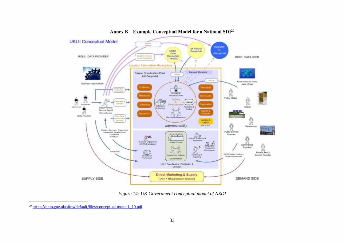
Annex H presents an example of a conceptual model for a SDI currently in use in the United
Kingdom. Frequently asked questions about SDI are found in Annex C.

6
A Marine Spatial Data Infrastructure (MSDI) is that element of an SDI that focuses on the
marine input in terms of governance, standards, ICT and content. The concept of MSDI is now
gaining wider appreciation in terms of the way a variety of data types might be combined for
efficient analysis by a wide range of disciplines, such as spatial planning, environmental
management and emergency response. This requires the data to be held in a generic way, rather
than for a particular product for a limited user group or for a specific purpose. An MSDI is not
a collection of hydrographic products, but an infrastructure that promote interoperability of data
at all levels.
This document focuses on the importance of MSDI to IHO MS and provides guidance towards
engaging in MSDI and provides evidence of data management best practice and use cases for
consideration.
2.1. What constitutes an MSDI?
An MSDI can be described as a framework comprising the key components shown in Figure 1.
Figure 1: The Four pillars of MSDI
2.1.1. Policy and Governance
A policy should exist defining the need to create information that is interoperable. This policy
is often linked to a regional, national or organizational strategy for sharing and exchanging
geographic information (e.g. INSPIRE in the EU1, and LINZ in New Zealand2). Annex F
presents best practice guidelines for data policy.
2.1.2. People & Organizations
Functional MSDI requires willingness and practical co-operation between the various
organizations that create, share and use information to implement the overall policy. There
1 http://inspire.ec.europa.eu/ 2 http://www.linz.govt.nz/about-linz/our-location-strategy/connecting-and-sharing-geospatial-data

7
should also be a clearly defined governance structure and transparency in decision-making and
reporting to foster a shared sense of working towards a common goal.
2.1.3. Enablers
The enablers in MSDI are the essential building blocks that provide the framework for data
acquisition, management, updating and dissemination:
Standards: International Standards for geographic information exist or are being
developed and, in many areas, sector-based standards are being put in place that depend
on these over-arching standards. For example; IHO S-57 and also S-100 relies in turn
on the ISO 19100 series of geographic standards. The standards work of the Open
Geospatial Consortium (OGC) especially in the areas of data content modelling, data
transport, and web services are critical to developing a robust SDI approach;
Technology: The provision of technical infrastructure (both hardware and software) will
enable the delivery of data and services to allow the viewing, sharing3, transformation
and downloading of data to complement informational products. As the technical
infrastructure matures, development can enable the SDI not only to work in different
geodetic systems but also enable the user to transform data to create informational
products (such as maps) in different projections.
Metadata: At its simplest, metadata is "data about data" and describes the characteristics
of a dataset (i.e. content, value and limitations) and is normally held in a metadata
management system or clearinghouse to provide mechanisms of search and retrieval. ..
It is a vital component in "discovering" data and information and understanding how
the data can be used. The most common way to search for data through its metadata in
a quick and easy manner is using a web portal
IHO S-100 Universal Hydrographic Data Model: the S-100 provides the data framework
for the development of not only the next generation of ENC products, but also other
related digital datasets and products required by the hydrographic, maritime and GIS
communities. Specifications based on S-100 are now being developed for a range of
thematic data resources such as S-102 for bathymetry and S-122 for Marine Protected
Areas (MPA).
2.1.4. Content
Arguably, the most important component of SDI is the information content which is available
to users. Without content, expressed within a consistent coordinate reference system, SDI is of
minimal use. At the core of this information is reference information (i.e. the common datasets,
themes or spatial data layers that "most people use most of the time" and which collectively
make up a digital base "map" that can be viewed and queried).
Reference information may be defined as any geographic feature that is used as a
location reference for application information, or can be used in geographic analysis. It
is sometimes arbitrarily divided into base and associated thematic reference information
with base information comprising fundamental topographic features (e.g. buildings,
roads and elevation) describing complete and detailed coverage of the Earth’s surface.
Associated reference information comprises supplementary datasets where this is also
3 One of the key objectives on any SDI is enabling data sharing among SDI participants, this does not necessarily mean "free and unlimited access", but controlled and regulated by the SDI authorities and contributors.

8
commonly used to support geo-referencing or analysis (e.g. transport networks, land
cover).
Application information provides the outer layer of information which is generally
"application" or "business" specific. It may contain no spatial reference(s) other than
provided by the reference information and consist only as supplementary properties.
2.1.5. Education and Learning
SDI cannot be successfully delivered without the four key pillars above. However, a fifth key
element which underpins the four pillars; education and learning, is very important but often
overlooked (Figure 2). In the HO community, involvement in MSDI take up and adoption has
been slow. A lack of understanding of SDI has been responsible, in part, for MSDI input lagging
behind its terrestrial counterparts with MSDI, as part of existing SDI not considered a priority
or considered unnecessary.
Annex E introduces a 1-Day Training Session template with the Fundamentals of a Marine
Spatial Data Infrastructure (MSDI).
Figure 2: MSDI Framework with additional inputs to ensure success
3. The Current Landscape
Since C-17 was first published in 2009 the landscape in which HOs operate has rapidly changed
due to, for example, the need for greater access and sharing of public data; open data initiatives;
the development of new and potentially disruptive technologies and the advent of the power of
"place" driven by the expectations of users viewing, analyzing and using spatial data.

9
New data capture technologies such as satellite derived bathymetry, crowd sourced data and the
use of Underwater Autonomous and Remotely Operated Vehicles (UAV and ROV) are now
being actively employed as more cost effective methods in sea regions and depths where either
existing data is poor or non-existent and where conditions allow for the use of these
technologies. Ship-borne survey may over time become the capture platform of last resort for
some purposes. The emergence of e-Navigation, a concept developed by IMO, embraces the
harmonized collection, integration, exchange, presentation and analysis of maritime
information on board ship and ashore. It does this by electronic means to enhance berth to berth
navigation and related services, for safety and security at sea and protection of the marine
environment.
Politicians are now taking a far greater interest in the world’s sea space in terms of its potential
to generate economic and socio-economic benefits and to maximize this within national
territorial sea limits. The recent spate of disasters at sea across the World have all heightened
the urgency for better access and re-use of HO data for emergency response purposes.
Geospatial data and information is no longer seen as "special" or "different" as the citizen,
thanks to Google, Microsoft and other global technology companies providing mapping "mash
ups", now use such information without even thinking about where it came from and any
intrinsic value contained therein. We now have mobile devices capable of doing what a
mainframe computer did 10 years ago for a fraction of the cost in a fraction of the time.
The value of geospatial data has fallen by approximately 80% in the last 5 years. It is now
considered to be a commodity resource. In turn the advent of Open Data strategies by nations,
allowing the re-use of data in a free and open manner is itself stimulating the growth of
applications developed by commercial companies.
4. The traditional role of HOs
All HOs depend on data, but mostly think and operate in terms of products. The creation of
ENCs requires chart information to be decomposed into features and attributes, but the output
is still a generalized product, albeit provided as data sets. The delivery of these data sets is also
on a cell-by-cell basis, characterized by scale. They are therefore restricted in their use by
design.
Most HOs focus on supplying products to a narrow sector of navigational users. The driving
force is navigational safety, with any additional use, being an opportunistic spin-off. The
opportunity to service a wider user community (outside of navigation) of approximately 5
million potential users has been overlooked in the past but now needs to be seriously considered.
The imperative to engage with this much wider community of users has grown with the demand
for access to marine and maritime geospatial data from commerce, government, academia and
the citizen.
5. From Data to Information to Knowledge
The principle of data being the foundation of knowledge is well known (Figure 3). In essence,
knowledge is only of value if conveyed, and as the pyramid shows with a broad base of data
required to extract a smaller volume of knowledge. What is less often articulated is the amount
of redundancy in many knowledge systems, where far more data is held than actually converted
into conveyed knowledge. The conversion of detailed bathymetric surveys into charts with

10
sparse soundings is a good example of this. A large amount of data is collected, and although
it presents a lot of information to the compiler, only a small amount of the knowledge is passed
on to the recipient of the product. Thus, the knowledge transfer is only a small part of the
potential of the original data. Many hydrographic data sets have the potential to convey a range
of knowledge categories.
Figure 3: The Data Information Knowledge triangle
Continuing with the bathymetric survey example, in addition to providing knowledge relevant
to a navigational chart (where the knowledge conveyed is shoal biased to ensure a suitable depth
of water safety margin) the data could also be used for the following purposes:
Full 3D seafloor modeling for engineering purposes (e.g. underwater construction;
pipeline/cable laying; dumping and dredging operations) for which shoal bias is
inappropriate;
Seafloor type definition from backscatter data for sedimentary studies; engineering
planning;
Sound velocity data for oceanographic studies;
Wreck and obstruction data in more detail than portrayed on charts (e.g. for historical
studies, defense applications, recreational diving interest) and
Geodetic and tidal information for datum studies.
In addition to the bathymetric survey case described, HOs have a wealth of other data including
navigational marks, traffic schemes, boundaries and limits. The idea of exploiting as much of
the data as possible, for numerous applications has to make sense in the modern world.
Work remains to be done to derive benefit from HOs maritime data heritage in order to satisfy
the breadth of current and future customers’ needs. It seems difficult to determine non SOLAS
off-the-shelf products that would meet the various possible marine data requirements. Therefore
the future may lie in developing systems and workflows that would meet user requirements and
from such systems derive fit-for-purpose products/maps without human assistance except at the
user interface: the concept of marine ontologies may be the solution to achieve this?
But what are ontologies? They are a representation of knowledge, in a particular subject
domain, such as marine, that are written with a standardized and structured syntax. Ontologies
can relate resources to other resources, either internally or in other ontologies. For example, an

11
individual resource is associated with a class ("apple" is a member of "fruit") or a class is
associated with an ontology (class "fruit" is described in an ontology called "food").
A formal specification of a (controlled) vocabulary can be something we are all familiar with:
a plain list of words, a dictionary, a taxonomy, a thesaurus or it could be a more technical
document such as an Object Model in Unified Modeling Language (UML) diagram, or an
eXtensible Markup Language (XML) schema. Simply expressing a controlled vocabulary in a
Web Ontology Language (OWL) file makes it qualify as an ontology.
6. Data Duplication and Conflict
An organization focused on the delivery of discrete products (such as paper charts, ENCs and
nautical publications) may have separate data holdings that contribute to different product lines.
This can result in the same data being held more than once (e.g. light information shown on
charts being stored in a separate system to the light information in a List of Lights). This is not
only inefficient in terms of the volume and use of data held, but can also lead to differences
between the data held for the same feature. This has become particularly evident where some
ENCs and paper charts have discrepancies between each other and between scales. This puts
into question the value of the knowledge portrayed, as the conflict demonstrates doubt and
uncertainty in what is correct. Such fragmentation of data, together with proprietary or product
specific formats can limit interoperability. This is something that improved data management
practices or developing an enterprise SDI within the HO could help to eliminate.
7. Why is MSDI important to a HO?
Involvement in MSDI will elevate the importance of hydrography across a wider marine sector
in-country and regionally as well as giving a wider user community exposure to the data and
information that can be provided by the HO. It will also provide politicians with the information
necessary for government per se, to gain a greater interest and understanding of the role of
hydrography nationally.
Hydrography has a vital role in MSDI in providing core "reference" data (such as bathymetry,
maritime boundaries, coast line and geographic areas and names). After all, Hydrography is the
branch of applied science which deals with the measurement and description of the physical
features of oceans, seas, coastal areas, lakes and rivers, as well as with the prediction of their
change over time. It does this firstly for the purpose of safety of navigation but also plays a
crucial role in the support, through its data and information resources, of all other marine
activities, including economic development, security and defense, scientific research, and
environmental protection.
8. MSDI – Some Important Drivers
8.1. Blue Economy and Blue Growth
The concept of a "blue economy" came out of the 2012 Rio+20 Conference and emphasizes
conservation and sustainable management, based on the premise that healthy ocean ecosystems
are more productive and a must for sustainable ocean-based economies. To support a shift to
this new approach, the UN Food and Agriculture Organization (FAO) launched the Blue
12
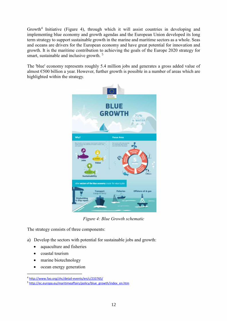
Growth4 Initiative (Figure 4), through which it will assist countries in developing and
implementing blue economy and growth agendas and the European Union developed its long
term strategy to support sustainable growth in the marine and maritime sectors as a whole. Seas
and oceans are drivers for the European economy and have great potential for innovation and
growth. It is the maritime contribution to achieving the goals of the Europe 2020 strategy for
smart, sustainable and inclusive growth. 5
The 'blue' economy represents roughly 5.4 million jobs and generates a gross added value of
almost €500 billion a year. However, further growth is possible in a number of areas which are
highlighted within the strategy.
Figure 4: Blue Growth schematic
The strategy consists of three components:
a) Develop the sectors with potential for sustainable jobs and growth:
aquaculture and fisheries
coastal tourism
marine biotechnology
ocean energy generation
4 http://www.fao.org/zhc/detail-events/en/c/233765/ 5 http://ec.europa.eu/maritimeaffairs/policy/blue_growth/index_en.htm
13
seabed mining
b) Providing knowledge, legal certainty and security in the blue economy:
marine knowledge to improve access to information about the sea;
maritime spatial planning to ensure an efficient and sustainable management of
activities at sea;
integrated maritime surveillance to give authorities a better picture of what is happening
at sea.
c) Sea basin strategies to ensure tailor-made measures and to foster cooperation between
countries in the following sea basins:
Adriatic and Ionian Seas
Arctic Ocean
Atlantic Ocean
Baltic Sea
Black Sea
Mediterranean Sea
North Sea
8.2. UN-GGIM
The United Nations initiative on Global Geospatial Information Management (UN-GGIM)6 is
now playing a leading role in setting the agenda for the development of global geospatial
information and to promote its use to address key global challenges. It provides a forum to liaise
and coordinate among Member States, and between Member States and international
organizations.
The IHO currently has observer status at UN-GGIM and has recently stated that in the marine
space, the future role of the IHO and its MS will be crucial to enabling the wider reach and use
of HO data as part of the framework of work activities such as:
Development of the global geodetic reference frame;
Development of a global map for sustainable development;
Geospatial information supporting Sustainable Development and the post-2015
development agenda;
Adoption and implementation of standards by the global geospatial information
community;
Development of a knowledge base for geospatial information;
Identification of trends in national institutional arrangements in geospatial information
management;
Integrating geospatial statistics and other information;
Legal and policy frameworks, including critical issues related to authoritative data;
6 http://ggim.un.org/

14
Development of shared statement of principles on the management of geospatial
Information7; and
Determining fundamental data sets.
8.3. G8 Open Data Charter
In June 2013, the G8 Group of major economic nations signed the Open Data Charter8. The
world is witnessing the growth of a global movement facilitated by technology and social media
and fueled by information; one that contains enormous potential to create more accountable,
efficient, responsive and effective governments and businesses, and to spur economic growth.
Access to data allows individuals and organizations to develop new insights and innovations
that can improve the lives of others and help to improve the flow of information within and
between countries. While governments and businesses collect a wide range of data, they do not
always share these data in ways that are easily discoverable, useable, or understandable by the
public.
People expect to be able to access information and services electronically when and how they
want. Increasingly, this is true of government data as well. We have arrived at a tipping point,
heralding a new era in which people can use open data to generate insights, ideas, and services
to create a better world for all.
Open data can increase transparency about what government and business are doing. Open data
also increase awareness about how countries’ natural resources are used, how extractives
revenues are spent, and how land is transacted and managed. All of which promotes
accountability and good governance, enhances public debate, and helps to combat corruption.
Transparent data on G8 development assistance are also essential for accountability.
Providing access to government data can empower individuals, the media, civil society, and
business to fuel better outcomes in public services such as health, education, public safety,
environmental protection, and governance.
A set of principles will be the foundation for access to, and the release and re-use of data made
available by G8 governments. They are:
Open Data by Default
Quality and Quantity
Useable by All
Releasing Data for Improved Governance
Releasing Data for Innovation
While working within national political and legal frameworks, implementation of these
principles in accordance with the technical best practice and timeframes will need to be set out
in our national action plans.
7 http://ggim.un.org/docs/statement%20of%20shared%20guiding%20principles%20flyer.pdf 8 https://www.gov.uk/government/publications/open-data-charter/g8-open-data-charter-and-technical-annex
15
8.4. Smart Oceans9
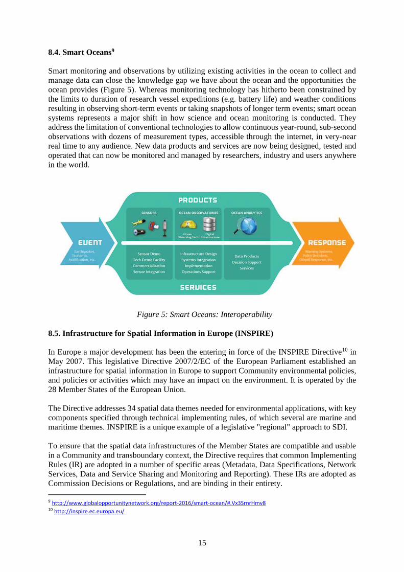
Smart monitoring and observations by utilizing existing activities in the ocean to collect and
manage data can close the knowledge gap we have about the ocean and the opportunities the
ocean provides (Figure 5). Whereas monitoring technology has hitherto been constrained by
the limits to duration of research vessel expeditions (e.g. battery life) and weather conditions
resulting in observing short-term events or taking snapshots of longer term events; smart ocean
systems represents a major shift in how science and ocean monitoring is conducted. They
address the limitation of conventional technologies to allow continuous year-round, sub-second
observations with dozens of measurement types, accessible through the internet, in very-near
real time to any audience. New data products and services are now being designed, tested and
operated that can now be monitored and managed by researchers, industry and users anywhere
in the world.
Figure 5: Smart Oceans: Interoperability
8.5. Infrastructure for Spatial Information in Europe (INSPIRE)
In Europe a major development has been the entering in force of the INSPIRE Directive10 in
May 2007. This legislative Directive 2007/2/EC of the European Parliament established an
infrastructure for spatial information in Europe to support Community environmental policies,
and policies or activities which may have an impact on the environment. It is operated by the
28 Member States of the European Union.
The Directive addresses 34 spatial data themes needed for environmental applications, with key
components specified through technical implementing rules, of which several are marine and
maritime themes. INSPIRE is a unique example of a legislative "regional" approach to SDI.
To ensure that the spatial data infrastructures of the Member States are compatible and usable
in a Community and transboundary context, the Directive requires that common Implementing
Rules (IR) are adopted in a number of specific areas (Metadata, Data Specifications, Network
Services, Data and Service Sharing and Monitoring and Reporting). These IRs are adopted as
Commission Decisions or Regulations, and are binding in their entirety.
9 http://www.globalopportunitynetwork.org/report-2016/smart-ocean/#.Vx3SrnrHmv8 10 http://inspire.ec.europa.eu/

16
8.6. e-Navigation
The IMO e-navigation initiative also has a vision beyond current navigational products. The
Strategy Implementation Plan (SIP) states that ‘as shipping moves into the digital world, e-
navigation is expected to provide digital information and infrastructure for the benefit of
maritime safety, security and protection of the environment, reducing administrative burden
and increasing the efficiency of maritime trade and transport.’ E-navigation relies on S-100 as
an enabler, but also on data not currently held by HOs. Thus in sympathy with MSDI, e-
navigation requires interoperability of data.
The challenge at this time is to establish a digital network of information that connects ship to
ship, ship to shore, shore to ship and shore to shore by a maritime digital infrastructure.
International Association of Marine Aids to Navigation and Lighthouse Authorities (IALA) is
also engaged in e-Navigation and supporting the establishment of a maritime digital
infrastructure using IHO S-100 Standards.
8.7. Emergency Planning and Response
A driver is to develop and provide improved plans for and a far more proactive way of
responding to natural and man-made disasters and emergencies in the world’s sea space. We
have seen several very high profile devastating events in the last five years including:
Gulf of Mexico oil spill (Sept 2010)
Japan earthquake and tsunami ( March 2011)
Korean ferry disaster (April 2014)
Loss of Malaysia Airlines MH370 (March 2015)
Figure 6 shows images of the Gulf of Mexico oil spill and of the earthquake and tsunami that
hit Japan.
Reaction to each of these, and numerous other events, requires a multi-disciplinary approach
including emergency response, environmental protection and longer term regional planning.
Although precompiled products are currently essential, the knowledge they convey, which can
be inadequate for the purpose, is often trapped in a form (whether paper or digital) that is not
easily compatible with the tools and systems used by non-marine agencies. This prompts the
need for greater interoperability across both data and response agencies.
Figure 6: Images showing the Gulf of Mexico oil spill (left) and the Japanese tsunami (right)

17
8.8. Rising Sea Levels
Evidence of climate change is leading to raised concerns for the coastal zone both in terms of
rising sea levels and the increasing occurrence of extreme weather patterns leading to greater
coastal flooding. A growth in the use of cross-polar routes as the Arctic ice sheet melts may put
environmental pressure on developing new sea routes in that region as well as increasing the
challenges of disaster response. These new initiatives will require interoperable spatial data.
8.9. Population growth
With over 50% of the world’s populations now living with 50km of the sea, the drive for
additional infrastructure development in the coastal zone is growing year on year. Overall
population growth is putting great pressure on energy generation, food production and other
resources as well as on both the marine environment and seaborne trade. This in turn puts
pressure on HOs to provide suitable support to marine spatial planning.
All of the above change agents demonstrate the need for better utilization of marine data, such
that more informed decision making can lead to effective solutions.
9. What role should a HO have in MSDI?
Most HOs hold data in order to support nautical charting requirements with limited emphasis
placed on providing that same data to support wider environmental and commercial coastal and
offshore activities.
MSDI places a greater emphasis on the unlocking of all geospatial information, including
hydrographic information, and to make that information more widely available to support the
myriad of uses described in Annex B of this document. HOs are well placed to support SDIs in
that it provides a natural extension in the management and dissemination of the underpinning
hydrographic information to a wider user community in an integrated manner. All HOs should
therefore carefully consider how they might engage and play a full role in the development of,
or participation in a SDI. Annex G show possible ways for a HO to engage in SDI.
Hydrographic Offices (HO) should be able to play a central role in the development of the
marine component of all SDIs. Hydrography, with its subset of data themes (e.g. bathymetry,
coastline, geographic names) forms the key "base reference" or "core geography" layers for the
sea space in each State or region. In this capacity, HO data is in a position to provide a rich and
unparalleled resource for users at all levels.
However, in some countries the HO has to struggle with other national organizations to have
its data recognized as reference data so how might a HO achieve being recognized as a major
component of its national MSDI? This might require discussions at a higher level within
government and / or with other data providers to "make the case" for hydrographic data to be
treated as a core geographic layer. Therefore the question may be "how can HO achieve being
recognized as a major component of its national MSDI"? The HO being convinced is not
enough and making the case is sometimes not well articulated.
Some HOs are already be involved in MSDI, some are considering participation (and how such
involvement might benefit both the HO and other marine/maritime data providers) whilst others
have yet to consider MSDI. At this time, the picture across the HO community is far from clear.
18
Some will be seeking ways to improve their knowledge and understanding of MSDI. Being
involved in MSDI does not mean that the data must be provided to a central information
"warehouse" or database; it can and should be held and managed at the organizational level.
9.1. What are the benefits to an HO in supporting an MSDI?
The following benefits and opportunities are likely to be realized when HOs engage with
stakeholders involved in MSDI:
greater appreciation of the inherent value in HO data and information which will lead
to its wider use through the development of new products and services by the HO or its
data licensees;
improved decision making (in respect of marine planning, integrated coastal zone
management, flood mitigation, climate change adaptation, emergency response);
increased efficiencies in organizational processes (e.g. data collection and management)
by reducing duplication and encouraging co-ordination;
improved data management practices especially in the critical areas of land and marine
convergence across the coastal zone;
increased and wider exposure through hydrographic information provided for purposes
other than navigation;
greater recognition and understanding of the role and functions of the HO through
multiple use of its data;
cost savings through efficiencies leading to more effective use of public funds;
involvement in the mainstream of geospatial decision making;
greater co-operation with other information providers;
increased security in data use and reduction of risk;
increased opportunities for resources and funding; and
additional opportunities for licensing and revenue generation.
A list of stakeholders to be considered by IHO Member States in developing their understanding
and engagement in SDI is provided in Annex H.
9.2. What are the organizational challenges that HOs face in an MSDI?
Some challenges will be apparent at the HO level but others may be at the Government or State
level:
The HO showing a willingness to work with other organizations and adopting a
partnership approach (e.g. developing a new joint policy on MSDI).
Adapting the HO organizational culture by winning over those people who are skeptical
of change and, in doing so, gaining buy-in from decision makers.
Challenging the way things are currently done to ensure they are undertaken more
effectively and efficiently in the future.
Accepting that hydrographic data is information, rather than a product, and taking steps
to migrate from a product to a data centric operation and workflow.

19
Investing in improved business processes and information management.
Engaging with the non-marine community to enable them to better understand MSDI
components, unique challenges and relevance.
Making the case for MSDI when there is a lack of funding to progress involvement.
Persuading decision makers and budget managers to support MSDI activities.
The decision to engage in MSDI may rest at a higher level within Government rather
than within the HO. It is therefore important that the HO works with Government
decision- makers to gain the necessary trust and authority of higher authority
stakeholders to support the HO role in MSDI.
Ensuring the HO has the knowledge, training and skills for involvement in MSDI.
Getting a priority commitment for Data Management and MSDI. If no priority is given
by decision makers then, regardless of how well advanced the HO is in data centric
management and MSDI, this activity runs the risk of being suspended or stopped.
9.3. Step by step approach to MSDI involvement
MSDI can operate at the organization level (as an enterprise SDI), at the country/state level (as
part of a national SDI) or at the regional level across borders (e.g. Arctic SDI). In all cases, it
is necessary to follow the steps below to ensure success:
1. Prepare and define the HO policy and role for MSDI (if not done already).
2. Identify an MSDI "champion" to influence, lead and gain support for MSDI at the
highest levels of leadership (this may need to be at Ministerial and/or Senior
Management level).
3. Identify key HO stakeholders and their requirements.
4. Build support for engagement at Senior Management level.
5. Identify national or regional initiatives/legislation which might support SDI.
6. Participate in the appropriate IHO Regional Hydrographic Commission(s).
7. Join and actively participate in the IHO MSDI Working Group11.
8. Identify other data providers to the MSDI:
a. Who are they and what is their data?
b. How does that data complement that of the HO?
c. Who are the key people in that organization to engage with?
d. What do they expect from the HO by way of data content, skills and knowledge?
e. How do they interact with other organizations in the MSDI?
f. What are their data sharing and exchange protocols?
9. Invite other relevant marine and terrestrial data providers to engage with you.
10. Plan engagement with stakeholders and all other data providers and work to get
stakeholder support (e.g. users, influencers, enablers):
11. If the MSDI is new and the HO is the lead organization, consider developing a "White
Paper" for discussion and comment by senior management, decision makers and
politicians across all stakeholders. Note: IHO MSDIWG has produced a White Paper12
11 http://www.iho.int/srv1/index.php?option=com_content&view=article&id=483&Itemid=370&lang=en 12 http://www.iho.int/mtg_docs/com_wg/MSDIWG/MSDIWG_Misc/MSDIWG-BOK.html

20
12. Promote the benefits and opportunities to be derived from MSDI to all non-HO
stakeholders.
13. Gain necessary HO approvals for involvement.
14. Set up and/or participate in MSDI stakeholder groups (e.g. Steering Group).
15. Scope out a work plan or "road map" (including timescales).
16. Identify internal HO benefits and promote them to all colleagues and decision makers.
17. Engage, respond, and communicate with all stakeholders.
18. Develop HO involvement in the MSDI.
9.4. Building the Team to deliver MSDI
Identify the appropriate skills and knowledge in your workforce to enable the development of
SDI within the HO to progress. These skills should include:
Understanding what constitutes an MSDI and how it might be developed and delivered;
Understanding the data (e.g. its constituents, capture, aggregation);
Understanding the variety of potential users of the MSDI and their specific needs can
better inform decision making regarding content, accessibility and metadata;
A knowledge of data management (standards, metadata, architecture, modelling, best
practice);
A knowledge of Information and Communications Technology (ICT) such as web
services and delivery, interoperability, data sharing and exchange, geo-portal
development;
The ability to communicate (e.g. with users to determine requirements and describe
data; with management to gain support, acceptance and funding to provide the best
service);
A knowledge of software solutions across the geospatial information industry (e.g.
platforms for delivery, database design and operation); and
Experience in team working to ensure delivery of common MSDI goals.
10. Business Planning
In order to develop the HO approach towards an SDI, it will be necessary to undertake some
business planning to ensure the organization is prepared. This might take the form of a business
plan and would typically include the following elements:
Have a Vision for the organization as part of an MSDI;
Prepare a Mission Statement (e.g. "The HO will be the center of expertise for all
hydrographic information");
Identify existing data, products and services;
Confirm the HO organizational structure and governance approach;
Define the key objectives to ensure success;
Prepare an Implementation plan or "Road Map";

21
Identify the value SDI involvement will deliver to stakeholders;
Make the business case for MSDI including:
o The level of investment required
o Defining the process to assess the value and benefits
o Identification of the risks and constraints
o Identification of the Return on Investment (ROI)
Annex I lists some examples of business cases.
11. Steps required to be taken by HOs to make MSDI happen
In order for the MSDI to operate at its optimum level, minimum requirements in terms of data
management will be required. This is not an onerous task as HOs ought to be able to define
which data is relevant and at what level they wish to provide data.
Data Management will probably include inputs such as policy and plans necessary to deliver
metadata, data sharing and exchange mechanisms, levels of data interoperability, network
services including "discovery", "view", "download", "invoke" and "transform" and other plans
necessary to ensure compliance with MSDI requirements (e.g. data licensing, digital rights
management, pricing).
Step 1: Skills and Knowledge
Ensure the necessary skills and knowledge is available to enable the development of MSDI
within the HO.
Step 2: Identify what data you hold, where it is held and how it is held
HO data which should be part of an MSDI includes any navigational or other water body data13
and comprises at least:
"source" data (e.g. dense bathymetric data) and/or
product data (e.g. ENC data, digital nautical publications, Digital Elevation Model)
complete with
metadata (data about data). Identify those themes of data that would support the MSDI as "core or base reference"
information (e.g. bathymetry, seabed characterization, and coastline).
Step 3: Data Ownership
An HO which provides information/data into an MSDI must take steps to ensure that it owns
the data or the rights to the data to allow it to populate the MSDI. Often, HOs rely on the
provision of bathymetric survey data from other parties such as port authorities, the offshore
industry and other HOs. In this case, the HO is not the "owner" of the data but rather a
"custodian". When considering what data the HO may contribute to an MSDI, it should be
13 This will depend on the constitution and remit of the HO and fellow Government Agencies. In some cases the only data the
HO could offer may be bathymetry as other data falls under the responsibility of other Departments and Agencies and they may have good reasons for not releasing the information.
22
aware that it may not have authority to include source data for which it is not the owner and
permission to provide such data should always be sought although, in general terms, the HO
would be able under its agreements with the data suppliers to include product level data.
The HO should also identify the organization's data custodians/stewards for each specific data set. Types of Hydrographic data (by theme) suitable for MSDI may include:
Bathymetry (e.g. Digital Elevation Model, Triangulated Irregular Network, Grid,
points);
Coastline;
Tidal data (heights and streams);
Oceanographic data (e.g. sound velocity, salinity, temperature, currents);
Aids to Navigation (e.g. lights, landmarks, buoys);
Maritime information and regulations (e.g. administrative limits, traffic separation
schemes);
Obstructions and wrecks;
Geographical names (e.g. sea names, undersea feature names, charted coastal names);
Seafloor type (e.g. sand, rocks, mud);
Constructions/infrastructure at sea (e.g. wind farms, oil platforms, submarine cables,
pipelines);
Shoreline constructions/infrastructures (e.g. tide gauges, jetties) and
Practice and Exercise and /or Restricted areas.14
Some of the above themes of data might be held by other authorities who are also providing
inputs to an SDI. Ideally, the HO should discuss with other data providers where potential
overlaps exist in data holdings. Part of this discussion would involve the need to de-conflict
data where overlap occurs. Source data should prevail over derived/generalized product data.
Step 4: Create the metadata
Increasingly, hydrographic organizations are collecting, storing and archiving large quantities
of digital data which are important national assets that must be managed, controlled and made
available for dissemination and use. In order to achieve this, data custodians need to record
information about their data – in the form of metadata.
The minimum set of metadata required for data discovery for hydrographic requirements should
describe information about the type of data, the extent of data, the quality of the data and the
spatial/temporal reference systems used for the data.
Metadata should:
provide data producers with appropriate information to characterize their data properly;
facilitate discovery, retrieval and reuse of data so that users will be better able to locate,
access, evaluate, and utilize their resources;
14 If allowed to be released to the MSDI.
23
enable users to apply data in the most efficient way by knowing its basic characteristics;
provide optional metadata elements to allow for more detailed description of data;
Use the ISO 19115 as the standard to ensure full interoperability. An essential part of metadata includes information on the Geographic Reference Systems used15
. This includes both horizontal and vertical datum and projection (e.g. EPSG [European
Petroleum Survey Group] codes, Coordinates [e.g. xyz, WGS84 datum, Vertical Datum [e.g.
local and regional]).
Step 5: Capture data sets in digital form
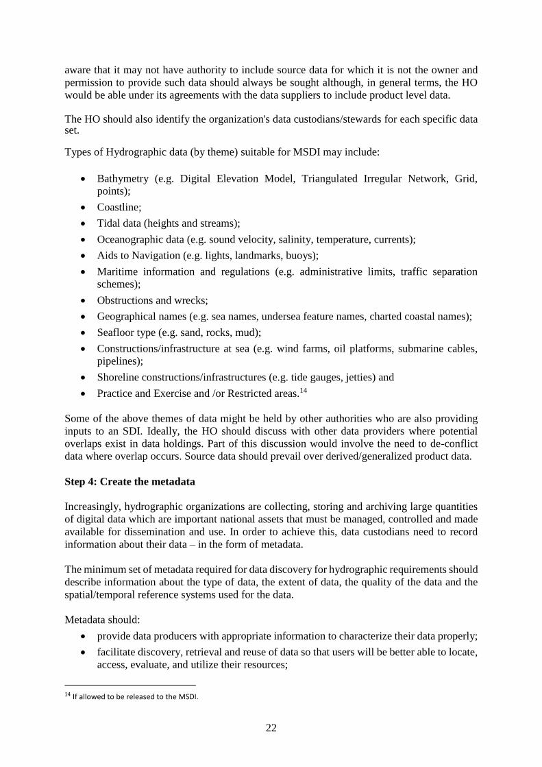
Figure 7 shows the 5 Star approach to digital data form. In general:
scan manuscript documents into raster formats ensuring that the scan density is such
that it can be used without resorting to the hard copy to resolve readability; and/or
capture data in vector format where possible. This could be done using optical character
recognition methods or capture using double digitization to ensure the quality and
completeness of data capture (e.g. hand-drawn soundings).
ensure rigorous checking and validation is in place.
capture data as close to source scale or highest resolution as possible (i.e. not at product
scale).
Figure 7: The 5 star approach to digital data management (http://5stardata.info)
Step 6: Develop a technical architecture and environment
In order for data to be more easily shared and exchanged as part of an SDI, certain things have
to be considered:
Apply MSDI implementation rules (defined by the MSDI to which the HO is joining).
Study best practice guidelines if the HO is creating an MSDI itself.
15 Iliffe, J and Lott, R (2008) "Datums and Map Projections": Whittles Publishing; Dunbeath
Worst
Best

24
Identify where harmonizing the data from other providers to meet MSDI requirements
in terms of its interoperability is possible. Always keep it simple.
Define the standards with which the HO is already compliant (e.g. S-57, S-100, ISO
19100 series, OGC standards).
Use of "web-based" services based on OGC standards (e.g. Web Map Services [WMS],
Web Feature Service [WFS], Web Coverage Services [WCS] or Tile Map Services
[TMS]).
Step 7: Make the Metadata Searchable
Initially on your website (but ideally through SDI Geo-portal if available).
Update the metadata to identify raster or vector data availability.
Enable the search for metadata by type, area and/or key word.
Step 8: Make the Data Available
Develop download facilities for data sets (note that for some dense datasets, the use of
web delivery is not possible).
Develop automated search and download of data sets via web mapping services (WMS,
TMS).
Develop a seamless validated database of vector data using international standards (e.g.
S-57 object catalogue or S-100 concept dictionary or data model).
Where security of data is an issue, develop an acceptable level at which data can be
made available either in-country or internationally. This may involve data thinning or
gridding to a level where data might be declassified. It is important to promote the fact
that "data can be released unless there is a very good reason why it cannot".
Facilitate automated search and download of data via web feature services (WFS).
Establish a licensing and, if required, a cost recovery regime supported and underpinned
by an organizational and/or government policy.
Step 9: Monitoring and Reporting
Every HO should provide update reports, regarding their status in respect of building,
engagement and/or contributing to an SDI in their country or region, to their respective
Regional Hydrographic Commission (RHC) meetings. Such a report should include:
What data is being disseminated (through web-based access or manual dissemination);
Identification of which datasets complete with metadata are to be provided into an SDI
and report progress on preparation;
Monitoring and report on feedback from users and stakeholders; and
Defining the type of data services and products being offered by the HO.
Step 10: Making MSDI Involvement Sustainable
Providing data to a MSDI framework at an organizational, national or regional level should be
considered as a long term initiative which over time will evolve and mature such that the
activities in Steps 1-9 are considered "business as usual". As such, the framework, systems and

25
processes have to be sustainable over time. Therefore it is critically important therefore that
data is managed, shared and published in a sustainable "best practice" manner.
12. The Challenges for Hydrographic Offices
12.1. Developing a Wider Remit
Given the scope of MSDI, e-navigation and no doubt other initiatives, HOs need to consider
the extent of their domain and influence, and how this might need to change to address future
expectations. At present most HOs work in a relatively restricted domain, mostly due to their
government status, tightly defined responsibilities and funding arrangements. This limits their
opportunities to reach their full potential as data custodians rather than as product producers.
Authorities who define the role of HOs therefore need to be challenged to encourage them to
support the wider potential of hydrographic data.
To make data accessible to users outside of the HO community, it needs to be held in a
universally recognized format. S-57 is an established format, but limited to ENCs. S-100
provides the universal data model for holding a wide range of data in a widely recognized
format. It is understandable that S-100 data is not yet widely available, as the product
specifications based on the data model are still under development. However, HOs need to
carefully consider whether they will simply export their existing data into appropriate S-100
specifications, or convert their internal data holdings according to the principles of the S-100
universal data model.
Moving to an internal data holding based on S-100, will also provide the opportunity to remove
duplication and ambiguity. The aim must be to only hold each feature once such that it is known
to be authoritative. If scale dependent portrayal is required, this should be an attribute of the
feature and not an excuse to hold the feature more than once.
The potential for HOs to contribute to national and regional SDI is becoming more realistic.
This requires serious consideration in terms of the consequences to how data is managed. It is
therefore important to:
Use a data centric approach, holding unique features with an identifier [UID] such that
they are stored once but can be used many times;
Use the S-100 standard internally; and
Consider and promote the wider use of data.
These matters could be advanced through the sharing of best practice, promotion of case studies
and, given a higher level of importance, through engagement with local and national
government to gain support for maintaining MSDI as an enabler to better environmental
management, faster response to disasters as well as for the promotion of more efficient
navigation and shipping practices.
12.2. Data Sharing and Exchange
HOs often have difficulties gaining access to commercial surveys of their national waters and
in some cases they may not be aware that surveys have been undertaken. In order to obtain

26
these surveys HOs should consider engaging further with both commercial and its wider
government partner’s to seek ways of gaining access to survey data that, hitherto, may not have
been made available to HOs for its primary purpose of supporting safe navigation. The lack of
access to survey data coupled with reducing budgets impacting on its ability to undertake the
necessary surveys means there is a risk of not being able to provide a reliable service.
Access to commercial surveys undertaken for other purposes, such as oil and gas exploration,
dredging campaigns, offshore renewable site surveys and conservation must be considered if
the HO remit is to remain relevant and affordable in future. The cost of sharing, exchanging or
even licensing such data will be significantly less that undertaking repeat surveys in areas where
at least some existing data is known to exist, or undertaking new surveys where the HO bears
the entire cost.
Examples exist whereby governments and/or commerce work together to ensure that where
surveys are undertaken, that they meet S-44 standards even though the primary purpose of that
survey may not be for SOLAS purposes, but perhaps for example, for seismic or conservation
purposes. In the UK Dependent Territories, UKHO and the Centre for Environment, Fisheries
and Aquaculture Science (Cefas) are pooling resources to ensure that future surveys undertaken
can satisfy a wider need that purely hydrography in supporting future economic and socio-
economic development. In France, SHOM and IFREMER share resources in a similar way
gaining “economies of scale” from the outcomes of a particular survey project.
In order to facilitate the wider availability of bathymetric data there are three main issues that
need to be addressed by HOs:
1. Contractual arrangements that enable survey operators to provide appropriate bathymetric
information to HOs for use in navigational products and for wider marine use, without
compromising commercial or other sensitivities. This may be generalized or reduced
density data.
2. Notification, to the HO, of intended survey operations to allow it to consider what data
already exists, what will be collected and what is required by the HO to fulfil national and
international obligations;
3. An obligation on all marine survey operators to report any information that might cause a
risk to marine and / or maritime activities, particularly with respect to SOLAS dangers to
navigation.
13. A look into the Future!
So where will the HOs, as part of the global geospatial community, be in the next 10 years?
There is no doubt that there has never been a more urgent need for a paradigm shift in how we
inhabit our planet. Whether we look at it through the lens of climate change, population growth,
migration, socio-political unrest, or use of natural resources; it is clear that our current
"direction of travel" is unsustainable and potentially unpalatable.
There is no escaping that technology now dominates our lives, with a large part of the world’s
economy and society now relying on smart phones, IT and the internet. At the heart of today’s
world is the data that this technology generates. Yet, in these days of big data, open data, the

27
Internet of Things, sensors, augmented reality and almost instantaneous sharing of information
on social media, there is a mismatch between the rate of change of technology and the ability
for our world’s leaders and policy makers to keep up and understand the implications of this
change.
The ongoing challenge is that the time taken to deliver such policy and standards is
extraordinarily long whilst technology is moving forward much more quickly. In the past, these
kinds of technological shifts have allowed humanity to advance its resilience, adaptability and
influence.
Spatial information has a critical part to play here as “everything happens somewhere!”
Providing a sense of place is extremely powerful because, as humans, we gain comfort from
knowing our place and position in the world. This is now more important as our world
increasingly operates online and becomes more intangible. But do we believe we as geospatial
specialists can fill this role?
There is a widely held belief that the geospatial industry, as we know it, has reached an
existential moment. Our past belief in the central role and importance of geospatial data has
been eroded by the realization that geo-technology and its use, is now so ubiquitous as to be
almost invisible.
Many of the key skillsets we had previously taken for granted as exclusively ours are now
shared by other professionals, users and even hobbyists such as gamers, geo-cachers, travelers
and ramblers. What this gives the geospatial industry is the opportunity to evolve into a new
role in this information rich world.
We must take charge of technology, and not be its slave, by raising our profile to view the wider
geospatial picture. There is far more to “location intelligence” than maps and charts. It’s all
about the data, what you do with it and what outcomes you can provide that counts.
The geospatial industry, of which HOs are part, now has to understand how to switch from
being a data provider to becoming a data service and to do it quickly. Data is no longer
considered an asset but a ‘modus operandi’.
Doing nothing is no longer a realistic option!
28
Annex A - SDI Best Practice
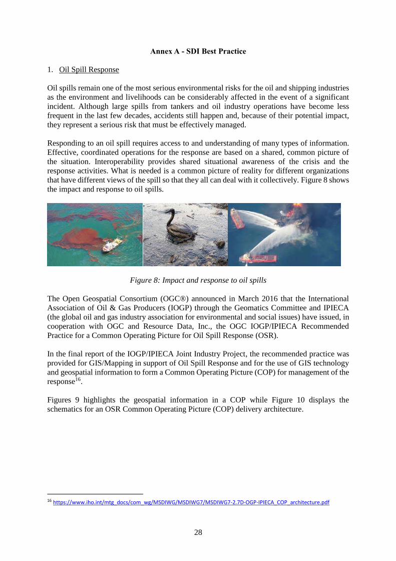
1. Oil Spill Response
Oil spills remain one of the most serious environmental risks for the oil and shipping industries
as the environment and livelihoods can be considerably affected in the event of a significant
incident. Although large spills from tankers and oil industry operations have become less
frequent in the last few decades, accidents still happen and, because of their potential impact,
they represent a serious risk that must be effectively managed.
Responding to an oil spill requires access to and understanding of many types of information.
Effective, coordinated operations for the response are based on a shared, common picture of
the situation. Interoperability provides shared situational awareness of the crisis and the
response activities. What is needed is a common picture of reality for different organizations
that have different views of the spill so that they all can deal with it collectively. Figure 8 shows
the impact and response to oil spills.
Figure 8: Impact and response to oil spills
The Open Geospatial Consortium (OGC®) announced in March 2016 that the International
Association of Oil & Gas Producers (IOGP) through the Geomatics Committee and IPIECA
(the global oil and gas industry association for environmental and social issues) have issued, in
cooperation with OGC and Resource Data, Inc., the OGC IOGP/IPIECA Recommended
Practice for a Common Operating Picture for Oil Spill Response (OSR).
In the final report of the IOGP/IPIECA Joint Industry Project, the recommended practice was
provided for GIS/Mapping in support of Oil Spill Response and for the use of GIS technology
and geospatial information to form a Common Operating Picture (COP) for management of the
response16.
Figures 9 highlights the geospatial information in a COP while Figure 10 displays the
schematics for an OSR Common Operating Picture (COP) delivery architecture.
16 https://www.iho.int/mtg_docs/com_wg/MSDIWG/MSDIWG7/MSDIWG7-2.7D-OGP-IPIECA_COP_architecture.pdf

29
Figure 9: Common Operating Picture, highlighting geospatial information
Figure 10: OSR Common Operating Picture (COP) delivery architecture
2. Arctic SDI
Improved access to geospatial data can help us better to predict, understand and react to changes
in the Arctic. Responses to the impact of climate change and human activities in the Arctic
(Figure 11) requires accessible and reliable data to facilitate monitoring, management,
emergency preparedness and decision making.

30
The Arctic SDI governance model is based on cooperation on prioritized activities where, as
agreed to in the Arctic SDI Memorandum of Understanding, activities are developed and
managed through the voluntary commitment of each agency. The Arctic Spatial Data
Infrastructure (SDI) provides such an infrastructure and its development is facilitated by the
National Mapping Agencies of the eight Arctic countries.
Figure 11: Environment and the human presence in the Arctic
Important data sets are produced and distributed by many stakeholders – public and commercial
sector – and most of it can be geographically referenced. A spatial data infrastructure provides
tools for data distributors to ensure that their geospatial data is easier for users to access, validate
and combine with other data.
The role of the eight National Mapping Agencies of the Arctic countries is to provide
stakeholders access to a coherent and authoritative Arctic reference map through the publication
of selected data from their respective holdings as well as to lead and guide the development of
an Arctic SDI to in order to develop best practice.17 Figure 12 shows the activities supported
by the Arctic SDI.
Figure 12: Schematic showing the activities supported by Arctic SDI
17 http://arctic-sdi.org/
31
3. New Zealand Geospatial Strategy and National Spatial Data Infrastructure
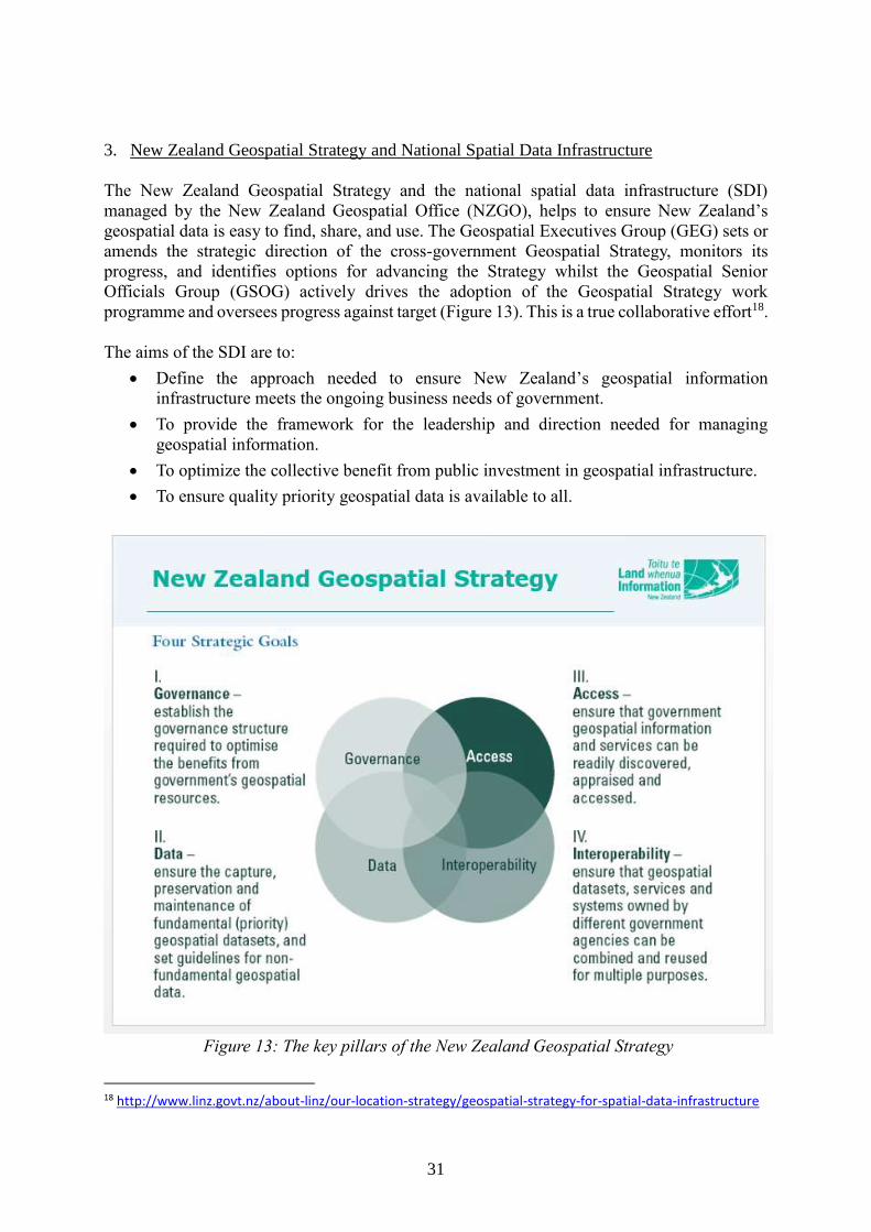
The New Zealand Geospatial Strategy and the national spatial data infrastructure (SDI)
managed by the New Zealand Geospatial Office (NZGO), helps to ensure New Zealand’s
geospatial data is easy to find, share, and use. The Geospatial Executives Group (GEG) sets or
amends the strategic direction of the cross-government Geospatial Strategy, monitors its
progress, and identifies options for advancing the Strategy whilst the Geospatial Senior
Officials Group (GSOG) actively drives the adoption of the Geospatial Strategy work
programme and oversees progress against target (Figure 13). This is a true collaborative effort18.
The aims of the SDI are to:
Define the approach needed to ensure New Zealand’s geospatial information
infrastructure meets the ongoing business needs of government.
To provide the framework for the leadership and direction needed for managing
geospatial information.
To optimize the collective benefit from public investment in geospatial infrastructure.
To ensure quality priority geospatial data is available to all.
Figure 13: The key pillars of the New Zealand Geospatial Strategy
18 http://www.linz.govt.nz/about-linz/our-location-strategy/geospatial-strategy-for-spatial-data-infrastructure

32
The collaborative New Zealand Open Government Information and Data Programme19 is a
collaboration involving users, the open data community, civil society, and government agencies
(the data suppliers). It makes public government-held information more widely available for
people, communities, and businesses to re-use. Land Information New Zealand (LINZ) hosts
New Zealand’s Open Government Information and Data Programme. In promoting open
government information and data, the Programme is a key tool in helping New Zealand
maintain its strong history of open and transparent government.
19 http://www.linz.govt.nz/about-linz/what-were-doing/projects/open-government-information-and-data-programme
33
Annex B – Example Conceptual Model for a National SDI20
Figure 14: UK Government conceptual model of NSDI
20 https://data.gov.uk/sites/default/files/conceptual-model1_10.pdf

34
Annex C – Frequently Asked Questions (FAQs) about SDI
1. What is a SDI?
SDI is a term used to summarize a range of activities, processes, relationships and physical
entities that, taken together, provide for integrated management of spatial data, information and
services. The term covers the processes that integrate technology, policies, criteria, standards
and people necessary to promote geospatial data sharing throughout all levels of the public
sector; embraces the structure of working practices and relationships among data producers and
users that facilitates data sharing and use. It covers the set of actions and new ways of accessing,
sharing and using geographic data that enable far more comprehensive analysis at all levels of
government, the commercial and not-for-profit sectors and academia; and describes the
hardware, software and system components necessary to support these processes
2. In what way does SDI affect Hydrographic Offices?
A Hydrographic Service (HO), through systematic data collection carried out on the coast and
at sea, produces and disseminates information in support of maritime navigation safety and
marine environment preservation, defense and exploitation. The development of an SDI is a
natural extension in the management and dissemination of such information in an integrated
manner.
An HO is uniquely placed to play a central role in the development of the marine component
of SDI‟s. Hydrography, with its subset of data themes, forms the key "core geography" layer
for the sea space in a particular country or region. In this capacity, HO data provides a rich and
unparalleled resource for users at all levels.
3. Why is it important that a Hydrographic Office gets involved?
By getting involved, the HO will gain a greater appreciation of the inherent value in its
information which will lead to the wider use of hydrographic data and information in the
development of new products and services. It would also demonstrate that the HO is a vital
element of the national spatial data infrastructure and that it has a role to play. It will also allow
the HO to work in cooperation with others to tackle some of the difficult issues affecting
geospatial data at this time.
4. What does an HO need to consider in establishing a presence in SDI?
Firstly, the HO should prepare and define its policy relating to data to take account of its
potential outside of charting and navigational use. The HO needs to identify key internal
stakeholders and their requirements as well as identify an SDI "champion" for its involvement
or leadership. It can then build support for engagement at Senior Management level within the
HO and gain the necessary approvals for involvement.
Identifying National or Regional initiatives/legislation which might support and/or mandate
SDI is important as there may already be a framework in place. This process would require
engagement with external SDI stakeholders. The IHO Regional Hydrographic Commissions
(RHC) has a role as a stakeholder so the appropriate commission(s) should be notified. There
needs to be willingness and practical co-operation between the various organizations that create,
shares and uses information to implement the overall policy. There should also be a clearly
defined governance structure, transparency in decision making, and reporting to foster a shared
sense of a working towards a common goal.

35
5. In what ways is Hydrographic information important to SDI?
HO data should be an integral part of an SDI as it comprises "core reference" geographic data
themes which represent a key element of the marine component of a National SDI (NSDI).
MSDI is the component of an SDI that encompasses marine geographic and business
information in its widest sense. This would typically include seabed topography (bathymetry),
geology, marine infrastructure (e.g. wrecks, offshore installations, pipelines and cables),
administrative and legal boundaries and oceanography. Much of this information resides in the
HO as "source" data (e.g. dense bathymetric data) and/or product data (e.g. ENC data, digital
nautical publications, digital elevation models) complete with metadata (data about data).
6. Standards play an important role in the development of SDI. What practical steps does
the HO need to take to ensure it complies with the relevant standards?
International standards for geographic information exist or are being created and, in many areas,
sector-based standards are being put in place that depend on these over-arching standards; for
example, IHO S-100 relies on the ISO 19100 series of geographic standards. The standards
work of the Open Geospatial Consortium (OGC) especially in the areas of data content
modelling, data transport, and web services are critical to developing a robust SDI approach.
SDI requires that data can be "discovered", managed, shared, exchanged and disseminated. At
its simplest, metadata is „data about data‟ and describes the characteristics of a dataset (i.e.
content, value and limitations) and normally held in a metadata management system or
clearinghouse to provide mechanisms of search and retrieval. It is a vital component in
"discovering" data and information and understanding how it can be used.
With web-based dissemination, the use of services based on OGC standards (e.g. Web Feature
Service, Web Map Services, Web Coverage Services) are becoming increasingly popular. The
practical way to ensure compliance is to ensure that the basic steps in best practice data
management are followed. In doing so, a metadata search facility (e.g. a portal) should be
developed to allow users to find data. Specifications for data capture and management should
follow industry or sector standards to ensure it is interoperable.
7. What is the value and benefit of SDI?
Engaging in SDI affords real benefits to the HO irrespective of its chosen business model. The
greater appreciation of the inherent value in HO information will lead to the wider use of
hydrographic data and information in the development of new products and services, improved
decision making (e.g. spatial planning, integrated coastal zone management, flood mitigation
and climate change adaptation).
Efficiencies in organizational processes (e.g. data collection and management) will be gained
by reducing duplication and encouraging co-ordination of activities promoting the more
effective use of public funds. It will also enable the HO to be in the mainstream of geospatial
decision making through co-operation and working together with other information providers.
Downstream benefits from this approach will be realized in three ways; enhanced commercial
activity in the marine environment, supporting national or regional legislative initiatives and
through developing the knowledge economy.

36
8. How much is this likely to cost the organization?
The real cost of developing the framework within the HO to support an SDI is relatively low.
In some respects the costs of not doing this is greater in the longer term, in that the HO will be
"left behind" in key areas of organizational efficiency and excellence. There is no requirement
for a HO to capture new information or to change the way data is ingested, managed or
disseminated as part of SDI development. What it does require is a change in the way the HO
approaches the components of SDI in order to achieve best practice and drive through
efficiencies and effectiveness in the organization. Investing in improved business processes and
information management may be necessary but as part of business improvement plans.
9. What challenges is the HO likely to encounter in developing its role in SDI?
There will be obstacles to be encountered on the route to SDI engagement and participation. A
number of these obstacles will not necessarily be technological but about the organization and
its people. Being able to work with other organizations and adopting a partnership approach is
critical to success, but equally important is persuading HO staff to challenge the way things are
currently done to ensure they are undertaken more efficiently in the future and to change the
culture of the organization; winning over sceptics whilst at the same time educating the non-
marine community about marine SDI components. It is essential that the HO has the knowledge,
training and skills for involvement in SDI.
SDI is all about accepting that hydrographic data is information rather than products such as
charts. Provision of funding across the HO community is always an issue so one challenge
might be persuading the budget manager to support such activities.
10. What are appropriate timescales over which an SDI might be developed?
An SDI will be developed over a period of time. It is not something that can be delivered
quickly. In the European Union (EU), the INSPIRE programme is set to develop over a 13 year
period, but that does involve 28 States in the EU. At the national level 3-5 years might be
considered a realistic ambition for development.
11. How can an HO ensure it remains at the forefront of SDI in the future?
An HO can remain engaged in the process by delivering best practice in terms of data and
organizational management and by communicating with others involved at all times on
developments and innovation in the way progress of the SDI is managed and monitored.
12. How can a HO make the Business Case for investment in MSDI?
It is vital that HO decision makers and stakeholders work together to put together a sound
financial and operational case for MSDI. In addition to a project definition, the complete
business case should include the following elements:
Financial Analysis
o This is usually a summary of key financial metrics and highlights including:
detailed assumptions, calculations, and the complete sensitivity analysis.
Strategic Analysis
o This includes internal and external benefits and project interrelationships. In the
case of collaborative projects, this will describe the full project, the cost-sharing

37
methodology, and if relevant, the benefits to other participants and the
community.
Recommended Course of Action
o If the business case is persuasive, it should conclude with a recommendation to
make the investment (perhaps with other participating agencies). If the business
case is not persuasive, it may end with a recommendation to table the project
concept for future consideration.
Falling technology costs, the growth of commercially available spatial data, and regulatory
changes can make a difference in the costs and benefits of a MSDI project. Participating
agencies may wish to revisit tabled business cases as part of an annual strategic planning
process to determine whether circumstances have changed sufficiently to warrant an updated
analysis.
A business case may be extremely brief or may be significantly longer. Larger investments
often require more detailed business cases21.
21 https://www.fgdc.gov/policyandplanning/future-directions/action-plans/draftroiworkbook

38
Annex D – Hydrographic Data Policy
Best Practice Guidelines for Hydrographic Offices
Background
Fit for purpose Hydrographic data and information, which is authoritative and up to date, is
essential in underpinning evidence-based decision making and asset management enabling
Governments and the commercial sector to deliver their policy objectives for the marine
environment and coastal zone.
Ensuring good governance and the most productive use of existing and new data and
information is a key aim of emergent marine monitoring and science strategies as well as
underpinning coastal zone management.
Hydrographic data and information is acquired, managed, manipulated, and disseminated
primarily by Hydrographic Offices (HOs). Its use outside of navigational products and services
has been limited to date but the requirement for such information from other users, both public
and private sector, is growing very swiftly across the World.
Hydrographic Data Policies underpinned by best practice are needed to support the
requirements of a Spatial Data Infrastructure (SDI) of which geospatial information in the
marine space is a major component.
Policy Aim
The overall aims of a HO Data Policy is to provide Government and the commercial sector with
appropriate data and information to deliver its marine objectives; to support the safe, sustainable
use and development of its coastline and seas, whilst encouraging data sharing and re-use and
the optimization of public funds.
These aims shall be achieved by HOs by implementing the following policy statements whilst
working together with others to the benefit of the wider marine community.
Policy Statements
1. HOs acquiring or holding hydrographic data shall document the existence of these datasets
(themselves or via a third party) and make this information publicly available through the
creation and dissemination of metadata to ISO standards.
2. Where it is impractical to use data directly (for example, it is not to a required specification)
consideration shall be given to making existing data usable prior to undertaking nugatory
work.
3. HOs shall adopt and assist in the development of common standards, technology and inter-
organizational relationships that promote and facilitate data sharing and re-use.
4. HOs shall define terms and conditions associated with data sharing and re-use, adopting
common and user friendly licensing procedures, wherever possible, in line with any
emerging simplified licensing requirements.

39
5. HOs shall ensure the appropriate governance framework, knowledge and skills necessary
to acquire, manage, manipulate, use and re-use data effectively are put in place.
6. HOs along with other organizations shall collaborate to coordinate marine and coastal data
acquisition thereby avoiding replication and ensuring cost effective and efficient use of
public funds.
7. HOs shall collaborate to create common reference datasets (e.g. elevation of the sea bed)
by utilizing existing data wherever possible.
8. HOs identified as authorities for core geographic reference data (e.g. seabed
characterization or topography) shall maintain this data to the required standards and at as
close to source scale as possible, to ensure its re-use applicability now and in the future.
9. HOs must ensure that it owns, or has the appropriate rights to, the data that allows the HO
to populate the SDI with that data.
10. In order to enable the maximum re-use and sharing of all information held by the HO, best
practice in data management will be adopted.
11. HOs, as data owners or custodians, shall maximize the value and benefit of Hydrographic
data by defining appropriate and flexible rights of use and not impose unreasonable
restrictions on use.
12. Organizations involved in SDI (including HOs) will seek to establish and maintain
interoperability of marine information with associated land information and underground
information so that users on-shore or off-shore may use common datasets in solving coastal
zone issues.
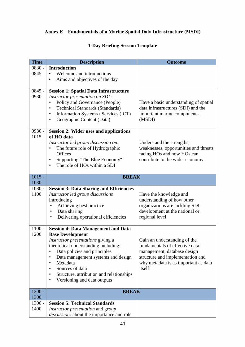
40
Annex E – Fundamentals of a Marine Spatial Data Infrastructure (MSDI)
1-Day Briefing Session Template
Time Description Outcome
0830 -
0845 Introduction
• Welcome and introductions
• Aims and objectives of the day
0845 -
0930 Session 1: Spatial Data Infrastructure Instructor presentation on SDI :
• Policy and Governance (People)
• Technical Standards (Standards)
• Information Systems / Services (ICT)
• Geographic Content (Data)
Have a basic understanding of spatial
data infrastructures (SDI) and the
important marine components
(MSDI)
0930 -
1015 Session 2: Wider uses and applications
of HO data
Instructor led group discussion on:
• The future role of Hydrographic
Offices
• Supporting "The Blue Economy"
• The role of HOs within a SDI
Understand the strengths,
weaknesses, opportunities and threats
facing HOs and how HOs can
contribute to the wider economy
1015 -
1030 BREAK
1030 -
1100 Session 3: Data Sharing and Efficiencies
Instructor led group discussions
introducing
• Achieving best practice
• Data sharing
• Delivering operational efficiencies
Have the knowledge and
understanding of how other
organizations are tackling SDI
development at the national or
regional level
1100 -
1200 Session 4: Data Management and Data
Base Development
Instructor presentations giving a
theoretical understanding including:
• Data policies and principles
• Data management systems and design
• Metadata
• Sources of data
• Structure, attribution and relationships
• Versioning and data outputs
Gain an understanding of the
fundamentals of effective data
management, database design
structure and implementation and
why metadata is as important as data
itself!
1200 -
1300 BREAK
1300 -
1400 Session 5: Technical Standards
Instructor presentation and group
discussion: about the importance and role

41
of data standards including the IHO S-100:
Universal Hydrographic Data Model and
extending S-100 for other products and
services
Gain a basic knowledge of standards
employed in the geospatial world;
the implications of S-100 for the HO
community and the opportunities to
extend the S-1XX specifications in a
common manner
1400 -
1430 Session 6: Introduction to Data
Publishing in the Electronic Age
Instructor presentation on the work of the
Open Geospatial Consortia (OGC); Data
Sharing and Network Services (Discover,
View and Download)
Have an understanding of what
publishing means using a variety of
media and how web services are
developing to assist the user to
access metadata and data for onward
use
1430 -
1445 BREAK
1445 -
1530 Session 7: MSDI - Obstacles to
progress? Instructor presentation
introducing and addressing challenges
facing HOs:
• People as individuals and as part of
teams
• Organizational culture
• Organizational structures
• Making the business case for MSDI
• Making change happen
• Sustainable change
Understand why "change" is mission
critical to achieving best practice and
delivering MSDI and why without the
support of people, success is far from
guaranteed!
1530 -
1600 Session 8: If it’s so good, why isn’t it
happening? Interactive group session discussing the
factors that hinder development, how these
can be overcome by understanding, careful
design, sympathetic communication with
stakeholders and an understanding and
appreciation of the value and benefit that
change brings over time
Have the confidence and knowledge to
manage and / or contribute to the
change process and identify the
benefits and opportunities of MSDI
and the role HOs should play in NSDI
1600 -
1630 Session 9: What have you learnt today?
Interactive group discussion:
• Review Key Points and Messages
• Has the briefing met your
expectations?
• How can you deliver MSDI and best
practice?
• What will success look like?
• What are the next steps?
Reinforce key messages learnt so that
attendees have a knowledge and
understanding and of the
fundamentals of MSDI and how
people, organizations and processes
influence outcomes
End of Briefing Session

42
Annex F – Example Uses of Hydrographic Data for Purposes Other Than Navigation
Spatial Planning
Coastal Zone Management
Habitat mapping & heritage assessment
Conservation assessment & designation
Site selection (e.g. renewable energy and oil & gas extraction)
Route optimization
Vessel location and disposal monitoring
Homeland security and defense
Aggregates extraction
Fisheries regulation
Coastal protection & shoreline management
Licensing & consent evaluation
Emergency planning & management
Emergency response
Survey planning & execution
Leisure & Tourism
43
Annex G – How HOs might engage in SDI
Through the IHO
Website (IHO MSDIWG page and dropdown options containing guidance documents,
case studies and body of knowledge)22
Links to S-100 Universal Hydrographic Data Model data page23
Regional Hydrographic Commissions (RHCs)
International Hydrographic Conferences
Capacity Building activities
Through Regional and / or National SDI focused events
Seminars (e.g. EuroSDR, OceanWise)
Workshops (e.g. IHO SDI Awareness)
Conferences (e.g. INSPIRE; GSDI; ICC; IHO)
Industry (e.g. CARIS; Esri; OceanWise; Envitia)
Outreach through other Associations
International Federation of Hydrographic Societies (IFHS)
Inter-Governmental Oceanographic Commission (IOC)
International Cartographic Association (ICA)
User Groups (e.g. Esri; 1Spatial)
Association for Geographic Information (AGI)
Open Geospatial Consortia (OGC)
World Wide Web Consortia (W3C)
Media
• Providing SDI related articles to relevant journals (e.g. Hydro magazine)
• Advertorial in regional or national press
• Public Relations through exhibiting and / or sponsorship of events
Leverage and influencing
• Using public relations expertise
• Using political contacts in-country to further SDI policy development
• Through contact with SDI regional, national or marine SDI "Champion"
• Through Funding bodies for financial support (e.g. UNESCO; World Bank)
• By lobbying as part of the wider SDI stakeholder group
22 https://www.iho.int/srv1/index.php?option=com_content&view=article&id=483&Itemid=370&lang=en 23 http://www.iho.int/iho_pubs/standard/S-100_Index.htm

44
Annex H – Stakeholders to be considered by IHO member states in developing their
understanding and engagement in SDI
Standards / Normalization experts To ensure common approach to data standards and specifications is followed (e.g. ISO, OGC)
National Mapping Agencies/ Survey Departments/Environment Departments To discuss interoperability and potential harmonization of land and sea spatial data
Government contacts in-country
• Policy level – to identify legislative drivers for SDI
• Administration level – to develop stakeholder involvement
• Political level - to gain influence and leverage through the SDI "Champion"
Private Sector partners To assist in technical requirements for SDI compliance
• Software companies (e.g. CARIS; Esri, Envitia)
• System integrators (e.g. IBM, BAE Systems)
• Data Management specialists (e.g. OceanWise)
Users To identify what customers of HO data require, how and when they require it to be provided
IHO Working Groups & Committees To learn what developments and / or changes to specifications and processes are happening.
Regional or National Spatial Data Infrastructure (SDI) initiatives such as:
European Commission (INSPIRE): Joint Research Centre in Ispra; Italy
http://inspire.jrc.ec.europa.eu/
Kartverket – Norway NSDI: http://kartverket.no/en/Systempages/Ordbok/N/NSDI/
Natural Resources Canada - GeoConnections (CGDI): http://www.nrcan.gc.ca/earth-
sciences/geomatics/canadas-spatial-data-infrastructure/8906
Malaysia (MaCGDI): http://www.mygeoportal.gov.my/international-sdi
Latin America and Caribbean: http://www.geosur.info/geosur/index.php/en/
GSDI To promote international cooperation and collaboration in support of local, national and
international spatial data infrastructure developments. http://gsdiassociation.org/
Other data providers (e.g. geology, seismic, science)
To enable interoperability at both the organizational and data level
Other marine/ maritime organizations (e.g. ports; coast- guards; environment)
To gain a wider perspective on how information and services provided by other organizations
impacts on those provided by the HO and to engender collaboration and co-operation in
developing SDI capability
45
Annex I – SDI Business Plans – Links to examples
1. The Philippine Geospatial Data Infrastructure (PGDI) Master Plan 2011-2020
http://namria.gov.ph/Downloads/PGDIMasterPlan.pdf
2. USA - Advancing State-wide Spatial Data Infrastructures in Support of the National
Spatial Data Infrastructure (NSDI) - Strategic Plan Guidelines
https://www.fgdc.gov/initiatives/50states/newspbp/StrategicPlanGuidelines_v2_052809_Final
Version.pdf
3. Pacific Islands - Spatial Data Infrastructure Implementation (PACGEO)
http://www.iho.int/mtg_docs/com_wg/MSDIWG/MSDIWG7/Open/OF1-
2_Sachindra%20Singh%20(SPC).pdf or http://geonetwork.sopac.org/geonetwork
4. National Spatial Data Infrastructure – The Case of Brazil (INDE)
http://www.infodev.org/infodev-files/resource/InfodevDocuments_1105.pdf and
http://www.inde.gov.br/
5. The Spatial Data Infrastructure of Germany (GDI-DE)
http://www.geoportal.de/EN/Geoportal/Services/Spatial-Data-and-Services-in-
Web/_functions/germany/germany_table.html?
Note: A list of existing SDI/NSDI and MSDI initiatives across the World and map showing
existing national geoportals can be found at:
http://www.iho.int/mtg_docs/com_wg/MSDIWG/MSDIWG_Misc/SDI-portals.pdf and
http://www.iho.int/gis/msdi.gis.html
https://www.fgdc.gov/initiatives/50states/newspbp/StrategicPlanGuidelines_v2_052809_FinalVersion.pdf
Related Documents