Space Data Services Support for National Forest Monitoring Systems The Global Forest Observations Initiative Version 1.1 for CEOS SIT-29 (April 2014)

Welcome message from author
This document is posted to help you gain knowledge. Please leave a comment to let me know what you think about it! Share it to your friends and learn new things together.
Transcript
Space Data ServicesSupport for National Forest Monitoring Systems
The Global Forest Observations Initiative
Version 1.1for CEOS SIT-29 (April 2014)

The Five Components of GFOIThe work of GFOI is undertaken by five components, shown below. The Coordination of Satellite Data Supply (The Space Data Component of GFOI) is the responsibility of the CEOS Space Data Coordination Group (SDCG) and is explained on the following page.
What is GFOI?
The Global Forest Observations Initiative (GFOI) is an initiative of the inter-governmental Group on Earth Observations (GEO) that aims to:
1. Foster the sustained availability of observations for national forest monitoring systems;
2. Support governments that are establishing national systems by providing a platform for coordinating observations, providing assistance and guidance on utilising observations, developing accepted methods and protocols, and promoting ongoing research and development; and
3. Work with national governments that report into international forest assessments such as the national greenhouse gas inventories reported to the UN Framework Convention on Climate Change (UNFCCC) using methods of the Intergovernmental Panel on Climate Change (IPCC).
The purpose of this document is to introduce the GFOI Space Data Services – a selection of services that provide a case-by-case response to a country’s satellite data needs, which are not always adequately covered by the baseline strategy, and which take into account national needs as well as existing/planned capacities and relationships.
Coordination of Satellite Data
Supply
Research &Development
Plan
Methods &Guidance
Documentation
Administration& Coordination
CapacityBuilding
Support countries in the use of ground observations and remotely sensed data and methodologies for the establishment of their national Forest Monitoring and Carbon Tracking systems.
Help nations develop a capacity to utilise Earth Observation data in a credible national forest monitoring system that can provide input to national MRV systems for GHG emissions and removals.
New methodologies are constantly developed to use new sensors in management and monitoring of forest systems. The R&D plan identi�es priority areas where research is required to achieve GFOI goals.
The implementation of GFOI’s objectives will require coordination and communication across the range of stakeholders. This component covers the necessary management functions and is the main role of the GFOI O�ce.
Background and Introduction
1

The Committee on Earth Observation Satellites (CEOS) has effectively coordinated space-based acquisitions since 2009 in support of Forest Carbon Tracking (FCT) demonstration activities. Based on the FCT experience, CEOS has accepted responsibility for coordination of the satellite data contribution to the observations and measurement component of GFOI to ensure the regular and systematic observations and measurements for effective reporting. This will ensure continuity of data supply for the maintenance of consistent time series.
Recognising the magnitude of the challenge involved in meeting the requirements of the countries, given the global scale and sustained coverage needed, and the need for significant and sustained effort, CEOS at the 25th CEOS Plenary, in 2011, agreed to the establishment of a dedicated Space Data Coordination Group (SDCG) for GFOI charged with defining and implementing a three-part strategy as a framework for its coordination efforts, comprising: the Baseline Global Data Acquisition Strategy, the Space Data Services for GFOI, and data supply in support of GFOI R&D activities.
Baseline Global Data Acquisition Strategy
A coordinated Baseline Global Data Acquisition Strategy involving a number of space-based core data that can be used and shared free-of-charge for GFOI purposes. This involves systematic and sustained wall-to-wall Earth Observation (EO) acquisitions of
forested areas globally and provides the default forest
observations data for all countries without specific
technical requirements, heritage, or data preference (such as for a particular mission or data type). This
Baseline Global Data Acquisition Strategy
should guarantee the
minimum consistent space data provision necessary for all interested countries to engage in reporting to the UNFCCC under the provisions of a future climate treaty. This includes the requirements for Reducing Emissions from Deforestation and Forest Degradation in developing countries (REDD+) and the role of conservation, sustainable management of forests, and enhancement of forest carbon stocks in developing countries. To this end, the Baseline Global Data Acquisition Strategy needs to assist implementation of the methodologies described in the Methods & Guidance Documentation (MGD).
Space Data Services
A coordinated strategy for national data acquisitions will accommodate the needs of countries that have specific technical requirements or heritage and experience on working with a particular EO data source or type. It will also accommodate the numerous intergovernmental arrangements that may exist or emerge for the supply of certain data to one or more countries. This will involve a wider range of satellite data sources, including data that are ordinarily provided on a commercial basis.
Data Supply in Support of GFOI R&DActivities
This includes support for: science studies assisting the development and evolution of the MGD for GFOI; satellite sensor interoperability; time series consistency; forest degradation; and validation activities. Many R&D activities will also need satellite data that, for operational purposes, is provided commercially. However, they are often developed in cooperation with CEOS agencies - giving the agencies the right to support R&D projects with data free of charge.
Space DataComponent of GFOI
The Space Data Component of GFOI
2

GFOI Space Data Services StrategyIn order to deliver the three-part strategy, the SDCG has developed a set of Space Data Services for GFOI. The objective of these services is to provide more country specific support, based on national needs as well as existing/planned capacities and relationships. The Space Data Services Strategy focuses on direct support to individual countries, typically in cooperation with FAO/UN-REDD and the World Bank’s FCPF, in relation to their Space Data Service needs.
The GFOI Space Data Services
The Six GFOI Space Data ServicesThe GFOI Space Data Services are:
1. Regional GFOI Space Data Workshops — including leveraging the substantial contribution of existing GFOI capacity building efforts in Africa, South America and Southeast Asia, to build relationships and determine requirements and priorities.
2. Impartial National Space Data Needs Assessments — as a service to individual governments seeking to establish their MRV strategies and the role of space data therein; SDCG will help determine their capacity and requirements for all kinds of space data including core, contributing, and commercial data.
3. National Historical Coverage Reports — to assess, on request, what satellite data exist for a given country or region for past years, including that in support of setting reference levels for national reporting obligations under UNFCCC.
4. Ensured On-going Coverage — tailored support to ensure that on-going national baseline acquisitions are included in the long-term acquisition strategies of all supporting data.
5. Satellite Data Discovery, Assembly & Delivery — support for the fundamental tasks around identifying and, if necessary, delivering data (or derived products) supplied by the core data supply agencies for national coverage.
6. Cloud Storage, Processing, and Analysis of Satellite Data — via the Space Data Management System (SDMS) and other GFOI Space Data Services prototypes for countries whose spatial data infrastructure necessitates a virtual national capability for GFOI. This system will be developed in close cooperation with FAO and will ensure compliance with the MGD and IPCC guidelines for the national reporting obligations.
3

The GFOI SpaceData Services
Regional GFOI Space Data Workshops
Building on the series of SilvaCarbon workshops that have been organised in South America, the first Asian regional workshop took place in January 2014 in Chiang Mai, Thailand. The forest monitoring workshop was titled: “South East Asia GFOI Technical Initiative” and covered a number of GFOI topics including the Global Baseline Data Acquisition Strategy, the Space Data Services, Research & Development, and the Space Data Management System (SDMS).
The African series of GFOI regional technical workshops will be initiated in Cameroon in June 2014. The workshop has an overall aim of supporting participating countries to develop a data plan for their needs in the context of REDD+, as well as to explore new and existing methodologies to develop products from remote sensing data.
National Historical Coverage Reports
The CEOS Systems Engineering Office has already produced national historical coverage reports for a number of countries which analyse the Landsat archive to assess what data exists for a country. The reports include a summary of what mission the data comes from, the number of scenes acquired, the dates of the acquisitions, cloud cover statistics, and details on the available processing level.
The Space Data Management System
The Space Data Management System is planned to be an online portal for access to space data, processing tools, and a cloud-storage infrastructure.
Major obstacles for users of satellite imagery are the very large data volumes and the computer hardware requirements for timely processing of products.
The SDMS has been developed to reduce the technical infrastructure barrier for countries seeking to set up a national forest monitoring system that can provide input to national MRV systems for GHG emissions and removals in IPCC-compliant reporting to the UNFCCC mechanisms, such as REDD+.
The SDMS will offer a number of functions, including:
• dedicated storage and cloud-computing infrastructure;
• data archive search and access;• access to the CEOS Visualization Environment
(COVE), coverage analyser, and Google Earth Engine;
• an open-source processing environment;• linkages to training and capacity building
materials;• secure access to global baseline and custom
datasets;• the ability to download/upload datasets and
analysis tools;• access to general and open-source tools, including
mosaics tools for the removal of clouds; and• the ability to conduct analyses and develop
reports (including historical coverage and cloud-cover reports) for delivery or local storage.
Examples of GFOI Space Data Services Activities
4

How To Get SupportSDCG Contact Information
For queries related to the GFOI Space Data Services, please contact the Space Data Coordination Group for GFOI using the contact details below.
CEOS Space DataCoordination Group for GFOIEmail: [email protected]
For all other enquiries, please contact the GFOI Programme Office.
GFOI Programme OfficeEmail: [email protected]
Website: www.gfoi.org
Capacity BuildingFor more information on SilvaCarbon and the regional GFOI space data workshops, please contact: Sylvia N Wilson at [email protected] and Jason Ko at [email protected]
5
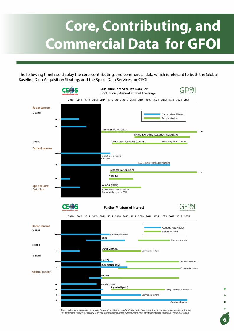
Core, Contributing, and Commercial Data for GFOI
6
2010 2011 2012 2013 2014 2015 2016 2017 2018 2019 2020 2021 2022 2023 2024 2025
Global ForestObservations Initiative
Global Forest Observations Initiative
Further Missions of Interest
Radar sensorsC-band
Optical sensors
RADARSAT-2 (CSA)
DMC-2 Constellation (UK)Commercial system
Deimos-1 (Spain)
COSMO-SkyMed Constellation & 2nd Generation (ASI)
Commercial system
There are also numerous missions in planning by several countries that may be of value - including many high resolution missions of interest for validation.Few datastreams will have the capacity to provide routine global coverage. But many more will be able to contribute to national and regional coverages.
Ingenio (Spain)Data policy to be determined
Commercial system
RISAT-1/-1A (ISRO)
L-band
X-band
Commercial system
Current/Past Mission
Future Mission
ALOS-2 (JAXA)
SPOT-6/7 (Airbus)
RapidEye (BlackBridge)
Commercial system
Commercial system
Commercial system
TerraSAR-X, TanDEM-X, TerraSAR-X-2 (DLR)Commercial system
IRS-1c/d & ResourceSat (India)Commercial system
ALOS (JAXA)
C-band
Optical sensors
2010 2011 2012 2013 2014 2015 2016 2017 2018 2019 2020 2021 2022 2023 2024 2025
Sentinel-1A/B/C (ESA)
RADARSAT CONSTELLATION 1/2/3 (CSA)
L-band
LANDSAT-7/-8 (USGS)
CBERS Series (INPE/CRESDA)
LS-7 technical/coverage limitations
Sentinel-2A/B/C (ESA)
SAOCOM-1A/B -2A/B (CONAE)
ERS-1&2 (ESA) Current/Past Mission
Future Mission
Radar sensors
Archive available from 1991
Data policy to be con�rmed
Landsat Archive available from 1972
Global ForestObservations Initiative
Global Forest Observations Initiative
Sub-30m Core Satellite Data ForContinuous, Annual, Global Coverage
CBERS-4
SPOT global archive data older than 5 years is available as core dataSPOT coverage available over Congo basin 2008 - 2015
SPOT 1–5 (CNES)
ALOS (JAXA)
2007-2010 50m global mosaic available as core data. 25m product anticipated
Envisat (ESA)
Special Core Data Sets
ALOS-2 (JAXA)
Annual ALOS-2 mosaics will befreely available starting 2014
The following timelines display the core, contributing, and commercial data which is relevant to both the Global Baseline Data Acquisition Strategy and the Space Data Services for GFOI.

Related Documents