TREATIES AND OTHER INTERNATIONAL ACTS SERIES 12-717 ________________________________________________________________________ SPACE COOPERATION Land Remote Sensing Satellite Data Memorandum of Understanding Between the UNITED STATES OF AMERICA and the EUROPEAN SPACE AGENCY Signed at Reston and Paris June 18 and July 17, 2012 with Annexes

Welcome message from author
This document is posted to help you gain knowledge. Please leave a comment to let me know what you think about it! Share it to your friends and learn new things together.
Transcript

TREATIES AND OTHER INTERNATIONAL ACTS SERIES 12-717 ________________________________________________________________________
SPACE COOPERATION Land Remote Sensing Satellite Data Memorandum of Understanding
Between the UNITED STATES OF
AMERICA and the EUROPEAN SPACE AGENCY
Signed at Reston and Paris June 18 and July 17, 2012 with Annexes

NOTE BY THE DEPARTMENT OF STATE Pursuant to Public Law 89—497, approved July 8, 1966 (80 Stat. 271; 1 U.S.C. 113)— “. . .the Treaties and Other International Acts Series issued under the authority of the Secretary of State shall be competent evidence . . . of the treaties, international agreements other than treaties, and proclamations by the President of such treaties and international agreements other than treaties, as the case may be, therein contained, in all the courts of law and equity and of maritime jurisdiction, and in all the tribunals and public offices of the United States, and of the several States, without any further proof or authentication thereof.”
EUROPEAN SPACE AGENCY
Space Cooperation: Land Remote Sensing
Satellite Data Memorandum of understanding signed at Reston and Paris June 18 and July 17, 2012; Entered into force July 17, 2012. With annexes.
ESA/PB-EO(2012)39XX-49.0000
ACIS Ref. ID: 10374
MEMORANDUM OF UNDERSTANDING
BETWEEN THE
UNITED STATES GEOLOGICAL SURVEYOF THE DEPARTMENT OF THE INTERIOR
AND THE
EUROPEAN SPACE AGENCY
FOR COOPERATION IN THE USE OFU.S. LANDSAT DATA
Page 1 of 9

ESA/PB-E0(2012)39XX-49.0000
ACIS Ref. ID: 10374
PREAMBLE
The United States Geological Survey of the United States Department of the Interior (hereinafterreferred to as "USGS") and the European Space Agency (hereinafter referred to as "ESA")established by the Convention which was opened for signature in Paris on 30 May 1975 andentered into force on 30 October 1980, having its headquarters at 8-10 rue Mario-Nikis, 75015Paris, France (hereinafter referred to as "the Parties"),
RECOGNIZING their mutual interest in the use of space technology for peaceful purposes;
NOTING the value of the United States Landsat satellite missions to cooperation amonggovernments in space-based remote sensing of the Earth's surface;
DESIRING to establish an overall legal framework for cooperation in future land remotesensing satellite missions;
HAVE AGREED as follows:
ARTICLE 1— PURPOSE AND SCOPE OF COOPERATION
This Memorandum of Understanding (hereinafter referred to as "MOU") establishes theterms and conditions under which USGS will provide United States-owned land remotesensing satellite data from Landsat 8 and subsequent spacecraft (hereinafter referred to as"Landsat data") and ESA will receive, process, archive, distribute, and exchange suchdata in cooperation with the USGS. This MOU consists of a main text, an annexcontaining the definition of terms used in the main body of the MOU (Annex I), and anannex on the annual access fee agreement for the Landsat missions that shall beconcluded at the outset of each new Landsat mission (Annex II, III, IV, etc.). Theannexes form an integral part of this MOU, but the Parties may update and amend themin a separate and independent process without requiring the revision of the main text ofthe MOU.
ARTICLE 2 — RESPONSIBILITIES OF THE PARTIES
A. The USGS shall:
1. Program Landsat satellites to collect and provide Landsat data of areaswithin the acquisition radius of ESA's ground station(s) to the extent thatsuch requests can be accommodated by the spacecraft. The USGS shallendeavor to schedule satellite downlink resources to meet requests fromall of its international cooperators (hereinafter referred to as "IC"s) in an
Page 2 of 9
ESAJPB-E0(2012)39XX-49.0000
ACIS Ref. ID: 10374
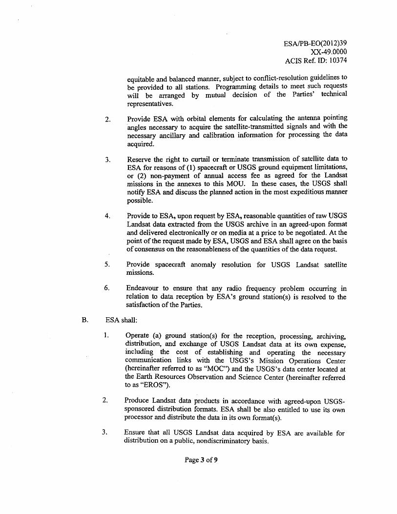
equitable and balanced manner, subject to conflict-resolution guidelines tobe provided to all stations. Programming details to meet such requestswill be arranged by mutual decision of the Parties' technicalrepresentatives.
2. Provide ESA with orbital elements for calculating the antenna pointingangles necessary to acquire the satellite-transmitted signals and with thenecessary ancillary and calibration information for processing the dataacquired.
3. Reserve the right to curtail or terminate transmission of satellite data toESA for reasons of (1) spacecraft or USGS ground equipment limitations,or (2) non-payment of annual access fee as agreed for the Landsatmissions in the annexes to this MOU. In these cases, the USGS shallnotify ESA and discuss the planned action in the most expeditious mannerpossible.
4. Provide to ESA, upon request by ESA, reasonable quantities of raw USGSLandsat data extracted from the USGS archive in an agreed-upon formatand delivered electronically or on media at a price to be negotiated. At thepoint of the request made by ESA, USGS and ESA shall agree on the basisof consensus on the reasonableness of the quantities of the data request.
5. Provide spacecraft anomaly resolution for USGS Landsat satellitemissions.
6. Endeavour to ensure that any radio frequency problem occurring inrelation to data reception by ESA's ground station(s) is resolved to thesatisfaction of the Parties.
B. ESA shall:
1. Operate (a) ground station(s) for the reception, processing, archiving,distribution, and exchange of USGS Landsat data at its own expense,including the cost of establishing and operating the necessarycommunication links with the USGS's Mission Operations Center(hereinafter referred to as "MOC") and the USGS's data center located atthe Earth Resources Observation and Science Center (hereinafter referredto as "EROS").
2. Produce Landsat data products in accordance with agreed-upon USGS-sponsored distribution formats. ESA shall be also entitled to use its ownprocessor and distribute the data in its own format(s).
3. Ensure that all USGS Landsat data acquired by ESA are available fordistribution on a public, nondiscriminatory basis.
Page 3 of 9
ESA/PB-E0(2012)39XX-49. 0000
ACIS Ref. ID: 10374
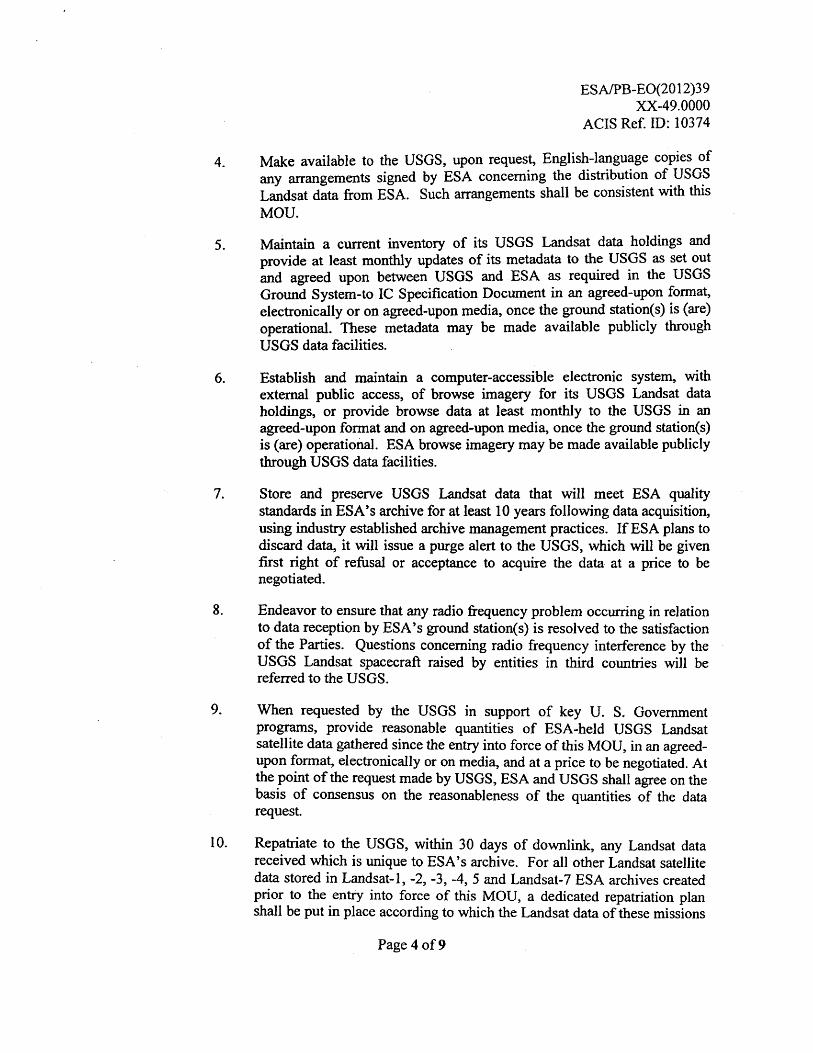
4. Make available to the USGS, upon request, English-language copies ofany arrangements signed by ESA concerning the distribution of USGSLandsat data from ESA. Such arrangements shall be consistent with thisMOU.
5. Maintain a current inventory of its USGS Landsat data holdings andprovide at least monthly updates of its metadata to the USGS as set outand agreed upon between USGS and ESA as required in the USGSGround System-to IC Specification Document in an agreed-upon format,electronically or on agreed-upon media, once the ground station(s) is (are)operational. These metadata may be made available publicly throughUSGS data facilities.
6. Establish and maintain a computer-accessible electronic system, withexternal public access, of browse imagery for its USGS Landsat dataholdings, or provide browse data at least monthly to the USGS in anagreed-upon format and on agreed-upon media, once the ground station(s)is (are) operational. ESA browse imagery may be made available publiclythrough USGS data facilities.
7. Store and preserve USGS Landsat data that will meet ESA qualitystandards in ESA's archive for at least 10 years following data acquisition,using industry established archive management practices. If ESA plans todiscard data, it will issue a purge alert to the USGS, which will be givenfirst right of refusal or acceptance to acquire the data at a price to benegotiated.
8. Endeavor to ensure that any radio frequency problem occurring in relationto data reception by ESA's ground station(s) is resolved to the satisfactionof the Parties. Questions concerning radio frequency interference by theUSGS Landsat spacecraft raised by entities in third countries will bereferred to the USGS.
9. When requested by the USGS in support of key U. S. Governmentprograms, provide reasonable quantities of ESA-held USGS Landsatsatellite data gathered since the entry into force of this MOU, in an agreed-upon format, electronically or on media, and at a price to be negotiated. Atthe point of the request made by USGS, ESA and USGS shall agree on thebasis of consensus on the reasonableness of the quantities of the datarequest.
10. Repatriate to the USGS, within 30 days of downlink, any Landsat datareceived which is unique to ESA's archive. For all other Landsat satellitedata stored in Landsat-1, -2, -3, -4, 5 and Landsat-7 ESA archives createdprior to the entry into force of this MOU, a dedicated repatriation planshall be put in place according to which the Landsat data of these missions
Page 4 of 9

ESA/PB-E0(2012)39XX-49.0000
ACIS Ref. ID: 10374
shall be repatriated to USGS.
11. For purposes of validating data quality, exchange limited amounts ofESA-held USGS Landsat data, in an agreed-upon format, electronically oron media, when requested by the USGS. Data for this purpose shall beexchanged annually, at no cost to the USGS. ESA and USGS shall concurand agree which amounts constitute limited amounts of ESA-held USGSLandsat data.
12. When requested by the USGS in response to a significant loss ofspacecraft capability to record data for the USGS archive, and as long asthis is possible subject to budgetary and network resources, providesufficient quantities of newly acquired USGS Landsat data to meet U.S.Government mission requirements, in an agreed-upon format,electronically or on media, at a cost to be negotiated. For any supportnecessary to ESA beyond providing USGS Landsat data to the USGS asdescribed above, the Parties will negotiate specific financial terms.
13. Communicate with the MOC on spacecraft information, in order tomaximize data collection and efficiency of spacecraft operations.
14. Endeavour to provide support for spacecraft anomaly resolution of theUSGS Landsat missions.
ARTICLE 3 — INTERNATIONAL MISSION COORDINATION
1. Each Party shall designate program representatives to be responsible for theimplementation of this MOU, who will meet on a yearly basis. Supplementalmeetings between the Parties will be held by mutual agreement.
2. Program management representatives from the Parties will participate in annualmeetings of the Landsat Ground Station Operators Working Group (LGSOWG).This group, chaired by the USGS, will serve as a forum for the exchange ofpolicy, programmatic and management information among station operators andthe USGS.
3. Technical representatives from the Parties will participate in annual meetings ofthe Landsat Technical Working Group (LTWG). This group, also chaired by theUSGS, will review and coordinate technical and operational aspects of USGSinternational mission support.
ARTICLE 4 — SCIENCE AND APPLICATIONS DEVELOPMENT
The Parties may consider partnering with a view to:
Page 5 of 9

ESA/PB-E0(2012)39)0C-49.0000
ACIS Ref. ID: 10374
1. Identify opportunities for cooperation in improved land remote sensing satellitedata collection, user accessibility, and data distribution.
2. Identify opportunities to support new research in the use of land remote sensingsatellite data, and the development of related applications to enhance land usepractices, ecosystems management, climate change research, and other areas ofEarth systems science.
3. Cooperate in the support of global observation and science programs involvingthe use of land remote sensing satellite data.
4. Consult with one another on best practices and improved means of cooperationin the long-term archiving and preservation of land remote sensing satellite data.
5. Share information and consider opportunities for training and capacity buildingin the use of land remote sensing satellite data.
6. Share information on their respective development and potential for cooperationin their respective land remote sensing satellite missions in accordance with theprovisions of Article 10.
ARTICLE 5 — USER SERVICE ARRANGEMENTS
The USGS reserves the right to service the requests for Landsat data made by all usersaffiliated with U.S. Government programs.
ARTICLE 6 — FINANCIAL ARRANGEMENTS AND LEGAL AUTHORIZATION
1. The Parties shall be responsible for funding their respective activities under thisMOU. Additionally, ESA, or its designated agent, shall pay to the USGS in atimely manner, any access fees described in the annexes to this MOU. Thesefees are required to enable the USGS to administer all operations in support of aglobal network of cooperating ground receiving stations.
2. Obligations under this MOU and any implementing annexes shall be subject tothe availability of funding obtained through each Party's funding procedures.
3. Should either Party encounter budgetary problems that may affect the activitiescarried out under this MOU that Party shall notify and consult with the otherParty in a timely manner in order to minimize the negative impact of suchproblems on the Parties' cooperation.
Page 6 of 9
ESA/PB-E0(2012)39XX-49.0000
ACIS Ref. ID: 10374
ARTICLE 7 — DUTIES, FEES, AND TAXES
In accordance with its applicable laws, rules, and regulations, each Party shall seek toensure free customs clearance and waiver of all applicable duties, fees, and taxes for theimport or export of goods necessary for the implementation of this MOU. In the eventthat any duties, fees, or taxes of any kind are nonetheless levied on such goods, suchduties, fees, or taxes shall be borne by the Party of the country levying them.
ARTICLE 8 — ENTRY AND EXIT OF PERSONNEL
On a reciprocal basis, each Party shall use reasonable efforts to facilitate, in accordancewith its applicable laws, rules, and regulations, the entry to and exit from the territoryconcerned or premises as applicable of personnel engaged in the performance of activitiespursuant to this MOU.
ARTICLE 9 — LAWS, WARRANTIES, RIGHTS, AND LIABILITY
1. The activities under this MOU shall be conducted in accordance with the laws,rules, and regulations applicable to the Parties, respectively, and shall be subjectto the availability of appropriated funds.
2. The USGS does not warrant the suitability of its Landsat data for any purposeand shall not be liable for any damage or injury brought about by use of USGSLandsat satellite systems and their data.
3. The USGS retains the ownership right to all raw Landsat data acquired by itssatellites. Beyond the provisions of Article 2.B.3, the USGS places norestrictions on ESA to disclose, use, manipulate, generate products from,distribute, or sell USGS Landsat data.
ARTICLE 10 — EXCHANGE OF TECHNICAL INFORMATION
1. USGS and ESA shall exchange appropriate technical information for processingdata and documentation for the purposes of downlinking, processing, andarchiving USGS Landsat data as well as for generating and distributing productsfrom that data.
2. Technical information exchanged between the Parties will be subject to theapplicable laws, rules, regulations, and policies of the Parties, respectively. Inthe event it is necessary to exchange technical information and the furnishingParty considers that such technical information is to be protected for proprietaryor export control purposes, such information must be clearly marked with alegend indicating the country of origin, the conditions of release, that theinformation relates to this MOU, and that it is furnished in confidence.
Page 7 of 9
ESA/PB-E0(2012)39XX-49.0000
ACIS Ref. ID: 10374
3. USGS and ESA will take all lawful steps available to prevent disclosure of suchprotected or proprietary technical information without the consent of the otherParty and to ensure that it is used only for the purposes of this MOU.
4. USGS and ESA may release to the public other general, non-technicalinformation regarding each other's programs or operations after ensuring,through consultation with each other when necessary, that this information isfairly and accurately represented.
ARTICLE 11 — CONSULTATIONS AND SETTLEMENT OF DISPUTES
I . The Parties shall consult with each other promptly when events occur or mattersarise that may call into question the interpretation or implementation of theterms of this MOU.
2. Any issue in the interpretation or implementation of this MOU that - cannot beresolved by the Parties' respective Program Managers will be referred forsettlement to the ESA Director of Earth Observation and the USGS LandRemote Sensing Program Coordinator. If they are unable to come to anagreement, then the issue will be referred to the ESA Director General and theUSGS Director or their designated representatives for joint resolution.
3. If an issue not resolved through consultation still needs to be resolved, theParties may agree to submit the dispute to an agreed form of dispute resolution.
ARTICLE 12 — ENTRY INTO FORCE, DURATION, AND TERMINATION
1. This MOU shall enter into force upon signature by both Parties and remain inforce through the operational lifetime of the USGS Landsat 8 and subsequentspacecraft from which ESA receives USGS Landsat data. This MOU may beamended at any time by written agreement of the Parties in accordance with therules and procedures of each Party. Amendments shall take effect on the date oftheir signature by the Parties.
2. In the event that either of the Parties is unable to comply with any provision ofthis MOU, either Party, after consultation with the other, shall have the option ofterminating this MOU, providing at least 30 days' notice of such action,forwarded in writing by one Party to the other.
3. Notwithstanding termination or expiration of this MOU, the obligations of theParties set forth in Articles 2.B.3, 2.B.7, 9.2, 9.3, and 10 of this MOU shallcontinue to apply.
Page 8 of 9
ESA/PB-EO(2012)39XX-49.0000
ACTS Ref. ID: 10374
4. This MOU shall neither replace nor supersede the previously concludedagreements between the Parties on Landsat -1, -2, -3, -4, -5 and -7 data whichshall continue to be in force in accordance with their respective provisions.
ARTICLE 13 — SIGNATURE
IN WITNESS THEREOF, respective representatives of the Parties have signed thisMemorandum of Understanding.
Done at on
Done at on
For the United States Geological Surveyof the Department of the Interior:
laaSk C CS, VACt.(\-AO. Marcia McNuttDirectorU.S. Geological SurveyReston, Virginia
For the European Space Agency:
Mr. Jean-Jacques adainDirector GeneralEuropean Space AgencyParis, France
v?p , zoQ_. Date Dat
.CLS \r-)r\ Place Place
Page 9 of 9
ESA/PB-E0(2012)39XX-49.0000
ACIS Ref. ID: 10375
ANNEX I
TO THE
MEMORANDUM OF UNDERSTANDING
BETWEEN THE
UNITED STATES GEOLOGICAL SURVEYOF THE DEPARTMENT OF THE INTERIOR
AND THE
EUROPEAN SPACE AGENCY
FOR COOPERATION IN THE USE OFU.S. LANDSAT DATA
DEFINITION OF TERMS
Page 1 of 3

ESA/PB-E0(2012)39XX-49.0000
ACTS Ref. ID: 10375
Acquisition Radius:An ESA acquisition radius is that portion of the Earth over which the satellite cancommunicate with ESA's ground station or stations.
Browse:
Browse is a full resolution or sub-sampled Level OR or Level 1 digital image of the Earththat can be viewed on a scene basis to quickly assess general ground area coverage, dataquality, and the spatial relationships between ground area coverage and cloud coverage.A browse is an image with a reduced data volume to facilitate screening of archived LandRemote Sensing Satellite Data. Specifications regarding browse images are documentedin the appropriate mission Data Format Control Book (DFCB) and made available by theUSGS.
Data Format:
The Landsat Technical Working Group (LTWG) recommends the archive data format forexchanging data between an International Cooperator and USGS archives. The archivedata exchange format for purposes of quality assessment and key government programs istypically the lowest level of processed data available (i.e. Mission or Raw ComputerCompatible [RCC] Data) and is transferred electronically or on media. The archive dataexchange format is documented in the appropriate mission Data Validation and ExchangePlan and associated Data Format Control Book (DFCB) and made available by theUSGS.
Data Products Distribution Format:
The USGS Land Remote Sensing Satellite Data products are Level-ORp (Level ZeroReformatted Product) in HDF format and Level-1T (terrain corrected) in Geo-TIFFformat. International Cooperators may produce data products of their choice. ESA isencouraged, but not required to produce Level ORp data products in HDF format, but isrequired to distribute Level-1T data products in Geo-TIFF format. Specificationsregarding Level-ORp and Level-1T data products are documented in the appropriatemission Data Format Control Book (DFCB) and made available by the USGS.
International Cooperator (IC):
An International Cooperator (IC) is any non-U.S. Government agency or commercialorganization acting on behalf of or in cooperation with a foreign government orinternational organization, which enters into an agreement with the USGS for purposes ofreceiving or exchanging Land Remote Sensing Satellite Data.
Key U.S. Government Programs:
Key U.S. Government Programs are any U.S. Government agencies and U.S.Government contractors, other U.S. and foreign researchers and entities involved in the
Page 2 of 3
ESAJPB-E0(2012)39XX-49.0000
ACIS Ref. ID: 10375
United States Global Change Research Program, and U.S. and foreign researchers andforeign and international entities having signed a cooperative agreement with the UnitedStates Government involving the use of USGS Land Remote Sensing Satellite Data fornon-commercial purposes.
The United States Global Change Research Program is the Executive Branch programresponding to Public Law 101-606, the Global Change Research Act of 1990, and mostrecently described in the annual report accompanying the President's budget entitled"Our Changing Planet: The U.S. Climate Change Science Program for Fiscal Year 2012."
International counterpart programs of the U.S. Global Change Research Program arediscussed in Section V of "Our Changing Planet." These include the IntergovernmentalPanel on Climate Change, the World Climate Research Program, the InternationalCouncil on Science, and the Group on Earth Observations.
Mission Operations Center (MOC):
The Mission Operations Center (MOC) consists of the people, procedures, andhardware/software systems used for the successful execution of real-time spacecraftoperations and off-line scheduling and analysis activities. All command and controlfunctions of the spacecraft performed by the Flight Operations Team (FOT) will takeplace from the MOC.
Metadata:
Metadata is descriptive information pertaining to the USGS Land Remote SensingSatellite Data, including such information as location and acquisition date, compiled forLevel OR and Level-1 data, and made available through the USGS user interface.Specifications regarding the metadata are documented in the Landsat MetadataDescription Document (LMDD) and made available by the USGS.
Raw Data:
Raw Data is the USGS Land Remote Sensing Satellite Data in the form of widebandtelemetry transmitted by the satellite.
U.S. Government and Affiliated Users:
U.S. Government and Affiliated Users are any federal, state or local government agencypersonnel and personnel from any organization performing cooperative work with or forthese government agencies.
USGS Land Remote Sensing Satellites:
USGS Land Remote Sensing Satellites are the Landsat satellites owned and operated bythe USGS for the purposes of this agreement.
Page 3 of 3

ESA/PB-E0(2012)39XX-49.0000
ACIS Ref. ID: 10376
ANNEX II
TO THE
MEMORANDUM OF UNDERSTANDING
BETWEEN THE
UNITED STATES GEOLOGICAL SURVEYOF THE DEPARTMENT OF THE INTERIOR
AND THE
EUROPEAN SPACE AGENCY
FOR COOPERATION IN THE USE OFU.S. LANDSAT DATA
LANDSAT 8ANNUAL ACCESS FEE AGREEMENT
ESA/PB-E0(2012)39XX-49.0000
ACIS Ref. ID: 10376
INTRODUCTION
Pursuant to Article 6 of the Memorandum of Understanding (MOU) between the UnitedStates Geological Survey of the Department of the Interior and the European SpaceAgency (ESA) for Cooperation in the use of US Landsat Data, the U.S. PresidentialDecision Directive/National Science and Technology Council-3, as amended on October16, 2000 and the Land Remote Sensing Policy Act of 1992, the USGS has established afee structure to enable it to administer all operations in support of a global network ofcooperating ground receiving stations for direct reception of data from the Landsat 8mission. This Annex sets forth the related financial and administrative terms andconditions for Landsat 8 cooperation between the USGS and ESA.
ARTICLE 2 — FEE STRUCTURE
The fee structure comprises a one-time initialization fee and an annual access fee. If ESAmoves a receiving antenna to a new location greater than 50 kilometers from its originallocation, an antenna move fee will be assessed. The annual access fee will be payable forthe United States Government (USG) Fiscal Year, which begins on October 1 and endson September 30, and may be prorated to the remaining portion of the USG Fiscal Year,from the start date for direct transmission of Landsat 8 data to September 30.
The initialization fee for a new ESA station is U.S. $35,000 for each receiving site. Thetotal initialization fee for ESA will be U.S. $0 for any of the existing receiving siteslocated at Kiruna, Sweden; Neustrelitz, Germany; Maspalomas, Spain; Matera, Italy; orMalindi, Kenya.
The antenna move fee is U.S. $15,000 and will be billed each time a station is moved adistance greater than 50 kilometers.
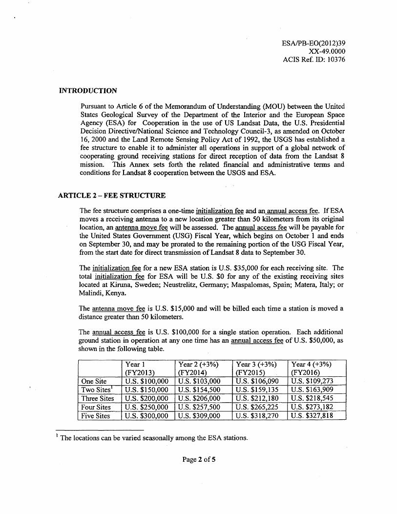
The annual access fee is U.S. $100,000 for a single station operation. Each additionalground station in operation at any one time has an annual access fee of U.S. $50,000, asshown in the following table.
Year 1(FY2013)
Year 2 (+3%)(FY2014)
Year 3 (+3%)(FY2015)
Year 4 (+3%)(FY2016)
One Site U.S. $100,000 U.S. $103,000 U.S. $106,090 U.S. $109,273Two Sites' U.S. $150,000 U.S. $154,500 U.S. $159,135 U.S. $163,909Three Sites U.S. $200,000 U.S. $206,000 U.S. $212,180 U.S. $218,545Four Sites U.S. $250,000 U.S. $257,500 U.S. $265,225 U.S. $273,182Five Sites U.S. $300,000 U.S. $309,000 U.S. $318,270 U.S. $327,818
The locations can be varied seasonally among the ESA stations.
Page 2 of 5

ESA/PB-E0(2012)39XX-49.0000
ACIS Ref. ID: 10376
ARTICLE 3 — PAYMENT SCHEDULE
The one-time initialization fee and antenna move fee, if applicable, are due and payable30 days prior to ESA reception of Landsat 8 data.
The annual access fee will be paid annually. ESA will receive an annual bill 30 daysprior to the start of the USG Fiscal Year (billing date of September 1).
The USGS reserves the right to terminate transmission of Landsat 8 data to ESA at anytime that ESA is in arrears in its payments to the USGS or is delinquent in regularlyscheduled delivery of raw telemetry data to the USGS in accordance with MOU Article2.A.3. The USGS will notify ESA 30 days in advance of its intention to terminatetransmission for these reasons. Payments may be by check or electronic bank transfer inU.S. dollars. Payments by check shall be in U.S. dollars and shall be payable to:
Department of the Interior/USGS
Payments by check shall be mailed to:
USGS Office of Financial Management271 National Center12201 Sunrise Valley DriveReston, Virginia, 20192 USA
Payments by electronic bank transfer shall be in U.S. dollars and transferred to theUSGS's bank account. The USGS will provide exact electronic bank transferinformation with each billing.
All payments must be received within 30 days from the date of invoice. Charges for latepayment will be at the U. S. Treasury Department prevailing rate on the overdue balancefor each 30-day period or portion thereof that payment is delayed.
ARTICLE 4 — FEE CHANGES
While USGS reserves the right to make modifications to the annual access fee used inthis fee structure, it is the USGS's intent to minimize the changes to the fee structureduring the life of the Landsat 8 mission. For the Landsat 8 mission, a 3% annual increaseis planned to account for average annual rates of inflation. Reasonable notification ofany proposed change to these fees (initialization, antenna move, and annual access fees),taking into account the budget cycles of the parties, shall be provided in writing by theUSGS to ESA 60 days prior to the implementation of the proposed change. Anyproposed fee change would not exceed 10% of the current annual access fee.
ARTICLE 5 — CONTINGENCIES
Page 3 of 5

ESA/PB-E0(2012)39XX-49.0000
ACIS Ref. ID: 10376
The USGS, in consultation with ESA, may curtail or terminate the transmission of dataand adjust the annual access fees if the USGS is unable to satisfy data requests due tospacecraft system capability limitations or ground receiving stations conflicts. Thedetermination of a non-operable spacecraft for an extended period of time shall result inpro-rated compensation through either a credit toward future payments or a refund of theamount as agreed through mutual consent of the Parties.
ARTICLE 6 — DURATION AND AMENDMENT
This Annex will remain in effect as long as the MOU remains in force, and it may beamended by mutual consent of USGS and ESA through an exchange of letters.
At the beginning of each new USG Fiscal Year, the USGS and ESA will review thisAnnex and revise it if necessary.
Page 4 of 5

For European Space Agency:
ther KohlhammerHead of the Ground Segment andMission Operations DepartmentEuropean Space Agency (ESA)ESRIN, Rome
A 9 - z a-ez
ESA/PB-E0(2012)39XX-49.0000
ACTS Ref. ID: 10376
ARTICLE 7 — AUTHORIZING SIGNATURES
The signatures of the authorized officials below signify the agreement by the Parties tothe terms of the annex.
For the United States Geological Surveyof the Department of the Interior:
c.‘,3-1 c to.c %1/4a5.76—. Marcia McNuttDirectorU.S. Geological SurveyReston, Virginia
NouSkk_ VE -CG\ Z._(date) (date)
Page 5 of 5
Related Documents


