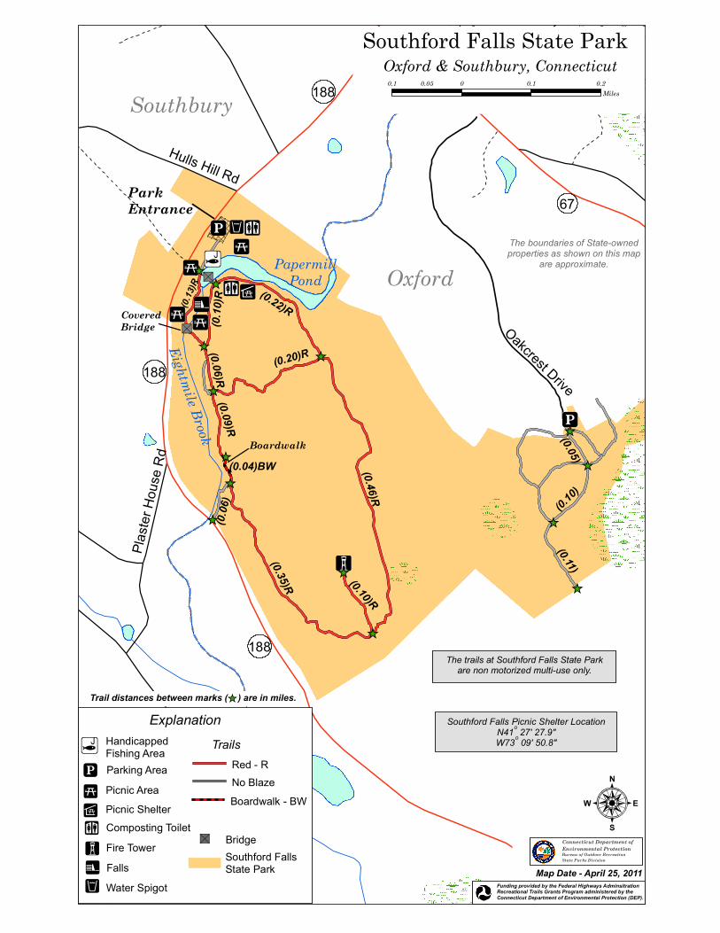
^ _ ! j 188 188 67 ! _ ! 3 ! A ! j ! l ! 5 ! _ ! n ! 5 ! 5 " S " S ! ² ! 5 Park Entrance Hulls Hill Rd Plaster House Rd Covered Bridge Boardwalk Oakcrest Drive 188 Eightmile Brook Papermill Pond (0.20)R (0.22)R (0.46)R (0.10)R (0.35)R (0.06) (0.04)BW (0.09)R (0.06)R (0.13)R (0.10)R ^ _ ^ _ ^ _ ^ _ ^ _ ^ _ ^ _ ^ _ ^ _ ^ _ ^ _ ^ _ ^ _ (0.11) (0.10) (0.05) Oxford Southbury Southford Falls State Park : Oxford & Southbury, Connecticut 0.1 0 0.1 0.2 0.05 Miles The boundaries of State-owned properties as shown on this map are approximate. Connecticut Department of Environmental Protection Bureau of Outdoor Recreation State Parks Division Map Date - April 25, 2011 Trail distances between marks ( ) are in miles. ^ _ Funding provided by the Federal Highways Adminsitration Recreational Trails Grants Program administered by the Connecticut Department of Environmental Protection (DEP). The trails at Southford Falls State Park are non motorized multi-use only. Explanation Southford Falls State Park ! l ! j Handicapped Fishing Area Parking Area Fire Tower ! A ! ² Falls Trails Boardwalk - BW Red - R No Blaze " S Bridge Picnic Area ! 5 ! _ Composting Toilet Water Spigot ! n Picnic Shelter ! 3 Southford Falls Picnic Shelter Location N41 o 27' 27.9" W73 o 09' 50.8"

Welcome message from author
This document is posted to help you gain knowledge. Please leave a comment to let me know what you think about it! Share it to your friends and learn new things together.
Transcript
_̂
!j
188
188
67!_
!3
!A
!j
!l!5
!_!n
!5!5"S
"S
!²
!5
ParkEntrance
Hulls Hill Rd
Plaste
r Hou
se R
d
CoveredBridge
Boardwalk
Oakcrest Drive
188
Eightmile Brook
PapermillPond
(0.20)R
(0.22)R
(0.46)R(0.10)R
(0.35)R
(0.06
)
(0.04)BW
(0.09)R(0.06)R
(0.13
)R
(0.10
)R
_̂
_̂
_̂
_̂_̂
_̂_̂
_̂
_̂
_̂
_̂
_̂
_̂
(0.11)
(0.10)
(0.05)
Oxford
Southbury
Southford Falls State Park
:
Oxford & Southbury, Connecticut0.1 0 0.1 0.20.05
Miles
The boundaries of State-ownedproperties as shown on this map
are approximate.
Connecticut Department ofEnvironmental ProtectionBureau of Outdoor RecreationState Parks Division
Map Date - April 25, 2011
Trail distances between marks ( ) are in miles._̂
Funding provided by the Federal Highways AdminsitrationRecreational Trails Grants Program administered by the Connecticut Department of Environmental Protection (DEP).
The trails at Southford Falls State Parkare non motorized multi-use only.
Explanation
Southford FallsState Park
!l
!j
HandicappedFishing AreaParking Area
Fire Tower!A
!²
Falls
Trails
Boardwalk - BW
Red - RNo Blaze
"S Bridge
Picnic Area!5
!_ Composting Toilet
Water Spigot!n
Picnic Shelter!3
Southford Falls Picnic Shelter LocationN41o 27' 27.9"W73o 09' 50.8"
Related Documents